Embed Size (px)
Citation preview
Multi GNSSCurrent Status and Future
Session 2.3 Multi GNSS Environment
Larry D. Hothem
Senior Advisor for GPS/GNSS Technical Issues
Member US Delegation to the ICG
DOI Lead Member, GPS International Working Group (GIWG), PNT
DOI Member of Various PNT Working Groups
U.S. Geological Survey, Department of the Interior
Reston, Virginia USA
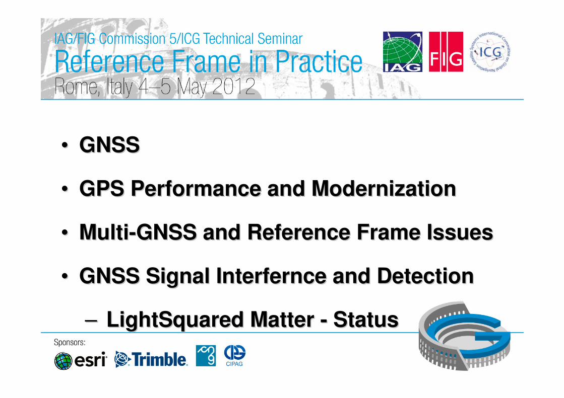
•• GNSS GNSS
•• GPS Performance and ModernizationGPS Performance and Modernization
•• MultiMulti--GNSS and Reference Frame IssuesGNSS and Reference Frame Issues
•• GNSS Signal Interfernce and DetectionGNSS Signal Interfernce and Detection
–– LightSquared Matter LightSquared Matter -- StatusStatus
3
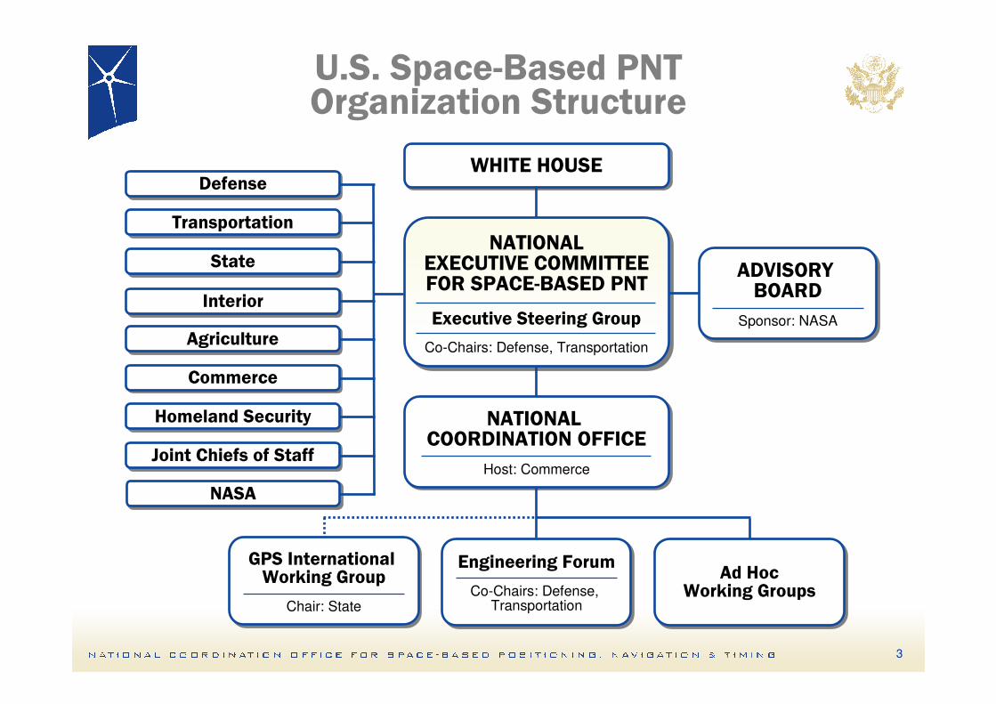
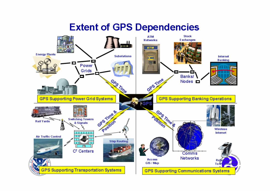
U.S. Space-Based PNTOrganization Structure
WHITE HOUSEWHITE HOUSE
ADVISORY BOARD
Sponsor: NASA
ADVISORY BOARD
Sponsor: NASA
NATIONALEXECUTIVE COMMITTEEFOR SPACE-BASED PNT
Executive Steering Group
Co-Chairs: Defense, Transportation
NATIONALEXECUTIVE COMMITTEEFOR SPACE-BASED PNT
Executive Steering Group
Co-Chairs: Defense, Transportation
NATIONAL COORDINATION OFFICE
Host: Commerce
NATIONAL COORDINATION OFFICE
Host: Commerce
GPS International Working Group
Chair: State
GPS International Working Group
Chair: State
Engineering Forum
Co-Chairs: Defense, Transportation
Engineering Forum
Co-Chairs: Defense, Transportation
Ad HocWorking Groups
Ad HocWorking Groups
DefenseDefense
TransportationTransportation
StateState
InteriorInterior
AgricultureAgriculture
CommerceCommerce
Homeland SecurityHomeland Security
Joint Chiefs of StaffJoint Chiefs of Staff
NASANASA
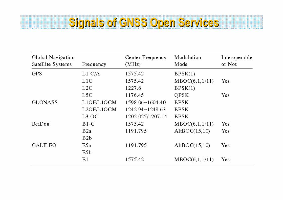
Signals of GNSS Open ServicesSignals of GNSS Open Services
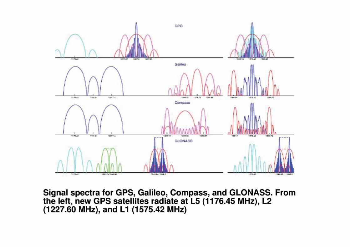
Signal spectra for GPS, Galileo, Compass, and GLONASS. From Signal spectra for GPS, Galileo, Compass, and GLONASS. From the left, new GPS satellites radiate at L5 (1176.45 MHz), L2 the left, new GPS satellites radiate at L5 (1176.45 MHz), L2 (1227.60 MHz), and L1 (1575.42 MHz)(1227.60 MHz), and L1 (1575.42 MHz)
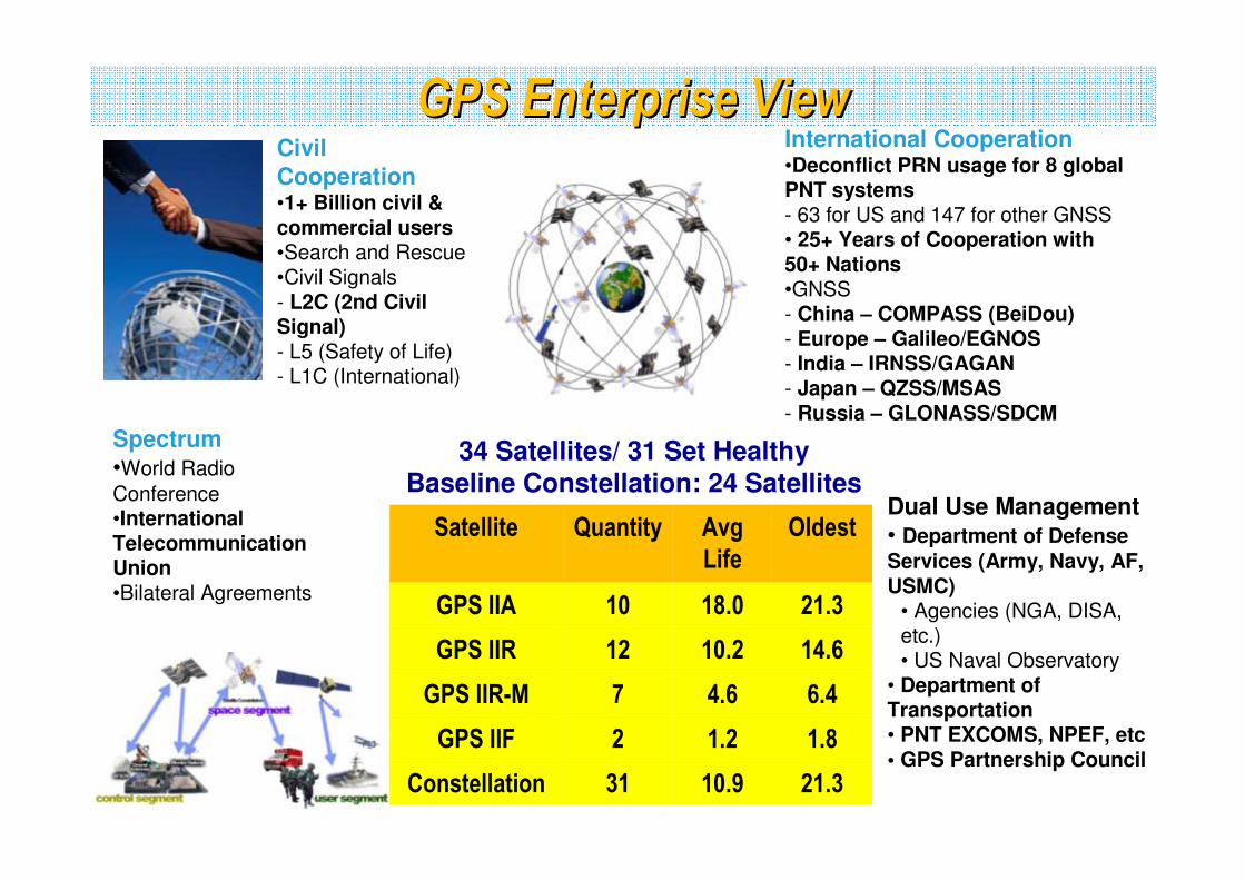
GPS Enterprise View GPS Enterprise View Civil
Cooperation •1+ Billion civil & commercial users •Search and Rescue •Civil Signals - L2C (2nd Civil Signal) - L5 (Safety of Life) - L1C (International)
Spectrum
•World Radio
Conference •International Telecommunication Union •Bilateral Agreements
International Cooperation •Deconflict PRN usage for 8 global PNT systems - 63 for US and 147 for other GNSS• 25+ Years of Cooperation with 50+ Nations •GNSS - China – COMPASS (BeiDou)- Europe – Galileo/EGNOS - India – IRNSS/GAGAN - Japan – QZSS/MSAS - Russia – GLONASS/SDCM
Dual Use Management
• Department of Defense
Services (Army, Navy, AF, USMC)
• Agencies (NGA, DISA, etc.) • US Naval Observatory
• Department of Transportation • PNT EXCOMS, NPEF, etc• GPS Partnership Council
34 Satellites/ 31 Set HealthyBaseline Constellation: 24 Satellites
Satellite Quantity Avg
Life
Oldest
GPS IIA 10 18.0 21.3
GPS IIR 12 10.2 14.6
GPS IIR-M 7 4.6 6.4
GPS IIF 2 1.2 1.8
Constellation 31 10.9 21.3
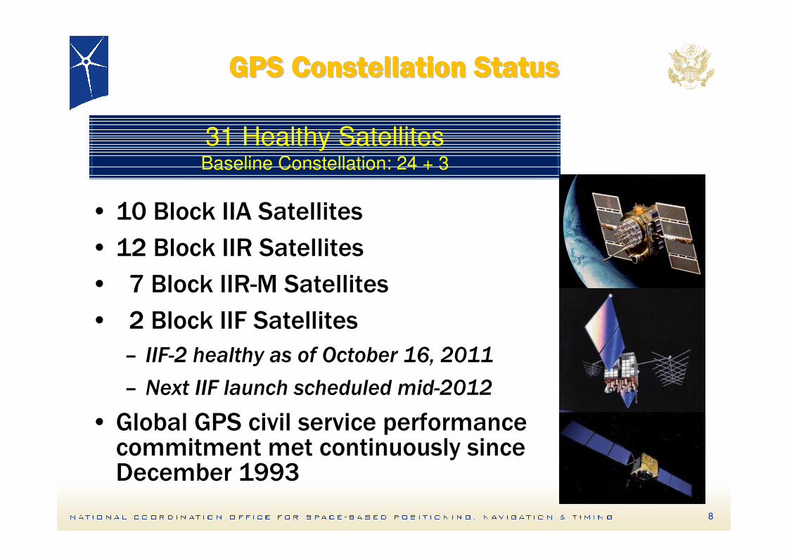
GPS Constellation StatusGPS Constellation StatusGPS Constellation StatusGPS Constellation StatusGPS Constellation StatusGPS Constellation StatusGPS Constellation StatusGPS Constellation Status
• 10 Block IIA Satellites
• 12 Block IIR Satellites
• 7 Block IIR-M Satellites
• 2 Block IIF Satellites
– IIF-2 healthy as of October 16, 2011
– Next IIF launch scheduled mid-2012
• Global GPS civil service performance commitment met continuously since December 1993
31 Healthy SatellitesBaseline Constellation: 24 + 3
8
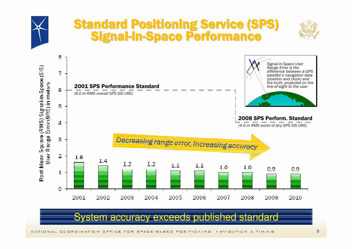
Standard Positioning Service (SPS)Standard Positioning Service (SPS)Standard Positioning Service (SPS)Standard Positioning Service (SPS)Standard Positioning Service (SPS)Standard Positioning Service (SPS)Standard Positioning Service (SPS)Standard Positioning Service (SPS)SignalSignalSignalSignalSignalSignalSignalSignal--------inininininininin--------Space PerformanceSpace PerformanceSpace PerformanceSpace PerformanceSpace PerformanceSpace PerformanceSpace PerformanceSpace Performance
2001 SPS Performance Standard(6.0 m RMS overall SPS SIS URE)
2008 SPS Perform. Standard(4.0 m RMS worst of any SPS SIS URE)
Signal-in-Space User Range Error is the difference between a GPS satellite’s navigation data (position and clock) and the truth, projected on the line-of-sight to the user
System accuracy exceeds published standard
9
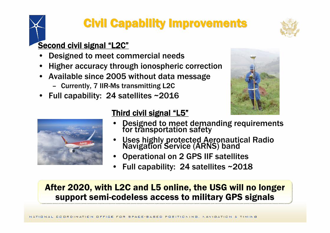
Civil Capability ImprovementsCivil Capability ImprovementsCivil Capability ImprovementsCivil Capability ImprovementsCivil Capability ImprovementsCivil Capability ImprovementsCivil Capability ImprovementsCivil Capability Improvements
Second civil signal Second civil signal Second civil signal Second civil signal ““““L2CL2CL2CL2C””””
• Designed to meet commercial needs
• Higher accuracy through ionospheric correction
• Available since 2005 without data message– Currently, 7 IIR-Ms transmitting L2C
• Full capability: 24 satellites ~2016
Third civil signal Third civil signal Third civil signal Third civil signal ““““L5L5L5L5””””
• Designed to meet demanding requirements for transportation safety
• Uses highly protected Aeronautical Radio Navigation Service (ARNS) band
• Operational on 2 GPS IIF satellites
• Full capability: 24 satellites ~2018
After 2020, with L2C and L5 online, the USG will no longer support semi-codeless access to military GPS signals
After 2020, with L2C and L5 online, the USG will no longer support semi-codeless access to military GPS signals
Civil Capability ImprovementsCivil Capability ImprovementsCivil Capability ImprovementsCivil Capability ImprovementsCivil Capability ImprovementsCivil Capability ImprovementsCivil Capability ImprovementsCivil Capability Improvements
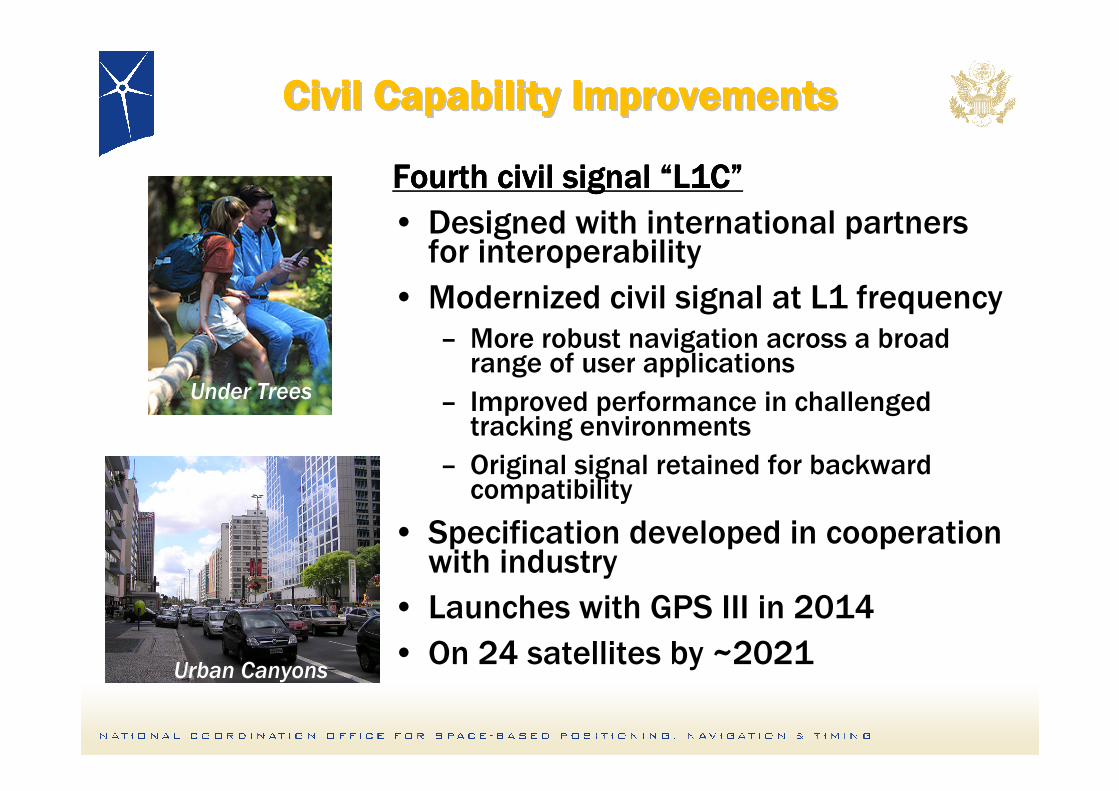
Fourth civil signal Fourth civil signal Fourth civil signal Fourth civil signal ““““L1CL1CL1CL1C””””
• Designed with international partnersfor interoperability
• Modernized civil signal at L1 frequency– More robust navigation across a broad range of user applications
– Improved performance in challengedtracking environments
– Original signal retained for backward compatibility
• Specification developed in cooperation with industry
• Launches with GPS III in 2014
• On 24 satellites by ~2021
Under Trees
Urban Canyons
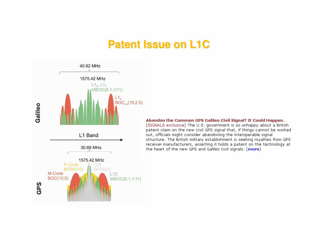
Patent Issue on L1CPatent Issue on L1C
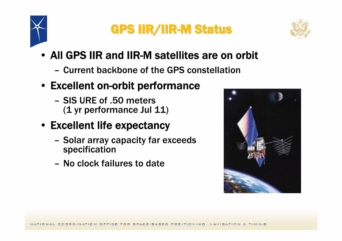
GPS IIR/IIRGPS IIR/IIRGPS IIR/IIRGPS IIR/IIRGPS IIR/IIRGPS IIR/IIRGPS IIR/IIRGPS IIR/IIR--------M StatusM StatusM StatusM StatusM StatusM StatusM StatusM Status
• All GPS IIR and IIRAll GPS IIR and IIRAll GPS IIR and IIRAll GPS IIR and IIR----M satellites are on orbitM satellites are on orbitM satellites are on orbitM satellites are on orbit
– Current backbone of the GPS constellation
• Excellent onExcellent onExcellent onExcellent on----orbit performanceorbit performanceorbit performanceorbit performance
– SIS URE of .50 meters (1 yr performance Jul 11)
• Excellent life expectancyExcellent life expectancyExcellent life expectancyExcellent life expectancy
– Solar array capacity far exceeds specification
– No clock failures to date
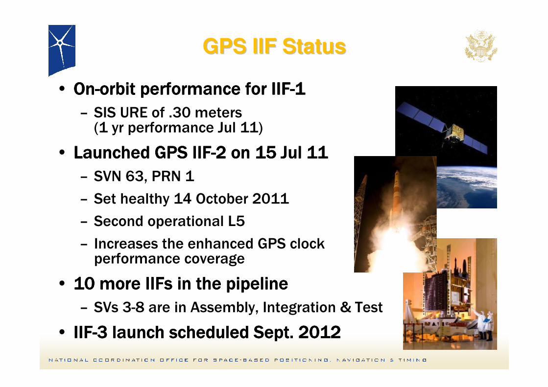
GPS IIF StatusGPS IIF Status
• OnOnOnOn----orbit performance for IIForbit performance for IIForbit performance for IIForbit performance for IIF----1111
– SIS URE of .30 meters (1 yr performance Jul 11)
• Launched GPS IIFLaunched GPS IIFLaunched GPS IIFLaunched GPS IIF----2 on 15 Jul 112 on 15 Jul 112 on 15 Jul 112 on 15 Jul 11
– SVN 63, PRN 1
– Set healthy 14 October 2011
– Second operational L5
– Increases the enhanced GPS clockperformance coverage
• 10 more IIFs in the pipeline10 more IIFs in the pipeline10 more IIFs in the pipeline10 more IIFs in the pipeline
– SVs 3-8 are in Assembly, Integration & Test
• IIFIIFIIFIIF----3 launch scheduled Sept. 20123 launch scheduled Sept. 20123 launch scheduled Sept. 20123 launch scheduled Sept. 2012
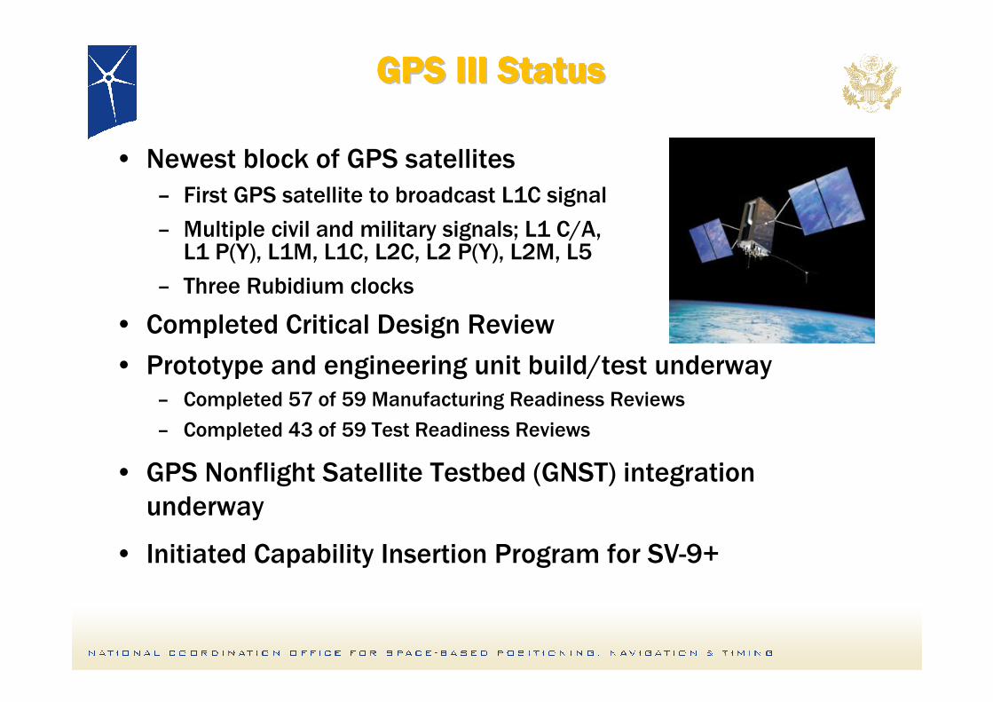
GPS III StatusGPS III StatusGPS III StatusGPS III StatusGPS III StatusGPS III StatusGPS III StatusGPS III Status
• Newest block of GPS satellites
– First GPS satellite to broadcast L1C signal
– Multiple civil and military signals; L1 C/A,L1 P(Y), L1M, L1C, L2C, L2 P(Y), L2M, L5
– Three Rubidium clocks
• Completed Critical Design Review
• Prototype and engineering unit build/test underway– Completed 57 of 59 Manufacturing Readiness Reviews
– Completed 43 of 59 Test Readiness Reviews
• GPS Nonflight Satellite Testbed (GNST) integration
underway
• Initiated Capability Insertion Program for SV-9+
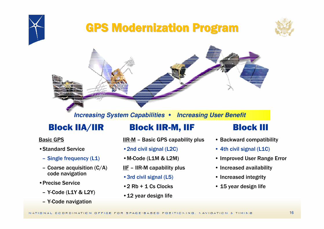
GPS Modernization ProgramGPS Modernization ProgramGPS Modernization ProgramGPS Modernization ProgramGPS Modernization ProgramGPS Modernization ProgramGPS Modernization ProgramGPS Modernization Program
Increasing System Capabilities � Increasing User Benefit
Block IIA/IIR Block IIIBlock IIR-M, IIF
• Backward compatibility
• 4th civil signal (L1C)
• Improved User Range Error
• Increased availability
• Increased integrity
• 15 year design life
IIR-M – Basic GPS capability plus
•2nd civil signal (L2C)
•M-Code (L1M & L2M)
IIF – IIR-M capability plus
•3rd civil signal (L5)
•2 Rb + 1 Cs Clocks
•12 year design life
Basic GPS
•Standard Service
– Single frequency (L1)
– Coarse acquisition (C/A) code navigation
•Precise Service
– Y-Code (L1Y & L2Y)
– Y-Code navigation
16
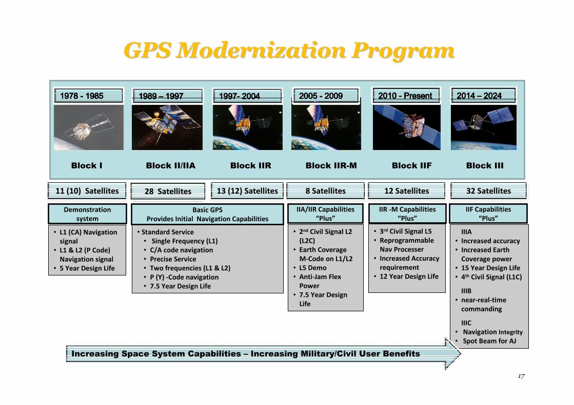
GPS Modernization ProgramGPS Modernization Program
17
Block I Block II/IIA Block IIR Block IIR-M Block IIF Block III
• L1 (CA) Navigation
signal
• L1 & L2 (P Code)
Navigation signal
• 5 Year Design Life
• Standard Service
• Single Frequency (L1)
• C/A code navigation
• Precise Service
• Two frequencies (L1 & L2)
• P (Y) -Code navigation
• 7.5 Year Design Life
Demonstration
system
Basic GPS
Provides Initial Navigation Capabilities
IIA/IIR Capabilities
“Plus”
• 2nd Civil Signal L2
(L2C)
• Earth Coverage
M-Code on L1/L2
• L5 Demo
• Anti-Jam Flex
Power
• 7.5 Year Design
Life
IIR -M Capabilities
“Plus”
• 3rd Civil Signal L5
• Reprogrammable
Nav Processer
• Increased Accuracy
requirement
• 12 Year Design Life
IIF Capabilities
“Plus”
IIIA
• Increased accuracy
• Increased Earth
Coverage power
• 15 Year Design Life
• 4th Civil Signal (L1C)
IIIB
• near-real-time
commanding
IIIC
• Navigation Integrity
• Spot Beam for AJ
1978 1978 1978 1978 ---- 1985198519851985 1989 1989 1989 1989 –––– 1997199719971997 1997199719971997---- 2004200420042004 2005 2005 2005 2005 ---- 2009200920092009 2010 2010 2010 2010 ---- PresentPresentPresentPresent 2014 2014 2014 2014 –––– 2024202420242024
11 (10) Satellites11 (10) Satellites 28 Satellites28 Satellites 13 (12) Satellites13 (12) Satellites 8 Satellites8 Satellites 12 Satellites12 Satellites 32 Satellites32 Satellites
Increasing Space System Capabilities – Increasing Military/Civil User Benefits
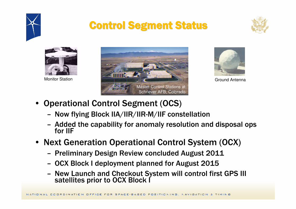
Control Segment Status Control Segment Status Control Segment Status Control Segment Status Control Segment Status Control Segment Status Control Segment Status Control Segment Status
• Operational Control Segment (OCS)– Now flying Block IIA/IIR/IIR-M/IIF constellation
– Added the capability for anomaly resolution and disposal ops for IIF
• Next Generation Operational Control System (OCX) – Preliminary Design Review concluded August 2011
– OCX Block I deployment planned for August 2015
– New Launch and Checkout System will control first GPS III satellites prior to OCX Block I
Monitor Station Ground Antenna
Master Control Stations at
Schriever AFB, Colorado

GPS Status SummaryGPS Status Summary
19
• GPS has continuously met its commitments to all users
• Modernization of all GPS
Segments is on track
• Striving to continually
improve navigation and timing
services while maintaining backward compatibility with
legacy equipment
• GPS is committed to open and transparent cooperation
with the international GNSS
community
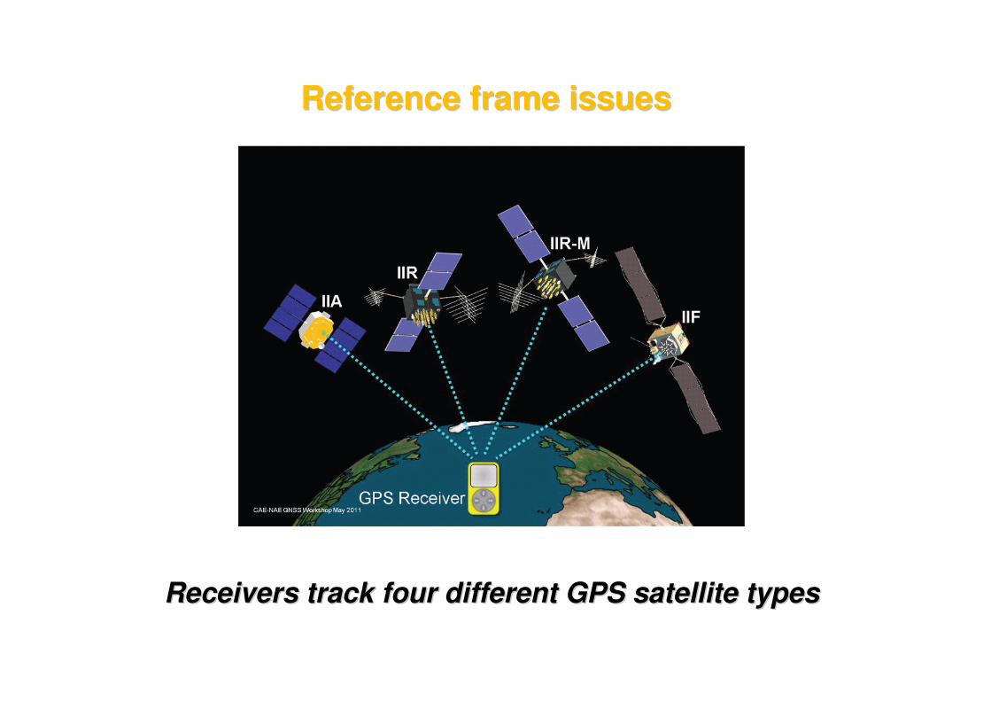
Receivers track four different GPS satellite typesReceivers track four different GPS satellite types
Reference frame issuesReference frame issues
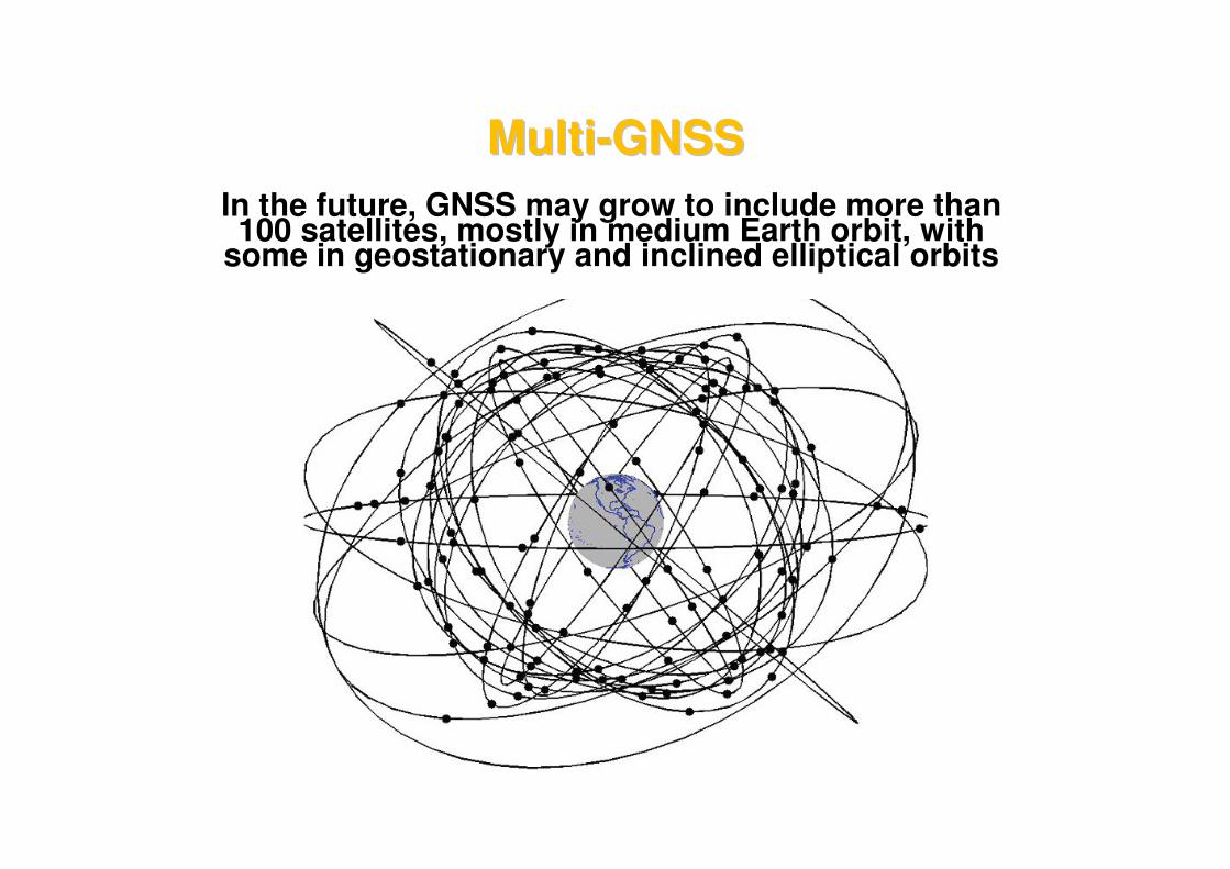
In the future, GNSS may grow to include more than 100 satellites, mostly in medium Earth orbit, with
some in geostationary and inclined elliptical orbits
MultiMulti--GNSSGNSS
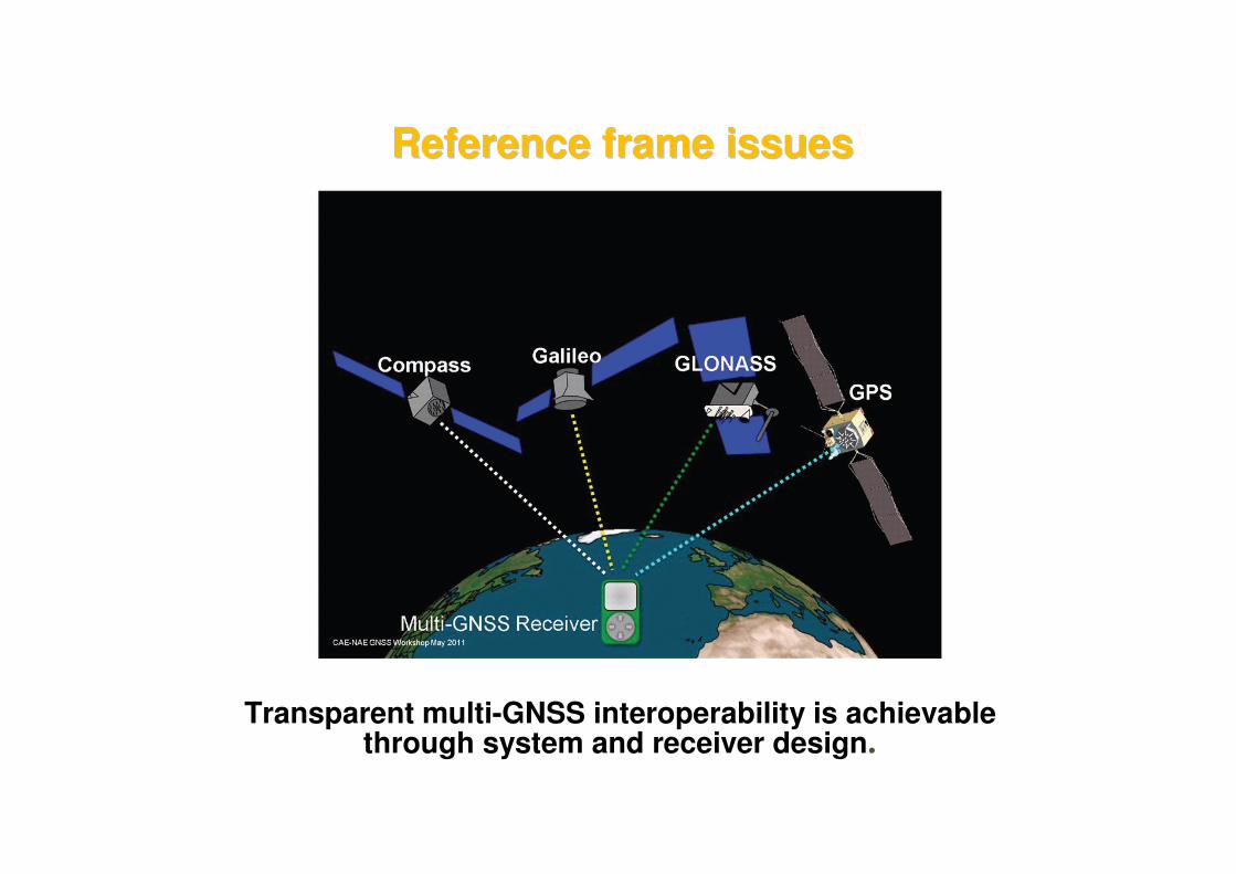
Transparent multi-GNSS interoperability is achievable through system and receiver design.
Reference frame issuesReference frame issues
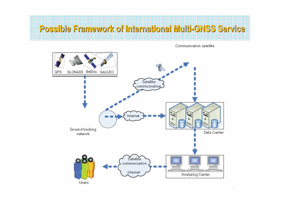
Possible Framework of International MultiPossible Framework of International Multi--GNSS ServiceGNSS Service
GNSS Signal Interference and Detection GNSS Signal Interference and Detection
24
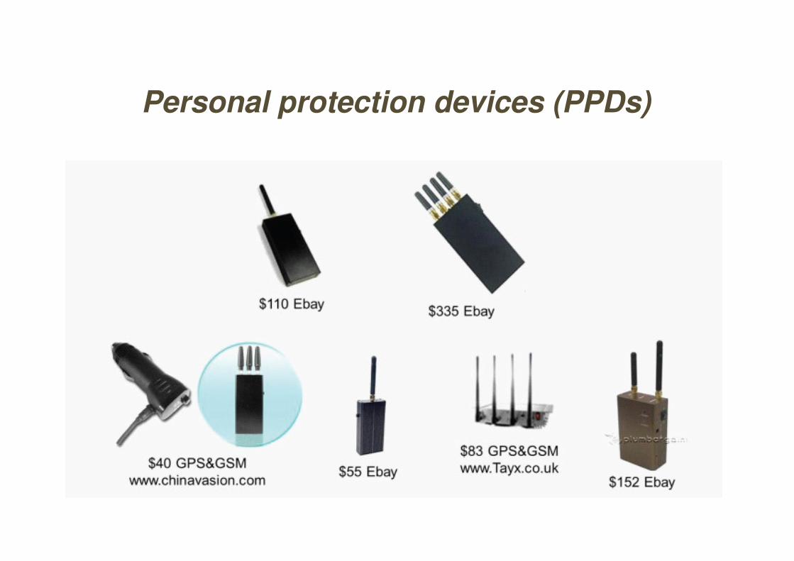
Personal protection devices (PPDs)
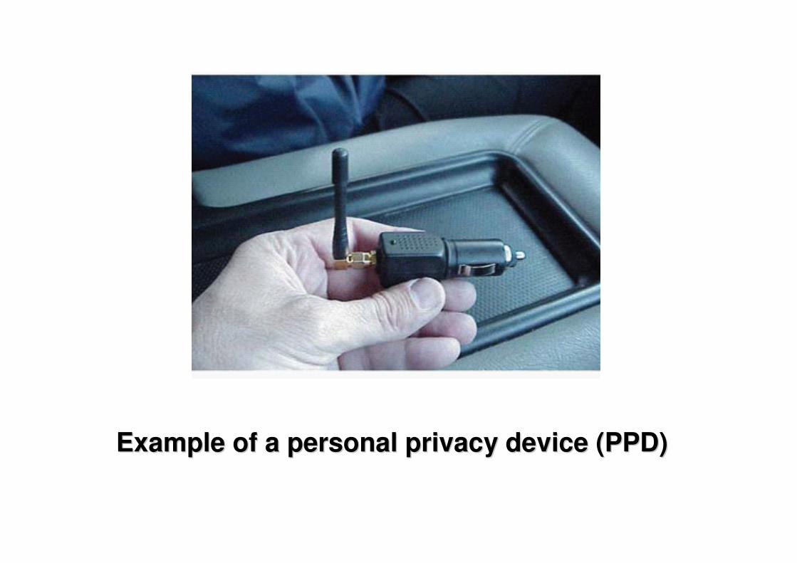
Example of a personal privacy device (PPD)Example of a personal privacy device (PPD)
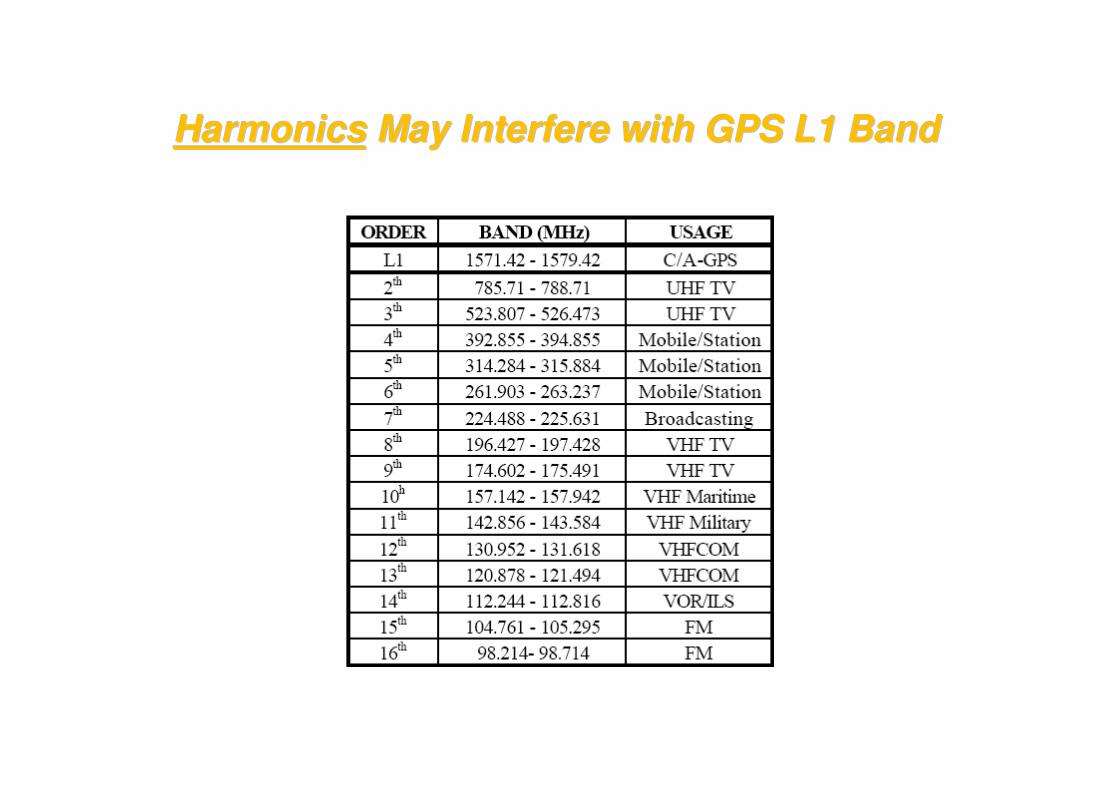
HarmonicsHarmonics May Interfere with GPS L1 BandMay Interfere with GPS L1 Band
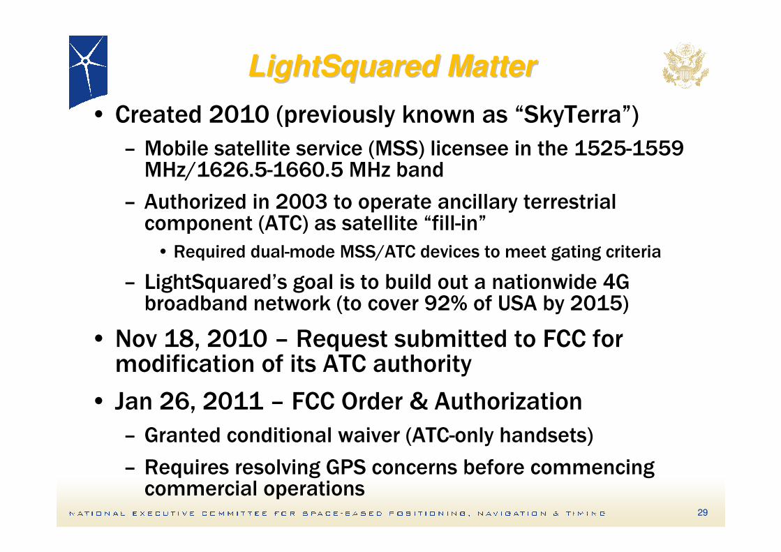
LightSquared MatterLightSquared Matter
29
• Created 2010 (previously known as “SkyTerra”)
– Mobile satellite service (MSS) licensee in the 1525-1559 MHz/1626.5-1660.5 MHz band
– Authorized in 2003 to operate ancillary terrestrial component (ATC) as satellite “fill-in”
• Required dual-mode MSS/ATC devices to meet gating criteria
– LightSquared’s goal is to build out a nationwide 4G broadband network (to cover 92% of USA by 2015)
• Nov 18, 2010 – Request submitted to FCC for modification of its ATC authority
• Jan 26, 2011 – FCC Order & Authorization
– Granted conditional waiver (ATC-only handsets)
– Requires resolving GPS concerns before commencing commercial operations
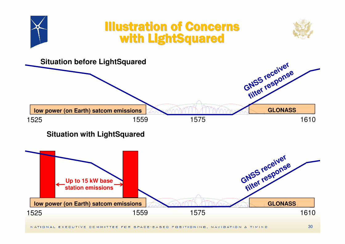
Illustration of ConcernsIllustration of ConcernsIllustration of ConcernsIllustration of ConcernsIllustration of ConcernsIllustration of ConcernsIllustration of ConcernsIllustration of Concernswith LightSquaredwith LightSquaredwith LightSquaredwith LightSquaredwith LightSquaredwith LightSquaredwith LightSquaredwith LightSquared
GLONASS
GLONASS
1525 1559 1575 1610
Situation before LightSquared
GNSS receiver
filter r
esponse
1525 1559 1575 1610
Situation with LightSquared
GNSS receiver
filter r
esponse
low power (on Earth) satcom emissions
low power (on Earth) satcom emissions
30
Up to 15 kW base station emissions
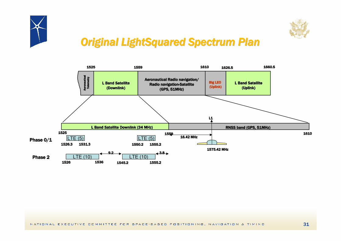
1525152515251525 1559155915591559 1610161016101610
L Band Satellite Downlink (34 MHz)L Band Satellite Downlink (34 MHz)L Band Satellite Downlink (34 MHz)L Band Satellite Downlink (34 MHz) RNSS band (GPS, 51MHz)RNSS band (GPS, 51MHz)RNSS band (GPS, 51MHz)RNSS band (GPS, 51MHz)
LTE (10) LTE (10)1526152615261526 1536153615361536 1545.21545.21545.21545.2 1555.21555.21555.21555.2
3.83.83.83.89.29.29.29.2
LTE (5)1526.31526.31526.31526.3 1531.31531.31531.31531.3
LTE (5)1550.21550.21550.21550.2 1555.21555.21555.21555.2
1575.42 MHz1575.42 MHz1575.42 MHz1575.42 MHz
16.42 MHz16.42 MHz16.42 MHz16.42 MHz
L1L1L1L1
Phase 0/1Phase 0/1Phase 0/1Phase 0/1
Phase 2Phase 2Phase 2Phase 2
1525152515251525 1559155915591559 1626.51626.51626.51626.51610161016101610
L Band SatelliteL Band SatelliteL Band SatelliteL Band Satellite
(Uplink)(Uplink)(Uplink)(Uplink)
L Band SatelliteL Band SatelliteL Band SatelliteL Band Satellite
(Downlink)(Downlink)(Downlink)(Downlink)Aeronautical
Aeronautical
Aeronautical
Aeronautical
Telemetry
Telemetry
Telemetry
Telemetry
Aeronautical Radio navigation/Aeronautical Radio navigation/Aeronautical Radio navigation/Aeronautical Radio navigation/
Radio navigationRadio navigationRadio navigationRadio navigation----SatelliteSatelliteSatelliteSatellite
(GPS, 51MHz)(GPS, 51MHz)(GPS, 51MHz)(GPS, 51MHz)
Big LEO Big LEO Big LEO Big LEO
(Uplink)(Uplink)(Uplink)(Uplink)
1660.51660.51660.51660.5
Original LightSquared Spectrum Plan Original LightSquared Spectrum Plan Original LightSquared Spectrum Plan Original LightSquared Spectrum Plan Original LightSquared Spectrum Plan Original LightSquared Spectrum Plan Original LightSquared Spectrum Plan Original LightSquared Spectrum Plan
31
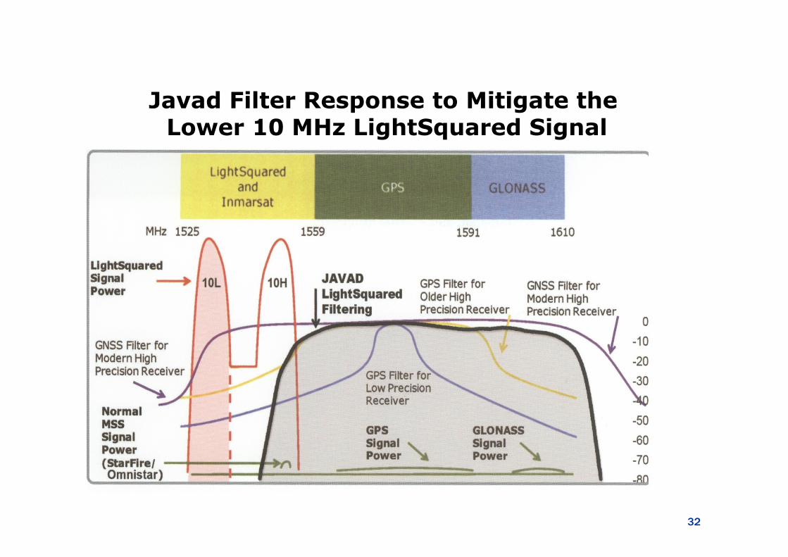
Javad Filter Response to Mitigate theLower 10 MHz LightSquared Signal
32
LightSquared (LSQ) LightSquared (LSQ)
– Testing of LSQ signal directly adjacent to GPS from LSQ towers to identify impact on the GPS signal
• Testing conclusively showed that the LSQ’s signal interfered directly with GPS receiver operation
– On February 14, 2012 the FCC rescinded the “Conditional Waiver Order” to continue to protect GPS receiver operation
– Federal Communications Commission (FCC) Office of Engineering and Technology is reviewing spectrum efficiency and receivers
• This is to enhance the use of spectrum for mobile broadband without affecting the GPS spectrum
– U.S. Department of Transportation and Commerce Department's National Telecommunications and Information Administration (NTIA)
• NTIA is the other U.S. organization that manages government spectrum • U.S. interagency working to draft new GPS spectrum-interference
standards to further strengthen existing policy protection of GPS
Summary on LightSquaredSummary on LightSquaredSummary on LightSquaredSummary on LightSquaredSummary on LightSquaredSummary on LightSquaredSummary on LightSquaredSummary on LightSquared
• LightSquared signals caused harmful interference to majority of GPS receivers tested
– With exception of cellular phones, Lower 10 MHz does not solve the problem, particularly with high-precision receivers
• Even an acceptable filter solution would need a long term transition/implementation plan to protect legacy GPS service and users (similar to semi-codeless GPS or analog to digital TV)
34

THANK YOU