Embed Size (px)
Citation preview
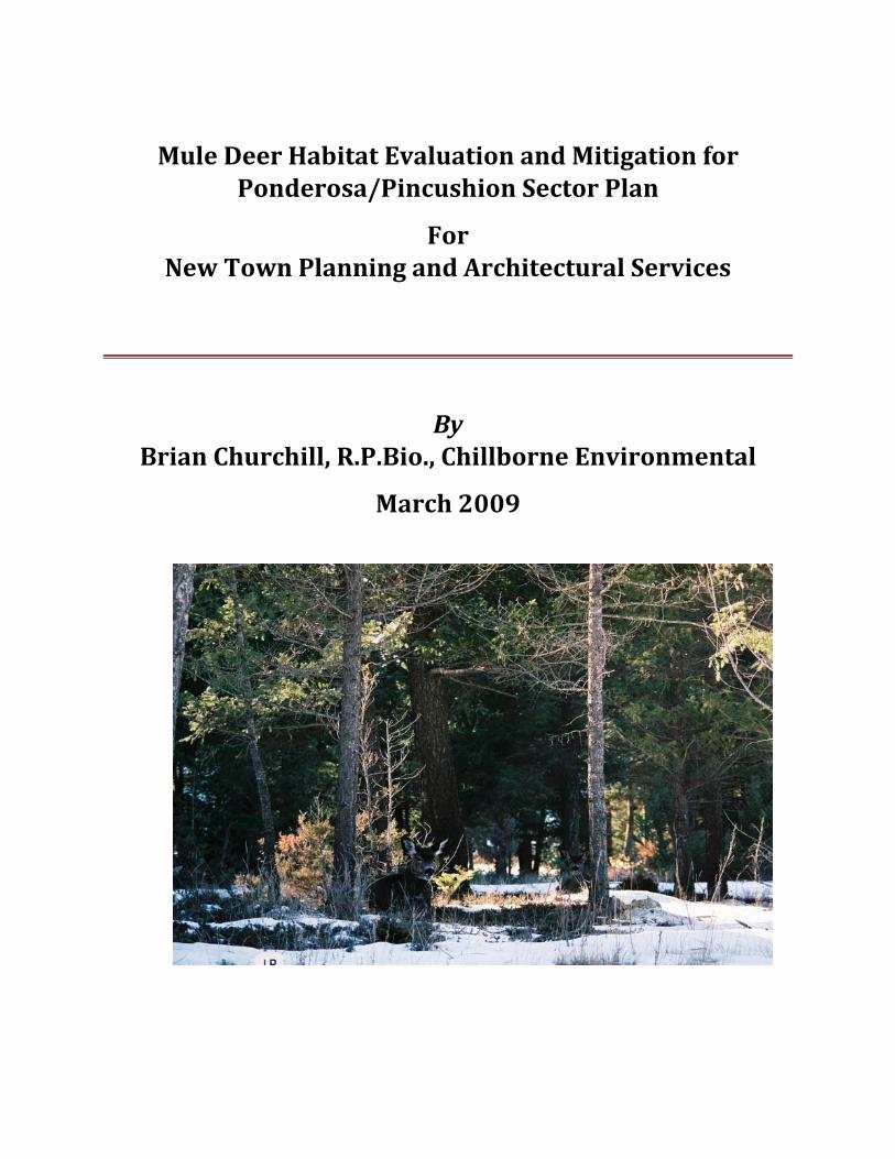
Mule Deer Habitat Evaluation and Mitigation for Ponderosa/Pincushion Sector Plan
For New Town Planning and Architectural Services
By Brian Churchill, R.P.Bio., Chillborne Environmental
March 2009
Mule Deer Habitat Evaluation and Mitigation for Ponderosa/Pincushion Sector Plan 2009
©Chillborne Environmental* March 2009 Page 2 of 31
*A Division of Chillborne Holdings Ltd SS2 Site 22 Compartment 23 Fort St. John, BC V1J 4M7 [email protected]
TABLE OF CONTENTS
EXECUTIVE SUMMARY ......................................................................................................................................... 5
BACKGROUND ......................................................................................................................................................... 7
SCOPE OF PROJECT ................................................................................................................................................ 7
OBJECTIVES .............................................................................................................................................................. 8
METHODOLOGY ...................................................................................................................................................... 9
RESULTS: ................................................................................................................................................................ 10
ECOLOGICAL CLASSIFICATION OF PEACHLAND WINTER RANGE AND THE ANNEX ................................................... 10
MULE DEER WINTER RANGE CURRENT SUITABILITY RATINGS ................................................................................... 12
WINTER RANGE ENHANCEMENT POTENTIAL .................................................................................................................. 13
SENSITIVE ECOSYSTEM POTENTIAL ................................................................................................................................... 16
WINTER RANGE REMAINING IN ANNEX AFTER DEVELOPMENT ................................................................................... 16
Mule Deer Habitat Evaluation and Mitigation for Ponderosa/Pincushion Sector Plan 2009
©Chillborne Environmental* March 2009 Page 3 of 31
*A Division of Chillborne Holdings Ltd SS2 Site 22 Compartment 23 Fort St. John, BC V1J 4M7 [email protected]
IMPACTS ON WINTER RANGE OF TRAILS, RECREATIONAL USE ........................................................ 18
MITIGATION STRATEGIES .................................................................................................................................................... 18
Off Road Vehicle Use ............................................................................................................................................................ 19
Invasive plants ....................................................................................................................................................................... 21
Harassment by Dogs ............................................................................................................................................................ 21
High levels of Human Use .................................................................................................................................................. 21
WILDFIRE INTERFACE ISSUES ........................................................................................................................ 22
MITIGATION LOSS OF HABITAT ................................................................................................................... 23
INDICATORS AND MONITORING.................................................................................................................... 24
SUMMARY .............................................................................................................................................................. 24
REFERENCES AND BIBLIOGRAPHY: .............................................................................................................. 26
APPENDIX A: CONSERVATION ORGANIZATIONSS ................................................................................... 27
OKANAGAN REGION WILDLIFE HERITAGE FUND SOCIETY, .......................................................................................... 27
HABITAT CONSERVATION TRUST FUND (HCTF) ........................................................................................................... 28
APPENDIX B: LARGER MAPS ........................................................................................................................... 29
APPENDIX C: CONTACTS FOR MAP FILES ................................................................................................... 31
Table 1 Winter Range Ecological Classification ................................................................................................. 10
Table 2 Mule Deer Winter Range Current Suitability Ratings ................................................................... 12
Table 3 Priority polygons for enhancement ........................................................................................................ 15
Table 4 Annex Zone areas .............................................................................................................................................. 17
Figure 1 Ecological Classification of Peachland Winter Range and the Annex ................................ 11
Mule Deer Habitat Evaluation and Mitigation for Ponderosa/Pincushion Sector Plan 2009
©Chillborne Environmental* March 2009 Page 4 of 31
*A Division of Chillborne Holdings Ltd SS2 Site 22 Compartment 23 Fort St. John, BC V1J 4M7 [email protected]
Figure 2 Mule Deer Winter Range Current Suitability Ratings ................................................................. 12
Figure 3 suggested High potential enhancement areas (IDF zone) ........................................................ 14
Figure 4 ExistingRoads and Trails From The Integrated Registry (ILRR) .......................................... 19
Figure 5 Proposed roads and Trails ......................................................................................................................... 20
Figure 6 Mule Deer winter Range ratings& structural stages ................................................................... 29
Figure 7Mule Deer Ratings and important Rock Talus Elements ............................................................ 30
Acknowledgements
This project has been conducted under the Guidance of Keith Funk and Lisa Fraser of New Town Planning and Architectural Services for the client Treegroup Developments Corp.
The project wasn’t possible without the Terrestrial Ecosystem Mapping provided by John Grods with permission from Sun Developments.
We are appreciative of the assistance provided by Richard Bugera of New Town, John Grods R.P.Bio., Makonis Consulting Ltd., Gary Tipper of the Nature Conservancy and Brian Robertson and Robert Stewart of the Ministry of Environment.
Thank you.
Brian Churchill R. P. Bio ‐Chillborne Environmental
Kirstin Campbell PHD – TerraTree Forestry
Mule Deer Habitat Evaluation and Mitigation for Ponderosa/Pincushion Sector Plan 2009
©Chillborne Environmental* March 2009 Page 5 of 31
*A Division of Chillborne Holdings Ltd SS2 Site 22 Compartment 23 Fort St. John, BC V1J 4M7 [email protected]
EXECUTIVE SUMMARY
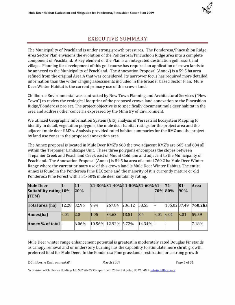
The Municipality of Peachland is under strong growth pressures. The Ponderosa/Pincushion Ridge Area Sector Plan envisions the evolution of the Ponderosa/Pincushion Ridge area into a complete component of Peachland. A key element of the Plan is an integrated destination golf resort and village. Planning for development of this golf course has required an application of crown lands to be annexed to the Municipality of Peachland. The Annexation Proposal (Annex) is a 59.5 ha area refined from the original Area A that was considered. Its narrower focus has required more detailed information than the wider ranging assessments included in the broader based Sector Plan. Mule Deer Winter Habitat is the current primary use of this crown land.
Chillborne Environmental was contracted by New Town Planning and Architectural Services (“New Town”) to review the ecological footprint of the proposed crown land annexation to the Pincushion Ridge/Ponderosa project. The project objective is to specifically document mule deer habitat in the area and address other concerns expressed by the Ministry of Environment.
We utilized Geographic Information System (GIS) analysis of Terrestrial Ecosystem Mapping to identify in detail, vegetation polygons, the mule deer habitat ratings for the project area and the adjacent mule deer RMZ’s. Analysis provided rated habitat summaries for the RMZ and the project by land use zones in the proposed annexation area.
The Annex proposal is located in Mule Deer RMZ’s 668 the two adjacent RMZ’s are 665 and 684 all within the Trepanier Landscape Unit. These three polygons encompass the slopes between Trepanier Creek and Peachland Creek east of Mount Coldham and adjacent to the Municipality of Peachland. The Annexation Proposal (Annex) is 59.5 ha area of a total 760.2 ha Mule Deer Winter Range where the current primary use of this crown land is Mule Deer Winter Habitat. The entire Annex is found in the Ponderosa Pine BEC zone and the majority of it is currently mature or old Ponderosa Pine Forest with a 31‐50% mule deer suitability rating.
Mule Deer Suitability rating (TEM)
110%
1120%
2130% 3140% 4150% 5160% 6170%
7180%
8190%
Area
Total area (ha) 12.28 32.96 9.94 267.84 236.12 58.55 ‐ 105.02 37.49 760.2ha
Annex(ha) <.01 2.0 1.05 34.63 13.51 8.4 <.01 <.01 <.01 59.59
Annex % of total ‐ 6.06% 10.56% 12.92% 5.72% 14.34% ‐ ‐ ‐ 7.18%
Mule Deer winter range enhancement potential is greatest in moderately rated Douglas Fir stands as canopy removal and or understory burning has the capability to stimulate more shrub growth, preferred food for Mule Deer. In the Ponderosa Pine grasslands restoration or a strong growth
Mule Deer Habitat Evaluation and Mitigation for Ponderosa/Pincushion Sector Plan 2009
©Chillborne Environmental* March 2009 Page 6 of 31
*A Division of Chillborne Holdings Ltd SS2 Site 22 Compartment 23 Fort St. John, BC V1J 4M7 [email protected]
response of grassland to prescribed fire will produce more of an increase in the quality of Mule Deer Forage than and increase in overall quantity.
The development of the Pincushion/Ponderosa Sector Plan will increase the human population of the immediate area greatly. The development area abuts the Mule Deer Winter Range to the north, west and south. The increased population will likely increase uses on the winter range some of which could be detrimental to its winter range values and use by Mule Deer Primary conflicts are likely to be: Off Road Vehicle Use, Invasive plants, Harassment by Dogs and High levels of Human Use. A proactive identification and management of uses can prevent the majority of these potential impacts.
There are a large number of sensitive ecosystem components that have some probability of occurring in the project area. While forested grasslands are in themselves sensitive and regionally scarce they are not the components that require site identification and individual management at this site. The polygons identified as Rock, Talus or Cliff has features that indicate a high probability of the occurrence of scarce ecosystem elements, such as listed reptiles. Inventory of these areas to identify occurrence of scarce sensitive ecosystem components is an intensive project that should occur during the spring and summer prior to construction disturbance.
Development of the Annex will remove a significant part of the Mule Deer Winter range and this removal combined with the dramatic increase in local population makes the preservation and good management of the remaining winter range crucial. Conflicts that would additionally indirectly impact the winter range as a result of the Annexation Proposal are addressed.
The proposed development interfaces with crown lands whose primary use is Mule Deer Winter Range. Firesmart principles include both management of the ignition potential in the urban development through standards for structures and the developed site and reducing the fire hazard on the Mule Deer Winter Range in the Ponderosa Pine low snow areas is compatible with Mule Deer range enhancement. Municipalities, developers and home owners are encouraged to plan and mitigate for the wildfire hazard potential in this interface. There are a number of provincial programs available to assist municipalities in this planning.
The alienation the 59.59ha (the Annex) to allow for the construction of the golf course and housing will result in the complete loss of mule deer winter habitat values on 16 hectares and the loss of most winter range habitat values on the 43.5 ha designated for golf course. Although some winter browse will remain on the outer edges of the golf course this value is very small. Some additional loss will occur from trail development and use; however there is opportunity to mitigate this loss through vegetation management on other parts of the winter range. An estimate of the costs of enhancement activities to mitigate for the loss of the Annex would range in the order of $5500 to $8500 per year. This could be accomplished by annual payments, lump sums periodically or the establishment of an endowment.
Mule Deer Habitat Evaluation and Mitigation for Ponderosa/Pincushion Sector Plan 2009
©Chillborne Environmental* March 2009 Page 7 of 31
*A Division of Chillborne Holdings Ltd SS2 Site 22 Compartment 23 Fort St. John, BC V1J 4M7 [email protected]
BACKGROUND
The Municipality of Peachland is under strong growth pressures. The Ponderosa/Pincushion Ridge Area Sector Plan envisions the evolution of the Ponderosa/Pincushion Ridge area into a complete component of Peachland. A key element of the Plan is an integrated destination golf resort and village. Planning for development of this golf course has required an application of crown lands to be annexed to the Municipality of Peachland.
The Annexation Proposal (Annex) is a 59.59 ha area refined from the original Area A that was considered. Its narrower focus has required more detailed information than the wider ranging assessments included in the broader based Sector Plan. Mule Deer Winter Habitat is the current primary use of this crown land.
SCOPE OF PROJECT
Chillborne Environmental (“Chillborne”) was contracted by New Town Planning and Architectural Services (“New Town”) to review the ecological footprint of the proposed crown land annexation to the Pincushion Ridge/Ponderosa project. Brian Churchill, R. P. Bio. (#128) undertook this assessment on behalf of Chillborne. Mr. Churchill is familiar with the general area and ecology from his training education and work expertise. He is familiar with the specific area from his recent work with mountain goats along Highway 97 between Summerland and Peachland.
This project will build on previous assessment work by Summitt Environmental and Cascadia Natural Resource Consultants. Mapping and site investigation work on the larger annexation area A has been completed by Cascadia (van Woudenberg 2007), Makonis (Grods 2005‐9). Additionally mule deer habitat models are provided in the South Okanagan Valley Terrestrial Ecosystem Mapping (Iverson, K. and A. Haney 2005).
Mule Deer Habitat Evaluation and Mitigation for Ponderosa/Pincushion Sector Plan 2009
©Chillborne Environmental* March 2009 Page 8 of 31
*A Division of Chillborne Holdings Ltd SS2 Site 22 Compartment 23 Fort St. John, BC V1J 4M7 [email protected]
The project objective to specifically document mule deer habitat in the area and address other concerns of the Ministry of Environment as outlined in a letter from Brian Robertson to Keith Funk dated January 13, 2009. We were provided with background studies and the proposed annexation boundary and proposed zoning/ development criteria as proposed as of February 2009. Our work is constrained in scope to the proposal as of that date.
The major scope of this proposal is construct a Mule Deer habitat and mitigation document to complement existing documentation in the Ponderosa/Pincushion Sector Plan that will meet the requirements of the Ministry of Environment (MOE) as outlined in Mr. Robertson’s letter. The work will include; calculations based on the footprint outlines provided by New Town, utilization of GIS databases to construct impact tables from detailed ecosystem mapping, assessment of existing and future mule deer habitat productivity, a table of impacts and disturbances and strategies for mitigation and compensation for these impacts.
The secondary scope of the project was to similarly define grasslands, riparian features, defined special habitat features and red or blue listed species. This assessment is intended to cover issues relating to the annexation, additional specific on site issue management will have to be conducted as part of the development and construction process.
While this proposal is intended to assist in meeting information needs for the Ministry of Environment as outlined to Mr. Funk by Mr. Robertson’s letter, our work is our best professional effort but is not warranted to achieve the approval of Ministry of Environment.
OBJECTIVES
To quantify and assess the impact of the Ponderosa/Pincushion Sector Plan on mule deer habitat and habitat potential, including direct and indirect impacts.
To quantify and assess the grassland and riparian components, and additionally consider potential risks to red and blue species and special habitat features.
To present impact information in tabular or map formats.
To identify the best management practices to reduce environmental impacts on ecosystems on which mule deer depend.
Mule Deer Habitat Evaluation and Mitigation for Ponderosa/Pincushion Sector Plan 2009
©Chillborne Environmental* March 2009 Page 9 of 31
*A Division of Chillborne Holdings Ltd SS2 Site 22 Compartment 23 Fort St. John, BC V1J 4M7 [email protected]
To identify activities for the protection/mitigation of mule deer and their wintering capacity in the Sector Area.
To suggest monitoring criteria for project appropriate wildlife management in the Sector.
METHODOLOGY
Initially, we reviewed the Ponderosa/Pincushion Sector Plan, especially Appendices A and B. We reviewed additional pertinent information on Mule Deer Habitat Management for the Okanagan, primarily mule deer habitat models are provided in the South Okanagan Valley Terrestrial Ecosystem Mapping (TEM) (Iverson, K. and A. Haney 2005).
We acquired the Draft TEM for the project area (Grods 2005) and project proposed footprint layers from New Town Services. We also acquired information from the Okanagan Shuswap Land and Resources Management Plan (LRMP), including mule deer Resource Management Zone (RMZ) units and general guidelines for Low Snow Zone.
We utilized Geographic Information System (GIS) analysis to identify in detail, vegetation polygons, the mule deer habitat ratings for the project area and the adjacent mule deer RMZ’s. Analysis provided rated habitat summaries for the RMZ and the project by land use zones in the proposed annexation area. We utilized the GIS data to overlay the project boundaries and zoning on ortho‐digital photography to provide information on the special relationship of the site to the overall mule deer winter range, to the existing urban/rural settlement and land use and to the forest cover identified in the TEM analysis.
We reviewed Regional District community information pertaining to management of “interface lands” those lands along the boundary of crown or wildlands and developed areas. Most information was gained from the “Firesmart” manuals (Firesmart 2003).
We queried the use of prescribed fire in the Okanagan PPxh1 zone and interpreted the TEM Vegetation Polygons for enhancement potential. Primary analysis was based on the structural stage, mule deer ratings and area calculations from the TEM mapping. Secondary analysis utilized the calculation of Mule Deer Winter Range enhance‐ability from applying a projected increase in winter range suitability from enhancement techniques that include; canopy coverage manipulation using either or both mechanical clearing and prescribed fire and forage species management utilizing either or both mechanical clearing and prescribed fire but also seeding/weed control if

Mule Deer Habitat Evaluation and Mitigation for Ponderosa/Pincushion Sector Plan 2009
©Chillborne Environmental* March 2009 Page 10 of 31
*A Division of Chillborne Holdings Ltd SS2 Site 22 Compartment 23 Fort St. John, BC V1J 4M7 [email protected]
required. MOE staff Brian Robertson and Robert Stewart have provided valuable observations on the general range condition and trends on these Mule Deer RMZ’s and the annexation area.
RESULTS:
The Annex proposal is located in Mule Deer RMZ’s 668 the two adjacent RMZ’s are 665 and 684 all within the Trepanier Landscape Unit. These three polygons encompass the slopes between Trepanier Creek and Peachland Creek east of Mount Coldham and adjacent to the Municipality of Peachland.
ECOLOGICAL CLASSIFICATION OF PEACHLAND WINTER RANGE AND THE ANNEX
TABLE 1 WINTER RANGE ECOLOGICAL CLASSIFICATION
BEC Zone BEC Structural Stage
Hectares Annex hectares
Annex as %
Interior Douglas Fir 380.63 0
herb 15.93 0
Young forest 17.05
Mature and old forest 311.16 0
shrub 11.81
rock 24.68 0
Ponderosa Pine 379.60 59.59 15.69% herb .34 0.15 44.11% shrub 3.72Young Forest 56.13
Mature and old forest 229.84 46.51 20.23%
Cliff 35.42 1.85 5.22% rock and talus 54.14 9.78 18.06%
Total area of Crown Range in RMZ ‘s 668,665 &684
760.23 59.59 7.83%
Mule Deer Habitat Evaluation and Mitigation for Ponderosa/Pincushion Sector Plan 2009
©Chillborne Environmental* March 2009 Page 11 of 31
*A Division of Chillborne Holdings Ltd SS2 Site 22 Compartment 23 Fort St. John, BC V1J 4M7 [email protected]
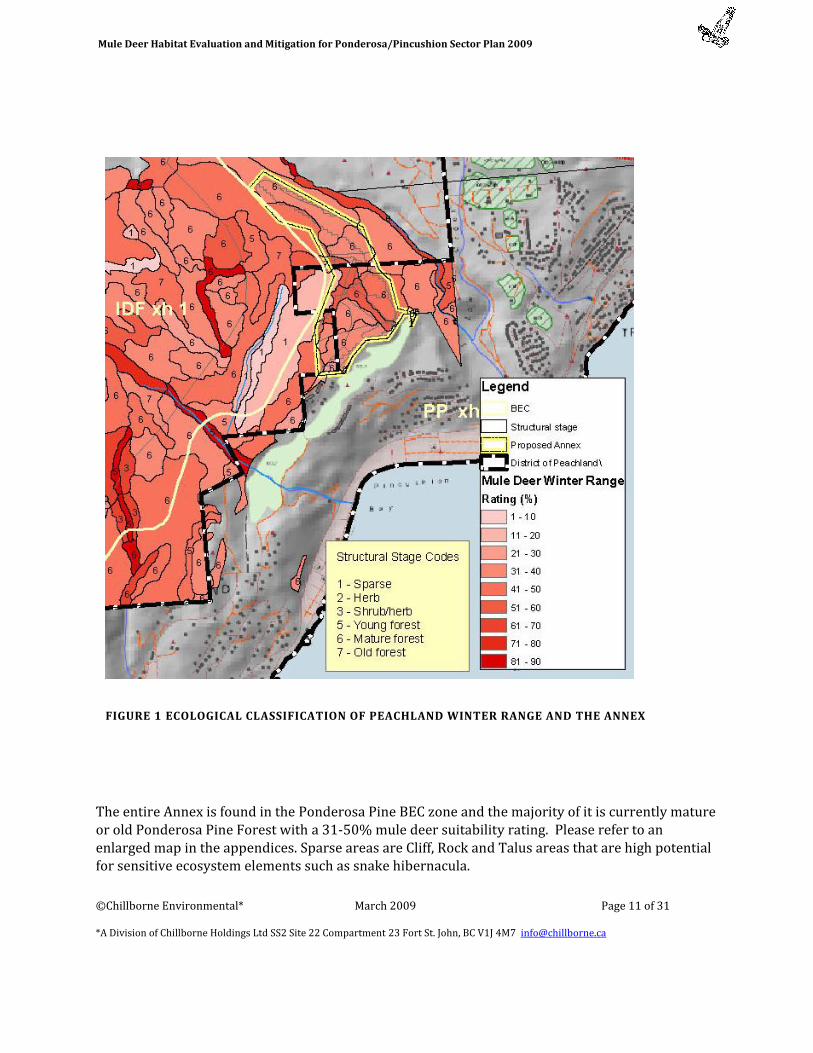
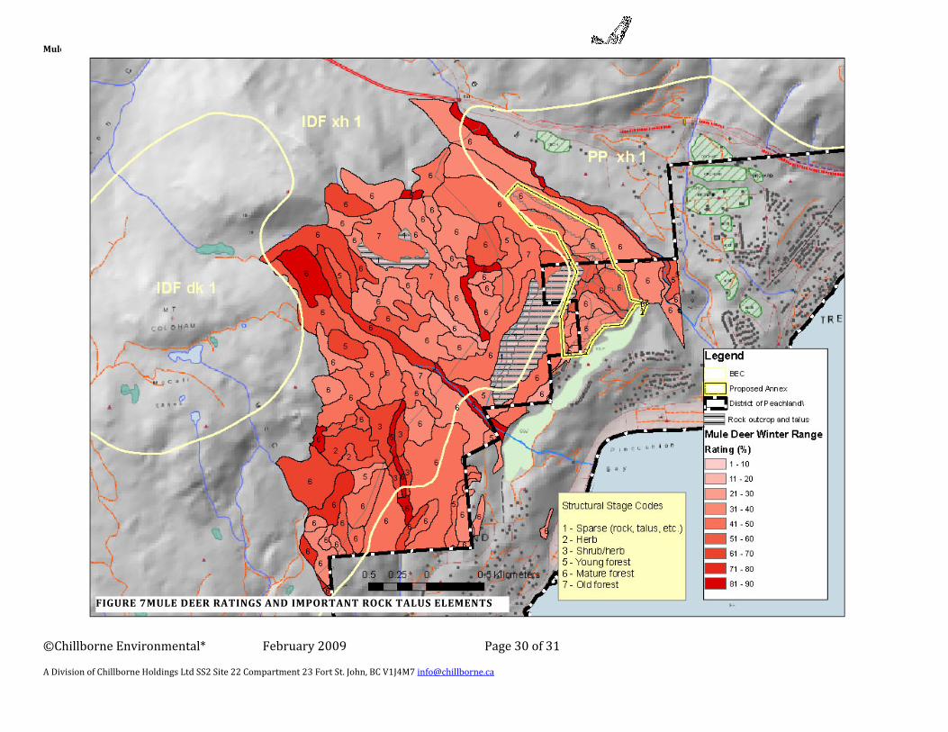
The entire Annex is found in the Ponderosa Pine BEC zone and the majority of it is currently mature or old Ponderosa Pine Forest with a 31‐50% mule deer suitability rating. Please refer to an enlarged map in the appendices. Sparse areas are Cliff, Rock and Talus areas that are high potential for sensitive ecosystem elements such as snake hibernacula.
FIGURE 1 ECOLOGICAL CLASSIFICATION OF PEACHLAND WINTER RANGE AND THE ANNEX
Mule Deer Habitat Evaluation and Mitigation for Ponderosa/Pincushion Sector Plan 2009
©Chillborne Environmental* March 2009 Page 12 of 31
*A Division of Chillborne Holdings Ltd SS2 Site 22 Compartment 23 Fort St. John, BC V1J 4M7 [email protected]
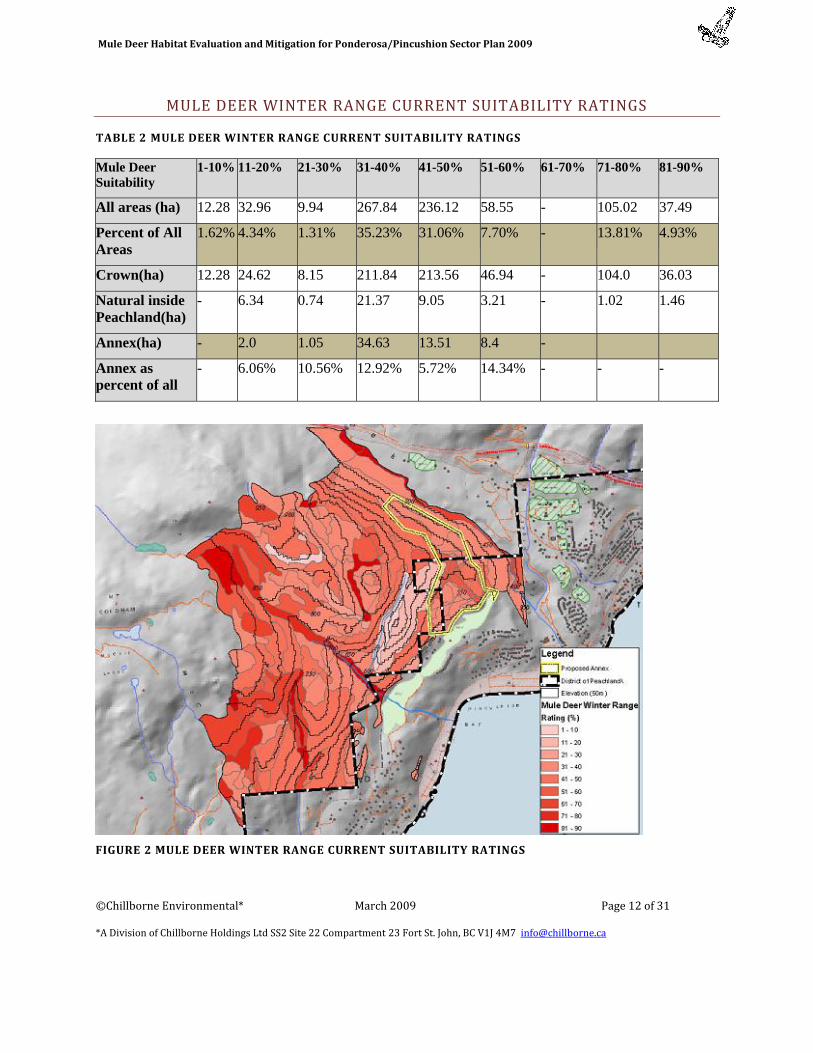
MULE DEER WINTER RANGE CURRENT SUITABILITY RATINGS
TABLE 2 MULE DEER WINTER RANGE CURRENT SUITABILITY RATINGS
Mule Deer Suitability
1-10% 11-20% 21-30% 31-40% 41-50% 51-60% 61-70% 71-80% 81-90%
All areas (ha) 12.28 32.96 9.94 267.84 236.12 58.55 - 105.02 37.49
Percent of All Areas
1.62% 4.34% 1.31% 35.23% 31.06% 7.70% - 13.81% 4.93%
Crown(ha) 12.28 24.62 8.15 211.84 213.56 46.94 - 104.0 36.03
Natural inside Peachland(ha)
- 6.34 0.74 21.37 9.05 3.21 - 1.02 1.46
Annex(ha) - 2.0 1.05 34.63 13.51 8.4 -
Annex as percent of all
- 6.06% 10.56% 12.92% 5.72% 14.34% - - -
FIGURE 2 MULE DEER WINTER RANGE CURRENT SUITABILITY RATINGS

Mule Deer Habitat Evaluation and Mitigation for Ponderosa/Pincushion Sector Plan 2009
©Chillborne Environmental* March 2009 Page 13 of 31
*A Division of Chillborne Holdings Ltd SS2 Site 22 Compartment 23 Fort St. John, BC V1J 4M7 [email protected]
WINTER RANGE ENHANCEMENT POTENTIAL
The Okanagan Shuswap LRMP identifies that Mule Deer in the main Okanagan valley utilize low snow areas for winter range and are not reliant on the snow interception of forest canopy as indicated in the Mule Deer Habitat model for the Caribou (Armletter 1986). The Okanagan Innovative Forestry Project is showing mule deer winter range activity is determined but by the forage (primarily shrub) availability (van Woudenberg, 2007). Discussion with the Ecosystems staff of MOE indicate that the Annexation area is primarily used by Mule Deer when snow depths at higher elevation push them down out of the Interior Douglas Fir Zone higher on the mountain during mid to late winter.
Mule Deer forage (primarily shrubs) is more abundant and available in Interior Douglas Fir forest types than in Ponderosa Pine Forest types, with the exception of Riparian Areas. Ponderosa Pine Forest types in the area tend to have a primarily grassy understory (van Woudenberg, 2007) whereas the Interior Douglas Fir types tend to have more shrubs in a mixed shrub grassland understory.
The LRMP identifies (Appendix V pg 4‐12 section 3.2) that to maintain or enhance forage for Mule Deer Range Use Plans (RUPs) will “identify and manage for desired plant communities(DPC) that favour mule deer winter browse species. Winter deer browse species include Ceanothus spp., Saskatoon, Rosa spp., chokecherry, Douglas Maple, Salix spp. etc.” These species are not common in dryer sites in the Ponderosa Pine Zone. Enhancement potential is therefore necessarily focused on the Interior Douglas Fir Zone where increases in shrubs are more feasible.
The current mule deer winter range suitability is illustrated in Figure 2 , showing the highest suitability along the riparian areas along Peachland Creek, Trepanier Creek and to the north of Pincushion Mountain. The rocky slopes of Pincushion Mountain show the lowest rating.
Most of the area including the majority of the Annex is of moderate rating (31‐40% suitability). (note The Mule Deer rating was based on the maximum value (from 1 to 100) that could be provided in a given polygon for winter feeding (shrub and/or bunchgrass habitats), security (coniferous forest) or thermal (open sunny ridges and slopes) as modeled using the polygons from this project to which were applied the Central Okanagan TEM ratings.) These sites are relatively good growing sites in the Ponderosa Pine Zone, i.e. have the biological capacity to grow large‐size trees and abundant grasses, relative to other steeply‐sloped sites in the area.
Mule Deer winter range enhancement potential is greatest in the moderately rated moister Douglas Fir stands as canopy removal and or understory burning has the capability to stimulate more shrub growth, preferred food for Mule Deer. In the Ponderosa Pine grasslands restoration or a strong growth response of grassland to prescribed fire will produce more of an increase in the quality of Mule Deer Forage than an increase in overall quantity.
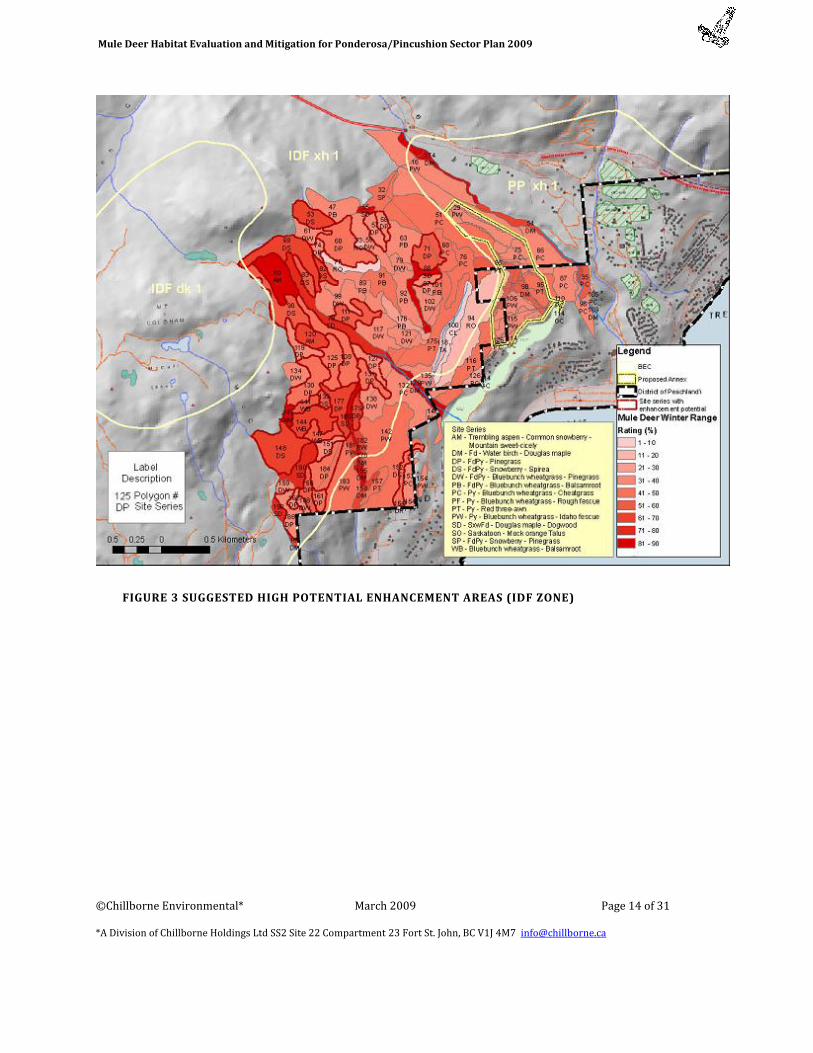
We have identified polygons with the best potential for enhancement in Figure 3 suggested High potential enhancement areas (IDF zone)
Mule Deer Habitat Evaluation and Mitigation for Ponderosa/Pincushion Sector Plan 2009
©Chillborne Environmental* March 2009 Page 14 of 31
*A Division of Chillborne Holdings Ltd SS2 Site 22 Compartment 23 Fort St. John, BC V1J 4M7 [email protected]
FIGURE 3 SUGGESTED HIGH POTENTIAL ENHANCEMENT AREAS (IDF ZONE)

Mule Deer Habitat Evaluation and Mitigation for Ponderosa/Pincushion Sector Plan 2009
©Chillborne Environmental* March 2009 Page 15 of 31
*A Division of Chillborne Holdings Ltd SS2 Site 22 Compartment 23 Fort St. John, BC V1J 4M7 [email protected]
The identified potential priority enhancement areas are:
TABLE 3 PRIORITY POLYGONS FOR ENHANCEMENT
IDF High Priority Potential Enhancement Site Series Name
Symbol TEM Polygon Numbers
Total Area (ha)
Trembling aspen - Common snowberry - Mountain sweet-cicely
AM 80, 120 143
20.64
FdPy - Pinegrass DP 57, 58, 60, 71, 74, 97, 108, 111, 119, 125, 127, 130, 131, 151, 156, 161, 162, 177, 179, 184, 186
109.66
FdPy - Snowberry - Spirea DS 53, 69, 82, 83, 90, 139, 148, 152
83.53
Bluebunch wheatgrass - Balsamroot
WB
141, 144, 147 14.11
The Ponderosa Pine zone while important as a low snow winter zone and spring range has less potential for shrub enhancement. The wide spacing of mature trees in this zone limits mule deer use for thermal and escape cover in these forests. Management for healthy bunchgrass communities will provide the best mule deer range for this site series. Enhancement, while often worthwhile, is limited to managing against invasive species, spacing for reduced canopy coverage and periodic rejuvenation to reduce dry needles and grass residue. These activities fit well with interface fire management strategies and programs.
Priority polygons for enhancement were identified based on site series. Those site series which had high suitability were determined to have the most potential for activities which could enhance habitat potential such as forage. The majority of enhancement activities should therefore be prioritized for those areas with these site series, but which currently have lower suitability ratings.
Figure 3 suggested High potential enhancement areas (IDF zone),also shows that at the north west end of the Annex two polygons (PW, PC) could potentially play a strong role in maintaining connectivity between the remaining mule deer winter range on the slopes and benches immediately south of Trepanier Creek and the IDF winter ranges to the south and west. It is strongly suggested that the mature forest cover in these polygons be maintained to provide
Mule Deer Habitat Evaluation and Mitigation for Ponderosa/Pincushion Sector Plan 2009
©Chillborne Environmental* March 2009 Page 16 of 31
*A Division of Chillborne Holdings Ltd SS2 Site 22 Compartment 23 Fort St. John, BC V1J 4M7 [email protected]
connectivity as a thermal and escape corridor. (Tem Polygons 889,890,874,873,868,851,843 PP and 811 813 836 IDF)
SENSITIVE ECOSYSTEM POTENTIAL
There are a large number of sensitive ecosystem components that have some probability of occurring in the project area. While forested grasslands are in themselves sensitive and regionally scarce they are not the components that require site identification and individual management at this site. The polygons identified as Rock, Talus or Cliff has features that indicate a high probability of the occurrence of scarce ecosystem elements, such as snake hibernacula, other scarce reptile occurrence and scarce plant communities. Lewis’s Woodpecker, Townsend’s Big‐eared Bat and other bat species utilize large trees and cavities so management for these species must be included in the tree retention strategies in detailed site planning and operations, especially those close to the rock talus areas.
Inventory of these areas to identify occurrence of scarce sensitive ecosystem components is an intensive project that should occur during the spring and summer prior to construction disturbance. If occurrences are identified there are some management guidelines that can be adapted to mitigate impacts on the ecosystem elements and in the case of rattlesnakes, the “challenges” they may pose to human use in the area.
The LRMP has an objective to provide suitable well distributed habitat for wildlife tree dependant species. The strategies include assessing larger diameter stems for those that can be safely retained with high value wildlife trees being a priority (Appendix V, pg 3‐3 section 1, 1.2, 1.3). There is a consideration of safety as deteriorating snags are often the highest value wildlife trees, especially for Lewis Woodpecker nests. Of special note is the importance of large trees, both dead and alive in the Ponderosa Pine ecosystem. Special consideration and marking of large trees that can be safely retained during the development is imperative to an ecologically responsible development.
It is important that an on the ground inventory of the high probability polygons and the large trees within the Annex be conducted as soon as possible so that consideration to mitigation of effect and protection of these elements can be built into the operational plans. A target of approximately 10 large trees per hectare is appropriate.
WINTER RANGE REMAINING IN ANNEX AFTER DEVELOPMENT
Mule Deer Habitat Evaluation and Mitigation for Ponderosa/Pincushion Sector Plan 2009
©Chillborne Environmental* March 2009 Page 17 of 31
*A Division of Chillborne Holdings Ltd SS2 Site 22 Compartment 23 Fort St. John, BC V1J 4M7 [email protected]
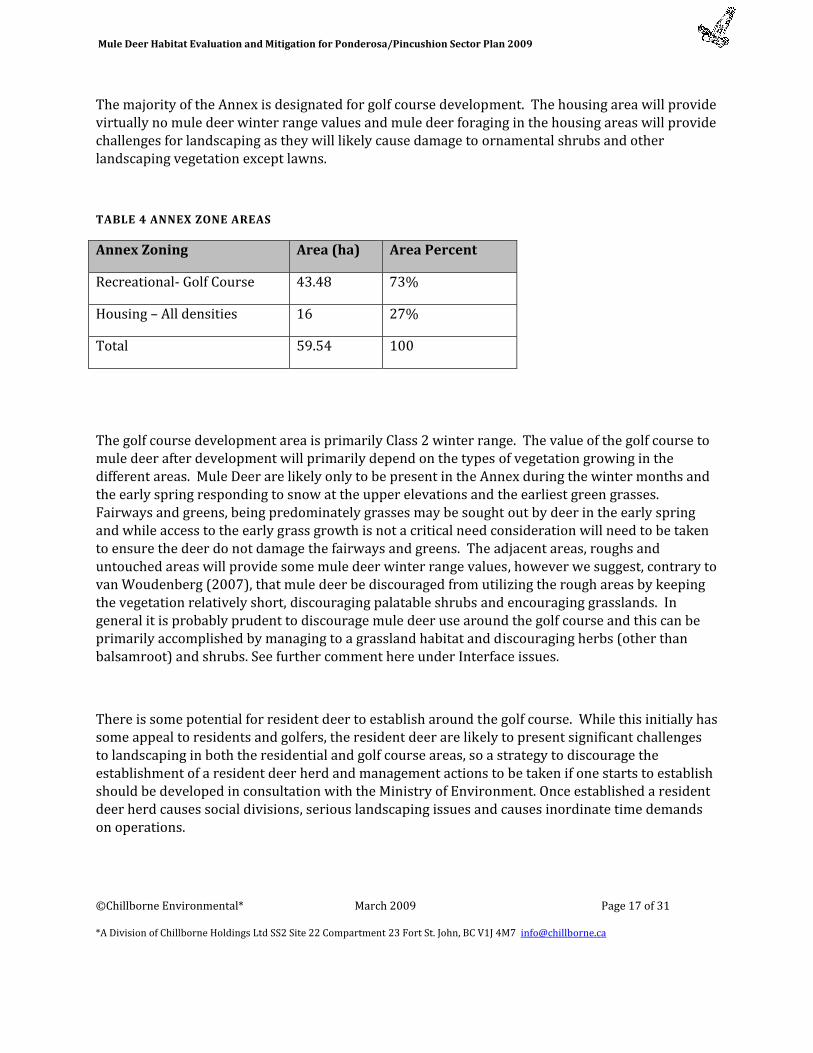
The majority of the Annex is designated for golf course development. The housing area will provide virtually no mule deer winter range values and mule deer foraging in the housing areas will provide challenges for landscaping as they will likely cause damage to ornamental shrubs and other landscaping vegetation except lawns.
TABLE 4 ANNEX ZONE AREAS
Annex Zoning Area (ha) Area Percent
Recreational‐ Golf Course 43.48 73%
Housing – All densities 16 27%
Total 59.54 100
The golf course development area is primarily Class 2 winter range. The value of the golf course to mule deer after development will primarily depend on the types of vegetation growing in the different areas. Mule Deer are likely only to be present in the Annex during the winter months and the early spring responding to snow at the upper elevations and the earliest green grasses. Fairways and greens, being predominately grasses may be sought out by deer in the early spring and while access to the early grass growth is not a critical need consideration will need to be taken to ensure the deer do not damage the fairways and greens. The adjacent areas, roughs and untouched areas will provide some mule deer winter range values, however we suggest, contrary to van Woudenberg (2007), that mule deer be discouraged from utilizing the rough areas by keeping the vegetation relatively short, discouraging palatable shrubs and encouraging grasslands. In general it is probably prudent to discourage mule deer use around the golf course and this can be primarily accomplished by managing to a grassland habitat and discouraging herbs (other than balsamroot) and shrubs. See further comment here under Interface issues.
There is some potential for resident deer to establish around the golf course. While this initially has some appeal to residents and golfers, the resident deer are likely to present significant challenges to landscaping in both the residential and golf course areas, so a strategy to discourage the establishment of a resident deer herd and management actions to be taken if one starts to establish should be developed in consultation with the Ministry of Environment. Once established a resident deer herd causes social divisions, serious landscaping issues and causes inordinate time demands on operations.
Mule Deer Habitat Evaluation and Mitigation for Ponderosa/Pincushion Sector Plan 2009
©Chillborne Environmental* March 2009 Page 18 of 31
*A Division of Chillborne Holdings Ltd SS2 Site 22 Compartment 23 Fort St. John, BC V1J 4M7 [email protected]
IMPACTS ON WINTER RANGE OF TRAILS, RECREATIONAL USE
The development of the Pincushion/Ponderosa Sector Plan will increase the human population of the immediate area greatly. The development area abuts the Mule Deer Winter Range to the north, west and south. The increased population will likely increase uses on the winter range some of which could be detrimental to its winter range values and use by Mule Deer. The LRMP includes a principle that some areas cannot withstand the impacts of mechanized use and restrictions may be appropriate (Appendix V2, Land Stewardship Principles). Development of the Annex will remove a significant part of the Mule Deer Winter range and this removal combined with the dramatic increase in local population makes the preservation and good management of the remaining winter range crucial. The following conflicts that would additionally impact the winter range are an indirect impact of the Annexation Proposal.
.
Primary conflicts are likely to be:
• Off Road Vehicle Use
• Invasive plants
• Harassment by Dogs
• High levels of Human Use
A proactive identification and management of uses can prevent the majority of these potential impacts
MITIGATION STRATEGIES
A number of strategies can be employed to deal with these conflicts. The planning and implementation of these strategies should begin prior to the construction in the area and will require not only planning on the part of the developer but awareness and constraints on the construction operations and the cooperation of Municipality, Ministry of Environment and possibly other government ministries. The Westbank First Nation may be able to provide a strong moral and operational compass for the development and implementation of these strategies.
Mule Deer Habitat Evaluation and Mitigation for Ponderosa/Pincushion Sector Plan 2009
©Chillborne Environmental* March 2009 Page 19 of 31
*A Division of Chillborne Holdings Ltd SS2 Site 22 Compartment 23 Fort St. John, BC V1J 4M7 [email protected]
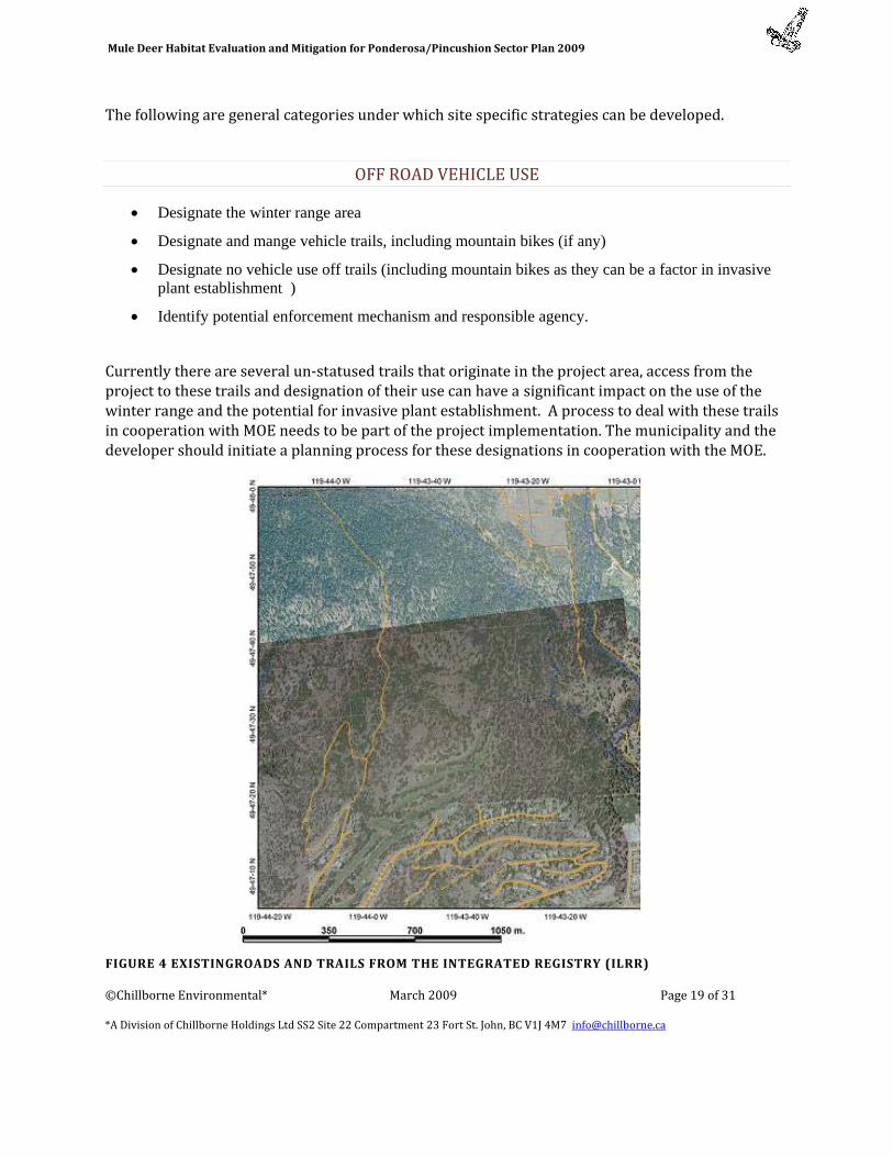
The following are general categories under which site specific strategies can be developed.
OFF ROAD VEHICLE USE
• Designate the winter range area
• Designate and mange vehicle trails, including mountain bikes (if any)
• Designate no vehicle use off trails (including mountain bikes as they can be a factor in invasive plant establishment )
• Identify potential enforcement mechanism and responsible agency.
Currently there are several un‐statused trails that originate in the project area, access from the project to these trails and designation of their use can have a significant impact on the use of the winter range and the potential for invasive plant establishment. A process to deal with these trails in cooperation with MOE needs to be part of the project implementation. The municipality and the developer should initiate a planning process for these designations in cooperation with the MOE.
FIGURE 4 EXISTINGROADS AND TRAILS FROM THE INTEGRATED REGISTRY (ILRR)

Mule Deer Habitat Evaluation and Mitigation for Ponderosa/Pincushion Sector Plan 2009
©Chillborne Environmental* March 2009 Page 20 of 31
*A Division of Chillborne Holdings Ltd SS2 Site 22 Compartment 23 Fort St. John, BC V1J 4M7 [email protected]
Currently there are a number of trail as shown in maroon in Figure 5. A number of these trails are in the footprint of the Annex and will likely be eliminated. They will be replaced by a perimeter trail around the golf course reducing the trail footprint.
The trailheads are found within the project for all trails with only the Mt Coldham trail and the Trepanier Creek trail accessible from the other end. Management of the trailheads and the options for use of the trails with options for foot, horse, mountain bike, ATV use will fall under the project planning. Reducing or eliminating the vehicular use of these trails will be a significant mitigation for preserving the Mule Deer Winter Range Values.
The Sector Plan identifies trails in the area as per Figure 5. These trails comprise at total of 5.33 km, if you include an impact buffer 20 m either side a total of 20.75 ha is the footprint of the proposed trails. The perimeter trail may have a high value as a fire break around the golf course, consistent with Firesmart principles. This firebreak value is helpful to any prescribed fire projects planned for
FIGURE 5 PROPOSED ROADS AND TRAILS
Mule Deer Habitat Evaluation and Mitigation for Ponderosa/Pincushion Sector Plan 2009
©Chillborne Environmental* March 2009 Page 21 of 31
*A Division of Chillborne Holdings Ltd SS2 Site 22 Compartment 23 Fort St. John, BC V1J 4M7 [email protected]
the adjacent grasslands in the Mule Deer Winter Range. However these trails and their use will reduce the amount of Mule Deer Winter Range and frequent disturbance will inhibit mule deer use adjacent to the trails.
INVASIVE PLANTS
Reducing or eliminating the establishment of invasive plants will be a significant mitigation for preserving the Mule Deer Winter Range Values. The project planning and operations can address the following issues.
• Identify potential invasive plants and establishment mechanisms
• Identify construction practices to reduce invasive plants on site, off site
• Identify management practices to reduce invasive plants on site.
• Identify remediation practices for invasive plants
• Draft and implement invasive plant policy
HARASSMENT BY DOGS
Reducing or eliminating the harassment of mule deer from free ranging dogs will be a significant mitigation for preserving the Mule Deer Winter Range Values. The project planning and operations can address the following issues.
• Identify and develop an off leash dog area in or adjacent to the development.
• Identify the critical time windows when dog harassment of Mule Deer must be managed
• Provide educational materials to the residents on dog mule deer interactions and issues
• Work with the municipality on an appropriate dog bylaw for residential areas, natural areas and golf course.
HIGH LEVELS OF HUMAN USE
Reducing or eliminating the impacts of high levels of human use on mule deer and mule deer habitat will be a significant mitigation for preserving the Mule Deer Winter Range Values. The project planning and operations can address the following issues.
Mule Deer Habitat Evaluation and Mitigation for Ponderosa/Pincushion Sector Plan 2009
©Chillborne Environmental* March 2009 Page 22 of 31
*A Division of Chillborne Holdings Ltd SS2 Site 22 Compartment 23 Fort St. John, BC V1J 4M7 [email protected]
• Identify the critical time windows when human use of Mule Deer winter range must be managed.
• Provide educational materials to the residents on mule deer needs and issues regarding appropriate timing of uses on winter range, introduction of invasive plants, off trail use and potential tick issues
• Work with the municipality on appropriate recreational use guidelines for residential areas, natural areas and golf course that respect mule deer winter habitat and avoid mule deer human interactions during critical periods.
WILDFIRE INTERFACE ISSUES
The proposed development interfaces with crown lands whose primary use is Mule Deer Winter Range. These are forested lands that provide a fuel source for wildlife that interfaces with the golf course and other developments. Municipalities, developers and home owners are encouraged to plan and mitigate for the wildfire hazard potential in this interface. Information is available from the Ministry of Forests and the Firesmart Manual (Firesmart 2003).
Firesmart principles include management of the ignition potential in the urban development through standards for structures and the developed site. However as important are the principles of reducing the fire hazard in the area adjacent to the development through fuel reduction, in this case on the Mule Deer Winter Range.
Reducing the fire hazard on the Mule Deer Winter Range in the Ponderosa Pine low snow areas is largely compatible with Mule Deer range enhancement. Mule Deer Winter Range Enhancement would include ensuring a wide spacing of mature trees to reduce canopy coverage, elimination of extra fuel loads to rejuvenate grassland. Fire Hazard reduction includes wider spacing of trees contributing to the canopy, reduction of ladder fuels and reduction of surface fuels. On the Ponderosa Pine Bunchgrass communities prescribed burning and canopy thinning for Winter Range Management would accomplish both objectives. (See Fuel Reduction Standards for Crown Fire Hazard, Firesmart 2003 Appendix 2). Consideration could be given to frequent management of a narrow special zone along the interface with the proposed development where a reduction in canopy, ladder fuels and surface fuels could provide a fuel break. The reduction of coarse woody debris in this zone might also provide a break in habitat for small mammals and reptiles reducing their movements into the development where they suffer increased mortality and conflicts with intensive human activity.
Mule Deer Habitat Evaluation and Mitigation for Ponderosa/Pincushion Sector Plan 2009
©Chillborne Environmental* March 2009 Page 23 of 31
*A Division of Chillborne Holdings Ltd SS2 Site 22 Compartment 23 Fort St. John, BC V1J 4M7 [email protected]
Additional Firesmart principles of water sources and access to the perimeter would be part of the proposed golf course with its perimeter trail. (Golf courses with irrigated green vegetation are also recognised to provide a reduced fire hazard).
Prior to significant development, Prescribed Fire Treatment of the Mule Deer Winter Range immediately adjacent to the proposed development would reduce fuel build up and provide a fire hazard reduction for interface fires. Periodic (5 to 10 years) re‐treatment of these sites after development would also be beneficial and achievable with the access to water supplies and the firebreak values of the perimeter trails.
MITIGATION‐ LOSS OF HABITAT
The alienation the 59.5 ha (the Annex) will allow for the construction of the golf course and housing will result in the complete loss of mule deer winter habitat values on 16 hectares and the loss of most winter range habitat values on the 43.5 ha designated for golf course. Although some winter browse will remain on the outer edges of the golf course this value is very small. Some loss also will occur with the development and use of the trail system.
However there is opportunity to mitigate this loss through vegetation management on other parts of the winter range. As identified in the section on Winter Range Enhancement Potential, and detailed in Figure 3 and Table 3 , high priority enhancement sites exist on this winter range.
Treatment of enough area to match the loss to the Annex would meet the LRMP objective of maintaining or increasing Mule Deer Winter Forage. After unsuccessfully attempting to find an algorithm to define the amount required to be treated we have fallen back on an assumption is that treatment; spacing, thinning, prescribed fire or a combination of these will increase the forage on these priority sites substantially, increasing ratings value by at least a category. (The Mule Deer rating was based on the maximum value (from 1 to 100) that could be provided in a given polygon for winter feeding (shrub and/or bunchgrass habitats), security (coniferous forest) or thermal (open sunny ridges and slopes) as modeled using the polygons from this project to which were applied the Central Okanagan TEM ratings. Grods personal communication). Under this assumption the treatment of 50 to 65 ha should result in an increase in habitat suitability to match the loss of habitat to the Annex. However, treatments have a relatively short life and need to be revisited on about a ten year periodicity. Or in other terms treatment of five to seven hectares annually would be required. However as prescribed fires or thinning projects benefit from the efficiency of scale it is most likely that rather than an annual project, a larger project would occur every few years.
It would be prudent to undertake the initial project adjacent to the annex prior to new residents being established.
These types of treatments have rarely been applied in the main Okanagan Valley thus estimation of costs is difficult. Prescribed burns in White Lake Provincial Park over a two applications have cost approximately $500 per hectare. Nature Conservancy of Canada thinning treatment programs that
Mule Deer Habitat Evaluation and Mitigation for Ponderosa/Pincushion Sector Plan 2009
©Chillborne Environmental* March 2009 Page 24 of 31
*A Division of Chillborne Holdings Ltd SS2 Site 22 Compartment 23 Fort St. John, BC V1J 4M7 [email protected]
include burning of fuels and some seeding in the East Kootenay averaged $613.50 per hectare over 139 hectares but are expected to rise significantly due to the loss of salvage value of trees.
It would seem reasonable that costs of enhancement activities to mitigate for the loss of the Annex would range in the order of $5500 to $8500 per year. This could be accomplished by annual payments or the establishment of an endowment.
Payment of the endowment or annual payments to the Government of British Columbia for this specific purpose is difficult; the more normal route is to utilize a conservation organization. Funds can be directed to a conservation organization dedicated to the purpose of enhancement of the Peachland Mule Deer Winter Range only (RMZ‘s 668,665 &684). The suitable organization would be responsible for implementation for a small (7%) administration fee. Two organizations that may be appropriate are the Habitat Conservation Trust Fund and the Okanagan Region Wildlife Heritage Fund Society. Please see Appendix A for information on these two organizations.
I must be stressed that for effective mitigation of Mule Deer Winter Habitat from the alienation of the Annex funds must be dedicated to enhancement activities within Mule Deer Planning Resource Management Zones (RMZ‘s) 668,665 &684 and the management need is long term due to the permanent loss of the Annex lands as Mule Deer Winter Range.
INDICATORS AND MONITORING
Indicators can be developed in consultation with the Project manager for some or all of the following.
Invasive plants: annual late spring surveys, followed by remediation measures.
Sensitive Ecosystem Elements: Pre development Inventory, A mitigation plan and a monitoring survey five years after development. Sensitive ecosystem elements include rare ground plants, Trees/snags, listed or regionally important reptiles and birds.
Mule Deer Winter Range, an enhancement program should include periodic monitoring of range condition and trends. For the project a base line survey of range condition in those polygons adjacent to the project prior to development and five years after development would be beneficial.
Monitoring should be under the direction of an appropriate qualified environmental professional.
SUMMARY
The Annex proposal is located in Mule Deer RMZ’s 668 the two adjacent RMZ’s are 665 and 684 all within the Trepanier Landscape Unit. These three polygons encompass the slopes between Trepanier Creek and Peachland Creek east of Mount Coldham and adjacent to the Municipality of
Mule Deer Habitat Evaluation and Mitigation for Ponderosa/Pincushion Sector Plan 2009
©Chillborne Environmental* March 2009 Page 25 of 31
*A Division of Chillborne Holdings Ltd SS2 Site 22 Compartment 23 Fort St. John, BC V1J 4M7 [email protected]
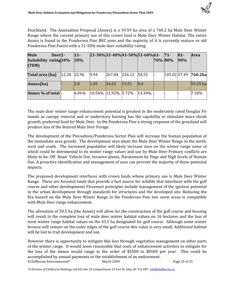
Peachland. The Annexation Proposal (Annex) is a 59.59 ha area of a 760.2 ha Mule Deer Winter Range where the current primary use of this crown land is Mule Deer Winter Habitat. The entire Annex is found in the Ponderosa Pine BEC zone and the majority of it is currently mature or old Ponderosa Pine Forest with a 31‐50% mule deer suitability rating.
Mule Deer Suitability rating (TEM)
110%
1120%
2130% 3140% 4150% 5160% 6170%
7180%
8190%
Area
Total area (ha) 12.28 32.96 9.94 267.84 236.12 58.55 ‐ 105.02 37.49 760.2ha
Annex(ha) ‐ 2.0 1.05 34.63 13.51 8.4 ‐ 59.59 ha
Annex % of total ‐ 6.06% 10.56% 12.92% 5.72% 14.34% ‐ ‐ ‐ 7.18%
The mule deer winter range enhancement potential is greatest in the moderately rated Douglas Fir stands as canopy removal and or understory burning has the capability to stimulate more shrub growth, preferred food for Mule Deer. In the Ponderosa Pine a strong response of the grassland will produce less of the desired Mule Deer Forage.
The development of the Pincushion/Ponderosa Sector Plan will increase the human population of the immediate area greatly. The development area abuts the Mule Deer Winter Range to the north, west and south. The increased population will likely increase uses on the winter range some of which could be detrimental to its winter range values and use by Mule Deer Primary conflicts are likely to be: Off Road Vehicle Use, Invasive plants, Harassment by Dogs and High levels of Human Use. A proactive identification and management of uses can prevent the majority of these potential impacts.
The proposed development interfaces with crown lands whose primary use is Mule Deer Winter Range. These are forested lands that provide a fuel source for wildlife that interfaces with the golf course and other developments Firesmart principles include management of the ignition potential in the urban development through standards for structures and the developed site. Reducing the fire hazard on the Mule Deer Winter Range in the Ponderosa Pine low snow areas is compatible with Mule Deer range enhancement.
The alienation of 59.5 ha (the Annex) will allow for the construction of the golf course and housing will result in the complete loss of mule deer winter habitat values on 16 hectares and the loss of most winter range habitat values on the 43.5 ha designated for golf course. Although some winter browse will remain on the outer edges of the golf course this value is very small. Additional habitat will be lost to trail development and use.
However there is opportunity to mitigate this loss through vegetation management on other parts of the winter range. It would seem reasonable that costs of enhancement activities to mitigate for the loss of the Annex would range in the order of $5500 to $8500 per year. This could be accomplished by annual payments or the establishment of an endowment.
Mule Deer Habitat Evaluation and Mitigation for Ponderosa/Pincushion Sector Plan 2009
©Chillborne Environmental* March 2009 Page 26 of 31
*A Division of Chillborne Holdings Ltd SS2 Site 22 Compartment 23 Fort St. John, BC V1J 4M7 [email protected]
REFERENCES AND BIBLIOGRAPHY:
Armletter, H.M., R.J. Dawson and R.N.Thomson,1989 Handbook for Timber and Mule Deer Management Co‐ordination on Winter Ranges in the Cariboo Forest Region, Land Management handbook Number 13. BC Ministry of Forests, Victoria, BC.
Iverson, K., D. Curran, T. Fleming and A. Haney. 2008. Sensitive Ecosystems Inventory – Okanagan Valley: Vernon to Osoyoos, 2000 – 2007. Methods, Ecological Descriptions, Results and Conservation Tools. Technical Report Series No. 495, Canadian Wildlife Service, Pacific and Yukon Region, British Columbia. http://a100.gov.bc.ca/pub/acat/public/viewReport.do?reportId=15326
Iverson, K. and A. Haney May 2006 An Updated Terrestrial Ecosystem Map (TEM) for the South Okanagan Valley (with Sensitive Ecosystems Inventory ‐ SEI) http://a100.gov.bc.ca/pub/acat/public/viewReport.do?reportId=7441
Firesmart 2003, Partners in Protection ISBN 0‐662‐34064‐7 Cat. no. Fo42‐291/2003E http://www.partnersinprotection.ab.ca/downloads/
Grods, J. 2005 Preliminary Terrestrial Ecosystem mapping (TEM) unpublished data. Makonis Consulting Ltd. Prepared for New Town Planning Services, Kelowna, BC.
The Integrated Land and Resource Registry (ILRR) http://ilmbwww.gov.bc.ca/ilrr/ILRR.htm
Okanagan Innovative Forestry Society 2007, Mule Deer Winter Range Habitat Assessment and Use Project: Year (2006 2007) Annual Progress Report Cascadia Natural Resource Consultants Inc http://a100.gov.bc.ca/pub/acat/public/viewReport.do?reportId=10814
Okanagan LRMP Mule Deer Planning Cells August 30, 2002
\\giswhse.env.gov.bc.ca\kamwhse\arclib\landuse\lrmp\okanagan\amdrmz_tok
Okanagan Shuswap Land and Resource Management Plan, 2001 Government of British Columbia http://www.ilmb.gov.bc.ca/slrp/lrmp/kamloops/okanagan/plan/files/oslrmpfull.pdf
Prescribed Burning in BC Parks 2008 http://www.elp.gov.bc.ca/bcparks/conserve/fire/fire_in_parks_brochure_dec08.pdf
Simpson, K and L. Gyug, 1992. Deer Capability and Land Use in Peachland. Keystone Bio‐Research. Prepared for Ministry of Environment, Lands and Parks, Penticton, BC.
van Woudenberg, A.M. 2007, Assessment of Mule Deer Winter Range in Crown Land Proposal Area A, Pincushion/Ponderosa Area Structure Plan, Cascadia Resource Consultants Inc.11pg mimeo.

Mule Deer Habitat Evaluation and Mitigation for Ponderosa/Pincushion Sector Plan 2009
©Chillborne Environmental* March 2009 Page 27 of 31
*A Division of Chillborne Holdings Ltd SS2 Site 22 Compartment 23 Fort St. John, BC V1J 4M7 [email protected]
APPENDIX A: CONSERVATION ORGANIZATIONSS
OKANAGAN REGION WILDLIFE HERITAGE FUND SOCIETY,
Society Information April 8th, 2008
1. General information:
The Okanagan Region Wildlife Heritage Fund Society was formed in January of 1988 and obtained charitable status in November of the same year. It is a Society formed and operated by volunteers.
The Society has worked closely with the Ministry of Environment staff in Penticton from its inception and has administered the funding of Habitat Conservation Trust Fund projects for that office since 1992.
Over the years, the Society has purchased conservation properties in its own name and has contributed funds to the purchase of similar properties by other conservation organizations.
Currently the Society is a partner in the Okanagan River Restoration Initiative (ORRI) and holds title to the properties purchased to date for that project.
The Society is also managing mitigation funds from the Ministry of Transport for fisheries damages caused by construction of the bridge over Okanagan Lake, the funds to be used for fisheries projects on Mission Creek in Kelowna.
The Society will also be receiving funds from the Ministry of Forests for projects related to beetle kill in the Region.
2. Contact Information:
John B. Holdstock
Treasurer Okanagan Region Wildlife Heritage Fund Society 1326 Scott Crescent Kelowna, BC V1Z 2P7
Phone: 250 769‐3952 Fax: 250 769‐0727
E‐mail: [email protected]
Mule Deer Habitat Evaluation and Mitigation for Ponderosa/Pincushion Sector Plan 2009
©Chillborne Environmental* March 2009 Page 28 of 31
*A Division of Chillborne Holdings Ltd SS2 Site 22 Compartment 23 Fort St. John, BC V1J 4M7 [email protected]
3. Charitable Information:
The Society is registered as a Canadian Charitable Society –Registration # 0809301‐52
4. Categories:
Scope: Regional Group Methods: Conserve/Preserve/Restore Grant Category: Biodiversity
Financial Information available on request.
HABITAT CONSERVATION TRUST FUND (HCTF)
Our Mission
The mission of the Habitat Conservation Trust Fund (HCTF) is to invest in projects that maintain and enhance the health and biological diversity of British Columbia's fish, wildlife, and habitats so that people can use, enjoy, and benefit from these resources.
Conservation projects that restore, maintain, or enhance native wildlife populations and habitats. Brian Springinotic Executive Director
250‐356‐6124 [email protected]
Suite 100 ‐ 333 Quebec St Victoria, BC V8V 5B7
Mailing Address:
PO Box 9354 Stn Prov Govt Victoria BC V8W 9M1
Toll Free Number: 1‐800‐387‐9853 Local Number: 387‐9853 Fax Number: 250‐952‐6684

APPENDIX B: LARGER MAPS
FIGURE 6 MULE DEER WINTER RANGE RATINGS& STRUCTURAL STAGES
Mule Deer Habitat Evaluation and Mitigation for Ponderosa/Pincushion Sector Plan
©Chillborne Environmental* February 2009 Page 30 of 31
A Division of Chillborne Holdings Ltd SS2 Site 22 Compartment 23 Fort St. John, BC V1J4M7 [email protected]
FIGURE 7MULE DEER RATINGS AND IMPORTANT ROCK TALUS ELEMENTS
Mule Deer Habitat Evaluation and Mitigation for Ponderosa/Pincushion Sector Plan
©Chillborne Environmental* February 2009 Page 31 of 31
A Division of Chillborne Holdings Ltd SS2 Site 22 Compartment 23 Fort St. John, BC V1J4M7 [email protected]
APPENDIX C: CONTACTS FOR MAP FILES
TERRATREE FORESTRY
3‐466 Chesterfield Ave email: [email protected]
Duncan BC, V9L 3L8 ph: 250.737.1206
Chillborne Environmental 250 785 6417 fax 250 787 5519
Site 22 Comp 23 SS#2 email [email protected]
Fort St. John, BC V1J 4M7 www.chillborne.ca