Embed Size (px)
Citation preview

1
M.TECH- REMOTE SENSING AND WIRELESS SENSOR NETWORKS
Centre for Excellence in Computational Engineering & Networking
Earth observation from space has provided mankind and its decision makers with new global perspective
of its environment. Protection of the environment will certainly be one of the greatest challenges in the
21st century. Remote sensing data gathered from air borne and space borne sensor systems are one of the
starting points for preparing tools for gaining a better understanding of its complex interactions between
the atmosphere, oceans, ice regions and land surfaces on one hand and the population with its various
activities on the other hand.Recent developments in sensor technology coupled with wireless network
technology have given a new dimension to the word ‘remote sensing’. Remote sensing by deployment of
thousands of sensors in fields to gather data for remote monitoring, control or other decision making
process can now be put under the purview of remote sensing. There are immense possibilities for
integrating data obtained from satellite based sensing and ground based measurements using cheap
sensors deployed in the field. This course aims at developing manpower in this highly interdisciplinary
area. The forecast for such manpower requirements is large and fall short of the current requirements.
Remote sensing and wireless sensor networks as a scientific discipline, depends on field measurements,
computer vision, adhoc wireless networks, analysis and cognition systems. It has great strategic
importance from the point of view of defense, natural calamities, space exploration and non-destructive
testing. It is also applied in agriculture, marine and geological explorations, weaponry, transportation and
health monitoring of machines, structures and livestock.
The basic course starts with a strong foundation in mathematics. It is strengthened by courses in remote
sensing, image processing, pattern recognition and specific courses on sensor technology, wireless
networking and geographical information systems.
Electives offered, to additionally gain insight into optics are microwave engineering and topics like
animal vision systems. They also include some powerful mathematical tools like level set, computational
electromagnetic and measurement techniques.
2
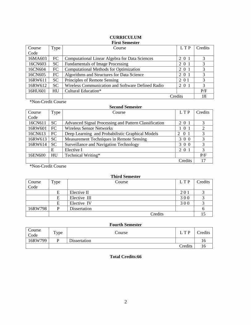
CURRICULUM
First Semester
Course
Code
Type Course L T P Credits
16MA603 FC Computational Linear Algebra for Data Sciences 2 0 1 3
16CN603 SC Fundamentals of Image Processing 2 0 1 3
16CN604 FC Computational Methods for Optimization 2 0 1 3
16CN605 FC Algorithms and Structures for Data Science 2 0 1 3
16RW611 SC Principles of Remote Sensing 2 0 1 3
16RW612 SC Wireless Communication and Software Defined Radio 2 0 1 3
16HU601 HU Cultural Education* P/F
Credits 18
*Non-Credit Course
Second Semester
Course
Code
Type Course L T P Credits
16CN611 SC Advanced Signal Processing and Pattern Classification 2 0 1 3
16RW601 FC Wireless Sensor Networks 1 0 1 2
16CN613 FC Deep Learning and Probabilistic Graphical Models 2 0 1 3
16RW613 SC Measurement Techniques in Remote Sensing 3 0 0 3
16RW614 SC Surveillance and Navigation Technology 3 0 0 3
E Elective I 2 0 1 3
16EN600 HU Technical Writing* P/F
Credits 17
*Non-Credit Course
Third Semester
Course
Code
Type Course L T P Credits
E Elective II 2 0 1 3
E Elective III 3 0 0 3
E Elective IV 3 0 0 3
16RW798 P Dissertation 6
Credits 15
Fourth Semester
Course
Code Type Course L T P Credits
16RW799 P Dissertation 16
Credits 16
Total Credits:66
3
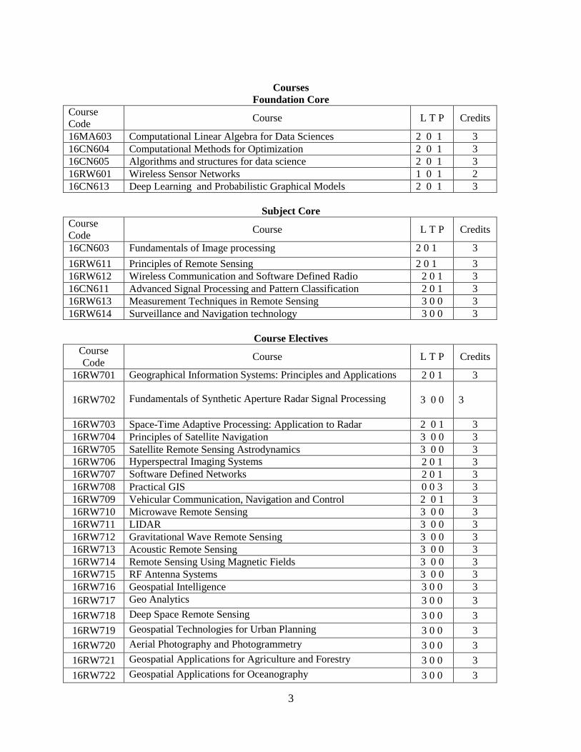
Courses
Foundation Core
Course
Code Course L T P Credits
16MA603 Computational Linear Algebra for Data Sciences 2 0 1 3
16CN604 Computational Methods for Optimization 2 0 1 3
16CN605 Algorithms and structures for data science 2 0 1 3
16RW601 Wireless Sensor Networks 1 0 1 2
16CN613 Deep Learning and Probabilistic Graphical Models 2 0 1 3
Subject Core
Course
Code Course L T P Credits
16CN603 Fundamentals of Image processing 2 0 1 3
16RW611 Principles of Remote Sensing 2 0 1 3
16RW612 Wireless Communication and Software Defined Radio 2 0 1 3
16CN611 Advanced Signal Processing and Pattern Classification 2 0 1 3
16RW613 Measurement Techniques in Remote Sensing 3 0 0 3
16RW614 Surveillance and Navigation technology 3 0 0 3
Course Electives
Course
Code Course L T P Credits
16RW701 Geographical Information Systems: Principles and Applications 2 0 1 3
16RW702
Fundamentals of Synthetic Aperture Radar Signal Processing
3 0 0
3
16RW703 Space-Time Adaptive Processing: Application to Radar 2 0 1 3
16RW704 Principles of Satellite Navigation 3 0 0 3
16RW705 Satellite Remote Sensing Astrodynamics 3 0 0 3
16RW706 Hyperspectral Imaging Systems 2 0 1 3
16RW707 Software Defined Networks 2 0 1 3
16RW708 Practical GIS 0 0 3 3
16RW709 Vehicular Communication, Navigation and Control 2 0 1 3
16RW710 Microwave Remote Sensing 3 0 0 3
16RW711 LIDAR 3 0 0 3
16RW712 Gravitational Wave Remote Sensing 3 0 0 3
16RW713 Acoustic Remote Sensing 3 0 0 3
16RW714 Remote Sensing Using Magnetic Fields 3 0 0 3
16RW715 RF Antenna Systems 3 0 0 3
16RW716 Geospatial Intelligence 3 0 0 3
16RW717 Geo Analytics 3 0 0 3
16RW718 Deep Space Remote Sensing 3 0 0 3
16RW719 Geospatial Technologies for Urban Planning 3 0 0 3
16RW720 Aerial Photography and Photogrammetry 3 0 0 3
16RW721 Geospatial Applications for Agriculture and Forestry 3 0 0 3
16RW722 Geospatial Applications for Oceanography 3 0 0 3
4
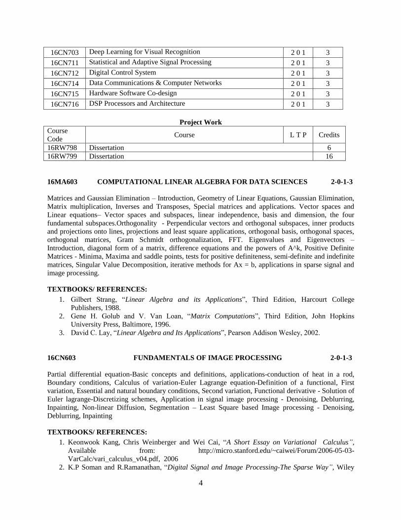
16CN703 Deep Learning for Visual Recognition 2 0 1 3
16CN711 Statistical and Adaptive Signal Processing 2 0 1 3
16CN712 Digital Control System 2 0 1 3
16CN714 Data Communications & Computer Networks 2 0 1 3
16CN715 Hardware Software Co-design 2 0 1 3
16CN716 DSP Processors and Architecture 2 0 1 3
Project Work
Course
Code Course L T P Credits
16RW798 Dissertation 6
16RW799 Dissertation 16
16MA603 COMPUTATIONAL LINEAR ALGEBRA FOR DATA SCIENCES 2-0-1-3
Matrices and Gaussian Elimination – Introduction, Geometry of Linear Equations, Gaussian Elimination,
Matrix multiplication, Inverses and Transposes, Special matrices and applications. Vector spaces and
Linear equations– Vector spaces and subspaces, linear independence, basis and dimension, the four
fundamental subspaces.Orthogonality - Perpendicular vectors and orthogonal subspaces, inner products
and projections onto lines, projections and least square applications, orthogonal basis, orthogonal spaces,
orthogonal matrices, Gram Schmidt orthogonalization, FFT. Eigenvalues and Eigenvectors –
Introduction, diagonal form of a matrix, difference equations and the powers of A^k, Positive Definite
Matrices - Minima, Maxima and saddle points, tests for positive definiteness, semi-definite and indefinite
matrices, Singular Value Decomposition, iterative methods for Ax = b, applications in sparse signal and
image processing.
TEXTBOOKS/ REFERENCES:
1. Gilbert Strang, “Linear Algebra and its Applications”, Third Edition, Harcourt College
Publishers, 1988.
2. Gene H. Golub and V. Van Loan, “Matrix Computations”, Third Edition, John Hopkins
University Press, Baltimore, 1996.
3. David C. Lay, “Linear Algebra and Its Applications”, Pearson Addison Wesley, 2002.
16CN603 FUNDAMENTALS OF IMAGE PROCESSING 2-0-1-3
Partial differential equation-Basic concepts and definitions, applications-conduction of heat in a rod,
Boundary conditions, Calculus of variation-Euler Lagrange equation-Definition of a functional, First
variation, Essential and natural boundary conditions, Second variation, Functional derivative - Solution of
Euler lagrange-Discretizing schemes, Application in signal image processing - Denoising, Deblurring,
Inpainting, Non-linear Diffusion, Segmentation – Least Square based Image processing - Denoising,
Deblurring, Inpainting
TEXTBOOKS/ REFERENCES:
1. Keonwook Kang, Chris Weinberger and Wei Cai, “A Short Essay on Variational Calculus”,
Available from: http://micro.stanford.edu/~caiwei/Forum/2006-05-03-
VarCalc/vari_calculus_v04.pdf, 2006
2. K.P Soman and R.Ramanathan, “Digital Signal and Image Processing-The Sparse Way”, Wiley
5
Publishers, 2011.
3. Selesnick, Ivan. "Least Squares with Examples in Signal Processing." Online, March 2013.
16CN604 COMPUTATIONAL METHODS FOR OPTIMIZATION 2-0-1-3
Introduction - mathematical optimization, least-squares and linear programming, convex and nonlinear
optimization. Convex sets, Convex optimization problems - optimization problem in standard form,
convex optimization problems, quasi-convex optimization, linear optimization, quadratic optimization,
generalized inequality constraints, semi definite programming, vector optimization. Duality,
Approximation and fitting, Statistical estimation, Geometric problems, Unconstrained minimization-
gradient descent method, steepest descent method, Newton's method. Equality constrained minimization -
equality constrained minimization, eliminating equality constraints, Newton's method with equality
constraints, infeasible start Newton method, and implementation. Interior-point methods -inequality
constrained minimization, logarithmic barrier function and central path, barrier method, L1 Norm
Optimization methods,
Alternating direction method of multipliers (ADMM), Applications in Signal and Image Processing.
TEXTBOOKS/ REFERENCES:
1. Stephen P. Boyd and Lieven Vandenberghe D, “Convex Optimization”, Cambridge University
Press, 2004.
2. Kalyanmoy Deb, "Optimization for Engineering Design Algorithms and Examples", Prentice Hall
of India, New Delhi, 2004.
3. Edwin K.P. Chong and Stanislaw H. Zak, “An Introduction to Optimization” Second Edition,
Wiley-Interscience Series in Discrete Mathematics and Optimization, 2004.
4. M. AsgharBhatti, “Practical Optimization Methods: With Mathematica Applications”, Springer
Verlag Publishers, 2000.
16CN605 ALGORITHMS AND STRUCTURES FOR DATA SCIENCE 2-0-1-3
Algorithm Analysis - Methodologies for Analyzing Algorithms, Asymptotic Notation, A Quick
Mathematical Review, Case Studies in Algorithm Analysis, Amortization, Experimentation .Basic Data
Structures - Stacks and Queues, Vectors, Lists, and Sequences, Trees, Priority, Queues and Heaps,
Dictionaries and Hash Tables. Search Trees and Skip Lists - Ordered Dictionaries and Binary Search
Trees, AVL Trees. Bounded-Depth Search Trees, Splay Trees, Skip Lists. Sorting, Sets, and Selection -
Merge-Sort, Abstract Data Type, Quick-Sort, A Lower Bound on Comparison-Based Sorting, Bucket-
Sort and Radix-Sort, Comparison of Sorting Algorithms, Selection. Fundamental Techniques - The
Greedy Method, Divide-and-Conquer, Dynamic Programming. Graphs - Abstract Data Type Data
Structures for Graphs, Graph Traversal. Directed Graphs , Weighted Graphs, Single-Source Shortest
Paths, All-Pairs Shortest Paths, Minimum Spanning Trees, Network Flow and Matching, Flows and Cuts.
Additional Topics- Computational Geometry, Range Trees, Priority Search Trees, Quadtrees and k-D
Trees, the Plane Sweep Technique, Convex Hulls.NP-Completeness - P and NP, NP-Completeness,
Important NP-Complete Problems.
TEXTBOOKS/ REFERENCES:
1. Michael T. Goodrich and Roberto Tamassia, “Algorithm Design Foundations, Analysis and
Internet Examples”, John Wiley and Sons, 2003.
6
2. Michael T. Goodrich and Roberto Tamassia, “Data Structures and Algorithms in C++”, John
Wiley and Sons, 2003.
3. Michael T. Goodrich and Roberto Tamassia, “Data Structures and Algorithms in Java”, Fourth
Edition, John Wiley and Sons, 2004.
16RW611 PRINCIPLES OF REMOTE SENSING 2-0-1-3
Introduction to Remote Sensing Science and Technology: Principles of Remote sensing. Electromagnetic
Radiation (EMR).Spectral quantities, Spectral signatures and characteristics, spectral reflectance curves.
Remote Sensing observations and platforms: Air borne and space borne platforms. Aerial Stereocoverage
and Remote Sensing Satellites. RSS Sensors: aerial photography, single and multi-band scanners.
LANDSAT 6/7/8, SPOT, IKONOS, IRS and ERS, Quick bird. Geographic Information System (GIS):
Introduction, the essential elements of a GIS, GIS definition and terminology, GIS categories,
Components of GIS Fundamental Operations of GIS, A theoretical framework for GIS. The Essential
Elements of a GIS: An overview, Functional Elements, Data in a GIS, Data Structure Raster Data
Structures, Vector Data Structures, Comparisons between Data Structures. Data Acquisition and Data
input, Data Management: Basic Principles of Data Management; Efficiency, Conventional Database
Management systems, Spatial database Management Product Generation: Types of output products,
hardware components. Integrated Analysis of Spectral and Attribute data.DataQuality: introduction,
Components of data quality, Sources of error. Introduction to GPS.Dataand imagery products:
Measurement Techniques in GIS mapping, manufacturing, quality control, robotics, navigation, mobile
mapping, VR generation and animation. Data Products Specifications in SatRS.
TEXTBOOKS/REFERENCES:
1. Anji Reddy M., “Remote Sensing and GIS”, The Book Syndicate, Hyderabad, 2000.
2. P.A.Burrough and R. A. McDonnell, “Principles of Geographical Information Systems”, Oxford,
1998.
3. Rao D.P., “Remote Sensing for Earth Resource”, AEG Publication, Hyderabad, 1987.
4. Kang Tsung Chang, “Geographic Information Systems”, Tata McGraw Hill Publication, 2002.
5. Chandra A.M. and GoshS.K., “Remote Sensing and GIS’, Narosa Publishing House, 2007.
6. DebashisChakraborthy and Rabi N.Sahoo, “Fundamentals of Geographic Information Systems”,
Viva Books Pvt. Ltd., 2007.
16RW612 WIRELESS COMMUNICATION AND SOFTWARE 1-0-1-2
DEFINED RADIO
Introduction to Software Defined Radios, SDR Architecture, Analog to Digital and Digital to Analog
conversion, Digital frequency up and down convertors, Digital Hardware for SDR, Introduction to USRP,
UHD, GNU Radio and RTL- SDR, Multiple Access and Multiplexing Techniques, Spread spectrum and
Code division multiple access (CDMA) techniques: Direct sequence, Frequency hopping; Multicarrier
techniques: Orthogonal frequency division (OFDM) and Multicarrier CDMA (MC-CDMA).
TEXTBOOKS/ REFERENCES:
1. Simon Haykin, “Digital Communications”, John Wiley and Sons, 1998.
2. Wayne Tomasi, “Advanced Electronic Communication Systems”, Fourth Edition Pearson
Education Asia, 1998.

7
3. B.P.Lathi, “Modern Digital and Analog Communication Systems”, Third Edition, Oxford
University Press.
4. Ravindranathan, “Communication Systems Modeling using Matlab& Simulink” Universities
Press.
5. Robert W. Stewart , Kenneth W. Barlee , Dale S. W. Atkinson , Louise H., Crockett, "Software
Defined Radio using MATLAB & Simulink and the RTL-SDR", Edition1, Sep, Strathclyde
Academic Media, 2015.
16CN611 ADVANCED SIGNAL PROCESSING AND PATTERN 2-0-1-3
CLASSIFICATION
Fourier based signal processing, Discrete-Time Bases and Filter Banks , Continuous-Time Bases and
Wavelets, Orthogonal wavelets, bi-orthogonal wavelets, m-band wavelets, wavelet packet analysis, lifting
schemes, second generation wavelets, Classification: Naïve Bayes, Decision trees, Deep learning neural
network and kernel methods for Classification.Applications: Speech, audio, image, and video
compression, Signal Denoising, Feature extraction, Inverse problems.
TEXTBOOKS/ REFERENCES:
1. M. Vetterli, J. Kovacevic, and V. K. Goyal, “The World of Fourier and Wavelets: Theory,
Algorithms and Applications”, 2015.
2. Ian Goodfellow, YoshuaBengio and Aaron Courville,” Deep Learning”, MIT press 2016.
16RW601 WIRELESS SENSOR NETWORKS 2-0-1-3
Overview of Wireless Communication – Wireless Channel – Physical Modeling of Wireless Channel –
Path loss and Shadowing – Statistical Multipath Channel – Capacity of Wireless Channels – AWGN
Channel Capacity – Capacity of Fading Channels
Point –to-Point Communication – Detection – Diversity – Equalization - Channel Uncertainty – MIMO –
Spatial Multiplexing and Channel Modeling – Capacity and Multiplexing Architectures – Diversity –
Multiplexing Tradeoff – Universal Space Time Codes
Multicarrier Modulation – Cellular Systems and Interference Management – Multiuser Systems –
Capacity and Opportunistic Communication – MIMO Multiuser – Ad-hoc Wireless Networks
TEXTBOOK/ REFERENCES:
1. David Tse, PramodViswanath ,”Fundamentals of Wireless Communication”, Cambridge
University Press, 2005.
2. Andrea Goldsmith, “Wireless Communication”, Cambridge University Press, 2005.
3. Theodre.S.Rapapport, “Wireless Communications-Principles and Practice”, Second Edition,
Prentice Hall Inc., 2008.

8
16CN613 DEEP LEARNING AND PROBABILISTIC GRAPHICAL 2-0-1-3
MODELS
Samples, Events, Event space, Probability Space , Random Variables, Independence and Conditional
Independence, Conditional Probability, Joint Probability, Bayes' theorem Joint and Marginal Probability,
Estimation Theory - Maximum Likelihood Estimators. Probabilistic Graphical Models: Direct and
undirected model, Inference from Direct and undirected graphical model, Structured and Unstructured
graphical models, Partition Function, D-Separation, Energy based models, Factor Graphs, Sampling from
Graphical Models. Montecarlo Methods: Markov Chain and Montecarlo methods, Gibbs Sampling,
Approximate Inference – Expectation Maximization, MAP Inference. Special cases: HMM, CRF,
Kalman Filter, Deep Learning and graphical Models. .
TEXTBOOKS/ REFERENCES:
1. Koller, Daphne, and Nir Friedman, “Probabilistic Graphical Models: Principles and
Techniques”. MIT press, 2009.
2. Ian Goodfellow, YoshuaBengio and Aaron Courville, “Deep Learning”, MIT press 2016.
16RW613 MEASUREMENT TECHNIQUES IN REMOTE SENSING 3-0-0-3
Introduction to Measurement Techniques in atmospheric Remote Sensing, Concepts of remote
sensing, Definition of remote sensing, Principles of remote sensing, Passive and Active remote sensing,
Remote sensing Properties, Multi concepts in remote sensing, Electro Magnetic Interactions, Physical
Basics of Remote sensing, Remote sensing instrumentation, Sensors and its types, Resolution concepts of
Remote Sensing Detection, Platforms to acquire Remote Sensing data, Spectral reflectance curve, GIS
data and resources, Spatial data criteria, Data acquisition, Data entry and its Quality, Error, Atmospheric
radiation, heat transport in atmosphere, basic concepts- Planck’s law, Stephen Boltzmann law, Wien’s
law, albedo, radiative processes, atmospheric influence on radiation, atmospheric scattering, radiative
model, aerosol and atmospheric radiation, model for greenhouse effect, Remote sensing process and its
methods, thermal infrared techniques, remote sensing data types, radiation detectors, infrared radiometer,
hyperspectral and multispectral comparison, push broom technology, airborne and satellite TIR scanner
system, image distortion in TIR, geometric effects, effect of weather on images, interpretation of thermal
imagery, photointerpretation, procedure for IR surveys,advantages of thermal imagery,photogrammetry
and its principles,,stereoscopicparallax,photo projection systems,photo coordinate system,relating photo
coordinates to image coordinates,orientations,terminology and formulas,stereophotography,focal length
and magnification,image,reliefinstruments,orthophotography,abstraction,microwave remote
sensing,atmospheric correction of optically sensed remote sensing imagery,transmittance,surface
reflectance retrieval,cluster matching method,sea-viewing wide field of view sensor(SeaWiFS),MODIS.
TEXTBOOKS/REFERENCES:
1. Herbert J. Kramer, “Observation of the Earth and Its Environment”, Survey of Missions and
Sensors, Second Edition, Springer-Verlag, 1994.
2. Gunter Seeber, “Satellite Geodesy”, Revised Edition, Walter de Gruyter, September 2003.
3. John D. Bossler, “Manual of Geospatial Science and Technology”, Second Edition (Hardcover),
CRC, 2010.
4. JianGuo Liu and Philippa Mason, “Essential Image Processing and GIS for Remote Sensing”, First
Edition, Wiley, 2009.

9
16RW614 SURVEILLANCE AND NAVIGATION TECHNOLOGY 3-0-0-3
Origin of sensor errors, how they propagate and are modeled and simulated – Probability, random
processes, estimation theory and the Kalman Filter – The kinematics, dynamics and control of 6-DoF
motion – Principles of Geodesy and the WGS-84 datum – Earth-based navigation by celestial, inertial and
radio systems – IMU sensors: Gyroscope and accelerometer principles – Error sources – UAS and missile
guidance
TEXTBOOKS/REFERENCES:
1. Etkin B, "Dynamics of Atmospheric Flight", Dover, 2005.
2. Groves P, "Principles of GNSS, Inertial, and Integrated Navigation Systems", Artech House,
2008.
3. Titterton D andWeston J, "Strapdown Inertial Navigation Technology", IET, 2004.
16EN 600 TECHNICAL WRITING P/F
(Non-credit Course)
Technical terms – Definitions – extended definitions – grammar checks – error detection –
punctuation – spelling and number rules – tone and style – pre-writing techniques – Online and
offline library resources – citing references – plagiarism – Graphical representation –
documentation styles – instruction manuals – information brochures – research papers –
proposals – reports (dissertation, project reports etc.)
TEXTBOOKS/REFERENCES:
1. H.L. Hirsch, Essential Communication Strategies for Scientists, Engineers and Technology
Professionals, Second Edition, New York: IEEE press, 2002.
2. P.V. Anderson, Technical Communication: A Reader-Centered Approach, Sixth Edition,
Cengage Learning India Pvt. Ltd., New Delhi, 2008, (Reprint 2010).
3. W.Jr. Strunk and E.B.White, The Elements of Style, New York. Alliyan & Bacon, 1999.
16RW701 GEOGRAPHICAL INFORMATION SYSTEM: PRINCIPLES 2-0-1-3
AND APPLICATIONS
Remote sensing Data Types-digital analogue-drainage pattern-erosionland depositional land forms-
floodplain mapping-coastal land forms-glacial land forms.Hazards-earthquake and volcanoes – landslide -
forest fire –oil spill. Land use /Land cover: concepts-classification:- Landusemapping-land
evaluation.Agriculture:cropassessment,disease detection, forestry:types – species identification and
diseases detection.Soils:Soil mapping-Soil moisture- soil erosion – reservoir station-soil salinity-soil
conservation.Water resources- water quality monitoring and mapping-water pollution,identification
ground water potential and recharge areas-integrated watershed development. GIS application-
Fundamentals of GIS-layers and themes-modelingweighing-specific applications-infrastructure.
Application to agriculture-water management – database creation- networking of data, Map
scaling.Application of GIS in environment-damage assessment- Coastal and marine applications.ESA,
ISRO, and NASARS: mapping, navigation, and current and future missions for earth, solar system planets
and satellites. Shuttle Radar Topography Mission, Uninhabited Aerial Vehicle, Industry Standard
10
Software in GIS/RS: Arc GIS, ERDAS, ILWIS, QGIS, ENVI. Digital Science and art of designing and
producing maps – basic principles of digital map design and production – Established cartographic design
principles – scale and projection, symbolization and classification techniques – use of tones and colors,
and techniques for portraying surfaces - Cartographic functionalities for Map Design - Open Source GIS
– Import and Export of spatial data – Practical Applications
TEXTBOOKS/REFERENCES:
1. Lilles and Keifer, “Remote Sensing and Image Interpretation”, John Wiley and Sons, New York,
2004.
2. George Joseph, “Fundamentals of Remote Sensing”, Universities Press(India)Ltd, Hyderabad,
2003.
3. Deren Li, Jie Shan and Jianya Gong, “Geospatial Technology for Earth Observation”, Springer,
2009.
4. Scott Gleason and Demoz Gebre-Egiabher, “GNSS Applications and Methods”, Artech House
Publishers, 2009.
16RW702 FUNDAMENTALS OF SYNTHETIC APERTURE RADAR 3-0-0-3
SIGNAL PROCESSING
Foundations – Common synthetic aperture imaging algorithms: Doppler beam sharpening, range,
Doppler, range migration, and polar format – Emerging SAR techniques: back-projection –
Interferometric SAR for 3D mapping and change detection – SAR image exploitation and parameter
retrieval – Understand fundamental SAR system characteristics of resolution, coverage, and image quality
and their determinants – Explore the similarities and differences of major 2D and 3D imaging modes –
Learn the advantages and limitations of many common SAR image formation algorithms – Interpret SAR
imagery – Size SAR signal processors and data links – Master motion compensation and auto-focus
algorithms – Integrate SAR and GMTI modes – Generate 2D and 3D target signatures using turntable
ISAR ranges – Avoid common SAR misconceptions – Recognize how SAR concepts and basic
calculations are applied to a variety of systems.
TEXTBOOKS/REFERENCES:
1. Cloude SR, "Polarisation: Applications in Remote Sensing", Oxford University Press, 2009.
2. Curlander JC, Mcdonough RN, "Synthetic Aperture Radar: Systems and Signal Processing",
Wiley, 1991.
3. Franceschetti G, Lanari R, "Synthetic Aperture Radar Processing", CRC Press, 1999.
16RW703 SPACE-TIME ADAPTIVE PROCESSING: APPLICATION 2-0-1-3
TO RADAR
Fundamental considerations and digital signal processing review – Temporal and spatial beamforming
algorithms – Space-time adaptive processing fundamentals – STAP algorithms/architectures: design and
implementation – Practical concerns affecting real-world STAP implementation and performance:
computer laboratory and numerical exercises – Evaluate the impact of clutter on radar system detection
performance – Identify applications of STAP technology and the corresponding benefits

11
TEXTBOOKS/REFERENCES:
1. Richard Klemm, "Principles of Space-time Adaptive Processing", IET, 2002.
2. Guerci JR, "Space-time Adaptive Processing for Radar", Second Edition., Artech House, 2003.
3. Melvin M. Weiner, "Adaptive Antennas and Receivers", CRC Press, 2005.
16RW704 PRINCIPLES OF SATELLITE NAVIGATION 3-0-0-3
Fundamentals of Satellite Navigation – Reference Coordinate Systems – Ranging Using TOA
Measurements – EDM Satellite Orbits – Position Determination Using PRN Codes – GPS System
Segments – Signal Characteristics – Navigation Message Format – Signal Acquisition, Tracking, and
Data Demodulation – Interference, Multipath, and Scintillation – Differential GPS
TEXTBOOKS/REFERENCES:
1. John WB, "Engineering Satellite-Based Navigation and Timing: Global Navigation Satellite
Systems, Signals, and Receivers", John Wiley & Sons, 2015.
2. Bob Williams, "Intelligent Transport Systems Standards", Artech House, 2008.
3. Pat Norris, "Watching Earth from Space", Springer Science & Business Media, 2010.
4. XuGuochang, "GPS: Theory, Algorithms and Applications", Springer Science & Business Media,
2007
16RW705 SATELLITE REMOTE SENSING ASTRODYNAMICS 3-0-0-3
Orbital mechanics – Orbital elements – Ground trace – Remote sensing satellite (RSS) classification
based on orbits and purpose – Two-line element (TLE) – Sun-synchronous orbit (SSO) – Orbital
perturbations – Multi-SSO – Space environment – Atmospheric density models – Attitude determination
and control system (ADCS) – ADCS sensors – Reference frames – Ephemeris – Orbital lifetime and
decay – Ballistic coefficients – RSS classifications based on mission requirements – Performance
parameters – Navigation and tracking – Beta angle – GPS & Autonomous navigation/control –
Communications – Link equation – Hardware – Central processing – RSS structural design – RSS
constellations – Mission simulations software – Orbital parameter estimation using cloud computing
TEXTBOOKS / REFERENCES:
1. David A. Vallado, “Fundamentals of Astrodynamics and Applications,” Third Edition,
Microcosm Press Inc., 2007.
2. Rainer Sandau, Hans-Peter Roeser, Arnoldo Valenzuela (Ed.), “Small Satellite Missions for Earth
Observation: New Developments and Trends,” First Edition, Springer, 2010.
3. Frank M. Flechtner, MioaraMandea, Thomas Gruber, Markus Rothacher, Jens Wickert, Andreas
Günter, TiloSchöne (Ed.), “System Earth via Geodetic-Geophysical Space Techniques”,
Advanced Technologies in Earth Sciences, First Edition, Springer, 2010.
4. Herbert J. Kramer, “Observation of the Earth and Its Environment: Survey of Missions and
Sensors,” Second Edition, Springer-Verlag, 1994.
16RW706 HYPERSPECTRAL IMAGING SYSTEMS 2-0-1-3
Introduction to hyperspectral imaging – Visualization of hyperspectral images – Challenges of
hyperspectral data processing – Band detection – Band selection – Band Denoising: Least Square, Total
Variation, Legendre-Fenchel Transformation Sparse Filter– Classification Techniques for hyperspectral
data analysis: Support Vector Machines - Recursive Least Squares - Sparsity based classification

12
algorithms - Alternating Direction Method of Multipliers (ADMM) – Algorithm demonstrations and
practice
TEXTBOOKS/REFERENCES:
1. Bioucas-Dias, Jos M., Antonio Plaza, Gustavo Camps-Valls, Paul Sche- unders, NASSER M.
Nasrabadi, and Jocelyn Chanussot, “Hyperspectral Remote Sensing Data Analysis and Future
Challenges’. IEEE Geoscience and Remote Sensing Magazine,1(2), 6-36, 2013.
2. Qiangqiang Yuan, Liangpei Zhang and HuanfengShen, “Hyperspectral Image Denoising
Employing a Spectral-Spatial Adaptive Total Variation Model”. Geoscience and Remote Se
nsing, IEEE Transactions on 50, no. 10: 3660-3677, 2012.
3. AnkurHanda, Richard A. Newcombe, AdrienAngeli and Andrew J. Davison. “Applications of
Legendre-Fenchel Transformation to Computer Vision Problems”, Department of Computing at
Imperial College London, DTR11-7 45, 2011
4. Yi Chen, Nasser M. Nasrabadi and Trac D. Tran. “Hyperspectral Image Classification using
Dictionary-Based Sparse Representation”. Geoscience and Remote Sensing, IEEE Transactions
on Vol. 49, no. 10, pp. 39733985, 2011.
5. Jos M. Bioucas-Dias, and Mrio AT Figueiredo, “Alternating Direction Algorithms for
Constrained Sparse Regression: Application to Hyperspectralunmixing”, In Hyperspectral
Image and Signal Processing: Evolution in Remote Sensing (WHISPERS), 2010 2nd Workshop
on, pp. 1-4. IEEE, 2010.
6. Camps-Valls, Gustavo, and Lorenzo Bruzzone.” Kernel-Based Methods for Hyperspectral Image
Classification”, IEEE Journal on Selected Topics in Applied Earth Observations and Remote
Sensing, 43(6), 1351-1362, 2005.
16RW707 SOFTWARE DEFINED NETWORKS 2-0-1-3
History and evolution of SDN, Control and data plane separation, Virtual networking, SDN Nuts
and Bolts, Control Plane, Data Plane, Programming SDNs, Open Flow model and centralized
network control, data plane generation, open source controllers, network function virtualization
and service chaining, SDN framework for controllers, applications and ecosystems.
TEXTBOOKS/ REFERENCES:
1. Thomas Nadeau D and Ken Gray, “SDN: Software Defined Neworks”, O’Rielly Media,
2013.
16RW708 PRACTICAL GIS 0-0-3-3
Introduction to GIS for Earth Observation - Land Applications - Ocean Atmosphere and Crysphere
Applications - Environment and Security - Synergy with Other Space Technology - Advanced
Technology for Earth Observation - GIS data models - Tabular analysis - Point analysis - Line analysis -
Network analysis - Dynamic segmentation - Polygon analysis - Grid analysis - Image analysis - Modeling
- Geocoding Basics- Thematic Information from Space- Height Information from Space

13
TEXTBOOK/REFERENCE:
1. David L Verbyla, “Pracital GIS Analysis,” Taylor and Francis, 2002.
2. Neteler Markus, Mitasova Helena, "Open Source GIS," Springer, 2008.
3. Linder Wilfried, "Digital Photogrammetry," Springer, 2009.
4. .Williams Jonathan, "GIS Processing of Geocoded Satellite Data," Springer, 2001
16RW709 VEHICULAR COMMUNICATION, NAVIGATION AND 2-0-1-3
CONTROL
Need of vehicular communication - Safety - Classification of safety applications - Bidirectional
transmission schemes - Non-autonomous systems - Autonomous systems, ad-hoc services, bidirectional
communication, position based communication, multi-hop position based communication, information in
the vehicular network, routing
TEXTBOOK/REFERENCE:
1. RaduPoescu-Zeletin, IljaRadusch and Mihai Adrian Rigani, “Vehicular 2-X
Communication,” Springer, 2010.
2. Xiang W., "Wireless Access in Vehicular Environments Technology", Springer, 2015.
3. Luan T.-H., Shen X. (Sherman), and Bai F., "Enabling Content Distribution in Vehicular
Ad Hoc Networks", Springer, 2014.
16RW710 MICROWAVE REMOTE SENSING 3-0-0-3
Overview of microwave systems, physical fundamentals, polarimetry, microwaves in the real world,
detecting microwaves, atmospheric sounding, passive imaging, active microwaves, imaging radar,
interferometry,
TEXTBOOK/REFERENCE:
1. Iian H Woodhouse, “Introduction to Microwave Remote Sensing”, CRC Press, 2005.
2. J A Richards, "Remote Sensing with Imaging Radar," Springer, 2009.
3. Sharkov Eugene A, "Passive Microwave Remote Sensing of the Earth," Springer, 2003.
4. Jin, Ya-Qiu, "Theory and Approach of Information Retrievals from Electromagnetic Scattering
and Remote Sensing," Springer, 2006.
5. Kozlov, A.I., Ligthart, L.P., Logvin, A.I., "Mathematical and Physical Modelling of Microwave
Scattering and Polarimetric Remote Sensing," Springer, 2002.
16RW711 LIDAR 3-0-0-3
Introduction to LIDAR - Polarization in LIDAR - LIDAR and multiple scattering - LIDAR and
atmospheric aerosol particles - High spectral resolution LIDAR - Visibility and cloud LIDAR - Different
absorption LIDAR - Raman LIDAR - Temperature measurements with LIDAR - Resonance Scattering
LIDAR - Doppler Wind LIDAR - Airborne and Spaceborne LIDAR
TEXTBOOK/REFERENCE:
14
1. Claus Weitkamp, “LIDAR-Range Resolved, Optical Remote Sensing of The Atmosphere”,
Springer, 2005.
2. Ansmann A, Neuber R, Rairoux P and Wandinger U, "Advances in Atmospheric Remote Sensing
with LIDAR," Springer, 1997.
3. Zuev V E and Naats I E, "Inverse Problems of Lidar Sensing of the Atmosphere," Springer, 1983.
16RW712 GRAVITATIONAL WAVE REMOTE SENSING 3-0-0-3
Sources of gravitational waves - Sources of Gravitational Radiation - The Rate of Gravitational Collapse
in the Milky Way - Gravitational Radiation from Rotating Stellar Core Collapse - Remarks on SN 1987a -
Coalescing Binaries to Post-Newtonian Order - Principles of Signal Processing - A Review of the
Statistical Theory of Signal Detection - Radio Pulsar Search Techniques - Sample Covariance Techniques
in the Detection of Gravitational Waves - Gravitational wave detectors - Resonant-bar detectors - Gravity
wave dewars - Detection of continuous wave - Data analysis and algorithms for gravitational wave
antennas - Fabry-Perot cavity gravity-wave detectors - Gravitational wave detection at low and very low
frequencies - Spacecraft Gravitational Wave Experiments - Gravitational Antenna Bandwidths and Cross
Sections - Comparison of Bars and Interferometers: Detection of Transient Gravitational Radiation -
Broadband Search Techniques for Periodic Sources of Gravitational Radiation
TEXTBOOK/REFERENCE:
1. David G Blair, "The Detection of Gravitational Waves” Cambridge University Press, 1991.
2. Bassan Massimo, "Advanced Interferometers and the Search for Gravitational Waves," Springer,
2014.
3. Schutz B F, "Gravitational Wave Data Analysis," Springer, 1989.
16RW713 ACOUSTIC REMOTE SENSING 3-0-0-3
Acoustic remote sensing - Instrumentation.- Physical Grounds for Acoustic Remote Sensing of the
Atmospheric Boundary Layer; Technological Development of Atmospheric Echosounders - Atmosphere
near the ground - Sound in atmosphere - Scattering - Sound transmission and reception - SODAR -
Calibration - SODAR signal analysis - Detecting signals in noise - Turbulent intensities - Enhancement of
signals - Measurement errors - Acoustic Propagational Characteristics and Tomography Studies -
Spreading and subduction - Abyssal basins and the polar seas - Continental margins - Shallow-water
environments - Man-made structures - Anomalies and artifacts - Computer-assisted interpretation
TEXTBOOK/REFERENCE:
1. Stuart Bradley, “Atmosphere Acoustic Remote Sensing”, CRC press, 2008.
2. Caiti A, Chapman N R, Hermand J-P and Jesus S M, "Acoustic Sensing Techniques for the
Shallow Water Environment," Springer, 2006.
3. SingalSagar Pal, "Acoustic Remote Sensing Applications," Springer, 1997.
4. Blondel Philippe, "The Handbook of Sidescan Sonar," Springer, 2009.
16RW714 REMOTE SENSING USING MAGNETIC-FIELDS 3-0-0-3
15
IMS Satellites - The Los Alamos Synchonous Orbit Data Set - Satellite Instrumentation and Data - Space
Environment Monitoring by Low-Altitude Operational Satellites - Atmosphere Explorer and the IMS -
Magsat Data Availability - Ground Based Observations - Magnetometer Networks - Midlatitude
Magnetometer Chains During the IMS - The Stare System and Some of Its Applications - Worldwide
Incoherent Scatter Radar Measurements - ISEE-Magnetoapuse Observations
TEXTBOOK/REFERENCE:
1. Russell C T and Southwood D J, "The IMS Source Book: Guide to the International
Magnetospheric Study Data Analysis," Wiley, 2003.
2. Reid AB et al., "GEOPHYSICS: Magnetic interpretation in Three Dimensions using Euler
Deconvolution," Society of Exploration Geophysicists, 1990.
3. Richard J Blakely and Robert W Simpson, "Approximating edges of source bodies from magnetic
or gravity anomalies", Society of Exploration Geophysicists, 1986.
16RW715 RF ANTENNA SYSTEMS 3-0-0-3
Analysis techniques for designing reflector antennas - measurement technique - techniques for designing
beam-waveguide systems - Deep-space station - Reflex-dichroic feed systems - L-band distortion
compensation - Multi-frequency operation - Antenna research system task - Computational
Electrodynamics - FDTD - FEM - MoM - Mobile Communication Systems - Simulation - Transfer
Function - Electromagnetic Bandgap Material - Gain Enhancement for Terahertz Planar - Spectrum
Scarcity - Terahertz Communication Systems - Terahertz Planar Antenna - Terahertz Wireless
Communication
TEXTBOOK/REFERENCE:
1. William A Imbriale, “Large Scale Antennas of Deep Space Networks”, Wiley, 2003.
2. Arik D Brown, "Electronically Scanned Arrays MATLAB Modeling and Simulation," CRC Press,
2012.
3. ChandranSathish, "Adaptive Antenna Arrays," Springer, 2004.
4. Gustrau Frank, Manteuffel Dirk, "EM Modeling of Antennas and RF Components for Wireless
Communication Systems," Springer, 2006.
5. JhaKumudRanjan, Singh Ghanshyam, "Terahertz Planar Antennas for Next Generation
Communication," Springer, 2014.
16RW716 GEOSPATIAL INTELLIGENCE 3-0-0-3
Geographic intelligence (GEOINT) - Categories of GEOINT - Multilevel GEOINT - GEOINT cycle -
Core areas of intelligence planning process - Support planning, operations, communication and
information systems, security - Semantic referencing of geosensor data and volunteered geographic
information - Spatial cyberinfrastructure: building new pathways for geospatial semantics on existing
infrastructures - Location-based access control using semanticweb technologies - Topographic mapping
data semantics through data conversion and enhancement
TEXTBOOK/REFERENCE:
1. Committee and Staff of the NRC, "Future US Workforce for Geospatial Intelligence", The
National Academic Press, 2013.
2. Ashish Naveen, ShethAmit P, "Geospatial Semantics and the Semantic Web," Springer, 2011

16
3. LakshmananValliappa, "Automating the Analysis of Spatial Grids," Springer, 2012
16RW717 GEOANALYTICS 3-0-0-3
Introduction to geo spatial analysis - Data collection, processing and applications for geospatial analysis -
Fuzzy set theory in geospatial analysis - Thematic cartography and geovisualization - Spatial prominence
and spatial weights matrix in geospatial analysis - Geographically weighted regression in geospatial
analysis - Statistical and Graphical Foundation - Multi-layer perception neural networks in geospatial
analysis - GIS network model in geospatial analysis
TEXTBOOK/REFERENCE:
1. Yuji Murayama, “Progress in Geospatial Analysis”, Springer, 2012.
2. Terry A Slocum, Robert B McMaster, Fritz C Kessler, and Hugh H Howard., "Thematic
Cartography and Geovisualization”, Pearson Education, Inc., 2008.
3. Natalia Andrienko and Gennady Andrienko, "Exploratory Analysis of Spatial and Temporal
Data”, Springer-Verlag, 2005.
4. Gennady Andrienko, Natalia Andrienko, Peter Bak, Daniel Keim, and Stefan Wrobel, "Visual
Analytics of Movement”, Springer, 2013.
16RW718 DEEP SPACE REMOTE SENSING 3-0-0-3
Electromagnetics - Radio spectrum management - Deep Space Radio sources - Characteristics of deep-
space radio waves (the radio sky), and changes during propagation from source of origin - Contemporary
and futuristic radio telescope systems: Design, ICT infrastructure - Data acquisition schemes - Data
formats & archiving schemes - Radio imaging - Reduction and analysis algorithms - Software
development: parameterization, calibrating, data processing & software engineering issues - Delay-
Doppler image of the solar system; Multidimensional Imaging Radar Data Visualization.
TEXTBOOKS/REFERENCES:
1. Thomas L. Wilson, Kristen Rohlfs and Susanne Hüttemeister , “Tools of Radio Astronomy”,
Springer, 2009.
2. L.E. Kopilovich and L.G. Sodin, “Multielement System Design in Astronomy and Radio Science”,
Springer, 2001.
3. John D Kraus, “Radio Astronomy”, Tata McGraw-Hill Inc., 1996.
4. A Richard Thompson, James M Moran, and George W Swenson Jr, “Interferometry and
Synthesis in Radio Astronomy”, Wiley, 2001.
5. Gerrit L. Verschuur, “Galactic and Extragalactic Radio Astronomy", Springer-Verlag, 1991.
16RW719 GEOSPATIAL TECHNOLOGIES FOR URBAN PLANNING 3-0-0-3
Urban Planning: Challenges and Opportunities in Present Context, Remote Sensing Overview and
Earth Observation Data for Urban Planning, GIS Concepts and Spatial Database for Urban Planning
,Geospatial Data and Services on BhuvanGeoportal ,Open Source Tools and Datasets for Urban Planning
17
, Urban/ Regional Features Extraction Using Remote Sensing Data GPS Concepts, Mobile Mapping and
Application in Urban Utility Mapping , Crowd sourcing and Mobile Apps for Citizen-centric services
,National Urban Information System (NUIS) and Bhuvan-NUIS BDB, Base Maps and Cadastral Mapping
Urban Land use/ Land cover Classification , Urban Sprawl and Urban Growth Modeling , Urban Green
Spaces, Land Surface Temperature Studies in Urban Areas , Urban Seismic Risk Assessment ,3D City
Modeling for Urban Planning , Close Range Photogrammetry for Urban Heritage Studies Smart City and
AMRUT: Mission Guidelines, Challenges and Opportunities.
TEXTBOOKS/REFERENCES:
1. Juliana Maantay, John Ziegler and John Pickles, “GIS for the Urban Environment”, Esri Press
2006.
2. Allan Brimicombe, “GIS Environmental Modeling and Engineering”, CRC; First Edition 2003.
CRC Press, Second Edition, ISBN: 978-1439808702, 2009.
3. Paul Longley, Michael Batty, “Spatial Analysis: Modeling in a GIS Environment”, Wiley, 1997.
4. Michael F. Goodchild, Louis T. Steyaert, Bradley O. Parks, Carol Johnston, David
Maidment,Michael Crane, Sandi Glendinning, “GIS and Environmental Modeling: Progress and
Research Issues (Hardcover)”, Wiley Publishers, First Edition, 1996.
5. Roland Fletcher, “The Limits of Settlement Growth: A Theoretical Outline”, New Studies in
Archaeology, First edition, Cambridge University Press; 2007.
6. SaidEasa, Yupo Chan, “Urban Planning and Development Applications of GIS”, Amer Society
of Civil Engineers, ISBN: 978-0784404614, 1999.
7. Arvey J. Miller, Shih-Lung Shaw, “Geographic Information Systems for Transportation:
Principles and Applications”, Spatial Information Systems, Oxford University Press, USA,
ISBN: 978-0195123944, 2001.
16RW720 AERIAL PHOTOGRAPHY AND PHOTOGRAMMETRY 3-0-0-3
Introduction to aerial photography – Basic information and specifications of aerial photographs Planning
and execution of photographic flights Aerial cameras – Types and their characteristics Aerial film
negative and its processing- completion of photographic task- Introduction – Definition and terms in
Photogrammetry Types of aerial photographs Geometry of Aerial Photographs Introduction to digital
photogrammetry- Orthophotos and digital orthophotography
Making measurements from aerial photographs, Measurement of height from Aerial Photograph Relief
displacement of vertical features and its determination Vertical exaggeration and slopes – Factor affecting
vertical exaggeration and its determination Elements of photo interpretation , Symbols and colour
schemes used in photo interpretation Principles of stereo photogrammetry
Model deformation and rectification Simple plotting Instruments – simple and stereo plotters
TEXTBOOKS/REFERENCES:
1. Gupta, R.P.., “Remote Sensing Geology”, Springer Verlag, 1990.
2. Jensen, J.R., “Remote Sensing of the Environment: An Earth resource Perspective”, Prentice Hall
Lillesand, T.M., and Kieffer, R.M., 1987
3. John Wiley. Miller, V.C., “Remote Sensing and Image Interpretation”, Photogeology. McGraw
Hill, 1961.
16RW721 GEOSPATIAL APPLICATIONS FOR AGRICULTURE AND 3-0-0-3
FORESTRY

18
Spectral properties of crops in optical & TIR region, Microwave backscattering behavior of crop canopy –
crops identification and crop inventory - Soil classifications – Soil survey, Types and methods - Soil
mapping - watershed management - Forest taxonomy – inventory of forest land – forest types and density
mapping - Forest fire mapping & damage assessment - global effects and climatic changes in forestry and
agriculture - Case studies.
TEXTBOOKS/REFERENCES:
1. Anji Reddy,M., “Geoinformatics for Environmental Management”
, B.S. Publications, 2004.
2. Franklin S.E., “Remote Sensing for Sustainable Forest Management”, Lewis Publication,
2001.
3. Gupta, R.P. “Remote Sensing Geology”. Springer Verlag, 1990.
4. Jensen,J.R, “Remote Sensing of the Environment: An Earth resource”, Perspective.Prentice
Hall, 2001.
5. Lillesand T.M., and Kieffer, R.M., “Remote Sensing and Image Interpretation”, John Wiley,
1987.
16RW722 GEOSPATIAL APPLICATIONS FOR OCEANOGRAPHY 3-0-0-3
Costal processes – Oceanic circulation - reflection, diffraction and refraction in Oceans - properties of sea
water and parameters – Coastal erosion and protection - sea surface temperature – Use of Microwave
Data – Sensors for Ocean Monitoring - Integrated coastal Zone Management – Case Studies
TEXTBOOKS/REFERENCES:
1. Shun Lin Liang, “Advances in Land RS”, System, Modeling Invention and Applications, 2001.
2. Joe Boris Dexon, “Soil Mineralogy with Environmental Application”, Library of Congress
Catalog, 2004.
3. James B, “Introduction of Remote sensing”, Third Edition Campbell, Third Edition Guilford
Press, 2002.
16CN703 DEEP LEARNING FOR VISUAL RECOGNITION 2-0-1-3
Image Classification: Data driven approach – k- Nearest Neighbor - Linear Classification: Support Vector
Machine – softmax – Optimization: Stochastic Gradient Descent – Back propagation – Neural Network
Architecture: model of a biological neuron – activation functions – neural net architecture – preprocessing
– weight initialization - batch normalization – regularization – loss functions- Learning and Evaluation –
Convolutional Neural Networks: Architectures – Convolution / pooling layers – Understanding and
Visualizing Convolutional Neural Networks . Lenet, Alexnet, Googlenet for visual perception tasks..
TEXTBOOKS/ REFERENCES:
1. Domingos, Pedro. "A Few Useful Things to Know about Machine Learning." Communications of
the ACM 55.10 (2012): 78-87.
2. Li Fei-Fei (Stanford), Rob Fergus (NYU), Antonio Torralba (MIT), “Recognizing and Learning
Object Categories” (Awarded the Best Short Course Prize at ICCV 2005).

19
3. Baydin, AtilimGunes, Barak A. Pearlmutter, and Alexey AndreyevichRadul, "Automatic
Differentiation in Machine Learning: A Survey", arXiv preprint arXiv:1502.05767, 2015.
4. Bengio, Yoshua, "Practical Recommendations for Gradient-Based Training of Deep
Architectures”, Neural Networks: Tricks of the Trade. Springer Berlin Heidelberg, pp-437-478,
2012.
5. LeCun, Yann A., et al. "Efficient Backprop ", Neural networks: Tricks of the trade, Springer
Berlin Heidelberg, pp:9-48, 2012.
6. Simonyan, Karen, Andrea Vedaldi, and Andrew Zisserman, "Deep Inside Convolutional
Networks: Visualising Image Classification Models and Saliency Maps" arXiv preprint arXiv:
1312.6034, 2013.
7. Zeiler, Matthew D., and Rob Fergus, "Visualizing and Understanding Convolutional Networks"
Computer vision–ECCV 2014. Springer International Publishing, pp:818-833, 2014.
8. Springenberg, Jost Tobias, et al, "Striving for Simplicity: The All Convolutional Net", arXiv
preprint arXiv: 1412.6806, 2014.
9. Russakovsky, Olga, et al. "Imagenet Large Scale Visual Recognition Challenge." International
Journal of Computer Vision 115.3 pp: 211-252, 2015.
10. Mahendran, Aravindh, and Andrea Vedaldi, "Understanding Deep Image Representations by
Inverting Them." Computer Vision and Pattern Recognition (CVPR), 2015 IEEE Conference on.
IEEE, 2015.
16CN711 STATISTICAL AND ADAPTIVE SIGNAL PROCESSING 2-0-1-3
Review of random variables, Parameter Estimation Theory, Estimation of signal in presence of white
Gaussian Noise, Adaptive Filtering.
TEXTBOOKS/ REFERENCES:
1. M. Hays,”Statistical Digital Signal Processing and Modelling”, John Wiley and Sons, 1996.
2. M.D. Srinath, P.K. Rajasekaran and R. Viswanathan, “Statistical Signal Processing with
Applications”, PHI, 1996.
3. Simon Haykin, “Adaptive Filter Theory”, Prentice Hall, 1996.
4. D.G. Manolakis, V.K. Ingle and S.M. Kogon, “Statistical and Adaptive Signal Processing”,
McGraw Hill, 2000.
5. S. M. Kay, “Modern Spectral Estimation”, Prentice Hall, 1987.
16CN712 DIGITAL CONTROL SYSTEM 2-0-1-3
Concept & Representation of Discrete time System, State Space Analysis, Controllability, Observability&
Stability tests, Design of discrete time Controllers and observers, State Observers.
20
TEXTBOOKS/ REFERENCES:
1. B. C. Kuo, “Digital Control Systems”, Oxford University Press, Second Edition, Indian Edition,
2007.
2. K. Ogata, “Discrete Time Control Systems”, Second Edition, Prentice Hall, 1995.
3. M. Gopal, “Digital Control and State Variable Methods”, Second Edition, Tata Mcgraw Hill,
2003.
4. G. F. Franklin, J. D. Powell and M. L. Workman, “Digital Control of Dynamic Systems”,
Addison Wesley, 1998, Pearson Education, Asia, Third Edition, 2000.
5. K. J. Astroms and B. Wittenmark, “Computer Controlled Systems - Theory and Design”,
Prentice Hall, Third Edition, 1997.
16CN714 DATA COMMUNICATIONS AND COMPUTER NETWORKS 2-0-1-3
Introduction, Bandwidth utilization, Connecting LANs, Backbone Networks, and Virtual LANs,
Connecting Devices,Network Layer, Transport Layer, Application Layer, WWW and HTTP.
TEXTBOOKS/ REFERENCES:
1. Behrouza A. Forouzan, “Data Communications and Networking”, Fourth Edition, TMH,
2006.
2. A.S.Tanenbaum, “Computer Networks”, Fourth Edition, Pearson Education, 2013.
16CN715 HARDWARE SOFTWARE CO-DESIGN 2-0-1-3
Codesign overview, Models and methodologies of system design, Hardware software
partitioning and scheduling, Cosimulation, synthesis and verifications, Architecture mapping,
HW-SW Interfaces and Reconfigurable computing, System on Chip (SoC) and IP cores, Low-
Power Techniques in RT Embedded Systems, On-chip Networking, Sensor Networks, Software
for Embedded Systems, Introduction to Xilinx Zynq and Vivado, Dataflow modelling.
TEXTBOOKS/ REFERENCES:
1. J.Staunstrup and W.Wolf , “Hardware/Software Co-Design Principles and Practice”,
Springer Science and Buisness Media, 2013.
2. Patrick Schaumont, “A Practical Introduction to Hardware Software Co-design, Springer
Science and Buisness Media, 2013.
16CN716 DSP PROCESSORS AND ARCHITECTURE 2-0-1-3

21
Introduction to Digital Signal Processing, Computational Accuracy In DSP Implementations,
Architectures For Programmable DSP Devices, Execution Control And Pipelining,
Programmable Digital Signal Processors, Implementations Of Basic DSP Algorithms,
Implementation Of FFT Algorithms, Interfacing Memory and I/O Peripherals to programmable
DSP Devices.
TEXTBOOKS/ REFERENCES:
1. Avtar Singh and S. Srinivasan, “Digital Signal Processing”, Thomson Publications,
2004.
2. Lapsley et al, “DSP Processor Fundamentals, Architectures & Features”, S. Chand &
Co, 2002.