Embed Size (px)
Citation preview
Course Structure
&
Syllabus
M.Tech. Remote Sensing
Department of Remote Sensing
Birla Institute of Technology
Mesra, Ranchi- 835215
Jharkhand, INDIA
Restructured and applicable from
Session 2021-22 onwards
SYLLABUS: M.Tech. REMOTE SENSING MO-2021_Revised
DEPARTMENT OF REMOTE SENSING, BIRLA INSTITUTE TECHNOLOGY, MESRA, RANCHI 835215
Page 1
Institute Vision
To become a Globally Recognized Academic Institution in consonance with the social, economic and
ecological environment, striving continuously for excellence in education, research and technological
service to the National needs.
Institute Mission
• To educate students at Undergraduate, Post Graduate Doctoral and Post-Doctoral levels to
perform challenging engineering and managerial jobs in industry.
• To provide excellent research and development facilities to take up Ph.D. programmes and
research projects.
• To develop effective teaching and learning skills and state of art research potential of the faculty.
• To build national capabilities in technology, education and research in emerging areas.
• To provide excellent technological services to satisfy the requirements of the industry and overall
academic needs of society.
Department Vision
Be a centre of excellence in the field of Geo-spatial Technology education and research to meet the
needs of ever increasing requirement of human resources in these fields and to cater to the larger interest
of the Society and Nation.
Department Mission
• Impart quality education and equip the students with strong foundation that could make them
capable of handling challenges of the ever advancing geo-spatial technologies.
• Maintain state-of-the-art in research and outreach facilities in phase with the premier institutions
for sustained improvement in the quality of education and research.
Programme Educational Objectives
(PEOs)
Programme Outcomes
(POs)
1. To prepare the students in identifying,
analysing and solving geospatial
problems.
1. An ability to independently carry out
research /investigation and
development work to solve real life
geospatial problems.
2. To train the students in developing
practical and executable solutions to the
challenges of growing field of Remote
Sensing and GIS.
2. An ability to write and present a
substantial technical report/document
and publish international level
research articles.
3. To impart the students with strong base
of knowledge that makes them suitable
both for industries as well as for
teaching and research.
3. Students should be able to
demonstrate a degree of mastery over
the areas of Remote Sensing and GIS
technology. The mastery should be at
a level higher than the requirements
in the appropriate bachelor program.
.
4. To inculcate the students with the
sensitivity towards ethics, public
policies and their responsibilities
towards the society.
4. An ability to share theoretical and
practical knowledge in both teaching
and research as well as in industries.
5. An ability to apply professional ethics,
accountability and equity.
SYLLABUS: M.Tech. REMOTE SENSING MO-2021_Revised
DEPARTMENT OF REMOTE SENSING, BIRLA INSTITUTE TECHNOLOGY, MESRA, RANCHI 835215
Page 2
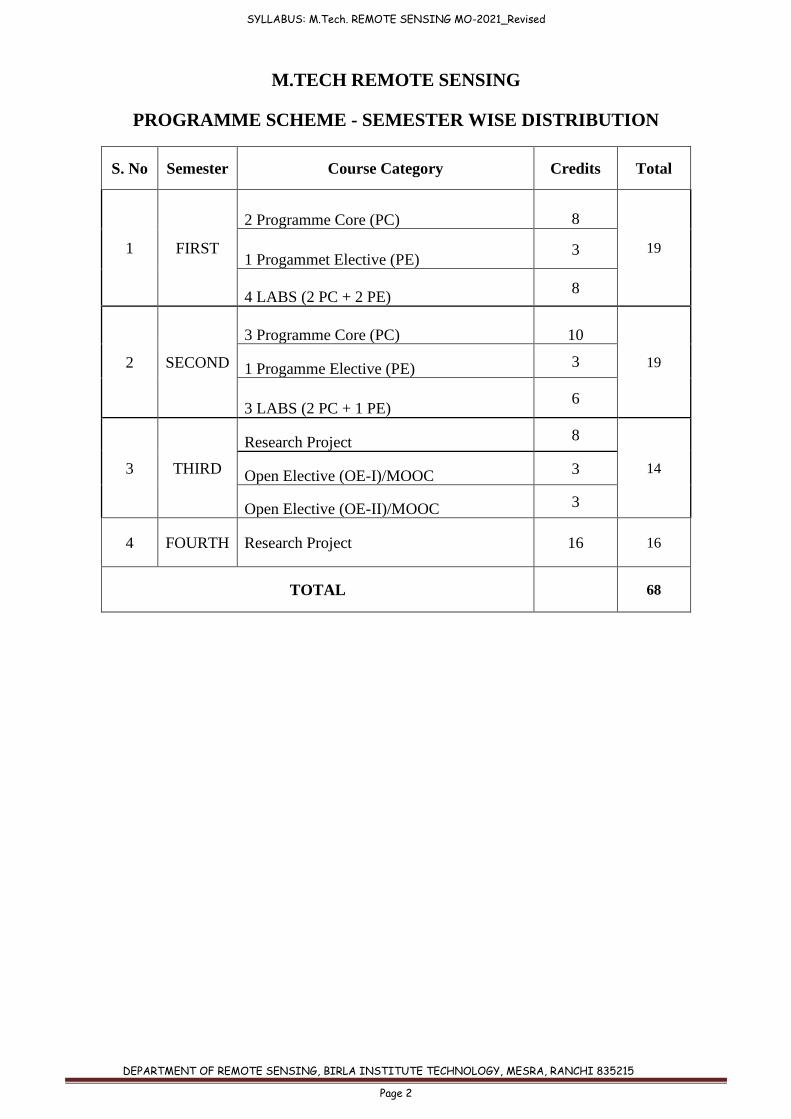
M.TECH REMOTE SENSING
PROGRAMME SCHEME - SEMESTER WISE DISTRIBUTION
S. No Semester Course Category Credits Total
1 FIRST
2 Programme Core (PC)
8
19 1 Progammet Elective (PE)
3
4 LABS (2 PC + 2 PE) 8
2 SECOND
3 Programme Core (PC)
10
19 1 Progamme Elective (PE) 3
3 LABS (2 PC + 1 PE) 6
3 THIRD
Research Project 8
14 Open Elective (OE-I)/MOOC 3
Open Elective (OE-II)/MOOC 3
4 FOURTH Research Project 16 16
TOTAL 68
SYLLABUS: M.Tech. REMOTE SENSING MO-2021_Revised
DEPARTMENT OF REMOTE SENSING, BIRLA INSTITUTE TECHNOLOGY, MESRA, RANCHI 835215
Page 3
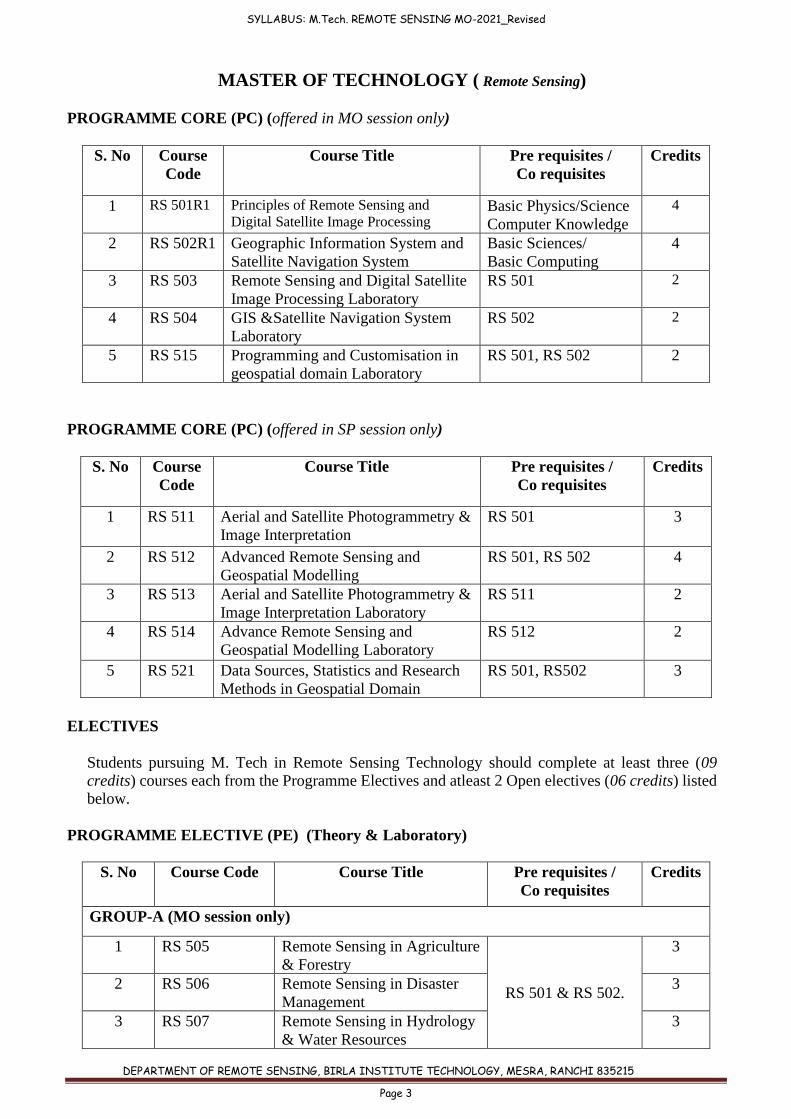
MASTER OF TECHNOLOGY ( Remote Sensing)
PROGRAMME CORE (PC) (offered in MO session only)
S. No Course
Code
Course Title Pre requisites /
Co requisites
Credits
1 RS 501R1 Principles of Remote Sensing and
Digital Satellite Image Processing Basic Physics/Science
Computer Knowledge
4
2 RS 502R1 Geographic Information System and
Satellite Navigation System
Basic Sciences/
Basic Computing
4
3 RS 503 Remote Sensing and Digital Satellite
Image Processing Laboratory
RS 501 2
4 RS 504 GIS &Satellite Navigation System
Laboratory
RS 502 2
5 RS 515 Programming and Customisation in
geospatial domain Laboratory
RS 501, RS 502 2
PROGRAMME CORE (PC) (offered in SP session only)
S. No Course
Code
Course Title Pre requisites /
Co requisites
Credits
1 RS 511 Aerial and Satellite Photogrammetry &
Image Interpretation
RS 501 3
2 RS 512 Advanced Remote Sensing and
Geospatial Modelling
RS 501, RS 502 4
3 RS 513 Aerial and Satellite Photogrammetry &
Image Interpretation Laboratory
RS 511 2
4 RS 514 Advance Remote Sensing and
Geospatial Modelling Laboratory
RS 512 2
5 RS 521 Data Sources, Statistics and Research
Methods in Geospatial Domain
RS 501, RS502 3
ELECTIVES
Students pursuing M. Tech in Remote Sensing Technology should complete at least three (09 credits) courses each from the Programme Electives and atleast 2 Open electives (06 credits) listed below.
PROGRAMME ELECTIVE (PE) (Theory & Laboratory)
S. No Course Code Course Title Pre requisites /
Co requisites
Credits
GROUP-A (MO session only)
1 RS 505 Remote Sensing in Agriculture
& Forestry
RS 501 & RS 502.
3
2 RS 506 Remote Sensing in Disaster
Management
3
3 RS 507 Remote Sensing in Hydrology
& Water Resources
3
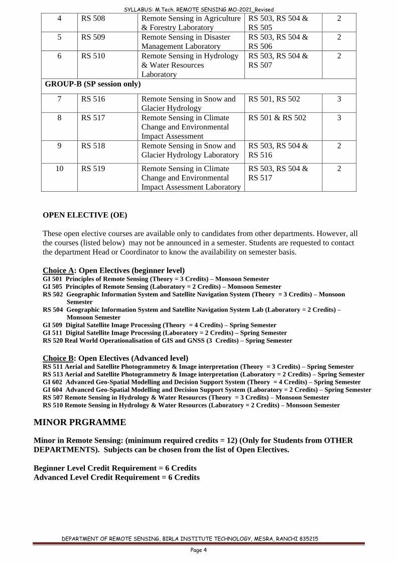
SYLLABUS: M.Tech. REMOTE SENSING MO-2021_Revised
DEPARTMENT OF REMOTE SENSING, BIRLA INSTITUTE TECHNOLOGY, MESRA, RANCHI 835215
Page 4
4 RS 508 Remote Sensing in Agriculture
& Forestry Laboratory
RS 503, RS 504 &
RS 505
2
5 RS 509 Remote Sensing in Disaster
Management Laboratory
RS 503, RS 504 &
RS 506
2
6 RS 510 Remote Sensing in Hydrology
& Water Resources
Laboratory
RS 503, RS 504 &
RS 507
2
GROUP-B (SP session only)
7 RS 516 Remote Sensing in Snow and
Glacier Hydrology
RS 501, RS 502 3
8 RS 517 Remote Sensing in Climate
Change and Environmental
Impact Assessment
RS 501 & RS 502 3
9 RS 518 Remote Sensing in Snow and
Glacier Hydrology Laboratory
RS 503, RS 504 &
RS 516
2
10 RS 519 Remote Sensing in Climate
Change and Environmental
Impact Assessment Laboratory
RS 503, RS 504 &
RS 517
2
OPEN ELECTIVE (OE)
These open elective courses are available only to candidates from other departments. However, all
the courses (listed below) may not be announced in a semester. Students are requested to contact
the department Head or Coordinator to know the availability on semester basis.
Choice A: Open Electives (beginner level) GI 501 Principles of Remote Sensing (Theory = 3 Credits) – Monsoon Semester
GI 505 Principles of Remote Sensing (Laboratory = 2 Credits) – Monsoon Semester
RS 502 Geographic Information System and Satellite Navigation System (Theory = 3 Credits) – Monsoon
Semester
RS 504 Geographic Information System and Satellite Navigation System Lab (Laboratory = 2 Credits) –
Monsoon Semester
GI 509 Digital Satellite Image Processing (Theory = 4 Credits) – Spring Semester
GI 511 Digital Satellite Image Processing (Laboratory = 2 Credits) – Spring Semester
RS 520 Real World Operationalisation of GIS and GNSS (3 Credits) – Spring Semester
Choice B: Open Electives (Advanced level) RS 511 Aerial and Satellite Photogrammetry & Image interpretation (Theory = 3 Credits) – Spring Semester
RS 513 Aerial and Satellite Photogrammetry & Image interpretation (Laboratory = 2 Credits) – Spring Semester
GI 602 Advanced Geo-Spatial Modelling and Decision Support System (Theory = 4 Credits) – Spring Semester
GI 604 Advanced Geo-Spatial Modelling and Decision Support System (Laboratory = 2 Credits) – Spring Semester
RS 507 Remote Sensing in Hydrology & Water Resources (Theory = 3 Credits) – Monsoon Semester
RS 510 Remote Sensing in Hydrology & Water Resources (Laboratory = 2 Credits) – Monsoon Semester
MINOR PRGRAMME
Minor in Remote Sensing: (minimum required credits = 12) (Only for Students from OTHER
DEPARTMENTS). Subjects can be chosen from the list of Open Electives.
Beginner Level Credit Requirement = 6 Credits
Advanced Level Credit Requirement = 6 Credits
SYLLABUS: M.Tech. REMOTE SENSING MO-2021_Revised
DEPARTMENT OF REMOTE SENSING, BIRLA INSTITUTE TECHNOLOGY, MESRA, RANCHI 835215
Page 5
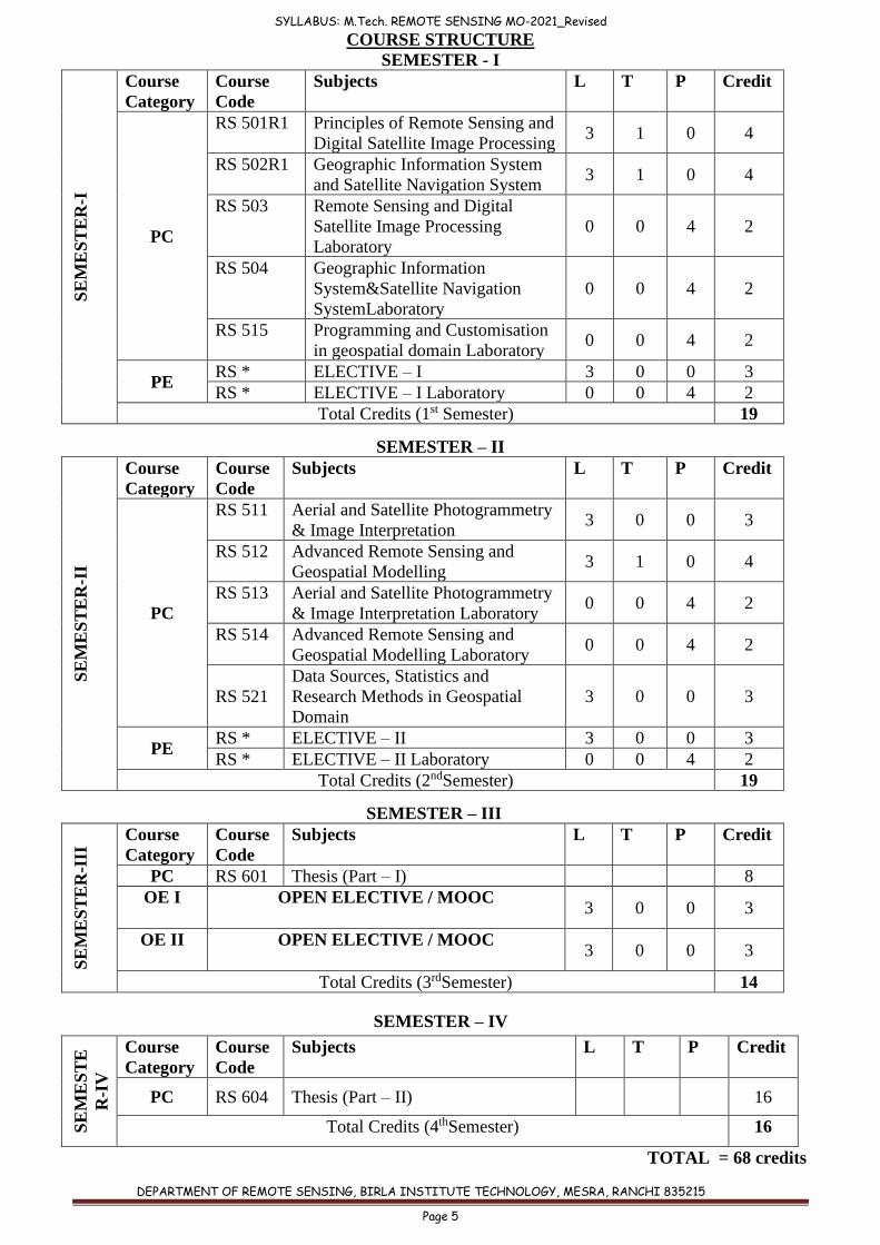
COURSE STRUCTURE
SEMESTER - I S
EM
ES
TE
R-I
Course
Category
Course
Code
Subjects L T P Credit
PC
RS 501R1 Principles of Remote Sensing and
Digital Satellite Image Processing 3 1 0 4
RS 502R1 Geographic Information System
and Satellite Navigation System 3 1 0 4
RS 503 Remote Sensing and Digital
Satellite Image Processing
Laboratory
0 0 4 2
RS 504 Geographic Information
System&Satellite Navigation
SystemLaboratory
0 0 4 2
RS 515 Programming and Customisation
in geospatial domain Laboratory 0 0 4 2
PE RS * ELECTIVE – I 3 0 0 3
RS * ELECTIVE – I Laboratory 0 0 4 2
Total Credits (1st Semester) 19
SEMESTER – II
SE
ME
ST
ER
-II
Course
Category
Course
Code
Subjects L T P Credit
PC
RS 511 Aerial and Satellite Photogrammetry
& Image Interpretation 3 0 0 3
RS 512 Advanced Remote Sensing and
Geospatial Modelling 3 1 0 4
RS 513 Aerial and Satellite Photogrammetry
& Image Interpretation Laboratory 0 0 4 2
RS 514 Advanced Remote Sensing and
Geospatial Modelling Laboratory 0 0 4 2
RS 521
Data Sources, Statistics and
Research Methods in Geospatial
Domain
3 0 0 3
PE RS * ELECTIVE – II 3 0 0 3
RS * ELECTIVE – II Laboratory 0 0 4 2
Total Credits (2ndSemester) 19
SEMESTER – III
SE
ME
ST
ER
-III
Course
Category
Course
Code
Subjects L T P Credit
PC RS 601 Thesis (Part – I) 8
OE I OPEN ELECTIVE / MOOC 3 0 0 3
OE II OPEN ELECTIVE / MOOC 3 0 0 3
Total Credits (3rdSemester) 14
SEMESTER – IV
SE
ME
ST
E
R-I
V
Course
Category
Course
Code
Subjects L T P Credit
PC RS 604 Thesis (Part – II) 16
Total Credits (4thSemester) 16
TOTAL = 68 credits
SYLLABUS: M.Tech. REMOTE SENSING MO-2021_Revised
DEPARTMENT OF REMOTE SENSING, BIRLA INSTITUTE TECHNOLOGY, MESRA, RANCHI 835215
Page 6
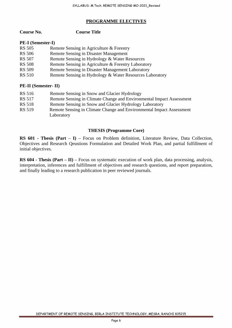
PROGRAMME ELECTIVES
Course No. Course Title
PE-I (Semester-I)
RS 505 Remote Sensing in Agriculture & Forestry
RS 506 Remote Sensing in Disaster Management
RS 507 Remote Sensing in Hydrology & Water Resources
RS 508 Remote Sensing in Agriculture & Forestry Laboratory
RS 509 Remote Sensing in Disaster Management Laboratory
RS 510 Remote Sensing in Hydrology & Water Resources Laboratory
PE-II (Semester- II)
RS 516 Remote Sensing in Snow and Glacier Hydrology
RS 517 Remote Sensing in Climate Change and Environmental Impact Assessment
RS 518 Remote Sensing in Snow and Glacier Hydrology Laboratory
RS 519 Remote Sensing in Climate Change and Environmental Impact Assessment
Laboratory
THESIS (Programme Core)
RS 601 - Thesis (Part – I) – Focus on Problem definition, Literature Review, Data Collection,
Objectives and Research Qeustions Formulation and Detailed Work Plan, and partial fulfillment of
initial objectives.
RS 604 - Thesis (Part – II) – Focus on systematic execution of work plan, data processing, analysis,
interpretation, inferences and fulfillment of objectives and research questions, and report preparation,
and finally leading to a research publication in peer reviewed journals.
SYLLABUS: M.Tech. REMOTE SENSING MO-2021_Revised
DEPARTMENT OF REMOTE SENSING, BIRLA INSTITUTE TECHNOLOGY, MESRA, RANCHI 835215
Page 7
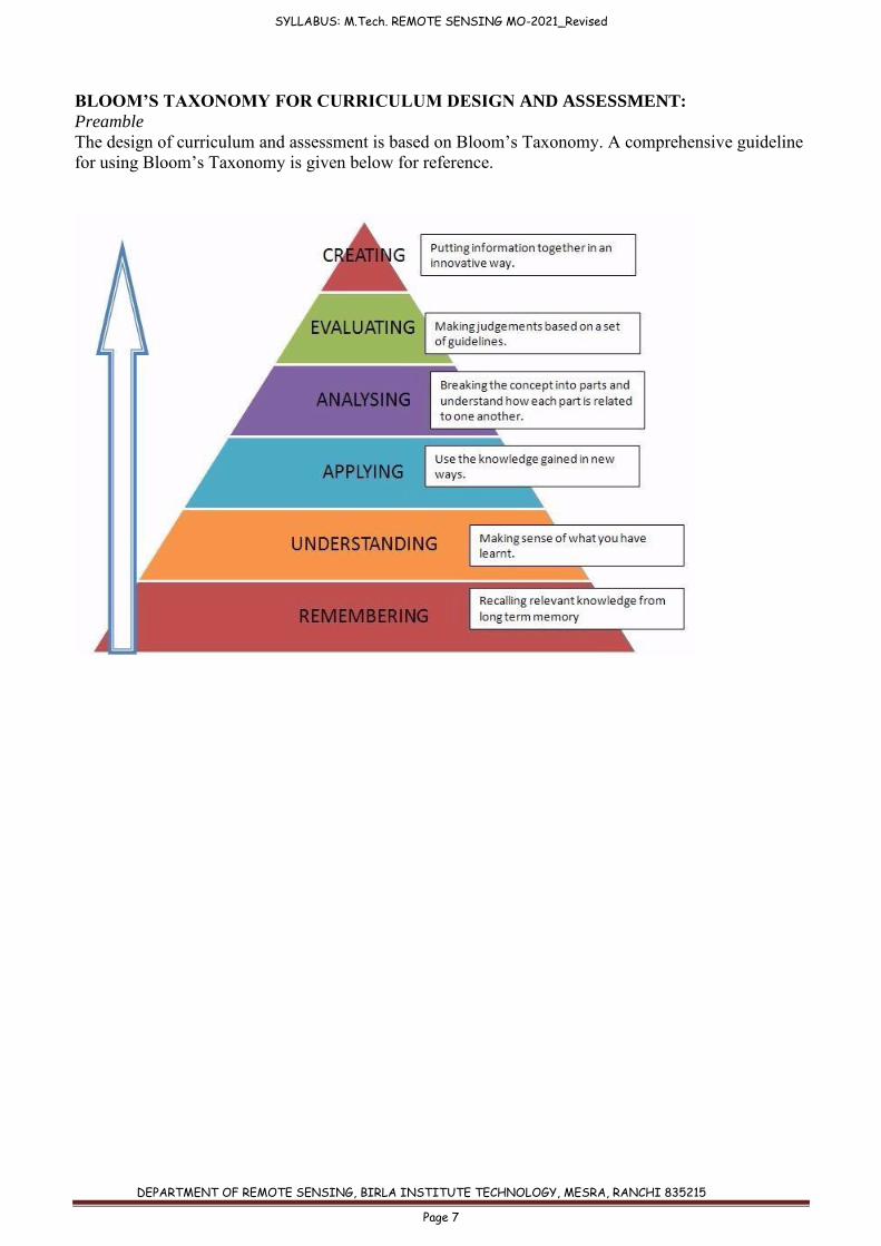
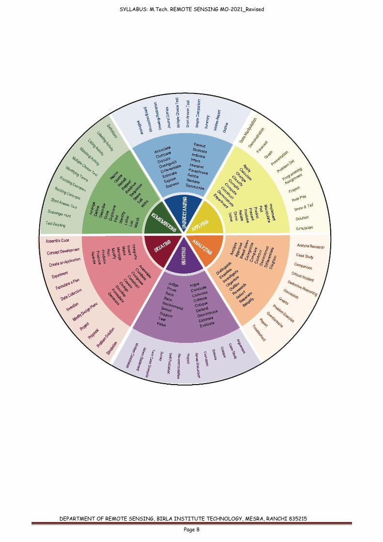
BLOOM’S TAXONOMY FOR CURRICULUM DESIGN AND ASSESSMENT:
Preamble
The design of curriculum and assessment is based on Bloom’s Taxonomy. A comprehensive guideline
for using Bloom’s Taxonomy is given below for reference.
SYLLABUS: M.Tech. REMOTE SENSING MO-2021_Revised
DEPARTMENT OF REMOTE SENSING, BIRLA INSTITUTE TECHNOLOGY, MESRA, RANCHI 835215
Page 8
SYLLABUS: M.Tech. REMOTE SENSING MO-2021_Revised
DEPARTMENT OF REMOTE SENSING, BIRLA INSTITUTE TECHNOLOGY, MESRA, RANCHI 835215
Page 9
M. Tech. (REMOTE SENSING)
SEMESTER I
Course code: RS 501R1
Course title: PRINCIPLES OF REMOTE SENSING & DIGITAL SATELLITE IMAGE
PROCESSING
Pre-requisite(s): Basic Physics/Science
Co- requisite(s): Computer Knowledge
Credits: L: T: P: C:
3 1 0 4
Class schedule per week: 4
Class: M. TECH
Semester / Level: 01/05 (Monsoon)
Branch: REMOTE SENSING
Name of Teacher:
Course Objectives
This course aims to:
1. Disseminate basic concepts and applications of Electromagnetic Spectrum in Remote
Sensing, Energy Balance and Data acquisition platforms, sensors and their
characterstics 2. Enhance student’s knowledge about optical, thermal and microwaves based Remote
Sensing and Applications for solving real life problems
3. Introduce students to digital image processing tools and techniques.
Course Outcomes (CO):
On completion of this course, students should be able to:
CO1 Explain physical principles and sensing process in remote sensing.
CO2 Explain different type of sensors (optical, microwave, thermal and LIDAR) and their
characteristics.
CO3 Describe preprocessing requirements and discuss various Digital Image Processing
techniques.
CO4 Rationalise statistical outlook of satellite images and different classification
approaches with respect to diverse applications.
CO5 Apply the knowledge of remote sensing in various thematic studies
MODULE 1: BASIC CONCEPTS
Remote Sensing: History, Development, Definition, Concept & Principles, Electromagnetic
Radiation (EMR) and Its Characteristics, Wavelength Regions and their Significance, Interaction
of EMR with Atmosphere and Earth’s Surface: Absorption, Reflectance and Scattering,
Atmospheric Windows, Energy Balance Equation, Spectral Response and Spectral Signature,
Spectral, Spatial, Temporal and Radiometric resolutions.
SYLLABUS: M.Tech. REMOTE SENSING MO-2021_Revised
DEPARTMENT OF REMOTE SENSING, BIRLA INSTITUTE TECHNOLOGY, MESRA, RANCHI 835215
Page 10
MODULE 2: DATA ACQUISITION
Platform: Balloon, Rocket, Helicopter, Aircraft and Spacecraft, Aerial vs. Satellite Remote
Sensing, Satellites and their Specifications: LANDSAT, SPOT, ENVISAT, RADARSAT, IRS,
IKONOS, Sensors and their Specifications: MSS, TM, LISS(I,II,III,IV), PAN, WiFS, AWiFS,
MODIS, Weather & Communication Satellites.
MODULE 3: OPTICAL, THERMAL AND MICROWAVE REMOTE SENSING
Imaging and Non-Imaging, Active and Passive, Multispectral, Superspectral and Hyperspectral
Sensors, Electro-Optical Systems, Opto-Mechanical Scanners, Infrared Scanners, Scatterometer,
Thermal Properties of Terrain, Thermal IR Environmental Considerations, Thermal Infrared and
Thermal Scanners, Microwave Remote sensing concepts: Backscattering, Range Direction,
Azimuth Direction, Incident Angle, Depression Angle, Polarization, Dielectric Properties,
Surface Roughness and Interpretation, Speckle and Its Reduction, Applications of optical,
thermal and microwave remote sensing.
MODULE 4: IMAGE ENHANCEMENT AND FILTERING TECHNIQUES
Concepts about digital image and its characteristics, Sources of image degradation - Image
restoration and Noise Abatement , Radiometric and Geometric correction technique, linear and
non linear transformation for geometric corrections, Look-up Tables (LUT) and Types of image
displays and FCC, Radiometric enhancement techniques, Spatial enhancement techniques,
Contrast stretching: Linear and non-linear methods, Low Pass Filtering: Image smoothing, High
Pass Filtering: Edge enhancement and Edge detection, Gradient filters, Directional and non-
directional filtering.
MODULE 5: PATTERN RECOGNITION
Concept of Pattern Recognition, Multi-spectral pattern recognition, Spectral discrimination,
Signature bank, Parametric and Non-Parametric classifiers, Unsupervised classification
methods. Supervised classification techniques, Limitations of standard classifiers.
TEXT BOOKS:
1. Joseph,George and Jeganathan, C. (2017). “Fundamentals of Remote Sensing”, 3rd Edition,
Universities press (India) Pvt. Ltd., Hyderabad.
2. Jensen, J.R. (2006). “Remote Sensing of the Environment – An Earth Resources
Perspective”, Pearson Education, Inc. (Singapore) Pvt. Ltd., Indian edition, Delhi.
3. Jensen, J.R. (1996). Introductory Digital Image Processing A remote sensing perspective.
Prentice Hall Seies in GIS , USA
4. Lillesand, Thomas M. and Kiefer, Ralph, W. (2007). “Remote Sensing and Image
Interpretation”, 4th Edition, John Wiley and Sons, New York.
REFERENCE BOOKS:
1. Sabins, F.F. Jr. (2007). ‘Remote Sensing – Principles and Interpretation”, W.H. Freeman &
Co.
2. Reeves, Robert G. (1991), “Manual of Remote Sensing, Vol. I, American Society of
Photogrammetry and Remote Sensing, Falls Church, Virginia, USA
SYLLABUS: M.Tech. REMOTE SENSING MO-2021_Revised
DEPARTMENT OF REMOTE SENSING, BIRLA INSTITUTE TECHNOLOGY, MESRA, RANCHI 835215
Page 11
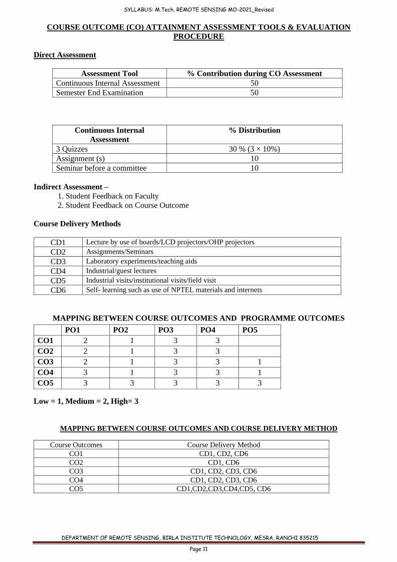
COURSE OUTCOME (CO) ATTAINMENT ASSESSMENT TOOLS & EVALUATION
PROCEDURE
Direct Assessment
Assessment Tool % Contribution during CO Assessment
Continuous Internal Assessment 50
Semester End Examination 50
Continuous Internal
Assessment
% Distribution
3 Quizzes 30 % (3 × 10%)
Assignment (s) 10
Seminar before a committee 10
Indirect Assessment –
1. Student Feedback on Faculty
2. Student Feedback on Course Outcome
Course Delivery Methods
CD1 Lecture by use of boards/LCD projectors/OHP projectors
CD2 Assignments/Seminars
CD3 Laboratory experiments/teaching aids
CD4 Industrial/guest lectures
CD5 Industrial visits/institutional visits/field visit
CD6 Self- learning such as use of NPTEL materials and internets
MAPPING BETWEEN COURSE OUTCOMES AND PROGRAMME OUTCOMES
Low = 1, Medium = 2, High= 3
MAPPING BETWEEN COURSE OUTCOMES AND COURSE DELIVERY METHOD
Course Outcomes Course Delivery Method
CO1 CD1, CD2, CD6
CO2 CD1, CD6
CO3 CD1, CD2, CD3, CD6
CO4 CD1, CD2, CD3, CD6
CO5 CD1,CD2,CD3,CD4,CD5, CD6
PO1 PO2 PO3 PO4 PO5
CO1 2 1 3 3
CO2 2 1 3 3
CO3 2 1 3 3 1
CO4 3 1 3 3 1
CO5 3 3 3 3 3
SYLLABUS: M.Tech. REMOTE SENSING MO-2021_Revised
DEPARTMENT OF REMOTE SENSING, BIRLA INSTITUTE TECHNOLOGY, MESRA, RANCHI 835215
Page 12
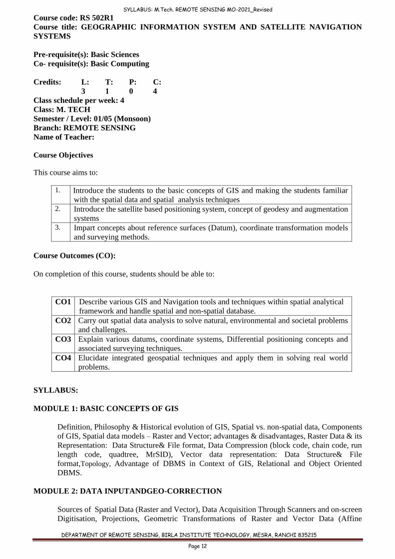
Course code: RS 502R1
Course title: GEOGRAPHIC INFORMATION SYSTEM AND SATELLITE NAVIGATION
SYSTEMS
Pre-requisite(s): Basic Sciences
Co- requisite(s): Basic Computing
Credits: L: T: P: C:
3 1 0 4
Class schedule per week: 4
Class: M. TECH
Semester / Level: 01/05 (Monsoon)
Branch: REMOTE SENSING
Name of Teacher:
Course Objectives
This course aims to:
1. Introduce the students to the basic concepts of GIS and making the students familiar
with the spatial data and spatial analysis techniques 2. Introduce the satellite based positioning system, concept of geodesy and augmentation
systems 3. Impart concepts about reference surfaces (Datum), coordinate transformation models
and surveying methods.
Course Outcomes (CO):
On completion of this course, students should be able to:
CO1 Describe various GIS and Navigation tools and techniques within spatial analytical
framework and handle spatial and non-spatial database.
CO2 Carry out spatial data analysis to solve natural, environmental and societal problems
and challenges.
CO3 Explain various datums, coordinate systems, Differential positioning concepts and
associated surveying techniques.
CO4 Elucidate integrated geospatial techniques and apply them in solving real world
problems.
SYLLABUS:
MODULE 1: BASIC CONCEPTS OF GIS
Definition, Philosophy & Historical evolution of GIS, Spatial vs. non-spatial data, Components
of GIS, Spatial data models – Raster and Vector; advantages & disadvantages, Raster Data & its
Representation: Data Structure& File format, Data Compression (block code, chain code, run
length code, quadtree, MrSID), Vector data representation: Data Structure& File
format,Topology, Advantage of DBMS in Context of GIS, Relational and Object Oriented
DBMS.
MODULE 2: DATA INPUTANDGEO-CORRECTION
Sources of Spatial Data (Raster and Vector), Data Acquisition Through Scanners and on-screen
Digitisation, Projections, Geometric Transformations of Raster and Vector Data (Affine
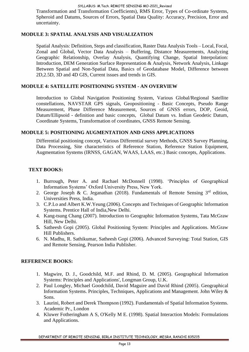
SYLLABUS: M.Tech. REMOTE SENSING MO-2021_Revised
DEPARTMENT OF REMOTE SENSING, BIRLA INSTITUTE TECHNOLOGY, MESRA, RANCHI 835215
Page 13
Transformation and Transformation Coefficients), RMS Error, Types of Co-ordinate Systems,
Spheroid and Datums, Sources of Errors, Spatial Data Quality: Accuracy, Precision, Error and
uncertainty.
MODULE 3: SPATIAL ANALYSIS AND VISUALIZATION
Spatial Analysis: Definition, Steps and classification, Raster Data Analysis Tools – Local, Focal,
Zonal and Global, Vector Data Analysis – Buffering, Distance Measurements, Analyzing
Geographic Relationship, Overlay Analysis, Quantifying Change, Spatial Interpolation:
Introduction, DEM Generation Surface Representation & Analysis, Network Analysis, Linkage
Between Spatial and Non-Spatial Data, Basics of Geodatabase Model, Difference between
2D,2.5D, 3D and 4D GIS, Current issues and trends in GIS.
MODULE 4: SATELLITE POSITIONING SYSTEM - AN OVERVIEW
Introduction to Global Navigation Positioning System, Various Global/Regional Satellite
constellations, NAVSTAR GPS signals, Geopositioning - Basic Concepts, Pseudo Range
Measurement, Phase Difference Measurement, Sources of GNSS errors, DOP, Geoid,
Datum/Ellipsoid - definition and basic concepts, Global Datum vs. Indian Geodetic Datum,
Coordinate Systems, Transformation of coordinates, GNSS Remote Sensing.
MODULE 5: POSITIONING AUGMENTATION AND GNSS APPLICATIONS
Differential positioning concept, Various Differential survey Methods, GNSS Survey Planning,
Data Processing, Site characteristics of Reference Station, Reference Station Equipment,
Augmentation Systems (IRNSS, GAGAN, WAAS, LAAS, etc.) Basic concepts, Applications.
TEXT BOOKS:
1. Burrough, Peter A. and Rachael McDonnell (1998). ‘Principles of Geographical
Information Systems’ Oxford University Press, New York.
2. George Joseph & C. Jeganathan (2018). Fundamentals of Remote Sensing 3rd edition,
Universities Press, India.
3. C.P.Lo and Albert K.W.Yeung (2006). Concepts and Techniques of Geographic Information
Systems. Prentice Hall of India,New Delhi.
4. Kang-tsung Chang (2007). Introduction to Geographic Information Systems, Tata McGraw
Hill, New Delhi.
5. Satheesh Gopi (2005). Global Positioning System: Principles and Applications. McGraw
Hill Publishers.
6. N. Madhu, R. Sathikumar, Satheesh Gopi (2006). Advanced Surveying: Total Station, GIS
and Remote Sensing, Pearson India Publisher.
REFERENCE BOOKS:
1. Magwire, D. J., Goodchild, M.F. and Rhind, D. M. (2005). Geographical Information
Systems: Principles and Applications', Longman Group, U.K.
2. Paul Longley, Michael Goodchild, David Maguire and David Rhind (2005). Geographical
Information Systems. Principles, Techniques, Applications and Management. John Wiley &
Sons.
3. Laurini, Robert and Derek Thompson (1992). Fundamentals of Spatial Information Systems.
Academic Pr., London
4. Kluwer Fotheringham A S, O'Kelly M E. (1998). Spatial Interaction Models: Formulations
and Applications.
SYLLABUS: M.Tech. REMOTE SENSING MO-2021_Revised
DEPARTMENT OF REMOTE SENSING, BIRLA INSTITUTE TECHNOLOGY, MESRA, RANCHI 835215
Page 14
5. Thanappan Subash (2011). Geographical Information System,Lambert Academic
Publishing.
6. John E. Harmon & Steven J. Anderson (2003). The design and implementation of
Geographic Information Systems, John Wiley &Sons,.
7. ArcGIS 10.1 Manuals, 2016.
8. N.K.Agrawal (2004). Essentials of GPS, Spatial Network Pvt. Ltd
9. Leica. A. (2003). GPS Satellite Surveying, John Wiley & Sons. New York
10. Terry-Karen Steede (2002). Integrating GIS and the Global Positioning System, ESRI Press
11. Hofmann W.B &Lichtenegger, H. Collins (2001). Global Positioning System – Theoryand
Practice, Springer-Verlag Wein, New York,.
12. Gunter Seeber (2003). Satellite Geodesy Foundations-Methods and Applications,Gruyter,
Walter de GmbH.
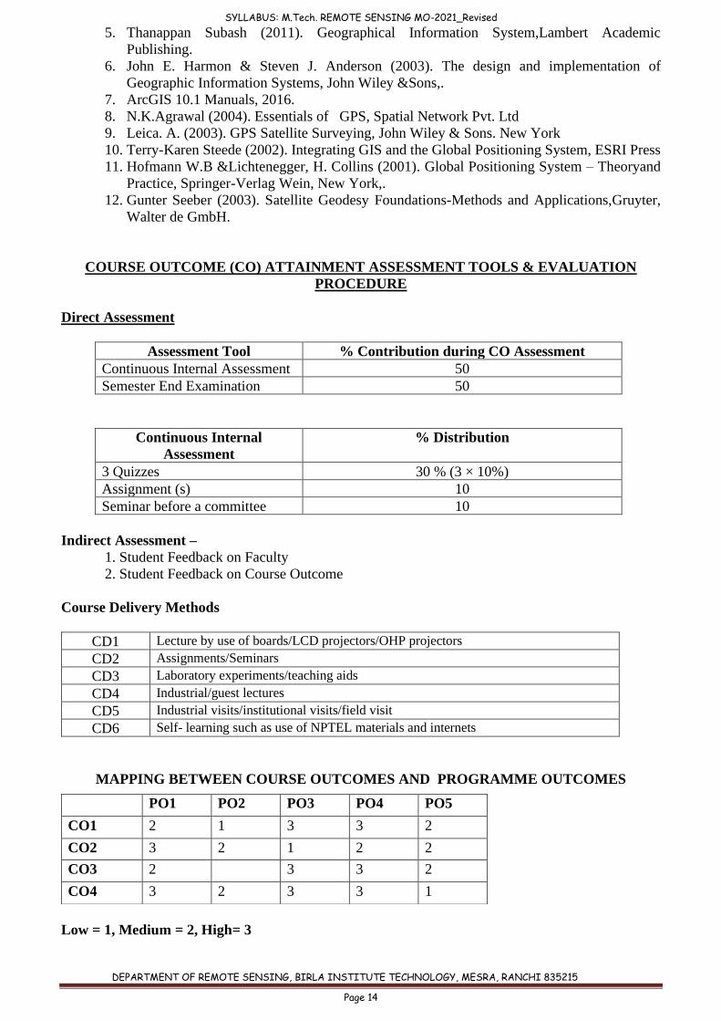
COURSE OUTCOME (CO) ATTAINMENT ASSESSMENT TOOLS & EVALUATION
PROCEDURE
Direct Assessment
Assessment Tool % Contribution during CO Assessment
Continuous Internal Assessment 50
Semester End Examination 50
Continuous Internal
Assessment
% Distribution
3 Quizzes 30 % (3 × 10%)
Assignment (s) 10
Seminar before a committee 10
Indirect Assessment –
1. Student Feedback on Faculty
2. Student Feedback on Course Outcome
Course Delivery Methods
CD1 Lecture by use of boards/LCD projectors/OHP projectors
CD2 Assignments/Seminars
CD3 Laboratory experiments/teaching aids
CD4 Industrial/guest lectures
CD5 Industrial visits/institutional visits/field visit
CD6 Self- learning such as use of NPTEL materials and internets
MAPPING BETWEEN COURSE OUTCOMES AND PROGRAMME OUTCOMES
Low = 1, Medium = 2, High= 3
PO1 PO2 PO3 PO4 PO5
CO1 2 1 3 3 2
CO2 3 2 1 2 2
CO3 2 3 3 2
CO4 3 2 3 3 1
SYLLABUS: M.Tech. REMOTE SENSING MO-2021_Revised
DEPARTMENT OF REMOTE SENSING, BIRLA INSTITUTE TECHNOLOGY, MESRA, RANCHI 835215
Page 15
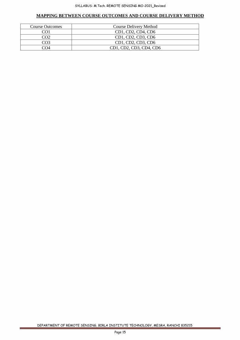
MAPPING BETWEEN COURSE OUTCOMES AND COURSE DELIVERY METHOD
Course Outcomes Course Delivery Method
CO1 CD1, CD2, CD4, CD6
CO2 CD1, CD2, CD3, CD6
CO3 CD1, CD2, CD3, CD6
CO4 CD1, CD2, CD3, CD4, CD6
SYLLABUS: M.Tech. REMOTE SENSING MO-2021_Revised
DEPARTMENT OF REMOTE SENSING, BIRLA INSTITUTE TECHNOLOGY, MESRA, RANCHI 835215
Page 16
ELECTIVES Course code: RS 505
Course title: REMOTE SENSING IN AGRICULTURE AND FORESTRY
Pre-requisite(s): (i) Knowledge of Basic Sciences
(ii) Computer Knowledge
Co- requisite(s):
Credits: L: T: P: C:
3 0 0 3
Class schedule per week: 3
Class: M. TECH
Semester / Level: 01/05 (Monsoon)
Branch: REMOTE SENSING
Name of Teacher:
Course Objectives
This course aims to:
1. Enhance the student’s understanding about role of remote sensing for agriculture and
forestry applications. 2. Make the student assess various situations of agriculture damages and land
degradation, and to detect and quantify those problems using remote sensing. 3. Learn various forestry, ecological and wildlife related concepts, and to use remote
sensing in those fields.
Course Outcomes (CO):
On completion of this course, students should be able to:
CO1 Map and quantify various agricultural features, yield, and identify the difference
between healthy crop and affected crop using remote sensing data.
CO2 Identify and visually interpret various land features and its degradation on the satellite
imagery and importance of secondary data in the field of agriculture.
CO3 Able to identify different types of forests features and associated problems (such as
forest fire, degradation, deforestation etc) with the help of satellite data.
CO4 Able to model landscape ecological metrics, anthropogenic disturbances and wildlife
site suitability using RS&GIS.
MODULE 1: INTRODUCTION
Spectral Properties of Vegetation: Natural and Man-made, Crop Yield and Acreage Estimation,
Discriminate Analysis, Agricultural Applications: Sensor Requirements.
MODULE 2: DAMAGE ASSESSMENT
Plant Stress, Disease and Change Detection, Various Vegetation and Climatic Indices for
Drought Damage assessment and Monitoring, Pest Control and Monitoring, Salt Affected land
Mapping and Monitoring. Land degradation (water logging, salinization, erosion) assessment
using RS & GIS.
SYLLABUS: M.Tech. REMOTE SENSING MO-2021_Revised
DEPARTMENT OF REMOTE SENSING, BIRLA INSTITUTE TECHNOLOGY, MESRA, RANCHI 835215
Page 17
MODULE 3: LAND USE/LAND COVER
Basic Concept and Criteria of Land Use / Land Cover Classification, Methodology,
Classification System, Level of Classification, Land Capability Assessment.
MODULE 4: FORESTRY CONCEPTS
Conventional/Recent Remote Sensing Classification and Forest Inventory, Climatic, Altitudinal
and Topographical Zones and Vegetation Relation, Forest Types Classification and Retrieval of
Biophysical Parameters, Sensor Requirements, Landscape Ecology Concepts.
MODULE 5: VISUAL AND DIGITAL ANALYSIS:
Forest Cover, Canopy Density, Biomass Assessment, Forest Fire and Burnt Area Identification,
Indian Forest Fire Alarm, Geospatial Modelling of Forest Fire Risk Zones, Sustainable
Management, Criteria & Indicators based Decision Framework. Wildlife and Landscape
Relationship, Habitat Assessment and Suitability Modelling, Disturbance Index and Analysis.
TEXT BOOKS:
1. Nicolas Baghdadi and Meherez Zribi (2016). Land Surface Remote Sensing in Agriculture
and Forest, ISTE Press and Elsevier, UK.ISBN:978-1-78548-103-1
2. Roy, P.S., Dwivedi, and Vijayan, D. (2010). Remote Sensing Applications. NRSC, ISRO,
Hyderabad. ISBN 978-81-909460-0-1.
3. NDMA (2010). National Disaster Management Guidelines: Management of Drought. A
publication of National Disaster Management Authority Government of India, New Delhi.
ISBN: 978-93-80440-08-8
4. Fortin, M.S. and Dale, M. (2005). Spatial Analysis for Ecologist, Cambridge University
Press, Cambridge. ISBN- 9780521804345.
REFERENCE MATERIALS:
1. Boyd, D.S. and Danson, F.M. (2005). Satellite remote sensing of forest resources: Three
decades of research development. Prog. Phys.Geogr., 29, 1-26.
2. Kogan, F.N. (2001). Operational Space Technology for Global Vegetation Assessment.
Bulletin of the American Meteorological Society, 82:1949-1964.
3. Thornthwaite, C.W. (1948). An Approach toward a rational classification of climate,
Geographical Review, 21: 633-655.
4. Sinha, A.K. (1986). Spectral Reflectance characteristics of Soils and its correlation with soils
properties and surface conditions, Journal of Indian Soceity of Remote Sensing, 14(1), 1-9.
5. Nagendra, H. and Gadgil, M. (1999). Satellite imagery as a tool for monitoring species
diversity: An assessment, Journal of Applied Ecology, 36: 388-397.
6. Muller, D. and Ellenberg, D.H. (1974). Aims and Methods of Vegetation Ecology, John
Wiley and Sons,New York.
7. Franklin, S.E. (2001). Remote Sensing for Sustainable Forest Management, Lewis
Publishers, Washington, D.C.
8. Behera, M.D. and Roy, P.S. (2002). Lidar Remote Sensing for Forestry Applications: The
Indian Context, Current Science, 83(11):1320-1327.
SYLLABUS: M.Tech. REMOTE SENSING MO-2021_Revised
DEPARTMENT OF REMOTE SENSING, BIRLA INSTITUTE TECHNOLOGY, MESRA, RANCHI 835215
Page 18
9. Delcourt H.R. and Delcourt, P.A. (1988), Quaternary Landscape Ecology: Relevant Scales
in Spce and Time, Landscape Ecology, 2: 23-44.
10. Farina, A. (2008). Principles and Methods in Landscape Ecology, Chapman & Hall
Publication, London. ISBN – 9780412730405.
11. Digby, P.G.N. and Kempton, R.A. (1996). Multivariate Analysis of Ecological
Communities. Chapman & Hall Publication. London. ISBN – 0412246406.
12. Environmental Education Media Films: http://www.eempc.org/
13. Environmental Development related: www.kosmosjournal.org
COURSE OUTCOME (CO) ATTAINMENT ASSESSMENT TOOLS & EVALUATION
PROCEDURE
Direct Assessment
Assessment Tool % Contribution during CO Assessment
Continuous Internal Assessment 50
Semester End Examination 50
Continuous Internal
Assessment
% Distribution
3 Quizzes 30 % (3 × 10%)
Assignment (s) 10
Seminar before a committee 10
Indirect Assessment –
1. Student Feedback on Faculty
2. Student Feedback on Course Outcome
Course Evaluation:
Individual assignment, Quizes, Mid and End semester examinations
Course Delivery Methods
CD1 Lecture by use of boards/LCD projectors/OHP projectors
CD2 Assignments/Seminars
CD3 Laboratory experiments/teaching aids
CD4 Industrial/guest lectures
CD5 Industrial visits/institutional visits/field visit
CD6 Self- learning such as use of NPTEL materials and internets
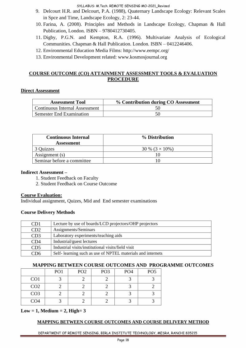
MAPPING BETWEEN COURSE OUTCOMES AND PROGRAMME OUTCOMES
Low = 1, Medium = 2, High= 3
MAPPING BETWEEN COURSE OUTCOMES AND COURSE DELIVERY METHOD
PO1 PO2 PO3 PO4 PO5
CO1 3 2 2 3 3
CO2 2 2 2 3 2
CO3 2 2 2 3 3
CO4 3 2 2 3 3
SYLLABUS: M.Tech. REMOTE SENSING MO-2021_Revised
DEPARTMENT OF REMOTE SENSING, BIRLA INSTITUTE TECHNOLOGY, MESRA, RANCHI 835215
Page 19
Course Outcomes Course Delivery Method
CO1 CD1, CD2, CD3, CD6
CO2 CD1, CD2, CD3, CD4, CD6
CO3 CD1, CD2, CD3, CD4, CD6
CO4 CD1, CD2, CD3, CD4, CD5, CD6
SYLLABUS: M.Tech. REMOTE SENSING MO-2021_Revised
DEPARTMENT OF REMOTE SENSING, BIRLA INSTITUTE TECHNOLOGY, MESRA, RANCHI 835215
Page 20
Course code: RS 506
Course title: REMOTE SENSING IN DISASTER MANAGEMENT
Pre-requisite(s): (i) Knowledge of Basic Sciences
(ii) Computer Knowledge
Co- requisite(s):
Credits: L: T: P: C:
3 0 0 3
Class schedule per week: 3
Class: M. TECH
Semester / Level: 01/05 (Monsoon)
Branch: REMOTE SENSING
Name of Teacher:
Course Objectives
This course aims to:
1. Impart basic concepts of disaster, its causes and its historial background 2. Enhance student's knowledge about disaster management planning
3. Make the students learn Geoinformatics approaches to deal with disaster risk reduction
and management.
Course Outcomes (CO):
On completion of this course, students should be able to:
CO1 Explain various types of disasters and responsible factors.
CO2 Interpret and discriminate different stages of disaster management planning and utility
of geomatics tools in every stage.
CO3 Understand administrative structure of disaster management in India.
CO4 Understand the ethical and humanitarian values.
CO5 Apply integrated geospatial techniques in disaster management and disaster risk
reduction.
MODULE 1: INTRODUCTION
Natural and human induced disasters, Fundamental concept of Disaster Management, Various
natural disasters and their characterization: Cyclones, Floods, Earth quakes, land subsidence and
Landslides, Forest fires, Droughts. Disasters and National losses, Historical perspective of
disasters in India. Existing organizational structure for managing disasters in India, NGOs and
people participation in disaster management.
MODULE 2: RS & GIS FOR HAZARD, RISK AND DAMAGE ASSESSMENT
Hazard evaluation – Zonation – Risk assessment and vulnerability, Damage assessment – Land
use planning and regulation for sustainable development, Potential of GIS application in disaster
mapping – Disaster management plan.
SYLLABUS: M.Tech. REMOTE SENSING MO-2021_Revised
DEPARTMENT OF REMOTE SENSING, BIRLA INSTITUTE TECHNOLOGY, MESRA, RANCHI 835215
Page 21
MODULE 3: LONG TERM MITIGATION MEASURES
Needs and approach towards prevention, principles and components of mitigation, Disaster
legislation and policy – Insurance – Cost effective analysis – Utilisation of resource, Training –
Education – Public awareness –Role of media.
MODULE 4: DISASTER MANAGEMENT PLANNING
Spatial and non-spatial data bank creation, Natural disaster management plans, Shelterbelts,
Special structures, Disaster preparedness and Mitigation. Information needs of Disaster
management, Operational emergency management – Vulnerability analysis of infrastructures,
Settlements and population, Pre-disaster and post disaster planning for relief operations, Satellite
communications during disasters: networks, use of Internets, Warning system - rehabilitation -
Post disaster review, Global Disaster Alert and Coordination System.
MODULE 5: DISASTER MODELING AND CASE STUDIES
Known/Generic Models in managing various disasters, Earthquakes in India, Tsunami Impact
Assessment, Floods in Indo Gangetic plains, Landslides in Himalayan region, Drought in Indian
plateau regions, Glacial lake outburst floods.
TEXT BOOKS:
1. Roy, P.S. (2000). Natural Disaster and their mitigation. Published by Indian Institute of
Remote Sensing (IIRS).
2. Sdidmore, A. (2002). Environmental Modeling with GIS and Remote Sensing, Taylor &
Francis.
3. Anji Reddy, M. (2004) Geoinformatics for environmental Management. B. S. Publication.
4. Murthy, D.B.N. (2008) - Disaster Management - Deep & Deep Publication.
REFERENCE BOOKS:
1. Bhattacharya, Tushar (2012). Disaster Science and Management, McGraw Hill Education
(India) Pvt. Ltd. ISBN-10: 1259061302; ISBN-13: 978-1259061301
2. UN (2015). Disasters without boarders United Nations Publications Sales No: E15.II.F.13,
ISBN: 978-92-1-120699-9
3. Gupta, H. K. (2012). Disaster Management, Universities press India , e-ISBN
9788173718663
4. Hyndman, Donald and Hyndman, David (2018). Natural Hazards and Disasters, ISBN -
13:0538737524
5. Pandey, Mrinalini (2014). Disaster Management, Willey India Pvt.Ltd ISBN
10: 8126549246 / ISBN 13: 9788126549245
6. Shukla, Shailesh,and Hussain, Shamna (2013) Biodiversity, Environment and Disaster
Management Unique Publications, ISBN: 9788183577670, 8183577679
7. Babar, Md. (2007). Environmental Changes and Natural Disasters, New India Publishing
Agency.
8. A. Orhan, R. Backhaus, P. Boccardo, S. Zlatanova (2010). Geoinformation for Disaster and
Risk Management Examples and Best Practices, Joint Board of Geospatial Information
Societies and United Nations Office for Outer Space Affairs, Denmark.
SYLLABUS: M.Tech. REMOTE SENSING MO-2021_Revised
DEPARTMENT OF REMOTE SENSING, BIRLA INSTITUTE TECHNOLOGY, MESRA, RANCHI 835215
Page 22
9. Liu Y. & Baas S. (2001). Strengthening pastoral institutions in North-West China pastoral
area to access improved extension services for risk management and poverty alleviation.
(www.fao.org/sd/2001/IN0601_en.htm).
10. Swift, J. & Baas, S. (2003). Managing Pastoral Risk in Mongolia - A Plan of Action.
ProjectTCP/FAO/MON0066.FAO.Rome. (available at www.fao.org/docrep/009/ ah828e/
ah828e00.htm).
11. Tearfund (2005). Mainstreaming disaster risk reduction: a tool for development
organisations by S. La Trobe and I. Davis. Teddington, Middlesex. UN/ISDR. 2004.
12. UN/ISDR. (2004). Living with Risk: A global review of disaster reduction initiatives. 2004
Version, Volume II Annexes. Geneva.
13. ESRI (2006). GIS and Emergency Management in Indian Ocean Earthquake/Tsunami
COURSE OUTCOME (CO) ATTAINMENT ASSESSMENT TOOLS & EVALUATION
PROCEDURE
Direct Assessment
Assessment Tool % Contribution during CO Assessment
Continuous Internal Assessment 50
Semester End Examination 50
Continuous Internal
Assessment
% Distribution
3 Quizzes 30 % (3 × 10%)
Assignment (s) 10
Seminar before a committee 10
Indirect Assessment –
1. Student Feedback on Faculty
2. Student Feedback on Course Outcome
Course Evaluation:
Individual assignment, Quizes, Mid and End semester examinations
Course Delivery Methods
CD1 Lecture by use of boards/LCD projectors/OHP projectors
CD2 Assignments/Seminars
CD3 Laboratory experiments/teaching aids
CD4 Industrial/guest lectures
CD5 Industrial visits/institutional visits/field visit
CD6 Self- learning such as use of NPTEL materials and internets
MAPPING BETWEEN COURSE OUTCOMES AND PROGRAMME OUTCOMES
Low = 1, Medium = 2, High= 3
PO1 PO2 PO3 PO4 PO5
CO1 1 2 2 3 3
CO2 3 2 3 3 3
CO3 2 2 2 2
CO4 3
3
CO5 3 3 2 3 3
SYLLABUS: M.Tech. REMOTE SENSING MO-2021_Revised
DEPARTMENT OF REMOTE SENSING, BIRLA INSTITUTE TECHNOLOGY, MESRA, RANCHI 835215
Page 23
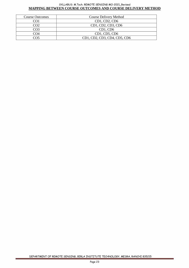
MAPPING BETWEEN COURSE OUTCOMES AND COURSE DELIVERY METHOD
Course Outcomes Course Delivery Method
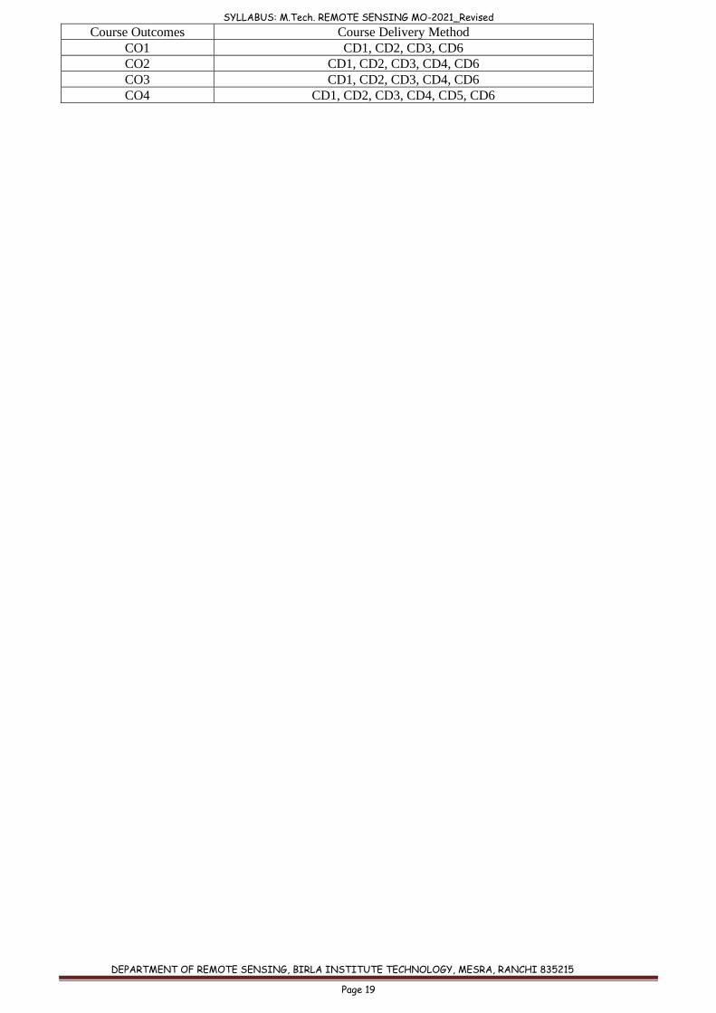
CO1 CD1, CD2, CD6
CO2 CD1, CD2, CD3, CD6
CO3 CD1, CD6
CO4 CD1, CD5, CD6
CO5 CD1, CD2, CD3, CD4, CD5, CD6
SYLLABUS: M.Tech. REMOTE SENSING MO-2021_Revised
DEPARTMENT OF REMOTE SENSING, BIRLA INSTITUTE TECHNOLOGY, MESRA, RANCHI 835215
Page 24
Course code: RS 507
Course title: REMOTE SENSING IN HYDROLOGY & WATER RESOURCES
Pre-requisite(s): (i) Knowledge of Basic Sciences
(ii) Student must have computer knowledge
Co- requisite(s):
Credits: L: T: P: C:
3 0 0 3
Class schedule per week: 3
Class: M. TECH
Semester / Level: 01/05 (Monsoon)
Branch: REMOTE SENSING
Name of Teacher:
Course Objectives
This course aims to:
A. Introduce students about hydrologic cycle, Precipitation, Aquifer & Aquifer coefficients,
ground water movement and understand the data required for various hydrological
studies. B. Make them understand river basin and watershed concepts, parameters and management
strategies. C. Disseminate knowledge about water resource estimation, evaluation, and modelling.
Course Outcomes (CO):
On completion of this course, students should be able to:
CO1 Describe hydrologic cycle, data requirement for hydrological studies and characterise
aquifers and ground water movement.
CO2 Evaluate basins and drainages to infer surface and near surface characteristics of the
area.
CO3 Describe ground water regimes of India and determine water quality and ground water
prospects zones with the use of satellite data.
CO4 Design suitable watershed management strategy by characterising watersheds for
sustainable development of water resources including site suitability analysis for water
recharge structures and reservoir sediment estimation.
CO5 Estimate and model surface runoff, flood, drought, snowmelt runoff and soil erosion .
MODULE 1: Basic Concepts
Hydrologic cycle, Forms of precipitation, Precipitation measurement - conventional vs satellite
data based, Data for hydrological studies. Aquifers, Geological materials as aquifers and Aquifer
parameters - Porosity, Specific yield, Storage coefficient. Ground water movement - Darcy’s
Law, Permeability, Hydraulic Conductivity, Transmissivity.
MODULE 2: Ground-water exploration and evaluation
Ground water regimes in India, Geophysical techniques for groundwater prospecting. Remote
sensing in hydro-geomorphology and ground water prospect mapping, Remote sensing in water
quality mapping and monitoring.
SYLLABUS: M.Tech. REMOTE SENSING MO-2021_Revised
DEPARTMENT OF REMOTE SENSING, BIRLA INSTITUTE TECHNOLOGY, MESRA, RANCHI 835215
Page 25
MODULE 3: River Basins
Classification of streams and rivers, Drainage pattern, Delineation of Drainage basin and
catchment, Interlinking of river basins. Remote sensing based site selection for river valley
projects.
MODULE 4: Watershed management
Watershed characterization using remote sensing, Morphometric parameters and analysis,
Watershed problems and management strategy. Ground water recharge structures and their site
suitability analysis.
MODULE 5: Operational applications in Water Resources
Satellite image based surface runoff modeling, Flood and drought- mapping and modeling,
Reservoir sediment estimation, Snow and Glacier Hydrology, Snowmelt runoff modeling, Soil
erosion modeling.
TEXT BOOKS:
1. Murthy, J. V. S. (1994). Watershed Management in India. Wiley Eastern Ltd., New Delhi.
2. David Keith Todd (2005). Groundwater Hydrology, John Wiley & Sons, New York, Second Edition.
3. H. M. Raghunath (2000). Hydrology- principles, Analysis, Design, New Age International, New
Delhi.
4. P. Singh, Vijay P. Singh (2000). "Snow and Glacier Hydrology".
REFERENCE BOOKS:
1. P. Singh (2001). "Snow and Glacier Hydrology", Springer.
2. Schultz, G. A. and Engman, E. T. (2000). Remote Sensing in Hydrology and Water
Management, Springer-Verlag, Berlin, Germany.
COURSE OUTCOME (CO) ATTAINMENT ASSESSMENT TOOLS & EVALUATION
PROCEDURE
Direct Assessment
Assessment Tool % Contribution during CO Assessment
Continuous Internal Assessment 50
Semester End Examination 50
Continuous Internal
Assessment
% Distribution
3 Quizzes 30 % (3 × 10%)
Assignment (s) 10
Seminar before a committee 10
Indirect Assessment –
1. Student Feedback on Faculty
2. Student Feedback on Course Outcome
SYLLABUS: M.Tech. REMOTE SENSING MO-2021_Revised
DEPARTMENT OF REMOTE SENSING, BIRLA INSTITUTE TECHNOLOGY, MESRA, RANCHI 835215
Page 26
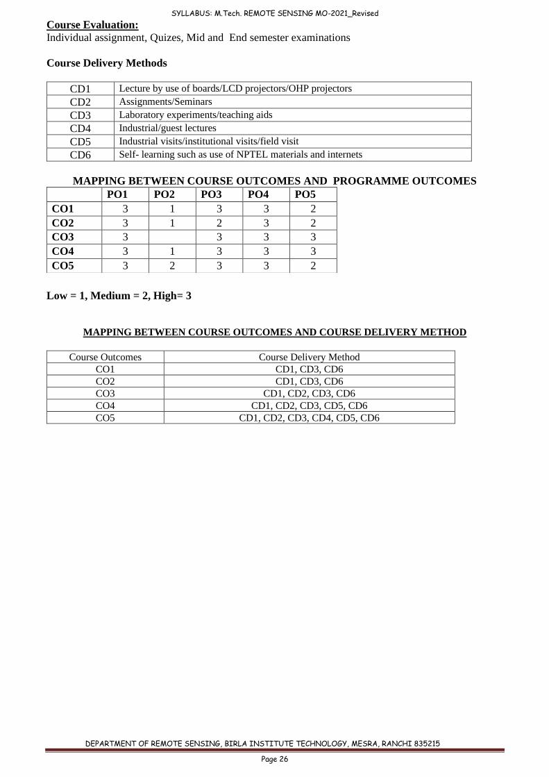
Course Evaluation:
Individual assignment, Quizes, Mid and End semester examinations
Course Delivery Methods
CD1 Lecture by use of boards/LCD projectors/OHP projectors
CD2 Assignments/Seminars
CD3 Laboratory experiments/teaching aids
CD4 Industrial/guest lectures
CD5 Industrial visits/institutional visits/field visit
CD6 Self- learning such as use of NPTEL materials and internets
MAPPING BETWEEN COURSE OUTCOMES AND PROGRAMME OUTCOMES
Low = 1, Medium = 2, High= 3
MAPPING BETWEEN COURSE OUTCOMES AND COURSE DELIVERY METHOD
Course Outcomes Course Delivery Method
CO1 CD1, CD3, CD6
CO2 CD1, CD3, CD6
CO3 CD1, CD2, CD3, CD6
CO4 CD1, CD2, CD3, CD5, CD6
CO5 CD1, CD2, CD3, CD4, CD5, CD6
PO1 PO2 PO3 PO4 PO5
CO1 3 1 3 3 2
CO2 3 1 2 3 2
CO3 3
3 3 3
CO4 3 1 3 3 3
CO5 3 2 3 3 2
SYLLABUS: M.Tech. REMOTE SENSING MO-2021_Revised
DEPARTMENT OF REMOTE SENSING, BIRLA INSTITUTE TECHNOLOGY, MESRA, RANCHI 835215
Page 27
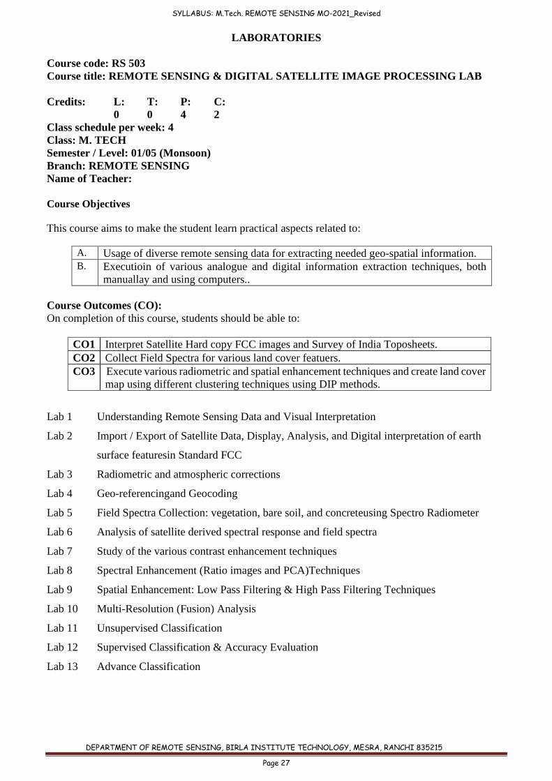
LABORATORIES
Course code: RS 503
Course title: REMOTE SENSING & DIGITAL SATELLITE IMAGE PROCESSING LAB
Credits: L: T: P: C:
0 0 4 2
Class schedule per week: 4
Class: M. TECH
Semester / Level: 01/05 (Monsoon)
Branch: REMOTE SENSING
Name of Teacher:
Course Objectives
This course aims to make the student learn practical aspects related to:
A. Usage of diverse remote sensing data for extracting needed geo-spatial information. B. Executioin of various analogue and digital information extraction techniques, both
manuallay and using computers..
Course Outcomes (CO):
On completion of this course, students should be able to:
CO1 Interpret Satellite Hard copy FCC images and Survey of India Toposheets.
CO2 Collect Field Spectra for various land cover featuers.
CO3 Execute various radiometric and spatial enhancement techniques and create land cover
map using different clustering techniques using DIP methods.
Lab 1 Understanding Remote Sensing Data and Visual Interpretation
Lab 2 Import / Export of Satellite Data, Display, Analysis, and Digital interpretation of earth
surface featuresin Standard FCC
Lab 3 Radiometric and atmospheric corrections
Lab 4 Geo-referencingand Geocoding
Lab 5 Field Spectra Collection: vegetation, bare soil, and concreteusing Spectro Radiometer
Lab 6 Analysis of satellite derived spectral response and field spectra
Lab 7 Study of the various contrast enhancement techniques
Lab 8 Spectral Enhancement (Ratio images and PCA)Techniques
Lab 9 Spatial Enhancement: Low Pass Filtering & High Pass Filtering Techniques
Lab 10 Multi-Resolution (Fusion) Analysis
Lab 11 Unsupervised Classification
Lab 12 Supervised Classification & Accuracy Evaluation
Lab 13 Advance Classification
SYLLABUS: M.Tech. REMOTE SENSING MO-2021_Revised
DEPARTMENT OF REMOTE SENSING, BIRLA INSTITUTE TECHNOLOGY, MESRA, RANCHI 835215
Page 28
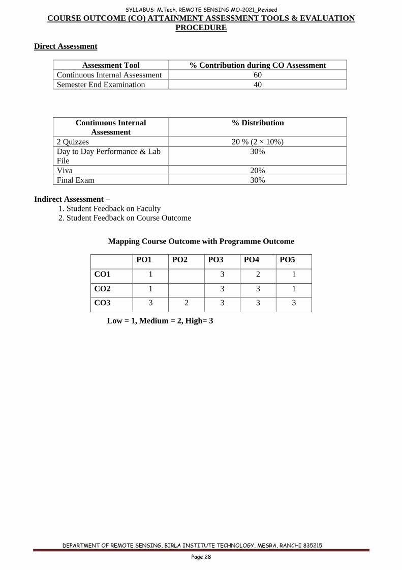
COURSE OUTCOME (CO) ATTAINMENT ASSESSMENT TOOLS & EVALUATION
PROCEDURE
Direct Assessment
Assessment Tool % Contribution during CO Assessment
Continuous Internal Assessment 60
Semester End Examination 40
Continuous Internal
Assessment
% Distribution
2 Quizzes 20 % (2 × 10%)
Day to Day Performance & Lab
File
30%
Viva 20%
Final Exam 30%
Indirect Assessment –
1. Student Feedback on Faculty
2. Student Feedback on Course Outcome
Mapping Course Outcome with Programme Outcome
Low = 1, Medium = 2, High= 3
PO1 PO2 PO3 PO4 PO5
CO1 1 3 2 1
CO2 1 3 3 1
CO3 3 2 3 3 3
SYLLABUS: M.Tech. REMOTE SENSING MO-2021_Revised
DEPARTMENT OF REMOTE SENSING, BIRLA INSTITUTE TECHNOLOGY, MESRA, RANCHI 835215
Page 29
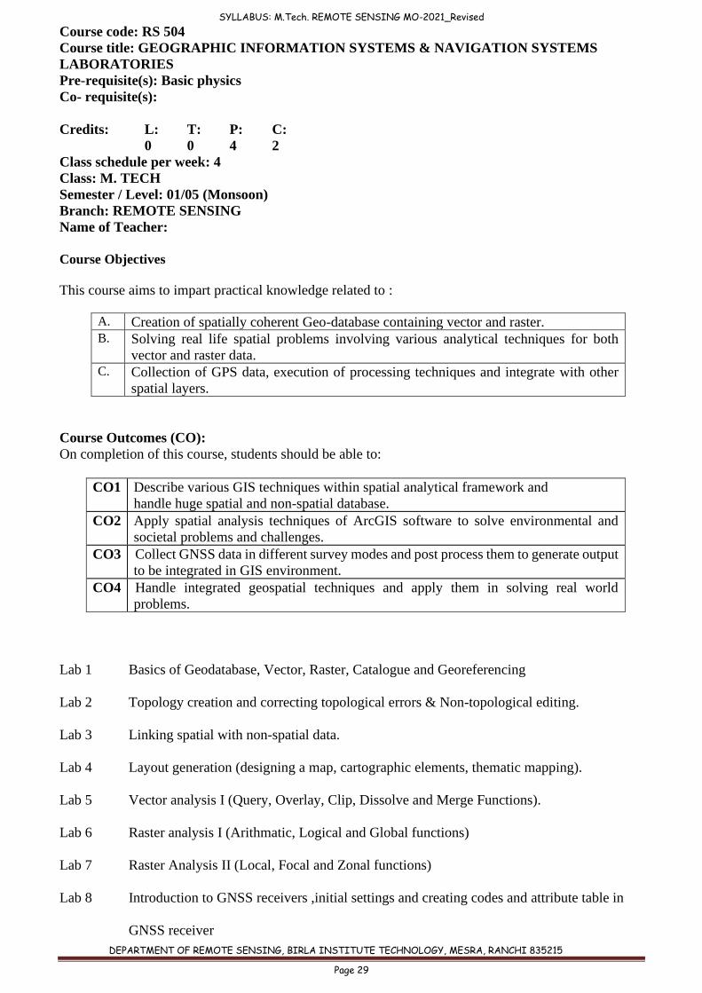
Course code: RS 504
Course title: GEOGRAPHIC INFORMATION SYSTEMS & NAVIGATION SYSTEMS
LABORATORIES
Pre-requisite(s): Basic physics
Co- requisite(s):
Credits: L: T: P: C:
0 0 4 2
Class schedule per week: 4
Class: M. TECH
Semester / Level: 01/05 (Monsoon)
Branch: REMOTE SENSING
Name of Teacher:
Course Objectives
This course aims to impart practical knowledge related to :
A. Creation of spatially coherent Geo-database containing vector and raster. B. Solving real life spatial problems involving various analytical techniques for both
vector and raster data. C. Collection of GPS data, execution of processing techniques and integrate with other
spatial layers.
Course Outcomes (CO):
On completion of this course, students should be able to:
CO1 Describe various GIS techniques within spatial analytical framework and
handle huge spatial and non-spatial database.
CO2 Apply spatial analysis techniques of ArcGIS software to solve environmental and
societal problems and challenges.
CO3 Collect GNSS data in different survey modes and post process them to generate output
to be integrated in GIS environment.
CO4 Handle integrated geospatial techniques and apply them in solving real world
problems.
Lab 1 Basics of Geodatabase, Vector, Raster, Catalogue and Georeferencing
Lab 2 Topology creation and correcting topological errors & Non-topological editing.
Lab 3 Linking spatial with non-spatial data.
Lab 4 Layout generation (designing a map, cartographic elements, thematic mapping).
Lab 5 Vector analysis I (Query, Overlay, Clip, Dissolve and Merge Functions).
Lab 6 Raster analysis I (Arithmatic, Logical and Global functions)
Lab 7 Raster Analysis II (Local, Focal and Zonal functions)
Lab 8 Introduction to GNSS receivers ,initial settings and creating codes and attribute table in
GNSS receiver
SYLLABUS: M.Tech. REMOTE SENSING MO-2021_Revised
DEPARTMENT OF REMOTE SENSING, BIRLA INSTITUTE TECHNOLOGY, MESRA, RANCHI 835215
Page 30
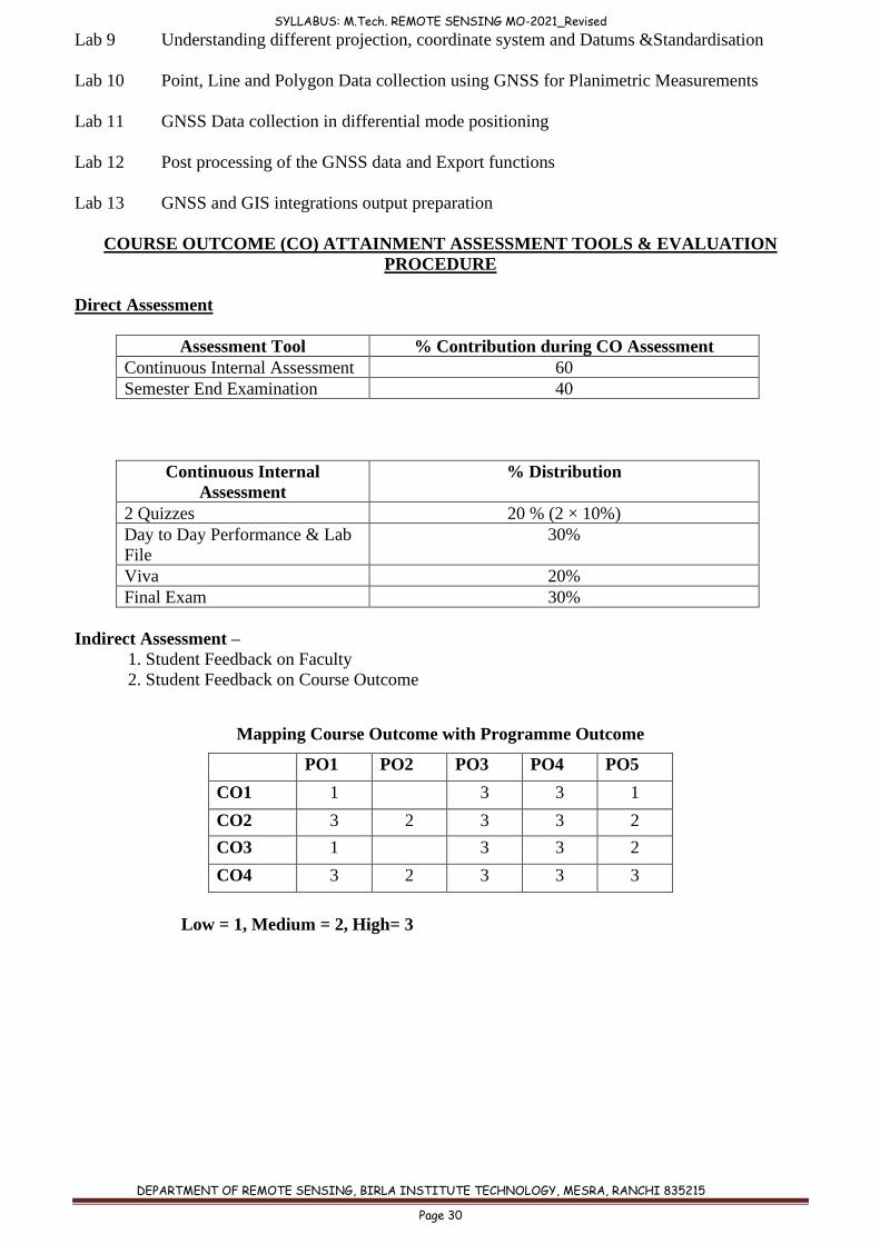
Lab 9 Understanding different projection, coordinate system and Datums &Standardisation
Lab 10 Point, Line and Polygon Data collection using GNSS for Planimetric Measurements
Lab 11 GNSS Data collection in differential mode positioning
Lab 12 Post processing of the GNSS data and Export functions
Lab 13 GNSS and GIS integrations output preparation
COURSE OUTCOME (CO) ATTAINMENT ASSESSMENT TOOLS & EVALUATION
PROCEDURE
Direct Assessment
Assessment Tool % Contribution during CO Assessment
Continuous Internal Assessment 60
Semester End Examination 40
Continuous Internal
Assessment
% Distribution
2 Quizzes 20 % (2 × 10%)
Day to Day Performance & Lab
File
30%
Viva 20%
Final Exam 30%
Indirect Assessment –
1. Student Feedback on Faculty
2. Student Feedback on Course Outcome
Mapping Course Outcome with Programme Outcome
Low = 1, Medium = 2, High= 3
PO1 PO2 PO3 PO4 PO5
CO1 1 3 3 1
CO2 3 2 3 3 2
CO3 1 3 3 2
CO4 3 2 3 3 3
SYLLABUS: M.Tech. REMOTE SENSING MO-2021_Revised
DEPARTMENT OF REMOTE SENSING, BIRLA INSTITUTE TECHNOLOGY, MESRA, RANCHI 835215
Page 31
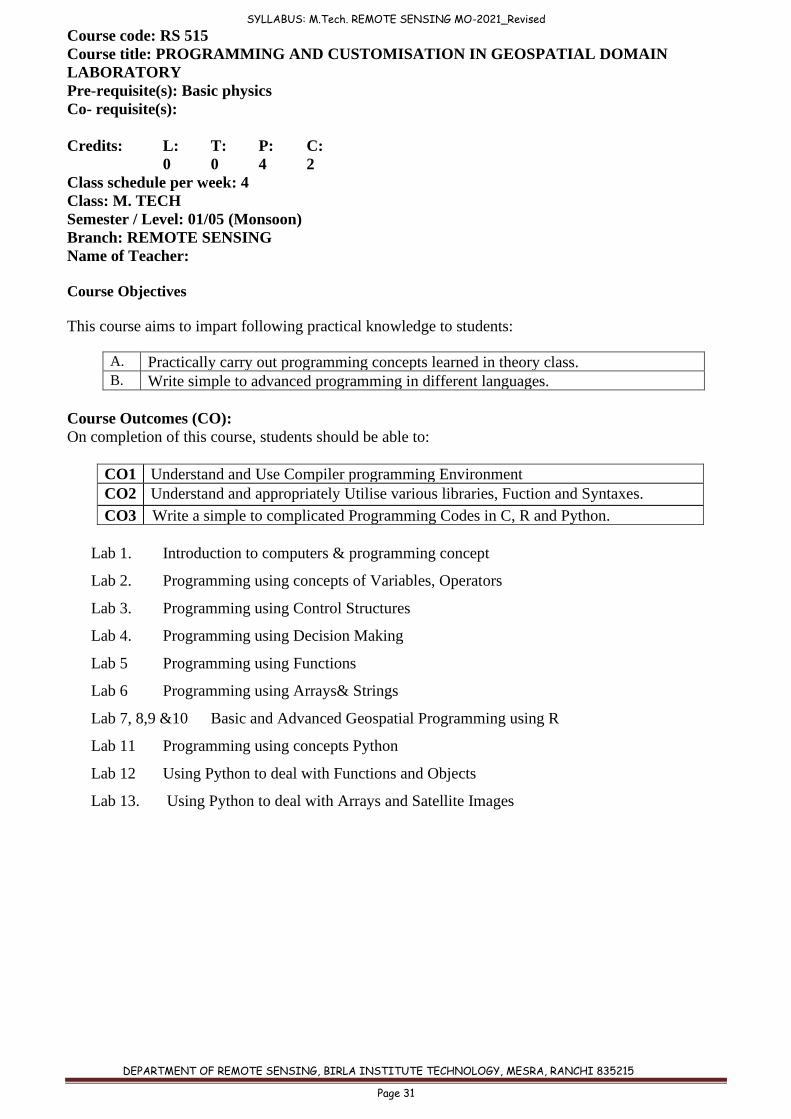
Course code: RS 515
Course title: PROGRAMMING AND CUSTOMISATION IN GEOSPATIAL DOMAIN
LABORATORY
Pre-requisite(s): Basic physics
Co- requisite(s):
Credits: L: T: P: C:
0 0 4 2
Class schedule per week: 4
Class: M. TECH
Semester / Level: 01/05 (Monsoon)
Branch: REMOTE SENSING
Name of Teacher:
Course Objectives
This course aims to impart following practical knowledge to students:
A. Practically carry out programming concepts learned in theory class. B. Write simple to advanced programming in different languages.
Course Outcomes (CO):
On completion of this course, students should be able to:
CO1 Understand and Use Compiler programming Environment
CO2 Understand and appropriately Utilise various libraries, Fuction and Syntaxes.
CO3 Write a simple to complicated Programming Codes in C, R and Python.
Lab 1. Introduction to computers & programming concept
Lab 2. Programming using concepts of Variables, Operators
Lab 3. Programming using Control Structures
Lab 4. Programming using Decision Making
Lab 5 Programming using Functions
Lab 6 Programming using Arrays& Strings
Lab 7, 8,9 &10 Basic and Advanced Geospatial Programming using R
Lab 11 Programming using concepts Python
Lab 12 Using Python to deal with Functions and Objects
Lab 13. Using Python to deal with Arrays and Satellite Images
SYLLABUS: M.Tech. REMOTE SENSING MO-2021_Revised
DEPARTMENT OF REMOTE SENSING, BIRLA INSTITUTE TECHNOLOGY, MESRA, RANCHI 835215
Page 32
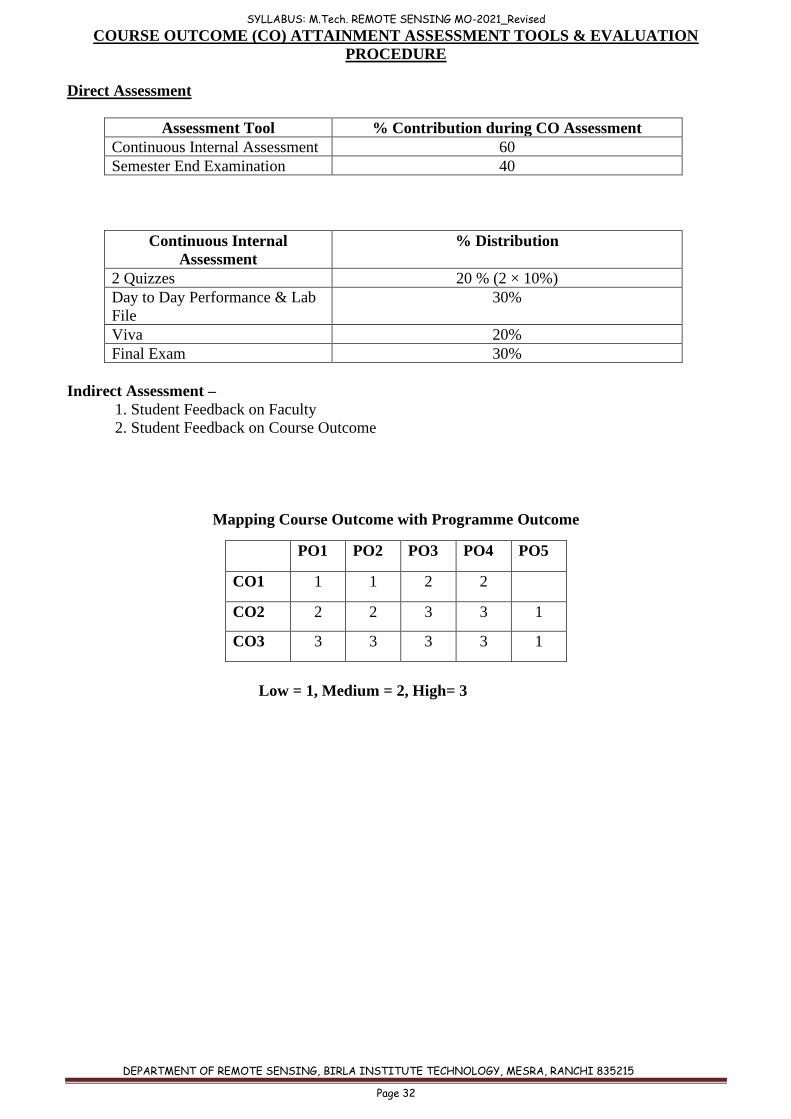
COURSE OUTCOME (CO) ATTAINMENT ASSESSMENT TOOLS & EVALUATION
PROCEDURE
Direct Assessment
Assessment Tool % Contribution during CO Assessment
Continuous Internal Assessment 60
Semester End Examination 40
Continuous Internal
Assessment
% Distribution
2 Quizzes 20 % (2 × 10%)
Day to Day Performance & Lab
File
30%
Viva 20%
Final Exam 30%
Indirect Assessment –
1. Student Feedback on Faculty
2. Student Feedback on Course Outcome
Mapping Course Outcome with Programme Outcome
Low = 1, Medium = 2, High= 3
PO1 PO2 PO3 PO4 PO5
CO1 1 1 2 2
CO2 2 2 3 3 1
CO3 3 3 3 3 1

SYLLABUS: M.Tech. REMOTE SENSING MO-2021_Revised
DEPARTMENT OF REMOTE SENSING, BIRLA INSTITUTE TECHNOLOGY, MESRA, RANCHI 835215
Page 33
Course code: RS 508
Course title: REMOTE SENSING IN AGRICULTURE AND FORESTRY LABORATORY
Pre-requisite(s): Basic physics
Co- requisite(s):
Credits: L: T: P: C:
0 0 4 2
Class schedule per week: 4
Class: M. TECH
Semester / Level: 01/05 (Monsoon)
Branch: REMOTE SENSING
Name of Teacher:
Course Objectives
This course aims to make the student:
A. Utilise diverse remote sensind data for extracting vegetation related spatial
information. B. Execute appropriate digital image processing and modelling techniques for diverse
agriculture and forestry applications.
Course Outcomes (CO):
On completion of this course, students should be able to:
CO1 Visually and Digitally differentiate various agriculture and forestry features from
satellite data.
CO2 Use various remote sensing and GIS tools for extracting land cover, land capability,
degradation, waterlogging, and model acreage, lifezones and fire risk.
CO3 Execute spatial models related to landscape metrics, biodiversity, wild life habitat
suitability , and environmental problems.
Lab 1 Visual Interpretation of different types of forests and crops.
Lab 2 On-Screen Land Degradation Mapping
Lab 3 Digital classification of Agriculture and Foresty Types
Lab 4 Detection of Plant Stress, Change Detection and Salt Affected Areas.
Lab 5 Desertification, Waterlooging and Flood Damage Assessment using RS & GIS.
Lab 6 Land Cover Mapping using multi-temporal RS data.
Lab 7 Acreage and Land Capability Modelling using RS & GIS.
Lab 8 Climatic, Altitudinal and Topographic relation with Life Zones and its Modelling.
Lab 9 Landscape Metrics Modelling.
Lab 10 Anthropogenic Disturbance Modelling using RS & GIS
Lab 11 Biodiversity Modelling using RS & GIS
Lab 12 Wildlife Habitat Modelling using RS& GIS
Lab 13 Forest Fire Risk Modelling using RS & GIS
SYLLABUS: M.Tech. REMOTE SENSING MO-2021_Revised
DEPARTMENT OF REMOTE SENSING, BIRLA INSTITUTE TECHNOLOGY, MESRA, RANCHI 835215
Page 34
COURSE OUTCOME (CO) ATTAINMENT ASSESSMENT TOOLS & EVALUATION
PROCEDURE
Direct Assessment
Assessment Tool % Contribution during CO Assessment
Continuous Internal Assessment 60
Semester End Examination 40
Continuous Internal
Assessment
% Distribution
2 Quizzes 20 % (2 × 10%)
Day to Day Performance & Lab
File
30%
Viva 20%
Final Exam 30%
Indirect Assessment –
1. Student Feedback on Faculty
2. Student Feedback on Course Outcome
Mapping Course Outcome with Programme Outcome
Low = 1, Medium = 2, High= 3
PO1 PO2 PO3 PO4 PO5
CO1 1 1 3 2 1
CO2 2 2 3 3 3
CO3 3 2 3 3 3
SYLLABUS: M.Tech. REMOTE SENSING MO-2021_Revised
DEPARTMENT OF REMOTE SENSING, BIRLA INSTITUTE TECHNOLOGY, MESRA, RANCHI 835215
Page 35
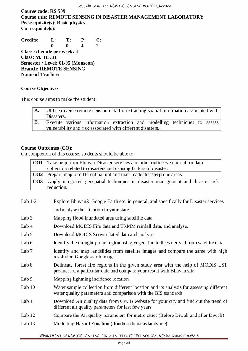
Course code: RS 509
Course title: REMOTE SENSING IN DISASTER MANAGEMENT LABORATORY
Pre-requisite(s): Basic physics
Co- requisite(s):
Credits: L: T: P: C:
0 0 4 2
Class schedule per week: 4
Class: M. TECH
Semester / Level: 01/05 (Monsoon)
Branch: REMOTE SENSING
Name of Teacher:
Course Objectives
This course aims to make the student:
A. Utilise diverse remote sensind data for extracting spatial information associated with
Disasters. B. Execute various information extraction and modelling techniques to assess
vulnerability and risk associated with different disasters.
Course Outcomes (CO):
On completion of this course, students should be able to:
CO1 Take help from Bhuvan Disaster services and other online web portal for data
collection related to disasters and causing factors of disaster.
CO2 Prepare map of different natural and man-made disasterprone areas.
CO3 Apply integrated geospatial techniques in disaster management and disaster risk
reduction.
Lab 1-2 Explore Bhuvan& Google Earth etc. in general, and specifically for Disaster services
and analyse the situation in your state
Lab 3 Mapping flood inundated area using satellite data
Lab 4 Download MODIS Fire data and TRMM rainfall data, and analyse.
Lab 5 Download MODIS Snow related data and analyse.
Lab 6 Identify the drought prone region using vegetation indices derived from satellite data
Lab 7 Identify and map landslides from satellite images and compare the same with high
resolution Google-earth image
Lab 8 Delineate forest fire regions in the given study area with the help of MODIS LST
product for a particular date and compare your result with Bhuvan site
Lab 9 Mapping lightning incidence location
Lab 10 Water sample collection from different location and its analysis for assessing different
water quality parameters and comparison with the BIS standards
Lab 11 Download Air quality data from CPCB website for your city and find out the trend of
different air quality parameters for last few years
Lab 12 Compare the Air quality parameters for metro cities (Before Diwali and after Diwali)
Lab 13 Modelling Hazard Zonation (flood/earthquake/landslide).
SYLLABUS: M.Tech. REMOTE SENSING MO-2021_Revised
DEPARTMENT OF REMOTE SENSING, BIRLA INSTITUTE TECHNOLOGY, MESRA, RANCHI 835215
Page 36
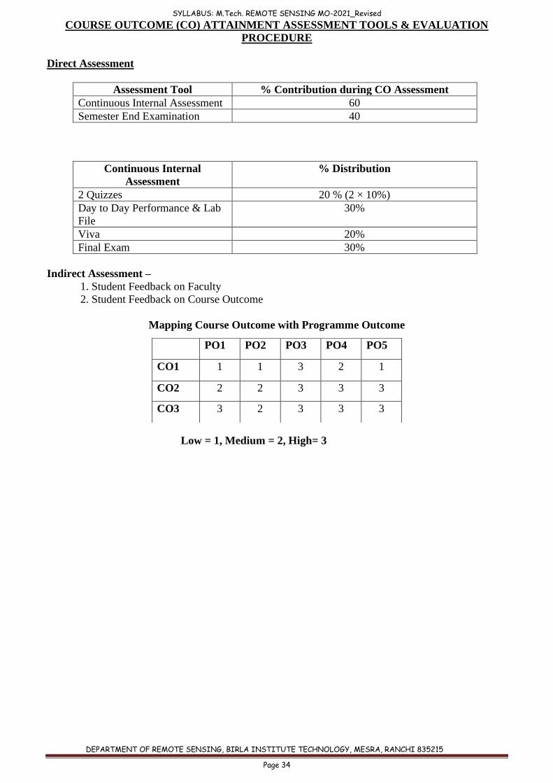
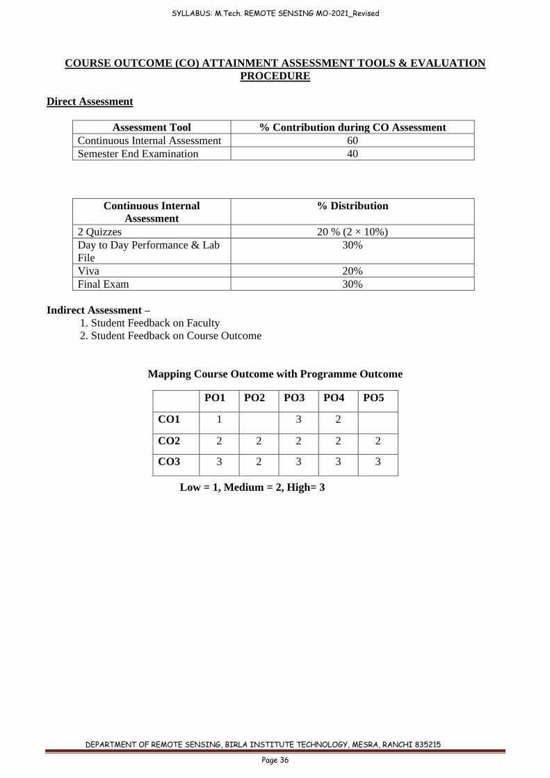
COURSE OUTCOME (CO) ATTAINMENT ASSESSMENT TOOLS & EVALUATION
PROCEDURE
Direct Assessment
Assessment Tool % Contribution during CO Assessment
Continuous Internal Assessment 60
Semester End Examination 40
Continuous Internal
Assessment
% Distribution
2 Quizzes 20 % (2 × 10%)
Day to Day Performance & Lab
File
30%
Viva 20%
Final Exam 30%
Indirect Assessment –
1. Student Feedback on Faculty
2. Student Feedback on Course Outcome
Mapping Course Outcome with Programme Outcome
Low = 1, Medium = 2, High= 3
PO1 PO2 PO3 PO4 PO5
CO1 1
3 2
CO2 2 2 2 2 2
CO3 3 2 3 3 3
SYLLABUS: M.Tech. REMOTE SENSING MO-2021_Revised
DEPARTMENT OF REMOTE SENSING, BIRLA INSTITUTE TECHNOLOGY, MESRA, RANCHI 835215
Page 37
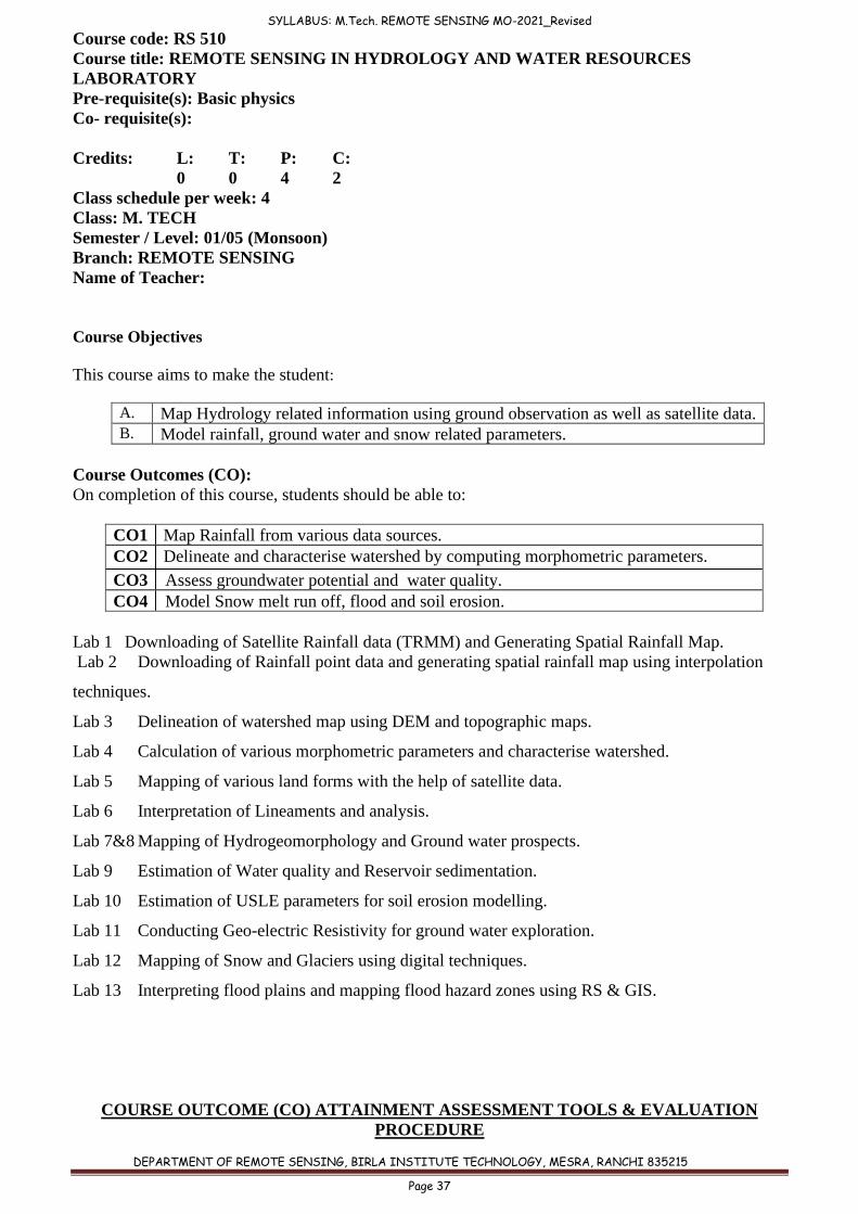
Course code: RS 510
Course title: REMOTE SENSING IN HYDROLOGY AND WATER RESOURCES
LABORATORY
Pre-requisite(s): Basic physics
Co- requisite(s):
Credits: L: T: P: C:
0 0 4 2
Class schedule per week: 4
Class: M. TECH
Semester / Level: 01/05 (Monsoon)
Branch: REMOTE SENSING
Name of Teacher:
Course Objectives
This course aims to make the student:
A. Map Hydrology related information using ground observation as well as satellite data. B. Model rainfall, ground water and snow related parameters.
Course Outcomes (CO):
On completion of this course, students should be able to:
CO1 Map Rainfall from various data sources.
CO2 Delineate and characterise watershed by computing morphometric parameters.
CO3 Assess groundwater potential and water quality.
CO4 Model Snow melt run off, flood and soil erosion.
Lab 1 Downloading of Satellite Rainfall data (TRMM) and Generating Spatial Rainfall Map.
Lab 2 Downloading of Rainfall point data and generating spatial rainfall map using interpolation
techniques.
Lab 3 Delineation of watershed map using DEM and topographic maps.
Lab 4 Calculation of various morphometric parameters and characterise watershed.
Lab 5 Mapping of various land forms with the help of satellite data.
Lab 6 Interpretation of Lineaments and analysis.
Lab 7&8 Mapping of Hydrogeomorphology and Ground water prospects.
Lab 9 Estimation of Water quality and Reservoir sedimentation.
Lab 10 Estimation of USLE parameters for soil erosion modelling.
Lab 11 Conducting Geo-electric Resistivity for ground water exploration.
Lab 12 Mapping of Snow and Glaciers using digital techniques.
Lab 13 Interpreting flood plains and mapping flood hazard zones using RS & GIS.
COURSE OUTCOME (CO) ATTAINMENT ASSESSMENT TOOLS & EVALUATION
PROCEDURE
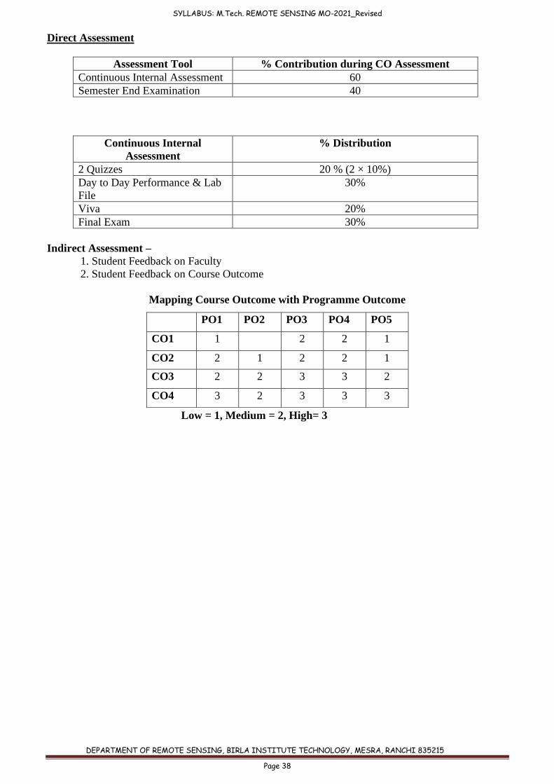
SYLLABUS: M.Tech. REMOTE SENSING MO-2021_Revised
DEPARTMENT OF REMOTE SENSING, BIRLA INSTITUTE TECHNOLOGY, MESRA, RANCHI 835215
Page 38
Direct Assessment
Assessment Tool % Contribution during CO Assessment
Continuous Internal Assessment 60
Semester End Examination 40
Continuous Internal
Assessment
% Distribution
2 Quizzes 20 % (2 × 10%)
Day to Day Performance & Lab
File
30%
Viva 20%
Final Exam 30%
Indirect Assessment –
1. Student Feedback on Faculty
2. Student Feedback on Course Outcome
Mapping Course Outcome with Programme Outcome
Low = 1, Medium = 2, High= 3
PO1 PO2 PO3 PO4 PO5
CO1 1 2 2 1
CO2 2 1 2 2 1
CO3 2 2 3 3 2
CO4 3 2 3 3 3