Embed Size (px)
Citation preview
Mt Keith Page 1© CRC LEME 2003
MT. KEITH NICKEL SULPHIDE DEPOSIT, WESTERN AUSTRALIA
C.R.M. Butt1 and N.W. Brand2
1CRC LEME, CSIRO Exploration and Mining, PO Box 1130, Bentley, Western Australia 6102.
2Anglo American Exploration (Aust.) Ltd., Suite1, Brodie-Hall Drive, Bentley, Western Australia 6102.
LOCATION
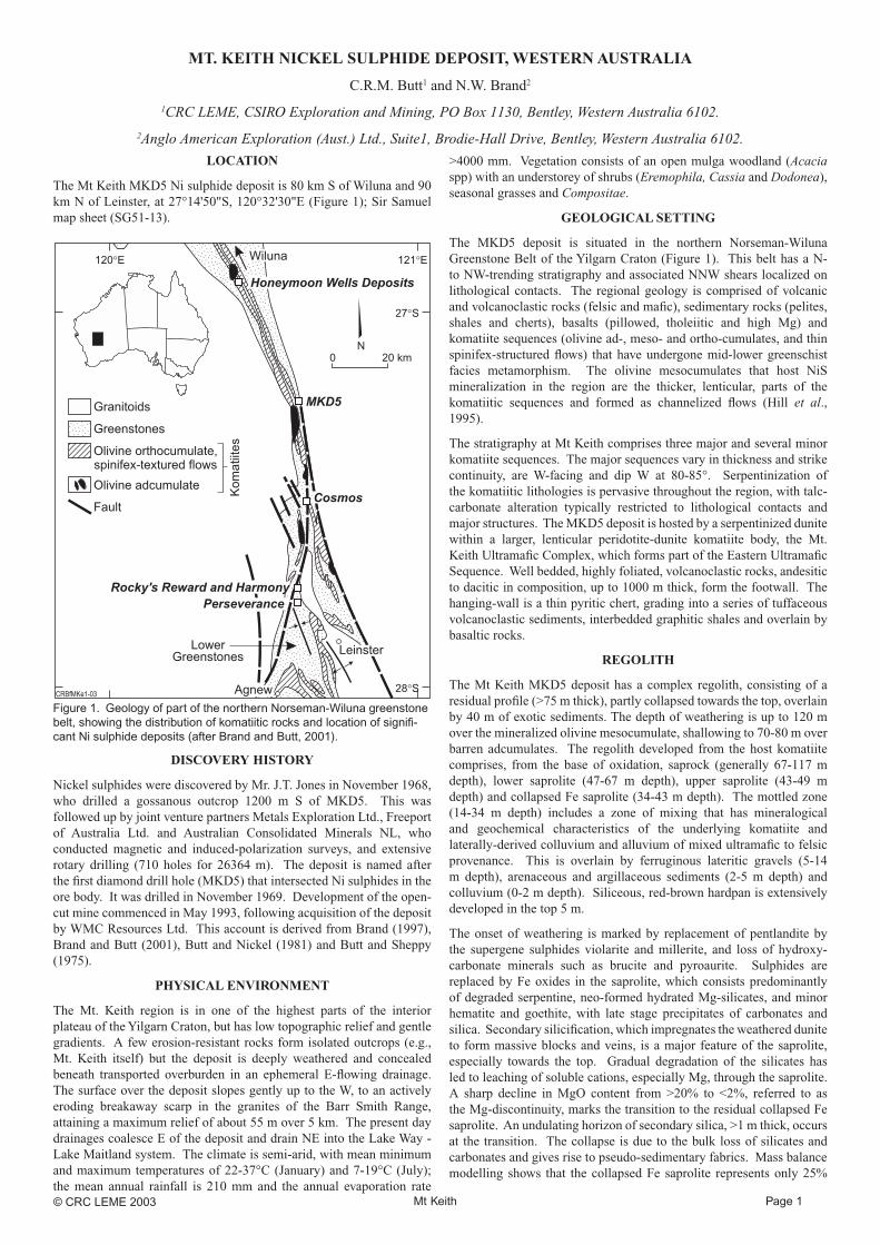
The Mt Keith MKD5 Ni sulphide deposit is 80 km S of Wiluna and 90 km N of Leinster, at 27°14'50"S, 120°32'30"E (Figure 1); Sir Samuel map sheet (SG51-13).
Figure 1. Geology of part of the northern Norseman-Wiluna greenstone belt, showing the distribution of komatiitic rocks and location of signifi -cant Ni sulphide deposits (after Brand and Butt, 2001).
DISCOVERY HISTORY
Nickel sulphides were discovered by Mr. J.T. Jones in November 1968, who drilled a gossanous outcrop 1200 m S of MKD5. This was followed up by joint venture partners Metals Exploration Ltd., Freeport of Australia Ltd. and Australian Consolidated Minerals NL, who conducted magnetic and induced-polarization surveys, and extensive rotary drilling (710 holes for 26364 m). The deposit is named after the fi rst diamond drill hole (MKD5) that intersected Ni sulphides in the ore body. It was drilled in November 1969. Development of the open-cut mine commenced in May 1993, following acquisition of the deposit by WMC Resources Ltd. This account is derived from Brand (1997), Brand and Butt (2001), Butt and Nickel (1981) and Butt and Sheppy (1975).
PHYSICAL ENVIRONMENT
The Mt. Keith region is in one of the highest parts of the interior plateau of the Yilgarn Craton, but has low topographic relief and gentle gradients. A few erosion-resistant rocks form isolated outcrops (e.g., Mt. Keith itself) but the deposit is deeply weathered and concealed beneath transported overburden in an ephemeral E-fl owing drainage. The surface over the deposit slopes gently up to the W, to an actively eroding breakaway scarp in the granites of the Barr Smith Range, attaining a maximum relief of about 55 m over 5 km. The present day drainages coalesce E of the deposit and drain NE into the Lake Way - Lake Maitland system. The climate is semi-arid, with mean minimum and maximum temperatures of 22-37°C (January) and 7-19°C (July); the mean annual rainfall is 210 mm and the annual evaporation rate
>4000 mm. Vegetation consists of an open mulga woodland (Acacia spp) with an understorey of shrubs (Eremophila, Cassia and Dodonea), seasonal grasses and Compositae.
GEOLOGICAL SETTING
The MKD5 deposit is situated in the northern Norseman-Wiluna Greenstone Belt of the Yilgarn Craton (Figure 1). This belt has a N- to NW-trending stratigraphy and associated NNW shears localized on lithological contacts. The regional geology is comprised of volcanic and volcanoclastic rocks (felsic and mafi c), sedimentary rocks (pelites, shales and cherts), basalts (pillowed, tholeiitic and high Mg) and komatiite sequences (olivine ad-, meso- and ortho-cumulates, and thin spinifex-structured fl ows) that have undergone mid-lower greenschist facies metamorphism. The olivine mesocumulates that host NiS mineralization in the region are the thicker, lenticular, parts of the komatiitic sequences and formed as channelized fl ows (Hill et al., 1995).
The stratigraphy at Mt Keith comprises three major and several minor komatiite sequences. The major sequences vary in thickness and strike continuity, are W-facing and dip W at 80-85°. Serpentinization of the komatiitic lithologies is pervasive throughout the region, with talc-carbonate alteration typically restricted to lithological contacts and major structures. The MKD5 deposit is hosted by a serpentinized dunite within a larger, lenticular peridotite-dunite komatiite body, the Mt. Keith Ultramafi c Complex, which forms part of the Eastern Ultramafi c Sequence. Well bedded, highly foliated, volcanoclastic rocks, andesitic to dacitic in composition, up to 1000 m thick, form the footwall. The hanging-wall is a thin pyritic chert, grading into a series of tuffaceous volcanoclastic sediments, interbedded graphitic shales and overlain by basaltic rocks.
REGOLITH
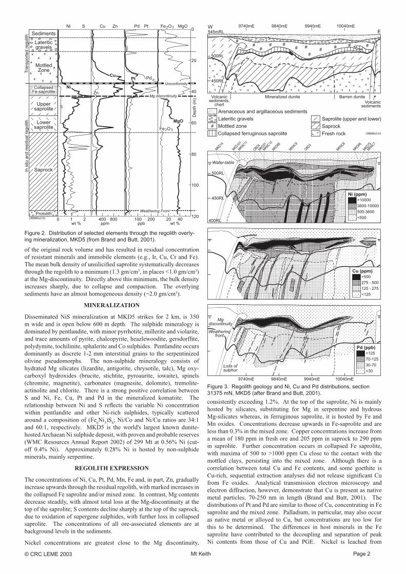
The Mt Keith MKD5 deposit has a complex regolith, consisting of a residual profi le (>75 m thick), partly collapsed towards the top, overlain by 40 m of exotic sediments. The depth of weathering is up to 120 m over the mineralized olivine mesocumulate, shallowing to 70-80 m over barren adcumulates. The regolith developed from the host komatiite comprises, from the base of oxidation, saprock (generally 67-117 m depth), lower saprolite (47-67 m depth), upper saprolite (43-49 m depth) and collapsed Fe saprolite (34-43 m depth). The mottled zone (14-34 m depth) includes a zone of mixing that has mineralogical and geochemical characteristics of the underlying komatiite and laterally-derived colluvium and alluvium of mixed ultramafi c to felsic provenance. This is overlain by ferruginous lateritic gravels (5-14 m depth), arenaceous and argillaceous sediments (2-5 m depth) and colluvium (0-2 m depth). Siliceous, red-brown hardpan is extensively developed in the top 5 m.
The onset of weathering is marked by replacement of pentlandite by the supergene sulphides violarite and millerite, and loss of hydroxy-carbonate minerals such as brucite and pyroaurite. Sulphides are replaced by Fe oxides in the saprolite, which consists predominantly of degraded serpentine, neo-formed hydrated Mg-silicates, and minor hematite and goethite, with late stage precipitates of carbonates and silica. Secondary silicifi cation, which impregnates the weathered dunite to form massive blocks and veins, is a major feature of the saprolite, especially towards the top. Gradual degradation of the silicates has led to leaching of soluble cations, especially Mg, through the saprolite. A sharp decline in MgO content from >20% to <2%, referred to as the Mg-discontinuity, marks the transition to the residual collapsed Fe saprolite. An undulating horizon of secondary silica, >1 m thick, occurs at the transition. The collapse is due to the bulk loss of silicates and carbonates and gives rise to pseudo-sedimentary fabrics. Mass balance modelling shows that the collapsed Fe saprolite represents only 25%
Mt Keith Page 2© CRC LEME 2003
Figure 2. Distribution of selected elements through the regolith overly-ing mineralization, MKD5 (from Brand and Butt, 2001).
of the original rock volume and has resulted in residual concentration of resistant minerals and immobile elements (e.g., Ir, Cu, Cr and Fe). The mean bulk density of unsilicifi ed saprolite systematically decreases through the regolith to a minimum (1.3 gm/cm3, in places <1.0 gm/cm3) at the Mg-discontinuity. Directly above this minimum, the bulk density increases sharply, due to collapse and compaction. The overlying sediments have an almost homogeneous density (~2.0 gm/cm3).
MINERALIZATION
Disseminated NiS mineralization at MKD5 strikes for 2 km, is 350 m wide and is open below 600 m depth. The sulphide mineralogy is dominated by pentlandite, with minor pyrrhotite, millerite and violarite, and trace amounts of pyrite, chalcopyrite, heazlewoodite, gersdorffi te, polydymite, tochilinite, sphalerite and Co sulphides. Pentlandite occurs dominantly as discrete 1-2 mm interstitial grains to the serpentinized olivine pseudomorphs. The non-sulphide mineralogy consists of hydrated Mg silicates (lizardite, antigorite, chrysotile, talc), Mg oxy-carboxyl hydroxides (brucite, stichtite, pyroaurite, iowaite), spinels (chromite, magnetite), carbonates (magnesite, dolomite), tremolite-actinolite and chlorite. There is a strong positive correlation between S and Ni, Fe, Cu, Pt and Pd in the mineralized komatiite. The relationship between Ni and S refl ects the variable Ni concentration within pentlandite and other Ni-rich sulphides, typically scattered around a composition of (Fe
6Ni
3)S
8; Ni/Co and Ni/Cu ratios are 34:1
and 60:1, respectively. MKD5 is the world's largest known dunite-hosted Archaean Ni sulphide deposit, with proven and probable reserves (WMC Resources Annual Report 2002) of 299 Mt at 0.56% Ni (cut-off 0.4% Ni). Approximately 0.28% Ni is hosted by non-sulphide minerals, mainly serpentine.
REGOLITH EXPRESSION
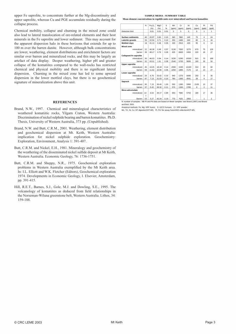
The concentrations of Ni, Cu, Pt, Pd, Mn, Fe and, in part, Zn, gradually increase upwards through the residual regolith, with marked increases in the collapsed Fe saprolite and/or mixed zone. In contrast, Mg contents decrease steadily, with almost total loss at the Mg-discontinuity at the top of the saprolite; S contents decline sharply at the top of the saprock, due to oxidation of supergene sulphides, with further loss in collapsed saprolite. The concentrations of all ore-associated elements are at background levels in the sediments.
Nickel concentrations are greatest close to the Mg discontinuity,
Figure 3. Regolith geology and Ni, Cu and Pd distributions, section 31375 mN, MKD5 (after Brand and Butt, 2001).
consistently exceeding 1.2%. At the top of the saprolite, Ni is mainly hosted by silicates, substituting for Mg in serpentine and hydrous Mg-silicates whereas, in ferruginous saprolite, it is hosted by Fe and Mn oxides. Concentrations decrease upwards in Fe-saprolite and are less than 0.3% in the mixed zone. Copper concentrations increase from a mean of 180 ppm in fresh ore and 205 ppm in saprock to 290 ppm in saprolite. Further concentration occurs in collapsed Fe saprolite, with maxima of 500 to >1000 ppm Cu close to the contact with the mottled clays, persisting into the mixed zone. Although there is a correlation between total Cu and Fe contents, and some goethite is Cu-rich, sequential extraction analyses did not release signifi cant Cu from Fe oxides. Analytical transmission electron microscopy and electron diffraction, however, demonstrate that Cu is present as native metal particles, 70-250 nm in length (Brand and Butt, 2001). The distributions of Pt and Pd are similar to those of Cu, concentrating in Fe saprolite and the mixed zone. Palladium, in particular, may also occur as native metal or alloyed to Cu, but concentrations are too low for this to be determined. The differences in host minerals in the Fe saprolite have contributed to the decoupling and separation of peak Ni contents from those of Cu and PGE. Nickel is leached from
Mt Keith Page 3© CRC LEME 2003
upper Fe saprolite, to concentrate further at the Mg-discontinuity and upper saprolite, whereas Cu and PGE accumulate residually during the collapse process.
Chemical mobility, collapse and churning in the mixed zone could also lead to lateral translocation of ore-related elements and their host minerals in the Fe saprolite and lower sediment. This may account for the apparent dispersion halo in these horizons that extends for up to 100 m over the barren dunite. However, although bulk concentrations are lower, weathering, element distributions and enrichment factors are similar over barren and mineralized rocks, and this may be largely an artefact of data display. Deeper weathering, higher pH and greater collapse of the komatiites compared to the wall-rocks has restricted chemical and physical mobility and there is no signifi cant lateral dispersion. Churning in the mixed zone has led to some upward dispersion in the lower mottled clays, but there is no geochemical signature of mineralization above this unit.
REFERENCES
Brand, N.W., 1997. Chemical and mineralogical characteristics of weathered komatiitic rocks, Yilgarn Craton, Western Australia: Discrimination of nickel sulphide bearing and barren komatiites. Ph.D. Thesis, University of Western Australia, 373 pp. (Unpublished).
Brand, N.W. and Butt, C.R.M., 2001. Weathering, element distribution and geochemical dispersion at Mt. Keith, Western Australia: implication for nickel sulphide exploration. Geochemistry: Exploration, Environment, Analysis 1: 391-407.
Butt, C.R.M. and Nickel, E.H., 1981. Mineralogy and geochemistry of the weathering of the disseminated nickel sulfi de deposit at Mt Keith, Western Australia. Economic Geology, 76: 1736-1751.
Butt, C.R.M. and Sheppy, N.R., 1975. Geochemical exploration problems in Western Australia exemplifi ed by the Mt Keith area. In: I.L. Elliott and W.K. Fletcher (Editors), Geochemical exploration 1974. Developments in Economic Geology, I. Elsevier, Amsterdam, pp. 391-415.
Hill, R.E.T., Barnes, S.J., Gole, M.J. and Dowling, S.E., 1995. The volcanology of komatiites as deduced from fi eld relationships in the Norseman-Wiluna greenstone belt, Western Australia. Lithos, 34: 159-188.
SAMPLE MEDIA - SUMMARY TABLEMean element concentrations in regolith units over mineralized and barren komatiites
N Fe2O3
(%)
MgO
(%)
S
%
Mn
(ppm)
Cr
(ppm)
Ni
(ppm)
Cu
(ppm)
Pt
(ppb)
Pd
(ppb)
Detection limit 0.01 0.01 0.01 5 5 5 5 1 1
Surface sediments 40 20.97 0.65 0.10 360 *860 140 75 4 24
Lateritic gravels 33 22.54 0.71 0.10 250 1480 240 80 6 16
Mottled clays 18 41.13 0.48 0.05 330 2910 420 95 6 14
Mixed zone
mineralized 22 46.38 0.48 0.07 3130 7050 3270 670 75 105
barren 39 48.17 0.76 0.09 635 6600 2450 220 18 27
Collapsed Fe saprolite
mineralized 30 46.53 0.94 0.14 3230 5290 10550 915 70 180
barren 32 43.51 1.61 0.08 2540 5700 9690 160 30 50
Upper saprolite
mineralized 45 10.25 18.18 0.14 2000 1530 12100 310 20 60
barren 59 11.62 15.90 0.06 2250 1885 7170 14 13 27
Lower saprolite
mineralized 25 6.76 33.42 0.33 940 1370 6690 250 9 30
barren 47 7.13 31.03 0.10 780 1360 4541 28 4 17
Saprock
mineralized 90 7.15 38.40 1.00 550 1380 5990 2105 10 37
barren 37 5.42 38.32 0.11 570 1160 2785 9 2 11
Meso-adcumulate
mineralized 10
7
6.64 39.17 0.89 650 *890 5750 180 17 36
Barren 53 5.27 42.34 0.19 770 *625 2850 - 1 2
N: number of samples. NB Pt and Pd data are based on fewer samples: see Brand (1997) and Brand
and Butt, 2001.
Analytical methods: Fe, Mg: XRF fusion; S: LECO furnace; Cr: XRF powder;
Mn, *Cr, Ni, Cu: HF digestion/ICP-MS; Pt, Pd: fire assay fusion/NiS collection/ICP-MS.