Embed Size (px)
Citation preview

REPORT84
by M. G. M. Painter, P. B. Groenewald, and M. McCabe
EAST YILGARN GEOSCIENCE DATABASE1:100 000 GEOLOGY OF THE
LEONORA–LAVERTON REGIONEASTERN GOLDFIELDS
GRANITE–GREENSTONE TERRANE— AN EXPLANATORY NOTE

GEOLOGICAL SURVEY OF WESTERN AUSTRALIA
REPORT 84
EAST YILGARN GEOSCIENCE DATABASE,1:100 000 GEOLOGY OF THE LEONORA–LAVERTON REGION, EASTERNGOLDFIELDS GRANITE–GREENSTONETERRANE — AN EXPLANATORY NOTE
byM. G. M. Painter, P. B. Groenewald, and M. McCabe
Perth 2003

MINISTER FOR STATE DEVELOPMENTHon. Clive Brown MLA
DIRECTOR GENERAL, DEPARTMENT OF INDUSTRY AND RESOURCESJim Limerick
DIRECTOR, GEOLOGICAL SURVEY OF WESTERN AUSTRALIATim Griffin
REFERENCEThe recommended reference for this publication is:PAINTER, M. G. M., GROENEWALD, P. B., and McCABE, M., 2003, East Yilgarn Geoscience Database, 1:100 000 geology of the
Leonora–Laverton region, Eastern Goldfields Granite–Greenstone Terrane — an explanatory note: Western Australia GeologicalSurvey, Report 84, 45p.
National Library of AustraliaCataloguing-in-publication entry
Painter, M. G. M.East Yilgarn Geoscience Database, 1:100 000 geology of the Leonora–Laverton region, Eastern Goldfields Granite–GreenstoneTerrane — an explanatory note
Bibliography.ISBN 0 7307 5739 0
1. Geology — Western Australia — Eastern Goldfields — Databases.2. Geological mapping — Western Australia — Eastern Goldfields — Databases.I. Groenewald, P. B.II. McCabe, M., 1965–.III. Geological Survey of Western Australia.IV. Title. (Series: Report (Geological Survey of Western Australia); 84).
559.416
ISSN 0508–4741
Grid references in this publication refer to the Geocentric Datum of Australia 1994 (GDA94). Locations mentioned in the textare referenced using Map Grid Australia (MGA) coordinates, Zone 51. All locations are quoted to at least the nearest 100 m.
Copy editor: D. P. ReddyCartography: L. S. CosgroveDesktop publishing: K. S. NoonanPrinted by Haymarket Printing, Perth, Western Australia
Published 2003 by Geological Survey of Western Australia
Copies available from:Information CentreDepartment of Industry and Resources100 Plain StreetEAST PERTH, WESTERN AUSTRALIA 6004Telephone: (08) 9222 3459 Facsimile: (08) 9222 3444This and other publications of the Geological Survey of Western Australia are available online through the Department’sbookshop at www.doir.wa.gov.au
Cover photograph:The historic mine site at Mount Windarra (MGA 425200E 6848550N) in the Margaret Anticline northwest of Laverton, where sulfidemineralization associated with komatiitic lavas made this the second-largest Australian source of nickel from 1974 to 1979.

iii
Contents
Introduction ............................................................................................................................................................... 1Abstract ...................................................................................................................................................................... 1
Location, access, and physiography .................................................................................................................. 3The database .............................................................................................................................................................. 5
Themes ............................................................................................................................................................... 5Geology ....................................................................................................................................................... 5Regional interpreted bedrock geology ....................................................................................................... 9Airborne magnetic survey .......................................................................................................................... 9Magnetic interpretation .............................................................................................................................. 9Landsat TM ................................................................................................................................................. 9Localities of mine workings, prospects, and subsurface observations ..................................................... 9MINEDEX — mineral resources ............................................................................................................... 9TENGRAPH — a record of the extent, location, and status of tenements .............................................. 9
Geological setting of the Leonora–Laverton region .............................................................................................. 10Boundary between the Eastern Goldfields and Southern Cross Granite–Greenstone Terranes ................... 10Subdivision of the southern part of the Eastern Goldfields Granite–Greenstone Terrane ............................ 10Greenstone belts ............................................................................................................................................... 10
Illaara greenstone belt, Southern Cross Granite–Greenstone Terrane .................................................... 12Mount Ida greenstone belt ........................................................................................................................ 12Agnew–Wiluna greenstone belt ............................................................................................................... 13Yandal greenstone belt ............................................................................................................................. 13Malcolm greenstone belt .......................................................................................................................... 14Pig Well – Yilgangi belt ........................................................................................................................... 14Murrin greenstone belt ............................................................................................................................. 14Laverton greenstone belt .......................................................................................................................... 15Duketon greenstone belt ........................................................................................................................... 16Cosmo Newbery greenstone belt ............................................................................................................. 16
Archaean geology ................................................................................................................................................... 16Rock types ........................................................................................................................................................ 16
Ultramafic rocks ....................................................................................................................................... 16Mafic volcanic rocks ................................................................................................................................ 18Felsic extrusive rocks ............................................................................................................................... 19Clastic sedimentary rocks ......................................................................................................................... 19Chemical sedimentary rocks .................................................................................................................... 20Mafic intrusive rocks ................................................................................................................................ 20Granitoid rock types ................................................................................................................................. 20Dykes and veins ........................................................................................................................................ 22Metamorphic rocks ................................................................................................................................... 22Gneissic rocks ........................................................................................................................................... 22
Deformation ..................................................................................................................................................... 22Early deformation events .......................................................................................................................... 22D2 event ..................................................................................................................................................... 22D3 event ..................................................................................................................................................... 23D4 and D5 events ....................................................................................................................................... 24
Metamorphism ................................................................................................................................................. 24Proterozoic geology ................................................................................................................................................ 24
Mafic to ultramafic dykes ................................................................................................................................ 24Permian geology ...................................................................................................................................................... 24Regolith ................................................................................................................................................................... 24
Alluvial deposits .............................................................................................................................................. 25Colluvial deposits ............................................................................................................................................. 25Sheetwash deposits .......................................................................................................................................... 25Sandplain deposits ........................................................................................................................................... 25Lacustrine deposits .......................................................................................................................................... 25Residual deposits ............................................................................................................................................. 25Deeply weathered rocks of uncertain origin ................................................................................................... 25
Economic geology ................................................................................................................................................... 25Gold .................................................................................................................................................................. 26Nickel and cobalt ............................................................................................................................................. 26Copper, zinc, silver, and lead .......................................................................................................................... 26Magnesium ....................................................................................................................................................... 31Manganese and iron ......................................................................................................................................... 31Phosphate, rare earth elements, niobium, and tantalum ................................................................................. 31Tungsten ........................................................................................................................................................... 31

iv
Uranium ............................................................................................................................................................ 31Molybdenum .................................................................................................................................................... 31Bismuth ............................................................................................................................................................ 31Gemstones ........................................................................................................................................................ 31
References ............................................................................................................................................................... 32
Appendices
1. Rock codes and definitions ........................................................................................................................... 372. MINEDEX commodity groups, mineralization types, and reference abbreviations .................................. 41
Figures
1. Areas covered in the three phases of the East Yilgarn Geoscience Database project and1:100 000-scale maps collated in the database .............................................................................................. 2
2. Cultural and topographic features of the central Eastern Goldfields Granite–Greenstone Terrane ............ 43. Illustrative plots generated from the database for a small part of the coverage ........................................... 64. Tectonic units of the Leonora–Laverton region ............................................................................................ 85. Major structural features of the Leonora–Laverton region ......................................................................... 116. Gold mineralization in the Leonora–Laverton region ................................................................................. 277. Mineralization other than gold in the Leonora–Laverton region ................................................................ 28
Tables
1. The eighteen 1:100 000-scale geological maps and Explanatory Notes collated in the thirdphase of the East Yilgarn Geoscience Database project ................................................................................ 3
2. Summary of regional deformation events in the Leonora–Laverton region ............................................... 233. Gold production and indicated resources of the Leonora–Laverton region ............................................... 294. Nickel and cobalt production and indicated resources of the Leonora–Laverton region ........................... 305. Production and indicated resources of other commodities of the Leonora–Laverton region .................... 30
Digital data (in pocket)
East Yilgarn Geoscience Database (Leonora–Laverton area), 1:100 000 digital geological data package (1 CD)

1
GSWA Report 84 East Yilgarn Geoscience Database, 1:100 000 geology of the Leonora–Laverton region
East Yilgarn Geoscience Database,1:100 000 geology of the Leonora–Laverton region,
Eastern Goldfields Granite–Greenstone Terrane — an explanatory note
by
M. G. M. Painter, P. B. Groenewald, and M. McCabe
AbstractEighteen 1:100 000-scale geological maps of the central Eastern Goldfields Granite–Greenstone Terrane, Western Australia, havebeen collated as geospatially referenced digital information in Phase 3 of the East Yilgarn Geoscience Database project. Thisapproximately 50 000 km2 area around Leonora and Laverton includes most of the Laverton, Murrin, and Malcolm greenstonebelts, as well as parts of the Illaara, Mount Ida, Agnew–Wiluna, Yandal, Duketon, and Cosmo Newbery greenstone belts. Originalmap boundary discrepancies have been resolved and standardized rock type definitions applied to provide a seamless map ofoutcrop and regolith. Additional data themes include an aeromagnetic interpretation of concealed lithological and structuralfeatures; a 1:500 000-scale interpretation of Precambrian geology beneath younger cover; mine site, mineral occurrence, andexploration data; mineral resource locations and statistics (MINEDEX); tenement distribution and status information (TENGRAPH);and pseudocolour images derived from Landsat TM data.
The outcrop geology of this poorly exposed region reveals only segments of Archaean lithostratigraphy, with little continuitywithin the greenstone belts and no definitive data to allow correlation between them. Interpretations of tectonic settings and thecomplex deformation history are limited by the lack of fresh outcrop. There are a few minor exposures of Permian conglomeratesand sandstones. Most of the area is covered by transported and residual regolith.
There is gold mineralization in most of the greenstone belts and despite more than a century of productive mining, additionalgold resources have been discovered in the area during the last decade. Nickel sulfide ores have been mined from Mount Windarraand South Windarra in the Laverton belt, and extensive nickel–cobalt laterite deposits are currently being exploited at MurrinMurrin.
KEYWORDS: Archaean geology, greenstones, GIS data base, Yilgarn Craton, Eastern Goldfields, Southern Cross, Leonora,Laverton, remote sensing, mineral resources, gold, nickel.
IntroductionThe Geological Survey of Western Australia (GSWA)and Geoscience Australia (formerly the AustralianGeological Survey Organisation — AGSO) collaboratedin the National Geological Mapping Accord (NGMA)to complete geological mapping of the EasternGoldfields Granite–Greenstone Terrane at 1:250 000 and1:100 000 scales. The first phase of the East YilgarnGeoscience Database collated twenty 1:100 000-scale mapsheets from the southern Eastern Goldfields Granite–Greenstone Terrane (Fig. 1) as a seamless digital dataset(Groenewald et al., 2000). The second phase incorporatedeighteen 1:100 000-scale maps from the northern EasternGoldfields Granite–Greenstone Terrane (Groenewald
et al., 2001). Eighteen published NGMA 1:100 000-scalegeological maps (Table 1), covering the central 48 708 km2
of the Eastern Goldfields Granite–Greenstone Terranearound Leonora and Laverton (Fig. 1), are collated in thisReport as the third phase of the East Yilgarn GeoscienceDatabase. Continuous upgrading of the East YilgarnGeoscience Database, including planned improvementssuch as an upgraded 1:100 000-scale regolith layer andexpansion to include recent GSWA mapping in thesoutheastern Eastern Goldfields, Southern Cross Terrane,and Earaheedy Basin, will maintain currency and expandthe usefulness of a powerful spatial data resource forfuture advances in mineral exploration.
Because only two of the eighteen 1:100 000-scalemaps within the area are accompanied by Explanatory

2
Painter et al.
Figure 1. a) Areas covered in the three phases of the East Yilgarn Geoscience Database project;b) the 1:100 000-scale maps collated in Phase 3 of the database (this report). Margins adjusted inthis compilation are indicated by heavy lines, with an area in northwestern MCMILLAN also remapped
PERTH
(Groenewaldet al., 2000)
200 km
SOUTHERN
OCEAN
INDIAN
OCEAN
24°
28°
32°
116° 120° 124°
MP24A
Fault
07.04.03
Granite
YILGARN CRATON
Greenstone
Kalgoorlie
Eastern GoldfieldsGranite–Greenstone
Terrane
FaultIda
Phase 1
Phase 3(This report)
Phase 2
a)
b)
50 km
SouthWest
Terrane
SouthernCross
Granite–Greenstone
Terrane
MurchisonGranite–Greenstone
Terrane
Narryer Terra
neMarymia Inlier
Goodin Inlier(Groenewaldet al., 2001)
121° 122°120° 123°28°
29°
MUNJEROO2941
WILDARA3041
WEEBO3141
NAMBI3241
MOUNT VARDEN3341
MCMILLAN3441
MOUNT ALEXANDER2940
WILBAH3040
LEONORA3140
MINERIE3240
LAVERTON3340
BURTVILLE3440
MOUNT MASON2939
BALLARD3039
MELITA3139
YERILLA3239
LAKE CAREY3339
MOUNT CELIA3439

3
GSWA Report 84 East Yilgarn Geoscience Database, 1:100 000 geology of the Leonora–Laverton region
Notes (LEONORA* and MELITA; Table 1), an overview isprovided of the geology of the central Eastern GoldfieldsGranite–Greenstone Terrane. This Report also providesan explanation of the nature and origin of the digitalthemes into which the data have been divided, withdetails of metadata, data attributes, and look-up tablesprovided in the ‘readme’ and data dictionary files on theaccompanying compact discs. Rock types and theidentification codes used in the map data are defined inAppendix 1.
Although all Archaean rock types in the area coveredhave been metamorphosed, protoliths are commonlyrecognizable and the terminology used in this Report isbased on primary compositions.
Location, access, andphysiographyThe eighteen 1:100 000-scale maps comprising thisdataset cover an area between latitudes 28°S and 29°30'Sand longitudes 120°E to 123°E. This includes the LEONORA
(SH 51-1) and LAVERTON (SH 51-2) 1:250 000 map sheets,and the northern halves of the MENZIES (SH 51-5) andEDJUDINA (SH 51-6) 1:250 000 map sheets (Figs 1 and 2),encompassing an area of 48 708 km2.
In the area covered by the database, populated gazettedtownsites include Leonora, Laverton, Agnew, andKookynie. Aboriginal communities include MountMargaret on the old Leonora–Laverton Road and Morapoion the Kookynie Road (Fig. 2). Access to most of theregion is very good. Sealed roads connect the major
centres of the region, including the Goldfields Highwaythat passes from Kalgoorlie in the south, throughLeonora and northwest towards Wiluna, and the Leonora–Laverton Road (Fig. 2). Good-quality gravel roads extendthroughout most of the region, from which an extensivenetwork of variably maintained pastoral tracks andfence lines can be accessed. In the west the road fromLeonora to Mount Ida extends to meet the Menzies–Sandstone Road, at the Perrinvale Outcamp to the westand the Riverina Outcamp to the south. The old mainroad from Leonora to Agnew traverses the northwesternpart. In the northern part of the area good access isprovided by well-maintained roads from Leonora toNambi, Nambi to Weebo, and Nambi to Laverton viaErlistoun. Roads between Malcolm, Kookynie, Glenorn,Yerilla, and Yundamindra allow easy access in thesouth (Fig. 2). North and east of Laverton, the Bandyaroad provides access to the north and the Warburton RangeRoad (which is to be renamed the Outback Highway)extends northeast from Laverton and ultimately toUluru in the Northern Territory. Recent mining activityhas disrupted older access roads south of Laverton. Usersof these roads should contact the Laverton Shire Councilor the relevant mining companies for the most recenttopocadastral maps of the area.
A railway line extends south from Leonora throughKookynie to Kalgoorlie. Leonora and Laverton havepublic access airports, and many mine sites and stationshave private airstrips.
The topography of the area is subdued, with elevationranging from a low of around 330 m above the AustralianHeight Datum (AHD) at Lake Raeside and Lake Minigwalin the southeast of the region to 565 m (AHD) at MountClark on MOUNT VARDEN. The physiography comprisesthree main landform components, all related to theunderlying geology:
* Capitalized names refer to standard 1:100 000 map sheets, unless otherwiseindicated.
Table 1. The eighteen 1:100 000-scale geological maps and Explanatory Notes collated in the third phase of the East Yilgarn GeoscienceDatabase project
Sheet Number Source Map reference Explanatory Notes reference
BALLARD 3039 GA Rattenbury and Stewart (2000)BURTVILLE 3440 GA Duggan (1995a)LAKE CAREY 3339 GA Rattenbury and Swager (1994)LAVERTON 3340 GA Williams et al. (1997)LEONORA 3140 GA Stewart and Liu (1997) Williams (1998)MCMILLAN 3441 GA Champion and Stewart (1996)MELITA 3139 GSWA Witt (1992) Witt (1994)MINERIE 3240 GA Williams et al. (1995)MOUNT ALEXANDER 2940 GA Duggan (1995b)MOUNT CELIA 3439 GA Duggan (1995c)MOUNT MASON 2939 GA Duggan and Rattenbury (1996)MOUNT VARDEN 3341 GA Rattenbury et al. (1996)MUNJEROO 2941 GA Duggan et al. (1996b)NAMBI 3241 GA Jagodzinski et al. (1996)WEEBO 3141 GA Oversby et al. (1996a)WILBAH 3040 GA Duggan et al. (1996a)WILDARA 3041 GA Oversby et al. (1996b)YERILLA 3239 GA Oversby and Vanderhor (1995)
NOTES: GA Geoscience Australia, formerly Australian Geological Survey Organization (AGSO)GSWA Geological Survey of Western Australia
4
Painter et al.
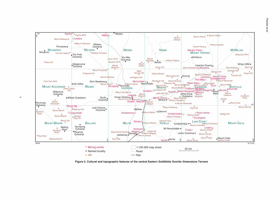
Figure 2. Cultural and topographic features of the central Eastern Goldfields Granite–Greenstone Terrane
MUNJEROO WILDARA WEEBO NAMBIM VOUNT ARDEN
M MC ILLAN
M MOUNT ASON
WILBAH LEONORA LAVERTON BURTVILLE
M COUNT ELIAL CAKE AREYBALLARD MELITA YERILLA
Peperill Hill
The Two Sisters
Cork Tree Hill
View Hill
Mount Adamson
Mount Mcauley
Agnew Bluff
Junior Hill
Boudie HillMountClifton
MountRedcliffe
MountNewman Rufus Hill
Mount Zephyr
MountBoreas
Mount Windarra
Camel Hump
Mount Amy Mount Clarke
Mount Varden
Glascock Hill
Point Kidman
Hammer Hill
Diorite Hill
Mount Barnicoat
Dingo Hill
Start Hill
IronstonePoint
MountLebanon
Mount Dennis
Mount East
JubileeHill
Mount WeldMount Jumbo
Dead CamelHill
MountAlexander
YendangRock
Mount Ida
SpottedDog Hill
Oberwyl HillMount BevonRanford
Peak
Day RockWalling Rock
Mount MasonWilga Hill
Mount CeliaMount PercyMount Howe
Mount Hornet
Mount Linden
Pyke Hill
Mount Keith
Mount ColindinaMount Florence
Kilmore Hill
Mount Kildare
Mount Fouracre
Mount Stirling Dodgers Hill
WestTerrace Hill
Mount George
Mount Davis
MountMalcolm
MountMargaret
Mount Redcastle
Mount Kilkenny
Mount Nangaroo
Mount PhoenixMount McKenzie
Mount KorongMinerie Hill
Randwick Hill
Mount Flora
MountStewart
Mount Ross
Red HillMount Niagara
Mount Jessop
Dead Horse Rocks
Twin Hills
Mount Barton
Monument HillEast Terrace
Wildara Pinnacle
Admiral Hill
Mount Ajax
Mount Crawford
Cardinia Hill
Benalla Hill
Mount Melita
M AOUNT LEXANDER MINERIE
Mount Leonora Mount Kowtah
MunjerooThe FollyOutcamp
MulgaroonaOutcamp
WildaraOutcamp
Ten MileOutcamp
Nambi
Erlistoun
Laverton Downs
MountWeld
Korong
Red KnobOutstation
Mount Celia
Larkin Outcamp
Mt Remarkable
Yundamindra
Yerilla
Glenorn
Minara
Melita
JeedamyaMorapoi
KurrajongOutcamp
RiverinaOutcamp
WallingRock
PerrinvaleOutcamp
WillsmoreOutcamp
Wilbah Outstation
Sturt Meadows
SouthOutcamp
Clover Downs
Mertondale
Last ChanceOutcamp
Pinnacles
White Cliffs
Ida Valley
Weebo
TarmoolaKurrajong
Craiggiemore
Agnew
Lawlers
Windarra
Hanns CampLavertonFive Mile
Mount Margaret Mount MargaretMission
Mount MorgansKowtahCardinia
Mertondale
MalcolmGwalia
Leonora
Mount Ida
Copperfield Desdemona
Yerilla
NiagaraKookynie Craig
Linden
Merolia Burtville
Euro
Murrin Murrin
Eucalyptus
Pyke HollowYundamindera
Tampa
Hawk Nest
Monitor Flats
Named locality
Hill
Mining centre25 km
MP26 22.10.02
Road
Rail
1:100 000 map sheet
Wibboo12
0°
28°
121°
122°
123°
29°

5
GSWA Report 84 East Yilgarn Geoscience Database, 1:100 000 geology of the Leonora–Laverton region
• Several large playa lakes, claypans, and associatedalluvial channels are flanked by dunes of quartzsand or gypsum (or both) that are typically stabilizedby vegetation. These dunes separate many smallperipheral lakes and saltpans. The lake and dunesystems represent southeasterly trending palaeo-drainage systems that have evolved since the EarlyCretaceous, possibly reflecting control by post-Archaean faulting or Palaeozoic valleys.
• Expansive undulating plains, irregularly disrupted bybreakaways or scarps, are underlain by granitoid,gneiss, and their weathered products. Sandy soils ofgranitic composition overlie siliceous duricrust andkaolinitized granite and, less commonly, fresh rock.The extensive areas covered by siliceous or ferruginousduricrusts (‘laterite’ in many early descriptions)indicate an extended period of landscape evolution.
• Subdued strike ridges are interspersed with plateaus ofduricrust and deeply weathered bedrock over thegreenstone belts of the area. Most greenstone outcropis deeply weathered. The most pronounced topographyis around the area near Mount Clarke and the MurphyHills (MGA 436800E 6898190N) on MOUNT VARDEN,and near Mount Florence south of Lake Carey(MGA 431590E 6764430N) where chert units formprominent ridges in otherwise subdued landscapes.
The databasePhase 3 of the East Yilgarn Geoscience Database is the lastmajor instalment of the Geographic Information System(GIS) package that covers the Eastern Goldfields Granite–Greenstone Terrane (Fig. 1a), and fills the gap betweenPhases 1 (Menzies to Norseman) and 2 (Cunyu to CosmoNewbery).
The original versions of the 1:100 000-scale geologicalmaps were created either through direct digital compil-ation by Geoscience Australia, or by digitizing of hand-drawn GSWA compilations. Precision and fidelity of datatransfer to the format appropriate for the current work weremaintained through comparison with the published maps.Any discrepancies between adjacent map sheets wereresolved to provide seamless continuity. Many adjustmentscould be made confidently after examination of aerialphotographs or Landsat TM (Thematic Mapper) images,although the boundaries between several adjacent maps(Fig. 1b) were remapped to confirm the continuity, identity,and distribution of several rock units or structural features.
The definitions of rock units or subdivisions shownon the maps have been checked against field notes,Explanatory Notes, or other published material to allowapplication of the standardized codes developed forPhases 1 (Groenewald et al., 2000) and 2 (Groenewaldet al., 2001) of the database. Where necessary, new rockcodes have been added to the standardized set. Definitionsof all the codes applied in the database are provided inAppendix 1.
The database was assembled using the EnvironmentalSystems Research Institute (ESRI) software ArcInfo 8.0.1to yield seamless layers within a digital map library. The
library was then converted into formats suitable forapplication of the popular GIS software packages ArcView,ArcExplorer, and MapInfo. Details of the directorystructure, data dictionary, and other metadata are providedin text files on the compact disk.
ThemesThe database comprises a variety of types of data innecessarily diverse formats, all linked by their spatialattribute of geographic location. This requires subdivisionof the data into different packages that may be thought ofas different layers of information or ‘themes’. Much of thepower of Geographic Information Systems stems from thissubdivision in that it allows selective access to data for theapplication of analytical methodology. The themes usedin this database are detailed below.
Geology
The geological data are subdivided according to variousattributes, as follows:• The position of outcrop geology is recorded in layers
according to data type, and is represented as eitherpolygons or lines, depending on the form of the rockunits. Outcropping planar units that have widths toonarrow to be represented as polygons on the originalmaps are presented as linear features.
• Attributes of each rock unit include an identificationlabel code, for which standardized definitions areprovided in look-up tables (Appendix 1).
• Subsurface records of rock types (from drillholes andcosteans) are provided as points in the mine workingsand exploration coverage (see below).
• Outcropping faults or shears are included in the linedata layer.
• The concealed geology layer shows the inferredpositions of geological boundary features, faults,and dykes interpreted from aeromagnetic images.Structural orientation records are in a point data layer,with measurements provided in the clockwise format(with dip direction taken as 90° greater than strike).
• Outcrop fold annotation is also provided in the pointdata layer.
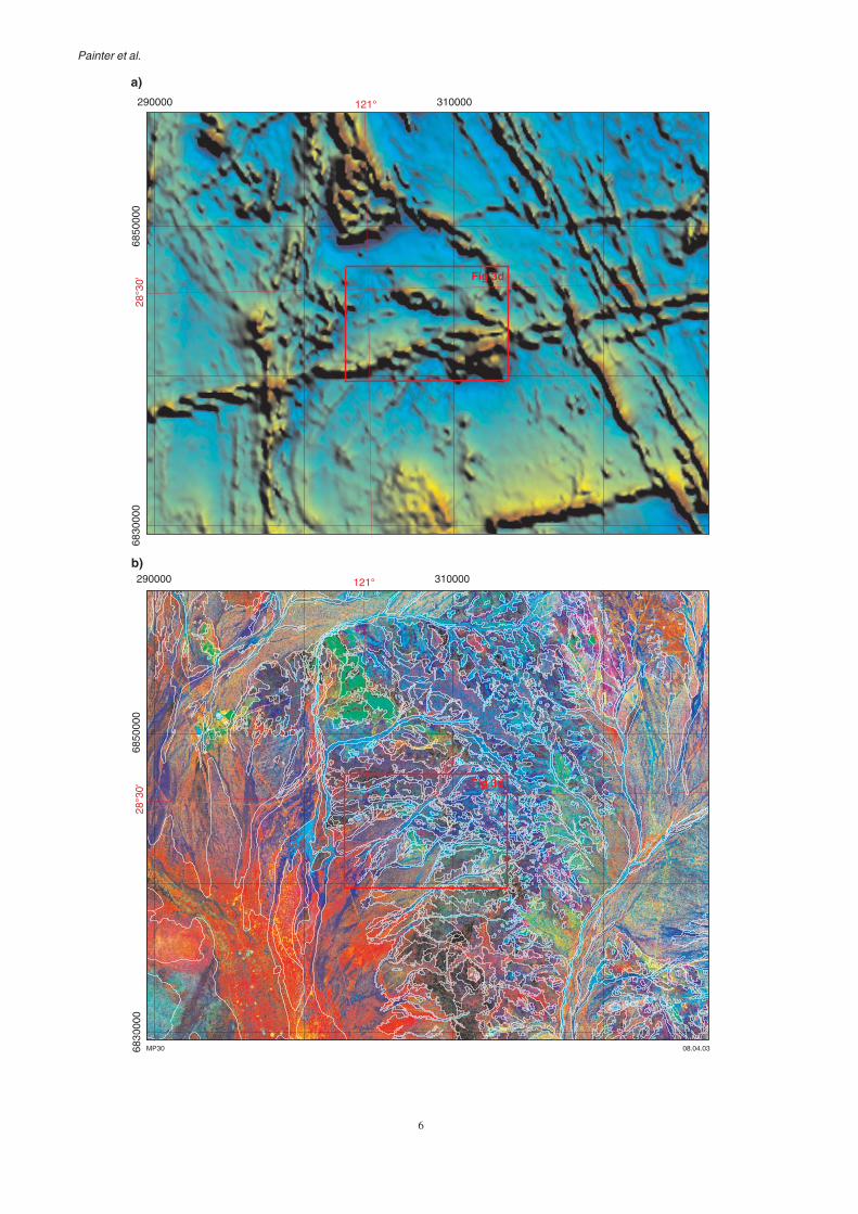
Figure 3 shows an example of the outcrop geologycontent of the database and possible data combinations thatcan be generated using the various themes describedbelow.
It should be noted that outcrop geology data have beenderived almost entirely from published map sheets,seventeen of which were mapped by Geoscience Australiaand one (MELITA) by GSWA (Table 1). Although regional-scale remapping of the central Eastern Goldfields Granite–Greenstone Terrane was beyond the scope of this project,numerous local areas were studied to ensure continuityacross former map sheet boundaries. An exception is theCosmo Newbery greenstone belt, on northeasternMCMILLAN (Fig. 4), which was remapped because the poorresolution of previous 1:100 000 mapping was such thatpolygons could not be matched with COSMO NEWBERY tothe north.
6
Painter et al.
290000 310000
6850
000
6830
000
121°
290000 310000
6850
000
6830
000
121°
28°3
0'28
°30'
MP30
a)
b)
Fig 3d
08.04.03
Fig 3d

7
GSWA Report 84 East Yilgarn Geoscience Database, 1:100 000 geology of the Leonora–Laverton region
Figure 3. Illustrative plots generated from the database for a small part of coverage: a) total magnetic intensityimage illustrating the pronounced dykes and greenstones; b) Landsat TM coverage of an area withoutlines of the observed geology superimposed on the pseudocolour image; c) an extract from theregional interpreted geology theme of the database covering the area shown in 3a and b; d) outcropgeology comprising polygons (coded as in Appendix 1), observed fault (solid line) and dykes, andstandard structural symbols, with mine site and subsurface data points
Victory/Herald
14.04.03MP28
270000 290000 310000 330000
6860
000
6840
000
6820
000
304000 306000 308000 310000
6844
000
6842
000
62
48
60
64
82
40
47
52
72
82
121°
28°3
0'
d)
c)121°
28°3
0'
Fig 3d
8
Painter et al.
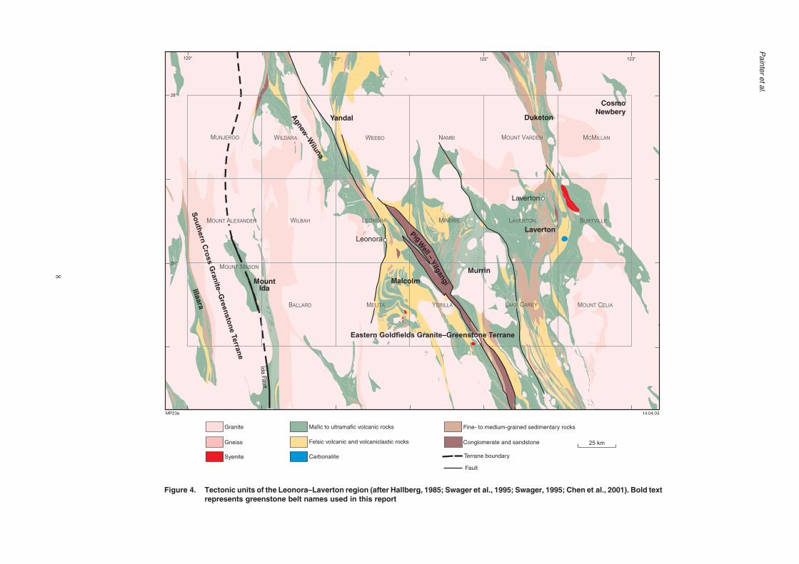
Figure 4. Tectonic units of the Leonora–Laverton region (after Hallberg, 1985; Swager et al., 1995; Swager, 1995; Chen et al., 2001). Bold textrepresents greenstone belt names used in this report
Ida Fault
Terrane boundary
Laverton
Leonora
Agnew
–Wiluna
Illaara
MurrinMalcolm
Laverton
DuketonYandal
Pig
Well –
Yilgangi
CosmoNewbery
Granite
Gneiss
Mafic to ultramafic volcanic rocks
Felsic volcanic and volcaniclastic rocks
Fine- to medium-grained sedimentary rocks
Conglomerate and sandstone
Syenite Carbonatite
MountIda
MUNJEROO WILDARA WEEBO NAMBI MOUNT VARDEN MCMILLAN
MOUNT ALEXANDER WILBAH LEONORA MINERIE LAVERTON BURTVILLE
MOUNT MASON
BALLARD MELITA YERILLA LAKE CAREY MOUNT CELIA
120° 121° 122° 123°
28°
29°
MP23a 14.04.03
So
uth
ern
Cro
ss
Gra
nite
–G
reen
sto
ne
Terra
ne
Eastern Goldfields Granite–Greenstone Terrane
Fault
25 km

9
GSWA Report 84 East Yilgarn Geoscience Database, 1:100 000 geology of the Leonora–Laverton region
Regional interpreted bedrock geology
The interpreted bedrock geology theme provided in thedatabase is a map of the interpreted distribution ofPrecambrian rock types beneath younger cover. This is asegment of the continuous Western Australian 1:500 000coverage completed in 2001 by GSWA. Polygon and linedata are in separate layers. Note that the map of interpretedsolid geology was compiled for presentation at a scale of1:500 000 and thus may not conform in detail andprecision to the 1:100 000-scale outcrop maps.
Airborne magnetic survey
The airborne magnetic survey theme has been derivedfrom the Geoscience Australia dataset, comprising earlier(1965–67) Bureau of Mineral Resources and more recent(1995) AGSO data. The false-colour image has beenrendered in red, green, and blue intensity layers to allowreplication of the standard geophysical pseudocolourspectrum in ArcView. Although the pixel size of 100 mused in this coverage may not allow detailed interpretationof the outcrop geology at 1:100 000 scale, it doescontribute to interpretation of the geology on a regionalscale, particularly in areas of very poor outcrop. Theoriginal data may be acquired from Geoscience Australiaat a nominal cost.
Magnetic interpretation
Magnetic features identified in the detailed airbornemagnetic coverage (400 m flight-line spacing) areprovided as the magnetic interpretation theme in thedatabase. This represents an examination of features, suchas linear anomalies, boundaries around zones of differentmagnetic texture, and inferred discontinuities withreference to the mapped geological characteristics toprovide a carefully constrained geophysical interpretation.This previously unpublished coverage was created by MrA. Whitaker and has been released with authorization byGeoscience Australia. A part of the detailed aeromagneticcoverage used in this interpretation was provided to theNGMA by Fugro Inc. (Fig. 1b).
Landsat TM
The Landsat TM theme comprises two Landsat TMimages, prepared using data collected in January andFebruary 1998, providing coverage in which many of therecent exploration grids are visible. Data from the sampledates have been merged and normalized by the WesternAustralian Department of Land Administration (DOLA),using robust regression techniques, to provide a seamlessLandsat image. Spatial accuracy better than 50 m with apixel size of 25 m has been preserved. Raw data may bepurchased from the Satellite Remote Sensing Servicesbranch of DOLA.
A monochromatic (grey-scale) layer shows principalcomponent values derived from Landsat TM bands 1, 4,and 7 using standard eigenvector formulae. In addition, apseudocolour image was prepared using ratios betweenbands 2, 3, 4, 5, and 7 to distinguish between iron- and
silica-rich areas, and between vegetation- and outcrop-dominated areas. Light-tan colouration is equivalent torecent alluvium, the lakes are light blue, mafic rockoutcrops commonly range from purple through Prussianblue to lighter blue-green, lateritic areas are dark brown,and kaolinite-enriched areas (granitic) are a bluish off-white.
Localities of mine workings, prospects,and subsurface observations
This theme shows the localities of historical and currentlyoperating mines and batteries, as well as prospects,mineral occurrences, and subsurface rock types revealedby mineral exploration. In view of the predominance ofgold workings in the area, a mine site is only labelled witha commodity code in the database when it is not gold. Thehigh level of exploration activity throughout the region inthe 1980s and 1990s resulted in a marked increase in theresource inventory, particularly near abandoned mines. Forthis reason, the more recent finds, as shown by theDepartment of Industry and Resources’ (DoIR, formerlyDepartment of Mineral and Petroleum Resources) minesand mineral deposits information database (MINEDEX;see below), may have historical names for localitiesslightly different from those shown in the historical mine-workings dataset. Similarly, present large-scale opencutmining operations have commonly amalgamated severalhistorical mine sites.
MINEDEX — mineral resources
The extract from the MINEDEX database included in thepresent database provides the following information, eitherdirectly as point attribute information or in look-up tables:• commodity groups, projects, and sites;• corporate ownership and percentage holding;• site type and stage of development;• site coordinates;• current (at date of compact disc compilation) mineral
resource estimates.
Details of the classifications and abbreviations used inthe tables are provided in Appendix 2.
TENGRAPH — a record of the extent,location, and status of tenements
The tenement information within the database is extractedfrom DoIR’s electronic tenement graphics system(TENGRAPH). The information demarcates the extent andlocation of tenements, with the following additional datain the attribute table:• tenement identification (Tenid; e.g. M 2600261 refers
to mining licence M 26/261;• survey status (Survstatus), indicating whether or not
the tenement has been surveyed;• status of the tenement (Tenstatus), referring to whether
the tenement application has been granted (L) or isunder application (P);
• dates and times of submission of application, granting,and expiry of tenement holding.

10
Painter et al.
In view of the continuous and ongoing changes in thetenement situation, current tenement plans should beviewed at the DoIR offices in Perth and Kalgoorlie beforeany land-use decisions or tenement applications are made.
Geological setting of theLeonora–Laverton region
The region covered by Phase 3 of the East YilgarnGeoscience Database predominantly covers the EasternGoldfields Granite–Greenstone Terrane, but also incorpor-ates granites and the easternmost greenstone belts of theSouthern Cross Granite–Greenstone Terrane in thesouthwest (Fig. 1a).
The Eastern Goldfields Granite–Greenstone Terranemakes up the eastern third of the Archaean Yilgarn Craton(Fig. 1a; Gee et al., 1981; Griffin, 1990a,b; Myers, 1997).The Ida Fault in the Menzies–Coolgardie area (Figs 1a and4) marks the western limit of the terrane, and is an east-dipping, crustal-scale structure (Swager et al., 1997)separating the Eastern Goldfields Granite–GreenstoneTerrane from the largely older succession of the SouthernCross Granite–Greenstone Terrane. The northwardcontinuation of this fault is not well defined, but is inferredto lie west of the Agnew–Wiluna greenstone belt.
The mafic-dominated greenstone sequences of theSouthern Cross Granite–Greenstone Terrane are con-strained to a c. 3000–2900 Ma age by sensitive high-resolution ion microprobe (SHRIMP) U–Pb zirconanalyses of various rock types (Pidgeon and Wilde, 1990;Nelson, 1999). This is significantly older than thegreenstone sequences of the Eastern Goldfields Granite–Greenstone Terrane, which have been constrained tobetween 2750 and 2655 Ma (Kent and Hagemann, 1996;Nelson, 1995, 1996, 1997a,b, 1998, 2000; Krapez et al.,2000). No basement or rock types older than 2750 Mahave been identified in the Eastern Goldfields Granite–Greenstone Terrane (with the exception of the Norsemangreenstones in the south; e.g. Nelson, 1995). Nevertheless,xenocrystic zircons older than 3000 Ma in felsicmetavolcanic rocks suggest pre-existing continental crust(Compston et al., 1986; Nelson, 1997a). This is supportedby the trace element geochemistry of some mafic rocksthat indicate contamination of a primitive ultramaficmagma by older sialic crust (Arndt and Jenner, 1986;Barley, 1986; Lesher and Arndt, 1995), and geochemistryof granitoids indicating generation through repeatedcrustal reworking (e.g. Wyborn, 1993). Widespread felsicvolcanism occurred in the Yilgarn Craton between c. 2760and 2700 Ma (Pidgeon and Wilde, 1990; Pidgeon andHallberg, 2000), with several such volcanic centres withinthis database coverage.
Boundary between the EasternGoldfields and Southern CrossGranite–Greenstone TerranesThe definition of the boundary between the EasternGoldfields and Southern Cross Granite–Greenstone
Terranes is controversial. Various authors have implied thatthe boundary is along the Ida Fault continuation within theMount Ida greenstone belt (e.g. Swager, 1995a) or in graniteswest of the belt (e.g. Griffin, 1990a,b; Fig. 4). Stratigraphicrelationships of the southern part of the Mount Idagreenstone belt (south of the database area) indicate thatthe ultramafic-bearing eastern part of the belt is part of theEastern Goldfields Granite–Greenstone Terrane and thatthe basalts and cherts of the western part are part of theSouthern Cross Granite–Greenstone Terrane (e.g. Wyche,1999). Recent aeromagnetic interpretations suggest that theIda Fault is discontinuous along strike (e.g. Whitaker, 2001).Whether the shear propagates through to the northern partof the Mount Ida greenstone belt (within the database area)is unclear, but similar rock relationships exist here (seebelow). The boundary between the Eastern Goldfields andSouthern Cross Granite–Greenstone Terranes is thereforeconsidered to be the Ida Fault within the Mount Idagreenstone belt, but is probably obscured by granitoids tothe north (Figs 4 and 5).
Subdivision of the southern partof the Eastern Goldfields Granite–Greenstone TerraneSwager et al. (1990, 1995) and Swager (1995a, 1997)subdivided the greenstones of the southern part of theEastern Goldfields Granite–Greenstone Terrane intoseveral postulated tectono-stratigraphic ‘terranes’ boundedby major shear zones. Other interpretations have suggestedsubdivision into a back-arc rift and a volcanic arc (Barleyet al., 1989; Morris and Witt, 1997), or into the Kalgoorlieand Edjudina–Laverton greenstones (Groenewald et al.,2000), with possible smaller structural domains within thelithotectonic settings. Extrapolation of suggestedsubdivisions to the north is hampered by the lack ofexposure and detailed geochronology. The range of rocktypes is very similar in the northern and southern parts ofthe Eastern Goldfields Granite–Greenstone Terrane, andthe similarity between successions in the Wiluna – MountKeith area and the northwestern Kalgoorlie greenstoneshas been noted by Liu et al. (1998), and a directcorrelation postulated by Libby et al. (1997).
Greenstone beltsThe Eastern Goldfields Granite–Greenstone Terrane in theLeonora–Laverton area consists of expanses of granitoidsintruding or in faulted contact with a broad region ofArchaean supracrustal rocks stretching from Agnew in thenorthwest and Duketon in the northeast, through Lavertonand Leonora in the centre, to the Yilgangi area in the south(Fig. 4). Geophysical and field evidence indicate that thesupracrustal rocks are dissected by numerous regional-scale shear zones across which subtle differences inlithology can be recognized. This suggests continuity orstructural coalescence of these rock units; however, thedifferences in various areas of outcrop allow subdivisioninto discrete greenstone belts. For this reason the centralexpanse of supracrustal rocks is best described in termsof individual greenstone belts.

11
GS
WA
Report 84
East Y
ilgarn Geoscience D
atabase, 1:100 000 geology of the Leonora–Laverton region
Figure 5. Major structural features of the Leonora–Laverton region (after Hallberg, 1985; Swager et al., 1995; Swager, 1995a,b; Chen et al., 2001), including major faults and shear zones,and folds mentioned in the text (k = Kurrajong Anticline, K = Kilkenny Syncline, L = Lawlers Anticline, m = Marshall Pool Syncline, M = Margaret Anticline). The Celia andKilkenny Tectonic Zones are broad zones of shear bound by distinct shear zones
m
K
L
M
k
k
K
Granite
Greenstone
Domain boundary fault
Fault
Strongly shearedgreenstone
Major anticline
Major syncline
Shear
Cha
tterb
oxS
hear
Hootanui
Melita
Safari
Lave
rton
S
hear
Claypan
Cutline S
hear
Lulu Shear
Harold
Brum
by
Ninnis Shear
Sons of GwaliaShear
Glenorn
Yerilla
Ballard
Ida Fault
Perseverence Ock
erbu
rry
She
ar
Mt M
cClu
re S
hear
Gar
dine
r S
hear
Mount
CeliaKilkenny
War
oong
a S
hear
Moriaty S
hear
Laverton
Leonora
TectonicZone
Shear
Shear
Shear
Shear
Shear
Shear
George
Shear
Shear
Shear
–Em
u
Shear
Laverton re
straining jo
g
Duketon
restraining jo
g
Yandal restra
ining jog
Mt Kilkenny –Welcome Well area
Tectonic
Zone
120° 122° 123°
28°
29°
14.04.03MP22a
25 km
Southern C
ross Granite–G
reenstoneTerrane Eastern Goldfields Granite–Greenstone Terrrane

12
Painter et al.
The subdivision of the Leonora–Laverton region intoindividual greenstone belts permits correlation with theparts of the Eastern Goldfields Granite–GreenstoneTerrane to the north and south. The greenstones consistof metamorphosed ultramafic, mafic, and felsic volcanicor intrusive igneous rocks and immature sedimentaryrocks typical of Archaean supracrustal successions. Thetypically poor exposure makes recognition or correlationof lithostratigraphic sequences difficult. Althoughindicators of younging direction are rarely preserved inthe greenstones, pillow lavas and sedimentary structuresas well as differentiation trends in mafic intrusions provideconsistent younging directions in many areas. Much of thegeological interpretation summarized here is based onfield mapping data and interpretation of regional (400 mline spacing) and local, more detailed, airborne magneticsurveys.
Illaara greenstone belt, Southern CrossGranite–Greenstone Terrane
Only the central part of the Illaara greenstone belt (Griffin,1990a) is within the report area (Fig. 4). Wyche (1999) andWyche et al. (2001) noted the regionally distinctivelithostratigraphy of the Southern Cross Granite–Greenstone Terrane, in keeping with the westward dip andyounging direction evident in the Illaara greenstone belt(Kriewaldt, 1970; Stewart et al., 1983). From the base upthe stratigraphy comprises sandstone, quartzite, andbanded iron-formation (BIF) overlain by tholeiitic tokomatiitic basalt and komatiite, and an upper, poorlyexposed sequence of felsic to intermediate volcanic andvolcaniclastic rocks. Thin BIF and chert units become lesscommon up sequence. The base of the sequence isintruded by granitoids and is tectonized. A sequence oftholeiitic basalt with minor interbands of chert, BIF, andshale is exposed in the western side of the belt, but isfaulted against the eastern side and the stratigraphicrelationship is unclear. Wyche (1999) noted lateralvariation in the lower part of the stratigraphy, particularlyin the quartzite that lenses out to the south. Wyche et al.(2001) noted that the Illaara greenstone belt cannot becorrelated with certainty with other greenstone belts of theSouthern Cross Granite–Greenstone Terrane to the west.
On the YOUANMI 1:250 000 sheet to the west a steeplynorthward-plunging anticline and syncline pair dominatesthe structural pattern of the northern part of the Illaaragreenstone belt. South of this, particularly within thearea covered by the database, the stratigraphy dipsuniformly steeply westward. The bulk of the belt has beenmetamorphosed to greenschist to amphibolite facies, withthe higher grades predominating toward its margins andto the south (Ahmat, 1986; Wyche, 1999).
Detrital zircons from the lowermost quartzite unitindicate a maximum depositional age of c. 3300 Ma(Wyche et al., 2001).
Mount Ida greenstone belt
The Mount Ida greenstone belt (Fig. 4), as recognized byGriffin (1990b), extends from Willsmore Outcamp
(MGA 237700E 6803550N) in the north (Fig. 2) tosouth of Davyhurst. The greenstone belt comprises aneastern and western segment. The eastern segmentcontains mafic to ultramafic volcanic and intrusiverocks and is part of the Eastern Goldfields Granite–Greenstone Terrane. The western segment is dominatedby a thick sequence of tholeiitic basalt with common BIFunits, and shows a closer affinity to rocks of the SouthernCross Granite–Greenstone Terrane to the west (Wyche,1999). The boundary between the terranes is defined atthe Ida Fault to the south (see above). On MOUNT MASON
the location of what may be a continuation of the IdaFault is obscured by lateritic and related colluvialmaterial, but continuity of magnetic trends suggest thatthe fault is near the Bottle Creek gold mine (in theCopperfield mining centre) and further to the north-northwest between West Bluff (MGA 250900E 6779150N)and Mount Bevon (MGA 238250E 6784150N, Fig. 2).Further northward on MOUNT ALEXANDER the Ida Fault isinterpreted to continue north-northwesterly, probablybetween the BIF and quartzite units around MountAlexander and the hills of mafic rock several kilometresto the east.
The eastern sequence of the Mount Ida greenstone beltis part of the Kalgoorlie greenstones (as defined byGroenewald et al., 2000), and is dominated by basalt andultramafic rocks in the lower part of the stratigraphy. Hillet al. (1995, 2001) included these rocks in the WalterWilliams Formation, which they defined as ‘a layeredbody… consisting of a lower zone of olivine cumulatesand an upper zone of gabbroic rocks’. The formation isinterpreted to be a part of a large ponded komatiitic flow,in which in situ fractionation was fed by several influxesof fresh lava (Gole and Hill, 1990). The Walter WilliamsFormation is folded about the southward-plungingKurrajong Anticline on BALLARD (k on Fig. 5). The name‘Walter Williams Formation’ has not been used within thedatabase due to uncertainty concerning the absolute spatialextent of the formation.
In the west a thick sequence of predominantlytholeiitic basalt contains interbeds of BIF, chert, and shale,and local lenses of gabbro and komatiitic basalt. Bandediron-formation dips shallowly to moderately westward atMount Ida. Near Mount Alexander the sequence isdominated by steeply southwesterly dipping BIF andquartzite units. The western margin of the sequence islargely an intrusive contact with regional monzogranites.
Metamorphic grade ranges from lower to upperamphibolite facies (Binns et al., 1976; Wyche, 1999), butprimary textures are commonly preserved (e.g. Hill et al.,2001).
No geochronology is available for the Mount Idagreenstone belt within the area covered by the data-base. The 2640 ± 8 Ma (Nelson, 1995) Clarke WellMonzogranite on RIVERINA to the south of the study areaintruded the Ida Fault and post-dates movement alongthe fault (Wyche, 1999). Further south the UlarringMonzogranite intruded the greenstone belt, with a samplefrom Ularring Rock (MGA 263390E 6686890N) providinga SHRIMP U–Pb zircon age of 2632 ± 4 Ma (Nelson,2000).

13
GSWA Report 84 East Yilgarn Geoscience Database, 1:100 000 geology of the Leonora–Laverton region
Agnew–Wiluna greenstone belt
The southernmost part of the Agnew–Wiluna greenstonebelt is incorporated in this dataset (Fig. 4; see Groenewaldet al., 2001, for a synopsis of the geology of the northernpart), and includes the western Agnew and eastern MountClifford domains, which are separated by granitoids andfaults.
The Agnew domain is dominated by the LawlersAnticline (L on Fig. 5), which plunges 30–40° northward(e.g. Aoukar and Whelan, 1990). The anticline has acore of granitoid rocks that appear to intrude thesupracrustal lithologies, whereas to the west the domainis in faulted contact with granitoids along the WaroongaShear Zone. To the east the relationship to granitoids isunclear, but is probably largely intrusive in nature. Thesoutheasternmost and southwesternmost parts of thedomain are characterized by folds that are attenuatedbetween faults and the major granitoid intrusions. Severaloverturned early generation folds are refolded by theLawlers Anticline.
A distinct stratigraphy comprising two distinctsequences separated by an unconformity has beenrecognized for the supracrustal lithologies of the Agnew–Wiluna greenstone belt, and this can be recognized inthe Agnew domain (Naldrett and Turner, 1977). Thelower sequence is exposed in the Lawlers Anticlinenear Yakabindie and the upper sequence is exposedelsewhere in the belt. The oldest recognized rocks in theAgnew domain are basalt, komatiitic basalt, and komatiiteand their coeval subvolcanic intrusives, and associatedinterflow sedimentary rocks (Platt et al., 1978; Inwood,1998). The mafic to ultramafic sequence is overlain bylocally preserved and volumetrically minor felsicvolcanic rocks (Aoukar and Whelan, 1990). Granite,leucogranite, and diorite to tonalite of the ‘LawlersTonalite’ (Foden et al., 1984) intruded the greenstonesequence at 2652 ± 20 Ma (Rb–Sr whole-rock age; Cooperet al., 1978). A strongly deformed sedimentarysequence of mudstone to conglomerate, known locally asthe ‘Scotty Creek Formation’ (but reclassified as theJones Creek Conglomerate by Wyche and Griffin,1998), unconformably overlies these rocks (Inwood,1998).
The Mount Clifford domain is bound to the east bythe Perseverance and Mount George Shear Zones (Fig. 5;Williams et al., 1989), and incorporates the CorktreeWell and Sons of Gwalia domains to the southwest(Williams, 1998). A regional-scale stratigraphy has notbeen determined for this domain due to extensive foldingand faulting, but Hill et al. (2001, p. 31) noted that‘the nature of the komatiites is consistent with correlationwith the upper greenstone sequence of the Agnew–Wilunagreenstone belt farther north’. Common rock typesinclude ultramafic to basaltic flows and felsic pyroclasticrocks associated with dunitic lenses (Naldrett and Turner,1977) that probably represent differentiates of eitherlayered flows or subvolcanic intrusions. The southwesternboundary of the Mount Clifford domain varies innature. In the south the arcuate Sons of Gwalia ShearZone is an early extensional structure (Williams et al.,1989) that separates the supracrustal rocks from the
Raeside Batholith, which is largely composed ofgranodiorite and monzogranite, but is tonalitic nearLeonora (Dudley et al., 1990). In the north a broad shearzone trending north–south, west of the Bannockburn andSlaughter Yard mine sites and east of Wildara Outcampon WILDARA, separates gneissic granitoid and graniticgneiss from sheared greenstone lithologies. The RobesWell pluton intrudes the supracrustal sequence betweenSturt Meadows (on WILBAH) and Mount Ross (onLEONORA).
The geochronology of the Agnew–Wiluna greenstonebelt is poorly constrained, particularly within the areacovered by this database. Just north of the field area aconventional U–Pb zircon age of 2795 ± 38 Ma for agranophyric differentiate of the Kathleen Valley layeredgabbro (Cooper and Dong, 1983) may represent the ageof the lower supracrustal succession between the LawlersAnticline and Yakabindie (Naldrett and Turner, 1977).Also to the north the Jones Creek Conglomerate has amaximum depositional age, based on SHRIMP U–Pbdata from zircon populations, of 2667 ± 6 Ma (Nelson,2000).
Early deformational episodes are locally well preservedin the southern part of the Agnew–Wiluna greenstone belt.Early extension produced low-angle shear zones along beltmargins (Williams et al., 1989; Williams, 1998). The arcuateSons of Gwalia Shear Zone is an extensional deformational(De1) structure that dips radially away from the RaesideBatholith and contains mineral lineations that plunge down-dip along the shear plane (Williams et al., 1989; Williams,1998; see Deformation). Minor F1 folds are preserved ingabbro and basalt, and are refolded around the LawlersAnticline creating an F2 structure (e.g. Blewett, 2001; seeDeformation). The Agnew–Wiluna greenstone belt hasbeen metamorphosed largely to greenschist facies, withhigher grades prevalent adjacent to granitoid and gneisscontacts (Platt et al., 1978).
Several large gold deposits are present within theAgnew–Wiluna greenstone belt in the database area,including Tower Hill, Son of Gwalia, Harbour Lights,Tarmoola, Agnew, Emu, and Lawlers (see Economicgeology and the references therein for descriptions andproduction figures).
Yandal greenstone belt
The Yandal greenstone belt is east of the Agnew–Wilunagreenstone belt (Fig. 4) and is equivalent to the Yandal,Lake Violet, and Millrose greenstone belts as defined byGriffin (1990b). Only the southernmost part of the Yandalgreenstone belt, where it converges with the Agnew–Wiluna and Malcolm greenstone belts, is within the areacovered by this database. More details on the rest of thebelt are provided by Phillips and Anand (2000) andGroenewald et al. (2001).
Rock exposure is minimal in the southern Yandalgreenstone belt; only deeply weathered felsic volcanicrocks and rare basalt outcrop amongst extensive lateritecover, and so a stratigraphy has not been determinedspecifically for this area. The Mount McClure and

14
Painter et al.
Ockerburry Shear Zones bound the 8 km-wide belt ofsupracrustal rocks to the west and east respectively(Fig. 5). This area is intensely sheared and is also calledthe Yandal Shear Zone (e.g. Messenger, 2000). Aero-magnetic data suggest intense north–south shearing in thenorthwestern corner of WEEBO that swings towards thesouth-southeast near the southern termination of the belt.
Malcolm greenstone belt
The Malcolm greenstone belt (Fig. 4; Griffin, 1990b)largely corresponds to the Keith–Kilkenny Tectonic Zoneof Hallberg (1985), and appears to be the northernequivalent of the Kurnalpi domain, and possibly theGindalbie domain of Groenewald et al. (2000). The beltis bound by the Mount George Shear Zone to the west andthe Glenorn Shear Zone to the east (Fig. 5). The GlenornShear Zone forms the western edge of the broad KilkennyTectonic Zone, and was considered by Williams (1993)to correspond to the area east of the Melita–Emu ShearZone (a concept not adopted here). The northern extremityof the greenstone belt and the area south of Niagara areintruded by granite. The belt is broadest on MELITA andYERILLA, and is strongly sheared farther southeast.
The Malcolm greenstone belt hosts three significantbimodal and felsic subalkaline volcanic complexes knownas the Melita, Teutonic Bore, and Jeedamya Complexes.The Melita Complex is a bimodal package comprisingrhyolitic to dacitic lavas and volcaniclastic rocks that areinterlayered with pillow basalts and mafic hyaloclastites(Witt, 1994; Brown et al., 2001). Brown et al.’s (2001)definition of the Melita Complex differs from that ofprevious workers because it includes the interbandedvolcanic, volcaniclastic, and intrusive mafic units that Witt(1994) and Hallberg (1985) excluded from the MelitaComplex. The felsic rocks in particular are enriched inincompatible elements, more so than other felsic rocks ofthe Eastern Goldfields Granite–Greenstone Terrane.Morris and Witt (1997) considered the sequence to haveresulted from anhydrous melting of tonalite, whereasBrown et al. (2001) considered the sequence to representpartial melting of intermediate arc-type crust. Hallberg(1985) and Witt (1994) inferred a volcanic centre east ofMount Melita.
The Teutonic Bore Complex is strongly deformed andattenuated, but is similar in character to the MelitaComplex, comprising andesite and pillow basalt inter-bedded with thick beds of silicic volcaniclastic rocks andrhyolite lava (Brown et al., 2001). Compositionally similaralkaline intrusive rocks associated with this complex areprobably genetically related to the volcanic rocks (Brownet al., 2001).
The Jeedamya Complex is a calc-alkaline inter-mediate–silicic complex consisting predominantly ofrhyolitic to rhyodacitic pyroclastic and volcaniclastic rocks(Witt, 1994). A broad area of laterite separates theJeedamya and Melita Complexes, so the nature of thecontact between them is unclear.
Both the Melita and Jeedamya Complexes have actedas structural buttresses and contain the least deformed
rocks of the belt. Other more highly deformed areas,particularly north of Leonora, contain common sediment-ary rocks with subordinate silicic volcanic rocks, butexposure is typically poor.
Geochronological constraints on the Malcolm green-stone belt are limited to felsic rocks of the volcaniccomplexes. Rocks of the Teutonic Bore Complex recorda U–Pb zircon age of 2692 ± 4 Ma (Nelson, 1995); felsicrocks near Mount Germatong immediately east of Leonora(MGA 342050E 6807250N) record a similar age (2692 Ma,U–Pb zircon; Pidgeon, 1986) and are probably part of thiscomplex. The felsic volcanic rocks near Mount Germatonggold mine provided an extremely discordant U–Pb zirconage of 2735 ± 10 Ma (Pidgeon and Wilde, 1990), whichis older than most other recorded ages for felsic volcanicrocks throughout the Eastern Goldfields Granite–Greenstone Terrane. The same study yielded a date of2697 ± 3 Ma for felsic volcanic rocks at Pig Well, about7 km to the northeast. The Melita Complex is younger,recording a U–Pb zircon age of 2683 ± 3 Ma (Brown et al.,2002), which is within error of the U–Pb zircon age of2681 ± 4 Ma for the Jeedamya Complex to the south(Nelson, 1996).
The Malcolm greenstone belt contains numerous smallgold deposits, but no major deposits. The only recentlyexploited economical base metal deposit of the EasternGoldfields Granite–Greenstone Terrane is Teutonic Borein the northern part of the belt.
Pig Well – Yilgangi belt
The Pig Well – Yilgangi belt extends from Gambier LassWell in the north to Lake Rebecca in the south, andis rarely more than 8 km wide (Fig. 4). It is dominatedby fine- to coarse-grained siliciclastic deposits thatoverlie, or are in faulted contact with, the adjacentMalcolm and Murrin greenstone belts (Hallberg, 1985).This belt incorporates both the Pig Well and YilgangiConglomerates, and the northern part is commonlyreferred to as the ‘Pig Well graben’ (e.g. Hallberg, 1985).It falls entirely within the broad Kilkenny Tectonic Zoneand is locally strongly deformed.
A minimum U–Pb zircon age of 2662 ± 5 Ma isprovided by a monzodiorite dyke that intrudes the YilgangiConglomerate (Nelson, 1996).
Murrin greenstone belt
The Murrin greenstone belt (Griffin, 1990b) is bound bythe Glenorn Shear Zone on the western side of the broadKilkenny Tectonic Zone, and by the Claypan Shear Zoneto the east (Figs 4 and 5). To the north the greenstone beltis intruded by granitoids. To the south the belt may beequivalent to the Mulgabbie domain of Groenewald et al.(2000), but its relationship with that domain is unclear.Several elongate to ovoid granitoids of various sizesintrude the belt.
The Murrin greenstone belt consists of a sequencecomprising predominantly mafic to ultramafic volcanicand intrusive rocks, with lesser proportions of andesite,
15
GSWA Report 84 East Yilgarn Geoscience Database, 1:100 000 geology of the Leonora–Laverton region
intermediate volcaniclastic rocks, acid volcanic andvolcaniclastic rocks, siltstone, and sandstone, whichHallberg (1985) called ‘Association 2’ (see Lavertongreenstone belt). Intermediate volcanism is pre-dominantly preserved within the Welcome Well Complex,which is defined as ‘a sequence of subalkaline tointermediate volcanic rocks and associated epiclastic rock’(Brown et al., 2001). It is dominated by felsic volcani-clastic rocks with subordinate andesite and basalt, andhyaloclastite, and is intruded by extensive dolerite(Brown et al., 2001). The Welcome Well Complex hasbeen interpreted as the subaqueous proximal to medialfacies of an andesitic stratovolcano (Giles and Hallberg,1982), although subaerial andesitic volcanism andsedimentation have been inferred (Janka and Cas,2001).
Layered intrusions are common in the Murringreenstone belt near Mount Kilkenny (e.g. KilkennyGabbro) and the Eucalyptus mine. They probablyrepresent subvolcanic sills that commonly grade fromolivine-bearing cumulate to leucogabbro. The mafic toultramafic Murrin Murrin complex, which formsthe deepest part of the Kilkenny Syncline, has beenrecognized as an extensive ponded komatiitic unit inwhich differentiation led to the formation of substantialolivine orthocumulates (Hill et al., 2001). Extensivelaterite development over these ultramafic rocks hasformed large supergene nickel–cobalt deposits at MurrinMurrin.
Structurally, large-scale D2/D3 folds and D3 faultscontrol the distribution of rock units (see Deformation).Between Welcome Well and Mount Kildare, shallowlyplunging D3 folds trend north-northeasterly and aretruncated by north-northwesterly trending D3 shear zonesand bound by reverse faults. Chen et al. (2001) consideredsuch juxtaposition of regional grains to be a function oflocalized compression during sinistral D3 transpression inright-stepping restraining jogs. Metamorphic gradethroughout the Murrin greenstone belt is variable, buttypically low.
No SHRIMP geochronology data are available for theMurrin greenstone belt.
Laverton greenstone belt
The Laverton greenstone belt (Fig. 4) is equivalent to theMargaret and Merolia greenstone belts of Griffin (1990b)and is equivalent to that described by Chen (1999) andStewart (2001). To the east and north the belt is intrudedby granitoids, whereas the western edge of the CeliaTectonic Zone (the Claypan Shear Zone) forms thewestern margin, incorporating the regional MargaretAnticline (M on Fig. 5). To the north a portion ofthe Hootanui Shear Zone probably demarcates theboundary with the Duketon greenstone belt, althoughexposure is poor. To the south the Laverton greenstone beltincorporates the Edjudina, Pinjin, and Linden terranes(Swager, 1997) or domains (Groenewald et al., 2000) ofthe southern Eastern Goldfields Granite–GreenstoneTerrane.
In contrast to adjacent greenstone belts the Lavertongreenstone belt contains abundant BIF, which is typicallyrare in the Eastern Goldfields. Banded iron-formation iscommon in the central part of the Laverton greenstone beltnear Laverton township, becoming more abundant andmore iron rich south of the Margaret Anticline and LakeCarey. Banded iron-formation units are hosted byintensely deformed sedimentary sequences of siltstonethrough to fine sandstone, some of which are possibly ofvolcaniclastic origin. The Margaret Anticline and easternareas of the belt are dominated by basalt, komatiitic basalt,dolerite, and gabbro. Siltstone, sandstone, felsic volcanicand volcaniclastic rocks, and ultramafic rocks are locallysignificant.
Hallberg (1985) described two distinct stratigraphicassociations for the greenstones that comprise theLaverton greenstone belt, but these have not been datedor adopted by subsequent mapping geologists (e.g.Rattenbury et al., 1996; Williams et al., 1997; Stewart,2001). Hallberg’s (1985) scheme has not been used in theEast Yilgarn Geoscience Database, but is worthy of notehere. The lowermost sequence, Association 1, is exposedin the Margaret Anticline only; the upper Association 2 isexposed elsewhere. Association 1 is characterized byseveral BIF horizons associated with ultramafic rocks(usually komatiite) and komatiitic basalt within a sequencedominated by basalt and topped by conglomerate,siltstone, and shale. The lowermost part of the stratigraphyis preserved at Mount Windarra and South Windarra,where basal BIF is overlain by ultramafic schist and basalt.Association 2 lies conformably on Association 1 and iscompositionally similar to it, except that BIF andkomatiite are rare.
The Laverton greenstone belt hosts a number ofunusual intrusions. The extensive Diorite Hill layeredintrusive complex (12 × 8 km) east of Laverton is typicallynoritic in composition (Stewart, 2001). It is exposed at afew localities, but is commonly covered by regolith.Foliated porphyritic syenite near Mount McKenna, alsoeast of Laverton, is the largest syenitic intrusive of theEastern Goldfields Granite–Greenstone Terrane (13 ×2 km) and contains a moderately easterly dipping foliation.The Mount Weld Carbonatite (4 km diameter) is notexposed, but is in the subsurface south of Laverton.Deeply weathered tonalite is exposed 12 km north ofLaverton.
In the north the Laverton greenstone belt is structurallydominated by the Margaret Anticline, which is a reclined,eastward-plunging regional-scale D2 fold (Stewart, 2001;see Deformation). A number of D1 folds are refolded bythis anticline. A D3 restraining jog between the Celia ShearZone and the Hootanui Shear was proposed by Chen(1998) and Chen et al. (2001) to explain complex fault,fold, and rock unit orientation geometries for that region(see Deformation). Amphibolite-grade metamorphism ispresent adjacent to the granite contact on the eastern sideof the belt. Elsewhere, metamorphic grades are commonlylow, with prehnite–pumpellyite-facies metamorphismsoutheast of Laverton.
No SHRIMP geochronology data are available for theLaverton greenstone belt.
16
Painter et al.
Duketon greenstone belt
Only the southern part of the Duketon greenstone belt(Griffin, 1990b) is within the study area (on MOUNT
VARDEN). In this area the belt is bound to the west by theHootanui Shear and is in intrusive contact with granitoidsto the east (Figs 4 and 5).
In the western part of the belt in the study area,deformed mafic and ultramafic rocks are interbanded withminor felsic rocks, and are overlain predominantly bysiltstone interlayered with minor conglomerate, sandstone,and chert. Chert bands define folding and are exposed asprominent ridges, but younging indicators are rare. Theeastern part of the belt is dominated by basalt to doleritewith less common ultramafic rocks. Extensive lateritedevelopment has obscured much of the Archaean geology.Poor exposure and structural complexity have precludedestablishment of a stratigraphy for the Duketon greenstonebelt. The metamorphic grade varies from lower greenschistto lower amphibolite facies on MOUNT VARDEN.
The portion of the Duketon greenstone belt on MOUNT
VARDEN is strongly sheared. Chen et al. (2001) proposeda D3 restraining jog between the Lulu and Hootanui Shearsto explain structural complexity (see Deformation). Onlythe southern part of that restraining jog is within the studyarea. The degree of shearing has obscured recognition ofearlier deformation fabrics.
No SHRIMP geochronology data are available for theDuketon greenstone belt.
Cosmo Newbery greenstone belt
Only the southern portion of the Cosmo Newberygreenstone belt (Griffin, 1990b) is within the study area(Fig. 4), and the following relates to that portion only. Thebelt is bound to the west by a shear and to the east byporphyritic monzogranite. Basalt with subordinate doleriteconstitutes the bulk of the belt, with tremolitic schist onthe western margin. Several gabbroic dykes of inferredProterozoic age are exposed in fresh outcrops. Basalt unitsdip uniformly steeply eastward. Pervasive north-northwesterly striking subvertical foliation throughout thesupracrustal sequence is subparallel to feldspar phenocrystalignment in the porphyritic monzogranite to the east.Bedding and foliation intersections commonly plungeshallowly to moderately southward.
Archaean geologyThis section contains brief descriptions of the major rocktypes of the Leonora–Laverton region of the EasternGoldfields Granite–Greenstone Terrane. A description ofeach of the rock types present is beyond the scope ofthis volume, but all rock code descriptions used are listedin Appendix 1. A major hindrance to the compilation ofthis section has been the lack of Explanatory Notesfor 1:100 000-scale maps throughout the area covered.Explanatory Notes have been published for MELITA (Witt,1994) and LEONORA (Williams, 1998), and the notes forthe 1:50 000 mapping of Hallberg (1985) east of Leonora
have been of use. Explanatory Notes for each of the1:250 000 sheets (EDJUDINA — Williams et al., 1976(1st edition); Chen, 1999 (2nd edition); LAVERTON —Gower, 1976 (1st edition); Stewart, 2001 (2nd edition);LEONORA — Thom and Barnes, 1977; and MENZIES —Kriewaldt, 1970) are useful, but do not provide thedetail required. Although all rock types described belowhave been subjected to metamorphism under lowergreenschist- to upper amphibolite-facies conditions,igneous or sedimentary names and terminology are usedwhere protolith characteristics are recognized.
Rock types
Ultramafic rocks
Ultramafic rocks form a small, but widespread andsignificant, proportion of the greenstone belts in theEastern Goldfields Granite–Greenstone Terrane andseveral publications provide comprehensive descriptionsof these rock types, such as Hill et al. (1990, 1995, 2001).In the Leonora–Laverton area, where about 6.5% of theaerial extent of Archaean supracrustal rocks is ultramafic,the most extensive outcrops are on WILDARA, WEEBO,BALLARD, MINERIE, LEONORA, MELITA, and MOUNT VARDEN.These include undivided ultramafic rock (Au), komatiite(Auk), peridotite (Aup), tremolite schist (Aur), serpentinite(Aus), talc–chlorite schist (Aut), and pyroxenite (Aux).Peridotite and komatiite are respectively the most and leastabundant ultramafic rock types in outcrop; however, Hillet al. (1995, 2001) established a close petrogenetic linkagebetween these rock types. The ultramafic rocks commonlyform concordant lenses or sheets in the greenstonesequences, and contain up to 10% magnetite. Themagnetite content is responsible for the strong anomalieson aeromagnetic images, and thus aids in the interpretationof the extent of the supracrustal sequences concealedbeneath regolith.
Deeply weathered, highly altered, and intenselydeformed ultramafic rocks are classified as ‘undivided’(Au) because protoliths cannot be determined withcertainty. A secondary silica ‘caprock’ (Rzu) is associatedwith these rocks at some localities and elsewhere they arevariably ferruginized.
In the Murrin and Laverton greenstone belts,unassigned ultramafic rocks (Au) outcrop near GibsonWell in the north, in the central area 5 km north ofLaverton Downs Homestead (MGA 444700E 6851900N),near Minerie Hill (MGA 379500E 6825500N) in thesouthwest, and on the shores of Lake Carey in the south.
Unassigned ultramafic rocks are widespread in theAgnew–Wiluna, Malcolm, and Mount Ida greenstonebelts. On northeastern MELITA there are several squarekilometres of ultramafic rocks that are too altered andpoorly exposed for classification, but in places havecharacteristics typical of the layered komatiitic units. Forexample, siliceous caprock with relict orthocumulatetexture west of Snowy Well (MGA 347550E 6778260N)overlies unsilicified ultramafic rocks in which localprimary harrisitic textures are represented by metamorphicserpentine, tremolite, and magnetite pseudomorphs after

17
GSWA Report 84 East Yilgarn Geoscience Database, 1:100 000 geology of the Leonora–Laverton region
skeletal olivine. Unassigned ultramafic rocks are poorlyexposed on LEONORA, except for the hills east of Tarmoola(MGA 318700E 6821330N) that are composed of foliatedserpentinized and carbonated ultramafic rocks with norelict primary igneous structures. These ultramafic rocksoverlie less deformed sedimentary rocks, with S–C fabricsthat suggest emplacement of the ultramafic rocks as athrust slice over the felsic rocks (Williams, 1998). OnBALLARD minor areas of unassigned ultramafic rockassociated with peridotites represent part of the Kurrajongkomatiitic assemblage described by Hill et al. (1990).Extensive areas of unassigned ultramafic rocks in theMount Clifford and Marshall Pool areas have komatiiticprotoliths similar to those identified in the Kurrajongassemblage (Donaldson et al., 1986).
Komatiite (Auk) is the ultramafic volcanic rockdistinguished by olivine spinifex texture. The dominantmineral assemblages are now serpentine–chlorite in areaswith low metamorphic grade, or tremolite–chlorite in areaswith higher metamorphic grade. Talc and magnetite arecommon minor or accessory minerals. Primary olivine isvery rare and primary chromite is in low concentrations,but widespread. Although olivine is almost universallyserpentinized, it is commonly pseudomorphed and thisallows recognition of spinifex texture even in highlyaltered rocks. Replicas of large (commonly 50–150 mm,but up to 700 mm, across) platy skeletal olivine crystalsare arranged most commonly as book-like stacks, but arealso dispersed in random orientations in the uppermostpart of a lava flow. In areas of low strain, relict texturesin the lower part of a flow allow recognition of originalolivine-cumulate rocks. Thus, original komatiitic lavaflows have been identified despite the ubiquitousmetamorphism and alteration, with primary flow thicknessranging from less than a metre to more than severalhundred metres. Fractionated successions with a totalthickness of up to 800 m in lobes of the komatiite flowsprobably reflect enormous outpouring of lava leading tothe development of large flow fields (Hill et al., 2001).Lateral extents of about 100 km are recognized for someflows, with major lateral variations attributed to differentsub-environments within the voluminous and regionallyextensive eruptions (Hill et al., 1990). These flow fieldsare represented in the database by the extensive peridotiteoutcrops described below.
Outcrops of komatiite (Auk) in the southwestern partof BALLARD are associated with other ultramafic rock typessuch as serpentinite, peridotite, tremolite schist and talc–chlorite schist. Hill et al. (1990) attributed these rocks tothe Kurrajong Complex, which is a differentiatedkomatiite unit. MOUNT VARDEN, LAVERTON, and MOUNT
CELIA contain minor outcrops of komatiite.
The most extensive outcrops of ultramafic rocks areperidotite (Aup), typically representing rocks in whichassemblages of serpentine, amphibole, chlorite or talcpreserve textures that reveal the original mineralogical andcumulate characteristics. The largest of these are in theMount Clifford – Marshall Pool area, about 50 km north ofLeonora in the southernmost extent of the Agnew–Wilunabelt, where extensive ultramafic complexes are overlain byspinifex-textured flows. Excellent examples of diagnostickomatiitic textures are preserved in the Marshall Pool area
(MGA 302860E 6857800N) in outcrops too small to recordat the scale of mapping. Similarly, several exposures ofspinifex-textured rock indicate that the extensivesurrounding peridotites represent differentiated komatiiticrocks in the Kilkenny Syncline on MINERIE.
Other peridotite exposures are on western BALLARD,northwestern LEONORA, northwestern WILDARA, easternMELITA, and southeastern MINERIE. In all instances theperidotite units are at or near the base of differentiatedbodies. Relict textures represented by fine-grainedpseudomorphic aggregates of serpentine and magnetite,with minor but variable talc, tremolite, and carbonatecomponents, reveal cumulate protolith characteristics.
Talc–chlorite schist (Aut) is commonly fine grainedand strongly schistose. Talc is dominant, chlorite variesfrom 10 to 40 vol. %, magnetite is a common accessorymineral, carbonate reaches up to 20%, and tremolite andantigorite are present in some samples. The most extensiveoutcrops of talc–chlorite schist are on WILDARA, about3 km west of Anderson Bore (MGA 299170E 6880760N)where these rocks outcrop in a belt that is 12 km long andup to 0.5 km wide. There are numerous small outcrops inthe Mount Clifford (MGA 303740E 6851460N) andBannockburn (MGA 293790E 6550150N) areas, nearMount Newman (MGA 312990E 6845630N) on theboundary between LEONORA and WEEBO, in the hills eastof Tarmoola (MGA 318700E 6821330N), east of MountRoss (MGA 309420E 6823290N), and at mine sitesimmediately northwest and southwest of the Leonora townsite. In the Duketon belt on MOUNT VARDEN, talc–chloriteschist is exposed as several elongate strips up to 500 mwide and several kilometres long. Further south onLAVERTON two similar northwest-trending units, 5–6 km inlength and up to 300 m wide, are exposed west ofWindarra Well (MGA 425500E 6845500N) and at MountPhoenix (MGA 408300E 6818000N).
Tremolite schist (Aur) is fine to medium grained, andcomposed mainly of tremolite or actinolite needles or bladesup to 10 mm long. The microstructural fabric varies fromcompletely random orientation of the acicular tremolite, toa planar arrangement defining the schistosity, to a minerallineation. Chlorite and talc are the other main minerals,with carbonate at some localities. This rock type forms twoelongate bodies on BURTVILLE, up to about 1 km thick, withinmore extensive basalt at Ironstone Point (MGA 487500E6808750N). Smaller bodies are exposed at Mallock Well onBURTVILLE (MGA 462900E 6802000N) and further northeastnear Two Mile Well on MCMILLAN (MGA 490200E6899100N; Fig. 2). On northwestern MCMILLAN a narrowunit of tremolite schist is exposed along the contact betweenlayered tholeiitic basalts and granitoids, possiblyrepresenting an ultramafic basal portion of a differentiatedflow. On northwestern BALLARD several outcrops ofmedium- to coarse-grained tremolite schist, containingminor talc, chlorite, and carbonate minerals, may bemetamorphosed pyroxenite or high-Mg basalt.
Serpentinite (Aus) is fine grained and composed ofserpentine (20–90%), actinolite, relict olivine, chlorite,epidote, plagioclase, hornblende, magnesite, opaqueminerals, and chalcedony. It is even grained to weaklyblastoporphyritic, massive to foliated, and in places grades

18
Painter et al.
into talc schist or chlorite–magnetite schist. The rock formselongate bodies several kilometres long, and is exposed onLAVERTON at Jubilee Hill and east of Laverton Downs. Theonly other extensive serpentinite units are in the SnakehillSyncline and Kurrajong Complex on BALLARD.
Metapyroxenite (Aux) is a rock consisting predom-inantly of tremolite or serpentine pseudomorphs afterclinopyroxene. Deformed and more strongly recrystallizedsamples contain moderate to large amounts of chlorite andtalc. This rock forms the basal parts of layered mafic sillson MELITA, and is exposed on the eastern limb of theLawlers Anticline on WILDARA. There are also severaloutcrops of pyroxenite on LAVERTON.
Mafic volcanic rocks
Mafic volcanic rocks make up about 50% of the exposedgreenstone sequences, and contain both tholeiitic andkomatiitic (high-Mg) types. Characteristic textures are notalways preserved in the rocks. For example, massive, fine-to medium-grained metabasites (Ab) are mainly tholeiiticbasalts, but may include intercalations of komatiitic basalt.Pillow structures are present at several localities, but arenot widely recognized, probably because the rocks are toopoorly exposed. The strong deformation in some areas alsomasks such structures.
High-Mg or komatiitic basalt (Abm), which amountsto about 2% of the exposed Archaean supracrustalsequences and about 5% of the basaltic rocks, isdistinguished by relict pyroxene spinifex, variolitictextures, and its chemical composition (i.e., 10–18 wt %anhydrous MgO). Grey to pale-green tremolite–actinoliteis the main constituent mineral, with up to about 30%plagioclase, accessory amounts of opaque oxides(typically magnetite), and secondary chlorite. Thecommon relict pyroxene-spinifex texture consists oftremolite–actinolite pseudomorphs of acicular clino-pyroxene ranging in length from a few millimetres up toseveral centimetres. Clusters of pseudomorphs can assumedendritic or fan-like forms. Komatiitic basalt flows varylaterally in physical characteristics, with spinifex texturescompletely absent from substantial portions in some cases.Although pillow structures are present, these are rarelywell exposed in surface outcrop and are probably obscuredby the deformation in many areas.
On northwestern WILDARA relatively unalteredkomatiitic basalt is exposed in the eastern limb of theLawlers Anticline. The rock is characterized by coarsepyroxene spinifex, and pillow structures that, althoughpoorly exposed, indicate northeasterly younging of steeplynortheasterly dipping flows. On southwestern WILDARA
komatiitic basalt outcrops northwest of Marshall Well,about 3 km south of Kents Bore at the northwesternextremity of the Marshall Pool Syncline, and in theBannockburn gold mine workings.
On LEONORA komatiitic basalts outcrop east of MountStirling (MGA 311380E 6833290N), where individualflows are identified by the position of pillowed flow tops.The flows range from 100 to 300 m in thickness, and varyin grain size from gabbroic in patches to glassy at the flow
margins. The bulk of the flow is medium grained andequigranular. On southeastern BALLARD komatiitic basaltforms the upper portion of the ultramafic sequencedescribed by Hill et al. (1995) in the Kurrajong Anticlineand the Snake Hill Syncline to the south. West of ParadiseWell (MGA 343540E 6787400N) on MELITA, komatiiticbasalts are exposed as strongly foliated, fine- to coarse-grained, tremolite-rich mafic schist in which flattenedvarioles are obvious on foliation surfaces, and spinifex islocally evident. Komatiitic basalt is associated withperidotite in extensive areas around the Kilkenny Synclinein the Murrin greenstone belt. In the Laverton greenstonebelt komatiitic basalt is exposed 5 km south-southeast ofMount Varden (MGA 440650E 6884050N) and east ofMount Margaret Mission (MGA 420300E 6814250N).
There are extensive outcrops of tholeiitic basalt (Abv)in all greenstone areas and these amount to about 70% ofall mafic volcanic rocks. This rock type is typicallyequigranular, very fine to fine grained (but locally mediumor coarse grained), and composed of blue-green actinolite,plagioclase, and opaque minerals (ilmenite and magnetite).Locally, other minerals include green hornblende insteadof actinolite, epidote after plagioclase, hematite, quartz,carbonate, and titanite. These are typically massive rocks,but may be amygdaloidal (Abvy) or porphyritic (Abvp).Pillow structures and flow top breccias are rarely exposedor poorly preserved. In areas where the texture of thebasaltic rocks ranges from aphyric to fine-grainedsubophitic, the term basalt/dolerite (Abd) has been used.These areas probably represent crystallization of thicker,possibly ponded, flows or numerous subvolcanicintrusions. These rocks make up extensive parts of thegreenstones on MOUNT ALEXANDER, southeastern MINERIE,and MCMILLAN.
Coarsely porphyritic basalt (Abvp) has plagioclasephenocrysts ranging from 2 to 30 mm in length, locallyin glomeroporphyritic clusters, set in a fine- to medium-grained hornblende and plagioclase matrix. Althoughan uncommon rock type, the porphyritic basalt formsstratigraphic marker units that can be recognized inareas of otherwise indeterminate bedding. For example,the 5 km-long unit east of Mount George (LEONORA,MGA 335000E 6810700N) contains the only recognizedbedding in a 5 km2 area of basalt/dolerite (Abd). Theporphyritic basalt outcrops in several places on YERILLA
and LAKE CAREY.
Amygdaloidal basalt (Abvy) is a distinctly vesicularrock that can be distinguished from very fine grained,non-vesicular tholeiitic basalts. The most extensive outcropsof amygdaloidal basalt are in the Mount Clifford greenstonebelt on WEEBO, in the Malcolm greenstone belt onYERILLA, in the Murrin greenstone belt near CementTank Well (MGA 376700E 6803450N) on MINERIE, andin the Laverton greenstone belt 4 km north ofMorgans (MGA 409000E 6817000N), and at MallockWell (MGA 462900E 6802000N) and Golden RingWell (MGA 458050E 6800300N) in the southeast. Theamygdaloidal basalt around Cement Tank Well isunderlain, overlain, and interbedded with thick units ofsandstone, forming a steeply easterly dipping, uprightsequence that is about 3300 m thick.

19
GSWA Report 84 East Yilgarn Geoscience Database, 1:100 000 geology of the Leonora–Laverton region
Where mafic rocks are completely recrystallized andno vestiges of primary textures remain, they are classifiedas amphibolite (Aba). Prismatic amphibole and fine,polygonal, granoblastic plagioclase that shows little orno twinning are the main constituents, with localclinopyroxene. Compositional variations are reflected bydifferent proportions of plagioclase relative to amphibole.In cases where metamorphic foliation is very welldeveloped and the nature of the protolith is obscured byadvanced recrystallization and alteration, these rocks areclassified as mafic schists (Ala).
Felsic extrusive rocks
Felsic rocks of probable volcanic and volcaniclastic originamount to about 15% of the greenstone belts. Whereprotolith classification is hindered by deep weathering oradvanced metamorphism, these are simply called felsicrocks (Af) or schistose felsic rocks (Afs). The felsic rocks(Af) typically consist of fine-grained, equigranularquartz, feldspar, and biotite, and are locally porphyriticwith phenocrysts of typically subhedral quartz crystals2–6 mm across or subhedral feldspar up to 8 mm inlength, and rare biotite and hornblende. The schistoserocks (Afs) are common in major fault or shear zones, andcontain a schistosity typically defined by white mica. Insaprock variants, quartz grains are commonly hosted bya mass of clay minerals that may or may not preserve afoliation, but remnant quartz phenocrysts locally displayembayments that are indicative of their volcanogenicorigin.
Felsic volcanic and volcaniclastic rocks (Afv) havebeen recognized by the clearly extrusive textures, such asflow banding, embayed quartz or feldspar phenocrysts (orboth), fragmental clastic deposits, and finely layeredtuffites. These rocks are most common on MINERIE,MELITA, YERILLA, and LAKE CAREY.
The distribution of felsic pyroclastic rocks in thedatabase area is relatively restricted, particularly asmappable units. Tuffaceous rock (Aft) is finely banded andfine to medium grained, and contains quartz and feldsparphenocrysts. It is almost exclusively restricted to MINERIE
and BURTVILLE, in units up to 500 m thick, with a fewminor exposures on WILDARA, WEEBO, and LAKE CAREY.Ignimbrite (Aftn) is exposed on LAKE CAREY and YERILLA,where it consists of quartz and feldspar crystals and lithicfragments encased in a banded siliceous matrix thatretains textural evidence of welding and differentialcompaction around phenocrysts and clasts. Elongatehollows and some fine-grained quartzofeldspathic laths inthese rocks are interpreted to be after fiamme, whichrepresent pumice fragments compressed subparallelto primary layering during accumulation of the ignimbrite.
Intermediate volcanic rocks only locally make up asignificant proportion of the greenstone sequences.Intermediate volcanic rocks (Afiv) are fine grained,quartzofeldspathic, and have either volcaniclastic or flowtextures. The criteria commonly used for recognition ofthese rocks are a fine grain size and a felsic compositionwith plagioclase, but no quartz phenocrysts. A coarselyporphyritic variant is also exposed on YERILLA near Salt
Bush Creek (MGA 380000E 6754000N), in the Mount Idagreenstones on BALLARD, and in the Laverton greenstonebelt on MOUNT VARDEN. The foliated equivalents (Afivf )also outcrop on MOUNT VARDEN.
Andesite (Afid) is a dominant rock type inthree volcanic centres. Andesites in the Welcome WellComplex, in the Murrin greenstone belt between KauriWell (MGA 377250E 6823620N) and CorkscrewWell (MGA 377150E 6814900N) on MINERIE, includevariable assemblages of massive to pillowed to auto-brecciated flows, agglomerates or coarse mass-flowdeposits, epiclastic sandstone and conglomerate, andmafic to intermediate subvolcanic sill complexes. The IdaHill Complex around Lawson Well (MGA 448150E6825300N) on LAVERTON and the Bore Well Complex onLAKE CAREY also have significant proportions of andesite.The Lawson Well locality includes porphyritic andamygdaloidal andesite, together with agglomeratescontaining andesitic clasts up to 0.5 m long.
Hornblende(–plagioclase)-phyric intermediate lava(Afivh) and its foliated variant (Afivf) outcrop in theMurrin greenstone belt 4–5 km west of Minerie Hill(MGA 397500E 6825500N) and in the Ida Hill Complexof the Laverton greenstone belt around Lawson Well(MGA 448150E 6825300N).
Porphyritic felsic rocks are widespread in the felsicvolcanic successions. These are typically feldspar–quartzporphyritic (Afp) or quartz(–feldspar) porphyritic (Afpq),with a fine-grained dacitic to rhyolitic groundmass.Plagioclase-phyric andesite (Afip) is also recognized.These lithologies are typically volcanic to subvolcanic insetting and association, and are most common on MELITA
and LEONORA.
Basaltic andesite (Abi) is a pale-green to grey-green,fine-grained, massive to pillowed rock, which iscommonly exposed as rounded cobbles and boulders, withwell-preserved pillows at several localities. Amygdales arecommon in most exposures. Larger gas pipes and cavitieslocally coalesce into irregular quartz-cemented brecciazones that may represent flow tops. Basaltic andesiteconsists of plagioclase, tremolite–actinolite, rare chlorite,and accessory titanite or leucoxene in a fine-grainedgroundmass containing abundant plagioclase microlites.Basaltic andesite outcrops extensively on northeasternMELITA.
Clastic sedimentary rocks
All greenstone belts in the study area contain clasticsedimentary rocks but they are more common in theIllaara, Murrin, and Duketon greenstone belts. Sediment-ary structures are difficult to recognize, particularly in thefine- to medium-grained rocks, but younging andpalaeocurrent indicators can be identified with persistence.
Undivided sedimentary rock (As) is either poorlyexposed, deeply weathered or comprises a sedimentaryrock sequence that cannot be subdivided at 1:100 000scale. Shale and slate (Ash) are very common and maybe used locally as marker units. These rock types are

20
Painter et al.
common as interflow sedimentary units in volcanogenicsequences, where shale units have taken up strain so thatthe cleavage is either parallel or subparallel to composit-ional layering.
Siltstone through to fine sandstone (Ass) predominatesin the Duketon and Laverton greenstone belts. Sandstone(Ast) is more common in the Murrin greenstone beltand in the Pig Well – Yilgangi belt, where it is associatedwith conglomerate (Asc). Volcaniclastic conglomeratecontaining andesitic clasts (Ascfi) is restricted to theWelcome Well volcanic complex in the Murrin greenstonebelt. Conglomerate containing clasts of quartz, quartzite,and chert (Ascq) is common in the Illaara greenstone beltwhere it overlies and is interbedded with quartzite.Quartzite (Asq) is present in the Southern Cross Granite–Greenstone Terrane as a prominent strike-ridge along theeastern side of the Illaara greenstone belt and as a smallexposure in the western part of the Mount Ida greenstonebelt. Several very minor exposures have been recorded inthe Eastern Goldfields Granite–Greenstone Terrane, buttheir validity has not been ascertained here.
Chemical sedimentary rocks
Of the chemical sedimentary rocks, chert (Ac) predomin-ates in the Eastern Goldfields Granite–Greenstone Terranewhereas BIF (Aci) predominates in the Southern CrossGranite–Greenstone Terrane. Banded iron-formation formsa significant proportion of the rock exposure in the Illaaraand the western Mount Ida greenstone belts. Both theMurrin and Laverton greenstone belts contain a higherproportion of BIF in the north, whereas to the southvirtually all chemical sedimentary rocks are chert. Chertrather than BIF is common in the Duketon greenstone belt,where it is typically associated with siltstone andsandstone (Ass). Chert and BIF are not common rock typesin the Malcolm, Agnew–Wiluna, and Yandal greenstonebelts within the database area.
Topographically, chert and BIF units commonly formprominent strike-ridges. They typically define the bestavailable markers for remotely sensed correlation ofoutcrops or delineation of structures, particularly throughuse of aerial photography or magnetic imagery.
Mafic intrusive rocks
Mafic intrusive rocks are common throughout Archaeansupracrustal sequences of the Eastern Goldfields Granite–Greenstone Terrane and constitute about 12% of allgreenstone belts. Although metamorphic amphibole hascommonly replaced original pyroxene, it is typicallypseudomorphic and primary textures are recognizable,allowing the use of igneous terminology in most instances.
Dolerite or microgabbro (Aod) locally forms cross-cutting intrusions, but commonly forms concordant layersin basalt. It is unclear whether these rocks represent sillsor coarser grained portions of thick lava flows, but bothmodes of origin are likely. In moderately deformedsequences basalt tends to preferentially absorb strain sothat only a weak foliation is developed in doleritic layers.
Intersertal to ophitic textures are commonly preserved inweakly deformed specimens despite amphibole andchlorite pseudomorphism. High-magnesium dolerite(Aodm), recognized by the pyroxene spinifex texture, is aderivative of the komatiitic basalts, probably as intra-volcanic intrusions.
Tabular bodies of gabbro (Aog) are common asconcordant units within all the supracrustal packages ofthe study area. Most units were probably emplaced as sills,although weathering and poor exposure typically obscuretheir relationship with the country rocks. Gabbro istypically interlayered with either dolerite and basalt or withgabbronorites and ultramafic rock. Gabbro variants includeequigranular gabbro (Aoge), coarse-grained gabbro (Aogc),olivine gabbro (Aogv), leucogabbro (Aogl), porphyriticgabbro (Aogp), and quartz-bearing gabbro (Aogq).
Gabbronorite and norite (Aon) are only exposed onMELITA and BURTVILLE. They typically have mesocumulateto adcumulate textures. Tabular to lath-shaped plagioclasewith weak to moderate compositional zoning is thedominant mineral. Hypersthene is predominantly acumulus phase (but less commonly an intercumulusmineral), and augite, also a cumulus phase in somesamples, is more commonly oikocrystic. At Diorite Hillon BURTVILLE these rocks probably represent a portion ofa large, poorly exposed, layered mafic intrusion.
Compositional and cumulus layering indicative ofdifferentiation is evident in many gabbroic intrusions.Dolerite and cumulate-textured gabbronorite and gabbroicanorthosite, mainly in the Niagara mining area on MELITA,were grouped as the ‘Niagara Layered Complex’ by Witt(1994), who recognized similarities to the Carr BoydRocks Complex farther south. This definition has not beenused here because the distribution of sills and dykesattributed to the complex was not shown on MELITA, andthe sills on YERILLA included in the complex are notdistinctive in the field. Witt (1994) suggested that thepresence of anorthositic and quartz–magnetite-enrichedgabbros was evidence of an extensive layered intrusion,and recorded the sills as up to about 400 m in thickness.Ultramafic cumulates are only locally recognizable in thesesills.
Granitoid rock types
Granitoids are the dominant rock type in the YilgarnCraton, but are commonly poorly exposed or stronglyweathered. Most outcrops in the central Eastern Goldfieldsand central-eastern Southern Cross Granite–GreenstoneTerranes are strongly degraded, either in breakawayswhere variably kaolinized and silicified granitoid isexposed below silcrete duricrust, or as variably weatheredremnants in areas of quartzofeldspathic sand. Lesscommonly, relatively fresh outcrops are exposed asisolated whalebacks, pavements, and tors.
Champion and Sheraton (1997) and Champion (1997)argued that it is not possible to classify granitoids onthe basis of age relative to deformational events in thepoorly exposed Eastern Goldfields Granite–GreenstoneTerrane, although some magmatism was synchronous with

21
GSWA Report 84 East Yilgarn Geoscience Database, 1:100 000 geology of the Leonora–Laverton region
felsic volcanism in the greenstone belts and waspretectonic. On the basis of detailed petrographic andgeochemical studies, Champion and Sheraton (1997)subdivided the granitoids in the north Eastern GoldfieldsGranite–Greenstone Terrane into five groups: high-Ca(>60% of total granites), low-Ca (>20–25%), mafic(<5–10%), high-HFSE (high field-strength element;<5–10%), and syenitic groups (<5%). Although thisscheme is probably suitable for future work, it could notbe applied in the present collation because of the lack ofwidespread geochemical information.
Large areas of granitoid outcrop are too weathered toallow classification, apart from the recognition of commongranitic characteristics (Ag). Where grain size is consistentover an extended area, coarse- (Agc), medium- (Agem),and fine-grained (Aga) varieties are distinguished.Weathered exposures of strongly foliated granite (Agf )locally contain abundant mafic enclaves (Agb). Wheredegradation is more severe, residual granitoid regolith maybe classified as deeply leached granitic laterite (Rgpg) orsilcrete with kaolinite after granitoids (Rzpg; see below).
Monzogranite (Agm) is the most common identifiablegranitoid rock type in the Yilgarn Craton and in thedatabase area. It is commonly leucocratic (less than10 modal percent mafic mineralogy) and varies locallyfrom massive to foliated (Agmf ) or porphyritic (Agmp).Identification as coarse- (Agmc), medium- (Agmm), andfine-grained (Agma) monzogranite indicates identifiablyconsistent grain size over an extended area.
The Bulla Rocks monzogranite (Agbu) intrudesthe Murrin greenstone belt between Mount Kildare(MGA 384600E 6774750N) and the Yundaminderamining centre (MGA 403500E 6779300N). It is a porphyriticbiotite(–hornblende) monzogranite that is foliatedabout its margins and contains mafic xenoliths (Chen,1999). The Galah monzogranite (Aggl) near JeedamyaHomestead (MGA 332500E 6746000N) differs from mostmonzogranites of the region in that it has two primary micas(biotite and muscovite), secondary carbonate, epidote,fluorite, common internal pegmatitic segregations, and ahalo of pegmatite dykes around its margin (Witt, 1994).The Jungle monzogranite (Agju) is an elongate biotitemonzogranite that intruded along a major north-northwesterly trending fault (Chen, 1999). The crystalliz-ation history of monzogranite within the database area isnot constrained by publicly available geochronology data,but a synopsis of recent age constraints in the northern andsouthern Eastern Goldfields Granite–Greenstone Terranewas provided by Groenewald et al. (2000, 2001).
Strongly foliated to gneissic granitoid (Agn) isconcentrated in regions dominated by granitoids to thewest of the Agnew–Wiluna greenstone belt and to the eastof the Laverton and Duketon greenstone belts, with lesseramounts in granitoids to the northwest of the Lavertongreenstone belt. Compositional banding, rotated feldsparporphyroblasts, and mineral elongation lineations arecommon features of this rock type. Attenuated enclavesof metamorphosed mafic rock are locally common. Thisrock unit is transitional between foliated granitoid (Agf,Agmf) and granitoid gneiss (Ang). The large number ofauthors for the original maps, combined with the problem
of checking all outcrops being beyond the scope of thiscompilation, means that some overlap in rock typedefinition is to be expected.
The Hick Well pluton, within the Raeside Batholithwest of Leonora (Williams, 1998), contains asubstantial proportion of granodiorite (Agg). Granodioritepredominates over monzogranite between MetzkeBore (MGA 312700E 6802700N) and White City Well(MGA 312700E 6802700N) and the intensity ofdeformation varies from weak to moderately strong.Monzogranite tends to predominate south of White CityWell. A large pluton of granodiorite (with minor tonaliteand diorite), centred on Yundamindra Homestead(MGA 412500E 6764000N), forms prominent hills withwhalebacks and tors, and is probably related to severalsmaller intrusions southward toward Larkin Outcamp(MGA 421050E 6849500N).
Tonalite (Agt) intrudes greenstone lithologies atLinden (MGA 446350E 6756950N) and west of GardinerWell (MGA 407650E 6774000N), forms several elongateintrusions north of Mount Weld Homestead (MGA 445950E6820200N), and intrudes granitoids north of Lancefield(MGA 440300E 6845200N). Tonalite and more voluminousporphyritic tonalite (Agtp) constitute the Lawlers Tonalitethat forms the cores of the Lawlers Anticline and has anintrusive contact with the Agnew–Wiluna greenstone belt.On the basis of detailed field observations, Platt et al. (1978)suggested that the Lawlers Tonalite intruded the Agnew–Wiluna greenstone belt as a tabular body before the firstdeformation event in the area. Tonalite from Outcamp Borejust south of the database area has a U–Pb zircon age of2710 ± 6 Ma (Nelson, 1997a), which suggests that the firstdeformation event was c. 2710 Ma or younger.
Diorite (Agd) intrusions are volumetrically minor.A series of intrusions are centred about an area westof Wilsons Patch (MGA 317900E 6869800N), 10 kmnorth of Teutonic Bore mine. Minor diorite intrudesmonzogranite between the Digger and Woolshed Wells(MGA 365750E 6869800N).
Syenogranite (Agy) constitutes most of the granitoidsexposed on WEEBO. Elsewhere, syenogranite is uncommon,although there is a cluster of small intrusions near Kookynie.The Carpet Snake Syenogranite (Agcs), which is 3 to 8 kmnorth of Jeedamya Homestead (MGA 332500E 6746000N),is similar to the Galah Monzogranite (Aggl) in that it containstwo primary micas, secondary carbonate, epidote, fluorite,internal pegmatite segregations, and pegmatite dykeconcentrations intruding alternating granite and greenstonelithologies along its margin (Witt, 1994).
A large syenite (Ags) intrusion in the Mount McKennaarea east of Laverton (MGA 455200E 6836800N)commonly displays a moderately east-northeasterlydipping foliation (Agsf ) defined by the alignment oforthoclase phenocrysts, and contains large enclaves ofamphibolite. Most syenite intrusions are small andscattered throughout the region, including the MountMargaret area. The McAuliffe Well Syenite (Agmw;MGA 396200E 6737200N) varies to quartz syenite incomposition, and has a U–Pb zircon age of 2651 ± 5 Ma(Nelson, 1997a). The syenite intrudes a bimodal sequence

22
Painter et al.
of volcanic rocks with a U–Pb zircon age of 2696 ± 6 Ma(Nelson, 1998).
Dykes and veins
Numerous dykes and veins crosscut the lithologies of thecentral Eastern Goldfields and central-eastern SouthernCross Granite–Greenstone Terranes. The most commonvarieties are quartz veins and pods (q), aplite (a), granite(g), and pegmatite (p). Lamprophyre dykes (l) areclustered on southern MINERIE, but are rare elsewhere.Ages for these rocks are uncertain, but field relationscommonly suggest an Archaean age.
Metamorphic rocks
Although all Archaean rock types in the area haveundergone at least low-grade metamorphism, protoliths arecommonly recognized. However, there are several areasin which protolith identity is obscure, largely because ofintense deformation combined with recrystallization. Suchrocks are classified using metamorphic terminology.
Of the low- to medium-grade metamorphic rocks, themore common lithologies are: amphibolite (Ala);quartzofeldspathic schists that contain biotite (Alqb), ormuscovite (Alqm), or are very felsic (Alqf ); and maficchloritic schists (All). There is a high-grade pyroxenehornfels (Ahbx) adjacent to noritic rocks on northwesternBURTVILLE.
Gneissic rocks
Distinction between gneissic granitoid (Agn) and stronglyfoliated granitoid (e.g. Agf, Agmf) is somewhat subjectiveand, apart from map sheet boundary discrepancies, therehas been no effort to standardize usage of these termsthroughout the Leonora–Laverton area. Rather, theterminology used in the published map sheets is retained.
Strongly foliated to gneissic granite shows a systematicvariation in the dip of the foliation or gneissosity relativeto distance from the faulted greenstone contact in theMurphy Hills area (MGA 424300E 6901600N) on MOUNT
VARDEN. Adjacent to the faulted granite and greenstonecontact, the foliation or gneissosity dips steeply (70–80°)towards the east-northeast, parallel to the contact. Over the4 km of sparse outcrop west of the contact, the dipof the foliation or gneissosity lessens gradually withdistance to around 30°, but its strike stays relativelyconstant.
Deformation
Early deformation events
Deformation events prior to the D2 regional compressionare only sporadically preserved. Consequently, opiniondiffers as to the nature and number of pre-D2 deformationevents. Williams and Currie (1993) argued that earlyextension (De1) led to core complex development (their De)
in the Leonora area (Table 2). Vanderhor and Witt (1992)proposed that during this extensional event (their D1)recumbent folding in the Leonora and Yerilla areasdeveloped by gravitational sliding. In contrast, Williamsand Currie (1993) and Williams (1998) preferreddevelopment of F1 folds during a subsequent thrust-relatedcompressional event (their D1). The absolute timing of thisearly deformation has not been established.
Earliest deformation events are characterized by tightisoclinal recumbent folds (that are now refolded) andthrusting that has duplicated the stratigraphy (D1; Table 2).These structures are present in all greenstone belts of thecentral Eastern Goldfields Granite–Greenstone Terrane(e.g. Chen, 1999; Harris et al., 1997; Hammond andNisbet, 1992; Platt, 1980; Platt et al., 1978; Stewart, 2001;Vanderhor and Witt, 1992; Williams and Currie, 1993;Williams and Whitaker, 1993). Of particular note are thelarge-scale F1 folds in and around the Melita and Jeedamyavolcanic complexes, which are recognizable in aerialphotographs (Witt, 1994). Less common is a north- tonorthwest-trending stretching lineation (L1), which islocally present on the S1 foliation in folded supracrustalsequences and early granitoids (Vanderhor and Witt, 1992;Witt, 1994). Evidence for an early extension and corecomplex development is best preserved in the Sons ofGwalia Shear at Leonora, where greenschist-faciessupracrustal rocks are downthrown relative to the adjacentRaeside Batholith and amphibolite-grade supracrustalrocks (Williams and Currie, 1993).
The Kilkenny Syncline on southern MINERIE wasassigned to F1 by Stewart (1998) on the basis that thisnorth-trending structure is cut by a strong northwest-striking foliation attributed to D2. In this case a complexinterdigitated outcrop pattern in the Margaret Anticlinecould represent D2 refolding of an earlier recumbentantiformal structure.
Following development of the F1 recumbent folds,further localized extension (De2) allowed accumulation ofsandstone and conglomerate of the Pig Well – Yilgangi belt(Stewart, 2001; Table 2). Whether this belt represents atrue pre-D2 graben structure is unclear, hence the commonname for the belt, the ‘Pig Well Graben’, is avoided.
D2 event
Intense east-northeast–west-southwest compression duringD2 produced long-wavelength north-northwesterlytrending folds and faults, and attenuation of the greenstonebelts (Table 2). Two of the major structures producedduring this deformation are the north-northwesterlyplunging Lawlers Anticline in the Agnew–Wilunagreenstone belt and the overturned but east-plungingMargaret Anticline (Stewart, 2001) in the Lavertongreenstone belt. At outcrop scale the most recognizablefeature is the north-northwesterly trending S2 foliation thatvaries in intensity according to rock composition, andbecomes stronger with proximity to faults active duringD2 and to some granitoids (e.g. Chen, 1999). Shallow- tomoderate-plunging bedding and S2-foliation intersectionlineations locally give a pencilled appearance to outcrop.South-plunging examples of these lineations are common

23
GSWA Report 84 East Yilgarn Geoscience Database, 1:100 000 geology of the Leonora–Laverton region
in the Cosmo Newbery greenstone belt. The absolutetiming of D2 has not been determined in the databasearea, but comparison with the southern EasternGoldfields Granite–Greenstone Terrane suggests an age of2675–2657 Ma (Nelson, 1997b), although Krapez et al.(2000) preferred an age of 2650–2630 Ma.
D3 event
Regional sinistral transpression dominated during the D3
event (Table 2), which may represent a continuation of D2
following clockwise rotation of the far-field stress regime(Williams and Whitaker, 1993). Widespread sinistralmovement on north-northwesterly trending shear zonesoccurred at this time, but varied shear sense was recordedon north- to northeast-trending shears and the developmentof similarly oriented folds was enigmatic (Hammond andNisbet, 1992; Williams, 1998). A viable transpressionalmechanism for the development of these obliquely alignedfeatures during D3 was proposed by Chen (1998), Liu andChen (1998a,b), and Chen et al. (2001). The major shearsof the region have a right-stepping regional distribution,
so differential compression between the shears developedregional-scale restraining jogs. North- to northeast-trending folding, and similarly trending reverse, dextral,and sinistral shearing and faulting developed continuouslywithin these restraining jogs throughout the duration ofD3. Chen et al. (2001) identified three major restrainingjogs, all of which are partly in the database area (Fig. 5).These are the Duketon restraining jog (Duketon green-stone belt, between the Lulu and Hootanui Shears), theLaverton restraining jog (Laverton greenstone belt,between the Celia Tectonic Zone and the Hootanui Shear),and the Yandal restraining jog (Yandal greenstone belt,between the Ninnis and Perseverance Shears). They alsoidentified the Mount Kilkenny to Welcome Well area ofthe Murrin greenstone belt as a similarly deformed area,representing D3 compressional folding and faulting on thenortheastern side of the northern termination of theKilkenny Shear.
The absolute timing of D3 has not been determined inthe database area, but comparison with the southernEastern Goldfields Granite–Greenstone Terrane suggestsan age of 2663–2645 Ma (Nelson, 1997b; Swager, 1997).
Table 2. Summary of regional deformation events in the Leonora–Laverton region
Event Structures Locality or example Timing constraint
?De1 Extension and core complex development Leonora; Felsic ash interbedded in komatiites c. 2705 Ma(e);on granite–greenstone contacts(a); Mount Malcolm; early granites c. 2680 Marecumbent folds(b); Yerilla;variable movement directions(c); Sons of Gwalia Shear at Leonora;bedding-parallel foliation(c); Windarra;synvolcanic granites(d) Lawlers
D1 Compression with recumbent folds(a–d, g–l) All greenstone belts, good exampleswith bedding-parallel foliation(c); east of Leonora, and around thenorthwest-trending stretching lineation(b,l) Melita and Jeedamya complexes
?De2 Extension and development of limited Pig Well, Yilgangi Pre-dates 2662 ± 5 Ma(m) felsic dykeclastic basins(k) crosscutting Yilgangi Conglomerate
D2 Intense ENE–WSW compression(c,k,n,o), Large to regional-scale folds Not constrained in database area;with shallow plunging upright folds, and penetrative S2 foliation 2675–2657 Ma(p) or 2650–2630 Ma(q)
widespread WNW-trending foliation, common in all greenstones for southern Eastern Goldfieldsand bedding–foliation intersection lineation
D3 Regional sinistral transpression(l,n,o): NNW- Most major shears including Celia Not constrained in database area;trending strike-slip shears and drag folds(c,d,f,k); and Kilkenny tectonic zones(r); 2663–2645 Ma(o,p) for southerndevelopment of regional-scale restraining Eastern Goldfieldsjogs(r) with N- to NNE-trending folding at Laverton, Duketon, and Yandalshear terminations and within jogs(r); restraining jogs;tightening of F2 folds(n,o);late steeply dipping reverse faults(c) Melita and Niagara
D4 Minor brittle ENE-striking faults Commonly observed as brittle Not constrained in database area;offsets on chert and BIF units 2620–2600 Ma(o) for southern
Eastern Goldfields
D5 Wide-spaced crenulation(f) Leonora area
SOURCE: (a) Williams and Currie (1993) (g) Chen (1999) (m) Nelson (1996)(b) Vanderhor and Witt (1992) (h) Harris et al. (1997) (n) Swager et al. (1995)(c) Witt (1994) (i) Platt (1980) (o) Swager (1997)(d) Hammond and Nisbet (1992) (j) Platt et al. (1978) (p) Nelson (1997 b)(e) Nelson (1997a) (k) Stewart (2001) (q) Krapez et al. (2000)(f) Williams (1998) (l) Williams and Whitaker (1993) (r) Chen et al. (2001)
24
Painter et al.
D4 and D5 events
Deformation after D3 was relatively minor and appears tobe localized. Brittle east-northeasterly striking D4 faultingcommonly offsets shears and stratigraphic markers suchas chert and BIF units (Table 2). Senses of fault offsetsare variable, and probably contain a significant verticalcomponent in addition to easily observed lateralcomponents. Swager (1997) placed the age of D4 around2620–2600 Ma. A localized, southeast-striking, widelyspaced crenulation (D5) that is commonly gently dippinghas been reported in the Leonora area (Williams, 1998;Table 2).
MetamorphismA number of metamorphic events affected the rocks of thecentral Eastern Goldfields Granite–Greenstone Terrane.Regionally, the central parts of the greenstone belts containmetamorphic grades of prehnite–pumpellyite to lowergreenschist facies. A continuum through to upperamphibolite facies is commonly exhibited close togranitoid intrusions (Binns et al., 1976; Hallberg, 1985).The distribution of the metamorphic facies is mainly theresult of two temporally distinct periods of metamorphism.Before these, however, it is likely that hydrothermalseafloor alteration caused alteration of mafic rocks andserpentinization of ultramafic rocks immediately afterdeposition (e.g. Williams and Hallberg, 1973).
Metamorphism associated with the first phase ofregional deformation resulted in development of locallypreserved D1 fabrics. Williams and Currie (1993)documented an abrupt change in metamorphic gradeacross the D1 Sons of Gwalia Shear near Leonora, fromgreenschist facies above and east of the shear, toamphibolite facies below and west of the shear (adjacentto the Raeside Batholith). This, in conjunction withsense of shear indicators, was used to imply corecomplex development during early extension. For theMelita area, Witt (1994) calculated regional temperaturesof around 350°C augmented by extensive granitoidintrusion to develop high metamorphic grades in thecontact aureoles.
Regional metamorphism associated with D2/D3
deformation resulted in the widespread development of thenortherly to north-northwesterly trending S2 foliation orcleavage. On YABBOO immediately south of the databasearea, porphyroblasts have overgrown this foliation,constraining the metamorphic peak to late D2 to D3
(Swager, 1995a,b). Thermal perturbations created byintrusion of syn-D2 granitoids allowed further developmentof higher grade zones adjacent to granitoids, such as azone of pyroxene hornfels near Mount Windarra in theMargaret Anticline (Hallberg, 1985).
Hallberg (1985) also noted a number of regionallyimportant metasomatic styles of alteration. Low-temperature quartz–andalusite–chloritoid(–kyanite)metasomatism was described in the Mount Leonora andMount Malcolm areas. Carbonate flooding over a largearea of the Murrin greenstone belt adjacent to the
Kilkenny Shear Zone may be related to extensive D3
deformation of that area.
Proterozoic geologyMafic to ultramafic dykesFresh exposures of north-northwesterly and easterlytrending gabbroic dykes (#dy) in the Cosmo Newberygreenstone belt are undeformed and post-date greenstonedeformation and granitoid intrusion, and are probably ofProterozoic age.
Regionally, compositions of Proterozoic dykes rangefrom pyroxenite through gabbronorite to granophyre. Thedykes intrude the Archaean granitoids and greenstone beltswith easterly to northeasterly and north-northwesterlytrends. Although locally exposed as low ridges, the greatmajority of dykes are covered by surficial deposits.Recognition of their widespread distribution, abundance,and extent has depended upon regional airbornemagnetic surveys. These intrusions were grouped asthe Widgiemooltha dyke suite by Sofoulis (1966)and described in some detail by Hallberg (1987).A Palaeoproterozoic age (2418 ± 3 Ma; SHRIMP U–Pbbaddeleyite age) was confirmed for an easterly trendingdyke by Nemchin and Pidgeon (1998).
Permian geologyOutliers of Permian glacial deposits that unconformablyoverlie the Archaean Yilgarn Craton are mostly assignedto the Paterson Formation of the Gunbarrel Basin.Conglomerate (Pac) containing granite and greenstoneclasts, commonly with striations, in a clay- and silt-richmatrix, is probably of glacigene origin. Sandstone topebbly sandstone units (Pas) probably represent fluviatiledeposits associated with the glaciation.
RegolithOutcrop is largely obscured by regolith developmentthroughout the Leonora–Laverton region. Unconsolidatedor partially consolidated sedimentary material is mostcommon, but lateritic profiles commonly overprint rockunits in the greenstone belts, particularly highly maficvarieties. Deeply weathered ultramafic rocks are exploitedfor nickel at Murrin Murrin. The Yandal greenstone beltimmediately north of the database area was the subject ofa Cooperative Research Centre for Landscape Evolutionand Mineral Exploration (CRC-LEME) project, whichrecognized that weathering and drainage systems evolvedover the last 60 million years (Anand, 2000). Weatheringis common to depths of 150 m below the surface, and 90%of the area is covered by transported overburden rangingin thickness from 3 to 40 m, with palaeodrainage channelsto a depth of 100 m (Anand, 2000).
The subdivision and classification of regolith typesin the database has been modified to conform with
25
GSWA Report 84 East Yilgarn Geoscience Database, 1:100 000 geology of the Leonora–Laverton region
the most recent classification system documented byHocking et al. (2001). Several areas have been remappedin the course of eliminating discordance between theoriginal sheets, resulting in reclassification of the regolithin large areas. The unit definitions are provided inAppendix 1.
Alluvial depositsAlluvium (A) occupies present-day drainage channels andfloodplains, and consists of unconsolidated clay throughto boulders, although most sediment is of sand to gravelsize.
Colluvial depositsColluvium (C) is common on sloping or irregular groundand contains a large component of coarse-grainedproximal debris. The finer grained matrix material islocally ferruginous. Colluvium is also subdivided toindicate dominant provenance rock types, such asferruginous gravel (Cf ), ferruginized BIF (Cfci), quartzvein (Cq) or silica caprock after ultramafic rocks (Czu).Areas of particularly thin colluvium are indicated bycomposite codes, for example, areas where colluvium restsupon mafic volcanic rock are coded C/Abv.
Sheetwash depositsSheetwash (W) is common on broad, gently sloping plains,and consists of reddish, ferruginous fine sand to clay. Thematerial has been transported and substantially reworked,and is generally distal to its source areas. Flat areas inwhich ferruginous gravel rests on these deposits are alsodistinguished (Wf).
Sandplain depositsPlains and dunes of eolian sand (S) cover extensive areasas sheets of variable thickness adjacent to salt-lakemargins and on duricrust plateaus overlying granitoid. Thisfine-grained quartz sand may contain layers of clay andferruginous nodules. Unconsolidated deposits of sandwithin old valley systems (Sv) also have eolian character-istics in some areas. Quartzofeldspathic sand and graveldeposits overlying granitoids (Sgp) commonly containsome lithic fragments that indicate a largely proximalorigin, and regolith deflation may have been an activemechanism.
Lacustrine depositsPlaya deposits within salt lakes and claypans (Ll) consistof interbedded clay, sand, and evaporite minerals (gypsumand halite), locally intermixed with sandplain deposits(Lm). These are commonly surrounded by dunes of sand,silt, and gypsum (Ld) derived from the lakes andsandplains. Many of these dunes are now stabilized byvegetation.
Residual depositsFerricrete or ferruginous duricrust (Rf ), previously termedlaterite on several of the published 1:100 000 maps, iswidespread. Breakaways or erosional scarps commonlybound the ferruginous duricrust outcrops and reveal highlyweathered (bleached and mottled) rocks that can beidentified by locally preserved textural features. Theselateritization profiles are up to 100 m thick. The ferricreteis typically yellowish brown to dark brown, locally black,and commonly massive to nodular or pisolitic. Whereduricrust has formed directly from the underlying bedrock,original structures and textures are commonly preserved,which is represented by the use of composite codes (e.g.Rf/Ab).
Silcrete (Rz) is commonly light grey to white andsubvitreous to vitreous, and overlies quartzofeldspathicrocks. Angular medium-grained quartz grains are commonwhere it overlies granite, and the outcrop style commonlymimics that of fresh granite. Silica caprock (Rzu) is asubvitreous siliceous rock, typically light brown to off-white in colour, that is developed mainly over deeplyweathered ultramafic rocks, particularly over serpentinizedperidotite where olivine cumulate textures are locallypreserved. Chrysoprase and jasperoidal chalcedony arepresent locally.
Deeply weathered rocks ofuncertain originDeep and intense weathering has resulted in numerousareas where saprolitic residuum is recognizable, butoriginal rock types cannot be determined. These have beencoded Xw.
Economic geologyGold and nickel are the principal mineral commoditiesproduced in the region covered by Phase 3 of the EastYilgarn Geoscience Database. The region includes partsof the East Murchison, North Coolgardie, and MountMargaret mineral fields
As outlined in the summary of data themes inthe database, the themes MINOCC, MINEDEX, andTENGRAPH provide locality, resource, and tenementinformation respectively for the database area. The datain these layers are voluminous because of the large numberof both historical and current mine sites, and continuingprospecting activity. However, these data are simply anindex to details of exploration activities that are recordedin open-file statutory mineral exploration reports storedin the Western Australian mineral exploration database(WAMEX) in the DoIR library. At the time of writing,more than 1600 reports were publicly accessible from thePerth and Kalgoorlie offices of DoIR, with recent reportsavailable directly through the Internet. The MINEDEXdatabase and annual publications such as DoIR’s MPRStatistics Digest provide resource and production statistics.Exploration and development statistics are presented inFlint (2002).

26
Painter et al.
Brief overviews of the commodities in the centralEastern Goldfields Granite–Greenstone Terrane arepresented below. More detailed descriptions are present inthe references listed therein. Locations of the mines sitesdescribed in the text are shown in Figures 6 and 7.
GoldThe Western Australian gold rush of the 1890s led toEuropean settlement of the area now known as the EasternGoldfields. Gold mining centres were established atLeonora, Laverton, Agnew, Kookynie (Fig. 2), and variousother sites in the middle to late 1890s. Gold productionfrom the region peaked in the early 1900s, decliningthrough to the 1920s. There was resurgence during theGreat Depression of the 1930s and a major trough in the1960s. Interest in the region was renewed in the 1980s and1990s, leading to a number of new discoveries and thedevelopment of several major gold mining centres.
The major operational mines of the region (Fig. 6)include Emu, Sunrise, Wallaby, Lawlers, Tarmoola, Sonsof Gwalia, Thunderbox, and Sunrise Dam (includingCleo). Past major producers include Granny Smith,Beasley Creek, Bottle Creek, Lancefield, Burtville,Kookynie, Harbour Lights, Tower Hill, and MountMorgans, with smaller operations at Linden and Yunda-mindera. There are a number of deposits yet to bedeveloped near Laverton and to the south, including theChatterbox Shear deposits (Whisper, Rumour, Innuendo,and Garden Well). A list of these and other deposits, theirproduction to date, and remaining resources is presentedin Table 3.
Most gold mineralization is fracture controlled andhosted by either quartz-vein sets or by alteration haloesaround these veins. Groves (1993) and Solomon andGroves (1994) proposed a continuum model for goldmineralization that has been applied to the deposits of thecentral Eastern Goldfields Granite–Greenstone Terrane, amodel in which the deposits are described as ‘late-orogenicstructurally controlled’ (Witt and Vanderhor, 1998) and‘orogenic’ (Groves et al., 1998). The model interprets golddeposits of varying characteristics as having formedthroughout the middle to upper crust adjacent to crustal-scale plumbing systems in response to a massive fluid flux.Evidence from gold mines throughout the EasternGoldfields Granite–Greenstone Terrane, including those ofthe Leonora and Laverton regions, suggests that a regionalmineralizing event at 2650–2630 Ma was responsiblefor the deposition of the vast bulk of the gold in termsof tonnage (Solomon and Groves, 1994; Yeats andMcNaughton, 1997). Many major deposits have or hadassociated alluvial or eluvial gold, commonly as placerdeposits, in regolith at or immediately beneath the surface.
Detailed descriptions of most of the major deposits ofthe region are available in Hughes (1990) and Berkmanand Mackenzie (1998).
Nickel and cobaltIntense nickel exploration in the late 1960s and 1970sfocused on ultramafic-hosted nickel sulfide deposits in the
Agnew–Wiluna, Murrin, and Laverton greenstone belts.The areas explored were around Mount Windarra andSouth Windarra in the database area (Fig. 7, Table 4),and at Mount Keith and in the Honeymoon Well andPerseverance areas north of the database area. MountWindarra and South Windarra fall within the Lavertongreenstone belt. At these deposits nickel sulfide ore isdisseminated throughout peridotite at the base of aparticular ultramafic volcanic flow, which is stratigraphic-ally the lowermost ultramafic unit of the MargaretAnticline stratigraphy (Reddell and Schmulian, 1990).Other nickel sulfide deposits include Mount Clifford(Marriott), Weebo Bore, Allstate, Mount Newman, SchmitzWell, Woodline Well, and Heron Well. Descriptions ofdeposits are given by Marston (1984) and Knight (1975).
Lateritic nickel and cobalt mineralization has beenmined at the Murrin Murrin laterite deposits, and similardeposits are at Lawlers, Marshall Pool, Pyke Hill, WaiteKauri, Eucalyptus Bore, and Mertondale (Fig. 7, Table 4).The Murrin Murrin deposit directly overlies folded layeredkomatiite flows containing basal peridotite in the KilkennySyncline (Fazakerley and Monti, 1998). These ultramaficrocks appear to be free of nickel sulfide (Fazakerley andMonti, 1998). Nickel–cobalt laterite mineralization isderived from in situ chemical weathering of ultramaficrocks. Nickel, as well as cobalt, is concentrated withinvarious transitional minerals that are stable in near-surfaceconditions (Burger, 1996).
Lateritic nickel–cobalt deposits of the Yilgarn Cratonhave a prolonged weathering history and compared toother deposits have higher smectite and silica (chalcedony,chert) contents, coincident nickel and cobalt maximarelatively high in the weathering profile, nickel-poorsaprolite, and complex internal geometries (Burger, 1996).Typically, nickel–cobalt laterite deposits of the YilgarnCraton contain, at surface, dense hematite-rich duricrustthat overlies a heterogeneous ferruginous zone dominatedby siliceous goethite, limonite, and limonitic clay invarying proportions (Burger, 1996). Beneath this is asmectite zone containing nickeliferous smectite-clayminerals. At the base of the regolith profile is the saprolitezone. The thickness of these zones varies between depositsin the region, presumably related to variations in hostmineralogy and the extent of leaching.
Copper, zinc, silver, and leadEconomic volcanic-hosted massive sulfide (VHMS)-stylemineralization appears to be rare in the Eastern GoldfieldsGranite–Greenstone Terrane. Teutonic Bore, 55 km north-northwest of Leonora, is the largest (Fig. 7, Table 5) andmost recently mined (1980 to 1984) VHMS-style depositof the Eastern Goldfields Granite–Greenstone Terrane. Thedeposit consisted of a single lens of massive to bandedsulfide hosted by pyritic black shale and siltstone, withcrosscutting stringer mineralization in the basaltic andfelsic volcanic–volcaniclastic footwall representing thefeeder (Greig, 1984). The feeder zone contained strongquartz–chlorite–carbonate–sericite alteration. Greig (1984)suggested that the deposit formed on the flanks of arhyolite dome, with sulfide accumulation in a palaeo-topographic low.

27
GS
WA
Report 84
East Y
ilgarn Geoscience D
atabase, 1:100 000 geology of the Leonora–Laverton region
Figure 6. Gold mineralization in the Leonora–Laverton region
25 kmGold mine
Gold deposit
Underground gold mine
MP27a 22.10.02
Crusader
Tarmoola
Jasper
CleoSunriseSunrise Dam Group
Granny Smith
Mary Mac West LavertonBarnicoat
Mt Morgans
LawlersRedeemer
Emu
TimoniCopperfield
Bannockburn
Sons of Gwalia
Twin Hills
Two Dees
Cosmopolitan
Pykes Hollow
Second Fortune
BoomerangTempest
Lancefield
TransvaalWestralia
Wallaby
Thunderbox
28°00'
120°00' 121°00' 122°00' 123°00'
29°00'
Greenstone
Fault

28
Painter et al.
MP29a
Greenstone
Fault
23.04.03
29°00'
123°00'122°00'121°00'120°00'
28°00'
Weebo Bore
Marshall Pool
Marriott
Mt Newman
MertondaleWaite Kauri
MM 2
MM 1
MM 4
MM 9MM 8
Murrin Murrin
MM 3MM 6
MM 5
Mt KilkennyPyke Hill Eucalyptus Bore
Eucalyptus NorthEucalyptus South
Mt Weld
Pelican
Lancefield
South Windarra
Woodline Well
Mt Windarra Windarra
Aubils
Lady Byron
Rare earth elements
Nickel
Uranium
Magnesite
Copper, zinc, silver, lead
25 km
Marshall Pool
White Eagle
Lake Raeside
Teutonic Bore
Nangaroo
Anaconda
MM 10MM 18
MM Plant
MM 54 North
MM East
MM 17MM 7
AllstateLawlers
Schmitz Well
Heron Well
Jaguar
Figure 7. Mineralization other than gold in the Leonora–Laverton region (major laterites of the Murrin Murrin venture indicated as MM numbers)

29
GSWA Report 84 East Yilgarn Geoscience Database, 1:100 000 geology of the Leonora–Laverton region
Successful exploration of this volcanic unit led to thediscovery of a similar massive sulfide occurrence about3 km south of Teutonic Bore in February 2002. This find,named Jaguar, consisted of seven drillholes that intersectedhigh-grade copper (3–5%), zinc (9–16%) and silver-richmassive sulfides, 5–12 m thick, at depths between 480 and540 m.
The Anaconda (Fig. 7; Eulaminna), Nangaroo, andCrayfish Creek (2.4 km south of Nangeroo) depositsare in the same stratigraphic horizon in the KilkennySyncline, around 45 km east of Leonora. The horizon ischaracterized by black shale, greywacke, and siltstone(probably of volcaniclastic origin) that overliesrhyodacitic volcanic and volcaniclastic rocks, and isoverlain by pillow basalt (Ferguson, 1998). The depositsare small (Table 5), each representing venting ofhydrothermal fluids onto the sea floor or infiltration offluids below the sediment–water interface or both, and
alteration and vent zones are recognized. Anaconda andNangaroo were mined between 1899 and 1908, andNangaroo was mined for copper between 1950 and 1967(Ferguson, 1998).
Other VHMS-style deposits include Rio Tinto, Nambi(Mount Zephyr), Doyle Well, and Wendys Bore (Ferguson,1998). Other copper, zinc, silver, and lead depositsinclude Copperfield (Kriewaldt, 1970), Dodgers Hill(Hallberg, 1985), and Wilsons Patch (Thom and Barnes,1977). Witt et al. (1996) and Messenger (2000) comparedtrace element signatures of felsic volcanic sequencesin the Eastern Goldfields Granite–Greenstone Terranewith those of VHMS-mineralized and barren domains ofthe Abitibi greenstone belt in Canada. They suggestedthat the Agnew–Wiluna and Yandal greenstone beltsare not prospective for VHMS mineralization,whereas the Malcolm greenstone belt shows higherprospectivity.
Table 3. Gold production and indicated resources of the Leonora–Laverton region
Deposit __ MGA coordinates __ Status Past production(a) ___ Remaining resources ___ Total(b)
Easting Northing Contained Tonnage Grade Contained Contained(m) (m) metal (kg) (Mt) (g/t) metal (kg) metal (kg)
Bannockburn 294787 6850288 Closed 12 263 9.75 3.08 30 057 42 319Beasley Creek 434061 6838930 Closed see Lancefield(c) – – – –Bottle Creek 251752 6770565 Closed 3 238 0.14 3.00 429 3 667Burtville 464860 6817743 Closed 12 209 – – – 12 209Cleo 443497 6783068 Operating see Sunrise Dam(c) – – –
Emu (Agnew) 255060 6899950 Operating 70 688 17.02 4.44 75 624 146 312Garden Well 433681 6831446 Undeveloped – 0.35 2.52 883 883Granny Smith 442811 6813040 Closed 187 521 27.50 2.81 77 275 264 796Harbour Lights 336348 6804852 Closed 8 433 – – – 8 433Ida H 451265 6826652 Closed 14 661 1.85 2.10 3 875 18 536
Innuendo 434056 6832190 Undeveloped – 0.56 2.49 1 394 1 394Kookynie – Orient 348468 6767517 Closed 12 188 4.27 3.87 16 508 28 695WellLancefield 439686 6840569 Closed 58 805 17.28 2.96 51 207 110 011Lawlers 258119 6892005 Closed 34 663 4.76 5.71 27 155 61 818Linden 445742 6760332 Closed 2 600 0.57 6.44 3 637 6 237
Mertondale 357776 6827608 Closed 5 930 – – – 5 930Mount Morgans 408512 6817344 Closed 68 128 3.36 3.64 12 230 80 358Niagara 346208 6748922 Closed see Kookynie – – – – –
Orient Well(c)
Rumour 432659 6827945 Undeveloped – 2.65 2.10 5 565 5 565SOG, Leonora 328546 6817453 Operating 137 993 38.71 3.51 135 920 273 913
Sunrise 443993 6783296 Operating see Granny Smith(c) – – –Sunrise Dam 446334 6789728 Operating 32 448 68.75 3.41 234 256 266 705Tarmoola 320082 6826257 Operating 40 014 72.09 1.44 103 612 143 626Tower Hill 336467 6802206 Closed see SOG, Leonora(c) – – – –Wallaby 432196 6808235 Operating – 41.67 2.86 119 176 119 176Whisper 433771 6830853 Undeveloped – 2.65 2.54 6 731 6 731Yundamindera 404207 6780651 Closed 1 832 – – – 1 832
TOTAL 703 612 313.93 2.88 905 533 1 609 146
SOURCE: MINEDEX (Department of Industry and Resources’ mines and mineral deposits information database)NOTES: (a) Past production figures are a sum of pre-1988 (Hickman and Keats, 1990) and post-1988 (Royalties division, Department of Industry and Resources) production figures
(b) Total represents total pre-production gold content of the deposit and is derived by the sum of past production and remaining resource figures(c) Deposit production figures are not available individually, but were historically summed with the quoted depositSOG: Sons of Gwalia

30
Painter et al.
Table 4. Nickel and cobalt production and indicated resources of the Leonora–Laverton region
Deposit __ MGA coordinates _ Status Commodity Past production _____ Remaining resources _____ Total(a)
Easting Northing Contained Tonnage Grade Contained Contained(m) (m) metal (t) (Mt) % metal (t) metal (t)
Nickel sulfide depositsMount Windarra 425192 6848551 Closed Ni (b)97 582 4.10 1.33 54 530 152 112South Windarra 425811 6834702 Closed Ni (b)40 704 – – – 40 704
Nickel laterite depositsEucalyptus Bore 421995 6787649 Undeveloped Ni – 69.8 1.01 703 490 703 490
Co – 69.8 0.06 41 880 41 880Lawlers (confidential) Undeveloped Ni – (c)190.00 (c)0.64 (c)1 221 000 1 221 000
Co – (c)190.00 (c)0.04 (c)83 000 83 000Marshall Pool 302543 6866315 Undeveloped Ni – (c)186.00 (c)0.77 (c)1 430 000 1 430 000
Co – (c)186.00 (c)0.04 (c)82 000 82 000Murrin Murrin 393249 6813705 Operating Ni (b)34 992 (c)307.00 (c)0.80 (c)2 456 000 2 490 992
Co (b)1 757 (c)116.80 (c)0.08 (c)93 440 95 197Pyke Hill 417222 6786476 Undeveloped Ni – 13.0 1.23 159 900 159 900
Co – 13.0 0.15 19 500 19 500Waite Kauri 374535 6826805 Undeveloped Ni – 8.446 0.98 82 939 82 939
Co – 8.446 0.67 5 659 5 659
SOURCE: MINEDEX (Department of Industry and Resources’ mines and mineral deposits information database)NOTES: (a) TOTAL represents total pre-production contained metal of the deposit and is derived by the sum of past production and remaining resource figures
(b Data sourced from Royalties division, Department of Industry and Resources(c) Data sourced from Mulholland (2000)
Table 5. Production and indicated resources of other commodities of the Leonora–Laverton region
Deposit MGA coordinates Status Commodity Past production ______ Remaining resources ____ Total(a)
Easting Northing Contained Tonnage Grade Contained Contained(m) (m) metal (Mt) metal metal
Copper, zinc, lead, and silverAnaconda 380268 6794985 Closed Ag – 0.48 9.53 g/t 4 530 kg 4 530 kg
Cu (b)4 274 t 0.48 1.62% 7 701 kg 11 975 kgZn – 0.48 3.36% 15 972 kg 15 972 kg
Nangaroo 383578 6799110 Closed Cu (b)276 t 0.01 18.00% 2 520 kg 2 796 kgTeutonic Bore 318563 6856097 Closed Cu (c)87 850 t 3.025 1.38% 41 742 t 45 924 t
Zn (c)240 960 t 3.025 4.62% 139 707 t 149 593 tPb (c)20 080 t – – – 20 080 tAg (c)366 460 kg 3.0 93.03 g/t 279 095 kg 294 196 kg
MagnesiteLawlers (confidential) Undeveloped Mg – 94.9 23.1% 21 921 kt 21 921 ktMarshall Pool 302544 6866379 Undeveloped Mg – 21.9 22.8% 4 993 kt 4 993 ktMurrin Murrin (confidential) Undeveloped Mg – – – – –White Eagle 263246 6748144 Undeveloped Mg – 9.60 38.0% 3 648 kt 3 648 kt
ManganeseMount Lucky (confidential) Undeveloped Mn – 0.04 38.0% 15 200 t 15 200 t
Fe – 0.04 16.0% 6 000 t 6 000 t
Phosphate, rare earth elements, niobium, and tantalumMount Weld 455871 6807156 Undeveloped phosphate – 260.00 18.00% 46.8 kt 46.8 kt
REE oxides – 1.70 19.61% 332.4 kt 332.4 kttantalite – 145.00 0.034% 49.3 kt 49.3 ktcolumbite – 273.00 0.90% 2 457.0 kt 2 457.0 kt
UraniumLake Raeside (BP) 277882 6813361 Undeveloped U – 6.70 0.253 kg/t 1 695 t 1 695 tLake Raeside (ESSO)270441 6813712 Undeveloped U – 0.45 0.450 kg/t 112 t 112 tStakeyard Well 281149 6806989 Undeveloped U – 0.11 0.410 kg/t 45 t 45 t
SOURCE: MINEDEX (Department of Industry and Resources’ mines and mineral deposits information database)NOTES: (a) Total represents total pre-production commodity content of the deposit and is derived by the sum of past production and remaining resource figures
(b) Data sourced from Ferguson (1998)(c) Data sourced from Davies and Blockley (1990)REE Rare earth elements

31
GSWA Report 84 East Yilgarn Geoscience Database, 1:100 000 geology of the Leonora–Laverton region
MagnesiumMagnesite is commonly spatially associated with, but formsdiscrete deposits to, the lateritic nickel–cobalt deposits ofthe Eastern Goldfields Granite–Greenstone Terrane.Topographically, the magnesium mineralization is typicallydownstream from and lower than its genetically relatednickel–cobalt laterite. Magnesium resources have beenidentified at Marshall Pool, Murrin Murrin, White Eagle,and Joes Bore (MGA 3678500E 6892000N; Thom andBarnes, 1977) east of Lawlers (Fig. 7, Table 5).
Manganese and ironManganese and iron have been mined at Mount Lucky,20 km southeast of Laverton. Psilomelane and pyrolusiteare associated with jaspilite and BIF (Lord and de laHunty, 1950; Tomich, 1956). Historic production was notrecorded, but a small resource is present (Table 5).
Manganese oxide coatings are commonly associatedwith BIF throughout the Laverton greenstone belt.
Phosphate, rare earth elements,niobium, and tantalumThe Mount Weld phosphate, rare earth element, niobium,and tantalum deposits (Fig. 7) overlie the 2021 ± 13 MaMount Weld carbonatite, which is a cylindrical, predom-inantly sövitic intrusion of 4 km diameter that has intrudedthe Laverton greenstone belt (Duncan and Willett, 1990).The carbonatite is not exposed; almost all resources(Table 5) are in the karst-like regolith above thecarbonatite, which is now covered by more recent alluvialmaterial (Duncan and Willett, 1990). Residual apatiteforms a continuous 6–30 m-thick sheet directly overlyingfresh carbonatite, but grains are coated with iron oxides(and other minerals) that render the phosphate depositslargely unacceptable for industrial use. Residualconcentrates of primary magmatic phases, such aspyrochlore, ilmenite, and niobian rutile, above the apatitezone contain subeconomic concentrations of niobium andtantalum. Rare earth elements in primary magmatic phases(monazite, apatite, synchysite) are dispersed throughoutthe carbonatite regolith. Local concentrations of secondarymonazite contain very high proportions of lanthanides (upto 45% lanthanide oxides; Duncan and Willett, 1990).Little of the fresh rock, which is at depths greater than50 m, has been assayed for these or other commodities.
TungstenPatchy scheelite mineralization is associated with 30 m-long by 0.75 m-wide quartz lenses in strongly meta-morphosed mafic rocks, 1.5 km east-southeast of theOgilvies gold workings, near Mount Amy on MOUNT
VARDEN (Fig. 2; Berliat, 1954; Gower, 1976). Scheelite isalso a common accessory mineral in many gold depositsof the Eastern Goldfields Granite–Greenstone Terrane(Ghaderi et al., 1999).
UraniumCalcrete-hosted uranium deposits are hosted by theTertiary palaeodrainage systems of the north and centralEastern Goldfields Granite–Greenstone Terrane. Theuraniferous mineral carnotite forms coatings and fillingswithin the calcrete (Langford, 1974). A number ofpotential deposits have been identified beneath LakeRaeside (Fig. 7), including Stakeyard Well (Table 5), butnone have been exploited.
MolybdenumMolybdenite is in pegmatite at the Mount Molybdenite(Thomas’ Show) deposit on LEONORA (approximately25 km north of Leonora town) and in reaction zonesadjacent to porphyry dykes at South Windarra onLAVERTON (Fig. 7; Baxter, 1978).
BismuthHallberg (1985) noted that bismuth was common in golddeposits around Niagara on MELITA (Fig. 2). The TeutonicBore VHMS deposit on WILDARA contains several sulfidesof bismuth, copper, and lead (Fig. 7; Greig, 1984).
GemstonesChrysoprase is associated with silica caprock overultramafic rocks. Several prospects have been identifiedat Marshall Creek on (WILDARA), Murrin Murrin (onMINERIE; Fig. 2), and near Eucalyptus (on LAKE CAREY;Fig. 2). Chrysoprase has been mined on a small scale fromseveral localities, but there are no records of production.Operations at Boyce Creek, just south of the database area,resumed in July 2001.
Local occurrences of lace and honey opal have beenreported 3 km north of Pyke Well on Yundamindra Stationon LAKE CAREY (Williams et al., 1976). Moss opal wasmined on a small scale with chrysoprase near Eucalyptuson LAKE CAREY (Hallberg, 1985).

32
Painter et al.
References
CHAMPION, D. C., 1997, Granitoids in the Eastern Goldfields, inKalgoorlie ’97 — an international conference on crustal evolution,metallogeny and exploration of the Yilgarn Craton — an update,Extended abstracts compiled by K. F. CASSIDY, A. J. WHITAKER,and S. F. LIU: Australian Geological Survey Organisation,Record 1997/41, p. 71–76.
CHAMPION, D. C., and SHERATON, J. W., 1997, Geochemistry andNd isotope systematics of Archaean granites of the EasternGoldfields, Yilgarn Craton, Australia: implications for crustal growthprocesses: Precambrian Research, v. 83, p. 109–132.
CHAMPION, D., and STEWART, A. J., 1996, McMillan, W.A.:Australian Geological Survey Organisation, 1:100 000 GeologicalSeries.
CHEN, S. F., 1998, Strike-slip-induced local compression deformationin the Edjudina and Laverton area, eastern Yilgarn Craton, WesternAustralia: Western Australia Geological Survey, Annual Review1997–98, p. 99–103.
CHEN, S. F., 1999, Edjudina W. A. (2nd edition): Western AustraliaGeological Survey, 1:250 000 Geological Series Explanatory Notes,32p.
CHEN, S. F., WITT, W., and LIU, S. F., 2001, Transpressional andrestraining jogs in the northeastern Yilgarn Craton, Western Australia:Precambrian Research, v. 106, p. 309–328.
COMPSTON, W., WILLIAMS, I. S., CAMPBELL, I. H., andGRESHAM, J. J., 1986, Zircon xenocrysts from the Kambaldavolcanics: age constraints and direct evidence for older continentalcrust below the Kambalda–Norseman greenstones: Earth andPlanetary Sciences Letters, v. 76, p. 299–311.
COOPER, J. A., and DONG, Y. B., 1983, Zircon age data from agreenstone of the Archaean Yilgarn Block: Mid Proterozoic heatingor uplift?: Contributions to Mineralogy and Petrology, v. 82,p. 397–402.
COOPER, J. A., NESBITT, R. W., PLATT, J. P., and MORTIMER,G. E., 1978, Crustal development in the Agnew region, WesternAustralia, as shown by Rb/Sr isotopic and geochemical studies:Precambrian Research, v. 7, p. 31–59.
DAVIES, B. M., and BLOCKLEY, J. G., 1990, Copper, lead, and zinc,in Geology and mineral resources of Western Australia: WesternAustralia Geological Survey, Memoir 3, p. 631–639.
DONALDSON, M. J., LESHER, C. M., GROVES, D. I., andGRESHAM, J. J., 1986, Comparison of Archean dunites andkomatiites associated with nickel mineralisation in Western Australia:implications for dunite genesis: Mineralium Deposita, v. 21,p. 296–305.
DUDLEY, R. J., SKWARNECKI, M. S., and MAKAR, M., 1990,Harbour Lights gold deposit, Leonora, in Geology of the mineraldeposits of Australia and Papua New Guinea, Volume 1 edited byF. E. HUGHES: Australasian Institute of Mining and Metallurgy,Monograph 14, p. 343–348.
DUGGAN, M. B., 1995a, Burtville, W.A. (preliminary edition):Australian Geological Survey Organisation, 1:100 000 GeologicalSeries.
DUGGAN, M. B., 1995b, Mount Alexander, W.A. (preliminary edition):Australian Geological Survey Organisation, 1:100 000 GeologicalSeries.
AHMAT, A. L., 1986, Metamorphic patterns in the greenstone belts ofthe Southern Cross Province, Western Australia: Western AustraliaGeological Survey, Report 19, p. 1–21.
ANAND, R. R., 2000, Regolith and geochemical synthesis of theYandal greenstone belt, in Yandal greenstone belt: regolith,geology and mineralization edited by G. N. PHILLIPS andR. R. ANAND: Australian Institute of Geoscientists, Bulletin 32,p. 79–111.
AOUKAR, N., and WHELAN, P., 1990, Emu gold deposit, Agnew, inGeology of the mineral deposits of Australia and Papua New Guinea,Volume 1 edited by F. E. HUGHES: Australasian Institute of Miningand Metallurgy, Monograph 14, p. 323–329.
ARNDT, H. T., and JENNER, G. A., 1986, Crustally contaminatedkomatiites and basalts from Kambalda, Western Australia: ChemicalGeology, v. 56, p. 229–255.
BARLEY, M. E., 1986, Incompatible-element enrichment in Archeanbasalts: a consequence of contamination by older sialic crust ratherthan mantle heterogeneity: Geology, v. 14, p. 947–950.
BARLEY, M. E., EISENLOHR, B. N., GROVES, D. I., PERRING,C. S., and VEARNCOMBE, J. R., 1989, Late Archean convergentmargin tectonics and gold mineralization: a new look at theNorseman–Wiluna belt, Western Australia: Geology, v. 17,p. 826–829.
BAXTER, J. L., 1978, Molybdenum, tungsten, vanadium and chromiumin Western Australia: Western Australian Geological Survey, MineralResources Bulletin 11, 140p.
BERKMAN, D. A., and MACKENZIE, D. H., (editors), 1998, Geologyof Australian and Papua New Guinean mineral deposits: AustralasianInstitute of Mining and Metallurgy, Monograph 22, 901p.
BERLIAT, K., 1954, Report on Laverton scheelite prospect P.A.2548T,P.A.2554T, P.A.2555T, Laverton, Mt Margaret Goldfield: WesternAustralia Geological Survey, Annual Report 1951, p. 32.
BINNS, R. A., GUNTHORPE, R. J., and GROVES, D. I., 1976,Metamorphic patterns and development of greenstone belts in theeastern Yilgarn Block, Western Australia, in The early history ofthe Earth edited by B. F. WINDLEY: London, John Wiley and Sons,p. 303–313.
BLEWETT, R. S., 2001, Leonora, W.A. (preliminary edition), 1:250 000scale solid geology map: Canberra, AGSO – Geoscience Australia.
BROWN, S. J., BARLEY, M. E., KRAPEZ, B., and CAS, R. A. F.,2002, The Late Archaean Melita Complex, Eastern Goldfields,Western Australia: shallow submarine bimodal volcanism in a riftedarc environment: Journal of Volcanology and Geothermal Research,v. 115, p. 303–327.
BROWN, S. J., KRAPEZ, B., BERESFORD, S. W., CASSIDY, K. F.,CHAMPION, D. C., BARLEY, M. E., and CAS, R. A. F., 2001,Archaean volcanic and sedimentary environments of the EasternGoldfields Province, Western Australia — a field guide: WesternAustralia Geological Survey, Record 2001/13, 66p.
BURGER, P. A., 1996, Origins and characteristics of lateritic nickeldeposits, in Nickel ’96; Mineral to Market edited by E. J. GRIMSEYand I. NEUSS: Australasian Institute of Mining and Metallurgy,Publication Series 6/96, p. 179–183.

33
GSWA Report 84 East Yilgarn Geoscience Database, 1:100 000 geology of the Leonora–Laverton region
DUGGAN, M. B., 1995c, Mount Celia, W.A. (preliminary edition):Australian Geological Survey Organisation, 1:100 000 GeologicalSeries.
DUGGAN, M. B., and RATTENBURY, M. S., 1996, Mount Mason,W.A. (preliminary edition): Australian Geological SurveyOrganisation, 1:100 000 Geological Series.
DUGGAN, M. B., WHITAKER, A. J., and BASTRAKOVA, I. V.,1996a, Wilbah, W.A.: Australian Geological Survey Organisation,1:100 000 Geological Series.
DUGGAN, M. B., WILLIAMS, P. R., and OVERSBY, B. S., 1996b,Munjeroo, W.A. (2nd edition): Australian Geological SurveyOrganisation, 1:100 000 Geological Series.
DUNCAN, R. K., and WILLETT, G. C., 1990, Mount Weld carbonatite,in Geology of the mineral deposits of Australia and Papua NewGuinea, Volume 1 edited by F. E. HUGHES: Australasian Instituteof Mining and Metallurgy, Monograph 14, p. 591–597.
FAZAKERLEY, V. W., and MONTI, R., 1998, Murrin Murrinnickel–cobalt deposits, in Geology of Australian and Papua NewGuinean mineral deposits edited by D. A. BERKMAN andD. H. MACKENZIE: Australasian Institute of Mining andMetallurgy, Monograph 22, p. 329–333.
FERGUSON, K. M., 1998, Lead, zinc and silver deposits of WesternAustralia: Western Australia Geological Survey, Mineral ResourceBulletin 15, 314p.
FLINT, D. J., 2002, Overview of the mineral sector in Western Australiain 2000–01: Western Australia Geological Survey, 8p.
FODEN, J. D., NESBITT, R. W., and RUTLAND, R. W. R., 1984,The geochemistry and crustal origin of the Archaean acid intrusiverocks in the Agnew Dome, Lawlers, Western Australia: PrecambrianResearch, v. 23, p. 247–272.
GEE, R. D., BAXTER, J. L., WILDE, S. A., and WILLIAMS, I. R.,1981, Crustal development in the Archaean Yilgarn Block, WesternAustralia, in Archaean geology edited by J. E. GLOVER andD. I. GROVES: 2nd International Archaean Symposium, Perth, W.A.,1980; Geological Society of Australia, Special Publication no. 7,p. 43–56.
GHADERI, M., PALIN, J. M., CAMPBELL, I. H., and SYLVESTER,P. J., 1999, Rare earth element systematics in scheelite fromhydrothermal gold deposits in the Kalgoorlie–Norseman region,Western Australia: Economic Geology, v. 94, p. 423–437.
GILES, C. W., and HALLBERG, J. A., 1982, The genesis of theArchaean Welcome Well Volcanic Complex, Western Australia:Contributions to Mineralogy and Petrology, v. 80, p. 307–318.
GOLE, M. J., and HILL, R. E. T., 1990, The refinement of extrusivemodels for the genesis of nickel deposits: implications from casestudies at Honeymoon Well and the Walter Williams Formation:Minerals and Energy Research Institute of Western Australia(MERIWA), Report 68, 176p.
GOWER, C. F., 1976, Laverton, W.A. (1st edition): Western AustraliaGeological Survey, 1:250 000 Geological Series Explanatory Notes,30p.
GREIG, D. D., 1984, Geology of the Teutonic Bore massive sulphidedeposit, Western Australia: Australian Institute of Mining andMetallurgy, Bulletin and Proceedings, v. 289, p. 147–156.
GRIFFIN, T. J., 1990a, Southern Cross Province, in Geology and mineralresources of Western Australia: Western Australia Geological Survey,Memoir 3, p. 60–77.
GRIFFIN, T. J., 1990b, Eastern Goldfields Province, in Geology andmineral resources of Western Australia: Western Australia GeologicalSurvey, Memoir 3, p. 77–119.
GROENEWALD, P. B., PAINTER, M. G. M., and McCABE, M.,2001, East Yilgarn Geoscience Database, 1:100 000 geology of the
north Eastern Goldfields Province — an explanatory note: WesternAustralia Geological Survey, Report 83, 39p.
GROENEWALD, P. B., PAINTER, M. G. M., ROBERTS, F. I.,McCABE, M., and FOX, A., 2000, East Yilgarn GeoscienceDatabase, 1:100 000 geology Menzies to Norseman — an explanatorynote: Western Australia Geological Survey, Report 78, 53p.
GROVES, D. I., 1993, The crustal continuum model for late-Archaeanlode-gold deposits of the Yilgarn Block, Western Australia:Mineralium Deposita, v. 28, p. 366–374.
GROVES, D. I., GOLDFARB, R. J., GEBRE-MARIAM, M.,HAGEMANN, S. G., and ROBERT, F., 1998, Orogenic golddeposits: a proposed classification in the context of their crustaldistribution and relationship to other gold deposit types: Ore GeologyReviews, v. 13, p. 1–27.
HALLBERG, J. A., 1985, Geology and mineral deposits of the Leonora–Laverton area, northeastern Yilgarn Block, Western Australia: Perth,Western Australia, Hesperian Press, 140p.
HALLBERG, J. A., 1987, Postcratonization mafic and ultramafic dykesof the Yilgarn Block: Australian Journal of Earth Sciences, v. 34,p. 135–149.
HAMMOND, R. L., and NISBET, B. W., 1992. Towards a structuraland tectonic framework for the Norseman–Wiluna Greenstone Belt,Western Australia, in The Archaean: terrains, processes andmetallogeny edited by J. E. GLOVER and S. E. HO: University ofWestern Australia, Geology Department and University Extension,Publication no. 22, p. 39–50.
HARRIS, D. H. M., WILLIAMS, P. R., NEWTON-SMITH, J., andFITZGERALD, L. G., 1997, Tectonic fabric development andmineralisation of the Duketon greenstone belt, Western Australia:Australian Journal of Earth Sciences, v. 44, p. 503–508.
HICKMAN, A. H., and KEATS, W., 1990, Gold, in Geology andmineral resources of Western Australia: Western Australia GeologicalSurvey, Memoir 3, p. 645–669.
HILL, R. E. T., BARNES, S. J., and DOWLING, S. E., 2001, Komatiitesof the Norseman–Wiluna greenstone belt, Western Australia — afield guide: Western Australia Geological Survey, Record 2001/10,71p.
HILL, R. E. T., BARNES, S. J., GOLE, M. J., and DOWLING, S. E.,1990, Physical volcanology of komatiites: a field guide to thekomatiites of the Norseman–Wiluna Greenstone Belt, EasternGoldfields Province, Yilgarn Block, Western Australia: GeologicalSociety of Australia (W.A. Division), Excursion guide book no. 1,100p.
HILL, R. E. T., BARNES, S. J., GOLE, M. J., and DOWLING, S. E.,1995, The volcanology of komatiites as deduced from fieldrelationships in the Norseman–Wiluna greenstone belt, WesternAustralia: Lithos, v. 34, p. 159–188.
HOCKING, R. M., LANGFORD, R. L., THORNE, A. M., SANDERS,A. J., MORRIS, P. A., STRONG, C. A., and GOZZARD, J. R.,2001, A classification system for the regolith in Western Australia:Western Australia Geological Survey, Record 2001/4, 22p.
HUGHES, F. E., (editor), 1990, Geology of the mineral deposits ofAustralia and Papua New Guinea, Volume 1: Australasian Instituteof Mining and Metallurgy, Monograph 14, 978p.
INWOOD, 1998, New Holland, New Holland South and Genesisgold deposits, Lawlers, in Geology of Australian and Papua NewGuinean mineral deposits edited by D. A. BERKMAN andD. H. MACKENZIE: Australasian Institute of Mining andMetallurgy, Monograph 22, p. 155–160.
JAGODZINSKI, E., WHITAKER A. J., and SEDGMEN, A.,1996, Nambi, W.A. Sheet 3241: Australian Geological SurveyOrganisation,1:100 000 Geological Series.
JANKA, C. J. E., and CAS, R. A. F., 2001, Tectonostratigraphic settingand facies architecture of two Archaean volcanic centres of the

34
Painter et al.
Eastern Goldfields Province, Western Australia in FourthInternational Archaean Symposium, Perth, W.A., 2001, ExtendedAbstracts: AGSO – Geoscience Australia, Record 2001/37,p. 164–165.
KENT, A. J. R., and HAGEMANN, S. G., 1996, Constraints on thetiming of lode-gold mineralization in the Wiluna greenstone belt,Yilgarn Craton, Western Australia: Australian Journal of EarthSciences, v. 443, p. 573–588.
KNIGHT, C. L., (editor), 1975, Economic geology of Australia andNew Guinea, 1. Metals: Australasian Institute of Mining andMetallurgy, Monograph 5, 1126p.
KRAPEZ, B., BROWN, S. J. A., HAND, J., BARLEY, M. E., andCAS, R. A. F., 2000, Age constraints on recycled crustal andsupracrustal sources of Archaean metasedimentary sequences, EasternGoldfields Province, Western Australia: evidence from SHRIMPzircon dating: Tectonophysics, v. 322, p. 89–133.
KRIEWALDT, M. J. B., 1970, Menzies, W.A.: Western AustraliaGeological Survey, 1:250 000 Geological Series Explanatory Notes,11p.
LANGFORD, F. F., 1974, A supergene origin for vein-type uraniumores in the light of the Western Australian calcrete–carnotite deposits:Economic Geology, v. 69, p. 516–526.
LESHER, C. M., and ARNDT, N. T., 1995, REE and Nd isotopegeochemistry, petrogenesis and volcanic evolution of contaminatedkomatiites at Kambalda, Western Australia: Lithos, v. 34,p. 127–157.
LIBBY, J. W., STOCKMAN, P. R., and LANGWORTHY, P. J., 1997,Nickel mineralization and geology of the Perseverance – MountKeith segment of the Agnew–Wiluna greenstone belt, in Kalgoorlie'97 — an international conference on crustal evolution, metallogenyand exploration of the Yilgarn Craton — an update, ExtendedAbstracts compiled by K. F. CASSIDY, A. J. WHITAKER, andS. F. LIU: Australian Geological Survey Organisation, Record 1997/41, p. 97–101.
LIU, S. F., and CHEN, S. F., 1998a, Structural framework of thenorthern Yilgarn Craton and implications for hydrothermal goldmineralization: Australian Geological Survey Organisation, ResearchNewsletter, v. 29, p. 21–23.
LIU, S. F., and CHEN, S. F., 1998b, Structural framework of the northernYilgarn Craton from recent geological and geophysical mapping:The 14th Australian Geological Convention, Townsville, Queensland,1998; Geological Society of Australia, Abstracts, v. 49, p. 278.
LIU, S. F., GRIFFIN, T., WYCHE, S., WESTAWAY, J., andFERGUSON, K. M., 1998, Geology of the Sir Samuel 1:100 000Sheet: Western Australia Geological Survey, 1:100 000 GeologicalSeries Explanatory Notes, 25p.
LORD, J. H., and de la HUNTY, L. E., 1950, Report on the manganesedeposit on temporary reserve 1225H near Laverton, W.A.: WesternAustralia Geological Survey, Annual Report 1948, p. 49.
MARSTON, R. J., 1984, Nickel mineralization in Western Australia:Western Australia Geological Survey, Mineral Resources Bulletin 14,271p.
MESSENGER, P. R., 2000, Igneous geochemistry and base metalpotential of the Yandal belt, in Yandal greenstone belt: regolith,geology and mineralization edited by G. N. PHILLIPS andR. R. ANAND: Australian Institute of Geoscientists, Bulletin no. 32,p. 69–71.
MORRIS, P. A., and WITT, W. K., 1997, Geochemistry and tectonicsetting of two contrasting Archaean felsic volcanic associations inthe Eastern Goldfields, Western Australia: Precambrian Research,v. 83, p. 83–107.
MULHOLLAND, I. R., 2000, The Mt Margaret nickel lateriteproject, in New Generation Nickel Laterites in the EasternGoldfields: Australasian Institute of Mining and Metallurgy, New
Generation Nickel Laterite Conference, Kalgoorlie, W.A., 2000,Proceedings.
MYERS, J. S., 1997, Preface: Archaean geology of the EasternGoldfields of Western Australia — a regional overview: PrecambrianResearch, v. 83, p. 1–10.
NALDRETT, A. J., and TURNER, A. R., 1977, The geology andpetrogenesis of a greenstone belt and related nickel sulfidemineralization at Yakabindie, Western Australia: PrecambrianResearch, v. 5, p. 43–103.
NELSON, D. R., 1995, Compilation of SHRIMP U–Pb zircongeochronology data, 1994: Western Australia Geological Survey,Record 1995/3, 244p.
NELSON, D. R., 1996, Compilation of SHRIMP U–Pb zircongeochronology data, 1995: Western Australia Geological Survey,Record 1996/5, 168p.
NELSON, D. R., 1997a, Compilation of SHRIMP U–Pb zircongeochronology data, 1996: Western Australia Geological Survey,Record 1997/2, 189p.
NELSON, D. R., 1997b, Evolution of the Archaean granite–greenstoneterranes of the Eastern Goldfields, Western Australia: SHRIMPU–Pb zircon constraints: Precambrian Research, v. 83, p. 57–81.
NELSON, D. R., 1998, Compilation of SHRIMP U–Pb zircongeochronology data, 1997: Western Australia Geological Survey,Record 1998/2, 242p.
NELSON, D. R., 1999, Compilation of SHRIMP U–Pb zircongeochronology data, 1998: Western Australia Geological Survey,Record 1999/2, 222p.
NELSON, D. R., 2000, Compilation of geochronology data, 1999:Western Australia Geological Survey, Record 2000/2, 251p.
NEMCHIN, A. A., and PIDGEON, R. T., 1998, Precise conventionaland SHRIMP baddeleyite U–Pb age for the Binneringie dyke, nearNarrogin, Western Australia: Australian Journal of Earth Sciences,v. 45, p. 673–675.
OVERSBY, B. S., and VANDERHOR, F., 1995, Yerilla, W.A.Sheet 3239: Australian Geological Survey Organisation, 1:100 000Geological Series.
OVERSBY, B. S., WHITAKER, A. J., SEDGMEN, A., andBASTRAKOVA, I. V., 1996a, Weebo, W.A. Sheet 3141 (2ndedition): Australian Geological Survey Organisation, 1:100 000Geological Series.
OVERSBY, B. S., WILLIAMS, P. R., and DUGGAN, M. B., 1996b,Wildara, W.A. Sheet 3041 (2nd edition): Australian GeologicalSurvey Organisation, 1:100 000 Geological Series.
PHILLIPS, G. N., and ANAND, R. R., (editors), 2000, Yandalgreenstone belt: regolith, geology and mineralization: AustralianInstitute of Geoscientists, Bulletin no. 32, 400p.
PIDGEON, R. T., 1986, The correlation of acid volcanics in theArchaean of Western Australia: Western Australian Mining andPetroleum Research Institute, Report 27.
PIDGEON, R. T., and HALLBERG, J. A., 2000, Age relationships insupracrustal sequences of the northern part of the Murchison Terrane,Archaean Yilgarn Craton, Western Australia: a combined field andzircon U–Pb study: Australian Journal of Earth Sciences, v. 47,p. 153–165.
PIDGEON, R. T., and WILDE, S. A., 1990, The distribution of 3.0 and2.7 Ga volcanic episodes in the Yilgarn Craton of Western Australia:Precambrian Research, v. 48, p. 309–325.
PLATT, J. P., 1980, Archaean greenstone belts; a structural test oftectonic hypotheses: Tectonophysics, v. 65, p. 127–150.
PLATT, J. P., ALLCHURCH, P. D., and RUTLAND, R. W. R., 1978,Archaean tectonics in the Agnew supracrustal belt, Western Australia:Precambrian Research, v. 7, p. 3–30.

35
GSWA Report 84 East Yilgarn Geoscience Database, 1:100 000 geology of the Leonora–Laverton region
RATTENBURY, M. S., JAGODZINSKI, E., DUGGAN, M.,CHAMPION, D., and BLAKE, D., 1996, Mount Varden, W.A.Sheet 3341: Australian Geological Survey Organisation, 1:100 000Geological Series.
RATTENBURY, M. S., and STEWART, A. J., 2000, Ballard, W.A.Sheet 3039 (2nd edition): Australian Geological Survey Organisation,1:100 000 Geological Series.
RATTENBURY, M. S., and SWAGER, C. P., 1994, Lake Carey, W.A.Sheet 3339: Australian Geological Survey Organisation, 1:100 000Geological Series.
REDDELL, C. T., and SCHMULIAN, M. L., 1990, Windarra nickeldeposits, Laverton, in Geology of the mineral deposits of Australiaand Papua New Guinea, Volume 1 edited by F. E. HUGHES:Australasian Institute of Mining and Metallurgy, Monograph 14,p. 561–566.
SOFOULIS, J., 1966, Widgiemooltha, W.A. (1st edition): WesternAustralia Geological Survey, 1:250 000 Geological SeriesExplanatory Notes, 26p.
SOLOMON, M., and GROVES, D. I., 1994, The geology and origin ofAustralia’s mineral deposits: Oxford University Press, OxfordMonographs on Geology and Geophysics, no. 24, 951p.
STEWART, A. J., 1998, Recognition, structural significance, andprospectivity of early (F1) folds in the Minerie 1:100 000 sheet area,Eastern Goldfields, Western Australia: Australian Geological SurveyOrganisation, Research Newsletter, v. 29, p. 4–6.
STEWART, A. J., 2001, Laverton, W.A. (2nd edition): Western AustraliaGeological Survey, 1:250 000 Geological Series Explanatory Notes,58p.
STEWART, A. J., and LIU, S. F., 1997, Leonora, W.A. Sheet 3140(2nd edition): Australian Geological Survey Organisation, 1:100 000Geological Series.
STEWART, A. J., WILLIAMS, I. R., and ELIAS, M., 1983, Youanmi,W.A.: Western Australia Geological Survey, 1:250 000 GeologicalSeries Explanatory Notes, 58p.
SWAGER, C. P., 1995a, Geology of the greenstone terranes in theKurnalpi–Edjudina region, southeastern Yilgarn Craton: WesternAustralia Geological Survey, Report 47, 31p.
SWAGER, C. P., 1995b, Geology of the Edjudina and Yabboo 1:100 000sheets: Western Australia Geological Survey, 1:100 000 GeologicalSeries Explanatory Notes, 35p.
SWAGER, C. P., 1997, Tectono-stratigraphy of late Archaean greenstoneterranes in the southern Eastern Goldfields, Western Australia:Precambrian Research, v. 83, p. 11–42.
SWAGER, C. P., GOLEBY, B. R., DRUMMOND, B. J.,RATTENBURY, M. S., and WILLIAMS, P. R., 1997, Crustalstructure of the granite–greenstone terranes in the Eastern Goldfields,Yilgarn Craton, as revealed by seismic reflection profiling:Precambrian Research, v. 83, p. 43–56.
SWAGER, C. P., GRIFFIN, T. J., WITT, W. K., WYCHE, S., AHMAT,A. L., HUNTER, W. M., and McGOLDRICK, P. J., 1990, Geologyof the Archaean Kalgoorlie Terrane — an explanatory note: WesternAustralia Geological Survey, Record 1990/12, 55p.
SWAGER, C. P., GRIFFIN, T. J., WITT, W. K., WYCHE, S., AHMAT,A. L., HUNTER, W. M., and McGOLDRICK, P. J., 1995, Geologyof the Archaean Kalgoorlie Terrane — an explanatory note: WesternAustralia Geological Survey, Report 48 (reprint of Record 1990/12), 26p.
THOM, R., and BARNES, R. G., 1977, Leonora, W.A.: WesternAustralia Geological Survey, 1:250 000 Geological SeriesExplanatory Notes, 31p.
TOMICH, S. A., 1956, A report on a manganese deposit on M.L. 22Tin temporary reserve 1225H near Laverton, W.A.: Western AustraliaGeological Survey, Annual Report 1953, p. 16–18.
VANDERHOR, F., and WITT, W. K., 1992, Strain partitioning nearthe Keith–Kilkenny Fault Zone in the central Norseman–WilunaBelt, Western Australia: Australia BMR, Record 1992/68, 13p.
WHITAKER, A. J., 2001, Laverton, W.A. (preliminary edition)1:250 000 scale solid geology map: AGSO – Geoscience Australia.
WILLIAMS, D. A. C., and HALLBERG, J. A., 1973, Archaean layeredintrusions of the Eastern Goldfields region, Western Australia:Contributions to Mineralogy and Petrology, v. 38, p. 45–70.
WILLIAMS, I. R., GOWER, C. F., and THOM, R., 1976, Edjudina,W.A.: Western Australia Geological Survey, 1:250 000 SeriesExplanatory Notes, 29p.
WILLIAMS, P. R., 1993, A new hypothesis for the evolution of theEastern Goldfields Province, in Kalgoorlie ’93 — An internationalconference on crustal evolution, metallogeny, and exploration in theEastern Goldfields edited by J. A. WILLIAMS and J. A. HALDANE:Australian Geological Survey Organisation, Record 1993/54,p. 77–84.
WILLIAMS, P. R., 1998, Geology, structure, and gold resources of theLeonora 1:100 000 sheet, W.A.: Australian Geological SurveyOrganisation, Record 1998/9, 71p.
WILLIAMS, P. R., and CURRIE, K. L., 1993, Character and regionalimplication of the sheared Archaean granite–greenstone contact nearLeonora, Western Australia: Precambrian Research, v. 62,p. 343–365.
WILLIAMS, P. R., DUGGAN, M. B., and BASTRAKOVA, I. V.,1995, Minerie, W.A. Sheet 3240: Australian Geological SurveyOrganisation, 1:100 000 Geological Series.
WILLIAMS, P. R., DUGGAN, M. B., and JAGODZINSKI, E., 1997,Laverton, W.A. Sheet 3340: Australian Geological SurveyOrganisation, 1:100 000 Geological Series.
WILLIAMS, P. R., NISBET, B.W., and ETHERIDGE, M. A., 1989,Shear zones, gold mineralisation and structural history in the LeonoraDistrict, Eastern Goldfields Province, Western Australia: AustralianJournal of Earth Sciences, v. 36, p. 383–403.
WILLIAMS, P. R., and WHITAKER, A. J., 1993, Gneiss domes andextensional deformation in the highly mineralized Archaean EasternGoldfields Province, Western Australia: Ore Geology Reviews, v. 8,p. 141–162.
WITT, W. K., 1992, Melita, W.A. Sheet 3139: Western AustraliaGeological Survey, 1:100 000 Geological Series.
WITT, W. K., 1994, Geology of the Melita 1:100 000 sheet: WesternAustralia Geological Survey, 1:100 000 Geological SeriesExplanatory Notes, 63p.
WITT, W. K., MORRIS, P. A., WYCHE, S., and KNIGHT, J. T.,1996, The Gindalbie Terrane as a target for VMS-style mineralizationin the Eastern Goldfields Province of the Yilgarn Craton:Western Australian Geological Survey, Annual Review 1995–96,p. 41–55.
WITT, W. K., and VANDERHOR, F., 1998, Diversity within a unifiedmodel for Archaean gold mineralization in the Yilgarn Cratonof Western Australia: an overview of the late-orogenic,structurally controlled gold deposits: Ore Geology Reviews, v. 13,p. 29–64.
WYBORN, L. A. I., 1993, Constraints on interpretations of lower crustalstructure, tectonic setting and metallogeny of the Eastern Goldfieldsand Southern Cross Provinces provided by granite geochemistry:Ore Geology Reviews, v. 8, p. 125–140.
WYCHE, S., 1999, Geology of the Mulline and Riverina 1:100 000sheets: Western Australia Geological Survey, 1:100 000 GeologicalSeries Explanatory Notes, 28p.
WYCHE, S., CHEN, S. F., RIGANTI, A., and GREENFIELD, J. E.,2001, Stratigraphy in the central Yilgarn Craton: Western AustraliaGeological Survey, Record 2001/5, p. 12–14.

36
Painter et al.
WYCHE, S., and GRIFFIN, T., 1998, Depot Springs, W.A. Sheet 2942(1st edition): Western Australia Geological Survey, 1:100 000Geological Series.
YEATS, C. J., and McNAUGHTON, N. J., 1997, Significance ofSHRIMP II U–Pb geochronology on lode-gold deposits of theYilgarn Craton, in Kalgoorlie ’97 — an international conference oncrustal evolution, metallogeny and exploration of the Yilgarn craton— an update, Extended Abstracts compiled by K. F. CASSIDY,A. J. WHITAKER, and S. F. LIU: Australian Geological SurveyOrganisation, Record 1997/41, p. 125–130.

37
GSWA Report 84 East Yilgarn Geoscience Database, 1:100 000 geology of the Leonora–Laverton region
Appendix 1
Rock codes and definitions
Permian rocks: Gunbarrel Basin
Ps Sedimentary rock; quartz pebble conglomerate,poorly sorted sandstone; glacigene deposit
Psc Unassigned conglomerate; polymictic, poorlysorted; fluvioglacial deposit
Pac PATERSON FORMATION: conglomerate,with sandstone and siltstone; probably ofglacigene origin
Pas PATERSON FORMATION: sandstone, withpebbly to bouldery siltstone, conglom-erate, and mudstone; probably of fluviatileorigin
Proterozoic mafic dykes
P_dg Diorite dykeP_dy Mafic and ultramafic dykes; locally known as
the Widgiemooltha dyke swarm
Dykes and veins
a Aplite dykegd Dioritel Lamprophyre dykep Pegmatite dyke or podq Quartz vein or pod; quartzolite; massive,
crystalline, or brecciatedqxi Goethite/hematite–quartz breccia
Archaean dykes and veins
Apf Felsic (acid to intermediate) porphyry; feldsparand/or quartz phenocrysts
Apfh Hornblende–feldspar porphyryApq Quartz–feldspar porphyry
Granitoid rocks
Ag Granitoid rock, undividedAga Fine-grained granitoid rock; deeply weatheredAgb Foliated granitoid rock interleaved with sub-
ordinate mafic rock; gneissic banding locallydeveloped
Agc Coarse-grained granitoid rockAgd Diorite to quartz monzodiorite; with horn-
blende, clinopyroxene and/or biotite; smalldykes and stocks
Agem Medium-grained, equigranular granitoid rockAgf Strongly foliated granitoid; locally gneissose;
includes amphibolite lenses
Regolith
A Clay, silt, sand, and gravel in channels and onfloodplains
A2 Older generation alluvium with heterogeneouscomposition; exposed in recent alluvialchannels; locally silicified
Apc Clay and silt in claypans
C Gravel and sand as proximal sheetwash andtalus
Cf Ferruginous gravel or reworked ferruginousduricrust
Cfci Detritus and talus adjacent to ridges of bandediron-formation
Cq Quartz-vein debris
Ld Sand, silt, and gypsum in stabilized dunesadjacent to playa lakes
Ldeg Kopi — lithified gypsum and clay in moundsand dunes adjacent to playa lakes
Lg Silt, sand, and gravel in halophyte flats adjacentto playas
Ll Saline and gypsiferous evaporites, clay, silt, andsand in playalakes
Lm Mixed playa and sandplain terrain, commonlyin palaeodrainages
Rf Ferruginous duricrust and/or ferricrete; massiveto rubbly; locally reworked
Rfi Massive ironstone as ridge and capping
Rgpg Deeply weathered granitoid rock; mottled andleached zones of lateritic profile
Rk Calcrete
Rz Silcrete
Rzpg Silcrete and/or kaolinized granitoid rock
Rzu Siliceous caprock over ultramafic rock; locallyincludes chalcedony and chrysoprase
S Yellow sand with minor silt and clay; limoniticpisoliths near base; low, vegetated duneslocally common; pebbles of ferruginousduricrust
Sd Yellow sand in stabilized dunes
Sv Sandy colluvium with limonitic pisolithson low plateaus associated with weatheredgranitoid
Sgp Quartzofeldspathic sand and gravel over andadjacent to granitoid rocks
W Clay, silt, and sand as extensive fans; locallyferruginous and/or gravelly
Xw Weathered rock; protolith unrecognizable
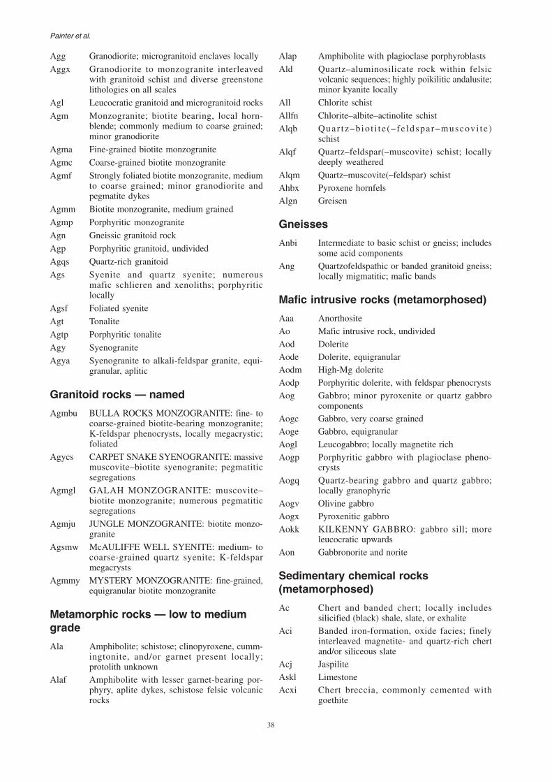
38
Painter et al.
Agg Granodiorite; microgranitoid enclaves locally
Aggx Granodiorite to monzogranite interleavedwith granitoid schist and diverse greenstonelithologies on all scales
Agl Leucocratic granitoid and microgranitoid rocks
Agm Monzogranite; biotite bearing, local horn-blende; commonly medium to coarse grained;minor granodiorite
Agma Fine-grained biotite monzogranite
Agmc Coarse-grained biotite monzogranite
Agmf Strongly foliated biotite monzogranite, mediumto coarse grained; minor granodiorite andpegmatite dykes
Agmm Biotite monzogranite, medium grained
Agmp Porphyritic monzogranite
Agn Gneissic granitoid rock
Agp Porphyritic granitoid, undivided
Agqs Quartz-rich granitoid
Ags Syenite and quartz syenite; numerousmafic schlieren and xenoliths; porphyriticlocally
Agsf Foliated syenite
Agt Tonalite
Agtp Porphyritic tonalite
Agy Syenogranite
Agya Syenogranite to alkali-feldspar granite, equi-granular, aplitic
Granitoid rocks — named
Agmbu BULLA ROCKS MONZOGRANITE: fine- tocoarse-grained biotite-bearing monzogranite;K-feldspar phenocrysts, locally megacrystic;foliated
Agycs CARPET SNAKE SYENOGRANITE: massivemuscovite–biotite syenogranite; pegmatiticsegregations
Agmgl GALAH MONZOGRANITE: muscovite–biotite monzogranite; numerous pegmatiticsegregations
Agmju JUNGLE MONZOGRANITE: biotite monzo-granite
Agsmw McAULIFFE WELL SYENITE: medium- tocoarse-grained quartz syenite; K-feldsparmegacrysts
Agmmy MYSTERY MONZOGRANITE: fine-grained,equigranular biotite monzogranite
Metamorphic rocks — low to mediumgrade
Ala Amphibolite; schistose; clinopyroxene, cumm-ingtonite, and/or garnet present locally;protolith unknown
Alaf Amphibolite with lesser garnet-bearing por-phyry, aplite dykes, schistose felsic volcanicrocks
Alap Amphibolite with plagioclase porphyroblasts
Ald Quartz–aluminosilicate rock within felsicvolcanic sequences; highly poikilitic andalusite;minor kyanite locally
All Chlorite schist
Allfn Chlorite–albite–actinolite schist
Alqb Quar tz–b io t i t e (– fe ldspar–muscov i te )schist
Alqf Quartz–feldspar(–muscovite) schist; locallydeeply weathered
Alqm Quartz–muscovite(–feldspar) schistAhbx Pyroxene hornfelsAlgn Greisen
Gneisses
Anbi Intermediate to basic schist or gneiss; includessome acid components
Ang Quartzofeldspathic or banded granitoid gneiss;locally migmatitic; mafic bands
Mafic intrusive rocks (metamorphosed)
Aaa AnorthositeAo Mafic intrusive rock, undividedAod DoleriteAode Dolerite, equigranularAodm High-Mg doleriteAodp Porphyritic dolerite, with feldspar phenocrystsAog Gabbro; minor pyroxenite or quartz gabbro
componentsAogc Gabbro, very coarse grainedAoge Gabbro, equigranularAogl Leucogabbro; locally magnetite richAogp Porphyritic gabbro with plagioclase pheno-
crystsAogq Quartz-bearing gabbro and quartz gabbro;
locally granophyricAogv Olivine gabbroAogx Pyroxenitic gabbroAokk KILKENNY GABBRO: gabbro sill; more
leucocratic upwardsAon Gabbronorite and norite
Sedimentary chemical rocks(metamorphosed)
Ac Chert and banded chert; locally includessilicified (black) shale, slate, or exhalite
Aci Banded iron-formation, oxide facies; finelyinterleaved magnetite- and quartz-rich chertand/or siliceous slate
Acj JaspiliteAskl LimestoneAcxi Chert breccia, commonly cemented with
goethite

39
GSWA Report 84 East Yilgarn Geoscience Database, 1:100 000 geology of the Leonora–Laverton region
Sedimentary clastic rocks(metamorphosed)
As Sedimentary rock, undivided; includes sand-stone, siltstone, shale, and chert; may havevolcaniclastic component
Asc Conglomerate with subordinate sandstone;pebbles and boulders include granitoid, chert,felsic porphyry, and mafic rock; matrix or clastsupported
Ascb Conglomerate and subordinate pebbly sand-stone with gabbro and basalt clasts
Ascf Oligomictic conglomerate with clasts mainly offelsic volcanic rock; subordinate sandstone;psammitic matrix
Ascfi Volcaniclastic conglomerate, sandstone, andtuff with dominantly andesite clasts
Ascq Oligomictic conglomerate with clasts mainly ofquartz, quartzite, and chert
Asf Volcaniclastic, tuffaceous, and other felsicsedimentary rocks; foliated; commonly deeplyweathered and kaolinized
Ash Shale–slate, in part chert; minor siltstone andsandstone; foliated; commonly silicified
Asjc JONES CREEK CONGLOMERATE: con-glomerate and sandstone; dominantly granitoidclasts in quartzofeldspathic matrix
Asjcp JONES CREEK CONGLOMERATE: poly-mictic conglomerate
Asjct JONES CREEK CONGLOMERATE: arkosicsandstone, fine to medium grained; rare pebbles
Asq Medium-grained quartzite; locally quartzsiltstone and quartz–muscovite schist
Ass Sandstone to siltstone, locally partly con-glomerate
Ast Sandstone; locally pebbly, volcaniclastic orpelitic
Astf Arkose
Felsic igneous rocks (metamorphosed)Af Felsic volcanic and volcaniclastic rocks;
undivided; includes tuff; commonly deeplyweathered and kaolinized
Afd Dacite; commonly tuffaceous; locally brecci-ated
Aff Foliated felsic rock
Afid Andesite
Afih Hornblende–plagioclase porphyry; felsic tointermediate
Afis Intermediate hornblende–biotite–quartz–feldspar(–garnet) schist; variable hornblendecontent; interlayered with felsic and maficschists
Afiv Intermediate volcanic rock; local fragmentaltextures; variably foliated and chloritized;local intermediate schist and lithic wackeinterlayers
Afivf Foliated intermediate volcanic rock;hornblende-phyric
Afivh Intermediate volcanic rock and breccia;plagioclase, hornblende and biotite phenocrysts,and local lithic fragments, in a fine-grainedmatrix
Afp Feldspar–quartz porphyry; dacite to rhyodacite;volcanic or subvolcanic; locally schistose
Afpp Felsic intrusive porphyritic rock; plagioclasephenocrysts; locally schistose
Afpq Quartz–feldspar porphyry; weak to schistosefoliation
Afr Rhyolite lava flows, quartz-phyric, locallytuffaceous; weak to schistose foliation
Afrtx Rhyolitic to rhyodacitic tuff and oligomicticbreccia; massive to poorly bedded, with lithicclasts (>1 cm) in fine-grained to glassy matrix;includes some Afv
Afrkx Mixed rhyolitic and trachytic tuff and oligo-mictic breccia
Afs Schistose quartzofeldspathic micaceous rockderived from felsic volcanic or volcaniclasticprotolith
Aft Felsic tuffaceous rock; finely banded; foliated;fine to medium grained; quartz and feldsparphenocrysts
Aftn IgnimbriteAfv Felsic volcanic and volcaniclastic rocks; quartz
and/or feldspar phenocrysts; includes frag-mental rock and finely layered tuff; variablyfoliated
Mafic extrusive rocks (metamorphosed)
Ab Fine- to very fine grained mafic rock, undividedAba Amphibolite, fine to medium grained;
commonly weakly foliated or massiveAbc Fine-grained mafic rock, strongly carbonatized,
locally amygdaloidalAbd Basalt–dolerite; fine-grained basalt with
common dolerite-textured layers or zonesAbf Foliated fine-grained mafic rock; locally
hornfelsed or epidotizedAbfv Bimodal volcanic sequence; basalt with
interlayers of rhyolite or daciteAbg Mafic rock interleaved with minor foliated
granitoid rockAbi Basaltic andesite and andesite; amygdaloidal;
locally plagioclase and/or hornblende phyricAbk Komatiitic basalt; pyroxene spinifex common;
variolitic, pillowed locallyAbmf Foliated high-Mg basaltAbv Basalt, undivided; includes feldspar–
hornblende or chlorite schist; locallyporphyritic; doleritic in parts
Abva Basalt, aphyricAbvc Basalt, extensively carbonatized; includes
massive carbonate lenses

40
Painter et al.
Abvl Pillow basalt; flow-top breccia with varioles orspinifex locally
Abvp Porphyritic basalt; medium- to coarse-grainedplagioclase phenocrysts; local intenseepidotization
Abvs Fine-grained schist derived from basalt;amphibole–chlorite assemblages; locallystrongly metasomatized
Abvx Basaltic fragmental rock; agglomerate, hyalo-clastite peperite or breccia
Abvy Amygdaloidal basalt
Ultramafic rocks (metamorphosed)
Au Ultramafic rock, undivided; includes talc–chlorite(–carbonate) and tremolite–chloriteschist
Auc Talc–carbonate(–serpentine) rock; commonlyschistose
Auk Komatiite; olivine spinifex texture; tremolite–chlorite, serpentinite, carbonate assemblages;silicified or weathered
Aup Peridotite, commonly serpentinitized; relictolivine-cumulate texture; locally rodingitized orsilicified
Aur Tremolite(–chlorite–talc–carbonate) schist;locally serpentinized; derived from komatiiticor pyroxenitic basalt or pyroxenite
Aus Serpentinite, commonly massiveAut Talc–chlorite(–carbonate) schist; minor
tremolite–chlorite schistAux Pyroxenite; commonly associated with
peridotite in minor layered sills; variablytremolitized, locally schistose
Codes for simplified geology polygons
P Predominantly clastic sedimentsP_XX(od) Dolerite dyke, sill, and plug; fine- to
medium-grained doleriteP_XXwe Mount Weld CarbonititeAYI(b) Mafic volcanic rocks with minor mafic and
ultramafic intrusive rocks; minor felsicrocks
AYI(bg) Mafic rock interleaved with minor granitoidrock
AYI(bm) Ultramafic volcanic rock; komatiitic basalt;high-Mg basalt; and tremolite–chlorite–talcschist
AYI(ci) Banded iron-formation and chert; undividedAYI(f) Felsic to intermediate volcanic and volcano-
genic rocks; undividedAYI(fs) Felsic volcanogenic sedimentary rocks;
local felsic lava and tuffAYI(g) Granitoid rock; monzogranite dominant
AYI(gb) Granitoid rock interleaved with minor maficrock
AYI(gg) GranodioriteAYI(gm) Monzogranite (adamellite)AYI(gn) Foliated; gneissic; and migmatitic granitoidAYI(gs) SyenograniteAYI(gt) TonaliteAYI(gzq) Quartz monzoniteAYI(iv) Intermediate volcanic rockAYI(ng) Monzogranitic to tonalitic gneissAYI(nq) Quartzofeldspathic gneissAYI(o) Metamorphosed mafic intrusive rock;
metagabbro and metadoleriteAYI(od) Mafic intrusive rock; metadoleriteAYI(og) Mafic intrusive rock; metagabbroAYI(s) Metasedimentary rock dominantAYI(sc) Metamorphosed conglomerateAYI(sv) Sedimentary and volcaniclastic rocksAYI(u) Metamorphosed ultramafic rock dominantAYI(uk) Komatiite; minor basalt; dolerite; and
sedimentary rockAYI(up) Peridotite; commonly serpentinized;
olivine-cumulate textureAYI(xsf) Interbedded sedimentary and felsic volcanic
rocks
Codes for the magnetic interpretation
-PicM Mount Weld carbonatiteAa Greenstone, undividedAa/Ag Greenstone, undividedAa/Agmg Greenstone, undividedAg_h Granite; high magnetizationAg_l Granite; low magnetizationAg_l/Aa Granite; low magnetizationAg_m Granite; medium magnetizationAg_m/Aa Granite; medium magnetizationAgmg Gneiss–migmatite–granite, undividedAgmg_l Gneiss–migmatite–granite; low magnetiz-
ationAgmg_m Gneiss–migmatite–granite; medium mag-
netizationAgn Granitoid gneiss / strongly deformed graniteAi_h Intrusive rock, unassigned; high magnetiz-
ationAi_m Intrusive rock, unassigned; medium mag-
netizationAi_r Intrusive rock, unassigned; remanent
magnetismAogi Layered intrusion

41
GSWA Report 84 East Yilgarn Geoscience Database, 1:100 000 geology of the Leonora–Laverton region
Appendix 2
MINEDEX commodity groups, mineralization types,and reference abbreviations
Commodity groups and mineralsNote: Mineral order represents the sequence of relative importance within the specific commodity group. Contaminantor gangue minerals in potential products have an order of 500 or greater.
Commodity group Order Mineral Mineral
abbrev.
40 Limestone LST50 Black granite B.GRAN55 Granite GRAN60 Marble MARBLE70 Dolerite DOLER80 Slate SLATE90 Spongolite SPONG
Dolomite 10 Dolomite DOLOMFluorite 10 Fluorite CaF2
Gem, semi-precious and 10 Amethyst AMETHornamental stones 20 Emerald EMER
30 Opal OPAL32 Tourmaline TOURM35 Chrysoprase CHRYSP37 Malachite MALACH40 Tiger eye T.EYE45 Jasper JASPER50 Zebra rock ZEBRA60 Chert (green) CHERT
Gold 10 Gold Au20 Silver Ag30 Copper Cu40 Nickel Ni50 Cobalt Co54 Lead Pb55 Zinc Zn60 Tungsten WO3
70 Molybdenum Mo500 Antimony Sb510 Arsenic As
Graphite 10 Graphite GRAPH20 Carbon (fixed) C
Gypsum 10 Gypsum CaSO4
30 Alunite ALUM500 Salt SALT
Heavy mineral sands 10 Heavy minerals HM20 Ilmenite ILM30 Leucoxene LEUCO50 Rutile RUTILE60 Zircon ZIRCON70 Monazite MONAZ80 Xenotime XENO90 Garnet GARNET
100 Kyanite KYAN130 Synthetic rutile SYN.R510 Slimes SLIMES520 Titanium dioxide TiO2
530 Zirconia ZrO2
Industrial pegmatite 10 Mica MICAminerals 20 Beryl BERYL
30 Feldspar FELDS35 Alkalis K+Na37 Alumina Al2O3
Commodity group Order Mineral Mineral
abbrev.
Alunite 10 Alunite ALUM20 Potash K2O30 Gypsum CaSO4
Andalusite 10 Andalusite ANDAntimony 10 Antimony SbArsenic 10 Arsenic AsAsbestos 10 Asbestos ASBBarite 10 Barite BaSO4
Bauxite–alumina 10 Alumina (available) ABEA20 Bauxite BAUX
500 Reactive silica RESIO2
Bismuth 10 Bismuth BiChromite–platinoids 10 Chromite Cr2O3
20 Platinum Pt25 Palladium Pd31 Rhodium Rh40 PGE PGE50 PGE + gold PGEAu55 Gold Au60 Nickel Ni70 Copper Cu
100 Iron FeClays 10 Attapulgite ATTAP
20 Bentonite BENT30 Kaolin KAOLIN35 Saponite SAPON40 Cement clay C.CLAY60 White clay W.CLAY
Coal 10 Coal COAL20 Lignite LIGN
Construction materials 10 Aggregate AGGREG20 Gravel GRAVEL30 Sand SAND40 Rock ROCK50 Soil SOIL
300 Vanadium V2O5
310 Titanium dioxide TiO2
320 Iron FeCopper–lead–zinc 10 Zinc Zn
20 Copper Cu30 Lead Pb40 Silver Ag50 Gold Au60 Molybdenum Mo65 Cobalt Co70 Barium Ba80 Cadmium Cd90 Tungsten WO3
Diamonds 10 Diamond DIAMDiatomite 10 Diatomite DIATOMDimension stone 10 Dimension stone DIM.ST
20 Sandstone SST30 Quartzite QZTE
42
Painter et al.
Commodity groups and minerals (continued)
Commodity group Order Mineral Mineralabbrev.
40 Quartz QUARTZ505 Ferric oxide Fe2O3
Iron ore 10 Iron Fe20 Manganese Mn
500 Phosphorus P510 Alumina Al2O3
520 Silica SiO2
525 Sulfur S530 Loss on ignition LOI
Limestone–limesand 10 Calcium carbonate CaCO3
20 Limestone–limesand LIME50 Shell grit SHELL70 Chalk CHALK
100 Lime CaO200 Magnesite MgCO3
501 Silica SiO2
Magnesite 10 Magnesite MgCO3
10 Manganese Mn100 Iron Fe510 Silica SiO2
520 Alumina Al2O3
530 Phosphorus PNickel 10 Nickel Ni
20 Copper Cu25 Cobalt Co30 Nickel + copper Ni+Cu35 Nickel equivalent Ni EQU40 Gold Au50 Platinum Pt55 Palladium Pd70 Chromite Cr2O3
80 Silver Ag90 Magnesia MgO
500 Silica SiO2
Other 10 Gold AuPeat 10 Peat PEATPhosphate 10 Phosphate P2O5
Pigments 10 Ochre OCHRE20 Hematite pigment HEM
Potash 10 Potash K2O10 Sulfur S20 Iron Fe30 Zinc Zn40 Copper Cu
Commodity group Order Mineral Mineralabbrev.
50 Lead PbRare earths 10 Rare earth oxides REO
20 Yttrium Y2O3
25 Lanthanides LnO30 Tantalite Ta2O5
40 Columbite Nb2O5
50 Tin (cassiterite) SnO2
60 Xenotime XENO70 Gallium Ga80 Zirconia ZrO2
90 Hafnium HfO2
100 Beryl BERYL510 Alumina Al2O3
Salt 10 Salt SALT20 Gypsum CaSO4
Silica – silica sand 10 Silica SiO2
20 Sand SAND30 Quartzite QZTE
510 Ferric oxide Fe2O3
520 Titanium dioxide TiO2
530 Alumina Al2O3
540 Heavy minerals HMTalc 10 Talc TALCTin–tantalum–lithium 10 Tin (cassiterite) SnO2
20 Tantalite Ta2O5
30 Columbite Nb2O5
40 Spodumene Li2O50 Kaolin KAOLIN
510 Ferric oxide Fe2O3
Tungsten–molybdenum 10 Tungsten WO3
20 Molybdenum Mo30 Copper Cu40 Antimony Sb50 Vanadium V2O5
60 Gold AuUranium 10 Uranium U3O8
20 Vanadium V2O5
30 Copper CuVanadium–titanium 10 Vanadium V2O5
20 Titanium dioxide TiO2
30 Iron Fe40 Gold Au
Vermiculite 10 Vermiculite VERMIC

43
GSWA Report 84 East Yilgarn Geoscience Database, 1:100 000 geology of the Leonora–Laverton region
Mineralization types
Abbreviation Mineralization type
FEBR Iron ore deposits in the Brockman Iron FormationFEGGT Iron ore deposits in granite–greenstone terranesFEMM Iron ore deposits in the Marra Mamba Iron
FormationFEPIS Pisolitic iron-ore depositsFESCRE Scree and detrital iron-ore depositsFESED Sedimentary basin iron-ore depositsFGRAN Fluorite deposits associated with granitic rocksFPEGM Pegmatite-hosted fluorite depositsFVEIN Vein fluorite depositsGEMMET Gem and/or semi-precious stones in high-grade
metamorphic rocksGEMPEG Pegmatite-hosted gem and/or semi-precious stonesGEMSED Sediment-hosted gem and/or semi-precious stonesGEMUM Ultramafic-hosted gem and/or semi-precious stonesGEMVOL Gem and/or semi-precious stones in volcanic rocksGRMETA Graphite deposits in metamorphic rocksGRPEG Pegmatite-hosted graphite depositsGRQTZV Graphite deposits in quartz veinsGRUM Graphite as segregations in ultramafic rocksGYBBAS Gypsum in coastal barred-basin depositsGYDUNE Dunal gypsum depositsGYLAKE Gypsum in lake sedimentsHMSCAP Heavy mineral deposits in the Capel shorelineHMSDON Heavy mineral deposits in the Donnelly shorelineHMSDUN Heavy mineral deposits in the Quindalup shorelineHMSEN Heavy mineral deposits in the Eneabba shorelineHMSGIN Heavy mineral deposits in the Gingin shorelineHMSHV Heavy mineral deposits in the Happy Valley
shorelineHMSMES Heavy mineral deposits in Mesozoic formationsHMSMIL Heavy mineral deposits in the Milyeaanup shorelineHMSMIS Heavy mineral deposits — miscellaneousHMSMUN Heavy mineral deposits in the Munbinea shorelineHMSWAR Heavy mineral deposits in the Warren shorelineHMSWRN Heavy mineral deposits in the Waroona shorelineHMSYOG Heavy mineral deposits in the Yoganup shorelineKBRINE Potash deposits in brines and surface evaporitesKEVAP Potash deposits in buried evaporite sequencesKGLAUC Potash in glauconitic sedimentsKLAKE Potash associated with lake sedimentsMGUM Mafic–ultramafic rocksMNCAV Joint–cavity-fill manganese depositsMNRES Residual manganese depositsMNSED Sedimentary manganese depositsMNSUPR Precambrian supergene enrichment of manganiferous
sedimentsMOPOR Porphyry Cu–Mo depositsNABRIN Salt in brines and surface evaporitesNAVAP Salt deposits in buried evaporite sequencesNIINTR Nickel in dunite phase of thick komatiite flowsNILAT Lateritic nickel depositsNISED Nickel deposits in metasedimentary rocksNITHOL Nickel deposits in the gabbroic phase of layered
tholeiitesNIVEIN Vein-type nickel depositsNIVOLC Nickel associated with volcanic peridotitesPCARB Carbonatite-hosted phosphate deposits
PEGPEG Pegmatite-hosted industrial mineralsPGALL Alluvial–eluvial platinoid depositsPGUANO Quaternary guano (phosphate) depositsPIGHEM Specular hematite pigmentPNOD Seafloor (nodular) phosphate depositsPSED Phosphate deposits in Phanerozoic sediments
Abbreviation Mineralization type
ALLAKE Alunite in lake sedimentsANDSED Andalusite in metasedimentary rocksASBAMP Metasomatic asbestos deposits in amphibolitesASBBIF Asbestos deposits in banded iron-formationsASBDLM Asbestos deposits in dolomite intruded by doleriteASBSER Asbestos deposits in serpentinitesASBUM Asbestos veins in ultramafic rocksASMASS Stratiform massive arsenopyrite in metasedimentsASQTZV Arsenic associated with auriferous quartz veinsAUALL Alluvial–eluvial gold depositsAUBIF Gold in banded iron-formation and related sedimentsAUCONG Gold in conglomerate within greenstonesAUEPI Epigenetic gold deposits in Precambrian terrainsAUFVOL Felsic volcanic rocks and/or volcanogenic sediments
containing auriferous quartz veins and/or shear zonesAUGRAN Gold deposits along granite–greenstone contacts
and in granitoid rocksAULAT Lateritic gold depositsAUPLAC Precambrian placer gold depositsAUPOR Gold associated with felsic porphyry within
greenstonesAUSHER Basalt and/or dolerite containing auriferous
quartz veins along faults or shear zonesAUSTOK Dolerite or gabbro containing auriferous quartz
stockworks or veinsAUSYN Syngenetic gold deposits in Precambrian terrainsAUUM Gold deposits in ultramafic rocksBABED Stratabound bedded barite depositsBACAV Vein and cavity-fill depositsBAPEGM Pegmatite-hosted barite depositsBAUKAR Karstic bauxite depositsBAULAT Lateritic bauxite depositsBIPEGM Bismuth in quartz-rich pegmatitesBIQTZV Bismuth associated with gold mineralizationBMMASS Volcanogenic Cu–Zn depositsBMMISS Mississippi Valley-type Pb–Zn depositsBMPOR Porphyry Cu–Mo depositsBMSED Sedimentary Cu–Pb–Zn depositsBMSHER Base metal deposits in quartz veins and/or shear
zonesCADUNE Limesand in coastal dune sandsCALAKE Calcareous material in lake sedimentsCALIME Limestone depositsCASEA Offshore limesand depositsCLBED Bedded sedimentary clay depositsCLRES Residual clay depositsCLTRAN Transported clay depositsCOJSBT Jurassic sub-bituminous coalCOLIGN Eocene lignite depositsCOPBIT Permian bituminous coalCOPSBT Permian sub-bituminous coalCRLAT Lateritic chromium depositsCRPGLY Platinum group elements and/or chromium in
layered mafic–ultramafic intrusionsCRPGUM Platinum group elements and/or chromium in
metamorphosed mafic–ultramafic rocksDIAALL Alluvial–eluvial diamond depositsDIALAM Lamproitic diamond depositsDLMBED Dolomite deposits in sedimentary sequencesDLMKAN Residual kankar (dolomite) depositsDLMLAK Dolomite deposits associated with lake sedimentsDLMSOM Metasomatic dolomite depositsDTMLAK Diatomaceous lake depositsFEBIF Primary banded iron-formation deposits

44
Painter et al.
Mineralization types (continued)
Abbreviation Mineralization type
PVEIN Vein phosphate depositsREALL Alluvial–eluvial rare earth depositsRECARB Carbonatite-hosted rare earth depositsREFELS Felsic volcanic-hosted rare earth depositsREHMS Rare earths in heavy mineral sandsREPPEG Pegmatite-hosted rare earth depositsRESST Xenotime in sandstonesSBQTZV Antimony associated with auriferous quartz veinsSIDUNE Mesozoic dune and bedded silica sandsSIQTZ Silica in vein quartzSIQZTE Silica in quartzite or chert or bothSMASS Sulfur in massive sulfidesSNALL Alluvial–eluvial tin–tantalum depositsSNGREI Tin–tantalum deposits in greisen zonesSNPEGM Pegmatite tin–tantalum–lithium depositsSNVEIN Vein tin–tantalum depositsSSEDQZ Sulfur in sediments and/or quartz veinsTALDLM Talc deposits associated with dolomiteTALUM Talc deposits in ultramafic rocks
Abbreviation Mineralization type
UCALC Calcrete-related uranium depositsUCAV Secondary (cavity-fill) vein-like uranium depositsUCONG Conglomerate-hosted depositsULIGN Lignite-hosted uranium depositsUPEG Pegmatite-hosted uranium depositsUSST Sandstone-hosted uranium depositsUUNCF Unconformity-related uranium depositsUVEIN Uranium in veins associated with base metalsVCALC Calcrete-related vanadium depositsVERUM Vermiculite deposits associated with weathered
mafic and ultramafic bodiesVTIALL Alluvial–eluvial vanadium–titanium depositsVTILAT Lateritic vanadium–titanium depositsVTIMAG Titaniferous magnetite depositsVTIVN Vanadium–titanium vein deposits associated with
base metalsWMOGRE Tungsten–molybdenum deposits in greisen zonesWMOPEG Pegmatite tungsten–molybdenum deposits
WSKARN Tungsten–molybdenum skarn deposits

45
GSWA Report 84 East Yilgarn Geoscience Database, 1:100 000 geology of the Leonora–Laverton region
Abbreviations of source references
Source Full title
02208/93 Department of Industry and Resources (DoIR)mines file number
? Unknown sourceA_______ Accession number of open-file statutory
mineral exploration report in DoIR libraryAIMM PRO Australasian Institute of Mining and
Metallurgy ProceedingsAMH Australian Mining HandbookAMIQ Australian Mineral Industries QuarterlyAR(CO) Annual Report to Shareholders (abbreviated
company name)ASX(CO) Report to Shareholders (abbreviated company
name)AUSIMM Australasian Institute of Mining and Metallurgy
ReportAUSIMM14 Australasian Institute of Mining and Metallurgy
Bulletin and numberBHP BHP correspondenceBMR Bureau of Mineral Resources ReportBMR RR 1 Bureau of Mineral Resources Resource Report
and numberBMR59/24 Bureau of Mineral Resources Record and numberBULL(NO) Geological Survey of Western Australia (GSWA)
Mineral Resource Bulletin (and number)CO CORR/REP Company report to shareholdersCO(CO) Company report to shareholders (abbreviated
company name)CSIROPUB CSIRO publicationDN Daily News newspaperEMP(NO) Environmental management report (and number)ER Open-file statutory mineral exploration report in
DoIR libraryERMP Environmental Review and Management ProgramF.NOTE DoIR file noteFR Financial Review newspaperGG Gold Gazette
Source Full title
GS BULL GSWA BulletinGS REP GSWA ReportGSWA AR GSWA Annual ReportHI CORR/REP Hamersley Iron correspondence or reportHOGAN Hogan and Partners Investor’s SharewatchHOMESWES Homeswest reportHY(CO) Half year report to shareholders (abbreviated
company name)I(NO) Item number of open-file statutory mineral
exploration report in DoIR libraryIND MIN Industrial Minerals magazineKAL MIN Kalgoorlie Miner newspaperM(NO) M number of open-file statutory mineral
exploration report in DoIR libraryMB SYMP Metals Bulletin SymposiumMEM 3 GSWA Memoir and numberMG Metals GazetteMINER MinerMINMET MINMET reportMJ Mining JournalMM Mining MonthlyMRR(NO) GSWA Mineral Resources Report (number)NOI(NO) Notice of Intent to mine (number)PAYD PaydirtPER Public Environmental ReviewPERS COM Personal communicationPRO(CO) Company prospectus (abbreviated company
name)QR(CO) Quarterly report to shareholders (abbreviated
company name)REC(NO) GSWA Record (number)REP 33 GSWA Report (number)ROY REP DoIR Royalty ReportSTAT DEC Statutory Declaration submitted to DoIRWEST A The West Australian newspaper

Further details of geological publications and maps produced by theGeological Survey of Western Australia can be obtained by contacting:
REPORT 84PAINTER et al.
The Leonora–Laverton area in the Eastern Goldfields Granite–Greenstone Terrane of the YilgarnCraton comprises a diverse range of greenstone belts and granitoids. This area containsseveral world-class gold mines, and considerable progress has been made in the exploitationof large nickel laterite deposits. Deposits of nickel sulfides and other base metalmineralization have been of great value in the past and remain exploration targets.This Report provides a digital compilation of eighteen 1:100 000-scalegeological map sheets published in the last ten years. Rock unitdefinitions established in earlier stages of the East YilgarnGeoscience Database combined with remapping of localareas has produced a seamless digital map covering anarea of almost 50 000 km , accompanied by interpretedregional geology and an aeromagnetic interpretation, as wellas mineral occurrence, tenement and topocadastral themes.Images produced from recent LandsatTM and magneticsurvey data are also provided. Files are formatted for ArcView,ArcINFO, and Mapinfo software, but may also be viewed using
the free software provided on the disc, ArcExplorer.
2
East Yilgarn Geoscience Database, 1:100 000 geology of the Leonora–Laverton region,Eastern Goldfields Granite–Greenstone Terrane —
an explanatory note
Information CentreDepartment of Industry and Resources100 Plain StreetEast Perth WA 6004Phone: (08) 9222 3459 Fax: (08) 9222 3444www.doir.wa.gov.au