Embed Size (px)
Citation preview

Mount Victoria to Lithgow Great Western Highway Upgrade
Strategic review of a Newnes Plateau corridor
CE001081_GWH NPC_ Draft Report_rev6 P a g e | 83
PART 3PART 3PART 3PART 3 ENGINEERINGENGINEERINGENGINEERINGENGINEERING DESIGN DESIGN DESIGN DESIGN
AND COSTINGAND COSTINGAND COSTINGAND COSTING

Mount Victoria to Lithgow Great Western Highway Upgrade
Strategic review of a Newnes Plateau corridor
84 | P a g e 12 November 2008
Technical Report
14 INTRODUCTION
A key element of the analysis and assessment of the viability of a Newnes Plateau corridor is
the engineering feasibility and costs. This section provides an outline of the alignment
definition, the cross sections used and intersection treatments identified for the process of
assessing the relative costs for construction of the base case and Newnes Plateau corridors. In
order to refine the corridor alignment, design work along a road centreline to provide a
vertical and horizontal alignment enabled an assessment of the grades, vertical and horizontal
curves, earthworks and potential structures for each of the two corridors. This information was
then used to establish strategic estimates of cost for each of the options.
In order to provide a suitable comparison of the two options the same process was carried out
for each. The road centrelines and vertical alignment for each of the identified possible routes
within each corridor were assessed taking into account a number of design parameters and
constraints associated with each. This provided the base from which to assess the works
required for each of the alignments and the estimates of cost. The eastern section of each of
the corridors is the same, from Soldiers Pinch to where the Mount Victoria to Lithgow base case
deviates down into the Hartley Valley.
The design cross sections used for the design and earthworks aspects were as defined in the
project brief, consisting of three lanes for the sections of the Mount Victoria to Lithgow base
case on the eastern and western ends with four lanes through the Hartley Valley and three
lanes for the length of the Newnes Plateau corridor. The location, type and number of
intersections for each of the options are indicative only for the purposes of this assessment.
The Newnes Plateau corridor alignment was also assessed with a vertical alignment that
allowed slightly steeper grades (eight per cent versus six per cent) to measure the impact on
earthworks quantities and overall costs.

Mount Victoria to Lithgow Great Western Highway Upgrade
Strategic review of a Newnes Plateau corridor
CE001081_GWH NPC_ Draft Report_rev6 P a g e | 85
15 DESIGN CRITERIA
15.1 OVERVIEW
The RTA brief broadly defined the criteria for the strategic design of a base case corridor
option through the Mount Victoria to Lithgow and a Newnes Plateau corridor option.
The strategic base case option was to comprise a road consisting of a four lane configuration
through the Hartley Valley and a three lane configuration for the eastern and western steep
graded sections in and out of the valley and the remainder of the road to Soldiers Pinch at the
eastern end of the project.
The strategic Newnes Plateau corridor option was initially to be considered in a number of
configurations - two lane, three lane, four lane undivided configurations and a four lane
divided motorway configuration. The order of modelling and analysis was to be staged to
compare first the two lane, then the three lane and finally four lane solutions.
Prior to commencement of strategic road design, a decision was taken to model the three lane
undivided configuration first as it was judged that the two lane configuration may not gain
acceptance from stakeholders and was not comparable to the base case.
Only the Mount Victoria to Lithgow base case and the three lane configuration for the Newnes
Plateau corridor have been modelled. Sufficient information based on the analysis of the three
lane configuration was available for the strategic analysis of the corridor viability.
The strategic geometric design was undertaken for the purposes of testing engineering
feasibility and to develop strategic costs. The geometric design has been carried out in
accordance with the requirements of the RTA’s Road Design Guide.
Additional criteria relating to the road cross section were confirmed prior to the
commencement of the 3D road modelling. Road cross sections adopted are detailed in Section
16.3.3.
15.2 MOUNT VICTORIA TO LITHGOW BASE CASE CORRIDOR
The preliminary design criteria specified for the Mount Victoria to Lithgow base case strategic
route option are as follows:
� The eastern and western steep graded sections to comprise a minimum three lane
configuration with central barrier.
� The section across the valley to comprise a four lane configuration.
� The length of the route to be approximately 20 km including the section of the Great
Western Highway at Forty Bends.
� Grades to be a maximum of six per cent.
� Horizontal curves to be a minimum of 450 m radius.
Generally, this strategic option will provide a new pavement and formation on a greater than
100 km/h alignment.

Mount Victoria to Lithgow Great Western Highway Upgrade
Strategic review of a Newnes Plateau corridor
86 | P a g e 12 November 2008
Technical Report
15.3 NEWNES PLATEAU CORRIDOR
The design criteria adopted for the Newnes Plateau strategic route option are as for the Mount
Victoria to Lithgow base case except that for the analysis described in this report, a three lane
configuration has been used. As for the base case, the eastern and western steep graded
sections also comprise a three lane configuration with central barrier.
For the Newnes Plateau corridor option, the following questions were also addressed:
a. What type of reductions in projected costs could be achieved by accepting slightly
steeper grades (say six to eight per cent)?
b. Would an alignment be possible that reduced the high cost in structures without trading
off the gains of a flatter alignment?
c. What cost reductions could be achieved by having at-grade intersections?
d. Could such intersections be designed without becoming an impediment to priority vehicle
movements?
e. What are the costs associated with minimal upgrading of the existing Great Western
Highway alignment to adequately address remaining traffic needs and ongoing
maintenance.

Mount Victoria to Lithgow Great Western Highway Upgrade
Strategic review of a Newnes Plateau corridor
CE001081_GWH NPC_ Draft Report_rev6 P a g e | 87
16 CORRIDOR DESCRIPTION
16.1 OVERVIEW
The corridors developed using Cardno EnCEP for the Mount Victoria to Lithgow base case and
the Newnes Plateau corridor alignment (Section 12) were subjected to engineering analysis in
order to obtain an estimated cost of construction for each. A vertical and horizontal road
alignment was developed within each corridor using the MX road design software, enabling
construction quantities to be measured for use in the estimates.
Numerous feasible road alignments are possible within a corridor and extensive analysis is
required to approach the optimum alignment. For the purposes of this study, one feasible
alignment was developed for each corridor.
A plan of the Mount Victoria to Lithgow base case corridor and a longitudinal section of a
possible road alignment within the corridor are contained in Appendix G. A plan of the Newnes
Plateau corridor and a longitudinal section of a possible road alignment within the corridor are
contained in Appendix H.
16.2 CORRIDOR SELECTION PROCESS
The selection of a route for engineering analysis through each of the Mount Victoria to Lithgow
base case and the Newnes Plateau corridors required input from the engineering design team
as the Cardno EnCEP program does not currently incorporate horizontal or vertical curvature
parameters within the program set-up.
The engineering design team developed a practical three dimensional route through each of
the Cardno EnCEP selected corridors based on the specified road design criteria. On the few
occasions where the horizontal road design criteria required the alignment to move outside the
corridor, the alignment was manually checked against the constraining values (Part 2) to
ensure that it was still acceptable.
16.3 DESIGN ASPECTS
16.3.1 General aspects
Given the strategic nature of this project, only the alignment mainlines were modelled using
MX road design software. Access provisions, intersections and interchanges are described in
words only and are treated as additional items added manually to the project estimates.
For both the base case corridor and the Newnes Plateau corridor alignments, much of the
proposed road is outside existing road corridors and therefore significant land acquisition is
required. Existing road corridors have therefore been utilised where practical to minimise
acquisition costs.
Transverse drainage requirements have not been modelled. Drainage has been allowed for in
the estimates as a cost per kilometre.

Mount Victoria to Lithgow Great Western Highway Upgrade
Strategic review of a Newnes Plateau corridor
88 | P a g e 12 November 2008
Technical Report
The Bells Line of Road corridor study (SKM 2004) concluded that tunnels were not economically
viable given the predicted low traffic volumes on the road. Tunnels have been avoided in both
the Mount Victoria to Lithgow base case corridor and the Newnes Plateau corridor options.
16.3.2 Survey
Digital terrain models used for road design were formed through a combination of 10 m, 2 m
and 1 m contours provided from three sources; RTA, SKM, and data held by Cardno. No aerial
laser survey was available at the time of assessment.
16.3.3 Typical cross sections
Three typical cross-sections have been used for the various sections of the two corridors.
Option A is a four lane divided carriageway (shown in Figure 16.1) with the following
characteristics adopted as per the Mount Victoria to Lithgow upgrade study design workshop
outputs (21 April 2008):
� Dual carriageway with two 3.5 m wide traffic lanes in each direction.
� Five metre wide median.
� Left hand side shoulder width of 2.5 m.
� Right hand side shoulder width of 1.0 m.
� Total carriageway width of 26.0 m.
Figure 16.1 Four lane divided carriageway (option A)
Option B is a three lane carriageway with central barrier (shown in Figure 16.2) with the
following characteristics adopted as per the Mount Victoria to Lithgow upgrade study design
workshop outputs (21 April 2008):
� Single carriageway with:
� Two 3.5 m wide traffic lanes in one direction.
� One 3.5 m wide traffic lane in the other direction.
� 0.6 m wide Type F Jersey Kerb central barrier.
� Left hand side shoulder width of 2.5 m.
� Right hand side shoulder width of 1.0 m.
� Total carriageway width of 18.1 m.

Mount Victoria to Lithgow Great Western Highway Upgrade
Strategic review of a Newnes Plateau corridor
CE001081_GWH NPC_ Draft Report_rev6 P a g e | 89
Option C is a three lane undivided carriageway (shown in Figure 16.3) with the following
characteristics:
� Single carriageway with:
� Two 3.5 m wide traffic lanes in one direction.
� One 3.5 m wide traffic lane in the other direction.
� Left hand side shoulder width of 2.5 m
� Total carriageway width of 15.5 m.
Figure 16.2 Three Lane carriageway with central barrier (option B)
Figure 16.3 Three lane carriageway (option C)
Mount Victoria to Lithgow base case
Across the valley floor
The RTA brief required four lanes across the valley. A dual carriageway with 3.5 m wide traffic
lanes and a 5 m wide median has been adopted in line with the Mount Victoria to Lithgow
upgrade study design workshop outputs (21 April 2008), as per option A described previously.
Eastern and western steep grades
A minimum of three x 3.5 m wide traffic lanes with a central barrier has been adopted, as per
option B described previously.
Soldiers Pinch to eastern descent
This length is relatively flat. The existing highway at Soldiers Pinch consists of 3 lanes divided
by a central barrier. For the base case, three x 3.5 m wide traffic lanes have been adopted for
this section, as per option C described previously.

Mount Victoria to Lithgow Great Western Highway Upgrade
Strategic review of a Newnes Plateau corridor
90 | P a g e 12 November 2008
Technical Report
Shoulders
The Mount Victoria to Lithgow upgrade study design workshop outputs specified a left hand
side shoulder width of 2.5 to 3.0 m. A left hand side shoulder width of 2.5 m has been adopted.
A right hand side shoulder width of 1.0 m has been adopted for the dual carriageway section
and in the three lane section against the central barrier.
Newnes Plateau corridor
Soldiers Pinch to Darling Causeway
As for the base case, three x 3.5 m wide traffic lanes have been adopted for this section, as
per option C described previously.
Darling Causeway to western descent
Three x 3.5 m wide traffic lanes have been adopted for this section, as per option C described
previously.
Western descent
Three x 3.5 m wide traffic lanes with a central barrier have been adopted, as per option B
described previously.
Shoulders
A left hand side shoulder width of 2.5 m has been adopted. A right hand side shoulder width of
1.0 m has been adopted in the three lane section where there is a central barrier.
16.3.4 Overtaking provisions
For the base case corridor, the section of the route from Soldiers Pinch to the valley floor plus
the ascent from the valley floor to the highway at Forty Bends, consists of three lanes. From
Soldiers Pinch until the descent into the valley, the direction of the third lane alternates where
appropriate to provide passing opportunities. On the steep sections at each end of the valley,
the ascent contains two lanes.
The Newnes Plateau option analysed consists of three lanes. From Soldiers Pinch until the
western descent to the existing highway at Marrangaroo, the direction of the third lane
alternates where appropriate to provide passing opportunities. On the steep section from the
plateau to Marrangaroo, the ascent contains two lanes and the descent one lane.
16.3.5 Geometric design
Geometric design has been carried out in accordance with the RTA Road Design Guide.
The Mount Victoria to Lithgow base case corridor and the Newnes Plateau corridor routes both
adopt a maximum six per cent grades and minimum 450 m radius horizontal curves.
The Newnes Plateau corridor route has been tested for savings with grades between six per
cent and eight per cent.
Mount Victoria to Lithgow Great Western Highway Upgrade
Strategic review of a Newnes Plateau corridor
CE001081_GWH NPC_ Draft Report_rev6 P a g e | 91
16.3.6 Earthworks
As a general rule, the depth of cut/fill was limited to 25 m where possible to minimise the
effect on the environment and enhance constructability. A notable exception is the long, deep
cut required to bring the Newnes Plateau route down from the plateau to the existing Highway
at Marrangaroo, which has a maximum height of 66 m.
Cut
There are many deep cuts in sandstone in the steep eastern and western ends of the Mount
Victoria to Lithgow base case corridor and the western end of the Newnes Plateau corridor
alignment. Batter slopes were considered in consultation with the RTA and it was agreed that
vertical batters are appropriate and the best approach. It has also been noted that railway
cuttings in the area have remained for 100 years with vertical batters. Consequently, where
cuts are required the alignments have been modelled with vertical batters and six metre wide
benches at 10 m intervals.
Fill
Generally, where the average height of fill exceeds 15m, a bridge has been provided.
Reinforced earth retaining walls have been provided where space and/or environmental
constraints exist in order to limit the overall footprint of the proposed road and prevent the
occurrence of extremely wide fill batters.
16.3.7 Intersections and access
The intersections and access arrangements described below have been adopted for the
purposes of this investigation. It should be noted that the location, type and number of
intersections are indicative only at this strategic stage and may change following more detailed
investigations.
Common to Mount Victoria to Lithgow base case and Newnes Plateau corridors
� Eastern access to / from Mount Victoria – seagull connection to the existing highway.
� Access from Mount Victoria northwards to the new road – single lane on ramp (left out
only) from the Darling Causeway where it intersects the new road. Traffic coming from
the west wanting to access Mount Victoria to use the seagull at the eastern access.
Mount Victoria to Lithgow base case corridor
� Central access to the new road in Hartley Valley by way of T junctions with U-turn
facilities including minor connections to existing roads at Browns Gap Road and Fields
Road.
� Jenolan Caves Road - 400 m long deviation between Jenolan Caves Road and River Lett
Hill.
� Connection to existing highway at the western end – seagull intersection.
Newnes Plateau corridor
� Intersection with Bells Line of Road – seagull intersection.
� Intersection with Valley View Road – seagull intersection.
� Access to / from Lithgow via east facing on / off ramps at Newnes Junction (half
interchange using new bridge over the railway for on ramp access).
� Grade separated interchange at Marrangaroo catering for all traffic movements.
Mount Victoria to Lithgow Great Western Highway Upgrade
Strategic review of a Newnes Plateau corridor
92 | P a g e 12 November 2008
Technical Report
16.3.8 Bridges and structures
Bridges have been provided:
� At river crossings.
� Over existing roads and railway lines.
� Generally, where the average height of fill exceeds 15m.
� At grade separated interchanges.
Minor structures over minor waterways and access roads have not been individually detailed
and are deemed to be included in the general drainage and earthworks costs in the estimates.
As noted in Section 16.3.6, reinforced earth retaining walls have been provided where space
and/or environmental constraints exist in order to limit the overall footprint of the proposed
road and prevent the occurrence of extremely wide fill batters.
16.4 DESCRIPTION OF CORRIDORS
16.4.1 Proposed Mount Victoria to Lithgow base case corridor route option
The Mount Victoria to Lithgow base case comprises an 18 km long deviation of the highway
through Hartley Valley, well to the north of the existing Great Western Highway route.
Generally, this corridor option would have a new pavement and formation on a greater than
100 km/h alignment with six per cent maximum grades. Also included in the base case is the
upgrading of the four kilometre long section of the existing Great Western Highway from Forty
Bends (where the new route rejoins the existing highway) to South Bowenfels.
Alignment
Following is a description of some of the features along this alignment option:
� The proposed alignment option starts on the existing highway at the western end of the
Soldiers Pinch project. It moves north of and adjacent to the existing highway and
proceeds west past the point where the highway crosses the railway. Access to and from
Mount Victoria would be by way of a seagull intersection. The proposed alignment option
continues to follow the railway on the northern side past the marshalling yards to the
northern extremity of the township. After two kilometres it crosses the railway onto the
Darling Causeway.
� The proposed alignment option is then generally over the Darling Causeway for two
kilometres, requiring the existing road to be reconstructed to produce a 100 km/h
horizontal and vertical alignment. This would involve up to 10 m deep cuts and five
metre fills on retaining walls adjacent to the railway. The section of the Causeway from
the connection back to Mount Victoria would become a local road connection into the
town. An on ramp connection from the Causeway to the highway is proposed.
� The alignment proposed alignment option descends on the sloping face of the escarpment
on a long six per cent downgrade; generally trying to follow a ridge line. Extensive
lengths have high fills or deep cuts up to 25 m in depth/height. The proposed alignment
option contains a 560 m long viaduct near the base of the descent to the valley floor. It
should be noted that in severe terrain such as this, minor shifts in the alignment can
produce major changes in cuts and fills and the requirement for bridges or viaducts and
that more detailed studies would optimise the alignment.
Mount Victoria to Lithgow Great Western Highway Upgrade
Strategic review of a Newnes Plateau corridor
CE001081_GWH NPC_ Draft Report_rev6 P a g e | 93
� The proposed alignment option reaches the valley floor and passes to the north of
Hartley Vale. It then traverses relatively flat open country for the next three to four
kilometres through Hartley Valley, before joining the alignment of Hartley Vale Road
approximately 0.5 km before its intersection with Browns Gap Road.
� The proposed alignment option then follows the Hartley Vale Road / Browns Gap Road
corridor across the River Lett and then follows the Browns Gap Road corridor as it
ascends from the valley floor. For this analysis, it has been assumed that access to the
new road in Hartley Valley will be via a staggered T-junction with U-turn facilities
including minor service road connections to existing road(s). This treatment is similar to
that adopted on upgraded sections of the Pacific Highway and allows for an upgrading to
a grade separated interchange in future if warranted.
� The proposed alignment option deviates from the Browns Gap Road corridor
approximately 1.5 km after the River Lett crossing and generally follows a series of ridges
on grades up to four per cent with relatively minor cuts and fills through the undulating
terrain. Other than where it approaches the existing highway, it stays well away from
existing houses.
� The proposed alignment option ends by approaching the existing highway between an
historic building on the left and a virtual cliff face on the right. It is proposed to connect
the existing highway via a seagull intersection. As discussed below, this will be the
connection to Jenolan Caves Rd.
Property and access
The proposed route option by-passes the Mount Victoria urban area with the railway on one
side and the National Park on the other. It passes around the rural residential zoning and
around the existing sub-division activity in Hartley Valley.
At-grade connections are provided with the existing highway east of Mount Victoria, with the
Darling Causeway and the existing highway before Forty Bends. There are a number of local
roads that intersect the new route. For this analysis, it is assumed that access to the new road
will be via staggered T-junctions with U-turn facilities and service roads parallel to the new
alignment connecting to the existing roads. Local traffic being generated by the residential
areas could also use the existing road network to travel either east or west by using the T
junctions and U-turn facilities.
The proposed route option would sever some properties in Hartley Valley. The precise
alignment can be adjusted to minimise this, but nevertheless severances would occur with this
option. The property issues will create the need for some land swapping negotiations and stock
underpasses at some locations may need to be provided. All land is either privately owned or is
crown land under grazing lease. Although the alignment passes close to the National Park
boundary it does not cross onto it.
Jenolan Caves Road connection
The connection between Jenolan Caves Road and the existing highway at River Lett Hill would
be improved to allow a non-stop traffic connection. This would involve a small deviation of
Jenolan Caves Road with a seagull connection to the highway.
Upgrade at Forty Bends
In addition to the construction of the new route, the Mount Victoria to Lithgow base case
would include the upgrading of the four kilometre long section of the existing highway from
Forty Bends (where the new route rejoins the existing highway) to South Bowenfels. This would

Mount Victoria to Lithgow Great Western Highway Upgrade
Strategic review of a Newnes Plateau corridor
94 | P a g e 12 November 2008
Technical Report
be upgraded to the same greater than 100 km/h three lane standard as the adjoining section of
the new route.
Construction
The new section of the proposed route option would be constructed completely off the line of
the existing highway with no provision for traffic other than the local road crossings and the
end connections. The Darling Causeway works would be carried out free of traffic by closing
the road for a number of months during construction. Not working under traffic ensures that
there is flexibility in construction technique, timing and speed.
The upgrading of the Forty Bends section of the highway would be constructed under traffic.
Given the nature of the terrain, this would be a complex and costly operation.
Staging possibilities
The Mount Victoria to Lithgow base case alignment option offers no possibilities of staged
construction. The value of the project would not be realised until fully complete.
16.4.2 Proposed Newnes Plateau corridor route option
The Newnes Plateau corridor proposed route option comprises a 30.5 km long route
commencing at Soldiers Pinch, passing to the north of Mount Victoria to join the Darling
Causeway, generally following the alignment of the Causeway to Bell, generally following the
alignment of Chifley Road from Bell to Newnes Junction and then on a greenfield alignment
across the Newnes Plateau, descending to meet the existing Highway at Marrangaroo.
Alignment
Following is a description of some of the features along this proposed alignment option:
� The first section of the proposed alignment option from Soldiers Pinch to the Darling
Causeway is the same as for the Mount Victoria to Lithgow base case. The proposed
alignment option starts on the existing highway at the western end of the Soldiers Pinch
project. It moves north of and adjacent to the existing highway and proceeds west past
the point where the highway crosses the railway. Access to and from Mount Victoria
would be by way of a seagull intersection. The proposed alignment option continues to
follow the railway on the northern side past the marshalling yards to the northern
extremity of the township. After two kilometres it crosses the railway onto the Darling
Causeway. As with the base case, the section of the Causeway from the connection back
to Mount Victoria would become a local road connection into the town. An on ramp
connection from the Causeway to the highway is proposed.
� The proposed alignment option is then generally over the Darling Causeway to the
intersection with the Bells Line of Road and Chifley Road at Bell. It only deviates from
the existing road corridor where the alignment straightens and follows a power easement
for around one kilometre approximately 2.5 km from Bell. The proposed alignment option
requires the existing road to be reconstructed to produce a 100 km/h horizontal and
vertical alignment. This would involve up to 10 m deep cuts and five metre fills on
retaining walls adjacent to the railway.
� An at grade seagull intersection is proposed with the Bells Line of Road forming the minor
leg of the intersection.

Mount Victoria to Lithgow Great Western Highway Upgrade
Strategic review of a Newnes Plateau corridor
CE001081_GWH NPC_ Draft Report_rev6 P a g e | 95
� The proposed alignment option is then generally over Chifley Road for approximately six
kilometres to Newnes Junction. An at grade seagull intersection is proposed at Valley
View Road. The proposed alignment option only deviates from the existing road corridor
approximately 1.5 km from the Junction as it straightens and crosses the existing
alignment twice on a long viaduct as it deviates to a greenfield corridor. Access to / from
Lithgow is proposed via east facing on / off ramps at Newnes Junction, the on ramp
passing under the new viaduct to access the proposed alignment option.
� The proposed alignment option then proceeds over the Main West Railway line, the
access road to the Hanson Sand Quarry and Clarence Colliery, the Zig Zag Railway and
proceeds on a mildly undulating vertical alignment for approximately seven kilometres
until the start of the decline from the plateau to Marrangaroo. Along this length, the
proposed alignment option crosses a wide, deep valley containing Farmers Creek on a 700
m viaduct. Other crossings include Dargans Creek, Sawmill Access Road, Old Bells Line of
Road, State Mine Gully Road and headwater tributaries of Marrangaroo Creek.
� The proposed alignment option declines on a six per cent slope for approximately 2.4 km
through a series of cuts up to 64 m deep. It emerges from the cut onto a 650 m long
viaduct with a slope of six per cent and then on fill down to Department of Defence land
and rural residential properties on the valley floor to the south of the Lithgow
Correctional Centre.
� The final section of the alignment traverses the valley floor and links with the existing
highway south of the existing highway crossing of the railway. A full (all directions)
interchange is proposed at this location.
Construction
As with the base case proposed alignment option, the new section of the proposed route option
from Soldiers Pinch to the Darling Causeway would be constructed completely off the line of
the existing highway with no provision for traffic other than the local road crossings and the
end connections. The remainder of the Darling Causeway works would be carried out free of
traffic by closing the road during construction. Not working under traffic ensures that there is
flexibility in construction technique, timing and speed.
The section from Bell to Newnes Junction would need to be constructed to ensure that this
section remained open to traffic at all times. The amount of traffic control required and the
interaction with the existing road will depend on where in the corridor the new alignment is
located. More detailed studies would optimise this proposed alignment option.
The section from Newnes Junction to Marrangaroo is essentially a greenfield site, however,
access would need to be maintained at all times to the Hanson Sand Quarry and Clarence
Colliery.
The construction of the interchange at the existing highway at Marrangaroo would need to
maintain traffic flow on the existing highway at all times.
Staging possibilities
The Newnes Plateau proposed alignment option could be constructed in stages, for example:
� Soldiers Pinch to the Darling Causeway.
� Darling Causeway to Bell.
� Bell to Newnes Junction.
� Newnes Junction to Marrangaroo.
Mount Victoria to Lithgow Great Western Highway Upgrade
Strategic review of a Newnes Plateau corridor
96 | P a g e 12 November 2008
Technical Report
However, traffic would not be able to use the constructed sections until all sections were
complete. While it is possible to construct a section such as Marrangaroo to Newnes Junction or
Bell, it could not be opened to traffic as it would be potentially unsafe to transition traffic
from a high standard section of road to a low standard section. The value of the project would
therefore not be realised until fully complete.
16.4.3 Newnes Plateau option (grades six per cent—eight per cent)
The Newnes Plateau route has been tested to see if reductions in projected costs could be
achieved by accepting slightly steeper grades between six per cent and eight per cent.
Opportunities to increase the grade and reduce the length and size of structures exist as
follows:
� Where the alignment crosses a wide, deep valley at Farmers Creek on a 700 m viaduct.
The grades either side of the valley were increased to eight per cent with a subsequent
decrease in the length of the viaduct to 520 m. A consequence of the regrading was,
however, that the length of the cuts either side of the bridge increase.
� The decline from the plateau to the valley floor at Marrangaroo. Increasing the grade to
eight per cent reduces the length of the large cut by approximately 700 m and marginally
reduces the maximum depth to approximately 58 m. The length of the viaduct following
the cut is reduced in length from 645 m to 490 m.
The cost savings are detailed in Section 17.

Mount Victoria to Lithgow Great Western Highway Upgrade
Strategic review of a Newnes Plateau corridor
CE001081_GWH NPC_ Draft Report_rev6 P a g e | 97
17 STRATEGIC COST ESTIMATES
17.1 OVERVIEW
The strategic cost estimates are based on RTA standard cost items and unit rates derived from
an assessment of rates used for the Bells Line of Road corridor study (SKM 2004) and RTA
strategic rates based on historic costs. These costs were then adjusted to 2008 dollars.
The adoption of a Newnes Plateau corridor does not remove the need to maintain the existing
Great Western Highway in its current location. It follows that costs to upgrade the Mount
Victoria area to make it safe and maintain it into the future must be added to a Newnes
Plateau corridor solution. The same is also true if the Mount Victoria to Lithgow base case
corridor is adopted, although the extent of upgrading should also include upgrading in the Forty
Bends area.
Cost estimates for maintenance of the existing highway and the new routes have been derived
based on strategic road maintenance rates.
17.2 BASIS FOR COST ESTIMATES
17.2.1 Cost items and rates
The basis for cost estimates is contained in Appendix I and itemises the line items in the cost
estimate spreadsheets in Appendix J and the derivation of the rates used. The line items fall
under the following categories.
Construction cost items
Construction cost items calculate a cost for construction of the basic road alignment and cross
section. Construction cost items include:
� Infrastructure general – includes community liaison, principal’s project accommodation,
control of traffic and environmental protection. Applied as a rate per kilometre at this
stage of the analysis.
� Erosion and sedimentation control - applied as a rate per kilometre at this stage of the
analysis.
� Drainage – includes stormwater drainage, kerbs and gutters, subsurface drainage and
rock filled gabions and mattresses. Applied as a rate per kilometre at this stage of the
analysis.
� Earthworks – includes clearing and grubbing and all cut, fill and haul operations including
removal of topsoil. Areas for clearing and grubbing, earthworks and topsoil volumes were
determined from the MX design models. Rates applied were derived from an assessment
of rates used for the Bells Line of Road corridor study (SKM 2004) and RTA strategic rates
based on historic costs.
� Structures – includes the construction of bridges. Lengths and areas of bridges were
determined from analysis of the MX design models. Rates applied were derived from an
assessment of rates used for the Bells Line of Road corridor study (SKM 2004) and RTA
strategic rates based on historic costs.

Mount Victoria to Lithgow Great Western Highway Upgrade
Strategic review of a Newnes Plateau corridor
98 | P a g e 12 November 2008
Technical Report
� Pavement – includes the construction of asphalt pavements. Areas of pavement were
determined from the MX design models. Rates applied were derived from an assessment
of RTA Strategic Rates based on historic costs.
� Roadside furniture – including signs, markings, barriers, landscaping and noise walls for
this estimate. Applied as a rate per kilometre at this stage of the analysis.
� Local road connections – includes intersections and interchanges. Estimated under
manual adjustments at this stage of the analysis (refer below).
� Miscellaneous – includes retaining walls. Approximate areas of retaining walls have been
determined from the MX models. Rates applied were derived from an assessment of rates
used for the Bells Line of Road corridor study (SKM 2004) and RTA strategic rates based
on historic costs.
� Noise walls – included under roadside furniture at this stage of the analysis (see above).
� Project management – includes construction project management services, principal
arranged insurance and client representation. Applied as a percentage of the
construction cost.
Non-construction costs
Construction cost items include:
� Project development:
� Route/concept development and environmental impact statement. Calculated as
two per cent of construction cost based on RTA typical strategic rates.
� Project management services calculated as four per cent of route development
costs.
� Client representation calculated as 10 per cent of project management costs.
� Detail design and investigation:
� Investigation and design calculated as four per cent of construction cost based on
RTA typical strategic rates.
� Project management services calculated as four per cent of investigation and
design costs.
� Client representation calculated as 10 per cent of project management costs.
� Property acquisitions:
� Acquire property, rates applied were derived from an assessment of rates used for
the Bells Line of Road corridor study (SKM 2004) and RTA strategic rates based on
historic costs.
� Professional services for property calculated as seven per cent of acquisition costs.
� Project management services calculated as two per cent of acquisition costs.
� Client representation calculated as 10 per cent of project management costs.
� Public utilities:
� Utility adjustments calculated as two per cent of construction cost based on RTA
typical strategic rates.
� Project management services calculated as four per cent of utility adjustment
costs.
� Client representation calculated as 10 per cent of project management costs.
Mount Victoria to Lithgow Great Western Highway Upgrade
Strategic review of a Newnes Plateau corridor
CE001081_GWH NPC_ Draft Report_rev6 P a g e | 99
Manual adjustments to costs
Manual adjustments to costs include access provisions, intersections and interchanges and
upgrading works required on the Great Western Highway in its current location. These are
treated as additional items added manually to the project estimates at this stage of the
analysis. The approach taken has been to add these additional costs based on the additional
length or area and the average unit rate produced for the option.
These items are detailed in Appendix I.
17.2.2 Contingencies
Contingencies are based on the RTA’s contingencies for strategic estimates (RTA project
estimating, January 2008). The contingencies for strategic estimates have been derived using
typical rates and the document recommends contingencies in the order of 40 per cent to 70 per
cent should be applied depending on the confidence and reliability of the information used in
preparing the estimate.
For the strategic assessment purposes of the project and for the purposes of this report, a
contingency of 70 per cent has been adopted.
17.2.3 Maintenance costs
For the purpose of this study, maintenance is divided into the following:
� Resealing, which involves placing a new layer of asphaltic concrete (AC) over an existing
pavement to strengthen the pavement and to smooth out irregularities caused by wear.
� Rehabilitation, which involves reconstruction of the existing pavement to restore it to its
former (or greater) strength.
The initial refurbishment of some sections of the existing Great Western Highway has been
included in the base cost estimates for each of the options. Refurbishment refers to resealing
of sections of the Great Western Highway plus, for the Mount Victoria to Lithgow base case
corridor, the reconstruction of the existing Great Western Highway at Forty Bends.
The cost of ongoing maintenance of the existing Great Western Highway and new routes has
also been assessed and is included in the whole of life cost assessment of the options.
The rates adopted for these items are detailed in Appendix J.
17.3 SUMMARY OF COST ESTIMATES
The strategic cost estimate spreadsheets for the alignment options described in this report are
included in Appendix J.
The estimates are summarised below in Table 17.1.

Mount Victoria to Lithgow Great Western Highway Upgrade
Strategic review of a Newnes Plateau corridor
100 | P a g e 12 November 2008
Technical Report
Table 17.1 Cost estimates
Description
Amount
($m) Contingency Estimate ($m)
(excluding
contingency) %
Amount
($m)
(including
contingency)
Mount Victoria to Lithgow base case corridor
New corridor works $237 70 $166 $402
Refurbish existing $50 70 $35 $84
Total $287 70 $201 $487
Newnes Plateau corridor (six per cent maximum grades)
New corridor works $519 70 $363 $882
Refurbish existing $11 70 $7 $18
Total $530 70 $370 $900
Newnes Plateau corridor (eight per cent maximum grades)
New corridor works $449 70 $314 $763
Refurbish existing $11 70 $7 $18
Total $460 70 $321 $781
The refurbishment of the existing Great Western Highway in the base case corridor includes
reconstruction and realignment at Forty Bends and resurfacing of 15 km of the existing Great
Western Highway from Soldiers Pinch to the top of River Lett Hill.
The refurbishment of the existing Great Western Highway in the Newnes Plateau corridor
option consists of resurfacing of 19 km of the existing highway from Soldiers Pinch to South
Bowenfels.
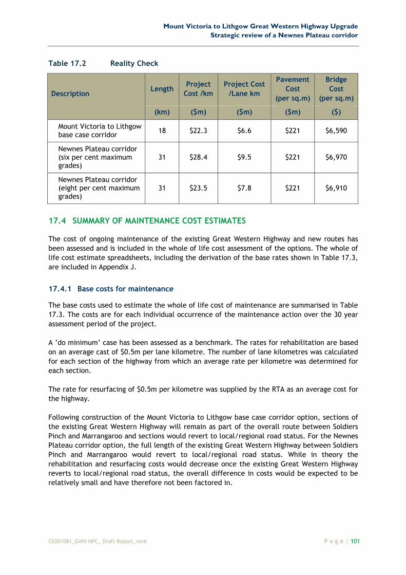
A reality check is summarised below in Table 17.2 (costs based on 70 per cent contingency).
The reality check is a comparison of unit costs (ie costs per km, costs per lane, costs per square
metre) for the project. For example, for the length of road of either 18 km or 31 km for the
base case versus the Newnes Plateau corridor options, it can be seen that the project cost per
kilometre are of similar magnitudes. This information can then be used by the RTA to compare
with other major projects in NSW.
Mount Victoria to Lithgow Great Western Highway Upgrade
Strategic review of a Newnes Plateau corridor
CE001081_GWH NPC_ Draft Report_rev6 P a g e | 101
Table 17.2 Reality Check
Description Length
Project
Cost /km
Project Cost
/Lane km
Pavement
Cost
(per sq.m)
Bridge
Cost
(per sq.m)
(km) ($m) ($m) ($m) ($)
Mount Victoria to Lithgow base case corridor
18 $22.3 $6.6 $221 $6,590
Newnes Plateau corridor (six per cent maximum grades)
31 $28.4 $9.5 $221 $6,970
Newnes Plateau corridor (eight per cent maximum grades)
31 $23.5 $7.8 $221 $6,910
17.4 SUMMARY OF MAINTENANCE COST ESTIMATES
The cost of ongoing maintenance of the existing Great Western Highway and new routes has
been assessed and is included in the whole of life cost assessment of the options. The whole of
life cost estimate spreadsheets, including the derivation of the base rates shown in Table 17.3,
are included in Appendix J.
17.4.1 Base costs for maintenance
The base costs used to estimate the whole of life cost of maintenance are summarised in Table
17.3. The costs are for each individual occurrence of the maintenance action over the 30 year
assessment period of the project.
A ’do minimum’ case has been assessed as a benchmark. The rates for rehabilitation are based
on an average cast of $0.5m per lane kilometre. The number of lane kilometres was calculated
for each section of the highway from which an average rate per kilometre was determined for
each section.
The rate for resurfacing of $0.5m per kilometre was supplied by the RTA as an average cost for
the highway.
Following construction of the Mount Victoria to Lithgow base case corridor option, sections of
the existing Great Western Highway will remain as part of the overall route between Soldiers
Pinch and Marrangaroo and sections would revert to local/regional road status. For the Newnes
Plateau corridor option, the full length of the existing Great Western Highway between Soldiers
Pinch and Marrangaroo would revert to local/regional road status. While in theory the
rehabilitation and resurfacing costs would decrease once the existing Great Western Highway
reverts to local/regional road status, the overall difference in costs would be expected to be
relatively small and have therefore not been factored in.

Mount Victoria to Lithgow Great Western Highway Upgrade
Strategic review of a Newnes Plateau corridor
102 | P a g e 12 November 2008
Technical Report
Table 17.3 Base costs for maintenance
Description Rehabilitate Resurface
Rate $m/km
Cost $m
Rate $m/km
Cost $m
‘Do minimum’ Case
Existing Great Western Highway
Soldiers Pinch to Mount Victoria $1.00 $1.77 $0.50 $0.89
Mount Victoria to Forty Bends $1.38 $19.98 $0.50 $7.24
Forty Bends to South Bowenfels $1.27 $5.12 $0.50 $2.02
South Bowenfels to Marrangaroo $1.16 $9.95 $0.50 $4.29
Base Total $36.82 Base Total $14.43
Mount Victoria to Lithgow base case corridor
New road
Soldiers Pinch to Forty Bends - 3 lanes $0.56 $6.34
Soldiers Pinch to Forty Bends - 4 lanes $0.78 $5.39
Existing highway in base case
Forty Bends to South Bowenfels $0.56 $2.26
South Bowenfels to Marrangaroo $1.16 $9.95 $0.50 $4.29
Existing highway (local road)
Soldiers Pinch to Mount Victoria $1.00 $1.77 $0.50 $0.89
Mount Victoria to Forty Bends $1.38 $19.98 $0.50 $7.24
Base Total $31.71 Base Total $26.41
Newnes Plateau corridor
New road
Soldiers Pinch to Marrangaroo $0.56 $17.06
Existing highway (local road)
Soldiers Pinch to Mount Victoria $1.00 $1.77 $0.50 $0.89
Mount Victoria to Forty Bends $1.38 $19.98 $0.50 $7.24
Forty Bends to South Bowenfels $1.27 $5.12 $0.50 $2.02
South Bowenfels to Marrangaroo $1.16 $9.95 $0.50 $4.29
Base Total $36.82 Base Total $31.49
The new sections of road constructed under each of the corridor options will not require
rehabilitation during the 30 year assessment period of the project. The Forty Bends to South
Bowenfels section of the existing Great Western highway in the base case is to be
reconstructed at the same time as the new road and therefore rehabilitation of this section is
not required during the project assessment period.

Mount Victoria to Lithgow Great Western Highway Upgrade
Strategic review of a Newnes Plateau corridor
CE001081_GWH NPC_ Draft Report_rev6 P a g e | 103
17.4.2 Whole of life cost of maintenance
The whole of life cost estimate spreadsheet in Appendix J sets out a proposed maintenance
program for each of the options over the project assessment period of 30 years. The costs used
are present day costs without discounting.
Mount Victoria to Lithgow Great Western Highway Upgrade
Strategic review of a Newnes Plateau corridor
104 | P a g e 12 November 2008
Technical Report
This page is intentionally left blank