Embed Size (px)
Citation preview
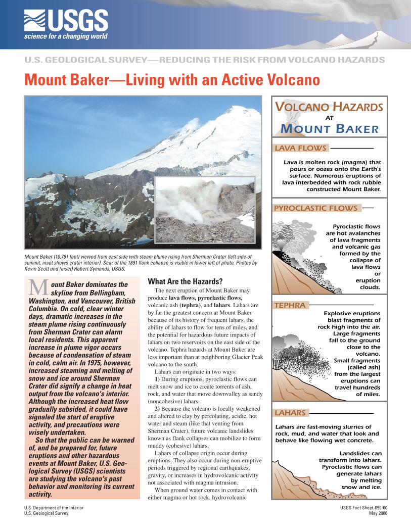
Mount Baker—Living with an Active Volcano
U.S. Department of the InteriorU.S. Geological Survey
USGS Fact Sheet-059-00May 2000
M
GUS S
MOUNT BAKER
Explosive eruptionsblast fragments of
rock high into the air. Large fragments
fall to the groundclose to the
volcano.Small fragments
(called ash)from the largest
eruptions cantravel hundreds
of miles.
Lahars are fast-moving slurries ofrock, mud, and water that look andbehave like flowing wet concrete.
Landslides cantransform into lahars.Pyroclastic flows can
generate laharsby melting
snow and ice.
TEPHRA
PYROCLASTIC FLOWS
LAVA FLOWS
VOLCANO HAZARDS
LAHARS
Lava is molten rock (magma) thatpours or oozes onto the Earth'ssurface. Numerous eruptions of
lava interbedded with rock rubbleconstructed Mount Baker.
AT
Pyroclastic flowsare hot avalanches
of lava fragmentsand volcanic gas
formed by thecollapse oflava flows
oreruption
clouds.
Mount Baker (10,781 feet) viewed from east side with steam plume rising from Sherman Crater (left side ofsummit, inset shows crater interior). Scar of the 1891 flank collapse is visible in lower left of photo. Photos byKevin Scott and (inset) Robert Symonds, USGS.
What Are the Hazards?The next eruption of Mount Baker may
produce lava flows, pyroclastic flows,volcanic ash (tephra), and lahars. Lahars areby far the greatest concern at Mount Bakerbecause of its history of frequent lahars, theability of lahars to flow for tens of miles, andthe potential for hazardous future impacts oflahars on two reservoirs on the east side of thevolcano. Tephra hazards at Mount Baker areless important than at neighboring Glacier Peakvolcano to the south.
Lahars can originate in two ways:1) During eruptions, pyroclastic flows can
melt snow and ice to create torrents of ash,rock, and water that move downvalley as sandy(noncohesive) lahars.
2) Because the volcano is locally weakenedand altered to clay by percolating, acidic, hotwater and steam (like that venting fromSherman Crater), future volcanic landslidesknown as flank collapses can mobilize to formmuddy (cohesive) lahars.
Lahars of collapse origin occur duringeruptions. They also occur during non-eruptiveperiods triggered by regional earthquakes,gravity, or increases in hydrovolcanic activitynot associated with magma intrusion.
When ground water comes in contact witheither magma or hot rock, hydrovolcanic
Washington, and Vancouver, BritishColumbia. On cold, clear winterdays, dramatic increases in thesteam plume rising continuouslyfrom Sherman Crater can alarmlocal residents. This apparentincrease in plume vigor occursbecause of condensation of steamin cold, calm air. In 1975, however,increased steaming and melting ofsnow and ice around ShermanCrater did signify a change in heatoutput from the volcano's interior.Although the increased heat flowgradually subsided, it could havesignaled the start of eruptiveactivity, and precautions werewisely undertaken.
So that the public can be warnedof, and be prepared for, futureeruptions and other hazardousevents at Mount Baker, U.S. Geo-logical Survey (USGS) scientistsare studying the volcano's pastbehavior and monitoring its currentactivity.
ount Baker dominates theskyline from Bellingham,
U.S. GEOLOGICAL SURVEY—REDUCING THE RISK FROM VOLCANO HAZARDS

400,000 and 300,000 years ago and formerlybigger than today's Mount Baker.
Although numerous in Oregon and southernWashington, cinder cones formed of the rocktype called basalt are rare around Mount Baker.A cinder cone that formed 9,800 years ago inSchriebers Meadow produced a widespreadtephra layer, and lava flows that reached theBaker River.
Today's Mount Baker Modern Mount Baker formed during and
since the last ice age, which ended about15,000 years ago. Lava flows from the summitvent erupted between 30,000 and 10,000 yearsago and, during the final stages of edificeconstruction, blocky pyroclastic flows poureddown most of the volcano's drainages. Aneruption 6,600 years ago produced a blanket ofash that extended more than 20 miles to thenortheast. This eruption probably occurredfrom the presently ice-filled summit crater.Subsequently, sulfurous gases have found twopathways to the surface—Dorr Fumaroles,northeast of the summit, and Sherman Crater,
Deposit of the largest lahar from MountBaker, exposed near the confluence of theMiddle and North Forks of the NooksackRiver, about 20 miles from its source at theRoman Wall. Note the protruding logs andbranches from living trees that wereknocked down and carried by the lahar. Iceaxe, 3 ft, shows scale. Lahars are thegreatest hazard at Mount Baker. Insetshows the flow front of a slurry of rock andwater, typical of lahars. The flow is about 10feet deep, moving right to left at 20 miles perhour. Photos by Kevin Scott, USGS.
Volcanic ash (tephra) layers on Mount Baker's southflank. Lower white band is from an eruption of CraterLake, Oregon (7,700 years ago); upper yellow band isfrom a hydrovolcanic eruption of Mount Baker (6,600years ago). Above the yellow band is a black ash froma magmatic eruption of Mount Baker (also about6,600 years ago). Tephra hazards at Mount Baker areless significant than at neighboring Glacier Peakvolcano to the south. Photo by Kevin Scott, USGS.
explosions of steam and rock can occur. Suchevents, in addition to possibly triggeringcollapse, can themselves be hazardous.
Mount Baker— Early HistoryUSGS research in the last decade shows
Mount Baker to be the youngest of severalvolcanic centers in the area and one of theyoungest volcanoes in the Cascade Range. Vol-canic activity in the Mount Baker area beganmore than one million years ago, but many ofthe earliest lava and tephra deposits have beenremoved by glacial erosion. The pale-coloredrocks northeast of the modern volcano markthe site of ancient Kulshan Caldera thatcollapsed after an enormous ash eruption onemillion years ago. Subsequently, eruptions inthe Mount Baker area have produced cones andlava flows of andesite, the rock that makes upmuch of other Cascade Range volcanoes likeMounts Rainier, Adams, and Hood. From about900,000 years ago to the present, numerousandesitic volcanic centers in the area havecome and gone, eroded by glaciers. The largestis the Black Buttes edifice, active between
south of the summit. Both these area are sitesof pervasive bedrock alteration, convertinglavas to weak, white-to-yellow material rich inclays, silica, and sulfur-bearing minerals. AtSherman Crater, collapses of this weakenedrock created lahars in 1843 and as recently asthe 1970's.
Past Events — Future HazardsLike most volcanoes, Mount Baker's history
records great variations in behavior. Scientistsbelieve the following case histories are goodexamples of the range in size and types ofhazardous activity that have occurred in the
THOUSANDS OF YEARS AGO12 10 02468
Cinder cone
Sequence of events about 6,600 years ago
1843 1891 1975
Hydrovolcanicexplosion,collapse,lahars
Largecollapse,largelahar
Hydrovolcanicexplosion,collapse,large lahar
Collapse,lahar
Collapse,lahar
Collapse,lahar
Multiple lava flows,pyroclastic flows,ash eruptions,noncohesive lahars
Asheruption
AD
Increasedsteam andheat
Historical eventsEruptions and flank collapses at Mount Bakerduring the past 12,000 years
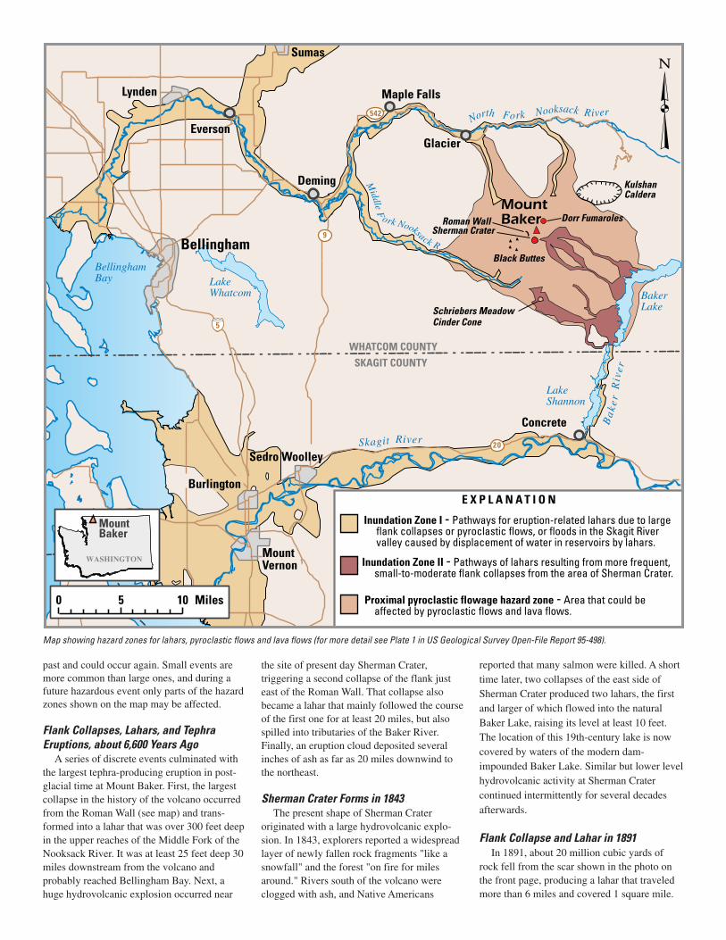
WHATCOM COUNTYSKAGIT COUNTY
BellinghamBay
E X P L A N A T I O N
Proximal pyroclastic flowage hazard zone - Area that could be affected by pyroclastic flows and lava flows.
Inundation Zone I - Pathways for eruption-related lahars due to large flank collapses or pyroclastic flows, or floods in the Skagit River valley caused by displacement of water in reservoirs by lahars.
Inundation Zone II - Pathways of lahars resulting from more frequent, small-to-moderate flank collapses from the area of Sherman Crater.
North Fork Nooksack River
Maple Falls
Glacier
Lynden
Deming
Concrete
LakeWhatcom
LakeShannon
BakerLake
Skagit River
Middle
F
ork Nooksack R.Black Buttes
Schriebers MeadowCinder Cone
Dorr Fumaroles
Kulshan Caldera
Roman WallSherman Crater
Ba
k er
Riv
er
Bellingham
Sumas
Everson
Mount Baker
542
9
20
5
0 5 10 Miles
Sedro Woolley
Burlington
Mount Vernon
Map showing hazard zones for lahars, pyroclastic flows and lava flows (for more detail see Plate 1 in US Geological Survey Open-File Report 95-498).
past and could occur again. Small events aremore common than large ones, and during afuture hazardous event only parts of the hazardzones shown on the map may be affected.
Flank Collapses, Lahars, and TephraEruptions, about 6,600 Years Ago
A series of discrete events culminated withthe largest tephra-producing eruption in post-glacial time at Mount Baker. First, the largestcollapse in the history of the volcano occurredfrom the Roman Wall (see map) and trans-formed into a lahar that was over 300 feet deepin the upper reaches of the Middle Fork of theNooksack River. It was at least 25 feet deep 30miles downstream from the volcano andprobably reached Bellingham Bay. Next, ahuge hydrovolcanic explosion occurred near
the site of present day Sherman Crater,triggering a second collapse of the flank justeast of the Roman Wall. That collapse alsobecame a lahar that mainly followed the courseof the first one for at least 20 miles, but alsospilled into tributaries of the Baker River.Finally, an eruption cloud deposited severalinches of ash as far as 20 miles downwind tothe northeast.
Sherman Crater Forms in 1843The present shape of Sherman Crater
originated with a large hydrovolcanic explo-sion. In 1843, explorers reported a widespreadlayer of newly fallen rock fragments "like asnowfall" and the forest "on fire for milesaround." Rivers south of the volcano wereclogged with ash, and Native Americans
reported that many salmon were killed. A shorttime later, two collapses of the east side ofSherman Crater produced two lahars, the firstand larger of which flowed into the naturalBaker Lake, raising its level at least 10 feet.The location of this 19th-century lake is nowcovered by waters of the modern dam-impounded Baker Lake. Similar but lower levelhydrovolcanic activity at Sherman Cratercontinued intermittently for several decadesafterwards.
Flank Collapse and Lahar in 1891In 1891, about 20 million cubic yards of
rock fell from the scar shown in the photo onthe front page, producing a lahar that traveledmore than 6 miles and covered 1 square mile.
R E A S O N S F O R T H E C L O S U R EBased on scientific information obtained from the U.S. Geological Survey and scientists studying steam activity on Mt. Baker, the Forest Service has closed the shoreline and all campgrounds at Baker Lake.The closure is in the interest of public safety.
There is danger that the heavy steam acitivity will trigger a massive mudslide from the upper slopesof Mt. Baker. Such a slide could enter the lake with great force, sending a wave of water alongthe lakeshore and into the campground areas.
This closure includes Horseshoe Cove, BoulderCreek, Maple Grove, Baker Lake, Park Creek andShannon Creek Campgrounds as well as.......
C L O S U R EC L O S U R E
View looking north at Mount Baker summit, ShermanCrater, and the Roman Wall. Photo by Dave Tucker.
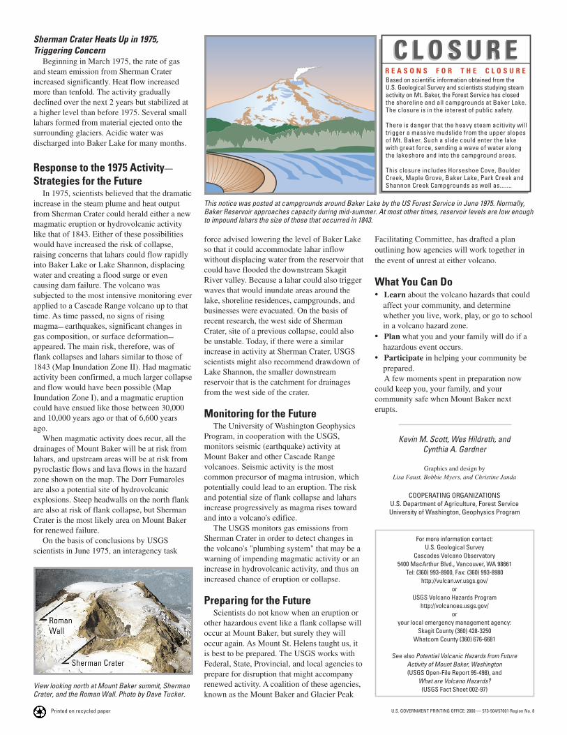
This notice was posted at campgrounds around Baker Lake by the US Forest Service in June 1975. Normally,Baker Reservoir approaches capacity during mid-summer. At most other times, reservoir levels are low enoughto impound lahars the size of those that occurred in 1843.
Sherman Crater Heats Up in 1975,Triggering Concern
Beginning in March 1975, the rate of gasand steam emission from Sherman Craterincreased significantly. Heat flow increasedmore than tenfold. The activity graduallydeclined over the next 2 years but stabilized ata higher level than before 1975. Several smalllahars formed from material ejected onto thesurrounding glaciers. Acidic water wasdischarged into Baker Lake for many months.
Response to the 1975 Activity—
Strategies for the FutureIn 1975, scientists believed that the dramatic
increase in the steam plume and heat outputfrom Sherman Crater could herald either a newmagmatic eruption or hydrovolcanic activitylike that of 1843. Either of these possibilitieswould have increased the risk of collapse,raising concerns that lahars could flow rapidlyinto Baker Lake or Lake Shannon, displacingwater and creating a flood surge or evencausing dam failure. The volcano wassubjected to the most intensive monitoring everapplied to a Cascade Range volcano up to thattime. As time passed, no signs of risingmagma— earthquakes, significant changes ingas composition, or surface deformation—
appeared. The main risk, therefore, was offlank collapses and lahars similar to those of1843 (Map Inundation Zone II). Had magmaticactivity been confirmed, a much larger collapseand flow would have been possible (MapInundation Zone I), and a magmatic eruptioncould have ensued like those between 30,000and 10,000 years ago or that of 6,600 yearsago.
When magmatic activity does recur, all thedrainages of Mount Baker will be at risk fromlahars, and upstream areas will be at risk frompyroclastic flows and lava flows in the hazardzone shown on the map. The Dorr Fumarolesare also a potential site of hydrovolcanicexplosions. Steep headwalls on the north flankare also at risk of flank collapse, but ShermanCrater is the most likely area on Mount Bakerfor renewed failure.
On the basis of conclusions by USGSscientists in June 1975, an interagency task
force advised lowering the level of Baker Lakeso that it could accommodate lahar inflowwithout displacing water from the reservoir thatcould have flooded the downstream SkagitRiver valley. Because a lahar could also triggerwaves that would inundate areas around thelake, shoreline residences, campgrounds, andbusinesses were evacuated. On the basis ofrecent research, the west side of ShermanCrater, site of a previous collapse, could alsobe unstable. Today, if there were a similarincrease in activity at Sherman Crater, USGSscientists might also recommend drawdown ofLake Shannon, the smaller downstreamreservoir that is the catchment for drainagesfrom the west side of the crater.
Monitoring for the FutureThe University of Washington Geophysics
Program, in cooperation with the USGS,monitors seismic (earthquake) activity atMount Baker and other Cascade Rangevolcanoes. Seismic activity is the mostcommon precursor of magma intrusion, whichpotentially could lead to an eruption. The riskand potential size of flank collapse and laharsincrease progressively as magma rises towardand into a volcano's edifice.
The USGS monitors gas emissions fromSherman Crater in order to detect changes inthe volcano's "plumbing system" that may be awarning of impending magmatic activity or anincrease in hydrovolcanic activity, and thus anincreased chance of eruption or collapse.
Preparing for the FutureScientists do not know when an eruption or
other hazardous event like a flank collapse willoccur at Mount Baker, but surely they willoccur again. As Mount St. Helens taught us, itis best to be prepared. The USGS works withFederal, State, Provincial, and local agencies toprepare for disruption that might accompanyrenewed activity. A coalition of these agencies,known as the Mount Baker and Glacier Peak
Facilitating Committee, has drafted a planoutlining how agencies will work together inthe event of unrest at either volcano.
What You Can Do• Learn about the volcano hazards that could affect your community, and determine whether you live, work, play, or go to school in a volcano hazard zone.• Plan what you and your family will do if a hazardous event occurs.• Participate in helping your community be prepared.
A few moments spent in preparation nowcould keep you, your family, and yourcommunity safe when Mount Baker nexterupts.
Kevin M. Scott, Wes Hildreth, andCynthia A. Gardner
Graphics and design byLisa Faust, Bobbie Myers, and Christine Janda
COOPERATING ORGANIZATIONSU.S. Department of Agriculture, Forest ServiceUniversity of Washington, Geophysics Program
For more information contact:U.S. Geological Survey
Cascades Volcano Observatory5400 MacArthur Blvd., Vancouver, WA 98661
Tel: (360) 993-8900, Fax: (360) 993-8980http://vulcan.wr.usgs.gov/
orUSGS Volcano Hazards Program
http://volcanoes.usgs.gov/or
your local emergency management agency:Skagit County (360) 428-3250
Whatcom County (360) 676-6681
See also Potential Volcanic Hazards from FutureActivity of Mount Baker, Washington(USGS Open-File Report 95-498), and
What are Volcano Hazards?(USGS Fact Sheet 002-97)
Printed on recycled paper U.S. GOVERNMENT PRINTING OFFICE: 2000 — 573-504/57001 Region No. 8