Embed Size (px)
Citation preview

����������� �
�������

�� ������ ������������������ ��� ������
����������� ���������� ����! � ��"����#$�� � ��� �%&'()*(("+���,$�� ���-
.���&//%')'(0
����1������������������������
������� ��� ������������������������������
������������ ��� ��������������������
���!����� �����"�#�������$��������%&'�(&������������%���������)�'������*
+,��� -�$���� �����.����������
�����.� ���������� �����������/�%'�!%0�����!������
$������� �2� �1
3����������������������4���� ���4������5�� ���� ������ �$�������������� �'6��$����'((/47���������������� ����������������������8�����9�8������:����������;���� ����,$�� � � ��� ������7$��� ���7-2 �<������5������=�������>���������3���2 �� ������� � 2�����������7����� 2���;���� ���� ������7?����@ �5 2������A�������

The mountain known as Montgó is located in MarinaAlta county, at the north-eastern end of Alicanteprovince, sweeping up over the bordering plains ofOndara-Dènia and Jávea- Gata de Gorgos, with a sur-face area of 2117.68 ha, and was declared a Nature
Reserve by the Generalitat Valenciana on 16th March1987. In November 2002 a zone for damping impactsof 5386.31 ha. around the mountain was decreed,with the protected zone being extended to atotal amount of 7503.99 ha.
This mountain, an inescapable visual landmark foranyone in its vicinity, runs in parallel to the coast,reaching a height of 753 metres. The Montgó runsdown to the sea across a plain known as “les Planes”,which ends in the rugged cliffs of San Antonio head,forming one of the most spectacular landscapes in theValencian coastline. This zone was declared a Marine
Reserve on 9th November 1993 of fishing interest; itwas also declared a Natural Marine Reserve by act11/1994 due to the diversity of both environmentsand living creatures in its sea beds.
We thus find ourselves up against an impressive rockymass which seems to rise up out of the sea and reachthe sky, caressing the clouds which often crown itspeak. The curt, dry look appreciated by the observerfrom a distance nevertheless hides a dazzling treas-ure-hoard of life which makes it a paradigm of thewealth of Valencian nature; ravines, walls, summit,terraces, coastline, sea beds… It has a range ofecosystems, accommodating hundreds of species,many of these of extraordinary scientific value.
Its outstanding location has fostered a constant relation-ship with the human beings who have populated it, usedas a home, defensive watchtower, hunting ground,space for harvesting, crops and leisure, making use ofthis since the most remote times. The vestiges of thispresence are to be found all over the park and its sur-roundings, talking to us of ancient civilisations, past usesand more recent ones of the environment, with whichthe inhabitants were able to maintain a proper balancefor centuries.
The protection of this area by the Generalitat Valencianaenables conservation in the present and future of thisemblematic place in the best condition possible.

B. A
lbia
ch
Montgó mountain seen from oneof Denia's beaches
Geology and climate
From the geological point of view, the Montgóbelongs to the last unit of the Pre-bética range. Thematerials that can be seen date back to the lowercretaceous and quaternary periods.
This is a gentle synclinal flexion, tipping slightly to thenorth and broken by two faults, one to the north(Dénia) and another to the south (Xàbia) with majorvertical displacement and approximately east-westorientation. The erosive agents have graduallysculpted out their present morphology in the lime-stone.
The cliffs in San Antonio, moulded by the constanterosion of the sea against the hard rock, are promi-nent features.
As regards the climate, the Montgó lies in the cli-matic division of two variants of the westernMediterranean climate, and would be included in asector with “rainy coastal plain climate” charac-terised by considerable rainfall, with an average of700 mm. a year with a maximum rainfall peak in theautumn, marked summer droughts, though to thesouth this quickly changes into a semi-arid climate.This is thus a climatic transition zone.
The effect of crypto-precipitation (hidden rainfall),found in the summit zone, is also significant, beingvery abundant due to the customary presence ofclouds there.

G. B
.
After the area was retaken from the Arabs, severalchapels were built around the Montgó, as well as theMonasterio de Nuestra Señora de los Angeles in LesPlanes, whose origins date back to the 14th century.Very close to the monastery there is a remarkableset of eleven former windmill buildings, erectedfrom the14th to the 18th centuries.
At the end of les Rotes area one can still find theTorre del Gerro, a 16th century watchtower, underone of whose windows the coat of arms of Carlos Ican be seen.
Traditional activities
Until the great revolution meant by tourism in thelast third of the nineteenth century, the economicactivities traditionally undertaken in the area were:agriculture, fishing, sea trade and fan-palm crafts. The main crops were grown on unirrigated land:grapevines, olives, carob, figs, almonds, wheat... cov-ering the farmland, all typical Mediterranean crops.Beyond their strict food value, they convey to us awhole culture involving the inhabitants of these landsfrom the dawn of our civilisation.
The Mediterranean sea has offered up a plentifulbounty to endless generations of fishermen. Fish,molluscs and seafood have formed part of the basicprotein diet for the people of the county’s villagesand helped to develop a rich cuisine based on theseproducts.
At the present time these traditional activities are inserious danger of disappearance, due to the changesin the county’s economy, now focusing on tourismand building, which has clearly modified the lifestyle,the traditional customs and even the landscape in thezone.
History
Montgó mountain has borne witness to humanactivity almost from its beginnings. Many sites andremains confirm this presence: The Barranc de Migdia ravine, Foradada andMontgó caves display remains from the UpperPalaeolithic to the Bronze age.In Benimaquia, Coll de Pous and Pic de l’Aguila therewere Iberian settlements from the 7th centurybefore Christ.In Roman times the port of Dianium took on specialsignificance, as was stated in the inscription in theCova de l’aigua.In Arab times the Dénia Taifa or emirate wasdeclared, and Abu-Abdalla wrote:”... At its south-ern end there is a large mountain, round in shape,from the top of which the mountains of Ibiza can beseen out to sea. This mountain is known as Caon” –From this it would change into Mont Caon, Mont-Gaun, and today’s Mont-gó.
El Gerro tower

B. A
lbia
ch
Gen
eral
itat
Vale
ncia
na
The cliffs in the shadowy areas have the highhumidity, isolation and inaccessibility conditionsallowing the growth of numerous endemisms suchas horseshoe vetch or the Scabiosa Saxatilis. Wherethe slope flattens off a little, bush species and lianasappear, forming the dense thickets typical of theshady area; honeysuckle, sarsaparilla, Laurustinusor flowering ash are typical of the cooler anddamper areas
On the cliffs in the sunny part there are speciesadapted to the low environmental humidity and thehigh temperatures, while on the cliffs at SanAntonio head one can find species adapted to life incracks and ledges on the cliff, and to salinity. Manyof these plants are endemic to this zone. We can
“Herba santa” (Carduncellus dianius)
Vegetation
The vegetation of the Montgó was one of the mainreasons for declaring this a protected space. Boththe geology and the climate enable the appearanceand distribution of over 650 different species offlora. This wide range of flowers found in such asmall space, and the plentiful endemisms here aresufficient to justify its protection. At the top of theMontgó the kermes oak and rosemary grow withplentiful French lavender. The kermes oak grovesconsist of large bushes such as the kermes oakitself, the lentisc or the fan palm; the rosemarybrushland is made up of this species or the Frenchlavender. These communities of bushes replace theformer holm oak groves, a community with a treestrata dominated by the evergreen oak, a few spec-imens of this still remaining.
Bushes dominate the skirts of El Montgó
G. B
.
As you can see, there is plentifulrich vegetation
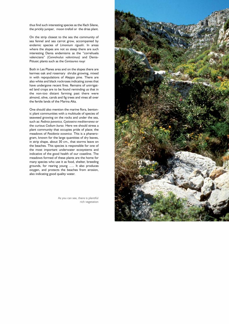
thus find such interesting species as the Ifach Silene,the prickly juniper, moon trefoil or the drias plant.
On the strip closest to the sea the community ofsea fennel and sea carrot grow, accompanied byendemic species of Limonium rigualii. In areaswhere the slopes are not so steep there are suchinteresting Denia endemisms as the “correhuelavalenciana” (Convolvulus valentinus) and Denia-Pitiusic plants such as the Centaurea rouyi
Both in Les Planes area and on the slopes there arekermes oak and rosemary shrubs growing, mixedin with repopulations of Aleppo pine. There arealso white and black rockroses indicating zones thathave undergone recent fires. Remains of unirrigat-ed land crops are to be found reminding us that inthe non-too distant farming past there werealmond, olive, carob and fig trees and vines all overthe fertile lands of the Marina Alta.
One should also mention the marine flora, benton-ic plant communities with a multitude of species ofseaweed growing on the rocks and under the sea,such as: Padinia pavonica, Cystoseira mediterranea orthe curious Codium bursa. Here we should stress aplant community that occupies pride of place; themeadows of Posidonia oceanica. This is a phanero-gram, known for the large quantities of dry leaves,in strip shape, about 30 cm., that storms leave onthe beaches. This species is responsible for one ofthe most important underwater ecosystems andindicative of the good health of our coastline. Themeadows formed of these plants are the home formany species who use it as food, shelter, breedinggrounds, for rearing young ….. It also producesoxygen, and protects the beaches from erosion,also indicating good quality water.

B. A
lbia
ch
as well the curious crossbills, the spectacular bubo birdsor the tawny owl, which hunts its prey in the pine spin-neys.
As for the mammals, there are badgers, increasinglylarge numbers of boars and carnivores such as the foxand the genet which depend on the plentiful rabbits androdents. The bats, that live in the caves of the Montgóare a key item in the park’s ecosystems through con-suming large amounts of insects. Mehely’s horseshoebat is an important one, in danger of extinction and withone of its most important breeding grounds in theReserve in the caves here.
There are large numbers of reptiles such as thePsammodromus algirus lizard, the ocellated lizard orthe Montpellier snake. The presence of the viviparousskink is noteworthy. The amphibians are rather scanty,with the common toad and natterjack toad.
The farming zones around the mountain represent theideal ecosystems for birds such as little owls or barnowls which feed on the small rodents. In the inverte-brate group there are major communities of gastropodsand insects, both with wide ranges of species.
The fauna in the marine reserve covers diverse com-munities which are distributed depending on the depth.From the shore one can find species such as the seatomato, molluscs such as limpets or mussels, crabs orsea urchins; down to a depth of 25 m., where the pro-tagonists are organisms such as sponges and pre-coral-ligen species covering the rocks. The environment iscompleted with a multitude of fish such as moray eels,groupers and a variety of sparidae (porgies), sea snails,octopi or crustaceans such as the much-loved lobster.
The protection of this zone seeks not only to preserveits biodiversity but also to reinforce and guarantee con-tinuity of the nearby fishing zones.
Fauna
The fauna found in the Nature Reserve is closelylinked with these landscape units and the plant com-munities that grow in them.
In the cliffs of San Antonio head some customary res-idents are the shag, the peregrine falcon and the yel-low-legged gull, and Audouin’s gull winters here,among many other birds.
On the rocky crags one can find crows, jackdaws andbirds of prey, a prominent one being Bonelli’s eaglewith one nesting couple, the kestrel and several cou-ples of imperial owls.
Numerous species of birds and mammals find shelterand food among the kermes and pine groves. Some ofthe more common birds are great tits and blackcaps,
Red fox (Vulpes vulpes)

Plana de Justa
Els Castellans
Urb.del MontgóJesus Pobre
Alqueriade Colomer
Alqueriade Fernando
Gata deGorgos
Cova Tallada
Segunda Cala
el Garroferet
Punta de la Pedrera
Playa del Benisser
Punta de l’Espanyol
Playa del l’Arenal
Puertode Xàbia
Primera Cala
CabodeSant
AntoniP. del Pope
Punta Negra
Punta del Sard
Playa de les Arenetes
Playa de l’Aiguadolç
Les Rotes
Betlem
Urb.lesArenetes
Cova deL’Aigua
puerto de Denia
Playa de la MarinetaCassiana
Penya del’Àguila
488,6Coll de Pous
Plana delsMolins
Ermita deSta.Lucia
164,7Ermita
del Pópul
Santuari de la Marede Déu dels Àngels
CV-735
CV-736
CV-725
CV-
738
CV-734
CV-739
CV-742
Riu Gorgos
Ferr
ocar
rilAl
acan
t-D
en
ia
Ermita delPare Pere
-10
-20
-30
road hermitage beacon
peak
geodesic vertex
information centre
camping
mill
castle
cave
ruins
path
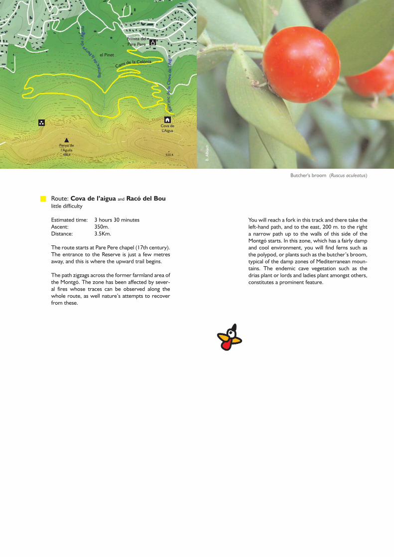
route: La Cova de l’Aigua y el Racó del Bou
route: Les Planes. Ar recreativa y los Molinos
route: Cabo de San Antonio. Cala del Tango
buildings
administrative boundary
Castillo de Denia
Poblat Ibèric
Creu de Xàbia751,8
Creu de Denia698
Dénia
Xàbia
B. A
lbia
ch
Ermita delPare Pere
el Pinet
523,4
Cova deL’Aigua
Penya del’Àguila
488,6
Barr
anc
dela
Cio
vade
l’Aig
ua
Barr
anc
dela
Penya
del’À
guila
Cami de la Colònia
You will reach a fork in this track and there take theleft-hand path, and to the east, 200 m. to the righta narrow path up to the walls of this side of theMontgó starts. In this zone, which has a fairly dampand cool environment, you will find ferns such asthe polypod, or plants such as the butcher’s broom,typical of the damp zones of Mediterranean moun-tains. The endemic cave vegetation such as thedrias plant or lords and ladies plant amongst others,constitutes a prominent feature.
Butcher's broom (Ruscus aculeatus)
Route: Cova de l’aigua and Racó del Boulittle difficulty
Estimated time: 3 hours 30 minutesAscent: 350m.Distance: 3.5Km.
The route starts at Pare Pere chapel (17th century).The entrance to the Reserve is just a few metresaway, and this is where the upward trail begins.
The path zigzags across the former farmland area ofthe Montgó. The zone has been affected by sever-al fires whose traces can be observed along thewhole route, as well nature’s attempts to recoverfrom these.
G. B
.
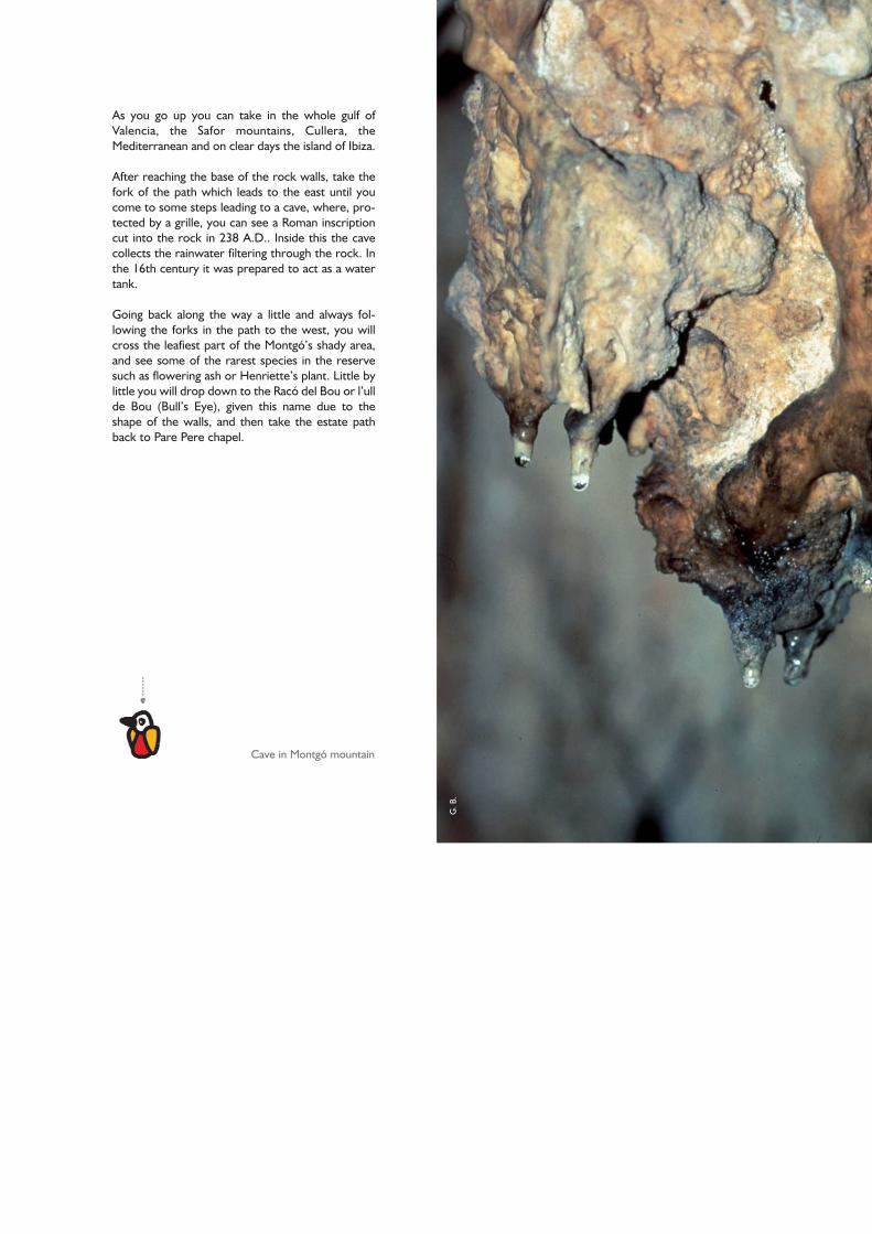
Cave in Montgó mountain
As you go up you can take in the whole gulf ofValencia, the Safor mountains, Cullera, theMediterranean and on clear days the island of Ibiza.
After reaching the base of the rock walls, take thefork of the path which leads to the east until youcome to some steps leading to a cave, where, pro-tected by a grille, you can see a Roman inscriptioncut into the rock in 238 A.D.. Inside this the cavecollects the rainwater filtering through the rock. Inthe 16th century it was prepared to act as a watertank.
Going back along the way a little and always fol-lowing the forks in the path to the west, you willcross the leafiest part of the Montgó’s shady area,and see some of the rarest species in the reservesuch as flowering ash or Henriette’s plant. Little bylittle you will drop down to the Racó del Bou or l’ullde Bou (Bull’s Eye), given this name due to theshape of the walls, and then take the estate pathback to Pare Pere chapel.

Gen
eral
itat
Vale
ncia
n
Plana del Cap deSant Antoni
Plana dels Molins
El Rafal
El Pujol
Santuari de la Mare deDéu dels Àngels
Plana deSant Jeroni
Port de Xàbia
Barr
anc
dela
Rabo
sa
Cami del Cap de Sant Antoni
Cami d
el’E
rmita
dels
Ang
els
Remains of the old windmills
Then go on to the left to the south to the shrine of“Mare de Deu dels Angels” whose present buildingwas a Hieronymite Convent until recent times, andis now a spirituality centre.
Going on along the line of cypresses you will cometo the dels molins viewpoint, observing a set of wind-mill buildings, unique in the whole ValencianCommunity. From here you will be able to see awide panorama of Xabia bay and the mountains inthe county.
Go back to the recreation area along Calle Penaguila,which runs from the end of the Camí del Monestir tothe east, as far as “Cuesta del cabo San Antonio”street, until you come to San Antonio head streetagain. Cross this and take the path in front of you toreturn to the starting point in the recreation area.
Route: Les Planes. Recreation area and Los MolinosLittle difficulty
Estimated time: 2 hours.Ascent: 10 m.Distance: 4,5 km
This route starts in the recreation area, located 700metres before reaching San Antonio head lighthouse tothe left. You will see a car park zone, beside the road,under the pine trees. The area is equipped with bench-es and tables in the shade of the trees, has drinkingwater and toilets (to make use of these one first has toask Javea Council for permission). From here the routesets off along the road heading into the pine trees.
You will come to a former barracks for guards whowatched over the ravines and coves used for hidingsmuggled goods.

Gen
eral
itat
Vale
ncia
na
Cova del XiuladorFar de
Sant Antoni
Coves Santes
Plana de Sant Jeroni
162,1
146,9
Cami del Cap de Sant Antoni
La Solsida
Platgeta del Pope
Port de Xàbia
L’Escull
Barr
anc
del
Tang
ó
Route: Cabo de San Antonio. Cala del Tangó little difficulty
Estimated time: 1 hour Ascent: 160 m.Distance: 2 km
This route starts from the first viewpoint that youfind, before reaching the lighthouse. From here youcan enjoy an excellent view of the cliffs, similar tothe one from dels molins vantage point.
Gliding gulls will accompany you as you head downa path among pine trees, thyme, rosemary bushesand many other plants that will take you to El Tangóor El Pope Cove, beside the port of Xabia.
If this is the right time of year, it would be a goodidea to take a face mask to dive in the crystallinewaters, where you will discover the explosion oflife on the sea bed, whose importance has led tothis being declared a Marine Reserve.
Although these are just three proposals to get toknow the reserve, the Montgó has a much widernetwork of paths. At the reception centre for visi-tors the staff of the Reserve will inform you aboutthese.
Aerial view of Montgó mountain headingtoward the Mediterranean sea
G. B
.
Accommodation
You should remember that free camping is notallowed in the nature reserve, but there is a verywide range of hotels, rented residences and campingsites.Information and tourism offices:
Denia: 966 422 367Xabia: 965 790 736
Cuisine
One of the most outstanding aspects of the MarinaAlta is the excellence of its cooking, both traditionaland contemporary. For centuries it has wisely com-bined the products of the country with ingredientsfrom the sea and the mountains, to produce a widerange of recipes of all kinds: rice, fish and meat dish-es; cold meats that are used in each village in theirown traditional recipes; as well as the excellentsponge cakes and Christmas sweets.
The sea, which is in this area particularly rich inspecies has given rise to dishes of intense flavour: thefamous red shrimp of Dénia, fish stews, the famous“arròs a banda” rice and “Polp amb penques” octo-pus are some of the exquisite recipes coming fromthe coast.
There are plenty of bars and restaurants availablewhere you can enjoy the local cooking.
The Marina county produces excellent wines andmistela sweet wines at the Xaló or Teulada wineries.Salt meat and fish and pickles are also produced.
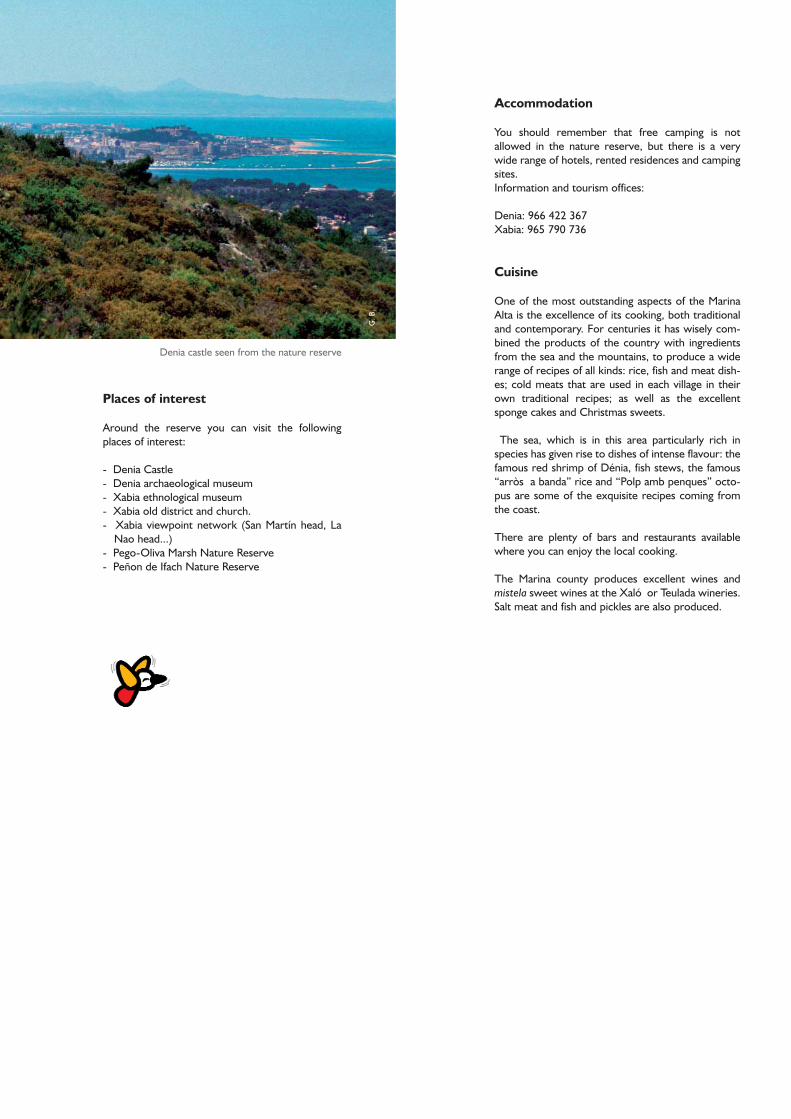
Places of interest
Around the reserve you can visit the followingplaces of interest:
- Denia Castle- Denia archaeological museum- Xabia ethnological museum- Xabia old district and church.- Xabia viewpoint network (San Martín head, La
Nao head...) - Pego-Oliva Marsh Nature Reserve- Peñon de Ifach Nature Reserve
Denia castle seen from the nature reserve

Do not leave the markedpaths to take short cuts
Recommendations
No picking flowers andplants
Do not drop litter in thereserve. Use the litter bins
No smoking in thenature reserve
No driving motor vehiclesalong the tracks
No fishing in the marinereserve
Please do not makenoise
Dogs must be on aleash
Do not bother or catchany animals
No camping in thenature reserve
It is strictly forbidden tolight fires
How to get there
It is easy to get to the park:Take the A-70 motorway, exit 62 (Ondara-Denia-Javea) to Denia and from Jaume I square takeAvenida del Montgó, to Pare Pere chapel, whereseveral of the routes in the reserve start out.
You can also start from Xabia along the road whichgoes from San Antonio head or from Jesús Pobre, inthe Mitjans district, where several of the paths foraccess to the reserve start.
The Reserve’s information centre is located in thepublic gardens of Torrecremada, beside Déniacourts.
If you call contact phone 966 423 205 you canarrange guided visits for groups of 10 or morepersons.