Embed Size (px)
Citation preview

Moisture and Atmospheric Stability
AOS 101 Discussion
Discussion Leader – Val

Contouring Help
• Contour Tutorial

Review
• Turn in hw #3
• Badger forecasts
• Why do you dry off faster in a desert climate?

The biggest power plant on Earth’s surface-
http://www.srh.weather.gov/jetstream/atmos/hydro.htm

Water can exist in all three phases in our atmosphere
• What term do we seem to use to quantify the amount of water in any given volume of air at one time?
• Answer: Moisture

Ways to measure the moisture content of the atmosphere (discussed in lec.)
• Absolute Humidity
• Specific Humidity
• Saturation Mixing Ratio
• Vapor Pressure
• Saturation Vapor Pressure
• Relative Humidity
• Dew Point Temperature
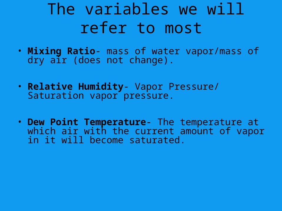
The variables we will refer to most
• Mixing Ratio- mass of water vapor/mass of dry air (does not change).
• Relative Humidity- Vapor Pressure/ Saturation vapor pressure.
• Dew Point Temperature- The temperature at which air with the current amount of vapor in it will become saturated.

Two ways to saturate the air Two ways to saturate the air (or (or
raise the relative humidity)raise the relative humidity)

Two ways to saturate the air Two ways to saturate the air (or (or
raise the relative humidity)raise the relative humidity)• 1. Add more water vapor to it• 2. Decrease the temperature
This is because warm air is capable of “holding” more water vapor molecules than cold air.
(Remember the water vapor molecules are moving faster in warm air and less likely to stick and condense)
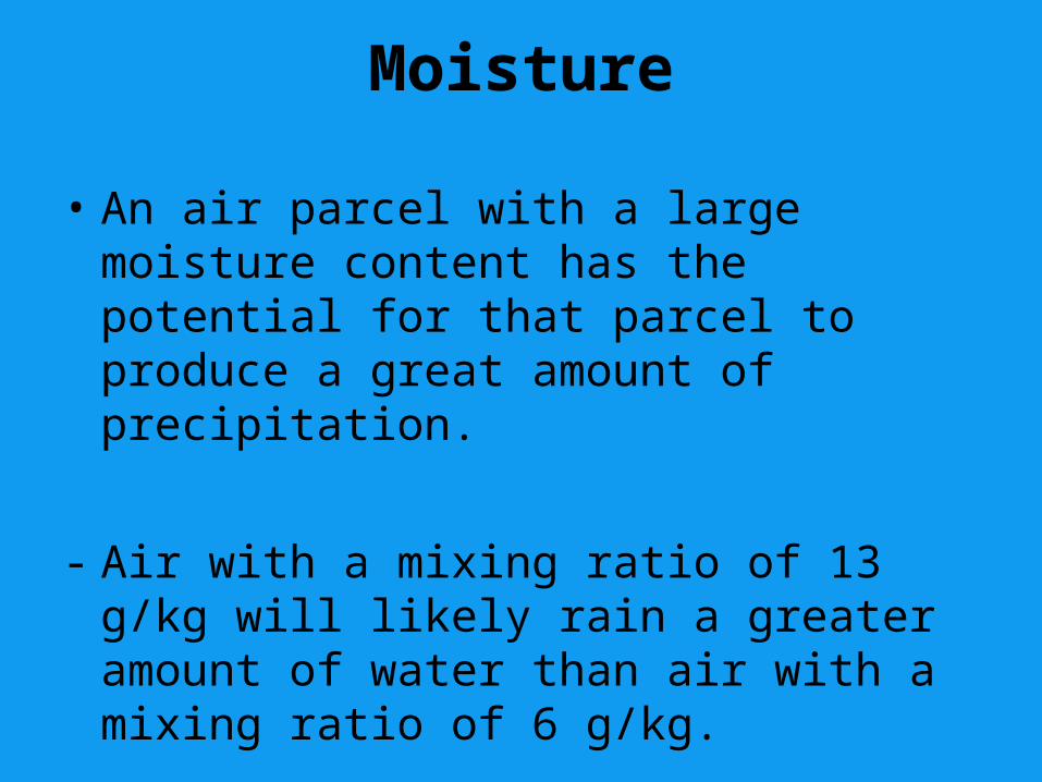
Moisture
• An air parcel with a large moisture content has the potential for that parcel to produce a great amount of precipitation.
- Air with a mixing ratio of 13 g/kg will likely rain a greater amount of water than air with a mixing ratio of 6 g/kg.

Moisture
Two parcels of air:
PARCEL 1PARCEL 1: Temperature = 31 oF, Dewpoint = 28 oF
PARCEL 2PARCEL 2: Temperature = 89 oF, Dewpoint = 43 oF
Parcel 2 contains more water vapor than Parcel 1, because its dewpoint is higher.
Parcel 1 has a higher relative humidity, because it wouldn’t take much cooling for the temperature to equal the dewpoint! Thus, Parcel 1 is more likely to become saturated. But if it happened that both parcels became saturated then Parcel 2 would have the potential for more precipitation.
RH is not simply equal to the dewpoint divided by the temp. but is a good representation.

The other key component to the hydrologic cycle- Stability
• What is stability?
• Stability refers to a condition of equilibriumIf we apply some perturbation to a system, how will
that system be affected?
– Stable: System returns to original state– Unstable: System continues to move away from
original state– Neutral: System remains steady after perturbed
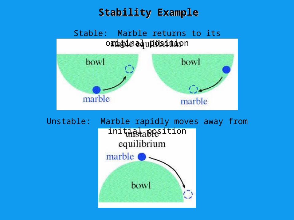
Stability ExampleStability Example
Stable: Marble returns to its original position
Unstable: Marble rapidly moves away from initial position
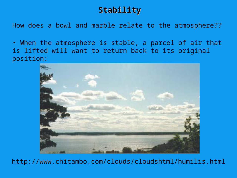
StabilityStability
How does a bowl and marble relate to the atmosphere??
• When the atmosphere is stable, a parcel of air that is lifted will want to return back to its original position:
http://www.chitambo.com/clouds/cloudshtml/humilis.html

Stability Cont.Stability Cont.
• When the atmosphere is unstable (with respect to a lifted parcel of air), a parcel will want to continue to rise if lifted:
http://www.physicalgeography.net/fundamentals/images/cumulonimbus.jpg

– Imaginary small body of air a few meters wide
• Can expand and contract freely
• Does not break apart
• Only considered with adiabatic processesadiabatic processes - External air and heat cannot mix with the air inside the parcel
• Parcel warms or cools purely due to pressure changes (ΔU = Q – W)
What do we mean by an air parcel?

Buoyancy and Stability• At same pressure if at same altitude!
• So if ρparcel < ρenv. Parcel is positively buoyantParcel is positively buoyant
• In terms of temperature that would mean:
T of parcel > T of environment – buoyant! (unstable)
T of parcel < T of environment – sink! (stable)
T of parcel = T of environment – stays put (neutral)

Atmospheric Stability (Review)
This is all well and good but what about day to day applications… almost there

Vertical Profile of Atmospheric Temperature

Lapse RatesLapse Rates
Lapse RateLapse Rate: The rate at which temperature decreases with height (Remember the inherent negative wording to it)
Environmental Lapse RateEnvironmental Lapse Rate: Lapse rates associated with an observed atmospheric sounding (negative for an inversion layer)
Parcel Lapse RateParcel Lapse Rate: Lapse rate of a parcel of air as it rises or falls (either saturated or not)
MALR - Moist Adiabatic Lapse RateMoist Adiabatic Lapse Rate: Saturated air parcel
DALR - Dry Adiabatic Lapse RateDry Adiabatic Lapse Rate: Dry air parcel

DALR
• Air in parcel must be unsaturated
• (RH < 100%)
• Rate of adiabatic heating or cooling = 9.8°C for every 1000 meter (1 kilometer) change in elevation– Parcel temperature decreases by about 10° if
parcel is raised by 1km, and increases about 10° if it is lowered by 1km

MALR (or SALR)
• As rising air cools, its RH increases because the temperature approaches the dew point temperature, Td
• If T = Td at some elevation, the air in the parcel will be saturated (RH = 100%)
• If parcel is raised further, condensation will occur and the temperature of the parcel will cool at the rate of about 6°C per 1km in the mid-latitudes

DALR vs. MALR
• The MALR is less than the DALR because of latent heating– As water vapor
condenses into liquid water for a saturated parcel, LH is released, lessening the adiabatic cooling Remember no heat exchanged with environment

DALR vs. MALR
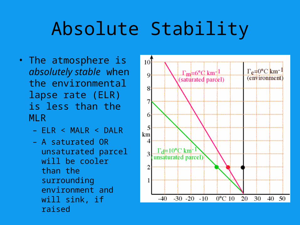
Absolute Stability
• The atmosphere is absolutely stable when the environmental lapse rate (ELR) is less than the MLR– ELR < MALR < DALR– A saturated OR
unsaturated parcel will be cooler than the surrounding environment and will sink, if raised

Absolute Stability
• Inversion layers are always absolutely stable– Temperature
increases with height
– Warm air above cold air = very stable

Absolute Instability
• The atmosphere is absolutely unstable when the ELR is greater than the DALR– ELR > DALR > MALR– An unsaturated OR
saturated parcel will always be warmer than the surrounding environment and will continue to ascend, if raised

Conditional Instability
• The atmosphere is conditionally unstable when the ELR is greater than the MALR but less than the DALR– MALR < ELR < DALR– An unsaturated parcel
will be cooler and will sink, if raised
– A saturated parcel will be warmer and will continue to ascend, if raised

Conditional Instability
• Example: parcel at surface– T(p) = 30°C, Td(p) =
14°C (unsaturated)– ELR = 8°C/km for first
8km• Parcel is forced
upward, following DALR
• Parcel saturated at 2km, begins to rise at MALR
• At 4km, T(p) = T(e)…this is the level of free convection (LFC)

Conditional Instability
• Example continued…– Now, parcel will rise
on its own because T(p) > T(e) after 4km
– The parcel will freely rise until T(p) = T(e), again
• This is the equilibrium level (EL)
• In this case, this point is reached at 9km
– Thus, parcel is stable from 0 – 4km and unstable from 4 – 9km
LCL

Lifting due to Topography

How does the parcel get a lift?
• Convection
• Convergence
• Topography

Lifting due to Topography
• This type of lifting occurs when air is confronted by a sudden increase in the vertical topography of the Earth– When air comes across a
mountain, it is lifted up and over, cooling as it is rising
• The type of cloud formed is dependent upon the moisture content and stability of the air

Lifting by Convection
• As the earth is heated by the sun, thermals (bubbles of hot air) rise upward from the surface
• The thermal cools as it rises, losing some of its buoyancy (its ability to rise)
• The vertical extent of the cloud is largely determined by the stability of the environment

Lifting by Convection
• A deep stable layer restricts continued vertical growth
• A deep unstable layer will likely lead to development of rain-producing clouds
• These clouds are more vertically developed than clouds developed by convergence lifting
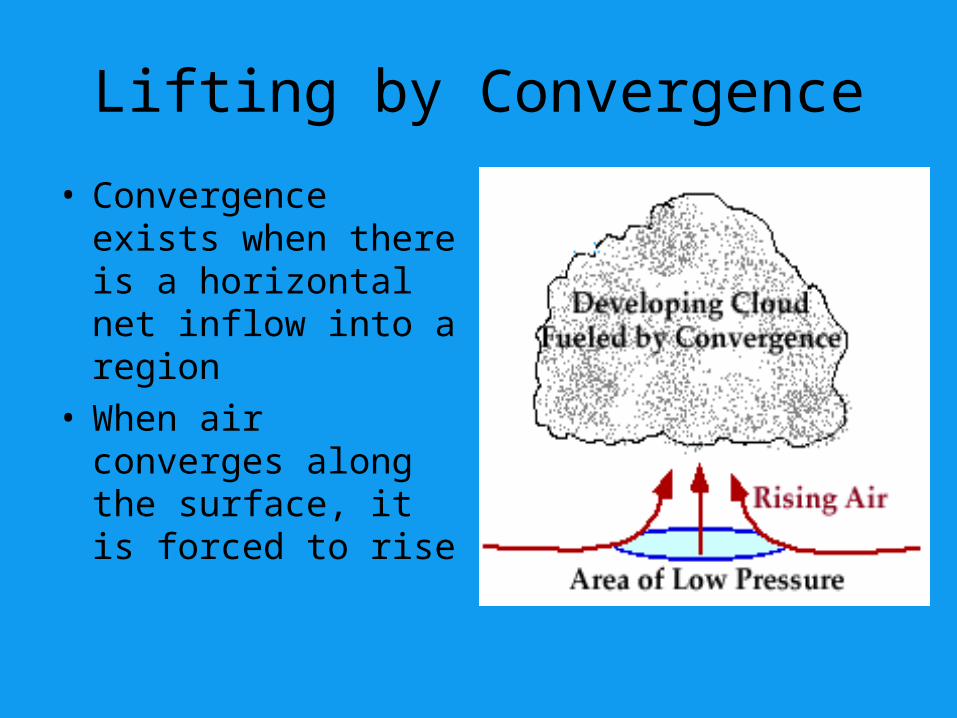
Lifting by Convergence
• Convergence exists when there is a horizontal net inflow into a region
• When air converges along the surface, it is forced to rise

Lifting by Convergence
• Large scale convergence can lift air hundreds of kilometers across
• Vertical motions associated with convergence are generally much weaker than ones due to convection
• Generally, clouds developed by convergence are less vertically developed


![RocksDB and MongoRocks - Percona · PDF filefile format (data block) aaaaaaa : val aaaaaab : val aaaaaac : val aabaaaa : val aabaaax : val aaaaaaa : val [6]b : val [6]c : val [2]baaaa](https://img.pdfslide.us/doc/110x75/5a78a2407f8b9a87198e3d9a/rocksdb-and-mongorocks-percona-format-data-block-aaaaaaa-val-aaaaaab-val.jpg)