Embed Size (px)
Citation preview
Modern Studies of Coastal Erosion in Wisconsin

Modern Studies of Coastal Erosion in Wisconsin - 2011 i
MODERN STUDIES
OF COASTAL EROSION IN
WISCONSIN
Philip Keillor, P.E., Coastal Engineer – is the primary author of this report. Alan R. Lulloff, P.E. editor
ii Modern Studies of Coastal Erosion in Wisconsin - 2011
Acknowledgements The report was prepared under the direction of the Wisconsin Natural Hazards Work Group.
Kate Angel, chair – WI Coastal Management Program, WI Department of Administration Kate Barrett – GIS Analyst, Office of the Great Lakes, WI Department of Natural Resources Susan Boldt – Planning Analyst, WI Emergency Management Gene Clark – Coastal Engineering Specialist, University of Wisconsin Sea Grant Institute David Hart – Coastal GIS Specialist, University of Wisconsin Sea Grant Institute David Mickelson – University of Wisconsin ‐ Madison Chin Wu – University of Wisconsin ‐ Madison
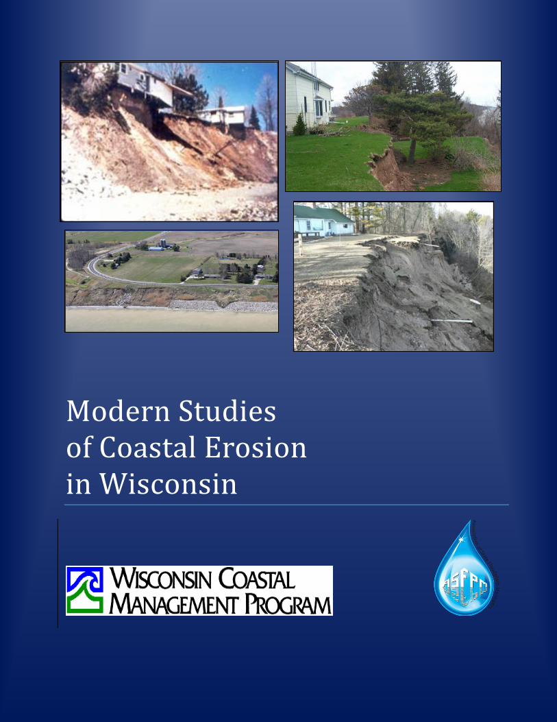
THE FOLLOWING INDIVIDUALS PROVIDED HELPFUL COMMENTS ON THE FINAL DRAFT OF THIS PUBLICATION: Kate Angel, Program and Planning Analyst, Wisconsin Coastal Management Program, Kate Barrett, Geographic Information Systems Analyst, Office of the Great Lakes, WI Department of Natural Resources, Gene Clark, Coastal Engineering Specialist, University of Wisconsin Sea Grant Institute, Tuncer Edil, Soils Engineer, University of Wisconsin‐Madison, David Hart, Coastal Geographic Information Systems Specialist, University of Wisconsin Sea Grant Institute and David Mickelson, Senior Scientist and Emeritus Professor, Quaternary and Glacial Geology, University of Wisconsin‐Madison. Cover Photos – clockwise from top left: Ozaukee County – 1987 photo source: Wisconsin DNR Sheboygan County – 2011 photo source – Matt Mrochinski, Sheboygan County Ozaukee County – 2002 photo source – Alan Lulloff County LS Sheboygan County – 2011 photo source – US Army Corps of Eng.
Acknowledgement
FUNDED IN PART BY THE WISCONSIN COASTAL MANAGEMENT PROGRAM. Financial assistance for this project was provided by the Coastal Zone Management Act of 1972, as amended, administered by the Office of Ocean and Coastal Resource Management, National Oceanic and Atmospheric Administration pursuant to Grant #NA17OZ2357 and the WISCONSIN COASTAL MANAGEMENT PROGRAM. THE WISCONSIN COASTAL MANAGEMENT PROGRAM, part of the Wisconsin Department of Administration, and overseen by the WISCONSIN COASTAL MANAGEMENT COUNCIL, was established in 1978 to preserve, protect and manage the resources of the Lake Michigan and Lake Superior coastline for this and future generations.
©2011 by the Association of State Floodplain Managers. Reproduction of this publication for educational or other non‐commercial purposes is authorized without prior written permission from the copyright holder provided the source is fully acknowledged. Reproduction of this publication for resale or other commercial purposes is prohibited without prior written permission of the copyright holder.
Modern Studies of Coastal Erosion in Wisconsin - 2011 iii
Table of Contents Acknowledgements ...................................................................................................................................... ii Table of Contents ......................................................................................................................................... iii Introduction .................................................................................................................................................. 1 SHORE EROSION STUDIES ............................................................................................................................. 2
1930s ................................................................................................................................................ 2 1940s ................................................................................................................................................ 2 1950s ................................................................................................................................................ 3 1960s ................................................................................................................................................ 4 1970s ................................................................................................................................................ 4
Legal Issues Relating to Wisconsin’s Great Lakes Shorelines and Shore Erosion ............... 9 The Coastwatchers of Racine County, Wisconsin: 1978 – 1982 ......................................... 9 Erosion Hazard Area Maps ............................................................................................... 10 Stability of Wisconsin’s Coastal Slopes ............................................................................. 10 Statistical Analysis of Erosion on Minnesota’s and Wisconsin’s Lake Superior: 1930s ‐ 1975 .................................................................................................................................. 11
1980s .............................................................................................................................................. 12 1990s .............................................................................................................................................. 16 2000 – 2007 ................................................................................................................................... 23
INFORMATION ON NEAR SHORE LAKEBED AREAS ..................................................................................... 25 Racine County Bathymetry: 1872 ‐ 1949 ....................................................................................... 25 Kenosha County Bathymetry: 1872 – 1953 ................................................................................... 25 Bathymetric Mapping by Federal Agencies in the 1980s .............................................................. 26 A Few Profiles of the Racine County Lakebed in 1982 .................................................................. 26 Comparison of Nearshore Profiles in Northern Milwaukee County: 1872, 1912, 1944, 1986 ...... 26 Lakebed Profiles in Three Coastal Neighborhoods on Lake Michigan and Green Bay: 1990‐199227
SHORE STABILIZATION AND PROTECTION .................................................................................................. 28 BACKGROUND ................................................................................................................................ 28 SOME WISCONSIN STUDIES OF SHORE STABILIZATION ................................................................ 28
1930s ................................................................................................................................ 28 1940s ................................................................................................................................ 28 1950s ................................................................................................................................ 29 1960s ................................................................................................................................ 30 1970s ................................................................................................................................ 30 1980s ................................................................................................................................ 31 1990s ................................................................................................................................ 34 2000 to 2007 ..................................................................................................................... 35
EXTENT OF DEVELOPMENT AND ECONOMIC VALUE OF SHORELINE PROPERTY ....................................... 37 Inventory of Shoreland Development: 1967 ‐ 1992 ...................................................................... 37 Economic Value of Shoreland Property ......................................................................................... 37
References .................................................................................................................................................. 38

This Page Intentionally Left Blank
Modern Studies of Coastal Erosion in Wisconsin - 2011 1
Introduction There has been scientific interest in Wisconsin’s Great Lakes shorelines since before settlement. Observations of explorer/naturalists were written and preserved in diaries. Observations of surveyors have been preserved in original survey notebooks written prior to settlement. Scientific observations have been preserved in numerous bulletins, monographs, and scientific papers published since settlement. A sampling of this work can be found in The Physical Geography of Wisconsin, particularly the chapters on the Wisconsin coasts of Lake Michigan and Lake Superior (Martin 1916). Much of this literature may be accessed through the State Historical Society. The federal General Land Office conducted the Original Land Survey of Wisconsin between 1833 and 1866. Original survey notebooks containing measurements of bluff edge distance from section lines and “meander lines” tracing bluff and bank edges from section to section, are available at the Wisconsin Board of Commissioners of Public Lands. The U.S. Army Engineers’ Lake Survey came through the Great Lakes and surveyed the shorelines of Wisconsin before settlement. This early map collection has been preserved in the American Geographical Society Map Collection in the U.W.‐ Milwaukee Golda Meir Library. The U.S. Geological Survey archives and the U.W.‐Madison’s Arthur H. Robinson Map Library preserve additional records of past interest in Wisconsin’s Great Lakes coasts. The following review of modern coastal erosion studies is believed to contain most of the publicly‐funded coastal erosion and shore protection studies done in Wisconsin from 1930 to the present time. This review is covered in chronological order; first for coastal slopes, then for the near shore lakebed, followed by shore protection studies. These studies, large and small, are representative of the work that has been done to understand and deal with coastal erosion in Wisconsin. Coastal erosion is a highly variable and significant process on the coasts of Wisconsin. Average annual recession rates measured over half a decade to multiple decades range from undetectable erosion to 10 – 17 feet per year. Single extreme precipitation events and storm wave events can sometimes bring sudden losses of 100 feet or more of bluff top land. The modern studies of Wisconsin’s coastal erosion have concentrated on the visible erosion of coastal slopes, not the dynamic changes of beaches nor the erosion of the near shore lakebed. The severity of coastal erosion in Wisconsin depends largely upon the soil properties, site conditions, and soil conditions. Important, visible site conditions include gullies, bare slopes, and slump blocks of intact pieces of the land slowly moving down slope towards the lake. Soil conditions include evidence of surface water running over slope faces to the lake, groundwater seeping from slope faces, and trees fallen or leaning lakeward. Soil properties, soil conditions, and the variability over time of groundwater elevations within slopes are not always visible and require drilling, sampling, and monitoring by geotechnical engineers or hydrogeologists. The severity of coastal erosion partly depends upon the presence or absence of invisible natural shore protection (rocky or sandy underwater ridges, reefs, shoals or bars and gentle, broad, shallow underwater slopes near the shore).
2 Modern Studies of Coastal Erosion in Wisconsin - 2011
SHORE EROSION STUDIES Shore erosion was apparently not a problem for Native Americans prior to European settlement; dwellings and other structures were easily relocated. Shore erosion became a problem where settlers built structures that were threatened or destroyed by this natural process. Wisconsin’s coastal cities, towns and villages developed at river mouths where the coastal land was relatively low. In some places like Milwaukee, the lakebed was filled in front of coastal bluffs and breakwaters were built to create harbors, providing erosion protection for nearby shorelines. The federal General Land Office conducted the original survey of Wisconsin between 1832 and 1866. Surveyors ‐ working through what is now the State of Wisconsin ‐ mapped Great Lakes shorelines and section lines. Scans of the surveyor’s notebooks are available at the Wisconsin Board of Commissions of Public Lands. This information still provides the primary baseline from which historic erosion can be measured at section corners near the coast.
1930s The 1930s inaugurated the era of aerial photography. These photos provide another baseline from which historic erosion can be measured using photogrammetry. Unfortunately, the purpose of such photography was primarily to show urban, forest, and agricultural land cover. Consequently, many coastal aerial photos not taken for the purpose of measuring erosion show the shoreline on the periphery of the photos; resulting in distorted distances and major errors in measuring shoreline or bluff edge changes. Shoreline erosion is mentioned in site‐specific studies related to development or to solving an erosion problem. Whitney (1936) described a detailed engineering investigation of a solution to a major bluff settlement on five lots in the developing Village of Whitefish Bay. One day in March 1927, a vertical crack was discovered in the lawn about 20 feet back from the edge of the bluff. Within a few days the crack was 300 feet long. Settling of the lakeward portion of the lawn proceeded at several inches to six inches per day, accelerating within 24 hours after a heavy rain. The crack continued to extend in length until it was over half a mile long. By April 20 the top of the bluff had settled 12 feet. Shortly after the crack first appeared, a “longitudinal extrusion of compressed clay formed about half way down the bluff, accompanied by longitudinal surface cracks and tipping of trees along the line. The lower bank and the beach itself were moving eastward.” (Whitney, 1936, page 309).
1940s In December 1943, the Milwaukee County Board of Supervisors appointed a 13 member Committee on Lake Michigan Shore Erosion. Three months later, the committee asked the County to request a shore erosion study from the U.S. Army Corps of Engineers’ Beach Erosion Board. The Board did this study in 1944 and 1945 with assistance from the Milwaukee County Planning Department and municipal engineers in coastal communities of the County. The Beach Erosion Board report summarized recession for 105 years; from 1836 to 1941 (USACE 1945). The Milwaukee Committee report documented total and annual average recession of the top of county bluffs at 21 road end locations including north and south county lines for the following periods: 1836 – 1874, 1874 – 1944. They also calculated total and
Modern Studies of Coastal Erosion in Wisconsin - 2011 3
average annual recession for the entire 108 year period. The following quotes from the Milwaukee Committee report (Milwaukee County Committee, 1945) seem relevant today: “There is very little width of beach at the base of the bluff, except where protective structures have created or maintained a beach and for the most part, except for the protected places, erosion of the bank is continuing today, accelerated in many places to a danger point during periods of high water…. During the time that records have been kept of shoreline changes, the average recession of Milwaukee County shore line has varied from practically nothing in certain places to approximately 3.5 feet per year in others.” (pages 6 and 7) “In many places along the lake front sand deposits are water‐bearing and become unstable when supersaturated with ground water, resulting in slides…. The action of the waves causes erosion at the toe of the slope, leaving the bank in an unstable condition and inviting slides that are often extensive in volume, involving thousands of yards of earth…. These slides usually occur where erosion has removed the support at the toe of the slope and the bank is supersaturated with groundwater….” (pages 7 and 8) “…the general narrowness of the natural beaches along the shore attest to the relatively meager supply of sand and gravel available for beaches in Milwaukee County. Only a small percentage of the material that is removed from the banks by wave action is of the size found on the beaches, most of the material apparently being so fine that it is held in suspension as silt and deposited out in the lake, thus lost to the beaches…. The littoral drift along the Milwaukee County shore line is from north to south, with a resulting tendency to accumulate sand to the north of any structure extending into the lake and to deplete the beach to the south of such structure by cutting off the littoral movement…. There appears to be another movement of beach material worthy of note that occurs during storms when the beach is swept practically bare of sand and restored by a few days of calm, gentle wave action.” (pages 17 and 18) Another of the Milwaukee Committee’s conclusions: “Where very wet conditions occur in the banks, excessive slides often follow, and attention to drainage should not be overlooked.” (page 30)
1950s Erosion of Racine County: 1836 ‐ 1946 In this 1951 study, the Corps of Engineers established a base line of referenced markers and measured an average of four profiles per mile of shore from Wind Point southward, typically from 50 feet landward of the bluff edge offshore to the 12‐foot depth contour. The Milwaukee District of the Corps of Engineers used survey records of bluff edge “meander lines” and surveyed measurements of bluff edge to section corners to compute the recession for the 38 years between 1836 and 1874, the 72 years between 1874 and 1946, and the 110 years between 1836 and 1946 (USACE 1952). This information was republished in DeGroot and Keillor (1977). Meander lines surveyed with compass and measuring line provide rough but useful approximations of the bluff edge location at the time of survey. Bluff materials surveyed north of Wind Point indicated that only about 10 percent of the bluff soils were sufficiently coarse to nourish beaches (pages 5 and 6). In general, county beaches were narrow, except for North Beach (north of the harbor breakwater) which measured about 450 feet wide. Observations of impounded beach deposits indicated that littoral drift of sediments is generally from north to south with occasional reversals (page 11).
4 Modern Studies of Coastal Erosion in Wisconsin - 2011
Erosion of Kenosha County: 1836 ‐ 1953 In this study, the Corps of Engineers established a base line of referenced markers and measured an average of four profiles per mile of shore, typically from 50 feet landward of the bluff edge offshore to the 20‐foot depth contour. Long‐term, average annual recession rates at coastal section lines were published for the periods of 1836 – 1872, 1872‐1953, 1836‐1953 (USACE 1954, page A‐4). Kenosha County has clay bluffs north of the harbor with typically only seven percent of the soil coarse enough to build beaches. South of the harbor, sandy banks and bluffs contain 90 percent or more of material coarse enough to build beaches. Bluff recession averaged about two feet per year north of the harbor and four feet per year south of the harbor between 1872 and 1953 (page 12). Erosion of the Red Clay Bluffs of Lake Superior Beginning in 1954, Wisconsin’s unfunded Red Clay Interagency Committee addressed concerns and problems with streambank and lakeshore erosion in the red clay soil areas of Wisconsin’s Lake Superior shores. The concerns were eventually perceived to be: 1) detrimental effects of turbidity and sedimentation on Lake Superior and its harbors, 2) maintenance of roadways, shoreland and streambank property values jeopardized by erosion, 3) adverse effects of turbidity and sedimentation on fish populations in coastal streams and in Lake Superior, 4) adverse effects on aesthetics and recreational development from turbid waters and unsightly hillsides, stream banks, coastal slopes and road banks marred by erosion (Red Clay Committee 1972). The committee filed a report in 1957. The report did not consider environmental impacts of red clay.
1960s Mid‐decade brought record low water levels to the Great Lakes and much greater development of shoreline property for recreational and residential homes. The U.S. Army Corps of Engineers published their shoreline inventory report for the Great Lakes; part of the National Shoreline Study (USACE 1964). The report provided a general description of Wisconsin’s coasts. In 1960, 1964 and 1967, the Red Clay Interagency Committee wrote progress reports on the problems of erosion and sedimentation on Wisconsin’s Lake Superior coast (Red Clay Committee 1972). These reports did not consider soil creep, nor the possible environmental effects of red clay erosion on the lake. Striegl (1968) has been credited for one of the few quantitative evaluations of shore bluff recession for the Lake Michigan coastline. For the period 1874‐1946, he calculated the recession rate for Racine County to be approximately 1.2 feet per year”(Pezzetta and Moore 1976). Striegl’s report was not reviewed for this report.
1970s The early 1970s were years of lake levels rising to set new records ‐ not to be exceeded until 1985 and 1986. It was also a time when public controversy and a court case over the dumping of taconite tailings at Silver Bay, Minnesota led to company‐funded studies and stimulated other studies of the comparative contributions of erosion and taconite processing to the sedimentation of western Lake Superior (Red Clay Committee 1972, Hess 1973).
Modern Studies of Coastal Erosion in Wisconsin - 2011 5
1972 Report on the Red Clay Bluffs of Wisconsin’s Lake Superior Coast The committee considered excessive erosion and sedimentation “the number one problem in the northwestern red clay area of Wisconsin (Red Clay Committee, 1972). They had this perspective on the troublesome red clays: “The clay is plastic when wet…. Unprotected red clay soils are unstable, highly erodible and subject to slippage particularly along stream and lakeshore banks, roads and field gullies…. The red clay area is geologically young with soil erosion processes still occurring naturally at a rapid rate. These become accelerated wherever and whenever steep slopes become bare due to natural or man‐made causes. The levels of erosion and resulting sedimentation in the streams can be classified as ‘accelerated’ following catastrophic floods, and ‘continuing’ during normally flow. Abnormally heavy rains periodically cause accelerated erosion on exposed red clay soils. …forest cover alone is not the answer to adequate erosion control. Deep gullies were formed long before axe or saw touched a tree on these red clay soils.” (pages i and ii) Some idea of the instability of stream slopes is indicated by the example of Whittlesey Creek; a trout stream up to the mid‐1940s. After two severe storms in 1940 and 1946, catastrophic erosion changed the creek into a “relatively dry stream bed.” (page 50) They identified the clays as “Pleistocene red clays” and “Valders clay”. (page 51) The Red Clay Committee (1972) recommended that shoreline recession rates be determined, that a network of iron rods be established as benchmarks at sites vulnerable to erosion, and that periodically (every one to five years) aerial photographs be taken, and benchmarks be surveyed with respect to the moving shore to determine the “exact locations and extent of shoreline and gully erosion.” (page 22) The benchmark network and regular periodic surveys of erosion were never carried out. The Red Clay Committee (1972) identified aerial photo sources. The entire 156 mile shoreline had been photographed by the U.S. Geological Survey in 1959 and by the Wisconsin Department of Transportation in 1968. They also mentioned aerial photos taken by the U.S. Department of Agriculture of entire coastal counties, but no dates were mentioned. Shoreline Erosion on Wisconsin’s Lake Superior Coast: 1852 – 1966 Hess (1973) made measurements of changes in shoreline position from maps, plat sheets from the first land survey in 1852, and aerial photographs (post‐1938) for Wisconsin’s Lake Superior coast from the Superior Entry on Wisconsin Point a little more than 50 miles along the shore to Bark Point (a few miles west of Cornucopia). Shoreline, back beach, and bank edge distances from section lines were measured with a microscope on a glass scale and spaced about 1,000 feet apart. The changes in shoreline position were measured for two time periods: the 114 years from 1852 to 1966 and 28 years covered by available aerial photography: 1938‐1966. This report provides an approximation of long‐term recession in the study area to the mid‐1960s. The reach of Lake Superior coast studied by Hess contains a major part of the red clay area of the coast. “The red clay materials are known to be unstable, highly erodable, and subject to slippage along streams and lakeshore banks” (Hess, page 7 and 9, quoting the Red Clay Project report ‐Red Clay Committee, 1972). The instability of the red clay on slopes of Douglas and western Bayfield counties has in recent years been identified by geotechnical engineers as “soil creep”. Soil creep has for many years created serious slope stability problems for highway engineers in the area, but remained unexamined during the 1977 shore erosion study and during several subsequent slope stability studies.
6 Modern Studies of Coastal Erosion in Wisconsin - 2011
Sinuosity and Variability of Coastal Slope Soils Pezzetta and Moore (1976) reported on three of 15 coastal sites selected for monitoring bluff recession rates. These authors provided detailed information about the three study sites and erosion measured in 1975 and 1976. They measured a major slump failure at the Port Washington site where a seven feet thick segment of bluff failed between the summer and fall of 1975, followed by a 17 feet thick slump during the late fall and winter of 1976. Pizzetta and Moore introduced a “sinuosity factor, S” as a measure of shoreline geometry. S = actual length of the bluff edge between two points on the bluff edge length of a straight line between the same two points on the bluff edge “The sinuosity factor offers a numerical means for representing the general configuration of the bluff crest with time. Therefore, S indicates the degree of irregularity or smoothness of the crestline at the monitoring sites.” (page 19) The limiting value of S is unity, for a straight bluff edge. “The sinuosity also offers an indirect means for assessing the nature and intensity of erosional processes and the changes in composition of the shoreland materials as the banks recede…. The higher rates of erosion which occur within the cusps of an irregular crestline must in turn be related to the compositional properties and stability conditions of the bluff materials at that point. A highly irregular mode of bluff slumping may be due to till deposits of considerable variation in composition.” (page 20) Hadley (1976) wrote a public information booklet describing the processes that cause shoreline erosion along Wisconsin’s southeastern coast of Lake Michigan. Wisconsin Shore Erosion Study in 1976 The most extensive study of coastal erosion in Wisconsin was undertaken to obtain information at two levels of detail for two different groups of users. General shoreline descriptions and types of bluff were provided in a 199 page Technical Report as a reach‐by‐reach, general description of the Wisconsin shoreline from the Illinois border to Manitowoc (WCMP 1977). More detailed information about critical erosion areas in each county were gathered for engineers and planners. “Critical erosion areas are defined as areas in which property of unusual cultural, economic or scientific value is in danger of being damaged or destroyed through the processes of coastal erosion. For the purposes of this study a quantitative working definition of erosion problem areas was developed so that the resources of the study could be directed toward the most serious erosion problem areas. The criteria of this definition included; (1) public perception, (2) shore recession rates, (3) shore damages, (4) protective structures, (5) bluff height and (6) shore development.”(WCMP 1977 Technical Report, page 3) The more detailed information for engineers and planners carried the caveat that site‐specific information was not available for all locations within the critical areas. On‐site investigations would be needed for most shoreline development projects. This information was spelled out in nine separate volumes of Appendices (WCMP 1977, 1980). Measurements of long‐term and short‐term shoreline erosion (recession) were made and used to help identify critical erosion areas. Estimates of “long‐term” recession rates were based on a variety of data sources, including original survey maps. Short‐term
Modern Studies of Coastal Erosion in Wisconsin - 2011 7
recession rates over the previous 10 years were determined by making measurements on aerial photos of the coasts taken over the previous 10 to 15 years. The most extensive field survey of coastal erosion in Wisconsin was undertaken in 1976 along selected reaches of the state’s Lake Michigan and Lake Superior coasts. The field work included collection and analysis of soil samples from just 20 geotechnical bore holes in six of the state’s 15 coastal counties; northern Kenosha (1), Racine (3), central and southern Milwaukee (4), southern Ozaukee (2), northern Sheboygan (4), central and southern Manitowoc (4). Data from these bore holes was published as a separate appendix (Appendix 8). Twenty‐seven reaches of varying lengths were described (one or two pages per reach) in the Technical Report (WCMP 1977) for the Lake Michigan coast of Wisconsin from the Illinois border through Carol Beach to the northern jetty of Manitowoc Harbor. Appropriate coastal portions of WisDOT road maps (with the reach boundaries marked), and sketches of the hypothesized and generalized long shore structure of bluff soils (stratigraphy) are interspersed with the text. Thirty‐four reaches of varying lengths were selected for the Lake Superior coast of Wisconsin from the tip of Wisconsin Point on the Minnesota‐Wisconsin border to the mouth of the Montreal River on the Wisconsin‐Michigan border. The reach boundaries are shown on coastal portions of WisDOT road maps. The Technical Report does not show long shore stratigraphic sections for the Lake Superior shore. Unfortunately, the review copy of the Technical Report (WCMP 1977) contains textual descriptions for only 13 of the 34 reaches on Lake Superior: 1 through 9, 22D (not shown on a map), 27, 28 and 33. Appendix 9 contains more detailed information but only for reaches 1 through 5 from the tip of Wisconsin Point to Bark Bay in western Bayfield County. An example of the appendices is Appendix 2 for Racine County (and a portion of southern Milwaukee County). A coastal portion of a WisDOT road map shows boundaries of reaches and locations of bore holes for geotechnical investigation. Descriptions of four shoreline reaches cover the county’s shoreline. For each reach there is a description of the boundaries, a narrative of the shore land including apparent materials in bluff/bank soils, a mention of shore protection structures, a description of the beach (if any), and a description of bluff stability and locations of bluff failure and fill. For each reach there is a sketch of a generalized long shore section of likely soil structure (stratigraphy). Some sections‐long stretches of coast are blank; indicating that the stratigraphy is unknown. There is also a map showing long‐term (approximately 100 year) recession rates, short‐term (approximately 10 year) recession rates, shore height, and locations of shore protection structures. Recession rates are given as representative for roughly one half to one mile of coast. Also shown is an indication of the public perception of erosion hazards, the number of houses per mile, and boat ramps. Additional maps and tables show safety factors computed from slope stability analyses, the confidence level in the data, and tabulated information about the bluff slope, toe of the bluff, and the beach. Cross sections of selected slope profiles show the results of slope stability analyses, the nature of slope failure and the locations of observed seeps. Locations of slope stability analyses could be identified to the nearest city block by comparing the shape of street layouts on appendices maps to current layouts of streets. In some cases, such locations can be identified with specific buildings or other structures on the coast. Appendix 8 contains detailed locations of bore holes and a description of the soil layers in each bore hole.

8 Modern Studies of Coastal Erosion in Wisconsin - 2011
Caution (from Chapter III, page 1 of BLRPC 1996): “In the earlier 1977 study (WCMP 1977), a number of sections were mis‐identified. These errors have been corrected in the 1996 report. The section numbers used in the report to identify geographical locations are not in error and will stay the same. However, the township and range for selected sections were misidentified. These previous errors do not adversely affect the data in this (1996) report.” The errors remained uncorrected in the 1977 shore erosion study report appendices and may have been reproduced with the recession rate information re‐published as Appendix 1 in the first edition of the Coastal Processes Manual (Keillor and Miller 1987). Appendix 9 for the Lake Superior coast (WCMP, 1980) is unlike the other appendices in several ways. First, there are no section‐by‐section recession rates and slope stability safety factors shown on maps for each reach. There are two untitled and barely legible maps of the state’s Lake Superior shoreline from Wisconsin Point in Douglas County to Sand Point in Bayfield County (pages 9 and 10) showing average annual recession rates from 1938‐1966, 1966‐1975, and 1938‐1975. The sources of this information are not given on the maps nor mentioned in the document, but look like results from Hess (1973). “All of the shoreline recession measurements were done under the direction of Mr. Charles Hess….” (WCMP 1977 Technical Report, page 7) The long‐term recession rate information was extracted from these maps by careful comparisons with county maps and published by county, township, range and section in the Keillor and Miller (1987). The Technical Report (WCMP 1977) contains an important cautionary statement: “There are a number of assumptions that have been made in analyzing the bluffs along the shoreline that require a certain amount of caution in assessing the absolute reliability of the engineering judgments made. All of the engineering properties have been averaged, assumed homogenous and consistent throughout any given stratum and the stratigraphy has been assumed horizontal and continuous. These conditions may prevail at a particular site, but may be drastically different from those in the near vicinity. Thus, the extrapolation of data is precarious, and the assignment of Unsafe or Safe slope designations must be viewed with a certain degree of skepticism. These extrapolations are to be used as a guideline or an indication of general conditions along the shoreline, but should not exclude detailed geotechnical subsurface investigations at any particular site to assess its slope stability. It should also be mentioned that these Safety Factors do not indicate large, dramatic failures, but consecutive failures of a smaller extent, thus the term “Unsafe” does not mean a catastrophic landslide always, but rather a high probability of subsequent erosion by mass wasting. Finally, the methods used in analyzing the stability of the slopes do not account for surface sloughing, solifluction, mass flows, slope wash, or wave erosion which must also be considered in determining the ultimate stability of the slope, or the ultimate rate of retreat of the bluff toe.” (page 24) Recent Recession in Racine County: 1968‐1976 Keillor and DeGroot (1978) wrote a two‐volume study of recent recession rates in Racine County for the periods of 1968 – 1976, 1969 – 1976, 1970 – 1976, with the time span dependent on dates that aerial photos were taken for various sections of the county’s coast. Measurements were made using a 40 power microscope and scale (similar to Hess’ method) on stable polyester topographic maps made for Racine County from aerial photos. Measurement intervals were 200 feet for a severely eroding portion of one county section, and 500 feet for the rest of the county. The change in position of the bluff edge, bluff toe, and shoreline were measured relative to a reference line. The greatest recession rates were in northern sections of the county. In one very actively‐eroding area within Section 6, the maximum average annual recession rate was 20 feet per year. Sections 6 and 8 had an average measured recession rate of 5.8 feet per year (+/‐ 0.3‐0.5 feet per year) between 1968 and 1976. The report contained an
Modern Studies of Coastal Erosion in Wisconsin - 2011 9
estimate of measurement error; a rare feature in Wisconsin coastal erosion studies. The maximum possible error in calculating recession rate (in the case of a short 4.3 year time interval) was plus or minus 0.8 feet per year. Higher recession rates in the northern part of the county were also attributed to higher, more unstable bluffs, a perched water table, and a lack of structural shore protection structures. Keillor and DeGroot compared their measurements of recent recession to those made previously by the Army Corps of Engineers (USACE 1952): “The highest recent bluff recession rates in Racine County approached the 16 – 16.5 feet per year recession rates measured at two locations prior to 1870. Six of nine measurement sites (compared) had lower recent recession rates than 110 year average recession rates, in spite of recent record high water levels.” The unpublished, but still available, report (in two parts) contains enough information to replicate measurements on more recent rectilinearized topographic maps.
Legal Issues Relating to Wisconsin’s Great Lakes Shorelines and Shore Erosion In the 1970s, WCMP and WDNR funded and published studies on determining the Ordinary High Water Mark (OHWM) in Wisconsin (Weinberg and Neuman, 1976), delineating or identifying Great Lakes shorelines (Butler and Epstein 1977) and the feasibility of obtaining compensation for shore erosion on one’s property caused by the actions of others (Butler et al 1978).
The Coastwatchers of Racine County, Wisconsin: 1978 – 1982 In July 1978, Racine County began a project funded by WCMP. Some volunteers were trained to observe, photograph and measure slope failures on a weekly basis at nine sites spanning the 14 miles of the county’s Lake Michigan coast. Other volunteers were trained to estimate breaking wave heights, directions of wave approach and wave periods in daily observations at five locations. Data gathering began in September 1978 and continued for nearly four years through June 1982 (Racine County, 1982). Wind and precipitation data from the Milwaukee Airport were used with the wave observations in data analysis to identify storm events and rainfall. The budget did not allow for groundwater monitoring. Wave observations over four years at the five locations showed differences in wave characteristics between stations. The northern reaches of the county face northeast and east, separated by Wind Point from the southern reaches of the county that face southeast and east. Data from any one station could not represent the nearshore wave climate of Racine County. Analysis of data showed the sheltering influence of Wind Point and the influence of nearshore bathymetry on large, shoaling storm waves; making their approach nearly perpendicular to shore through wave refraction (Racine County, 1982). During the four years, there were more days with observed storm waves (four feet or more in height) in February, March, October and November than during the other eight months of the year. During the 1980 – 1982 period, Coastwatchers paid close attention to water seeps and mud flows; evidence that bluffs had elevated groundwater levels. There was considerable evidence of seeps and mud flows during the spring and fall seasons when there was a lot of slumping activity. Mud flows appeared to be directly related to heavy precipitation. Mud flows persisted and water continued flowing from seep veins for one to two weeks following rainfalls greater than half an inch. These flows continued for up to a month following heavy rains exceeding one inch per day at the Milwaukee Airport (Racine County 1982). There were many occasions when substantial slumping activity occurred in the absence of heavy rainfall events and storm wave events. Bluff slumping activity appeared to be more closely related to the presence of temporarily perched (elevated) water tables than to heavy rainfall and
10 Modern Studies of Coastal Erosion in Wisconsin - 2011
storm wave events (Keillor and Gruning 1984). The work of Sterrett (1980) on the relationship between slope failure and groundwater elevation in nearby southern Milwaukee County and the research of Vallejo (1977), and others was helpful and influential with the Coastwatchers. Two Coastwatch sites in northern Racine County were located on undeveloped state, federal, and county owned land and continually experienced major bluff failures with recession ranging from six to 14 feet per year. Here, Coastwatchers observed three types of bluff failure: bluff top retreat, mid‐bluff collapse, and toe erosion. Slope failures usually occurred in this sequence: toe erosion, followed by bluff top retreat, followed by mid‐bluff collapse (Racine County 1982). The sequence differed from the slope evolution pattern observed at Kewaunee and Port Washington sites documented by Edil and Vallejo (1976). Along almost all of the Racine County coast, the bases of coastal bluffs were exposed to intermittent wave attack because there was little or no beach ‐ except for the occasional and temporary piles of material deposited by slope failures.
Erosion Hazard Area Maps In 1979, the UW‐Extension Geological and Natural History Survey prepared erosion hazard area maps for the following coastal counties: Kenosha, Racine, Milwaukee, Ozaukee, Sheboygan, Manitowoc, Kewaunee, Door, Brown, Ashland, Iron, Bayfield, Douglas. Erosion hazard area maps were not published for Oconto and Marinette counties. The coastal maps had Great Lakes shorelines color coded for one of two erosion potentials: High erosion potential: “Areas prone to more rapid erosion due to the presence of several risk factors, e.g. high bluffs, unvegetated slopes, ground water seepage, low, erodible sand plains.” Low to moderate erosion potential: “Shoreland areas periodically subject to the erosive actions of waves and/or bluff failure processes.” Shoreline was also marked that was protected by shore protection structures along with the caveat that such structures do not guarantee long‐term protection. The network of sections and roads printed on the maps allowed the erosion potential to be identified down to the quarter section. For undeveloped land, the reader was cautioned: “Along high bluffs and erodible sand plains, Wisconsin’s 75‐foot minimum coastal setback does not offer adequate protection. In some cases, greater setbacks may be necessary.” The 1979 erosion hazard area maps are outdated. Much more of the state’s coast has shore protection structures of undetermined quality and effectiveness. Some of the shore labeled “high erosion potential” or “low to moderate erosion potential” on the Lake Michigan coast may have a different erosion potential today. Stocks of the erosion hazard area maps are becoming depleted. Wisconsin Sea Grant had a few complete sets.
Stability of Wisconsin’s Coastal Slopes Vallejo and Edil (1979) published their paper summarizing the strength parameters and stable slope angles of selected Wisconsin coastal slopes under selected groundwater and slope soil weathering conditions. The paper included properties of 12 soil units on the Lake Michigan coast and two coastal slope sites on Lake Superior at Madigan Beach, Iron County. The paper did not include engineering properties of coastal slopes in Douglas, Bayfield and Ashland counties, some of which were published
Modern Studies of Coastal Erosion in Wisconsin - 2011 11
the next year in the thesis of Need (1980). Also in 1980, a companion paper by Edil and Vallejo (1980) showed how bluff height, groundwater elevation and effective friction angle affected the ultimate angle of slope stability. The number of samples used to test the properties reported by Vallejo and Edil (1979) is not given. A majority of the Lake Michigan soil units tested were tested as part of Vallejo’s PhD thesis (Vallejo 1977).
Statistical Analysis of Erosion on Minnesota’s and Wisconsin’s Lake Superior: 1930s ‐ 1975 Using aerial photographs, Johnson and Johnston (1981) measured erosion of coastal slopes at 114 sites along Minnesota’s entire Minnesota north shore between the 1930s and 1975. They did a statistical analysis of recession rates vs. lithology (slope material type), slope steepness, near shore slope (inferred from topographic maps), and direction of exposure to storm winds and waves. They included data from 61 sites along Wisconsin’s coast from Wisconsin Point to 10.7 miles east of Cornucopia, published in WCMP 1977 (Appendix 9). The authors described the Wisconsin shoreline as mostly clay (65 percent) with sand and gravel deposits (mainly at and near stream mouths) along 20 percent of the coast, sandy till along 13 percent of the coast and few bedrock exposures (apparently two percent). They found that the north‐facing clay slopes and sandy/gravelly shores of Wisconsin had significantly higher erosion rates than the south‐facing clay slopes and sandy/gravelly shores of Minnesota. Major storm waves in the western arm of Lake Superior come from the northeast. Their paper makes no mention of “soil creep” in the clay coastal slopes of Minnesota and Wisconsin. Johnson and Johnston (1995) described their recession rate methods, four types of possible errors and estimated a total probable error (TPE) of 0.11 mm. “At a photo scale of 1:24,000 and a time interval of 36 yr, this TPE of 0.11 mm would represent 0.073 m/yr. (0.2 feet per year)” (page 6). They claimed that the same methods were used in WCMP 1977, citing Hess (1973). The large 36 year time allows a 0.11 mm error on the photo measurements (8.7 feet of error on the ground) to be greatly reduced on an annual rate calculation. The authors claimed that errors due to distortions in the photographs were negligible and did not include those errors because “measurements were restricted to photo centers, elevation differences between reference points and the bluff edge were small, and only short distances were being measured.” This reassurance is unconvincing and so is the small error estimate. The authors also stated that “all reference points were chosen from the central two‐thirds (not the centers) of the aerial photos to minimize error due to radial distortion….” (page 5). They do not indicate that all bluff edges also met these criteria to minimize radial distortion. Aerial photo flights in the 1930s were typically flown for purposes of agriculture and forestry, not for measuring erosion. Consequently, shorelines typically occurred on photos anywhere but at or near the centers of the photos. Keillor (1998) cites four references in making a case for a minimum recession rate of one foot per year because of measurement error of as much as + 1 feet per year in making estimates from aerial photographs.
12 Modern Studies of Coastal Erosion in Wisconsin - 2011
1980s Studies of Red Clays on Wisconsin’s Lake Michigan Coast In 1980, a pair of Master’s theses was published; studies of the red clays of Wisconsin’s Lake Superior coast and uplands:
Johnson (1980) studied three clays; the Jardine Creek Till, the Hanson Creek Till and the Douglas Till. He focused on the origins of these clays, made a case for them having been deposited by glaciers and distinguished them from lacustrine clays laid down by sediment deposition at some much higher elevation of the prehistoric lake. He described the engineering properties of the Douglas and Hanson Creek tills related to their glacial origins: overburden pressure, pre‐consolidation pressure, bulk density and over consolidation ratio. He did not give other engineering properties needed to determine slope stabilities. He did not mention “soil creep”.
Need (1980) also wrote about the same three till units, describing their composition, and eight of their engineering properties obtained by testing one to 12 geotechnical samples per till unit. Properties tested included: plasticity index, dry density, standard penetration resistance, over consolidation ratio, effective angle of internal friction and cohesion intercept (Table 1, page 10). Since the focus of the two theses was origins and characteristics of the tills, the values for these properties were not used to estimate soil strength and slope stability. Neither were groundwater elevation or “soil creep” mentioned; they were not aspects of the study.
Recession in Manitowoc County: 1938 – 1978 Peters (1982) made recession measurements of bluff/bank erosion on two portions of the Manitowoc County coast: from the southern county line north to the City of Manitowoc, and from the north end of Point Beach State Forest to the northern county line. Peters compared bluff edges at the same locations on black and white aerial photos from 1938 and 1975 (or 1978) and calculated bluff recession at five to 10 sites per mile of coast. Peters also used original land survey notes from 1834 and 1835 to determine initial bluff edge position with regard to section corners and compared this information to bluff edge positions at section lines on USGS 1:24000 topographic maps published in 1953 and 1978. This information was converted into annual recession rates averaged over more than 100 years. Peters made an error analysis. The following report was not located and reviewed: SEWRPC 1982. Community Assistance Planning Report No. 86. a Lake Michigan Coastal Erosion Management Study for Racine County, Wisconsin. A Massive Slope Failure at Klode Park in 1986 Published documentation of massive, deep‐seated slope failures is rare. “On December 12, 1986 during a severe storm, approximately 240 feet of protective sea wall was completely washed out at the north end of the beach at Klode Park. The missing wall section came within 30 feet of the North Shore Water Commission’s Water Intake Pump Station which serves roughly 40,000 residents in the communities of Fox Point, Glendale and Whitefish Bay. Emergency measures were taken by the commission…. On April 14, 1987, another storm resulted in a mammoth land slide at Klode Park taking a section of bluff 240 feet long by 100 feet wide by 60 feet high out 200 feet into the lake.”(Village of Whitefish Bay 1987)
Modern Studies of Coastal Erosion in Wisconsin - 2011 13
Shoreline Erosion in Northern Milwaukee County: 1963 – 1985 SEWRPC (1987) describes a shoreline erosion management study of 8.3 miles of shoreline along the northern portion of Milwaukee County. Nearly 70 percent of this shore had a narrow beach; 3 m (10 feet) or less in width during field work in 1986 (Edil and Bosscher 1988). Bluff profiles were surveyed and bluff recession rates were measured for the periods of 1963‐1985 and 1978 – 1985. Note: The following report was not located and reviewed in this report: SEWRPC. 1987. Northern Milwaukee County Lake Michigan Shoreline Erosion Management Study. Southeastern Wisconsin Regional Planning Commission, Waukesha, Wisconsin. In its’ place is the following description and review of SEWRPC 1988 which is likely the final report of the study. SEWRPC (1988) is a report of a shoreline erosion management plan that includes information on bluff stability analyses at 36 locations along a 7.3 mile reach of the Lake Michigan shore from Milwaukee’s Linnwood Avenue Water Treatment Plant through the Villages of Shorewood, Whitefish Bay and Fox Point. The sources of soil and groundwater information for the slope stability analyses were provided in the report along with a table locating the bluff profiles and stability analyses by street address of the properties where the stability analyses were made (Tables 22‐24, pages 97‐100). The report includes a graphic for each of the 42 bluff cross‐sections and deterministic slope stability analyses for the 36 locations, or “sections” (pages 105‐139). Some probabilistic slope stability analyses were also made where there was some uncertainty about underlying soil properties and conditions: the report contains four diagrams of these analyses. The SEWRPC (1988) report does not contain appended notes showing the along shore location of each profile on each analyzed property where the bluff profile was made. In 1986, more than half of the northern Milwaukee County shoreline north of the Linnwood Avenue Water Treatment Plant had bluffs that were marginally stable or unstable (SEWRPC 1988, Map 20, page 150). For conditions at the time of slope stability analysis, the potential for rotational and translational sliding and a ranking of slope toe erosion is given for each section of bluff analyzed (Table 29, page 140). A useful and important longitudinal section of bluff soils along the length of the study area is provided (Figure 1, page 13) showing the great long shore variability of soil types. The figure is useful for showing the limitations of “rule of thumb” statements about slope stability, and the necessity for site‐by‐site slope stability analysis throughout the study area. A map of soil boring locations (Map 3, page 14) shows some clustering of sites and shoreline stretches (4,000 – 9,500 feet in length) without boreholes where bluff soil types have to be inferred, or where there are low lakeshore terraces with no bluffs at the shore. Three distinct glacial till units were identified in the exposed faces of northern Milwaukee County bluffs. The exposed till units are: the New Berlin Formation, the Oak Creek Formation, and the Ozaukee Member of the Kewaunee Formation (Ozaukee Till). Unfortunately, the term “formation” is used in the names of rock as well as till units, so care is required in distinguishing between names of rock and till. “Additional glacial deposits are located beneath the lake bed.” (page 10) Not stated: Whether or not these deposits are exposed on the lakebed, and whether or not the New Berlin Formation till (the lowest exposed unit of till in the bluff) is believed to be the till beneath the nearshore lakebed,
14 Modern Studies of Coastal Erosion in Wisconsin - 2011
SEWRPC (1988) contains bluff recession measurements made from aerial photos and topographic maps at intervals of 200 feet (intervals perpendicular to section lines, not to the shore) with the shoreline distance between measurements varying from 200 to 350 feet. Table 18 (pages 80 – 84) provides average annual recession rates for 173 of these intervals (Shoreline Recession Reach) for the periods of 1963 – 1985 and 1978 – 1985. Just five of the intervals also include the long‐term average annual recession rate between 1836 and 1985, using the USACE (1945) data. The entire set of average annual recession rates is plotted in Figure 49 (page 85) showing a remarkably low (less than 0.5 feet per year) recession rate along the northern county coast except for 10 sites where average annual recession averaged 1.0 or 1.5 feet per year. The methods used to make recession rate measurements are described (page 74) but the rates were published without a statement of estimated error. Considering the relatively short 7 and 22 year time spans for the recession measurements, the likely measurement errors are at least +/‐ 0.5 feet per year and may be as large as +/‐ 1.0 feet per year (Keillor, 1998, pages 43 and 44). Therefore, there are few measurements of bluff edge recession in northern Milwaukee County that rise above likely measurement errors. Kewaunee County Property Owners’ Erosion and Flooding Experience and Opinions in the 1980s Drought (1988) described results from responses to a questionnaire mailed out in August 1987; less than a year after the October 1986 record high water levels on Lake Michigan. The answers provide a “snapshot” of coastal property owner experience with and opinions of, coastal hazards at that time. The response percentage was considered acceptable: 133 completed surveys (51%) were returned out of 260 questionnaires mailed to all coastal property owners in the county plus shoreline property owners living along the Ahnapee River within the City of Algoma, and the Kewaunee River within the City of Kewaunee. Fortunately, responses of riverine property owners were distinguished from responses of coastal property owners on many questions (but not on shore protection questions). Here is a sample of coastal property owners’ responses to some of the questions: Question 5. How many feet of shoreline have been lost in the past 3‐4 years? Seventy of the property owners (nearly 60 percent) reported losing more than 10 feet. Question 21 and 22. If undeveloped areas along the county’s coast are allowed to be developed, how close to the bluff (edge) should this development be allowed to locate? Sixty respondents (nearly 77 percent) felt that development should be prohibited within 75 feet of the bluff edge. Twenty eight of this subset felt that development should not be allowed within 150 feet of the bluff edge. Question 20. If your property is located along a bluff, is slumping of the bluff a problem? Respondents numbered 104. Fifty‐seven respondents (nearly 55 percent) said that slumping is a problem. Thirty‐five (nearly 34 percent) said that slumping is not a problem. Although flooding hazard is not the subject of this review, it’s worth noting the responses of river and coastal shoreline property owners in Kewaunee County to a few questions about their vulnerability to high lake levels (with which they had recent experience): Question 15. Do you feel that your land and/or principal structure is in danger of being adversely affected by Lake Michigan if water levels remain the same? According to Drought, in August 1987, lake level was about 580 feet above IGLD (1955); 1.3 feet below the August 1986 lake level. Forty‐seven property owners (36 percent of respondents to the question) answered “yes” and 60 property owners (47 percent) answered “no”.
Modern Studies of Coastal Erosion in Wisconsin - 2011 15
Question 16. If water levels were to rise two feet above the August 1987 lake level, do you feel that your land and/or principal structure is in danger of being adversely affected by Lake Michigan? According to Drought, such a lake level would be about 582 feet above IGLD (1955) and represent “the highest water levels ever recorded for Lake Michigan” (page 37). Nearly 66 percent of respondents said “yes” to this question. Question 17. If professional engineering services were made available to you to identify the alternatives for protecting your property, would you use such services? Forty‐five of the respondents (34 percent) said “yes”, 23 of the respondents (18 percent) said “no” and 63 of the respondents (48 percent) were uncertain (mostly because of uncertainty about cost). The 131 respondents to the question were nearly all of the 133 respondents to the survey. Peer‐Reviewed Publications from Wisconsin Studies of Slope Stabilities In the late 1970s and through the 1980s, there were a number of masters’ theses and peer‐reviewed publications of potential importance in recommending and supporting conclusions to be drawn from the state’s various studies of coastal slope instabilities. These publications contain useful information about stable slope angles representative of Wisconsin’s coastal slopes under different observed soil and groundwater conditions. These publications include the following: Design Charts for Development and Stability of Evolving Slopes (Vallejo and Edil, 1979). Mechanics of Coastal Landslides and the Influence of Slope Parameters (Edil and Vallejo,1980). Origin of the Lake Superior Red Clay and Glacial History of Wisconsin’s Lake Superior Shoreline West of the Bayfield Peninsula (Johnson,1980). Till Stratigraphy and Glacial History of Wisconsin’s Lake Superior Shoreline: Wisconsin Point to Bark River (Need,1980). Till Stratigraphy and Glacial History Along the Western Shoreline of Wisconsin’s Bayfield Peninsula (Need et al 1981). Ground‐Water Flow Systems and Stability of a Slope (Sterrett and Edil,1982). Landslide Hazard Potential Determination Along a Shoreline Segment (Edil and Schultz,1983). The above publications are informative for local government planners and zoning administrators. They are most useful for engineers trained in coastal slope stability methods. Information from these publications, and others like them, will be a vital foundation in any future effort to develop generalized engineering recommendations for appropriate stable slopes, factors of safety, and setback distances for future building along Wisconsin’s Great Lakes coasts.
16 Modern Studies of Coastal Erosion in Wisconsin - 2011
1990s Recession and Slope Stability in Northeastern Wisconsin: 1977 – 1995 BLRPC (1996) is a report of changes in bluff recession and bluff stability on selected bluff slopes between four specific measurement dates 1977, 1980, 1988 and 1995 conducted by Bay Lakes Regional Planning Commission. The report covers nearly two decades of erosion studies in 23 shoreline reaches along 77 miles of the Lake Michigan coast in Sheboygan, Manitowoc, Kewaunee, and Door counties. BLRPC 1996 is a part of the same WCMP‐funded study in 1995, but is a less detailed study than was reported in SEWRPC 1997 (page V‐1). Each reach represents a fairly uniform shore type ranging in length from the less than one mile long Reach 20 in Sheboygan County to the 11 mile long Reach 18 in the southern half of Sheboygan County and the eight mile long Reach 40 from the Kewaunee/Door county line to the Sturgeon Bay Ship Canal. Slope stability and recession rate data are provided in the three pages of Appendix A, including profile number, deterministic factor of safety for bluff stability analysis in 1977 and 1996, measured recession (1978‐1992) and the average annual recession rate for that period. Many slope stability profile sites did not include recession measurements. Instead, some of the profile sites included “bluff top field estimated recession since 1975”. There are some reaches of shoreline with little or no information on slope stability and recession totaling less than 31 miles of the 77 miles in the study area. These unstudied stretches of shoreline include low, stabilized sandy terraces in front of stable bluffs, sandy beaches and dunes, and the wooded ridges, swales and sandy beaches in and near Point Beach State Park (Reach 29). Slope stability analyses and recession rates were not recorded in the 11 miles and 13 sections of Reach 18, 2 of the 3 sections in the four miles of Reach 19, five of the seven sections in the five miles of Reach 29, all three sections in the three miles of Reach 39, and in seven of the eight sections in the eight miles of Reach 40. Appendix A lacks an explanation for the profile numbering scheme which can be confusing. The appendix lists only one 1996 profile; profile 96‐1 in Reach 23, yet lists many factors of safety determined in 1996 for profiles labeled “77‐“ and “80 –“, indicating locations profiled in 1996 that had been previously profiled in 1977 or 1980. Profiles from 1977 and 1980 are provided in Appendix B, but without spatial control reference points. Several cautions: a) “In the earlier 1977 study, a number of sections were mis‐identified. These errors have been corrected in the 1996 report. The section numbers used in the report to identify geographical locations are not in error and will stay the same. However, the township and range for selected sections were mis‐identified. These previous errors do not adversely affect the data in this report.”(BLRPC 1996, Chapter III, page 1) b) The map locations of the reaches may not match the written descriptions of the reaches in Chapter III – Inventory Findings and Analysis. The paragraph describing Reach 20 in Chapter 3, page 7, places it adjacent to downtown Sheboygan, within the harbor breakwater. Map I – 1 (page 2a) shows Reach 20 extending northward from Sheboygan Point, well to the north of the harbor breakwater.
Modern Studies of Coastal Erosion in Wisconsin - 2011 17
c) The stated performance of the slope stability methods (such as Table IV‐1, Chapter IV, page 3a) represent all slope profiles studied in NE and SE Wisconsin coastal bluffs, not just those bluff profiles specific to northeast Wisconsin. Chapter V provides a summary and conclusions, including maps that show bluff stability, bluff recession and beach width. Surprisingly, Map V‐1 shows two areas in Reach 21 where bluff recession is 2 – 9 feet per year, but the bluff is rated “unlikely to fail”. Southeastern Wisconsin Shoreline Recession and Bluff Stability in 1995 SEWRPC 1997 is a report of changes in bluff recession and bluff stability on selected bluff slopes between two specific measurement dates, two decades apart, in Kenosha, Racine, Milwaukee and Ozaukee counties shoreline. The report was intended to “serve as a data base for system‐level shore land development and preservation planning programs. “ (page 349) The primary parts of the report containing information for such a data base are: a. Table 9; deterministic slope stability factors in 1995 and 1977 (pages 321‐324). b. Table 10; deterministic and probabilistic slope stability analysis results (pages 325‐328). c. Table A‐1; bluff (not shoreline) recession data; 1963‐1995, 1970‐1995, 1975‐1995, and recession rates reported in the 1977 shore erosion study (pages 351‐355). d. Bluff profiles with potential failure surfaces, safety factors, soil types, and water table scattered throughout the report. These data are located by section, township, range and county. There is no easily‐extracted information within the report that would enable future re‐occupation of a site where a slope stability analysis or recession measurement had been made. Aerial photos in the report will help locate within each section where a profile was made. Field notes from the study are needed for better location. The report describes the reoccupation and new stability analyses of some sites where bluff profiles and stability analyses had been done in 1977 and 1986. For analytical purposes, the 77 miles of shoreline in the four counties was divided into 17 reaches. Within each reach, there were a number of bluff profiles and bluff stability analyses made at sites previously occupied during previous studies in 1976, 1980, 1982, or 1987. The tabular information suggests that there were no more than two slope stability analyses made at two different times at most sites, with a third (probabilistic) slope stability analysis made in 1995 at some sites to supplement some deterministic analyses. The description of bluff stability analysis (pages 22, 27, 28) is confusing and needs clarification for a reader not trained in slope stability analysis. For example, the narrative on probabilistic slope stability analysis uses interchangeably the terms “conditions” and “safety factors” which are not synonymous. The apparent reference is to 250 pairs of potential failure surfaces and their respective safety factors (page 27). Shoreline recession measurements were made at approximately quarter mile intervals (page 28); an interval too large except for the most generalized statements about recession. The narrative that accompanies the recession and slope stability information is a vital, valuable part of the report, but requires some work to assemble. Table 3 (page 23‐26) is where one can begin to find the relevant slope
18 Modern Studies of Coastal Erosion in Wisconsin - 2011
stability profiles, given the usual information on county, township, range and section. Paging through the report, aerial photos for sections of interest can be found. For example, Section 17 of T4N, R23E in Racine County is characterized by four profiles in the 1995 study (6‐8, 6‐9, 6‐10, and 6‐11 according to page 23). Profiles 6‐8, 6‐9, and 6‐10 were previously made in 1982; Profile 6‐11 was previously made in 1976. The profiles are shown graphically on pages 103 and 104 and in an aerial photograph (Map 32, page 99) along with an “erosion analysis zone number” 16b that is also used. In the narrative of Erosion Zone 16b (a 0.65 mile stretch of coast described on page 101 and 105); there is the briefest mention of Profiles 6‐8 and 6‐11. There is no narrative reference to Profiles 6‐9 and 6‐10. Two important quotes and two summary statements from SEWRPC 1997: “From 1963 through 1995, average annual bluff recession rates ranged up to over 10.0 feet in Southeastern Wisconsin, with episodic rates as high as 100 feet during major storm events. It should be noted that since shoreline erosion tends to be episodic rather than continuous, erosion and recession rates will vary widely from year to year.” (page 3) In 1995, bluff stability analyses at 184 sites indicated: 1) slopes were stable at 80 sites (43 percent of the sample), 2) slopes were marginally stable at 47 sites (26 percent of the sample) and 3) slopes were unstable at 57 sites (31 percent of the sample) (page 346). A comparison of slope stability analyses in 1995 with previous analyses at the same 154 sites in 1977 indicated: 1) At 72 sites, or 47 percent of the sites, slopes were found to be more stable, 2) At 69 sites, or 45 percent of sites, the stability of slopes was unchanged, and 3) at 13 sites, or 8 percent of sites, slopes were found to be less stable (page 346). SEWRPC 1997 mentions 192 sites where bluff slope geometry was measured (page 22), 184 sites where bluff stability analyses were made in 1995 (page 346) and 154 sites where bluff stability comparisons were made with stability analyses in 1977 and 1995. The report does not explain the “winnowing” of sites. Chapman (1996), citing Peters (1982) re‐stated the four bluff evolution models used in Wisconsin erosion studies beginning in the 1970s: 1) increasing slope (steeper slope), 2) decreasing slope (less steep slope), 3) parallel retreat caused by solifluction or seasonal translational failures along the whole length of a slope, and 4) stable slopes with no changes in slope. The results described in the previous paragraph from SEWRPC 1997 indicate that between 1977 and 1995, less than 10 percent of the slopes at 154 sampled sites had become less stable. Nearly half of the analyzed slopes had increased stability. Over the years, a bluff slope may shift from one model of bluff change to another. Some cautions in using SEWRPC 1997: 1) Map 95; a color‐coded summary of erosion and bluff stability analyses for the 77 miles of coast in southeastern Wisconsin (pages 316‐318) needs to be used with caution, paying close attention to the coding because the beach width information band is inserted between the bands for bluff stability and bluff recession; 2) There is no error analysis mentioned for recession rates;

Modern Studies of Coastal Erosion in Wisconsin - 2011 19
3) Conclusions about changing beach widths, the influence of shoreline protection structures on beach width, and the near shore lakebed becoming steeper or less steep, are not supported by data gathered with careful horizontal and vertical control, adjusted to correct for changing water levels during the field surveys and between surveys (pages 324 and 328). 4) The statement about changes in the rate of shoreline recession between 1975 and 1995 on a county section by county section basis, is unsupported by any assurances that the same measurement sites were occupied in 1995 as in 1975 or that differences in the rate exceeded measurement error. 5) One conclusion in the SEWRPC 1997 report seems poorly‐supported: “In many cases the apparent increase in bluff stability may be attributed to the construction of shoreline protection structures and/or bluff re‐grading. This is most apparent in the shorelines through Kenosha and Racine Counties.” (Page 346) There was no data presented to correlate the presence/absence of re‐graded slopes and shore protection structures with stable/unstable slopes. The 13 sites that became less stable from 1977 to 1995 is too small a sample to draw a conclusion about the role of shore protection and slope re‐grading. At least 13 of the slopes profiled had “fill” marked on the profiles; mainly at the base of the slope. Fill at the base of slopes is usually placed between shore protection structures and the slopes. However, no shore protection structures are labeled on any of the profiles. The thirteen profiles were taken in Kenosha (1), Racine (10), and Milwaukee (2) counties. No slope profiles marked with “fill” in Ozaukee County were published in the report. 6) Chapter IV: “Evaluation of analytical methods for predicting long‐term slope stability” in SEWRPC 1997 should be considered a secondary reference. The primary reference is Chapman 1996. Predictive Capabilities of Stability Analysis Methods (1996) Chapman (1996) evaluated the predictive capabilities of four slope stability analysis methods used in the 1977 and 1995 Wisconsin shore erosion studies. He described the preparation for his thesis portion of the 1995 report that included the examination of data from about 175 miles of Wisconsin’s Lake Michigan shoreline. “Areas with bluff modifications that disrupt the natural slope evolution, such as shore protection structures or re‐graded bluffs, have been excluded. Man‐made shoreline modifications resulted in the exclusion of much of the southern Wisconsin shoreline, including the shoreline of Kenosha, Racine and Milwaukee Counties from the detailed analysis of this study.” (page 2) Chapman also described the calibrations needed to correct for the influence of surface weathering processes, including freeze‐thaw and desiccation on slopes. All of Chapman’s conclusions were about the usefulness of the four methods in anticipating the evolution of natural bluff slopes, not about slopes that transitioned from natural slopes to engineered slopes. Here are some of Chapman’s conclusions: 1. The Bishop’s Method‐based models were successful in predicting bluff stability in about 70 percent of cases when used as a deterministic model, and in about 80 percent of cases when used as a probabilistic model. 2. The Infinite Slope Analysis Method‐based models were successful in predicting bluff stability in about 85 percent of cases whether used as a deterministic or as a probabilistic model. 3. When all four models were used to describe the bluff conditions for the specific site or shoreline section, the combined result was found to be successful in predicting the stability of the bluff slope in about 90 percent of cases.
20 Modern Studies of Coastal Erosion in Wisconsin - 2011
4. The Bishop’s Method should be used where rotational failures are expected, and the Infinite Slope Analysis Method should be used when shallow failures or translational failures are expected. 5. “The predictive capability of the landslide evaluation methods can be improved by using an empirical calibration of the output; Using the calibrated output of the models will result in correct predictions for 72‐85% of the analyses….An analysis that incorporates calibrated probabilistic and deterministic methods and explores both failure surface shapes will provide correct predictions for 90% of the analyses….Both translational and rotational failures must be evaluated using methods specific to these failure types.” (from the abstract)There is no information about the 10 to 30 percent of cases where the four slope stability methods failed to predict long‐term slope stability. Chapman (1996) added the following caveat to his statement about the 90% correct prediction performance of the selected combination of probabilistic and deterministic slope stability methods: “…provided the environmental conditions seen are similar to those occurring from 1976 to 1996”. The Corps of Engineers’ Lake Michigan Potential Damages Study
In 1994 the U.S. Army Corps of Engineers ‐ Detroit District prepared a comprehensive kilometer‐by‐kilometer database of recession rate data for all of the U.S. Great Lakes shorelines. This database provides mean, median, maximum and minimum recession rates for each kilometer reach and was based on all available shoreline recession rate data as of March 1994.
For the 1997 Lake Michigan Potential Damages Study, new recession rate data (i.e., anything updated, calculated or created subsequent to the 1994 database) for the Lake Michigan shoreline needed to be incorporated into this database.
New recession rate data were acquired for the Wisconsin shorelines through the following data sources:
Wisconsin Recession Rate Study ‐ The State of Wisconsin contracted S.E.H. and Baker Engineering to develop a new recession rate methodology for the Wisconsin coast. Three 10‐mile test sites in three counties (Manitowoc, Ozaukee, Racine) were completed and "new" recession rate data was determined for these sites;
SEWRPC Lake Michigan Recession and Bluff Stability in Southeastern Wisconsin ‐ This 1997 report by SEWRPC provides updated recession rate data for Kenosha, Racine, Milwaukee, and Ozaukee Counties. Calculations are provided for the periods 1963‐1995, 1970‐1995 and 1975‐1995.
Bay/Lakes Regional Planning Commission, Lake Michigan Recession and Bluff Stability in Northeastern Wisconsin ‐ This is a report similar in nature to the above and covers some of the northeastern counties including Sheboygan, Manitowoc, Kewaunee and Door. Calculations are provided for the period 1978‐1992
Detailed descriptions of the new data sets are found in Stewart (1997). The comprehensive updated database is also available as an Appendix to the Stewart (1997) report. These may both be obtained from USACE Detroit District.
Modern Studies of Coastal Erosion in Wisconsin - 2011 21
Federal Emergency Management Agency – Evaluation of Coastal Erosion Hazards Study On September 23, 1994, Congress enacted into law the National Flood Insurance Reform Act (NFIRA). Section 577 of NFIRA required FEMA to submit a report to Congress that evaluates the economic impact of erosion and erosion mapping on the National Flood Insurance Program (NFIP) and on coastal communities. The Evaluation of Erosion Hazards study was conducted in 3 phases. In phase 1, FEMA contracted with various State agencies to produce 60‐year erosion hazard areas (ERAs) in 27 counties nationwide (see below). The Heinz Center conducted phases 2 and 3, which included a field survey of structures and economic analysis of policy changes in EHAs. Erosion in Manitowoc, Ozaukee and Racine Counties: 1952 ‐ 1995 FEMA provided funding to the Wisconsin Coastal Management Program (WCMP) to produce 60‐year erosion hazard areas (ERAs) in 3 Wisconsin counties. In 1996, the WCMP put out a request for proposals and SEH, Inc. and Michael Baker, Jr., Inc. (hereafter referred to as SEH/Baker) prepared a joint proposal and were awarded the contract. The project was completed in March 1997. Mapping Erosion Hazard Areas – Racine, Ozaukee and Manitowoc Counties summarizing the results was submitted to FEMA by the WCMP in November 1997. The report determined recession rates in Manitowoc, Ozaukee and Racine counties for the periods of 1952‐1992 or 1956‐1995. It should be noted that in some areas of the country the pilot project included the development of projected floodplain boundaries to reflect recession. This analysis was not conducted for the Wisconsin counties. Two subsequent reports (Lulloff, 1998) and (Lulloff and Keillor, 2000) further evaluated the results and revised the recession rate methodology. An Approach to Erosion on High Bluffs, Stable Slope Angles and Deep‐Slumps (1998) Mickelson and Edil (1998), in a retrospective look at their previous erosion studies, attempted to “develop a rational approach to determining a set of stable slope angles” for use in the southern 10 miles of Ozaukee County and the northern 10 miles of Manitowoc County. In the intervening coast, low sandy terraces typically front glacial till slopes. They also intended to “develop a recession line based on bluff activity in the last 20 years that shows the likely position of the bluff in 60 years” (quotes from Goals 1 and 6 of six goals listed). Mickelson and Edil termed their conclusions and recommendations a “significant departure from the traditional annualized recession rate‐based predictions of Springman and Born (1979) and Yanggan (1981)” and therefore also a significant departure from the setback methodologies adopted by some Wisconsin coastal counties based on these two published works (page 11). Mickelson and Edil criticized two widely‐recommended and widely‐used aspects of recession methodology in Wisconsin. Regarding the use of average annual recession rates for high bluffs subject to large slump failures, they said: “Average annual recession rates for these bluffs are not meaningful predictors of future recession except over time scales of hundreds of years because (of) the episodic nature of retreat.” Regarding the practice of adding a slope stabilization distance based on stable slope angle to a recession distance when estimating bluff top position in 60 years, they said that the practice appears to be “overly conservative” and “will over estimate bluff retreat in most cases.” (quotes from pages 1 and 2) Therefore, a detailed examination of Mickelson and Edil’s conclusions and recommendations is justified.
22 Modern Studies of Coastal Erosion in Wisconsin - 2011
Their recommendations were intended for application in the two 10 mile study reaches, tested, and revised if needed before extending the application to the rest of Wisconsin’s shoreline. The recommendations are particularly important for problematic slopes where deep‐seated slumps occur. “Deep‐seated slumps” commonly refer to slope failures that result in the loss of a large mass of the slope including a large retreat of the bluff edge in a single failure event. Mickelson and Edil (1998) recognized 14 shoreline types and described four categories and 11 types of high bluffs in the study area in their 12 page report (plus four pages of diagrams, a few tables, and computer program examples). Here are their four categories and recommendations: High Bluffs That Fail by Deep Slumping (Category II Bluffs). “There appears to be a long ‘cycle time’ for these high bluffs and a large slump, although taking place only occasionally, can in a single event cause substantial bluff top recession. Average annual recession rates for these bluffs are not meaningful predictors of future recession except over time intervals of hundreds of years because (of) the episodic nature of retreat. For the high bluffs in Ozaukee County that fail by large, deep‐seated slumps, it appears that stable slope angle is not the critical factor to consider unless shore protection is added and maintained. The best predictor of where the bluff top will be in 60 years is to assume that the slope will be unstable and that at least one large failure will take place during the next 60 years. A more conservative approach would be to assume that there will be 2 failure cycles. The prediction of bluff top recession then should be based on the expected extent of this failure(s) manifested at bluff top.” (pages 1 and 2) Reasoning for these statements was given. Mickelson and Edil describe four phases in the evolutionary development of such bluffs that will eventually result in a large slump event. The four phases are also shown in one of the four pages of Figure 1. High Bluffs That Fail by Shallow Slumps and Slides. Mickelson and Edil (1998) recommended the use of long‐term recession rates for high bluffs that fail by shallow slumps and slides and for low bluffs (such as those in the Manitowoc County study area) that respond more rapidly and predictably to the factors that promote erosion. “From the experience of the last 20 years, it appears that it is overly conservative to add an additional slope stabilization distance based on stable slope angle when estimating bluff top position in 60 years…. A facility set back beyond these future bluff top positions might be appropriate for buildings.” (page 2) Reasoning for these views was given. The authors added an important, but now‐highly questionable assumption: “….assuming the next 60 years will have water levels like the last 20 years.” Most perspectives of Great Lakes water levels response to a changing regional climate suggest lower‐than‐historic levels in the next 60 years (Appendix Y). Mickelson and Edil (1998) advised that stable slope angles make sense only where the bases of erodible slopes are protected by shore protection structures, and the structures are going to be maintained. They recommended that the stable slope angle be used in areas where large, deep seated slumping does not occur. The stable slope recommendations of Mickelson and Edil are based on measurements of steepest slope “segments” …….not overall slopes. As their diagrams show, coastal bluffs are commonly complex, with different slope angles, different vegetation and groundwater conditions, and different stabilities in segments along a slope from bluff top to beach or water’s edge. Mickelson and Edil stated an important limitation of erosion studies since the 1970s: “The distribution of geologic units in the subsurface was mapped in most detail in the 1970s. At that time we had just experienced a long period of high water and severe erosion…. The exposure has never been as good since that time, and there has not been sufficient funding to do another detailed study.” (page 11)
Modern Studies of Coastal Erosion in Wisconsin - 2011 23
Mickelson and Edil included in Category IV low lacustrine terraces of sandy soils deposited at higher ancient lake stages. Not all of these terraces are stable. Parts of them are unprotected or inadequately‐protected. In the spring of 1985, as high lake levels rose higher, some of these terraces eroded rapidly as much as 30 – 50 feet during single weekend storms. Such episodic erosion of terraces, like deep‐slumping high bluffs, is not adequately characterized by either stable slope angles or historic recession rates. The authors recommended an additional “facility setback” distance of 50 feet to be added to setbacks determined for each of the four categories listed above “considered adequate to mitigate residential building impacts” (page 10). For multi‐family residences, high rise buildings, etc., Mickelson and Edil recommended that a facility setback (distance) be determined case‐by‐case, site‐by‐site. The authors recommended that stable slope angles be determined for other reaches of Wisconsin’s coasts, for representative soil conditions, appropriate groundwater conditions in order “to see what slope angles produce factors of safety greater than 1.0” (page 11). This is the only apparent reference to safety factors in this report. The Province of Ontario commissioned an engineering study of coastal slopes in which stable slope angles were computed based on factors of safety that varied depending upon the type of structure to be built in proximity to a coastal slope.
2000 – 2007 Stability of Wisconsin’s Lake Superior Coastal Slopes Revisited In 2001, WCMP and WDNR contracted with Bayfield County and with Professors Tuncer Edil, David Mickelson, and Chin Wu to update, and fill gaps in, information on erosion and slope stability along Wisconsin’s Lake Superior coast. A new methodology for setback determination was developed and applied to the methodology to shoreland zoning in Bayfield County. Slope creep, a vexing problem for state and county highway engineering departments along portions of the Lake Superior coast, had not been studied during earlier research projects in the 1970s and 1980s. Historic erosion rates had been determined only for bluffs along the coast of Douglas County and western Bayfield County. Published results from these studies are still pending. Factors Controlling Rates of Bluff Recession Brown et al (2005) described bluff recession in six time intervals ranging from 7 to 17 years from 1938 to 1999 at two sites on Wisconsin’s Lake Michigan coast; one site of high bluff (100 – 130 feet) in Ozaukee County and one site with a low bluff (30 – 36 feet) in Manitowoc County. They attempted to find empirical relationships between recession rates and lake level, storm events, deep water wave power and wave impact height (an elevation to which wave run up reaches). Their data showed an increase in the average number of storms per year from 1948 to 1999 at Milwaukee and a trend in average annual precipitation at Milwaukee that rose from 1960 to the early 1980s before leveling off or slightly declining in the early 1990s. They observed no strong relationship between deepwater wave power and recession rates, or between storm frequency and recession rates. Lake level appeared to have a relationship to the low‐bluff crest recession rate at Manitowoc but not to the high bluff crest recession rate in Ozaukee County. The authors hypothesized that the erosion cycle time for the high bluff (“probably 50 to 100 years”, page 319) is greater than the period of study, and that the cycle time for the low bluff at the Manitowoc site is “considerably shorter” than the period of study.
24 Modern Studies of Coastal Erosion in Wisconsin - 2011
Extreme rainfall events occurring at particular coastal slope sites are more likely to impact recession rates than average annual rainfall recorded tens of miles away. Brown et al (2005) did not take into consideration the role of extreme precipitation events in slope failures. Three such events occurred in southeastern Wisconsin within their study period (SEWRPC 1997). One event on June 20 and 21, 1997 had the most intense rainfall centered in northern Milwaukee County and reaching into southern Ozaukee County in a band 13 miles wide by 18 miles long, to the south of Manitowoc County. Another event on June 16 through 18, 1996 dropped 13.52 inches of rain on the City of Port Washington in Ozaukee County and caused much damage, triggering coastal slope failures. Distribution maps for intense rainfall events indicate that their intense rainfall patterns may cover a few sections to nearly a full county depending on the inches of rainfall contour selected (SEWRPC 2004).
Modern Studies of Coastal Erosion in Wisconsin - 2011 25
INFORMATION ON NEAR SHORE LAKEBED AREAS In general, the near shore areas of Wisconsin’s Lake Michigan coast have not been surveyed since the early to mid‐20th century, except in the vicinity of harbors and other major shoreline structures such as power plants and water intakes. For example, off of Racine County, the lakebed within one half mile of shore was surveyed by the U.S. Army Corps of Engineers in 1872, 1903, and 1949 (Racine County, 1982, page 21). Along most of the state’s coast, only scattered information about a few local lakebed areas has been obtained. What does this lack of information about lakebeds have to do with coastal slopes and their stabilization? The features of the hidden near shore lakebed can mean the difference between having and not having a serious erosion problem. The slope of near shore lakebed areas and the presence or absence of hidden, underwater bars or shoals determines the height of waves reaching the shore. Steep slopes near shore allow higher waves and more wave energy to reach the shore than do less steep slopes. Near shore shoals and bars cause many waves to steepen and break; dissipating much of the wave energy before the waves can reach the shore. Erosion of the lakebed over decades can cause more wave energy to reach shore when higher water levels return, than were present the last time water levels were as high.
Racine County Bathymetry: 1872 ‐ 1949 In their 1951 reconnaissance study of erosion in Racine County, the Corps of Engineers compared near shore depth contours south of Wind Point developed from lakebed surveys between 1872 and 1949 (USACE 1952, pages 8 and 9). Maps in the report showed nearshore depth contours along the entire length of the county. Unfortunately, the report makes no mention of near shore depth changes north of Wind Point. The maps in the review copy of the report are nearly illegible. The Corps’ comments about lakeward and landward movement of 6‐, 12‐, and 18‐foot depth contours are specific to identifiable features (street names, breakwater, Wind Point, county line). In general the 6‐ and 12‐foot depth contours moved landward where there was erosion of the shore. Exceptions were noted, most notably the shoaling lakeward movement of the 18‐foot contour from Wind Point to the harbor breakwater and from Larson Avenue to the Kenosha County line.
Kenosha County Bathymetry: 1872 – 1953 “Comparison of available survey data for 1872 and 1953” (USACE 1954) indicates a general history of shore line and offshore contour recession (landward movement). However this has been modified in many sections by structures. Since construction of the harbor piers, accretion caused an advance of the shore line and offshore contours for about one mile north thereof…. In general there has been erosion in the near offshore…the 6‐ and 12‐foot depth contours have moved landward. The 18‐foot depth contour has moved lakeward except south of Eichelman Park where it has moved landward” (pages 12 and 13). A more detailed description of offshore accretion and erosion was included in the appendix (pages A‐7 to A‐8).
26 Modern Studies of Coastal Erosion in Wisconsin - 2011
Bathymetric Mapping by Federal Agencies in the 1980s On Lake Superior, NOAA re‐mapped much of the lakebed in Wisconsin waters in the 1980s ‐ using hydrographic survey ships and shipboard launches. It’s likely that waters off Ashland and Iron counties were not surveyed. In the 1980s, NOAA and the USGS published a pair of experimental topographic maps (4.5 minute quadrangle series) that include detailed bathymetry in the Sturgeon Bay area of Door County on the Sturgeon Bay side and the lake side of the Sturgeon Bay Ship Canal.
A Few Profiles of the Racine County Lakebed in 1982 In 1982, nine bathymetric profiles were collected offshore of three Coastwatch wave observation stations and the Town of Caledonia Shore Stabilization Project, in support of the 1978‐1982 Coastwatcher Program (Racine County 1982). Five of the profiles were run from shore out to 500 feet from shore and showed a steepening, concave profile as shore was approached; an indication of a down‐cutting (eroding) lakebed. Four of the profiles were run from shore lakeward 0.8 to 1.5 miles. On two long transects offshore of two wave observing stations, a pronounced ridge was detected rising seven to nine feet above the lakebed, slightly less than a mile offshore with water depths of 24 – 36 feet over the ridge. The ridge heights and water depths are sufficient to steepen, but not break, the highest storm waves. Another ridge half a mile offshore, and several minor inshore bars, were identified offshore of the third wave observation station.
Comparison of Nearshore Profiles in Northern Milwaukee County: 1872, 1912, 1944, 1986 In support of the SEWRPC (1987, 1988) study, Warzyn et al (1987) did a feasibility study for onshore protection structures and offshore protection structures. As part of the feasibility study, Warzyn surveyed 15 bathymetric profiles extending to 1,500 feet from shore; from the north end of Lake Park in the City of Milwaukee to Doctors Park. The profiles were referenced to the lake surface on 8/15/86 (the date of the survey) and located on map segments. From a review of published reports and their own observations, the authors described the lakebed as underlain by glacial till (glacial deposits of clay, silt, sand and gravel), outwash deposits (sand and gravel from glacial streams), lake sediments and limestone bedrock (located in the southern reaches of Fox Point). Bathymetric survey data were compared with earlier bathymetric surveys in 1871, 1912, and 1944 as reported in USACE (1945). SEWRPC (1988) authors claim to have noted some steepening of the lakebed in 1986 compared to the earlier surveys and made this statement: “…it is expected that, in general, the near‐shore zone will become somewhat steeper in the future unless measures such as beach nourishment are implemented.” One plausible and attributed cause for the steepening; the declining availability of littoral drift as more shore protection structures are installed. The other attributed cause; the high water levels in 1985 and 1986, probably has nothing to do with lakebed steepening. A third plausible (but unstated) cause for the steepening is lakebed erosion coupled with shore erosion. No mention was made of lakebed erosion or of attempts to probe the lakebed for soft, erodible till. SEWRPC (1988) contains a map claiming to represent near‐shore bathymetry in the study area in 1986 (Map 5, page 22) but lacks the locations of the 15 bathymetric survey lines run by Warzyn et al (1987). No horizontal control information was provided by Warzyn et al and therefore their profiles cannot be re‐occupied in the future using information available in the report. Fifteen survey lines in 7.3 miles of
Modern Studies of Coastal Erosion in Wisconsin - 2011 27
shoreline represents an average spacing between survey transects of about 2600 feet (roughly a half mile). Several of the lakebed features shown scale less than 2600 feet. The detail of the represented lakebed contours on this map may be misleading given the wide spacing between transects and should only be taken as a rough indication of lakebed features. The differences in (or lack of) documented horizontal and vertical control in the 1871, 1912, and 1944 surveys severely limits any comparisons with the Warzyn survey.
Lakebed Profiles in Three Coastal Neighborhoods on Lake Michigan and Green Bay: 1990‐1992 In 1990 – 1992, bathymetric profiles were done with lakebed probing of sediments and soft underlying clay layers offshore of nearly 100 properties in three coastal neighborhoods: Edgewater Beach on Green Bay, Lake Church and Lake Forest on Lake Michigan (Keillor 1992). Off of the Lake Church and Edgewater Beach neighborhoods, under thin layers of sand and gravel, significant (up to a foot thick) thicknesses of soft clay lakebed were found. This soft clay is vulnerable to erosion by waves. The bathymetric data remains unpublished.
28 Modern Studies of Coastal Erosion in Wisconsin - 2011
SHORE STABILIZATION AND PROTECTION BACKGROUND The design and construction of shore stabilization using structures has been done on Wisconsin’s Great Lakes coasts in two ways: 1. As a “do‐it‐yourself” effort by marine contractors and confident shore property owners. 2. As rather large‐scale, engineered structures for governments and other institutions or corporations. Some of the latter have amenities supplementing their shore protection function. Some are creative attempts to mimic natural shore protection structures. Examples of both types of structures can be found in many places along the state’s coast.
SOME WISCONSIN STUDIES OF SHORE STABILIZATION
1930s Drainage Tunnel to Protect a Neighborhood Coastal Bluff in Milwaukee County. 1932 Whitney (1936) described a section of high bluff in the Village of Whitefish Bay north of Milwaukee that began to fail in 1927 and continued until 1932. Drainage tunnels were dug in a sand stratum 25 – 40 feet beneath five bluff top properties, parallel to and landward from the bluff edge. The tunnels reduced the groundwater level and relieved the hydrostatic pressure within about 530 feet of the shoreline. The bluff dewatering and drainage system operated until at least 1960 (SEWRPC, 1988, page 3), and maybe as recently as the 1970s (David Mickelson, 2007, personal communication). Two stone block, porous jetties (or groins) were built as an “experimental” shore protection measure. No other structures were recommended because of the high cost and insufficient cooperation of property owners. Hope for something better was expressed: “Permanent protection from wave erosion will be provided at some future time if a proposed highway is constructed in what is now the lake along the shore line.” (page 313) This was a reference to a future (and unfulfilled) extension of Lakeshore Memorial Drive. Proposed Offshore Islands for Milwaukee County. 1934 Lindberg (1934) described a proposal to build a series of offshore islands from Lake Park in the City of Milwaukee to Green Tree Road in the Village of Fox Point. The proposal was intended to provide protection against wave erosion, create additional public lake frontage that would allow extension of Lincoln Memorial Drive to Green Tree Road and provide protection for small boating activities. “The proposal was not implemented, apparently, due primarily to a lack of funding. “ (SEWRPC, 1988, page 3) The vision for creation of offshore islands reappeared occasionally for more than the next half century.
1940s Milwaukee County’s Shore Erosion Study: 1943 Late in 1943, the Milwaukee County Board of Supervisors authorized a study of Lake Michigan shore erosion in the county and requested a study from the U. S. Army Corps of Engineers Beach Erosion Board. The Committee and the Board reports documented more than 63 structures along the county
Modern Studies of Coastal Erosion in Wisconsin - 2011 29
coastline and noted their state of repair (Milwaukee County Committee 1945, USACE 1945). The Committee’s report recommended (for private property) that rip rap revetments or concrete bulkheads be installed, or groins (for properties where a beach was desired. The Committee report mentioned that past local policy was that public interest in shore protection was justified only when public lands have been affected. The Committee stated: “It is questionable, however, whether this will always be the best policy for the future as the value of shore property increases.” (page 19) The Committee gave some reasons for their doubts. Shore protection is usually too difficult or costly for an individual, leading to failure of the structure and resulting in damage to adjoining properties. Erosion of private property may endanger public highways and other public improvements. Shore protection might in the future become a public concern to protect the tax base (page 30). “There have been a number of cases where the assessed valuation has been materially lowered by reason of erosion, resulting in a reduction of tax receipts.” (page 19) The committee report describes county experience with rip rap revetments, rubble mound offshore breakwaters, shore‐parallel walls of concrete or rock‐filled timber cribs, and groins. The Milwaukee Committee recommended widening of beaches adjacent to a northward‐extended Lincoln Memorial Drive, anchoring the beaches with armored headlands north and south of the Bradford Beach bath house and adding a “hook of land” along the north side of the breakwater to prevent or slow movement of sand along the breakwater. This recommendation was eventually accomplished with the present captive beaches and armored headlands. The Committee recommended that the most effective type of shoe protection structure for individual properties is either properly‐designed rip rap revetments or a concrete wall with small, low, sand‐tight groins to prevent scour and to stabilize the beach in front of such structures. “It is the further opinion of the Committee that, because of the broad scope of the erosion problem, some form of coordinated government control of the design, construction, and maintenance of protective structures is essential to attain satisfactory results.” (page 32) “The Committee recommended that some form of coordinated government regulation of the design, construction, and maintenance of shore protection structures be established.” (SEWRPC 1988) The recommended types of shore protection structures are common in Milwaukee County but the recommendation for regulation has not yet been put in practice. In 1945, the U.S. Army Corps of Engineers completed a study of how to prevent beach erosion, restore and create new beaches along Milwaukee County’s coast (USACE 1945). The report recommended that the shoreline north of the Linnwood Avenue Water Treatment Plant be protected by extending Lincoln Memorial Drive along a filled lakefront that included some large sand beaches and that the remainder of the Fox Point shoreline be protected with a series of groins (a groin field) and periodically nourished with sand. The study authors concluded that “the federal government should not provide funds for the implementation of shore protection measures in northern Milwaukee County.” (SEWRPC 1988, page 3) The recommendation to extend Lincoln Memorial Drive was found to be technically feasible, but was not implemented.
1950s Corps of Engineers’ Shore Protection Recommendation for Racine County: 1951 In their 1951 study, the Milwaukee District considered two ways of protecting eroding shores; providing filled beaches stabilized by groins, and armor stone revetments (USACE 1952). They provided design requirements and several sheets of design details. One recommendation was slopes above revetments to be regraded to a slope of about 1: 1.5 (vertical: horizontal); a slope much steeper than the 1: 2.5
30 Modern Studies of Coastal Erosion in Wisconsin - 2011
slopes recommended in Racine and other counties ordinances. At specific locations south of Wind Point where erosion was a problem, the recommendations were either revetments, or new or repaired groin fields depending upon whether or not there was adequate littoral drift. For the reach from the Milwaukee County Line to Wind Point, the report mentions the suitability of groins: “As indicated in the analysis of the problem, the material transported close inshore in this reach is sufficient to provide an adequate protective beach if groins are employed to impound material.” (page 16) The evidence in the report would not presently be considered sufficient to support a recommendation of groins. While beach materials were composed of coarse sand, gravel and pebbles, bluff materials sampled north of Wind Point “indicates that only about 10 percent of the material is of sufficient size to remain on the beach when subjected to wave action” (pages 5 and 6). The recommendation therefore relied on an estimate from USACE (1945) that 17,000 cubic yards of beach material per year moves southward from Milwaukee County into Racine County (page 12). Corps of Engineers’ Shore Protection Recommendation for Kenosha County: 1953 As they had done for Milwaukee and Racine counties, the Corps recommended ways for local interests (not the federal government) to protect portions of the Kenosha County shoreline (USACE 1954). The City of Kenosha had built various timber, stone and concrete shore protection structures (including shore‐parallel breakwaters) since 1918 and at the time of the survey in 1953, timber bulkheads were still common (one built in 1943). Some of the timber structures provided adequate protection. The report provides recommended crest elevations, armor stone weight, for improving shore protection of the city’s coastal parks and selected shoreline reaches. Economic benefits to first‐cost ratios ranging from 0.2 to 0.7 were estimated for seven parks or reaches.
1960s The U.S. Army Corps of Engineers supported “do‐it‐yourself” shore protection efforts beginning in the late 1960s with a popular and widely‐distributed booklet for property owners and contractors on Great Lakes coasts titled: Help Yourself (USACE 1968, 1973, 1978). This popular booklet served its purpose in Wisconsin and the other Great Lakes states through the 1970s and into the 1980s.
1970s A Shore Protection Study for Milwaukee County: 1975 The U.S. Army Corps of Engineers published a study of shore erosion along the publicly‐owned shore lands of Milwaukee County and possible solutions to the erosion problem on these lands. At the request of Wisconsin Congressman Henry S. Reuss, the Corps expanded the study to include investigation of the feasibility of extending Lincoln Memorial Drive northward from the City of Milwaukee Linnwood Avenue Water Treatment Plant to the Fox Point terrace. “The study concluded that although there were several alternative methods of erosion control which were technically feasible for northern Milwaukee County, none of the alternatives could be economically justified. This study therefore concurred with the 1945 recommendation by the Corps of Engineers “that no federal funds should be used for the protection of the shoreline in northern Milwaukee County” (SEWRPC 1988, page 4). A Shore Erosion Structure for Cliffside Park, Racine County in 1977 In response to a 1974 request from the Racine County Parks Director, the U.S. Army Corps of Engineers (Chicago District) contacted with a coastal engineering firm; Moffatt and Nichol, Engineers to draft a
Modern Studies of Coastal Erosion in Wisconsin - 2011 31
“reconnaissance report” under Section 103 of the River and Harbor Act of 1962, as amended (USACE 1977). The report contained a proposed plan and cost estimate for several optional structures to protect eroding Cliffside Park in the Town of Caledonia. Erosion threatened an adjoining subdivision. A quarry stone revetment, Nami Ring revetment, Longard Tube revetment, a Z‐wall structure and a swimming beach anchored by a groin were the options considered. The study concluded that further study of the swimming beach was warranted and that the other alternatives were not “economically justified.” In addition, the report “concluded that there is sufficient economic justification and Federal interest to warrant undertaking a detailed project study of the shore erosion problem at Racine County, Wisconsin.” (page 36) Examples of Engineered Shore Protection Structures: 1978 The WCMP published Owen Ayres and Associates’ examples of shore protection structures, providing design considerations and procedures used to develop detailed design examples for nine sites on Wisconsin’s Lake Michigan shoreline (Hanson et al, 1978). The new report was a follow‐up to the authors’ review of shore protection methods based on actual case studies and published the year before (Hanson et al, 1977). In the second report, three shore protection structures were selected and “designed” for each of the nine sites as examples of temporary, intermediate and permanent (or long‐term) solutions to shore erosion. The authors considered the design examples as useful for “guidelines only, and not to be taken as detailed designs applicable to a specific location” because they were based on incomplete data. The 1978 report included some sketches of ways to drain surface water and groundwater to improve bluff stability. The Port Wing Low Cost Shoreline Protection Demonstration Project: 1978, 1979 In 1978 and 1979, the U.S. Army Corps of Engineers built a shoreline erosion control demonstration project near Port Wing, Wisconsin. The project was part of the national Shoreline Erosion Control Demonstration Program, authorized by Section 54 of Public Law 93‐251, the Water Resources Development Act of 1974. In this program, the Corps constructed a wide variety of “low cost” shore protection structures at 16 selected demonstration sites around the coasts of the United States (including two sites on Great Lakes coasts; one of them near Port Wing). In the Port Wing project, five different types of revetments were interspersed with boulder revetments. Backfilling and grass planting on a re‐graded slope were done in 1979. The Corps of Engineers monitored the project through 1980, reporting the results in USACE (1981e).
1980s Low Cost Shore Protection Guides: 1981 In the early 1980s, the Corps of Engineers published information about the projects in the Shoreline Erosion Control Demonstration Program. Information about the structures, their initial performance and failures was published in an informational booklet (USACE 1981a), and a series of books aimed at property owners (USACE 1981b), contractors and engineers (USACE 1981c), and local government officials (USACE 1981d). Detailed design, cost and performance information on the projects was published in the program’s voluminous (830 page) final report (USACE 1981e). The Help Yourself and Low Cost Shore Protection guides provided some rule‐of‐thumb assistance to prospective builders. A contractor or property owner, gathering some basic on‐site information (including the depth of water 50 feet offshore) could use the tables to size armor stone, pick the height of a seawall or revetment, and determine several other parameters for the design of a structure suited
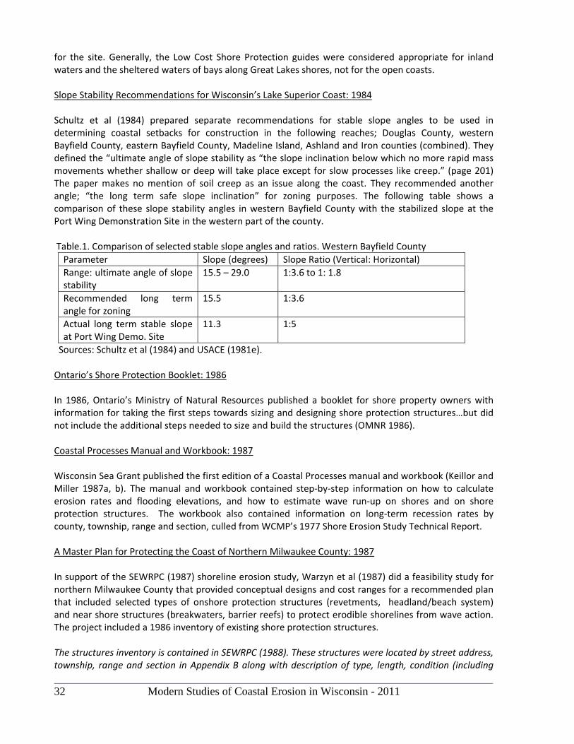
32 Modern Studies of Coastal Erosion in Wisconsin - 2011
for the site. Generally, the Low Cost Shore Protection guides were considered appropriate for inland waters and the sheltered waters of bays along Great Lakes shores, not for the open coasts. Slope Stability Recommendations for Wisconsin’s Lake Superior Coast: 1984 Schultz et al (1984) prepared separate recommendations for stable slope angles to be used in determining coastal setbacks for construction in the following reaches; Douglas County, western Bayfield County, eastern Bayfield County, Madeline Island, Ashland and Iron counties (combined). They defined the “ultimate angle of slope stability as “the slope inclination below which no more rapid mass movements whether shallow or deep will take place except for slow processes like creep.” (page 201) The paper makes no mention of soil creep as an issue along the coast. They recommended another angle; “the long term safe slope inclination” for zoning purposes. The following table shows a comparison of these slope stability angles in western Bayfield County with the stabilized slope at the Port Wing Demonstration Site in the western part of the county. Table.1. Comparison of selected stable slope angles and ratios. Western Bayfield County
Parameter Slope (degrees) Slope Ratio (Vertical: Horizontal)
Range: ultimate angle of slope stability
15.5 – 29.0 1:3.6 to 1: 1.8
Recommended long term angle for zoning
15.5 1:3.6
Actual long term stable slope at Port Wing Demo. Site
11.3 1:5
Sources: Schultz et al (1984) and USACE (1981e). Ontario’s Shore Protection Booklet: 1986 In 1986, Ontario’s Ministry of Natural Resources published a booklet for shore property owners with information for taking the first steps towards sizing and designing shore protection structures…but did not include the additional steps needed to size and build the structures (OMNR 1986). Coastal Processes Manual and Workbook: 1987 Wisconsin Sea Grant published the first edition of a Coastal Processes manual and workbook (Keillor and Miller 1987a, b). The manual and workbook contained step‐by‐step information on how to calculate erosion rates and flooding elevations, and how to estimate wave run‐up on shores and on shore protection structures. The workbook also contained information on long‐term recession rates by county, township, range and section, culled from WCMP’s 1977 Shore Erosion Study Technical Report. A Master Plan for Protecting the Coast of Northern Milwaukee County: 1987 In support of the SEWRPC (1987) shoreline erosion study, Warzyn et al (1987) did a feasibility study for northern Milwaukee County that provided conceptual designs and cost ranges for a recommended plan that included selected types of onshore protection structures (revetments, headland/beach system) and near shore structures (breakwaters, barrier reefs) to protect erodible shorelines from wave action. The project included a 1986 inventory of existing shore protection structures. The structures inventory is contained in SEWRPC (1988). These structures were located by street address, township, range and section in Appendix B along with description of type, length, condition (including
Modern Studies of Coastal Erosion in Wisconsin - 2011 33
type of failure), with bluff height, slope and vegetation. This information may be useful in a GIS file. An overview of shore protection structures in the study area is provided in Map 12 (page 49) and in oblique aerial photos (pages 272‐308). The recommended master plan proposed a system of onshore protection in Fox Point; a set of segmented near shore breakwaters protecting artificial captive beaches at two Fox Point locations (including Doctors Park); a series of offshore reefs southward from Green Tree Road in Fox Point to the Linwood Pumping Station in the City of Milwaukee; a contained beach at Klode Park and southward from the park; and a contained beach at Atwater Beach in Shorewood. SEWRPC 1988 concluded with a recommended plan and cost estimate for stabilizing and armoring the northern Milwaukee County shoreline. At the time of the study (1986), 274 residential properties with a combined total economic value exceeding $70 million were located along the shoreline of northern Milwaukee County. The economic value of non‐residential property was not estimated. The consultants recommended a shore stabilization plan that had an estimated capital cost of nearly $15 million, an average annual maintenance cost of slightly less than one million dollars, a 50‐year present worth of slightly less than $28 million and an equivalent annual cost of $1.75 million (page 249). The master plan was never adopted but some elements of the plan appeared in subsequent built projects designed by some of the engineering firms involved in the SEWRPC (1987) study. Three near shore breakwaters and a captive beach held in place by sheet pile groins were built for the Village of Whitefish Bay at Klode Park following a massive slope failure in the park in April 1987 (SEWRPC 1988). A similar but larger system was constructed on the north side of the Milwaukee Harbor breakwater north of McKinley Marina along with a unique massive, broad and low‐crested revetment protecting Lincoln Memorial Drive. Much of the material (including beach material) for these projects came from Milwaukee’s Deep Tunnel Project for temporary storage of storm water; a project that needed nearby rock disposal sites. SEWRPC 1988 contains helpful information about site‐specific studies needed to design shore protection systems (Table 36, pages 155‐158). Table 36 also includes recommended information needed in site investigations, design criteria for: extreme low as well as extreme high lake level elevations, the reoccurrence intervals for design storm wave conditions to be withstood including more stringent criteria for structures which “protect major public facilities where storm damage would have catastrophic impacts.” The table contains some criteria for re‐grading coastal slopes, filling, dealing with groundwater seepage, coping with excessive surface water runoff and soil erosion, and correcting for a poorly‐vegetated slope. SEWRPC 1988 (pages 164‐180) also contains diagrams and limited specifications for a broad variety, but select set, of 11 “typical” shore protection structures. This section of the report also contains information on four proprietary products. Dimensions, unit size and weight and other design information are given for the described typical structures along with estimated construction and maintenance costs (undated dollars). There is a typical caveat that detailed design features must be based on a detailed analysis of site conditions. This engineering section of the SEWRPC (1988) report has some of the structure specificity of the Help Yourself booklet without the “help yourself” steps that walk the reader through selection of design criteria appropriate to specific sites. This information could be used by coastal property owners (public and private) as a supplement to Clark et al (2005) in negotiating contracts with coastal engineers and contractors.
34 Modern Studies of Coastal Erosion in Wisconsin - 2011
Modeling Coastal Processes and Shore Protection Structures In the 1980s, it became common practice for coastal engineering firms to use a combination of mathematical models in computer programs and physical models to mimic coastal processes on and their interactions with structures. Modeling gained popularity in support of the design of large projects with shore protection structures. The Klode Park beach and shore protection system were physically modeled at a scale of 1 to 20 (model to full size) in the Hydraulic Offshore Wave Basin of the Canadian National Research Council Laboratory in Ottawa, Canada in June and July of 1987 (SEWRPC 1988). Construction of the project began in the fall of 1987 and the new beach system and park with a re‐graded and re‐vegetated slope and new walkways were opened to the public in July 1988. Surveying Property Owners Experience, Measuring the Adequacy of Shore Protection Structures In 1989, questionnaires about their experience with shore erosion, flooding and shore protection were sent to property owners in three coastal neighborhoods with shores of relatively‐low terraces and banks: Edgewater Beach on Green Bay, Lake Church (Ozaukee County) and Lake Forest (Door County) on Lake Michigan (Keillor 1992). The intent of the survey was somewhat similar to that of Drought (1988) but intended to compare owners experience with measures of adequacy of protection from erosion and flooding. Survey responses led to field visits, surveys of elevation (house, top of bank, crest of shore protection structure, beach, near shore lakebed), observations and other measurements. The results of the surveys and measurements indicated that the coastal property owners had adequately protected their homes. None had been lost. However, many properties suffered substantial periodic erosion loss while the owners invested in the occasional repair and replacement of inadequate shore protection structures that did not meet criteria for adequate protection (USACE 1978, Keillor and Miller 1987). Much of the shore protection studied in the three neighborhoods would not offer adequate protection if the severest storms were to occur with a reappearance of the record high lake level of October 1986.
1990s Emergence of a New Philosophy: Armored Shores as a Last Resort In the 1990s, there were no new “do‐it‐yourself”, how‐to guides on shore protection from the U.S. Army Corps of Engineers for shore property owners. A new Corps philosophy towards shore protection structures developed, articulated by Pope (1997) and echoed in USACE/Veritech (2003). This philosophy considers shore protection structures as an option of last resort. The “last resort” attitude towards shore protection structures was common among Corps of Engineers and Sea Grant coastal engineers on the Great Lakes in the 1980s as they became increasingly aware of the problems and failures of shore protection structures and the significance and widespread presence of near shore lakebed erosion. Where significant lakebed erosion exists, the process undermines, and eventually leads to the destruction of, most, if not all shore protection structures. A New Coastal Processes Manual: 1998 In 1998, Wisconsin Sea Grant published a second edition of the Coastal Processes Manual which provides the only publicly‐available compilation of frequencies and elevations of storm surges and 100‐year flood elevations for specific locations on both Canadian and U.S. shores of the Great Lakes (Keillor 1998). The new manual mentioned that “there are no up‐to‐date design guides for shore protection on the Great Lakes” (page 61). The manual also introduced a risk‐based approach to erosion and flooding
Modern Studies of Coastal Erosion in Wisconsin - 2011 35
and mentioned a pending new Coastal Engineering Manual with a new probabilistic approach to shore protection design. The manual was eventually published as USACE/Veritech (2003). The new Sea Grant manual had a little information about a changing climate and a few pages on shore protection structures (stressing how they fail). The second edition did not contain tables of wave run‐up estimates for beaches and selected shore protection structures, or tables of long‐term recession rates for Wisconsin’s coastal sections, published in the first edition. Lake Michigan Potential Damages Study: 1999 In 1999, The US Army Corps of Engineers inventoried shore protection structures in five counties along the Lake Michigan shoreline including Ozaukee, Manitowoc, Sheboygan counties in Wisconsin. This information was used to determine the level of shore protection that may reasonably exist along these shorelines over the next 50 years, as well as the level of potential damage that these structures may prevent (or cause). The objective of this study was to estimate future structural shore protection trends along each reach of shoreline, in each of the five counties, for each of five alternate water level scenarios under consideration. The current shoreline classification database includes an inventory of shore protection type, level of performance, and spatial coverage based on a review of 1997 aerial photography. There is evidence that the protective structures in the pilot counties of Wisconsin (Ozaukee, Manitowoc, Sheboygan) are not adequate for long‐term protection and most of them will eventually fail (Corps of Engineers “Lake Michigan Potential Damages Study,” 2000). The US Army Corps of Engineers also has prepared an analysis of structural shore protection impacts in the Great Lakes Region:
2000 to 2007 The Port Wing Demonstration Site: a Durable Example of Slope Stabilization and Shore Protection on Lake Superior’s Highly‐Erodible Red Clay Coast Today, one of the most notable example in Wisconsin of successful shore protection structures and a stabilized coastal slope is the nearly 30 year old Port Wing Low Cost Shore Protection Demonstration Project of the U.S. Army Corps of Engineers. The project slope and shore protection structures, with little or no maintenance over the decades, stretches along a thousand feet of Lake Superior shoreline at an unmarked site alongside of Wisconsin State Highway 13, about 23 miles east of Superior and 6 miles southwest of Port Wing, Wisconsin. A long, stable boulder revetment and a steel H‐pile/railroad tie sea wall still protect a lush grassy slope of 1: 5 (vertical: horizontal) reaching from the lake to the highway. The nearshore lakebed in front of these structures had a gentle slope of 1:75 (vertical:horizontal) at the time of construction (USACE 1981e). Replacements for the Corps of Engineers’ Help Yourself Pamphlet: 1999, 2003 For decades, the U.S. Army Corps of Engineers considered updating or replacing the Help Yourself booklet. When the replacements eventually happened, two descriptive, complementary booklets were produced: Living with the Lakes (USACE/GLC 1999) and Living on the Coast (USACE/UWSG 2003). Neither booklet contains design information for constructing shore protection structures. The Living with the Lakes booklet describes the hydrologic cycle, human influence on the Great Lakes system, the human adjustments to lake levels and the effects of natural lake level fluctuations on the users and the environment of the lakes. A few pages of the booklet dealt with living on the shore and the use of shore protection structures.
36 Modern Studies of Coastal Erosion in Wisconsin - 2011
The Living on the Coast booklet is about coastal processes, stabilizing coastal slopes and strategies for protecting shorelines (with or without shore protection structures) and coastal investments. A decision was made by the U.S. Army Corps of Engineers and the advisory group to the project to not update and publish information for sizing and designing shore protection structures. The booklet was written in keeping with a new Corps’ philosophy towards shore protection structures considers shore protection structures as an option of last resort, articulated by Pope (1997). There has been increasing awareness of the detrimental effects that shore protection structures can have on neighboring properties and on the environment (USACE/UWSG 2003). Advice on Stabilizing Coastal Slopes and Working with a Contractor and Engineer: 2005 Wisconsin Sea Grant published two booklets that provides advice on how to select a contractor and engineer (Clark et al 2005), and describe ways to stabilize coastal slopes (Chase et al 2005). Inventory and Assessment of Erosion Control Structures in Racine County: 2005 Mackey (2005) conducted an inventory and assessment of shoreline erosion control structures in Racine County. He produced a data base and information for a coastal GIS that documents the characteristics and assesses the effectiveness and likely impact of these structures on nearshore habitat. There continues to be no current information on design of shore protection structures for marine contractors and bold shore property owners, comparable to the Corps of Engineers’ Help Yourself booklet of the late 1960s and early 1970s (USACE 1973, 1978). The Low Cost Shore Protection guides were useful for protected shorelines of bays, but not for the open coasts of the Great Lakes, except for the Port Wing demonstration project. . Private and public shore property owners must rely on experienced marine contractors and knowledgeable engineering consultants to provide information on adequate measures for stabilizing coastal slopes, constructing and maintaining shore protection systems. There are a few currently‐available publications that are intended to help contractors, consultants, and property owners investigate those possible measures. In the past, engineers relied on the U.S. Army Corps of Engineers for design guidance that was published in post World War II publications of the Beach Erosion Control Board, and several editions of the Shore Protection Manual. Today, engineering of shore protection structures has become more specialized and relies partly on experience and proprietary software of coastal engineering firms and on the Coastal Engineering Manual and companion software (USACE/Veritech 2003). The growing list of engineered coastal projects in Wisconsin (with harbor and shore protection) developed with numerical and physical modeling include: Sheboygan Marina, Port Washington Marina and Inner Harbor Redevelopment projects, Reef Point Marina in Racine, the Kenosha Harbor Marina, as well as the captive beach, near shore breakwaters and broad crested revetment adjacent to Lincoln Memorial Drive in Milwaukee, north of the McKinley Marina and the harbor breakwater. It is common practice for coastal engineering firms to use a combination of mathematical models in computer programs and physical models in support of the design of large projects with shore protection structures.
Modern Studies of Coastal Erosion in Wisconsin - 2011 37
EXTENT OF DEVELOPMENT AND ECONOMIC VALUE OF SHORELINE PROPERTY Inventory of Shoreland Development: 1967 ‐ 1992 Niedzwiedz (1995) reported on a WCMP‐funded project in which he and his students examined high quality color aerial photos taken by the U.S. Army Corps of Engineers in two or three years in the interval from 1967 to 1992. On each set of photos, they counted buildings and estimated areas for each of a number of land use categories within the 1,000 feet shoreland jurisdiction of coastal management. Their analysis included lineal feet of sea walls and revetments plus a count of groins and non‐flow through docks. Structures were totaled by minor civil jurisdiction and summed by counties. The coverage by counties was as follows: a. 1978 and 1992: Kenosha, Racine, Milwaukee, Ozaukee, Sheboygan, Manitowoc, Kewaunee b. 1978 and 1992: Brown, Oconto, Marinette c. 1967, 1978 and 1992: Door d. 1992 only: Douglas, Bayfield, Ashland, Iron Niedzwiedz (1995) compiled a spatial record of structures on Mylar overlays of aerial photos (not orthophotographs) and compiled a set of reports. The inventory has also been preserved on a Microsoft Excel spreadsheet. No digital spatial data were developed on the project that could be input to GIS. They also produced a color graphic showing the percent and total change in buildings within 1,000 feet of shore along Wisconsin’s Green Bay and Lake Michigan coasts from 1978 to 1992.
Economic Value of Shoreland Property Estimates of the value of shoreland property are rare in Wisconsin. One exception is SEWRPC (1988); a report of a shoreline erosion management plan for a 7.3 mile reach of northern Milwaukee County’s Lake Michigan shore from the Linnwood Avenue Water Treatment Plant through the Villages of Shorewood, Whitefish Bay and Fox Point. At the time of the study in 1986; a. Five acres of land and 23 residential buildings with a 1986 economic value of about $3.8 million lay within 10 feet of the edge of marginal or unstable bluffs and terraces (page 237) b. Thirteen acres of land containing 40 residential buildings with a 1986 economic value of about $6.9 million lay within 25 feet of the edge of marginal or unstable bluffs and terraces At that time, 274 residential properties with a combined total economic value exceeding $70 million were located along the shoreline of northern Milwaukee County (page 249). As coastal development intensifies and the climate change; it becomes increasingly important to understand these growing coastal investments and their vulnerabilities to coastal processes. The more than $70 million value for 7 or 8 miles of shoreline provides a glimpse of the likely billions of dollars in value of Wisconsin’s more than 1,000 miles of Great Lakes shoreline. WCMP should use available coastal GIS information to obtain a best estimate of total economic value of the state’s coasts. Niedzwiedz (1995) reports and other public information can be used to identify like and unlike minor civil divisions that can guide interpolation and extrapolation of economic value to civil divisions where data is unavailable because of county, town, and city policies that prevent data sharing.
38 Modern Studies of Coastal Erosion in Wisconsin - 2011
References Bahnick, D. A., A.B. Dickas, J. W. Horton and R.Kk. Roubal. 1972. Effects of South Shore Drainage Basins and Clay Erosion on the Physical and Chemical Limnology of Western Lake Superior. Prelimary Tech. Report OWRR A‐034‐Wis. April 1972. 26 pages. BLRPC. 1996. Lake Michigan Shoreline Recession and Bluff Stability in Northeastern Wisconsin: 1996. Bay‐Lake Regional Planning Commission. Draft Report. Brown, Elizabeth (Lisa) Andrea. 2000. Influence of Water Level, Wave Climate and Weather on Coastal Recession Along a Great Lakes Shoreline. MS Thesis. Geological Engineering, University of Wisconsin‐Madison. 177 pages. Brown, E.A., Wu, C.H., Mickelson, D.M., Edil T.B., Factors controlling rates of bluff recession at two sites on Lake Michigan, J. of Great Lakes Research, 31(3), 306‐321, 2005 Butler, Kent and Earl F. Epstein 1977. Delineating Great Lakes Shorelines. WCMP Technical Report Series and UW‐Madison Institute for Environmental Studies Report No. 71. 20 pages Butler, Kent, Robert DeGroot, Mark Greenwood, and David Thomas. 1978. Feasibility of Compensation for Man‐Induced Shore Erosion: Part I: Summary Report. Wisconsin Coastal Management Program. August 1978. 26 pages. Chapman, John A. 1996. Predictive Capability of Stability Analysis Methods for Lake Michigan Shoreline Slopes. MS Thesis. Department of Civil and Environmental Engineering, University of Wisconsin‐Madison. 203 pages. Chapman, John A., Tuncer B. Edil, and David M. Mickelson. 1996. Effectiveness of Analysis Methods for Predicting Long Term Slope Stability on the Lake Michigan Shoreline. Final report to the Bay‐Lake Regional planning Commission and Southeastern Wisconsin Regional Planning Commission. December 1996. Chase, Ronald, Tuncer Edil, Alan Kehew, Philip Keillor, and David Mickelson. 2005. Stabilizing Coastal Slopes on the Great Lakes. University of Wisconsin Sea Grant Institute. 12 pages. WISCU‐G‐05‐003. Clark, Gene, Matthew Clark, and Philip Keillor. 2005. Working with Engineers and Contractors on Shore Protection Projects. University of Wisconsin Sea Grant Institute. 4 pages. WISCU‐G‐05‐002. Drought, James F. 1988. Kewaunee County Coastal Hazard Management Plan. Bay‐Lake Regional Planning Commission. 103 pages. Edil, T.B. and L.E. Vallejo. 1976. Shoreline Erosion and Landslides in the Great Lakes. UW Sea Grant Advisory Report No. 15. October 1976. Edil, T.B. and L. E. Vallejo. 1980. Mechanics of Coastal Landslides and the Influence of Slope Parameters. Engineering Geology 16 ( 1980): 83‐96. UW Sea Grant Reprint WIS‐SG‐80‐716.
Modern Studies of Coastal Erosion in Wisconsin - 2011 39
Edil, Tuncer B., and Michael N. Schultz. 1983. Landslide Hazard Potential Determination Along a Shoreline Segment. Engineering Geology 19 (159‐177). UW Sea Grant Reprint WIS‐SG‐83‐751. Hadley, David W. 1976. Shoreline Erosion in Southeastern Wisconsin. Wisconsin Geological and Natural History Survey. Special Report Number 5. 33 pages. Hanson, S.N., W. Wallace, and R. Chenoweth. 1977. Great Lakes Shore Erosion Protection: A General Review with Case Studies. Owen Ayres and Associates for the Wisconsin Coastal Management Program. Hanson, S.N., W. Wallace, and R. Chenoweth. 1978. Great Lakes Shore Erosion Protection. Structural Design Examples. Owen Ayres and Associates for the Wisconsin Coastal Management Program. 112 pages. Hess, Charles S. 1973. Study of Shoreline Erosion on the Western Arm of Lake Superior. Geography Department, University of Wisconsin, Madison, Wisconsin. June 1, 1973. Johnson, Mark Dale. 1980. Origin of the Lake Superior Red Clay and Glacial History of Wisconsin’s Lake Superior Shoreline West of the Bayfield Peninsula. MS Thesis (Geology). UW‐Madison. 58 pages plus references. Johnson, Beth L. and Carol A. Johnston. 1995. Relationship of Lithology and Geomorphology to Erosion of the Western Lake Superior Coast. J. Great Lakes Res. 21(1): 3‐16. International Association for Great Lakes Research. Pages 3‐16. Kamphuis, J.W. 1987. Recession Rate of Glacial Till Bluffs. Journal of Waterway, Port, Coastal and Ocean Engineering. American Society of Civil Engineers. Vol. 113, No. 1, January 1987. Keillor, J. Philip and Robert DeGroot, Recent Recession of Lake Michigan Shorelines in Racine County, Wisconsin, University of Wisconsin Sea Grant Institute~ 1978. Keillor, J. Philip and Betty Gruning. 1984. Facing the Lake: The Coastwatchers of Racine County, Wisconsin. Coastal Zone Management Journal. 11(4):297‐315. WIS‐SG‐84‐755. Keillor, J. Philip and Allen H. Miller. 1987a. Coastal Processes Manual. University of Wisconsin Sea Grant Institute. WIS‐SG‐87‐430. 54 pages. Keillor, J. Philip and Allen H. Miller. 1987b. Coastal Processes Workbook. University of Wisconsin Sea Grant Institute. WIS‐SG‐87‐431. 28 pages. Keillor, J. Philip. 1992. Construction on Wisconsin’s Lake Michigan Coast. Proceedings, Coastal Engineering Practice ’92. WW Division, American Society of Civil Engineers. Long Beach, California, March 9‐11, 1992. Pages 762 ‐ 778. Keillor, 1998, Coastal Processes Manual. 2nd Edition. University of Wisconsin Sea Grant Institute. WISCU‐H‐98‐001. 124 pages. Lindberg, Thorsten. 1934. Proposed Extension of Lincoln Memorial Drive from Lake Park to Green Tree Road. Tentative Plan of the Milwaukee County Regional Planning Department.
40 Modern Studies of Coastal Erosion in Wisconsin - 2011
Lulloff, Alan R. 1998. Refining the Methodology to Estimate Shore Recession on Wisconsin’s Great Lakes Coasts. 7 pages. Lulloff, Alan R. and J. Philip Keillor. 2000. Shore Recession Methodology for Wisconsin’s Great Lakes Shores With special reference to Wisconsin’s Lake Michigan Coastline. June 2000. Mackey, Scudder D. 2005. Assessment of Lake Michigan Erosion Control Structures in Racine County. Habitat Solutions. December 2005. Martin, Lawrence. 1982. The Physical Geography of Wisconsin. University of Wisconsin Press. 1965 edition. Fourth printing in 1982. 608 pages. Mickelson, David M. and Tuncer B. Edil. 1998. Report on Bluff Stability Planning in the Southern 10 Miles of Ozaukee County and the Northern 10 Miles of Manitowoc County. June 15, 1998, revised July 8, 1998. Unpublished manuscript. Milwaukee County Committee. 1945. Report of Committee, Lake Michigan Shore Erosion, Milwaukee County, Wisconsin. October, 1945. Need, Edward Adams. 1980. Till Stratigraphy and Glacial History of Wisconsin’s Lake Superior Shoreline: Wisconsin Point to Bark River. MS Thesis (Geology). UW‐Madison. 81 pages. Niedzwiedz, William. 1995. Inventory of development within 1000 feet of Wisconsin’s Great Lakes shores. University of Wisconsin‐Green Bay. Unpublished series of reports with maps and a Microsoft Excel spreadsheet. OMNR. 2001. Understanding natural hazards. An introductory guide for public health and safety policies 3.1, provincial policy statement. Ontario Ministry of Natural Resources. 40 pages. Peters, Christopher S. 1982. Erosion Hazard Setback Recommendations for Manitowoc, County, Wisconsin. May 3, 1982. Unpublished, report. Pezzetta, J. M. and J. Robert Moore. 1976. Erosional Characteristics of the Wisconsin Shoreline of Lake Michigan. University of Wisconsin Sea Grant College Program. July, 1976. Unpublished report. Pierce, Angela. 2007. Guide to Hazard Mitigation Planning for Wisconsin Coastal Communities. Bay‐Lake Regional Planning Commission. 75 pages with CD. Pope, J. 1997. Responding to coastal erosion and flooding damage. 2002. Journal of Coastal Research 13 (3): 704‐710. Summer 1997. Racine County. 1982. Racine County Coastwatch Program. Final Report to WCMP. 105 pages. Red Clay Committee. 1972. Erosion and Sedimentation in the Lake Superior Basin: Report, Red Clay Inter‐Agency Committee. 81 pages. Rovey II, C.W. and M.K. Borucki. 1994. Bluff Evolution and Long‐term Recession Rates, Southwestern Lake Michigan. Environmental Geology, Springer‐Verlag, Publisher. Vol. 23, pages 256‐263.
Modern Studies of Coastal Erosion in Wisconsin - 2011 41
Schultz, M.N., T.B. Edil and A. Bagchi. 1984. Geomorphology and Stability of Southwestern Lake Superior Coastal Slopes. Proceedings of the International Symposium on Landslides. University of Toronto Press. Pages 197 – 202. WIS‐SG‐84‐765. SEWRPC. 1987. Northern Milwaukee County Lake Michigan Shoreline Erosion Management Study. Southeastern Wisconsin Regional Planning Commission, Waukesha, Wisconsin. SEWRPC. 1988. A Lake Michigan Shoreline Erosion Management Plan for Northern Milwaukee County Wisconsin. Southeastern Wisconsin Regional Planning Commission, Waukesha, Wisconsin. SEWRPC. 1997. Lake Michigan Shoreline Recession and Bluff Stability in Southeastern Wisconsin: 1995. Southeastern Wisconsin Regional Planning Commission and Geotechnical Consultants Tuncer B. Edil, David M. Mickelson, and John A. Chapman. SEWRPC. 1997b. Newsletter. Southeastern Wisconsin Regional Planning Commission and Geotechnical Consultants. Vol. 37, No. 3. May‐June 1997. SEWRPC. 2004. Newsletter. Southeastern Wisconsin Regional Planning Commission and Geotechnical Consultants. Vol. 42, No. 1. 2004. Springman, Roger and Stephen M. Born. June 1979. Wisconsin’s shore erosion plan: an appraisal of options and strategies. UW‐Madison Department of Urban and Regional Planning, WI Geological and Natural History Survey and UW‐Extension Report prepared for the WI Coastal Management Program. Sterrett, Robert J. 1980. Factors and Mechanics of Bluff Erosion on Wisconsin’s Great Lakes Shorelines. PhD Thesis. University of Wisconsin‐Madison. Sterrett, Robert J. and Tuncer B. Edil. 1982. Ground‐Water Flow Systems and Stability of a Slope. Ground Water 20 (1): 5‐11. January‐February 1982. Stewart, Chris. 1994. Recession Rates for Lake Michigan Potential Damages Study. U.S. Army Corps of Engineers, Detroit District. Striegl, A. R. 1968. Shoreland and Flood Plain Zoning along the Wisconsin Shore of Lake Michigan. State of Wisconsin, Department of Natural Resources, Division of Environmental Protection, 50 pages. USACE 1945. Beach Erosion Study, Lake Michigan Shoreline of Milwaukee County, Wisconsin. House Document No. 527. 79th Congress, 2nd Session. Report of the Chief of Engineers, Department of the Army. 1945. USACE 1952. Beach Erosion Control Report on Cooperative Study of Racine County, Wisconsin. House Document No. 88, 83rd Congress, 1st Session. Report of the Chief of Engineers, Department of the Army. 1952. USACE 1955. Beach Erosion Study, Lake Michigan Shoreline, City of Kenosha. House Document No. 273, 84th Congress, 2nd Session. Report of the Chief of Engineers, Department of the Army. May 1955. USACE. 1971. Great Lakes Region Inventory Report, National Shoreline Study. Department of the Army, Corps of Engineers, Northcentral Division.
42 Modern Studies of Coastal Erosion in Wisconsin - 2011
USACE. 1971. Shore Protection Guidelines. National Shoreline Study. Department of the Army, Corps of Engineers, Washington, D.C. 59 pages. USACE 1973. Help Yourself. General Information Pamphlet. North Central Division, U.S. Army Corps of Engineers. Fold‐out pamphlet; like a highway map. USACE. 1975. Lake Michigan Shoreline, Milwaukee County, Wisconsin, Preliminary Feasibility Report. U.S. Army Corps of Engineers. USACE. 1977. Section 103 Reconnaissance Report on Shore Erosion, Racine County, WI. Chicago District, Corps of Engineers, Department of the Army. USACE 1978. Help Yourself. Revision, General Information Pamphlet. North Central Division, U.S. Army Corps of Engineers. 24 pages. USACE. 1981a. Low Cost Shore Protection. U.S. Army Corps of Engineers. 36 pages. USACE. 1981b. Low Cost Shore Protection….a Property Owner’s Guide. U.S. Army Corps of Engineers. 159 pages. USACE. 1981c. Low Cost Shore Protection….a Guide for Engineers and Contractors. U.S. Army Corps of Engineers. 173 pages. USACE. 1981d. Low Cost Shore Protection….a Guide for Local Government Officials. U.S. Army Corps of Engineers. 108 pages. USACE. 1981e. Low Cost Shore Protection. Final Report on the Shoreline Erosion Control Demonstration Program (Section 54). U.S. Army Corps of Engineers. 830 pages. USACE. Date? Potential Damages Study, Lake Michigan. U.S. Army Corps of Engineers. USACE/GLC. 1999. Living with the Lakes. Understanding and Adapting to Great Lakes Water Level Changes. U.S. Army Corps of Engineers and The Great Lakes Commission. 39 pages. USACE/UWSG. 2003. Living on the Coast. Protecting investments in shore property on the Great Lakes. U.S. Army Corps of Engineers and the University of Wisconsin Sea Grant Institute. 49 pages. Vallejo, Luis E. 1977. Mechanics of the Stability and Development of the Great Lakes Coastal Bluffs. PhD Thesis. University of Wisconsin‐Madison. Vallejo, Luis E. and Tuncer B. Edil. 1979. Design Charts for Development and Stability of Evolving Slopes. J. Civil Engineering Design 1 (3): 231‐252. Village of Whitefish Bay. 1987. Klode Park Erosion Control and Beach Restoration. Unpublished project information sheet. Warzyn Engineering, Inc.; Johnson, Johnson and Roy, Inc.; W.F. Baird and Associates. 1987? A Future for the Milwaukee County North Shore, A Report on the Design and Construction of Offshore Protection
Modern Studies of Coastal Erosion in Wisconsin - 2011 43
Structures. Report submitted to the Technical Advisory Committee for the Milwaukee County North Shore Erosion Study. This undated report includes a summary of discussions at a workshop in 1986 and references to costs in 1987 dollars. WCMP. 1977. Shore Erosion Study Technical Report with the following Appendices as separate documents: Appendix 1 (Kenosha County), Appendix 2 (Racine County), Appendix 3 (Milwaukee County, Appendix 4 (Ozaukee County), Appendix 5 (Sheboygan County), Appendix 6 (southern and central Manitowoc County), Appendix 7 (northern Manitowoc, Kewaunee and Door counties), Appendix 8 (summary of engineering boring logs for Milwaukee County). WCMP. 1979. Erosion Hazard Areas – Sheboygan County. Wisconsin Coastal Management Program. One of a series of maps showing coastal erosion hazard areas for Kenosha, Racine, Milwaukee, Ozaukee, Sheboygan, Kewaunee, Door, Brown counties. WCMP. 1980. Shore Erosion Study. Appendix 9 (Douglas and western Bayfield counties to Bark Bay. WCMP. 1997. Mapping Erosion Hazard Areas (Lake Michigan) Racine, Ozaukee and Manitowoc Counties. Weinberg, Anne C. and Michael Neuman. 1976. Ordinary High Watermark Determination on Wisconsin’s Great Lakes. Wisconsin Department of Natural Resources. 20 pages. Whitney, C.S. 1936. Stabilizing a Lake Michigan Bluff. Civil Engineering, American Society of Civil Engineers. Vol. 6, No. 5. Yanggen, Doug A. January 1981. Regulations to Reduce Coastal Erosion Losses. University of Wisconsin‐Extension for the Wisconsin Coastal Management Program


Managing Risk in Appendix 4-1