Embed Size (px)
Citation preview
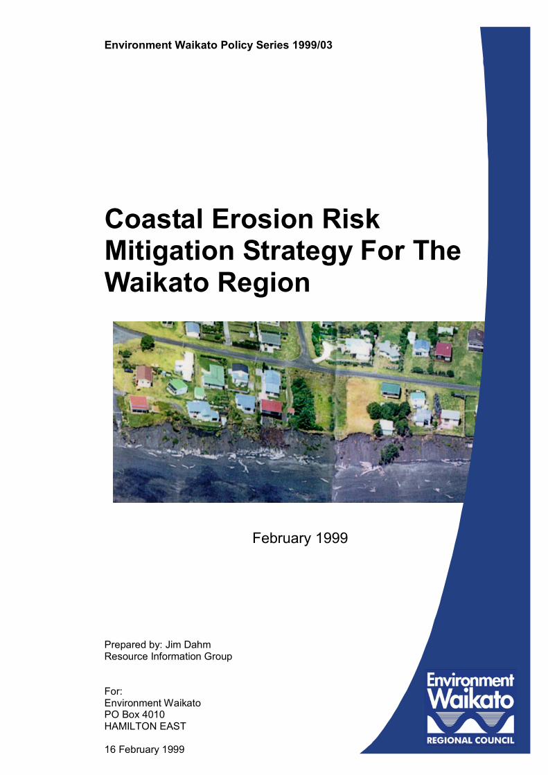
Prepared by: Jim DahmResource Information Group
For:Environment WaikatoPO Box 4010HAMILTON EAST
16 February 1999
Environment Waikato Policy Series 1999/03
Coastal Erosion RiskMitigation Strategy For TheWaikato Region
February 1999

Doc # 480281 Page i
Executive Summary
IntroductionThis report outlines the risk mitigation strategy for coastal erosion in the WaikatoRegion. A draft version was reported to Council in July 1997 and has been furtherdiscussed with coastal district councils and others prior to finalising.
Purpose of the StrategyThe primary purpose of the strategy is to help promote a consistent, well integrated andsustainable approach to the management of coastal erosion in the Waikato Region inaccordance with the purpose and principles of the Resource Management Act and thepolicies and objectives of the New Zealand Coastal Policy Statement (NZCPS), and the(proposed) Regional Policy Statement (RPS).
A draft, prioritised implementation plan is also proposed.
Relevant Responsibilities for the Management ofCoastal ErosionThe strategy adopts the division of responsibilities proposed in the Regional PolicyStatement (RPS) for the management of natural hazards. Namely, that territorialauthorities have primary responsibility for the control of the use of land for theavoidance and mitigation of coastal erosion, except for the coastal marine area whereEnvironment Waikato has primary responsibility. Environment Waikato hasresponsibility for ensuring Regional consistency in the management of coastal erosion.
However, in line with the proposed Regional Coastal Plan (RCP), the strategy alsoproposes a partnership approach for a number of activities. These include hazardassessment, dune management (through the Beachcare programme), site specifichazard management strategies, targeted education and information campaigns, andmonitoring and review.
Outline of Proposed StrategyThe proposed strategy consists of 4 major elements:
Element 1 - Central Focus of StrategyThe central focus of the strategy is to develop a pattern of land use and developmentthat enables coastal communities to live with coastal erosion and minimises the needto modify natural coastal processes. This entails a level of risk that can beappropriately lived with, not necessarily the absence of risk.
It is proposed that this be achieved by a Region-wide strategy that focuses on:
• avoiding and reducing risk - to be achieved by identifying and appropriatelymanaging hazard areas and by protecting and enhancing natural coastal systems(such as dunes) that provide hazard protection;
• encouraging coastal communities to accept and live with coastal erosion - wherethis is practical and appropriate; and,
• emphasising public information and advice and working in partnership with coastalcommunities and affected stakeholders.
Page ii Doc # 480281
Element 2 - Site Specific Hazard Management StrategiesAt some locations, the complexity of existing and potential hazard problems will requiresite specific management strategies.
It is proposed that these be developed using a multi-stakeholder partnership approach,involving Environment Waikato, the local district council and other relevantstakeholders (typically affected property owners, beach users, local communities andthe Department of Conservation). This approach, consistent with the proposed RCP,has proved successful in pilot studies to date - most notably at Whiritoa Beach.
There are several difficult problem sites in the Region and prioritisation is required toadequately address these issues. Urgent action is required at Buffalo Beach, Raglan,Aotea and Mokau and it is proposed these be initial priorities.
Other high priority sites are Cook’s Beach, Hahei, Koputauaki Bay, Thames CoastHighway, Kawhia and Marokopa.
Element 3 - Coastal StructuresManaging risk by shoreline modification will be minimised under the proposed strategy,particularly the use of shoreline armouring structures. Again, this is consistent withpolicy directions in the NZCPS and the proposed RCP.
This will require continued emphasis on advocacy and assistance with thedevelopment of alternative approaches. Useful progress has been made in the latterarea in trials over the last two to three years.
However, it is recognised that there will also be some sites where there are noreasonable alternatives to shoreline armouring, particularly in the short to mediumterm. Therefore, it is proposed that guidelines be developed for the consenting anduse of these structures. Initial guidelines are included in the risk mitigation strategy.
Element 4 - Monitoring and InvestigationsA cost-effective, monitoring strategy is required to ensure that the effectiveness of thestrategy is monitored and reviewed. Appropriate applied research should also beencouraged to help improve the assessment and management of coastal erosion.
ImplementationImplementation of the strategy is critical to effectiveness and has been emphasised bycoastal district councils and communities.
An implementation strategy is planned which envisages the development andimplementation of the strategy over three years - with all elements of the strategyoperational by June 30, 2002.
Doc # 480281 Page iii
ContentsExecutive Summary i
Introduction iPurpose of the Strategy iRelevant Responsibilities for the Management of Coastal Erosion iOutline of Proposed Strategy i
Element 1 - Central Focus of Strategy iElement 2 - Site Specific Hazard Management Strategies iiElement 3 - Coastal Structures iiElement 4 - Monitoring and Investigations ii
Implementation ii
Contents iii
1 Introduction 1
2 Structure of this Document 1
3 The Issue of Coastal Erosion Hazard 1
4 Statutory Considerations 24.1 Statutory Framework 24.2 Statutory Responsibilities for the Management of Coastal Erosion Hazard 4
5 Purpose of the Strategy 5
6 Management Options 56.1 Managing Land Use and Development 6
6.1.1 Undeveloped Areas 66.1.2 Existing Development in Areas of High Hazard 7
6.2 Protect and Enhance Natural Systems which Buffer Coastal Erosion 76.2.1 Dune Management 76.2.2 Beach and Dune Nourishment 8
6.3 Living with Coastal Erosion 106.4 Modify Natural Coastal Processes and Landforms 11
7 Proposed Risk Mitigation Strategy 127.1 Introduction 127.2 Outline of Proposed Management Strategy 13
7.2.1 Element 1 - Central Focus 137.2.2 Element 2 - Site Specific Hazard Management Strategies 137.2.3 Element 3- Coastal Structures 157.2.4 Element 4 - Monitoring and Further Investigations 16
8 Implementation Plan 16

Doc # 480281 Page 1
1 IntroductionThis document outlines the risk mitigation strategy for coastal erosion in the WaikatoRegion.
The strategy is based on the issue assessment report on coastal erosion hazardpresented to the Environment Committee in October 1996. This latter report has alsorecently been expanded and will be issued as a technical report of Council in April/May1999.
The strategy is based on Council experience at approximately 90 coastal erosionhazard problem sites over the last eight or nine years and extensive associateddiscussions with district council staff, community stake-holders and other parties. Bestmanagement practice from overseas has also been considered, including a recentstudy trip to the United States examining various aspects of coastal managementincluding hazard management.
2 Structure of this DocumentThis document has the following structure:
• Section 3 reviews coastal erosion hazard as a management issue in the WaikatoRegion;
• Section 4 summarises relevant statutory responsibilities for the management ofcoastal erosion hazard, as defined by the proposed RPS;
• Section 5 outlines the purpose and associated objectives of this strategy;
• Section 6 reviews the various options for the management of coastal erosion;
• Section 7 outlines the proposed risk mitigation strategy; and
• Section 8 outlines a suggested implementation plan and identifies relevantresponsibilities of the various agencies.
3 The Issue of Coastal Erosion Hazard The 1996 and 1999 reports note that coastal erosion hazard raises widespread andsignificant management issues around the coast of the Waikato Region. These management issues essentially relate both to: • risk to development (including houses and roads), important cultural sites and
residential property; and, • environmental and other problems associated with inappropriate management of
this hazard. Actual or potential risk to residential property and development occurs at the vastmajority (>80 percent) of coastal settlements in the Region, with serious existingproblems at 21 settlements. Several roads are also subject to serious coastal erosionissues, particularly along the eastern and western margins of the Firth of Thames.Significant threat to important cultural sites also exists, including urupa at KoputauakiBay and Mokau.
Page 2 Doc # 480281
Most of the existing and potential coastal erosion hazard problems arise because ofcoastal subdivision and/or development having been undertaken too close to the sea.At most sites, there is no present trend for long term recession and erosion is primarilyassociated with dynamic natural shoreline fluctuations and changes. Subdivision anddevelopment has simply been undertaken without adequate set-back to accommodatethese natural shoreline movements. The report also noted that there was considerable potential for aggravation of existingproblems by ongoing concentration of value in hazard areas and the potential impactsof changes likely to accompany predicted global warming. For instance, calculations of aggravated erosion were made for the easternCoromandel based on present “best estimates” of sea-level rise over the next century.These suggest that along the eastern Coromandel coast, sea-level rise alone couldresult in serious risk to existing property and development with a combined presentvalue in excess of $525 million. This compares to the present moderate to serious riskto residential property and development worth approximately $150 million. Moreover,for the same area, there would be serious risk to nearly 570 existing dwellingscompared to about 60 dwellings presently at risk along that coastline. The management of coastal erosion hazard is also very complex with conflicts ofinterest related to the high public and private values which intersect along the coastalmargin. To date, the risk (or perceived risk) to development or private property has typicallybeen managed by attempting to modify natural coastal processes and shorelinebehaviour - particularly with the use of shoreline armouring devices. However, theassessment reports note that the structures frequently raise significant environmentalconcerns and other issues and they are unlikely to provide sustainable and appropriatemedium to long-term solutions at many sites. An increased emphasis will be requiredon managing human aspirations and behaviour if coastal erosion is to be managedeffectively while sustaining the natural and amenity values of coastlines.
4 Statutory Considerations
4.1 Statutory Framework The management of natural hazards, including coastal erosion, is primarily conductedwithin the framework of the Resource Management Act 1991 (Figure 1). As such, theavoidance or mitigation of coastal erosion hazard must be undertaken in a manner thatis consistent with the purpose and principles of the Act and with the policies andobjectives of subsidiary documents, including the New Zealand Coastal PolicyStatement (NZCPS) and the proposed Regional Policy Statement (RPS) and RegionalCoastal Plan (RCP).
Doc # 480281 Page 3
EarthquakeMitigation Plan
FloodMitigation Plan
Coastal ErosionMitigation Plan
Stat
utor
y
Doc
umen
ts
The Planning Framework
Figure 1: The Planning Framework of the Resource Management Act 1991.
Page 4 Doc # 480281
Therefore, environmental matters are now integral to the management of coastalerosion hazard. These environmental management objectives include the preservationof the natural character of the coast and the maintenance and enhancement of publicaccess to and along the coast and amenity values (RMA, Part II, Sections 6a, 6d, and7c). The assessment reports identified these matters as environmental values thathave frequently been significantly impacted by historic management of coastal erosionhazard. Other relevant statutes include the Building Act 1991, the Civil Defence Act 1983, theLocal Government Act 1974 and the Soil Conservation and Rivers Control Act 1941.
4.2 Statutory Responsibilities for the Management ofCoastal Erosion Hazard Under the Resource Management Act, the primary responsibility for the control of theuse of land for the avoidance or mitigation of natural hazards rests with regionalcouncils and territorial authorities. However, the exact division of responsibility is not specified in the Act. Rather, section62 (1) of the Resource Management Act (RMA) requires regional policy statements toclarify the relevant responsibilities of regional and territorial authorities in relation to thecontrol of the use of land for the avoidance or mitigation of natural hazards. Section 3.8.3 of the proposed RPS (as per Variation 1, August 1998) proposes thatterritorial authorities have the primary responsibility for the control of the use of land forthe avoidance or mitigation of natural hazards - including the development ofobjectives, policies and rules relating to this function. In regard to the coast, thisresponsibility applies to all land except the coastal marine area (CMA) - whereEnvironment Waikato has primary responsibility (in conjunction with the Minister ofConservation). The management regime for the CMA is set out in the proposed RCP. Although the RPS is not yet operational, the above divisions of responsibility have metwith broad agreement and are unlikely to change. The respective responsibilities,landward and seaward of mean high water springs, emphasise the need for integrationand consistency. Under the proposed RPS, Environment Waikato has primaryresponsibility for ensuring that objectives, policies and rules relating to the control ofthe use of land for the avoidance or mitigation of natural hazards are consistentbetween Councils. As part of ensuring an integrated and consistent framework forhazard management, Environment Waikato has a lead role in the development ofhazard specific mitigation plans and in collection, analysis, storage and communicationof natural hazard information to territorial authorities. Coastal territorial authorities also have responsibilities under the Building Act 1991,which contains specific provisions governing the issue of consents for the erection ofbuildings on “land .. subject to, or .. likely to be subject to, erosion ..”. Under section36(1) of the Act, a territorial authority is required to refuse to grant a building consentfor a new building or major alteration on such land - unless they are satisfied thatadequate provision has or will be made to protect the land or building. EnvironmentWaikato has similar responsibility for all structures in the CMA. The Department of Conservation also has responsibilities relevant to the managementof coastal erosion, including its roles in monitoring the implementation of the NewZealand Coastal Policy Statement (NZCPS) and in the consenting of RestrictedCoastal Activities. Various public utility operators who provide essential services (e.g.communications, electricity, gas, transport) also have a key role to play in planning tominimise damage and disruption to these services due to natural hazards.
Doc # 480281 Page 5
5 Purpose of the Strategy The primary purpose of the strategy, a non-statutory document, is to promoteintegrated and sustainable management of coastal erosion hazard within the WaikatoRegion - in accordance with the purpose and principles of the Resource ManagementAct (RMA) and the polices and objectives of the NZCPS and the proposed RPSi andRCP. In particular the strategy aims to help promote an approach to the management ofcoastal erosion hazard which will:
• ensure that adverse effects (including environmental effects) associated with coastalerosion hazard are minimised, in accordance with Objective 3.8.4 of the proposedRPS;
• promote a consistent approach to the management of coastal erosion hazard acrossthe Region, in accordance with Policy 1, Section 3.8.3 of the proposed RPS;
• clarify the responsibilities of all relevant agencies for the management of coastalerosion hazard to minimise inefficiencies and/or duplication of functions, inaccordance with Objective 3.8.3 of the proposed RPS;
• promote integrated management of coastal erosion hazard, in accordance withObjectives 2.2.2 and 3.5.6 of the proposed RPS;
• ensure that coastal communities and other stake-holders (e.g. the operators ofpublic utilities) are adequately informed of management directions andresponsibilities, in accordance with Objective 3.8.3 of the RPS;
• provide opportunities for effective and meaningful participation by coastalcommunities and other stake-holders in the management of coastal erosion; and,
• be practical and cost-effective.
6 Management Options There are four basic options to avoid or mitigate coastal erosion hazard: - manage land use and development in hazard risk areas; - protect and enhance natural systems which buffer coastal erosion (e.g. beach and
dune areas between subdivision and the sea); - accept and live with coastal erosion; and/or, - modify natural coastal processes and/or landforms. The first three of these options involve a focus on human use and behaviour, while thefourth focuses on managing the nature and/or behaviour of the natural coastline. These options are not mutually exclusive and a hazard management strategy for anyparticular locality may involve any one or a combination of these options. The options are outlined further below.
Page 6 Doc # 480281
6.1 Managing Land Use and Development Most existing coastal erosion hazard problems in the Waikato Region result fromlocating subdivision and/or development too close to the sea to accommodate naturalshoreline changes. Therefore, management of land use and development is generallyrequired at most sites to effectively avoid or mitigate risk - either in isolation or inassociation with other management options. Fundamental to this approach is the identification of areas of existing and potentialhazard. Appropriate assessment of hazard requires good information, particularly oncoastal processes, sediment sources and budgets, and the nature and pattern ofhistorical shoreline changes. Also in regard to future changes which may affect coastalerosion hazard, such as predicted global warming. However, collectively, these arefactors on which there is generally only limited information. As such, hazardassessment also inevitably draws heavily on experience and judgement. There is oftenconsiderable difference in the judgement of even experienced practitioners. Therefore,considerable care is required to ensure that precautionary but reasonable assessmentsare made and that Regional consistency is obtained as far as is practical andappropriate. These matters will require careful attention in the implementation of therisk mitigation strategy. Most typically, management of land use and development is undertaken using varioussubdivision and development controls, particularly development setbacks andrelocatability requirements. However, there are also a wide range of other measureswhich can be used to manage human use and development - including reserve takes,voluntary covenants, purchase of hazard risk areas, physical relocation of existingdevelopment and “planned retreat”. These measures have considerable flexibility and can be used variously to: • avoid the creation of hazard problems in undeveloped areas; • avoid or minimise the aggravation of existing hazard problems; • reduce existing risk; and/or • mitigate risk associated with conditional use of hazard areas. As such, they offer considerable versatility in the management of hazard. For instance,they can be used in a variety of situations where different emphases are required -such as both developed and undeveloped areas, or areas of both high and low risk. These measures can also facilitate the integration of coastal hazard management withother management objectives. e.g. Multiple objective development set-backs,providing not only for hazard protection but also for other objectives such aspreservation of natural character, enhancement of public access and amenity values,and protection of cultural and archaeological sites. Examples of potential application are briefly discussed in following paragraphs.
6.1.1 Undeveloped Areas In undeveloped areas, risk avoidance can usually be readily achieved by the use ofsubdivision and development setbacks. The taking or acquisition of reserves is alsoimportant to ensure effective management of natural buffer zones and provide for arange of other coastal management objectives (e.g. public access and amenity).
Doc # 480281 Page 7
6.1.2 Existing Development in Areas of High Hazard Areas in which there is existing property and development at risk generally present themost complex hazard management problems. In these situations, there are typicallyno easy or cheap options for the relevant agencies and property owners. Site specificand staged strategies, involving the use of a number of management options, aregenerally required for practical and environmentally sustainable solutions. Subdivision and development controls are inevitably an important element of suchstrategies. These measures are required to effectively prevent aggravation of theexisting problems. The measures also reduce risk over time, by providing for re-development to be setback out of the hazard area (provided that there is an adequatebuildable area further landward on the same section). Effective management of existing natural buffers is also required at such sites Other measures are also required where development such as roads or dwellings areat immediate risk. Typically used are measures that modify natural coastal behaviour,such as beach or dune nourishment, groynes or shoreline armouring. These can beuseful and appropriate measures where their role is to “hold” the situation while theplanning controls take effect. There are also less frequently used and alternative approaches that can potentially beused in such situations, particularly relocation of threatened development and/orproperty purchase. However, neither these or “holding measures” are without major difficulties.Considerable time and skill is required to design and implement practical andappropriate strategies involving planning and other measures. These strategiesgenerally have to be staged over time. It is particularly important to involve all relevantparties in the design of such strategies to ensure an appropriate balance of interestsand minimise conflict, while also promoting sustainable management. As a generalrule, such strategies cannot be effectively designed by “experts” working in isolationfrom the communities of interest.
6.2 Protect and Enhance Natural Systems whichBuffer Coastal Erosion This management option incorporates a wide variety of approaches that are designedto: • manage and protect existing natural coastal systems (e.g. dunes) which provide
protection from coastal erosion; and/or • enhance the natural buffering ability of these coastal systems (e.g. beach and dune
nourishment) Natural features such as beaches, dunes, mangroves, and salt-marsh wetlands providethe cheapest and most environmentally appropriate means of protecting subdivisionand development against natural hazards. As such, the protection of these systemsand their natural buffering ability is a fundamental and essential element in anyeffective strategy for the management of coastal erosion. High priority is given to thisin national, regional and district planning documents (e.g. policies 3.4.2 and 3.4.3 in theNZCPS).
6.2.1 Dune Management Many ocean beaches along the east and west coast of the Region are backed by sanddunes which provide effective natural protection from coastal hazards such as erosion.These dunes are also critically important to the natural and amenity values of the
Page 8 Doc # 480281
beaches and frequently contain important cultural and archaeological sites. As such,protecting the sand reserves and the natural integrity and function of these coastaldunes is fundamental to sustainable coastal management - including hazardmanagement. This is especially so at developed beach sites, particularly along the east coast of theRegion. At many of these sites, most of the dune sand reserves which haveaccumulated over the last 6000 years have been buried by coastal subdivision, leavingonly narrow buffer zones between coastal settlements and the sea. Some of thesebuffer zones have already proved inadequate (e.g. parts of Buffalo and Cooksbeaches) and many of the rest are potentially inadequate given the effects likely toaccompany predicted global warming (Dahm, 1999). Once the protective dunes arelost or become inadequate, serious conflicts and complex problems develop - withsimple or inexpensive solutions rarely available. Available information also suggests that there is no longer any significant net sandsupply to beaches along the eastern Coromandel - so that present dune and beachsand reserves can essentially be regarded as fixed and finite. This places extraemphasis on the need to protect existing dune sand reserves as effectively as possible. As such, it is ultimately desirable to have effective dune management action at mosteast coast settlements in the Waikato Region - though initial work should focus onpriority developed sites and/or badly degraded dune systems. Effective dune management is essentially based on maintaining an adequatevegetation cover - particularly the native sand grasses on the dune face, which arecritical to natural dune building and repair. This generally requires management ofhuman use (particularly vehicle and pedestrian access over the dunes) as well asaction to re-establish sand grass cover in areas where it has been damaged. If severewind erosion damage has occurred, dune repair can also be a prerequisite to re-establishment of an appropriate vegetation cover. Community support is also essentialto effective dune management. Council initiated Beachcare, a pilot community-based dune management programme inJanuary 1993 to address dune management issues - in partnership with local districtcouncils. This programme, which now involves eight or nine coastal communities andhas operated for six years, has proved to be an effective means of designing andimplementing appropriate dune management action and increasing community supportand awareness. The involvement of coastal communities has been capped at this levelduring the trial and development period.
6.2.2 Beach and Dune Nourishment In some situations, it can be practical and appropriate to enhance the buffering abilityof beach and/or dune systems by nourishment (i.e. adding sand to these systems).Beach and dune nourishment are now widely practised overseas (e.g. beachnourishment is the foremost tool used along the coast of the eastern United States inthe management of coastal hazards). However, although there has also been anincreasing number of examples in New Zealand in recent years, the practice is stillrelatively rare here. A significant advantage of beach and dune nourishment is that this work generally hasminimal adverse environmental effects - provided that appropriate sand (particularly,similar in size to existing beach sands) is available and can be obtained without undueconsequences. However, beach nourishment can be limited by the availability of suitable sand, thecosts of obtaining and placing the sand, the dynamic nature of the beach environment(which can result in placed sand being quickly moved offshore or alongshore -necessitating frequent maintenance) and the volumes of sand that are often required to
Doc # 480281 Page 9
usefully mitigate erosion hazard (particularly for ocean beach systems which generallyextend some distance offshore and alongshore). A further limitation of beach nourishment is that it is generally not a long-term solution -since the sand is gradually lost offshore and/or alongshore. (In very dynamicenvironments this loss can occur at such a rate that nourishment is not effective and/oreconomic as a means of managing coastal erosion). Therefore, where this measure isused to manage coastal erosion it will generally need to be coupled with othermeasures to ensure long-term sustainable solutions are ultimately developed. i.e. theprimary use of beach nourishment is as a short term “holding” measure - while moreappropriate longer term measures are implemented and take effect. Lack of familiarity of New Zealand coastal communities with beach and dunenourishment can also be a limiting factor. Council experience in recent years is thatconsiderable effort can be required to get community support for such work. (However,recent sites have exhibited less resistance, suggesting that pilot trials over the last fouror five years have increased community appreciation of the potential of this option).With options such as dune nourishment, views and disturbance of existing vegetationare extra complications that can also make such work difficult to promote (thougheffective restoration of dune vegetation is relatively easily undertaken with a well-planned project). Despite these limitations and difficulties, there is considerable scope for increased useof beach and dune nourishment around the coast of the Waikato Region. Workconducted in the Region to date indicates that beach nourishment can be particularlyappropriate (i.e. practical and cost-effective) as hazard mitigation in shelteredenvironments - such as some sites in east coast estuaries. It has also proved to beuseful for enhancing recreational values at such sites. Beach and dune nourishment can also be conducted for little to no public cost whentied in with local dredging programmes being undertaken for other purposes. Such usealso helps conserve limited sand reserves. Council has introduced measures in theproposed Regional Coastal Plan (RCP) to promote the use of dredged sands for beachand dune nourishment where appropriate. Pilot study trials have already been conducted (and others are presently beingplanned) to help develop appropriate guidelines for such work. To date Council hasbeen involved in seven separate beach nourishment efforts in Otahu, Whangamataand Tairua estuaries. These have generally proved relatively successful in managingerosion issues in these estuarine environments - though low cost, wooden groyneshave also been required to help hold the sand in place at two of these sites. Thesetrials have all used sands dredged for other purposes, which were required to bereturned to the coastal environment in line with the above-noted measures in the RCP. There is less immediate potential for beach nourishment on open coast beaches,because of the large volumes of sand required for such work. Moreover, most dredgedsand sourced from development projects is from estuarine environments and oftenfiner than beach sands. However, in some cases these sands are suitable (e.g.sufficiently coarse) for dune nourishment along ocean beaches. Major dune nourishment was successfully undertaken along the Whitianga foreshore inconnection with the development of the Whitianga Marina in 1994 and 1995. This workwas largely designed through a community participation programme co-ordinated byWhitianga Beachcare and resulted in the placement of approximately 60,000 cubicmetres of sands. Further dune nourishment is presently being planned for the northernend of the beach; also utilising a community based approach (largely focused on localproperty owners).
Page 10 Doc # 480281
6.3 Living with Coastal Erosion As coastal erosion is a natural process on all shorelines in the Region, it is importantthat communities increasingly come to recognise and live with this process. As notedearlier, most of the present erosion hazard problems arise through inadequaterecognition of and allowance for natural coastal processes. Many of these issues areaggravated by a widespread community perception that shorelines are static oradvancing and that erosion is somehow unnatural or exceptional, a problem rather thana natural process. An improved understanding of the dynamics of local shorelines will help enable coastalcommunities and property owners to better adapt to living with these shorelines. To date, the option of tolerating or living with coastal erosion has been given littleconsideration by management agencies and beachfront property owners. However,there does appear to be considerable scope for increased use of this option -particularly where shorelines are simply undergoing dynamic fluctuations as opposedto long-term recession. The option is particularly appropriate where coastal erosion poses no immediate threatto development or to private property. However, it also likely to be appropriate in manysituations where erosion poses a risk to private property alone - provided that it is clearthat the erosion does not also pose a threat to development (e.g. dwellings). In manyof these cases, adjustment to coastal erosion simply requires managing this section ofproperty as a natural buffer rather than “static” property. For instance, reinstatingfrontal dunes and native sand-binding vegetation where these features have beenlevelled and/or grassed. However, living with coastal erosion is not a practical or appropriate option at siteswhere development is likely to be threatened. At these sites, options are requiredwhich address the threat to the development. Despite the latter limitation, there is considerable scope for increased use of thisoption. However, advisory and education work will be required to raise publicawareness and acceptance. In particular, it is important that considerable effort is placed on informing coastalcommunities about the dynamic nature of the Region’s coast. This requires anincreased attention on community information and education, as well as opportunitiesfor community participation (e.g. in coastal management and monitoring) that willenable communities to better understand the Region’s shorelines. Some work has already commenced with the Beachcare programme and the Coastsand Us unit presently being developed by Environmental Education Programme. Council has also recently installed a computer-controlled video monitoring unit atTairua Ocean beach and is presently planning a similar installation on the west coast(at Mokau). While these units have primarily been installed for improved coastalmonitoring, they also have considerable potential for use in community information andeducation. Video images are placed directly on the internet and have already provedpopular with the community for beach condition information. However, it is alsoplanned to develop time-lapse videos of beach and bar changes which willconsiderably assist communities understand dynamic changes in these environments. However, despite these useful initial efforts, a well co-ordinated and strategicinformation and participation programme is desirable – since major changes in presentunderstandings and perceptions are required.
Doc # 480281 Page 11
6.4 Modify Natural Coastal Processes and Landforms There are a wide variety of measures which have been used to manage coastalerosion by modifying natural coastal processes or landforms. Such measures includevarious shoreline armouring devices, groynes and (more rarely) offshore reefs and/orbreakwaters. These measures are designed to protect property and development behind the coastby limiting or preventing coastal erosion. i.e. They are essentially property protectiondevices. If properly designed and constructed, the measures can (and frequently do)provide effective protection for both property and development. In the Waikato Region, a fundamental issue with the use of these measures is that theyfocus on modifying coastal behaviour, while most problems in the Region relate tohuman behaviour - particularly the placement of subdivision and development too closeto the sea. By providing a measure of security, or apparent security, these measurescan potentially lead to pressure for more development in areas of hazard risk. Nonetheless, the management of erosion hazard in the Waikato Region has historicallyemphasized the use of such measures. In particular, the use of shoreline armouring devices (e.g. dumped rocks, sea walls, rip-rap revetments) placed along the foreshore to armour the coast and prevent landwardmovements. A recent survey indicated that there are now over 400 of these structuresaround the coast of the Region. While well designed shoreline armouring works can effectively protect property anddevelopment, the measures can also have significant impacts on coastal processesand result in a number of adverse environmental impacts. The assessment reportsnote that particularly significant adverse effects often occur in relation to naturalcharacter, amenity values and public access along the coast. These effects largelyrelate to loss of beach width, due primarily to direct burial or “passive erosion” effects.Aggravation of erosion may also play a part, though present information suggests thiseffect is probably limited. The nature of these impacts and the reasons for them arediscussed more fully in the erosion hazard assessment report. As the protection ofsuch values are matters central to the purpose and principles of the ResourceManagement Act and to the policies of the NZCPS, such adverse effects are notconsistent with sustainable coastal management. There are also a variety of other concerns in regard to shoreline armouring structures,broadly outlined in the hazard assessment report. It is sometimes possible to minimise adverse effects associated with shorelinearmouring. For instance, some adverse environmental effects can be significantlyreduced by locating and burying the armouring works sufficiently landward that they areonly exposed for short durations (e.g. during and after extreme erosion events).However, this is not common practice and most structures are placed on the foreshorewhere adverse effects are maximised. Overall, the significant adverse effects and other concerns with shoreline armouring aresuch that these measures are generally incompatible with sustainable coastalmanagement. As such, the structures are generally undesirable as a means ofmanaging coastal erosion - particularly as long-term solutions to erosion hazard. Nonetheless, structures can and do prove important short to medium term measures atsites where there is serious hazard to dwellings or roads. Whenever practical, use ofstructures in such situations should use measures designed and located to minimiseadverse environmental effects. This can include the use of relatively soft measures.For instance, Environment Waikato has worked with district councils and communities
Page 12 Doc # 480281
to develop simple but effective beach nourishment and groyne proposals which haveavoided the need for shoreline armouring works at three sites in recent years. However, use of harder measures like shoreline armouring cannot be entirely avoidedat many sites in the short term. Examples in the Waikato Region include parts of StateHighway 25 along the Thames Coast and at the southern end of Buffalo Beach. Theroad in these areas would be severely damaged without the use of shorelinearmouring. However, use of structures in such situations should emphasise measuresdesigned and located to minimise adverse environmental effects. Ideally, long term strategies are also required at difficult problem sites to ensure thatactions over time eventually reduce and, where practical, eliminate the need forstructures. The need for such long-term strategies can also be identified as a consentrequirement for new shoreline armouring works in such locations. A recent example isthe shoreline armouring placed along the sea frontage of Te Puru School.
7 Proposed Risk Mitigation Strategy
7.1 Introduction The review of management options presented in section 6 suggests that any strategyfor sustainable management of coastal erosion should focus on: • management of land use and development; • protection and, where appropriate, enhancement of natural buffer zones; and/or, • living with coastal erosion. While measures that involve modification of natural shorelines will sometimes benecessary and/or appropriate, these measures are generally incompatible with theobjectives of sustainable coastal management. As such, their use should be limited. Overall, this suggests that the central focus of sustainable management of coastalerosion should be to develop a pattern of land use and development that minimises theneed to modify natural shoreline behaviour. i.e. A pattern of human use anddevelopment that will enable coastal communities to live with coastal erosion. Essentially speaking, this requires a natural buffer of adequate width so that naturalshoreline movements do not threaten people or things they value to the extent that theyare unable to live with such movements. This does not necessarily entail the absence of risk, but rather a level of risk that canbe appropriately lived with. As such, it can be achieved both by: • avoiding and reducing risk; and,
• learning to live with appropriate risk. As it is not possible to completely eliminate risk, given the existing pattern of use anddevelopment around the Waikato Region, sustainable management of coastal erosionwill require a strategy that focuses on both these aspects. Moreover, as both of these aspects have a considerable focus on changing humanactivity and attitudes, emphasis should also be placed on measures that are likely topromote such changes in understanding and behaviour. In particular, good information
Doc # 480281 Page 13
accessible to communities, advice, advocacy and community participationprogrammes.
7.2 Outline of Proposed Management Strategy The proposed strategy consists of four major elements: • a central focus - relevant to the management of coastal erosion hazard at all sites in
the Region; • site specific hazard management strategies - relevant to difficult problem sites; • guidelines for the use of coastal structures - in recognition that these devices will
continue to be relevant in the management of coastal erosion hazard at some sitesin the immediate future; and,
• ongoing monitoring and investigations - required to develop, monitor and refine
strategy over time. Each of these four elements is outlined below.
7.2.1 Element 1 - Central Focus It is proposed that sustainable management of coastal erosion should be promoted bya Region-wide strategy that focuses on: • avoiding and reducing risk by:
- identifying hazard risk areas and managing subdivision and developmentwithin these areas to avoid and (with existing development) reduce hazard risk;and,
- protecting and, where practical and appropriate, enhancing the buffering ability
of natural coastal systems; • encouraging coastal communities to accept and live with coastal erosion,
where this is practical and appropriate; and, • facilitating the above directions by placing emphasis on public information,
advice, and advocacy together with opportunities for meaningful communityparticipation in decision-making likely to affect their interests.
These elements are central to effective and sustainable management of coastalerosion hazard at all sites.
7.2.2 Element 2 - Site Specific Hazard Management Strategies At some sites in the Region, the complexity of present hazard problems will require sitespecific management strategies in order to work towards long-term sustainablesolutions. Meaningful participation by stake-holders is critical to effective resolution of thecomplex conflicts of interest at these sites. Therefore, these site specific strategiesshould preferably be developed using a multi-stakeholder approach involvingEnvironment Waikato, the local district council and other relevant stake-holders (e.g.affected property owners, Department of Conservation, beach users, localcommunities).
Page 14 Doc # 480281
Most acute problems identified in the hazard assessment report are likely to requiresite specific hazard management strategies. Discussions with district councils have been conducted and priorities have been agreedwith most councils, as follows: • Thames Coromandel District Council: Agreed priorities with district council and
local community boards are Buffalo Beach, Cooks Beach, Tararu andKoputauaki Bay. Urban development and residential property is threatened at the first three of thesesites, with the State Highway also at risk at Buffalo. Coastal structures are also asignificant issue at all 3 sites. At Koputauaki Bay, primary concern is a Maori urupa(burial ground) seriously threatened by erosion. The Coromandel Community Boardhave requested that site be given priority to assist local Maori landowners find andimplement an appropriate solution.
Other sites in this district likely to require site specific strategies once priority siteshave been addressed include Whangapoua, Hahei, Te Puru and possiblyWharekaho. The issues at these sites relate largely to threat to residential propertyand development. Coastal structures are also an issue at some sites.
State Highway 25 along the Thames Coast is also a high priority issue. As use ofshoreline armouring is inevitable on parts of this road (and some areas of districtcouncil roads to the north of Coromandel), guidelines are required for erosionprotection to facilitate any future action required while minimising adverse effects.Input is also required into longer term strategies for these roads to ensure erosionhazard is minimised as far as practicable.
• Hauraki District Council: Whiritoa Beach is the primary erosion hazard issue in
this district. Risk to the surf club is the main remaining issue at this site. • Franklin District Council: No priority sites yet agreed with FDC, though the
Seabird Coast Road is probably the main outstanding issue. An eroding landfill south of Kaiaua was initially a priority but Environment Waikatoand FDC have agreed on action at this site and this work has now been completedand is being monitored. Similarly, issues at Sunset Beach, Port Waikato have nowlargely been addressed through the Beachcare group initiated in 1993.
• Waikato District Council: Cliff erosion in Raglan township has been the major
priority identified by the District Council. Coastal structures, particularly shoreline armouring, are also a major issue aroundparts of the township. There are also various other relatively minor erosion issuesaround the vicinity of Raglan, the harbour entrance area and Manu Bay.
• Otorohanga District Council: Priority issues relate to the Kawhia and Aotea
foreshores. Issues include threat to residential property and development and tolocal roads. Coastal structures are also an issue at both sites, with the mostimmediate of these issues at Aotea where there is significant community concernand conflict with regard to the local foreshore.
• Waitomo District Council: The Mokau sand spit is the highest priority in this
district, with serious threat to local residential properties and dwellings. Other priority sites for later attention include Marokopa, Seaview and Te Waitere.Threat to local residential property and development is the major issue at thesesites, though coastal structures and dune management are also significant issues atMarokopa.
Doc # 480281 Page 15
However, given the limited resources, available work in the immediate future mustfocus on the highest priority sites. In terms of hazard risk and urgency of managementaction, the highest priorities are Buffalo Beach, Raglan, Aotea and Mokau.Therefore, these will probably be the major priorities for the next financial year. However, urgent issues could also develop at other sites (e.g. Cooks Beach andHahei) if there are major cyclones and some flexibility in work-load will need to bemaintained. There is also very strong political and community pressure for support of the localMaori at Koputauaki Bay. The urupa at this site, which includes recently buried family,is now very seriously threatened. Strategies for other priority sites can be initiated as the above sites are addressed.
7.2.3 Element 3- Coastal Structures Managing risk by shoreline modification will be avoided as far as practical under theproposed strategy, particularly the use of shoreline armouring structures. However, there will be some sites where there will be no reasonable alternatives tosuch measures, reflecting the level of investment and infrastructure already located inhazard risk areas and the impracticality of other management options in the short term. Therefore, given the range of potential problems with the use of such structures, it iscritically important to develop guidelines for the future consenting and use of thesemeasures - particularly for shoreline armouring. These guidelines will also considerably assist with the consenting of the large number(400+) of existing unauthorised structures. (As noted in the October 1996 report, it is astatutory requirement that a coastal consent be applied for all unauthorised structureswithin 6 months of the Regional Coastal Plan becoming operative. Guidelines will alsoneed to address issues such as the removal of structures that have failed or that are nolonger required.) In order to develop such guidelines it will be necessary to investigate and evaluateexisting structures and also to review experience elsewhere. However, the following are recommended as interim guidelines:
• Structures should only be considered where coastal development (e.g. dwellings,infrastructure) is threatened and it is not reasonably practical to manage the riskusing a more appropriate approach (e.g. to live with the risk or to relocate thedevelopment further landward).
• Preference should be given to moderately “soft” structures (e.g. groynes with beachnourishment) where these are practical. Council has made some progress inpromoting and developing such applications over the last three years, and this workshould be continued.
• Where a “hard” option (e.g. shoreline armouring) is required, the structure should bedesigned and located to avoid or minimise adverse environmental effects (e.g. avoidexposure on the foreshore; minimise seaward intrusion; locate as far landward aspossible). Where adverse effects cannot be avoided, appropriate mitigation actionshould be required (e.g. provision for public access where this is adverselyimpacted).
• Where a structure is required, it should be consented as a short to medium term“holding measure” (as opposed to a long term solution), while more appropriate
Page 16 Doc # 480281
long-term measures are developed or take effect. Preferably, it should be part of adefined strategy which will eventually eliminate the need for the structure.
• At those rare sites (e.g. parts of SH 25 along the Thames Coast) where “hard”structures may be required as medium to long-term solutions to erosion hazard, theavoidance of adverse effects should be given particularly strong emphasis -together with the mitigation of adverse effects that cannot be avoided.
Council has made useful progress in avoiding the use of shoreline armouring in recentyears by following these guidelines in advisory and advocacy work with coastalcommunities. Similarly, the guidelines have proved useful for consenting. It isimportant to maintain and extend such work to help promote a more appropriateshoreline management culture in the Region.
7.2.4 Element 4 - Monitoring and Further Investigations A simple, cost-effective, monitoring strategy is required to ensure that: • coastal changes are adequately monitored;
• hazard assessment areas are regularly reviewed and updated (at least once every10 years and/or as significant new information comes to hand - e.g. major revisionof IPCC predictions);
• effectiveness of the strategy can be assessed; and,
• individual management measures (e.g. dune management; guidelines for coastalstructures; planning instruments) can be reviewed and improved as appropriate.
Appropriate investigations by other agencies (e.g. Crown Research Institutes,Universities) should also be encouraged to improve prediction and management ofcoastal erosion hazard. Similarly, liaison with other regions and appropriate agencies should be maintained andextended to improve prediction and management of coastal erosion hazard and topromote inter-regional integration and consistency.
8 Implementation Plan A detailed implementation plan will continue to be negotiated and agreed with district
councils and other relevant parties. However, Table 1 outlines a recommendedimplementation strategy and relevant management responsibilities. • Year 1 – 1999/00: In this year the focus is on:
- Developing and documenting hazard management zones for priority districts
- Incorporation of hazard zones and appropriate management provisions intodistrict plans
- Initiation of management strategies at priority sites
- Initiate development and implementation of the monitoring and reviewprogramme
- Refine initial guidelines for the use and consenting of erosion protectionstructures
Doc # 480281 Page 17
- Completion of a review of the Beachcare programme
• Year 2 – 2000/01: In this year the focus is on:
- Develop and initiate a targeted environmental education programme aimed atnearshore property owners and coastal communities
- Completion of hazard zone assessment work for Region
• Year 3 – 2001/2002: Completion of all matters relevant to operationalising thestrategy, including:
- Complete incorporation of hazard zones and appropriate managementprovisions into district plans
- Completion of all planning matters relevant to implementation of the strategy
- Completion of strategies for the six pilot study sites
- Guidelines for coastal structures, dune management and dune/beachnourishment completed
- Complete monitoring and review programme
Essentially, all aspects of the strategy should be operational by June 30, 2002.
Page 18 Doc # 480281
Note:
The proposed implementation plan is subject each year to thenormal Business Plan preparation, budgeting and approvalprocesses associated with the Annual Plan.
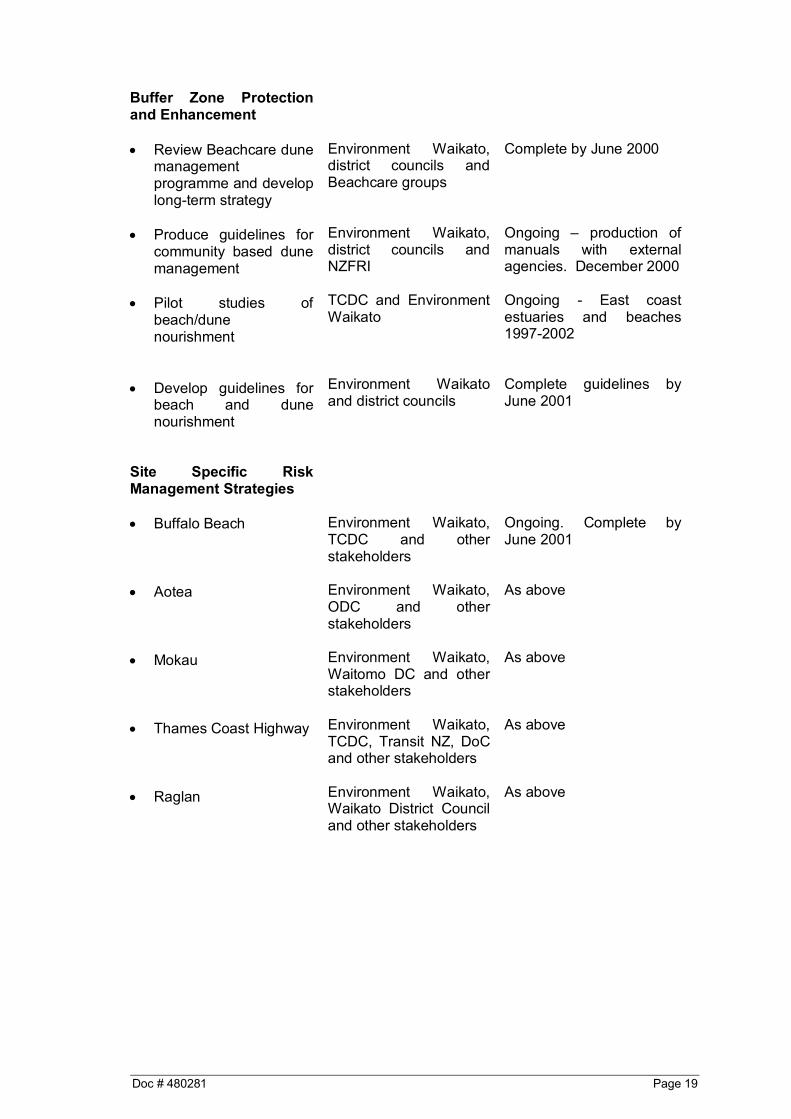
Table 1: Proposed Implementation Plan
Action Who When
Strategy Development
• Finalise strategy Environment Waikatoand coastal districtcouncils
Completed
Hazard Definition
• Define appropriatehazard managementzones and document
• Recognise hazard
management zones inappropriate districtcouncils plans
• Hazard Mapping
Environment Waikato -in consultation withcoastal district councils
District councils - inconsultation withEnvironment Waikato
Environment Waikatoand District Councils.
Complete for entire Regionby June 2000
Ongoing. Complete byDecember 2000
Programmed andcompleted by June 2000for specific sites.
Planning Matters
• Implement appropriatesubdivision anddevelopment controls indistrict plans
• Implement other
required changes toRegional and districtplans
District councils - inconsultation withEnvironment Waikato
Environment Waikatoand district councils
Ongoing. Complete onpriority basis by December2000 including site specificRisk ManagementStrategies.
Ongoing. Complete onpriority basis by December2001
Doc # 480281 Page 19
Buffer Zone Protectionand Enhancement
• Review Beachcare dunemanagementprogramme and developlong-term strategy
• Produce guidelines for
community based dunemanagement
• Pilot studies of
beach/dunenourishment
• Develop guidelines for
beach and dunenourishment
Environment Waikato,district councils andBeachcare groups
Environment Waikato,district councils andNZFRI
TCDC and EnvironmentWaikato
Environment Waikatoand district councils
Complete by June 2000
Ongoing – production ofmanuals with externalagencies. December 2000
Ongoing - East coastestuaries and beaches1997-2002
Complete guidelines byJune 2001
Site Specific RiskManagement Strategies
• Buffalo Beach • Aotea • Mokau • Thames Coast Highway • Raglan
Environment Waikato,TCDC and otherstakeholders
Environment Waikato,ODC and otherstakeholders
Environment Waikato,Waitomo DC and otherstakeholders
Environment Waikato,TCDC, Transit NZ, DoCand other stakeholders
Environment Waikato,Waikato District Counciland other stakeholders
Ongoing. Complete byJune 2001
As above
As above
As above
As above
Page 20 Doc # 480281
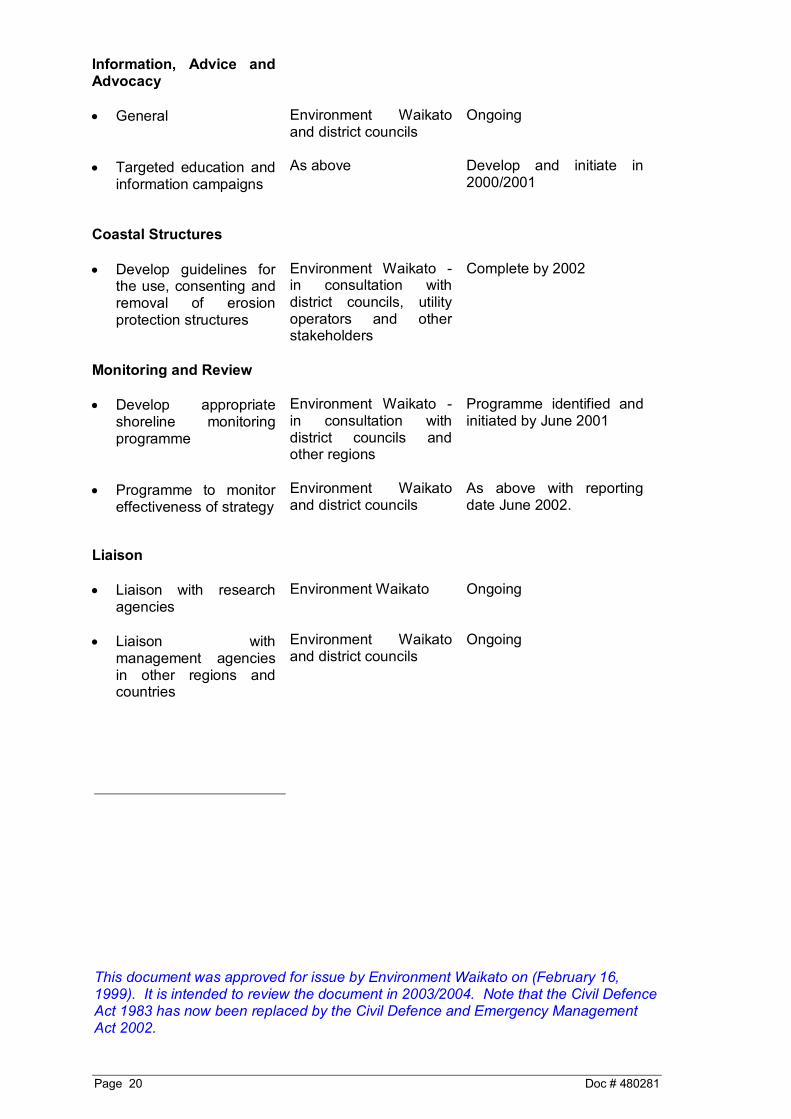
Information, Advice andAdvocacy
• General • Targeted education and
information campaigns
Environment Waikatoand district councils
As above
Ongoing
Develop and initiate in2000/2001
Coastal Structures
• Develop guidelines forthe use, consenting andremoval of erosionprotection structures
Environment Waikato -in consultation withdistrict councils, utilityoperators and otherstakeholders
Complete by 2002
Monitoring and Review
• Develop appropriateshoreline monitoringprogramme
• Programme to monitor
effectiveness of strategy
Environment Waikato -in consultation withdistrict councils andother regions
Environment Waikatoand district councils
Programme identified andinitiated by June 2001
As above with reportingdate June 2002.
Liaison
• Liaison with researchagencies
• Liaison with
management agenciesin other regions andcountries
Environment Waikato
Environment Waikatoand district councils
Ongoing
Ongoing
This document was approved for issue by Environment Waikato on (February 16,1999). It is intended to review the document in 2003/2004. Note that the Civil DefenceAct 1983 has now been replaced by the Civil Defence and Emergency ManagementAct 2002.