Embed Size (px)
Citation preview
Model Water Efficient Landscape Ordinance
1
California Code of Regulations Title 23. Waters
Division 2. Department of Water Resources Chapter 2.7. Model Water Efficient Landscape Ordinance
§ 490. Purpose. (a) The State Legislature has found: (1) that the waters of the state are of limited supply and are subject to ever increasing demands; (2) that the continuation of California’s economic prosperity is dependent on the availability of adequate supplies of water for future uses; (3) that it is the policy of the State to promote the conservation and efficient use of water and to prevent the waste of this valuable resource; (4) that landscapes are essential to the quality of life in California by providing areas for active and passive recreation and as an enhancement to the environment by cleaning air and water, preventing erosion, offering fire protection, and replacing ecosystems lost to development; and (5) that landscape design, installation, maintenance and management can and should be water efficient; and (6) that Section 2 of Article X of the California Constitution specifies that the right to use water is limited to the amount reasonably required for the beneficial use to be served and the right does not and shall not extend to waste or unreasonable method of use. (b) Consistent with these legislative findings, the purpose of this model ordinance is to: (1) promote the values and benefits of landscapes while recognizing the need to invest water and other resources as efficiently as possible; (2) establish a structure for planning, designing, installing, maintaining and managing water efficient landscapes in new construction and rehabilitated projects; (3) establish provisions for water management practices and water waste prevention for existing landscapes; (4) use water efficiently without waste by setting a Maximum Applied Water Allowance as an upper limit for water use and reduce water use to the lowest practical amount; (5) promote the benefits of consistent landscape ordinances with neighboring local and regional agencies; (6) encourage local agencies and water purveyors to use economic incentives that promote the efficient use of water, such as implementing a tiered-rate structure; and (7) encourage local agencies to designate the necessary authority that implements and enforces the provisions of the Model Water Efficient Landscape Ordinance or its local landscape ordinance. Note: Authority cited: Section 65593, Government Code. Reference: Sections 65591, 65593, 65596, Government Code.
§ 490.1 Applicability (a) After January 1, 2010, this ordinance shall apply to all of the following landscape projects: (1) new construction and rehabilitated landscapes for public agency projects and private development projects with a landscape area equal to or greater than 2,500 square feet requiring a building or landscape permit, plan check or design review; (2) new construction and rehabilitated landscapes which are developer-installed in single-family and multi-family projects with a landscape area equal to or greater than 2,500 square feet requiring a building or landscape permit, plan check, or design review; (3) new construction landscapes which are homeowner-provided and/or homeowner-hired in single-family and multi-family residential projects with a total project landscape area equal to or greater than 5,000 square feet requiring a building or landscape permit, plan check or design review;
2
(4) existing landscapes limited to Sections 493, 493.1 and 493.2; and (5) cemeteries. Recognizing the special landscape management needs of cemeteries, new and rehabilitated cemeteries are limited to Sections 492.4, 492.11 and 492.12; and existing cemeteries are limited to Sections 493, 493.1 and 493.2. (b) This ordinance does not apply to: (1) registered local, state or federal historical sites; (2) ecological restoration projects that do not require a permanent irrigation system; (3) mined-land reclamation projects that do not require a permanent irrigation system; or (4) plant collections, as part of botanical gardens and arboretums open to the public. Note: Authority Cited: Section 65595, Government Code. Reference: Section 65596, Government Code. § 491. Definitions. The terms used in this ordinance have the meaning set forth below: (a) “applied water” means the portion of water supplied by the irrigation system to the landscape. (b) “automatic irrigation controller” means an automatic timing device used to remotely control valves that operate an irrigation system. Automatic irrigation controllers schedule irrigation events using either evapotranspiration (weather-based) or soil moisture data. (c) “backflow prevention device” means a safety device used to prevent pollution or contamination of the water supply due to the reverse flow of water from the irrigation system. (d) “Certificate of Completion” means the document required under Section 492.9. (e) “certified irrigation designer” means a person certified to design irrigation systems by an accredited academic institution a professional trade organization or other program such as the US Environmental Protection Agency’s WaterSense irrigation designer certification program and Irrigation Association’s Certified Irrigation Designer program. (f) “certified landscape irrigation auditor” means a person certified to perform landscape irrigation audits by an accredited academic institution, a professional trade organization or other program such as the US Environmental Protection Agency’s WaterSense irrigation auditor certification program and Irrigation Association’s Certified Landscape Irrigation Auditor program. (g) “check valve” or “anti-drain valve” means a valve located under a sprinkler head, or other location in the irrigation system, to hold water in the system to prevent drainage from sprinkler heads when the sprinkler is off. (h) “common interest developments” means community apartment projects, condominium projects, planned developments, and stock cooperatives per Civil Code Section 1351. (i) “conversion factor (0.62)” means the number that converts acre-inches per acre per year to gallons per square foot per year (j) “drip irrigation” means any non-spray low volume irrigation system utilizing emission devices with a flow rate measured in gallons per hour. Low volume irrigation systems are specifically designed to apply small volumes of water slowly at or near the root zone of plants. (k) “ecological restoration project” means a project where the site is intentionally altered to establish a defined, indigenous, historic ecosystem. (l)“effective precipitation” or “usable rainfall” (Eppt) means the portion of total precipitation which becomes available for plant growth. (m) “emitter” means a drip irrigation emission device that delivers water slowly from the system to the soil. (n) “established landscape” means the point at which plants in the landscape have developed significant root growth into the soil. Typically, most plants are established after one or two years of growth. (o) “establishment period of the plants” means the first year after installing the plant in the landscape or the first two years if irrigation will be terminated after establishment. Typically, most plants are established after one or two years of growth.
3
(p) “Estimated Total Water Use” (ETWU) means the total water used for the landscape as described in Section 492.4. (q) “ET adjustment factor” (ETAF) means a factor of 0.7, that, when applied to reference evapotranspiration, adjusts for plant factors and irrigation efficiency, two major influences upon the amount of water that needs to be applied to the landscape. A combined plant mix with a site-wide average of 0.5 is the basis of the plant factor portion of this calculation. For purposes of the ETAF, the average irrigation efficiency is 0.71. Therefore, the ET Adjustment Factor is (0.7)=(0.5/0.71). ETAF for a Special Landscape Area shall not exceed 1.0. ETAF for existing non-rehabilitated landscapes is 0.8. (r) “evapotranspiration rate” means the quantity of water evaporated from adjacent soil and other surfaces and transpired by plants during a specified time. (s) “flow rate” means the rate at which water flows through pipes, valves and emission devices, measured in gallons per minute, gallons per hour, or cubic feet per second. (t) “hardscapes” means any durable material (pervious and non-pervious). (u) “homeowner-provided landscaping” means any landscaping either installed by a private individual for a single family residence or installed by a licensed contractor hired by a homeowner. A homeowner, for purposes of this ordinance, is a person who occupies the dwelling he or she owns. This excludes speculative homes, which are not owner-occupied dwellings. (v) “hydrozone” means a portion of the landscaped area having plants with similar water needs. A hydrozone may be irrigated or non-irrigated. (w) “infiltration rate” means the rate of water entry into the soil expressed as a depth of water per unit of time (e.g., inches per hour). (x)“invasive plant species” means species of plants not historically found in California that spread outside cultivated areas and can damage environmental or economic resources. Invasive species may be regulated by county agricultural agencies as noxious species. “Noxious weeds” means any weed designated by the Weed Control Regulations in the Weed Control Act and identified on a Regional District noxious weed control list. Lists of invasive plants are maintained at the California Invasive Plant Inventory and USDA invasive and noxious weeds database. (y) “irrigation audit” means an in-depth evaluation of the performance of an irrigation system conducted by a Certified Landscape Irrigation Auditor. An irrigation audit includes, but is not limited to: inspection, system tune-up, system test with distribution uniformity or emission uniformity, reporting overspray or runoff that causes overland flow, and preparation of an irrigation schedule. (z) “irrigation efficiency” (IE) means the measurement of the amount of water beneficially used divided by the amount of water applied. Irrigation efficiency is derived from measurements and estimates of irrigation system characteristics and management practices. The minimum average irrigation efficiency for purposes of this ordinance is 0.71. Greater irrigation efficiency can be expected from well designed and maintained systems. (aa) “irrigation survey” means an evaluation of an irrigation system that is less detailed than an irrigation audit. An irrigation survey includes, but is not limited to: inspection, system test, and written recommendations to improve performance of the irrigation system. (bb) “irrigation water use analysis” means an analysis of water use data based on meter readings and billing data. (cc) “landscape architect” means a person who holds a license to practice landscape architecture in the state of California Business and Professions Code, Section 5615. (dd) “landscape area” means all the planting areas, turf areas, and water features in a landscape design plan subject to the Maximum Applied Water Allowance calculation. The landscape area does not include footprints of buildings or structures, sidewalks, driveways, parking lots, decks, patios, gravel or stone walks, other pervious or non-pervious hardscapes, and other non-irrigated areas designated for non-development (e.g., open spaces and existing native vegetation).
4
(ee) “landscape contractor” means a person licensed by the state of California to construct, maintain, repair, install, or subcontract the development of landscape systems. (ff) “Landscape Documentation Package” means the documents required under Section 492.3. (gg) “landscape project” means total area of landscape in a project as defined in “landscape area” for the purposes of this ordinance, meeting requirements under Section 490.1. (hh) “lateral line” means the water delivery pipeline that supplies water to the emitters or sprinklers from the valve. (ii) “local agency” means a city or county, including a charter city or charter county, that is responsible for adopting and implementing the ordinance. The local agency is also responsible for the enforcement of this ordinance, including but not limited to, approval of a permit and plan check or design review of a project. (jj) “local water purveyor” means any entity, including a public agency, city, county, or private water company that provides retail water service. (kk) “low volume irrigation” means the application of irrigation water at low pressure through a system of tubing or lateral lines and low-volume emitters such as drip, drip lines, and bubblers. Low volume irrigation systems are specifically designed to apply small volumes of water slowly at or near the root zone of plants. (ll) “main line” means the pressurized pipeline that delivers water from the water source to the valve or outlet. (mm) “Maximum Applied Water Allowance” (MAWA) means the upper limit of annual applied water for the established landscaped area as specified in Section 492.4. It is based upon the area’s reference evapotranspiration, the ET Adjustment Factor, and the size of the landscape area. The Estimated Total Water Use shall not exceed the Maximum Applied Water Allowance. Special Landscape Areas, including recreation areas, areas permanently and solely dedicated to edible plants such as orchards and vegetable gardens, and areas irrigated with recycled water are subject to the MAWA with an ETAF not to exceed 1.0. (nn) “microclimate” means the climate of a small, specific area that may contrast with the climate of the overall landscape area due to factors such as wind, sun exposure, plant density, or proximity to reflective surfaces. (oo) “mined-land reclamation projects” means any surface mining operation with a reclamation plan approved in accordance with the Surface Mining and Reclamation Act of 1975. (pp) “mulch” means any organic material such as leaves, bark, straw, compost, or inorganic mineral materials such as rocks, gravel, and decomposed granite left loose and applied to the soil surface for the beneficial purposes of reducing evaporation, suppressing weeds, moderating soil temperature, and preventing soil erosion. (qq) “new construction” means, for the purposes of this ordinance, a new building with a landscape or other new landscape, such as a park, playground, or greenbelt without an associated building. (rr) “operating pressure” means the pressure at which the parts of an irrigation system are designed by the manufacturer to operate. (ss) “overhead sprinkler irrigation systems” means systems that deliver water through the air (e.g., spray heads and rotors). (tt) “overspray” means the irrigation water which is delivered beyond the target area. (uu) “permit” means an authorizing document issued by local agencies for new construction or rehabilitated landscapes. (vv) “pervious” means any surface or material that allows the passage of water through the material and into the underlying soil. (ww) “plant factor” or “plant water use factor” is a factor , when multiplied by ETo, estimates the amount of water needed by plants. For purposes of this ordinance, the plant factor range for low water use plants is 0 to 0.3, the plant factor range for moderate water use plants is 0.4 to 0.6, and the plant
5
factor range for high water use plants is 0.7 to 1.0. Plant factors cited in this ordinance are derived from the Department of Water Resources 2000 publication “Water Use Classification of Landscape Species”. (xx) “precipitation rate” means the rate of application of water measured in inches per hour. (yy) “project applicant” means the individual or entity submitting a Landscape Documentation Package required under Section 492.3, to request a permit, plan check, or design review from the local agency. A project applicant may be the property owner or his or her designee. (zz) “rain sensor” or “rain sensing shutoff device” means a component which automatically suspends an irrigation event when it rains. (aaa) “record drawing” or “as-builts” means a set of reproducible drawings which show significant changes in the work made during construction and which are usually based on drawings marked up in the field and other data furnished by the contractor. (bbb) “recreational area” means areas dedicated to active play such as parks, sports fields, and golf courses where turf provides a playing surface. (ccc) “recycled water”, “reclaimed water”, or “treated sewage effluent water” means treated or recycled waste water of a quality suitable for non-potable uses such as landscape irrigation and water features. This water is not intended for human consumption. (ddd) “reference evapotranspiration” or “ETo” means a standard measurement of environmental parameters which affect the water use of plants. ETo is expressed in inches per day, month, or year as represented in Section 495.1, and is an estimate of the evapotranspiration of a large field of four- to seven-inch tall, cool-season grass that is well watered. Reference evapotranspiration is used as the basis of determining the Maximum Applied Water Allowance so that regional differences in climate can be accommodated. (eee) “rehabilitated landscape” means any re-landscaping project that requires a permit , plan check, or design review, meets the requirements of Section 490.1, and the modified landscape area is equal to or greater than 2,500 square feet, is 50% of the total landscape area, and the modifications are completed within one year. (fff) “runoff” means water which is not absorbed by the soil or landscape to which it is applied and flows from the landscape area. For example, runoff may result from water that is applied at too great a rate (application rate exceeds infiltration rate) or when there is a slope. (ggg) “soil moisture sensing device” or “soil moisture sensor” means a device that measures the amount of water in the soil. The device may also suspend or initiate an irrigation event. (hhh) “soil texture” means the classification of soil based on its percentage of sand, silt, and clay. (iii)“Special Landscape Area” (SLA) means an area of the landscape dedicated solely to edible plants, areas irrigated with recycled water, water features using recycled water and areas dedicated to active play such as parks, sports fields, golf courses, and where turf provides a playing surface. (jjj) “sprinkler head” means a device which delivers water through a nozzle. (kkk) “static water pressure” means the pipeline or municipal water supply pressure when water is not flowing. (lll) “station” means an area served by one valve or by a set of valves that operate simultaneously. (mmm) “swing joint” means an irrigation component that provides a flexible, leak-free connection between the emission device and lateral pipeline to allow movement in any direction and to prevent equipment damage. (nnn) “turf” means a ground cover surface of mowed grass. Annual bluegrass, Kentucky bluegrass, Perennial ryegrass, Red fescue, and Tall fescue are cool-season grasses. Bermudagrass, Kikuyugrass, Seashore Paspalum, St. Augustinegrass, Zoysiagrass, and Buffalo grass are warm-season grasses. (ooo) “valve” means a device used to control the flow of water in the irrigation system. (ppp) “water conserving plant species” means a plant species identified as having a low plant factor. (qqq) “water feature” means a design element where open water performs an aesthetic or recreational function. Water features include ponds, lakes, waterfalls, fountains, artificial streams, spas, and swimming pools (where water is artificially supplied). The surface area of water features is included in
6
the high water use hydrozone of the landscape area. Constructed wetlands used for on-site wastewater treatment or stormwater best management practices that are not irrigated and used solely for water treatment or stormwater retention are not water features and, therefore, are not subject to the water budget calculation. (rrr) “watering window” means the time of day irrigation is allowed. (sss) “WUCOLS” means the Water Use Classification of Landscape Species published by the University of California Cooperative Extension, the Department of Water Resources and the Bureau of Reclamation, 2000. Note: Authority Cited: Section 65595, Government Code. Reference: Sections 65592, 65596, Government Code. § 492. Provisions for New Construction or Rehabilitated Landscapes. (a) A local agency may designate another agency, such as a water purveyor, to implement some or all of the requirements contained in this ordinance. Local agencies may collaborate with water purveyors to define each entity’s specific responsibilities relating to this ordinance. Note: Authority Cited: Section 65595, Government Code. Reference: Section 65596, Government Code. § 492.1 Compliance with Landscape Documentation Package. (a) Prior to construction, the local agency shall: (1) provide the project applicant with the ordinance and procedures for permits, plan checks, or design reviews; (2) review the Landscape Documentation Package submitted by the project applicant; (3) approve or deny the Landscape Documentation Package; (4) issue a permit or approve the plan check or design review for the project applicant; and (5) upon approval of the Landscape Documentation Package, submit a copy of the Water Efficient Landscape Worksheet to the local water purveyor. (b) Prior to construction, the project applicant shall: (1) submit a Landscape Documentation Package to the local agency. (c) Upon approval of the Landscape Documentation Package by the local agency, the project applicant shall: (1) receive a permit or approval of the plan check or design review and record the date of the permit in the Certificate of Completion; (2) submit a copy of the approved Landscape Documentation Package along with the record drawings, and any other information to the property owner or his/her designee; and (3) submit a copy of the Water Efficient Landscape Worksheet to the local water purveyor. Note: Authority Cited: Section 65595, Government Code. Reference: Section 65596, Government Code.
§ 492.2 Penalties. (a) A local agency may establish and administer penalties to the project applicant for non-compliance with the ordinance to the extent permitted by law. Note: Authority Cited: Section 65595, Government Code. Reference: Section 65596, Government Code.
7
§ 492.3 Elements of the Landscape Documentation Package. (a) The Landscape Documentation Package shall include the following six (6) elements: (1) project information; (A) date (B) project applicant (C) project address (if available, parcel and/or lot number(s)) (D) total landscape area (square feet) (E) project type (e.g., new, rehabilitated, public, private, cemetery, homeowner-installed) (F) water supply type (e.g., potable, recycled, well) and identify the local retail water purveyor if the applicant is not served by a private well (G) checklist of all documents in Landscape Documentation Package (H) project contacts to include contact information for the project applicant and property owner (I) applicant signature and date with statement, “I agree to comply with the requirements of the water efficient landscape ordinance and submit a complete Landscape Documentation Package”. (2) Water Efficient Landscape Worksheet; (A) hydrozone information table (B) water budget calculations 1. Maximum Applied Water Allowance (MAWA) 2. Estimated Total Water Use (ETWU) (3) soil management report; (4) landscape design plan; (5) irrigation design plan; and (6) grading design plan. Note: Authority Cited: Section 65595, Government Code. Reference: Section 65596, Government Code.
§ 492.4 Water Efficient Landscape Worksheet. (a) A project applicant shall complete the Water Efficient Landscape Worksheet which contains two sections (see sample worksheet in Appendix B): (1) a hydrozone information table (see Appendix B, Section A) for the landscape project; and (2) a water budget calculation (see Appendix B, Section B) for the landscape project. For the calculation of the Maximum Applied Water Allowance and Estimated Total Water Use, a project applicant shall use the ETo values from the Reference Evapotranspiration Table in Appendix A. For geographic areas not covered in Appendix A, use data from other cities located nearby in the same reference evapotranspiration zone, as found in the CIMIS Reference Evapotranspiration Zones Map, Department of Water Resources, 1999. (b) Water budget calculations shall adhere to the following requirements: (1) The plant factor used shall be from WUCOLS. The plant factor ranges from 0 to 0.3 for low water use plants, from 0.4 to 0.6 for moderate water use plants, and from 0.7 to 1.0 for high water use plants. (2) All water features shall be included in the high water use hydrozone and temporarily irrigated areas shall be included in the low water use hydrozone. (3) All Special Landscape Areas shall be identified and their water use calculated as described below. (4) ETAF for Special Landscape Areas shall not exceed 1.0. (c) Maximum Applied Water Allowance The Maximum Applied Water Allowance shall be calculated using the equation: MAWA = (ETo) (0.62) [(0.7 x LA) + (0.3 x SLA)]
8
The example calculations below are hypothetical to demonstrate proper use of the equations and do not represent an existing and/or planned landscape project. The ETo values used in these calculations are from the Reference Evapotranspiration Table in Appendix A, for planning purposes only. For actual irrigation scheduling, automatic irrigation controllers are required and shall use current reference evapotranspiration data, such as from the California Irrigation Management Information System (CIMIS), other equivalent data, or soil moisture sensor data. (1) Example MAWA calculation: a hypothetical landscape project in Fresno, CA with an irrigated landscape area of 50,000 square feet without any Special Landscape Area (SLA= 0, no edible plants, recreational areas, or use of recycled water). To calculate MAWA, the annual reference evapotranspiration value for Fresno is 51.1 inches as listed in the Reference Evapotranspiration Table in Appendix A. MAWA = (ETo) (0.62) [(0.7 x LA) + (0.3 x SLA)] MAWA = Maximum Applied Water Allowance (gallons per year) ETo = Reference Evapotranspiration (inches per year) 0.62 = Conversion Factor (to gallons) 0.7 = ET Adjustment Factor (ETAF) LA = Landscape Area including SLA (square feet) 0.3 = Additional Water Allowance for SLA SLA = Special Landscape Area (square feet) MAWA = (51.1 inches) (0.62) [(0.7 x 50,000 square feet) + (0.3 x 0)] = 1,108,870 gallons per year To convert from gallons per year to hundred-cubic-feet per year: = 1,108,870/748 = 1,482 hundred-cubic-feet per year (100 cubic feet = 748 gallons) (2) In this next hypothetical example, the landscape project in Fresno, CA has the same ETo value of 51.1 inches and a total landscape area of 50,000 square feet. Within the 50,000 square foot project, there is now a 2,000 square foot area planted with edible plants. This 2,000 square foot area is considered to be a Special Landscape Area. MAWA = (ETo) (0.62) [(0.7 x LA) + (0.3 x SLA)] MAWA = (51.1 inches) (0.62) [(0.7 x 50,000 square feet) + (0.3 x 2,000 square feet)] = 31.68 x [35,000 + 600] gallons per year = 31.68 x 35,600 gallons per year =1,127,808 gallons per year or 1,508 hundred-cubic-feet per year
(d) Estimated Total Water Use. The Estimated Total Water Use shall be calculated using the equation below. The sum of the Estimated Total Water Use calculated for all hydrozones shall not exceed MAWA.
Where: ETWU = Estimated Total Water Use per year (gallons) ETo = Reference Evapotranspiration (inches) PF = Plant Factor from WUCOLS (see Section 491) HA = Hydrozone Area [high, medium, and low water use areas] (square feet) SLA = Special Landscape Area (square feet) 0.62 = Conversion Factor IE = Irrigation Efficiency (minimum 0.71)
⎟⎠⎞
⎜⎝⎛ += SLA
IEHAxPFEToETWU )62.0)((
9
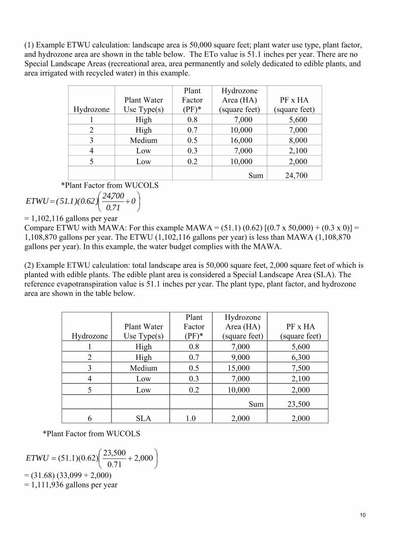
(1) Example ETWU calculation: landscape area is 50,000 square feet; plant water use type, plant factor, and hydrozone area are shown in the table below. The ETo value is 51.1 inches per year. There are no Special Landscape Areas (recreational area, area permanently and solely dedicated to edible plants, and area irrigated with recycled water) in this example.
*Plant Factor from WUCOLS
⎟⎠⎞
⎜⎝⎛ += 0
71.0700,24)62.0)(1.51(ETWU
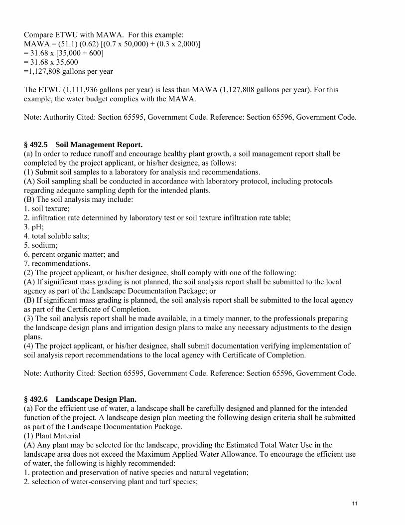
= 1,102,116 gallons per year Compare ETWU with MAWA: For this example MAWA = (51.1) (0.62) [(0.7 x 50,000) + (0.3 x 0)] = 1,108,870 gallons per year. The ETWU (1,102,116 gallons per year) is less than MAWA (1,108,870 gallons per year). In this example, the water budget complies with the MAWA. (2) Example ETWU calculation: total landscape area is 50,000 square feet, 2,000 square feet of which is planted with edible plants. The edible plant area is considered a Special Landscape Area (SLA). The reference evapotranspiration value is 51.1 inches per year. The plant type, plant factor, and hydrozone area are shown in the table below.
*Plant Factor from WUCOLS
⎟⎠⎞
⎜⎝⎛ += 000,2
71.0500,23)62.0)(1.51(ETWU
= (31.68) (33,099 + 2,000) = 1,111,936 gallons per year
Hydrozone Plant Water Use Type(s)
Plant Factor (PF)*
Hydrozone Area (HA)
(square feet) PF x HA
(square feet) 1 High 0.8 7,000 5,600 2 High 0.7 10,000 7,000 3 Medium 0.5 16,000 8,000 4 Low 0.3 7,000 2,100 5 Low 0.2 10,000 2,000
Sum 24,700
Hydrozone Plant Water Use Type(s)
Plant Factor (PF)*
Hydrozone Area (HA)
(square feet)PF x HA
(square feet) 1 High 0.8 7,000 5,600 2 High 0.7 9,000 6,300 3 Medium 0.5 15,000 7,500 4 Low 0.3 7,000 2,100 5 Low 0.2 10,000 2,000
Sum 23,500
6 SLA 1.0 2,000 2,000
10
Compare ETWU with MAWA. For this example: MAWA = (51.1) (0.62) [(0.7 x 50,000) + (0.3 x 2,000)] = 31.68 x [35,000 + 600] = 31.68 x 35,600 =1,127,808 gallons per year The ETWU (1,111,936 gallons per year) is less than MAWA (1,127,808 gallons per year). For this example, the water budget complies with the MAWA. Note: Authority Cited: Section 65595, Government Code. Reference: Section 65596, Government Code.
§ 492.5 Soil Management Report. (a) In order to reduce runoff and encourage healthy plant growth, a soil management report shall be completed by the project applicant, or his/her designee, as follows: (1) Submit soil samples to a laboratory for analysis and recommendations. (A) Soil sampling shall be conducted in accordance with laboratory protocol, including protocols regarding adequate sampling depth for the intended plants. (B) The soil analysis may include: 1. soil texture; 2. infiltration rate determined by laboratory test or soil texture infiltration rate table; 3. pH; 4. total soluble salts; 5. sodium; 6. percent organic matter; and 7. recommendations. (2) The project applicant, or his/her designee, shall comply with one of the following: (A) If significant mass grading is not planned, the soil analysis report shall be submitted to the local agency as part of the Landscape Documentation Package; or (B) If significant mass grading is planned, the soil analysis report shall be submitted to the local agency as part of the Certificate of Completion. (3) The soil analysis report shall be made available, in a timely manner, to the professionals preparing the landscape design plans and irrigation design plans to make any necessary adjustments to the design plans. (4) The project applicant, or his/her designee, shall submit documentation verifying implementation of soil analysis report recommendations to the local agency with Certificate of Completion. Note: Authority Cited: Section 65595, Government Code. Reference: Section 65596, Government Code.
§ 492.6 Landscape Design Plan. (a) For the efficient use of water, a landscape shall be carefully designed and planned for the intended function of the project. A landscape design plan meeting the following design criteria shall be submitted as part of the Landscape Documentation Package. (1) Plant Material (A) Any plant may be selected for the landscape, providing the Estimated Total Water Use in the landscape area does not exceed the Maximum Applied Water Allowance. To encourage the efficient use of water, the following is highly recommended: 1. protection and preservation of native species and natural vegetation; 2. selection of water-conserving plant and turf species;
11
3. selection of plants based on disease and pest resistance; 4. selection of trees based on applicable local tree ordinances or tree shading guidelines; and 5. selection of plants from local and regional landscape program plant lists. (B) Each hydrozone shall have plant materials with similar water use, with the exception of hydrozones with plants of mixed water use, as specified in Section 492.7(a)(2)(D). (C) Plants shall be selected and planted appropriately based upon their adaptability to the climatic, geologic, and topographical conditions of the project site. To encourage the efficient use of water, the following is highly recommended: 1. use the Sunset Western Climate Zone System which takes into account temperature, humidity, elevation, terrain, latitude, and varying degrees of continental and marine influence on local climate; 2. recognize the horticultural attributes of plants (i.e., mature plant size, invasive surface roots) to minimize damage to property or infrastructure [e.g., buildings, sidewalks, power lines]; and 3. consider the solar orientation for plant placement to maximize summer shade and winter solar gain. (D) Turf is not allowed on slopes greater than 25% where the toe of the slope is adjacent to an impermeable hardscape and where 25% means 1 foot of vertical elevation change for every 4 feet of horizontal length (rise divided by run x 100 = slope percent). (E) A landscape design plan for projects in fire-prone areas shall address fire safety and prevention. A defensible space or zone around a building or structure is required per Public Resources Code Section 4291(a) and (b). Avoid fire-prone plant materials and highly flammable mulches. (F) The use of invasive and/or noxious plant species is strongly discouraged. (G) The architectural guidelines of a common interest development, which include community apartment projects, condominiums, planned developments, and stock cooperatives, shall not prohibit or include conditions that have the effect of prohibiting the use of low-water use plants as a group. (2) Water Features (A) Recirculating water systems shall be used for water features. (B) Where available, recycled water shall be used as a source for decorative water features. (C) Surface area of a water feature shall be included in the high water use hydrozone area of the water budget calculation. (D) Pool and spa covers are highly recommended. (3) Mulch and Amendments (A) A minimum two inch (2″) layer of mulch shall be applied on all exposed soil surfaces of planting areas except in turf areas, creeping or rooting groundcovers, or direct seeding applications where mulch is contraindicated. (B) Stabilizing mulching products shall be used on slopes. (C) The mulching portion of the seed/mulch slurry in hydro-seeded applications shall meet the mulching requirement. (D) Soil amendments shall be incorporated according to recommendations of the soil report and what is appropriate for the plants selected (see Section 492.5). (b) The landscape design plan, at a minimum, shall: (1) delineate and label each hydrozone by number, letter, or other method; (2) identify each hydrozone as low, moderate, high water, or mixed water use. Temporarily irrigated areas of the landscape shall be included in the low water use hydrozone for the water budget calculation; (3) identify recreational areas; (4) identify areas permanently and solely dedicated to edible plants; (5) identify areas irrigated with recycled water; (6) identify type of mulch and application depth; (7) identify soil amendments, type, and quantity; (8) identify type and surface area of water features; (9) identify hardscapes (pervious and non-pervious);
12
(10) identify location and installation details of any applicable stormwater best management practices that encourage on-site retention and infiltration of stormwater. Stormwater best management practices are encouraged in the landscape design plan and examples include, but are not limited to: (A) infiltration beds, swales, and basins that allow water to collect and soak into the ground; (B) constructed wetlands and retention ponds that retain water, handle excess flow, and filter pollutants; and (C) pervious or porous surfaces (e.g., permeable pavers or blocks, pervious or porous concrete, etc.) that minimize runoff. (11) identify any applicable rain harvesting or catchment technologies (e.g., rain gardens, cisterns, etc.); (12) contain the following statement: “I have complied with the criteria of the ordinance and applied them for the efficient use of water in the landscape design plan”; and (13) bear the signature of a licensed landscape architect, licensed landscape contractor, or any other person authorized to design a landscape. (See Sections 5500.1, 5615, 5641, 5641.1, 5641.2, 5641.3, 5641.4, 5641.5, 5641.6, 6701, 7027.5 of the Business and Professions Code, Section 832.27 of Title16 of the California Code of Regulations, and Section 6721 of the Food and Agriculture Code.) Note: Authority Cited: Section 65595, Government Code. Reference: Section 65596, Government Code and Section 1351, Civil Code. § 492.7 Irrigation Design Plan. (a) For the efficient use of water, an irrigation system shall meet all the requirements listed in this section and the manufacturers’ recommendations. The irrigation system and its related components shall be planned and designed to allow for proper installation, management, and maintenance. An irrigation design plan meeting the following design criteria shall be submitted as part of the Landscape Documentation Package. (1) System (A) Dedicated landscape water meters are highly recommended on landscape areas smaller than 5,000 square feet to facilitate water management. (B) Automatic irrigation controllers utilizing either evapotranspiration or soil moisture sensor data shall be required for irrigation scheduling in all irrigation systems. (C) The irrigation system shall be designed to ensure that the dynamic pressure at each emission device is within the manufacturer’s recommended pressure range for optimal performance. 1. If the static pressure is above or below the required dynamic pressure of the irrigation system, pressure-regulating devices such as inline pressure regulators, booster pumps, or other devices shall be installed to meet the required dynamic pressure of the irrigation system. 2. Static water pressure, dynamic or operating pressure. and flow reading of the water supply shall be measured at the point of connection. These pressure and flow measurements shall be conducted at the design stage. If the measurements are not available at the design stage, the measurements shall be conducted at installation. (D) Sensors (rain, freeze, wind, etc.), either integral or auxiliary, that suspend or alter irrigation operation during unfavorable weather conditions shall be required on all irrigation systems, as appropriate for local climatic conditions. Irrigation should be avoided during windy or freezing weather or during rain. (E) Manual shut-off valves (such as a gate valve, ball valve, or butterfly valve) shall be required, as close as possible to the point of connection of the water supply, to minimize water loss in case of an emergency (such as a main line break) or routine repair.
13
(F) Backflow prevention devices shall be required to protect the water supply from contamination by the irrigation system. A project applicant shall refer to the applicable local agency code (i.e., public health) for additional backflow prevention requirements. (G) High flow sensors that detect and report high flow conditions created by system damage or malfunction are recommended. (H) The irrigation system shall be designed to prevent runoff, low head drainage, overspray, or other similar conditions where irrigation water flows onto non-targeted areas, such as adjacent property, non-irrigated areas, hardscapes, roadways, or structures. (I) Relevant information from the soil management plan, such as soil type and infiltration rate, shall be utilized when designing irrigation systems. (J) The design of the irrigation system shall conform to the hydrozones of the landscape design plan. (K) The irrigation system must be designed and installed to meet, at a minimum, the irrigation efficiency criteria as described in Section 492.4 regarding the Maximum Applied Water Allowance. (L) It is highly recommended that the project applicant or local agency inquire with the local water purveyor about peak water operating demands (on the water supply system) or water restrictions that may impact the effectiveness of the irrigation system. (M) In mulched planting areas, the use of low volume irrigation is required to maximize water infiltration into the root zone. (N) Sprinkler heads and other emission devices shall have matched precipitation rates, unless otherwise directed by the manufacturer’s recommendations. (O) Head to head coverage is recommended. However, sprinkler spacing shall be designed to achieve the highest possible distribution uniformity using the manufacturer’s recommendations. (P) Swing joints or other riser-protection components are required on all risers subject to damage that are adjacent to high traffic areas. (Q) Check valves or anti-drain valves are required for all irrigation systems. (R) Narrow or irregularly shaped areas, including turf, less than eight (8) feet in width in any direction shall be irrigated with subsurface irrigation or low volume irrigation system. (S) Overhead irrigation shall not be permitted within 24 inches of any non-permeable surface. Allowable irrigation within the setback from non-permeable surfaces may include drip, drip line, or other low flow non-spray technology. The setback area may be planted or unplanted. The surfacing of the setback may be mulch, gravel, or other porous material. These restrictions may be modified if: 1. the landscape area is adjacent to permeable surfacing and no runoff occurs; or 2. the adjacent non-permeable surfaces are designed and constructed to drain entirely to landscaping; or 3. the irrigation designer specifies an alternative design or technology, as part of the Landscape Documentation Package and clearly demonstrates strict adherence to irrigation system design criteria in Section 492.7 (a)(1)(H). Prevention of overspray and runoff must be confirmed during the irrigation audit. (T) Slopes greater than 25% shall not be irrigated with an irrigation system with a precipitation rate exceeding 0.75 inches per hour. This restriction may be modified if the landscape designer specifies an alternative design or technology, as part of the Landscape Documentation Package, and clearly demonstrates no runoff or erosion will occur. Prevention of runoff and erosion must be confirmed during the irrigation audit. (2) Hydrozone (A) Each valve shall irrigate a hydrozone with similar site, slope, sun exposure, soil conditions, and plant materials with similar water use. (B) Sprinkler heads and other emission devices shall be selected based on what is appropriate for the plant type within that hydrozone. (C) Where feasible, trees shall be placed on separate valves from shrubs, groundcovers, and turf. (D) Individual hydrozones that mix plants of moderate and low water use, or moderate and high water use, may be allowed if:
14
1. plant factor calculation is based on the proportions of the respective plant water uses and their plant factor; or 2. the plant factor of the higher water using plant is used for calculations. (E) Individual hydrozones that mix high and low water use plants shall not be permitted. (F) On the landscape design plan and irrigation design plan, hydrozone areas shall be designated by number, letter, or other designation. On the irrigation design plan, designate the areas irrigated by each valve, and assign a number to each valve. Use this valve number in the Hydrozone Information Table (see Appendix B Section A). This table can also assist with the irrigation audit and programming the controller. (b) The irrigation design plan, at a minimum, shall contain: (1) location and size of separate water meters for landscape; (2) location, type and size of all components of the irrigation system, including controllers, main and lateral lines, valves, sprinkler heads, moisture sensing devices, rain switches, quick couplers, pressure regulators, and backflow prevention devices; (3) static water pressure at the point of connection to the public water supply; (4) flow rate (gallons per minute), application rate (inches per hour), and design operating pressure (pressure per square inch) for each station; (5) recycled water irrigation systems as specified in Section 492.14; (6) the following statement: “I have complied with the criteria of the ordinance and applied them accordingly for the efficient use of water in the irrigation design plan”; and (7) the signature of a licensed landscape architect, certified irrigation designer, licensed landscape contractor, or any other person authorized to design an irrigation system. (See Sections 5500.1, 5615, 5641, 5641.1, 5641.2, 5641.3, 5641.4, 5641.5, 5641.6, 6701, 7027.5 of the Business and Professions Code, Section 832.27 of Title 16 of the California Code of Regulations, and Section 6721 of the Food and Agricultural Code.) Note: Authority Cited: Section 65595, Government Code. Reference: Section 65596, Government Code. § 492.8 Grading Design Plan. (a) For the efficient use of water, grading of a project site shall be designed to minimize soil erosion, runoff, and water waste. A grading plan shall be submitted as part of the Landscape Documentation Package. A comprehensive grading plan prepared by a civil engineer for other local agency permits satisfies this requirement. (1) The project applicant shall submit a landscape grading plan that indicates finished configurations and elevations of the landscape area including: (A) height of graded slopes; (B) drainage patterns; (C) pad elevations; (D) finish grade; and (E) stormwater retention improvements, if applicable. (2) To prevent excessive erosion and runoff, it is highly recommended that project applicants: (A) grade so that all irrigation and normal rainfall remains within property lines and does not drain on to non-permeable hardscapes; (B) avoid disruption of natural drainage patterns and undisturbed soil; and (C) avoid soil compaction in landscape areas. (3) The grading design plan shall contain the following statement: “I have complied with the criteria of the ordinance and applied them accordingly for the efficient use of water in the grading design plan” and shall bear the signature of a licensed professional as authorized by law. Note: Authority Cited: Section 65595, Government Code. Reference: Section 65596, Government Code.
15

§ 492.9 Certificate of Completion. (a) The Certificate of Completion (see Appendix C for a sample certificate) shall include the following six (6) elements: (1) project information sheet that contains: (A) date; (B) project name; (C) project applicant name, telephone, and mailing address; (D) project address and location; and (E) property owner name, telephone, and mailing address; (2) certification by either the signer of the landscape design plan, the signer of the irrigation design plan, or the licensed landscape contractor that the landscape project has been installed per the approved Landscape Documentation Package; (A) where there have been significant changes made in the field during construction, these “as-built” or record drawings shall be included with the certification; (3) irrigation scheduling parameters used to set the controller (see Section 492.10); (4) landscape and irrigation maintenance schedule (see Section 492.11); (5) irrigation audit report (see Section 492.12); and (6) soil analysis report, if not submitted with Landscape Documentation Package, and documentation verifying implementation of soil report recommendations (see Section 492.5). (b) The project applicant shall: (1) submit the signed Certificate of Completion to the local agency for review; (2) ensure that copies of the approved Certificate of Completion are submitted to the local water purveyor and property owner or his or her designee. (c) The local agency shall: (1) receive the signed Certificate of Completion from the project applicant; (2) approve or deny the Certificate of Completion. If the Certificate of Completion is denied, the local agency shall provide information to the project applicant regarding reapplication, appeal, or other assistance. Note: Authority Cited: Section 65595, Government Code. Reference: Section 65596, Government Code.
§ 492.10 Irrigation Scheduling. (a) For the efficient use of water, all irrigation schedules shall be developed, managed, and evaluated to utilize the minimum amount of water required to maintain plant health. Irrigation schedules shall meet the following criteria: (1) Irrigation scheduling shall be regulated by automatic irrigation controllers. (2) Overhead irrigation shall be scheduled between 8:00 p.m. and 10:00 a.m. unless weather conditions prevent it. If allowable hours of irrigation differ from the local water purveyor, the stricter of the two shall apply. Operation of the irrigation system outside the normal watering window is allowed for auditing and system maintenance. (3) For implementation of the irrigation schedule, particular attention must be paid to irrigation run times, emission device, flow rate, and current reference evapotranspiration, so that applied water meets the Estimated Total Water Use. Total annual applied water shall be less than or equal to Maximum Applied Water Allowance (MAWA). Actual irrigation schedules shall be regulated by automatic irrigation controllers using current reference evapotranspiration data (e.g., CIMIS) or soil moisture sensor data. (4) Parameters used to set the automatic controller shall be developed and submitted for each of the
following: (A) the plant establishment period;
16
(B) the established landscape; and (C) temporarily irrigated areas. (5) Each irrigation schedule shall consider for each station all of the following that apply: (A) irrigation interval (days between irrigation); (B) irrigation run times (hours or minutes per irrigation event to avoid runoff); (C) number of cycle starts required for each irrigation event to avoid runoff; (D) amount of applied water scheduled to be applied on a monthly basis; (E) application rate setting; (F) root depth setting; (G) plant type setting; (H) soil type; (I) slope factor setting; (J) shade factor setting; and (K) irrigation uniformity or efficiency setting. Note: Authority Cited: Section 65595, Government Code. Reference: Section 65596, Government Code.
§ 492.11 Landscape and Irrigation Maintenance Schedule. (a) Landscapes shall be maintained to ensure water use efficiency. A regular maintenance schedule shall be submitted with the Certificate of Completion. (b) A regular maintenance schedule shall include, but not be limited to, routine inspection; adjustment and repair of the irrigation system and its components; aerating and dethatching turf areas; replenishing mulch; fertilizing; pruning; weeding in all landscape areas, and removing and obstruction to emission devices. Operation of the irrigation system outside the normal watering window is allowed for auditing and system maintenance. (c) Repair of all irrigation equipment shall be done with the originally installed components or their equivalents. (d) A project applicant is encouraged to implement sustainable or environmentally-friendly practices for overall landscape maintenance. Note: Authority Cited: Section 65595, Government Code. Reference: Section 65596, Government Code.
§ 492.12 Irrigation Audit, Irrigation Survey, and Irrigation Water Use Analysis. (a) All landscape irrigation audits shall be conducted by a certified landscape irrigation auditor. (b) For new construction and rehabilitated landscape projects installed after January 1, 2010, as described in Section 490.1: (1) the project applicant shall submit an irrigation audit report with the Certificate of Completion to the local agency that may include, but is not limited to: inspection, system tune-up, system test with distribution uniformity, reporting overspray or run off that causes overland flow, and preparation of an irrigation schedule; (2) the local agency shall administer programs that may include, but not be limited to, irrigation water use analysis, irrigation audits, and irrigation surveys for compliance with the Maximum Applied Water Allowance. Note: Authority Cited: Section 65595, Government Code. Reference: Section 65596, Government Code.
17
§ 492.13 Irrigation Efficiency. (a) For the purpose of determining Maximum Applied Water Allowance, average irrigation efficiency is assumed to be 0.71. Irrigation systems shall be designed, maintained, and managed to meet or exceed an average landscape irrigation efficiency of 0.71. Note: Authority Cited: Section 65595, Government Code. Reference: Section 65596, Government Code. § 492.14 Recycled Water. (a) The installation of recycled water irrigation systems shall allow for the current and future use of recycled water, unless a written exemption has been granted as described in Section 492.14(b). (b) Irrigation systems and decorative water features shall use recycled water unless a written exemption has been granted by the local water purveyor stating that recycled water meeting all public health codes and standards is not available and will not be available for the foreseeable future. (c) All recycled water irrigation systems shall be designed and operated in accordance with all applicable local and State laws. (d) Landscapes using recycled water are considered Special Landscape Areas. The ET Adjustment Factor for Special Landscape Areas shall not exceed 1.0. Note: Authority Cited: Section 65595, Government Code. Reference: Section 65596, Government Code. § 492.15 Stormwater Management. (a) Stormwater management practices minimize runoff and increase infiltration which recharges groundwater and improves water quality. Implementing stormwater best management practices into the landscape and grading design plans to minimize runoff and to increase on-site retention and infiltration are encouraged. (b) Project applicants shall refer to the local agency or Regional Water Quality Control Board for information on any applicable stormwater ordinances and stormwater management plans. (c) Rain gardens, cisterns, and other landscapes features and practices that increase rainwater capture and create opportunities for infiltration and/or onsite storage are recommended. Note: Authority Cited: Section 65595, Government Code. Reference: Section 65596, Government Code. § 492.16 Public Education. (a) Publications. Education is a critical component to promote the efficient use of water in landscapes. The use of appropriate principles of design, installation, management and maintenance that save water is encouraged in the community. (1) A local agency shall provide information to owners of new, single-family residential homes regarding the design, installation, management, and maintenance of water efficient landscapes. (b) Model Homes. All model homes that are landscaped shall use signs and written information to demonstrate the principles of water efficient landscapes described in this ordinance. (1) Signs shall be used to identify the model as an example of a water efficient landscape featuring elements such as hydrozones, irrigation equipment, and others that contribute to the overall water efficient theme. (2) Information shall be provided about designing, installing, managing, and maintaining water efficient landscapes. Note: Authority Cited: Section 65595, Government Code. Reference: Section 65596, Government Code.
18
§ 492.17 Environmental Review. (a) The local agency must comply with the California Environmental Quality Act (CEQA), as appropriate. Note: Authority cited: Section 21082, Public Resources Code. Reference: Sections 21080, 21082, Public Resources Code. § 493. Provisions for Existing Landscapes. (a) A local agency may designate another agency, such as a water purveyor, to implement some or all of the requirements contained in this ordinance. Local agencies may collaborate with water purveyors to define each entity’s specific responsibilities relating to this ordinance. Note: Authority Cited: Section 65595, Government Code. Reference: Section 65596, Government Code. § 493.1 Irrigation Audit, Irrigation Survey, and Irrigation Water Use Analysis. (a) This section, 493.1, shall apply to all existing landscapes that were installed before January 1, 2010 and are over one acre in size. (1) For all landscapes in 493.1(a) that have a water meter, the local agency shall administer programs that may include, but not be limited to, irrigation water use analyses, irrigation surveys, and irrigation audits to evaluate water use and provide recommendations as necessary to reduce landscape water use to a level that does not exceed the Maximum Applied Water Allowance for existing landscapes. The Maximum Applied Water Allowance for existing landscapes shall be calculated as: MAWA = (0.8) (ETo)(LA)(0.62). (2) For all landscapes in 493.1(a), that do not have a meter, the local agency shall administer programs that may include, but not be limited to, irrigation surveys and irrigation audits to evaluate water use and provide recommendations as necessary in order to prevent water waste. (b) All landscape irrigation audits shall be conducted by a certified landscape irrigation auditor. Note: Authority Cited: Section 65595, Government Code. Reference: Section 65596, Government Code.
§ 493.2 Water Waste Prevention. (a) Local agencies shall prevent water waste resulting from inefficient landscape irrigation by prohibiting runoff from leaving the target landscape due to low head drainage, overspray, or other similar conditions where water flows onto adjacent property, non-irrigated areas, walks, roadways, parking lots, or structures. Penalties for violation of these prohibitions shall be established locally. (b) Restrictions regarding overspray and runoff may be modified if: (1) the landscape area is adjacent to permeable surfacing and no runoff occurs; or (2) the adjacent non-permeable surfaces are designed and constructed to drain entirely to landscaping. Note: Authority cited: Section 65594, Government Code. Reference: Section 65596, Government Code.
§ 494. Effective Precipitation. (a) A local agency may consider Effective Precipitation (25% of annual precipitation) in tracking water use and may use the following equation to calculate Maximum Applied Water Allowance: MAWA= (ETo - Eppt) (0.62) [(0.7 x LA) + (0.3 x SLA)]. Note: Authority Cited: Section 65595, Government Code. Reference: Section 65596, Government Code.
19
Appendices.
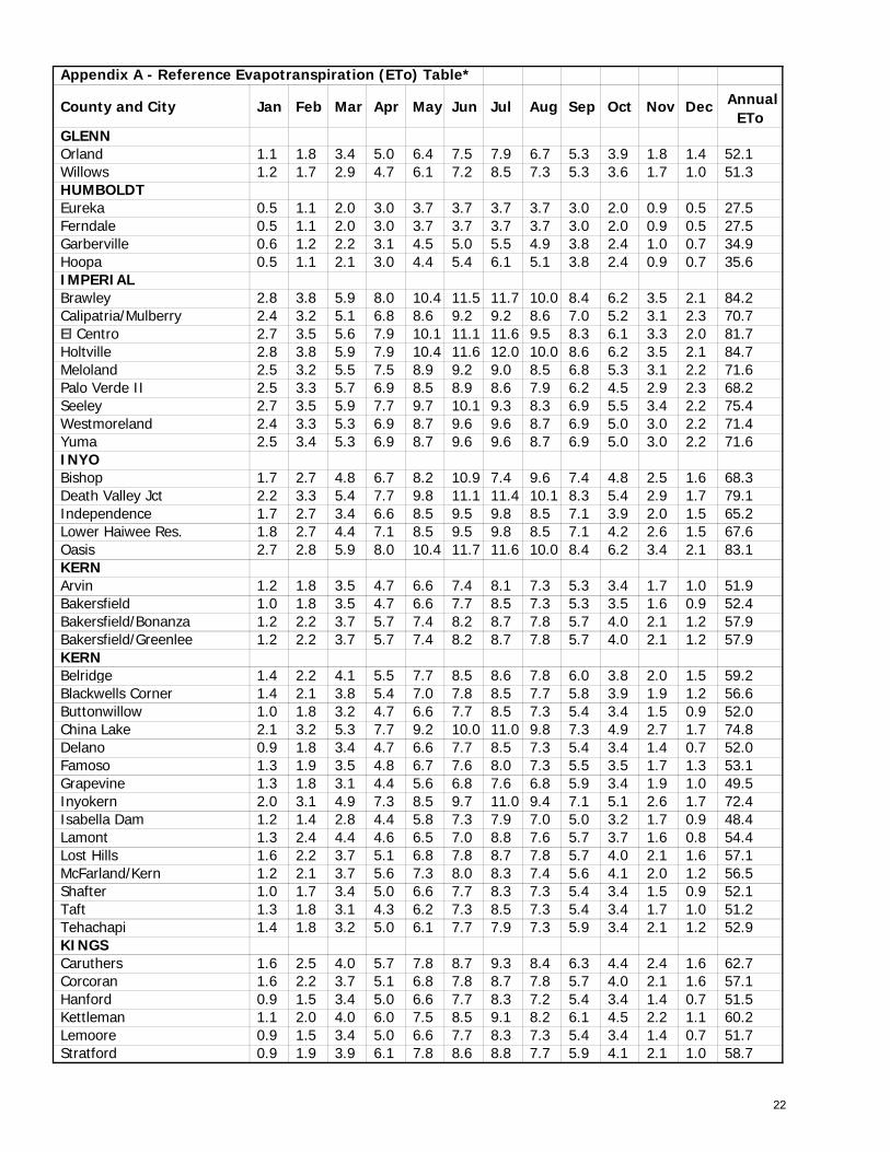
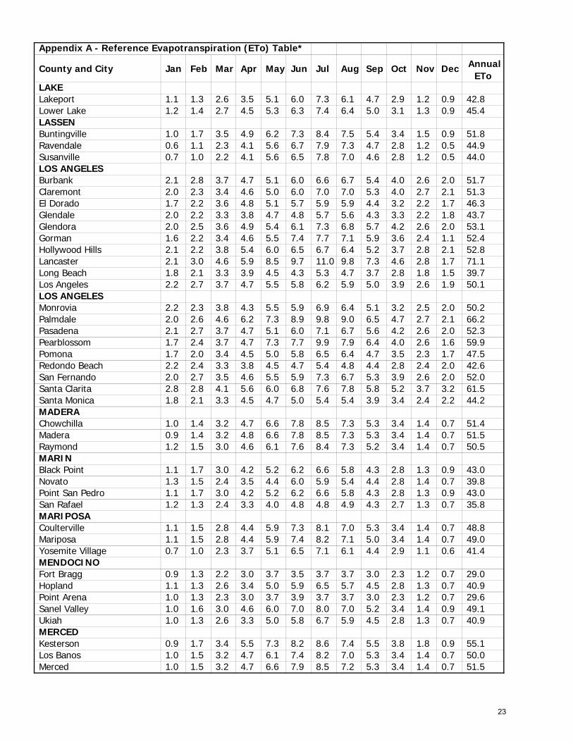
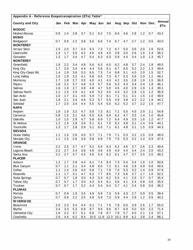
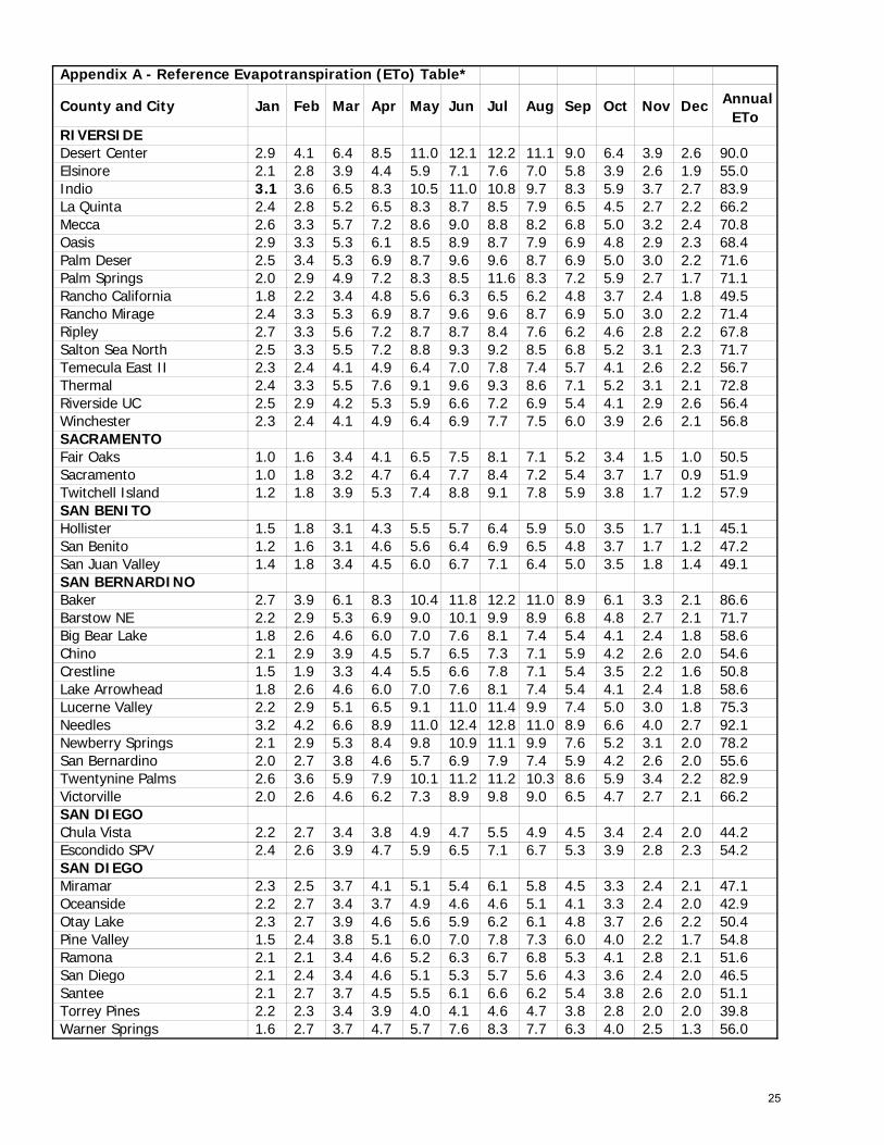
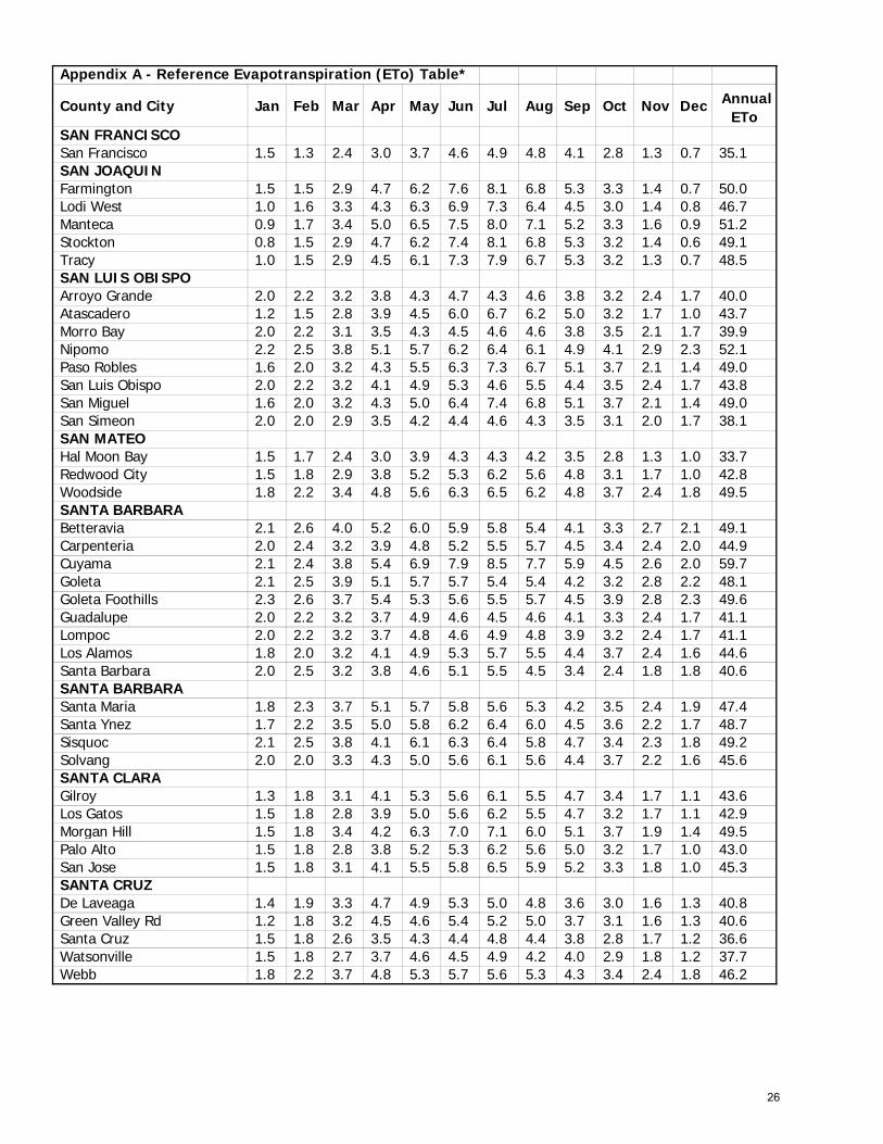
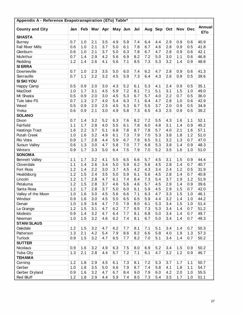
Appendix A. Reference Evapotranspiration (ETo) Table.
20
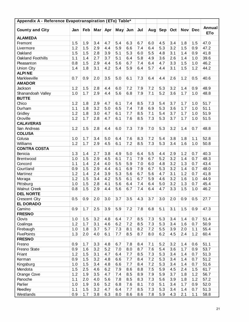
Appendix A - Reference Evapotranspiration (ETo) Table*
County and City Jan Feb Mar Apr May Jun Jul Aug Sep Oct Nov Dec Annual ETo
ALAMEDA Fremont 1.5 1.9 3.4 4.7 5.4 6.3 6.7 6.0 4.5 3.4 1.8 1.5 47.0 Livermore 1.2 1.5 2.9 4.4 5.9 6.6 7.4 6.4 5.3 3.2 1.5 0.9 47.2 Oakland 1.5 1.5 2.8 3.9 5.1 5.3 6.0 5.5 4.8 3.1 1.4 0.9 41.8 Oakland Foothills 1.1 1.4 2.7 3.7 5.1 6.4 5.8 4.9 3.6 2.6 1.4 1.0 39.6 Pleasanton 0.8 1.5 2.9 4.4 5.6 6.7 7.4 6.4 4.7 3.3 1.5 1.0 46.2 Union City 1.4 1.8 3.1 4.2 5.4 5.9 6.4 5.7 4.4 3.1 1.5 1.2 44.2 ALPINE Markleeville 0.7 0.9 2.0 3.5 5.0 6.1 7.3 6.4 4.4 2.6 1.2 0.5 40.6 AMADOR Jackson 1.2 1.5 2.8 4.4 6.0 7.2 7.9 7.2 5.3 3.2 1.4 0.9 48.9 Shanandoah Valley 1.0 1.7 2.9 4.4 5.6 6.8 7.9 7.1 5.2 3.6 1.7 1.0 48.8 BUTTE Chico 1.2 1.8 2.9 4.7 6.1 7.4 8.5 7.3 5.4 3.7 1.7 1.0 51.7 Durham 1.1 1.8 3.2 5.0 6.5 7.4 7.8 6.9 5.3 3.6 1.7 1.0 51.1 Gridley 1.2 1.8 3.0 4.7 6.1 7.7 8.5 7.1 5.4 3.7 1.7 1.0 51.9 Oroville 1.2 1.7 2.8 4.7 6.1 7.6 8.5 7.3 5.3 3.7 1.7 1.0 51.5 CALAVERAS San Andreas 1.2 1.5 2.8 4.4 6.0 7.3 7.9 7.0 5.3 3.2 1.4 0.7 48.8 COLUSA Colusa 1.0 1.7 3.4 5.0 6.4 7.6 8.3 7.2 5.4 3.8 1.8 1.1 52.8 Williams 1.2 1.7 2.9 4.5 6.1 7.2 8.5 7.3 5.3 3.4 1.6 1.0 50.8 CONTRA COSTA Benicia 1.3 1.4 2.7 3.8 4.9 5.0 6.4 5.5 4.4 2.9 1.2 0.7 40.3 Brentwood 1.0 1.5 2.9 4.5 6.1 7.1 7.9 6.7 5.2 3.2 1.4 0.7 48.3 Concord 1.1 1.4 2.4 4.0 5.5 5.9 7.0 6.0 4.8 3.2 1.3 0.7 43.4 Courtland 0.9 1.5 2.9 4.4 6.1 6.9 7.9 6.7 5.3 3.2 1.4 0.7 48.0 Martinez 1.2 1.4 2.4 3.9 5.3 5.6 6.7 5.6 4.7 3.1 1.2 0.7 41.8 Moraga 1.2 1.5 3.4 4.2 5.5 6.1 6.7 5.9 4.6 3.2 1.6 1.0 44.9 Pittsburg 1.0 1.5 2.8 4.1 5.6 6.4 7.4 6.4 5.0 3.2 1.3 0.7 45.4 Walnut Creek 0.8 1.5 2.9 4.4 5.6 6.7 7.4 6.4 4.7 3.3 1.5 1.0 46.2 DEL NORTE Crescent City 0.5 0.9 2.0 3.0 3.7 3.5 4.3 3.7 3.0 2.0 0.9 0.5 27.7 EL DORADO Camino 0.9 1.7 2.5 3.9 5.9 7.2 7.8 6.8 5.1 3.1 1.5 0.9 47.3 FRESNO Clovis 1.0 1.5 3.2 4.8 6.4 7.7 8.5 7.3 5.3 3.4 1.4 0.7 51.4 Coalinga 1.2 1.7 3.1 4.6 6.2 7.2 8.5 7.3 5.3 3.4 1.6 0.7 50.9 Firebaugh 1.0 1.8 3.7 5.7 7.3 8.1 8.2 7.2 5.5 3.9 2.0 1.1 55.4 FivePoints 1.3 2.0 4.0 6.1 7.7 8.5 8.7 8.0 6.2 4.5 2.4 1.2 60.4 FRESNO Fresno 0.9 1.7 3.3 4.8 6.7 7.8 8.4 7.1 5.2 3.2 1.4 0.6 51.1 Fresno State 0.9 1.6 3.2 5.2 7.0 8.0 8.7 7.6 5.4 3.6 1.7 0.9 53.7 Friant 1.2 1.5 3.1 4.7 6.4 7.7 8.5 7.3 5.3 3.4 1.4 0.7 51.3 Kerman 0.9 1.5 3.2 4.8 6.6 7.7 8.4 7.2 5.3 3.4 1.4 0.7 51.2 Kingsburg 1.0 1.5 3.4 4.8 6.6 7.7 8.4 7.2 5.3 3.4 1.4 0.7 51.6 Mendota 1.5 2.5 4.6 6.2 7.9 8.6 8.8 7.5 5.9 4.5 2.4 1.5 61.7 Orange Cove 1.2 1.9 3.5 4.7 7.4 8.5 8.9 7.9 5.9 3.7 1.8 1.2 56.7 Panoche 1.1 2.0 4.0 5.6 7.8 8.5 8.3 7.3 5.6 3.9 1.8 1.2 57.2 Parlier 1.0 1.9 3.6 5.2 6.8 7.6 8.1 7.0 5.1 3.4 1.7 0.9 52.0 Reedley 1.1 1.5 3.2 4.7 6.4 7.7 8.5 7.3 5.3 3.4 1.4 0.7 51.3 Westlands 0.9 1.7 3.8 6.3 8.0 8.6 8.6 7.8 5.9 4.3 2.1 1.1 58.8
21
Appendix A - Reference Evapotranspiration (ETo) Table*
County and City Jan Feb Mar Apr May Jun Jul Aug Sep Oct Nov Dec Annual ETo
GLENN Orland 1.1 1.8 3.4 5.0 6.4 7.5 7.9 6.7 5.3 3.9 1.8 1.4 52.1 Willows 1.2 1.7 2.9 4.7 6.1 7.2 8.5 7.3 5.3 3.6 1.7 1.0 51.3 HUMBOLDT Eureka 0.5 1.1 2.0 3.0 3.7 3.7 3.7 3.7 3.0 2.0 0.9 0.5 27.5 Ferndale 0.5 1.1 2.0 3.0 3.7 3.7 3.7 3.7 3.0 2.0 0.9 0.5 27.5 Garberville 0.6 1.2 2.2 3.1 4.5 5.0 5.5 4.9 3.8 2.4 1.0 0.7 34.9 Hoopa 0.5 1.1 2.1 3.0 4.4 5.4 6.1 5.1 3.8 2.4 0.9 0.7 35.6 IMPERIAL Brawley 2.8 3.8 5.9 8.0 10.4 11.5 11.7 10.0 8.4 6.2 3.5 2.1 84.2 Calipatria/Mulberry 2.4 3.2 5.1 6.8 8.6 9.2 9.2 8.6 7.0 5.2 3.1 2.3 70.7 El Centro 2.7 3.5 5.6 7.9 10.1 11.1 11.6 9.5 8.3 6.1 3.3 2.0 81.7 Holtville 2.8 3.8 5.9 7.9 10.4 11.6 12.0 10.0 8.6 6.2 3.5 2.1 84.7 Meloland 2.5 3.2 5.5 7.5 8.9 9.2 9.0 8.5 6.8 5.3 3.1 2.2 71.6 Palo Verde II 2.5 3.3 5.7 6.9 8.5 8.9 8.6 7.9 6.2 4.5 2.9 2.3 68.2 Seeley 2.7 3.5 5.9 7.7 9.7 10.1 9.3 8.3 6.9 5.5 3.4 2.2 75.4 Westmoreland 2.4 3.3 5.3 6.9 8.7 9.6 9.6 8.7 6.9 5.0 3.0 2.2 71.4 Yuma 2.5 3.4 5.3 6.9 8.7 9.6 9.6 8.7 6.9 5.0 3.0 2.2 71.6 INYO Bishop 1.7 2.7 4.8 6.7 8.2 10.9 7.4 9.6 7.4 4.8 2.5 1.6 68.3 Death Valley Jct 2.2 3.3 5.4 7.7 9.8 11.1 11.4 10.1 8.3 5.4 2.9 1.7 79.1 Independence 1.7 2.7 3.4 6.6 8.5 9.5 9.8 8.5 7.1 3.9 2.0 1.5 65.2 Lower Haiwee Res. 1.8 2.7 4.4 7.1 8.5 9.5 9.8 8.5 7.1 4.2 2.6 1.5 67.6 Oasis 2.7 2.8 5.9 8.0 10.4 11.7 11.6 10.0 8.4 6.2 3.4 2.1 83.1 KERN Arvin 1.2 1.8 3.5 4.7 6.6 7.4 8.1 7.3 5.3 3.4 1.7 1.0 51.9 Bakersfield 1.0 1.8 3.5 4.7 6.6 7.7 8.5 7.3 5.3 3.5 1.6 0.9 52.4 Bakersfield/Bonanza 1.2 2.2 3.7 5.7 7.4 8.2 8.7 7.8 5.7 4.0 2.1 1.2 57.9 Bakersfield/Greenlee 1.2 2.2 3.7 5.7 7.4 8.2 8.7 7.8 5.7 4.0 2.1 1.2 57.9 KERN Belridge 1.4 2.2 4.1 5.5 7.7 8.5 8.6 7.8 6.0 3.8 2.0 1.5 59.2 Blackwells Corner 1.4 2.1 3.8 5.4 7.0 7.8 8.5 7.7 5.8 3.9 1.9 1.2 56.6 Buttonwillow 1.0 1.8 3.2 4.7 6.6 7.7 8.5 7.3 5.4 3.4 1.5 0.9 52.0 China Lake 2.1 3.2 5.3 7.7 9.2 10.0 11.0 9.8 7.3 4.9 2.7 1.7 74.8 Delano 0.9 1.8 3.4 4.7 6.6 7.7 8.5 7.3 5.4 3.4 1.4 0.7 52.0 Famoso 1.3 1.9 3.5 4.8 6.7 7.6 8.0 7.3 5.5 3.5 1.7 1.3 53.1 Grapevine 1.3 1.8 3.1 4.4 5.6 6.8 7.6 6.8 5.9 3.4 1.9 1.0 49.5 Inyokern 2.0 3.1 4.9 7.3 8.5 9.7 11.0 9.4 7.1 5.1 2.6 1.7 72.4 Isabella Dam 1.2 1.4 2.8 4.4 5.8 7.3 7.9 7.0 5.0 3.2 1.7 0.9 48.4 Lamont 1.3 2.4 4.4 4.6 6.5 7.0 8.8 7.6 5.7 3.7 1.6 0.8 54.4 Lost Hills 1.6 2.2 3.7 5.1 6.8 7.8 8.7 7.8 5.7 4.0 2.1 1.6 57.1 McFarland/Kern 1.2 2.1 3.7 5.6 7.3 8.0 8.3 7.4 5.6 4.1 2.0 1.2 56.5 Shafter 1.0 1.7 3.4 5.0 6.6 7.7 8.3 7.3 5.4 3.4 1.5 0.9 52.1 Taft 1.3 1.8 3.1 4.3 6.2 7.3 8.5 7.3 5.4 3.4 1.7 1.0 51.2 Tehachapi 1.4 1.8 3.2 5.0 6.1 7.7 7.9 7.3 5.9 3.4 2.1 1.2 52.9 KINGS Caruthers 1.6 2.5 4.0 5.7 7.8 8.7 9.3 8.4 6.3 4.4 2.4 1.6 62.7 Corcoran 1.6 2.2 3.7 5.1 6.8 7.8 8.7 7.8 5.7 4.0 2.1 1.6 57.1 Hanford 0.9 1.5 3.4 5.0 6.6 7.7 8.3 7.2 5.4 3.4 1.4 0.7 51.5 Kettleman 1.1 2.0 4.0 6.0 7.5 8.5 9.1 8.2 6.1 4.5 2.2 1.1 60.2 Lemoore 0.9 1.5 3.4 5.0 6.6 7.7 8.3 7.3 5.4 3.4 1.4 0.7 51.7 Stratford 0.9 1.9 3.9 6.1 7.8 8.6 8.8 7.7 5.9 4.1 2.1 1.0 58.7
22
Appendix A - Reference Evapotranspiration (ETo) Table*
County and City Jan Feb Mar Apr May Jun Jul Aug Sep Oct Nov Dec Annual ETo
LAKE Lakeport 1.1 1.3 2.6 3.5 5.1 6.0 7.3 6.1 4.7 2.9 1.2 0.9 42.8 Lower Lake 1.2 1.4 2.7 4.5 5.3 6.3 7.4 6.4 5.0 3.1 1.3 0.9 45.4 LASSEN Buntingville 1.0 1.7 3.5 4.9 6.2 7.3 8.4 7.5 5.4 3.4 1.5 0.9 51.8 Ravendale 0.6 1.1 2.3 4.1 5.6 6.7 7.9 7.3 4.7 2.8 1.2 0.5 44.9 Susanville 0.7 1.0 2.2 4.1 5.6 6.5 7.8 7.0 4.6 2.8 1.2 0.5 44.0 LOS ANGELES Burbank 2.1 2.8 3.7 4.7 5.1 6.0 6.6 6.7 5.4 4.0 2.6 2.0 51.7 Claremont 2.0 2.3 3.4 4.6 5.0 6.0 7.0 7.0 5.3 4.0 2.7 2.1 51.3 El Dorado 1.7 2.2 3.6 4.8 5.1 5.7 5.9 5.9 4.4 3.2 2.2 1.7 46.3 Glendale 2.0 2.2 3.3 3.8 4.7 4.8 5.7 5.6 4.3 3.3 2.2 1.8 43.7 Glendora 2.0 2.5 3.6 4.9 5.4 6.1 7.3 6.8 5.7 4.2 2.6 2.0 53.1 Gorman 1.6 2.2 3.4 4.6 5.5 7.4 7.7 7.1 5.9 3.6 2.4 1.1 52.4 Hollywood Hills 2.1 2.2 3.8 5.4 6.0 6.5 6.7 6.4 5.2 3.7 2.8 2.1 52.8 Lancaster 2.1 3.0 4.6 5.9 8.5 9.7 11.0 9.8 7.3 4.6 2.8 1.7 71.1 Long Beach 1.8 2.1 3.3 3.9 4.5 4.3 5.3 4.7 3.7 2.8 1.8 1.5 39.7 Los Angeles 2.2 2.7 3.7 4.7 5.5 5.8 6.2 5.9 5.0 3.9 2.6 1.9 50.1 LOS ANGELES Monrovia 2.2 2.3 3.8 4.3 5.5 5.9 6.9 6.4 5.1 3.2 2.5 2.0 50.2 Palmdale 2.0 2.6 4.6 6.2 7.3 8.9 9.8 9.0 6.5 4.7 2.7 2.1 66.2 Pasadena 2.1 2.7 3.7 4.7 5.1 6.0 7.1 6.7 5.6 4.2 2.6 2.0 52.3 Pearblossom 1.7 2.4 3.7 4.7 7.3 7.7 9.9 7.9 6.4 4.0 2.6 1.6 59.9 Pomona 1.7 2.0 3.4 4.5 5.0 5.8 6.5 6.4 4.7 3.5 2.3 1.7 47.5 Redondo Beach 2.2 2.4 3.3 3.8 4.5 4.7 5.4 4.8 4.4 2.8 2.4 2.0 42.6 San Fernando 2.0 2.7 3.5 4.6 5.5 5.9 7.3 6.7 5.3 3.9 2.6 2.0 52.0 Santa Clarita 2.8 2.8 4.1 5.6 6.0 6.8 7.6 7.8 5.8 5.2 3.7 3.2 61.5 Santa Monica 1.8 2.1 3.3 4.5 4.7 5.0 5.4 5.4 3.9 3.4 2.4 2.2 44.2 MADERA Chowchilla 1.0 1.4 3.2 4.7 6.6 7.8 8.5 7.3 5.3 3.4 1.4 0.7 51.4 Madera 0.9 1.4 3.2 4.8 6.6 7.8 8.5 7.3 5.3 3.4 1.4 0.7 51.5 Raymond 1.2 1.5 3.0 4.6 6.1 7.6 8.4 7.3 5.2 3.4 1.4 0.7 50.5 MARIN Black Point 1.1 1.7 3.0 4.2 5.2 6.2 6.6 5.8 4.3 2.8 1.3 0.9 43.0 Novato 1.3 1.5 2.4 3.5 4.4 6.0 5.9 5.4 4.4 2.8 1.4 0.7 39.8 Point San Pedro 1.1 1.7 3.0 4.2 5.2 6.2 6.6 5.8 4.3 2.8 1.3 0.9 43.0 San Rafael 1.2 1.3 2.4 3.3 4.0 4.8 4.8 4.9 4.3 2.7 1.3 0.7 35.8 MARIPOSA Coulterville 1.1 1.5 2.8 4.4 5.9 7.3 8.1 7.0 5.3 3.4 1.4 0.7 48.8 Mariposa 1.1 1.5 2.8 4.4 5.9 7.4 8.2 7.1 5.0 3.4 1.4 0.7 49.0 Yosemite Village 0.7 1.0 2.3 3.7 5.1 6.5 7.1 6.1 4.4 2.9 1.1 0.6 41.4 MENDOCINO Fort Bragg 0.9 1.3 2.2 3.0 3.7 3.5 3.7 3.7 3.0 2.3 1.2 0.7 29.0 Hopland 1.1 1.3 2.6 3.4 5.0 5.9 6.5 5.7 4.5 2.8 1.3 0.7 40.9 Point Arena 1.0 1.3 2.3 3.0 3.7 3.9 3.7 3.7 3.0 2.3 1.2 0.7 29.6 Sanel Valley 1.0 1.6 3.0 4.6 6.0 7.0 8.0 7.0 5.2 3.4 1.4 0.9 49.1 Ukiah 1.0 1.3 2.6 3.3 5.0 5.8 6.7 5.9 4.5 2.8 1.3 0.7 40.9 MERCED Kesterson 0.9 1.7 3.4 5.5 7.3 8.2 8.6 7.4 5.5 3.8 1.8 0.9 55.1 Los Banos 1.0 1.5 3.2 4.7 6.1 7.4 8.2 7.0 5.3 3.4 1.4 0.7 50.0 Merced 1.0 1.5 3.2 4.7 6.6 7.9 8.5 7.2 5.3 3.4 1.4 0.7 51.5
23
Appendix A - Reference Evapotranspiration (ETo) Table*
County and City Jan Feb Mar Apr May Jun Jul Aug Sep Oct Nov Dec Annual ETo
MODOC Modoc/Alturas 0.9 1.4 2.8 3.7 5.1 6.2 7.5 6.6 4.6 2.8 1.2 0.7 43.2 MONO Bridgeport 0.7 0.9 2.2 3.8 5.5 6.6 7.4 6.7 4.7 2.7 1.2 0.5 43.0 MONTEREY Arroyo Seco 1.5 2.0 3.7 5.4 6.3 7.3 7.2 6.7 5.0 3.9 2.0 1.6 52.6 Castroville 1.4 1.7 3.0 4.2 4.6 4.8 4.0 3.8 3.0 2.6 1.6 1.4 36.2 Gonzales 1.3 1.7 3.4 4.7 5.4 6.3 6.3 5.9 4.4 3.4 1.9 1.3 45.7 MONTEREY Greenfield 1.8 2.2 3.4 4.8 5.6 6.3 6.5 6.2 4.8 3.7 2.4 1.8 49.5 King City 1.7 2.0 3.4 4.4 4.4 5.6 6.1 6.7 6.5 5.2 2.2 1.3 49.6 King City-Oasis Rd. 1.4 1.9 3.6 5.3 6.5 7.3 7.4 6.8 5.1 4.0 2.0 1.5 52.7 Long Valley 1.5 1.9 3.2 4.1 5.8 6.5 7.3 6.7 5.3 3.6 2.0 1.2 49.1 Monterey 1.7 1.8 2.7 3.5 4.0 4.1 4.3 4.2 3.5 2.8 1.9 1.5 36.0 Pajaro 1.8 2.2 3.7 4.8 5.3 5.7 5.6 5.3 4.3 3.4 2.4 1.8 46.1 Salinas 1.6 1.9 2.7 3.8 4.8 4.7 5.0 4.5 4.0 2.9 1.9 1.3 39.1 Salinas North 1.2 1.5 2.9 4.1 4.6 5.2 4.5 4.3 3.2 2.8 1.5 1.2 36.9 San Ardo 1.0 1.7 3.1 4.5 5.9 7.2 8.1 7.1 5.1 3.1 1.5 1.0 49.0 San Juan 1.8 2.1 3.4 4.6 5.3 5.7 5.5 4.9 3.8 3.2 2.2 1.9 44.2 Soledad 1.7 2.0 3.4 4.4 5.5 5.4 6.5 6.2 5.2 3.7 2.2 1.5 47.7 NAPA Angwin 1.8 1.9 3.2 4.7 5.8 7.3 8.1 7.1 5.5 4.5 2.9 2.1 54.9 Carneros 0.8 1.5 3.1 4.6 5.5 6.6 6.9 6.2 4.7 3.5 1.4 1.0 45.8 Oakville 1.0 1.5 2.9 4.7 5.8 6.9 7.2 6.4 4.9 3.5 1.6 1.2 47.7 St Helena 1.2 1.5 2.8 3.9 5.1 6.1 7.0 6.2 4.8 3.1 1.4 0.9 44.1 Yountville 1.3 1.7 2.8 3.9 5.1 6.0 7.1 6.1 4.8 3.1 1.5 0.9 44.3 NEVADA Grass Valley 1.1 1.5 2.6 4.0 5.7 7.1 7.9 7.1 5.3 3.2 1.5 0.9 48.0 Nevada City 1.1 1.5 2.6 3.9 5.8 6.9 7.9 7.0 5.3 3.2 1.4 0.9 47.4 ORANGE Irvine 2.2 2.5 3.7 4.7 5.2 5.9 6.3 6.2 4.6 3.7 2.6 2.3 49.6 Laguna Beach 2.2 2.7 3.4 3.8 4.6 4.6 4.9 4.9 4.4 3.4 2.4 2.0 43.2 Santa Ana 2.2 2.7 3.7 4.5 4.6 5.4 6.2 6.1 4.7 3.7 2.5 2.0 48.2 PLACER Auburn 1.2 1.7 2.8 4.4 6.1 7.4 8.3 7.3 5.4 3.4 1.6 1.0 50.6 Blue Canyon 0.7 1.1 2.1 3.4 4.8 6.0 7.2 6.1 4.6 2.9 0.9 0.6 40.5 Colfax 1.1 1.5 2.6 4.0 5.8 7.1 7.9 7.0 5.3 3.2 1.4 0.9 47.9 Roseville 1.1 1.7 3.1 4.7 6.2 7.7 8.5 7.3 5.6 3.7 1.7 1.0 52.2 Soda Springs 0.7 0.7 1.8 3.0 4.3 5.3 6.2 5.5 4.1 2.5 0.7 0.7 35.4 Tahoe City 0.7 0.7 1.7 3.0 4.3 5.4 6.1 5.6 4.1 2.4 0.8 0.6 35.5 Truckee 0.7 0.7 1.7 3.2 4.4 5.4 6.4 5.7 4.1 2.4 0.8 0.6 36.2 PLUMAS Portola 0.7 0.9 1.9 3.5 4.9 5.9 7.3 5.9 4.3 2.7 0.9 0.5 39.4 Quincy 0.7 0.9 2.2 3.5 4.9 5.9 7.3 5.9 4.4 2.8 1.2 0.5 40.2 RIVERSIDE Beaumont 2.0 2.3 3.4 4.4 6.1 7.1 7.6 7.9 6.0 3.9 2.6 1.7 55.0 Blythe 2.4 3.3 5.3 6.9 8.7 9.6 9.6 8.7 6.9 5.0 3.0 2.2 71.4 Cathedral City 1.6 2.2 3.7 5.1 6.8 7.8 8.7 7.8 5.7 4.0 2.1 1.6 57.1 Coachella 2.9 4.4 6.2 8.4 10.5 11.9 12.3 10.1 8.9 6.2 3.8 2.4 88.1
24
Appendix A - Reference Evapotranspiration (ETo) Table*
County and City Jan Feb Mar Apr May Jun Jul Aug Sep Oct Nov Dec Annual ETo
RIVERSIDE Desert Center 2.9 4.1 6.4 8.5 11.0 12.1 12.2 11.1 9.0 6.4 3.9 2.6 90.0 Elsinore 2.1 2.8 3.9 4.4 5.9 7.1 7.6 7.0 5.8 3.9 2.6 1.9 55.0 Indio 3.1 3.6 6.5 8.3 10.5 11.0 10.8 9.7 8.3 5.9 3.7 2.7 83.9 La Quinta 2.4 2.8 5.2 6.5 8.3 8.7 8.5 7.9 6.5 4.5 2.7 2.2 66.2 Mecca 2.6 3.3 5.7 7.2 8.6 9.0 8.8 8.2 6.8 5.0 3.2 2.4 70.8 Oasis 2.9 3.3 5.3 6.1 8.5 8.9 8.7 7.9 6.9 4.8 2.9 2.3 68.4 Palm Deser 2.5 3.4 5.3 6.9 8.7 9.6 9.6 8.7 6.9 5.0 3.0 2.2 71.6 Palm Springs 2.0 2.9 4.9 7.2 8.3 8.5 11.6 8.3 7.2 5.9 2.7 1.7 71.1 Rancho California 1.8 2.2 3.4 4.8 5.6 6.3 6.5 6.2 4.8 3.7 2.4 1.8 49.5 Rancho Mirage 2.4 3.3 5.3 6.9 8.7 9.6 9.6 8.7 6.9 5.0 3.0 2.2 71.4 Ripley 2.7 3.3 5.6 7.2 8.7 8.7 8.4 7.6 6.2 4.6 2.8 2.2 67.8 Salton Sea North 2.5 3.3 5.5 7.2 8.8 9.3 9.2 8.5 6.8 5.2 3.1 2.3 71.7 Temecula East II 2.3 2.4 4.1 4.9 6.4 7.0 7.8 7.4 5.7 4.1 2.6 2.2 56.7 Thermal 2.4 3.3 5.5 7.6 9.1 9.6 9.3 8.6 7.1 5.2 3.1 2.1 72.8 Riverside UC 2.5 2.9 4.2 5.3 5.9 6.6 7.2 6.9 5.4 4.1 2.9 2.6 56.4 Winchester 2.3 2.4 4.1 4.9 6.4 6.9 7.7 7.5 6.0 3.9 2.6 2.1 56.8 SACRAMENTO Fair Oaks 1.0 1.6 3.4 4.1 6.5 7.5 8.1 7.1 5.2 3.4 1.5 1.0 50.5 Sacramento 1.0 1.8 3.2 4.7 6.4 7.7 8.4 7.2 5.4 3.7 1.7 0.9 51.9 Twitchell Island 1.2 1.8 3.9 5.3 7.4 8.8 9.1 7.8 5.9 3.8 1.7 1.2 57.9 SAN BENITO Hollister 1.5 1.8 3.1 4.3 5.5 5.7 6.4 5.9 5.0 3.5 1.7 1.1 45.1 San Benito 1.2 1.6 3.1 4.6 5.6 6.4 6.9 6.5 4.8 3.7 1.7 1.2 47.2 San Juan Valley 1.4 1.8 3.4 4.5 6.0 6.7 7.1 6.4 5.0 3.5 1.8 1.4 49.1 SAN BERNARDINO Baker 2.7 3.9 6.1 8.3 10.4 11.8 12.2 11.0 8.9 6.1 3.3 2.1 86.6 Barstow NE 2.2 2.9 5.3 6.9 9.0 10.1 9.9 8.9 6.8 4.8 2.7 2.1 71.7 Big Bear Lake 1.8 2.6 4.6 6.0 7.0 7.6 8.1 7.4 5.4 4.1 2.4 1.8 58.6 Chino 2.1 2.9 3.9 4.5 5.7 6.5 7.3 7.1 5.9 4.2 2.6 2.0 54.6 Crestline 1.5 1.9 3.3 4.4 5.5 6.6 7.8 7.1 5.4 3.5 2.2 1.6 50.8 Lake Arrowhead 1.8 2.6 4.6 6.0 7.0 7.6 8.1 7.4 5.4 4.1 2.4 1.8 58.6 Lucerne Valley 2.2 2.9 5.1 6.5 9.1 11.0 11.4 9.9 7.4 5.0 3.0 1.8 75.3 Needles 3.2 4.2 6.6 8.9 11.0 12.4 12.8 11.0 8.9 6.6 4.0 2.7 92.1 Newberry Springs 2.1 2.9 5.3 8.4 9.8 10.9 11.1 9.9 7.6 5.2 3.1 2.0 78.2 San Bernardino 2.0 2.7 3.8 4.6 5.7 6.9 7.9 7.4 5.9 4.2 2.6 2.0 55.6 Twentynine Palms 2.6 3.6 5.9 7.9 10.1 11.2 11.2 10.3 8.6 5.9 3.4 2.2 82.9 Victorville 2.0 2.6 4.6 6.2 7.3 8.9 9.8 9.0 6.5 4.7 2.7 2.1 66.2 SAN DIEGO Chula Vista 2.2 2.7 3.4 3.8 4.9 4.7 5.5 4.9 4.5 3.4 2.4 2.0 44.2 Escondido SPV 2.4 2.6 3.9 4.7 5.9 6.5 7.1 6.7 5.3 3.9 2.8 2.3 54.2 SAN DIEGO Miramar 2.3 2.5 3.7 4.1 5.1 5.4 6.1 5.8 4.5 3.3 2.4 2.1 47.1 Oceanside 2.2 2.7 3.4 3.7 4.9 4.6 4.6 5.1 4.1 3.3 2.4 2.0 42.9 Otay Lake 2.3 2.7 3.9 4.6 5.6 5.9 6.2 6.1 4.8 3.7 2.6 2.2 50.4 Pine Valley 1.5 2.4 3.8 5.1 6.0 7.0 7.8 7.3 6.0 4.0 2.2 1.7 54.8 Ramona 2.1 2.1 3.4 4.6 5.2 6.3 6.7 6.8 5.3 4.1 2.8 2.1 51.6 San Diego 2.1 2.4 3.4 4.6 5.1 5.3 5.7 5.6 4.3 3.6 2.4 2.0 46.5 Santee 2.1 2.7 3.7 4.5 5.5 6.1 6.6 6.2 5.4 3.8 2.6 2.0 51.1 Torrey Pines 2.2 2.3 3.4 3.9 4.0 4.1 4.6 4.7 3.8 2.8 2.0 2.0 39.8 Warner Springs 1.6 2.7 3.7 4.7 5.7 7.6 8.3 7.7 6.3 4.0 2.5 1.3 56.0
25
Appendix A - Reference Evapotranspiration (ETo) Table*
County and City Jan Feb Mar Apr May Jun Jul Aug Sep Oct Nov Dec Annual ETo
SAN FRANCISCO San Francisco 1.5 1.3 2.4 3.0 3.7 4.6 4.9 4.8 4.1 2.8 1.3 0.7 35.1 SAN JOAQUIN Farmington 1.5 1.5 2.9 4.7 6.2 7.6 8.1 6.8 5.3 3.3 1.4 0.7 50.0 Lodi West 1.0 1.6 3.3 4.3 6.3 6.9 7.3 6.4 4.5 3.0 1.4 0.8 46.7 Manteca 0.9 1.7 3.4 5.0 6.5 7.5 8.0 7.1 5.2 3.3 1.6 0.9 51.2 Stockton 0.8 1.5 2.9 4.7 6.2 7.4 8.1 6.8 5.3 3.2 1.4 0.6 49.1 Tracy 1.0 1.5 2.9 4.5 6.1 7.3 7.9 6.7 5.3 3.2 1.3 0.7 48.5 SAN LUIS OBISPO Arroyo Grande 2.0 2.2 3.2 3.8 4.3 4.7 4.3 4.6 3.8 3.2 2.4 1.7 40.0 Atascadero 1.2 1.5 2.8 3.9 4.5 6.0 6.7 6.2 5.0 3.2 1.7 1.0 43.7 Morro Bay 2.0 2.2 3.1 3.5 4.3 4.5 4.6 4.6 3.8 3.5 2.1 1.7 39.9 Nipomo 2.2 2.5 3.8 5.1 5.7 6.2 6.4 6.1 4.9 4.1 2.9 2.3 52.1 Paso Robles 1.6 2.0 3.2 4.3 5.5 6.3 7.3 6.7 5.1 3.7 2.1 1.4 49.0 San Luis Obispo 2.0 2.2 3.2 4.1 4.9 5.3 4.6 5.5 4.4 3.5 2.4 1.7 43.8 San Miguel 1.6 2.0 3.2 4.3 5.0 6.4 7.4 6.8 5.1 3.7 2.1 1.4 49.0 San Simeon 2.0 2.0 2.9 3.5 4.2 4.4 4.6 4.3 3.5 3.1 2.0 1.7 38.1 SAN MATEO Hal Moon Bay 1.5 1.7 2.4 3.0 3.9 4.3 4.3 4.2 3.5 2.8 1.3 1.0 33.7 Redwood City 1.5 1.8 2.9 3.8 5.2 5.3 6.2 5.6 4.8 3.1 1.7 1.0 42.8 Woodside 1.8 2.2 3.4 4.8 5.6 6.3 6.5 6.2 4.8 3.7 2.4 1.8 49.5 SANTA BARBARA Betteravia 2.1 2.6 4.0 5.2 6.0 5.9 5.8 5.4 4.1 3.3 2.7 2.1 49.1 Carpenteria 2.0 2.4 3.2 3.9 4.8 5.2 5.5 5.7 4.5 3.4 2.4 2.0 44.9 Cuyama 2.1 2.4 3.8 5.4 6.9 7.9 8.5 7.7 5.9 4.5 2.6 2.0 59.7 Goleta 2.1 2.5 3.9 5.1 5.7 5.7 5.4 5.4 4.2 3.2 2.8 2.2 48.1 Goleta Foothills 2.3 2.6 3.7 5.4 5.3 5.6 5.5 5.7 4.5 3.9 2.8 2.3 49.6 Guadalupe 2.0 2.2 3.2 3.7 4.9 4.6 4.5 4.6 4.1 3.3 2.4 1.7 41.1 Lompoc 2.0 2.2 3.2 3.7 4.8 4.6 4.9 4.8 3.9 3.2 2.4 1.7 41.1 Los Alamos 1.8 2.0 3.2 4.1 4.9 5.3 5.7 5.5 4.4 3.7 2.4 1.6 44.6 Santa Barbara 2.0 2.5 3.2 3.8 4.6 5.1 5.5 4.5 3.4 2.4 1.8 1.8 40.6 SANTA BARBARA Santa Maria 1.8 2.3 3.7 5.1 5.7 5.8 5.6 5.3 4.2 3.5 2.4 1.9 47.4 Santa Ynez 1.7 2.2 3.5 5.0 5.8 6.2 6.4 6.0 4.5 3.6 2.2 1.7 48.7 Sisquoc 2.1 2.5 3.8 4.1 6.1 6.3 6.4 5.8 4.7 3.4 2.3 1.8 49.2 Solvang 2.0 2.0 3.3 4.3 5.0 5.6 6.1 5.6 4.4 3.7 2.2 1.6 45.6 SANTA CLARA Gilroy 1.3 1.8 3.1 4.1 5.3 5.6 6.1 5.5 4.7 3.4 1.7 1.1 43.6 Los Gatos 1.5 1.8 2.8 3.9 5.0 5.6 6.2 5.5 4.7 3.2 1.7 1.1 42.9 Morgan Hill 1.5 1.8 3.4 4.2 6.3 7.0 7.1 6.0 5.1 3.7 1.9 1.4 49.5 Palo Alto 1.5 1.8 2.8 3.8 5.2 5.3 6.2 5.6 5.0 3.2 1.7 1.0 43.0 San Jose 1.5 1.8 3.1 4.1 5.5 5.8 6.5 5.9 5.2 3.3 1.8 1.0 45.3 SANTA CRUZ De Laveaga 1.4 1.9 3.3 4.7 4.9 5.3 5.0 4.8 3.6 3.0 1.6 1.3 40.8 Green Valley Rd 1.2 1.8 3.2 4.5 4.6 5.4 5.2 5.0 3.7 3.1 1.6 1.3 40.6 Santa Cruz 1.5 1.8 2.6 3.5 4.3 4.4 4.8 4.4 3.8 2.8 1.7 1.2 36.6 Watsonville 1.5 1.8 2.7 3.7 4.6 4.5 4.9 4.2 4.0 2.9 1.8 1.2 37.7 Webb 1.8 2.2 3.7 4.8 5.3 5.7 5.6 5.3 4.3 3.4 2.4 1.8 46.2
26
Appendix A - Reference Evapotranspiration (ETo) Table*
County and City Jan Feb Mar Apr May Jun Jul Aug Sep Oct Nov Dec Annual ETo
SHASTA Burney 0.7 1.0 2.1 3.5 4.9 5.9 7.4 6.4 4.4 2.9 0.9 0.6 40.9 Fall River Mills 0.6 1.0 2.1 3.7 5.0 6.1 7.8 6.7 4.6 2.8 0.9 0.5 41.8 Glenburn 0.6 1.0 2.1 3.7 5.0 6.3 7.8 6.7 4.7 2.8 0.9 0.6 42.1 McArthur 0.7 1.4 2.9 4.2 5.6 6.9 8.2 7.2 5.0 3.0 1.1 0.6 46.8 Redding 1.2 1.4 2.6 4.1 5.6 7.1 8.5 7.3 5.3 3.2 1.4 0.9 48.8 SIERRA Downieville 0.7 1.0 2.3 3.5 5.0 6.0 7.4 6.2 4.7 2.8 0.9 0.6 41.3 Sierraville 0.7 1.1 2.2 3.2 4.5 5.9 7.3 6.4 4.3 2.6 0.9 0.5 39.6 SISKIYOU Happy Camp 0.5 0.9 2.0 3.0 4.3 5.2 6.1 5.3 4.1 2.4 0.9 0.5 35.1 MacDoel 1.0 1.7 3.1 4.5 5.9 7.2 8.1 7.1 5.1 3.1 1.5 1.0 49.0 Mt Shasta 0.5 0.9 2.0 3.0 4.5 5.3 6.7 5.7 4.0 2.2 0.7 0.5 36.0 Tule lake FS 0.7 1.3 2.7 4.0 5.4 6.3 7.1 6.4 4.7 2.8 1.0 0.6 42.9 Weed 0.5 0.9 2.0 2.5 4.5 5.3 6.7 5.5 3.7 2.0 0.9 0.5 34.9 Yreka 0.6 0.9 2.1 3.0 4.9 5.8 7.3 6.5 4.3 2.5 0.9 0.5 39.2 SOLANO Dixon 0.7 1.4 3.2 5.2 6.3 7.6 8.2 7.2 5.5 4.3 1.6 1.1 52.1 Fairfield 1.1 1.7 2.8 4.0 5.5 6.1 7.8 6.0 4.8 3.1 1.4 0.9 45.2 Hastings Tract 1.6 2.2 3.7 5.1 6.8 7.8 8.7 7.8 5.7 4.0 2.1 1.6 57.1 Putah Creek 1.0 1.6 3.2 4.9 6.1 7.3 7.9 7.0 5.3 3.8 1.8 1.2 51.0 Rio Vista 0.9 1.7 2.8 4.4 5.9 6.7 7.9 6.5 5.1 3.2 1.3 0.7 47.0 Suisun Valley 0.6 1.3 3.0 4.7 5.8 7.0 7.7 6.8 5.3 3.8 1.4 0.9 48.3 Winters 0.9 1.7 3.3 5.0 6.4 7.5 7.9 7.0 5.2 3.5 1.6 1.0 51.0 SONOMA Bennett Valley 1.1 1.7 3.2 4.1 5.5 6.5 6.6 5.7 4.5 3.1 1.5 0.9 44.4 Cloverdale 1.1 1.4 2.6 3.4 5.0 5.9 6.2 5.6 4.5 2.8 1.4 0.7 40.7 Fort Ross 1.2 1.4 2.2 3.0 3.7 4.5 4.2 4.3 3.4 2.4 1.2 0.5 31.9 Healdsburg 1.2 1.5 2.4 3.5 5.0 5.9 6.1 5.6 4.5 2.8 1.4 0.7 40.8 Lincoln 1.2 1.7 2.8 4.7 6.1 7.4 8.4 7.3 5.4 3.7 1.9 1.2 51.9 Petaluma 1.2 1.5 2.8 3.7 4.6 5.6 4.6 5.7 4.5 2.9 1.4 0.9 39.6 Santa Rosa 1.2 1.7 2.8 3.7 5.0 6.0 6.1 5.9 4.5 2.9 1.5 0.7 42.0 Valley of the Moon 1.0 1.6 3.0 4.5 5.6 6.6 7.1 6.3 4.7 3.3 1.5 1.0 46.1 Windsor 0.9 1.6 3.0 4.5 5.5 6.5 6.5 5.9 4.4 3.2 1.4 1.0 44.2 Denair 1.0 1.9 3.6 4.7 7.0 7.9 8.0 6.1 5.3 3.4 1.5 1.0 51.4 La Grange 1.2 1.5 3.1 4.7 6.2 7.7 8.5 7.3 5.3 3.4 1.4 0.7 51.2 Modesto 0.9 1.4 3.2 4.7 6.4 7.7 8.1 6.8 5.0 3.4 1.4 0.7 49.7 Newman 1.0 1.5 3.2 4.6 6.2 7.4 8.1 6.7 5.0 3.4 1.4 0.7 49.3 STANISLAUS Oakdale 1.2 1.5 3.2 4.7 6.2 7.7 8.1 7.1 5.1 3.4 1.4 0.7 50.3 Patterson 1.3 2.1 4.2 5.4 7.9 8.6 8.2 6.6 5.8 4.0 1.9 1.3 57.3 Turlock 0.9 1.5 3.2 4.7 6.5 7.7 8.2 7.0 5.1 3.4 1.4 0.7 50.2 SUTTER Nicolaus 0.9 1.6 3.2 4.9 6.3 7.5 8.0 6.9 5.2 3.4 1.5 0.9 50.2 Yuba City 1.3 2.1 2.8 4.4 5.7 7.2 7.1 6.1 4.7 3.2 1.2 0.9 46.7 TEHAMA Corning 1.2 1.8 2.9 4.5 6.1 7.3 8.1 7.2 5.3 3.7 1.7 1.1 50.7 Gerber 1.0 1.8 3.5 5.0 6.6 7.9 8.7 7.4 5.8 4.1 1.8 1.1 54.7 Gerber Dryland 0.9 1.6 3.2 4.7 6.7 8.4 9.0 7.9 6.0 4.2 2.0 1.0 55.5 Red Bluff 1.2 1.8 2.9 4.4 5.9 7.4 8.5 7.3 5.4 3.5 1.7 1.0 51.1
27
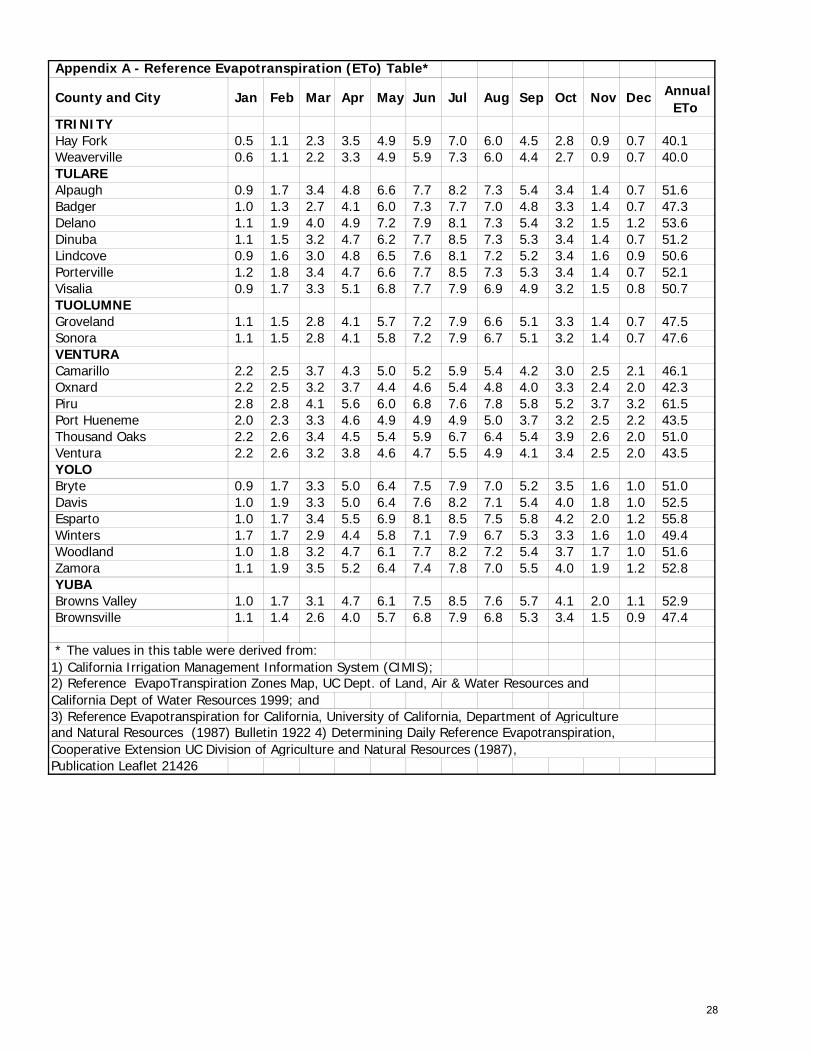
Appendix A - Reference Evapotranspiration (ETo) Table*
County and City Jan Feb Mar Apr May Jun Jul Aug Sep Oct Nov Dec Annual ETo
TRINITY Hay Fork 0.5 1.1 2.3 3.5 4.9 5.9 7.0 6.0 4.5 2.8 0.9 0.7 40.1 Weaverville 0.6 1.1 2.2 3.3 4.9 5.9 7.3 6.0 4.4 2.7 0.9 0.7 40.0 TULARE Alpaugh 0.9 1.7 3.4 4.8 6.6 7.7 8.2 7.3 5.4 3.4 1.4 0.7 51.6 Badger 1.0 1.3 2.7 4.1 6.0 7.3 7.7 7.0 4.8 3.3 1.4 0.7 47.3 Delano 1.1 1.9 4.0 4.9 7.2 7.9 8.1 7.3 5.4 3.2 1.5 1.2 53.6 Dinuba 1.1 1.5 3.2 4.7 6.2 7.7 8.5 7.3 5.3 3.4 1.4 0.7 51.2 Lindcove 0.9 1.6 3.0 4.8 6.5 7.6 8.1 7.2 5.2 3.4 1.6 0.9 50.6 Porterville 1.2 1.8 3.4 4.7 6.6 7.7 8.5 7.3 5.3 3.4 1.4 0.7 52.1 Visalia 0.9 1.7 3.3 5.1 6.8 7.7 7.9 6.9 4.9 3.2 1.5 0.8 50.7 TUOLUMNE Groveland 1.1 1.5 2.8 4.1 5.7 7.2 7.9 6.6 5.1 3.3 1.4 0.7 47.5 Sonora 1.1 1.5 2.8 4.1 5.8 7.2 7.9 6.7 5.1 3.2 1.4 0.7 47.6 VENTURA Camarillo 2.2 2.5 3.7 4.3 5.0 5.2 5.9 5.4 4.2 3.0 2.5 2.1 46.1 Oxnard 2.2 2.5 3.2 3.7 4.4 4.6 5.4 4.8 4.0 3.3 2.4 2.0 42.3 Piru 2.8 2.8 4.1 5.6 6.0 6.8 7.6 7.8 5.8 5.2 3.7 3.2 61.5 Port Hueneme 2.0 2.3 3.3 4.6 4.9 4.9 4.9 5.0 3.7 3.2 2.5 2.2 43.5 Thousand Oaks 2.2 2.6 3.4 4.5 5.4 5.9 6.7 6.4 5.4 3.9 2.6 2.0 51.0 Ventura 2.2 2.6 3.2 3.8 4.6 4.7 5.5 4.9 4.1 3.4 2.5 2.0 43.5 YOLO Bryte 0.9 1.7 3.3 5.0 6.4 7.5 7.9 7.0 5.2 3.5 1.6 1.0 51.0 Davis 1.0 1.9 3.3 5.0 6.4 7.6 8.2 7.1 5.4 4.0 1.8 1.0 52.5 Esparto 1.0 1.7 3.4 5.5 6.9 8.1 8.5 7.5 5.8 4.2 2.0 1.2 55.8 Winters 1.7 1.7 2.9 4.4 5.8 7.1 7.9 6.7 5.3 3.3 1.6 1.0 49.4 Woodland 1.0 1.8 3.2 4.7 6.1 7.7 8.2 7.2 5.4 3.7 1.7 1.0 51.6 Zamora 1.1 1.9 3.5 5.2 6.4 7.4 7.8 7.0 5.5 4.0 1.9 1.2 52.8 YUBA Browns Valley 1.0 1.7 3.1 4.7 6.1 7.5 8.5 7.6 5.7 4.1 2.0 1.1 52.9 Brownsville 1.1 1.4 2.6 4.0 5.7 6.8 7.9 6.8 5.3 3.4 1.5 0.9 47.4
* The values in this table were derived from:1) California Irrigation Management Information System (CIMIS);2) Reference EvapoTranspiration Zones Map, UC Dept. of Land, Air & Water Resources and California Dept of Water Resources 1999; and3) Reference Evapotranspiration for California, University of California, Department of Agriculture and Natural Resources (1987) Bulletin 1922 4) Determining Daily Reference Evapotranspiration,
Publication Leaflet 21426 Cooperative Extension UC Division of Agriculture and Natural Resources (1987),
28
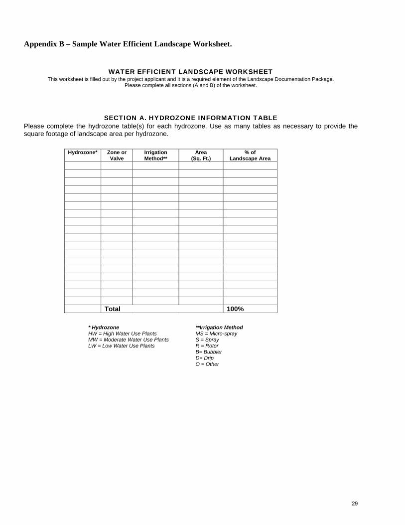
Appendix B – Sample Water Efficient Landscape Worksheet.
WATER EFFICIENT LANDSCAPE WORKSHEET
This worksheet is filled out by the project applicant and it is a required element of the Landscape Documentation Package. Please complete all sections (A and B) of the worksheet.
SECTION A. HYDROZONE INFORMATION TABLE
Please complete the hydrozone table(s) for each hydrozone. Use as many tables as necessary to provide the square footage of landscape area per hydrozone.
Hydrozone* Zone or Valve
Irrigation Method**
Area (Sq. Ft.)
% of Landscape Area
Total 100%
* Hydrozone HW = High Water Use Plants MW = Moderate Water Use Plants LW = Low Water Use Plants
**Irrigation Method MS = Micro-spray S = Spray R = Rotor B= Bubbler D= Drip O = Other
29
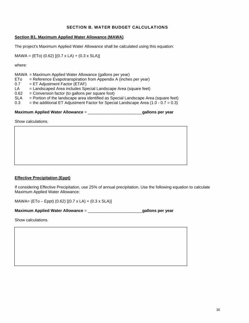
SECTION B. WATER BUDGET CALCULATIONS
Section B1. Maximum Applied Water Allowance (MAWA) The project's Maximum Applied Water Allowance shall be calculated using this equation: MAWA = (ETo) (0.62) [(0.7 x LA) + (0.3 x SLA)] where: MAWA = Maximum Applied Water Allowance (gallons per year) ETo = Reference Evapotranspiration from Appendix A (inches per year) 0.7 = ET Adjustment Factor (ETAF) LA = Landscaped Area includes Special Landscape Area (square feet) 0.62 = Conversion factor (to gallons per square foot) SLA = Portion of the landscape area identified as Special Landscape Area (square feet) 0.3 = the additional ET Adjustment Factor for Special Landscape Area (1.0 - 0.7 = 0.3) Maximum Applied Water Allowance = ________________________gallons per year Show calculations. Effective Precipitation (Eppt) If considering Effective Precipitation, use 25% of annual precipitation. Use the following equation to calculate Maximum Applied Water Allowance: MAWA= (ETo – Eppt) (0.62) [(0.7 x LA) + (0.3 x SLA)] Maximum Applied Water Allowance = ________________________gallons per year Show calculations.
30
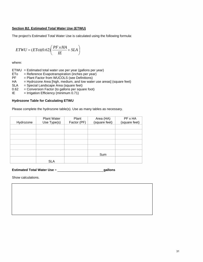
Section B2. Estimated Total Water Use (ETWU) The project’s Estimated Total Water Use is calculated using the following formula:
where: ETWU = Estimated total water use per year (gallons per year) ETo = Reference Evapotranspiration (inches per year) PF = Plant Factor from WUCOLS (see Definitions) HA = Hydrozone Area [high, medium, and low water use areas] (square feet) SLA = Special Landscape Area (square feet) 0.62 = Conversion Factor (to gallons per square foot) IE = Irrigation Efficiency (minimum 0.71) Hydrozone Table for Calculating ETWU Please complete the hydrozone table(s). Use as many tables as necessary.
Estimated Total Water Use = _________________________gallons Show calculations.
Hydrozone Plant Water Use Type(s)
Plant Factor (PF)
Area (HA) (square feet)
PF x HA (square feet)
Sum
SLA
⎟⎠⎞
⎜⎝⎛ += SLA
IEHAxPFEToETWU )62.0)((
31
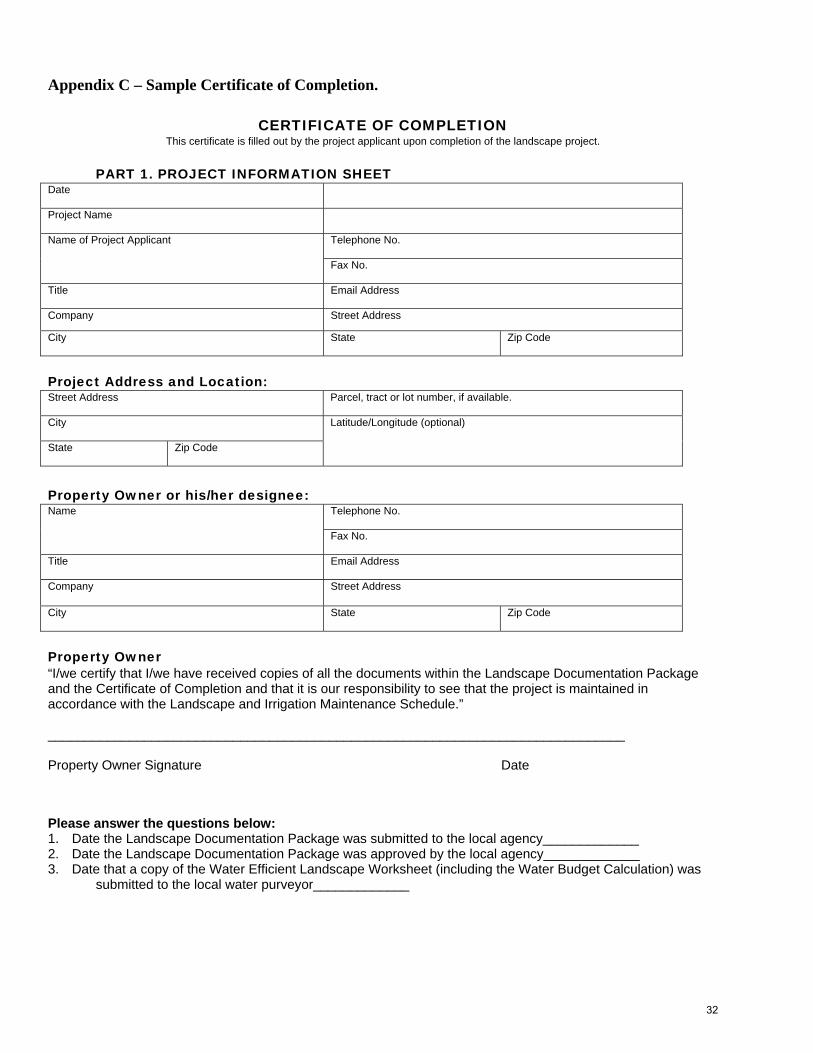
Appendix C – Sample Certificate of Completion.
CERTIFICATE OF COMPLETION
This certificate is filled out by the project applicant upon completion of the landscape project.
PART 1. PROJECT INFORMATION SHEET Date
Project Name
Telephone No.
Name of Project Applicant Fax No.
Title
Email Address
Company Street Address
City State Zip Code
Project Address and Location: Street Address
Parcel, tract or lot number, if available.
City State
Zip Code
Latitude/Longitude (optional)
Property Owner or his/her designee:
Telephone No.
Name
Fax No.
Title Email Address
Company Street Address
City
State Zip Code
Property Owner “I/we certify that I/we have received copies of all the documents within the Landscape Documentation Package and the Certificate of Completion and that it is our responsibility to see that the project is maintained in accordance with the Landscape and Irrigation Maintenance Schedule.” ______________________________________________________________________________ Property Owner Signature Date
Please answer the questions below: 1. Date the Landscape Documentation Package was submitted to the local agency_____________ 2. Date the Landscape Documentation Package was approved by the local agency_____________ 3. Date that a copy of the Water Efficient Landscape Worksheet (including the Water Budget Calculation) was
submitted to the local water purveyor_____________
32
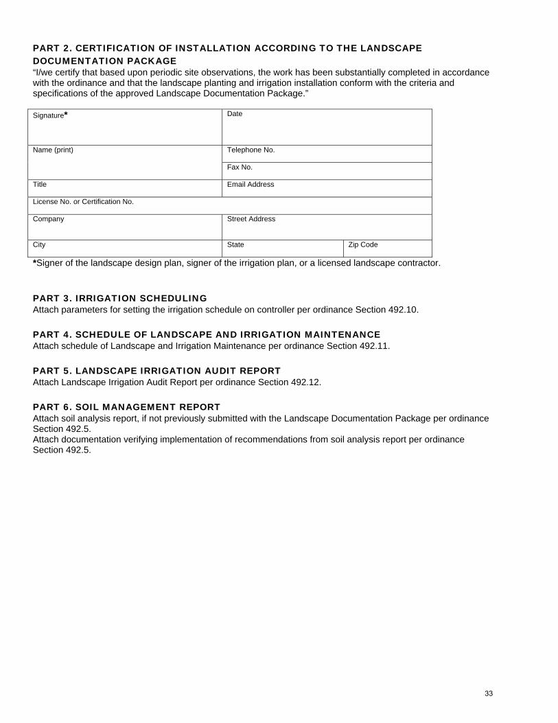
PART 2. CERTIFICATION OF INSTALLATION ACCORDING TO THE LANDSCAPE DOCUMENTATION PACKAGE “I/we certify that based upon periodic site observations, the work has been substantially completed in accordance with the ordinance and that the landscape planting and irrigation installation conform with the criteria and specifications of the approved Landscape Documentation Package.” Signature*
Date
Telephone No.
Name (print)
Fax No.
Title
Email Address
License No. or Certification No. Company Street Address
City
State Zip Code
*Signer of the landscape design plan, signer of the irrigation plan, or a licensed landscape contractor.
PART 3. IRRIGATION SCHEDULING Attach parameters for setting the irrigation schedule on controller per ordinance Section 492.10. PART 4. SCHEDULE OF LANDSCAPE AND IRRIGATION MAINTENANCE Attach schedule of Landscape and Irrigation Maintenance per ordinance Section 492.11. PART 5. LANDSCAPE IRRIGATION AUDIT REPORT Attach Landscape Irrigation Audit Report per ordinance Section 492.12. PART 6. SOIL MANAGEMENT REPORT Attach soil analysis report, if not previously submitted with the Landscape Documentation Package per ordinance Section 492.5. Attach documentation verifying implementation of recommendations from soil analysis report per ordinance Section 492.5.
33