Embed Size (px)
Citation preview
MOBILE GIS: A TOOL FOR INFORMAL SETTLEMENT OCCUPANCY AUDIT TO
IMPROVE INTEGRATED HUMAN SETTLEMENT IMPLEMENTATION IN
EKURHULENI, SOUTH AFRICA
B. T. Mokoena a,*, W. Musakwa a
a Dept. of Town and Regional Planning, University of Johannesburg, Cnr Siemert and Beit Streets, Doornfontein, South Africa –
[email protected], [email protected]
Commission II, Theme Session 17 Smart
Cities
KEY WORDS: Mobile GIS, occupancy audit, informal settlements, integration, Ekurhuleni
ABSTRACT:
Upgrading and relocating people in informal settlements requires consistent commitment, good strategies and systems so as to improve
the lives of those who live in them. In South Africa, in order to allocate subsidised housing to beneficiaries of an informal settlement,
beneficiary administration needs to be completed to determine the number of people who qualify for a subsidised house. Conventional
methods of occupancy audits are often unreliable, cumbersome and non-spatial. Accordingly, this study proposes the use of mobile
GIS to conduct these audits to provide up-to-date, accurate, comprehensive and real-time data so as to facilitate the development of
integrated human settlements. An occupancy audit was subsequently completed for one of the communities in the Ekurhuleni
municipality, Gauteng province, using web-based mobile GIS as a solution to providing smart information through evidence based
decision making. Fieldworkers accessed the off-line capturing module on a mobile device recording GPS coordinates, socio-economic
information and photographs. The results of this audit indicated that only 56.86% of the households residing within the community
could potentially benefit from receiving a subsidised house. Integrated residential development, which includes fully and partially
subsidised housing, serviced stands and some fully bonded housing opportunities, would then be key to adequately providing access
to suitable housing options within a project in a post-colonial South Africa, creating new post-1994 neighbourhoods, in line with
policy. The use of mobile GIS therefore needs to be extended to other informal settlement upgrading projects in South Africa.
1. INTRODUCTION
Urbanisation is a phenomenon that has been growing in recent
decades in the global south (Turok & Borel-Saladin, 2014),
manifesting itself in the form of informal settlements (Freire, et
al., 2014). It is said that Africa is urbanising rapidly from a 15%
growth in 1960 to 40% in 2010 (Freire, et al., 2014). According
to UN-Habitat (2010), 60% of Africans will be living in cities by
2050, and triple in the forthcoming 50 years. This will change the
form of regions and mandate policy makers to maximise on
urbanisation towards sustainable and inclusive growth (UN-
Habitat, 2015). The New Urban Agenda (UN-Habitat, 2015)
furthermore calls for policy makers to shift their mind sets from
viewing urbanisation as a problem but rather as a tool for
development. The current model of urbanisation is not
sustainable, nor is it adequate for social and economic prosperity
(UN-Habitat, 2015). The strategic and integrated approach taken
in the new Strategic Plan for 2014-2019, recommends that we
apply a more systemic approach that goes beyond addressing the
symptoms of urbanisation, but linking urbanization and human
settlements to sustainable development by focusing on the
prosperity, livelihoods and employment of the greater population
(UN-Habitat, 2015). This will be done by paying attention to the
basic needs of the millions of people living in poverty within
towns and cities, as well as urban slums (UN-Habitat, 2015).
Unlike Africa, other parts of the world’s urbanisation patterns
are normally led by industrialisation and economic development;
defined by the increase of productivity from proximity and the
concentration of activities, confirming a relationship between per
capita income and urbanisation (Freire, et al., 2014). Africa’s
* Corresponding author 1 Growth, transformation, reform: Emerging economies in the next decade (Zuma, 2013)
urbanisation patterns however indicate a migration of lower level
income groups and less investment of infrastructure (Freire, et
al., 2014). This poses a challenge for cities that are unable to
accommodate large population influxes that ensure favourable
living environments (Freire, et al., 2014).
Migration and urbanisation as described in the Migration and
Urbanisation in South Africa Report (2006) is often observed as
the result of raptures of economic exploitation, political tension,
environmental disasters or violence. South Africa has a particular
history, which informed its migration and urbanisation patterns
over the past few decades, known as apartheid. The apartheid
system historically endeavoured to restrict and control the
population movement as well as its settlements patterns in the
rural areas or Bantustans (Turok & Borel-Saladin, 2014). Thus
tyrannical laws were enforced on people such as the well-
documented population control, Group Areas Act of 1950 (Act
No. 41 of 1950) and pass law that caused impermanence in the
urbanisation process (Turok & Borel-Saladin, 2014; Harrison, et
al., 2008; Zuma, 2013). These events resulted in inadequate
urban planning in the urban areas which lead urban settlements
into sprawling peri-urban areas (Harrison, et al., 2008). This also
meant that people were forced to live in ethnically homogenous
homelands with limited access to land, resulting in the transition
from an agrarian to a cash-based rural economy in order to
provide large numbers of labour migrants1 (Zuma, 2013).
This unique phenomenon of urbanisation has affected the
housing sector drastically over the years, with the influx of
people coming into major cities in South Africa, most of whom
find themselves living in informal settlements (Huchzermeyer,
The International Archives of the Photogrammetry, Remote Sensing and Spatial Information Sciences, Volume XLI-B2, 2016 XXIII ISPRS Congress, 12–19 July 2016, Prague, Czech Republic
This contribution has been peer-reviewed. doi:10.5194/isprsarchives-XLI-B2-735-2016
735
2004). This posing a challenge for the state in how it deals with
housing people in the low income bracket or with no income at
all.
2. THE DISCOURSE OF UPGRADING
INFORMAL SETTLEMENTS PRE AND POST
1994
The chronical of informal settlement upgrading policy in South
Africa needs to be narrated for us to understand the context,
which we find ourselves today. In Marais & Ntema’s (2013)
reflection through the lens of Huchzermeyer (2004), discussions
of this unfolds in a manner that suggests that until recently, policy
had not been developed for the new post-apartheid government
for informal settlement upgrading. ‘Breaking New Ground’: A
comprehensive plan for the development of informal settlements
was developed only in 2004, after the realisation that the housing
subsidy scheme alone was not sufficient to deal with the large
inflow of black people in informal settlements (Huchzermeyer,
2004). The upgrading of informal settlements was strongly
opposed during the apartheid era, further enforced by the
demolishing and forced removals of these settlements (Platzky &
Walker, 1985). The control of urbanisation which was abolished
in 1985, saw the influx of people in many cities (Huchzermeyer,
2004). Controlled urbanisation was driven by the then
government to control land development which meant that land
was largely available for middle-income groups or white people
and not for low-income households or black people
(Huchzermeyer, 2004). The land that was made available for
black people was mostly funded by loans provided by the
National Housing Commission. The large influx of people by the
early 1990 in the form of land invasions on open land across
South Africa (Seekings, 1991) put pressure on the apartheid
government to embark on large-scale upgrading of informal
settlements (Marais & Ntema, 2013). The Independent
Development Trust (IDT) was then established around that time
providing site-and service and settlement upgrading to
approximately 100 000 households across South Africa
providing water, sanitation, electricity and ownership, packaged
in the capital subsidy of R7 500 per household (Marais & Ntema,
2013). The upgrading process by the IDT, Huchzermeyer (2004)
agues and critics, where driven by the market orientated
development approach (neo-liberalism) with very minimal
community participation as well as a technocratic approach of a
one size-fits-all, putting people on the periphery in greenfield
projects. Stating that the new post-apartheid government had
followed to a large extent in the same footsteps with its new
housing policy (Huchzermeyer, 2004). With a once off capital
subsidy, at the time, of R15 000 for people earning R0-800 per
month focusing on the lowest income earners, working on a
sliding scale, and providing R9 000 for people earning R2500-
R3500 per month (Huchzermeyer, 2004). Breaking New Ground
together with its Informal Settlement Upgrading Programme
introduced a concept of promoting social inclusion through
community based subsidies and participatory planning of
layouts, poverty eradication by securing tenure and assistant
livelihoods through well located land and reduction of
vulnerabilities through providing economic and social facilities
(Huchzermeyer, 2006). These objectives focused on the
rehabilitation of land for upgrading, moving away from the
overemphasis of Greenfield development as well as focusing on
mixed-income groups rather than just on low-income groups
(Huchzermeyer, 2006; Marais & Krige, 1999). Emphasising
rather on the need for better-located mixed-income and mixed-
use housing projects2.
2 National Development Plan: Vision for 2030, (2011)
3. ENUMERATION OF INFORMAL
SETTLEMENTS:
The enumeration process is an important part of informal
settlement upgrading, especially when there is no data that exists
for a community. It is also useful to have data that is regularly
updated. The purpose of enumeration is to provide basic
information on all individuals and households (Karanja, 2010) in
a particular settlement. This section highlights some of the
challenges faced in different enumeration processes.
An informal settlement was enumerated in Nairobi, Kenya,
organized by the inhabitants, to examine the detail and scale,
depth and nature of poverty within the community (Karanja,
2010). It was immediately established that the experience
gathered from this enumeration process, demonstrated that the
way in which information is collected as well as who gathers it,
is as important as the information itself (Karanja, 2010). This is
because it influences not only the quality and detail of the data
collection and its verification but the nature of the occupant’s
involvement with planning and implementation of informal
settlement upgrading (Karanja, 2010). It was also found that the
challenges and pressures faced in this enumeration process where
from the people who were not residents of the community,
wanting to get plots for friends or family members residing in
other communities or for adult children living with them
(Karanja, 2010).
In a another area, mapping and enumeration of informal Roma
settlements, located in Serbia Southeastern Europe was
conducted with the attempt to response to some of the housing
challenges confronting the communities (Vuksanovic-Macura,
2012). This exercise was conducted several times over a number
of years by non-governmental organisations and Roma
associates. The settlements, as described by Vuksanovic-
Macura’s (2012), were characterised by very poor living
conditions because of historic social exclusion and intolerance
faced from formal communities (Vuksanovic-Macura, 2012). In
her paper she also pointed out that the difficult housing
challenges that these settlers faced had not been adequately
addressed by national and local authorities, and therefore because
of this, with the aim of assisting communities, mapping and
enumeration initiatives were undertaken over the years for
settlement upgrading, socio-economic empowerment purposes,
to name a few (Vuksanovic-Macura, 2012).
The method used for enumeration and mapping were questioners
on household information and about the physical house and plot.
The mapping component described the extent of the settlement
spatially. Photographs were also taken. The data gathered was
entered into a spreadsheet programme and the maps were
digitized, forming a database (Vuksanovic-Macura, 2012).
As a final reflection the Vuksanovic-Macura’s (2012) paper
highlighted that while the information gathered by the NGO’s
was good for the initial phase of a project, given the limited scope
and funding, it was insufficient if procedures based on the law
was required. This is because official documentation is needed
should an upgrading project require formal administrative
procedures by way of producing an urban plan, legalizing
illegally constructed houses and initiating court procedures to
transfer ownership (Vuksanovic-Macura, 2012).
The International Archives of the Photogrammetry, Remote Sensing and Spatial Information Sciences, Volume XLI-B2, 2016 XXIII ISPRS Congress, 12–19 July 2016, Prague, Czech Republic
This contribution has been peer-reviewed. doi:10.5194/isprsarchives-XLI-B2-735-2016
736
It is found that the use of Geographic Information Systems (GIS),
according to Chitekwe-Biti, et al., (2012), has transformed the
extent in which information can be used for planning purpose
across the world. Internationally there has been a great
development of skills allowing communities to effectively and
accurately link information collected during household level
enumerations with mapping (Chitekwe-Biti, et al., 2012).
Therefore GIS has created the possibility of linking social data
with spatial data (Chitekwe-Biti, et al., 2012).
Consequently, the aim of this study is to use smart mobile GIS,
to enumerate and conduct an occupancy audit in Ulana informal
settlement, Ekurhuleni, South Africa. The remainder of the paper
is structured as follows; the next section provides a description
of the study area, Ekurhuleni, followed by the methodology,
which describes how the occupancy audit was conducted. Lastly
the results and discussion are presented.
4. STUDY AREA: EKURHULENI AND ULANA
SETTLEMENT
The Ekurhuleni Region is a Metropolitan made up of an
amalgamation of nine towns accompanied by its townships3. The
region was historically known as Eats Rand. Each town
consisting of suburbs, industrial areas and the black residential
areas attached to them (Bonner, et al., 2012; City of Ekurhuleni,
2013). It has a total surface area of 1 975 km² with a population
of 3 178 870 million (City of Ekurhuleni, 2013). It has a strong
manufacturing sector and is regarded as the transportation hub of
South Africa, having the busiest airport in Africa4 and as such
seeking towards branding itself an Aerotropolice. It also has
South Africa’s largest railway hub in Germiston, linking it to all
major population centres and ports in the Southern Africa
region4.
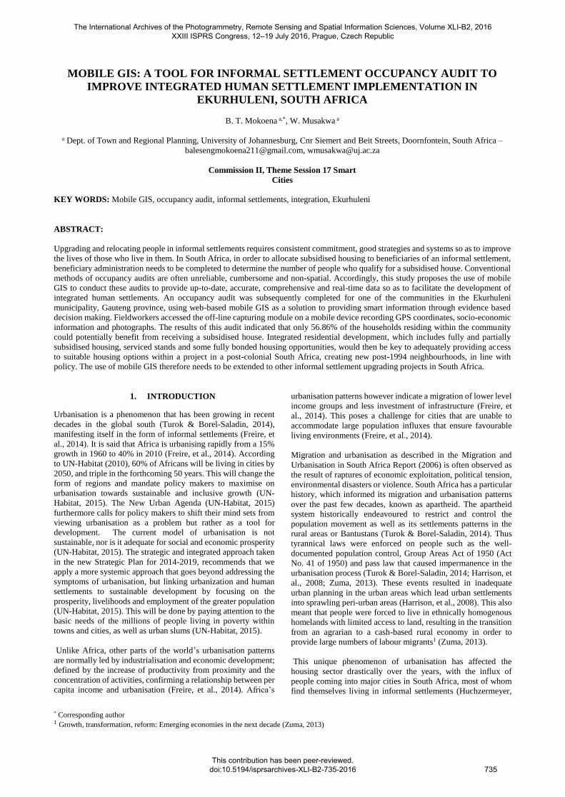
Ulana Settlement is an informal settlement located in Boksburg,
Ekurhuleni (Figure 1).
Figure 1: Location of Ulana Settlement
Ulana has a population of 3 092 households according to the
recent occupancy audit completed. Ekurhuleni has the second
highest number of households living in informal settlements in
the country5, with a total of 119 settlements and a population of
3 Townships in South Africa often referring to the location where the
black people reside. 4 Ekurhuleni Metropolitan Municipality: IDP, Budget & SDBIP,
2013/14-2015/16 (2013)
approximately 160 000 households6 in need of being upgraded or
relocated.
While enumeration of informal settlements remain an important
part of any upgrading project, this paper sets to demonstrate how
web based mobile GIS can be used as a tool for enumeration, to
foster integrated human settlements. Given the challenges of
urbanisation in cities of the Global South, and more specifically
within the unique context of South Africa (and Ekurhuleni), the
chronicles of upgrading informal settlements pre and post 1994
proved (and still proves) to be challenging.
5. METHODOLOGY
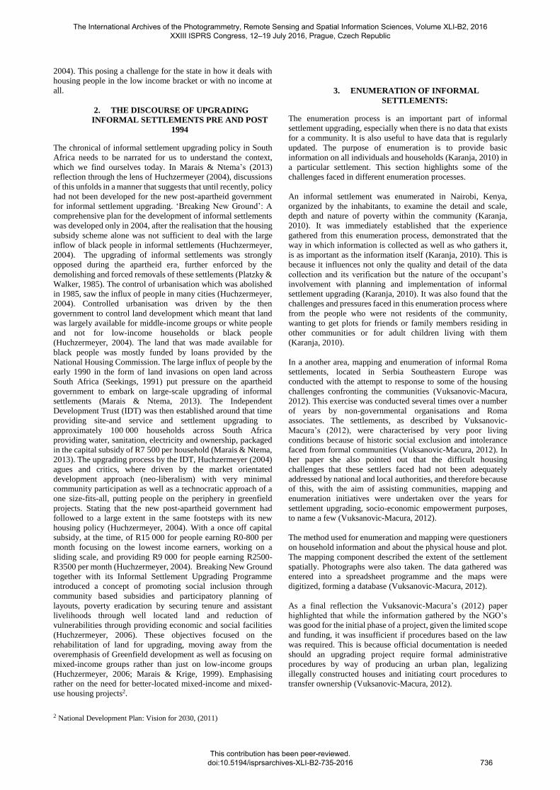
A web-based Mobile GIS tool was used to conduct the occupancy
audit in Ulana, as it is often difficult and cumbersome with other
techniques. Data collection was conducted from 13 March 2015
to 30 March 2015. A follow up data collection session was done
on April 18-19 for occupant’s who were unavailable in March. A
GPS was used to collect the location of the dwelling units (DU)
whilst an android-based tablet was used to collect attributes of
the DU, images as well as the household attributes. This
information was stored and synchronised in a server (Figure 2).
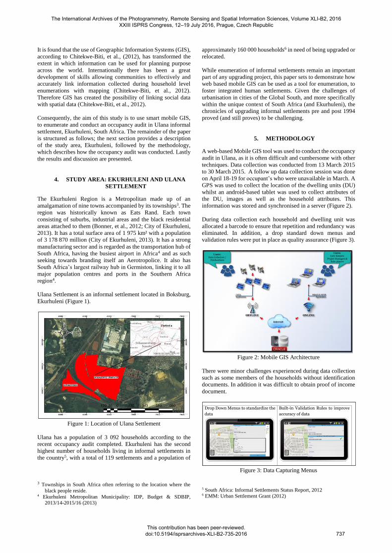
During data collection each household and dwelling unit was
allocated a barcode to ensure that repetition and redundancy was
eliminated. In addition, a drop standard down menus and
validation rules were put in place as quality assurance (Figure 3).
Figure 2: Mobile GIS Architecture
There were minor challenges experienced during data collection
such as some members of the households without identification
documents. In addition it was difficult to obtain proof of income
document.
Figure 3: Data Capturing Menus
5 South Africa: Informal Settlements Status Report, 2012 6 EMM: Urban Settlement Grant (2012)
12 | P a g e
9. Quality Assurance
Professional Mobile Mapping values the quality of the collected information.
The Quality Management System is of utmost importance for data
accuracy and to ensure compliance with the project objective and customer
satisfaction with the provision of useful and accurate data. The Quality
Assurance phase entails:
GIS Controls
Access Controls (Username & password protection)
Built-in Validation rules & controls
Data validation, quality assurance and data quality control
On site verifications (check back)
Examples of controls below:
Drop Down Menus to standardize the
data
Built-in Validation Rules to improve
accuracy of data
ID Validation – program indicates
to data collector if the recorded ID
number is valid.
For Valid ID number the
application automatically
populate Citizenship, Date of
Birth and Gender
For Invalid ID number the
application requested the data
collector to record Citizenship
Jump & Skip Patterns
Example – Marital Status
if Single – the application did
not request data collector to
record spouse details
if Married – the application
forced the data collector to
record the details of the spouse
EKU A 000 000 001
EKU A 000 000 001
821108 0049 089
The International Archives of the Photogrammetry, Remote Sensing and Spatial Information Sciences, Volume XLI-B2, 2016 XXIII ISPRS Congress, 12–19 July 2016, Prague, Czech Republic
This contribution has been peer-reviewed. doi:10.5194/isprsarchives-XLI-B2-735-2016
737
5.1 Data analysis
ArcGIS 10.3 was used to join the location and the attribution data
for spatial analysis. Density analysis was done using the spatial
analysist extension to determine the number of DU per 2500m2.
For the occupancy audit analysis descriptive statistical analysis
was carried out on demographic attributes such as citizenship,
gender, income, dependants and whether one received a
subsidised house before from the municipality or government.
The demographic profile would then be used to determine if a
household qualifies for a housing subsidy.
6. RESULTS AND DISCUSSION
6.1 Densities, Ulana Settlement
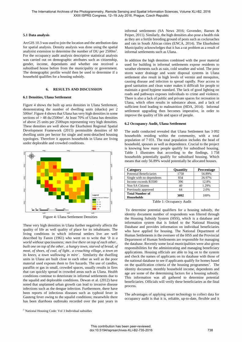
Figure 4 shows the built up area densities in Ulana Settlement,
demonstrating the number of dwelling units (shacks) per 2
500m². Figure 4 shows that Ulana has very high densities in some
sections of > 48 du/2500m2. At least 70% of Ulana has densities
of above 25 units per 2500sqm representing very high densities.
These densities are well above the Ekurhuleni Regional Spatial
Development Framework (2015) permissible densities of 60
dwelling units per hector for single and semi-detached housing
typologies. Therefore it appears households in Ulana are living
under deplorable and crowded conditions.
Figure 4: Ulana Settlement Densities
These very high densities in Ulana further negatively affects the
quality of life as well quality of place for its inhabitants. The
living conditions in which informal settlers live are well
described by Fanon (1961) who went on to write that ‘It is a
world without spaciousness; men live there on top of each other..
built one on top of the other.. a hungry town, starved of bread, of
meat, of shoes, of coal, of light.. a crouching village, a town on
its knees, a town wallowing in mire’. Similarity the dwelling
units in Ulana are built close to each other as well as the poor
material used exposes them to fire hazards. The use of candles,
paraffin or gas in small, crowded spaces, usually results in fires
that can quickly spread in crowded areas such as Ulana. Health
conditions continue to deteriorate in informal settlements due to
the squalid and deplorable conditions. Dewan et al. (2012) have
noted that unplanned urban growth can lead to invasive disease
infections such as the dengue infection. Furthermore, there have
been reports of infectious diseases such as typhoid fever in
Gauteng fever owing to the squalid conditions; meanwhile there
has been diarrhoea outbreaks recorded over the past years in
7 National Housing Code: Vol 3 Individual subsidies
informal settlements (SA News 2016; Govender, Barnes &
Peiper, 2011). Similarly, the high densities also pose a health risk
as they are a fertile breeding ground of pests such as cockroaches
and rats in South African cities (ENCA, 2014). The Ekurhuleni
Municipality acknowledges that it has a rat problem as a result of
informal settlements such as Ulana.
In addition the high densities combined with the poor material
used for building in informal settlements expose residents to
weather elements such as rain, cold weather and wind. The poor
storm water drainage and waste disposal systems in Ulana
settlement also result in high levels of vermin and mosquitos,
causing disease and infection to spread rapidly. Poor access to
good sanitation and clean water makes it difficult for people to
maintain a good hygiene standard. The lack of good lighting on
roads and pathways exposes individuals to crime and violence.
There is also a lack of public and private spaces for recreation in
Ulana, which often results in substance abuse, and a lack of
sufficient food leading to malnutrition (HDA, 2014). Informal
settlement upgrading then becomes imperative, in order to
improve the quality of life and space of people.
6.2 Occupancy Audit, Ulana Settlement
The audit conducted revealed that Ulana Settlement has 3 092
households residing within the community, with a total
population of 7 031. The total population includes the head of
household, spouses as well as dependence. Crucial to the project
is knowing how many people qualify for subsidised housing.
Table 1 illustrates that according to the findings, 1 758
households potentially qualify for subsidised housing. Which
means that only 56.89% would potentially be allocated houses.
Category Quantity Percentage Potential Beneficiaries 1758 56.89%
Single with no dependents 834 26.97%
Income exceeds R3500 396 12.8%
Non SA Citizens 40 1.29%
Previously approved 64 2.0%
Total Number of
Households 3092 100%
Table 1: Occupancy Audit
To determine potential qualifiers for a housing subsidy, the
identity document number of respondents was filtered through
the Housing Subsidy System (HSS), which is a database and
information system that is linked to the National Housing
Database and provides information on individual beneficiaries
who have applied for housing. The National Department of
Human Settlements is the overseer of the HSS and the Provincial
Department of Human Settlements are responsible for managing
the database. Recently some local municipalities were also given
responsibilities for the administrating and managing beneficiary
applications. Housing officials are able to log on to the system
and check the names of applicants on its database with those of
the national database to see if applicants qualify for homes based
on the qualification criteria of the housing programmes7. The
identity document, monthly household income, dependents and
age are some of the determining factors for a housing subsidy.
This information was all gathered to determine potential
beneficiaries. Officials will verify these beneficiaries as the final
process.
The advantages of applying smart technology to collect data for
occupancy audit is that it is, reliable, up-to-date, flexible and it
The International Archives of the Photogrammetry, Remote Sensing and Spatial Information Sciences, Volume XLI-B2, 2016 XXIII ISPRS Congress, 12–19 July 2016, Prague, Czech Republic
This contribution has been peer-reviewed. doi:10.5194/isprsarchives-XLI-B2-735-2016
738
facilitates informed decision making as opposed to traditional
cumbersome techniques such as use of paper based
questionnaires. At present the data that currently exists for
informal settlements for the Ekurhuleni Local Municipality is
outdated and only contains the approximate number of
households in each settlement without detailed demographic
attributes as collected using the smart mobile GIS. This
unfortunately becomes difficult for the Human Settlements
Department to plan adequately for informal settlement projects
and may lead to waste of financial resources. Having accurate
and updated information, that also contains potential
beneficiaries information, will enable the department to plan
more efficiently for its people as well as optimising resources.
For instance the In-Situ upgrading project for Ulana informal
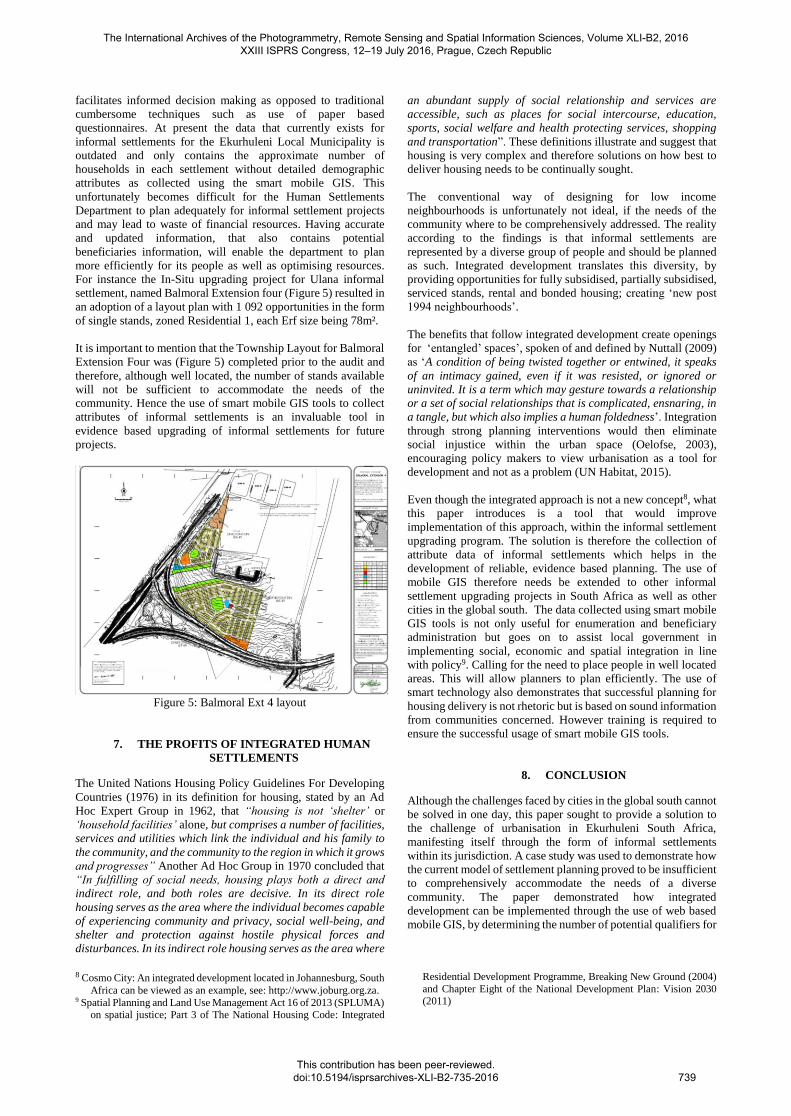
settlement, named Balmoral Extension four (Figure 5) resulted in
an adoption of a layout plan with 1 092 opportunities in the form
of single stands, zoned Residential 1, each Erf size being 78m².
It is important to mention that the Township Layout for Balmoral
Extension Four was (Figure 5) completed prior to the audit and
therefore, although well located, the number of stands available
will not be sufficient to accommodate the needs of the
community. Hence the use of smart mobile GIS tools to collect
attributes of informal settlements is an invaluable tool in
evidence based upgrading of informal settlements for future
projects.
Figure 5: Balmoral Ext 4 layout
7. THE PROFITS OF INTEGRATED HUMAN
SETTLEMENTS
The United Nations Housing Policy Guidelines For Developing
Countries (1976) in its definition for housing, stated by an Ad
Hoc Expert Group in 1962, that “housing is not ‘shelter’ or
‘household facilities’ alone, but comprises a number of facilities,
services and utilities which link the individual and his family to
the community, and the community to the region in which it grows
and progresses” Another Ad Hoc Group in 1970 concluded that
“In fulfilling of social needs, housing plays both a direct and
indirect role, and both roles are decisive. In its direct role
housing serves as the area where the individual becomes capable
of experiencing community and privacy, social well-being, and
shelter and protection against hostile physical forces and
disturbances. In its indirect role housing serves as the area where
8 Cosmo City: An integrated development located in Johannesburg, South
Africa can be viewed as an example, see: http://www.joburg.org.za. 9 Spatial Planning and Land Use Management Act 16 of 2013 (SPLUMA)
on spatial justice; Part 3 of The National Housing Code: Integrated
an abundant supply of social relationship and services are
accessible, such as places for social intercourse, education,
sports, social welfare and health protecting services, shopping
and transportation”. These definitions illustrate and suggest that
housing is very complex and therefore solutions on how best to
deliver housing needs to be continually sought.
The conventional way of designing for low income
neighbourhoods is unfortunately not ideal, if the needs of the
community where to be comprehensively addressed. The reality
according to the findings is that informal settlements are
represented by a diverse group of people and should be planned
as such. Integrated development translates this diversity, by
providing opportunities for fully subsidised, partially subsidised,
serviced stands, rental and bonded housing; creating ‘new post
1994 neighbourhoods’.
The benefits that follow integrated development create openings
for ‘entangled’ spaces’, spoken of and defined by Nuttall (2009)
as ‘A condition of being twisted together or entwined, it speaks
of an intimacy gained, even if it was resisted, or ignored or
uninvited. It is a term which may gesture towards a relationship
or a set of social relationships that is complicated, ensnaring, in
a tangle, but which also implies a human foldedness’. Integration
through strong planning interventions would then eliminate
social injustice within the urban space (Oelofse, 2003),
encouraging policy makers to view urbanisation as a tool for
development and not as a problem (UN Habitat, 2015).
Even though the integrated approach is not a new concept8, what
this paper introduces is a tool that would improve
implementation of this approach, within the informal settlement
upgrading program. The solution is therefore the collection of
attribute data of informal settlements which helps in the
development of reliable, evidence based planning. The use of
mobile GIS therefore needs be extended to other informal
settlement upgrading projects in South Africa as well as other
cities in the global south. The data collected using smart mobile
GIS tools is not only useful for enumeration and beneficiary
administration but goes on to assist local government in
implementing social, economic and spatial integration in line
with policy9. Calling for the need to place people in well located
areas. This will allow planners to plan efficiently. The use of
smart technology also demonstrates that successful planning for
housing delivery is not rhetoric but is based on sound information
from communities concerned. However training is required to
ensure the successful usage of smart mobile GIS tools.
8. CONCLUSION
Although the challenges faced by cities in the global south cannot
be solved in one day, this paper sought to provide a solution to
the challenge of urbanisation in Ekurhuleni South Africa,
manifesting itself through the form of informal settlements
within its jurisdiction. A case study was used to demonstrate how
the current model of settlement planning proved to be insufficient
to comprehensively accommodate the needs of a diverse
community. The paper demonstrated how integrated
development can be implemented through the use of web based
mobile GIS, by determining the number of potential qualifiers for
Residential Development Programme, Breaking New Ground (2004)
and Chapter Eight of the National Development Plan: Vision 2030 (2011)
The International Archives of the Photogrammetry, Remote Sensing and Spatial Information Sciences, Volume XLI-B2, 2016 XXIII ISPRS Congress, 12–19 July 2016, Prague, Czech Republic
This contribution has been peer-reviewed. doi:10.5194/isprsarchives-XLI-B2-735-2016
739
subsidised housing in each informal settlement upgrading
project, in order to assess the divers needs of communities.
9. REFERENCES
Bonner, P., Nieftagodien, N. & Mathabatha, S., 2012.
Ekurhuleni: The making of an urban region. Johannesburg: Wits
University Press. Chitekwe-Biti, B., Mudimo, P. & Nyama, G. M., 2012.
Developing an informal settlement upgrading protocol in
Zimbabwe - the Epwarth story. Environment & Urbanisation,
24(1), pp. 131-148.
City of Ekurhuleni, 2005. Ekurhuleni Growth Development
Strategy 2055, Germiston: Directorate: Communications and
Marketing.
City of Ekurhuleni, 2013. Ekurhuleni Metropolitan Municipality:
IDP, Budget & SDBIP, 2013/14-2015/16, Germiston:
Directorate: Communication and Marketing.
City of Ekurhuleni, 2015. RSDF. [Online]
Available at: http://www.ekurhuleni.gov.za/rsdf-1
[Accessed 27 February 2016].
City of Johannesburg, 2008. Cosmo City is a thriving suburb.
[Online]
Available at:
http://joburg.org.za/index.php?option=com_content&task=view
&id=2089&Itemid=168
[Accessed 28 December 2015].
Dawan, A., Yamaquchi, Y. & Ziaur Rahman, M., 2012.
Dynamics of land use/cover changes and the anlaysis of landscap
fragmentation in Dhaka Metropolitan. GeoJournal, 77(3), pp.
315-330.
ENCA, 2013. Ekurhuleni fights rat problem. [Online]
Available at: https://www.enca.com/south-africa/ekurhuleni-
fights-rat-problem
[Accessed 15 March 2016].
ENCA, 2014. Joburg to spend ,illions to fight rat epidemic.
[Online]
Available at: https://www.enca.com/joburg-spend-millions-
fight-rat-epedemic
[Accessed 16 March 2016].
Fanon, F., 1961. The Wretched of the Earth. London: Pinguin
Group.
Freire, M. E., Lall, S. & Leipziger, D., 2014. Africa’s
Urbanization: Challenges and Opportunities, Washington: The
Growth Dialogue.
Govender, T., Barnes, J. M. & Piper, C. H., 2011. Contribution
of water pollution from inadedequate sanitation and housing
quality to diarrheal disease in low-cost housing settlements of
Cape Town, South Africa. American journal of public health,
101(7), pp. 4-9.
Harrison, P., Todes, A. & Watson, V., 2008. Planning and
Transformation: Learning from the Post-Apartheid Experience.
Lanodon and New York: Routledge.
Housing Development Agency, 2012. South African: Informal
Settlements Status, s.l.: s.n.
Huchzermeyer, M., 2004. Unlawful occupation, informal
settlements and Urban Policy in South Africa and Brazil.
Trenton: Africa World Press.
Huchzermeyer, M., 2006. The new instrument for upgrading
informal settlements in South Africa: Contributions and
constraints. In: M. Huchzermeyer & A. Karam, eds. Infromal
Settlements: A perepetual challange. Cape Town: UCT Press, pp.
41-61.
Karanja, I., 2010. An enumeration and mapping of infromal
settlements in Kisumu, Kenya, implemented by their inhabitants.
Environment & Urbanisation, 22(1), pp. 217-239.
Marais, L. & Krige, S., 1999. Post-apartheid housing policy and
initiatives in South Africa: Reflections on the Bloemfontein-
Botshabelo-Thaba 'Nchu Region. Urban Forum, 10(2), pp. 115-
136.
Marais, L. & Ntema, J., 2013. The upgrading of an informal
settlement in South Africa: Two decades onwards. Habitat
International, Volume 39, pp. 85-95.
Nuttall, S., 2009. Entanglement: Litrary and cultural reflections
on post-aprtheid. Johannesburg: Wits University Press.
Oelofse, M., 2003. Social Justice, Social Intergration and the
Compact City: Lessons from Inner City of Johannesburg. In: P.
Harrison, M. Huchzermeyer & M. Mayekiso, eds. Confronting
Fragmentation: Housing and Urban Development in a
Democratising Society. Cape Town: Cape Town Press, pp. 88-
121.
Platzky, L. & Walker, C., 1985. The surplus people: Forced
removals in South Africa. Johannesburg: Raven Press.
Republic of South Africa, 2004. "Breaking New Ground": A
comprehensive plan for the development of sustainable human
settlements, s.l.: s.n.
Republic of South Africa, 2009. National Housing Code: Part 3
Upgrading Informal Settlement, s.l.: s.n.
Republic of South Africa, 2011. National Development Plan:
Vision of 2030 - Chapter 8, Pretoria: Government Printers.
Republic of South Africa, 2011. The National Development
Plan: Vision 2030, Pretoria: Governement Printers.
Republic of South Africa, 2012. Ekurhuleni Metropolitan
Municipality: Urban Settlement Grant, s.l.: s.n.
Republic of South Africa, 2013. Spatial Planning and Land Use
Management Act 16 of 2013, Pretoria: Goverenment Printers.
SA News, 2015. Gauteng on alert after four cases of typhoid
fever. [Online]
Available at: http://www.sanews.gov.za/south-africa/gauteng-
alert-after-four-cases-typhoid-fever
[Accessed 16 March 2016].
Seekings, J., 1991. Township resistance in 1980s. In: M.
Swilling, R. Humphries & K. Shubane, eds. Apartheid City in
Transition. Cape Town: Oxford University Press, pp. 290-308.
Stats-SA, 2006. Migration and Urbanisation in South Africa
Report, Pretoria: Republic of South Africa.
Turok, I. & Borel-Saladin, J., 2014. Is urbanisation in South
Africa on a sustainable trajectory?. Development Southern
Africa, 31(5), pp. 675-691.
UN-Habitat, 2010. State of the World's Cities 2010/2011:
Bridging the Urban Divide, Nairobi: UN Habitat.
UN-Habitat, 2015. Urban Solutions, Nairobi: UN-Habitat.
UN-Habitat, 2015. Urbanization for Prosperity, Nairobi: UN
Habitat.
United Nations, 1976. Housing Policy Guidelines for Developing
Countries, New York: UN-Habitat.
Vuksanovic-Macura, Z., 2012. The mapping and enumeration of
informal Roma settlements in Serbia. Environment &
Urbanisation, 24(2), pp. 685-705.
Zuma, N., 2013. Rural-urban Migration in South Africa. Haikou,
Economic Policy Forum.
The International Archives of the Photogrammetry, Remote Sensing and Spatial Information Sciences, Volume XLI-B2, 2016 XXIII ISPRS Congress, 12–19 July 2016, Prague, Czech Republic
This contribution has been peer-reviewed. doi:10.5194/isprsarchives-XLI-B2-735-2016
740