Embed Size (px)
Citation preview

Paper A 13
INTERPRETATION OF ERTS-MSS IMAGES OF A SAVANNA AREA I N EASTERN COLUMBIA
G. W. ,W. El bersen, Cenrro lnteramericano de Foroinrerpreracion, Aparrado Nal. 762LJ Bogota, D. E. Colombia
Iatroduct ion
One of the objectives of CIAP's BKPS proposal nr S R 305 was tr, make en extrapolation of existing so i l maps into unmapped areas, of the Llanos Orientale8 of Colombia. The f i r s t image received (nr 1086-14201 - 4, 5, 6 and 7) had no recovery with the area for which ground truth exists. ~t had recovery with the area requested but only w i t h the part intended for extrapolation. Neverthelea8 interpretation of the image was started a d dilr the inwtstigation was in progress, we received new images which
d id cwer the eanple area raqwflted (nr 1088-14320 - 4, 5, 6 and 7). Interpretation of these new images and confrontation of this intsrpmta- tion with groundtruth confirnrd the validity of most of the deLineations made in the preliminary interpretation.
~nterpretationr were made according to the conventional photointerpreta- tion bchnique called "Physiographic analyeian developed by Burjngh, 1960 and in UM a t ITC and C W . Most useful1 were the graen and infrared LPIges, the information from which wan pooled. Samplero?lrCiOOW aereml photographs were intsrpreted from both areas. Extrapolstion of informa- tion was dona via existiag moil map to E= iaYlge and photohago. The in-tation of the m h ~ m area on EKE3 war verified by the interpre- tation of aer ia l photo awples. (sw methods) and applying the knawlmd- ga gained by interpreting AP'S of the existing wi l map.
.yost units delkrscrtd in the existing reconnaiaaance so i l map a t a scale of 1:250000 could ba reaognirmd and delineatad i n the EIFS imrga. w i t h repetitive coverage the lremltr rorrld no doubt have kur rvcrol batter.
Methods n ha interpretation of th. mms bagor war carried out on blow up. a t a wale of app. 1: 500.000 of the green 8x18 infrared churnelr. (The b l w cham101 war of a mch l w e r quality dur to hm, while the red channel d id m t mpply any infomation not avrilable with better contrart on th. inf r a m , for our purpomer) . we tr iad two athod8 for pooling the inforution of both chn~l.. Lwp.8 wua &mad by ef tb. rlrrontmxmrcopa and dolirurtions uora madm acoording to p t t o r n r vir ibl . i n th. joint i.ug.. l[n th. noond @ppm8ah aa intarprotation war M& on th gmen channel imp. trunrfuring th. tramparant worlry to th. infrared an, ia order to b r h g Satramd 6.rivcld dotai l Lnto map.
105 Original photogr3phy may be purchaN from: EkOS Data Ceiiter 10th and Dakota Avenue Siolrx Falls, SD 57198
https://ntrs.nasa.gov/search.jsp?R=19730019489 2018-06-02T12:36:51+00:00Z

It was found tha t the use of a stereoscope t h ~ u g h accurate, was very t i r e - some mainly due t o the d i f f icu l ty of fusing images which show the same ob- jects Jn very contrasting tones. The interpretations were carried out notw?.thstanding the fac t tha t no r ea l stereoscopy is t o be obtained according t o the conventional photoin- terpretation technique called "Physiographi-: analysis" described by Buringh (1960) and in use a t ITC and CIAF. Applying t h i s techniqe , one t r i e s to establish which processes l ike a l luv ia l sedimentation, aeolian sedimentation, etc., have fonned or are forndng the landsurface under con- sideration. Subsequently an interpretation is made which is based on know- ledge concerning the relation between s o i l fonmtion and the abovementio- ned processes. Some l ines a re very obviws, others can only be drawn w3en there is additional local knowledge.
Of both the area with and without grocndtmth a s t r i p of a e r i a l photographs of 1:60.000 scale was interpreted, For t h e data flrw in the extrapolation see schem. The derived maps wers conseq\mntly enlarged to a scale of 1:320.000 with tha sole putpose of faci1itat:ing comparison w i t 3 the existing s o i l map a t 1:250.000. It is recognized tha t enlargement of interpretation beyond the scale of the original bass i m generally unsatisfactory since errors a re magnified.
Description of Units
General Since the mta r iver flows in a f au l t line there is a strong contrast between the area studied S. of the Me- river and the landscape:. N. of t h i s r iver which have not been object of int8nsive study on E m so far. he main object war the high plain (A) a very old a l luv ia l surface with mom aeolian influence divided in to various t ~ i t s : tho well drained level ,part (Aa) , th poorly drained part (As) , the undulating part (Ao) the dismcted part (Ac) the minor drainageways (Ae) and the major drainage- waya (Av). Most of these uni te could be diatinguished.
of tha floodplain of the mta r iver (V) the main subdivirio,. (Vb) with the high inundation hazard war premnt, occarionally including remnants of terracas (T) with a very lar pornition (TV) . Ibelativcrly L y r r r a a e proved aam minor patches of aeolian influence w i t h i n the flood plain related to extensive aeolian plain N. of the Meta r iver @ I . On t h i s landratpa t lw subdivirionr (Em) dunor, (Es) poorly drained aeolian plsir. uul(Er) ktter drainaged patcher within level aeolian plain, ocaur- rad. Of t h e n m l y (Em) could be identified with -minty especially i f tha inf-. tramgrernUB into the high plainr.

Unit: Aa - Occurrence: Anywhere in the l e v e l high p la ins S. of the MetA r i v e r where-
ver these pla ins a re nei ther poorly drained, nor dissected.
Aspect
Soi ls :
, a I n the ERTS images both i n the 5 and 7 channels a ra the r uni- form grey i f not disturbed by human influence o r by burn pat- t e rns i n various stages of regrowth. The u n i t i s ident i f ied i n t h i s analys is more by its posi t ion around its characteris- t i c drainage pat tern and by the lack of those charac te r i s t i c s t h a t ident i fy adjacent contrasting u n i t s of the same o r other landscapes.
On AP'S the same aforementioned c r i t e r i a apply, but i n addit ion a t y p i c a l pa t t e rn known a s "rizarniento" occurs which consis ts of p a r a l l e l erosion features on the long slopes towar5 the drainageways a;!d a r e t i c u l a r pa t t e rn i n the centres of the in- terfluveo.
well draine? --is016 (1) * ( typic subgroup) i n the high parts of the landscape, f ine s i l t y in ttm N. f ine loamy and clayey i n the s . ~ h e slopes a t . chuacterind by oxic haplorthents of course loamy tsxturas.
~ e l i a b i r i t y : Though t h e drainage pat tern of these u n i t s is ra the r charac- t e r i s t i c tzansi t ions towards t h e Ao and Ac un i t s , which a r e more dissected, a re ra the r gradual. Often a s l i g h t difference i n grey tone 3n the 7 channel image shows, bu t t h i s is not uniformly so, especia l ly s ince old burn pa t t e rns s p o i l t h i s contrast. For t h e present in te rp re ta t ion t h e inclusion of a ce r ta in amou-qt of Ao and Ac within Aa has t o be taken f o r grant- ed. Limits with the u n i t A s a r e thought t o be highly confiable due to its easy iden t i f i ca t ion i n channel 7, while the occurren- ce of m a l l u n i t s of Em h b n g r i v e r s and si-xeamr is ra the r eaeil;, detected in the 5 channel, so t h a t only minor c o n m i - nation with them u n i t s is to be sxl-acted
Rem8rks: Repetitive ERTS coverage w i l l f a c i l i t a t e a b s t t e r separation of Aa from Ao and Ac. Imager from the end of tha dry season a r e expected to show maximum vegetation differences due to drainage condition8 betwesn the level and dis.e?ted areas.
(I)* under thb heading we give the literal t rans la t ion of tho dqrcription of them u n i t s taken f ran pages 66, 67 and 68 of Vol. I1 of FA0,1966. NO at- has beon made to update the c l s s r i f i c a t i o n r made according to S o i l C la r r i f i ca t ion 7th App., 1960. It may be murfioned t h a t many authorr consider thr soils of thir area to be U l t i a o l . ra thor than oxisols (Wrrero, 1971). Thf. is probably due to the r a ~ juvulation by volcanic a r b s CBlberwlr, 1972).
Unit: 2 Occurrence: In the l eve l hiyh pla ins S. of the Met% river. In the larger
in terf luves wherever drainage is insuff ic ient .
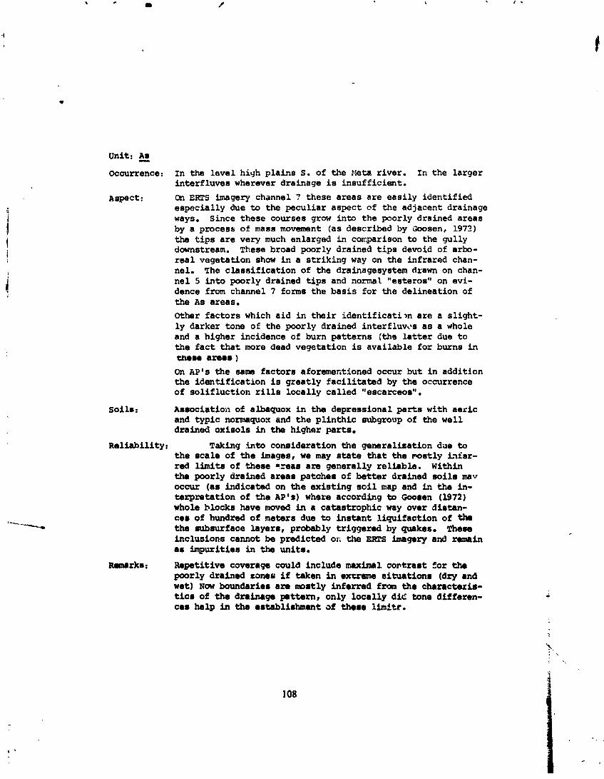
Aspect: On Ems imagery channel 7 these areas a re eas i ly ident i f ied especia l ly due to the pecul iar aspect of the adjacent drainage ways. Since these courses grow into the poorly drained areas by a process of mass movement (as described by W s e n , 1973) the t i p s a r e very much enlarged in c o ~ p a r i s o n to the gully downstream. These broad poorly drained t i p s devoid of arbo- r e a l vegetation show i n a s t r ik ing way on the infrared chan- nel. The c laes i f i ca t ion of the drainagesystem drawn on chan- ne l 5 into poorly drained t i p s and normal "esteros" on evi- dence from channel 7 form8 the bas i s fo r the delineation of the A s areas. Other fac to rs which a i d i n t h e i r i d e n t i f i c a t i m a r e a s l igh t - l y darker tone of the poorly drained interfluv,*s a s a whole and a higher incidence of burn pa t t e rns (the l a t t e r due t o the f a c t t h a t more dead vegetation is available fo r burns in meme a reas ) On AP's the same fac to rs aforamentioned occur but i n addit ion the iden t i f i ca t ion i s g rea t ly f a c i l i t a t e d by the occurrence of so l i f luc t ion rills loca l ly cal led "escarceos".
Soil. : Asuociation of albaquox in the depressional parts with aelric and typic normaquo+ and t h e p l i n t h i c eubgroup of the well drained oxisols in the higher parts .
Rel iabi l i ty : Taking i n t o consideration the generalization due to t h e scale of t h e images, we may state t h a t the m s t l y h f a r - red limits of theme -=ear a re generally re l iable . Within tha poorly drained areas patches of b e t t e r drained s o i l 8 rnav occw (as indicated on the exie t ing oil map and i n the in- t s rp re ta t ion of the AP's) where according to Gooren (1972) whole hlackr have mwed in a catastroptlic way wer distan- car of hundred of meters due to i n s t a n t l iquifact ion of thr the subsurface layers, probably tr iggered by quakes. There inclusions cannot be predicted on the EKTS hegory and remain a s impurit ies i n the units .
Ranarkr: m t i t i v o coverage could include maximal contraat f o r the poorly drained zone6 i f Wcen i n excreme s i tuat ion# (dry and wet) Now boundarier a m mostly inferred from the charectexis- t i c s of the drainage pmttern, only loca l ly d i e tone d i f fsren- ca r help in the ertablirhment of there limlte.
Solifluction r i l l s of As contrast w i t h "rizfl mianto" of A a on RP,
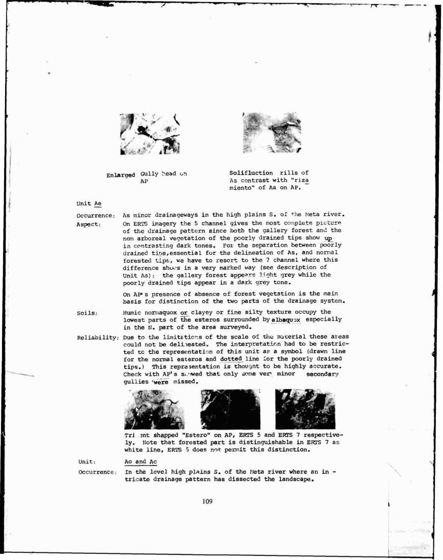
unit & m-rence: RS minor drainageways in the high p l a i n s S. oL' +he Meta river. Aspect: On E m imagery the 5 channel gives the most complete plc'.u--
of the drainage pattern ahce b t h the gallery forest ane the non arboreal veqetation of the poorlv d r a k e 3 tips shm up in ccrntrastj-ng dark tones. For the separation betwean pearly drained tips,essential for the del ineat ion of As, and nomal forested t ips , w e have to resort to the 7 channel where th i s difference shws in a very marked way (see description of Unit As) : the gallery forest appear: I;rjht grey while the poorly drained tips appear i n a dark grey tone.
On A P s presence af absence o f forest vegetation is the main basis for dist inct ion of the two parts of the drainage system.
Soils: Hmie nomaquox or clayey or f ine silty texture occupy the lmest parts o f the esteros surrounded by a-~x especially in the N. part of the area sumeyed .
Reliability: Due t o the 1hitrtio.e-s of the scale of the mterial these areas c w l d n o t be delileated, The interpretatirm had to ba restric- ted tc the repiestmtatign of t h i s u n i t a,c a symbol [drawn line for the n o m l asteras and dottea line For the poorly drained tips. 1 This representation is thovgnt t o be highly accurate. Cheek w i t h AP's s~,rmed t h a t only @me ver minor secondary gullias *w&k m i s s e d .
T s i ?.nt shapped '%stare" on AP, ERTS 5 and Ems 7 respective- ly. Note that forested part i s distinguishable in Ems 7 as w h i t e line, E R E 5 dws ?In* p e r m i t this distinctian.
Unit : Ao and Ac
Oecurrenee: I n the level high plains S, o f the Mta river where an Ln - tricata drainage pattern has dissected the landscape.

Aspect: On ERTS theae two u n i t s representing two fases of dissection could not be separated while limits of t h i s combined u n i t with the un i t Aa a re d i f f i c u l t t o t r ace exactly. Locally the Ao and Ac u n i t s shcw o l igh te r tone oh b t h 5 and 7 channels which may be due to scarcer vegetation. In other areas however it has been observed tha t Ao/Ac shcws a darker tone on the 7 chan- n e l than i n adjacent Aa areas; i n t h i s case the darker color may be due to +he presence of l a t e r i t e c rus t fragments on the surface of * e dissected a reas This matter needs fu r the r in- vestigation. On AP's the u n i t s are e a s i l y separated in the storeoimage due t o t h e i r d i f fe ren t r e l i e f . In addition the absence of the "ri- Z8udento1' pa t t e rn ckarac te r i s t i c of Aa serves a s an easy guide f o r d i s t inc t i cn , .
Soi ls : For Ao thera is a dominance of oxic haplorthents on the slopes t h a t grade through sapr ic tropepts t o the typic well drained oxisols of a e hil locks. Entic and sapr ic tropepts occur around 'che outcrops of indurated p l i n t i t e gravel.
In Ac sapr ic tropepts with a hardened p l i n t i t e gravel layer close t o the surface are dominant a l t e rna t ing with oxic haplor- thexts. Depressions may have a e r i s p l i n t i c normaquepts.
R e l i ~ h i l i t y : Since most l imi t s are inferred from charac te r i s t i c s of the drainagepattern which i n turn does change gradually, a l o t of inclusions of Aa w i l l occur. Tone di f ferences of these areas with Aa t!!ough local ly helpful1 a r e not consis tent and n e d fu r the r investigation.
Remarks: Here too repetiU.ve coverage may turn out to be useful1 since i n axtxeme s i t u a t i o . ? ~ of drought vegetation differences bet- ween these a reas and Aa w i l l be mOm m r m
Unit g Occurrence: A s major drainageways in t h e high p la ins S. of the Meta river.
Aspect: On EKTS imagery these ahow up very c lea r ly both i n the 5 and 7 channels. The gal lery fo res t shows, j u s t a s f o r the u n i t Ae, dark on channel 5 and l i g h t on channel 7. The watercour- s e s meandering within these mall floodplains show w e l l on the 7 channel. The major ones s h w their complete streambed wlrile t h e manor ones, the channel o f which is p a r t l y obscured by vegetation show a s a " s t r ing of pearls". The l a t t a r probably dw, t o t h e f a c t t h a t the m a l l u n i t s of water a r e l e s s than the minimum pic ture el-nt and consequently shcw up enlarged. h ' 9 r t streambeds could probable be rvjconstructed cunpletaly, within t h i s u n i t Av, but f o r cartographic masons no attempt m a mado, to &.'.a thsm. On A r ' s chese u n i t r a r e J.dentified by t h e i r l eve l topography and charac te r i r t i c g a l e r l forest .

Soils: Humic nonnaquox af clayey textures tha t l imit w i t h aquic tropepts a ~ d with well drained psawmentic oxisols.
Rnliability: Canparing AP ' s we mny concl.de t h & t t h i s wri t is accurately delineated. Since the vegetatio~; is the f-ctor on which the galery fcrest-boundazy hns been sh:'.ited s l igh t ly due to burns.
un i t Occuxrsnce: In the valleys of the main r ivers ; bg the streambed. Aspect : On ERTS imagery t h i s w:it shows t . a r l i gh t tono on the
channel 7 and a rather dark one or ,. me1 5. Crh the l a t t e r channel the tone .'.s variable accor - m the occurrence of fores t or shrub. A difference which does not show up in the 7 channel.
On a e r i a l pb.>toqraphs th i s un i t is easi ly separated i n the stereoimage trle to its position, f l a t tapography and the ocurrence of numerous m a l l streamchanne!ls. The color tone and texture indicative of shrub and forest res-pecti- vely serve as an added guide.
Soils: Entisols and ant ic tropepts on point bars and levees; aer ic normaquepts are dominant in the law parts with humic sub- groups i n the depressions.
~ a l i a b i i i ty : A t cer ta in places i n the all-avial plain there ex is t s a cer- t a in aeolian influence (Ee and E r ) . These unite w-re not detected on tha ERTS imagery cro t ha t the uni t indicated as vb on the map may contain un i t s of E s and ri:.
In the aforewntioned areas with aeolian influence the escarp- ment separating the unit from adjacent be t te r drained areas is poorly expressed resulting i n low contrast on the images and coasequentiy inacairatt boundaries.
Remarits : With repr:;=ru Ems coverage it is qui te well poraibla tha t the deliiledtion of Vb from E r can be improved eupecially i f cwerage includes high flood situations.
Unit 2 Occurrence: A s small un i t s (terrace remnants) within the Meta floodplain
mostly adjscent to the arcarpmsnt of the high plain.
Aspect: On EKPS iwgery of channel 7 these unit8 show up a s dark colored patches within the l i gh t grey tones of the galaxy forest of uni t Vb. They contain many open w a t s r w i e s . In the channel 5 they camrot be distinguished.
The dark color of these un i t s is probably due to the poor intzxnal drainage of its s o i l s which are mostly of a heavy texture. On AP's them terrace raminn a re characterized by a lawer proba3ly denmr shnab vogmtation which contrasts with the higher gallery f o n r t of un i t Vb.

s o i l s : The lagoons cf t h i s u n i t a r e surrounded by typic nr -nw-lepts and a e r i c humaqiley2s of clayey textures; ae r i c p l i n t h i c nor- rnaquepts characterize some levees an korders of escaqm lents, whila the albaquox ocupy those parts of the t e r race L!mt suffered aeolien influence.
Re l i ab i l i ty Comparison with the cx i s t ing s o i l map shows t h a t some u n i t s appear s t r ik ingly c l e a r i n t h e E ~ S h . y e while o the r s can only be inferred with d i f f i c u l t y from the open waterbodies. The aforementioned aeolian influence which is d i f f i c u l t to dis t inguish from Vb makes e r r o r s in delineation of cer- tain u n i t s probable.
s o i l s :
Re~mrks : EmS coverage from a high f l e d s i tua t ion would prowbly make the delineation of these u n i t s more accurate.
Unit
Occurrence: Small patches of longitudinal dunes, blown out from the major r i v e r s and occurring on the S. r i v e r shores e i the r i n the floodplain o r invading the high plain.
Aspect: On ERTS imagery especia l ly i n the 5 channel these dunes show up a s l i g h t colored elongated pa t t e rns with a c l e a r NE-SW or ienta t ion. The poorly drajnsd areas between the dunes a r e czasily iden t i f i ed on the 7 channel, where they show up a s dark colored streaks. The 5 channel shows the d e p e s - sions a s wel l due t o vegetation di f ferences though with l e s s contrast . On AP'S the same features o u t l i n d above together with the charac te r i s t i c r e l i e f vish.7.e i r ; +he stereoimage serve to iden t i fy t h i s &?it. u l t i c and typic quarzipsamments on the dunes t h a t grade through aqui.s haplorthents t o humic normaquepts of coarse loamy tex- t u r e i n the depressions. The t r ans i t ions towards the s o l i f l u c t i o n rills have a e r i c p l i n t h i c normaquepts.
Re l i ab i l i ty : Though one u n i t identified !n the sample s t r i p of AP1s was missed i n the EIFS in terpre ta t ion, we a r e r a the r confident that most major u n i t s have betn iden t i f i ed and properly de- l ineated, s h c e the u n i t s generally have a strong contras t with t h e i r surroundings and a pzedictable posit ion.
Unit
Occurrence: Within t h e eol ian p la in mainly N. of t h e r i v a r Meta i n b e t t e r :lrainage posi t ions a!.ong drainagew,~ys and escarpments
Aepect: In the eol ian p l a i n N. of tho r ive r Meta these units show up ao l i g h t colored s t r i p o along drainageways on 7 channel EKTS image. 1n the small patches S. of tne Meta r i v ~ r this u n i t could not be i d m t i f i e d in the 3s patches which a s a whole are d i f f i c u l t t o recognize wiu.\in the floodplain.

On A P n r they are identified by t h e i r position within the aeolian plain and by the i r lack of sol i f luat ion rills.
Soilr: ~ y p i c tropepto of f ine s i l t y texture tha t change W a r d s the drainage way8 into the typic mbgmups of the w e l l drained oxisolr of f ine loamy tsxtute. Towards the aeolian plain aer ic plintkic norrmrqueEtr appecr.
Reliability: For the area S. of the Meta mtry low. ama N. of the Meta where them uni ts have 8 major extension looks more promising a s f a r a s the ident:lfication and delimitation of these uni ts is concerned.
Unit:
Occurrence: A s level poorly drained p h h e mainly N. of tho Meta river. Aspect: On ERTS imagery N. of the mta r iver &&re arear a r e d i s -
tinguished by a dark mottled tone in the 7 channel to a lesser extent t'4.s mottling can be observed i n the 5 chm- nel too. The m a l l patcher t h a t occur S. from the mta r iver mainly within the flooclplain a re not easy to identify and very d i f f i c u l t t o separata from =?it Tv. After con - aulting the exinting s o i l map, identification is possible but delineatf-on of minor patches without thir aid means troublesome. In the A P ' ~ the- unite a re ear i ly recognized due t o the occurrence of '*ercarceosn (ml i f luc t ion rills). Confusion between E s and A s doer not occur since both uni ts have very different positions.
Dominance of clbaquox with fine loamy and clayey t6xturur i n the level par t s j t rans i t ions tmards dunes include oxic haglorthents. In areas with a s l i gh t slope tawards drainage ways aer ic and aer ic pl inthic normsquepts 8ra found. Very seldomly found a m the pl inthic subgroupr of the well drained oxisolr .
- l iabi l i ty: The amall patches occurring S. of the mta rivar cannot easi ly be identified and consequently occur as inclusionr F,q unit Vb. Confusion with 'Pv is also possible.
Remark: EK~S coverage for high flood situationr couM help in solving the identification p r o b h s .

Conclusion
Resuming we may s t a t e t h a t most of the important u n i t s of an e x i s t i ~ g 1 :250,000 reconnaissance s o i l map could be extrapolated successfully i n t o an unknown s imi lar area using EmS imagery in conjunctiol; with sample s t r i p s of a e r i a l photography. I n those cases where dmlineations were insa t i s fac to ry it is to be expected t h a t repeated E;mS coveraqe could improve the resul ts . The resu l t ing map shows s u f f i c i a n t d e t a i l to jus t i fy a publication scale of 1; 500.000. It can be c l a s s i f i e d as a s o i l map which is i n between exploratory and schematic. Kith repeated ERTS cwerage and sane f i e l d work it may be improved t o a s c i l map which c l a s s i f i e s i n b e t e e n exploratory and reconnaissance. Since t h e m maps a re use fu l l i n the f i r s t s tages of planning i n remote undeveloped a n a s it is s t ressed t h a t the application of conventional pnotointerpretat ion techniques (physiographfc analysis) on Ems imagery can yie ld s ign iz i san t p r a c t i c a l r e s u l t s especia l ly in the 2eveloping count-ies.
Bibliography
1. Buxingh, P. The application of a e r i a l photographs in s o i l surveys. In: Manual of phowgraphic in terpre ta t ion. Washington, American - Society of Phot~gramnetry, 1960. pp. 633-665.
2. Elbersen, G. W. Influencias volc inicas en 10s Llanos Orientales de Colombia. In: Ct;srto Congreso Iatinoamericano de l a Ciencia d e l Suslo, f iarzay, Venezuela, Noviembre, 1972.
3. Goosen, D. Algunos fenthenos de ines tabi l ided f i s i c a an suelos pla- nos de h r i c a Latina. In: Cuarto Congreso Iatinoamericano de la Ciencia d e l Suelo, Maracay, Venezuela, Noviembre, 1972.
4. Goosen, D. Physiography and s o i l s of the Llanos Orientales de Co- lanbia. Enscneda, In ternat ional Training Centre f o r Aer ia l Survey and Earth science# Ser ies B 64. 1971.
5. Guerrero 3. S o i l s of the Colombian Llanos Orientales. Canposition and Class i f i ca t ion of selected s o i l p ro f i l e s . Thesis Ph.D. Agr. Raleigh, North Caroline S t a t e univers i ty , 1971.
6. ORGWI2ACION DE IAS NACICNES UNIDAS PARA IA AGFUCUIGWRA Y IA ALfMGN- TACION (FA01 . Rewnocimiento edafol6giso de 10s Llanos Orien- t a l e s de Colombia. RaM. FAO/SF ll/COL. 1966.


Alluvial TUracna
Ll&lura Eolica
z? Em W u r o s
Aeolian Plain
-7
-- Es Llunva Solica man "Eecaf ceosn pobrammnte d r t I ~ 6 a
Aeolian Plain with " E s c u - ceoel' poorly drained
:, Er Rabc?x&s de C a f l a y Barran_ - - m a b i m a iqmrfectaamn- ta &madoe
Borders of Stxo.ns NICl E a c a t r asnta wll t o ~ i e c t l y - drained
Recvnt A l l u v i u m
- 1 Vb V.988 bisr. a polpaunto
Lu drerudoa con a l t o p l i g r o 64 inundaci6n
Ploodplain~ -11 t o poorly rlrained with a high u- t ion hazard
High Plain.
bvel ~ i g h Plain -11 and IPoderately -11 drainad
Low: ~ i g h Plain moduatoly -11 t o r e l y d r a w
iJnduAating High P h h
strongly ~ i 8 n e t d High Plain
Ritnr a4 stroam
unit bauduy
a m

ESCALA 1 ' 350.600
117

ERTS INTERPRETACION EXISTING SOIL MAP
-
ESCALA APROXIMADA I : 320.000

C X T l l A P O L A T E O S O I L Y A P


![Reference Code Element: [undetermined]library.loyno.edu/assets/handouts/archives/CORNET PRELIMINARY... · Reference Code Element: ... Binders 74 TEKE Bai Bume Dia Dzing Lwer Mfinu](https://img.pdfslide.us/doc/110x75/5b7a4d0c7f8b9aad4c8bc424/reference-code-element-undetermined-preliminary-reference-code-element.jpg)