Embed Size (px)
Citation preview
1
MINUTES
WASHINGTON COUNTY PLANNING BOARD
May 6, 2021
5:00 pm, Quorum Court Room, New Court House
280 N. College Ave.
Fayetteville, Arkansas 72701
DEVELOPMENT REVIEWED: ACTION TAKEN:
CONDITIONAL USE PERMIT HEARINGS
County
a. Ira Ruth Littrell Residential CUP Approved
County
b. Boston Mountain Fire Dept. Station 3 CUP Approved
Springdale Planning Area
c. Comic Towing CUP Approved
County
d. Rock Town Layover RV Park CUP Tabled
County
e. Pleasure Heights Road Sealant Facility CUP Approved
County
f. Sonora Subdivision CUP Tabled
LAND DEVELOPMENT HEARINGS
County
g. Sonora Subdivision Pre-Sub Tabled
County
h. Magnolia Acres Subdivision Phase 2 Pre-Sub Approved
Springdale Planning Area
i. Custom Lawn Care & Landscaping Pre-LSD Approved
1. ROLL CALL: Roll call was taken. Members present include Philip Humbard, Neil Helm, Loren
Shackelford and Kiara Luers.
2. APPROVAL OF MINUTES: Loren Shackelford made a motion to approve the minutes of the April 1st,
2021 meeting as written. Kiara Luers seconded. All board members were in favor of approving. Motion
passed.
3. APPROVAL OF THE AGENDA: Loren Shackelford made a motion to approve the agenda as written.
Kiara Luers seconded. All board members were in favor of approving. Motion passed.
4. NEW BUSINESS CONDITIONAL USE PERMIT HEARINGS
Fayetteville Planning Area
a. Ira Ruth Littrell Residential CUP
Conditional Use Permit Request
Location: Section 35, Township 17, Range 31
Applicant: Ira Ruth Littrell
Location Address: 2916 N Double Springs Road WC 881
2
JP District: Sam Duncan, District 7
Approximately: +/- 1.22 acres / 1 parcel
Coordinates: Latitude: 36.10601212, Longitude: -94.25412050
Project #: 2021-080 Planner: Nick Little email: [email protected]
APPLICANT’S REQUEST The applicant is requesting residential conditional use permit approval in order to place a second home
onto a parcel that is not 2 acres in size. The reason the applicant has to obtain this permit is because the
addition of a second home makes this property denser than the current zoning allows.
SITE INFORMATION Land Owner: Ira Ruth Littrell Parcel Number: 001-17549-000
Site Location: 2916 N Double Springs WC881; Fayetteville, AR 72704
Planning Area: Fayetteville Planning Area
Acreage: 1.72 QC District: 7, Sam Duncan Current Zoning: Agriculture/Single-Family Residential 1 unit per acre School District: Fayetteville FIRM: 05143C0185G Fire District: Wheeler Rural Wetland: No Watershed: None
UTILITIES Electricity: Ozark Electric Gas: Black Hills Energy Cable: Cox Communications Phone: AT&T Water Fayetteville Water
BACKGROUND/SYNOPSIS The applicant, Ira Ruth Littrell, is requesting residential conditional use permit approval in order to place
a second home on a parcel that is not 2 acres in size. The zoning is for Agricultural and Single Family
Residential uses with a maximum density of one (1) residential unit per acre. The purpose of this permit
is to address the density issue with putting a second home on the property. The project parcel is inside
of Fayetteville’s Planning Area. The proposal is located on the eastern side of N Double Springs Road
WC881. There is currently one residential structure on the property. The applicant is proposing to place
a second dwelling on the property. The dwelling is a 14’ x 80’ mobile home that will be placed to the
north of the existing home. Both dwellings on the property have their own individual septic systems. The
driveway for the new residence will access N Double Springs Road WC881.
COMPATIBILITY Surrounding Land Use and Zoning
Direction from Site Land Use Zoning
North Residential Ag/SF Res 1 unit/ac
South Residential Ag/SF Res 1 unit/ac
East Residential Ag/SF Res 1 unit/ac
West Residential/Agricultural Ag/SF Res 1 unit/ac
Existing Condition of Property
The subject property is zoned Ag/SF Res 1 unit/ac and has a residential use. It is in an area that is heavy
with residential and agricultural uses. The property contains one residence currently, as well as two
storage sheds. Pending the approval of this permit, there will be two total residences on the parent
parcel.
Future Land Use / Zoning Designation
The parcel is within Fayetteville’s Planning Area. The future land use plan for this parcel is considered
“Rural Area Residential”. The current zoning for the project parcel is Ag/SF Res 1 unit/ac. If the project is
approved, the zoning will stay the same, but with a conditional use allowance.
3
Neighbor Comments and Concerns
Pursuant to Sec 11-204, Sec 11-71 (2a), and Sec 11-101b of the Washington County Code of Ordinances,
notifications were sent by certified letter to all adjoining property owners within 300 feet. To date, Staff
has not received comments voicing opposition or favor of the project. Planning Staff will update the
Board should any further comments be received.
SUMMARY OF AGENCY COMMENTS – TECHNICAL REVIEW From Ozarks Electric
1. Any damage or relocation of existing facilities will be at owner’s expense. 2. Any power line extension that has to be built to this property will be at the owner’s expense.
The cost will be determined after the owner makes application for electric service and the line has been designed.
3. All off site easements that are needed for Ozarks to extend electrical service to the property must be obtained by developer and easement documentation provided to Ozarks before work begins. On site easements must be shown on plat and recorded with the county.
4. Please contact Ozarks Electric if you have any questions. Wes Mahaffey At (479)263-2167 Or [email protected]
5. NO BUILDINGS UNDER OZARK LINES
From Fayetteville Water 1. Private water service lines cannot cross property lines. If a lot split is proposed in the future, individual
water service to the lot must be provided. Shared water service is permissible if homes are on same parcel.
RECOMMENDATION & CONDITIONS Staff has reviewed the Residential CUP submittal documents and feel the proposal can be made
compatible with county ordinances with the following conditions:
Utility Conditions
Electricity – Ozarks Electric
1. Any damage or relocation of existing facilities will be at owner’s expense. 2. Any power line extension that has to be built to this property will be at the owner’s expense.
The cost will be determined after the owner makes application for electric service and the line has been designed.
3. All off site easements that are needed for Ozarks to extend electrical service to the property must be obtained by developer and easement documentation provided to Ozarks before work begins. On site easements must be shown on plat and recorded with the county.
4. Please contact Ozarks Electric if you have any questions. Wes Mahaffey At (479)263-2167 Or [email protected]
5. NO BUILDINGS UNDER OZARK LINES
Water – Fayetteville Water
1. Private water service lines cannot cross property lines. If a lot split is proposed in the future, individual water service to the lot must be provided. Shared water service is permissible if homes are on same parcel.
Fire Safety Conditions
1. The new home must be placed more than 20 feet away from any existing structures.
4
Environmental Conditions
1. No stormwater permit is required by Washington County at this time; however, applicant must comply with all rules and regulations of the Arkansas Department of Environmental Quality. www.adeq.state.ar.us
Standard Conditions for All Projects
1. Pay neighbor notification mailing fees within 30 days of project approval. Any extension must be approved by the Planning Office (fees will be calculated once the info is available from the post office). This total will be calculated for this project once all invoices are received.
2. Pay any engineering fees. This total will be calculated for this project once all invoices are received.
3. Any further splitting or land development not considered with this approval must be reviewed by the Washington County Planning Board/Zoning Board of Adjustments.
4. All CUPs must be ratified by the Quorum Court. 5. Final inspection approval is required prior to issuance of CUP approval letter. 6. It is the applicant’s responsibility to contact the Planning Office when inspections are needed. 7. Per Washington County ordinance Sec 11-75 (7): All plats for land developments approved by
the Washington County Planning Board shall be contingent upon receipt by the Developer of any Federal, State, or local or approvals, if any, whether known or unknown to the Board or the Developer.
8. All conditions shall be adhered to and completed in the appropriate time period set out by ordinance.
Washington County Planner, Nick Little, presented the staff report for the Board Members.
Loren Shackelford, Planning Board Member, inquired, “The size of the lot right now is +/- 1.22 acres so
if you said that the approved density would be increased to greater than 1 house per 2 acres. Is it already
1 house on less than 2 acres? The overall site size is 1.22 acres, correct? ”
Nick Little replied, “Correct. The current layout of the property is listed as 1.2 acres. The addition of the
second home would make it denser than what the zoning calls for: Agricultural/Single-Family Residential
1 unit/per acre.”
Loren Shackelford asked, “Okay, and they are on separate septic systems?”
Nick Little answered, “Correct, they have two septic systems on site.”
Loren Shackelford stated, “Thank you, Sir.”
No Public Comment
Public Comment Closed
Kiara Luers made a motion to approve the Ira Ruth Littrell Residential CUP subject to staff
recommendations. Neil Helm seconded. All Board Members present were in favor of approving. Motion
passed.
County
b. Boston Mountain Fire Dept. Station 3 CUP
Conditional Use Permit Request
Location: Section 08, Township 13, Range 30
Applicant: Brian Wilson
Location Address: 18878 Winn Creek WC 228
JP District: Jim Wilson, District 14
5
Approximately: +/- 8.48 acres / 1 parcel
Coordinates: Latitude: 35.82224666, Longitude: -94.19645047
Project #: 2021-083 Planner: Nathan Crouch email: [email protected]
APPLICANT’S REQUEST The applicant is requesting Conditions Use Permit approval for the use of a volunteer fire station on a
property zoned to allow Ag/SFR-1 uses. The requested use is exempt from Large Scale Development
review— Sec. 11-100 (l)(7).
SITE INFORMATION Land Owner: Boston Mountain Fire Association Parcel Number: 001-00677-008 Site Location: 18878 Winn Creek Rd. Planning Area: None Acreage: 1.62 acres +/- QC District: 14, Jim Wilson Current Zoning: Agriculture/Single-Family Residential 1 unit per acre School District: Greenland FIRM: 05143C0525F Fire District: Boston Mtn
UTILITIES Electricity: Ozark Electric Gas: N/A Cable: Ozarks Go Phone: Century Tel Water: Washington Water Authority
BACKGROUND/SYNOPSIS Matt Devore, on behalf of the applicant, Boston Mountain Volunteer Fire Department, is requesting
Conditional Use Permit (land use) approval for a fire station located in an area of the county zoned to
allow Agricultural and/or Single Family Residential land uses at a density of 1 residential unit/acre. The
applicant, Boston Mountain Fire Association, provided a letter of explanation states they are expanding
to provide fire protection/EMT to the interstate, tunnel, and west side of their district on include Devil’s
Den State Park, and to maintain ISO ratings for residences. The proposed fire station is only a garage for
the fire trucks. There is no water service or septic systems requested, and no kitchen or living quarters
are proposed. The proposed fire station #3 is planned to be a 40x60 ft. metal building with 4 overhead
bay doors. Electricity is the only utility requested, and they will utilize propane powered back-up
generators in case of electrical service outages. There will be a circle driveway with gravel driving
surface, about 200 ft. long and 12 ft. wide. The subject property is located at 18878 Winn Creek Rd., WC-
228. There are no existing structures on the property. The property is not located in a city planning area.
The zoning is for Agricultural and Single Family Residential uses with a maximum density of one (1)
residential unit per acre. Washington County Code of Ordinances states Large Scale Development
approval is not required for municipal and volunteer fire stations.
*Sec. 11-100: Large Scale Development standards.
(l): The following public utility services and structures are hereby exempt from the Washington County
Code provisions concerning large-scale developments.
(7): Any additions or expansions of municipal fire department volunteer fire departments, or ambulance
service buildings or facilities located in the unincorporated portions of the County.
Please see the attached plans, and letter from the applicant for more information
COMPATIBILITY Surrounding Land Use and Zoning
Direction from Site Land Use Zoning
North Agricultural/Residential Ag/SF Res 1 unit/ac
South Agricultural/Residential Ag/SF Res 1 unit/ac
East Agricultural/Residential Ag/SF Res 1 unit/ac
West Agricultural/Residential Ag/SF Res 1 unit/ac
6
Existing Condition of Property
The subject property is zoned Ag/SF Res 1 unit/ac and has no existing structures. It is in a rural area of
the county that doesn’t have much development other than single family residential uses.
County’s Land Use Plan
According to the County’s Land Use Plan:
SECTION III. PHYSICAL DEVELOPMENT
A. FIRE PROTECTION The public fire protection system must afford maximum security from fire loss while minimizing
costs of service and fire insurance costs.
The county can realize this goal by:
a. Locating fire stations on adequate sites and directly adjacent to major streets for the utmost accessibility to development within its service area, and the least amount of friction to adjacent land uses;
b. Avoid duplication of fire station service areas to lower county fire protection costs; c. Working directly and cooperatively with all area fire departments that serve the
unincorporated areas.
*It is planning staff’s opinion that the location of this proposed fire station meets these criteria.
Future Land Use / Zoning Designation
The parcel is not in a city planning area, and there is no Future Land Use designation for the project
parcel. The current zoning for the project parcel is Ag/SF Res 1 unit/ac. If the project is approved the
zoning will stay the same, but with a conditional use.
Neighbor Comments and Concerns
Pursuant to Sec 11-204, Sec 11-71 (2a), and Sec 11-101b of the Washington County Code of Ordinances,
notifications were sent by certified letter to all adjoining property owners within 300 feet. To date, Staff
has received zero (0) comments in opposition and one (1) comment in favor of the project. Planning
Staff will update the Board should any further comments be received.
Criteria for Conditional Uses
According to Sec 11-200(a) Criteria for allowance of conditional uses:
The Board shall hear and decide requests for a conditional use and may authorize such if it finds:
Criteria Staff Comments
1 That a written application has been filed with the Planning Office and the appropriate fee has been paid.
The applicant has submitted a written application and the appropriate fee.
2 That the applicant has provided proof that each property owner as set out in section 11-204 has been notified by return receipt mail.
Notifications of public hearing was sent via certified mail on April 22, 2021.
3 That adequate utilities, roads, drainage and other public services are available and adequate or will be made available and adequate if the use is granted.
Adequate utilities are available or will be made available at the applicant or property owner’s expense. However, the only utility requested is
7
electricity, of which there is an electric meter already on a pole on-site.
4 That the proposed use is compatible with the surrounding area.
The proposed use is not inherently compatible with the surrounding area due to zoning and majority of use. With conditions, the proposed use can be made more compatible.
5 That the establishment, maintenance, or operation of the conditional use will not be detrimental to or endanger the public health, safety, morals, comfort or general welfare.
The proposed use is a volunteer fire station. This use type is generally very low impact to the neighborhood due to the fact there isn’t much activity until there is an emergency. The applicant states they won’t run the emergency sirens until they get the fire trucks out onto the highway.
6 That the conditional use will not be injurious to the use and enjoyment of other property in the surrounding area for the purposes already permitted, nor substantially diminish and impair property values within the surrounding area.
The surrounding area is mostly agricultural by use and zoning. Staff feels that a small fire station like this will not impair property values. It should increase the district’s ISO rating which should lower fire insurance rates.
7 That the establishment of the conditional use will not impede the normal and orderly development and improvement of the surrounding area for uses permitted in the zone.
A volunteer fire department, with EMS, might make the community more attractive for future development.
SUMMARY OF AGENCY COMMENTS – TECHNICAL REVIEW Ozarks Electric
1. Any damage or relocation of existing facilities will be at owner’s expense. 2. Any power line extension that has to be built to this property will be at the owner’s expense.
The cost will be determined after the owner makes application for electric service and the line has been designed.
3. All off site easements that are needed for Ozarks to extend electrical service to the property must be obtained by developer and easement documentation provided to Ozarks before work begins. On site easements must be shown on plat and recorded with the county.
4. Please contact Ozarks Electric if you have any questions. Wes Mahaffey At (479)263-2167 or [email protected].
5. No buildings are to be located under Ozarks Electric power lines. 6. 30 ft. utility easement is required along all Ozarks Electric overhead power lines.
Washington Water Authority
1. Although water service is not requested at this time, should that change in the future, please submit a Request for Water Service with the WWA Office.
2. WWA has an 8” water main that runs on the east side of Winn Creek Road along this property’s western boundary. This water main ties into the WWA pump-station directly northeast of the intersection of Bethlehem Road and Winn Creek Road. If the future driveway to the fire station is to access Winn Creek over this water main, it is to be encased in 16” steel encasement. We highly suggest the driveway be located east of intersection of Bethlehem Road and Winn Creek to avoid the water main. Please call the WWA office for further details.
8
County Engineer
1. Based on reviewing Google Earth, it does not appear any flow leaving the site will cause any issues to downstream properties.
RECOMMENDATION & CONDITIONS Staff has reviewed the CUP submittal documents and technical review comments from the jurisdictional
reviewers, and feel the proposed fire station can be made compatible with county ordinances with the
following conditions:
Utility Conditions
Electricity – Ozarks Electric
1. Any damage or relocation of existing facilities will be at owner’s expense. 2. Any power line extension that has to be built to this property will be at the owner’s expense.
The cost will be determined after the owner makes application for electric service and the line has been designed.
3. All off site easements that are needed for Ozarks to extend electrical service to the property must be obtained by developer and easement documentation provided to Ozarks before work begins. On site easements must be shown on plat and recorded with the county.
4. Please contact Ozarks Electric if you have any questions. Wes Mahaffey At (479)263-2167 or [email protected].
5. No buildings are to be located under Ozarks Electric power lines. 6. 30 ft. utility easement is required along all Ozarks Electric overhead power lines.
Water – Washington Water Authority
1. Although water service is not requested at this time, should that change in the future, please submit a Request for Water Service with the WWA Office.
2. WWA has an 8” water main that runs on the east side of Winn Creek Road along this property’s western boundary. This water main ties into the WWA pump-station directly northeast of the intersection of Bethlehem Road and Winn Creek Road. If the future driveway to the fire station is to access Winn Creek over this water main, it is to be encased in 16” steel encasement. We highly suggest the driveway be located east of intersection of Bethlehem Road and Winn Creek to avoid the water main. Please call the WWA office for further details.
Sewer/Septic Conditions
1. Please contact the Arkansas Department of Health should the need for septic arise in the future.
Environmental Conditions
1. No stormwater permit is required by Washington County at this time; however, applicant must comply with all rules and regulations of the Arkansas Department of Environmental Quality. www.adeq.state.ar.us
Road Conditions
1. A permit from the Washington County Road Department is required prior to any work being completed in the right-of-way.
Signage Conditions
1. All signs must be out of the right of way. 2. Signs may not exceed 24 square feet in size. 3. Signs shall not be directly lit.
9
Lighting Conditions
1. All outdoor lighting must be shielded from neighboring properties. Any lighting must be indirect and not cause disturbance to drivers or neighbors. All security lighting must be shielded appropriately.
Screening Conditions
1. All outdoor storage areas and dumpsters, to include the gate, shall be screened with opaque material of a uniform type.
Planning Conditions
1. The Conditional Use Permit is specifically to allow a fire station only. Any future land uses not allowed by the current zoning must come before the Planning Board for conditional use permit approval and ratified by the Quorum Court.
2. The applicant must address all technical review comments as the project proceeds through to completion.
Standard Conditions
1. Pay neighbor notification mailing fees within 30 days of project approval. Any extension must be approved by the Planning Office (fees will be calculated once the info is available from the post office). This total will be calculated for this project once all invoices are received.
2. Pay any engineering fees. This total will be calculated for this project once all invoices are received.
3. Any further splitting or land development not considered with this approval must be reviewed by the Washington County Planning Board.
4. All CUPs must be ratified by the Quorum Court. 5. Final inspection approval is required prior to issuance of CUP approval letter. 6. It is the applicant’s responsibility to contact the Planning Office when inspections are needed. 7. Per Washington County ordinance Sec 11-75 (7): All plats for land developments approved by
the Washington County Planning Board shall be contingent upon receipt by the Developer of any Federal, State, or local or approvals, if any, whether known or unknown to the Board or the Developer.
8. All conditions shall be adhered to and completed in the appropriate time period set out by ordinance.
Washington County Planning Director, Nathan Crouch, presented the staff report for the Board
Members.
Brian Wilson, Applicant for the proposed project and President of the Fire Board, addressed the Board,
“There is a septic system there on the land, but we are not using that because we are not having any
plumbing on that or anything. Just in case you had any questions on the septic system that is already
there.”
Aaron Wood, Fire Chief of Boston Mountain, addressed the Board, “With this station in play, we retain
our ISO 5, which is a classification out in this area as a part of the County. If this isn’t allowed we’d lose
that and it would be a detriment to several hundred home owners.”
No Public Comment
Public Comment Closed
Loren Shackelford made a motion to approve the Boston Mountain Fire Dept. Station 3 CUP subject to
10
staff recommendations. Kiara Luers seconded. All Board Members present were in favor of approving.
Motion passed.
Springdale Planning Area
c. Comic Towing CUP
Conditional Use Permit Request
Location: Section 03, Township 17, Range 29
Applicant: John VanCuren
Location Address: Off of E HWY 412 on the corner of E Hewitt Springs WC 570
JP District: Patrick Deakins, District 5
Approximately: +/- 2.04 acres / 1 parcel
Coordinates: Latitude: 36.16668709, Longitude: -94.05163442
Project #: 2021-088 Planner: Nick Little email: [email protected]
APPLICANT’S REQUEST The applicant is requesting conditional use permit approval to operate a tow yard on a parcel that is
zoned for agricultural/single family residential uses with a maximum of one (1) unit per acre.
SITE INFORMATION Land Owner: Donald Vang Parcel Number: 001-14464-000
Site Location: Just southwest of 17120 E Hwy 412, Springdale, AR 72765
Planning Area: Springdale Planning Area
Acreage: 2 acres +/- QC District: 5, Patrick Deakins Current Zoning: Agriculture/Single-Family Residential 1 unit per acre School District: Springdale FIRM: 05143C0095G Fire District: Nob Hill Rural Wetland: No Watershed: Beaver Water District
UTILITIES Electricity: Ozark Electric Gas: Black Hills Energy Cable: Cox Communications Phone: AT&T Water Springdale Water
BACKGROUND/SYNOPSIS The applicant, John VanCuren, is requesting conditional use permit approval to operate a tow yard. The
zoning is for Agricultural and Single Family Residential uses with a maximum density of one (1)
residential unit per acre. The project parcel is within Springdale’s Planning Area. The proposal is located
on the northern side of E Hwy 412, with the project parcel’s west boundary also fronting Hewitt Springs
Road WC570. There are no residential structures on the property at this time. The applicant would like
to operate a tow yard on a lot that is approximately 2 acres. The size of the development will not exceed
1 acre, according to the applicant’s plans. The tow yard would be situated on the southwestern corner
of the listed project parcel. The applicant has estimated that the total area the tow yard would utilize
will fit within a 100x75 foot fenced area and will have a gravel surface. There is a proposed 24x40 foot
office building that will be located in the southeastern corner of the tow lot. The driveway is proposed
to access off of E Hwy 412. The proposed asphalt driveway is 20’ wide and 125’ long. There will be
asphalted customer parking just to the south of the fenced-in tow lot, equipped with two standard
parking spaces and 13x13 foot handicapped parking space. The applicant’s letter states that normal
business hours will be from 8 am to 5 pm, Monday through Friday. However, repossessions occur at
night sometimes. The approximate volume per week will be less than 20 cars coming in to the lot.
COMPATIBILITY Surrounding Land Use and Zoning
Direction from Site Land Use Zoning
North Agricultural/Vacant Ag/SF Res 1 unit/ac
South Highway/School Use Conditional Use Permit
East Vacant Ag/SF Res 1 unit/ac
West Residential Ag/SF Res 1 unit/ac
11
Existing Condition of Property
The subject property is zoned Ag/SF Res 1 unit/ac and is currently vacant. It is in an area that has a
significant amount of commercial or non-conforming uses, as well as some residential use. The property
does not currently have any residences on it. Current aerial imagery and a site visit show that the lot is
cleared and in good condition. There was a large amount of litter in the right of way just off of E Hwy
412 in front of the project parcel. This debris is believed to be from the passing automobiles and of the
applicant.
County’s Land Use Plan
According to the County’s Land Use Plan:
SECTION III. PHYSICAL DEVELOPMENT
A. LAND USE CONSIDERATIONS 1. LIGHT COMMERCIAL
Continuing with the primary goal of retaining the rural characteristics of Washington
County, light commercial uses should be allowed if:
a. Not incompatible with adjacent residential and agricultural uses; or by conditions placed on such to mitigate its impact. Together with community facilities and compatible residential uses, this use typically serves as a buffer between general commercial and
strictly residential uses. This area of the county is heavy with commercial uses to begin with, so the addition of
another light commercial use will not necessarily be incompatible with the
surrounding area. This proposed project sits just across E Hwy 412 from Sonora School
and just to the west of several businesses.
The immediate surrounding area around the proposed development is mostly vacant land, all owned by
Donald Vang. There is a residence directly northeast of the project parcel, but the property owner listed
for that home’s parcel is also Donald Vang. The parcel directly south of the project parcel encompasses E
Hwy 412, and beyond that is Sonora School. To the west of the project parcel, there are 2 relatively
small residential lots that sit on the western side of Hewitt Springs Road WC570. There will be a
significant vegetative barrier blocking the view of the tow lot from these residences. The tow lot will
include a wooden fence and gate that will house and protect all the towed vehicles.
Future Land Use / Zoning Designation
The parcel is within Springdale’s Planning Area. There Future Land Use for the parcel is listed as General
Commercial. The current zoning for the project parcel is Ag/SF Res 1 unit/ac. If the project is approved,
the zoning will stay the same, but with a conditional use allowance.
Neighbor Comments and Concerns
Pursuant to Sec 11-204, Sec 11-71 (2a), and Sec 11-101b of the Washington County Code of Ordinances,
notifications were sent by certified letter to all adjoining property owners within 300 feet. To date, Staff
has not received comments voicing opposition or favor of the project. Planning Staff will update the
Board should any further comments be received.
Criteria for Conditional Uses
According to Sec 11-200(a) Criteria for allowance of conditional uses:
The Board shall hear and decide requests for a conditional use and may authorize such if it finds:
12
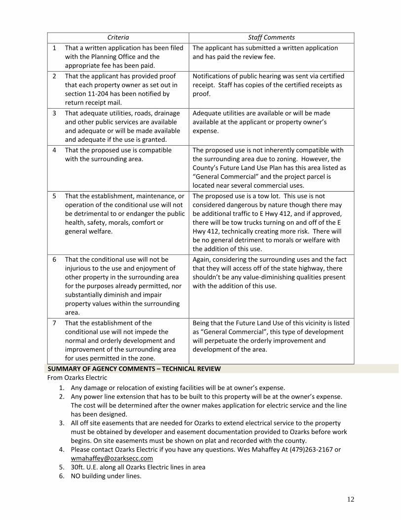
Criteria Staff Comments
1 That a written application has been filed with the Planning Office and the appropriate fee has been paid.
The applicant has submitted a written application and has paid the review fee.
2 That the applicant has provided proof that each property owner as set out in section 11-204 has been notified by return receipt mail.
Notifications of public hearing was sent via certified receipt. Staff has copies of the certified receipts as proof.
3 That adequate utilities, roads, drainage and other public services are available and adequate or will be made available and adequate if the use is granted.
Adequate utilities are available or will be made available at the applicant or property owner’s expense.
4 That the proposed use is compatible with the surrounding area.
The proposed use is not inherently compatible with the surrounding area due to zoning. However, the County’s Future Land Use Plan has this area listed as “General Commercial” and the project parcel is located near several commercial uses.
5 That the establishment, maintenance, or operation of the conditional use will not be detrimental to or endanger the public health, safety, morals, comfort or general welfare.
The proposed use is a tow lot. This use is not considered dangerous by nature though there may be additional traffic to E Hwy 412, and if approved, there will be tow trucks turning on and off of the E Hwy 412, technically creating more risk. There will be no general detriment to morals or welfare with the addition of this use.
6 That the conditional use will not be injurious to the use and enjoyment of other property in the surrounding area for the purposes already permitted, nor substantially diminish and impair property values within the surrounding area.
Again, considering the surrounding uses and the fact that they will access off of the state highway, there shouldn’t be any value-diminishing qualities present with the addition of this use.
7 That the establishment of the conditional use will not impede the normal and orderly development and improvement of the surrounding area for uses permitted in the zone.
Being that the Future Land Use of this vicinity is listed as “General Commercial”, this type of development will perpetuate the orderly improvement and development of the area.
SUMMARY OF AGENCY COMMENTS – TECHNICAL REVIEW From Ozarks Electric
1. Any damage or relocation of existing facilities will be at owner’s expense. 2. Any power line extension that has to be built to this property will be at the owner’s expense.
The cost will be determined after the owner makes application for electric service and the line has been designed.
3. All off site easements that are needed for Ozarks to extend electrical service to the property must be obtained by developer and easement documentation provided to Ozarks before work begins. On site easements must be shown on plat and recorded with the county.
4. Please contact Ozarks Electric if you have any questions. Wes Mahaffey At (479)263-2167 or [email protected]
5. 30ft. U.E. along all Ozarks Electric lines in area 6. NO building under lines.
13
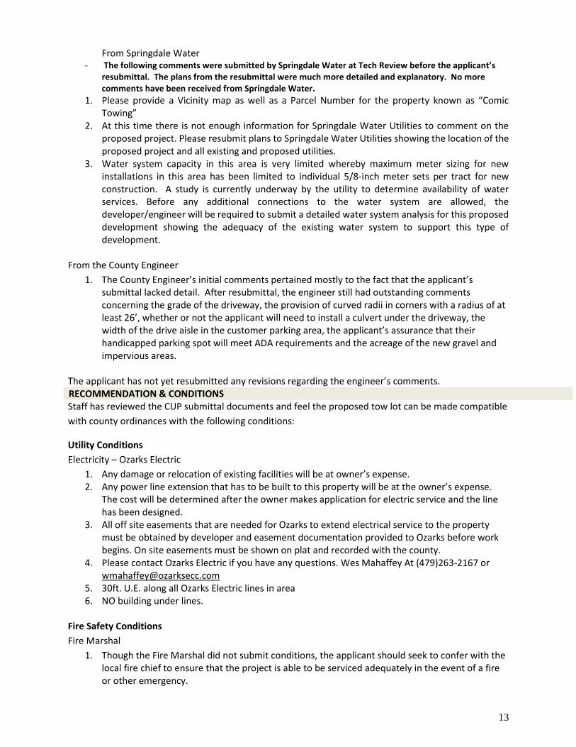
From Springdale Water - The following comments were submitted by Springdale Water at Tech Review before the applicant’s
resubmittal. The plans from the resubmittal were much more detailed and explanatory. No more comments have been received from Springdale Water.
1. Please provide a Vicinity map as well as a Parcel Number for the property known as “Comic Towing”
2. At this time there is not enough information for Springdale Water Utilities to comment on the proposed project. Please resubmit plans to Springdale Water Utilities showing the location of the proposed project and all existing and proposed utilities.
3. Water system capacity in this area is very limited whereby maximum meter sizing for new installations in this area has been limited to individual 5/8-inch meter sets per tract for new construction. A study is currently underway by the utility to determine availability of water services. Before any additional connections to the water system are allowed, the developer/engineer will be required to submit a detailed water system analysis for this proposed development showing the adequacy of the existing water system to support this type of development.
From the County Engineer
1. The County Engineer’s initial comments pertained mostly to the fact that the applicant’s submittal lacked detail. After resubmittal, the engineer still had outstanding comments concerning the grade of the driveway, the provision of curved radii in corners with a radius of at least 26’, whether or not the applicant will need to install a culvert under the driveway, the width of the drive aisle in the customer parking area, the applicant’s assurance that their handicapped parking spot will meet ADA requirements and the acreage of the new gravel and impervious areas.
The applicant has not yet resubmitted any revisions regarding the engineer’s comments. RECOMMENDATION & CONDITIONS Staff has reviewed the CUP submittal documents and feel the proposed tow lot can be made compatible
with county ordinances with the following conditions:
Utility Conditions
Electricity – Ozarks Electric
1. Any damage or relocation of existing facilities will be at owner’s expense. 2. Any power line extension that has to be built to this property will be at the owner’s expense.
The cost will be determined after the owner makes application for electric service and the line has been designed.
3. All off site easements that are needed for Ozarks to extend electrical service to the property must be obtained by developer and easement documentation provided to Ozarks before work begins. On site easements must be shown on plat and recorded with the county.
4. Please contact Ozarks Electric if you have any questions. Wes Mahaffey At (479)263-2167 or [email protected]
5. 30ft. U.E. along all Ozarks Electric lines in area 6. NO building under lines.
Fire Safety Conditions
Fire Marshal
1. Though the Fire Marshal did not submit conditions, the applicant should seek to confer with the local fire chief to ensure that the project is able to be serviced adequately in the event of a fire or other emergency.
14
Sewer/Septic Conditions
1. Please contact the Arkansas Department of Health should the need for septic arise in the future.
Drainage Conditions
1. Should the applicant deviate from their plans to cover the project area with gravel or if the applicant plans to alter the current existing grades, further review will be needed per the County Engineer.
Environmental Conditions
1. No stormwater permit is required by Washington County at this time; however, applicant must comply with all rules and regulations of the Arkansas Department of Environmental Quality. www.adeq.state.ar.us
Road Conditions
1. A permit from the Arkansas Highway and Transportation Department (AHTD) is required prior to any work being completed in the right-of-way.
Signage Conditions
1. All signs must be out of the right of ways. 2. Signs may not exceed 24 square feet in size. 3. Signs shall not be directly lit.
Lighting Conditions
1. All outdoor lighting must be shielded from neighboring properties. Any lighting must be indirect and not cause disturbance to drivers or neighbors. All security lighting must be shielded appropriately.
Screening Conditions
1. All outdoor storage areas and dumpsters, to include the gate, shall be screened with opaque material of a uniform type.
2. Any vegetation along the western portion of the bordering parcel must remain or if removed, must be replaced with vegetation for screening/privacy purposes.
3. The applicant shall utilize privacy fencing or similar opaque material to shield towed vehicles from view from the public road.
Planning Conditions
1. The Conditional Use Permit is specifically to allow a tow lot only. The size of the tow lot shall not exceed one acre in size. Any future land uses not allowed by the current zoning must come before the Planning Board/Zoning Board for conditional use permit approval and ratified by the Quorum Court.
2. The applicant must address all technical review comments as the project proceeds through to completion.
Standard Conditions for All Projects
1. Pay neighbor notification mailing fees within 30 days of project approval. Any extension must be approved by the Planning Office (fees will be calculated once the info is available from the post office). This total will be calculated for this project once all invoices are received.
2. Pay any engineering fees. This total will be calculated for this project once all invoices are received.
15
3. Any further splitting or land development not considered with this approval must be reviewed by the Washington County Planning Board/Zoning Board of Adjustments.
4. All CUPs must be ratified by the Quorum Court. 5. Final inspection approval is required prior to issuance of CUP approval letter. 6. It is the applicant’s responsibility to contact the Planning Office when inspections are needed. 7. Per Washington County ordinance Sec 11-75 (7): All plats for land developments approved by
the Washington County Planning Board shall be contingent upon receipt by the Developer of any Federal, State, or local or approvals, if any, whether known or unknown to the Board or the Developer.
8. All conditions shall be adhered to and completed in the appropriate time period set out by ordinance.
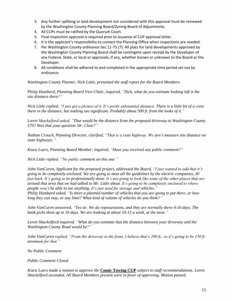
Washington County Planner, Nick Little, presented the staff report for the Board Members.
Philip Humbard, Planning Board Vice-Chair, inquired, “Nick, what do you estimate looking left is the
site distance there?”
Nick Little replied, “I just got a picture of it. It’s pretty substantial distance. There is a little bit of a crest
there in the distance, but nothing too significant. Probably about 500 ft. from the looks of it.”
Loren Shackelford asked, “That would be the distance from the proposed driveway to Washington County
570? Was that your question Mr. Chair?”
Nathan Crouch, Planning Director, clarified, “That is a state highway. We don’t measure site distance on
state highways.”
Kiara Luers, Planning Board Member, inquired, “Have you received any public comment?”
Nick Little replied, “No public comment on this one.”
John VanCuren, Applicant for the proposed project, addressed the Board, “I just wanted to add that it’s
going to be completely enclosed. We are going to meet all the guidelines by the electric companies, 30
feet back. It’s going to be professionally done. It’s not going to look like some of the other places that are
around that area that we had talked to Mr. Little about. It’s going to be completely enclosed to where
people won’t be able to see anything. It’s just used for storage and vehicles.”
Philip Humbard asked, “Is there a planned number of vehicles that you are going to put there, or how
long they can stay, or any limit? What kind of volume of vehicles do you think?”
John VanCuren answered, “Yes sir. We do repossessions, and they are normally there 4-10 days. The
bank picks them up in 10 days. We are looking at about 10-15 a week, at the most.”
Loren Shackelford inquired, “What do you estimate that the distance between your driveway and the
Washington County Road would be?”
John VanCuren replied, “From the driveway to the front, I believe that’s 280 ft., so it’s going to be 150 ft.
minimum for that.”
No Public Comment
Public Comment Closed
Kiara Luers made a motion to approve the Comic Towing CUP subject to staff recommendations. Loren
Shackelford seconded. All Board Members present were in favor of approving. Motion passed.
16
County
d. Rock Town Layover RV Park CUP
Conditional Use Permit Request
Location: Section 36, Township 18, Range 29
Applicant: Rick & Troyce England
Location Address: 16029 Bug Scuffle Road WC 216
JP District: Jim Wilson, District 14
Approximately: +/- 39.75 acres / 1 parcel
Coordinates: Latitude: 35.76343620, Longitude: -94.35298771
Project #: 2021-092 Planner: Nick Little email: [email protected]
APPLICANT’S REQUEST The applicant is requesting conditional use permit approval to operate a 6-space RV Park on a parcel
that is zoned for agricultural/single family residential uses with a maximum of one (1) unit per acre.
SITE INFORMATION Land Owner: Rick & Troyce England Parcel Number: 001-01969-000
Site Location: 16029 Crawley Road WC250, West Fork, AR 72774
Planning Area: None
Acreage: 39 acres +/- QC District: 14, Jim Wilson Current Zoning: Agriculture/Single-Family Residential 1 unit per acre School District: West Fork FIRM: 05143C0500G Fire District: Strickler Rural - 104 Wetland: No Watershed: None
UTILITIES Electricity: Ozark Electric Gas: None Cable: None Phone: PG Telco Water Washington Water Authority
BACKGROUND/SYNOPSIS The applicants are requesting conditional use permit approval to operate a 6-space RV park. The zoning
is for Agricultural and Single Family Residential uses with a maximum density of one (1) residential unit
per acre. The project parcel is not in a planning area. The proposal is located on the southern side of
Crawley Road WC250. There is one permanent dwelling towards the north end of the property. The
proposed RV Park is only 6 spaces and will not encompass an area larger than 1 acre. The RV spaces will
be situated towards the northern property boundary approximately 120’ from Crawley Road WC250.
Each RV space will be 80’ long by 25’ wide and will include an electrical hookup. The applicants outlined
in their submittal that water and sewer hookups for the RVs will not be included in this development.
The driveway and RV spaces will be graveled; there are no plans for paving of any kind for this
development. The applicants also stated in their letter of intent that there will be a 45-day stay limit for
any customers. The applicants have mentioned that some of their expected clientele will be
UTV/ATV/Side-by-Side users. The use of these off-road vehicles is popular in this area of the county and
the nearby national forest.
COMPATIBILITY Surrounding Land Use and Zoning
Direction from Site Land Use Zoning
North Agricultural/Vacant Ag/SF Res 1 unit/ac
South Agricultural/Vacant Ag/SF Res 1 unit/ac
East Residential/Agricultural Ag/SF Res 1 unit/ac
West Agricultural/Vacant Ag/SF Res 1 unit/ac
17
Existing Condition of Property
The subject property is zoned Ag/SF Res 1 unit/ac and has an agricultural and residential use. It is in an
area that is heavy with agricultural uses. The property currently has one permanent residence, located
about 275’ from the northern property boundary. Current aerial imagery and a site visit to the property
show that the land has been partially cleared and is free of debris.
County’s Land Use Plan
According to the County’s Land Use Plan:
SECTION III. PHYSICAL DEVELOPMENT
A. LAND USE CONSIDERATIONS 1. LIGHT COMMERCIAL
Continuing with the primary goal of retaining the rural characteristics of Washington
County, light commercial uses should be allowed if:
b. Not incompatible with adjacent residential and agricultural uses; or by conditions placed on such to mitigate its impact. Together with community facilities and compatible residential uses, this use typically serves as a buffer between general commercial and
strictly residential uses. Staff feels that this project can be made more compatible with the surrounding
community with certain conditions such as enforced quiet hours, fencing and
lighting conditions.
The subject area is located within a part of the county that is heavy in agricultural uses. All of the
immediate surrounding parcels are either agricultural or residential in use and tend to be larger lots. The
applicant hopes to utilize less than 1 acre’s worth of the approximate 39 acres. The proposed
development will be located towards the north end of the project parcel. There is one existing home
already on the property that will be located fairly close to the proposed development. The remainder of
the property is currently vacant.
Future Land Use / Zoning Designation
The parcel is not in a city planning area. There is not a Future Land Use designation for the subject
parcel. The current zoning for the project parcel is Ag/SF Res 1 unit/ac. If the project is approved, the
zoning will stay the same, but with a conditional use allowance.
Neighbor Comments and Concerns
Pursuant to Sec 11-204, Sec 11-71 (2a), and Sec 11-101b of the Washington County Code of Ordinances,
notifications were sent by certified letter to all adjoining property owners within 300 feet. To date, Staff
has received a significant amount of comments IN OPPOSITION to this project. Concerns with this
project include increased traffic from UTVs/ATVs, increase in potential crime, disruption of current
peaceful lifestyle, potential trespassing, noise and excessive alcohol consumption, general
incompatibility, potential danger for campers during hunting season, and worries of septic issues/illegal
dumping of RV waste due to the lack of on-site wastewater management. Planning Staff anticipates
more neighbor comments before the meeting, as well as contentious comments during the meeting on
May 6th.
Criteria for Conditional Uses
According to Sec 11-200(a) Criteria for allowance of conditional uses:
18
The Board shall hear and decide requests for a conditional use and may authorize such if it finds:
Criteria Staff Comments
1 That a written application has been filed with the Planning Office and the appropriate fee has been paid.
The applicant has submitted a written application and the $250 review fee.
2 That the applicant has provided proof that each property owner as set out in section 11-204 has been notified by return receipt mail.
Notifications of public hearing was sent via certified receipt. Staff has copies of the certified receipts as proof.
3 That adequate utilities, roads, drainage and other public services are available and adequate or will be made available and adequate if the use is granted.
Adequate utilities are available or will be made available at the applicant or property owner’s expense.
4 That the proposed use is compatible with the surrounding area.
The proposed use is not inherently compatible with the surrounding area due to zoning and majority of use. With conditions, the proposed use can be made more compatible.
5 That the establishment, maintenance, or operation of the conditional use will not be detrimental to or endanger the public health, safety, morals, comfort or general welfare.
The proposed use is an RV Park. This use is not considered dangerous by nature though there may be additional vehicles on these roads due to the development. The applicant has not set out plans to put a fence or any sort of visual/audible buffer around the development. Planning Staff will place conditions on this project that call for more aspects that should make this development more compatible.
6 That the conditional use will not be injurious to the use and enjoyment of other property in the surrounding area for the purposes already permitted, nor substantially diminish and impair property values within the surrounding area.
The surrounding area is mostly agricultural by use and zoning. There are several residences in the immediate area surrounding the proposed development, as well. Judging by the comments Planning Staff has received from neighbors, injury to use and enjoyment of surrounding properties seems to be one of the main concerns with compatibility.
7 That the establishment of the conditional use will not impede the normal and orderly development and improvement of the surrounding area for uses permitted in the zone.
The area in which this proposal is located is extremely rural. Staff feels that ‘normal and orderly development’ of this community would likely be no development whatsoever, outside of agricultural development. This type of light commercial usage is rare for the vicinity of the project.
SUMMARY OF AGENCY COMMENTS – TECHNICAL REVIEW From Ozarks Electric
General Comments:
1. Any relocation of existing facilities or extension of line that has to be built specifically to feed the RV Park will be at full cost to the developer.
2. All lot corners must be marked with stakes clearly identifying the lot number and all utility easement widths and road crossing requirements will be defined on the plat before Ozarks will begin construction.
19
3. All off site easements that are needed for Ozarks to extend electrical service to the RV Park property must be obtained by developer and easement documentation provided to Ozarks before work begins. On site easements must be shown on plat and recorded with the county.
4. All conduits placed for the road crossings will be installed by the developer and must be 4 inch schedule 40 conduits at 48 inch in depth at final grade and marked with a post to identify the end of conduits. Conduits must extend past the edge of any obstructions so that they are accessible during construction. The number of conduits at the crossing will be determined by each utility provider that will be using the conduits at the road crossing. (Bare minimum of 5 Pipes)
5. Developer must provide Ozarks Electric with a Digital copy (AutoCAD) of the Final plat. All conduits for road crossings and specific widths of U.E., Lot size, St. Light location and address to Lot must be shown on final plat before Ozarks Electric will sign the final plat.
6. Developer is responsible for a percentage of the total cost of construction which is determined at the time the engineering design for electrical service) There will be extra charges to the Developer when extra time or materials are used for rock trenching, boring, select material bedding, shoring, dewatering, etc.
7. All Utility Easements to be cleared of all trees, brush, dirt piles, buildings and debris so that the easement is accessible with equipment. If easement is not cleared developer may be subject to extra charges.
8. Developer must notify Staking Tech. if they are interested in Ozarks Street Lights or if they will be installing their own. If interested in Ozarks Street Light a picture will be provided if asked. Will need St. Light location on final plat. If developer decide to go with their own contact Cooperative representative below.
9. Please contact Ozarks Electric when construction begins on RV Park and again when construction is within three months of completion. Wes Mahaffey At (479)263-2167 or [email protected]
10. 30FT. U.E. ALONG ALL EXISTING OVERHEAD LINES
From the Washington County Road Department
1. After discussion about the potential for more UTVs and ATVs on Crawley Road and Bug Scuffle Road because of this development, Jeff Crowder, the County Road Superintendent, stated that the WCRD does not advocate for the illegal use of these vehicles on county roads. The Road Department does not facilitate enforcement of such illegal activity within public road right-of-way.
From the County Engineer
1. Initially, our engineer requested a more detailed site plan. Once the applicant resubmitted a new site plan with a better size scale, the engineer didn’t have any more comments.
RECOMMENDATION & CONDITIONS Staff has reviewed the CUP submittal documents and feel the proposed RV Park can be made
compatible with county ordinances with the following conditions:
Utility Conditions
Electricity – Ozarks Electric
1. Any relocation of existing facilities or extension of line that has to be built specifically to feed the RV Park will be at full cost to the developer.
2. All lot corners must be marked with stakes clearly identifying the lot number and all utility easement widths and road crossing requirements will be defined on the plat before Ozarks will begin construction.
20
3. All off site easements that are needed for Ozarks to extend electrical service to the RV Park property must be obtained by developer and easement documentation provided to Ozarks before work begins. On site easements must be shown on plat and recorded with the county.
4. All conduits placed for the road crossings will be installed by the developer and must be 4 inch schedule 40 conduits at 48 inch in depth at final grade and marked with a post to identify the end of conduits. Conduits must extend past the edge of any obstructions so that they are accessible during construction. The number of conduits at the crossing will be determined by each utility provider that will be using the conduits at the road crossing. (Bare minimum of 5 Pipes)
5. Developer must provide Ozarks Electric with a Digital copy (AutoCAD) of the Final plat. All conduits for road crossings and specific widths of U.E., Lot size, St. Light location and address to Lot must be shown on final plat before Ozarks Electric will sign the final plat.
6. Developer is responsible for a percentage of the total cost of construction which is determined at the time the engineering design for electrical service) There will be extra charges to the Developer when extra time or materials are used for rock trenching, boring, select material bedding, shoring, dewatering, etc.
7. All Utility Easements to be cleared of all trees, brush, dirt piles, buildings and debris so that the easement is accessible with equipment. If easement is not cleared developer may be subject to extra charges.
8. Developer must notify Staking Tech. if they are interested in Ozarks Street Lights or if they will be installing their own. If interested in Ozarks Street Light a picture will be provided if asked. Will need St. Light location on final plat. If developer decide to go with their own contact Cooperative representative below.
9. Please contact Ozarks Electric when construction begins on RV Park and again when construction is within three months of completion. Wes Mahaffey At (479)263-2167 or [email protected]
10. 30FT. U.E. along all overhead power lines.
Phone – PG Telco
1. Please contact PG Telco for telephone concerns and questions.
Water – Washington Water Authority
1. Please contact WWA for any water concerns or questions.
Fire Safety Conditions
Fire Marshal
1. Though the Fire Marshal did not submit conditions, the applicant should seek to confer with the local fire chief to ensure that the project is able to be serviced adequately in the event of a fire or other emergency.
Sewer/Septic Conditions
1. Please contact the Arkansas Department of Health should the need for septic arise in the future.
Environmental Conditions
1. No stormwater permit is required by Washington County at this time; however, applicant must comply with all rules and regulations of the Arkansas Department of Environmental Quality. www.adeq.state.ar.us

21
Road Conditions
1. A permit from the Washington County Road Department is required prior to any work being completed in the right-of-way.
Signage Conditions
1. All signs must be out of the right of ways. 2. Signs may not exceed 24 square feet in size. 3. Signs shall not be directly lit.
Lighting Conditions
1. All outdoor lighting must be shielded from neighboring properties. Any lighting must be indirect and not cause disturbance to drivers or neighbors. All security lighting must be shielded appropriately.
Screening Conditions
1. Any dumpsters used within the development shall be shielded from view with opaque materials. 2. The applicant shall utilize privacy fencing, vegetative or a similar opaque material to act as a
sight and sound buffer between the development and the surrounding properties.
Planning Conditions
1. The Conditional Use Permit is specifically to allow an RV Park only. The size of the RV Park shall not exceed one acre in size. Any future land uses not allowed by the current zoning must come before the Planning Board/Zoning Board for conditional use permit approval and ratified by the Quorum Court.
2. The applicant must address all technical review comments as the project proceeds through to completion.
3. The applicant shall strictly adhere to and enforce their outlined quiet hours of 10pm to 6am every day upon development.
4. The applicant shall strictly adhere to and enforce their outlined stay limit of 45 consecutive days for any one customer upon development.
Standard Conditions for All Projects
1. Pay neighbor notification mailing fees within 30 days of project approval. Any extension must be approved by the Planning Office (fees will be calculated once the info is available from the post office). This total will be calculated for this project once all invoices are received.
2. Pay any engineering fees. This total will be calculated for this project once all invoices are received.
3. Any further splitting or land development not considered with this approval must be reviewed by the Washington County Planning Board/Zoning Board of Adjustments.
4. All CUPs must be ratified by the Quorum Court. 5. Final inspection approval is required prior to issuance of CUP approval letter. 6. It is the applicant’s responsibility to contact the Planning Office when inspections are needed. 7. Per Washington County ordinance Sec 11-75 (7): All plats for land developments approved by
the Washington County Planning Board shall be contingent upon receipt by the Developer of any Federal, State, or local or approvals, if any, whether known or unknown to the Board or the Developer.
8. All conditions shall be adhered to and completed in the appropriate time period set out by ordinance.
Washington County Planner, Nick Little, presented the staff report for the Board Members.
22
Kiara Luers inquired, “The quiet hours, I am assuming they can’t enforce that on the ATV riders that
could potentially be on other properties, is that correct?”
Nick Little replied, “I am assuming the quiet hours will just be for the RV Park itself, and those would be
posted.”
Troyce and Rick England, Applicants for the proposed project, addressed the Board, “We are doing this
so that families can come and enjoy the outdoors of nature. Since the Covid deal, you can’t be inside with
your families and loved ones, so this is just a way for them to be able to get out and enjoy the wildlife. The
National Forest is about a mile down the road from this. There’s already traffic just from the National
Forest people camping, also riding their ATV’s, horses, bicycles and hikers. We welcome all the people
that come to the National Forest on this same road. I don’t see there really being much of a difference
causing any trash or vandalism with this. There will be no riding on the property or nothing like that. It’s
just for the camp ground.”
Philip Humbard asked, “Crawley Road is paved right?”
Troyce England answered, “No it’s all gravel.”
Kiara Luers inquired, “There’s not any on-site staff that would be there at any point, correct?”
Troyce England replied, “No, there will be someone there all the time.”
Philip Humbard asked, “Is it legal to ride an ATV on a campground?”
Troyce England answered, “Yes going to and from the trails, it is.”
Public Comment
Tara Browning, Neighbor at 22161 Bug Scuffle Road, addressed the Board, “I border this proposed RV
Park on the other side of Crawley Road. My husband and I currently live there and we have plans to
build our future house even closer to the proposed RV Park. We have already had a septic system
approved by the Board. We have already had a water tap installed so our future house would be closer to
this property. We are actively trying to raise a family so we have concerns about what kind of people will
be brought into the area. No offense to the applicants, but they do not live there. They are not familiar
with the traffic. It is not like what they say. In the summertime on the weekends, yes we have traffic, but
not during the week. There is one person that really rides their horses, but the ATV is the main concern. It
already brings a lot of noise currently on the weekends, but to add it during the weekdays. Also, not
knowing the kind of people that would be staying. We have a hunting stand that is within 200 yards of
their proposed location. I feel that is a major safety issue. We have agriculture on the property. I am
concerned about what might happen to them. Also, with fire burnings the wind blows the flames and
smoke towards the animals. My husband and I have been out there with Rusty, the applicants’ dad. He is
currently living on the property in an RV. He has been burning, and just from the one person it has made
it really difficult to breathe out there when we are working. I fear that having six RV’s, and how many
other tents burning multiple fires that would make that even more difficult. I am asking that this be
denied. I could give you a whole list, but mainly for my future family and just peace.”
Mark Faldon, representing the Faldon Family Trust owning 263 acres bordering the proposed project,
addressed the Board, “Our property has been in our family for well over 100 years. There are miles and
miles of rock walls from where our family came here from Tennessee in the late 1800’s. That is our
original homestead. The property is in a family trust, with specific instructions that it never leave the
Faldon family. Our primary use of that property, since it was acquired by my uncle, is as a family hunting
retreat. We have 15-20 members of my family that have hunted there since my father was a young man,
his father before him, as well. Our primary concern is safety. We have multiple hunting stands legally
23
located on our property that have been there for years. The site plan does show that the way it comes into
the gate and goes to the right that goes directly towards our property. Based on what I could tell that
would put the location of the RV’s probably within 200 yards of a legally located deer stand. Our second
concern is obviously the additional traffic down Crawley Road. It bisects our property. It dead ends onto
the National Forest. As mentioned, we do see additional UTV traffic lately. Our big concern there though
is the UTV traffic bisecting our property, as well as, foot traffic, pets or animals from the RV Park
potentially coming over onto our property. Then, once again the safety aspect of it. The applicant did
state that there is additional UTV traffic, but there is a trailhead for the Buckhorn OHV trials located on
National Forest property. Typically, we don’t really see a reason of why there’s additional traffic coming
on to the National Forest that way. That’s not a March trail that they’re going on. Like I said, our big
concern is the safety. Our use of our property for well over 50 years could be limited. Once again,
pedestrian traffic down the street as well.”
Philip Humbard inquired, “You said there was a trailhead?”
Mark Faldon replied, “It’s on Crawford County, not on Crawley Road, it would be back to the south.”
Philip Humbard asked, “And the road that they access the National Forest?”
Mark Faldon answered, “There’s two access from where this property is located. They can either, go
back to the south and access it through the official Buckhorn OHV Trailhead, or they can go down
Crawley Road, which bisects our property, the Crawley’s property and multiple neighbors here that I am
sure are going to speak. Like I said, we’ve seen considerable traffic since those opened up. Mrs. Crawley
will probably mention that they had a house broken into last year.”
Philip Humbard inquired, “It goes down to a trial that you can get on into the National Forest?”
Mark Faldon clarified, “On Crawley Road that is not an official trial for OHV’s. I would request though
that at some point limiting the access on Crawley Road to UTV’s would probably be something that all of
us would go for.”
Becky Furr, Neighbor at 16937 Crawley Road, addressed the Board, “My husband and I both grew up in
big cities; Dallas, Fort Worth and Houston. We met up here. One thing that we both knew we wanted was
to move to the country, because it’s quiet. We are losing ground on that every day. We have one family
that they don’t necessarily have a camp, but they have something going on. They have four-wheelers from
them that we didn’t used to have. They tear up the road. They don’t care, it’s not their road. They don’t
have to maintain it. They take signs down. They trespass. Just the noise of it. We had three of them this
weekend. My granddaughter was on my horse and I was very concerned that these people, we could hear
them coming and they were screaming and yelling all the way up the road on their vehicles. Then they get
right past our house and they park. I mean we could see them from the house. They’re yelling and
screaming, and here comes somebody else that’s with them and their ATV is even louder than theirs. We
put up with this all the time. I know that they are talking RV Park, these people are going to bring their
ATV’s. They aren’t just going to come out there and park just for the heck of it. They are going to bring
their ATV’s and they’re going to be zipping up and down the road scaring my animals, my horses, my
dogs, scaring me, some of them are so loud. That’s all I have to say.”
Cassy Julich, Neighbor at 22551 Bug Scuffle Road, addressed the Board, “My husband and I have a
home and our property south borders the proposed site for the RV Park, but my brothers, and my mother
and I also own the property above. We are almost bordering that entire place. I grew up living in that
area my entire life. My main concern, I suppose, would be deterioration of our road. We drive Bug
Scuffle every day to and from work. In the future, my kids will ride their horses along this road, as I did
when I was a kid. Increased trash, which we are already seeing. We’ve been seeing it for years now. The
deterioration of the road, they cut circles and doughnuts. It’s just not well trafficked or policed. It’s a
quiet area. To paint a picture for you, as Faldon mentioned there’s a trail system, which is great, and a
24
trailhead farther down into the National Forest past my property. I believe I’m the last property before
the National Forest. Down beyond that there’s a trail system, trailhead, plenty of parking; they’ve done a
great job at developing this system for this purpose. To have people park and have a place to be. People
will travel past our home, and past the proposed site for the RV Park to this trail system. We do have
traffic that goes to and from on Bug Scuffle to the trail systems. If you bring a campsite off of Bug Scuffle
Road where they have to travel the county road to the trail system, then it’s increased traffic that we
didn’t necessarily have beforehand. We are an avid outdoor family. We know what it’s like to go
camping. Our camper holds 28 gallons of waste. Sorry to be crude, but we can fill that up in 3-4 days. If a
family is coming in an RV and they are using their facilities in their RV and they fill their tanks before
their time is up in the campground, where does that go? What do they do next? If they are not using their
facilities in their RV, where are they going? Are they going outside? I have concerns of them leeching, or
opening their waste tank down our dirt road. I have children, and I worry about the traffic. I send my kids
down to check the mail. My kids play in our front yard. I have concerns not knowing the people that are
coming out there. I know it was brought up, but fires. How are fires maintained? It’s a residential area.
Monitoring those fires and having a safe place for those is a concern for me. We have livestock. We have
expensive equipment that borders this property. Tent campers, I worry about that. How long can they
stay? I am not sure that it was brought up. My husband and I have never gone anywhere and stayed 45
days in a camper. That’s a long time. We go a week every year in Colorado and stay in primitive
camping, but to know that somebody can stay for 45 days, you are almost parking and living. That is a
concern of ours. The noise is a concern, quiet hours in the campground. It is what it is. That is normal,
but to have riders all hours of the night, which they do now, blaring their radios driving up and down a
county road. That’s our home. There are primitive camping areas in the National Forest. There are
places for people to go that exist currently, that don’t bring it into our residential area.”
Stephanie Crawley, representing the Crawley family, addressed the Board, “This road is named after my
great, great, great grandfather who homesteaded our family farm. It is located almost at the terminus of
this very rural dirt road. If you guys don’t totally nix this project, I encourage you to drive out there and
look at it before you proceed with anything. When I say this is rural, this is about as rural as it gets. I
mean this is middle of nowhere. An RV Park out here is kind of laughable. Since the 1800’s my family and
other families in this area have farmed, ranched and raised families here. It’s a quiet existence and one
we share with the occasional hunter or folks that come to recreate in the National Forest. I, myself, am an
avid outdoors woman. I much prefer the outdoors than in. I understand the allure of the area. However,
this area does not have the infrastructure needed for an RV Park. The road alone would require hundreds
and thousands of dollars of improvements by the County to make if feasibly travelable by multiple
campers. It’s very small. If you meet somebody coming on, you pretty much have to get out of the way. It’s
simply not wide enough. Additionally, the run off and erosion caused by this RV Park, and the strain put
on the existing road could cause significant degradation to the farmland around it. Not to mention, the
habitat of the endangered Ozark Big-eared Bat. As I am sure you are aware most off-road vehicles do not
require licensure or inspection. By nature, it can be quite loud. This RV Park is tailored towards folks
with side by sides. When you’re raising animals or children the last thing you want is loud vehicles
gearing up on your dirt road. Additionally, there is a concern that there will not be a septic system on
site. The nearest dump station that I am aware of is 30 miles away in Greenland, in an RV Park where
you pay $15 to dump. I would like to think the fine folks using this park would do the right thing and
dump their sewage responsibly, but we’ve all seen people take the easy way out. There’s no law
enforcement in this far reaches of the county to enforce this or anything else such as quiet hours, drinking
and driving, which happens frequently or any other rules. Will the owners be on-site at all times to
enforce the rules? They’ve said they will be, but I don’t know how that’s possible. With the increase of the
Buckhorn Trail system, we’ve seen increased crime already. Our family farm house, which was built in
1913 has been broken into and equipment ruined. By allowing RV Parks you are increasing the odds of
more people, and more crime in this section in the county. I would ask is the county equipped and
prepared to increase the police presence here. Also, with additional usage comes an additional strain on
the already strained Buckhorn Trail system. The State Representatives in our area and Forest Service
Game and Fish are aware of the issues facing the Buckhorn Trail system; over use, use of unauthorized
trials, littering, etc. The trail system in this area is on the precipice close to that of a trail system in
25
Texarkana that had to be shut down and completely revised with the help of The Nature Conservancy.
There are other access points for this trailhead that have established camping areas, such as Mulberry,
already in much less rural settings. This RV Park is truly not needed for folks to utilize this trail. I would
plead with the commission to please respect the families that hunt, farm and raise families in this area,
and have for generations, and not allow this RV Park to happen. Thank you.”
Teresa Genz, representing the Genz family owning 140 acres behind the Faldon property, addressed the
Board, “I understand that it is agriculture by right and that is exactly what we do with it. That’s where
our cattle are. That’s where our horses are. I am very concerned about the health and safety of our
animals. We have great respect for the Faldons and the other hunters that are around. I’ve never lived
anywhere my whole life except for Bug Scuffle. We’ve all worked together for the privacy and the safety
of our community. It’s super easy to pick up the phone and call David and Becky, the Faldons, Tara or
anyone and say ‘Hey, is this person supposed to be here?’ That’s just the way it’s always been. I feel like
it’s getting completely out of control. With the campers, as Stephanie stated, the road is really not
adequate. If you were to have two RV’s meet on the county road I am not sure they could pass one
another. I know that two weekends ago I was on the tractor and meet an RV coming down the hill. I was
the one that had to give because I had the ability to give over to the side of the road. That’s not always
going to be the case. That definitely needs to be addressed to the county road. The speed limit is not
posted, therefore it is not obeyed. We’re a little worried about the decrease in property value. We’re also
worried about a fire. They’re six miles from the fire department. I think they stated in their application
that they were four miles from the fire department, but they are not, they are six miles. I also agree with
Stephanie. If you wanted to come and look at where they proposed to put the RV Park, I think you would
have a greater understanding of our concerns. We still have people that ride horses and would ride more
often if they weren’t afraid of the ATV’s and the UTV’s. The RV’s when they come by, it just would
absolutely scare a horse to death. It’s an accident waiting to happen. I believe it is still a law in Arkansas
that the horse has the right-of-way. If that law has changed, forgive me, because that’s what I’ve looked
up. No one in an RV or an ATV understands that. I believe that needs to be addressed as well. The
littering, the trash, the beer cans that are thrown out on the side of the road, it’s a bad fit for our
community. We chose to live there for a reason. We chose to live 45 minutes away from town my entire
life so that we can have the type of life, the agricultural life, that we chose to have. I feel like this is
invasive. I don’t know what else to say. The entire community feels the same way. Thank you.”
Randy Morrison, Neighbor at 16902 Crawley Road, addressed the Board, “I called and left a message
for Nick with his secretary in regards of the peace and quiet. The serenity of that place is the reason we
moved there. We love that property there. It lays on the back of the Crawley farm. With that in regard, we
also have trash that is always littered along Crawley Road from these people that are riding these RV’s
that bring them out there. Then they are riding their four-wheelers and stuff and they throw out their beer
cans. I have to go out and take a trash bag and from my place all the way up to the round-about there at
Crawley I pick up the beer cans and the trash. The other day there was a trash bag out there that they had
filled up their trash in a bag and just tossed it. That was very unacceptable for me. Also, in regard to that,
we hunt there. We have tree stands along the way about 200 yards off the road. We also consider that
hazardous going through there. They also will wake you up at night. In the middle of the night. You’ll
have people coming through shouting and screaming at 1, 2 and 3 o’clock in the morning. This is not
uncommon. Especially on the weekend. If you put in an RV Park where they can come in and just settle in
and go Monday through Friday or stay 45 days, how is that acceptable? How is that breaking our
serenity of our peace and quiet that we have there on Crawley Road. Not to mention that it’s a small
piece of heaven. I would encourage you to not approve of this. Thank you for your time.”
David Furr, Neighbor at 16937 Crawley Road, addressed the Board, “I don’t know what I can add
except there is one aspect, on Crawley Road, there’s four kind of hair pin turns that are blind curves. I
commute into town so I drive the road every day. I’ve had a lot of close calls on those curves. The
increased traffic. The ATV’s barrel around the curve and before you know it, they are right in front of
you. To me there is a big safety aspect on that road with increased traffic. I don’t think I can add much
more than what people have already said, but I did want to mention that.”
26
Treena Burnett, Member of the public at 25304 HWY 16, addressed the Board, “From the picture painted
for you, it sounds like ATV’s are crazy, out of control, dangerous things. We ride ATV’s all the time. We
have a razor. We take them all over the United States riding. We are very safe and where ever we go, we
are very respectful. We’ve even stopped in places and picked up trash to get it off of the roadway and to
keep the environment clean. As far as the hunting, the best I know is that there are laws that go with
hunting. If you are afraid of shooting in the direction of the residents, then I don’t think you should be a
gun owner. There is a guy that already lives there, is he in danger? With all these people hunting around
him and shooting in that direction? As far as the noise, the people who are trying to put in RV Park have
stated that they have quiet hours. They are not putting in an ATV Park, they are putting in an RV Park.
And vandalism, people who go out into the woods to camp and have fun with their family are not looking
to vandalize something, they are looking to have a good time. As far as the fire issued that people were
talking about, our government has control burns all the time. We live in south Madison County and we
get the smoke from that. You can have an open fire as long as there’s not a burn ban. Road damage, the
roads are maintained by the county. I don’t understand how there could be road damage from just traffic
going along the road. That’s part of why we pay taxes and why our county maintains roads for us. The
one lady she was talking about going out of state and camping, and all of the things that go along with
camping. If you are camping at RV Park or if you are primitive camping, you have those things. If you are
the owner of a camper, or even if you camp in a tent, you know those things that go along with it. How to
control your waste. How to take care of your gray water. We live in a very rural area. We live in south
Madison County. The traffic is way more than it was when I was a kid. That is just a part of our world.
We are evolving. That is part of it. That is okay. Thank you.”
Tara Browning commented, “I was really nervous when I came up at first, but after listening to what
others have said, and what the lady right before me just said, I applaud her for picking up the trash and
being a responsible ATV owner. However, my concern as somebody who plans on raising a family very
close to the area is, you are going to bring in strangers. They don’t know if they are going to pick up
trash. They don’t know what they are going to do. They don’t know if they are a sex offender or a
criminal. They have no knowledge of these people. That is the good thing about our area. We know our
neighbors. Everybody has been there for a while. I am one of the newest. I am going on 2 ½ years and we
plan on building our forever home there. The people who are proposing this RV Park have only been
owners since August of last year. They personally do not live there. Their father lives there in an RV.
They are not there 24/7 to know everything that goes on out there all the time. My property and where my
horses are, we have litter there all the time. I am constantly going in there and picking up bottles, beer
cans, barbed wire or just all kinds of crazy stuff. Ironically, their father Rusty actually informed me that I
had a trespasser at my horse hay shelter. About three weeks ago at about midnight. He asked me if we
were out there. We were not, because who wants to be out there with hogs and bears and stuff. The
Faldons have somebody who recently sent them photos of people trespassing on their land. They were
caught on camera. I have to politely say that the people who are proposing to do this do not know
everything that they are talking about. The Faldons and the Genz have literally grown up there. My
family plans on growing up there too. We bought the property because of the peace and quiet. I actually
already knew some of the people out there. I knew that they were good people. Just because they’re
responsible ATV owner’s doesn’t mean that the people that they bring will be. They say that this is not an
ATV Park, but yet they’re proposing an RV Park so people can go to the trails. They explicitly stated that
the National Forest is right down the road. Well, what are those people going to be doing? Are they going
to be walking to the National Forest? I don’t think so! Thank you.”
Mark Faldon stated, “Our primary concern is that this is the way we have used our property for over 70
years as a hunter, so for her to insinuate that we are irresponsible gun owners. This is what we’re
concerned about. The way that we are going to use our property is going to be effected by their project,
right? I understand if there’s a residence, but we are talking about six RV’s, as well as people who will
probably be walking around the property. Pets, as well. We completely understand. As I’ve said we’ve got
multiple neighbors here that we’ve been around for over 70 years. There has never been an issue with
that kind of thing. Like I said there is a little bit of a difference between the residents and a moving RV
Park with traffic in and out.”
27
Becky Furr communicated, “I didn’t say before that my husband and I have lived in this area for 42 years
now. We love it. If we didn’t we’d move away. We’ve lived in the city. We’ve heard all the noise. We did
our best to get away from it, but it’s creeping closer and closer to us all the time. You might put
restrictions on somebody and say ‘Well, you can’t ride your RV during the night.’ Try stopping them. It’s
another story. They have come through at midnight, 2 o’clock and 3 in the morning. Loud and proud.
They do tear up the road. I know this one lady says ‘How do they tear up the road?’ Well, when it’s
raining we have low spots in the road. They come through after the rain. They love riding through that
and spreading mud everywhere. Every time they do they’re knocking more dirt off the road and making
the holes bigger. The county doesn’t take care of our road, we take care of our road. We have to pay for
it. The county will come out if I beg them to, but it’s a pain. I just want to say that I have a degenerative
disease. It’s very painful. I have osteoarthritis, which is very painful. I have fibromyalgia, which is very
painful. I have peripheral neuropathy, very painful. Loud noises just rattle my nerves like you wouldn’t
believe. Up until 2018 I rode horses up and down those trails. I have met four-wheelers. If we can hear
them enough in the distance we try to find places to get off the road. We don’t have the right, they have
the right. Sometimes we didn’t have places and they would get up, and some of them are nice people. I am
not saying they’re all evil people, they’re not. I get frustrated and I just want to know sometimes where
these people live so I can come out and sit in front of their house and take my muffler off and just gun my
car and go up and down their road. Just so they can see what a nuisance it is. I am just like everybody
else here. We want peace and quiet. I wouldn’t have moved out here if we didn’t. Thank you.”
Cassy Julich commented, “I too was very nervous when I was up here the first time, but I think it’s very
important to address a few issues moving forward. The waste is a big concern of mine. It’s a big concern.
If you are living in an RV, which there is a gentleman that is living there, he doesn’t have a waste station.
I don’t know where it’s going, but it is not going in an appropriate place. If you bring in campers where
does that waste go? It is important. Is it leeching into the ground? Is it going down onto our road? That’s
a hazard. I am an avid outdoors woman. We have an ATV. We go to places and ride the trials, not only at
Buckhorn right out our backdoor, but we go to Millcreek, we go to Mulberry. We are very appropriate
where we go. We too have picked up trash. There are places, other than next door to my home, where I
live for peace and quiet, to take your camper and camp. There’s primitive camping, which other than
electricity, that’s what this proposal is. It’s offering primitive camping. There’s a place to do that at
Buckhorn. The National Forest has done a great job of developing that area. It’s great. It’s wonderful for
our family. We’re out there and we ride the trails. We’re respectful, but we don’t litter. To bring it further
into a community that wants the peace and quiet knowing that there are places to go, to park your RV, to
unload your side by side, I’m not sure that it’s worth that extra mile or so from a residential area to a
trail system where it’s already available. Thank you.”
Public Comment Closed
Kiara Luers stated, “At this time, after hearing from the neighbors and thinking about the compatibility
of this, I don’t believe that I could move forward today with an approval. Knowing that we only have four
today I wanted to bring that to the Board if this would rather be tabled, to allow for more Board
Members, or we can go to a vote later.”
Philip Humbard asked, “Nathan, you want to explain that to the applicants?”
Nathan Crouch explained, “The Board or yourselves can table the project tonight and we’ll bring it back
to the Planning Board next month. We’ll attempt to address some of these issues that have been brought
up tonight. We can see what we can do about mitigating some of this impact. Making some design
decisions on your site plan, and see what we can do to about making it more compatible. It may be that
the compatibility things that we discuss are not what you’re wanting to do, but if we table the project we
can either table it one month until the next Planning Board meeting in June, or we can table it a couple of
months until July. We can do whatever you want as far as when we table it to, but we’ll have to decide
that right now.”
28
Philip Humbard added, “What I’m hearing is if we vote on it right now it’s not going to pass. It’s really
not fair that we’ve not got a full Board here. It’s got to pass by a majority of the commission.”
Neil Helm made a motion to table the Rock Town Layover RV Park CUP until the June 10th, 2021
meeting. Loren Shackelford seconded. All Board Members present were in favor of approving. Motion
passed. County
e. Pleasure Heights Road Sealant Facility CUP
Conditional Use Permit Request
Location: Section 26, Township 18, Range 29
Applicant: Engineering Services Inc.
Location Address: 17154 Pleasure Heights Road WC 36
JP District: Patrick Deakins, District 5
Approximately: +/- 13.88 acres / 2 parcels
Coordinates: Latitude: 36.20042729, Longitude: -94.04648611
Project #: 2021-092 Planner: Sita Nanthavong email: [email protected]
APPLICANT’S REQUEST The applicant is requesting conditional use permit approval to allow the development and operation of a
sealant facility in an area that is zoned for Agricultural and Single Family Residential uses with a
maximum density of one (1) residential unit per acre.
SITE INFORMATION Land Owner: Vandelay Holdings, LLC Parcel Number: 001-18409-000, -001 Site Location: Pleasure Heights Planning Area: None Acreage: 13.88 acres +/- QC District: 5, Patrick Deakins Current Zoning: Agriculture/Single-Family Residential 1 unit per acre School District: Springdale FIRM: 05143C0085F Fire District: Nob Hill Wetland: No Watershed: None
UTILITIES Electricity: Ozark Electric Gas: Black Hills Corp Cable: Cox Communications Phone: AT&T Water City of Springdale
BACKGROUND/SYNOPSIS The applicant, Hall Brothers Inc, is requesting conditional use permit approval to allow the development
and operation of a sealant production facility. The zoning is for Agricultural and Single Family Residential
uses with a maximum density of one (1) residential unit per acre. The project parcel is not in the
Planning Area. The proposal is situated on two parcels that are located at 17152 Pleasure Heights Road
WC 36. The total area for the facility will be less than one acre in size. A Large Scale Development will
not be required due to the size of the facility. The property owner is Vandelay Land Holding LLC. They
will lease 0.98 acres to Hall Brothers Inc for use of the facility. The facility will be utilized to produce a
sealant that can be applied to asphalt surfaces. The applicant states that the product is an
“asphalt/emulsion based fog sealant rather than a coal tar based sealant like the majority of sealant
products.” The applicant states that there will be little to no smell associated with the production
process and that neighbors should not be able to detect odors coming from the facility. Please see the
attached documents for more detailed information.
COMPATIBILITY Surrounding Land Use and Zoning
Direction from Site Land Use Zoning
North Residential/Agricultural Ag/SF Res 1 unit/ac
South Industrial Ag/SF Res 1 unit/ac
East Residential/Agricultural Ag/SF Res 1 unit/ac
29
West Residential/Agricultural Ag/SF Res 1 unit/ac
Existing Condition of Property
The subject property is zoned Ag/SF Res 1 unit/ac and has an agricultural use. It is in an area that is
mixed with agricultural, residential, and industrial uses. The property is currently vacant and is
accessible only from Pleasure Heights Road WC 36. The parcels directly to the south of the proposed
facility are currently being used as an industrial mine. Some of these parcels already had an industrial
mine use when the County formally adopted its zoning of Ag/SF Res 1 unit/ac. The parcels that contain
the mine are a mixture of conditional uses and current County zoning.
County’s Land Use Plan
According to the County’s Land Use Plan:
SECTION III. PHYSICAL DEVELOPMENT
A. LAND USE CONSIDERATIONS 4. INDUSTRIAL
To achieve these objectives, it is essential to:
a. Adopt development regulations and standards to provide for quality development; b. Identify suitable land for reservation of future industrial growth; c. Provide adequate services, utilities and accessibility; d. Insulate industrial sites from other activities by location or buffers; and, e. Require provision of ample off-street parking and loading space.
The proposed Conditional Use Permit is to allow the applicant to develop and operate an asphalt sealant
facility in an area where industrial uses (mining) already exists. The applicant is planning to place their
facility along the southern portion of the parcels for easy access to Pleasure Heights Road and to allow a
greater buffer between the facility and the residences across Hurst WC 3512. Between the proposed
facility location and the nearest residences is a natural tree line that should help shield the adjoining
residences from the facility. The total acreage for the two parcels is 13.88 +/- and only 0.97 acres will be
utilized for the facility.
Future Land Use / Zoning Designation
The current zoning for the project parcel is Ag/SF Res 1 unit/ac. If the project is approved, the zoning will
stay the same, but with a conditional use allowance.
Neighbor Comments and Concerns
Pursuant to Sec 11-204, Sec 11-71 (2a), and Sec 11-101b of the Washington County Code of Ordinances,
notifications were sent by certified letter to all adjoining property owners within 300 feet. To date, Staff
has not received any comments. Staff will update the Planning Board if there are comments.
Criteria for Conditional Uses
According to Sec 11-200(a) Criteria for allowance of conditional uses:
The Board shall hear and decide requests for a conditional use and may authorize such if it finds:
Criteria Staff Comments
1 That a written application has been filed with the Planning Office and the appropriate fee has been paid.
The applicant has submitted a written application and tendered the appropriate fee.
30
2 That the applicant has provided proof that each property owner as set out in section 11-204 has been notified by return receipt mail.
Notifications of public hearing was sent via certified receipt. Staff has copies of the certified receipts as proof available upon request.
3 That adequate utilities, roads, drainage and other public services are available and adequate or will be made available and adequate if the use is granted.
Adequate utilities are available or will be made available at the applicant or property owner’s expense.
4 That the proposed use is compatible with the surrounding area.
The surrounding area is a mixed use of industrial (mining), agriculture, and residential. Directly across the street from the proposed facility is a large mining operation.
5 That the establishment, maintenance, or operation of the conditional use will not be detrimental to or endanger the public health, safety, morals, comfort or general welfare.
The applicant states that the impact to surrounding neighbors should be minimal given that the mining facility is directly across the street. The impact from the sealant facility is much less than the mining operation. There should be little to no odors emanating from the proposed facility.
6 That the conditional use will not be injurious to the use and enjoyment of other property in the surrounding area for the purposes already permitted, nor substantially diminish and impair property values within the surrounding area.
The proposed sealant facility should not be injurious to the surrounding property owners. The location of the proposed facility does not encroach upon any setbacks to adjoining parcels. There is a large industrial use to the south of the subject parcels. Surrounding residences should not feel additional impact from a small sealant facility.
7 That the establishment of the conditional use will not impede the normal and orderly development and improvement of the surrounding area for uses permitted in the zone.
The overall size of the facility is less than an acre. The applicants estimate that there be an estimated 200 loads in and out per year. This is much less than the industrial facility to the south. Residents and other businesses in the area should not feel the impact of an additional 1.5 trucks a day.
SUMMARY OF AGENCY COMMENTS – TECHNICAL REVIEW
REVIEWER COMMENTS
Planning Staff Sita Nanthavong
1. Please submit either a soil analysis for septic permitting or a statement detailing there will not be waste water facilities at the site.
2. Does the applicant have elevations or an image of what the facility structures will look like? Or can they detail what it may look like? Are there floor plans available for the interior of the buildings?
Electric Ozarks Electric
1. Any damage or relocation of existing facilities will be at owner’s expense.
2. Any power line extension that has to be built to this property will be at the owner’s expense. The cost will be determined after the owner makes application for electric service and the line has been designed.
3. All off site easements that are needed for Ozarks to extend electrical service to the property must be obtained by developer and easement documentation provided to Ozarks before work
31
begins. On site easements must be shown on plat and recorded with the county.
4. Please contact Ozarks Electric if you have any questions. Wes Mahaffey At (479)263-2167 or [email protected]
5. NO BUILDINGS UNDER OZARK LINES 6. 30FT. U.E. ALONG ALL OZARK OVERHEAD LINES
Water Springdale Water Utilities
1. The owner/developer shall be responsible for the cost of any required adjustments to the existing water and sewer facilities due to site grading, paving, lot line adjustments or other matters.
2. Field locate and verify the location of existing water facilities located on proposed Lots. Indicate the location of these facilities on the drawing and provide adequate easements, on-site and off-site, acceptable to the Springdale Water Utilities. Easements shall be established such that a minimum 10-foot space shall be provided between the utility and any permanent structure and easements shall be provided such that a minimum of 10-foot is between the utility and easement line.
3. Please be advised that private water meter service lines cannot cross adjacent properties in order to access services or be located and running parallel within a public utility easement.
4. Please be advised that approved septic applications from the Arkansas Department of Health shall be submitted to Springdale Water Utilities.
5. Water system capacity in this area is very limited whereby maximum meter sizing for new installations in this area has been limited to individual 5/8-inch meter sets per tract for new construction. A study is currently underway by the utility to determine availability of water services. Before any additional connections to the water system are allowed, the developer/engineer will be required to submit a detailed water system analysis for this proposed development showing the adequacy of the existing water system to support this type of development.
Fire Safety WC Fire Marshal
1. The architect/engineer will need to base the project off of the Arkansas Fire Prevention Code for the entire project.
Drainage Garver
1. Is there adequate sight distance for east driveway? 2. Is additional silt fence needed near northeast corner of facility? 3. What is the width of the access road here: 4. What is the proposed thickness of the access drive: 5. Drainage statement says there are no buildings.
WC Environmental Affairs
1. No stormwater permit is required by Washington County at this time; however, applicant must comply with all rules and regulations of the Arkansas Department of Environmental Quality. www.adeq.state.ar.us
WC 911 Addressing Dept. of Emergency Mgmt.
1. A physical 911 address may be required. Please complete the Address Application, if needed.
RECOMMENDATION & CONDITIONS Staff has reviewed the CUP submittal documents and feels that the proposed use can be made
compatible with the following conditions:
Utility Conditions
1. Any damage or relocation of existing facilities will be at the owner’s or developer’s expense.
32
2. All offsite easements that are needed for utility service to the property/properties must be obtained by the developer and easement documentation may be required by the utility company.
3. All onsite easements must be shown on the plat and recorded with the County. 4. It is the owner/developer’s responsibility to contact each utility provider to determine what
permits and/or easements will be required.
Fire/Safety Conditions
1. The project will need to be constructed by the Arkansas Fire Prevention Code. Code research and adherence will be the responsibility of the owner or their designee (Architect/Engineer).
Sewer/Septic Conditions
1. The project will need review by the Arkansas Department of Health department if the applicant wishes to install a septic system in the future.
2. It is the owner/developer’s responsibility to contact the Arkansas Department of Health to determine what permits and designs are required prior to construction.
Environmental Conditions
1. No stormwater permit is required by Washington County at this time; however, applicant must comply with all rules and regulations of the Arkansas Department of Environmental Quality. www.adeq.state.ar.us
Drainage/Engineering Conditions
1. All concerns from the Washington County Engineer must be addressed before final approval of this project may be given.
2. The Washington County Engineer must review and approve construction plans before the applicant may start to break ground for development.
Road Conditions
1. A permit from the Washington County Road Department will be required prior to any work being completed in the right-of-way.
2. Any tile that may be needed must be sized by the Road Department.
Addressing Conditions
1. A physical 911 address may be required. Please complete the Address Application, if needed.
Signage Conditions
1. Signs shall not be directly lit. 2. Signs may not exceed 24 square feet in size. 3. Signs must not be placed within right of ways.
Lighting Conditions
1. All outdoor lighting must be shielded from neighboring properties. Any lighting must be indirect and not cause disturbance to drivers or neighbors. All security lighting must be shielded appropriately.
Screening Conditions
1. All outside waste containers/areas must be screened from nearby neighbors utilizing uniform opaque screening materials.
2. The waste containment areas must also be gated.
33
3. The applicant should take care to leave as much of the natural vegetation surrounding the property boundaries as possible.
Planning Conditions
1. The applicant must address all technical review comments as the project proceeds through to completion.
Standard Conditions for All Projects
1. Pay neighbor notification mailing fees within 30 days of project approval. Any extension must be approved by the Planning Office (fees will be calculated once the info is available from the post office). This total will be calculated for this project once all invoices are received.
2. Pay any engineering fees. This total will be calculated for this project once all invoices are received.
3. Any further splitting or land development not considered with this approval must be reviewed by the Washington County Planning Board/Zoning Board of Adjustments.
4. All CUPs must be ratified by the Quorum Court. 5. Final inspection approval is required prior to issuance of CUP approval letter. 6. It is the applicant’s responsibility to contact the Planning Office when inspections are needed. 7. Per Washington County ordinance Sec 11-75 (7): All plats for land developments approved by
the Washington County Planning Board shall be contingent upon receipt by the Developer of any Federal, State, or local or approvals, if any, whether known or unknown to the Board or the Developer.
8. All conditions shall be adhered to and completed in the appropriate time period set out by ordinance.
Washington County Senior Planner, Sita Nanthavong, presented the staff report for the Board Members.
Loren Shackelford inquired, “I apologize I didn’t understand. Did you say the existing structures will or
will not be included in this?”
Sita Nanthavong replied, “They will not be.”
Philip Humbard asked, “I’m looking at this layout plan. Is there any plan to use any part of the property
other than that area that’s shown as developed?”
Sita Nanthavong answered, “No sir.”
Neil Helm inquired, “Is this JB Hunt owned? My concern is that we just approve a very contentious JB
Hunt project and from what I’m hearing you say, you are going to double the traffic? How many did you
say were coming out of JB Hunt?”
Sita Nanthavong replied, “This is not JB Hunt owned. Vandelay Land Holding is the land owner. I don’t
know if they are affiliated. We’re going to have an additional 200 trucks a year from this facility. Out of
JB Hunt, I didn’t state. From my understanding the 200 a year is coming out of the asphalt facility is a lot
less than what comes out of JB Hunt in a year, because they’re constantly running multiple trucks every
day.”
Neil Helm continued, “Are you saying only 200 a year? That doesn’t sound reasonable.”
Sita Nanthavong responded, “For this project, the asphalt facility. That is what their letter stated. The
applicant is here maybe they can expand on that more.”
Neil Helm went on, “I’d like to hear it.”
34
Daniel Lazenby, Engineer at ESI, addressed the Board, “We also have a representative of Hall Brothers
that will be operating the facility. I think that he can address your question the best.”
Jake Lawer, Representative from Hall Brothers, addressed the Board, “I am actually from Kansas, don’t
hold that against me. I apologize, but we operate an asphalt road sealer. It’s a very thin layer. A gallon
goes a long ways. A truckload will cover probably six miles. It’s a very thin spray applied. We are not
applying the material. We have contracts around the area that we have currently, but it’s a very thin
pavement preventive maintained to better the roads in the area. We’re not building the roads, we’re just
protecting the roads. It’s an asphalt sealer base. That 200 loads a year, if we do a million gallons out of
this facility that would be extensive. Our Texas facility is one of the leading manufactures and we do a
million gallons and that’s about 200 loads.”
Philip Humbard asked, “So these are like bulk tanks that you are taking to applicators?”
Jake Lawer answered, “Correct. We will manufacture the material onsite. Then we will transport those to
the onsite storage for the applicator.”
Philip Humbard inquired, “Is this similar to parking lot sealant?”
Jake Lawer replied, “It’s very similar, but there’s more technology involved than that. Other than the
parking lot sealant is more of a coal tar base, which is very stinky, and smelly. This is an asphalt
emulation base, which is more difficult for us to manufacture, but it is more environmentally friendly.”
Neil Helm asked, “What kind of objections should we receive from our neighbors?”
Jake Lawer answered, “I don’t foresee any with the vegetation that we have that they would even know
we are there. To be honest with you. We are pretty quiet. We’re only going to operating for six months at
the maximum. It’s a very seasonal operation.”
Neil Helm continued, “So what you’re telling me is that we’re not going to receive any objections from
the neighbors?”
Jake Lawer responded, “I wouldn’t see why you would. Down at our Texas facility the neighboring
property is an RV Park. It is directly across a chain link fence and we’ve received no complaints. They
built that facility knowing that our facility was there. We had a lot of back and forth. We have RV’s which
are very obviously noisy and very subjective to outside noise. We don’t have any complaints there at all.”
Neil Helm explained, “The reason that I ask these questions is we’ve had bullets flying over here for the
last year, year and a half over your neighbor.”
Jake Lawer stated, “Obviously coming up against this Board is very nerve racking, but I’ve looked at
those and I’m thinking ‘My goodness am I glad that I’m not putting in a quarry in this part.’ I think that
having approved that facility, we are going to be very quiet. It’s a six month operation out of the year.
200 loads a year is what I hope that we can get to. This is a very populous building type community from
what I’ve seen. We think our product is going to help better the roads in this part of the state. We are
hopeful, but currently right now we have about 100,000- 200,000 gallons to make. We’re not even a
quarter of the way to where we think we’d like to be.”
Neil Helm went on, “Another question on your facility, it’s well shielded on two sides, how about on the
road, do you plan any shielding there?”
Jake Lawer suggested, “We haven’t looked into that. There is some vegetation out on the road. We could
try to preserve some of that if that’s something that’s necessary. It’s going to look very similar to what’s
across the street to the south.”
35
Loren Shackelford inquired, “What’s the number of employees and the hours of operation that you
anticipate for this site?”
Jake Lawer replied, “We’ll be sun up to sun down. Some mornings there’ll be early morning loads that
will go out at 4 or 5 o’clock in the morning at times. Typically two employees at the facility.”
Philip Humbard asked, “When you load the trucks is that a noisy process or is it just like a pump
running?”
Jake Lawer answered, “It’s like a pump running.”
Philip Humbard went on, “I noticed in one of the pictures there was some spillage is that a common thing
or is that something that tracks on the highway? Will there be spillage on the road? Do we want it to
track on the highway? Will this be fenced?”
Jake Lawer responded, “There is a reason why we’re here. This is one of the existing facilities. We take
that very seriously. I can’t remember if we put that in our proposal.”
David Lazenby confirmed, “We aren’t proposing any fencing at this time, but if that is something that you
felt was necessary to keep trespassers off.”
Philip Humbard stated, “I’m just thinking about security. It’s only six months out of the year that you’re
going to be there. It’s people vandalizing in possibly. You know it’s a busy road through there. There are
a lot of curious people driving around looking at your stuff.”
Jake Lawer agreed, “That would probably be what would lead us to, to keep the vandalism down to a
minimum. You’re right. We’re here to better the community and roads. It’s a difficult product to make.
We’re okay doing it.”
Philip Humbard inquired, “Is there any hazardous type material?”
Jake Lawer replied, “It’s all non-hazardous material. Unlike our parking lot competitors that’s a coal
tar, which is a known carcinogenic. It’s DOT non-hazardous material.”
Loren Shackelford asked, “For the record on the public notices, you did say that there wasn’t any
negative comments from any neighbors on this, is that correct?”
Sita Nanthavong affirmed, “That is correct.”
No Public Comment
Public Comment Closed
Loren Shackelford made a motion to approve the Pleasure Heights Road Sealant Facility CUP subject
to staff recommendations. Kiara Luers seconded. All Board Members present were in favor of approving.
Motion passed.
County
f. Sonora Subdivision CUP
Conditional Use Permit Request
Location: Section 11, Township 17, Range 29
Applicant: Engineering Services Inc.
Location Address: On Sonora Road WC 93
JP District: Patrick Deakins, District 5
Approximately: +/- 16.74 acres / 15 lots
Coordinates: Latitude: 36.16086993, Longitude: -94.04820580
36
Project #: 2021-096 Planner: Sita Nanthavong email: [email protected]
APPLICANT’S REQUEST The applicant is requesting conditional use permit and preliminary subdivision approval to allow the
development of 15 single-family residential lots in an area that is zoned for Agricultural and Single
Family Residential uses with a maximum density of one (1) residential unit per acre.
SITE INFORMATION Land Owner: Savanna C McCain Revocable Living Trust Parcel Number: 001-14900-000 Site Location: Sonora Road Planning Area: None Acreage: 16.74 acres +/- QC District: 5, Patrick Deakins Current Zoning: Agriculture/Single-Family Residential 1 unit per acre School District: Springdale FIRM: 05143C0095F Fire District: Nob Hill Wetland: No Watershed: None
UTILITIES Electricity: Ozark Electric Gas: None Cable: Cox Communications Phone: AT&T Water City of Springdale
BACKGROUND/SYNOPSIS The applicant is requesting conditional use permit and preliminary subdivision approval to develop a
fifteen (15) lot subdivision on a lot that is approximately 16.74 acres in size. The zoning is for Agricultural
and Single Family Residential uses with a maximum density of one (1) residential unit per acre. The
project parcel is not in the Planning Area. The subject parcels is located south of Highway 412 along
Sonora Road, just south of the Sonora Elementary School. Being that some of the proposed lots are less
than one (1) acre in size, a conditional use permit must be approved by the Planning Board and ratified
by the Quorum Court.
Subject Parcel & Acreage Proposed Lots & Acreage 001-14900-000 16.74 acres +/- Lot 1 1.05 ac +/- Lot 9 1.00 ac +/- Lot 2 1.00 ac +/- Lot 10 1.00 ac +/- Lot 3 1.00 ac +/- Lot 11 1.00 ac +/- Lot 4 1.00 ac +/- Lot 12 0.89 ac +/- Lot 5 1.02 ac +/- Lot 13 0.88 ac +/- Lot 6 1.00 ac +/- Lot 14 0.88 ac +/- Lot 7 1.00 ac +/- Lot 15 0.87 ac +/- Lot 8 1.00 ac +/-
The subject parcel is currently vacant. There is an existing pond on proposed Lot 12. The applicant’s
developer states they will drain, muck, and fill the pond per County requirements. Please see the
attached documents for more detailed information.
COMPATIBILITY Surrounding Land Use and Zoning
Direction from Site Land Use Zoning
North Public Use CUP
South Residential/Agricultural Ag/SF Res 1 unit/ac
East Residential/Agricultural Ag/SF Res 1 unit/ac
West Residential/Agricultural Ag/SF Res 1 unit/ac
Existing Condition of Property
The subject property is zoned Ag/SF Res 1 unit/ac and has an agricultural use. It is in an area that is
mixed with agricultural and residential uses. The property is currently vacant and is accessible only from
Sonora Road WC 33. The parcels directly to the north belongs to the Sonora Elementary School. These

37
parcels have a conditional use to allow the non-conforming use of a school within the current County
zoning. Just north of the school is E Hwy 412. Between the school and the proposed subdivision is a
small tree line.
County’s Land Use Plan
According to the County’s Land Use Plan:
SECTION III. PHYSICAL DEVELOPMENT
A. LAND USE CONSIDERATIONS To achieve these objectives, it is essential to:
a. To provide for development of residential areas at appropriate densities. b. Update, administer and enforce subdivision regulations; and develop, adopt, and
enforce zoning and related regulations and codes; c. Require development to be connected to utilities and utilize zoning as a means to guide
the progression of development; d. Protect the character and integrity, and property values, of single family, residential
areas; e. Protect residential neighborhoods from inappropriate non-residential influences
through the use of regulatory controls; f. Ensure land use and development patterns which provide for the most efficient and
effective use of available utilities and services, including fire protection; and, g. Maintain an adequate county road plan and standards to guide and accommodate
traffic movement; to develop differing categories
The proposed Conditional Use Permit is to allow the applicant to develop a 15 lot subdivision. A total of
4 of these lots will be under one (1) acre in size. Per Sec 11-88 Residential lot and block standards for
subdivisions, the minimum area a lot must be is 10,000 square feet.
Proposed Lot Acreage per Plat Square Feet Lot 12 0.89 ac +/- 38,768 Lot 13 0.88 ac +/- 38,332 Lot 14 0.88 ac +/- 38,332 Lot 15 0.87 ac +/- 37,897
Proposed lots 12-15 are well over the 10,000 square foot requirement. Staff feels that with the
proposed conditions this project meets the goal of the County’s Land Use Plan. The smaller lots are
larger than the residential lot and block standards for subdivisions as set by the County and will be
utilized for single-family uses.
Future Land Use / Zoning Designation
The current zoning for the project parcel is Ag/SF Res 1 unit/ac. If the project is approved, the zoning
will stay the same, but with a conditional use allowance for proposed Lots 12 through 15 due to their
sizes being less than 1 acre.
Neighbor Comments and Concerns
Pursuant to Sec 11-204, Sec 11-71 (2a), and Sec 11-101b of the Washington County Code of Ordinances,
notifications were sent by certified letter to all adjoining property owners within 300 feet. To date, Staff
has not received any comments. Staff will update the Planning Board if there are comments.
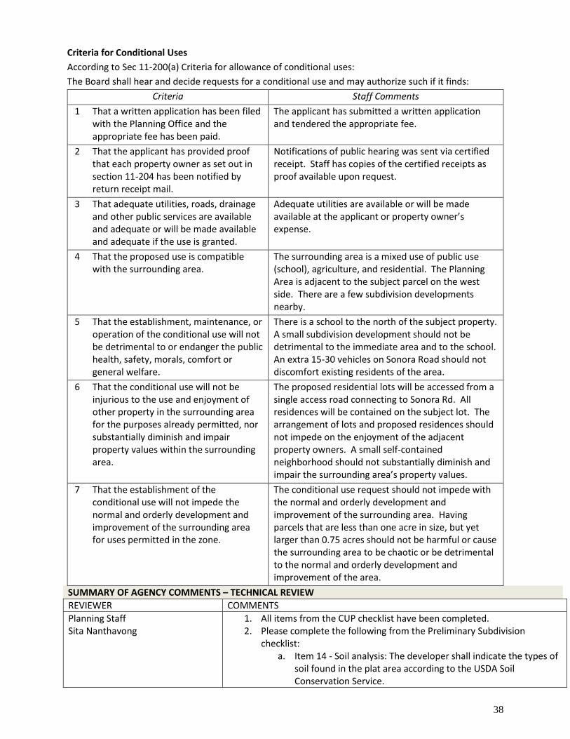
38
Criteria for Conditional Uses
According to Sec 11-200(a) Criteria for allowance of conditional uses:
The Board shall hear and decide requests for a conditional use and may authorize such if it finds:
Criteria Staff Comments
1 That a written application has been filed with the Planning Office and the appropriate fee has been paid.
The applicant has submitted a written application and tendered the appropriate fee.
2 That the applicant has provided proof that each property owner as set out in section 11-204 has been notified by return receipt mail.
Notifications of public hearing was sent via certified receipt. Staff has copies of the certified receipts as proof available upon request.
3 That adequate utilities, roads, drainage and other public services are available and adequate or will be made available and adequate if the use is granted.
Adequate utilities are available or will be made available at the applicant or property owner’s expense.
4 That the proposed use is compatible with the surrounding area.
The surrounding area is a mixed use of public use (school), agriculture, and residential. The Planning Area is adjacent to the subject parcel on the west side. There are a few subdivision developments nearby.
5 That the establishment, maintenance, or operation of the conditional use will not be detrimental to or endanger the public health, safety, morals, comfort or general welfare.
There is a school to the north of the subject property. A small subdivision development should not be detrimental to the immediate area and to the school. An extra 15-30 vehicles on Sonora Road should not discomfort existing residents of the area.
6 That the conditional use will not be injurious to the use and enjoyment of other property in the surrounding area for the purposes already permitted, nor substantially diminish and impair property values within the surrounding area.
The proposed residential lots will be accessed from a single access road connecting to Sonora Rd. All residences will be contained on the subject lot. The arrangement of lots and proposed residences should not impede on the enjoyment of the adjacent property owners. A small self-contained neighborhood should not substantially diminish and impair the surrounding area’s property values.
7 That the establishment of the conditional use will not impede the normal and orderly development and improvement of the surrounding area for uses permitted in the zone.
The conditional use request should not impede with the normal and orderly development and improvement of the surrounding area. Having parcels that are less than one acre in size, but yet larger than 0.75 acres should not be harmful or cause the surrounding area to be chaotic or be detrimental to the normal and orderly development and improvement of the area.
SUMMARY OF AGENCY COMMENTS – TECHNICAL REVIEW
REVIEWER COMMENTS
Planning Staff Sita Nanthavong
1. All items from the CUP checklist have been completed. 2. Please complete the following from the Preliminary Subdivision
checklist: a. Item 14 - Soil analysis: The developer shall indicate the types of
soil found in the plat area according to the USDA Soil Conservation Service.
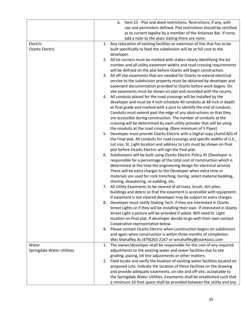
39
b. Item 15 - Plat and deed restrictions: Restrictions, if any, with use and perimeters defined. Plat restrictions should be certified as to current legality by a member of the Arkansas Bar. If none, add a note to the plats stating there are none.
Electric Ozarks Electric
1. Any relocation of existing facilities or extension of line that has to be built specifically to feed the subdivision will be at full cost to the developer.
2. All lot corners must be marked with stakes clearly identifying the lot number and all utility easement widths and road crossing requirements will be defined on the plat before Ozarks will begin construction.
3. All off site easements that are needed for Ozarks to extend electrical service to the subdivision property must be obtained by developer and easement documentation provided to Ozarks before work begins. On site easements must be shown on plat and recorded with the county.
4. All conduits placed for the road crossings will be installed by the developer and must be 4 inch schedule 40 conduits at 48 inch in depth at final grade and marked with a post to identify the end of conduits. Conduits must extend past the edge of any obstructions so that they are accessible during construction. The number of conduits at the crossing will be determined by each utility provider that will be using the conduits at the road crossing. (Bare minimum of 5 Pipes)
5. Developer must provide Ozarks Electric with a Digital copy (AutoCAD) of the Final plat. All conduits for road crossings and specific widths of U.E., Lot size, St. Light location and address to Lots must be shown on final plat before Ozarks Electric will sign the final plat.
6. Subdivisions will be built using Ozarks Electric Policy 45 (Developer is responsible for a percentage of the total cost of construction which is determined at the time the engineering design for electrical service) There will be extra charges to the Developer when extra time or materials are used for rock trenching, boring, select material bedding, shoring, dewatering, re-sodding, etc.
7. All Utility Easements to be cleared of all trees, brush, dirt piles, buildings and debris so that the easement is accessible with equipment. If easement is not cleared developer may be subject to extra charges.
8. Developer must notify Staking Tech. if they are interested in Ozarks Street Lights or if they will be installing their own. If interested in Ozarks Street Light a picture will be provided if asked. Will need St. Light location on final plat. If developer decide to go with their own contact Cooperative representative below.
9. Please contact Ozarks Electric when construction begins on subdivision and again when construction is within three months of completion. Wes Mahaffey At (479)263-2167 or [email protected]
Water Springdale Water Utilities
1. The owner/developer shall be responsible for the cost of any required adjustments to the existing water and sewer facilities due to site grading, paving, lot line adjustments or other matters.
2. Field locate and verify the location of existing water facilities located on proposed Lots. Indicate the location of these facilities on the drawing and provide adequate easements, on-site and off-site, acceptable to the Springdale Water Utilities. Easements shall be established such that a minimum 10-foot space shall be provided between the utility and any
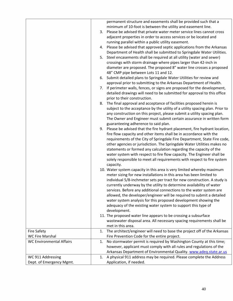
40
permanent structure and easements shall be provided such that a minimum of 10-foot is between the utility and easement line.
3. Please be advised that private water meter service lines cannot cross adjacent properties in order to access services or be located and running parallel within a public utility easement.
4. Please be advised that approved septic applications from the Arkansas Department of Health shall be submitted to Springdale Water Utilities.
5. Steel encasements shall be required at all utility (water and sewer) crossings with storm drainage where pipes larger than 42-inch in diameter are proposed. The proposed 8” water line crosses a proposed 48” CMP pipe between Lots 11 and 12.
6. Submit detailed plans to Springdale Water Utilities for review and approval prior to submitting to the Arkansas Department of Health.
7. If perimeter walls, fences, or signs are proposed for the development, detailed drawings will need to be submitted for approval to this office prior to their construction.
8. The final approval and acceptance of facilities proposed herein is subject to the acceptance by the utility of a utility spacing plan. Prior to any construction on this project, please submit a utility spacing plan. The Owner and Engineer must submit certain assurance in written form guaranteeing adherence to said plan.
9. Please be advised that the fire hydrant placement, fire hydrant location, fire flow capacity and other items shall be in accordance with the requirements of the City of Springdale Fire Department, State Fire code, other agencies or jurisdiction. The Springdale Water Utilities makes no statements or formed any calculation regarding the capacity of the water system with respect to fire flow capacity. The Engineer shall be solely responsible to meet all requirements with respect to fire system capacity.
10. Water system capacity in this area is very limited whereby maximum meter sizing for new installations in this area has been limited to individual 5/8-inchmeter sets per tract for new construction. A study is currently underway by the utility to determine availability of water services. Before any additional connections to the water system are allowed, the developer/engineer will be required to submit a detailed water system analysis for this proposed development showing the adequacy of the existing water system to support this type of development.
11. The proposed water line appears to be crossing a subsurface wastewater disposal area. All necessary spacing requirements shall be met in this area.
Fire Safety WC Fire Marshal
1. The architect/engineer will need to base the project off of the Arkansas Fire Prevention Code for the entire project.
WC Environmental Affairs 1. No stormwater permit is required by Washington County at this time; however, applicant must comply with all rules and regulations of the Arkansas Department of Environmental Quality. www.adeq.state.ar.us
WC 911 Addressing Dept. of Emergency Mgmt.
1. A physical 911 address may be required. Please complete the Address Application, if needed.
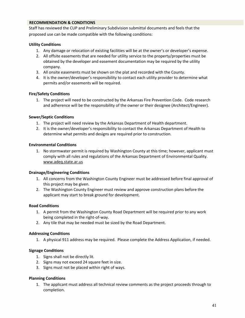
41
RECOMMENDATION & CONDITIONS Staff has reviewed the CUP and Preliminary Subdivision submittal documents and feels that the
proposed use can be made compatible with the following conditions:
Utility Conditions
1. Any damage or relocation of existing facilities will be at the owner’s or developer’s expense. 2. All offsite easements that are needed for utility service to the property/properties must be
obtained by the developer and easement documentation may be required by the utility company.
3. All onsite easements must be shown on the plat and recorded with the County. 4. It is the owner/developer’s responsibility to contact each utility provider to determine what
permits and/or easements will be required.
Fire/Safety Conditions
1. The project will need to be constructed by the Arkansas Fire Prevention Code. Code research and adherence will be the responsibility of the owner or their designee (Architect/Engineer).
Sewer/Septic Conditions
1. The project will need review by the Arkansas Department of Health department. 2. It is the owner/developer’s responsibility to contact the Arkansas Department of Health to
determine what permits and designs are required prior to construction.
Environmental Conditions
1. No stormwater permit is required by Washington County at this time; however, applicant must comply with all rules and regulations of the Arkansas Department of Environmental Quality. www.adeq.state.ar.us
Drainage/Engineering Conditions
1. All concerns from the Washington County Engineer must be addressed before final approval of this project may be given.
2. The Washington County Engineer must review and approve construction plans before the applicant may start to break ground for development.
Road Conditions
1. A permit from the Washington County Road Department will be required prior to any work being completed in the right-of-way.
2. Any tile that may be needed must be sized by the Road Department.
Addressing Conditions
1. A physical 911 address may be required. Please complete the Address Application, if needed.
Signage Conditions
1. Signs shall not be directly lit. 2. Signs may not exceed 24 square feet in size. 3. Signs must not be placed within right of ways.
Planning Conditions
1. The applicant must address all technical review comments as the project proceeds through to completion.
42
2. Per Sec. 11-102 Vehicular access from private drive a. No land development, including those subject to exemption as set out in Washington County
Code 11-79, shall be approved if any anticipated structure's driveway shall be so arranged such that it is necessary for a vehicle to back out onto any County or public road.
b. Every owner or developer of any such land development shall certify that no driveways shall be constructed in violation of this section and such shall be noted on any plat or exemption application.
c. No structure or driveway, regardless as to whether it is part of a land development, shall be built, installed or erected in such a manner that it will be necessary for any vehicle to back out onto any County or public road.
d. This section shall not be applicable to interior roads in a land development.
Standard Conditions for All Projects
1. Pay neighbor notification mailing fees within 30 days of project approval. Any extension must be approved by the Planning Office (fees will be calculated once the info is available from the post office). This total will be calculated for this project once all invoices are received.
2. Pay any engineering fees. This total will be calculated for this project once all invoices are received.
3. Any further splitting or land development not considered with this approval must be reviewed by the Washington County Planning Board/Zoning Board of Adjustments.
4. All CUPs must be ratified by the Quorum Court. 5. Final inspection approval is required prior to issuance of CUP approval letter. 6. It is the applicant’s responsibility to contact the Planning Office when inspections are needed. 7. Per Washington County ordinance Sec 11-75 (7): All plats for land developments approved by
the Washington County Planning Board shall be contingent upon receipt by the Developer of any Federal, State, or local or approvals, if any, whether known or unknown to the Board or the Developer.
8. All conditions shall be adhered to and completed in the appropriate time period set out by ordinance.
Washington County Senior Planner, Sita Nanthavong, presented the staff report for the Board Members.
David Lazenby, Engineer at ESI representing the applicant, addressed the Board, “Initially when we first
did the design for this subdivision we approached the street department to see what street section they
wanted. They gave us a sheet with three options for 1-3 lots, 3-10 lots and over 10. They said to use the
over 10 one. It showed a 50 ft. right-of-way. The original layout that we gave the county showed the 15
lots with the 50 ft. right-of-way, but we had 2 lots that were below the one acre minimum. One of the staff
comments during the review was per county ordinance it has to be a 60 ft. right-of-way. When we
expanded the right-of-way it caused an issue with a majority of the lots now which are slightly below an
acre. A lot of them are really close .98 or .95. That’s what caused that issue with the staff report and the
discrepancy with the CUP that we requested for two lots, and now for more lots less than an acre. Being
right next to the elementary school, if there was a place to have a density a little bit higher in the county,
this seems like it would be a likely candidate. If you’ve got any more questions I’d be happy to address
them.”
Philip Humbard inquired, “Have you had a perk test run on all of these?”
Danial Lazenby replied, “Yes, they have dug the perk test. They have not compiled the report and sent
them to the local health unit. Blake Murray is the engineer with ESI designing it. He told me on the phone
that the perk tests apparently were good and that shouldn’t have any issues. Clearly we will have the
actual perk test data on the plat that we would file. We’ll have Washington County sign off on everything
before we commence construction.”
43
Neil Helm asked, “What is the rule on the lot size?”
Sita Nanthavong answered, “1 acre. In order to split or subdivide any piece of property for residential
uses the minimum requirement is 1 acre. Anything that is under an acre has to process through a
Conditional Use Permit, which is what the applicant is here requesting tonight.”
Philip Humbard inquired, “So the process we are going through right now is to allow the .95 acre lots?
Previously, when they showed a 50 ft. right-of-way there were only two lots that were less than 1 acre.
Now that they are showing a 60 ft. right-of-way they only have two lots that are an acre.”
Sita Nanthavong replied, “Yes sir.”
Loren Shackelford summarized, “Basically, we are looking at two things. We’re looking at a Conditional
Use Permit for the size of the lots. Assuming that goes through, then we are going to look at the
Preliminary Subdivision to talk about the perk and all that sort of stuff.”
Sita Nanthavong affirmed, “Yes sir.”
Neil Helm asked, “Why do you want to change the rule and have it less than one acre? Why don’t you
just replat it?”
Sita Nanthavong answered, “When they redesigned the Subdivision to allow for the 60 ft. right-of-way it
took way more acreage for the right-of-way. The parcels technically got smaller. It’s a brand new
Subdivision it’s never been platted before. This is the CUP portion to allow the parcels to be less than an
acre.”
Neil Helm stated, “Then we don’t have a rule.”
Philip Humbard explained “No, we are following the rule. We are going through the process to allow less
than one acre. We do it all the time. We approve lots that are less than one acre.”
Loren Shackelford pointed out, “Which is what the maps that you provided show us. The area maps show
how many times we’ve allowed this same Conditional Use within a mile radius in this area.”
Sita Nanthavong detailed, “If I want to give Nathan a half acre to do anything with, I have to come before
the Board, because what I am doing is creating a piece of property that is less than an acre for whatever
reason. If the Board approves it, then it has to go to Quorum Court for ratification. If the Quorum Court
approves it then that piece that is half an acre in size that is not conformed to the one acre minimum
standard, gets to be given.”
Neil Helm inquired, “I hear what you’re saying, but what’s the compelling reason for not replatting this
and making them all one acre?”
Sita Nanthavong replied, “Because if they do that they can’t have the 60 ft. right-of-way which is what
the county is requiring or fewer lots. From my understanding with the developers, there has to be a
certain number of lots they can sell for it to be lucrative. The more lots they can sell the more productive
it is.”
Nathan Crouch added, “I just wanted to point out that we do not design these projects for our applicants.
We process what is submitted to us. From time to time we do give out constructive criticism, but by and
large we absolutely do not design these projects.”
Daniel Lazenby stated, “As far as one compelling reason as to why in this case it might make sense to
approve this; it is not out on Crawley Road near the Bobby Hooper Tunnel in an area surrounded by
44
estates that have been held in the same family name for generations. This is next to a new Sonora
Elementary School. It’s in the County, but it’s in an area that I think is going to be seeing development in
the near future in line with what will probably be municipal development standards. At that point these
lots are going to dwarf the lots that are going to be around it on those neighboring properties. It’s
probably going to be in an area that is going to be densely populated. That would be my anticipation
anyway. The school which is probably going to be the most sensitive neighbor, which is going to be the
most impacted by this are giving us an easement for the water line. Our water is connecting through the
school campus. We have been coordinating with them and they are okay with the development and
supportive of it, or at least have been accommodating us in giving us the easement.”
Neil Helm said, “You still borrowed over 7/10ths of an acre in order to make an extra lot. You borrowed
it from all of the other ones that are less than one acre. If you hadn’t borrowed that over 7/10ths of an acre
you’d have one less lot, but every other lot would be compliant.”
Daniel Lazenby affirmed, “Yes sir, that’s correct. When we had approached the client with the plans for
the Subdivision and said ‘Here, I think we can get 15 lots.’ At that time it was only 2 or 3 lots that did not
technically meet the requirement. Those were the long skinny ones at the front, but then when we had to
make the change to the road. That’s when the lot sizes became smaller than what the code requires,
technically. Which is why we are here today, to ask permission to make these lots as shown.”
Nathan Crouch added, “I’ve got one more interesting piece of information for you Mr. Chair, the western
border of the subject property is in the planning area. All the properties to the west of this one we could
approve 10,000 sq. ft. lots administratively, without even bringing them to you. That’s just under a
quarter of an acre. 500 feet to the left, we’d do 10,000 sq. ft. lots.”
Loren Shackelford pointed out, “Which is typical for development around elementary schools in
Northwest Arkansas and we have precedence of doing this in the County.”
No Public Comment
Public Comment Closed
Loren Shackelford made a motion to table the Sonora Subdivision CUP for the upcoming June 10th,
2021 meeting. Kiara Luers seconded. All Board Members present were in favor of approving. Motion
passed.
LAND DEVELOPMENT HEARINGS
County
g. Sonora Subdivision Pre-Sub
Preliminary Land Development Request
Location: Section 11, Township 17, Range 29
Applicant: Engineering Services Inc.
Location Address: On Sonora Road WC 93
JP District: Patrick Deakins, District 5
Approximately: +/- 16.74 acres / 15 lots
Coordinates: Latitude: 36.16086993, Longitude: -94.04820580
Project #: 2021-090 Planner: Sita Nanthavong email: [email protected]
Loren Shackelford made a motion to table the Sonora Subdivision Pre-Sub for the upcoming meeting on
June 10th, 2021. Kiara Luers seconded. All Board Members present were in favor of approving. Motion
passed.
County
h. Magnolia Acres Subdivision Phase 2 Pre-Sub
Preliminary Land Development Request
Location: Section 11, Township 17, Range 29
45
Applicant: Bates & Associates Inc.
Location Address: 18570 Lake Sequoyah WC 50
JP District: Butch Pond, District 15
Approximately: +/- 16.41 acres / 7 lots
Coordinates: Latitude: 36.06488725, Longitude: -94.02142308
Project #: 2021-093 Planner: Sita Nanthavong email: [email protected]
APPLICANT’S REQUEST The applicant is requesting preliminary subdivision approval to allow the development of the second
phase of the Magnolia Acres Subdivision.
SITE INFORMATION Land Owner: Moldenhauer Real Estate, Inc Parcel Number: 001-10456-004 Site Location: 18632 Lake Sequoyah WC 50 Planning Area: None Acreage: 16.41 acres +/- QC District: 15, Butch Pond Current Zoning: Agriculture/Single-Family Residential 1 unit per acre School District: Fayetteville FIRM: 05143C0235F & 05143C0245F Fire District: Round Mountain Wetland: No Watershed: None
UTILITIES Electricity: Ozark Electric Gas: None Cable: Cox Communications Phone: AT&T Water City of Fayetteville
BACKGROUND/SYNOPSIS The applicants, Tim Moldenhauer Real Estate Inc & Randall Carney, are requesting preliminary
subdivision approval to allow the development of a 7 lot subdivision. The zoning is for Agricultural and
Single Family Residential uses with a maximum density of one (1) residential unit per acre. The project
parcel is not in the Planning Area. The subject parcel is approximately 16.41 acres in size and will be split
into 7 lots, each over an acre in size.
Parent Tract Proposed Lot Acreage 001-10456-004 16.41 acres Lot 11 2.03 acres Lot 12 2.03 acres Lot 13 2.03 acres Lot 14 2.03 acres Lot 15 2.03 acres Lot 16 3.12 acres Lot 17 2.13 acres
The site is accessible from Lake Sequoyah Rd WC 50 and High Road WC 3305. All 7 lots will have access
to a proposed 20’ private asphalt drive connecting to Lake Sequoyah Rd WC 50. Please see the attached
documents for more detailed information.
COMPATIBILITY Surrounding Land Use and Zoning
Direction from Site Land Use Zoning
North Residential/Agricultural Ag/SF Res 1 unit/ac
South Residential/Agricultural Ag/SF Res 1 unit/ac
East Residential/Agricultural Ag/SF Res 1 unit/ac
West Residential/Agricultural Ag/SF Res 1 unit/ac
Existing Condition of Property
The subject property is zoned Ag/SF Res 1 unit/ac and has an agricultural use. It is in an area that is
mixed with agricultural and residential uses. The property is vacant. To the west is the first phase of the
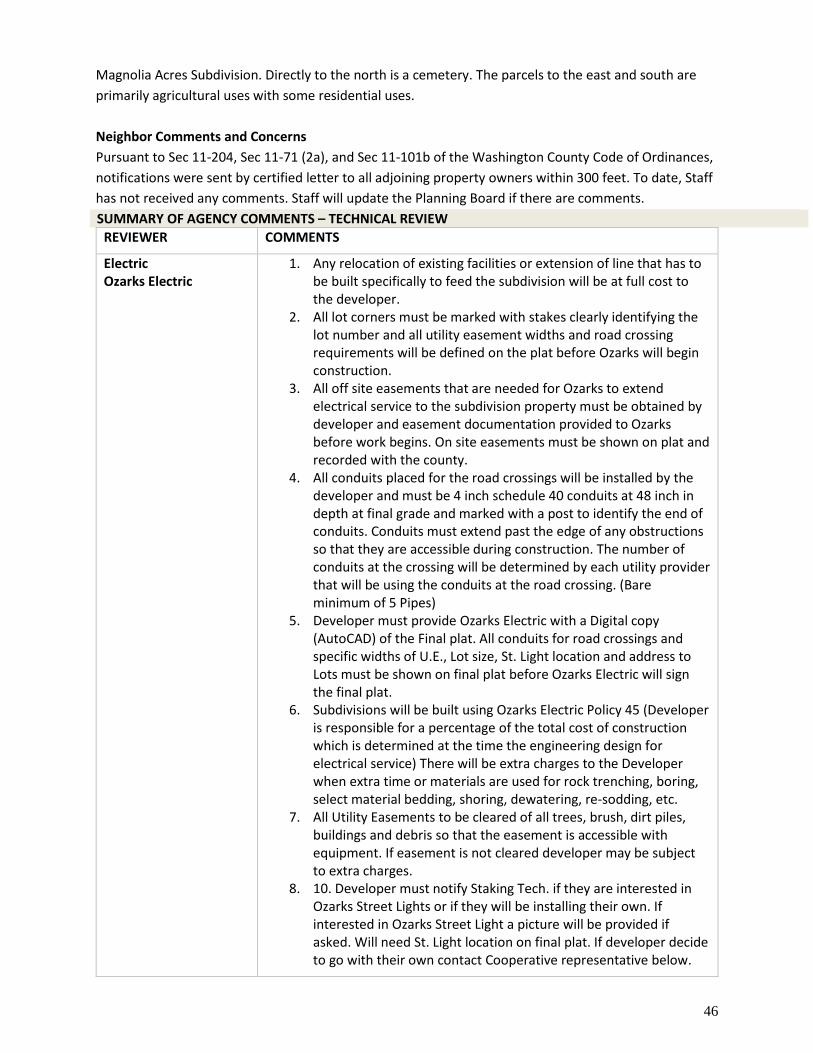
46
Magnolia Acres Subdivision. Directly to the north is a cemetery. The parcels to the east and south are
primarily agricultural uses with some residential uses.
Neighbor Comments and Concerns
Pursuant to Sec 11-204, Sec 11-71 (2a), and Sec 11-101b of the Washington County Code of Ordinances,
notifications were sent by certified letter to all adjoining property owners within 300 feet. To date, Staff
has not received any comments. Staff will update the Planning Board if there are comments.
SUMMARY OF AGENCY COMMENTS – TECHNICAL REVIEW
REVIEWER COMMENTS
Electric Ozarks Electric
1. Any relocation of existing facilities or extension of line that has to be built specifically to feed the subdivision will be at full cost to the developer.
2. All lot corners must be marked with stakes clearly identifying the lot number and all utility easement widths and road crossing requirements will be defined on the plat before Ozarks will begin construction.
3. All off site easements that are needed for Ozarks to extend electrical service to the subdivision property must be obtained by developer and easement documentation provided to Ozarks before work begins. On site easements must be shown on plat and recorded with the county.
4. All conduits placed for the road crossings will be installed by the developer and must be 4 inch schedule 40 conduits at 48 inch in depth at final grade and marked with a post to identify the end of conduits. Conduits must extend past the edge of any obstructions so that they are accessible during construction. The number of conduits at the crossing will be determined by each utility provider that will be using the conduits at the road crossing. (Bare minimum of 5 Pipes)
5. Developer must provide Ozarks Electric with a Digital copy (AutoCAD) of the Final plat. All conduits for road crossings and specific widths of U.E., Lot size, St. Light location and address to Lots must be shown on final plat before Ozarks Electric will sign the final plat.
6. Subdivisions will be built using Ozarks Electric Policy 45 (Developer is responsible for a percentage of the total cost of construction which is determined at the time the engineering design for electrical service) There will be extra charges to the Developer when extra time or materials are used for rock trenching, boring, select material bedding, shoring, dewatering, re-sodding, etc.
7. All Utility Easements to be cleared of all trees, brush, dirt piles, buildings and debris so that the easement is accessible with equipment. If easement is not cleared developer may be subject to extra charges.
8. 10. Developer must notify Staking Tech. if they are interested in Ozarks Street Lights or if they will be installing their own. If interested in Ozarks Street Light a picture will be provided if asked. Will need St. Light location on final plat. If developer decide to go with their own contact Cooperative representative below.
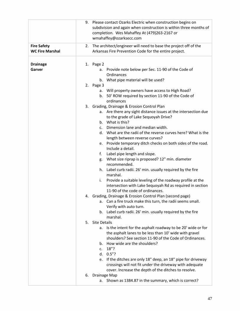
47
9. Please contact Ozarks Electric when construction begins on subdivision and again when construction is within three months of completion. Wes Mahaffey At (479)263-2167 or [email protected]
Fire Safety WC Fire Marshal
2. The architect/engineer will need to base the project off of the Arkansas Fire Prevention Code for the entire project.
Drainage Garver
1. Page 2
a. Provide note below per Sec. 11-90 of the Code of Ordinances
b. What pipe material will be used? 2. Page 3
a. Will property owners have access to High Road? b. 50' ROW required by section 11-90 of the Code of
ordinances 3. Grading, Drainage & Erosion Control Plan
a. Are there any sight distance issues at the intersection due to the grade of Lake Sequoyah Drive?
b. What is this? c. Dimension lane and median width. d. What are the radii of the reverse curves here? What is the
length between reverse curves? e. Provide temporary ditch checks on both sides of the road.
Include a detail. f. Label pipe length and slope. g. What size riprap is proposed? 12" min. diameter
recommended. h. Label curb radii. 26' min. usually required by the fire
marshal. i. Provide a suitable leveling of the roadway profile at the
intersection with Lake Sequoyah Rd as required in section 11-90 of the code of ordinances.
4. Grading, Drainage & Erosion Control Plan (second page) a. Can a fire truck make this turn, the radii seems small.
Verify with auto turn. b. Label curb radii. 26' min. usually required by the fire
marshal. 5. Site Details
a. Is the intent for the asphalt roadway to be 20' wide or for the asphalt lanes to be less than 10' wide with gravel shoulders? See section 11-90 of the Code of Ordinances.
b. How wide are the shoulders? c. 18”? d. 0.5”? e. If the ditches are only 18" deep, an 18" pipe for driveway
crossings will not fit under the driveway with adequate cover. Increase the depth of the ditches to resolve.
6. Drainage Map a. Shown as 1384.87 in the summary, which is correct?

48
b. Provide separate pre and post drainage area maps with updated TOC lines and calculations for post construction. TOC for Post Basin 2 will be shorter due to the runoff entering the proposed channel.
7. Hydrograph Report a. Why is this less than pre basin 1?
8. Hydrograph Report (second page) a. Provide calculations for this TOC.
9. Ditch Calcs a. Is this correct? This is shown as the area of the entire
basin 2. 10. Storm Sewer Tabulation
a. 1429.50 in plans. b. Is this slope correct? Label slope of pipe in plans and
ensure that slope in drainage report matches plans.
WC Environmental Affairs
2. No stormwater permit is required by Washington County at this time; however, applicant must comply with all rules and regulations of the Arkansas Department of Environmental Quality. www.adeq.state.ar.us
WC 911 Addressing Dept. of Emergency Mgmt.
2. A physical 911 address may be required. Please complete the Address Application, if needed.
RECOMMENDATION & CONDITIONS Staff has reviewed the Preliminary Subdivision submittal documents and recommends approval with the
following conditions:
Utility Conditions
1. Any damage or relocation of existing facilities will be at the owner’s or developer’s expense. 2. All offsite easements that are needed for utility service to the property/properties must be
obtained by the developer and easement documentation may be required by the utility company.
3. All onsite easements must be shown on the plat and recorded with the County. 4. It is the owner/developer’s responsibility to contact each utility provider to determine what
permits and/or easements will be required.
Fire/Safety Conditions
1. The project will need to be constructed by the Arkansas Fire Prevention Code. Code research and adherence will be the responsibility of the owner or their designee (Architect/Engineer).
Sewer/Septic Conditions
1. The project will need review by the Arkansas Department of Health department. 2. It is the owner/developer’s responsibility to contact the Arkansas Department of Health to
determine what permits and designs are required prior to construction.
Environmental Conditions
1. No stormwater permit is required by Washington County at this time; however, applicant must comply with all rules and regulations of the Arkansas Department of Environmental Quality. www.adeq.state.ar.us
49
Drainage/Engineering Conditions
1. All concerns from the Washington County Engineer must be addressed before final approval of this project may be given.
2. The Washington County Engineer must review and approve construction plans before the applicant may start to break ground for development.
Road Conditions
1. A permit from the Washington County Road Department may be required prior to any work being completed in the right-of-way.
2. Any tile that may be needed must be sized by the Road Department.
Addressing Conditions
1. A physical 911 address may be required. Please complete the Address Application, if needed.
Signage Conditions
1. Signs shall not be directly lit. 2. Signs may not exceed 24 square feet in size. 3. Signs must not be placed within right of ways.
Planning Conditions
1. The applicant must address all technical review comments as the project proceeds through to completion.
2. Per Sec. 11-102 Vehicular access from private drive a. No land development, including those subject to exemption as set out in Washington County
Code 11-79, shall be approved if any anticipated structure's driveway shall be so arranged such that it is necessary for a vehicle to back out onto any County or public road.
b. Every owner or developer of any such land development shall certify that no driveways shall be constructed in violation of this section and such shall be noted on any plat or exemption application.
c. No structure or driveway, regardless as to whether it is part of a land development, shall be built, installed or erected in such a manner that it will be necessary for any vehicle to back out onto any County or public road.
d. This section shall not be applicable to interior roads in a land development.
Standard Conditions for All Projects
1. Pay neighbor notification mailing fees within 30 days of project approval. Any extension must be approved by the Planning Office (fees will be calculated once the info is available from the post office). This total will be calculated for this project once all invoices are received.
2. Pay any engineering fees. This total will be calculated for this project once all invoices are received.
3. Any further splitting or land development not considered with this approval must be reviewed by the Washington County Planning Board/Zoning Board of Adjustments.
4. All CUPs must be ratified by the Quorum Court. 5. Final inspection approval is required prior to issuance of CUP approval letter. 6. It is the applicant’s responsibility to contact the Planning Office when inspections are needed. 7. Per Washington County ordinance Sec 11-75 (7): All plats for land developments approved by
the Washington County Planning Board shall be contingent upon receipt by the Developer of any Federal, State, or local or approvals, if any, whether known or unknown to the Board or the Developer.
50
8. All conditions shall be adhered to and completed in the appropriate time period set out by ordinance.
Washington County Senior Planner, Sita Nanthavong, presented the staff report for the Board Members.
Justin Reed, Engineer from Bates and Associates, addressed the Board, “I have no further comments, but
I would be happy to answer any questions should there be any.”
Loren Shackelford inquired, “The only question I have is the same question as the last one. Have all the
lots had perk tests and what’s the status of those tests?”
Justin Reed replied, “Yes sir. All lots have had perk tests. We’re currently awaiting the results of that.
They were done about 2 or 3 weeks ago so we’re really expecting them any time.”
No Public Comment
Public Comment Closed
Kiara Luers made a motion to approve the Magnolia Acres Subdivision Phase 2 Pre-Sub subject to
staff recommendations. Neil Helm seconded. All Board Members present were in favor of approving.
Motion passed.
Springdale Planning Area
i. Custom Lawn Care & Landscaping Pre-LSD
Preliminary Large Scale Development Request
Location: Section 28, Township 18, Range 29
Applicant: Earthplan Design Alternatives, PA
Location Address: 4551 E Monitor Road WC 91
JP District: Patrick Deakins, District 5
Approximately: +/- 33.02 acres / 1 parcel
Coordinates: Latitude: 36. 20525905, Longitude: -94.07895655
Project #: 2021-091 Planner: Sita Nanthavong email: [email protected]
APPLICANT’S REQUEST The applicant is requesting preliminary large scale development approval to allow the development and
construction of a lawn care and landscape business.
SITE INFORMATION Land Owner: Top Notch Rentals, LLC Parcel Number: 001-18461-000 Site Location: 4551 E Monitor Rd WC 91 Planning Area: Springdale Acreage: 33.64 acres +/- QC District: 5, Patrick Deakins Current Zoning: Agriculture/Single-Family Residential 1 unit per acre School District: Springdale FIRM: 05143C0080F Fire District: Nob Hill Wetland: No Watershed: None
UTILITIES Electricity: Ozark Electric Gas: None Cable: Cox Communications Phone: AT&T Water City of Springdale
BACKGROUND/SYNOPSIS The applicant, Daryl Ohaviano, is requesting preliminary large scale development approval to allow the
development of a lawn care and landscaping business. The zoning is for Agricultural and Single Family
Residential uses with a maximum density of one (1) residential unit per acre. This proposal has received
Conditional Use Permit approval from both the Washington County Planning Board and Quorum Court.
The project parcel is in the City of Springdale Planning Area. The proposal is located between E Monitor
Rd WC 91 and N Scott Hollow Rd WC 575. This application is for Phase 1 of the LSD. The applicant is
proposing a 9,600 sq. ft. structure, internal roads, and associated parking to be utilized as the main
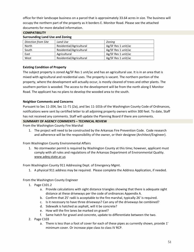
51
office for their landscape business on a parcel that is approximately 33.64 acres in size. The business will
occupy the northern part of the property as it borders E. Monitor Road. Please see the attached
documents for more detailed information.
COMPATIBILITY Surrounding Land Use and Zoning
Direction from Site Land Use Zoning
North Residential/Agricultural Ag/SF Res 1 unit/ac
South Residential/Agricultural Ag/SF Res 1 unit/ac
East Agricultural Ag/SF Res 1 unit/ac
West Residential/Agricultural Ag/SF Res 1 unit/ac
Existing Condition of Property
The subject property is zoned Ag/SF Res 1 unit/ac and has an agricultural use. It is in an area that is
mixed with agricultural and residential uses. The property is vacant. The northern portion of the
property, where the development will actually occur, is mostly cleared of trees and other plants. The
southern portion is wooded. The access to the development will be from the north along E Monitor
Road. The applicant has no plans to develop the wooded area to the south.
Neighbor Comments and Concerns
Pursuant to Sec 11-204, Sec 11-71 (2a), and Sec 11-101b of the Washington County Code of Ordinances,
notifications were sent by certified letter to all adjoining property owners within 300 feet. To date, Staff
has not received any comments. Staff will update the Planning Board if there are comments.
SUMMARY OF AGENCY COMMENTS – TECHNICAL REVIEW From the Washington County Fire Marshal
1. The project will need to be constructed by the Arkansas Fire Prevention Code. Code research and adherence will be the responsibility of the owner, or their designee (Architect/Engineer).
From Washington County Environmental Affairs
1. No stormwater permit is required by Washington County at this time; however, applicant must comply with all rules and regulations of the Arkansas Department of Environmental Quality. www.adeq.state.ar.us
From Washington County 911 Addressing Dept. of Emergency Mgmt.
1. A physical 911 address may be required. Please complete the Address Application, if needed.
From the Washington County Engineer
1. Page C101.2 a. Provide calculations with sight distance triangles showing that there is adequate sight
distance at these driveways per the code of ordinances Appendix A. b. Confirm that 25' radii is acceptable to the fire marshal, typically 26' is required. c. Is it necessary to have three driveways? Can any of the driveways be combined? d. Sidewalk is hatched as asphalt, will it be concrete? e. How will the fire lanes be marked on gravel? f. Same hatch for gravel and concrete, update to differentiate between the two.
2. Page C103 a. There is less than a foot of cover for each of these pipes as currently shown, provide 1'
minimum cover. Or increase pipe class to class IV RCP.
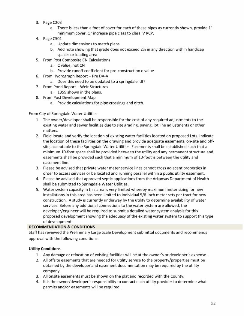
52
3. Page C203 a. There is less than a foot of cover for each of these pipes as currently shown, provide 1'
minimum cover. Or increase pipe class to class IV RCP. 4. Page C501
a. Update dimensions to match plans b. Add note showing that grade does not exceed 2% in any direction within handicap
spaces or loading area 5. From Post Composite CN Calculations
a. C value, not CN b. Provide runoff coefficient for pre-construction c-value
6. From Hydrograph Report – Pre DA-A a. Does this need to be updated to a springdale idf?
7. From Pond Report – Weir Structures a. 1359 shown in the plans.
8. From Post Development Map a. Provide calculations for pipe crossings and ditch.
From City of Springdale Water Utilities
1. The owner/developer shall be responsible for the cost of any required adjustments to the existing water and sewer facilities due to site grading, paving, lot line adjustments or other matters.
2. Field locate and verify the location of existing water facilities located on proposed Lots. Indicate the location of these facilities on the drawing and provide adequate easements, on-site and off-site, acceptable to the Springdale Water Utilities. Easements shall be established such that a minimum 10-foot space shall be provided between the utility and any permanent structure and easements shall be provided such that a minimum of 10-foot is between the utility and easement line.
3. Please be advised that private water meter service lines cannot cross adjacent properties in order to access services or be located and running parallel within a public utility easement.
4. Please be advised that approved septic applications from the Arkansas Department of Health shall be submitted to Springdale Water Utilities.
5. Water system capacity in this area is very limited whereby maximum meter sizing for new installations in this area has been limited to individual 5/8-inch meter sets per tract for new construction. A study is currently underway by the utility to determine availability of water services. Before any additional connections to the water system are allowed, the developer/engineer will be required to submit a detailed water system analysis for this proposed development showing the adequacy of the existing water system to support this type of development.
RECOMMENDATION & CONDITIONS Staff has reviewed the Preliminary Large Scale Development submittal documents and recommends
approval with the following conditions:
Utility Conditions
1. Any damage or relocation of existing facilities will be at the owner’s or developer’s expense. 2. All offsite easements that are needed for utility service to the property/properties must be
obtained by the developer and easement documentation may be required by the utility company.
3. All onsite easements must be shown on the plat and recorded with the County. 4. It is the owner/developer’s responsibility to contact each utility provider to determine what
permits and/or easements will be required.
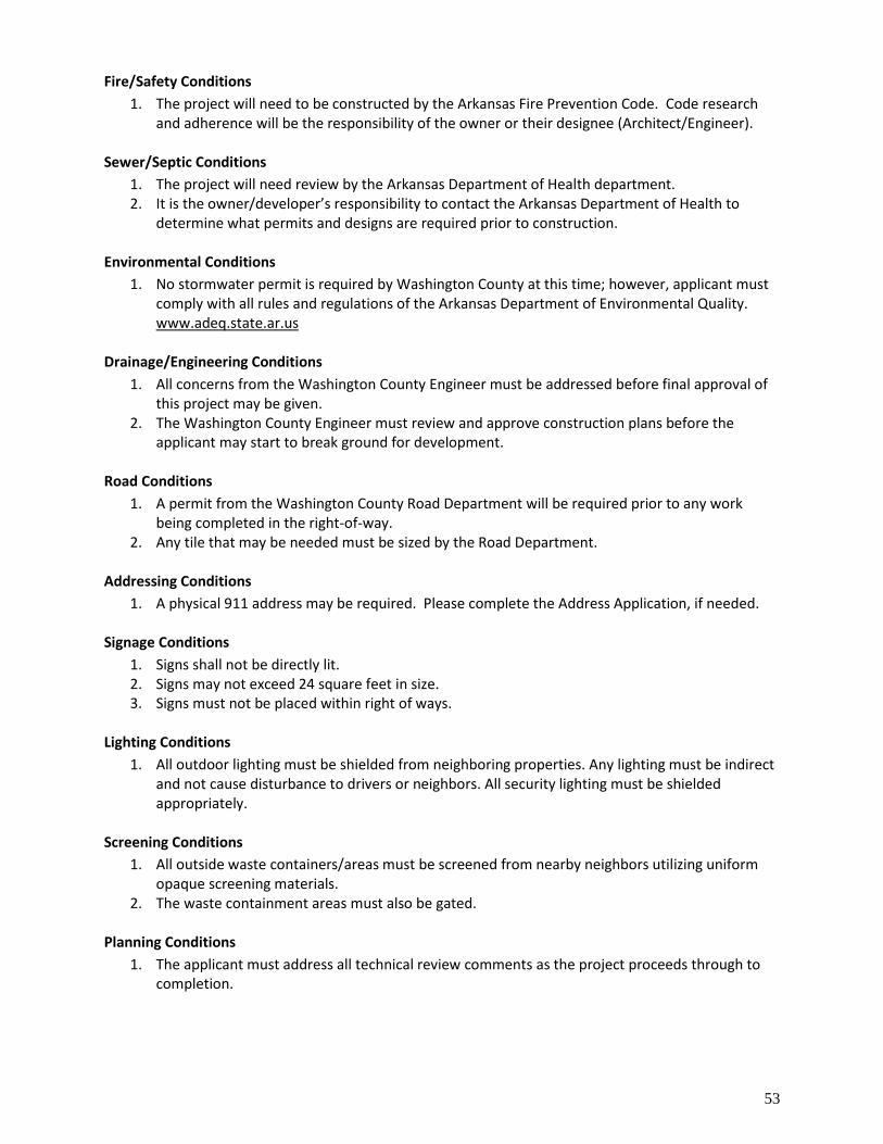
53
Fire/Safety Conditions
1. The project will need to be constructed by the Arkansas Fire Prevention Code. Code research and adherence will be the responsibility of the owner or their designee (Architect/Engineer).
Sewer/Septic Conditions
1. The project will need review by the Arkansas Department of Health department. 2. It is the owner/developer’s responsibility to contact the Arkansas Department of Health to
determine what permits and designs are required prior to construction.
Environmental Conditions
1. No stormwater permit is required by Washington County at this time; however, applicant must comply with all rules and regulations of the Arkansas Department of Environmental Quality. www.adeq.state.ar.us
Drainage/Engineering Conditions
1. All concerns from the Washington County Engineer must be addressed before final approval of this project may be given.
2. The Washington County Engineer must review and approve construction plans before the applicant may start to break ground for development.
Road Conditions
1. A permit from the Washington County Road Department will be required prior to any work being completed in the right-of-way.
2. Any tile that may be needed must be sized by the Road Department.
Addressing Conditions
1. A physical 911 address may be required. Please complete the Address Application, if needed.
Signage Conditions
1. Signs shall not be directly lit. 2. Signs may not exceed 24 square feet in size. 3. Signs must not be placed within right of ways.
Lighting Conditions
1. All outdoor lighting must be shielded from neighboring properties. Any lighting must be indirect and not cause disturbance to drivers or neighbors. All security lighting must be shielded appropriately.
Screening Conditions
1. All outside waste containers/areas must be screened from nearby neighbors utilizing uniform opaque screening materials.
2. The waste containment areas must also be gated.
Planning Conditions
1. The applicant must address all technical review comments as the project proceeds through to completion.
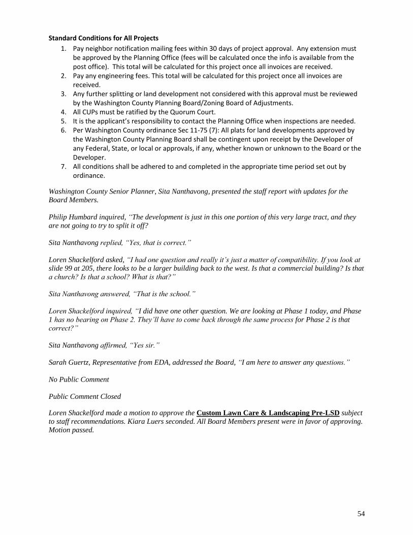
54
Standard Conditions for All Projects
1. Pay neighbor notification mailing fees within 30 days of project approval. Any extension must be approved by the Planning Office (fees will be calculated once the info is available from the post office). This total will be calculated for this project once all invoices are received.
2. Pay any engineering fees. This total will be calculated for this project once all invoices are received.
3. Any further splitting or land development not considered with this approval must be reviewed by the Washington County Planning Board/Zoning Board of Adjustments.
4. All CUPs must be ratified by the Quorum Court. 5. It is the applicant’s responsibility to contact the Planning Office when inspections are needed. 6. Per Washington County ordinance Sec 11-75 (7): All plats for land developments approved by
the Washington County Planning Board shall be contingent upon receipt by the Developer of any Federal, State, or local or approvals, if any, whether known or unknown to the Board or the Developer.
7. All conditions shall be adhered to and completed in the appropriate time period set out by ordinance.
Washington County Senior Planner, Sita Nanthavong, presented the staff report with updates for the
Board Members.
Philip Humbard inquired, “The development is just in this one portion of this very large tract, and they
are not going to try to split it off?
Sita Nanthavong replied, “Yes, that is correct.”
Loren Shackelford asked, “I had one question and really it’s just a matter of compatibility. If you look at
slide 99 at 205, there looks to be a larger building back to the west. Is that a commercial building? Is that
a church? Is that a school? What is that?”
Sita Nanthavong answered, “That is the school.”
Loren Shackelford inquired, “I did have one other question. We are looking at Phase 1 today, and Phase
1 has no bearing on Phase 2. They’ll have to come back through the same process for Phase 2 is that
correct?”
Sita Nanthavong affirmed, “Yes sir.”
Sarah Guertz, Representative from EDA, addressed the Board, “I am here to answer any questions.”
No Public Comment
Public Comment Closed
Loren Shackelford made a motion to approve the Custom Lawn Care & Landscaping Pre-LSD subject
to staff recommendations. Kiara Luers seconded. All Board Members present were in favor of approving.
Motion passed.
55
5. OTHER BUSINESS
Discussion of Current Development and Planning Department activities
Reminder of upcoming regular Planning Board Meetings:
o June 10th, 2021
o July 22nd, 2021
6. Adjourn
Loren Shackelford moved to adjourn. Neil Helm seconded. All Board members were in favor of
approving. Motion passed.
Planning Board adjourned.
Minutes submitted by: Juliana Mendoza
Approved by the Planning Board on:
___________________________________ Date: __________
Joel Kelsey, Planning Board Chairman