Embed Size (px)
Citation preview
Minutes of the 91st Meeting of the Expert Appraisal Committee for River Valley and
Hydroelectric Projects held on 8-9th
February, 2016 at Teesta Meeting Hall, 1st Floor,
Vayu Wing, Indira Paryavaran Bhawan, Jor Bagh Road, New Delhi-110003
The 91st Meeting of the Expert Appraisal Committee (EAC) for River Valley and
Hydroelectric Projects was held during 8-9th
February, 2016 at Teesta Meeting Hall, 1st Floor,
Vayu Wing, Indira Paryavaran Bhawan, Jor Bagh Road, New Delhi-110003. The meeting was
Chaired by Shri Alok Perti, Chairman. Shri. P. K. Choudhury, Dr. Vijay Kumar and Dr.
Linga Raju, Members could not attend the meeting. The list of EAC Members and
officials/consultants associated with various projects and who attended the meeting is at
Appendix. Members of EC expressed concern over non-participation of several members in
the meetings of the committee. Their non-participation deprives the Committee of the
considered opinion about various aspects of the project. It was decided that Secretariat, EC
would take appropriate actions to ensure their participation or seek alternative nomination
from their organizations.
The following Agenda items were taken-up in that order for discussions:
1st day (8.2.2016)
Minutes of 90th
EAC meetings were confirmed. Thereafter, the following agenda items
were taken up:
Agenda Item 2.1 Nakthan HEP Project (460 MW) in District Kullu of Himachal
Pradesh by M/s HPPC Ltd – for reconsideration of Environmental
Clearance (EC)
The project proponent made a detailed presentation. The Project is proposed to utilize
the water of Tosh Nalla and Parbati River (both streams are tributaries of river Beas). The
project will have two (2) diversion sites with common surge shaft and an underground
powerhouse. Out of 2 diversion sites; one will be on the river Parbati at Dhara Thach with
13.5 m high barrage & second on the Tosh nalla at Wanshi Thach with 12 m high barrage.
This is run-of-the-river scheme. An underground powerhouse is proposed on the right bank of
Parbati River at Nakthan village with 4 units of 115 MW capacity each. Total land
requirement is about 90.07 ha. Out of which 81.85 ha is forest land and 8.22 ha is private
land. The total project cost is about Rs. 4508.16 Crores.
2. This project was earlier considered by EAC in its meetings held on 23-24th
April, 2015
and 22-23rd
December 2015. While considering the proposal in its last meeting, EAC
observed the following:
i. The hydrological details in 90% dependable year for both Parbati River and Tosh Nala
and latest norms of MoEF&CC on environmental flow release at the downstream of the
project.
ii. A table of 10-daily water discharges corresponding to 90% dependable year showing the
intercepted discharge at both the diversion sites, the environmental flow to be released and
the other flow releases downstream of the barrage and spills to be provided in hydrology
section of EIA.

3. The project proponent mentioned that the e-flow study has been conducted by NIH
Roorkee. Based on the modified study report, the 90% dependable years and suggested e-flow
values for the project are as follows:
River Particulars 90% Dependable Year (As
Approved by CWC)
Parbati River 2006-07
Tosh Nallah 2000-01
Combined Flow/Discharge 2006-07
A. Parbati River
Downstream of
project
Discharge
in m3/sec
Average Depth
of flow in metres
Average Top
width in
metres
Average
velocity in
m/sec
Lean Season 1.71 0.55 2.75 2.44
Monsoon season 7.84 0.97 4.00 4.46
Non Monsoon/
Non Lean
season
3.00 0.67 3.16 3.10
B. Tosh Nalla
The project proponent has also submitted the EIA report in which e-flow study
conducted by NIH Roorkee is incorporated in hydrology section.
4. The project proponent has informed the committee that it has received approval from
Director of Energy, GoHP vide its letter no HPDOE/CE(Energy)/Nakthan/2014-9522-23
dated 18.3.2014 for fixing domain elevation of Nakthan HEP as EL + 2975 m (FRL) on
Parbati River and Tosh stream to EL + 2262 (TWL) on the right bank of Parbati river.
5. EAC members deliberated on the letter from Toss Mini Hydel Power Project dated
29.01.2016, where in it has been mentioned that:
“For Nakthan HEP (460 MW) M/s HPPC Ltd. have proposed diversion of Tosh nallah water
in addition to Parvati river. On Tosh nallah, the Govt. of H.P has signed Implementation
Agreement for 20 MW Toss HEP with our organization and has already been commissioned
10 MW capacity and it is under operation. This project shall become defunct if water is
Downstream of
project
Discharge
in m3/sec
Average Depth
of flow in metres
Average Top
width in
metres
Average
velocity in
m/sec
Lean Season 0.63 0.36 2.04 2.09
Monsoon
season
4.63 0.77 3.32 4.50
Non Monsoon/
Non Lean
season
1.10 0.45 2.33 2.59
diverted from Nakthan HEP. We have appeared presented our case to the Hon’ble High
Court, Himachal Pradesh. The Hon’ble court appointed Arbitrator to decide the issue. The
Learned Arbitrator has ruled in his award as under:
‘the Respondent (HPPCL) by way of permanent prohibitory injunction is restrained
to divert the water of Toss stream at 3630 EL or any point below 3630 EL so as to
impact power generation of 20 MW HEP over Toss stream’.
The relevant extract of the award and relevant copies were made available to the EAC.
6. The facts of the letter were clarified from M/S HPPCL and informed that the matter is
sub-judice. The committee took a serious note on this, the project is being discussed for 2
times in the EAC meetings, the facts were being hidden/suppressed by M/s. HPPCL.
7. EAC decided that the matter is Sub-judice, a decision in this regard shall be taken only
after the Courts Directions.
Agenda Item 2.2 Rampur HEP (412) Project in Shimla & Kullu Districts of Himachal
Pradesh by M/s. SJVN Ltd- for consideration of Amendment in
Environmental Clearance (dated 31.3.2006) – Part-A Specific
Condition No. (vi)– Release of downstream flow.
The representatives of Rampur HEP (412 MW) briefed the committee about the
project lay out and submitted that the project is a tail race development of 1500 MW Nathpa
Jhakri HEP with in-tandem operation having its intake structures at Jhakri from the tail race of
NJHEP. The water coming out of Nathpa Jhakri HEP machines is directly taken to the surface
power house of Rampur HEP near village Bael in District Kullu of Himachal Pradesh through
15.177 Km long Head Race Tunnel without any interference with water of Satluj river which
flows adjoining to intake structures. Rampur HEP does not have any dam and as such no
water from river Satluj is being diverted at Jahkri (the intake point). The project has already
started power generation in the year 2014.
2. The EAC was informed that the Rampur HEP (412 MW) was accorded Environment
Clearance on 31.3.2006. The project proponent (PP) informed that one of the specific
conditions in EC at S.No. (vi) states that “during lean season 23.7 cumecs water should be
made available in the released downstream of the dam for immediately aquatic life”. The
PP has now approached the Ministry for seeking relaxation in the said condition since
Rampur HEP, there is no dam and no additional water is extracted from the river and 23.7
cumecs being the quantum of total lean month flows of all tributaries falling in the stretch of
river Satluj between Nathpa and upstream of Rampur town. Further, as per EIA Study report
for the project it has been mentioned on page – 4-14 that ‘the lean season flow available in
river Satluj at Rampur Town is of the order of 23.7 cumecs’.
4. The matter was discussed and the EAC decided that a sub-committee shall undertake a
site visit, meanwhile the project proponents shall get the flow of Satluj river measured for the
present season (lean season) at Nathpa (just downstream of NJHEP dam), Jhakri (Intake for
Rampur HEP), Rampur town and downstream of village Bael (d/stream of Rampur HEP Tail
race) and present the report during the site visit of the sub-committee.
The committee after submitting the details of e-flow data/measurements, the project
will be reconsidered by the EAC.
Agenda Item 2.3 Lower Orr Dam under Ken-Betwa Link Project, Phase-II by Water
Resources Department, Government of Madhya Pradesh and M/s
National Water Development Agency – For consideration of
Environment Clearance (EC).
The project proponent made a detailed presentation on the project. It was clarified that
the Lower Orr is an independent project of Govt. of M.P not related to Ken-Betwa link
project, however, when Ken-Betwa link project materializes, the Lower Orr project shall
become an integral part of Ken-Betwa Link Project Phase-II.
2. It was noted that the project is proposed across Orr River which is a tributary to Betwa
River near the village Didauni on the border of Shivpuri & Ashok Nagar Districts in Madhya
Pradesh. The main aim of the Lower Orr project is to provide irrigation and domestic water
supply to water deficit areas of Shivpuri and Datia Districts of Madhya Pradesh. The
proposed dam site is located at a distance of about 6 km from Chanderi -Pichhore Road. The
total catchment area of Orr river upto Lower Orr dam is 1843 Sq. km. The 75% & 50%
dependable annual yield of the sub-basin upto the proposed dam site has been assessed as
362.53 MCM and 501.15 MCM respectively.
3. The project envisages the construction of a composite dam. In the proposed composite
dam, the concrete dam portion is 487 m long with 247 m long spillway & 240 m long Non
Overflow blocks. The earthen portion of dam is 1731 m long with a maximum height of 45 m.
A 91.260 Km long main canal has been proposed on the left bank of river. The FRL of the
Lower Orr project is kept as 380 m. The total submergence area is about 2723.70 ha. It is
proposed to provide irrigation facility to 67,570 ha in Shivpuri and Datia Districts with 150%
irrigation intensity utilizing 329.67 MCM. Beside 6 MCM water will be provided for drinking
water supply to the enroute villages and towns in the vicinity of the canal. About 1.65 lakh
people will get drinking water facility.
4. The total land requirement for proposed project is 3730 ha. Total land coming under
submergence area and canal network is 2723.70 ha and 1006 ha respectively. The break-up is
as follows:
S.
No.
Land use details Submergence
Area (ha)
Canal
Network (ha)
Total Land (ha)
1 Forest 968.243 70.0 1038.243
2 Culturable Area 853.287 475.0 1328.287
3 Unculturable
Area
556.605 375.0
931.605
4 Built up Area 19.614 86.0 105.614
5 Other lands 325.951 - 325.951
Total 2723.700 1006.0 3729.7 say 3730
ha
5. The flows for various dependable years like 50%, 75 % and 90% are 501.15 MCM,
361.965 MCM and 263.98 MCM respectively. A provision of 6 MCM of water has been kept
for providing drinking water to enroute villages and towns of Lower Orr canal off taking from
proposed Lower Orr dam. The month wise irrigation and drinking water demand for Lower
Orr command is given as below:
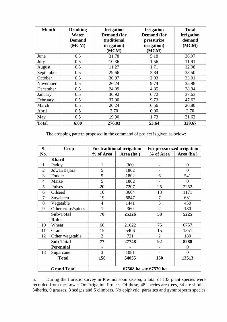
Month Drinking
Water
Demand
(MCM)
Irrigation
Demand (for
traditional
irrigation)
(MCM)
Irrigation
Demand (for
pressurize
irrigation)
(MCM)
Total
irrigation
demand
(MCM)
June 0.5 31.78 5.18 36.97
July 0.5 10.36 1.56 11.91
August 0.5 11.27 1.71 12.98
September 0.5 29.66 3.84 33.50
October 0.5 30.97 2.03 33.01
November 0.5 26.24 9.74 35.98
December 0.5 24.09 4.85 28.94
January 0.5 30.92 6.72 37.63
February 0.5 37.90 9.73 47.62
March 0.5 20.24 6.56 26.80
April 0.5 2.70 0.00 2.70
May 0.5 19.90 1.73 21.63
Total 6.00 276.03 53.64 329.67
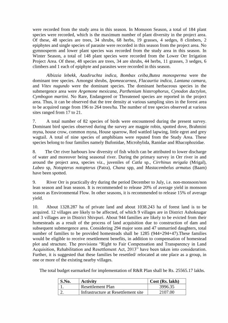
The cropping pattern proposed in the command of project is given as below:
S.
No.
Crop For traditional irrigation For pressurized irrigation
% of Area Area (ha ) % of Area Area (ha )
Kharif
1 Paddy 1 360 - 0
2 Jowar/Bajara 5 1802 - 0
3 Fodder 5 1802 6 541
4 Maize 5 1802 - 0
5 Pulses 20 7207 25 2252
6 Oilseed 10 3604 13 1171
7 Soyabeen 19 6847 7 631
8 Vegetable 4 1441 5 450
9 Other crops/spices 1 360 2 180
Sub-Total 70 25226 58 5225
Rabi
10 Wheat 60 21622 75 6757
11 Gram 15 5406 15 1351
12 Other /vegetable 2 721 2 180
Sub-Total 77 27748 92 8288
Perennial - - - 0
13 Sugarcane 3 1081 - 0
Total 150 54055 150 13513
Grand Total 67568 ha say 67570 ha
6. During the floristic survey in Pre-monsoon season, a total of 133 plant species were
recorded from the Lower Orr Irrigation Project. Of these, 48 species are trees, 34 are shrubs,
34herbs, 9 grasses, 3 sedges and 5 climbers. No epiphytic, parasites and gymnosperm species
were recorded from the study area in this season. In Monsoon Season, a total of 184 plant
species were recorded, which is the maximum number of plant diversity in the project area.
Of these, 48 species are trees, 34 shrubs, 68 herbs, 19 grasses, 4 sedges, 8 climbers, 2
epiphytes and single species of parasite were recorded in this season from the project area. No
gymnosperm and lower plant species was recorded from the study area in this season. In
Winter Season, a total of 148 plant species were recorded from the Lower Orr Irrigation
Project Area. Of these, 48 species are trees, 34 are shrubs, 44 herbs, 11 grasses, 3 sedges, 6
climbers and 1 each of epiphyte and parasites were recorded in this season.
Albizzia lebekk, Azadiruchta indica, Bombax ceiba,Butea monosperma were the
dominant tree species. Amongst shrubs, Ipomeacarnea, Flacaurtia indica, Lantana camara,
and Vitex nugundo were the dominant species. The dominant herbaceous species in the
submergence area were Argemone mexicana, Parthenium histerophorus, Cynodon dactylon,
Cymbogon martini. No Rare, Endangered or Threatened species are reported in the project
area. Thus, it can be observed that the tree density at various sampling sites in the forest area
to be acquired range from 196 to 264 trees/ha. The number of tree species observed at various
sites ranged from 17 to 21. 7. A total number of 82 species of birds were encountered during the present survey.
Dominant bird species observed during the survey are magpie robin, spotted dove, Brahmini
myna, house crow, common myna, House sparrow, Red wattled lapwing, little egret and grey
wagtail. A total of nine species of amphibians were reputed from the Study Area. These
species belong to four families namely Bufonidae, Microhylida, Ranidae and Rhacophozidae.
8. The Orr river harbours low diversity of fish which can be attributed to lower discharge
of water and moreover being seasonal river. During the primary survey in Orr river in and
around the project area, species viz., juveniles of Catla sp., Cirrhinus mrigala (Mrigal),
Labeo sp, Notopterus notopterus (Patra), Chana spp, and Mastacembelus armatus (Baam)
have been spotted.
9. River Orr is practically dry during the period December to July, i.e. non-monsoon/non
lean season and lean season. It is recommended to release 20% of average yield in monsoon
season as Environmental Flow. In other seasons, it is recommended to release 15% of average
yield.
10. About 1328.287 ha of private land and about 1038.243 ha of forest land is to be
acquired. 12 villages are likely to be affected, of which 9 villages are in District Ashoknagar
and 3 villages are in District Shivpuri. About 944 families are likely to be evicted from their
homesteads as a result of the process of land acquisition due to construction of dam and
subsequent submergence area. Considering 294 major sons and 47 unmarried daughters, total
number of families to be provided homesteads shall be 1285 (944+294+47).These families
would be eligible to receive resettlement benefits, in addition to compensation of homestead
plot and structure. The provisions “Right to Fair Compensation and Transparency in Land
Acquisition, Rehabilitation and Resettlement Act, 2013” have been taken into consideration.
Further, it is suggested that these families be resettled/ relocated at one place as a group, in
one or more of the existing nearby villages.
The total budget earmarked for implementation of R&R Plan shall be Rs. 25565.17 lakhs.
S.No. Activity Cost (Rs. lakh)
1. Resettlement Plan 3996.35
2. Infrastructure at Resettlement site 2107.00

3. Rehabilitation Plan 19461.82
Total 25565.17
An amount of Rs. 1690.60 lakh has been earmarked for implementation of plan for
income generating activities, which is in addition to the cost earmarked for implementation of
Resettlement and Rehabilitation Plan.
S.
No.
Activity No. of
PAFs
Unit Cost
(Rs./PAF)
Budget
(Rs. lakh)
Remarks
1 Reservoir fisheries - - Included in
the EMP
cost
2 Allied activities in Reservoir
fisheries
190 20,000 38.0
3 Agriculture in reservoir
fisheries area
662 50,000 331.0
4 Livestock Rearing 1321.6
5 Training of one member
from each PAF
1352 20,000 270.4 Included in
R&R cost
Total 1961.0
Cost to be earmarked
Livelihood Plan for PAFS
excluding cost for Training
of one member from each
PAF
1690.6
An amount of Rs. 498.0 lakh is being made for implementation of the LADP Activities.
S. No. Items Budget (Rs. lakh)
1 Construction/Up-gradation schools in Study Area 215.0
2 Scholarships to students in the Study Area 171.0
3 Improvement of Public Health Facility 112.0
Total 498.0
11. The total amount to be spent for implementation of Environmental Management Plan
(EMP) is Rs. 402.486 crores.
S. No. Item Cost (Rs. crore)
1. Environmental Management in labour camp 10.80
2. Control of Water Pollution 0.35
3. Air Pollution Control Measures 0.53
4. Public health delivery system 5.19
5. Restoration and Landscaping of construction sites 4.66
6. Energy Conservation measures 0.50
7. Catchment Area Treatment Plan 47.39
8. Disaster Management Plan 3.00
9 Compensatory Afforestation and Bio-diversity conservation 41.37
10. Greenbelt development 0.99
S. No. Item Cost (Rs. crore)
11. Fisheries Management 8.09
12. Environmental Monitoring during construction phase 1.30
13. Purchase of noise meter 0.015
14. Purchase of meteorological instruments 0.070
15. Water Quality Testing Kits 0.10
16. Resettlement and Rehabilitation Plan 255.651
17. Local Area Development Plan 4.98
18. Livelihood Plan for PAFs 16.90
19. Monitoring & Evaluation of R&R Plan 0.60
Total 402.486
12. After detailed deliberations, EAC observed the following:
i) Skill Mapping of the area be got conducted, mentioning the skills inherent of
the local people, skill requirement of the project and the best ways to develop
the skills in the local people so that the locals can be absorbed at project itself.
ii) Confirmed figure of the PAFs along with the provisions of R&R plan as per
the “Right to Fair Compensation and Transparency in Land Acquisition,
Rehabilitation and Resettlement Act, 2013” duly approved by the State Govt.
be prepared and submitted.
iii) There were some doubts in the presentations and report about number of fish
species available in the river/affected zone. However the presence of Indian
major carps itself indicate round year availability of water in the river or in
deep pools which support these sensitive species. Therefore there is need to
provide the e-flows to maintain the existing biota and fisheries in the river and
develop infrastructure for fish seed production for stocking in the submergence
and affected stretches.
iv) Considerable amount of budget (8.09 crores) has been proposed under EMP
for Fisheries management, in which major share is allotted in construction and
manpower sector. There is need to allot maximum funds for establishment of
fish hatchery for Indian major carps, creation of nursery areas and brooders.
v) One season baseline data collection shall be undertaken in the additional
command area (within the Gross Command Area) for various environmental
components.
vi) The impact of this project on the Ken-Betwa link project needs to be estimated
since ultimately they are to be integrated. Similarly the impact of the of the
Ken-Betwa link on this project needs to be assessed.
vii) Based on the above, draft EIA report shall be submitted to State Pollution
Control Board for conducting public hearing for additional command area.
Agenda Item 2.4 Barway 0.7 MW SHEP, Tensile Aut District Mandi, H.P.by M/s
Omel Energy & Engineering Services – for consideration of TOR.
The project proponent did not attend the meeting. Therefore, the EAC has not
considered the project and deferred the project.
Agenda Item 2.5 Kiru Hydro Electric Power Project (624 MW) at Kiru Tehsil and
District Kishwar, J&K by M/s Chenab Valley Power Project Pvt.
Ltd. – For consideration of Environment Clearance (EC)
The project proponent (PP) made a detailed presentation on 624 MW Kiru HE Project
proposed on river Chenab near village Patharnakki in the District Kishtwar of Jammu &
Kashmir. The project has been entrusted to Chenab Valley Power Projects Pvt. Ltd., a joint
venture amongst NHPC Ltd., J&K State Power Development Corporation Ltd. and Power
Trading Corporation of India Ltd. The project envisages construction of a 123 m (from river
bed level) high concrete gravity dam across river Chenab near village Patharnakki with four
intakes, four pressure shafts, an underground powerhouse of 4 units of 156 MW each. The
catchment area up-to diversion site (dam) is 10225 Sq. km. The total cost of project is about
Rs. 4640.88 crores and the construction period of the project is 54 months.
2. The scoping/TOR clearance for Kiru HEP (600 MW) was earlier granted by the
ministry on 9th
September, 2008 for 600 MW installed capacity. First Public Hearing was
conducted by JKSPCB on 30th
October, 2013 (after the expiry of TOR) for 660 MW installed
capacity. Based on earlier studies and Public Hearing conducted on 30th
October 2013,
EIA/EMP reports for 660 MW installed capacity were submitted in March 2014. Proposal
was appraised for Environment Clearance in 74th
EAC meeting held in May 2014. EAC noted
the change of capacity and expiry of TOR validity. EAC, during this meeting made
observations in regard to environment flow and recommended to conduct scientific study to
establish E-flow. In addition, it was also recommended that the reports be updated with one
season field data and fresh public hearing be conducted.
3. Scientific Study on E-flow was conducted and report submitted in June 2015. The
proposal was considered in 85th
EAC meeting held on 20-21st July 2015 and TOR for 624
MW capacity was issued for completion of studies and conducting fresh public hearing. EIA
and EMP reports were updated and Public Hearing was conducted by J&K State Pollution
Control Board on 27.11. 2015.
4. The PP informed EAC that all the components of DPR for the project have already
been approved by various Directorates of CEA/CWC and project has been appraised by
Central Electricity Authority in its meeting held on 22.1.2016.
5. The case for diversion of 82.05 ha of forest land for the project has been approved by
J&K State Forest Advisory Committee in its 78th
meeting held on 22nd
August 2013 and the
requisite payment in this regard has also been deposited with the Forest Department. Further,
the process for acquisition of both government and private land is in progress wherein the
Land Acquisition Notification under Section-4 of J&K State Land Acquisition Act has
already been issued and the proceedings under Sections-6&7 are under process. The details of
land requirement for the project were also provided wherein the total land to be acquired for
project is 179.78 ha out of which 82.05 ha is forest land, 51.37 ha is government land and
46.36 ha is private land.
6. The PP informed that the recommended studies have been completed and requisite
data collection has been done in accordance with the stipulated TOR wherein the data for four
seasons was collected earlier in year 2011 & socio-economic data collected earlier in 2011
and 2013. This was further augmented by one season additional field data in 2014. The data
collection details including study area, sampling sites, methodologies, compiled data and
results were discussed. The baseline data include soil types, soil texture, physico-chemical
characteristics of soil, water quality, air quality, noise quality, etc. The details on landuse/land
cover of the area were also presented. The details regarding forest types, floristic composition,
phyto-sociology, life forms, diversity, distribution, medicinal plants and rare and threatened
plant species was also presented by the proponents. The EAC was informed that no threatened
floral species were being affected by the project. Regarding faunal elements, the data
collected on mammals, reptiles, birds, herpato-fauna, butterflies, etc. was presented and
discussed in the meeting.
7. The data on aquatic biology was also provided with relation to phytoplankton, phyto-
benthos and macro-invertebrates along with the details of bacteriological studies. The details
and status of ichthyofauna were also presented before the committee. The EAC was informed
that due to construction of Salal dam in downstream has already blocked the migration of
some fish species to the upper sections of river and between Salal HEP and the proposed Kiru
HE Project two other power projects i.e. Baglihar HEP and Dul Hasti HEP are already
operational and the third one i.e. Ratle HE Project is under construction. Therefore, the
possibility of any long distance migration was not happening /feasible.
8. The data collected on the socio-economic environment of the area was also presented
by the PP. The impacts of project during its construction and operation phases on various
factors were presented and discussed in the meeting. After detailed discussions, the committee
was satisfied with the baseline data collection and the EIA studies conducted for the project.
9. The Environmental Management Plans (EMP) formulated on the basis of EIA studies
were also discussed in detail during the meeting. The EAC was informed that under
biodiversity conservation plan the provisions for In-situ and Ex-situ conservation of various
species have been proposed with a total cost of 139.80 lakhs. Under Catchment Area
Treatment Plan, the total free draining catchment area of 285.75 Sq.km (28575 ha) falls
under 5 sub-watersheds and 122 micro-watersheds. Areas falling under Severe and Very
Severe erosion categories are 1159.18 ha and 690.10 ha respectively. (Total = 1849.28 ha)
and the same have been taken for treatment. An area of 1246.66 ha is proposed to be treated
with biological measures and an area of 603.44 ha shall be treated with engineering measures.
These treatment measures shall be implemented over a period of five years. An amount of Rs.
1883.82 Lakhs has been kept for CAT plan. The CAT plan shall be implemented by J&K
Forest Department.
10. The total forest land required for the project is 82.05 ha and under the Compensatory
Afforestation plan a total provision of Rs. 1036 lakhs has been kept towards NPV of forest
land, compensation of trees, transplantation of saplings, compensatory afforestation and other
expenses. J&K Forest Advisory Committee has accorded approval for diversion of 82.05 ha
forest land for Kiru HE Project in its 78th
meeting held on 22nd
August, 2013. The
Compensatory Afforestation shall be done by J&K State Forest Department under CAMPA
on 164.10 ha of denuded or degraded forest areas. Under Fisheries Development Plan, a
provision of Rs. 798.59 lakh has been kept for establishment and operation of a fish hatchery
in 2 ha of area for continuous restocking of reservoir and river.
11. Solid Waste Management Plan contains the provisions for segregation, collection and
disposal of biodegradable and non-biodegradable wastes from project colonies and offices
with a total provision of Rs. 207.60 lakhs. In Public Health Management Plan, the provisions
are kept for combating communicable and vector borne diseases, health awareness, periodical
health check up and vaccination camps, etc. along with the provision for one medical aid post
with bedding facility, first aid boxes at all construction locations and two ambulances for
medical emergencies. There is one Primary Health Centre in the project area which has been
proposed to be strengthened under this plan. Total cost of health management plan has been
kept as Rs. 460 lakh.
12. Under Energy Conservation Plan, adequate arrangements shall be made for supply of
kitchen fuel viz. LPG and Kerosene, establishment of community kitchen and canteen for the
migrant workers and distribution of pressure cookers and solar cookers for efficient cooking
practices for the worker families. A cost of Rs. 75 lakhs has been budgeted for this plan.
13. Total quantity of muck generated from various project construction activities is
expected to be 25.78 lakh m3, out of which about 8.36 lakh m
3 of muck will be utilized and
balance 17.42 lakh m3
will be disposed off at four identified dumping sites having a total area
of 28.22 ha and capacity of 18.17 lakh m3. Apart from this, two temporary muck dumping
sites, having an area of 3 ha and capacity of 2.18 lakh m3, have also been identified where
muck shall be stored temporarily for segregation of usable and unusable portions. The
engineering, bioengineering and biological measures proposed for rejuvenation of these
dumping sites were also explained to the committee. It was also informed that these dumping
sites shall be established at a minimum horizontal distance of 30m from the highest flood
level of the river. Total budget of Rs. 1697.57 lakhs has been allocated for implementation of
muck disposal plan.
14. The requirement of construction material shall be fulfilled from seven rock quarries
and two clay quarries, out of which two rock quarries shall be the power house cavern and
dam site, which shall not require any restoration under EMP. The details pertaining to plan for
restoration of remaining quarry areas and borrow pits using both engineering and biological
measures was also explained to the committee. The cost of this plan has been earmarked to be
Rs. 221.16 lakhs. Landscaping and Restoration Plan and the Green Belt Development Plan
have been formulated with a provision of Rs. 100 lakhs and Rs. 28.78 lakhs, respectively.
Plan for control of air, noise and water pollution is prepared with a provision of Rs. 40 lakhs
and the Reservoir Rim Treatment plan having both engineering and biological measures has
been formulated with a budget of Rs. 620.17 lakhs.
15. Dam Break Modeling was carried out for Kiru HE Project so as to assess the dam
breach conditions and resultant inundation scenario. Based on dam break modeling, the
Disaster Management Plan has been prepared to deal with the dam break event covering the
provisions for Disaster Response Plan, Contingency Plan, Awareness & Emergency
Preparedness, Emergency Action Plan, Communication System, Emergency Alert System,
Emergency Warning & Control System, Health & Medical Response System, Information
Dissemination & Safety Procedures and Evacuation Plans, etc. A cost provision of Rs. 135.50
lakhs has been kept for disaster management plan.
16. In order to assess the effectiveness of various environmental management plans, a
Monitoring plan has been prepared clearly explaining the parameters to be monitored and
frequency of monitoring along with the responsible executing and monitoring agencies. Cost
of Rs. 75 lakhs has been earmarked under this plan.
17. The project required to acquire 46.36 ha of private land from four villages viz. Piyas,
Chhichha, Galhar Bhata and Bhagna falling under Tehsil- Nagseni of Kishtwar District. A
total of 181 project affected families (PAFs) have been identified with a total of 1009 project
affected persons. Out of these, 92 families shall be displaced and they shall be losing their
houses. These families shall also be losing their cattle sheds. 26 families shall be losing
kothas (seasonal cattle sheds). Apart from this, a total of 04 shops shall also be acquired. It
was informed that the acquisition of land for project is under process in accordance to the

J&K State Land Acquisition Act. The total cost of Rs. 2826.158 lakhs has been earmarked for
effective implementation of R&R package for the affected families. For establishment of
adequate facilities at the proposed resettlement colony area like roads, sewerage system,
drainage system, waste collection and disposal system, drinking water and electricity supply,
parks and playgrounds, community hall, places of worship, market area, burial ground, and
other infrastructure facilities a provision of Rs. 1500 lakhs has been made under this plan.
18. Various activities proposed under Social and Community Development plan were also
discussed. This component comprises of Education and Skill Development, Infrastructure
Development & Public Utilities and Social Welfare Schemes. A cost of Rs. 2837.20 lakhs has
been earmarked for this component. The total cost of R&R plan comprising of R&R package,
resettlement colony development and Community & Social Development comes to be Rs.
7213.36 lakhs.
19. Proceedings of public hearing and the status of queries raised during the public
hearing were discussed. The committee noted that on demand of public, a provision of Rs.
987 lakhs has been kept for construction of a hostel facility at Kishtwar town for the project
affected students of the area with a total intake capacity of 250 students (150 boys and 100
girls). The total cost of all EMP measures including R&R plan comes to Rs. 14732.35 lakhs.
20. After discussing the EMP and R&R plan prepared for the project, the EAC discussed
that only monetary compensation will not be sufficient for loss of land of a farmer; project
should enhance the provisions for skill development so that interested project affected persons
can have skill set for income generation. The committee observed that the total project cost is
Rs. 4640.88 crores and EMP budget is 147.32 crores i.e. about 3.2%. The committee
recommended that the overall EMP budget should be raised to 3.5% (i.e. Rs. 162.43 crore) of
the project cost.
21. The EAC directed that under EMP, Skill Mapping of the area be got conducted,
mentioning the skills inherent of the local people, skill requirement of the project and the best
ways to develop the skills in the local people so that the locals can be absorbed at project
itself.
22. The committee discussed the free flow stretch available for Kiru HE Project with
upstream Kirthai II HEP and downstream Kwar HEP. In upstream of Kiru HEP about 1 km of
free flowing stretch is available with respect to Kirthai-II HEP. For downstream portion, it
was informed by project proponents that during high flow period (June to September),
reservoir levels shall be maintained at MDDL to sluice down the sediment downstream for
efficient sediment management. In Kwar HEP also the reservoir level shall be kept at MDDL
i.e EL 1372 m during June to September, thus the free flow stretch between Kiru and Kwar
HEPs shall be around 1.3 km during June to September.
In the non-monsoon season, during peaking, reservoir level shall fluctuate between
FRL and MDDL As soon as the reservoir level reaches FRL, the peaking will start and in next
3 hours the reservoir will reach to MDDL. Then it will take around 20 hours or so to reach
FRL, that means reservoir level shall be at FRL for very less time, and in general, can be
considered to be at a level of around EL 1380 m. In this case, free flow stretch shall be around
0.8 to 0.9 km. The free flow stretch is around 325 m, with respect to Kwar HEP, if TRT outlet
level of Kiru and FRL of Kwar Project is considered.
The EAC was informed that projects located on Chenab river are governed by the
provisions of the Indus Waters Treaty (IWT) 1960 and have certain limitations under IWT.
EAC considered the explanation given for project operation and agreed that on an average
about 1 km free flow stretch shall be available for most part of the time for upstream as well
as downstream portions of Kiru HEP. From the explanation given by the developer as
mentioned above, it appears that practically the flow stretch shall be around 1 km between
Kiru HEP and Kwar HEP, which satisfies the free stretch requirement.
23. Committee also enquired about the fisheries component and the environment flow
provisions made. Developer explained that as recommended by EAC earlier, a scientific study
was conducted to assess the requirement of environment flow release from the project and
same was presented and discussed with EAC during 85th
meeting. Based on the habitat
simulation and hydraulic modeling, required flow depth, width and velocity was assessed for
the affected intermediate stretch of Chenab using Mike 11 model. Modeling results show that
10% of average lean season discharge (8.16 cumec) gives a depth of 86 cm and adequate
velocity and flow width. E- flow of 9 cumec has been taken in the DPR while finalizing the
power potential studies, which is considered adequate by the study. For the peak flow period
(June-September), 10% release (73.37 cumec) gives 1.93 m of flow depth, 2.89 m/s of
velocity and 24.05 m of flow width, which is about 50% of natural river width without any
flow diversion. Bela Nala will augment additional 7.18 cumec of water during this period.
Daily data analysis for 90% dependable year flow was presented; which showed that entire
period has adequate spills and flood peaks are distributed through-out the 4 month period. It
was further presented that by maintaining a minimum release of 73.37cumec (10% of average
peak period discharge in 90% DY), 24.5% of inflows will be released and it becomes 25.5%
when contribution of Bela Nala is added. All other years, more than 30% of inflow will be
available. For remaining four months, a flow release of 16.62 cumec, which is 10% of average
flow during this period in 90% dependable year, is recommended by the study which gives a
water depth of 1.13 m and flow width of 16.05 m as against the flow width of 27.75 m under
natural conditions without any diversion.
24. The EAC noted that the matter was discussed in detail in 85th
meeting, in which EAC
recommended that “Environment flow provisions should be in line with the findings of the
detailed scientific study. Therefore, final environment flow provisions to be made in the
project are 16 cumec for lean flow period (December – March), 73.37 cumec for peak flow
period (June-September) and 16.62 cumec for remaining four months (Oct, November, April
and May). Ministry, may however, take an appropriate view on lean season environmental
flow as the river comes under IWT.”
25. The EAC recommended that in line with the decision taken in 85th
meeting the final
environment flow provisions shall be 8.16 cumec (10%) for lean flow period (December –
March), 10% for peak flow period (June- September) and 10% for remaining four months
(Oct, November, April and May).
26. EAC further inquired about the environment flow provisions made in DPR and
whether the environment flow provisions will affect the power potential/installed capacity.
The proponent reported that power potential studies with regards to the recommended E-flow
of 20% during lean period and 10% during rest of the periods have also been conducted and
with this provision the installed capacity of the project shall remain the same i.e. 624 MW
however the power generation shall get reduced from the present 2363.55 MU to 2272.40 MU
which is acceptable to the proponent.
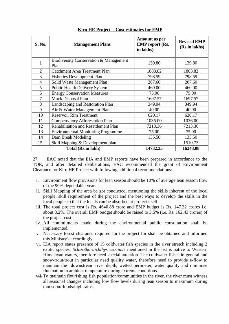
Kiru HE Project - Cost estimates for EMP
S. No.
Management Plans
Amount as per
EMP report (Rs.
in lakhs)
Revised EMP
(Rs.in lakhs)
1 Biodiversity Conservation & Management
Plan 139.80 139.80
2 Catchment Area Treatment Plan 1883.82 1883.82
3 Fisheries Development Plan 798.59 798.59
4 Solid Waste Management Plan 207.60 207.60
5 Public Health Delivery System 460.00 460.00
6 Energy Conservation Measures 75.00 75.00
7 Muck Disposal Plan 1697.57 1697.57
8 Landscaping and Restoration Plan 349.94 349.94
9 Air & Water Management Plan 40.00 40.00
10 Reservoir Rim Treatment 620.17 620.17
11 Compensatory Afforestation Plan 1036.00 1036.00
12 Rehabilitation and Resettlement Plan 7213.36 7213.36
13 Environmental Monitoring Programme 75.00 75.00
14 Dam Break Modeling 135.50 135.50
15. Skill Mapping & Development plan - 1510.73
Total (Rs.in lakh) 14732.35 16243.08
27. EAC noted that the EIA and EMP reports have been prepared in accordance to the
TOR, and after detailed deliberations; EAC recommended the grant of Environment
Clearance for Kiru HE Project with following additional recommendations:
i. Environment flow provisions for lean season should be 10% of average lean season flow
of the 90% dependable year.
ii. Skill Mapping of the area be got conducted, mentioning the skills inherent of the local
people, skill requirement of the project and the best ways to develop the skills in the
local people so that the locals can be absorbed at project itself.
iii. The total project cost is Rs. 4640.88 crore and EMP budget is Rs. 147.32 crores i.e.
about 3.2%. The overall EMP budget should be raised to 3.5% (i.e. Rs. 162.43 crores) of
the project cost.
iv. All commitments made during the environmental public consultation shall be
implemented.
v. Necessary forest clearance required for the project for shall be obtained and informed
this Ministry's accordingly.
vi. EIA report states presence of 15 coldwater fish species in the river stretch including 2
exotic species. Schizothoraichthys esocinus mentioned in the list is native to Western
Himalayan waters, therefore need special attention. The coldwater fishes in general and
snow-trout/trout in particular need quality water, therefore need to provide e-flow to
maintain the downstream river depth, wetted perimeter, water quality and minimise
fluctuation in ambient temperature during extreme conditions.
vii. To maintain flourishing fish population/communities in the river, the river must witness
all seasonal changes including low flow levels during lean season to maximum during
monsoon/floods/high rains.
Agenda Item 2.6 Goudruma Kathpal Project in District Mayurbhanj, Chattisgarh,
by M/s Goudruma-Kathpal Batinga, Government of Chhattisgarh
– for consideration of TOR.
The project proponent did not attend the meeting. Therefore, the EAC has not
considered the project and deferred the project.
Agenda Item 2.7 Karcham - Wangtoo Hydroelectric Project (1000 MW) in District
Kinnaur, Himachal Pradesh - Transfer of EC to M/s. Himachal
Baspa Power Company Limited
The project proponent had made a detailed presentation on the project. Karcham-
Wangtoo Hydroelectric Project (1000 MW) is located near village Karcham in District
Kinnaur, Himachal Pradesh. This is a run-of-the-river scheme on river Satluj. The
Environmental Clearance (EC) was accorded to the Project on 9th
November, 2005 in favour
of M/s. Jaypee Karcham Hydro Corporation Limited (JKHCL. The Project has been
commissioned on 13th
September, 2011 and is in operation since then.
2. The project was considered by EAC in its meeting held on 22-23rd
December, 2015.
The committee noted that in pursuance to the Hon’ble High Court of Himachal Pradesh,
Shimla order dated 25th
June, 2015, it was informed by M/s. Jaiprakash Power Ventures Ltd
mentioned that the Project has now been transferred to M/s. Himachal Baspa Power Company
Limited (HBPCL) w.e.f. 1.9.2015 and a request was made therein to transfer the EC already
accorded in the name of M/s. Himachal Baspa Power Company Limited (HBPCL).
3. The project proponent informed that as per the discussion during the 90th
EAC
meeting, following documents / data were submitted to Ministry and the same have been
presented during the meeting:
i) Affidavit for change of name on non-judicial stamped paper by M/s. Jaiprakash Power
Ventures Limited & M/s. Himachal Baspa Power Company Limited for transfer of
Environmental Clearance
ii) Deed partnership agreement and a copy of Hon’ble High Court order dated
25.6.2015
iii) Public Notice issued for change of name – Daily news paper (in English/local paper)
iv) Copy of the latest 6 monthly compliance report.
Considering the submissions by the Project Proponent, EAC was of the view that the EC
already granted to the Project can be transferred in the name of M/s. Himachal Baspa Power
Company Limited (HBPCL).
Agenda Item 2.7A Cumulative Impact Assessment & Carrying capacity Study (CIA &
CCS) of Chenab River Basin Study in Himachal Pradesh.
The project proponent along with the consultants made a detailed presentation
covering the Cumulative Impact Assessment (CIA) Study of Chenab Basin with in Himachal
Pradesh. The Cumulative Impact Assessment Study of Chenab Basin was initiated by
Directorate of Energy, Government of Himachal Pradesh. The MoEF&CC taken over all the
river basin/carrying capacity studies being conducted by Central/State agencies, therefore,
final report has been submitted to Ministry for consideration.
2. The study area covered Chenab basin within Himachal Pradesh up-to confluence of
Sansari Nala with Chenab river; beyond which Chenab river enters Jammu & Kashmir. EAC
was informed that for the CIA studies the Chenab basin in Himachal Pradesh has been
divided into four Sub-zones based upon ecological characteristics namely Chandra Sub-zone,
Bhaga Sub-zone, Udaipur Sub-zone (located in Lahaul Region) and Pangi Sub-zone (located
in Pangi Valley (Chamba district). The CIA study covered all planned hydro development
with total installed capacity of 3600.56 MW consisting of 6 commissioned projects of 6.4
MW, 16 allotted projects of 3041 MW, 21 small Himurja projects of 64.45 MW and 13
recently advertised projects of 489.1 MW. Status with respect to their EC or Scoping approval
was presented to committee. Methodology adopted to carry out CIA study was explained in
detail.
3. EAC was informed that as a part of study, extensive data has been collected as well as
generated from secondary and primary surveys carried out in three seasons for various
environmental attributes. Primary and secondary data related to meteorology, water resources,
water quality, flora, fauna, protected areas, aquatic flora & fauna, fish & fisheries, physical &
biological water quality aspects for entire study area were also presented in detail .
4. Forests constitute only 1.64% of the basin and majority of the area is under non-forest
which is comprised of barren land, snow, glaciers and ice-fields. The vegetation of the basin
can be classified into two broad types: Temperate (at El. 2000-3500 m) and Alpine at El.
>3500 m). There are two protected areas in Chenab basin for which final notification has been
published in 2013 viz. Sechu Tuan Nalla Wildlife Sanctuary and Chandra Taal Wildlife
Sanctuary. There is another Protected Area for which intent has been notified in 2010
i.e.Inderkilla National Park which lies adjacent to Chenab basin. Floristically the basin is rich
plant species whereinvascular plants are comprised of 1345 species of Angiosperms
belonging to 90 families, 20 species of Gymnosperms belonging to 4 families and 10 species
of Pteridophytes belonging to 6 families while among Lower plants 16 species of Bryophytes
belonging to 9 families and 27 species of Lichens belonging to 14 families are reportedly
found in the study area. According to Red Data Book of Plants published by Botanical Survey
of India 13 plant species under different threat categories are reported from Chenab basin. Out
of 333 endemic and near endemic plant species so far reported from Himalaya, 182 species
are reportedly found in Chenab basin. Out of 84 plant species which are endemic to North
West Himalaya and Himachal Pradesh, 56 species are reported from Chenab basin whereas 4
species are endemic only to Lahaul & Spiti region. Out of 23 species of rare and endangered
plant species recorded from Himachal Pradesh 13 plant species are found in Chenab basin that
are under different threat categories as per Red Data Book of Plants published by Botanical
Survey of India. According to Red-list Status of candidate species as per Shimla Conservation
Assessment Management Prioritization (CAMP) December, 2010 by Foundation for
Revitalization of Local Health Traditions (FRLHT), there are 57 species of plants in
Himachal Pradesh under various threat categories of which 43 species are found in Chenab
basin. This region harbours a wide range of medicinal plants also used by the local people. In
all 524 plant species belonging to 72 families have been documented so far which are used by
locals for medicinal purposes.
5. In all 32 mammalian species belonging to 13 families are reported from the study area.
According to WPA (1972) Schedules, 11 mammalian species have been included in Schedule-
I another 9 species in Schedule-II and rest are either under Schedule-III, IV or V. According
to IUCN Red List, 2 species are under Endangered category, 3 species are under Vulnerable
category, 6 species are under Near Threatened category and 19 species are under Least
Concern category. Out of 147 species of birds belonging to 43 families have been reported

from the study area. However during the field surveys 61 species of birds belonging to 26
families were recorded from the study area. 47 species of butterflies belonging to 4 families
were sighted from the basin. Total 8 species of Herpetofauna are reported from the Chenab
basin of which 4 species are of amphibians and 4 species are of reptiles. Water quality of
Chenab river as well as its tributaries is good to excellent.
6. The environmental flow assessment was explained to committee especially since the
river is devoid of fish and peculiarity of flow regimes. It was explained that due to peculiarity
of seasons and flow pattern in the study catchment like Low Flow and High Flow periods
have been considered in absence of clear defined monsoon and non-monsoon seasons.
Environmental flow regime, therefore was worked out based on annual discharge pattern.
Miyar Catchment discharge pattern shows a shorter high flow period and longer lean period
than main Chenab river. High flow period for main Chenab river is from June to September,
low flow period between November to April, intermediate in Oct & May and High flow
period for Miyar Nala is from June to August, low flow period between October to April,
intermediate in September & May.
7. Since productivity of Chenab river has been found good enough to sustain population
of fishes like trout which is substantiated by the richness and composition of benthic macro-
invertebrates, and other aquatic micro-organisms like periphyton and phytobenthos
(predominantly diatoms) in Chenab river and its tributaries, hence despite absence of fish
species, environment flow release is still very critical for de-watered stretches of Chenab
created due to diversion of water for hydropower development. In order to maintain the
integrity of populations especially of macro-invertebrates in the river, the flows should mimic
flow pattern that naturally occurred in different seasons. Keeping this in view, minimum
environment flow requirement has been established based upon pre-project habitat. To ensure
that water required to sustain the riverine ecology is available at all the times, flow width and
water depth has been compared to that of pre-project conditions. Environment flow release
recommendations have been made for the values where flow width and depth are close to
50% or half of the pre-project values. Pre-project water depth, flow width and flow velocity
have been assessed by reviewing the results of 100% release scenario. Based on this criteria,
environmental flows for all projects have been recommended for all three flow seasons (low,
high & intermediate). Committee found the approach in order.
To have complete transparency, stakeholder’s public consultation meetings were held
28th
, 29th
& 31st October 2014 at Keylong, Udaipur and Killar (Pangi). Inputs were presented
to the committee where concerns were against Gyspa project and protecting Mini Manali area
near Udaipur by reducing Seli FRL. People also demanded declaration of area above 7000 ft.
as Eco Sensitive Zones and to be recommended as no project zone. They provided several
other inputs which have been point-wise compiled and presented in the report.
After detailed deliberations, the committee asked the consultant to present report
based on their observations and to submit CIA report accordingly:
- Committee proposed that impact assessment for sensitivity of various sub-zones vis-à-
vis projects may be carried out based on certain common indices.
- Recommendations for individual projects may be made objectively and should be
irrespective of the EC or FC clearances already accorded to few HEPs.
- Since majority of the study area is above 3500 m elevation, eco-sensitivity and
fragility of study area may be assessed accordingly. There are very few forest patches
in these high elevation reaches which needs to be preserved.
- Projects falling within the protected areas may be dropped at the very outset itself.
- Presence of snow-trout fish species (Schizothoraichthys, Schizothorax and Diptychus)
endemic to Western Himalayan rivers need be ascertained with utmost care.
- Possibility of stocking brown trout in the river stretches and rainbow trouts/ Arctic
charr in the submergence need also be explored.
- Besides free flowing stretch between two projects, the peaking discharge, likely
impacts of peaking on downstream water quality; biota and fisheries ; and mitigation
measures should also be suggested.
Agenda Item 2.7 B Cumulative Impact Assessment & Carrying capacity Study (CIA &
CCS) of Dibang River Basin Study in Arunachal Pradesh.
The project proponent along with the consultants made a detailed presentation
covering the Cumulative Impact Assessment and Carrying Capacity Study (CIA & CCS) of
Dibang River Basin in Arunachal Pradesh. The study was initiated in May 2015. Initial time
frame for the study was 21 months. With a view to reduce the time frame of the study from 21
to 12 months, EAC in its meeting held during August, 2015: recommended to use secondary
data available with BSI, ZSI, CWC, etc. and augment it with one season (monsoon) primary
data. Based on the one season primary data and available secondary data, the interim report
has been prepared and submitted to Ministry for consideration.
2. It was informed that total identified projects in the basin are 18 with total installed
capacity of 10223 MW, out of which 14 have been allotted and 4 are yet to be allotted. There
are two Protected Areas in the basin i.e. Dibang Wildlife Sanctuary and Mehao Wildlife
Sanctuary and in addition part of Dihang Dibang Biosphere Reserve also falls in the basin. It
was highlighted that part of Malinye HEP falls within Dibang WLS and is yet to be allotted.
However, 4 HEPs viz. Mihundon, Etabue, Amulin and Attunli HEPs fall within 10 radius of
the sanctuary. No project falls within Mehao WLS while only Ashupani falls within 10 km
radius of the sanctuary.
3. Data collected and compiled using primary and secondary sources was presented for
Land use, Forest types & Cover, Taxonomical Diversity, Threatened and Endemic Species,
Faunal Resources, Avi Fauna, Butterflies, Herpetofauna, Reptiles, Amphibia, Physico-
chemical Water Quality, Biological Water Quality, Fish and Fisheries, etc. which was found
in order. It was also informed that the compilation of data collected through Primary field
surveys is complete and data collected from secondary sources like BSI & ZSI is also almost
complete and the study will be completed as per schedule. The list of fish species reported
include presence of two exotic fish species (common carp and tilapia) during the course of
study from the river. Since both the species prefers stagnant/ semi-stagnant water bodies with
organic load, while the river water seems in fluvitile condition and pollution free. Therefore
there is need to reaffirm the presence of these species from the river. Altitudinal distribution
of fish species in the river need be mentioned to justify the presence of coldwater and warm
water fishes in the river. Besides free flowing stretch between two projects, the peaking
discharge, likely impacts of peaking on downstream water quality; biota and fisheries; and
mitigation measures should also be suggested.
4. Regarding environmental flow assessment, it was informed that so far Central Water
Commission (CWC) has approved water availability series for three projects (Etalin, Attunli
and Dibang HEPs) and same data has been procured for modeling exercise. Though no data is
available for remaining projects for environment flow assessment as no progress is being
made on these projects however, data from PFRs, 12 more discharge series have been taken
for e-flow assessment modeling. River cross sections are not available for 15 projects; so
environment flow assessment could not be done at this stage; it would be required to recourse
to ASTER data available in public domain in order to complete the exercise in time.
Committee agreed however asked consultant to undertake ground verifications for accuracy of
data for all the remaining.
The committee after detailed deliberations expressed satisfaction on the progress of
the study and desired that report be finalized by April , 2016.
Agenda Item 2.7C Cumulative Impact Assessment & Carrying capacity Study (CIA &
CCS) of Satluj River Basin Study in Himachal Pradesh.
The project proponent along with the consultant i.e. Indian Council of Forestry
Research and Education (ICFRE) presented cumulative impact assessment & carrying
capacity study (CIA & CCS) of Sutlej River Basin. The Dept. of Energy, Govt. Himachal
Pradesh suggested ICFRE to identify and involve subject expert institute(s) for a holistic
assessment. ICFRE taken-up the study in association with 3 national subject expert
institutions The Alternate Hydro Energy Centre (AHEC), Indian Institute of Technology
(IIT), Roorkee; Directorate of Coldwater Fisheries Research (DCFR), Bhimtal; and Salim Ali
Centre for Ornithology & Natural History (SACON), Coimbatore.
2. The total catchment area of the Sutlej River up to Kol Dam is about 55,572 Sq.km, out
of which 18,419 km2 lies in India. The study area constitutes a part of the Sutlej basin falling
in the state of Himachal Pradesh i.e., upstream of tailrace outfall of Kol Dam right up to
Shipki-La on main Sutlej basin and up to Kunzum-La in Spiti sub-basin.
3. The thirty eight hydropower projects considered (8415 MW) for the study (> 10 MW)
will contribute to generate 32022million units (MU). List of projects in Sutlej basin is given
below.
S.N
o
Name of the
HEP
River/ Khad Capacit
yMWs
Project proponents
Commissioned Projects
1. Baspa -II Baspa 300 JP Hydro Power Pvt Ltd
2. Karcham
Wangtoo
Sutlej 1000 JP Karcham
3. Sumej Sechi and
Muhali Khad
14 Rangaraju Ware Housing Pvt
Ltd
4. SVP-Bhaba Wanger Gad 120 HPSEB
5. Ghanvi-I Ghanvi Khad 22.5 HPSEB
6. Nathpa Jhakri Sutlej 1500 SJVNL
Under Construction Projects
7. Kut Kut Khad 24 Kut Energy Pvt Ltd
8. Sorang Sorang 150 Himachal Sorang Power Pvt
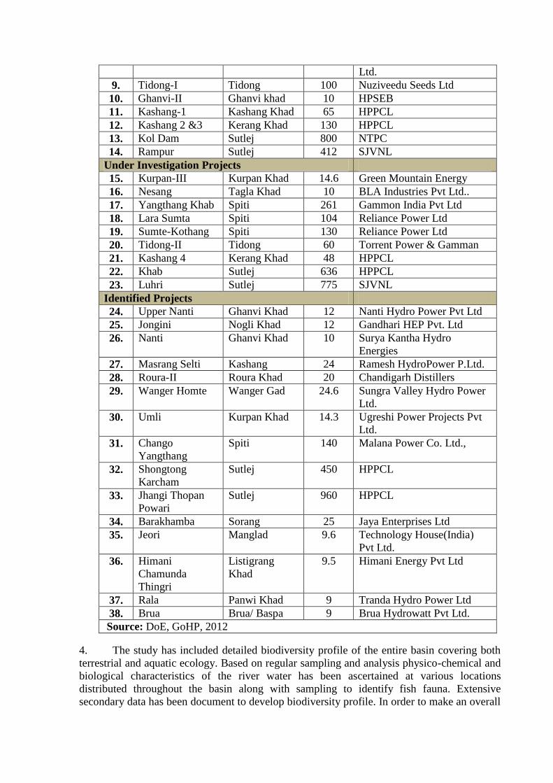
Ltd.
9. Tidong-I Tidong 100 Nuziveedu Seeds Ltd
10. Ghanvi-II Ghanvi khad 10 HPSEB
11. Kashang-1 Kashang Khad 65 HPPCL
12. Kashang 2 &3 Kerang Khad 130 HPPCL
13. Kol Dam Sutlej 800 NTPC
14. Rampur Sutlej 412 SJVNL
Under Investigation Projects
15. Kurpan-III Kurpan Khad 14.6 Green Mountain Energy
16. Nesang Tagla Khad 10 BLA Industries Pvt Ltd..
17. Yangthang Khab Spiti 261 Gammon India Pvt Ltd
18. Lara Sumta Spiti 104 Reliance Power Ltd
19. Sumte-Kothang Spiti 130 Reliance Power Ltd
20. Tidong-II Tidong 60 Torrent Power & Gamman
21. Kashang 4 Kerang Khad 48 HPPCL
22. Khab Sutlej 636 HPPCL
23. Luhri Sutlej 775 SJVNL
Identified Projects
24. Upper Nanti Ghanvi Khad 12 Nanti Hydro Power Pvt Ltd
25. Jongini Nogli Khad 12 Gandhari HEP Pvt. Ltd
26. Nanti Ghanvi Khad 10 Surya Kantha Hydro
Energies
27. Masrang Selti Kashang 24 Ramesh HydroPower P.Ltd.
28. Roura-II Roura Khad 20 Chandigarh Distillers
29. Wanger Homte Wanger Gad 24.6 Sungra Valley Hydro Power
Ltd.
30. Umli Kurpan Khad 14.3 Ugreshi Power Projects Pvt
Ltd.
31. Chango
Yangthang
Spiti 140 Malana Power Co. Ltd.,
32. Shongtong
Karcham
Sutlej 450 HPPCL
33. Jhangi Thopan
Powari
Sutlej 960 HPPCL
34. Barakhamba Sorang 25 Jaya Enterprises Ltd
35. Jeori Manglad 9.6 Technology House(India)
Pvt Ltd.
36. Himani
Chamunda
Thingri
Listigrang
Khad
9.5 Himani Energy Pvt Ltd
37. Rala Panwi Khad 9 Tranda Hydro Power Ltd
38. Brua Brua/ Baspa 9 Brua Hydrowatt Pvt Ltd.
Source: DoE, GoHP, 2012
4. The study has included detailed biodiversity profile of the entire basin covering both
terrestrial and aquatic ecology. Based on regular sampling and analysis physico-chemical and
biological characteristics of the river water has been ascertained at various locations
distributed throughout the basin along with sampling to identify fish fauna. Extensive
secondary data has been document to develop biodiversity profile. In order to make an overall
biodiversity assessment the study area were divided based on the major climatic and geology
into three environment unit. And the hydropower sites were monitored for three season and
assessment has been made on the basis of comparative richness.
5. A detailed separate section for environment flow assessment has been made, where
various flow assessment methodologies are discussed and the most suitable methodology for
Himachal Pradesh in general and Sutlej basin in particular i.e. Ecosystem approach was
adopted which is based on meeting the needs of fish species and their habitat requirement
(depth and velocity) specific to each de-watered stretch affected by diversion for hydropower
generation. The focus was on the characteristic features of the natural flow regime in the
project sites i.e. magnitude of base flows in the dry and wet season; magnitude, timing and
duration of floods in the wet season; and small pulses of higher flow, that occur between dry
and wet months.
6. Year flow series (90% DY), three average 10 days values have been calculated viz.
four leanest months, four monsoon months and remaining four months (pre and post
monsoon).Flows were carried out for releases of the average discharge for each of above three
scenarios. Various key parameters for establishing habitat requirement have been calculated
which include water depth, flow velocity and top width of waterway. Environmental flow
release recommendations for the projects are as follows:
Table: Month wise EFR requirements of the hydro power projects:
HEPs in the Non Fish Occurring Zone
Months EFR REQUIREMENTS Remarks
December, January,
February
20% of the mean lean
season (Dec-Jan-Feb) flow
March, April, May, October
and November
20% of the inflow These are the months in
which the fishes migrate
from lower reaches to higher
reaches or from higher
reaches to lower reaches
June, July, August and
September
30% of the cumulative
flow
HEPs in the Fish Occurring Zone
December, January,
February, March
20% of the mean lean
season (Dec-Jan-Feb) flow
April, May, October and
November
20% of the inflow or 25 cm
of water depth whichever is
more (Subject to 90%
dependable flow)
These are the months in
which the fishes migrate
from lower reaches to higher
reaches or from higher
reaches to lower reaches
June, July, August and
September
30% of the cumulative
flow
7. After computation of E- Flows for various sites, a consistency check was carried out
and if E-Flows at a downstream location was less than that compared to an upstream site,
E- Flows at the downstream sites was reset to the higher values.
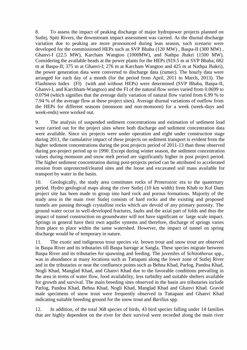
8. To assess the impact of peaking discharge of major hydropower projects planned on
Sutlej, Spiti Rivers, the downstream impact assessment was carried. As the diurnal discharge
variation due to peaking are more pronounced during lean season, such scenario were
developed for the commissioned HEPs such as SVP Bhaba (120 MW) , Baspa-II (300 MW) ,
Ghanvi-I (22.5 MW), Karcham Wangtoo (1000MW), and Nathpa Jhakri (1500 MW).
Considering the available heads at the power plants for the HEPs (919.5 m at SVP Bhaba; 682
m at Baspa-II; 375 m at Ghanvi-I; 276 m at Karcham Wangtoo and 425 m at Nathpa Jhakri),
the power generation data were converted to discharge data (cumec). The hourly data were
arranged for each day of a month (for the period from April, 2011 to March, 2013). The
Flashiness Index (FI) (with and without HEPs) were determined (SVP Bhaba, Baspa-II,
Ghanvi-I, and Karchham-Wangtoo) and the FI of the natural flow series varied from 0.0699 to
0.0794 (which signifies that the average daily variation of natural flow varied from 6.99 % to
7.94 % of the average flow at these project sites). Average diurnal variations of outflow from
the HEPs for different seasons (monsoon and non-monsoon) for a week (week-days and
week-ends) were worked out.
9. The analysis of suspended sediment concentrations and estimation of sediment load
were carried out for the project sites where both discharge and sediment concentration data
were available. Since six projects were under operation and eight under construction stage
during 2011, the cumulative impact of these projects on sediment transport is evident from the
higher sediment concentrations during the post projects period of 2011-13 than those observed
during pre-project period up to 1990. Except during winter season, the sediment concentration
values during monsoon and snow melt period are significantly higher in post project period.
The higher sediment concentration during post-projects period can be attributed to accelerated
erosion from unprotected/cleared sites and the loose and excavated soil mass available for
transport by water in the basin.
10. Geologically, the study area constitutes rocks of Proterozoic era to the quaternary
period. Hydro geological maps along the river Sutlej (10 km width) from Khab to Kol Dam
project site has been made to group into hard rock and porous formations. Majority of the
study area in the main river Sutlej consists of hard rocks and the existing and proposed
tunnels are passing through crystalline rocks which are devoid of any primary porosity. The
ground water occur in well-developed fractures, faults and the axial part of folds and thus the
impact of tunnel construction on groundwater will not have significant or large scale impact.
Springs in general have their own aquifer systems and therefore, discharge of springs varies
from place to place within the same watershed. However, the impact of tunnel on spring
discharge would be of temporary in nature.
11. The exotic and indigenous trout species viz. brown trout and snow trout are observed
in Baspa River and its tributaries till Baspa barrage at Sangla. These species migrate between
Baspa River and its tributaries for spawning and feeding. The juveniles of Schizothorax spp.,
was in abundance at many locations such as Tattapani along the lower zone of Sutlej River
and in the tributaries or near the confluence points such as Behna Khad, Parlog, Pandoa Khad,
Nogli Khad, Manglad Khad, and Ghanvi Khad due to the favorable conditions prevailing in
the area in terms of water flow, food availability, less turbidity and suitable shelters available
for growth and survival. The main breeding sites observed in the basin are tributaries include
Parlog, Pandoa Khad, Behna Khad, Nogli Khad, Manglad Khad and Ghanvi Khad. Gravid
male specimens of snow trout were frequently observed in Tattapani and Ghanvi Khad
indicating suitable breeding ground for the snow trout and Barilius spp.
12. In addition, of the total 368 species of birds, 43 bird species falling under 14 families
that are highly dependent on the river for their survival were recorded along the main river

and tributaries. Most of these bird species depends on aquatic fauna especially fishes as their
food source (e.g., Crested Kingfisher, Grey Heron, Little Egret, Large Egret, Great
Cormorant, Lesser Pied Kingfisher, Pallas’s Fish-eagle and White-breasted Kingfisher).Thus
the life cycle of avian, aquatic flora and fauna along downstream of Sutlej is closely linked
availability of the habitat. Further, Pinus gerardiana-Forest type 13/C2a Neoza Pine an
important tree grows naturally in the upper catchments of Sutlej River basin. It is harvested as
a community resource and right. The total forest group covering an area of 120.68 sq.km is
available only in Himachal Pradesh, of which 115.86 sq.km occur in Sutlej basin mainly in
the Kashang, Nesang, Rala, Roura, Sorang and Wanger Sub-catchments.
13. The report covered a detailed cumulative impact assessment of individual and all 38
hydroelectric project undertaken for the study with respect the valued Ecosystem Components
such water quality, water resources, sediment, environment flow, area of submergence,
flashiness, flow in diverted stretch of the river, land use changes ,terrestrial flora , fauna,
avian fauna including terrestrial & water birds , forest produce , aquatic ecology,
socioeconomic and downstream impacts; followed by recommendations for integrated
management plan with institutional mechanism for sustainable hydropower development in
the basin.
(i) For sustainable and optimal ways of hydropower development in the basin, projects which
are located in highly fragile areas, ecologically sensitive, socially important area are given
in the following table. Four projects including those indentified and formulated fall within
Spiti -Cold Desert Biosphere Reserve in Trans Himalayan part of Sutlej basin acting as a
corridor for the western Himalayan wild fauna. For such landscape, statuaries clearances
from relevant authorities may be obtained before proceeding for development of these
projects.
SNo Project Capacity
(MW)
Cold Desert
Biosphere Reserve
1 Yangthang Khab (UI) 261 Spiti river
2 Lara Sumta (UI) 104 Spiti river
3 Sumte-Kothang (UI) 130 Spiti river
4 Chango Yangthang (IP) 140 Spiti river
The total installed Capacity for
38 HEP under study is 8415.1
MW
635
(ii) There are ten (10) protected areas within the study area of Sutlej basin. Of which Kibber
Wildlife Sanctuary and Pin Valley National Park falls in Trans Himalayan region. Lippa-
Asrang Wildlife Sanctuary, Rakchham-Chitkul Wildlife Sanctuary and Rupi-Bhabha
Wildlife Sanctuary in Kinnaur District. Daranghati-I&II Wildlife Sanctuary, Majthal
Wildlife Sanctuary, Darlaghat Wildlife Sanctuary falls within Solan and Shimla. Great
Himalayan National Park in Kullu and Bandli Wildlife Sanctuary in Mandi.
(iii) The WLS and the NP in Trans Himalaya; the WLS and NP in Greater Himalaya act as
corridor for the entire landscape in the upper Spiti and Sutlej River during harsh climatic
conditions. An eco sensitive zone of 10 km was considered to assess the influence zone
with the individual HEPs. For the study 10 km radius (aerial distance) from the barrage
sites were considered and are presented below:
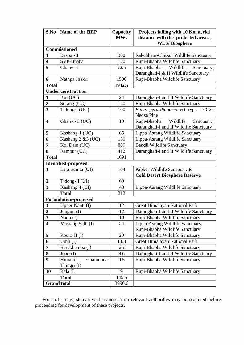
S.No Name of the HEP Capacity
MWs
Projects falling with 10 Km aerial
distance with the protected areas ,
WLS/ Biosphere
Commissioned
1 Baspa -II 300 Rakchham-Chitkul Wildlife Sanctuary
4 SVP-Bhaba 120 Rupi-Bhabha Wildlife Sanctuary
5 Ghanvi-I 22.5 Rupi-Bhabha Wildlife Sanctuary,
Daranghati-I & II Wildlife Sanctuary
6 Nathpa Jhakri 1500 Rupi-Bhabha Wildlife Sanctuary
Total 1942.5
Under construction
1 Kut (UC) 24 Daranghati-I and II Wildlife Sanctuary
2 Sorang (UC) 150 Rupi-Bhabha Wildlife Sanctuary
3 Tidong-I (UC) 100 Pinus gerardiana-Forest type 13/C2a
Neoza Pine
4 Ghanvi-II (UC) 10 Rupi-Bhabha Wildlife Sanctuary,
Daranghati-I and II Wildlife Sanctuary
5 Kashang-1 (UC) 65 Lippa-Asrang Wildlife Sanctuary
6 Kashang 2 &3 (UC) 130 Lippa-Asrang Wildlife Sanctuary
7 Kol Dam (UC) 800 Bandli Wildlife Sanctuary
8 Rampur (UC) 412 Daranghati-I and II Wildlife Sanctuary
Total 1691
Identified-proposed
1 Lara Sumta (UI) 104 Kibber Wildlife Sanctuary &
Cold Desert Biosphere Reserve
2 Tidong-II (UI) 60
3 Kashang 4 (UI) 48 Lippa-Asrang Wildlife Sanctuary
Total 212
Formulation-proposed
1 Upper Nanti (I) 12 Great Himalayan National Park
2 Jongini (I) 12 Daranghati-I and II Wildlife Sanctuary
3 Nanti (I) 10 Rupi-Bhabha Wildlife Sanctuary
4 Masrang Selti (I) 24 Lippa-Asrang Wildlife Sanctuary,
Rupi-Bhabha Wildlife Sanctuary
5 Roura-II (I) 20 Rupi-Bhabha Wildlife Sanctuary
6 Umli (I) 14.3 Great Himalayan National Park
7 Barakhamba (I) 25 Rupi-Bhabha Wildlife Sanctuary
8 Jeori (I) 9.6 Daranghati-I and II Wildlife Sanctuary
9 Himani Chamunda
Thingri (I)
9.5 Rupi-Bhabha Wildlife Sanctuary
10 Rala (I) 9 Rupi-Bhabha Wildlife Sanctuary
Total 145.5
Grand total 3990.6
For such areas, statuaries clearances from relevant authorities may be obtained before
proceeding for development of these projects.
(iv) In addition, it is recommended that the hydropower projects fall within 10 km radius of
the protected area may also be brought under the purview of the EIA notification so that
their impacts are adequately addressed and mitigated/managed.
(v) On the main river Sutlej there are two commissioned projects. In addition two under
construction in 2012 (are commissioned as on date), further three projects above Karcham
Wangtoo and one downstream of Rampur i.e., upstream of Kol dam have been proposed.
Altogether 8 projects on main Sutlej River will affect 92 % of river stretch. It is suggested
to re assess the projects for alternative sites or to enhance FRL of few projects and
dropping one or two projects to reduce percentage of river stretch affected/fragmented.
In addition, the following distance has been recommended to maintain distance
between projects that are made based only on dissolved oxygen as criteria:
for HEPs located
above 2000 m MSL - a distance of 500 m
between 2000 – 1000 m MSL - a distance of 1.0 km
between 1000 – 500 m MSL - a distance of 2.0 km
for below 500 m MLS - a distance of over 3.0 km
(vi) River /tributary wise operation guiding mechanism for storing and releasing of water to
the river needs to be ensure to maintain riparian ecology. It is recommended that a
comprehensive study be conducted to explore various alternatives and work out techno-
economic feasibility for regulation of the peaking discharge in Sutlej basin. To mitigate
the peaking impacts with respect to diurnal operation, mitigation measures need to be
studied in detail separately including their technical and financial viability. However, the
recommended EFR will reduce the impact of peaking.
(vii) The lower stretch of Sutlej basin supports good spawning and breeding ground for fishes
(ex. Ganvi khad, Manglad khad, Behna Khad, Nogli Khad, Tattapani etc). However, they
do not fall under any category of endangered or critically endangered species. However,
it is recommended to maintain fish stock through in situ conservation or through
establishment of hatcheries.
(viii) Presence of rare fish species of the region, Diptychus sps endemic to Western Himalayan
rivers need be ascertained with utmost care.
(ix) Altitudinal distribution of fish species in the river need be mentioned to justify the
presence of coldwater and warm water fishes in the river.
(x) The e-flow should be assessed on the basis of specific habitat requirements of the
available fish species during spawning, migration and nursery rearing.
(xi) Besides free flowing stretch between two projects, the peaking discharge, likely impacts
of peaking on downstream water quality; biota and fisheries; and mitigation measures
should also be suggested.
(xii) Dissolve oxygen has been attempted to determine the free flowing stretch between two
projects. Since dissolve oxygen alone is not a limiting factor in distribution of fish species
in the mountain waters, therefore some other physic-chemical, biotic /fisheries or related
parameters should also be assessed under the study.
(xiii) Impact of tunnel construction on groundwater are mostly temporary and on local scale.
There should be planned programme under the hydro projects to collect spring and stream
discharge data of pre and post construction period of tunnel on long term basis to asses
such impacts.
(xiv) For Future meteorological, hydrological and sediment data and trend analysis, it is
suggested that:
Meteorological observatory within the study area for analyzing the future trend in
climate especially with reference to hydropower or any specific development on
agriculture, horticulture and forest be established.
Adequate number of stream gauging stations at appropriate locations within the study
area for systematic data observation and assessments of actual flow and changes be
established
For analysing the impact of HEPs on sediment load, monitoring be made mandatory
and be initiated well before the start of construction of each HEP as well as develop
framework for documentation on accumulation of sediment upstream of the HEP for
regular measurement and stabilization.
(xv) Ensure the proposed installed capacity be planned in conformity with the water available
and other water use after satisfying the needs of environmental flow. To mimic natural
variations in flow regime ensure recommended variability in environmental flows should
be maintained. For commissioned projects, long-term research should be initiated to
assess the impact due to EFR on aquatic life and terrestrial riparian flora/agriculture
/horticulture crop. So that such findings will help in standardising appropriate
methodologies for estimation of EFR to suit the requirements and availability of resources
that vary from project to project in Indian basins.
(xvi) A detailed study has been recommended to assess changes in spring discharges due to
hydropower development to ensure the water availability especially along the
tributaries/Khad/streams as they are the most important sources for irrigation and drinking
water rather than the main river Sutlej.
(xvii) It is recommended to ensure implementation of national /state specific legislations
(Panchayat Extension to Scheduled Areas Act, 1995), the scheduled Tribes and other
Forest Dwellers Recognition of Forest Rights Act, 2006 and other State legislations
pertaining to alienation of tribal land etc. Consent from the concerned Gram Sabhas or the
Panchayats or the autonomous District Councils at the appropriate level in the Scheduled
Area as per the Fifth Schedule of the Constitution as per the Right to Fair Compensation
and Transparency in Land Acquisition, Rehabilitation and Resettlement (RFCTLARR)
Act, 2013 for the new projects.
(xviii) It is recommended for timely implementation of schemes through LADF, a process for
transparency in expenditure of LADF as prescribed in Government of Himachal Pradesh
notification dated 5th October 2011 be followed. The present situation about already
commissioned HEPs is not clear and there is considerable discontentment among the
public. The same may be clarified under the communication strategy developed by the
Government of Himachal Pradesh.
(xix) Recommended to establish Basin Management Unit (BMU) with adequate infrastructure,
human resources to coordinate and guide the hydropower developers’ forum for
hydropower development in the basin.
(xx) In addition, general recommendations have been also made for various environmental
components such as the geology, land use changes, meteorology, hydrology, water
resources, water quality/water use, soil erosion, sedimentation, muck disposal, terrestrial
flora/fauna, aquatic ecosystems, environmental flow requirements, flashiness, socio-
economic environment and benefit sharing.
(xxi) A number of mitigation and monitoring measures are proposed to minimize potential
cumulative impacts on the selected Valued Environmental Components. Such measures
has been recommended to be developed and implemented within a framework of a
cumulative impact management through integrated approach with shared responsibility of
the project proponents. To achieve this, an institutional framework involving various
stakeholders such as state departments, expert institutions & local people have been
proposed under the basin management for the parameters outlined for implementation. In
addition general recommendations on various parameters are outlined in the report.
After detailed deliberation, the committee observed the following:
i. All hydroelectric projects <10 MW in Sutlej basin be also included in the CEIA study.
List of such all hydroelectric projects in Sutlej basin be procured from Directorate of
Energy, Department of Energy, Government of Himachal Pradesh for purpose to
include in the CEIA study of Sutlej basin. (Director, IA Div, MoEF&CC)
ii. The proposed Luhri stage-I, II & III hydroelectricity project be also included in the
CEIA study instead of Luhri project (775MW) conducted before. (Director, IA Div,
MoEF&CC)
iii. Factors determining riparian distance between two cascading projects presented be
relooked considering the slope than altitude. In addition suggested for logical frame
work to calculate the distance between two cascading hydroelectric projects and apply
the same to the individual project under study
iv. Recommendation for dropping of the any project should be based on scientific and
logical reasoning framework supported with index methodology. For this EAC
advised that index methodology developed by NEHU can be referred.
v. Review the depth range ( m) provided for fish
vi. For assessing the Environmental Flow Requirement ( EFR) fish is not the only criteria,
thus other important criteria be used for calculating the EFR methodology
vii. Critical habitat for wildlife fall within any specific project be included in the report
(WII)
2nd
day (9.2.2016)
Agenda Item 2.8 Baspa Stage-II Hydroelectric Project (300 MW), Himachal Pradesh -
Transfer of EC to M/s. Himachal Baspa Power Company Limited
The project proponent had made a detailed presentation on the project. Baspa Stage-II
Hydroelectric Project (300 MW) is located in District Kinnaur, Himachal Pradesh. This is a
run-of-the-river scheme on river Baspa. The Environmental Clearance (EC) was accorded to
the project on 17th
December, 1993 to Himachal Pradesh State Electricity Board, Shimla.
During the year 1996, the EC was transferred in favour of M/s. Jaiprakash Hydro Power
Limited (JHPL)and later in the year 2009, to M/s. Jaiprakash Power Ventures Limited
(JPVL).
2. The project was considered by EAC in its meeting held on 22-23rd
December, 2015.
The committee noted that in pursuance to the Hon’ble High Court of Himachal Pradesh,
Shimla order dated 25th
June, 2015, it was informed by M/s. Jaiprakash Power Ventures Ltd
mentioned that the Project has now been transferred to M/s. Himachal Baspa Power Company
Limited (HBPCL) w.e.f. 1.9.2015 and a request was made therein to transfer the EC already
accorded in the name of M/s. Himachal Baspa Power Company Limited (HBPCL).
3. The project proponent informed that as per the discussion during the 90th
EAC
meeting, following documents / data were submitted to Ministry and the same have been
presented during the meeting:
i) Affidavit for change of name on non-judicial stamped paper by M/s. Jaiprakash Power
Ventures Limited & M/s. Himachal Baspa Power Company Limited for transfer of
Environmental Clearance
ii) Deed partnership agreement and a copy of Hon’ble High Court order dated
25.6.2015
iii) Public Notice issued for change of name – Daily news paper (in English/local paper)
iv) Copy of the latest 6 monthly compliance report
4. Considering the submissions by the Project Proponent, EAC was of the view that the
EC already granted to the Project can be transferred in the name of M/s. Himachal Baspa
Power Company Limited (HBPCL).
Agenda Item 2.8 A Dhauliganga Intermediate HE Project (225 MW) in Uttarakhand
by M/s NHPC Ltd. – for consideration of TOR.
The project proponent made a detailed presentation on the project. The project is a run
of the river scheme proposed near Nyu village on river Dhauliganga, a tributary of river Kali.
The project envisages construction of a 106 m high concrete dam across Dahauliganga river
for generating 225 MW of hydropower. An underground powerhouse proposed near Khet
village with 3 units of 75 MW each. Total submergence area is about 49.22 ha. Tentative land
requirement for the project is about 155 ha, out of which about 138 ha is forest area and about
17 ha is Revenue / Private land. It was also noted that some component of the project falls
under Askot Wildlife Sanctuary (AWLS). It was informed by NHPC that NBWL clearance
for the project is available. However, EAC enquired about the validity of NBWL clearance as
the clearance was accorded to the project in 2006 and the boundary of AWLS has been
revised in 2013. It was noted that Dam of the project falls in the revised boundary of AWLS.
Project proponent mentioned that the aspect of validity of the already obtained NBWL
clearance and Hon’ble Supreme Court directions shall be clarified from the competent
authority and if necessary, NHPC will apply for fresh NBWL clearance for the project.
2. The EAC was informed that Hon’ble Supreme Court in its order dated 13.8.2013
imposed ban on hydropower project and also has inter-alia, directed Ministry of Environment,
Forest & Climate and Government of Uttarakhand not to take-up any new project for
environmental and forest clearances in Uttarakhand till further orders. However, Hon’ble
Supreme Court in its order dated 12.10.2015 imposed ban on hydropower projects has been
lifted other than those of 24 hydropower projects mentioned in the report of Wildlife Institute
of India, Dehradun. Therefore, the project has been submitted for consideration for
Scoping/TOR clearance.
3. The Committee was informed that the water availability series for the project has been
developed for the period 1983-2015. Clearance from CWC/other agencies shall be obtained
during DPR preparation stage.
4. The EAC noted that there will be no major displacement of human population due to
construction of the project. Videography of the project area (Dam and Powerhouse site) was
also shown to the committee. Geological section and plan along the proposed dam axis and
powerhouse site were also shown. It was noted by the committee that at the proposed dam
axis, Phyllitic Limestone rocks are exposed along both the abutments. The valley in the
upstream of the of the proposed Dam axis widens up and exhibits favourable condition for
storage of water.
5. EAC directed that Skill mapping of the area be undertaken during the EIA & EMP
studies and a separate chapter be provided in the report, assessing the manpower requirement
of the project to accommodate the locals in the project during construction.
After detailed deliberations, the EAC requested the project proponent to (a) get
clarifications from competent authority on the validity of the already obtained NBWL
clearance in the light of revised notification of the Askot WLS and (b) the fulfillment of the
conditions specified by MoEF & CC vide letter dated 6.7.2006 and as directed by the Hon’ble
Supreme Court in this regard.
Agenda Item 2.9 Umngot HE Project (240 MW) in Meghalaya by M/s Meghalaya
Power Generation Corporation Ltd. - for consideration of TOR.
The project proponent made a detailed presentation on the project. It was noted that
the project was considered by EAC in its meeting held on 16-17th
October, 2014. The
committee noted that the Public Hearing was conducted after the ToR validity was over. The
EAC therefore, did not consider the proposal. The State Government was advised to apply for
a fresh ToR.
The Chief Engineer, MeECL submitted a fresh application for TOR of the Umngot
HEP (3 x 70MW) and the same has been presented before the EAC that the parameters of the
project remains the same as in the earlier proposal which was presented to MOEF except the
installed capacity of the project which has been brought down to 210 MW from 240 MW due
to consideration of environment flows. The committee appreciated that the latest norms of e-
flow have been followed while making study and accordingly for a downward capacity
reduction in the project to 210 MW
After detailed deliberations, the committee accepted the application of fresh TOR and
recommended TOR clearance for the project and also insisted that the public hearing would
have to be conducted again.
Agenda Item 2.10 Ken-Betwa interlinking Project in Districts Panna & Chatarpur,
Madhya Pradesh by Water Resources Department, Government of
Madhya Pradesh & M/s National Water Development Agency – for
consideration of Environmental Clearance (EC).
The project proponent made a detailed presentation on the project. It is noted that the
project envisages construction of 77 m high and 2031 m long composite dam across river
Kenr near village Daudhan in the District Chhatarpur in Madhya Pradesh to irrigate 6.35 lakh
ha area of land, drinking water purposes and generation of 78 MW hydropower. The project
comprises of two powerhouse of 2 x 30 MW & 3x6 MW each, two tunnels of 1.9 Km long
upper level, 1.1 Km long tunnel lower level &. A 221 Km long Ken-Betwa link canal has
been proposed on the left bank of the river. The project will provide irrigation facilities for
6,35,661 ha of area in Panna, Chhattarpur, Tikamgarh Districts, Madhya Pradesh and Banda,
Mahoba and Jhansi Districts in Uttar Pradesh. The culturable command area (CCA) is
5,15,215 ha. Total submergence area is 9000 ha out of which 5258 ha is forest land (includes
4141 ha Panna Tiger Reserve). A total of 10 villages consisting of 1585 families are likely to
be affected by this project. Panna Tiger Reserve falls within 10 Km radius of the project. The
total cost of the project is about Rs. 9393 Croes and proposed to be completed in 9 years.
2. The project was considered by EAC in its meeting held on 24-25th
August, 2015 and
on 26-27th
October, 2015. The committee observed that the Landscape Management Plan
(LMP) is being prepared by WII, Dehradun in absence of a plan, the committee cannot
examine the proposal. EAC also mentioned, after completion of plan, obtaining a second
opinion on the LMP from external expert the project will be reconsidered again for EC and
also handed over 4 representations received from NGOs/ Environmentalists including that of
former Secretary, Government of India Shri EAS Sarma to project proponent for compliance.
3. The project proponent submitted the compliance report to the observations of EAC
along with concept LMP received from WII detailing the activities to be undertaken for the
development of LMP simultaneously during the construction and it’s monitoring in the post
project scenario. The replies to the points raised by the NGOs/Environmentalists were also
submitted and presented before EAC on 9.2.2016.
4. The committee was informed by the project proponent that the project has been
approved by the State Wildlife Board. The committee noted that the director of the Panna
tiger reserve had not recommended the project, as per the agenda of the Board meeting and
the board had over-ruled him and approved the project without recording detailed reasons for
such rejection.
5. Comments of HS Kingra Vice Chairman and member of the Committee are as
follows: The matter related to the effect of the Ken-Betwa project on Panna Tiger Reserve
(PTR) and the breeding ground for vulture was discussed in the 91st meeting of the EAC. It
was seen that submergence of 4141Hact of the PTR is a serious issue and need to be studied
by some independent expert committee and the findings of such committee be placed before
the MP State Wild Life Board (MPSWLB) and NBWL. The agenda related to the clearance
by MPSWLB was perused and it was noted that in the agenda notes the then director PTR did
not recommend in favour of submergence of huge area of PTR and loss of breeding habitat
for the vultures. State Chief Wild Life Warden (SCWLW) Mr. Ravi Kumar IFS also agreed
with the views of the then Director PTR and endorsed his views without any modification.
How and what expertise the MPSWLB had over and above the technical advice rendered by
Director PTR and SCWLW of MP is not clear from the minutes or agenda notes place before
the MPSWLB. It is understood that as per convention and the extant Rules of Business of the
State Government the SCWLW must be the chief technical advisor to the Government of MP
on matters related to Wild Life. How the board overruled the advice of SCWLW is not
properly recorded in the minutes of the Board meeting. It is therefore opined that an
independent committee of three experts be constituted by the Ministry of Environment, Forest
& Climate Change in consultation with the EAC to give specific recommendations related to
submergence of PTR Core area and the habitat loss for breeding of vultures. It is then only
that the project can be considered for Environment Clearance.
6. After detailed deliberations, the EAC accepted the views expressed by the Mr.
H.S.Kingra, Vice-Chairman and member of the committee and considered the compliance
report submitted by the project proponent and decided that the project will be considered for
Environmental Clearance (EC) only after wildlife clearance of the project is obtained from
NBWL in the manner proposed by Mr. Kingra. The project proponent may submit again the
proposal for EC along with the decisions of NBWL.
Agenda Item 2.11 Upper Krishna Irrigation Project by M/s Krishna Bhagya Jala
Nigam Limited, Government of Karnataka - for consideration of
Amendment to Environmental Clearance (EC).
The project proponent made a detailed presentation on the project. The Upper Krishna
irrigation project proposed across Krishna river to provide irrigation facility for drought prone
areas of Bijapur, Bagalakot, Kalaburgi, Yadagir and Raichur Districts in northern Karnataka.
The project involves 2 major dams near Alamatti and Narayanapur to facilitate the irrigation
and also in generation of electricity. The Upper Krishna project was executed in 2 stages. viz.,
Stage-I of the project is irrigating 4,24,903 ha by utilizing 119 TMC of water. The gross
command area (GCA) of Stage-I is 5,49,000 ha. Similarly, Stage-II of the project is irrigating
1,97,120 ha.
2. The environmental clearance (EC) for Upper Krishna project Stage-I (Phase-II) was
accorded on 5.4.1989 and subsequently Stage-I (Phase-III) of the project was accorded EC on
18.7.2000 with the command area of 4,24,903 ha. In order to utilize the allocated water of 54
TMC as per Krishna Water Dispute Tribunal, the dam height was increased from 512.256 m
to 519.60 m to provide irrigation facilities for 1,97,120 ha. For this, Environmental Clearance
was obtained by the KBJNL on 4.10.2000.
3. The EAC noted the efforts of KBJNL for the Rehabilitation and Resettlement works,
Compensatory Afforestation, Canal Bank plantation and compliance to environmental
clearance conditions undertaken under Upper Krishna Stage-I and II. Further the KBJNL
stated that it has initiated water conservation measures by adopting Govt. of India program on
'National Water Mission (NWM)' as a part of National Action Plan for Climate Change. The
main objective of NWM is conservation of water and minimizing wastage and ensuring its
more equitable distribution both across and within states through 'Integrated Water Resource
Development and Management (IWRM)'. As part of the program, KBJNL has decided to
reduce the present irrigation intensity of Upper Krishna Project Stage-I and II from 108%,
115% to 100% and through which 20.97 TMC of water will be conserved.
4. Due to the persistent demands of adjoining farmers within the gross command area
and people representatives, it is proposed to take up modernization works with the available
modern technology by utilizing 17.78 TMC of conserved water with in the gross command
area of Upper Krishna project Stage-I and II without constructing any obstructions across the
Krishna river. This modernization proposal involves four sub-projects namely;
S.
No
Name of the
scheme
Water
allocation
Command
area
Mode of
irrigation
Benefitting villages
and Taluks
1 Thimmapur LIS 4.41
TMC
20100 ha Conventional 36 villages of Bagalkot
and Hungund Taluks of
Bagalkot District
2 Ramthal (Marol)
LIS
5.84
TMC
38000 ha Conventional
& Drip
83 villages of Hungund
Taluk of Bagalkot
District
S.
No
Name of the
scheme
Water
allocation
Command
area
Mode of
irrigation
Benefitting villages
and Taluks
3 Budihaal-
Peerapur LIS
3.78
TMC
20243 ha Conventional 42 villages of
Muddebihal and
SindagiTaluks of
Bijapur District
4 Nandawadagi
LIS
3.75
TMC
36100 ha Drip 86 villages of Hungund
Taluk of Bagalkot
District and Lingasugur
Taluk of Raichur
District
5. The committee was informed that the above proposal involves construction of intake
canal, Jack well-cum-pump house, raising main and distributory network only. The
modernization works neither involves Submergence nor Rehabilitation & Resettlement.
Further, there are no ecologically sensitive area, national parks, wildlife sanctuaries in the
command area and no forest land is required to implement the schemes. The modernization
works has following advantages to the region;
i. Agro linkages will be considerably improved due to the project in the command area.
ii. It allows a greater area of land to be used for crops in areas where rain fed production
is impossible or marginal.
iii. Extensive agricultural production supplies raw materials to the nearby small scale
industries thereby increasing the economy in the region.
iv. Increased groundwater recharge; reduction in opportunity costs of water uses.
v. Increased environmental benefits of water for in-stream flows, wildlife, flora and
fauna; increased farm forestry and vegetation in irrigated areas.
vi. Positive impact on poverty reduction through increased productivity and increased
employment opportunities
vii. It improves dairy farming.
viii. The increased labor opportunities for women will increase the household income in
turn resulting in the greater power of women in the household.
6. The modernization works also involves providing drip irrigation facilities for 60,100
ha within the gross command area. Due to the adoption of drip irrigation, there will be
reduction of water logging, reduction in land acquisition and no tree cutting will happen. It
also ensures equitable distribution of water to the beneficiaries, increased agricultural yield
compared to conventional method, savings in fertiliser and power. The muck generated
during these works will be reused for various works such as service road, inspection paths,
embankments, land levelling, filling trenches, etc.
7. After detailed deliberation, the committee is of the opinion that, the modernization
works are within the gross command area of Upper Krishna Project Stage-I & II which was
accorded Environmental Clearance by MoEF previously and doesn't envisage construction of
any major structures. However, involves construction of intake canal, Jack well-cum-pump
house, raising main and distributory network only. Therefore, the following Terms of
Reference is proposed;

i. One season baseline data collection shall be undertaken in the additional command
area (within the Gross Command Area) for various environmental components.
ii. Based on the above, draft EIA report shall be submitted to Karnataka State
Pollution Control Board for conducting Environmental Public Consultations in
three Districts viz. Bagalakot, Bijapur and Raichur.
Agenda Item2.12 Kotha Barrage Major Project, Vidisha (M.P) by M/s Bureau of
Design (Bodhi) Water Resources Department, Government of
Madhya Pradesh - for consideration of TOR.
The project proponent did not attend the meeting. Therefore, the EAC has not
considered the project and deferred the project.
Agenda Item2.13 Kurung HEP (330MW) in Kra Daadi District of Arunachal Pradesh
by M/s North Eastern Electric Power Corporation Ltd. - for
consideration of TOR.
The project proponent made a detailed presentation on the project. The project is
located near Muiri village in Kra Daadi district of Arunachal Pradesh. The project envisages
harnessing the power potential of Kurung River utilizing the pondage created by the
construction of 140 m high concrete dam near village Muiri and the Power House-1
(2x140MW) situated on the right bank of the river and Power House-2 (2x25MW) situated
on the left bank of the river near dam toe. The dam shall be constructed across river Kurung.
2. The total land requirement for the project is about 2217.50 ha. The quantum of Forest
land and non forest land to be acquired is 1505 ha and 712.5 ha respectively. The total land to
be acquired for the project including Forest land will be finalized during DPR stage
investigations. The salient features of the project are as follows:
A concrete gravity dam of 140m high from the deepest foundation level with
spillway comprising of 3 bays Spillway radial gate of size 10.00m (W) x 14.00m (H) to
pass the design flood of 8458 cumec.
2 numbers of 9.0m dia modified horse shoe shaped concrete lined Diversion
Tunnels with lengths 600m and 627m respectively.
Power Intake with Bell Mouth type trash rack on the right bank and left bank for PH-1
and PH-2 respectively.
Two numbers of circular Penstock of 6.5m dia each of 145m long feed two turbine units
of PH-1 on right bank.
Two numbers of circular Penstock of 2.8m dia and each of 150m long feed two
turbine units of PH-2 on left bank.
PH-1 of 77.925m (L) x 42.0m (W) x 54.0m (H) housing two Vertical Axis Francis
Turbines and Generator units of 140 MW each.
PH-2 of 55.585m (L) x 23.15m (W) x 40.5m (H) housing two Vertical Axis Francis
Turbines and Generator units of 25 MW each.
Tail race channel for PH-1 of 35m wide and 150m long and tail race channel for PH-2 of
25m wide and 50m long to discharge the water into the river
4. After deliberations, EAC recommended the project for ToR clearance with the
following additional TORs:
(i) Skill mapping in various phases of proposed project
(ii) Environmental Flows shall be released as per the recommendations of the
approved Cumulative Impact and Carrying Capacity Study of Subansiri Sub Basin
including Downstream Impacts Report
(iii) Faunal survey to be done using camera trapping method.
(iv) To maintain flourishing fish population/communities in the river, the river must
witness all seasonal changes including low flow levels during lean season to
maximum during monsoon/floods/high rains.
Agenda Item 2.14 Reoli – Dugli HEP (420 + 9.2 MW), located in Lahaul & Spiti District
of Himachal Pradesh by L&T Himachal Hydropower Limited - for
consideration of extension of TOR.
The Reoli Dugli HEP is proposed to be developed on Chenab River in Lahaul-Spiti
District of Himachal Pradesh. The project is envisaged as a run-of-the-river scheme in the
upper reaches of Chenab river A concrete gravity dam is proposed and underground power
house with an installed capacity of (420+9.2) MW immediately downstream of the dam. Out
of this 420 MW is proposed to be generated by the main powerhouse, whereas 2 units of 4.6
MW each are proposed to be installed to utilize the mandatory environmental releases. The
catchment area intercepted at the dam site is 6155 sq. km.
2. The TOR for Reoli Dugli HEP was issued TOR on 12th
March, 2013 which was
further extended for one year is valid up-to 11th
March, 2016. The EIA/EMP Report has been
submitted to Himachal Pradesh State Pollution Control Board (HPSPCB) on 18th
July 2015.
Subsequently muck management plan too has been presented on 9th
October, 2015 and the
same has been accepted by HPSPCB.
3. It was informed that due to extreme weather conditions at the site and limited
accessibility, the HPSPCB has decided to hold the public hearing in next working season i.e.
in between June-November, 2016.
4. The EAC observed the background for the request of the project proponent for
extension of validity of ToR for one year and recommended the extension of validity of TOR
till 11.3.2017.
Agenda Item 2.14A North Koel Project, Tehsil Kandi District Garhwa, Jharkhand by
M/s. Water Resources Department, Government of Jharkhand --
for re-consideration of TOR.
The project proponent made a detailed presentation on the project. The project is
proposed for installation of gates on Mandal Dam (District Latehar) and remaining work of
canal network (District Garhwa, Palamau, Gaya, Aurangabad) and Mohammabdganj barrage
(district Palamau) which were constructed before 1994. The Mandal dam falls in Palamu
Tiger Reserve. The sight was visited by National Tiger Conservation Authority and
recommended 4 m height reduction in F.R.L. The total culturable command area with this
revision is 87480 ha. With the recommendations of NTCA for height reduction, the project
envisages installation of Gates (11mx15m) on Mandal dam which will be 63.86 m in height
(F.R.L.). Almost 90% of the components of the barrage and canals have been completed and
are functional.
2. The estimated cost of the project is 1289.50 crores. About 0.82 MAF of water will be
shared after completion of the project between Bihar and Jharkhand. The proposal will
submerge around 17 villages partially which are settled in the upstream of dam. Also, after
this reduction in height, around 4253.68 ha core area of Palamau Tiger Reserve will be
submerged.
3. The project was considered by EAC in its meeting held on 23-24th
September, 2015.
After detailed deliberations, the EAC observed that since the proposed project has been
constructed prior to 1994 hence the construction made till date does not fall in violation case.
The dam construction was started around 40 years back to provide water for irrigation in the
region which has faced 10 major famines in this century.
4. The committee directed the project proponent to place before the committee the
complete background of the project. The extent of work already executed and the status of
applications made by the project proponent to seek forest clearance and NOC from National
Tiger Conservation Authority or any such body which regulates such wild life sanctuaries.
The project proponent further should clearly indicate the additional activity now required to
be done for which they are seeking Environment Clearance. In addition the Project Proponent
has to submit the NOC from concerned departments of the state governments of Bihar and
Jharkhand on sharing of waters of North Koel River for the project.
5. The project was reconsidered by EAC in its meeting held on 8-9th
February, 2016.
The project proponent intimated that environmental clearance was accorded to this project in
1984, which was not informed earlier. A copy of EC was submitted during the meeting.
6. However, during the deliberations, EAC was informed that the project falls in the core
area of the Tiger Reserve. Accordingly, the Project proponents were informed to obtain the
clearance from Wildlife Department and to obtain NOC from Palamau Tiger Reserve and
clearance from NBWL.
7. As far as the EC is concerned, a fresh / amended EC is not required for the project.
The Project proponent has to formally make a request to the Ministry for clarification in this
regard.
Agenda Item 2.14B Cumulative Impact Assessment & Carrying capacity Study (CIA &
CCS) of Kameng River Basin Study in Arunachal Pradesh.
The project proponent made a detailed presentation on Cumulative Impact Assessment
& Carrying capacity Study (CIA & CCS) of Kameng River Basin Study in Arunachal
Pradesh. The Study of Kameng sub-basin in Arunachal Pradesh was initiated at the instance
of Ministry of Environment, Forest & Climate Change, Government of India. The Kameng
sub-basin was awarded to WAPCOS Limited and scope of the study covered HEPs for entire
Kameng Basin (excluding Bichom). In the EAC meeting held in August 2015, it was
suggested that Basin Study be conducted using ZSI-BSI data and one season be conducted in
monsoon season.
2. The Kameng river basin covers almost the entire West Kameng and East Kameng
Districts as also parts of Papumpare and Lower Subansiri Districts. The river Kameng drains
an area of about 12,500 Sq.km The total length of the river from its origin in the Himalaya at
an elevation of about 5,000 m up-to its confluence with Brahmaputra River is about 200 km.
The major tributaries of river Kameng are Digen, Tenga, Gongri, Bichom, Para, Pacha, Pachi,
Pachuk, Papu and Dikrang are the main tributaries of Kameng. Kameng basin can be divided
into three parts as given below:

Kameng river upto confluence with Bichom river(upper sub-basin)
Bichom river upto confluence with Kameng river(Western sub-basin)
Kameng river beyond the confluence point (Eastern sub-basin)
3. The Basin Study envisages assessment of various impacts resulting from
implementation of HEPs in entire Kameng basin (excluding Bichom). A total of 44
hydroelectric projects are proposed to be developed on the Kameng basin. The number of
Category-A projects (Capacity >50MW) & Category-B projects (Capacity: 25 to 50MW)to be
covered as a part of the study are 17 and 13 respectively. Likewise, 14 Category-C projects
(Capacity <25MW) are to be covered as a part of the study.
4. At the present level of investigations, detailed project level information was for ten
(10) hydroelectric projects. The information on hydrological aspects is available only for five
(5) hydroelectric projects. The project and hydrological details of other projects are being
collected and shall be utilized in the subsequent reports.
5. The committee was informed that E- Flows in lean season shall be based on the fact
that in lean season Mahseer zone requires a minimum of 0.5 m average depth. The
corresponding figure for trout zone is taken as 0.4 m. The other criteria to be followed are the
reduction in water depth and flow width should not be more than 50% of pre-project levels.
Pre-project water depth, flow width and flow velocity is assessed by reviewing the results of
100% release scenario.
6. The Environmental flows in monsoon seasons meet the following criteria:
Provide adequate habitat in terms of water depth, velocity and water width of channel
for needs of aquatic life, which includes migration, breeding and spawning.
Provide flood peaks distributed over the monsoon period for riparian vegetation
abundance, to wet side channels and maintain habitat for aquatic species.
Meet flow requirements for breeding and spawning of prevalent fish species.
7. The Requirement for base flow in monsoon can be established from the modeling
output in terms of flow required to meet the habitat requirement i.e. water width, depth and
velocity. No specific criteria can be established to exactly fix the minimum habitat
requirement due to adaptability of the species to varied conditions in the rivers. Discharge that
provides water depth of 1.0 m in trout zone and 1.2 to 1.4 m in Mahaseer Zone can be
considered as Environmental Flows. Further, reduced flow depth and width of the river due to
diversion of water should be of the order of 50% or more as compared to that of pre-project
status. Requirement for base flow in pre-monsoon and post monsoon period shall be
established from the modelling output in terms of flow required to meet the habitat
requirement i.e. water width, depth and velocity.
8. The current norm of clear river stretch of 1 km shall be provided between the FRL of
downstream project and TWL of upstream.
9. Three sanctuaries i.e. Eagle Nest, Sesa Orchid and Pakhui are situated in the Kameng
river basin. Most of the area of these eco-sensitive zones is present in the Eastern Sub Basin.
Small part of the area is present in Western sub basin towards right bank of Tenga sub basin
of Bichom. The combined forests of Eagle’s Nest Wild Life Sanctuary, Pakke Tiger Reserve,
Sessa Orchid Sanctuary and Nameri National Park (in Assam) along with surrounding
reserved forests, cover an area of more than 2500 sq. km. form one of the largest protected
regions of North East India.
10. The committee directed that Consultant should rigorously follow up with the
Government of Arunachal Pradesh for collection of the data in view of the letter already
written by MOEF&CC.
11. The EAC after detailed deliberations noted that the data collected is preliminary in
nature and for some projects data has not been made available. The committee also noted that
the report does not contain analysis of assessment of environment flow or study on
assessment of free flow stretch between consecutive projects In the absence of such vital
details, it may not be possible to examine the report. Therefore, EAC observed that this
cannot be treated as an interim report to appraise and suggested to incorporate all the details.
Accordingly, the report needs to be modified by incorporating requisite studies/
information/input data. The EAC concluded that on receipt of a proper interim report, the
same will be considered afresh.
The meeting ended with vote of thanks to Chair.
*******
![MINUTES OF STATE EXPERT APPRAISAL COMMITTEEmpseiaa.nic.in/pdfs/Minutes-146.pdf · MINUTES OF STATE EXPERT APPRAISAL COMMITTEE 146th MEETING 8th November 2013 [V.Subramanian, Chairperson]](https://img.pdfslide.us/doc/110x75/5aaea55e7f8b9aa8438c5448/minutes-of-state-expert-appraisal-of-state-expert-appraisal-committee-146th-meeting.jpg)