Embed Size (px)
Citation preview
Minutes of the 45th meeting of the Expert Appraisal Committee held on 27th May, 2019 for appraisal of coal mining projects at Indira Paryavaran Bhawan, Ministry of Environment, Forest and Climate Change, New Delhi-3 The 45th meeting of the Expert Appraisal Committee (EAC) for Coal mining projects was held on 27th May, 2019 in the Ministry of Environment, Forest & Climate Change at Narmada Meeting Hall, Jal Wing, Ground Floor, Indira Paryavaran Bhawan, Jor Bagh Road, New Delhi to consider the proposals relating to coal mining sector. The following members were present:
1. Dr. Navin Chandra - Chairman
2. Dr. N. P. Shukla Member
3. Shri N.S.Mondal Member (Representative of CEA)
4. Shri S. K. Srivastava - Member Secretary
Confirmation of minutes There being no comments from any of the members of the Committee, minutes of the 44th meeting of the EAC held during 24-25 April, 2019 were confirmed in the presence of the members who had been present in the 44th meeting. Details of the proposals considered during the meeting, deliberations made and the recommendations of the Committee are explained in the respective agenda items as under:- Agenda No.45.1 Bharatpur Opencast (Expansion) Coal Mine Project of 20 MTPA capacity of in mine lease area of 1386.20 ha of M/s Mahanadi Coalfields Limited (MCL) located in Tehsil Talcher, District Angul (Odisha) - Amendment in Environmental Clearance [IA/OR/CMIN/9356/2007 F.No- J-11015/630/2007-I.A II(M) 45.1.1 The proposal is for amendment in environmental clearance dated 31st October, 2008 granted by the Ministry in favour of M/s Mahanadi Coalfields Ltd to Bharatpur Opencast Expansion project (15 MTPA to 20 MTPA) located in Talcher Coalfields, Tehsil Talcher, District Angul (Odisha). 45.1.2 The proposal was earlier considered by the EAC in its meeting held during 31st August, 2018 and observed that no amendment in the ECs was earlier sought either for Bharatpur OCP or for Jagannath and Ananta OCPs, and mining operations were continued which actually amounts to non-compliance of the conditions stipulated therein. That also reflects overlapping of land areas involved under the said coal mining projects, simultaneously figuring in the respective ECs. The Committee also insisted for a detailed clarification in this regard, and desired that the Ministry may take a view in complete perspective. The proposal was, therefore, not taken forward due to the anomalies stated above. 45.1.3 During deliberations, the EAC noted the following: The proposal is for amendment in environment clearance dated 31st October, 2008 granted by the Ministry to the project for expansion of Bharatpur Opencast Coal mine from 15 to 20 MTPA of M/s Mahanadi Coalfields Limited in mine lease area of 1324.80 ha (includes 185.08 ha of forest and 1139.72 ha of non-forest land) located at Tehsil Talcher, District Angul (Odisha). After reconciliation of land records, forest area now increased by 32.78 ha within the said mine lease area of 1324.80 ha.
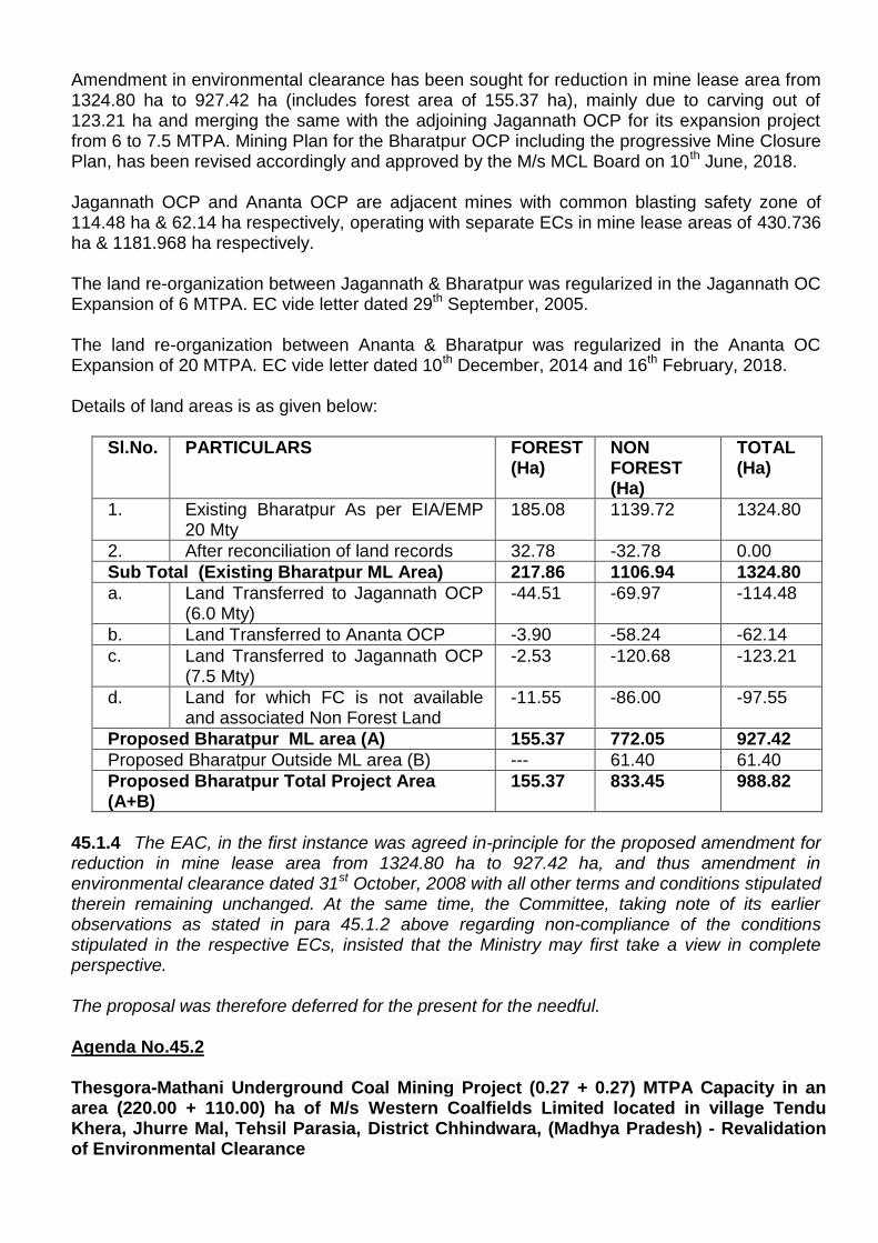
Amendment in environmental clearance has been sought for reduction in mine lease area from 1324.80 ha to 927.42 ha (includes forest area of 155.37 ha), mainly due to carving out of 123.21 ha and merging the same with the adjoining Jagannath OCP for its expansion project from 6 to 7.5 MTPA. Mining Plan for the Bharatpur OCP including the progressive Mine Closure Plan, has been revised accordingly and approved by the M/s MCL Board on 10th June, 2018. Jagannath OCP and Ananta OCP are adjacent mines with common blasting safety zone of 114.48 ha & 62.14 ha respectively, operating with separate ECs in mine lease areas of 430.736 ha & 1181.968 ha respectively. The land re-organization between Jagannath & Bharatpur was regularized in the Jagannath OC Expansion of 6 MTPA. EC vide letter dated 29th September, 2005. The land re-organization between Ananta & Bharatpur was regularized in the Ananta OC Expansion of 20 MTPA. EC vide letter dated 10th December, 2014 and 16th February, 2018. Details of land areas is as given below:
Sl.No. PARTICULARS FOREST (Ha)
NON FOREST (Ha)
TOTAL (Ha)
1. Existing Bharatpur As per EIA/EMP 20 Mty
185.08 1139.72 1324.80
2. After reconciliation of land records 32.78 -32.78 0.00
Sub Total (Existing Bharatpur ML Area) 217.86 1106.94 1324.80
a. Land Transferred to Jagannath OCP (6.0 Mty)
-44.51 -69.97 -114.48
b. Land Transferred to Ananta OCP -3.90 -58.24 -62.14
c. Land Transferred to Jagannath OCP (7.5 Mty)
-2.53 -120.68 -123.21
d. Land for which FC is not available and associated Non Forest Land
-11.55 -86.00 -97.55
Proposed Bharatpur ML area (A) 155.37 772.05 927.42
Proposed Bharatpur Outside ML area (B) --- 61.40 61.40
Proposed Bharatpur Total Project Area (A+B)
155.37 833.45 988.82
45.1.4 The EAC, in the first instance was agreed in-principle for the proposed amendment for reduction in mine lease area from 1324.80 ha to 927.42 ha, and thus amendment in environmental clearance dated 31st October, 2008 with all other terms and conditions stipulated therein remaining unchanged. At the same time, the Committee, taking note of its earlier observations as stated in para 45.1.2 above regarding non-compliance of the conditions stipulated in the respective ECs, insisted that the Ministry may first take a view in complete perspective. The proposal was therefore deferred for the present for the needful. Agenda No.45.2 Thesgora-Mathani Underground Coal Mining Project (0.27 + 0.27) MTPA Capacity in an area (220.00 + 110.00) ha of M/s Western Coalfields Limited located in village Tendu Khera, Jhurre Mal, Tehsil Parasia, District Chhindwara, (Madhya Pradesh) - Revalidation of Environmental Clearance
[IA/MP/CMIN/77583/1995; F. No.J-11015/29/93-IA.II (M)] 45.2.1 The proposal is for revalidation of environment clearance dated 20th January, 1995 granted by the Ministry in favour of M/s Western Coalfields Ltd for Thesgora-Mathani Underground Coal Mining Project (0.27 + 0.27) MTPA Capacity in area (220.00 + 110.00) ha of M/s Western Coalfields Limited located in villages Tendu Khera, Jhurre Mal, Tehsil Parasia, District Chhindwara, (Madhya Pradesh), in pursuance of this Ministry’s Notification dated 6th April, 2018. Project area involves 165 ha of forest land. However, Stage-II forest clearance for diversion of 214.949 and 0.354 ha of forest land has been obtained for non-forestry purposes, as mandated under the Forest (Conservation) Act, 1980 on 27/28 March, 1995. No Public hearing for the project was conducted by the State Pollution Control Board. Renewal for Consent to operate has been obtained and valid till 31st August, 2019 from State Pollution Control Board for Mathani Underground Coal Mine and CTO for Thesgora was valid till 31st August, 2017 and further CTO is not applied obtained as the mining activity has been completed due to exhaustion of coal reserves. 45.2.2 The Committee, after deliberations, desired for inputs/details in respect of the following:-
Public notice shall be issued through concerned SPCB for information of the stakeholders about the present coal mining operations inviting comments and their redressal,
Mining Plan and Progressive Mine Closure Plan duly approved by the competent authority,
Compliance status of the conditions stipulated in the environmental clearance from the concerned Regional Office of the Ministry.
Valid Consent to operate from the State Pollution Control Board for the present mining operations.
Redressal of issues raised during the public hearing conducted by the SPCB.
Coal production realized from the mine from 1993-94 vis-à-vis capacity stipulated in the environment clearance.
Need assessment survey for the activities proposed under the CSR and the comprehensive plan to be prepared accordingly for implementation by the project proponent. Also, impact of the CSR activities undertaken at an interval of 5 years to be evaluated and a report to be submitted.
Forest clearance for diversion of forest land as required under the Forest (Conservation) Act, 1980.
Details of court cases and the compliance of the orders, if any.
Agenda No.45.3
Ghughus Opencast Expansion Project of 1.90 MTPA in ML area of 1020 ha of M/s Western Coalfields Limited located in village Ghughus, District Chandrapur, (Maharashtra) - Revalidation of Environmental Clearance [IA/MH/CMIN/78652/2005; F.No. J-11015/78/2005-IA.II(M)] 45.3.1 The proposal is for revalidation of environment clearance dated 24th May, 2005 granted by the Ministry in favour of Ghughus Opencast Expansion Project of 1.90 MTPA in ML area of 1020 ha of M/s Western Coalfields Limited located in village Ghughus, District Chandrapur, (Maharashtra), in pursuance of this Ministry’s Notification dated 6th April, 2018.
Project area involves 104.05 ha of forest land. No forest clearance for diversion of forest land has been obtained for non-forestry purposes, as mandated under the Forest (Conservation) Act, 1980 has been obtained yet. Public hearing for the project was conducted by the State Pollution Control Board on 21st July, 2004. Renewal for Consent to operate has been applied on 31st March, 2017 to the State Pollution Control Board. 45.3.2 The Committee, after deliberations, desired for inputs/details in respect of the following:-
Public notice shall be issued through concerned SPCB for information of the stakeholders about the present coal mining operations inviting comments and their redressal,
Mining Plan and Progressive Mine Closure Plan duly approved by the competent authority,
Compliance status of the conditions stipulated in the environmental clearance from the concerned Regional Office of the Ministry.
Valid Consent to operate from the State Pollution Control Board for the present mining operations.
Redressal of issues raised during the public hearing conducted by the SPCB.
Coal production realized from the mine from 1993-94 vis-à-vis capacity stipulated in the environment clearance.
Need assessment survey for the activities proposed under the CSR and the comprehensive plan to be prepared accordingly for implementation by the project proponent. Also, impact of the CSR activities undertaken at an interval of 5 years to be evaluated and a report to be submitted.
Forest clearance for diversion forest land as required under the Forest (Conservation) Act, 1980 as the case may be, of the forest land involved in the project
Details of court cases and the compliance of the orders, if any. Agenda No.45.4 Chhendipada Opencast Coal Mining Project (0.35 MTY) in ML area of 76.30 ha of M/s Mahanadi Coalfields Limited located in village and Tehsil Chhendipada, District Angul, (Odisha) - Revalidation of Environmental Clearance [IA/OR/CMIN/8871/2000; F.No. J-11015/4/1995-IA.II (M)] 45.4.1 The proposal is for revalidation of environment clearance dated 30th June, 2000 granted by the Ministry in favour of M/s Mahanadi Coalfields Limited for Chhendipada Opencast Coal Mining Project (0.35 MTY) in ML area located in village and Tehsil Chhendipada, District Angul, (Odisha), in pursuance of this Ministry’s Notification dated 6th April, 2018. Project area involves 24.30 ha of forest land. Stage-II forest clearance for diversion of forest land has been obtained for non-forestry purposes, as mandated under the Forest (Conservation) Act, 1980 on 24th May, 2000. No Public hearing for the project was conducted by the State Pollution Control Board. Renewal for Consent to operate is obtained and valid upto 31st March, 2020 from the State Pollution Control Board. Further, the mining activity has been completed due to exhaustion of coal reserves.
45.4.2 The Committee, after deliberations, desired for inputs/details in respect of the following:-
Public notice shall be issued through concerned SPCB for information of the stakeholders about the present coal mining operations inviting comments and their redressal,
Mining Plan and Progressive Mine Closure Plan duly approved by the competent authority,
Compliance status of the conditions stipulated in the environmental clearance from the concerned Regional Office of the Ministry.
Valid Consent to operate from the State Pollution Control Board for the present mining operations.
Redressal of issues raised during the public hearing conducted by the SPCB.
Coal production realized from the mine from 1993-94 vis-à-vis capacity stipulated in the environment clearance.
Need assessment survey for the activities proposed under the CSR and the comprehensive plan to be prepared accordingly for implementation by the project proponent. Also, impact of the CSR activities undertaken at an interval of 5 years to be evaluated and a report to be submitted.
Forest clearance for diversion of forest land as required under the Forest (Conservation) Act, 1980 as the case may be, of the forest land involved in the project
Details of court cases and the compliance of the orders, if any.
Water bodies should be appropriately fenced or trench cutting should be implemented all along the banks.
Agenda No.45.5 Expansion of Jhingurda Opencast Coal Project of 3 to 5 MTPA capacity in ML area of 1200 ha for M/s Northern Coalfields Limited located in Jhingurda, Tehsil Morwa, District Sidhi (Madhya Pradesh) - Revalidation of Environmental Clearance [IA/MP/CMIN/7617/2003; F.No. J-11015/171/2003-IA.II(M)] 45.5.1 The proposal is for revalidation of environment clearance dated 13th May, 2005 granted by the Ministry in favour of M/s Northern Coalfields Limited for Expansion of Jhingurda Opencast Coal Project of 3 to 5 MTPA capacity in ML area of 1200 ha for M/s Northern Coalfields Limited located in Jhingurda, Tehsil Morwa, District Sidhi (Madhya Pradesh), in pursuance of this Ministry’s Notification dated 6th April, 2018. Project area involves 748 ha of forest land. Stage-II forest clearance for diversion of forest land, as mandated under the Forest (Conservation) Act, 1980 for 748 ha is not available as Forest Land was acquired under the CBA Act and had broken up before the commencement of FCA, 1980. Public hearing for the project was conducted by the State Pollution Control Board on 12th August, 2002. Renewal for Consent to operate is obtained and valid upto 31st July, 2019 from the State Pollution Control Board. 45.5.2 The Committee, after deliberations, desired for inputs/details in respect of the following:-
Public notice shall be issued through concerned SPCB for information of the stakeholders about the present coal mining operations inviting comments and their redressal,
Mining Plan and Progressive Mine Closure Plan duly approved by the competent authority,
Compliance status of the conditions stipulated in the environmental clearance from the concerned Regional Office of the Ministry.
Valid Consent to operate from the State Pollution Control Board for the present mining operations.
Redressal of issues raised during the public hearing conducted by the SPCB.
Coal production realized from the mine from 1993-94 vis-à-vis capacity stipulated in the environment clearance.
Need assessment survey for the activities proposed under the CSR and the comprehensive plan to be prepared accordingly for implementation by the project proponent. Also, impact of the CSR activities undertaken at an interval of 5 years to be evaluated and a report to be submitted.
Forest clearance for diversion of forest land as required under the Forest (Conservation) Act, 1980.
Details of court cases and the compliance of the orders, if any. Agenda No.45.6 Hindustan Lalpeth Opencast Coal Mining Project from 0.59 to 1 MTPA in ML area 311.66 ha of M/s Western Coalfields Limited located near village Mana, Tehsil and District Chandrapur (Maharashtra) – For Revalidation of Environmental Clearance [IA/MH/CMIN/79185/2006; F.No. J-11015/93/2005-IA.II(M)] 45.6.1 The proposal is for revalidation of environment clearance dated 14th July, 2006 granted by the Ministry in favour of Hindustan Lalpeth Opencast Coal Mining Project from 0.59 to 1 MTPA in ML area 311.66 ha of M/s Western Coalfields Limited located near village Mana, Tehsil and District Chandrapur (Maharashtra), in pursuance of this Ministry’s Notification dated 6th April, 2018. Project area involves 72.21 ha of forest land. Stage-II forest clearance for diversion of forest land has been obtained for non-forestry purposes, as mandated under the Forest (Conservation) Act, 1980 on for 72.22 ha on 8th May, 2001. Public hearing for the project was conducted by the State Pollution Control Board on 20th July, 2004. Renewal for Consent to operate has been applied and granted till 31st March, 2020. Letter is awaited by the State Pollution Control Board. 45.6.2 The Committee, after deliberations, desired for inputs/details in respect of the following:-
Public notice shall be issued through concerned SPCB for information of the stakeholders about the present coal mining operations inviting comments and their redressal,
Mining Plan and Progressive Mine Closure Plan duly approved by the competent authority,
Compliance status of the conditions stipulated in the environmental clearance from the concerned Regional Office of the Ministry.
Valid Consent to operate from the State Pollution Control Board for the present mining operations.
Redressal of issues raised during the public hearing conducted by the SPCB.
Coal production realized from the mine from 1993-94 vis-à-vis capacity stipulated in the environment clearance.
Need assessment survey for the activities proposed under the CSR and the comprehensive plan to be prepared accordingly for implementation by the project
proponent. Also, impact of the CSR activities undertaken at an interval of 5 years to be evaluated and a report to be submitted.
Forest clearance for diversion of forest land as required under the Forest (Conservation) Act, 1980, as the case may be, of the forest land involved in the project.
Details of court cases and the compliance of the orders, if any. Agenda No.45.7 Natraj Underground Mining Project of 0.64 MTPA in ML Area 483.227 ha of M/s Mahanadi Coalfields Limited located in villages Danara, Kochianali, Natedi, Tehsil Talcher, District Angul (Odisha) – For Revalidation of Environmental Clearance [IA/OR/CMIN/8439/2005; F.No. J-11015/306/2005-IA.II(M)] 45.7.1 The proposal is for revalidation of environment clearance dated 14th July, 2006 granted by the Ministry in favour of M/s Mahanadi Coalfields Limited for Natraj Underground Mining Project of 0.64 MTPA in ML Area 483.227 ha of M/s Mahanadi Coalfields Limited located in villages Danara, Kochianali, Natedi, Tehsil Talcher, District Angul (Odisha), in pursuance of this Ministry’s Notification dated 6th April, 2018. Project area involves 289.856 ha of forest land. Stage-II forest clearance for diversion of forest land has been obtained for non-forestry purposes, as mandated under the Forest (Conservation) Act, 1980 for 289.856 ha on 30th January, 2009. Public hearing for the project was conducted by the State Pollution Control Board on 3rd April, 2003. Renewal of Consent to operate was obtained and valid upto 31st March, 2022 from the State Pollution Control Board. 45.7.2 The Committee, after deliberations, desired for inputs/details in respect of the following:-
Public notice shall be issued through concerned SPCB for information of the stakeholders about the present coal mining operations inviting comments and their redressal,
Mining Plan and Progressive Mine Closure Plan duly approved by the competent authority,
Compliance status of the conditions stipulated in the environmental clearance from the concerned Regional Office of the Ministry.
Valid Consent to operate from the State Pollution Control Board for the present mining operations.
Redressal of issues raised during the public hearing conducted by the SPCB.
Coal production realized from the mine from 1993-94 vis-à-vis capacity stipulated in the environment clearance.
Need assessment survey for the activities proposed under the CSR and the comprehensive plan to be prepared accordingly for implementation by the project proponent. Also, impact of the CSR activities undertaken at an interval of 5 years to be evaluated and a report to be submitted.
Forest clearance for diversion of forest land as required under the Forest (Conservation) Act, 1980, as the case may be, of the forest land involved in the project
Details of court cases and the compliance of the orders, if any.
Agenda No.45.8 Vastan Lignite Mine Project of 1.20 MTPA in ML area 1536 ha of M/s Gujarat Industries Power Company Limited located in villages Nani Naroli, Taluka Mangrol, District Surat, (Gujarat) - Revalidation of Environmental Clearance [IA/GJ/MIN/26807/1996; F.No. J-11015/40/95-IA.II (M)] 45.8.1 The proposal is for revalidation of environment clearance dated 19th June, 1996 granted by the Ministry in favour of M/s Gujarat Industries Power Company Limited for Vastan Lignite Mine Project of 1.20 MTPA in ML area 1536 ha located in villages Nani Naroli, Taluka Mangrol, District Surat, (Gujarat), in pursuance of this Ministry’s Notification dated 6th April, 2018. No Forest land is involved in the said Project area for diversion of forest land has been obtained for non-forestry purposes, as mandated under the Forest (Conservation) Act, 1980 No Public hearing for the project was conducted by the State Pollution Control Board. Consent to operate is obtained and valid upto 1st November, 2018 from the State Pollution Control Board. Further renewal has been applied. 45.8.2 The Committee, after deliberations, desired for inputs/details in respect of the following:-
Public notice shall be issued through concerned SPCB for information of the stakeholders about the present coal/Lignite mining operations inviting comments and their redressal,
Mining Plan and Progressive Mine Closure Plan duly approved by the competent authority,
Compliance status of the conditions stipulated in the environmental clearance from the concerned Regional Office of the Ministry.
Valid Consent to operate from the State Pollution Control Board for the present mining operations.
Redressal of issues raised during the public hearing conducted by the SPCB.
Coal production realized from the mine from 1993-94 vis-à-vis capacity stipulated in the environment clearance.
Need assessment survey for the activities proposed under the CSR and the comprehensive plan to be prepared accordingly for implementation by the project proponent. Also, impact of the CSR activities undertaken at an interval of 5 years to be evaluated and a report to be submitted.
Forest clearance for diversion of forest land as required under the Forest (Conservation) Act, 1980.
Details of court cases and the compliance of the orders, if any.
Compliance of the Ministry’s OM dated 30th May, 2018 Agenda No.45.9 Basundhara (East) Opencast Project 0.6 MTPA in ML area 97.756 ha of M/s Mahanadi Coalfields Limited located in Villages Tikilipara, Siarmal, Saradega and Bankibahal Tehsil Himgir, District Sundargarh (Odisha) - Revalidation of Environmental Clearance [IA/OR/CMIN/80907/1995; F.No. J-11015/31/93-IA.II(M)] 45.9.1 The proposal is for revalidation of environment clearance dated 30th January, 1995 granted by the Ministry in favour of M/s Mahanadi Coalfields Ltd for Basundhara (East) Opencast Project 0.6 MTPA in ML area 97.756 ha (Total Area – 135.416 ha) located in villages
Tikilipara (partly), Siarmal (partly), Saradega (partly) and Bankibahal (partly), Tehsil Himgir, District Sundargarh (Odisha), in pursuance of this Ministry’s Notification dated 6th April, 2018. Project area involves 59.24 ha of forest land. Stage-II forest clearance for diversion of forest land has been obtained for non-forestry purposes, as mandated under the Forest (Conservation) Act, 1980 for 21.58 ha on 22nd April, 1996. 37.66 ha of forest land is outside of Mine lease area and is not used for non-forestry activity. No Public hearing for the project has been conducted by the State Pollution Control Board Renewal of Consent to operate was obtained and valid upto 31st March, 2017 from the State Pollution Control Board. Further renewal is not obtained as the mining activity has been completed due to exhaustion of coal reserves. 45.9.2 The Committee, after deliberations, desired for inputs/details in respect of the following:-
Public notice shall be issued through concerned SPCB for information of the stakeholders about the present coal mining operations inviting comments and their redressal,
Mining Plan and Progressive Mine Closure Plan duly approved by the competent authority,
Compliance status of the conditions stipulated in the environmental clearance from the concerned Regional Office of the Ministry.
Valid Consent to operate from the State Pollution Control Board for the present mining operations.
Redressal of issues raised during the public hearing conducted by the SPCB.
Coal production realized from the mine from 1993-94 vis-à-vis capacity stipulated in the environment clearance.
Need assessment survey for the activities proposed under the CSR and the comprehensive plan to be prepared accordingly for implementation by the project proponent. Also, impact of the CSR activities undertaken at an interval of 5 years to be evaluated and a report to be submitted.
Forest clearance for diversion of forest land as required under the Forest (Conservation) Act, 1980 as the case may be, of the forest land involved in the project.
Details of court cases and the compliance of the orders, if any.
Water bodies should be appropriately fenced or trench cutting should be implemented all along the banks.
Agenda No.45.10 Mangrol Valia lignite Mining Project 4.20 MTPA in ML area 2080 ha of M/s Gujarat Industries Power Company Ltd (Surat Lignite Power Project) located villages Mangrol, Shah, Charetha, Amandera, Harsani, Timberwa, Bhilwada, Nana Pardi, Luna, Dansoli, Rajgarh and Kosmadi, Tehsil Mangrol Valia, District Surat (Gujarat) - Revalidation of Environmental Clearance [IA/GJ/CMIN/8809/2001; F.No. J-11015/38/99-IA.II(M)] 45.10.1 The proposal is for revalidation of environment clearance dated 21st July, 2003 granted by the Ministry in favour of M/s Gujarat Industries Power Company Ltd for Mangrol Valia lignite Mining Project 4.20 MTPA in ML area 2080 ha of M/s Gujarat Industries Power Company Ltd (Surat Lignite Power Project) located villages Mangrol, Shah, Charetha, Amandera, Harsani, Timberwa, Bhilwada, Nana Pardi, Luna, Dansoli, Rajgarh and Kosmadi, Tehsil Mangrol Valia, District Surat (Gujarat), in pursuance of this Ministry’s Notification dated 6th April, 2018.
As per EC dated 21st July, 2003, No Forest land is involved in Project area. However, as stated by project proponent 4.48 ha of Protected Forest land is present and Forest Clearance for diversion of forest land has to be obtained for non-forestry purposes, as mandated under the Forest (Conservation) Act, 1980. Public hearing for the project was conducted by the State Pollution Control Board on 2nd April, 2013 and 5th April, 2013 (two districts). Renewal of Consent to operate was obtained and valid upto 17th June, 2020 from the State Pollution Control Board. 45.10.2 The Committee, after deliberations, desired for inputs/details in respect of the following:-
Public notice shall be issued through concerned SPCB for information of the stakeholders about the present coal mining operations inviting comments and their redressal,
Mining Plan and Progressive Mine Closure Plan duly approved by the competent authority,
Compliance status of the conditions stipulated in the environmental clearance from the concerned Regional Office of the Ministry.
Valid Consent to operate from the State Pollution Control Board for the present mining operations.
Redressal of issues raised during the public hearing conducted by the SPCB.
Coal production realized from the mine from 1993-94 vis-à-vis capacity stipulated in the environment clearance.
Need assessment survey for the activities proposed under the CSR and the comprehensive plan to be prepared accordingly for implementation by the project proponent. Also, impact of the CSR activities undertaken at an interval of 5 years to be evaluated and a report to be submitted.
Forest clearance for diversion of forest land as required under the Forest (Conservation) Act, 1980.
Details of court cases and the compliance of the orders, if any.
Agenda No.45.11 Hingula-II OC Expansion Project 15 MTPA in ML area 1741.95 ha M/s Mahanadi Coalfield Limited, located in Village Gopalprasad, Tehsil Talcher, District Angul (Odisha) - Revalidation of Environmental Clearance [IA/OR/CMIN/100723/2015; F.No J-11015/240/2008-IA.II(M)] 45.11.1 The proposal is for amendment in environment clearance dated 28th October, 2015 granted by the Ministry in favour of M/s Mahanadi Coalfields Ltd to Hingula-II Opencast Expansion Project (Phase-III) of capacity 15 MTPA located in an area of 1741.95 ha in Tehsil Talcher, District Angul (Odisha). 45.11.2 Amendment in environmental clearance has been sought in respect of two of the specific conditions stipulated therein as under:- Specific Condition No.(vii) ‘Coal transportation to consumers be made by rail mode so as to reduce the dust pollution. Coal transport from mine to washery and siding will be done by pipe conveyor and wagon loading
through SILO as proposed by project proponent. This arrangement will be ready within 3 (three years) and no road transport of coal after this period.’ Specific Condition No.(xix) ‘CSR cost should be Rs.5 per tonne of coal produced which should be adjusted as per the annual inflation.’ 45.11.3 The Committee, after deliberations, observed that given the time limit of 3 years for coal transportation through pipe conveyor and wagon loading through SILO, the proposal should have been submitted precisely within that period only. In view of prevailing circumstances, the Committee insisted for compliance status of the conditions stipulated in the environmental clearance dated 28th October, 2015 through the Ministry’s Regional Office. Agenda No.45.12 Datla Opencast Coal Mine Project 0.2 MTPA in an area of 57.753 ha of M/s Western Coalfields Limited located in villages Badi Datla and Dugaria, Tehsil Junnardeo, District Chindwara, (Madhya Pradesh) – For Revalidation of Environmental Clearance [IA/MP/CMIN/7214/2005; F.No. J-11015/115/2006-IA-II(M)] 45.12.1 The proposal is for revalidation of environment clearance dated 19th February, 2008 granted by the Ministry in favour of M/s Western Coalfields Ltd for Datla Opencast Coal Mine Project 0.2 MTPA in an area of 57.753 ha located in villages Badi Datla and Dugaria, Tehsil Junnardeo, District Chindwara (MP), in pursuance of this Ministry’s Notification dated 6th April, 2018. No Forest land is involved in Project area involved. Public hearing for the project was conducted by the State Pollution Control Board on 13th May, 2005. Renewal of Consent to operate has been applied on 1st December, 2011 for a period of 2012 to 2014, to the State Pollution Control Board. 45.12.2 The Committee, after deliberations, desired for inputs/details in respect of the following:-
Public notice shall be issued through concerned SPCB for information of the stakeholders about the present coal mining operations inviting comments and their redressal,
Mining Plan and Progressive Mine Closure Plan duly approved by the competent authority,
Compliance status of the conditions stipulated in the environmental clearance from the concerned Regional Office of the Ministry.
Valid Consent to operate from the State Pollution Control Board for the present mining operations.
Redressal of issues raised during the public hearing conducted by the SPCB.
Coal production realized from the mine from 1993-94 vis-à-vis capacity stipulated in the environment clearance.
Need assessment survey for the activities proposed under the CSR and the comprehensive plan to be prepared accordingly for implementation by the project proponent. Also, impact of the CSR activities undertaken at an interval of 5 years to be evaluated and a report to be submitted.
Forest clearance for diversion of forest land as required under the Forest (Conservation) Act, 1980.
Details of court cases and the compliance of the orders, if any
Water bodies should be appropriately fenced or trench cutting should be implemented along the banks.
Agenda No.45.13 Jagannath Washery of 10 MTPA in an area of 29.94 ha of M/s Mahanadi Coalfields Ltd. located in village Hensmul, District Talcher (Odisha) - Amendment in Environmental Clearance [IA/OR/CMIN/28013/2015; F.No. J-11015/203/2015-IA.II(M)] 45.13.1 The proposal is for amendment in environmental clearance dated 31st august, 2016 granted by the Ministry in favour of M/s Mahanadi Coalfields Limited to the Coal Washery of 10 MTPA in an area of 29.94 ha in village Hensmul, District Talcher (Odisha). The said EC was subsequently amended on 15th February, 2017, mainly in respect of specific conditions relating to raw coal transportation and development of green belt. 45.13.2 As per the details provided earlier and the environmental clearance granted by the Ministry on 31st August, 2016, washery based on the technology of Heavy Media Cyclone, was to be constructed and operated on BOM basis. Different conditions stipulated therein included the following:-
The washery shall be as per project report submitted and presented to EAC.
No change in mining technology and scope of works shall be made without prior approval of MoEF&CC.
Reject will be utilized in power generation for which Joint Venture Companies has been done with NTPC.
45.13.3 Now it is informed that earlier the tender for setting up Jagannath Washery of 10 MTPA on BOM concept was floated in June, 2015, which was subsequently cancelled in October, 2016. Based on fresh tender floated in March, 2018, BOM operator has since been finalized (L-1 bidder M/s Global Coal & Mining Pvt Ltd) with change in washing technology from Heavy Media Cyclone to Heavy Media Bath. With the proposed change, coal grade would be G12 in place of G11 and total water requirement from 0.084 kl per tonne of raw coal to 0.1 kl envisaged earlier. Details of amendments sought are as under:-
S. No.
EC Condition
Existing Point Modification Proposed
1 Specific condition 4 A(i)
The washery shall be as per project report submitted & presented to EAC.
The process in the project report (EIA-EMP) is Heavy Media Cyclone. Now the process as per Lowest Bidder is Heavy Media Bath. On account of change in this component of technology, no additional environmental impact is envisaged. Hence the change is to be incorporated in the process.
2 Specific condition 4B(i)
No change in mining technology and scope of works shall be made without prior approval of the MoEF&CC
3 Specific condition 4A(iii)
Reject will be utilized in power generation for which Joint Venture Companies has been done with NTPC.
As per this CIL Reject Policy, selling of rejects is first option and utilization of FBC based power plants as the second option. If either of the two options are not feasible or partially feasible due to techno-economic reasons, the
S. No.
EC Condition
Existing Point Modification Proposed
rejects/balance rejects may be stored / disposed off through environmentally friendly methods with proper and prior study of implications involved and with proper engineering solutions if required. Approved uniform policy for disposal and utilization of rejects produced from CIL washery (existing and future) will be followed.
4 Pt. no. 3(viii)
The coal grade is G11 The coal grade is G12
5 Pt. no. 3(ix)
The total estimated water requirement is 2271KL/D at 0.084 KL/T of coal washed
The total estimated water requirement is 0.10 m3/tonne of raw coal (dry) as quoted by the lowest bidder. Mine water will be utilised
6 Pt. no. 3(xiv)
Cost: As per revised Conceptual Report RCR): 26535.00 lakhs. As per lowest bidder: 34875.00 lakhs
Cost: As per revised Conceptual Report (RCR): 26535.00 lakhs. As per lowest bidder: 384,11,98,291.04
45.13.4 During deliberations, the EAC noted one of the specific conditions 4A (iii) regarding utilisation of washery rejects in power generation for which Joint Venture companies were formed with NTPC. Whereas, the present proposal envisages implementation of the policy of M/s Coal India Ltd in this regard. 45.13.5 The EAC, after deliberations, insisted for comparative picture of the washing technologies finalized now and that envisaged earlier, and their impact on different environmental parameters. That would also include washery rejects generation, its utilization, mine water utilization, etc. The Committee further desired for appraisal of the proposal accordingly even for ascertaining the requirement of fresh EIA studies and the EMP. The proposal was deferred for the needful. Agenda No.45.14 Nandira Underground Coal Mining Project of 0.33 MTPA in ML area 474 ha of M/s Mahanadi Coalfield Limited located in villages Jambubahali, Danara, Badajorada and Natedi, Tehsil Thalcher, District Angul (Odisha) - Revalidation of Environmental Clearance [IA/OR/CMIN/19782/1900; F.No. J-11015/866/2007-IA.II(M)] 45.14.1 The proposal is for revalidation of environment clearance dated 18th June, 2007 granted by the Ministry in favour of M/s Mahanadi Coalfields Ltd for Nandira Underground Coal Mining Project of 0.33 MTPA in ML area 474 ha of M/s Mahanadi Coalfield Limited located in villages Jambubahali, Danara, Badajorada and Natedi, Tehsil Thalcher, District Angul (Odisha) – For Revalidation of Environmental Clearance, in pursuance of this Ministry’s Notification dated 6th April, 2018.
Project area involves 398.01 ha of forest land. Stage-II forest clearance for diversion of forest land has been obtained for non-forestry purposes, as mandated under the Forest (Conservation) Act, 1980 for 325.38 ha on 16th June, 2009. Public hearing for the project area of 370 ha was conducted by the State Pollution Control Board on 16th August, 2006 Renewal of Consent to operate was obtained and valid upto 31st March, 2022 from the State Pollution Control Board. 45.14.2 The Committee, after deliberations, desired for inputs/details in respect of the following:-
Public notice shall be issued through concerned SPCB for information of the stakeholders about the present coal mining operations inviting comments and their redressal,
Mining Plan and Progressive Mine Closure Plan duly approved by the competent authority,
Compliance status of the conditions stipulated in the environmental clearance from the concerned Regional Office of the Ministry.
Valid Consent to operate from the State Pollution Control Board for the present mining operations.
Redressal of issues raised during the public hearing conducted by the SPCB.
Coal production realized from the mine from 1993-94 vis-à-vis capacity stipulated in the environment clearance.
Need assessment survey for the activities proposed under the CSR and the comprehensive plan to be prepared accordingly for implementation by the project proponent. Also, impact of the CSR activities undertaken at an interval of 5 years to be evaluated and a report to be submitted.
Forest clearance for diversion of forest land as required under the Forest (Conservation) Act, 1980, as the case may be. Forest land involved in the project is 398 ha but FC clearance is for only 325 ha.
Details of court cases and the compliance of the orders, if any Agenda No.45.15 Hingula Washery of 10 MTPA in an area of 27 ha of M/s Mahanadi Coalfields Limited located in, District Angul (Odisha) - Amendment in Environment Clearance [IA/OR/CMIN/18276/2013] F.No. J-11015/67/2013-IA.II(M) 45.15.1 The proposal is for amendment in environmental clearance dated 28th October, 2015 granted by the Ministry in favour of M/s Mahanadi Coalfields Limited to the Coal Washery of 10 MTPA in an area of 27 ha in District Angul (Odisha). 45.15.2 As per the details provided earlier and the environmental clearance granted by the Ministry on 28th October, 2015, washery based on the technology of Heavy Media Cyclone, was to be constructed and operated on BOM basis. Different conditions stipulated therein included the following:- ‘Detailed note to be provided on utilization of rejects if it is more than 80% ash content.’ 45.15.3 Now it is informed that earlier the tender for setting up Hingula Washery of 10 MTPA on BOM concept was floated in 2012, which was subsequently cancelled in November, 2016. Based on fresh tender floated in March, 2018, BOM operator has since been finalized (L-1
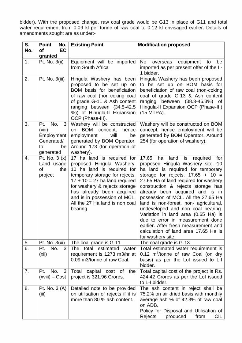
bidder). With the proposed change, raw coal grade would be G13 in place of G11 and total water requirement from 0.09 kl per tonne of raw coal to 0.12 kl envisaged earlier. Details of amendments sought are as under:-
S. No.
Point No. of EC granted
Existing Point Modification proposed
1. Pt. No. 3(ii) Equipment will be imported from South Africa
No overseas equipment to be imported as per present offer of the L-1 bidder.
2. Pt. No. 3(iii) Hingula Washery has been proposed to be set up on BOM basis for beneficiation of raw coal (non-coking coal of grade G-11 & Ash content ranging between (34.5-42.5 %)) of Hinugla-II Expansion OCP (Phase-III).
Hingula Washery has been proposed to be set up on BOM basis for beneficiation of raw coal (non-coking coal of grade G-13 & Ash content ranging between (38.3-46.3%) of Hingula-II Expansion OCP (Phase-III) (15 MTPA).
3. Pt. No. 3 (viii) – Employment Generated/ to be generated
Washery will be constructed on BOM concept; hence employment will be generated by BOM Operator. Around 173 (for operation of washery).
Washery will be constructed on BOM concept; hence employment will be generated by BOM Operator. Around 254 (for operation of washery).
4. Pt. No. 3 (x) Land usage of the project
17 ha land is required for proposed Hingula Washery. 10 ha land is required for temporary storage for rejects. 17 + 10 = 27 ha land required for washery & rejects storage has already been acquired and is in possession of MCL. All the 27 Ha land is non coal bearing.
17.65 ha land is required for proposed Hingula Washery site. 10 ha land is required for temporary storage for rejects. 17.65 + 10 = 27.65 Ha of land required for washery construction & rejects storage has already been acquired and is in possession of MCL. All the 27.65 Ha land is non-forest, non- agricultural, undeveloped and non coal bearing. Variation in land area (0.65 Ha) is due to error in measurement done earlier. After fresh measurement and calculation of land area 17.65 Ha is for washery site.
5. Pt. No. 3(xi) The coal grade is G-11 The coal grade is G-13.
6. Pt. No. 3 (xii)
The total estimated water requirement is 1273 m3/hr at 0.09 m3/tonne of raw Coal.
Total estimated water requirement is 0.12 m3/tonne of raw Coal (on dry basis) as per the LoI issued to L-I bidder.
7. Pt. No. 3 (xviii) – Cost
Total capital cost of the project is 321.96 Crores.
Total capital cost of the project is Rs. 424.42 Crores as per the LoI issued to L-I bidder.
8. Pt. No. 3 (A) (iii)
Detailed note to be provided on utilisation of rejects if it is more than 80 % ash content.
The ash content in reject shall be 75.2% on air dried basis with monthly average ash % of 42.3% of raw coal on ADB. Policy for Disposal and Utilisation of Rejects produced from CIL
Washeries (Existing & Future)” communicated by CIL vide CIL letter no. CIL/PMD/Ws/41/350 dated 24.07.2018
45.15.4 The EAC, after deliberations, desired for clarification/inputs in respect of the following:
Whether the proposed washery covering an area of 17.65 ha and temporary storage site for rejects (10 ha) in mine lease hold of Balram OCP is in conformity with its approved Mining Plan. Also, the proposal, if any, for amendment in the environment clearance for Balram OCP.
Justification for change in raw coal specifications (G11 to G13, ash content from 34.5-42.4% to 38.3-46.3%) from the same coal linkage i.e. Hingula-II Expansion OCP (Phase-III) of capacity 15 MTPA. Whether the same is in line with environmental clearance issued for the project. What about operational status of the project.
In view of the project within the mine lease hold of Balram OCP, compliance status of the conditions stipulated in its environmental clearance is essentially required.
Status of pipe conveyor (3.76 km) for raw coal transportation to washery and preparedness of washed/clean coal transportation by rail with loading arrangement through silo.
In view of major deviations from the earlier scope of work, fresh assessment of environment impacts and the EMP proposed accordingly.
The proposal was therefore deferred for the needful on the above lines. Agenda No.45.16 Manoharpur Opencast Coalmine Project (8 MTPA) of M/s Odisha Coal and Power Ltd, located in District Sundargarh (Odisha) - Amendment in Environmental Clearance [IA/OR/CMIN/19231/2008; F.No. J-11015/139/2008-IA-II(M)] 45.16.1 The proposal is for amendment in environmental clearance dated 21st February, 2014 granted by the Ministry in favour of M/s Odisha Power Generation Corporation Ltd (OPGCL) to Manoharpur Opencast Coal Mining project of capacity 8 MTPA located in mine lease area of 977.875 ha in Ib Valley, District Sundargarh (Odisha). 45.16.2 The said EC stipulates one of the specific conditions regarding coal transportation, as Specific condition (xii) of EC, it states ‘coal transportation from mine to railway siding by conveyor belt and from siding to TPP by MGR through SILO loading of the wagons’. Construction of MGR is delayed due to land acquisition issue in MCL command area. It is expected to be operational by Mar'2022. Coal mine operation has commenced. Hence amendment is sought for road transport of extracted coal for next three years. 45.16.3 The EAC after deliberation noted the following:- Manoharpur coal block was earlier allocated to Odisha Power Generation Corporation Limited by the Ministry of Coal in 2007 and later on de-allocated vide the judgement of Hn’ble Supreme Court of India during the year 2014. Further, Odisha Coal and Power Limited has been allotted coal block in 2015, with an intention to develop and operate the coal mines to cater the fuel requirement of OGPC Power Projects (Units 3&4-2X660 MW). Environmental Clearance dated 21st February, 2014 was transferred to Odisha Coal and Power Limited vide Ministry’s letter dated 30th December, 2015.
It has been envisaged to transport the coal produced from the mine to OPGC power plant through MGR system being constructed by OPGC. However, the construction of MGR system from Manoharpur Opencast Coal Mining Project by OPGC power plant is delayed due to land acquisition issues in MCL command area. However, the construction work is in full swing and expected to be ready by March, 2022. Since, the commissioning of MGR is delayed, OCPL proposes to transport extracted coal by road through 20/25 T tippers/trucks as an interim arrangement for an initial period of 3 years of coal production i.e. from April, 2019 to March, 2022 or till the dedicated MGR is operational, whichever is earlier. It is being proposed to transport 4.6 MTPA of coal by road for the next three years to Ib TPP of OPGC through two options, which are as follows:
(i) 9200 TPD of coal from Manoharpur coal mine to Kanika siding / ACB siding/any other Indian railway sidings in the near vicinity of mine by road and from there to Ib TPP of OPGC by rail.
(ii) 4740 TPD of coal from Manoharpur coal mine to Ib TPP directly by road, In unforeseen
situation, coal will be transported to Ubuda / Charrla railway siding (near plant and located at the proposed transportation route) by road and from there to Ib TPP by rail.
45.16.4 The EAC, after detailed deliberations, desired to explore for more coal transportation through Route 2, involving transport through road in a stretch of 23 km (from the coal block to Kanika/ACB Siding) and through rail in a stretch of approx 50 km (from Kanika/ACB siding to Ib TPP) in order to avoid coal transportation by road through Route 1 (117 km). In this regard, the Committee asked for confirmation from the Railway Authorities regarding non-availability of sufficient rakes for coal transportation more than 3 MTPA. The Committee also insisted for adequate road widening with black topping of road in an stretch of 350 m, common in case of both the routes. Agenda No.45.17 Proposed 1.25 MTPA Coal Washery (Wet process) of M/s Bhatia Energy & Coal Beneficiation Pvt Ltd in Village Lokhandi, Tehsil Takhatpur District Bilaspur (Chhattisgarh) - Terms of Reference [IA/CG/CMIN/76054/2018; F.No. J-11015/79/2018-IA.II(M)] 45.17.1 The proposal is for ToR for setting up Coal Washery of 1.25 MTPA capacity in an area of 11.53 ha of M/s Bhatia Energy & Coal Beneficiation Private Limited located in village Lokhandi, Tehsil Takhatpur, District Bilaspur (Chhattisgarh). 45.17.2 Details of the proposal, as ascertained from the proposal documents and as revealed from the discussions held during the meeting, are given as under: (i) The project area is covered under Survey of India Topo Sheet No 64J/4 and is bounded by the geographical coordinates ranging from to latitude 22°07'56.55"N and 22° 08'4.67"N longitudes 82°05'31.94"E and 82°05'44.68"E. (ii) Raw coal linkage from the nearby mines of M/s SECL, Bilaspur and Korba region. (iii) Transportation of raw coal is proposed through existing Uslapur railway siding located at 2.5 km from the project site. (iv) Project does not fall in the Critically Polluted Area (CPA), where the MoEF&CC’s vide its OM dated 13th January, 2010 has imposed moratorium on grant of environment clearance.
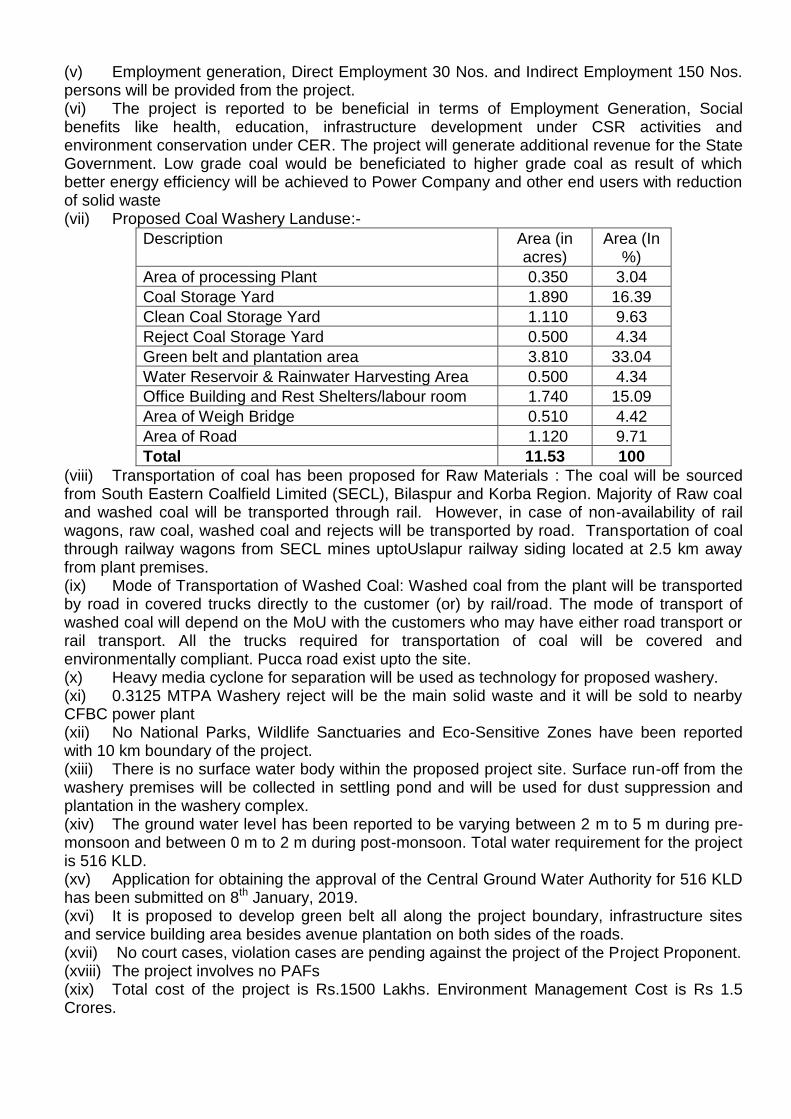
(v) Employment generation, Direct Employment 30 Nos. and Indirect Employment 150 Nos. persons will be provided from the project. (vi) The project is reported to be beneficial in terms of Employment Generation, Social benefits like health, education, infrastructure development under CSR activities and environment conservation under CER. The project will generate additional revenue for the State Government. Low grade coal would be beneficiated to higher grade coal as result of which better energy efficiency will be achieved to Power Company and other end users with reduction of solid waste (vii) Proposed Coal Washery Landuse:-
Description Area (in acres)
Area (In %)
Area of processing Plant 0.350 3.04
Coal Storage Yard 1.890 16.39
Clean Coal Storage Yard 1.110 9.63
Reject Coal Storage Yard 0.500 4.34
Green belt and plantation area 3.810 33.04
Water Reservoir & Rainwater Harvesting Area 0.500 4.34
Office Building and Rest Shelters/labour room 1.740 15.09
Area of Weigh Bridge 0.510 4.42
Area of Road 1.120 9.71
Total 11.53 100
(viii) Transportation of coal has been proposed for Raw Materials : The coal will be sourced from South Eastern Coalfield Limited (SECL), Bilaspur and Korba Region. Majority of Raw coal and washed coal will be transported through rail. However, in case of non-availability of rail wagons, raw coal, washed coal and rejects will be transported by road. Transportation of coal through railway wagons from SECL mines uptoUslapur railway siding located at 2.5 km away from plant premises. (ix) Mode of Transportation of Washed Coal: Washed coal from the plant will be transported by road in covered trucks directly to the customer (or) by rail/road. The mode of transport of washed coal will depend on the MoU with the customers who may have either road transport or rail transport. All the trucks required for transportation of coal will be covered and environmentally compliant. Pucca road exist upto the site. (x) Heavy media cyclone for separation will be used as technology for proposed washery. (xi) 0.3125 MTPA Washery reject will be the main solid waste and it will be sold to nearby CFBC power plant (xii) No National Parks, Wildlife Sanctuaries and Eco-Sensitive Zones have been reported with 10 km boundary of the project. (xiii) There is no surface water body within the proposed project site. Surface run-off from the washery premises will be collected in settling pond and will be used for dust suppression and plantation in the washery complex. (xiv) The ground water level has been reported to be varying between 2 m to 5 m during pre-monsoon and between 0 m to 2 m during post-monsoon. Total water requirement for the project is 516 KLD. (xv) Application for obtaining the approval of the Central Ground Water Authority for 516 KLD has been submitted on 8th January, 2019. (xvi) It is proposed to develop green belt all along the project boundary, infrastructure sites and service building area besides avenue plantation on both sides of the roads. (xvii) No court cases, violation cases are pending against the project of the Project Proponent. (xviii) The project involves no PAFs (xix) Total cost of the project is Rs.1500 Lakhs. Environment Management Cost is Rs 1.5 Crores.
(xx) Consent to Operate for the existing Coal Crusher (1,80,000 TPA) (Consent granted by CECB vide its letter no. 1363/R.O./T.S./C.E.C.B./2013 Bilaspur, dtd. 24/09/2013) valid till 24/12/2019 at Lokhandi Village, Takhatpur Tehsil, Bilaspur District, Chhattisgarh 45.17.3 During deliberations, the EAC noted the following:
The proposal is for terms of reference (ToR) to Proposed 1.25 MTPA Coal Washery (Wet process) of M/s Bhatia Energy & Coal Beneficiation Pvt Ltd in Village Lokhandi, Tehsil Takhatpur District Bilaspur (Chhattisgarh). No forest land is involved in the project The company (under the name of M/s. Bhatia Coal Tradelink) has already established a dry crushing and sizing unit (1,80,000 Metric Tonne/ Annum at the proposed coal washery site after obtaining consent from Chhattisgarh State Conservation Board vide Letter No. 1363/RO/TS/CECB/2013 Bilaspur, dated 24.09.2013. (Valid consent as on date vide Letter No. 31/TS/CECB/2018 dated 03.04.2018. Washed coal from the plant will be transported by road in covered trucks directly to the customer (or) by rail/road. The mode of transport of washed coal will depend on the MoU with the customers who may have either road transport or rail transport. All the trucks required for transportation of coal will be covered and environmentally compliant. Total daily water requirement in the proposed coal washery is about 3,125 KLD. However, most of the water from washed coal slurry will be recovered and reused in the plant. Daily make up water requirement in the plant will be about 516 KLD, which will be drawn from bore well sources. Consent to Operate for the existing Coal Crusher (1,80,000 TPA) (Consent granted by CECB vide its letter no. 1363/R.O./T.S./C.E.C.B./2013 Bilaspur, dtd. 24/09/2013) valid till 24/12/2019 at Lokhandi Village, Takhatpur Tehsil, Bilaspur District, Chhattisgarh. 45.17.4 The Committee, after deliberations, recommended for grant of terms of reference for setting up 1.25 MTPA Coal Washery (Wet process) of M/s Bhatia Energy & Coal Beneficiation Pvt Ltd in Village Lokhandi, Tehsil Takhatpur District Bilaspur (Chhattisgarh), for preparation of EIA/EMP reports along with public consultation, subject to compliance of all terms and conditions as specified/notified in the standard ToR applicable, along with the additional conditions as under:-
Permission for ground water withdrawal shall be obtained from Central Ground Water Authority (CGWA), if applicable.
Total fresh water requirement shall not exceed 3125 KLD, proposed to be met from groundwater source. Daily make up water requirement in the plant shall not more than 516 KLD.
Impact of proposed project/activity on hydrological regime of the area shall be assessed and report be submitted.
Ash content below 34% should be maintained in washed coal to be transported beyond 500 km for use in thermal power plants.
The washing technology so chosen should conform to ‘Zero Liquid Discharge’. Continuous monitoring of occupational safety and other health hazards, and the corrective
actions need to be ensured. For proper baseline air quality assessment, adequate monitoring stations in the downwind
areas based on wind rose pattern of the area, shall be set up for collection of air quality data and air quality modeling.
Disposal of washery rejects shall be in accordance with the extant policy and guidelines, and environment friendly.
Thick green belt of adequate width to be provided around the washery to mitigate/check
the dust pollution. A 3-tier avenue plantation should also be developed along vacant areas, storage yards, loading/transfer points, and also along internal roads/main approach roads.
Agenda No.45.18 Expansion of Adasa Mine (By conversion from UG to OC) with increase in production capacity from 0.5 MTPA to 1.5 MTPA (Normative) / 1 .85 (Peak) with increase in area from 221 ha to 596.27 ha of M/s Western Coalfields Limited located in Kotodi Village, Saoner Tehsil, Nagpur District (Maharashtra) - Extension of Validity of ToR [IA/MH/CMIN/37709/2016; F.No. J-11015/387/2015-IA.II(M)] 45.18.1 The proposal is for Extension of ToR validity for Conversion of Adasa UG to OC for Expansion in Capacity from 0.50 MTY to 1.85 MTY (Peak) & land area from 221.00 ha to 596.27 ha by adopting change in method of working from Underground to Opencast of M/s Western Coalfields Limited located near Kotodi village in Saoner Tehsil, District Nagpur (Maharashtra). 45.18.2 Details of the proposal, as ascertained from the proposal documents and also as informed during the meeting, are given as under: (xxi) The existing Adasa UG has been granted environmental clearance vide J-11015/341/2008-IA.II(M) dated 15th July, 2009 for production capacity of 0.50 MTPA within ML area of 221.0 ha. (xxii) The mine was proposed for conversion from Underground to Opencast with increasing in Capacity from 0.50 MTY to 1.85 MTY (Peak) & land area from 221.00 Ha to 596.27 ha. (xxiii) The proposal was discussed in 51st EAC (Thermal & Coal Mining) meeting held on 5th February, 2016 for grant of ToR. Terms of References (TORs) was granted vide MoEF&CC letter no J-11015/387/2015.IA-II(M) dated 29th February, 2016 (xxiv) The project area is covered under Survey of India Topo Sheet No55 K/15and is bounded by the geographical coordinates ranging from N 21º 19' 31" to N 21º 21' 16"and longitudes E 78º 55' 47" to E 78º 58' 40" (xxv) Coal linkage of the project was for Thermal power plants of MAHAGENCO & Miscellaneous consumers. There is no Joint venture involved. (xxvi) Project does not fall in the Critically Polluted Area (CPA), where the MoEF&CC’s vide its OM dated 13th January, 2010 has imposed moratorium on grant of environment clearance. (xxvii) Employment generation: Required Manpower for the project is 128 Nos as direct employment. (xxviii) The project is reported to be beneficial as it is an opencast mining method, the mineable reserves increase manifold and the target capacity is much more than underground mining. This project will thus bridge the gap(to the extent of the peak production capacity of the project) between demand & supply of non – coking coal for power plants & other bulk consumer (xxix) Total mining lease area is increased from 221.00 Ha to 596.27 Ha. The Mine Plan along with Mine closure Plan for Conversion of Adasa UG to OC was approved by the WCL Board vide letter no.WCL/BD/SECTT/BM-267/2015/2250 dated 21st August, 2015. (xxx) The land usage pattern of the project is as follows:
Pre-mining land use details: Details of changes in land use as per Present sanctioned ToR is provided below:
Pre-mining land use details
Sl. No.
Particulars Existing Land (ha)
Additional land (ha)
Total Land (ha)
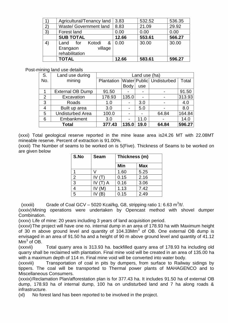
1) Agricultural/Tenancy land 3.83 532.52 536.35
2) Waste/ Government land 8.83 21.09 29.92
3) Forest land 0.00 0.00 0.00
SUB TOTAL 12.66 553.61 566.27
4) Land for Kotodi & Erangaon village rehabilitation
0.00 30.00 30.00
TOTAL 12.66 583.61 596.27
Post-mining land use details
S. No.
Land use during mining
Land use (ha)
Plantation Water Body
Public use
Undisturbed Total
1 External OB Dump 91.50 - - - 91.50
2 Excavation 178.93 135.0 - - 313.93
3 Roads 1.0 - 3.0 - 4.0
4 Built up area 3.0 - 5.0 - 8.0
5 Undisturbed Area 100.0 - - 64.84 164.84
6 Embankment 3.0 - 11.0 - 14.0
Total 377.43 135.0 19.0 64.84 596.27
(xxxi) Total geological reserve reported in the mine lease area is24.26 MT with 22.08MT mineable reserve. Percent of extraction is 91.00%. (xxxii) The Number of seams to be worked on is 5(Five). Thickness of Seams to be worked on are given below
S.No Seam Thickness (m)
Min Max
1 V 1.60 5.25
2 IV (T) 0.15 2.16
3 IV (T) A 0.16 3.06
4 IV (M) 1.13 7.42
5 IV (B) 0.15 2.49
(xxxiii) Grade of Coal GCV – 5020 Kcal/kg, G8, stripping ratio 1: 6.63 m3/t/.
(xxxiv) Mining operations were undertaken by Opencast method with shovel dumper Combination. (xxxv) Life of mine: 20 years including 3 years of land acquisition period. (xxxvi) The project will have one no. internal dump in an area of 178.93 ha with Maximum height of 30 m above ground level and quantity of 104.33Mm3 of OB. One external OB dump is envisaged in an area of 91.50 ha and a height of 90 m above ground level and quantity of 41.12 Mm3 of OB. (xxxvii) Total quarry area is 313.93 ha. backfilled quarry area of 178.93 ha including old quarry shall be reclaimed with plantation. Final mine void will be created in an area of 135.00 ha with a maximum depth of 114 m. Final mine void will be converted into water body. (xxxviii) Transportation of coal in pits by dumpers, from surface to Railway sidings by tippers. The coal will be transported to Thermal power plants of MAHAGENCO and to Miscellaneous Consumers. (xxxix) Reclamation Plan/afforestation plan is for 377.43 ha. It includes 91.50 ha of external OB dump, 178.93 ha of internal dump, 100 ha on undisturbed land and 7 ha along roads & infrastructure. (xl) No forest land has been reported to be involved in the project.
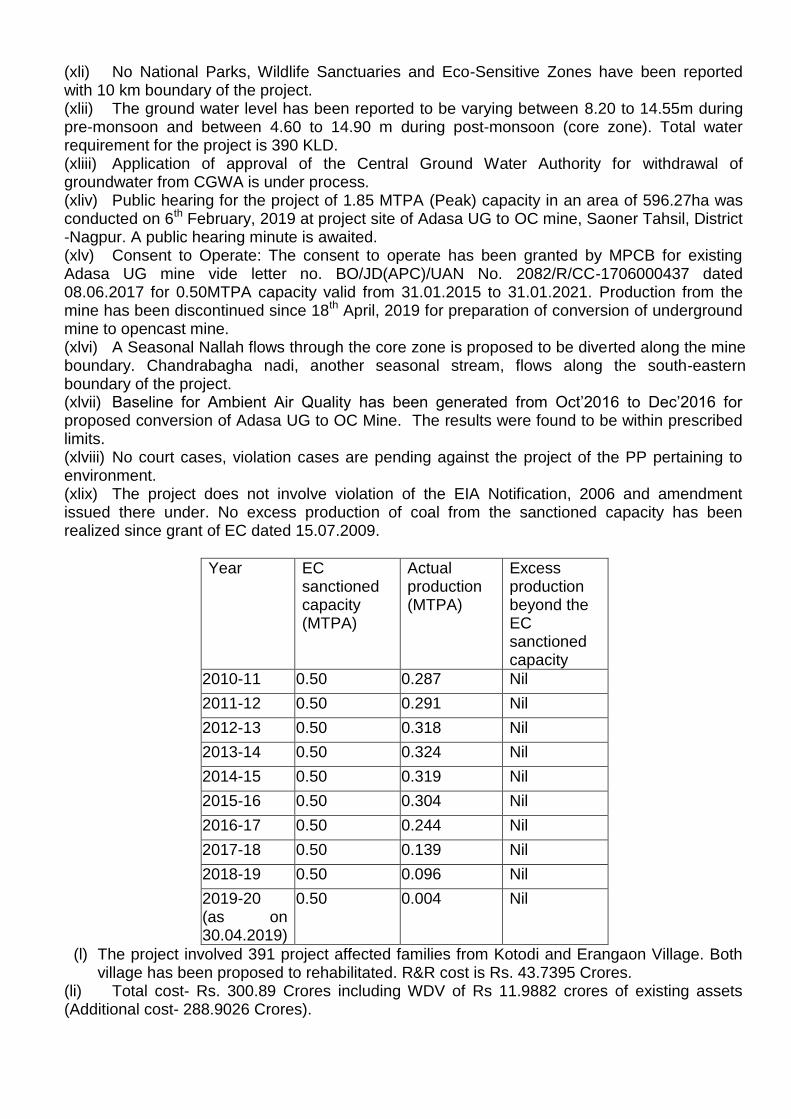
(xli) No National Parks, Wildlife Sanctuaries and Eco-Sensitive Zones have been reported with 10 km boundary of the project. (xlii) The ground water level has been reported to be varying between 8.20 to 14.55m during pre-monsoon and between 4.60 to 14.90 m during post-monsoon (core zone). Total water requirement for the project is 390 KLD. (xliii) Application of approval of the Central Ground Water Authority for withdrawal of groundwater from CGWA is under process. (xliv) Public hearing for the project of 1.85 MTPA (Peak) capacity in an area of 596.27ha was conducted on 6th February, 2019 at project site of Adasa UG to OC mine, Saoner Tahsil, District -Nagpur. A public hearing minute is awaited. (xlv) Consent to Operate: The consent to operate has been granted by MPCB for existing Adasa UG mine vide letter no. BO/JD(APC)/UAN No. 2082/R/CC-1706000437 dated 08.06.2017 for 0.50MTPA capacity valid from 31.01.2015 to 31.01.2021. Production from the mine has been discontinued since 18th April, 2019 for preparation of conversion of underground mine to opencast mine. (xlvi) A Seasonal Nallah flows through the core zone is proposed to be diverted along the mine boundary. Chandrabagha nadi, another seasonal stream, flows along the south-eastern boundary of the project. (xlvii) Baseline for Ambient Air Quality has been generated from Oct’2016 to Dec’2016 for proposed conversion of Adasa UG to OC Mine. The results were found to be within prescribed limits. (xlviii) No court cases, violation cases are pending against the project of the PP pertaining to environment. (xlix) The project does not involve violation of the EIA Notification, 2006 and amendment issued there under. No excess production of coal from the sanctioned capacity has been realized since grant of EC dated 15.07.2009.
Year EC sanctioned capacity (MTPA)
Actual production (MTPA)
Excess production beyond the EC sanctioned capacity
2010-11 0.50 0.287 Nil
2011-12 0.50 0.291 Nil
2012-13 0.50 0.318 Nil
2013-14 0.50 0.324 Nil
2014-15 0.50 0.319 Nil
2015-16 0.50 0.304 Nil
2016-17 0.50 0.244 Nil
2017-18 0.50 0.139 Nil
2018-19 0.50 0.096 Nil
2019-20 (as on 30.04.2019)
0.50 0.004 Nil
(l) The project involved 391 project affected families from Kotodi and Erangaon Village. Both village has been proposed to rehabilitated. R&R cost is Rs. 43.7395 Crores.
(li) Total cost- Rs. 300.89 Crores including WDV of Rs 11.9882 crores of existing assets (Additional cost- 288.9026 Crores).
45.18.3 During deliberations on the proposal, the Committee noted the following:- The proposal is for extension of validity of ToR granted by the Ministry on 29th February, 2016 for conversion of Adasa UG to OC with increase in production capacity from 0.50 MTPA to 1.85 MTPA (Peak) and land area from 221 ha to 596.27 ha of M/s Western Coalfields Limited located near Kotodi village in Tehsil Saoner, District Nagpur (Maharashtra). Initial validity of 3 years of the said ToR expired on 29th February, 2019. Extension of validity of ToR has been sought due to delay in conducting Public Hearing and Final EIA report is still to be finalized. The existing Adasa UG was granted environmental clearance on 15th July, 2009 for production capacity of 0.50 MTPA within ML area of 221 ha. 45.18.4 The EAC, after deliberations, recommended for extension of validity of ToR dated 29th February, 2016 for a period of one year i.e. up to 29th February, 2020 with all terms and conditions remaining the same. Agenda No.45.19 Expansion of Kanchan Opencast Coal Mining Project of M/s South Eastern Coalfields Limited located in Tehsil Nowrozabad and Bandhavgarh, District Umaria (MP) - Amendment in ToR [ IA/MP/CMIN/75372/2018; F.No. J-11015/574/2007-IA-II(M)] 45.19.1 The proposal is for Amendment in ToR for the expansion of Kanchan Opencast Coal Mine from 0.65 MTPA to 2.7 MTPA (Peak) in an area of 749.31 ha by M/s South Eastern Coalfields Limited located in District Umaria (Madhya Pradesh) The proposal for expansion of Kanchan opencast coal mine of SECL was considered by the EAC in its 34th meeting held on 24.07.2018 and ToR was issued vide F.No. J11015/574/2007-IA (M) Dated 17th August .2018 45.19.2 The details of the project, as per the documents submitted by the project proponent, and also as informed during the meeting, are reported to be as under:- (i) The project was accorded last EC issued for production capacity of 0.65 MTY (Normative) and 0.75 MTY (Peak) vide letter no. J-11015/574/2007-IA.II(M) dt. 29.03.2010. (ii) The Latitude and Longitude of the project site are 23o 20’ 12” to 23 o 20’ 50” North Longitude 80o 50’ 50” to 80o 52’ 41” East respectively. GSI Topo-sheet Number:64A/15. (iii) Coal Linkage : Thermal Power Stations (iv) Employment generated / to be generated: 258 No. (v) Benefits of the project: This coal Mine will go a long way in fulfilling the demand nation's electricity and other coal based industries, apart from earning revenue for the government. Opportunity of employment for the project affected villagers and allied industries. (vi) The land usage of the project will be as follows:
S.No. Type of land use Area(in Ha)
1 Agricultural Land 619.048
2 Forest Land 37.231
3 Waste Land 78.175
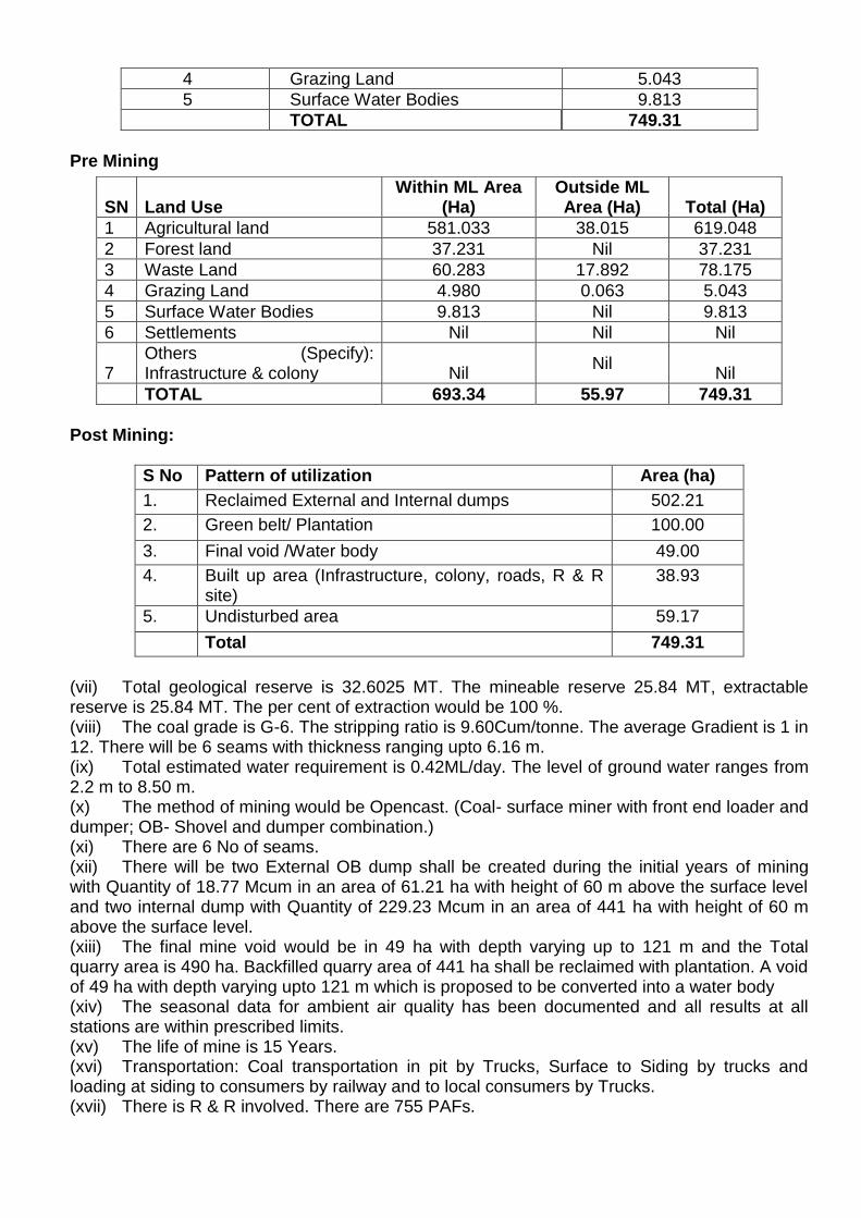
4 Grazing Land 5.043
5 Surface Water Bodies 9.813
TOTAL 749.31
Pre Mining
Post Mining:
S No Pattern of utilization Area (ha)
1. Reclaimed External and Internal dumps 502.21
2. Green belt/ Plantation 100.00
3. Final void /Water body 49.00
4. Built up area (Infrastructure, colony, roads, R & R site)
38.93
5. Undisturbed area 59.17
Total 749.31
(vii) Total geological reserve is 32.6025 MT. The mineable reserve 25.84 MT, extractable reserve is 25.84 MT. The per cent of extraction would be 100 %. (viii) The coal grade is G-6. The stripping ratio is 9.60Cum/tonne. The average Gradient is 1 in 12. There will be 6 seams with thickness ranging upto 6.16 m. (ix) Total estimated water requirement is 0.42ML/day. The level of ground water ranges from 2.2 m to 8.50 m. (x) The method of mining would be Opencast. (Coal- surface miner with front end loader and dumper; OB- Shovel and dumper combination.) (xi) There are 6 No of seams. (xii) There will be two External OB dump shall be created during the initial years of mining with Quantity of 18.77 Mcum in an area of 61.21 ha with height of 60 m above the surface level and two internal dump with Quantity of 229.23 Mcum in an area of 441 ha with height of 60 m above the surface level. (xiii) The final mine void would be in 49 ha with depth varying up to 121 m and the Total quarry area is 490 ha. Backfilled quarry area of 441 ha shall be reclaimed with plantation. A void of 49 ha with depth varying upto 121 m which is proposed to be converted into a water body (xiv) The seasonal data for ambient air quality has been documented and all results at all stations are within prescribed limits. (xv) The life of mine is 15 Years. (xvi) Transportation: Coal transportation in pit by Trucks, Surface to Siding by trucks and loading at siding to consumers by railway and to local consumers by Trucks. (xvii) There is R & R involved. There are 755 PAFs.
SN Land Use Within ML Area
(Ha) Outside ML Area (Ha) Total (Ha)
1 Agricultural land 581.033 38.015 619.048
2 Forest land 37.231 Nil 37.231
3 Waste Land 60.283 17.892 78.175
4 Grazing Land 4.980 0.063 5.043
5 Surface Water Bodies 9.813 Nil 9.813
6 Settlements Nil Nil Nil
7 Others (Specify): Infrastructure & colony Nil
Nil Nil
TOTAL 693.34 55.97 749.31
(xviii) Cost: Total capital cost of the project is Rs. 371.04 Crores. CSR Cost: 2% of the average net profit of the Company for the three immediate preceding financial years or Rs.2.00 per tonne of coal production of previous year whichever is higher. R&R Cost Rs.70.16 Crores. Environmental Management Cost Rs.99.70Crores). (xix) Water body: Ghorchat nallah is flowing on the North side of the mine boundary and Lehangi nallah is flowing on the east side of the mine boundary (xx) Approvals: Ground water clearance obtained on 09.04.2003 and online application for issuance of fresh NOC from CGWA has been submitted on 22.12.2017. Project Report of Kanchan Opencast Expn. Project (0.65 MTPA to 2.0 MTPA) was approved by SECL Board in its 230rd meeting held on 17/12/2014. Mine closure plan is an integral part of Project Report. (xxi) Wildlife issues: No wildlife sanctuary is there within 10Kms radius from the mine boundary. Although, wildlife conservation plan is under preparation at TFRI, Jabalpur. (xxii) Forestry issues: Total forest area involved 37.231 ha, for which application has been made on line 16th June 2016 for 6.081 Ha and on 21st Aug 2017 for 31.15 ha to obtain stage-I FC. Forest clearance for stage I issued by MoEF&CC on 24.01.2019 (xxiii) Total afforestation plan shall be implemented covering an area of 502.21ha at the end of mining. Green Belt over an area of 100 ha. Density of tree plantation 2500 trees/ ha of plants. (xxiv) There are no court cases/violation pending with the project (xxv) Public Hearing for the last EC was held on 12.02.2009. 45.19.3 During deliberations on the proposal, the Committee noted the following:- The present proposal is for amendment in ToR issued for the expansion project of Kanchan opencast coal mine from 0.65MTPA to 2.7 MTPA (Peak) of M/S South Eastern Coalfields Limited located in an area of 749.31 ha in District Umaria (Madhya Pradesh).
The Ministry had earlier granted EC to the expansion project of Kanchan Opencast Coal Mine from 0.32MTPA to 0.65 MTPA (Normative)/0.75MTPA(Peak) in an area of 203.93ha vide letter dated 29th March2010
Total area includes forest land of 37.231 ha (Revenue forest), for which application has been made on line 16th June 2016 for 6.081 Ha and on 21st Aug 2017 for 31.15 ha to obtain stage-I FC. .Stage I FC issued on 24.01.2019 Amendment in ToR has been sought for exemption/modification of condition no.4 regarding utilization of flyash in external overburden dumps and back filling as per the provisions contained in the Fly Ash notification, 2009, read with subsequent amendments.
45.19.4 The EAC, after deliberations, found no rationale for consideration of the proposal for the present. The proposal was not taken forward. Correction in Minutes of Meeting of 40th meeting held on 26th October, 2018 of below mentioned proposal Expansion of Kondapuram Underground Coal Mining Project from 0.51 MTPA to 0.92 MTPA in mine lease area of 477.03 ha of M/s the SCCL located in village Kondapuram, Tehsil Manuguru, District Bhadradri Kothagudem (Telangana) - For Terms of Reference The above proposal was recommended by the EAC in its meeting, however inadvertently finds mention of terms and conditions applicable for Opencast Coal mines instead of Underground Coal Mine
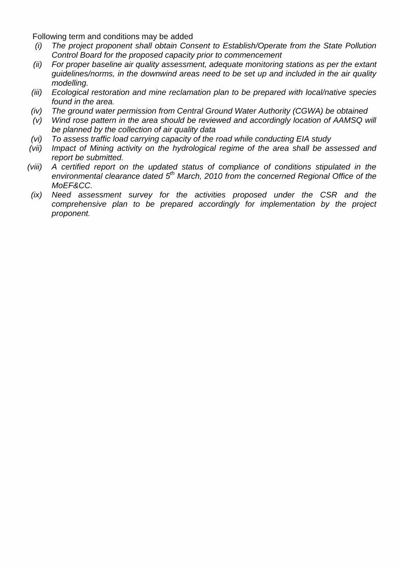
Following term and conditions may be added (i) The project proponent shall obtain Consent to Establish/Operate from the State Pollution
Control Board for the proposed capacity prior to commencement (ii) For proper baseline air quality assessment, adequate monitoring stations as per the extant
guidelines/norms, in the downwind areas need to be set up and included in the air quality modelling.
(iii) Ecological restoration and mine reclamation plan to be prepared with local/native species found in the area.
(iv) The ground water permission from Central Ground Water Authority (CGWA) be obtained (v) Wind rose pattern in the area should be reviewed and accordingly location of AAMSQ will
be planned by the collection of air quality data (vi) To assess traffic load carrying capacity of the road while conducting EIA study (vii) Impact of Mining activity on the hydrological regime of the area shall be assessed and
report be submitted. (viii) A certified report on the updated status of compliance of conditions stipulated in the
environmental clearance dated 5th March, 2010 from the concerned Regional Office of the MoEF&CC.
(ix) Need assessment survey for the activities proposed under the CSR and the comprehensive plan to be prepared accordingly for implementation by the project proponent.
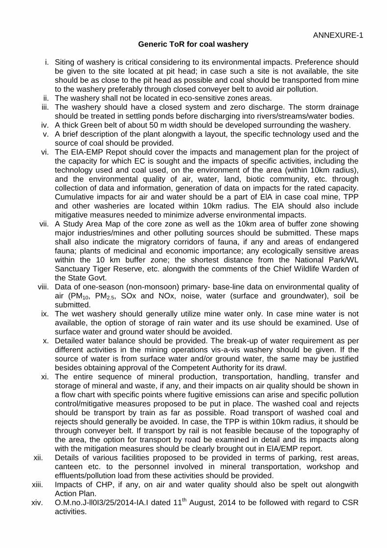
ANNEXURE-1 Generic ToR for coal washery
i. Siting of washery is critical considering to its environmental impacts. Preference should be given to the site located at pit head; in case such a site is not available, the site should be as close to the pit head as possible and coal should be transported from mine to the washery preferably through closed conveyer belt to avoid air pollution.
ii. The washery shall not be located in eco-sensitive zones areas. iii. The washery should have a closed system and zero discharge. The storm drainage
should be treated in settling ponds before discharging into rivers/streams/water bodies. iv. A thick Green belt of about 50 m width should be developed surrounding the washery. v. A brief description of the plant alongwith a layout, the specific technology used and the
source of coal should be provided. vi. The EIA-EMP Repot should cover the impacts and management plan for the project of
the capacity for which EC is sought and the impacts of specific activities, including the technology used and coal used, on the environment of the area (within 10km radius), and the environmental quality of air, water, land, biotic community, etc. through collection of data and information, generation of data on impacts for the rated capacity. Cumulative impacts for air and water should be a part of ElA in case coal mine, TPP and other washeries are located within 10km radius. The ElA should also include mitigative measures needed to minimize adverse environmental impacts.
vii. A Study Area Map of the core zone as well as the 10km area of buffer zone showing major industries/mines and other polluting sources should be submitted. These maps shall also indicate the migratory corridors of fauna, if any and areas of endangered fauna; plants of medicinal and economic importance; any ecologically sensitive areas within the 10 km buffer zone; the shortest distance from the National Park/WL Sanctuary Tiger Reserve, etc. alongwith the comments of the Chief Wildlife Warden of the State Govt.
viii. Data of one-season (non-monsoon) primary- base-line data on environmental quality of air (PM10, PM2.5, SOx and NOx, noise, water (surface and groundwater), soil be submitted.
ix. The wet washery should generally utilize mine water only. In case mine water is not available, the option of storage of rain water and its use should be examined. Use of surface water and ground water should be avoided.
x. Detailed water balance should be provided. The break-up of water requirement as per different activities in the mining operations vis-a-vis washery should be given. If the source of water is from surface water and/or ground water, the same may be justified besides obtaining approval of the Competent Authority for its drawl.
xi. The entire sequence of mineral production, transportation, handling, transfer and storage of mineral and waste, if any, and their impacts on air quality should be shown in a flow chart with specific points where fugitive emissions can arise and specific pollution control/mitigative measures proposed to be put in place. The washed coal and rejects should be transport by train as far as possible. Road transport of washed coal and rejects should generally be avoided. In case, the TPP is within 10km radius, it should be through conveyer belt. If transport by rail is not feasible because of the topography of the area, the option for transport by road be examined in detail and its impacts along with the mitigation measures should be clearly brought out in ElA/EMP report.
xii. Details of various facilities proposed to be provided in terms of parking, rest areas, canteen etc. to the personnel involved in mineral transportation, workshop and effluents/pollution load from these activities should be provided.
xiii. Impacts of CHP, if any, on air and water quality should also be spelt out alongwith Action Plan.
xiv. O.M.no.J-ll0I3/25/2014-IA.I dated 11th August, 2014 to be followed with regard to CSR activities.
xv. Details of Public Hearing, Notice(s) issued in newspapers, proceedings/minutes of
Public Hearing, points raised by the general public and response/commitments made by the proponent along with the Action Plan and budgetary provisions be submitted in tabular form. If the Public Hearing is in the regional language, an authenticated English translation of the same should be provided. Status of any litigations/ court cases filed/pending, if any, against the project should be mentioned in EIA.
xvi. Analysis of samples indicating the following be submitted: Characteristics of coal prior to washing (this includes grade of coal, other
characteristics of ash, S and heavy levels of metals such as Hg, As, Pb, Cr etc). Characteristics and quantum of coal after washing. Characteristics and quantum of coal rejects.
xvii. Details of management/disposal/use of coal rejects should be provided. The rejects should be used in TPP located close to the washery as far as possible. If TPP is within a reasonable distance (10 km), transportation should be by conveyor belt. If it is far away, the transportation should be by rail as far as possible.
xviii. Copies of MOU/Agreement with linkages (for stand-alone washery) for the capacity for which EC is being sought should be submitted.
xix. Corporate Environment Responsibility: a) The Company must have a well laid down Environment Policy approved by the
Board of Directors. b) The Environment Policy must prescribe for standard operating
process/procedures to bring into focus any infringements/deviation/violation of the environmental or forest norms/conditions.
c) The hierarchical system or Administrative Order of the company to deal with environmental issues and for ensuring compliance with the environmental clearance conditions must be furnished.
d) To have proper checks and balances, the company should have a well laid down system of reporting of non-compliances/violations of environmental norms to the Board of Directors of the company and/or shareholders or stakeholders at large.
xx. A detailed action Plan for Corporate Social Responsibility for the project affected people and people living in and around the project area should be provided.
xxi. Permission of drawl of water shall be pre-requisite for consideration of EC. xxii. Wastewater /effluent should confirm to the effluent standards as prescribed under
Environment (Protection) Act, 1986 xxiii. Details of washed coal, middling and rejects along with the MoU with the end-users
should be submitted. ***
ANNEXURE-2 GENERIC TOR FOR AN OPENCAST COALMINE PROJECT for EC
(i) An EIA-EMP Report shall be prepared for...... MTPA rated capacity in an ML/project area of.....ha based on the generic structure specified in Appendix III of the EIA Notification, 2006.
(ii) An EIA-EMP Report would be prepared for..... MTPA rated capacity to cover the impacts and environment management plan for the project specific activities on the environment of the region, and the environmental quality encompassing air, water, land, biotic community, etc. through collection of data and information, generation of data on impacts including prediction modeling for..... MTPA of coal production based on approved project/Mining Plan for.....MTPA. Baseline data collection can be for any season (three months) except monsoon.
(iii) A toposheet specifying locations of the State, District and Project site should be provided.
(iv) A Study area map of the core zone (project area) and 10 km area of the buffer zone (1: 50,000 scale) clearly delineating the major topographical features such as the land use, surface drainage pattern including rivers/streams/nullahs/canals, locations of human habitations, major constructions including railways, roads, pipelines, major industries/mines and other polluting sources. In case of ecologically sensitive areas such as Biosphere Reserves/National Parks/WL Sanctuaries/ Elephant Reserves, forests (Reserved/Protected), migratory corridors of fauna, and areas where endangered fauna and plants of medicinal and economic importance found in the 15 km study area should be given.
(v) Land use map (1: 50,000 scale) based on a recent satellite imagery of the study area may also be provided with explanatory note on the land use.
(vi) Map showing the core zone delineating the agricultural land (irrigated and un-irrigated, uncultivable land as defined in the revenue records, forest areas (as per records), along with other physical features such as water bodies, etc should be furnished.
(vii) A contour map showing the area drainage of the core zone and 25 km of the study area (where the water courses of the core zone ultimately join the major rivers/streams outside the lease/project area) should also be clearly indicated in the separate map.
(viii) A detailed Site plan of the mine showing the proposed break-up of the land for mining operations such as the quarry area, OB dumps, green belt, safety zone, buildings, infrastructure, CHP, ETP, Stockyard, township/colony (within and adjacent to the ML), undisturbed area -if any, and landscape features such as existing roads, drains/natural water bodies to be left undisturbed along with any natural drainage adjoining the lease /project areas, and modification of thereof in terms of construction of embankments/bunds, proposed diversion/re-channelling of the water courses, etc., approach roads, major haul roads, etc should be indicated.
(ix) In case of any proposed diversion of nallah/canal/river, the proposed route of diversion /modification of drainage and their realignment, construction of embankment etc. should also be shown on the map as per the approval of Irrigation and flood control Department of the concerned state.
(x) Similarly if the project involves diversion of any road/railway line passing through the ML/project area, the proposed route of diversion and its realignment should be shown in the map along with the status of the approval of the competent authority.
(xi) Break up of lease/project area as per different land uses and their stage of acquisition should be provided.
LANDUSE DETAILS FOR OPENCAST PROJECT should be given as per the following table:
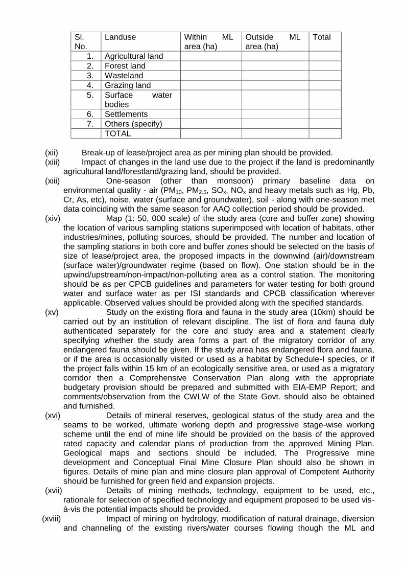
Sl. No.
Landuse Within ML area (ha)
Outside ML area (ha)
Total
1. Agricultural land
2. Forest land
3. Wasteland
4. Grazing land
5. Surface water bodies
6. Settlements
7. Others (specify)
TOTAL
(xii) Break-up of lease/project area as per mining plan should be provided. (xiii) Impact of changes in the land use due to the project if the land is predominantly
agricultural land/forestland/grazing land, should be provided. (xiii) One-season (other than monsoon) primary baseline data on
environmental quality - air (PM10, PM2.5, SOx, NOx and heavy metals such as Hg, Pb, Cr, As, etc), noise, water (surface and groundwater), soil - along with one-season met data coinciding with the same season for AAQ collection period should be provided.
(xiv) Map (1: 50, 000 scale) of the study area (core and buffer zone) showing the location of various sampling stations superimposed with location of habitats, other industries/mines, polluting sources, should be provided. The number and location of the sampling stations in both core and buffer zones should be selected on the basis of size of lease/project area, the proposed impacts in the downwind (air)/downstream (surface water)/groundwater regime (based on flow). One station should be in the upwind/upstream/non-impact/non-polluting area as a control station. The monitoring should be as per CPCB guidelines and parameters for water testing for both ground water and surface water as per ISI standards and CPCB classification wherever applicable. Observed values should be provided along with the specified standards.
(xv) Study on the existing flora and fauna in the study area (10km) should be carried out by an institution of relevant discipline. The list of flora and fauna duly authenticated separately for the core and study area and a statement clearly specifying whether the study area forms a part of the migratory corridor of any endangered fauna should be given. If the study area has endangered flora and fauna, or if the area is occasionally visited or used as a habitat by Schedule-I species, or if the project falls within 15 km of an ecologically sensitive area, or used as a migratory corridor then a Comprehensive Conservation Plan along with the appropriate budgetary provision should be prepared and submitted with EIA-EMP Report; and comments/observation from the CWLW of the State Govt. should also be obtained and furnished.
(xvi) Details of mineral reserves, geological status of the study area and the seams to be worked, ultimate working depth and progressive stage-wise working scheme until the end of mine life should be provided on the basis of the approved rated capacity and calendar plans of production from the approved Mining Plan. Geological maps and sections should be included. The Progressive mine development and Conceptual Final Mine Closure Plan should also be shown in figures. Details of mine plan and mine closure plan approval of Competent Authority should be furnished for green field and expansion projects.
(xvii) Details of mining methods, technology, equipment to be used, etc., rationale for selection of specified technology and equipment proposed to be used vis-à-vis the potential impacts should be provided.
(xviii) Impact of mining on hydrology, modification of natural drainage, diversion and channeling of the existing rivers/water courses flowing though the ML and
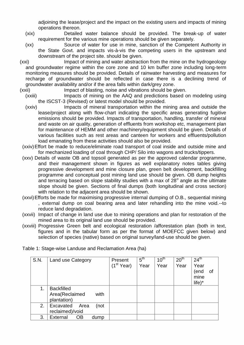
adjoining the lease/project and the impact on the existing users and impacts of mining operations thereon.
(xix) Detailed water balance should be provided. The break-up of water requirement for the various mine operations should be given separately.
(xx) Source of water for use in mine, sanction of the Competent Authority in the State Govt. and impacts vis-à-vis the competing users in the upstream and downstream of the project site. should be given.
(xxi) Impact of mining and water abstraction from the mine on the hydrogeology and groundwater regime within the core zone and 10 km buffer zone including long-term monitoring measures should be provided. Details of rainwater harvesting and measures for recharge of groundwater should be reflected in case there is a declining trend of groundwater availability and/or if the area falls within dark/grey zone.
(xxii) Impact of blasting, noise and vibrations should be given. (xxiii) Impacts of mining on the AAQ and predictions based on modeling using
the ISCST-3 (Revised) or latest model should be provided. (xxiv) Impacts of mineral transportation within the mining area and outside the
lease/project along with flow-chart indicating the specific areas generating fugitive emissions should be provided. Impacts of transportation, handling, transfer of mineral and waste on air quality, generation of effluents from workshop etc, management plan for maintenance of HEMM and other machinery/equipment should be given. Details of various facilities such as rest areas and canteen for workers and effluents/pollution load emanating from these activities should also be provided.
(xxiv) Effort be made to reduce/eliminate road transport of coal inside and outside mine and for mechanized loading of coal through CHP/ Silo into wagons and trucks/tippers.
(xxv) Details of waste OB and topsoil generated as per the approved calendar programme, and their management shown in figures as well explanatory notes tables giving progressive development and mine closure plan, green belt development, backfilling programme and conceptual post mining land use should be given. OB dump heights and terracing based on slope stability studies with a max of 28o angle as the ultimate slope should be given. Sections of final dumps (both longitudinal and cross section) with relation to the adjacent area should be shown.
(xxvi) Efforts be made for maximising progressive internal dumping of O.B., sequential mining , external dump on coal bearing area and later rehandling into the mine void.--to reduce land degradation.
(xxvii) Impact of change in land use due to mining operations and plan for restoration of the mined area to its original land use should be provided.
(xxviii) Progressive Green belt and ecological restoration /afforestation plan (both in text, figures and in the tabular form as per the format of MOEFCC given below) and selection of species (native) based on original survey/land-use should be given.
Table 1: Stage-wise Landuse and Reclamation Area (ha)
S.N. Land use Category Present (1st Year)
5th Year
10th Year
20th Year
24th Year (end of mine life)*
1. Backfilled Area(Reclaimed with plantation)
2. Excavated Area (not reclaimed)/void
3. External OB dump
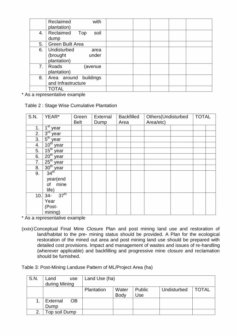
Reclaimed with plantation)
4. Reclaimed Top soil dump
5. Green Built Area
6. Undisturbed area (brought under plantation)
7. Roads (avenue plantation)
8. Area around buildings and Infrastructure
TOTAL
* As a representative example Table 2 : Stage Wise Cumulative Plantation
S.N. YEAR* Green Belt
External Dump
Backfilled Area
Others(Undisturbed Area/etc)
TOTAL
1. 1st year
2. 3rd year
3. 5th year
4. 10th year
5. 15th year
6. 20th year
7. 25th year
8. 30th year
9. 34th year(end of mine life)
10. 34- 37th Year (Post-mining)
* As a representative example
(xxix) Conceptual Final Mine Closure Plan and post mining land use and restoration of land/habitat to the pre- mining status should be provided. A Plan for the ecological restoration of the mined out area and post mining land use should be prepared with detailed cost provisions. Impact and management of wastes and issues of re-handling (wherever applicable) and backfilling and progressive mine closure and reclamation should be furnished.
Table 3: Post-Mining Landuse Pattern of ML/Project Area (ha)
S.N. Land use during Mining
Land Use (ha)
Plantation Water Body
Public Use
Undisturbed TOTAL
1. External OB Dump
2. Top soil Dump
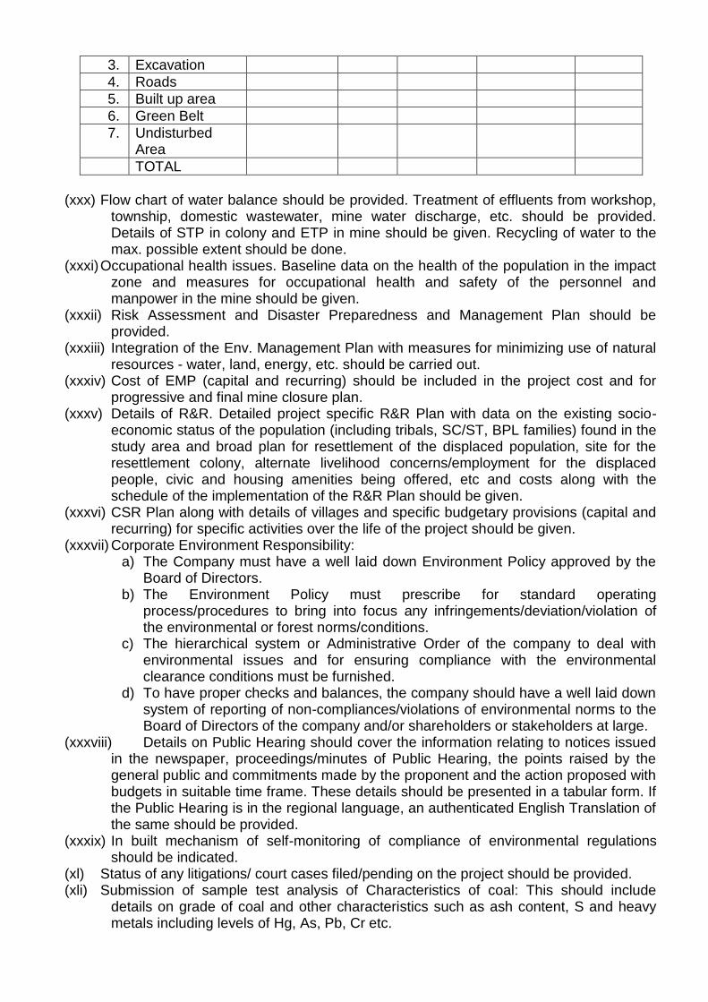
3. Excavation
4. Roads
5. Built up area
6. Green Belt
7. Undisturbed Area
TOTAL
(xxx) Flow chart of water balance should be provided. Treatment of effluents from workshop,
township, domestic wastewater, mine water discharge, etc. should be provided. Details of STP in colony and ETP in mine should be given. Recycling of water to the max. possible extent should be done.
(xxxi) Occupational health issues. Baseline data on the health of the population in the impact zone and measures for occupational health and safety of the personnel and manpower in the mine should be given.
(xxxii) Risk Assessment and Disaster Preparedness and Management Plan should be provided.
(xxxiii) Integration of the Env. Management Plan with measures for minimizing use of natural resources - water, land, energy, etc. should be carried out.
(xxxiv) Cost of EMP (capital and recurring) should be included in the project cost and for progressive and final mine closure plan.
(xxxv) Details of R&R. Detailed project specific R&R Plan with data on the existing socio-economic status of the population (including tribals, SC/ST, BPL families) found in the study area and broad plan for resettlement of the displaced population, site for the resettlement colony, alternate livelihood concerns/employment for the displaced people, civic and housing amenities being offered, etc and costs along with the schedule of the implementation of the R&R Plan should be given.
(xxxvi) CSR Plan along with details of villages and specific budgetary provisions (capital and recurring) for specific activities over the life of the project should be given.
(xxxvii) Corporate Environment Responsibility: a) The Company must have a well laid down Environment Policy approved by the
Board of Directors. b) The Environment Policy must prescribe for standard operating
process/procedures to bring into focus any infringements/deviation/violation of the environmental or forest norms/conditions.
c) The hierarchical system or Administrative Order of the company to deal with environmental issues and for ensuring compliance with the environmental clearance conditions must be furnished.
d) To have proper checks and balances, the company should have a well laid down system of reporting of non-compliances/violations of environmental norms to the Board of Directors of the company and/or shareholders or stakeholders at large.
(xxxviii) Details on Public Hearing should cover the information relating to notices issued in the newspaper, proceedings/minutes of Public Hearing, the points raised by the general public and commitments made by the proponent and the action proposed with budgets in suitable time frame. These details should be presented in a tabular form. If the Public Hearing is in the regional language, an authenticated English Translation of the same should be provided.
(xxxix) In built mechanism of self-monitoring of compliance of environmental regulations should be indicated.
(xl) Status of any litigations/ court cases filed/pending on the project should be provided. (xli) Submission of sample test analysis of Characteristics of coal: This should include
details on grade of coal and other characteristics such as ash content, S and heavy metals including levels of Hg, As, Pb, Cr etc.
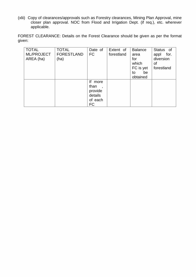
(xlii) Copy of clearances/approvals such as Forestry clearances, Mining Plan Approval, mine closer plan approval. NOC from Flood and Irrigation Dept. (if req.), etc. wherever applicable.
FOREST CLEARANCE: Details on the Forest Clearance should be given as per the format given:
TOTAL ML/PROJECT AREA (ha)
TOTAL FORESTLAND (ha)
Date of FC
Extent of forestland
Balance area for which FC is yet to be obtained
Status of appl for. diversion of forestland
If more than , provide details of each FC
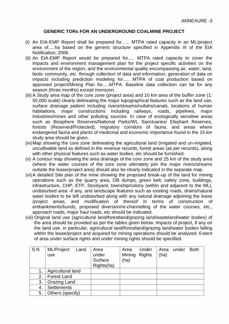
ANNEXURE -3
GENERIC TORs FOR AN UNDERGROUND COALMINE PROJECT
(i) An EIA-EMP Report shall be prepared for...... MTPA rated capacity in an ML/project area of.....ha based on the generic structure specified in Appendix III of the EIA Notification, 2006.
(ii) An EIA-EMP Report would be prepared for..... MTPA rated capacity to cover the impacts and environment management plan for the project specific activities on the environment of the region, and the environmental quality encompassing air, water, land, biotic community, etc. through collection of data and information, generation of data on impacts including prediction modeling for..... MTPA of coal production based on approved project/Mining Plan for.....MTPA. Baseline data collection can be for any season (three months) except monsoon.
(iii) A Study area map of the core zone (project area) and 10 km area of the buffer zone (1: 50,000 scale) clearly delineating the major topographical features such as the land use, surface drainage pattern including rivers/streams/nullahs/canals, locations of human habitations, major constructions including railways, roads, pipelines, major industries/mines and other polluting sources. In case of ecologically sensitive areas such as Biosphere Reserves/National Parks/WL Sanctuaries/ Elephant Reserves, forests (Reserved/Protected), migratory corridors of fauna, and areas where endangered fauna and plants of medicinal and economic importance found in the 15 km study area should be given.
(iv) Map showing the core zone delineating the agricultural land (irrigated and un-irrigated, uncultivable land as defined in the revenue records, forest areas (as per records), along with other physical features such as water bodies, etc should be furnished.
(v) A contour map showing the area drainage of the core zone and 25 km of the study area (where the water courses of the core zone ultimately join the major rivers/streams outside the lease/project area) should also be clearly indicated in the separate map.
(vi) A detailed Site plan of the mine showing the proposed break-up of the land for mining operations such as the quarry area, OB dumps, green belt, safety zone, buildings, infrastructure, CHP, ETP, Stockyard, township/colony (within and adjacent to the ML), undisturbed area -if any, and landscape features such as existing roads, drains/natural water bodies to be left undisturbed along with any natural drainage adjoining the lease /project areas, and modification of thereof in terms of construction of embankments/bunds, proposed diversion/re-channelling of the water courses, etc., approach roads, major haul roads, etc should be indicated.
(vii) Original land use (agricultural land/forestland/grazing land/wasteland/water bodies) of the area should be provided as per the tables given below. Impacts of project, if any on the land use, in particular, agricultural land/forestland/grazing land/water bodies falling within the lease/project and acquired for mining operations should be analyzed. Extent of area under surface rights and under mining rights should be specified.
S.N ML/Project Land use
Area under Surface Rights(ha)
Area Under Mining Rights (ha)
Area under Both (ha)
1. Agricultural land
2. Forest Land
3. Grazing Land
4. Settlements
5. Others (specify)
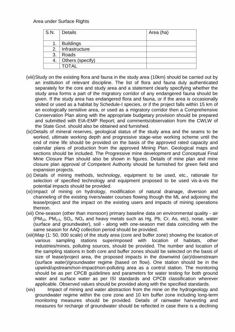
Area under Surface Rights
S.N. Details
Area (ha)
1. Buildings
2. Infrastructure
3. Roads
4. Others (specify)
TOTAL
(viii) Study on the existing flora and fauna in the study area (10km) should be carried out by
an institution of relevant discipline. The list of flora and fauna duly authenticated separately for the core and study area and a statement clearly specifying whether the study area forms a part of the migratory corridor of any endangered fauna should be given. If the study area has endangered flora and fauna, or if the area is occasionally visited or used as a habitat by Schedule-I species, or if the project falls within 15 km of an ecologically sensitive area, or used as a migratory corridor then a Comprehensive Conservation Plan along with the appropriate budgetary provision should be prepared and submitted with EIA-EMP Report; and comments/observation from the CWLW of the State Govt. should also be obtained and furnished.
(ix) Details of mineral reserves, geological status of the study area and the seams to be worked, ultimate working depth and progressive stage-wise working scheme until the end of mine life should be provided on the basis of the approved rated capacity and calendar plans of production from the approved Mining Plan. Geological maps and sections should be included. The Progressive mine development and Conceptual Final Mine Closure Plan should also be shown in figures. Details of mine plan and mine closure plan approval of Competent Authority should be furnished for green field and expansion projects.
(x) Details of mining methods, technology, equipment to be used, etc., rationale for selection of specified technology and equipment proposed to be used vis-à-vis the potential impacts should be provided.
(xi) Impact of mining on hydrology, modification of natural drainage, diversion and channeling of the existing rivers/water courses flowing though the ML and adjoining the lease/project and the impact on the existing users and impacts of mining operations thereon.
(xii) One-season (other than monsoon) primary baseline data on environmental quality - air (PM10, PM2.5, SOx, NOx and heavy metals such as Hg, Pb, Cr, As, etc), noise, water (surface and groundwater), soil - along with one-season met data coinciding with the same season for AAQ collection period should be provided.
(xiii) Map (1: 50, 000 scale) of the study area (core and buffer zone) showing the location of various sampling stations superimposed with location of habitats, other industries/mines, polluting sources, should be provided. The number and location of the sampling stations in both core and buffer zones should be selected on the basis of size of lease/project area, the proposed impacts in the downwind (air)/downstream (surface water)/groundwater regime (based on flow). One station should be in the upwind/upstream/non-impact/non-polluting area as a control station. The monitoring should be as per CPCB guidelines and parameters for water testing for both ground water and surface water as per ISI standards and CPCB classification wherever applicable. Observed values should be provided along with the specified standards.
(xiv) Impact of mining and water abstraction from the mine on the hydrogeology and groundwater regime within the core zone and 10 km buffer zone including long-term monitoring measures should be provided. Details of rainwater harvesting and measures for recharge of groundwater should be reflected in case there is a declining
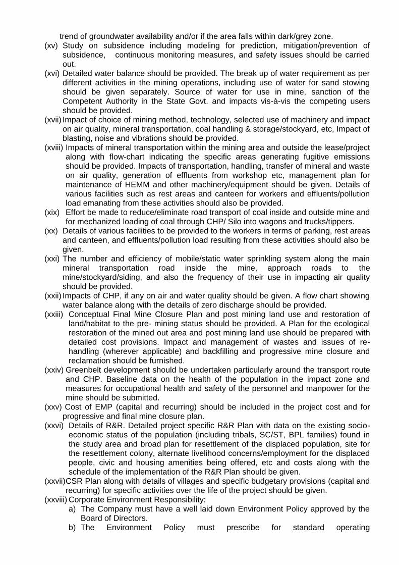
trend of groundwater availability and/or if the area falls within dark/grey zone. (xv) Study on subsidence including modeling for prediction, mitigation/prevention of
subsidence, continuous monitoring measures, and safety issues should be carried out.
(xvi) Detailed water balance should be provided. The break up of water requirement as per different activities in the mining operations, including use of water for sand stowing should be given separately. Source of water for use in mine, sanction of the Competent Authority in the State Govt. and impacts vis-à-vis the competing users should be provided.
(xvii) Impact of choice of mining method, technology, selected use of machinery and impact on air quality, mineral transportation, coal handling & storage/stockyard, etc, Impact of blasting, noise and vibrations should be provided.
(xviii) Impacts of mineral transportation within the mining area and outside the lease/project along with flow-chart indicating the specific areas generating fugitive emissions should be provided. Impacts of transportation, handling, transfer of mineral and waste on air quality, generation of effluents from workshop etc, management plan for maintenance of HEMM and other machinery/equipment should be given. Details of various facilities such as rest areas and canteen for workers and effluents/pollution load emanating from these activities should also be provided.
(xix) Effort be made to reduce/eliminate road transport of coal inside and outside mine and for mechanized loading of coal through CHP/ Silo into wagons and trucks/tippers.
(xx) Details of various facilities to be provided to the workers in terms of parking, rest areas and canteen, and effluents/pollution load resulting from these activities should also be given.
(xxi) The number and efficiency of mobile/static water sprinkling system along the main mineral transportation road inside the mine, approach roads to the mine/stockyard/siding, and also the frequency of their use in impacting air quality should be provided.
(xxii) Impacts of CHP, if any on air and water quality should be given. A flow chart showing water balance along with the details of zero discharge should be provided.
(xxiii) Conceptual Final Mine Closure Plan and post mining land use and restoration of land/habitat to the pre- mining status should be provided. A Plan for the ecological restoration of the mined out area and post mining land use should be prepared with detailed cost provisions. Impact and management of wastes and issues of re-handling (wherever applicable) and backfilling and progressive mine closure and reclamation should be furnished.
(xxiv) Greenbelt development should be undertaken particularly around the transport route and CHP. Baseline data on the health of the population in the impact zone and measures for occupational health and safety of the personnel and manpower for the mine should be submitted.
(xxv) Cost of EMP (capital and recurring) should be included in the project cost and for progressive and final mine closure plan.
(xxvi) Details of R&R. Detailed project specific R&R Plan with data on the existing socio-economic status of the population (including tribals, SC/ST, BPL families) found in the study area and broad plan for resettlement of the displaced population, site for the resettlement colony, alternate livelihood concerns/employment for the displaced people, civic and housing amenities being offered, etc and costs along with the schedule of the implementation of the R&R Plan should be given.
(xxvii) CSR Plan along with details of villages and specific budgetary provisions (capital and recurring) for specific activities over the life of the project should be given.
(xxviii) Corporate Environment Responsibility: a) The Company must have a well laid down Environment Policy approved by the
Board of Directors. b) The Environment Policy must prescribe for standard operating

process/procedures to bring into focus any infringements/deviation/violation of the environmental or forest norms/conditions.
c) The hierarchical system or Administrative Order of the company to deal with environmental issues and for ensuring compliance with the environmental clearance conditions must be furnished.
d) To have proper checks and balances, the company should have a well laid down system of reporting of non-compliances/violations of environmental norms to the Board of Directors of the company and/or shareholders or stakeholders at large.
(xxix) Details on Public Hearing should cover the information relating to notices issued in the newspaper, proceedings/minutes of Public Hearing, the points raised by the general public and commitments made by the proponent and the action proposed with budgets in suitable time frame. These details should be presented in a tabular form. If the Public Hearing is in the regional language, an authenticated English Translation of the same should be provided.
(xxx) In built mechanism of self-monitoring of compliance of environmental regulations should be indicated.
(xxxi) Status of any litigations/ court cases filed/pending on the project should be provided. (xxxii) Submission of sample test analysis of Characteristics of coal: This should include
details on grade of coal and other characteristics such as ash content, S and heavy metals including levels of Hg, As, Pb, Cr etc.
(xxxiii) Copy of clearances/approvals such as Forestry clearances, Mining Plan Approval, mine closer plan approval. NOC from Flood and Irrigation Dept. (if req.), etc. wherever applicable.
Details on the Forest Clearance should be given as per the format given:
Total ML /Project Area (ha)
Total Forest Land (ha)
Date of FC Extent of Forest Land
Balance area for which FC is yet to be obtained
Status of appl. For diversion of forest land
If more than one provide details of each FC
ANNEXURE-4
GENERIC TORs FOR AN OPENCAST-CUM-UNDERGROUND COALMINE PROJECT
(i) An EIA-EMP Report would be prepared for a combined peak capacity of .....MTPA for OC-cum-UG project which consists of .... MTPA in an ML/project area of ..... ha for OC and .... MTPA for UG in an ML/project area of ..... ha based on the generic structure specified in Appendix III of the EIA Notification 2006.
(ii) An EIA-EMP Report would be prepared for..... MTPA rated capacity to cover the
impacts and environment management plan for the project specific activities on the environment of the region, and the environmental quality encompassing air, water, land, biotic community, etc. through collection of data and information, generation of data on impacts including prediction modeling for..... MTPA of coal production based on approved project/Mining Plan for.....MTPA. Baseline data collection can be for any season (three months) except monsoon.
(iii) The ToRs prescribed for both opencast and underground mining are applicable for opencast – cum-underground mining.
***
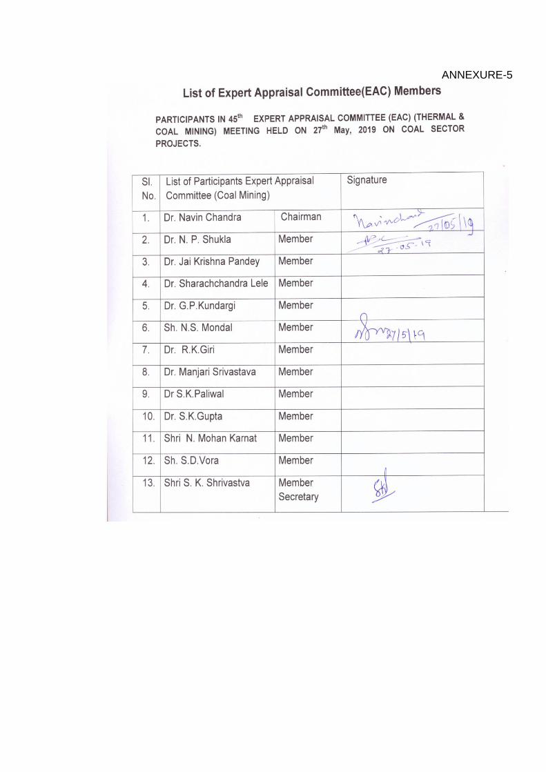
ANNEXURE-5
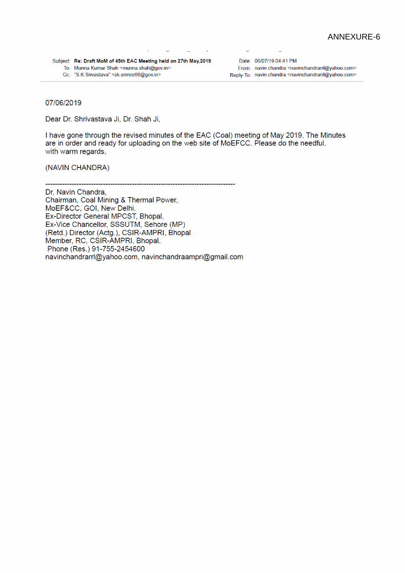
ANNEXURE-6