Embed Size (px)
Citation preview
“Map Projections and Parameters” from http://www.olmweb.dot.state.mn.us/ © Mn/DOT, 2002-2009 Page 1 of 26
Minnesota Department of Transportation Office of Land Management Source: http://www.olmweb.dot.state.mn.us/tech/Projections.htm
Map Projections and Parameters Last Updated on April 16, 2009
Notice of Error in Beltrami County North Zone Parameters
Conad83 was originally written in 1986 to run on the HP-310 computer system. In 1988, Conad83 was rewritten to run on IBM-compatible computers. At that time there was a transcription error, and the south parallel parameter for Beltrami County North Zone was mistakenly set one degree too far south, which results in county coordinate positional errors on the order of one to three meters. See below in the Lambert Zones table. The erroneous value persisted in the MnCon program that replaced the functionality of the Conad programs in 1997 and also appeared in some documentation of the Minnesota County Coordinate System, including this page.
This error was repaired in MnCon Version 1.9.3, released on June 7, 2001. Beginning with version 1.9.3, MnCon will include both the correct and erroneous parameters for Beltrami County North Zone. For lack of a better term, they are designated “good” and “bad” on the map projection lists and in the printed and file outputs. The uncorrected (or bad) value appears at the bottom of the lists and is included for the convenience of those who may need to convert from or to the old, erroneous county coordinates.
To summarize, any Beltrami County North Zone coordinate computed by the PC version of Conad83 or by MnCon prior to June 7, 2001 is incorrect with respect to the Minnesota County Coordinate System definition. Any coordinate projections computed from Beltrami County North Zone coordinates are also suspect and should be examined. No other counties, zones, or projections are affected.
Introduction
The following tables and examples provide the data needed to perform conversions of coordinates between map projections used in the State of Minnesota.
Required parameters, examples of usage and methods of parameter calculation are listed for all projections used in Minnesota. Since different conversion packages give the parameters different names, all known aliases have been noted.

“Map Projections and Parameters” from http://www.olmweb.dot.state.mn.us/ © Mn/DOT, 2002-2009 Page 2 of 26
For more information, please contact:
Roy Graff Minnesota Department of Transportation, Office of Land Management Surveys Research and Support Unit Transportation Building Mail Stop 643 395 John Ireland Boulevard Saint Paul, MN 55155-1899 (651) 366-3443 [email protected]
Click on the following links to jump to the associated topic:
NAD83 Universal Transverse Mercator
NAD83 Minnesota State Plane
NAD83 Minnesota County Coordinate System
NAD83 Minnesota County Zones with Lambert Conformal Conic Projection
NAD83 Minnesota County Zones with Transverse Mercator Projection
NAD83 Minnesota County Zones with Oblique Mercator Projection
NAD27 Universal Transverse Mercator
NAD27 Minnesota State Plane
NAD27 Minnesota Project Coordinate System
NAD27 Minnesota Project Zones in North State Plane
NAD27 Minnesota Project Zones in Central State Plane
NAD27 Minnesota Project Zones in South State Plane
NAD27 Minnesota Project Zones Along North Shore of Lake Superior
NAD27 Minnesota Project Coordinate System -- Modified for Counties
Conversions Between Datums
“Map Projections and Parameters” from http://www.olmweb.dot.state.mn.us/ © Mn/DOT, 2002-2009 Page 3 of 26
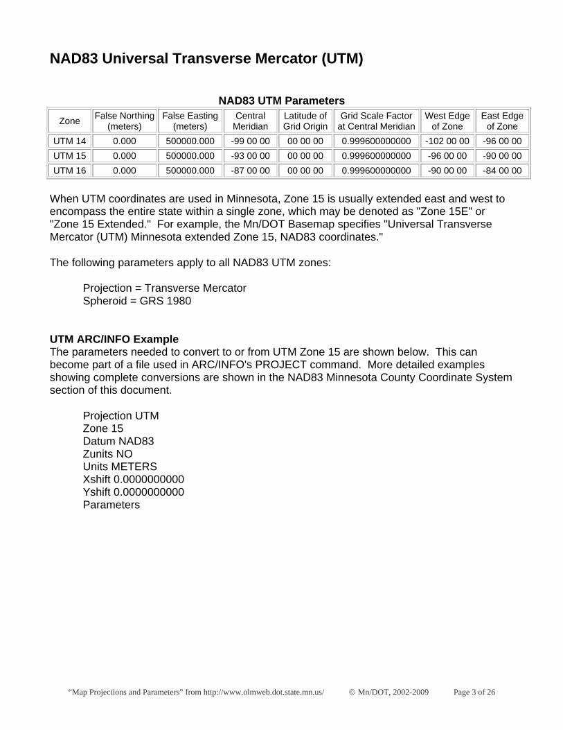
NAD83 Universal Transverse Mercator (UTM)
NAD83 UTM Parameters
Zone False Northing (meters)
False Easting (meters)
Central Meridian
Latitude of Grid Origin
Grid Scale Factor at Central Meridian
West Edge of Zone
East Edge of Zone
UTM 14 0.000 500000.000 -99 00 00 00 00 00 0.999600000000 -102 00 00 -96 00 00 UTM 15 0.000 500000.000 -93 00 00 00 00 00 0.999600000000 -96 00 00 -90 00 00 UTM 16 0.000 500000.000 -87 00 00 00 00 00 0.999600000000 -90 00 00 -84 00 00
When UTM coordinates are used in Minnesota, Zone 15 is usually extended east and west to encompass the entire state within a single zone, which may be denoted as "Zone 15E" or "Zone 15 Extended." For example, the Mn/DOT Basemap specifies "Universal Transverse Mercator (UTM) Minnesota extended Zone 15, NAD83 coordinates."
The following parameters apply to all NAD83 UTM zones:
Projection = Transverse Mercator Spheroid = GRS 1980
UTM ARC/INFO Example The parameters needed to convert to or from UTM Zone 15 are shown below. This can become part of a file used in ARC/INFO's PROJECT command. More detailed examples showing complete conversions are shown in the NAD83 Minnesota County Coordinate System section of this document.
Projection UTM Zone 15 Datum NAD83 Zunits NO Units METERS Xshift 0.0000000000 Yshift 0.0000000000 Parameters
“Map Projections and Parameters” from http://www.olmweb.dot.state.mn.us/ © Mn/DOT, 2002-2009 Page 4 of 26
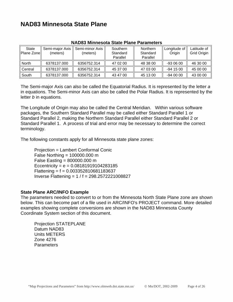
NAD83 Minnesota State Plane
NAD83 Minnesota State Plane Parameters State
Plane Zone Semi-major Axis
(meters) Semi-minor Axis
(meters) Southern Standard Parallel
Northern Standard Parallel
Longitude of Origin
Latitude of Grid Origin
North 6378137.000 6356752.314 47 02 00 48 38 00 -93 06 00 46 30 00 Central 6378137.000 6356752.314 45 37 00 47 03 00 -94 15 00 45 00 00 South 6378137.000 6356752.314 43 47 00 45 13 00 -94 00 00 43 00 00
The Semi-major Axis can also be called the Equatorial Radius. It is represented by the letter a in equations. The Semi-minor Axis can also be called the Polar Radius. It is represented by the letter b in equations.
The Longitude of Origin may also be called the Central Meridian. Within various software packages, the Southern Standard Parallel may be called either Standard Parallel 1 or Standard Parallel 2, making the Northern Standard Parallel either Standard Parallel 2 or Standard Parallel 1. A process of trial and error may be necessary to determine the correct terminology.
The following constants apply for all Minnesota state plane zones:
Projection = Lambert Conformal Conic False Northing = 100000.000 m False Easting = 800000.000 m Eccentricity = e = 0.08181919104283185 Flattening = f = 0.003352810681183637 Inverse Flattening = 1 / f = 298.2572221008827
State Plane ARC/INFO Example The parameters needed to convert to or from the Minnesota North State Plane zone are shown below. This can become part of a file used in ARC/INFO's PROJECT command. More detailed examples showing complete conversions are shown in the NAD83 Minnesota County Coordinate System section of this document.
Projection STATEPLANE Datum NAD83 Units METERS Zone 4276 Parameters
“Map Projections and Parameters” from http://www.olmweb.dot.state.mn.us/ © Mn/DOT, 2002-2009 Page 5 of 26
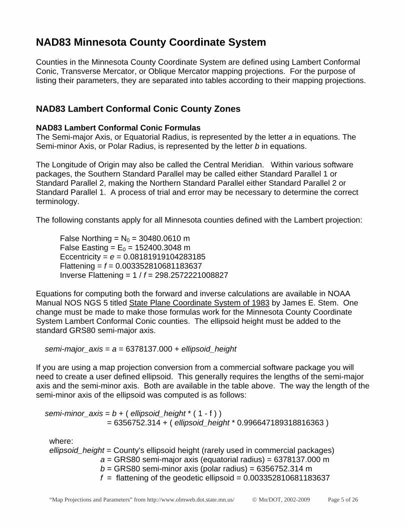
NAD83 Minnesota County Coordinate System
Counties in the Minnesota County Coordinate System are defined using Lambert Conformal Conic, Transverse Mercator, or Oblique Mercator mapping projections. For the purpose of listing their parameters, they are separated into tables according to their mapping projections.
NAD83 Lambert Conformal Conic County Zones
NAD83 Lambert Conformal Conic Formulas The Semi-major Axis, or Equatorial Radius, is represented by the letter a in equations. The Semi-minor Axis, or Polar Radius, is represented by the letter b in equations.
The Longitude of Origin may also be called the Central Meridian. Within various software packages, the Southern Standard Parallel may be called either Standard Parallel 1 or Standard Parallel 2, making the Northern Standard Parallel either Standard Parallel 2 or Standard Parallel 1. A process of trial and error may be necessary to determine the correct terminology.
The following constants apply for all Minnesota counties defined with the Lambert projection:
False Northing = N0 = 30480.0610 m False Easting = E0 = 152400.3048 m Eccentricity = e = 0.08181919104283185 Flattening = f = 0.003352810681183637 Inverse Flattening = 1 / f = 298.2572221008827
Equations for computing both the forward and inverse calculations are available in NOAA Manual NOS NGS 5 titled State Plane Coordinate System of 1983 by James E. Stem. One change must be made to make those formulas work for the Minnesota County Coordinate System Lambert Conformal Conic counties. The ellipsoid height must be added to the standard GRS80 semi-major axis.
semi-major_axis = a = 6378137.000 + ellipsoid_height
If you are using a map projection conversion from a commercial software package you will need to create a user defined ellipsoid. This generally requires the lengths of the semi-major axis and the semi-minor axis. Both are available in the table above. The way the length of the semi-minor axis of the ellipsoid was computed is as follows:
semi-minor_axis = b + ( ellipsoid_height * ( 1 - f ) ) = 6356752.314 + ( ellipsoid_height * 0.996647189318816363 )
where: ellipsoid_height = County's ellipsoid height (rarely used in commercial packages) a = GRS80 semi-major axis (equatorial radius) = 6378137.000 m b = GRS80 semi-minor axis (polar radius) = 6356752.314 m f = flattening of the geodetic ellipsoid = 0.003352810681183637
“Map Projections and Parameters” from http://www.olmweb.dot.state.mn.us/ © Mn/DOT, 2002-2009 Page 6 of 26
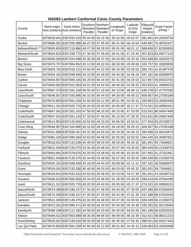
NAD83 Lambert Conformal Conic County Parameters
County Semi-major Axis (meters)
Semi-minor Axis (meters)
Southern Standard Parallel
Northern Standard Parallel
Longitude of Origin
Latitude of Grid Origin
Ellipsoid Height
(meters) Scale Factor
(PPM) *
Anoka 6378418.941 6357033.310 45 04 00 45 22 00 -93 16 00 45 02 07 281.941 44.20428724
Becker 6378586.581 6357200.388 46 47 00 47 05 00 -95 41 00 46 43 04 449.581 70.48782427
Beltrami/North ** 6378505.809 6357119.886 48 07 00 48 28 00 -95 01 00 48 01 12 368.809 57.82393824
Beltrami/South 6378544.823 6357158.770 47 30 00 47 55 00 -94 51 00 47 24 45 407.823 63.94077142
Benton 6378490.569 6357104.698 45 35 00 45 47 00 -94 03 00 45 33 33 353.569 55.43452579
Big Stone 6378470.757 6357084.952 45 13 00 45 32 00 -96 03 00 45 09 08 333.757 52.32828959
Blue Earth 6378403.701 6357018.121 43 56 00 44 22 00 -94 16 00 43 50 53 266.701 41.81487478
Brown 6378434.181 6357048.499 44 10 00 44 28 00 -94 44 00 44 06 29 297.181 46.59369970
Carlton 6378454.907 6357069.155 46 28 00 46 44 00 -92 41 00 46 25 02 317.907 49.84323792
Carver 6378400.653 6357015.083 44 41 00 44 54 00 -93 46 00 44 38 23 263.653 41.33699229
Cass/North 6378567.378 6357181.249 46 55 00 47 19 00 -94 13 00 46 48 13 430.378 67.47707050
Cass/South 6378546.957 6357160.896 46 16 00 46 44 00 -94 28 00 46 09 23 409.957 64.27535188
Chippewa 6378476.853 6357091.028 44 50 00 45 12 00 -95 51 00 44 45 10 339.853 53.28405458
Chisago 6378411.321 6357025.715 45 20 00 45 40 00 -93 05 00 45 17 47 274.321 43.00958101
Cook/North 6378647.541 6357261.143 47 56 00 48 10 00 -90 15 00 47 53 00 510.541 80.04547409
Cook/South 6378647.541 6357261.143 47 33 00 47 49 00 -90 15 00 47 26 20 510.541 80.04547409
Cottonwood 6378514.953 6357129.000 43 54 00 44 10 00 -94 55 00 43 50 53 377.953 59.25758572
Crow Wing 6378546.957 6357160.896 46 16 00 46 44 00 -94 28 00 46 09 23 409.957 64.27535188
Dakota 6378421.989 6357036.347 44 31 00 44 55 00 -93 19 00 44 28 19 284.989 44.68216973
Dodge 6378481.425 6357095.584 43 53 00 44 08 00 -92 55 00 43 50 02 344.425 54.00087831
Douglas 6378518.001 6357132.038 45 48 00 46 03 00 -96 03 00 45 45 32 381.001 59.73546821
Faribault 6378521.049 6357135.075 43 34 00 43 48 00 -93 57 00 43 30 00 384.049 60.21335070
Fillmore 6378464.661 6357078.876 43 33 00 43 48 00 -92 05 00 43 30 00 327.661 51.37252461
Freeborn 6378521.049 6357135.075 43 34 00 43 48 00 -93 57 00 43 30 00 384.049 60.21335070
Goodhue 6378434.181 6357048.499 44 18 00 44 40 00 -93 08 00 44 11 41 297.181 46.59369970
Grant 6378518.001 6357132.038 45 48 00 46 03 00 -96 03 00 45 45 32 381.001 59.73546821
Hennepin 6378418.941 6357033.310 44 53 00 45 08 00 -93 23 00 44 47 28 281.941 44.20428724
Houston 6378436.619 6357050.928 43 34 00 43 48 00 -91 28 00 43 30 00 299.619 46.97594298
Isanti 6378411.321 6357025.715 45 20 00 45 40 00 -93 05 00 45 17 47 274.321 43.00958101
Itasca/North 6378574.389 6357188.237 47 34 00 47 49 00 -93 44 00 47 30 00 437.389 68.57629430
Itasca/South 6378574.389 6357188.237 47 05 00 47 25 00 -93 44 00 47 01 35 437.389 68.57629430
Jackson 6378521.049 6357135.075 43 34 00 43 48 00 -93 57 00 43 30 00 384.049 60.21335070
Kanabec 6378472.281 6357086.471 45 49 00 46 20 00 -92 54 00 45 43 48 335.281 52.56723084
Kandiyohi 6378498.189 6357112.292 44 58 00 45 20 00 -94 45 00 44 53 29 361.189 56.62923202
Kittson 6378449.421 6357063.688 48 36 00 48 56 00 -96 09 00 48 32 38 312.421 48.98311215
Koochiching 6378525.621 6357139.632 48 00 00 48 37 00 -93 45 00 47 50 45 388.621 60.93017444
Lac Qui Parle 6378476.853 6357091.028 44 50 00 45 12 00 -95 51 00 44 45 10 339.853 53.28405458
“Map Projections and Parameters” from http://www.olmweb.dot.state.mn.us/ © Mn/DOT, 2002-2009 Page 7 of 26
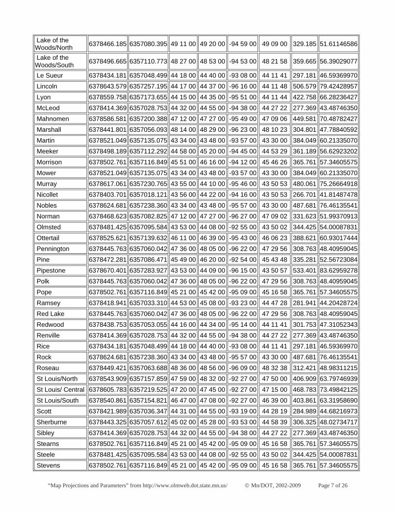
Lake of the Woods/North 6378466.185 6357080.395 49 11 00 49 20 00 -94 59 00 49 09 00 329.185 51.61146586
Lake of the Woods/South 6378496.665 6357110.773 48 27 00 48 53 00 -94 53 00 48 21 58 359.665 56.39029077
Le Sueur 6378434.181 6357048.499 44 18 00 44 40 00 -93 08 00 44 11 41 297.181 46.59369970
Lincoln 6378643.579 6357257.195 44 17 00 44 37 00 -96 16 00 44 11 48 506.579 79.42428957
Lyon 6378559.758 6357173.655 44 15 00 44 35 00 -95 51 00 44 11 44 422.758 66.28236427
McLeod 6378414.369 6357028.753 44 32 00 44 55 00 -94 38 00 44 27 22 277.369 43.48746350
Mahnomen 6378586.581 6357200.388 47 12 00 47 27 00 -95 49 00 47 09 06 449.581 70.48782427
Marshall 6378441.801 6357056.093 48 14 00 48 29 00 -96 23 00 48 10 23 304.801 47.78840592
Martin 6378521.049 6357135.075 43 34 00 43 48 00 -93 57 00 43 30 00 384.049 60.21335070
Meeker 6378498.189 6357112.292 44 58 00 45 20 00 -94 45 00 44 53 29 361.189 56.62923202
Morrison 6378502.761 6357116.849 45 51 00 46 16 00 -94 12 00 45 46 26 365.761 57.34605575
Mower 6378521.049 6357135.075 43 34 00 43 48 00 -93 57 00 43 30 00 384.049 60.21335070
Murray 6378617.061 6357230.765 43 55 00 44 10 00 -95 46 00 43 50 53 480.061 75.26664918
Nicollet 6378403.701 6357018.121 43 56 00 44 22 00 -94 16 00 43 50 53 266.701 41.81487478
Nobles 6378624.681 6357238.360 43 34 00 43 48 00 -95 57 00 43 30 00 487.681 76.46135541
Norman 6378468.623 6357082.825 47 12 00 47 27 00 -96 27 00 47 09 02 331.623 51.99370913
Olmsted 6378481.425 6357095.584 43 53 00 44 08 00 -92 55 00 43 50 02 344.425 54.00087831
Ottertail 6378525.621 6357139.632 46 11 00 46 39 00 -95 43 00 46 06 23 388.621 60.93017444
Pennington 6378445.763 6357060.042 47 36 00 48 05 00 -96 22 00 47 29 56 308.763 48.40959045
Pine 6378472.281 6357086.471 45 49 00 46 20 00 -92 54 00 45 43 48 335.281 52.56723084
Pipestone 6378670.401 6357283.927 43 53 00 44 09 00 -96 15 00 43 50 57 533.401 83.62959278
Polk 6378445.763 6357060.042 47 36 00 48 05 00 -96 22 00 47 29 56 308.763 48.40959045
Pope 6378502.761 6357116.849 45 21 00 45 42 00 -95 09 00 45 16 58 365.761 57.34605575
Ramsey 6378418.941 6357033.310 44 53 00 45 08 00 -93 23 00 44 47 28 281.941 44.20428724
Red Lake 6378445.763 6357060.042 47 36 00 48 05 00 -96 22 00 47 29 56 308.763 48.40959045
Redwood 6378438.753 6357053.055 44 16 00 44 34 00 -95 14 00 44 11 41 301.753 47.31052343
Renville 6378414.369 6357028.753 44 32 00 44 55 00 -94 38 00 44 27 22 277.369 43.48746350
Rice 6378434.181 6357048.499 44 18 00 44 40 00 -93 08 00 44 11 41 297.181 46.59369970
Rock 6378624.681 6357238.360 43 34 00 43 48 00 -95 57 00 43 30 00 487.681 76.46135541
Roseau 6378449.421 6357063.688 48 36 00 48 56 00 -96 09 00 48 32 38 312.421 48.98311215
St Louis/North 6378543.909 6357157.859 47 59 00 48 32 00 -92 27 00 47 50 00 406.909 63.79746939
St Louis/ Central 6378605.783 6357219.525 47 20 00 47 45 00 -92 27 00 47 15 00 468.783 73.49842125
St Louis/South 6378540.861 6357154.821 46 47 00 47 08 00 -92 27 00 46 39 00 403.861 63.31958690
Scott 6378421.989 6357036.347 44 31 00 44 55 00 -93 19 00 44 28 19 284.989 44.68216973
Sherburne 6378443.325 6357057.612 45 02 00 45 28 00 -93 53 00 44 58 39 306.325 48.02734717
Sibley 6378414.369 6357028.753 44 32 00 44 55 00 -94 38 00 44 27 22 277.369 43.48746350
Stearns 6378502.761 6357116.849 45 21 00 45 42 00 -95 09 00 45 16 58 365.761 57.34605575
Steele 6378481.425 6357095.584 43 53 00 44 08 00 -92 55 00 43 50 02 344.425 54.00087831
Stevens 6378502.761 6357116.849 45 21 00 45 42 00 -95 09 00 45 16 58 365.761 57.34605575
“Map Projections and Parameters” from http://www.olmweb.dot.state.mn.us/ © Mn/DOT, 2002-2009 Page 8 of 26
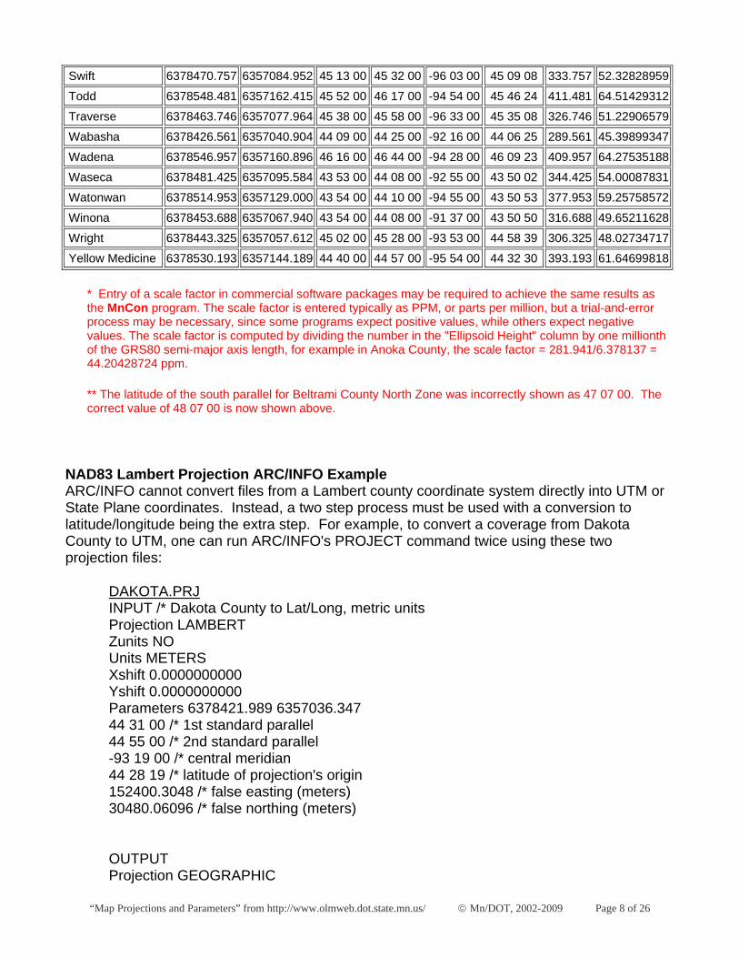
Swift 6378470.757 6357084.952 45 13 00 45 32 00 -96 03 00 45 09 08 333.757 52.32828959
Todd 6378548.481 6357162.415 45 52 00 46 17 00 -94 54 00 45 46 24 411.481 64.51429312
Traverse 6378463.746 6357077.964 45 38 00 45 58 00 -96 33 00 45 35 08 326.746 51.22906579
Wabasha 6378426.561 6357040.904 44 09 00 44 25 00 -92 16 00 44 06 25 289.561 45.39899347
Wadena 6378546.957 6357160.896 46 16 00 46 44 00 -94 28 00 46 09 23 409.957 64.27535188
Waseca 6378481.425 6357095.584 43 53 00 44 08 00 -92 55 00 43 50 02 344.425 54.00087831
Watonwan 6378514.953 6357129.000 43 54 00 44 10 00 -94 55 00 43 50 53 377.953 59.25758572
Winona 6378453.688 6357067.940 43 54 00 44 08 00 -91 37 00 43 50 50 316.688 49.65211628
Wright 6378443.325 6357057.612 45 02 00 45 28 00 -93 53 00 44 58 39 306.325 48.02734717
Yellow Medicine 6378530.193 6357144.189 44 40 00 44 57 00 -95 54 00 44 32 30 393.193 61.64699818
* Entry of a scale factor in commercial software packages may be required to achieve the same results as the MnCon program. The scale factor is entered typically as PPM, or parts per million, but a trial-and-error process may be necessary, since some programs expect positive values, while others expect negative values. The scale factor is computed by dividing the number in the "Ellipsoid Height" column by one millionth of the GRS80 semi-major axis length, for example in Anoka County, the scale factor = 281.941/6.378137 = 44.20428724 ppm.
** The latitude of the south parallel for Beltrami County North Zone was incorrectly shown as 47 07 00. The correct value of 48 07 00 is now shown above.
NAD83 Lambert Projection ARC/INFO Example ARC/INFO cannot convert files from a Lambert county coordinate system directly into UTM or State Plane coordinates. Instead, a two step process must be used with a conversion to latitude/longitude being the extra step. For example, to convert a coverage from Dakota County to UTM, one can run ARC/INFO's PROJECT command twice using these two projection files:
DAKOTA.PRJ INPUT /* Dakota County to Lat/Long, metric units Projection LAMBERT Zunits NO Units METERS Xshift 0.0000000000 Yshift 0.0000000000 Parameters 6378421.989 6357036.347 44 31 00 /* 1st standard parallel 44 55 00 /* 2nd standard parallel -93 19 00 /* central meridian 44 28 19 /* latitude of projection's origin 152400.3048 /* false easting (meters) 30480.06096 /* false northing (meters)
OUTPUT Projection GEOGRAPHIC
“Map Projections and Parameters” from http://www.olmweb.dot.state.mn.us/ © Mn/DOT, 2002-2009 Page 9 of 26
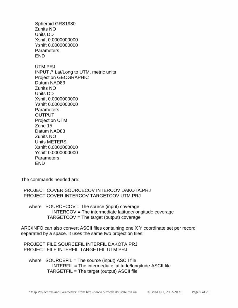
Spheroid GRS1980 Zunits NO Units DD Xshift 0.0000000000 Yshift 0.0000000000 Parameters END
UTM.PRJ INPUT /* Lat/Long to UTM, metric units Projection GEOGRAPHIC Datum NAD83 Zunits NO Units DD Xshift 0.0000000000 Yshift 0.0000000000 Parameters OUTPUT Projection UTM Zone 15 Datum NAD83 Zunits NO Units METERS Xshift 0.0000000000 Yshift 0.0000000000 Parameters END
The commands needed are:
PROJECT COVER SOURCECOV INTERCOV DAKOTA.PRJ PROJECT COVER INTERCOV TARGETCOV UTM.PRJ
where SOURCECOV = The source (input) coverage INTERCOV = The intermediate latitude/longitude coverage TARGETCOV = The target (output) coverage
ARC/INFO can also convert ASCII files containing one X Y coordinate set per record separated by a space. It uses the same two projection files:
PROJECT FILE SOURCEFIL INTERFIL DAKOTA.PRJ PROJECT FILE INTERFIL TARGETFIL UTM.PRJ
where SOURCEFIL = The source (input) ASCII file INTERFIL = The intermediate latitude/longitude ASCII file TARGETFIL = The target (output) ASCII file
“Map Projections and Parameters” from http://www.olmweb.dot.state.mn.us/ © Mn/DOT, 2002-2009 Page 10 of 26
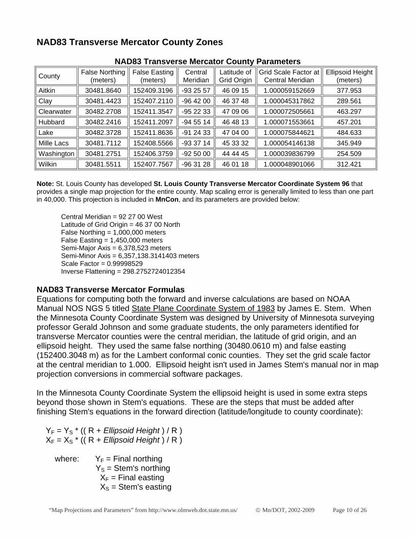
NAD83 Transverse Mercator County Zones
NAD83 Transverse Mercator County Parameters
County False Northing (meters)
False Easting (meters)
Central Meridian
Latitude of Grid Origin
Grid Scale Factor at Central Meridian
Ellipsoid Height (meters)
Aitkin 30481.8640 152409.3196 -93 25 57 46 09 15 1.000059152669 377.953 Clay 30481.4423 152407.2110 -96 42 00 46 37 48 1.000045317862 289.561 Clearwater 30482.2708 152411.3547 -95 22 33 47 09 06 1.000072505661 463.297 Hubbard 30482.2416 152411.2097 -94 55 14 46 48 13 1.000071553661 457.201 Lake 30482.3728 152411.8636 -91 24 33 47 04 00 1.000075844621 484.633 Mille Lacs 30481.7112 152408.5566 -93 37 14 45 33 32 1.000054146138 345.949 Washington 30481.2751 152406.3759 -92 50 00 44 44 45 1.000039836799 254.509 Wilkin 30481.5511 152407.7567 -96 31 28 46 01 18 1.000048901066 312.421
Note: St. Louis County has developed St. Louis County Transverse Mercator Coordinate System 96 that provides a single map projection for the entire county. Map scaling error is generally limited to less than one part in 40,000. This projection is included in MnCon, and its parameters are provided below:
Central Meridian = 92 27 00 West Latitude of Grid Origin = 46 37 00 North False Northing = 1,000,000 meters False Easting = 1,450,000 meters Semi-Major Axis = 6,378,523 meters Semi-Minor Axis = 6,357,138.3141403 meters Scale Factor = 0.99998529 Inverse Flattening = 298.2752724012354
NAD83 Transverse Mercator Formulas Equations for computing both the forward and inverse calculations are based on NOAA Manual NOS NGS 5 titled State Plane Coordinate System of 1983 by James E. Stem. When the Minnesota County Coordinate System was designed by University of Minnesota surveying professor Gerald Johnson and some graduate students, the only parameters identified for transverse Mercator counties were the central meridian, the latitude of grid origin, and an ellipsoid height. They used the same false northing (30480.0610 m) and false easting (152400.3048 m) as for the Lambert conformal conic counties. They set the grid scale factor at the central meridian to 1.000. Ellipsoid height isn't used in James Stem's manual nor in map projection conversions in commercial software packages.
In the Minnesota County Coordinate System the ellipsoid height is used in some extra steps beyond those shown in Stem's equations. These are the steps that must be added after finishing Stem's equations in the forward direction (latitude/longitude to county coordinate):
YF = YS * (( R + Ellipsoid Height ) / R ) XF = XS * (( R + Ellipsoid Height ) / R )
where: YF = Final northing YS = Stem's northing XF = Final easting XS = Stem's easting
“Map Projections and Parameters” from http://www.olmweb.dot.state.mn.us/ © Mn/DOT, 2002-2009 Page 11 of 26
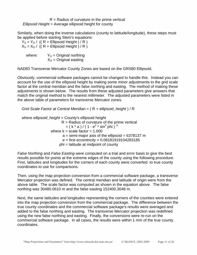
R = Radius of curvature in the prime vertical Ellipsoid Height = Average ellipsoid height for county
Similarly, when doing the inverse calculations (county to latitude/longitude), these steps must be applied before starting Stem's equations: YS = YO / (( R + Ellipsoid Height ) / R ) XS = XO / (( R + Ellipsoid Height ) / R )
where: YO = Original northing XO = Original easting
NAD83 Transverse Mercator County Zones are based on the GRS80 Ellipsoid.
Obviously, commercial software packages cannot be changed to handle this. Instead you can account for the use of the ellipsoid height by making some minor adjustments to the grid scale factor at the central meridian and the false northing and easting. The method of making these adjustments is shown below. The results from these adjusted parameters give answers that match the original method to the nearest millimeter. The adjusted parameters were listed in the above table of parameters for transverse Mercator zones.
Grid Scale Factor at Central Meridian = ( R + ellipsoid_height ) / R
where ellipsoid_height = County's ellipsoid height R = Radius of curvature of the prime vertical = ( k * a ) / ( 1 - e2 * sin2 phi ) ½ where k = scale factor = 1.000 a = semi-major axis of the ellipsoid = 6378137 m e = first eccentricity = 0.08181919104283185 phi = latitude at midpoint of county
False Northing and False Easting were computed on a trial and error basis to give the best results possible for points at the extreme edges of the county using the following procedure. First, latitudes and longitudes for the corners of each county were converted to true county coordinates to use for comparisons.
Then, using the map projection conversion from a commercial software package, a transverse Mercator projection was defined. The central meridian and latitude of origin were from the above table. The scale factor was computed as shown in the equation above. The false northing was 30480.0610 m and the false easting 152400.3048 m.
Next, the same latitudes and longitudes representing the corners of the counties were entered into the map projection conversion from the commercial package. The difference between the true county coordinates and the commercial software package's results were averaged and added to the false northing and easting. The transverse Mercator projection was redefined using the new false northing and easting. Finally, the conversions were re-run on the commercial software package. In all cases, the results were within 1 mm of the true county coordinates.

“Map Projections and Parameters” from http://www.olmweb.dot.state.mn.us/ © Mn/DOT, 2002-2009 Page 12 of 26
NAD83 Transverse Mercator ARC/INFO Example ARC/INFO can convert files between a transverse Mercator county coordinate system and latitude/longitude, UTM or State Plane coordinates in a one step process. It doesn't require two steps like in the case for the Lambert conformal conic counties because the ellipsoid is not changed. For example, to convert a coverage from Washington County to UTM, one can run ARC/INFO's PROJECT command using this projection file:
WASH2UTM.PRJ INPUT /* Washington County to UTM, metric units Projection TRANSVERSE Datum NAD83 Zunits NO Units METERS Xshift 0.0000000000 Yshift 0.0000000000 Parameters 1.000039836799 /* scale factor at central meridian -92 50 00.000 /* longitude at central meridian 44 44 45.000 /* latitude of origin 152406.37590 /* false easting (meters) 30481.27510 /* false northing (meters) OUTPUT Projection UTM Zone 15 Datum NAD83 Zunits NO Units METERS Xshift 0.0000000000 Yshift 0.0000000000 Parameters END
The commands needed are:
PROJECT COVER SOURCECOV TARGETCOV WASH2UTM.PRJ
where SOURCECOV = The source (input) coverage TARGETCOV = The target (output) coverage
ARC/INFO can also convert ASCII files containing one X Y coordinate set per record separated by a space. It uses the same projection file:
PROJECT FILE SOURCEFIL TARGETFIL WASH2UTM.PRJ
where SOURCEFIL = The source (input) ASCII file TARGETFIL = The target (output) ASCII file
“Map Projections and Parameters” from http://www.olmweb.dot.state.mn.us/ © Mn/DOT, 2002-2009 Page 13 of 26
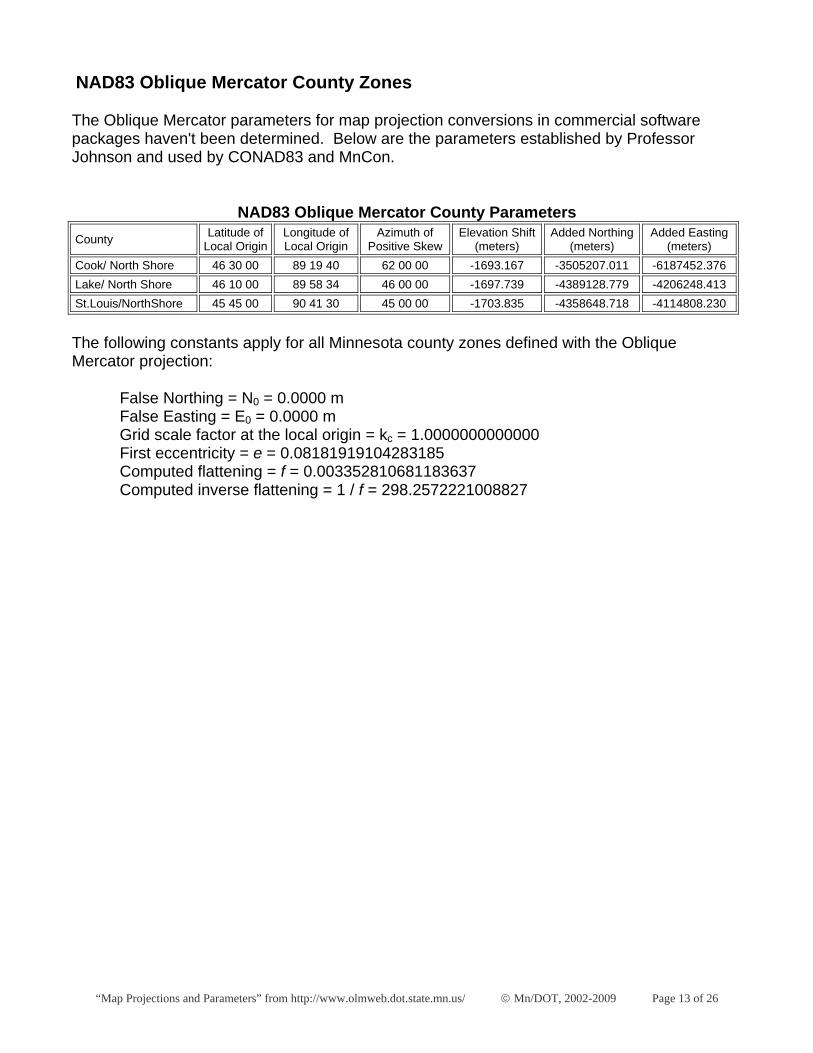
NAD83 Oblique Mercator County Zones
The Oblique Mercator parameters for map projection conversions in commercial software packages haven't been determined. Below are the parameters established by Professor Johnson and used by CONAD83 and MnCon.
NAD83 Oblique Mercator County Parameters County Latitude of
Local Origin Longitude of Local Origin
Azimuth of Positive Skew
Elevation Shift (meters)
Added Northing (meters)
Added Easting (meters)
Cook/ North Shore 46 30 00 89 19 40 62 00 00 -1693.167 -3505207.011 -6187452.376 Lake/ North Shore 46 10 00 89 58 34 46 00 00 -1697.739 -4389128.779 -4206248.413 St.Louis/NorthShore 45 45 00 90 41 30 45 00 00 -1703.835 -4358648.718 -4114808.230
The following constants apply for all Minnesota county zones defined with the Oblique Mercator projection:
False Northing = N0 = 0.0000 m False Easting = E0 = 0.0000 m Grid scale factor at the local origin = kc = 1.0000000000000 First eccentricity = e = 0.08181919104283185 Computed flattening = f = 0.003352810681183637 Computed inverse flattening = 1 / f = 298.2572221008827
“Map Projections and Parameters” from http://www.olmweb.dot.state.mn.us/ © Mn/DOT, 2002-2009 Page 14 of 26
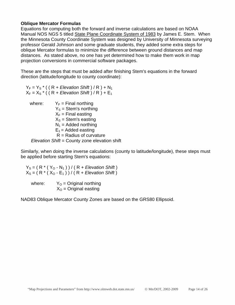
Oblique Mercator Formulas Equations for computing both the forward and inverse calculations are based on NOAA Manual NOS NGS 5 titled State Plane Coordinate System of 1983 by James E. Stem. When the Minnesota County Coordinate System was designed by University of Minnesota surveying professor Gerald Johnson and some graduate students, they added some extra steps for oblique Mercator formulas to minimize the difference between ground distances and map distances. As stated above, no one has yet determined how to make them work in map projection conversions in commercial software packages.
These are the steps that must be added after finishing Stem's equations in the forward direction (latitude/longitude to county coordinate):
YF = YS * ( ( R + Elevation Shift ) / R ) + N1 XF = XS * ( ( R + Elevation Shift ) / R ) + E1
where: YF = Final northing YS = Stem's northing XF = Final easting XS = Stem's easting N1 = Added northing E1 = Added easting R = Radius of curvature Elevation Shift = County zone elevation shift
Similarly, when doing the inverse calculations (county to latitude/longitude), these steps must be applied before starting Stem's equations:
YS = ( R * ( YO - N1 ) ) / ( R + Elevation Shift ) XS = ( R * ( XO - E1 ) ) / ( R + Elevation Shift )
where: YO = Original northing XO = Original easting
NAD83 Oblique Mercator County Zones are based on the GRS80 Ellipsoid.

“Map Projections and Parameters” from http://www.olmweb.dot.state.mn.us/ © Mn/DOT, 2002-2009 Page 15 of 26
NAD27 Universal Transverse Mercator
NAD27 UTM Parameters
Zone False Northing (meters)
False Easting (meters)
Central Meridian
Latitude of Grid Origin
Grid Scale Factor at Central Meridian
West Edge of Zone
East Edge of Zone
UTM 14 0.000 500000.000 -99 00 00 00 00 00 0.999600000000 -102 00 00 -96 00 00 UTM 15 0.000 500000.000 -93 00 00 00 00 00 0.999600000000 -96 00 00 -90 00 00 UTM 16 0.000 500000.000 -87 00 00 00 00 00 0.999600000000 -90 00 00 -84 00 00
When UTM coordinates are used in Minnesota, Zone 15 is usually extended east and west to encompass the entire state within a single zone, which may be denoted as "Zone 15E" or "Zone 15 Extended." For example, the Mn/DOT Basemap specifies "Universal Transverse Mercator (UTM) Minnesota extended Zone 15, NAD83 coordinates."
The following parameters apply to all NAD27 UTM zones:
Projection = Transverse Mercator Spheroid = Clarke 1866
UTM ARC/INFO Example The parameters needed to convert to or from UTM Zone 15 are shown below. This can become part of a file used in ARC/INFO's PROJECT command. More detailed examples showing complete conversions are shown in the NAD83 Minnesota County Coordinate System section of this document.
Projection UTM Zone 15 Datum NAD27 Zunits NO Units METERS Xshift 0.0000000000 Yshift 0.0000000000 Parameters
“Map Projections and Parameters” from http://www.olmweb.dot.state.mn.us/ © Mn/DOT, 2002-2009 Page 16 of 26
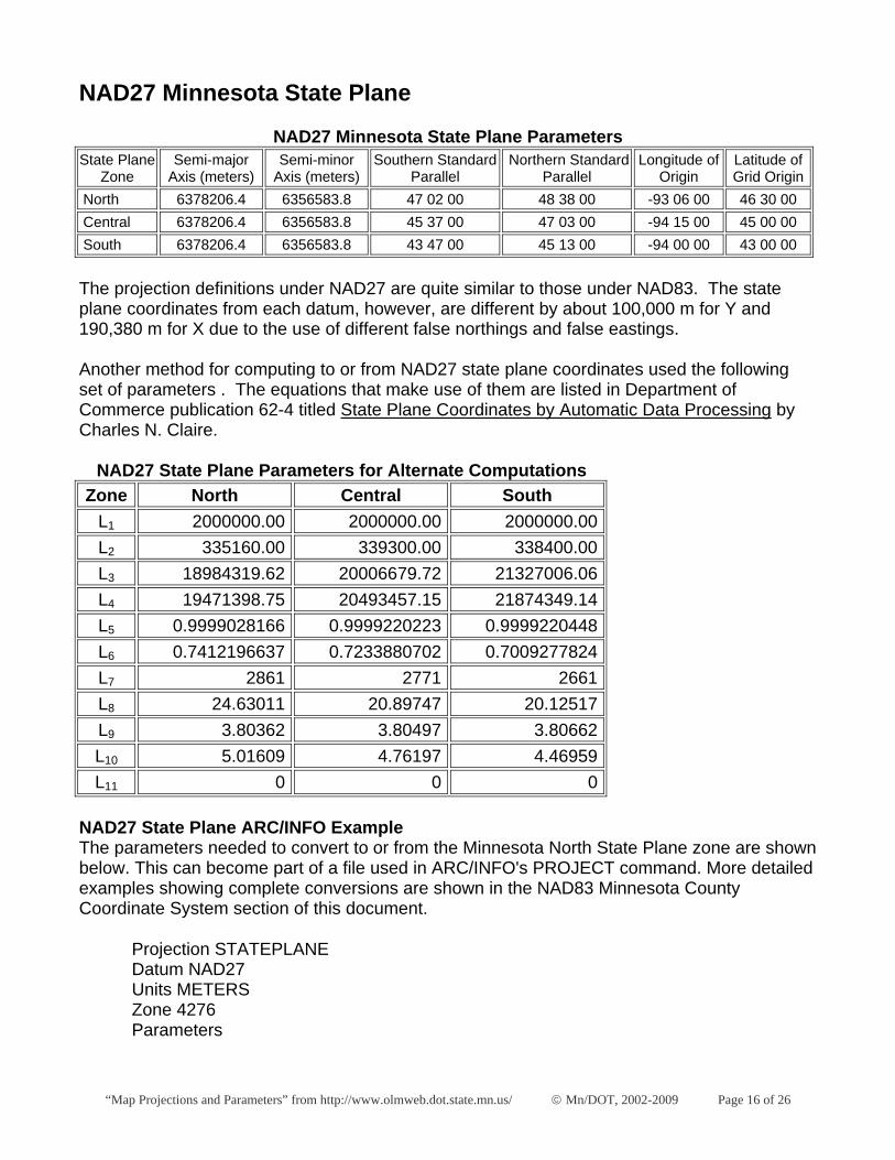
NAD27 Minnesota State Plane
NAD27 Minnesota State Plane Parameters State Plane
Zone Semi-major
Axis (meters) Semi-minor
Axis (meters) Southern Standard
Parallel Northern Standard
Parallel Longitude of
Origin Latitude of Grid Origin
North 6378206.4 6356583.8 47 02 00 48 38 00 -93 06 00 46 30 00 Central 6378206.4 6356583.8 45 37 00 47 03 00 -94 15 00 45 00 00 South 6378206.4 6356583.8 43 47 00 45 13 00 -94 00 00 43 00 00 The projection definitions under NAD27 are quite similar to those under NAD83. The state plane coordinates from each datum, however, are different by about 100,000 m for Y and 190,380 m for X due to the use of different false northings and false eastings. Another method for computing to or from NAD27 state plane coordinates used the following set of parameters . The equations that make use of them are listed in Department of Commerce publication 62-4 titled State Plane Coordinates by Automatic Data Processing by Charles N. Claire. NAD27 State Plane Parameters for Alternate Computations Zone North Central South
L1 2000000.00 2000000.00 2000000.00 L2 335160.00 339300.00 338400.00 L3 18984319.62 20006679.72 21327006.06 L4 19471398.75 20493457.15 21874349.14 L5 0.9999028166 0.9999220223 0.9999220448 L6 0.7412196637 0.7233880702 0.7009277824 L7 2861 2771 2661 L8 24.63011 20.89747 20.12517 L9 3.80362 3.80497 3.80662 L10 5.01609 4.76197 4.46959 L11 0 0 0
NAD27 State Plane ARC/INFO Example The parameters needed to convert to or from the Minnesota North State Plane zone are shown below. This can become part of a file used in ARC/INFO's PROJECT command. More detailed examples showing complete conversions are shown in the NAD83 Minnesota County Coordinate System section of this document.
Projection STATEPLANE Datum NAD27 Units METERS Zone 4276 Parameters
“Map Projections and Parameters” from http://www.olmweb.dot.state.mn.us/ © Mn/DOT, 2002-2009 Page 17 of 26
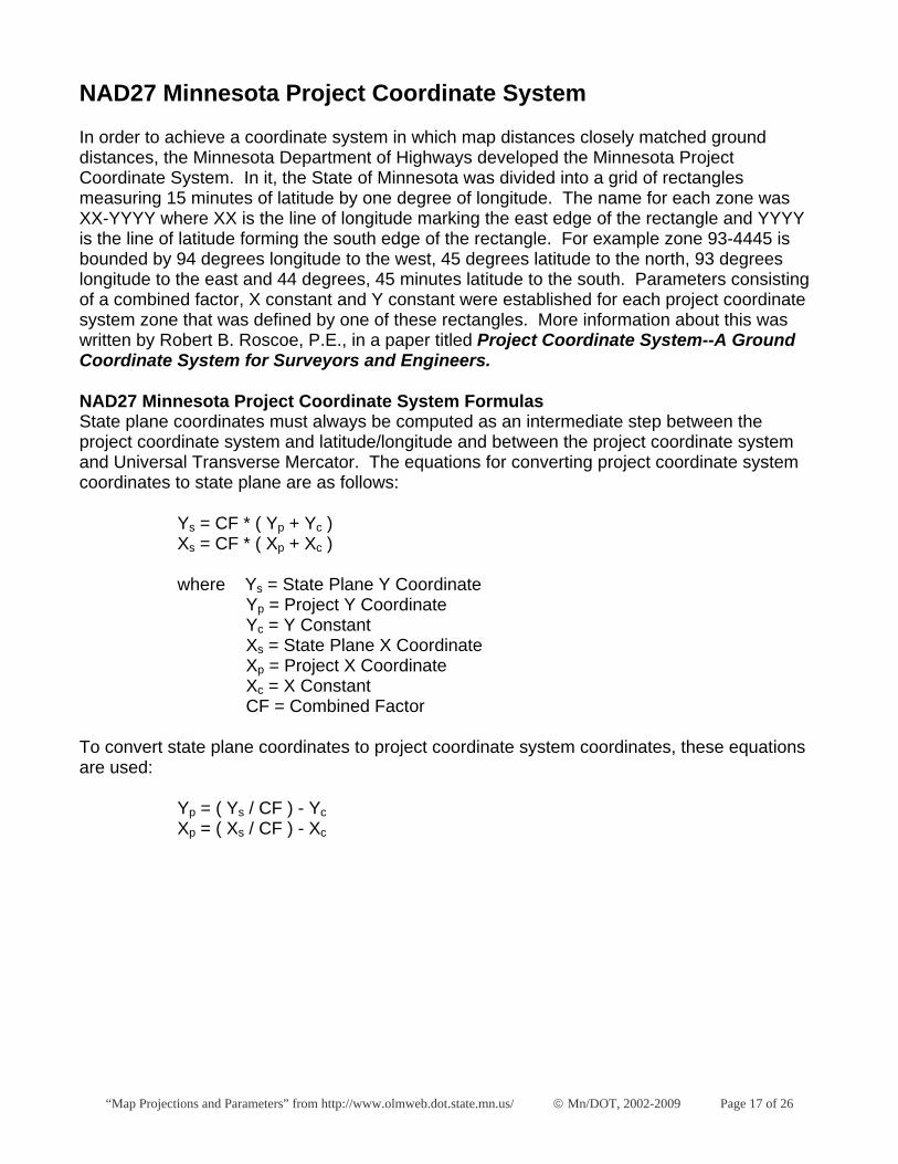
NAD27 Minnesota Project Coordinate System
In order to achieve a coordinate system in which map distances closely matched ground distances, the Minnesota Department of Highways developed the Minnesota Project Coordinate System. In it, the State of Minnesota was divided into a grid of rectangles measuring 15 minutes of latitude by one degree of longitude. The name for each zone was XX-YYYY where XX is the line of longitude marking the east edge of the rectangle and YYYY is the line of latitude forming the south edge of the rectangle. For example zone 93-4445 is bounded by 94 degrees longitude to the west, 45 degrees latitude to the north, 93 degrees longitude to the east and 44 degrees, 45 minutes latitude to the south. Parameters consisting of a combined factor, X constant and Y constant were established for each project coordinate system zone that was defined by one of these rectangles. More information about this was written by Robert B. Roscoe, P.E., in a paper titled Project Coordinate System--A Ground Coordinate System for Surveyors and Engineers.
NAD27 Minnesota Project Coordinate System Formulas State plane coordinates must always be computed as an intermediate step between the project coordinate system and latitude/longitude and between the project coordinate system and Universal Transverse Mercator. The equations for converting project coordinate system coordinates to state plane are as follows:
Ys = CF * ( Yp + Yc ) Xs = CF * ( Xp + Xc )
where Ys = State Plane Y Coordinate Yp = Project Y Coordinate Yc = Y Constant Xs = State Plane X Coordinate Xp = Project X Coordinate Xc = X Constant CF = Combined Factor
To convert state plane coordinates to project coordinate system coordinates, these equations are used:
Yp = ( Ys / CF ) - Yc Xp = ( Xs / CF ) - Xc
“Map Projections and Parameters” from http://www.olmweb.dot.state.mn.us/ © Mn/DOT, 2002-2009 Page 18 of 26
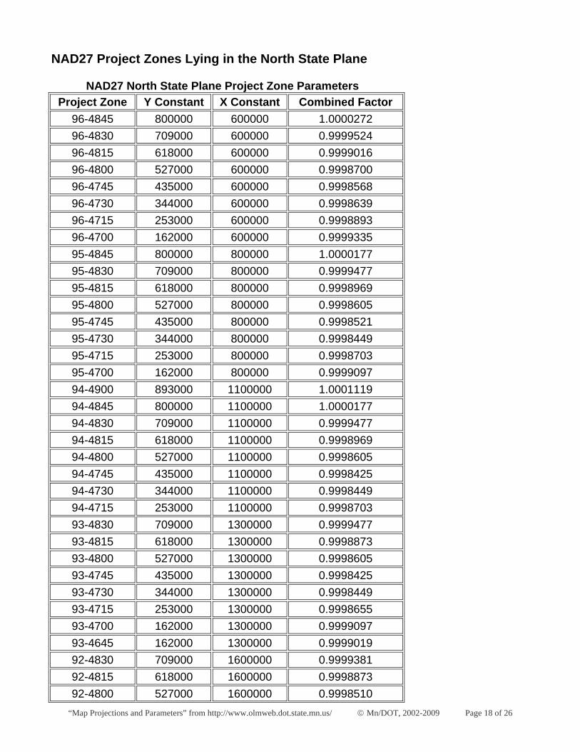
NAD27 Project Zones Lying in the North State Plane
NAD27 North State Plane Project Zone Parameters Project Zone Y Constant X Constant Combined Factor
96-4845 800000 600000 1.0000272 96-4830 709000 600000 0.9999524 96-4815 618000 600000 0.9999016 96-4800 527000 600000 0.9998700 96-4745 435000 600000 0.9998568 96-4730 344000 600000 0.9998639 96-4715 253000 600000 0.9998893 96-4700 162000 600000 0.9999335 95-4845 800000 800000 1.0000177 95-4830 709000 800000 0.9999477 95-4815 618000 800000 0.9998969 95-4800 527000 800000 0.9998605 95-4745 435000 800000 0.9998521 95-4730 344000 800000 0.9998449 95-4715 253000 800000 0.9998703 95-4700 162000 800000 0.9999097 94-4900 893000 1100000 1.0001119 94-4845 800000 1100000 1.0000177 94-4830 709000 1100000 0.9999477 94-4815 618000 1100000 0.9998969 94-4800 527000 1100000 0.9998605 94-4745 435000 1100000 0.9998425 94-4730 344000 1100000 0.9998449 94-4715 253000 1100000 0.9998703 93-4830 709000 1300000 0.9999477 93-4815 618000 1300000 0.9998873 93-4800 527000 1300000 0.9998605 93-4745 435000 1300000 0.9998425 93-4730 344000 1300000 0.9998449 93-4715 253000 1300000 0.9998655 93-4700 162000 1300000 0.9999097 93-4645 162000 1300000 0.9999019 92-4830 709000 1600000 0.9999381 92-4815 618000 1600000 0.9998873 92-4800 527000 1600000 0.9998510
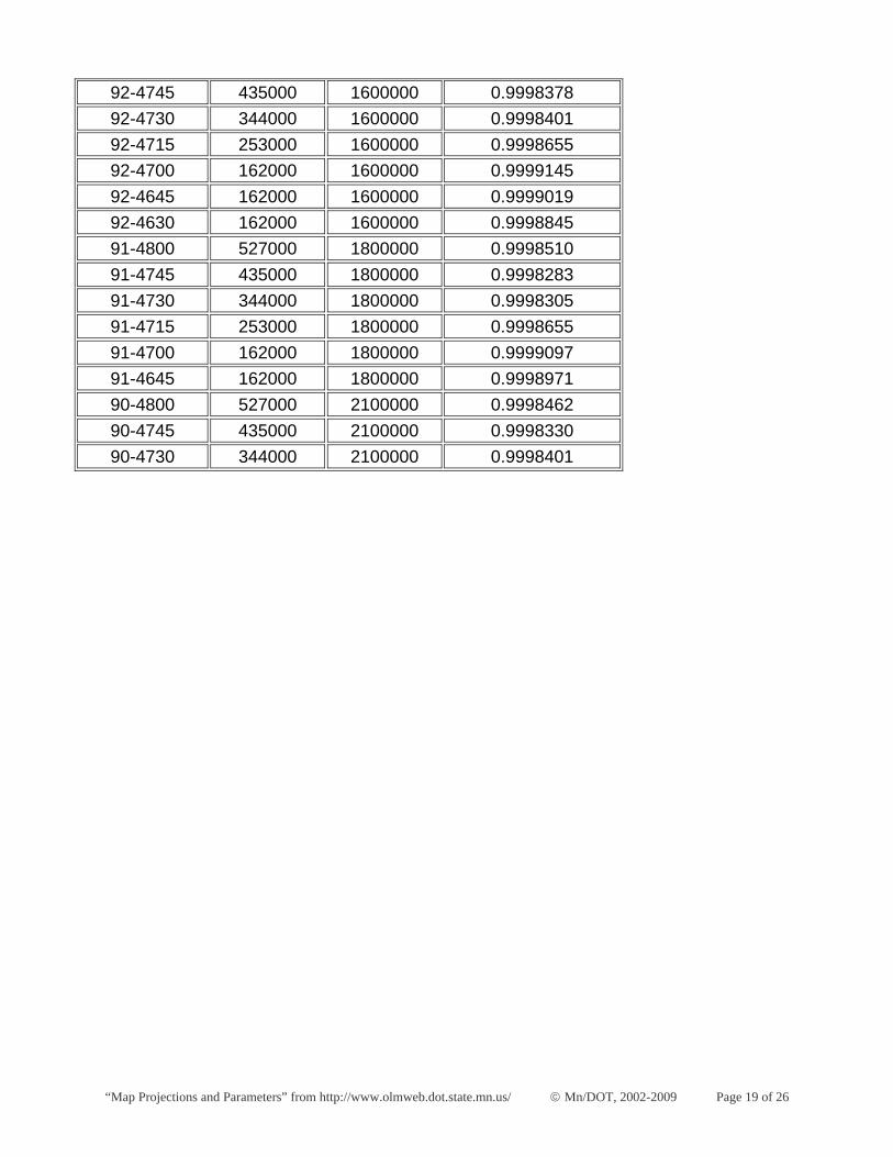
“Map Projections and Parameters” from http://www.olmweb.dot.state.mn.us/ © Mn/DOT, 2002-2009 Page 19 of 26
92-4745 435000 1600000 0.9998378 92-4730 344000 1600000 0.9998401 92-4715 253000 1600000 0.9998655 92-4700 162000 1600000 0.9999145 92-4645 162000 1600000 0.9999019 92-4630 162000 1600000 0.9998845 91-4800 527000 1800000 0.9998510 91-4745 435000 1800000 0.9998283 91-4730 344000 1800000 0.9998305 91-4715 253000 1800000 0.9998655 91-4700 162000 1800000 0.9999097 91-4645 162000 1800000 0.9998971 90-4800 527000 2100000 0.9998462 90-4745 435000 2100000 0.9998330 90-4730 344000 2100000 0.9998401
“Map Projections and Parameters” from http://www.olmweb.dot.state.mn.us/ © Mn/DOT, 2002-2009 Page 20 of 26
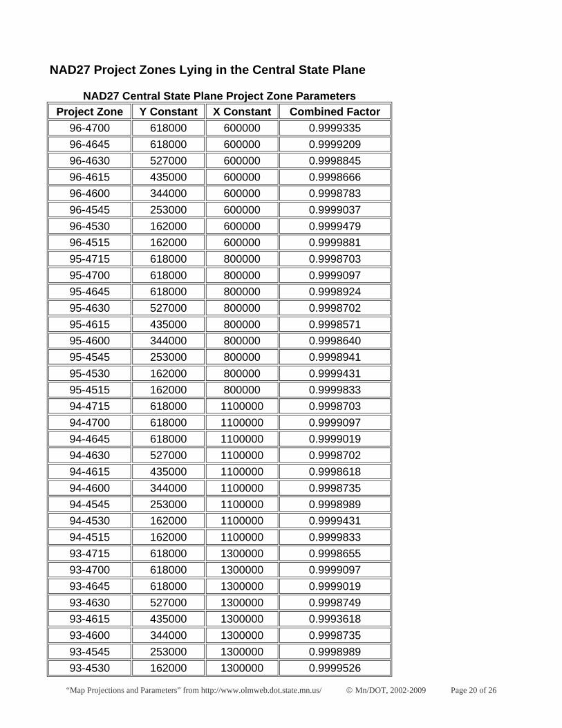
NAD27 Project Zones Lying in the Central State Plane
NAD27 Central State Plane Project Zone Parameters Project Zone Y Constant X Constant Combined Factor
96-4700 618000 600000 0.9999335 96-4645 618000 600000 0.9999209 96-4630 527000 600000 0.9998845 96-4615 435000 600000 0.9998666 96-4600 344000 600000 0.9998783 96-4545 253000 600000 0.9999037 96-4530 162000 600000 0.9999479 96-4515 162000 600000 0.9999881 95-4715 618000 800000 0.9998703 95-4700 618000 800000 0.9999097 95-4645 618000 800000 0.9998924 95-4630 527000 800000 0.9998702 95-4615 435000 800000 0.9998571 95-4600 344000 800000 0.9998640 95-4545 253000 800000 0.9998941 95-4530 162000 800000 0.9999431 95-4515 162000 800000 0.9999833 94-4715 618000 1100000 0.9998703 94-4700 618000 1100000 0.9999097 94-4645 618000 1100000 0.9999019 94-4630 527000 1100000 0.9998702 94-4615 435000 1100000 0.9998618 94-4600 344000 1100000 0.9998735 94-4545 253000 1100000 0.9998989 94-4530 162000 1100000 0.9999431 94-4515 162000 1100000 0.9999833 93-4715 618000 1300000 0.9998655 93-4700 618000 1300000 0.9999097 93-4645 618000 1300000 0.9999019 93-4630 527000 1300000 0.9998749 93-4615 435000 1300000 0.9993618 93-4600 344000 1300000 0.9998735 93-4545 253000 1300000 0.9998989 93-4530 162000 1300000 0.9999526
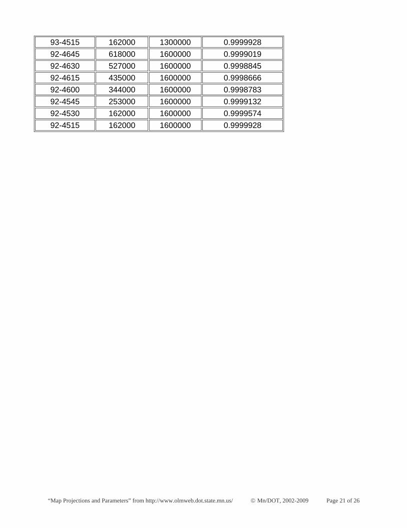
“Map Projections and Parameters” from http://www.olmweb.dot.state.mn.us/ © Mn/DOT, 2002-2009 Page 21 of 26
93-4515 162000 1300000 0.9999928 92-4645 618000 1600000 0.9999019 92-4630 527000 1600000 0.9998845 92-4615 435000 1600000 0.9998666 92-4600 344000 1600000 0.9998783 92-4545 253000 1600000 0.9999132 92-4530 162000 1600000 0.9999574 92-4515 162000 1600000 0.9999928
“Map Projections and Parameters” from http://www.olmweb.dot.state.mn.us/ © Mn/DOT, 2002-2009 Page 22 of 26
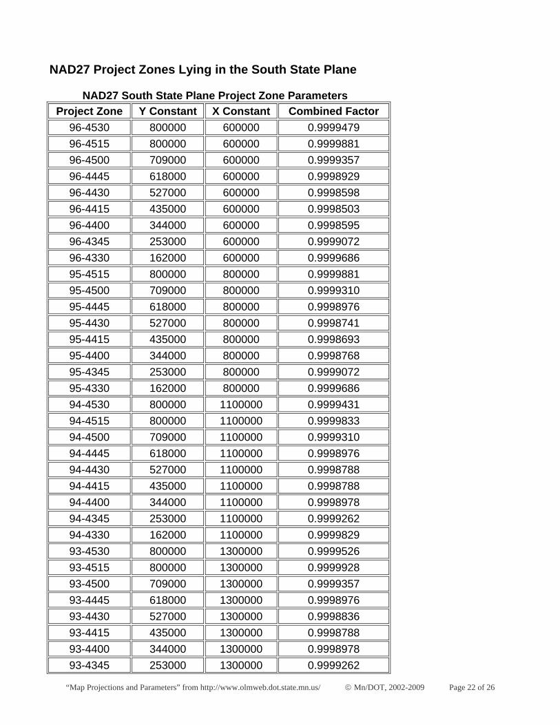
NAD27 Project Zones Lying in the South State Plane
NAD27 South State Plane Project Zone Parameters Project Zone Y Constant X Constant Combined Factor
96-4530 800000 600000 0.9999479 96-4515 800000 600000 0.9999881 96-4500 709000 600000 0.9999357 96-4445 618000 600000 0.9998929 96-4430 527000 600000 0.9998598 96-4415 435000 600000 0.9998503 96-4400 344000 600000 0.9998595 96-4345 253000 600000 0.9999072 96-4330 162000 600000 0.9999686 95-4515 800000 800000 0.9999881 95-4500 709000 800000 0.9999310 95-4445 618000 800000 0.9998976 95-4430 527000 800000 0.9998741 95-4415 435000 800000 0.9998693 95-4400 344000 800000 0.9998768 95-4345 253000 800000 0.9999072 95-4330 162000 800000 0.9999686 94-4530 800000 1100000 0.9999431 94-4515 800000 1100000 0.9999833 94-4500 709000 1100000 0.9999310 94-4445 618000 1100000 0.9998976 94-4430 527000 1100000 0.9998788 94-4415 435000 1100000 0.9998788 94-4400 344000 1100000 0.9998978 94-4345 253000 1100000 0.9999262 94-4330 162000 1100000 0.9999829 93-4530 800000 1300000 0.9999526 93-4515 800000 1300000 0.9999928 93-4500 709000 1300000 0.9999357 93-4445 618000 1300000 0.9998976 93-4430 527000 1300000 0.9998836 93-4415 435000 1300000 0.9998788 93-4400 344000 1300000 0.9998978 93-4345 253000 1300000 0.9999262
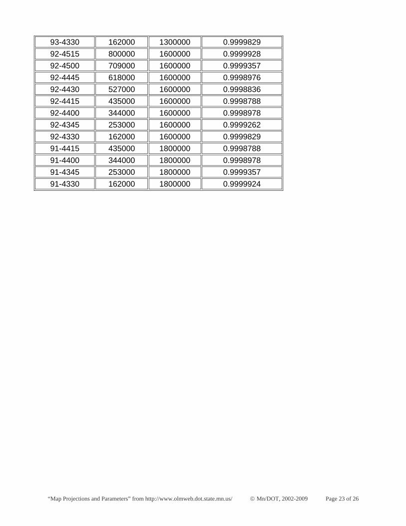
“Map Projections and Parameters” from http://www.olmweb.dot.state.mn.us/ © Mn/DOT, 2002-2009 Page 23 of 26
93-4330 162000 1300000 0.9999829 92-4515 800000 1600000 0.9999928 92-4500 709000 1600000 0.9999357 92-4445 618000 1600000 0.9998976 92-4430 527000 1600000 0.9998836 92-4415 435000 1600000 0.9998788 92-4400 344000 1600000 0.9998978 92-4345 253000 1600000 0.9999262 92-4330 162000 1600000 0.9999829 91-4415 435000 1800000 0.9998788 91-4400 344000 1800000 0.9998978 91-4345 253000 1800000 0.9999357 91-4330 162000 1800000 0.9999924
“Map Projections and Parameters” from http://www.olmweb.dot.state.mn.us/ © Mn/DOT, 2002-2009 Page 24 of 26
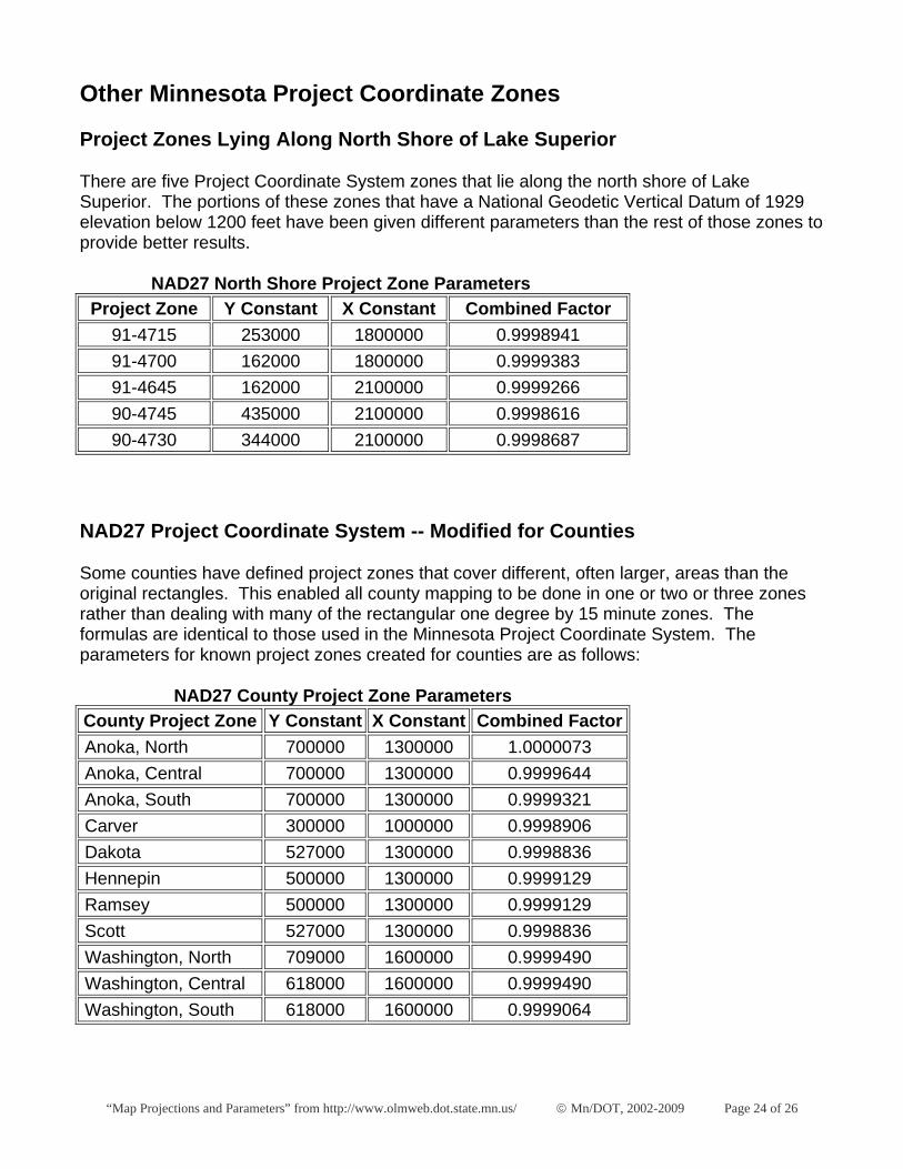
Other Minnesota Project Coordinate Zones
Project Zones Lying Along North Shore of Lake Superior
There are five Project Coordinate System zones that lie along the north shore of Lake Superior. The portions of these zones that have a National Geodetic Vertical Datum of 1929 elevation below 1200 feet have been given different parameters than the rest of those zones to provide better results.
NAD27 North Shore Project Zone Parameters Project Zone Y Constant X Constant Combined Factor
91-4715 253000 1800000 0.9998941 91-4700 162000 1800000 0.9999383 91-4645 162000 2100000 0.9999266 90-4745 435000 2100000 0.9998616 90-4730 344000 2100000 0.9998687
NAD27 Project Coordinate System -- Modified for Counties
Some counties have defined project zones that cover different, often larger, areas than the original rectangles. This enabled all county mapping to be done in one or two or three zones rather than dealing with many of the rectangular one degree by 15 minute zones. The formulas are identical to those used in the Minnesota Project Coordinate System. The parameters for known project zones created for counties are as follows:
NAD27 County Project Zone Parameters County Project Zone Y Constant X Constant Combined Factor Anoka, North 700000 1300000 1.0000073 Anoka, Central 700000 1300000 0.9999644 Anoka, South 700000 1300000 0.9999321 Carver 300000 1000000 0.9998906 Dakota 527000 1300000 0.9998836 Hennepin 500000 1300000 0.9999129 Ramsey 500000 1300000 0.9999129 Scott 527000 1300000 0.9998836 Washington, North 709000 1600000 0.9999490 Washington, Central 618000 1600000 0.9999490 Washington, South 618000 1600000 0.9999064

“Map Projections and Parameters” from http://www.olmweb.dot.state.mn.us/ © Mn/DOT, 2002-2009 Page 25 of 26
Conversions Between Datums
Converting data between the North American Datum of 1927 and the North American Datum of 1983 is not a simple task, since no direct mathematic relationship exists between them. There are, however, several ways to convert data. The appropriate method for any situation depends mostly on accuracy requirements. If a high degree of accuracy is required, additional information is necessary. For example, the coordinates of some points in a data set from both datums will be needed. In addition, best results can be achieved if surveying measurements between data set points are available.
The most accurate way to convert data from one datum to the other is not always feasible. It is the case where coordinates are known from both datums for one or more control points that are part of the data set and measurements from those control points(s) are available to all the other points in the data set. In this situation, the way to convert the data set to the other datum is by starting with the other datum's coordinates on the control point(s) and recomputing the coordinates of all the other points based on the measurements from the control points. This method will definitely provide data that is sufficiently accurate for engineering or surveying uses.
The next most accurate method is for the case where coordinates are known from both datums for three or more points in a data set, but measurements are not available. In this situation, a transformation algorithm can be used to compute the relationship between the two datums and apply it to the other points in the data set. This method may provide data that is sufficiently accurate for engineering or surveying uses, depending on the geographic extent of the data set being converted and the statistical results of the transformation.
If accuracy is not as important, there are several tools that can be used to convert between datums. The most famous is the National Geodetic Survey's NADCON, which can convert between NAD27 latitude/longitude and NAD83 latitude/longitude. Mn/DOT's MNCON program contains the NADCON functionality. The U.S. Army Corps of Engineers has a similar program called CORPSCON that extends the ability to state plane and Universal Transverse Mercator coordinates. Both of these programs are available from the National Geodetic Survey. ARC/INFO includes the NADCON algorithm in its PROJECT command, which can compute conversions within or between datums.
“Map Projections and Parameters” from http://www.olmweb.dot.state.mn.us/ © Mn/DOT, 2002-2009 Page 26 of 26
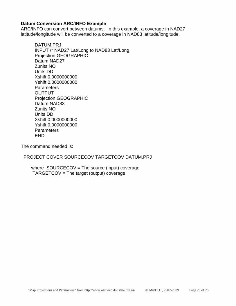
Datum Conversion ARC/INFO Example ARC/INFO can convert between datums. In this example, a coverage in NAD27 latitude/longitude will be converted to a coverage in NAD83 latitude/longitude.
DATUM.PRJ INPUT /* NAD27 Lat/Long to NAD83 Lat/Long Projection GEOGRAPHIC Datum NAD27 Zunits NO Units DD Xshift 0.0000000000 Yshift 0.0000000000 Parameters OUTPUT Projection GEOGRAPHIC Datum NAD83 Zunits NO Units DD Xshift 0.0000000000 Yshift 0.0000000000 Parameters END
The command needed is:
PROJECT COVER SOURCECOV TARGETCOV DATUM.PRJ
where SOURCECOV = The source (input) coverage TARGETCOV = The target (output) coverage