Embed Size (px)
Citation preview
ULI Washington Land Use Leadership Institute
mini Technical Assistance Panel (mTAP)
Placemaking at the Landover Metro Station
PANEL FINDINGS AND RECOMMENDATIONS
Mini Technical Assistance Panels (mTAPs)
ULI Washington’s Regional Land Use Leadership Institute is a 9-month academy designed to raise
awareness and strengthen collaboration among real estate industry leaders from all sectors, in order to
better prepare them to tackle the region’s complex land use issues. The thirty selected participants are
experienced professionals from the region’s leading public agencies, institutions, nonprofits and private-
sector real estate/land use firms. Through a mixture of lectures, tours and activities, participants engage
and collaborate with other real estate professionals on the most complex land use challenges that
confront the region.
The culminating exercise for the Leadership Institute was a series of mini-Technical Assistance Panels
(mTAPs), where teams of Leadership Institute participants worked over a two-month period to address a
particular local land use challenge. The mTAPs are modeled off of the more-extensive Technical
Assistance Panel program that ULI Washington offers on an ongoing basis (see ULI Washington’s TAP
website). ULI Washington has partnered with the Metropolitan Washington Council of Governments to
identify priority mTAP sites that embody key elements of the vision outlined in the Region Forward plan
and that can serve as models for other communities. The mTAPs were provided free of charge to local
sponsors.
This document outlines the panel’s findings and recommendations on how the sponsoring city or county
can achieve local planning goals while also making the greatest regional contribution toward sustainable
and equitable development. The panels also created a PowerPoint presentation that accompanies this
outline.
Placemaking at the Landover Metro Station
Panelists
George Kelly, Hines Limited Partnership James McCann, Baker Tilly Stuart Prince, The Peterson Companies Samuel Swiller, Gallaudet University Gwen Wright, City of Alexandria Mark Viani, McGuireWoods LLP
Assignment Regional Benefit: Improving jobs access through commercial and mixed-use income housing development near transit Local Objective: Define short- and long-term improvements that will enhance pedestrian safety and access to the Metro station, improve transportation choices along MD 202, and promote commercial and neighborhood revitalization. Regional Goal
• Transit-oriented and mixed use communities emerging in Regional Activity Centers that will capture new employment and household growth
Sponsor Questions for the Panel
• What uses and densities are feasible as part of a redevelopment strategy centered on this isolated Metro station? What can the County do in the Sector Plan to pave the way for a successful long-term and large-scale public-private redevelopment effort?
• What is the market potential for redevelopment of the adjoining vacant light industrial,
warehouse and distribution space located to the east of the Metro Station?
• What strategies would support near-term revitalization and phased long-term transit oriented redevelopment of the adjoining retail center (Dodge Park Drive)?
• What is the market for housing in this area and what is the appropriate density and unity mix for
the vacant Hunter Ridge site?
• What urban design improvements should me made in the station are to improve pedestrian access and support nearby TOD?
• What urban design improvements or transportation enhancements should be prioritized along
MD 202 to promote walkability, transit access and redevelopment?
Findings and Recommendations
Demographics
- One-mile radius population of 382,000, comprising of 138,000 households and 91,000
families
$57,000 and $67,000 median and average household income, respectively
30.7% with High School Graduate or GED, 15.1% with Bachelor’s degree and
11.1% with Graduate degree
78,000 owner occupied households and 60,000 renter occupied households
178,000 workforce participants with 18.4% office and administrative support,
28.5% service industries and 14.5% professional services
37 minutes average commute to work time
73.5% use non-transit options, with 55.1% car poolers
Users of public transportation – 26.5%
- Commentary
Majority of local population work in office support or service industries: “white-
blue” collar jobs, leading to a solidly middle class area
Carpooling, commute times, and distribution of professions suggest a large
number of government workers with many neighbors probably also co-workers
There is a clear preference for carpooling. The Landover station is in their
backyard but it is not preferred mode of transportation
Minor demographic differences as study’s radius narrows
Market Analysis
- The area is a mix of product types: Industrial, Residential and Retail with little to no true
office and no hospitality spaces
- A very challenged residential market with no new activity
Re-sales average $86K for Town Homes and $143K for Single Family Dwellings in
the last 6 months within a 2-mile radius
Home sales less than $100 PSF in many cases
High level of foreclosure and short sales activity
Subsidized housing is very close and abundant
Rents appear to be around $1.20 - 1.40 PSF for existing residential product.
- Cheverly neighborhood is an anchor
- To the East, within 0.5-mile radius, retail dominated by unanchored strips at
approximately $15.00 PSF rents
CVS and Aldi - ½ mile to the West
Woodmore Town Center has captured nearly all big box capacity
- Very little stand alone office
- Healthy industrial market including Ardwick Industrial Park to the northeast
Recent sale of $118 PSF
Opportunities
Underutilized Metrorail Station with large amount of parking (2nd or 3rd least used
station in the WMATA system)
Proximity to Route 50 and Baltimore-Washington Parkway
Stable, middle-class neighborhood with single family homes, some townhouses, multi-
family apartments, and several retail centers
Community focal points including the Prince George’s Ballroom, a privately-owned
historic site, and several parks
Constraints
Metrorail station’s lack of visibility – located well off the public thoroughfare
Metrorail station’s lack of connectivity to nearby neighborhoods
Environmentally sensitive areas surrounding Metrorail station
Warehouses near Metrorail station
Neighborhood will not support high rents
Strategy Summary
After assessing the Community’s substantial strengths and opportunities and the realistic means
to address its various constraints, the mTAP Group believes the most logical, market-based
approach is to begin by redefining the Landover Metro station as part of the Community’s core.
Currently, the Metro station is an underutilized asset. Indeed, WMATA reports that it is one of the
second or third lowest ranked Metro stations in its system, in terms of ridership levels. Housing
Intelligence Pro demographic reports show non-public transit as 73.5% of the Community’s work
transportation means. Further, 55.1% of the local workforce carpool to work, representing a
significant avoidance of the available transit options.
Short-term/immediate goals should include activating the Metro station and connecting it with
the surrounding community by improving its visibility and perception of security through better
wayfinding, lighting and signage. Mid-term goals and objectives should include improving
pedestrian access between the Metro station and surrounding properties. Long-term goals and
objectives should focus on providing market-based incentives to facilitate a limited amount of
transit oriented development at the Metro station and using this development as a catalyst for the
eventual redevelopment of the vacant industrial properties to the east, across Pennsy Drive, as
well as the Hunter Ridge site and Dodge Park Drive Retail Center and Kent Village Shopping
Center, further to the east. The eventual goal of this proposal is the development of an expanded
community core that incorporates the Metro station and ties in the properties along MD 202.
Strategy 1 (Now) “Pick Your Battles”
The questions presented to the mTAP Group address a range of planning questions across the
community. In the mTAP Group’s view, the most effective approach is to focus efforts and
resources on the Landover Metro station, redefine it as part of the Community’s core and use it as a
catalyst for change to the industrial properties to the east and further to the Hunter Ridge
development and adjacent commercial areas on MD 202. With a strengthened core, the
Community’s developmental will radiate outwards.
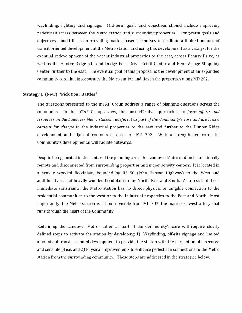
Despite being located in the center of the planning area, the Landover Metro station is functionally
remote and disconnected from surrounding properties and major activity centers. It is located in
a heavily wooded floodplain, bounded by US 50 (John Hanson Highway) to the West and
additional areas of heavily wooded floodplain to the North, East and South. As a result of these
immediate constraints, the Metro station has no direct physical or tangible connection to the
residential communities to the west or to the industrial properties to the East and North. Most
importantly, the Metro station is all but invisible from MD 202, the main east-west artery that
runs through the heart of the Community.
Redefining the Landover Metro station as part of the Community’s core will require clearly
defined steps to activate the station by developing 1) Wayfinding, off-site signage and limited
amounts of transit-oriented development to provide the station with the perception of a secured
and sensible place, and 2) Physical improvements to enhance pedestrian connections to the Metro
station from the surrounding community. These steps are addressed in the strategies below.
Strategy #2 (Short-Term) Improve visibility and perception of security for Metro Station
Despite its location in the center of the planning area, the Metro station is functionally remote and
does not promote a welcoming and secure place. Initial steps should focus on raising the Metro
station’s visibility in the community and improving the perception of its security.
Wayfinding/Signage
Contributing to its underutilization is the fact that the Metro station is largely invisible from
surrounding properties. To raise its profile in the community, a significant amount of wayfinding
signage should be installed along MD 202 and the existing pedestrian access routes to the Metro
station. As new pedestrian access routes are developed (See Strategy #3 below) they should also
be equipped with robust wayfinding signage to promote access to and usage of the Metro station.
Station Security
Area residents report that the Metro station has a vacant, remote “feel” to it. Indeed, the site
consists only of the station and a large parking lot. There is little activity or visible security at the
Metro station. Given the ample available space on the parking lot, consideration should be given
to placement of a Prince George’s County, MNCPPC or WMATA police substation on the property.
Lighting at the station, parking lot and entryways/pedestrian pathways should also be upgraded.
Strategy #3 (Mid-Term) Improve pedestrian connections to Metro Station
Building on the Metro station’s enhanced visibility in the Community and improved perception of
security, the next steps will promote pedestrian access to/from the station and the surrounding
community.
Currently, access to the Metro station from that portion of the community west of US 50 is limited
to a dangerous crossing of the MD 202 bridge over US 50 and the Metro rail lines. The MD 202
bridge provides only a minimal walkway, where pedestrians are required to walk along the edges
of vehicle travel lanes. These walkways do not connect into any pathway that proceeds directly to
the Metro station. Rather, area residents are obliged to step over a metal barrier, climb down a
narrow path worn in the adjacent vegetation before taking a circuitous route past the existing
blighted properties in the floodplain on the north side of MD 202.
Area residents walking to or from area south of MD 202 and west of US 50 are obliged to take the
additional dangerous step of crossing at unmarked locations, as the nearest marked crossing
points are at Kilmer Street (to the west) and Old Landover Road (to the east). Area residents
travelling to/from the residential communities located well north of MD 202 also have to take a
circuitous route through their community, across the MD 202 bridge and then utilize the ad hoc
trail system to access the Metro station.
Based on the foregoing limitations, it is easy to see why the Metro station is underutilized. For
most practical purposes, the Metro station is best accessed by car and, once area residents are in
their car, the need to utilize Metro is lessened significantly. Therefore, enhancing pedestrian
access to Metro is a crucial next step.
Provided below, are some of the critical pedestrian improvements that mTAP Group sees as
necessary to facilitating greater pedestrian access to and usage of the Metro station.
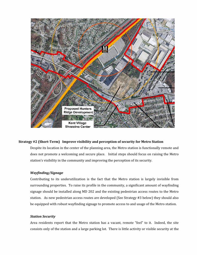
Improvement of pedestrian access on MD 202 over US 50, possibly with an urban deck.
This would provide improved pedestrian access along MD 202 and improve access for
properties west of US 50 to Landover Metro station (see below an example of an urban
deck in Alexandria over I-495.)
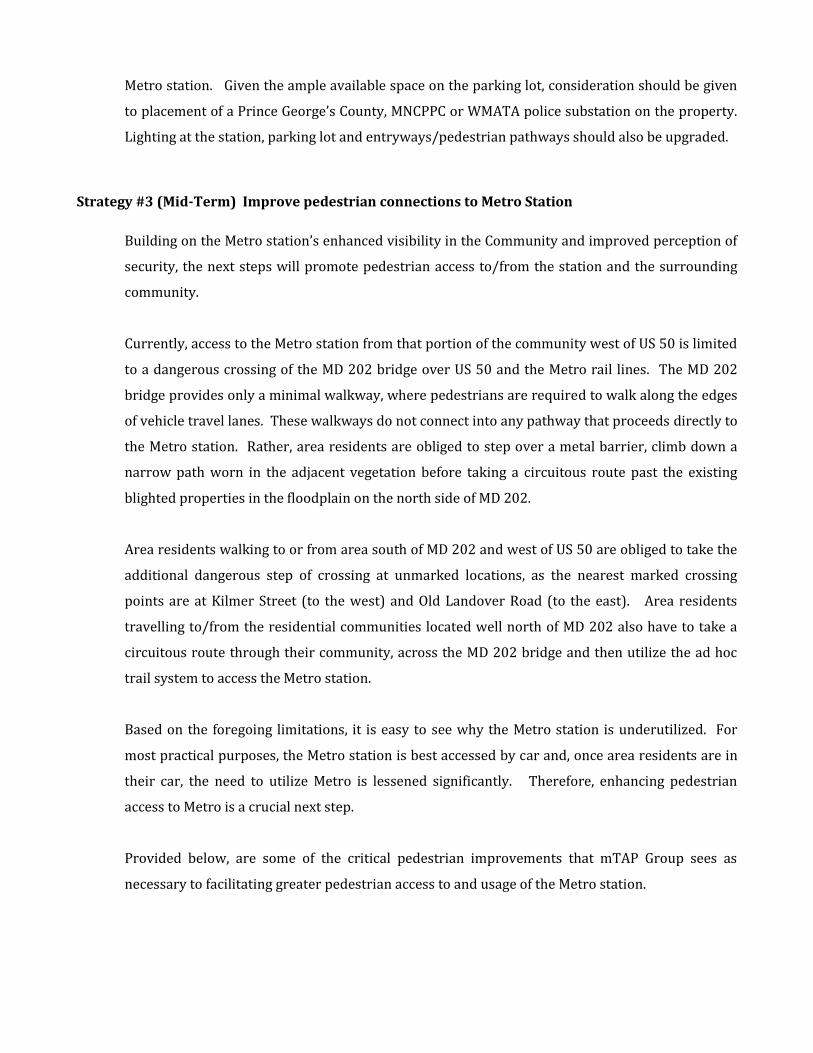
Connect residential communities west of US 50 and north of MD 202 to Metro via a
pedestrian bridge across US 50 and Metro lines (see below an example of a pedestrian
bridge in Silver Spring that spans the CSX and Metro tracks.)
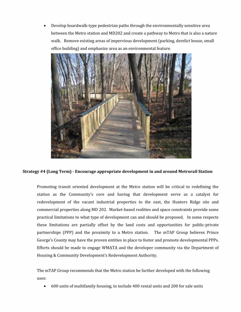
Develop boardwalk-type pedestrian paths through the environmentally sensitive area
between the Metro station and MD202 and create a pathway to Metro that is also a nature
walk. Remove existing areas of impervious development (parking, derelict house, small
office building) and emphasize area as an environmental feature.
Strategy #4 (Long Term) - Encourage appropriate development in and around Metrorail Station
Promoting transit oriented development at the Metro station will be critical to redefining the
station as the Community’s core and having that development serve as a catalyst for
redevelopment of the vacant industrial properties to the east, the Hunters Ridge site and
commercial properties along MD 202. Market-based realities and space constraints provide some
practical limitations to what type of development can and should be proposed. In some respects
these limitations are partially offset by the land costs and opportunities for public-private
partnerships (PPP) and the proximity to a Metro station. The mTAP Group believes Prince
George’s County may have the proven entities in place to foster and promote developmental PPPs.
Efforts should be made to engage WMATA and the developer community via the Department of
Housing & Community Development’s Redevelopment Authority.
The mTAP Group recommends that the Metro station be further developed with the following
uses:
600 units of multifamily housing, to include 400 rental units and 200 for sale units
30,000-50,000 square feet of ground floor retail and office, which would include anchors
such a large, full-service drug store, small grocery, MNCPPC office or police station, coffee
shop and/or a dry cleaners.
Wood construction over a concrete podium with above-grade parking
The mTAP Group believes that transit oriented development at the Metro station will serve as a
catalyst for eventual redevelopment of areas outside of this focus point, including the vacant and
underutilized industrial properties east of Pennsy Drive, the Hunters Ridge site and the
commercial properties along MD 202. This redevelopment will be better coordinated and
function more efficiently, if careful attention is paid to a future street grid that provides for
interconnectivity between these properties and eliminates barriers, due to grade differences,
physical obstructions, etc.
With regard to the vacant industrial properties to the east, the mTAP Group believes market
conditions will likely promote the development of some wood frame construction multifamily
dwellings, 4 -5 stories, and additional neighborhood serving retail uses, such as a grocery store.
The Hunters Ridge site is partially improved with utility connections for a townhouse
development. The mTAP Group believes it is best to continue this pattern of development in the
northern half of this site, where the existing utility connections are already in place. For the
southern half of the site, the mTAP Group believes promoting a compatible form of ownership
opportunity, such as “2 over 2” condominiums, is appropriate.
Finally, with regard to the commercial properties along MD 202, specifically the Dodge Park Drive
Retail Center and the Kent Village Shopping Center, the mTAP Group believes it is best to let the
market provide the necessary changes to serve the community as it evolves.
Conclusions and Regional Benefits The mTAP Group believes a focused strategy (Pick Your Battles) that emphasizes small-scaled,
“winnable” gains will catalyze further development around the Landover Metro. By focusing on
the opportunities presented, efforts will align well with existing regional transit oriented
development goals. Capitalizing on short- to mid-term opportunities will result in increased
neighborhood connection to the Landover Metrorail Station, leading to longer-term opportunities,
which will create value and further increase civic and community pride.
Panel Bios
Gwen Wright Chief, Development Division, City of Alexandria Department of Planning and Zoning Since September 2008, Gwen Wright has been Chief of the Development Division for the City of Alexandria Department of Planning and Zoning. In this position, she reviews development proposals throughout the City of Alexandria and shepherds a wide variety of projects – from urban infill to major brownfields reclamation – through the regulatory process and implementation. Prior to her work in Alexandria, Ms. Wright worked for 21 years for the Maryland-National Capital Park and Planning Commission in the Montgomery County Department of Planning. During her tenure in Montgomery County, she served as the Chief of Countywide Planning, including supervising the Environmental Planning, Transportation Planning and Historic Preservation Sections, as well as serving as Acting Planning Director during 2007-08. Prior to joining the Montgomery County Department of Planning, Ms. Wright was the Director of Architectural Design and Redevelopment for the Galveston Historical Foundation in Galveston, Texas. She has degrees in Architecture and Architectural History from Yale University and has spoken at numerous national and regional conferences on a wide variety of planning issues. Ms. Wright lives in the Cleveland Park neighborhood in Washington D.C., where she is co-chair of the Cleveland Park Historical Society Architectural Review Committee. She is also a member of Lambda Alpha.
George Kelly Hines Limited Partnership George Kelly is a Project Manager at Hines Interests Limited Partnership in Washington, D.C. where he is responsible for the Master Development and Office land use components of CityCenterDC - a 1.5M SF mixed-use development located in Washington’s CBD. Prior to joining Hines, George was a Scholar-in-Residence at the Urban Land Institute in Washington, D.C. where he researched and authored/contributed to publications on workforce housing, public/private partnerships, and small-scale development. He has also been an asset manager at Apartment Investment Management Corporation (AIMCO) with an emphasis on affordable housing redevelopment, and a strategy consultant with Mitchell Madison Group. George received a Bachelor of Science from the United States Military Academy at West Point, a Master of Real Estate Development from the University of Southern California, and an MBA from the University of Chicago. Following West Point, he served as an infantry officer in Central America. He is a native of Pittsburgh, PA and resides in Washington, D.C. with his wife and three children.
James McCann Senior Manager, Baker Tilly James McCann is a Senior Manager in Baker Tilly Virchow Krause’s DC office and has been with the firm for nine years. James specializes in tax compliance and consulting work for owners and operators of commercial
and residential real estate, as well as high net worth individuals. James holds Bachelors of Business Administration and Master of Accounting degrees from the College of William and Mary. Stuart Prince Vice President, Residential, The Peterson Companies Stuart Prince is serves as Vice President, Residential, at The Peterson Companies in Fairfax, Virginia. At the Peterson Companies, he serves as a Development Project Manager for four multi-family projects at National Harbor, including the One National Harbor Condominium, the Fleet Street Condominium, the Waterfront Street Condominium, and the Esplanade apartments. He currently leads the residential Marketing, Sales and Customer Service teams at National Harbor, and has extensive experience in community association and condominium formation. Mr. Prince is presently responsible for multifamily and residential lot development and sales at six projects in Virginia and Maryland comprising over 1,700 units. Mr. Prince joined The Peterson Companies in 2005 from the Washington, D.C. office of Latham & Watkins LLP, a large international law firm. At Latham & Watkins from 2001 to 2005, Mr. Prince focused on company and bank representation in high-yield debt offerings, with transactions exceeding over $1.5 billion. From 1996 to 1998, he worked as an analyst at two affiliated real estate finance companies in Atlanta, Georgia, Shoptaw-James, Inc. (predecessor to CBRE Debt & Equity Finance) and Main America Capital (acquired by GMAC Commercial). Mr. Prince earned a bachelor’s degree from Duke University and graduated magna cum laude from the Washington College of Law at American University, where he was a member of the American University Law Review. He is a member of the Urban Land Institute, and currently serves as the Vice President and a Board member of the First Tee of Washington, D.C, a non-profit organization targeting disadvantaged youths through the game of golf and its Life Skills program.
Samuel Swiller Associate Director, Real Estate and Economic Group, Gallaudet University Sam Swiller is the Director of Real Estate and Economic Development at Gallaudet University (www.gallaudet.edu), the only university in the world where all classes, programs and services are designed to accommodate deaf and hard of hearing students. Sam is leading initiatives to ensure 150 year-old Gallaudet’s long-term financial health, while generating tremendous value to the institution’s academic mission and neighboring communities. Current efforts include updating the campus master plan with a vision for a six acres, 1.5 million square foot mixed-use development along the campus’ 6th Street NE edge. The first phase of this plan, and the university’s first new dormitory in 30+ years, broke ground this past summer. In partnership with a top regional retail developer, Sam is launching a high quality farmers’ market that will tap into the history of the nearby Union Market and serve as a catalyst for further economic activity in the area. In conjunction with DC’s Office of Planning, he is overseeing Gallaudet’s employee housing assistance program, Live Near Gallaudet, which has set aside funds for down-payment grants and home-ownership and credit counseling courses. Prior to joining Gallaudet in 2009, Sam co-founded Indra Capital Partners (www.indracapital.com), a boutique investment management partnership geared towards real estate and infrastructure opportunities in emerging markets. Among their investments, Indra sourced and structured a $300 million, one million square foot mixed-use development anchored with a Four Seasons hotel in Bangalore, India. The project is the largest foray into Indian real estate to date for Indra’s co-investor,
Goldman Sachs. Sam’s knowledge of DC’s real estate market is rooted in his experiences at CIM Group (www.cimgroup.com), which he joined upon receiving his MBA in Real Estate Finance from Columbia University in 2004. Mark Viani Partner, McGuireWoods LLP Mr. Viani practices in the areas of land use, real estate, environmental, municipal and other areas of administrative law in Virginia, Maryland and the District of Columbia. He provides extensive services to clients throughout the Metropolitan Washington DC region who have encountered growth management and increasingly complex legislative and regulatory issues during all phases of the development process. In this regard, he represents, among others, local and national retail, office, residential and mixed-use developers and builders, golf course developers, nonprofit institutions and organizations, financial institutions, and hospitals. He is certified as a LEED accredited professional by the U.S. Green Building Council. Mr. Viani also has extensive experience in the area of local government and municipal law. He represents municipal and public agency clients in a variety of legal matters in federal and state courts and administrative proceedings. He is also the author of the book Maryland Local Government and Structure. Additionally, he commits substantial time and effort to participating in various community, civic, charitable, business and professional organizations and services.