Embed Size (px)
Citation preview
PT Sumbawa Timur Mining Hu’u Project
Onto Copper-Gold Deposit
Nusa Tenggara Barat Province – Indonesia
Mineral Resource Estimate Statement
December 2019
Mineral Resource Estimate Statement – December 2019
1
1. Introduction
The Mineral Resource for the Onto Copper-Gold Deposit is estimated as of December 2019 and utilises all drilling data collected to the end of 2017. The Mineral Resource estimate is reported in accordance with the guidelines in the 2012 Edition of the “Australasian Code for Reporting of Exploration Results, Mineral Resources and Ore Reserves” (2012 JORC Code).
Information pertaining to the Mineral Resource presented in this Statement is compiled by Competent Persons (as defined by the 2012 JORC Code). The Competent Person statement and the JORC Table 1 are provided in Appendix 1. This Statement sets out all relevant information concerning exploration results and mineral resources in accordance with the 2012 JORC Code.
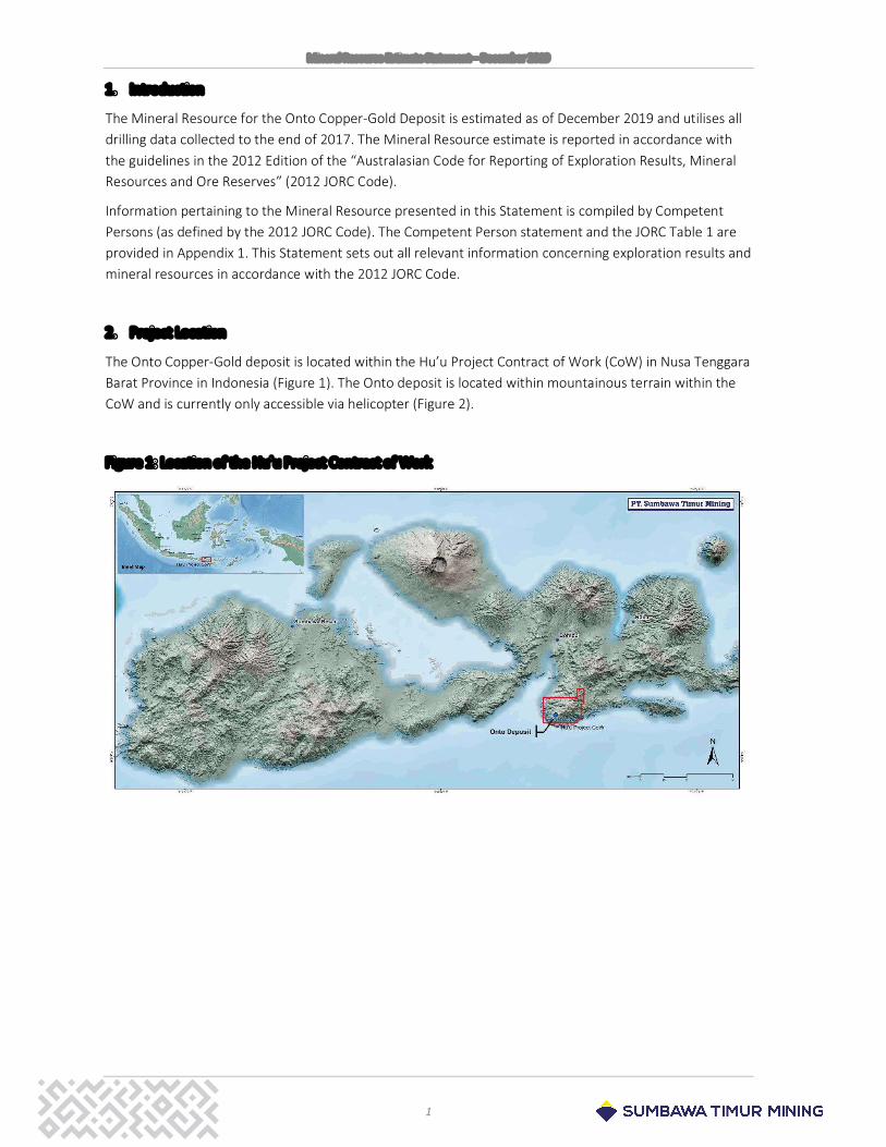
2. Project Location
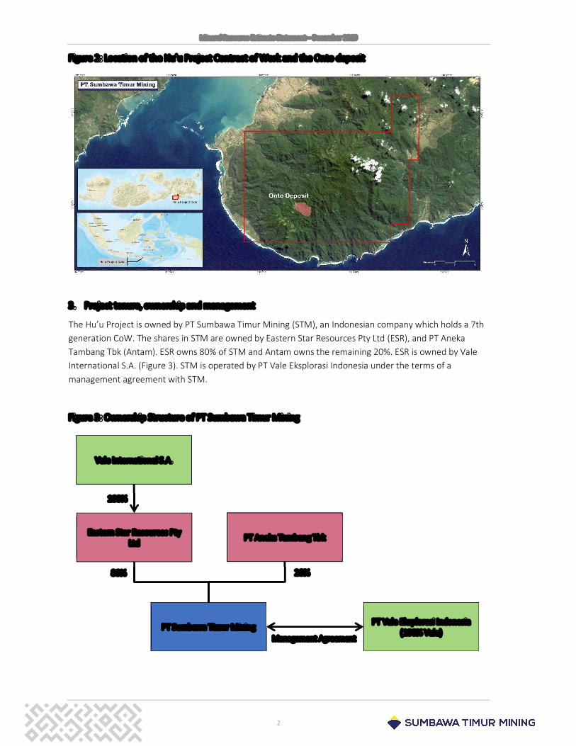
The Onto Copper-Gold deposit is located within the Hu’u Project Contract of Work (CoW) in Nusa Tenggara Barat Province in Indonesia (Figure 1). The Onto deposit is located within mountainous terrain within the CoW and is currently only accessible via helicopter (Figure 2).
Figure 1: Location of the Hu’u Project Contract of Work
Mineral Resource Estimate Statement – December 2019
2
Figure 2: Location of the Hu’u Project Contract of Work and the Onto deposit
3. Project tenure, ownership and management
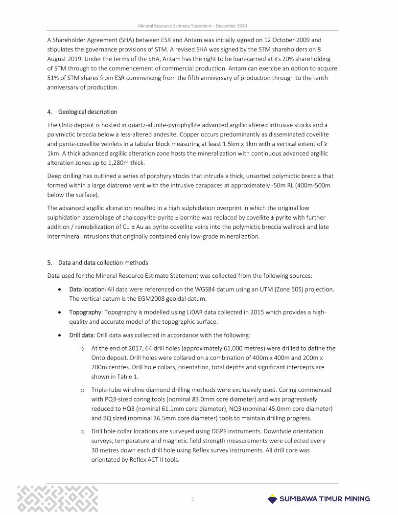
The Hu’u Project is owned by PT Sumbawa Timur Mining (STM), an Indonesian company which holds a 7th generation CoW. The shares in STM are owned by Eastern Star Resources Pty Ltd (ESR), and PT Aneka Tambang Tbk (Antam). ESR owns 80% of STM and Antam owns the remaining 20%. ESR is owned by Vale International S.A. (Figure 3). STM is operated by PT Vale Eksplorasi Indonesia under the terms of a management agreement with STM.
Figure 3: Ownership Structure of PT Sumbawa Timur Mining
Eastern Star Resources Pty Ltd
PT Aneka Tambang Tbk
PT Sumbawa Timur Mining
Vale International S.A.
PT Vale Eksplorasi Indonesia (100% Vale)
Management Agreement
80% 20%
100%
Mineral Resource Estimate Statement – December 2019
3
A Shareholder Agreement (SHA) between ESR and Antam was initially signed on 12 October 2009 and stipulates the governance provisions of STM. A revised SHA was signed by the STM shareholders on 8 August 2019. Under the terms of the SHA, Antam has the right to be loan-carried at its 20% shareholding of STM through to the commencement of commercial production. Antam can exercise an option to acquire 51% of STM shares from ESR commencing from the fifth anniversary of production through to the tenth anniversary of production.
4. Geological description
The Onto deposit is hosted in quartz-alunite-pyrophyllite advanced argillic altered intrusive stocks and a polymictic breccia below a less-altered andesite. Copper occurs predominantly as disseminated covellite and pyrite-covellite veinlets in a tabular block measuring at least 1.5km x 1km with a vertical extent of ≥ 1km. A thick advanced argillic alteration zone hosts the mineralization with continuous advanced argillic alteration zones up to 1,280m thick.
Deep drilling has outlined a series of porphyry stocks that intrude a thick, unsorted polymictic breccia that formed within a large diatreme vent with the intrusive carapaces at approximately -50m RL (400m-500m below the surface).
The advanced argillic alteration resulted in a high sulphidation overprint in which the original low sulphidation assemblage of chalcopyrite-pyrite ± bornite was replaced by covellite ± pyrite with further addition / remobilization of Cu ± Au as pyrite-covellite veins into the polymictic breccia wallrock and late intermineral intrusions that originally contained only low-grade mineralization.
5. Data and data collection methods
Data used for the Mineral Resource Estimate Statement was collected from the following sources:
Data location: All data were referenced on the WGS84 datum using an UTM (Zone 50S) projection. The vertical datum is the EGM2008 geoidal datum.
Topography: Topography is modelled using LiDAR data collected in 2015 which provides a high-quality and accurate model of the topographic surface.
Drill data: Drill data was collected in accordance with the following:
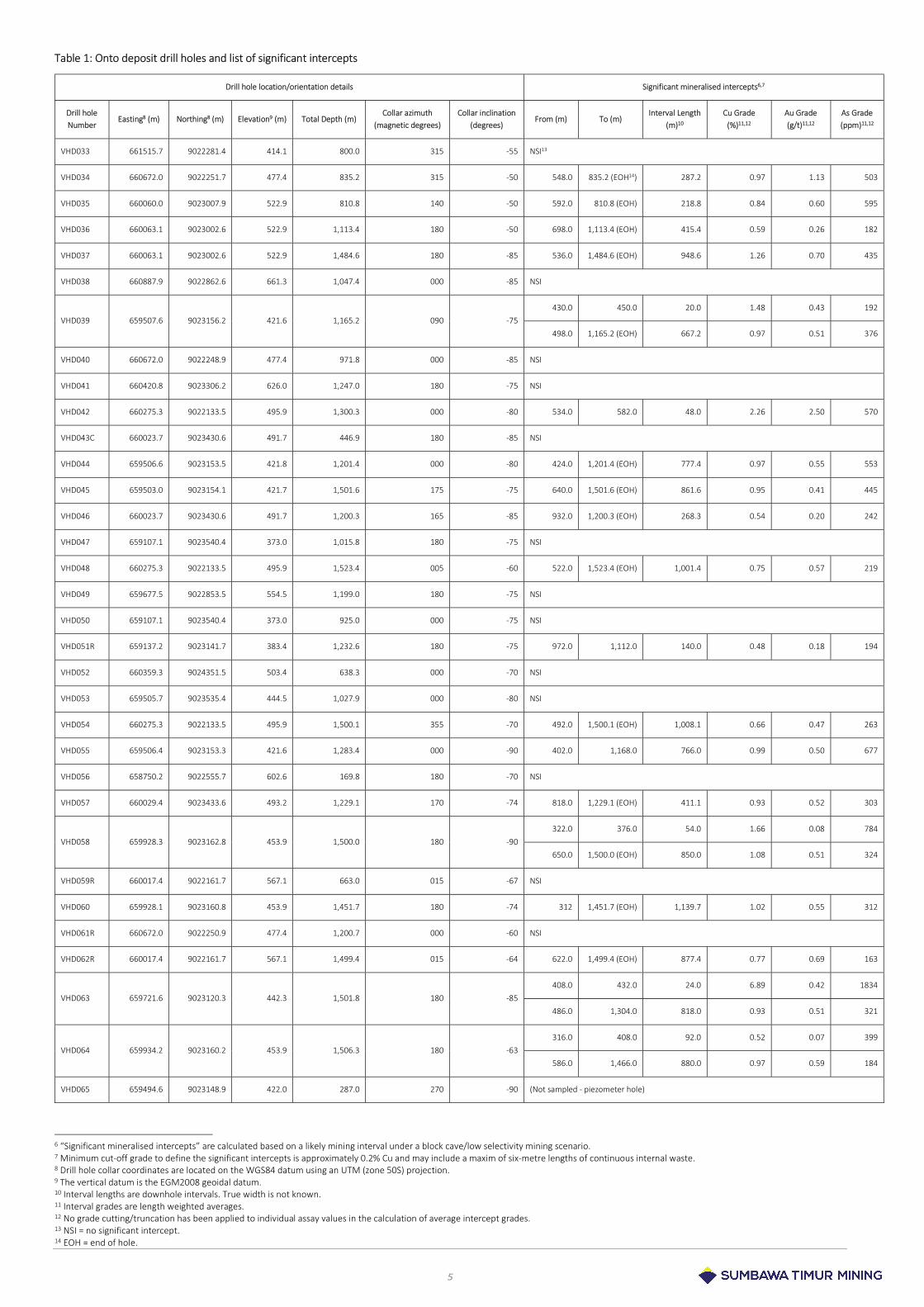
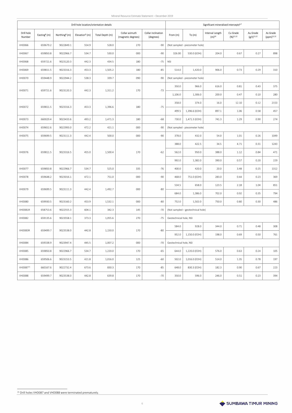
o At the end of 2017, 64 drill holes (approximately 61,000 metres) were drilled to define the Onto deposit. Drill holes were collared on a combination of 400m x 400m and 200m x 200m centres. Drill hole collars, orientation, total depths and significant intercepts are shown in Table 1.
o Triple-tube wireline diamond drilling methods were exclusively used. Coring commenced with PQ3-sized coring tools (nominal 83.0mm core diameter) and was progressively reduced to HQ3 (nominal 61.1mm core diameter), NQ3 (nominal 45.0mm core diameter) and BQ sized (nominal 36.5mm core diameter) tools to maintain drilling progress.
o Drill hole collar locations are surveyed using DGPS instruments. Downhole orientation surveys, temperature and magnetic field strength measurements were collected every 30 metres down each drill hole using Reflex survey instruments. All drill core was orientated by Reflex ACT II tools.
Mineral Resource Estimate Statement – December 2019
4
Drill core: Prior to any sampling, all core was washed and reconstructed with respect to the orientation line. The core is then photographed. Detailed logging of the core provides geotechnical (RQD1, fracture density, core recovery, joint characteristics) and geological data (rock type, alteration, oxidation and weathering, mineralogy and structure). The physical properties of the rock were assessed using HHXRF2 (Niton), magnetic susceptibility, ASD Terraspec SWIR3 analysis, point load testing and calliper dry bulk density. The mineral spectra data in the visible-near infrared (VNIR) to short wavelength infrared (SWIR) range was processed using TSG software. Holes were also processed with aiSIRISTM software provided by AusSpec International.
Bulk density: Calliper bulk density measurements were collected on a five-metre frequency down the length of each drill hole. Axial and diametrical point load data were collected at a 2.5-metre frequency.
Chemical assays: Sampling and sample preparation for chemical assaying applied the following methods:
o Drill core was cut and sampled in two-metre lengths (half-core). These samples were crushed to -2mm and, after splitting a portion, was pulverised to -75µm.
o Chemical analyses used a fire assay/AAS finish method for Au assay4 and a multi-elemental suite (including Cu, Ag, As, Fe and S) determined by a four-acid digest/ICP finish method5.
o Sample preparation was undertaken at the Intertek sample preparation laboratory on Sumbawa Island (Indonesia) and chemical analyses was performed at Intertek’s laboratory in Jakarta (Indonesia).
Quality assurance/quality control (QAQC): A comprehensive QAQC program was implemented in parallel with the sampling regime and consisted of blanks, certified reference materials (CRMs) and duplicate samples. The laboratory routinely evaluates crushing and pulverising product particle sizes and mass losses through the comminution circuits. Small sets of samples were periodically sent to independent laboratories for check analysis. Check density samples were sent to independent laboratories to continually evaluate the accuracy of the field-collected calliper bulk density measurements.
Geotechnical analysis: Samples of the major geological units were collected and sent to a geotechnical laboratory for unconfined compressive strength (UCS), triaxial, tensile, physical properties, elastic properties and abrasivity test work.
1 Rock quality designation 2 Hand-held X-ray fluorescence 3 Short-wave infrared 4 Intertek Laboratory analytical code: FA30/AA 5 Intertek Laboratory analytical code: 4AH2/OE201
5
Table 1: Onto deposit drill holes and list of significant intercepts
Drill hole location/orientation details Significant mineralised intercepts6,7
Drill hole Number
Easting8 (m) Northing8 (m) Elevation9 (m) Total Depth (m) Collar azimuth
(magnetic degrees) Collar inclination
(degrees) From (m) To (m)
Interval Length (m)10
Cu Grade (%)11,12
Au Grade (g/t)11,12
As Grade (ppm)11,12
VHD033 661515.7 9022281.4 414.1 800.0 315 -55 NSI13
VHD034 660672.0 9022251.7 477.4 835.2 315 -50 548.0 835.2 (EOH14) 287.2 0.97 1.13 503
VHD035 660060.0 9023007.9 522.9 810.8 140 -50 592.0 810.8 (EOH) 218.8 0.84 0.60 595
VHD036 660063.1 9023002.6 522.9 1,113.4 180 -50 698.0 1,113.4 (EOH) 415.4 0.59 0.26 182
VHD037 660063.1 9023002.6 522.9 1,484.6 180 -85 536.0 1,484.6 (EOH) 948.6 1.26 0.70 435
VHD038 660887.9 9022862.6 661.3 1,047.4 000 -85 NSI
VHD039 659507.6 9023156.2 421.6 1,165.2 090 -75 430.0 450.0 20.0 1.48 0.43 192
498.0 1,165.2 (EOH) 667.2 0.97 0.51 376
VHD040 660672.0 9022248.9 477.4 971.8 000 -85 NSI
VHD041 660420.8 9023306.2 626.0 1,247.0 180 -75 NSI
VHD042 660275.3 9022133.5 495.9 1,300.3 000 -80 534.0 582.0 48.0 2.26 2.50 570
VHD043C 660023.7 9023430.6 491.7 446.9 180 -85 NSI
VHD044 659506.6 9023153.5 421.8 1,201.4 000 -80 424.0 1,201.4 (EOH) 777.4 0.97 0.55 553
VHD045 659503.0 9023154.1 421.7 1,501.6 175 -75 640.0 1,501.6 (EOH) 861.6 0.95 0.41 445
VHD046 660023.7 9023430.6 491.7 1,200.3 165 -85 932.0 1,200.3 (EOH) 268.3 0.54 0.20 242
VHD047 659107.1 9023540.4 373.0 1,015.8 180 -75 NSI
VHD048 660275.3 9022133.5 495.9 1,523.4 005 -60 522.0 1,523.4 (EOH) 1,001.4 0.75 0.57 219
VHD049 659677.5 9022853.5 554.5 1,199.0 180 -75 NSI
VHD050 659107.1 9023540.4 373.0 925.0 000 -75 NSI
VHD051R 659137.2 9023141.7 383.4 1,232.6 180 -75 972.0 1,112.0 140.0 0.48 0.18 194
VHD052 660359.3 9024351.5 503.4 638.3 000 -70 NSI
VHD053 659505.7 9023535.4 444.5 1,027.9 000 -80 NSI
VHD054 660275.3 9022133.5 495.9 1,500.1 355 -70 492.0 1,500.1 (EOH) 1,008.1 0.66 0.47 263
VHD055 659506.4 9023153.3 421.6 1,283.4 000 -90 402.0 1,168.0 766.0 0.99 0.50 677
VHD056 658750.2 9022555.7 602.6 169.8 180 -70 NSI
VHD057 660029.4 9023433.6 493.2 1,229.1 170 -74 818.0 1,229.1 (EOH) 411.1 0.93 0.52 303
VHD058 659928.3 9023162.8 453.9 1,500.0 180 -90 322.0 376.0 54.0 1.66 0.08 784
650.0 1,500.0 (EOH) 850.0 1.08 0.51 324
VHD059R 660017.4 9022161.7 567.1 663.0 015 -67 NSI
VHD060 659928.1 9023160.8 453.9 1,451.7 180 -74 312 1,451.7 (EOH) 1,139.7 1.02 0.55 312
VHD061R 660672.0 9022250.9 477.4 1,200.7 000 -60 NSI
VHD062R 660017.4 9022161.7 567.1 1,499.4 015 -64 622.0 1,499.4 (EOH) 877.4 0.77 0.69 163
VHD063 659721.6 9023120.3 442.3 1,501.8 180 -85 408.0 432.0 24.0 6.89 0.42 1834
486.0 1,304.0 818.0 0.93 0.51 321
VHD064 659934.2 9023160.2 453.9 1,506.3 180 -63 316.0 408.0 92.0 0.52 0.07 399
586.0 1,466.0 880.0 0.97 0.59 184
VHD065 659494.6 9023148.9 422.0 287.0 270 -90 (Not sampled - piezometer hole)
6 “Significant mineralised intercepts” are calculated based on a likely mining interval under a block cave/low selectivity mining scenario. 7 Minimum cut-off grade to define the significant intercepts is approximately 0.2% Cu and may include a maxim of six-metre lengths of continuous internal waste. 8 Drill hole collar coordinates are located on the WGS84 datum using an UTM (zone 50S) projection. 9 The vertical datum is the EGM2008 geoidal datum. 10 Interval lengths are downhole intervals. True width is not known. 11 Interval grades are length weighted averages. 12 No grade cutting/truncation has been applied to individual assay values in the calculation of average intercept grades. 13 NSI = no significant intercept. 14 EOH = end of hole.
Mineral Resource Estimate Statement – December 2019
6
Drill hole location/orientation details Significant mineralised intercepts6,7
Drill hole Number
Easting8 (m) Northing8 (m) Elevation9 (m) Total Depth (m) Collar azimuth
(magnetic degrees) Collar inclination
(degrees) From (m) To (m)
Interval Length (m)10
Cu Grade (%)11,12
Au Grade (g/t)11,12
As Grade (ppm)11,12
VHD066 659679.2 9022849.1 554.9 528.0 270 -90 (Not sampled - piezometer hole)
VHD067 659850.8 9022966.7 534.7 530.0 000 -90 326.00 530.0 (EOH) 204.0 0.67 0.27 898
VHD068 659721.6 9023120.3 442.3 434.5 180 -75 NSI
VHD069 659811.5 9023316.3 453.3 1,505.2 180 -85 514.0 1,420.0 906.0 0.73 0.29 310
VHD070 659448.9 9022944.2 538.3 339.7 090 -90 (Not sampled - piezometer hole)
VHD071 659721.6 9023120.3 442.3 1,311.2 170 -73 350.0 966.0 616.0 0.81 0.43 375
1,106.0 1,306.0 200.0 0.47 0.10 280
VHD072 659811.5 9023316.3 453.3 1,396.6 180 -75 358.0 374.0 16.0 12.10 0.12 2153
499.5 1,396.6 (EOH) 897.1 1.06 0.58 457
VHD073 660029.4 9023433.6 493.2 1,471.3 180 -68 730.0 1,471.3 (EOH) 741.3 1.29 0.90 274
VHD074 659652.6 9022993.0 472.2 421.1 000 -90 (Not sampled - piezometer hole)
VHD075 659699.5 9023111.3 442.4 500.0 000 -90 378.0 432.0 54.0 1.01 0.26 1049
VHD076 659811.5 9023316.5 455.0 1,500.4 170 -62
388.0 422.5 34.5 4.71 0.31 1243
562.0 950.0 388.0 1.12 0.84 471
992.0 1,382.0 390.0 0.57 0.20 229
VHD077 659850.8 9022966.7 534.7 525.0 335 -76 400.0 420.0 20.0 3.48 0.25 1312
VHD078 659648.2 9023016.1 472.1 751.0 000 -90 468.0 751.0 (EOH) 283.0 0.44 0.23 369
VHD079 659699.5 9023111.3 442.4 1,492.7 000 -80 534.5 658.0 123.5 2.18 1.04 851
684.0 1,386.0 702.0 0.92 0.35 794
VHD080 659930.5 9023160.2 453.9 1,532.1 000 -80 752.0 1,502.0 750.0 0.80 0.30 486
VHD081R 658753.6 9022555.3 604.1 342.3 145 -70 (Not sampled – geotechnical hole)
VHD082 659135.6 9023558.1 373.3 1,055.6 270 -75 Geotechnical hole, NSI
VHD083R 659499.7 9023538.0 442.8 1,150.0 170 -80 584.0 928.0 344.0 0.71 0.48 308
952.0 1,150.0 (EOH) 198.0 0.69 0.50 761
VHD084 659338.9 9023947.4 445.5 1,007.2 000 -70 Geotechnical hole, NSI
VHD085 659850.8 9022966.7 534.7 1,220.0 170 -65 644.0 1,220.0 (EOH) 576.0 0.63 0.24 105
VHD086 659506.6 9023153.5 421.8 1,016.0 125 -60 502.0 1,016.0 (EOH) 514.0 1.35 0.78 197
VHD08715 660167.6 9022732.4 673.6 830.3 170 -85 648.0 830.3 (EOH) 182.3 0.90 0.67 223
VHD088 659499.7 9023538.0 442.8 639.8 170 -70 350.0 596.0 246.0 0.51 0.23 394
15 Drill holes VHD087 and VHD088 were terminated prematurely.
Mineral Resource Estimate Statement – December 2019
1117
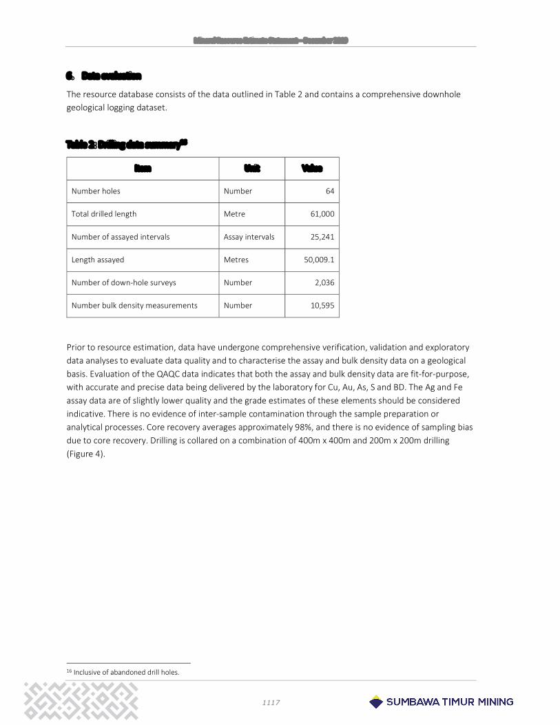
6. Data evaluation
The resource database consists of the data outlined in Table 2 and contains a comprehensive downhole geological logging dataset.
Table 2: Drilling data summary16
Item Unit Value
Number holes Number 64
Total drilled length Metre 61,000
Number of assayed intervals Assay intervals 25,241
Length assayed Metres 50,009.1
Number of down-hole surveys Number 2,036
Number bulk density measurements Number 10,595
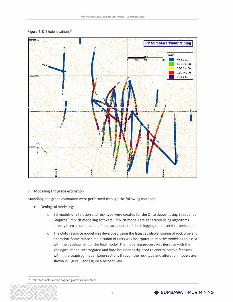
Prior to resource estimation, data have undergone comprehensive verification, validation and exploratory data analyses to evaluate data quality and to characterise the assay and bulk density data on a geological basis. Evaluation of the QAQC data indicates that both the assay and bulk density data are fit-for-purpose, with accurate and precise data being delivered by the laboratory for Cu, Au, As, S and BD. The Ag and Fe assay data are of slightly lower quality and the grade estimates of these elements should be considered indicative. There is no evidence of inter-sample contamination through the sample preparation or analytical processes. Core recovery averages approximately 98%, and there is no evidence of sampling bias due to core recovery. Drilling is collared on a combination of 400m x 400m and 200m x 200m drilling (Figure 4).
16 Inclusive of abandoned drill holes.
Mineral Resource Estimate Statement – December 2019
8
Figure 4: Dill hole locations17
7. Modelling and grade estimation
Modelling and grade estimation were performed through the following methods:
Geological modelling:
o 3D models of alteration and rock type were created for the Onto deposit using Seequent’s Leapfrog® implicit modelling software. Implicit models are generated using algorithms directly from a combination of measured data (drill hole logging) and user interpretation.
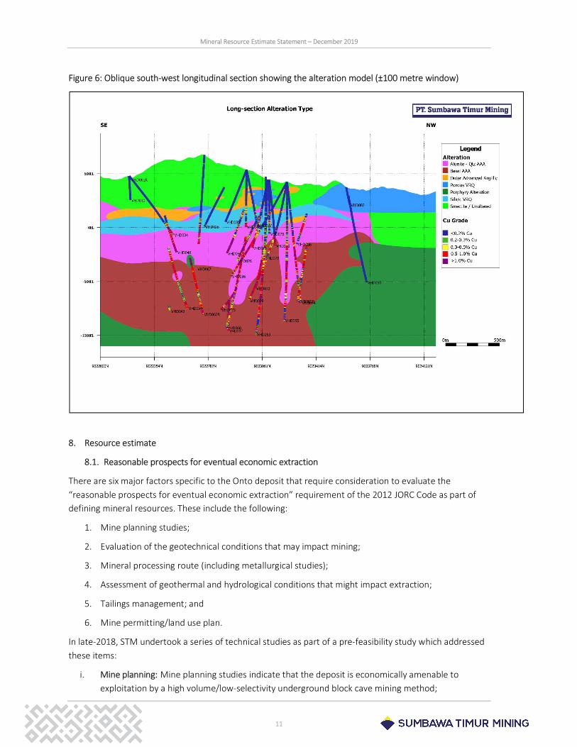
o The Onto resource model was developed using the latest available logging of rock type and alteration. Some minor simplification of units was incorporated into the modelling to assist with the development of the final model. The modelling process was iterative with the geological model interrogated and hard boundaries digitised to control certain features within the Leapfrog model. Long-sections through the rock type and alteration models are shown in Figure 5 and Figure 6 respectively.
17 Drill traces coloured to copper grades as indicated.
Mineral Resource Estimate Statement – December 2019
9
Grade estimation:
o A 0.2% Cu envelope is used for the purpose of grade estimation given the absence of an identifiable geological feature to differentiate mineralised rock from un-mineralised rock mass. This 0.2% Cu envelope is mainly confined to the interpreted advanced argillic alteration zone. Grade estimation has been restricted to the material inside this 0.2% Cu envelope.
o Assay data contained within the 0.2% Cu envelope were used for spatial continuity studies within the major rock type-alteration combinations. Variographic analyses showed strong anisotropic continuity in a NW-SE direction in the intrusive units overprinted with quartz-alunite advanced argillic alteration and in the polymictic breccia units overprinted with the basal advanced argillic alteration. Isotropic spatial continuity is observed in the intrusive units overprinted with basal advanced argillic alteration and in the polymictic breccia units overprinted with the quartz-alunite advanced argillic alteration. In all cases, a strong vertical component is also observed.
o Experimental directional variograms were developed along the three principal directions for Cu, Au, Ag, As, Fe, S and density and were modelled. The Ordinary Kriging method was used to estimate grades and density into a block model with block dimensions of 45m (N) x 45m (E) x 15m (El). Internal geological boundaries were used to constrain grade estimation within various geological units due to differing grade tenor and grade continuity characteristics.
Figure 5 and Figure 6 show the oblique longitudinal sections for the rock and alteration models.

Mineral Resource Estimate Statement – December 2019
10
Figure 5: Oblique south-west longitudinal section showing the rock-type model (±100 metre window)
Mineral Resource Estimate Statement – December 2019
11
Figure 6: Oblique south-west longitudinal section showing the alteration model (±100 metre window)
8. Resource estimate
8.1. Reasonable prospects for eventual economic extraction
There are six major factors specific to the Onto deposit that require consideration to evaluate the “reasonable prospects for eventual economic extraction” requirement of the 2012 JORC Code as part of defining mineral resources. These include the following:
1. Mine planning studies;
2. Evaluation of the geotechnical conditions that may impact mining;
3. Mineral processing route (including metallurgical studies);
4. Assessment of geothermal and hydrological conditions that might impact extraction;
5. Tailings management; and
6. Mine permitting/land use plan.
In late-2018, STM undertook a series of technical studies as part of a pre-feasibility study which addressed these items:
i. Mine planning: Mine planning studies indicate that the deposit is economically amenable to exploitation by a high volume/low-selectivity underground block cave mining method;
Mineral Resource Estimate Statement – December 2019
12
ii. Preliminary geotechnical characterisation: Preliminary geotechnical characterisation studies supports block cave mining as a viable mining method. The size of the planned mining footprint exceeds the minimum spans required to induce continuous caving;
iii. Metallurgy: Metallurgical test work to date indicates that the Cu-Au mineralisation can be recovered through a conventional milling-floatation circuit;
iv. Geothermal and hydrogeology: Preliminary geothermal and hydrogeological studies conclude that economic exploitation is feasible. Addressing the geothermal and hydrogeological data acquisition and modelling was prioritised in the pre-feasibility study and will be investigated in future studies;
v. Tailings Management: Studies into tailings management options and potential environmental impacts have commenced. It is anticipated that an appropriate management strategy will be developed;
vi. Mine permitting and land use: Approximately 70% of the Hu’u Project CoW is covered by protection forest. Prevailing regulations in Indonesia prohibit open cut mining operations in protection forest areas. Underground mining is permitted in protection forest areas provided that the operation does not cause surface or groundwater impacts. STM and the Indonesian Government are examining options to enable the development of a mining operation.
The abovementioned studies and ongoing work supports the proposition of “reasonable prospects for eventual economic extraction”. STM constrained the reported Mineral Resources to the volume of material contained within the physical mine design. The remainder of the drill-defined mineralised mass, outside the mine design, is defined as an ‘Exploration Target’. Therefore, the current reporting of the Resources estimate is limited to the available data and analysis conducted as part of mine design and planning studies undertaken as part of the pre-feasibility study.
8.2. Resource classification
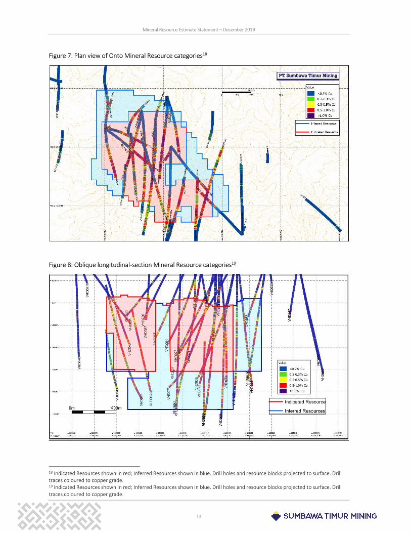
The Onto resource estimate is classified in accordance with the JORC Code (2012). The Code outlines items that require consideration when assigning an appropriate resource category. This includes data quality, the quality of the geological interpretation and modelling and an assessment of geological and grade continuity.
There is sufficient confidence in the data quality and geological model, and in both grade and geological continuity, as delineated by the 200m x 200m spaced drilling within the mine design to declare Indicated Mineral Resources as defined by the JORC Code (2012). Grade and geological continuity to declare Inferred Mineral Resources is also sufficiently delineated in the volume adequately drilled on a nominal 400m x 400m drill pattern within the mine design surrounding the Indicated Resources.
The location of the Indicated and Inferred material is shown in Figure 7 (plan) and Figure 8 (longitudinal section).
Mineral Resource Estimate Statement – December 2019
13
Figure 7: Plan view of Onto Mineral Resource categories18
Figure 8: Oblique longitudinal-section Mineral Resource categories19
18 Indicated Resources shown in red; Inferred Resources shown in blue. Drill holes and resource blocks projected to surface. Drill traces coloured to copper grade. 19 Indicated Resources shown in red; Inferred Resources shown in blue. Drill holes and resource blocks projected to surface. Drill traces coloured to copper grade.
Mineral Resource Estimate Statement – December 2019
14
8.3. Mineral Resource estimate
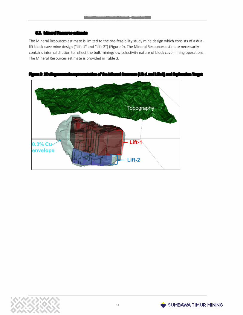
The Mineral Resources estimate is limited to the pre-feasibility study mine design which consists of a dual-lift block-cave mine design (“Lift-1” and “Lift-2”) (Figure 9). The Mineral Resources estimate necessarily contains internal dilution to reflect the bulk mining/low-selectivity nature of block cave mining operations. The Mineral Resources estimate is provided in Table 3.
Figure 9: 3D diagrammatic representation of the Mineral Resource (Lift-1 and Lift-2) and Exploration Target
Mineral Resource Estimate Statement – December 2019
15
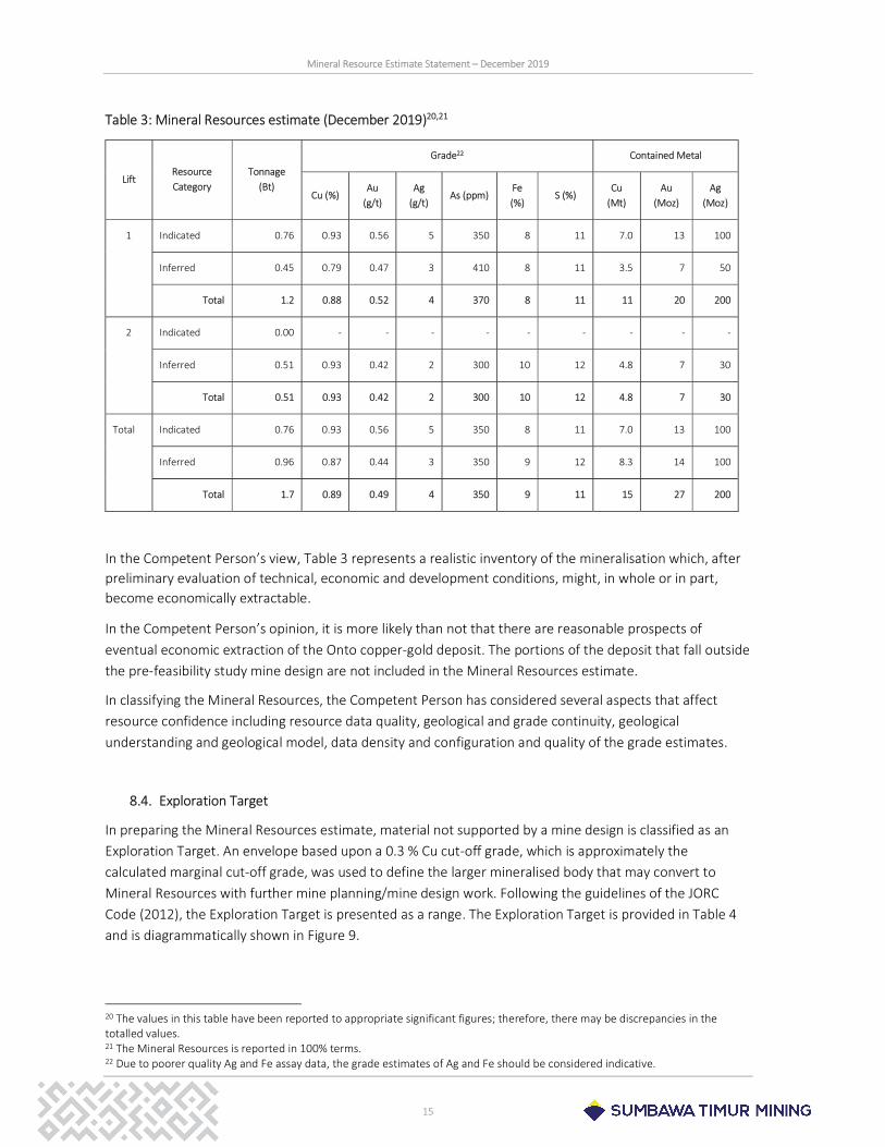
Table 3: Mineral Resources estimate (December 2019)20,21
Lift Resource Category
Tonnage (Bt)
Grade22 Contained Metal
Cu (%) Au
(g/t) Ag
(g/t) As (ppm)
Fe (%)
S (%) Cu
(Mt) Au
(Moz) Ag
(Moz)
1 Indicated 0.76 0.93 0.56 5 350 8 11 7.0 13 100
Inferred 0.45 0.79 0.47 3 410 8 11 3.5 7 50
Total 1.2 0.88 0.52 4 370 8 11 11 20 200
2 Indicated 0.00 - - - - - - - - -
Inferred 0.51 0.93 0.42 2 300 10 12 4.8 7 30
Total 0.51 0.93 0.42 2 300 10 12 4.8 7 30
Total Indicated 0.76 0.93 0.56 5 350 8 11 7.0 13 100
Inferred 0.96 0.87 0.44 3 350 9 12 8.3 14 100
Total 1.7 0.89 0.49 4 350 9 11 15 27 200
In the Competent Person’s view, Table 3 represents a realistic inventory of the mineralisation which, after preliminary evaluation of technical, economic and development conditions, might, in whole or in part, become economically extractable.
In the Competent Person’s opinion, it is more likely than not that there are reasonable prospects of eventual economic extraction of the Onto copper-gold deposit. The portions of the deposit that fall outside the pre-feasibility study mine design are not included in the Mineral Resources estimate.
In classifying the Mineral Resources, the Competent Person has considered several aspects that affect resource confidence including resource data quality, geological and grade continuity, geological understanding and geological model, data density and configuration and quality of the grade estimates.
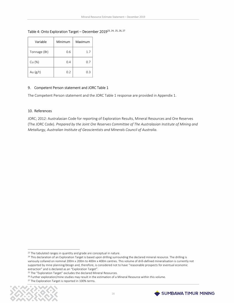
8.4. Exploration Target
In preparing the Mineral Resources estimate, material not supported by a mine design is classified as an Exploration Target. An envelope based upon a 0.3 % Cu cut-off grade, which is approximately the calculated marginal cut-off grade, was used to define the larger mineralised body that may convert to Mineral Resources with further mine planning/mine design work. Following the guidelines of the JORC Code (2012), the Exploration Target is presented as a range. The Exploration Target is provided in Table 4 and is diagrammatically shown in Figure 9.
20 The values in this table have been reported to appropriate significant figures; therefore, there may be discrepancies in the totalled values. 21 The Mineral Resources is reported in 100% terms. 22 Due to poorer quality Ag and Fe assay data, the grade estimates of Ag and Fe should be considered indicative.
Mineral Resource Estimate Statement – December 2019
16
Table 4: Onto Exploration Target – December 201923, 24, 25, 26, 27
9. Competent Person statement and JORC Table 1
The Competent Person statement and the JORC Table 1 response are provided in Appendix 1.
10. References
JORC; 2012: Australasian Code for reporting of Exploration Results, Mineral Resources and Ore Reserves (The JORC Code). Prepared by the Joint Ore Reserves Committee of The Australasian Institute of Mining and Metallurgy, Australian Institute of Geoscientists and Minerals Council of Australia.
23 The tabulated ranges in quantity and grade are conceptual in nature. 24 This declaration of an Exploration Target is based upon drilling surrounding the declared mineral resource. The drilling is variously collared on nominal 200m x 200m to 400m x 400m centres. This volume of drill-defined mineralisation is currently not supported by mine planning/design and, therefore, is considered not to have “reasonable prospects for eventual economic extraction” and is declared as an “Exploration Target”. 25 The “Exploration Target” excludes the declared Mineral Resources. 26 Further exploration/mine studies may result in the estimation of a Mineral Resource within this volume. 27 The Exploration Target is reported in 100% terms.
Variable Minimum Maximum
Tonnage (Bt) 0.6 1.7
Cu (%) 0.4 0.7
Au (g/t) 0.2 0.3

Mineral Resource Estimate Statement – December 2019
17
Disclaimers
# This Mineral Resources Estimate Statement contains certain technical data extracted from a Mineral Resources Estimate prepared in accordance with the JORC Code (2012) and updated by STM in December 2019. The information contained in this Mineral Resources Estimate Statement and any associated Press Release is a summary only and does not provide all information outlined in the STM December 2019 Mineral Resource Estimate. The Mineral Resource Estimate Statement has been prepared in in accordance with the guidelines in the 2012 Edition of the “Australasia Code for Reporting of Exploration Results, Mineral Resources and Ore Reserves” JORC Code (2012), but STM is not subject to the JORC Code and does not assume any obligation to comply with the JORC Code in this or any future report.
## This press release and the Attachment 1 thereto may include statements about our current expectations about future events or results (forward-looking statements). Many of those forward-looking statements can be identified by the use of forward-looking words such as "anticipate," "believe," "could," "expect," "should," "plan," "intend," "estimate" “will” and "potential," among others. All forward-looking statements involve various risks and uncertainties. We cannot guarantee that these statements will prove correct. We caution you that actual results may differ materially from the plans, objectives, expectations, estimates and intentions expressed in this presentation. We undertake no obligation to publicly update or revise any forward-looking statement, whether as a result of new information or future events or for any other reason. To obtain further information on factors that may lead to results different from those forecast by us, please consult the reports that Vale S.A. files with the U.S. Securities and Exchange Commission (SEC), the Brazilian Comissão de Valores Mobiliários (CVM), and, in particular, the factors discussed under “Forward-Looking Statements” and “Risk Factors” in Vale S.A.’s annual report on Form 20-F. To obtain further information on factors that may lead to results different from those forecast from us, please consult the reports that Antam files with the Indonesia Stock Exchange and the Australia Securities Exchange. None of the Company or any of its directors, officers, employees, agents, shareholders, affiliates, advisors or representatives shall have any responsibility or liability whatsoever (in negligence or otherwise) for the accuracy or completeness of, or any errors or omissions in, any information or opinions contained herein nor for any loss (including consequential loss or damage) howsoever arising, whether directly or indirectly, from any use, reliance or distribution of this press release or its contents or otherwise arising in connection with this press release. This press release should not be treated as advice relating to investment matters. Any further investment in any securities issued by the Company should be made solely on the basis of the final offer document issued in respect of such securities.]
.
NOTICE FOR U.S. INVESTORS:
The terms “mineral resources” and “Indicated and Inferred resources” are used in this statement. It is advised that the SEC does not recognise these terms and “resources” have not been prepared in accordance with Industry Guide 7. Such “resources” would be substantively the same as those prepared using the Guidelines established by the Society of Mining, Metallurgy and Exploration (SME) and defined as “Mineral Resource”. Estimates of resources are subject to further exploration and development, are subject to additional risks, and no assurance can be given that they will eventually convert to future reserves. Inferred Resources, in particular, have a great amount of uncertainty as to their existence and their economic and legal feasibility. Investors are cautioned not to assume that any part or all of the Inferred Resource exists or is economically or legally mineable. Also, disclosure of contained metal is permitted under the SME Guidelines and other regulatory guidelines, such as Canada’s NI43-101 and Australasia’s JORC, however, the SEC generally requires mineral resource information in SEC-filed documents to be reported only as in-place tonnage and grade. Investors are reminded that even if significant mineralisation is discovered and converted to reserves, during the time necessary to ultimately move such mineralisation to production the economic feasibility of production may change.
Mineral Resource Estimate Statement – December 2019
18
Appendix 1: Competent Person Statement and JORC Table 1
Competent Person Statement
Mineral Resources have been estimated and are reported in accordance with the guidelines in the 2012 Edition of the “Australasia Code for Reporting of Exploration Results, Mineral Resources and Ore Reserves” (2012 JORC Code). The information reported in this Mineral Resources Estimate Statement relates to Exploration Results, Exploration Targets and Mineral Resources estimates is based on information compiled by:
o Dr David Burrows: A Competent Person who is a Professional Geoscientist of the Association of Professional Geoscientists of Ontario (PGeo; Registration No 0611). Dr Burrows is responsible for the development of the geological model. Dr Burrows is a full-time employee of Vale Canada Limited; and
o Mr. Richard Hague: A Competent Person who is a Member of the Australian Institute of Geoscientists (MAIG; Member No 1745). Mr. Hague is responsible for the underpinning mineral resource data and estimate. Mr. Hague is a full-time employee of Vale Exploration Pty Ltd.
Both Dr Burrows and Mr Hague have sufficient experience that is relevant to the style of mineralisation and type of deposit under consideration and to the respective activity being undertaken to qualify as Competent Persons as defined in the 2012 Edition of the “Australasian Code for Reporting of Exploration Results, Mineral Resources and Ore Reserves” (2012 JORC Code). Both consent to the inclusion in the Statement of the matters based upon their information in the form and context in which it appears.
Mineral Resource Estimate Statement – December 2019
19
JORC Table 1
Section 1 “Sampling Techniques and Data” provides a summary of assessment and reporting criteria for the reporting of Mineral Resources in accordance with the Table 1 checklist in the JORC Code (2012). Criteria in each section apply to all preceding and succeeding sections.
Section 1 Sampling Techniques and Data
Criteria Explanation Commentary
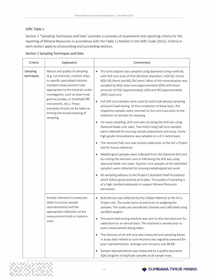
Sampling techniques
Nature and quality of sampling (e.g. cut channels, random chips, or specific specialised industry standard measurement tools appropriate to the minerals under investigation, such as down hole gamma sondes, or handheld XRF instruments, etc.). These examples should not be taken as limiting the broad meaning of sampling.
The Onto deposit was sampled using diamond coring methods, with drill core sizes of PQ3 (83.0mm diameter), HQ3 (61.1mm), NQ3 (45.0mm) and BQ (36.5mm). Most of the mineralisation was sampled by NQ3-sized core (approximately 60%) with lesser amounts of HQ3 (approximately 20%) and BQ (approximately 20%) sized core.
Full drill core samples were used for both bulk density sampling and point load testing. At the completion of these tests, the respective samples were returned to the core trays prior to the collection of samples for assaying.
For assay sampling, drill core was cut along the drill axis using diamond blade core saws. Two-metre long half-core samples were collected for ensuing sample preparation and assay. Some high-grade mineralisation was sampled on a 0.5 metre basis.
The remnant half-core was stored undercover at the Hu’u Project site for future reference.
Metallurgical samples were collected from the diamond drill core by cutting the remnant core in half along the drill axis using diamond blade core saws. Quarter-core samples of the identified sample/s were collected for ensuing metallurgical test work.
All sampling adheres to the Project’s Standard Field Procedures which follow good practice principles. The quality of sampling is of a high standard adequate to support Mineral Resource estimation.
Include reference to measures taken to ensure sample representativity and the appropriate calibration of any measurement tools or systems used.
Bulk density was collected by the Calliper Method at the Hu’u Project site. The scales were zeroed prior to weighing the samples. The scales are periodically checked and calibrated using certified weights.
The point load testing machine was sent to the manufacturer for calibration on an annual basis. The machine is zeroed prior to every measurement being taken.
The recovery of all drill core was measured and sampling biases in assay data related to core recovery was regularly assessed for poor representativity. Average core recovery was 98.8%.
Sample representativity was measured by a quality assurance (QA) program of duplicate samples at all sample mass
Mineral Resource Estimate Statement – December 2019
20
Criteria Explanation Commentary
reduction/comminution stages including core cutting, -2mm crushing and -75um pulverising. The results of the duplicate pair data were regularly assessed for precision and representativity.
Aspects of the determination of mineralisation that are Material to the Public Report.
As part of the Standard Field Procedures, all drill core was geologically logged for mineral species (both valuable and deleterious). Specific to the Onto deposit, these include sulphides (pyrite, covellite, enargite, chalcocite, chalcopyrite and bornite), silicates (e.g. smectites, kaolinite, pyrophyllite), sulphates (alunite, gypsum, anhydrite) and native sulphur.
Mineralogical and petrological studies of samples was performed to determine mineral relationships and paragenesis.
Drilling techniques
Drill type (e.g. core, reverse circulation, open-hole hammer, rotary air blast, auger, Bangka, sonic, etc) and details (eg core diameter, triple or standard tube, depth of diamond tails, face-sampling bit or other type, whether core is oriented and if so, by what method, etc.).
Triple-tube wireline diamond core methods were exclusively used. Coring commenced with PQ3 coring tools, which was progressively reduced to HQ3, NQ3 and BQ sized core, as required, to maintain drilling progress.
All drill core is orientated by Reflex ACT II tools.
Drill sample recovery
Method of recording and assessing core and chip sample recoveries and results assessed.
Core recovery was measured on a nominal two-metre basis conforming to the assaying sampling unit. Core recovery averaged 98.8%.
Correlation studies of core recovery against copper and gold assay data showed no correlation. This indicates that there was no sampling bias due to preferential sample loss.
Measures taken to maximise sample recovery and ensure representative nature of the samples.
Diamond coring methods were exclusively used. This method delivered excellent sample recovery an (average of 98.8%).
The mineralised portion of the rock mass is very competent which aided in obtaining the necessary core recovery to ensure representative samples.
Whether a relationship exists between sample recovery and grade and whether sample bias may have occurred due to preferential loss/gain of fine/coarse material.
Studies of correlation of core recovery and copper and gold grades showed no relationship. This indicates that there was no sampling bias due to preferential sample loss.
Logging Whether core and chip samples have been geologically and geotechnically logged to a level of detail to support appropriate
All drill core was geologically logged for weathering, oxidation, rock type, alteration and mineralisation. All drill core was scanned with field-portable full-range spectrometer (ASD), magnetic susceptibility meter and HHXRF (Niton) to aid in the
Mineral Resource Estimate Statement – December 2019
21
Criteria Explanation Commentary
Mineral Resource estimation, mining studies and metallurgical studies.
identification of alteration mineralogy and track elements of interest (Cu, Zn, As, Mo, Pb, Sr and Fe).
All drill core was geotechnically logged for sample recovery, RQD, structural defects, visual rock strength, joint description and fracture frequency.
Point load testing was carried out on drill core every 2.5m on a downhole basis.
The level of detail in the geological and geotechnical logging is sufficient to support Mineral Resource estimation, mining studies and metallurgical studies.
Whether logging is qualitative or quantitative in nature. Core (or costean, channel, etc) photography.
All drill core was digitally photographed in both wet and dry condition prior to any density or point load testing, core cutting and sampling.
Core logging is both qualitative and quantitative in nature. Geological logging describing weathering, oxidation, rock type, geotechnical properties, alteration and mineralisation is qualitative in nature.
Visual estimates of mineral abundances and alteration intensity were collected.
Shortwave length Infrared measurements (ASD), magnetic susceptibility and HHXRF (Niton) scanning of the drill core provided quantitative data.
The total length and percentage of the relevant intersections logged.
All holes were drilled from surface by coring methods for a total of approximately 61,000 metres. All drill core (un-mineralised and mineralised) was logged in detail.
Sub-sampling techniques and sample preparation
If core, whether cut or sawn and whether quarter, half or all core taken.
Drill core was cut along the drill axis using diamond saws. Two-metre long half-core samples were collected for ensuing sample preparation.
In rare cases of samples being rubbly or clay-rich, sampling by hand was undertaken using a spatula or blade.
Duplicate quarter-core samples were collected for quality control (QC) purposes at a rate of approximately 5%.
Remnant core consists of half-core or quarter-core where duplicate samples were collected or additional metallurgical samples were taken. Remnant drill core is securely stored in a weather proof core shed facility located at the Hu’u Project site.
If non-core, whether riffled, tube sampled, rotary split, etc and whether sampled wet or dry.
Not applicable; all drilling consisted of diamond drill core.
Mineral Resource Estimate Statement – December 2019
22
Criteria Explanation Commentary
For all sample types, the nature, quality and appropriateness of the sample preparation technique.
Sample preparation for assaying consisted of drying the sample at 105ºC and primary crushing of the total sample to P95 of 2mm. This was followed by rotary splitting to approximately 1.5kg, pulverizing to P95 of 75µm and the selection of requisite assay charges.
The sample preparation procedures follow good practice principles and are appropriate for the style of mineralisation.
Quality control procedures adopted for all sub-sampling stages to maximise representativity of samples.
A comprehensive quality control (QC) program is implemented in parallel with the sampling process to provide quality assurance, measure assay accuracy and precision, and to detect sample contamination.
The QC program consisted of the collection and submission of quarter-core field duplicates at a rate of approximately 5% and the insertion of field blanks and CRMs into the sample stream at a similar rate.
The field QC program is independent of the QC program implemented by the laboratory.
The CRMs were either commercially obtained from a reputable Australian supplier or are Matrix Matched Standards (MMS) created from the -2mm coarse reject material. Both types are certified for copper and gold and a suite of other elements. Several CRMs of differing grades were used to measure accuracy at several critical grades.
The laboratory’s QC program consisted of duplicate sampling at the -2mm crushing and -75µm pulverising stages, mass loss studies at all comminution stages, sieve screen size analyses, and the insertion of Analytical Blanks and a suite of CRMs.
All QC data are regularly statistically assessed to continually monitor the representativity of samples at all mass reduction/comminution stages.
Measures taken to ensure that the sampling is representative of the in-situ material collected, including for instance results for field duplicate/second-half sampling.
The QC program consists of the collection and submission of quarter-core field duplicates at a rate of approximately 5% to ensure that the field sampling is representative, repeatable and precise.
Results showed that sampling provides representative samples of the drill core.
Whether sample sizes are appropriate to the grain size of the material being sampled.
An evaluation of all duplicate assay data (field, -2mm and -75µm duplicate data) shows adequate precision and indicates that sample sizes were appropriate at the respective comminution grain sizes of the material being sampled at the field, -2mm and -75µm comminution stages.
Mineral Resource Estimate Statement – December 2019
23
Criteria Explanation Commentary
Quality of assay data and laboratory tests
The nature, quality and appropriateness of the assaying and laboratory procedures used and whether the technique is considered partial or total.
Assaying procedures applied standard methods used widely throughout the mining industry and consisted of:
o Multi-acid (four-acid) digest/ICP-OES finish was applied for a multi-element suite including Cu, Ag, As, Fe, and S28. This method has a detection range of 2-100,000ppm (10%) for Cu;
o Samples were digested using nitic, hydrochloric, hydrofluoric and perchloric acids and boiled to dryness. Hydrochloric acid was then added to dissolve the soluble salts before water was added to the sample to a predetermined volume;
o An over-limit method of the multi-acid (four acid) digest/AAS method was used for samples with Cu grades exceeding 10% (detection range of 0.1-50% Cu)29;
o The Leco Furnace method is used for samples with S grades exceeding 20% (detection range 0.01%-50%)30;
o 30g charge fire assay/AAS finish was used for Au. This method has a detection range of 0.01-30ppm Au31; and
o An over-limit method of standard gravimetric analysis was used for samples with Au grades exceeding 30ppm32.
All chemical methods in use were total or near-total digestion methods.
The chemical laboratory in Jakarta is ISO17025 certified by KAN for the sample preparation procedures and the analytical methods used to derive the Project’s assay data.
The assaying and laboratory procedures follow good practice principles and are appropriate for the style of mineralisation.
For geophysical tools, spectrometers, handheld XRF instruments, etc., the parameters used in determining the analysis including instrument make and model, reading times, calibrations factors applied and their derivation, etc.
Not material; geophysical tools were only used to provide indicative/qualitative data. These data were not used in the reporting of exploration results or for use in Mineral Resource Estimate.
The geophysical tools used, however, do provide qualitative information which provide a reference for geochemical analysis and aids in the identification of the broader alteration styles. The alteration interpretation was subsequently used in the derivation of the geological models.
The calibration of the ASD equipment utilised three certified
28 Intertek Laboratory analytical code: 4AH2/OE201. 29 Intertek Laboratory analytical code: 4AH2/AA. 30 Intertek Laboratory analytical code: CSA03. 31 Intertek Laboratory analytical code: FA30/AA. 32 Intertek Laboratory analytical code: FA25/GR200.
Mineral Resource Estimate Statement – December 2019
24
Criteria Explanation Commentary
standard reference materials. The calibration of the HHXRF (Niton) equipment utilised machine standards.
Nature of quality control procedures adopted (eg standards, blanks, duplicates, external laboratory checks) and whether acceptable levels of accuracy (i.e. lack of bias) and precision have been established.
The bulk density data was determined by the Calliper Method and was regularly checked by submitting a sub-set of the same samples to the chemical laboratory for dry bulk density determination by an alternative method (the Archimedes Method).
A comparison of the Calliper and Archimedes derived data showed that the Calliper data are precise and that no relative bias exists between datasets.
The QC program to monitor the assay data and laboratory tests consisted of duplicate sampling at the -2mm crushing and -75µm pulverising stages, mass loss studies at all comminution/mass reduction stages, sieve screen size analyses, insertion of blanks, analytical blanks and a suite of CRMs.
Independent laboratory check sample programs were regularly implemented whereby a selection of samples was sent to a second laboratory for confirmatory assays.
All QC data were statistically assessed to continually monitor data accuracy and precision.
An evaluation of the QC data derived from the CRMs indicates that acceptable levels of accuracy in the assay data are established.
An evaluation of QC data derived from the field and analytical blanks indicate that there was no significant and systematic sample contamination within the sample preparation process or evidence exists of contaminated sampling, analytical equipment or reagents.
An evaluation of the QC data derived from the -2mm and -75µm duplicate samples indicates that acceptable levels of precision in the assay data were established.
An evaluation of the external laboratory check sample programs confirmed the original assay data.
The assay data and laboratory tests were of a high quality and adequate to support the Mineral Resource estimate.
Verification of sampling and assaying
The verification of significant intersections by either independent or alternative company personnel.
Verification of significant intersections was undertaken by regular external laboratory check sampling programs and the collection of HHXRF (Niton) scans giving (amongst other data) Cu content. The external laboratory check sampling confirmed the original assay data.
A comparison between the HHXRF (Niton) and assay data
Mineral Resource Estimate Statement – December 2019
25
Criteria Explanation Commentary
indicates similar significant intersections.
Logging of mineralisation and the estimate of mineral abundance provides confirmation of the location of the significant intersections.
The use of twinned holes. Twinned holes were not drilled. It is not considered necessary to verify sampling intercepts in a massive low-grade deposit given that all drilling was/is undertaken by diamond coring methods producing high core recoveries averaging 98.8%.
Documentation of primary data, data entry procedures, data verification, data storage (physical and electronic) protocols.
The Project’s Standard Field Procedures document data entry procedures, data validation and data storage protocols. These procedures follow good practice principles.
Discuss any adjustment to assay data.
Below detection limit assay data are stored in the database as “<[the detection limit]”. For Mineral Resource grade estimation, these data are assigned half the lower detection limit. No other adjustment to assay data is made.
Location of data points
Accuracy and quality of surveys used to locate drill holes (collar and down-hole surveys), trenches, mine workings and other locations used in Mineral Resource estimation.
Drill hole collars were surveyed using differential GPS surveying instruments. The surveyed collar elevations were compared to the high-quality LiDAR topographic model to check for elevation errors.
Downhole surveys of the drill holes were collected on a nominal 30m downhole basis by use of a Reflex downhole camera. The readings were inspected to ensure they are consistent with surrounding readings.
All azimuth data are corrected for magnetic declination.
The survey data are of high quality and are adequate to support Mineral Resource estimation.
Specification of the grid system used.
All data are located on the WGS84 datum using a UTM (zone 50S) projection. The vertical datum is the EGM2008 geoidal datum.
Quality and adequacy of topographic control.
Topographic control is based upon a high quality and accurate digital terrain model (DTM) grid derived from a detailed LiDAR survey flown in 2015. The topographic control is adequate to support the Mineral Resource estimate.
Data spacing and distribution
Data spacing for reporting of Exploration Results.
Drill hole spacing was variable due to the stage of evaluation of the deposit and the nature of the terrain. The nominal drill hole spacing is a combination of 400m x 400m and infilled to a 200m x 200m density.
Mineral Resource Estimate Statement – December 2019
26
Criteria Explanation Commentary
Whether the data spacing and distribution is sufficient to establish the degree of geological and grade continuity appropriate for the Mineral Resource and Ore Reserve estimation procedure(s) and classifications applied.
At the prevailing drill hole spacing, the distribution of data is sufficient to establish the degree of geological and grade continuity appropriate for the Mineral Resource estimate and applied classification.
Whether sample compositing has been applied.
Assay samples were collected on a constant two-metre length basis. Compositing into longer intervals was not applied.
Orientation of data in relation to geological structure
Whether the orientation of sampling achieves unbiased sampling of possible structures and the extent to which this is known, considering the deposit type.
Interpretation of the available data indicates that the deposit generally strikes about 120º with sub-vertical orientation. Interpreted internal conjugate faults strike about 045º and 110º and are assumed to be sub-vertical.
The orientation of drilling was variable but was mostly orientated in an approximate north-south direction dipping between -50 to -90º. Several drill holes were orientated along the prevailing strike of the deposit to investigate the presence of north-south mineralised structures. None were recognised.
Drilling orientation is considered to have achieved unbiased sampling of the important structures in the deposit apart from NNE-SSW orientated faults.
If the relationship between the drilling orientation and the orientation of key mineralised structures is considered to have introduced a sampling bias, this should be assessed and reported if material.
Not applicable; the drilling orientation is not considered to have introduced a sampling bias.
Sample security
The measures taken to ensure sample security.
The measures to provide sample security include:
o Adequately trained and supervised personnel were involved at all stages of the drilling, logging, sample preparation, laboratory analysis and resource estimation process;
o Secure sampling compound with a security fence and well-maintained sampling sheds;
o Core samples were placed in calico bags securely tied and clearly sequentially numbered;
o Calico bagged samples were transported in poly-weave bags to the sample preparation facility;
o Upon receipt of the samples, the sample preparation laboratory checked the sample submission documentation and advised of any discrepancies or damaged sample bags;
Mineral Resource Estimate Statement – December 2019
27
Criteria Explanation Commentary
and
o Assay data were returned in both ASCII and pdf formats.
Audits or reviews
The results of any audits or reviews of sampling techniques and data.
Several internal reviews of the sampling, preparation and analytical methods were undertaken. These indicated that the processes in place followed good practice and were being followed.
Inspection and audits of the laboratory were routinely undertaken by company personnel. These inspections and audits did not identify any significant issues with the laboratory processes and procedures.
Mineral Resource Estimate Statement – December 2019
28
Section 2 Reporting of Exploration Results
Criteria Explanation Commentary
Mineral tenement and land tenure status
Type, reference name/number, location and ownership including agreements or material issues with third parties such as joint ventures, partnerships, overriding royalties, native title interests, historical sites, wilderness or national park and environmental settings.
The Onto deposit is located on Sumbawa Island, Indonesia, in the Province of Nusa Tenggara Barat Province.
PT Sumbawa Timur Mining (STM) owns the seventh generation Hu’u Project Contract of Work (CoW). STM is a joint venture between Eastern Star Resources Pty Ltd (80%) and PT Aneka Tambang Tbk (20%). ESR is 100%-owned by Vale International S.A.
All exploration and evaluation of the Hu’u Project and Onto deposit is managed by PT Vale Eksplorasi Indonesia under the terms of a management agreement with STM.
The CoW provides for the exploration, development and extraction of any Mineral Resources discovered. The royalty payable to the Government is set out in the CoW.
Approximately 70% of the CoW is classified as “Protection Forest”. Prevailing forestry regulations prohibit open-cut mining operations in protection forest areas and allows for underground mining provided there are no impacts to the surface and groundwater.
The security of the tenure held at the time of reporting along with any known impediments to obtaining a licence to operate in the area.
The CoW provides for 30 years of mineral production following a minimum of eight years of exploration, feasibility and construction. Under the terms of the CoW, the exploration, feasibility, construction and exploitation periods can be extended provided adequate justification is provided to regulatory authorities.
The CoW is currently in the Feasibility Study stage of exploration. Further extensions to the Feasibility Study period can be granted by the Ministry of Energy and Mineral Resources (MEMR).
STM successfully concluded an Amendment to the CoW on 7 May 2019. This amended CoW is consistent with the Law on Mineral and Coal Mining No. 4 of 2009 (the “Mining Law”). This amended CoW addresses provisions contained within the Mining Law regarding divestment, domestic refining and other legislative requirements.
Permission to conduct exploration within the designated forest areas must be obtained from the Ministry of Environment and Forestry. This is provided under a borrow-to-use forestry permit (“IPPKH Permit”). STM currently operates exploration, drilling and all field activities within the CoW under a valid IPPKH Permit.
Exploration done by other parties
Acknowledgment and appraisal of exploration by other parties.
The Onto deposit is a new discovery. Earlier exploration by other parties which contributed to the eventual discovery of the Onto deposit included:
o Copper anomalies were first discovered in the Hu’u River
Mineral Resource Estimate Statement – December 2019
29
Criteria Explanation Commentary
during stream sediment sampling by CSR in the 1980s. The identified anomaly had limited follow-up evaluation.
o In the 1990s, a regional stream sediment program by Aberfoyle Limited of Australia resulted in the definition of several drill targets within the CoW. Fifteen drill holes were drilled (approximately 5,500 metres of drilling). Drilling did not locate any significant mineralisation.
No further substantial work was undertaken by other parties.
Geology Deposit type, geological setting and style of mineralisation.
Sumbawa Island represents an early Miocene-Holocene volcanic arc accumulated on oceanic crust. The western part of the island is composed of late Oligocene-Middle Miocene calc-alkaline to low alkaline andesitic volcanic and volcanoclastic rocks with intermediate intrusions and shallow marine sedimentary rocks. Locally, the andesite is overlain by dacitic volcanic rocks. Numerous Miocene to Pliocene tonalite, dacite, diorite, andesite and trachyte intrusions were emplaced within the Miocene volcanic-sedimentary succession. The age of volcanism decreases northwards and Quaternary stratovolcanoes occur in the northern part of the island. There is a progressive change from calc-alkaline to shoshonitic affinity with time.
The Project lies in the eastern part of the Sumbawa porphyry belt which contains the Batu Hijau mine in the southwest of the island. The island also hosts the Elang and prospects to the west of Hu’u Project CoW. The Tujuh Bukit (Tumpangpitu) porphyry is located on the eastern tip of Java. The belt is transected by a series of NW-SE and NE-SW trending conjugate fault sets. NW-SE, N-S and NE-SW trending structures are reported to be associated with copper and gold mineralization in the Batu Hijau, and Elang deposits.
The Project covers an eroded stratovolcano and consists of predominantly andesitic volcanic, volcanoclastic and pyroclastic rocks with minor sedimentary rocks. A major diatreme hosts a cluster of porphyry intrusions within the core of the remnant stratovolcano. The project area is overprinted by a large advanced argillic alteration lithocap.
The mineralisation comprises pyrite>>covellite>>enargite>chalcopyrite>bornite; a very high-sulphidation assemblage within a large advanced argillic alteration system. The Onto deposit is a high-sulphidation-style deposit. Gold occurs with the covellite and pyrite.
Drill hole Information
A summary of all information material to the understanding of the exploration results including a tabulation of the following
A tabulation of the location, orientation and intercept depth/length of all drilling is provided in the body of this Statement.
Mineral Resource Estimate Statement – December 2019
30
Criteria Explanation Commentary
information for all Material drill holes:
o easting and northing of the drill hole collar
o elevation or RL (Reduced Level – elevation above sea level in metres) of the drill hole collar
o dip and azimuth of the hole
o down hole length and interception depth
o hole length.
If the exclusion of this information is justified on the basis that the information is not Material and this exclusion does not detract from the understanding of the report, the Competent Person should clearly explain why this is the case.
Not applicable; all drill hole information is provided in the body of this Statement.
Data aggregation methods
In reporting Exploration Results, weighting averaging techniques, maximum and/or minimum grade truncations (e.g. cutting of high grades) and cut-off grades are usually Material and should be stated.
The reported exploration results in this Statement were calculated using length-weighted methods.
No grade cutting/truncation was applied to individual assay values in the calculation of average intercept grades.
The minimum cut-off grade used to define the significant mineralised intercepts is 0.2% Cu.
Where aggregate intercepts incorporate short lengths of high grade results and longer lengths of low grade results, the procedure used for such aggregation should be stated and some typical examples of such aggregations should be shown in detail.
Not applicable; this report deals with a Mineral Resource estimate.
The assumptions used for any reporting of metal equivalent values should be clearly stated.
Not material; no metal equivalent values were used in the Mineral Resource estimate or are reported.
Mineral Resource Estimate Statement – December 2019
31
Criteria Explanation Commentary
Relationship between mineralisation widths and intercept lengths
These relationships are particularly important in the reporting of Exploration Results.
True widths of mineralisation were captured by the interpreted mineralisation 3D wireframes developed for Mineral Resource estimation.
If the geometry of the mineralisation with respect to the drill hole angle is known, its nature should be reported.
Drilling is/was orientated at -50º to -90º inclinations.
The geometry of the mineralisation is interpreted to have a relatively flat top, defined by the base of a sub-horizontal vuggy residual quartz silicic alteration horizon. The margins are thought to be sub-vertical; reflecting the orientation of the porphyry stocks.
If it is not known and only the down hole lengths are reported, there should be a clear statement to this effect (eg ‘down hole length, true width not known’).
Not applicable; this report deals with a Mineral Resource estimate.
Diagrams Appropriate maps and sections (with scales) and tabulations of intercepts should be included for any significant discovery being reported. These should include, but not be limited to a plan view of drill hole collar locations and appropriate sectional views.
Appropriate maps and sections are contained in the body of this Statement.
A tabulation of significant intercepts is contained in the body of this Statement.
Balanced reporting
Where comprehensive reporting of all Exploration Results is not practicable, representative reporting of both low and high grades and/or widths should be practiced to avoid misleading reporting of Exploration Results.
Not applicable; this report deals with a Mineral Resource estimate.
Other substantive exploration data
Other exploration data, if meaningful and material, should be reported including (but not limited to): geological observations; geophysical survey results; geochemical survey results; bulk samples – size and method of treatment; metallurgical test results; bulk density, groundwater, geotechnical and rock characteristics; potential
Not applicable; this report deals with a Mineral Resource estimate.
Mineral Resource Estimate Statement – December 2019
32
Criteria Explanation Commentary
deleterious or contaminating substances.
Further work The nature and scale of planned further work (eg tests for lateral extensions or depth extensions or large-scale step-out drilling).
Infill drilling will be undertaken within and surrounding the Onto deposit to better define geological and grade continuity. This drilling will also help define the limits of the deposit.
Diagrams clearly highlighting the areas of possible extensions, including the main geological interpretations and future drilling areas, provided this information is not commercially sensitive.
Not applicable; this report deals with a Mineral Resource estimate.

Mineral Resource Estimate Statement – December 2019
33
Section 3 Estimation and Reporting of Mineral Resources
Criteria Explanation Commentary
Database integrity
Measures taken to ensure that data has not been corrupted by, for example, transcription or keying errors, between its initial collection and its use for Mineral Resource estimation purposes.
The following procedures were/are in place to ensure database integrity:
o Data were collected, validated and maintained in an AcQuire database;
o A dedicated and appropriately trained Database Manager is responsible for the maintenance, security and quality of the database;
o Field-collected data imported into the database were assessed against a set of valid Project codes prior to acceptance into the database;
o Any errors were referred to the Supervising Project Geologist for correction; and
o Assay data were loaded directly into the database from the digital assay data files provided by the chemical laboratory.
The above procedures significantly minimise the potential for transcription and data entry errors.
All data used for the Mineral Resource estimate underwent validation prior to use for estimation purposes.
Data validation procedures used. Data validation procedures included the following validation and verification checks:
o Comparison between the assay data contained in the database against the original digital assay files provided by the chemical laboratory;
o Detection of invalid logging codes and illogical numerical values;
o Overlapping and missing intervals;
o Data beyond the drill hole total depth;
o Drill hole collar survey comparison with the LiDAR DTM surface; and
o Comparison of individual downhole survey readings with surrounding readings.
Site visits Comment on any site visits undertaken by the Competent Person and the outcome of those visits.
The Competent Persons and other senior company personnel regularly visited, and continue to visit, the Hu’u Project site to review data and sampling collection procedures and all other processes related to Mineral Resource estimation purposes.
These visits provide confidence that the data being collected for Mineral Resource estimation were/are being collected diligently and correctly in accordance to the Project’s Standard Field
Mineral Resource Estimate Statement – December 2019
34
Criteria Explanation Commentary
Procedures.
If no site visits have been undertaken indicate why this is the case.
Not applicable; site visits were/are regularly undertaken.
Geological interpretation
Confidence in (or conversely, the uncertainty of) the geological interpretation of the mineral deposit.
The geological model consists of 3D wireframes modelling rock type, alteration styles and structure (faulting). The geological model is robust and the geological interpretation predicts the geology encountered in the infill drilling program with a reasonable degree of accuracy. This provides confidence in the geological interpretation of the Onto deposit.
Nature of the data used and of any assumptions made.
The geological interpretation of the Onto deposit is based upon detailed geological logging of the drill core, ASD measurements, magnetic susceptibility measurements, chemical assay data and surface mapping.
The deposit is currently drilled on a nominal drill density of 400m x 400m and 200m x 200m centres.
In the construction of the model, it is assumed that similar geological observations in individual drill holes are from the same geological units observed in other holes and that the interpretation of units between holes correctly defines reality.
The effect, if any, of alternative interpretations on Mineral Resource estimation.
The mineralisation is mainly confined to the advanced argillic alteration zone proximal to polyphase porphyry stocks. Within this modelled alteration zone, Cu and Au grades range from low (non-economic) grades to high grades.
The continuity of the mineralisation reflects the assumed continuity of the modelled advanced argillic alteration zone and the currently known distribution of the porphyry stocks. Therefore, any alternative geological interpretation could have a significant effect on the Mineral Resource estimate.
Given the style of mineralisation and the deposit type, it is unlikely that a plausible alternate interpretation is possible. Infill drilling continues to confirm the current geological interpretation.
The use of geology in guiding and controlling Mineral Resource estimation.
The Mineral Resource estimate is constrained to a 0.2% Cu envelope mainly confined to the interpreted advanced argillic zone. This envelope is used to differentiate the “unmineralised” and “mineralised” rock mass given the absence of an identifiable mineralisation boundary.
Internal geological boundaries were used to constrain grade estimation within various geological units due to differing grade tenor and grade continuity characteristics of these geological
Mineral Resource Estimate Statement – December 2019
35
Criteria Explanation Commentary
units.
The factors affecting continuity both of grade and geology.
Data collected to date indicates that higher grade Cu-Au mineralisation is closely related to several earlier porphyry intrusions.
Dimensions The extent and variability of the Mineral Resource expressed as length (along strike or otherwise), plan width, and depth below surface to the upper and lower limits of the Mineral Resource.
The approximate dimensions of the deposit are a 1.5km strike length (NW-SE), 1km across strike and > 1km vertical extent.
The Onto deposit is partially open at depth. The northern and southern limits are ill-defined but are thought to be constrained by faulting.
The top of the main deposit is approximately 400m-800m below surface.
The Mineral Resource model extends from the top of the orebody to the vertical limit of drilling; approximately 0mEl to -1,000mEl.
Estimation and modelling techniques
The nature and appropriateness of the estimation technique(s) applied and key assumptions, including treatment of extreme grade values, domaining, interpolation parameters and maximum distance of extrapolation from data points. If a computer assisted estimation method was chosen include a description of computer software and parameters used.
The data used for Mineral Resource estimation were evaluated for quality and suitability. Following this, exploratory data analysis (EDA) was used to investigate the most suitable constraints/domaining and estimation methods.
The estimation process and key assumptions are summarised below:
o Seequent Leapfrog was used to develop the geological models;
o Geological wireframes were built from the geological interpretation;
o Dassault Systèmes Geovia GEMS software was used to develop the estimate of density and grade;
o From geological observations/exploratory data analysis, it was determined that the main mineralised geological feature of the Onto deposit was the advanced argillic altered rocks and the underlying intrusive rocks. To reduce smearing high grades into areas of waste, grade estimation was constrained within a 0.2% Cu envelope wireframe constructed in 3D space. In some cases, the boundary of the intrusive rocks was used as a hard boundary for grade estimation;
o All Cu, Au, Ag, As, Fe, S and bulk density data within the 0.2% Cu wireframe were flagged and extracted for use in grade and density estimation. No downhole compositing of assay data was undertaken since all sampling are collected on a consistent 2m basis.
Mineral Resource Estimate Statement – December 2019
36
Criteria Explanation Commentary
o A spatial continuity study was undertaken on all variables and experimental directional variograms were modelled;
o Estimation of Cu, Au, Ag, As, Fe and S grades and bulk density were made using the Ordinary Kriging method;
o All grade distributions are not significantly skewed and a bulk mining/low selectivity mining method is being envisaged. The Ordinary Kriging method, using uncut or uncapped data, is considered an appropriate method for estimation;
o Given the data density and configuration, a three-pass process was adopted for grade and density estimation: 1) with a data selection sphere of 250m radius with a minimum data requirement of eight data points and a maximum of 32, and an octant criterion of ≥4 octants containing data; 2) with a data selection sphere of 500m radius with the same data number and configuration constraints, and; 3) using a sphere of 500m radius search but with reduced data configuration requirements – minimum data points of four and a maximum of 32 and an octant criterion of ≥2 octants; and
o Blocks were discretised on a 10m x 10m x 5m basis.
The availability of check estimates, previous estimates and/or mine production records and whether the Mineral Resource estimate takes appropriate account of such data.
An “order of magnitude” check estimate using an alternate estimation method (the Inverse Distance Squared method) was developed as part of the model validation process. The check estimate gave similar results to the primary Mineral Resource estimate (<3 % difference in estimates of tonnage and grade estimates).
An independent check estimate was developed by an external party. This estimate confirmed the estimate reported here within.
This is a maiden public Mineral Resource estimate and no previous resource estimates are available for comparison.
Mining has not commenced; therefore, production data are not available for reconciliation purposes.
The assumptions made regarding recovery of by-products.
In addition to Cu and Au, grade estimates of Ag, As, Fe, S, Mo, Pb and Zn were made to aid preliminary process/metallurgical and economic studies to predict and value the likely effect of these co-products.
No assumptions were made about the recovery of by-products in the reporting the Mineral Resource estimate.
Mineral Resource Estimate Statement – December 2019
37
Criteria Explanation Commentary
Estimation of deleterious elements or other non-grade variables of economic significance (eg sulphur for acid mine drainage characterisation).
As, Fe, S, Mo, Pb and Zn grades were estimated to aid preliminary technical and economic studies to value the likely effect of these co-products.
In the case of block model interpolation, the block size in relation to the average sample spacing and the search employed.
The resource estimate is based upon a block model with block sizes of 45m (N) x 45m (E) x 15m (El). The underlying assay data density is about 400m (N) x 400m (E) x 2m (El) and, in places, 200m (N) x 200m (E) x 2m (El). Density data was collected on a 5m downhole basis.
The block-size-to-data-spacing ratio is considered reasonable given that a bulk mining/low selectivity mining method is likely to be used.
Grade and bulk density sphere-shaped searches for estimation ranged between a 250m-500m radius.
The size of the search ellipsoids is considered reasonable given the current data configuration and spacing.
Any assumptions behind modelling of selective mining units.
Mining of the Onto deposit is likely to use a block caving method. Block cave mining is a low selectivity method; therefore, the modelling of selective mining units is not required.
Any assumptions about correlation between variables.
No assumptions were made about the correlation between variables during grade estimation. Each element was independently estimated.
Description of how the geological interpretation was used to control the resource estimates.
The mineralisation is mainly confined to the advanced argillic alteration zone. Within this modelled alteration zone, Cu and Au grades range from low (non-economic) grades to high grades.
A 0.2% Cu envelope was constructed within the advanced argillic alteration zone to confine grade estimation.
Discussion of basis for using or not using grade cutting or capping.
The shape of the grade distributions of the various elements show that these are not skewed and, given that a bulk mining/low selectivity mining method is likely to be used, grade cutting or capping is not warranted.
The process of validation, the checking process used, the comparison of model data to drill hole data, and use of reconciliation data if available.
The resource block model was validated by several methods:
o Visual checks of the model juxta-positioned with the underlying assay data;
o The development of swath plots comparing estimated grades and drill hole assay grades by location; and
o A check estimate using an alternate estimation method.
Mineral Resource Estimate Statement – December 2019
38
Criteria Explanation Commentary
All validation methods did not identify any significant problems in the model.
Mining has not commenced; therefore, reconciliation data are not available for comparison.
Moisture Whether the tonnages are estimated on a dry basis or with natural moisture, and the method of determination of the moisture content.
Tonnage estimates are on a dry basis consistent with the assay data which are determined on a dry mass basis at the laboratory.
Cut-off parameters
The basis of the adopted cut-off grade(s) or quality parameters applied.
A strict cut-off grade to report the Mineral Resource estimate has not been applied because the block cave mining method is not amenable to selectively mine areas of waste and ore based upon a cut-off grade.
The reporting envelopes are based upon a block cave mine design which necessarily contain internal dilution to reflect the bulk mining/low selective nature of a block cave operation.
Mining factors or assumptions
Assumptions made regarding possible mining methods, minimum mining dimensions and internal (or, if applicable, external) mining dilution. It is always necessary as part of the process of determining reasonable prospects for eventual economic extraction to consider potential mining methods, but the assumptions made regarding mining methods and parameters when estimating Mineral Resources may not always be rigorous. Where this is the case, this should be reported with an explanation of the basis of the mining assumptions made.
The Onto deposit is a large, low grade copper-gold deposit amenable to bulk mining/low selectivity mining methods. Given the top of the deposit is 400m-800m below surface, block caving is considered the only feasible mining method.
The low level of selectivity of block cave mining is accounted by the inclusion of internal mining dilution in the declared Mineral Resource estimate.
The assumed mining method (block caving) is reasonable and is not detrimental to “reasonable prospects for eventual economic extraction”.
Metallurgical factors or assumptions
The basis for assumptions or predictions regarding metallurgical amenability. It is always necessary as part of the process of determining reasonable prospects for eventual economic extraction to consider potential metallurgical
Preliminary metallurgical test work indicates that the deposit is amenable to both traditional comminution/floatation and hydrometallurgical-type processes.
The results of the metallurgical test work are not detrimental to “reasonable prospects for eventual economic extraction”.
Mineral Resource Estimate Statement – December 2019
39
Criteria Explanation Commentary
methods, but the assumptions regarding metallurgical treatment processes and parameters made when reporting Mineral Resources may not always be rigorous. Where this is the case, this should be reported with an explanation of the basis of the metallurgical assumptions made.
Environmental factors or assumptions
Assumptions made regarding possible waste and process residue disposal options. It is always necessary as part of the process of determining reasonable prospects for eventual economic extraction to consider the potential environmental impacts of the mining and processing operation. While at this stage the determination of potential environmental impacts, particularly for a greenfields project, may not always be well advanced, the status of early consideration of these potential environmental impacts should be reported. Where these aspects have not been considered this should be reported with an explanation of the environmental assumptions made.
Approximately 70% of the CoW is covered by “Protection Forest”. Prevailing forestry regulations prohibit open cut mining operations in Protection Forest areas. Underground mining that causes surface disturbance or interferes with groundwater systems is not permitted in protection forest areas. Precedents exist in Indonesia for the permitting of underground mining operations in protected forest areas in Indonesia and options are being pursued by STM.
Studies into possible waste and process options and the environmental impacts have commenced. It is anticipated that an appropriate strategy will be developed in subsequent engineering, environmental and social studies.
Site-specific environmental factors are not considered to be detrimental to “reasonable prospects for eventual economic extraction”.
Bulk density Whether assumed or determined. If assumed, the basis for the assumptions. If determined, the method used, whether wet or dry, the frequency of the measurements, the nature, size and representativeness of the samples.
Dry bulk density was determined using the Calliper Method. The samples selected for density measurements were dried prior to determination to provide a dry bulk density.
Measurements were collected on a nominal 5m downhole basis. The resource database contains approximately 10,600 measurements.
The Calliper method requires semi-competent material. Given that the bulk of the deposit consists of very competent rock, a sampling bias has not occurred and the dataset is representative of the deposit.

Mineral Resource Estimate Statement – December 2019
40
Criteria Explanation Commentary
The bulk density data determined by the Calliper Method was regularly checked by submitting a random selection of density samples to the chemical laboratory for dry bulk density determination by an alternative method (the Archimedes Method).
A comparison between the Calliper and Archimedes data shows that the Calliper data are precise and that no relative bias exists between datasets.
Bulk density was estimated using the Ordinary Kriging method from the collected data.
The bulk density for bulk material must have been measured by methods that adequately account for void spaces (vugs, porosity, etc), moisture and differences between rock and alteration zones within the deposit.
The Calliper Method adequately accounts for void spaces.
Density measurements were collected throughout all rock and alteration zones within the deposit.
Discuss assumptions for bulk density estimates used in the evaluation process of the different materials.
The Onto deposit is contained in polymictic breccia and intrusive rocks overprinted by advanced argillic alteration.
There is no significant difference in bulk density statistical characteristics between these rock types/alteration styles.
Partitioning of density data inside the deposit, based upon different materials, is not warranted. All data inside the Onto deposit were used for estimation of bulk density.
Classification The basis for the classification of the Mineral Resources into varying confidence categories.
The classification of the Mineral Resources is based upon the confidence in the geological and grade continuity established by the existing data density, configuration and quality.
The classification also accounts for the likely mining method (large, bulk mining mining/low selectivity) and an assessment of the “reasonable prospects for eventual economic extraction” guidelines of the JORC Code (2012).
An assessment of grade and geological continuity is based upon the following:
o Continuity of the geological data and interpreted geological model;
o Spatial continuity studies of the assay data;
o Visual inspection of the variation in both assay and geological data in 3D space; and
o Studies evaluating the change in the Mineral Resource
Mineral Resource Estimate Statement – December 2019
41
Criteria Explanation Commentary
estimate based upon differing data densities.
Whether appropriate account has been taken of all relevant factors (ie relative confidence in tonnage/grade estimations, reliability of input data, confidence in continuity of geology and metal values, quality, quantity and distribution of the data).
Appropriate account was made for all relevant factors.
Whether the result appropriately reflects the Competent Person’s view of the deposit.
The results of the Mineral Resource classification reflect the Competent Person’s view on the confidence in the geological and grade continuity exhibited by the existing data.
Audits or reviews
The results of any audits or reviews of Mineral Resource estimates.
Internal peer reviews within the company have been undertaken of the Mineral Resource Estimate. These reviews did not identify any significant issues with the Mineral Resource estimates.
An independent resource estimate was developed by an independent Competent Person (CP). This showed that there were no significant differences between estimates. It was concluded by the Independent CP that the resource estimate is fit-for-purpose.
Discussion of relative accuracy/ confidence
Where appropriate a statement of the relative accuracy and confidence level in the Mineral Resource estimate using an approach or procedure deemed appropriate by the Competent Person. For example, the application of statistical or geostatistical procedures to quantify the relative accuracy of the resource within stated confidence limits, or, if such an approach is not deemed appropriate, a qualitative discussion of the factors that could affect the relative accuracy and confidence of the estimate.
The confidence level in the Mineral Resource estimate is reflected in the classification of the resource.
The relative accuracy of the estimate within confidence limits has not been quantified.
Given that the Onto deposit will be exploited by bulk mining methods, with very little selectivity, and that the grade distributions are not overly skewed, then grade estimates into large volumes of material is considered accurate. This provides confidence that the current estimate of resource and its grades is accurate within the constraints of the JORC Code (2012) definitions of the various Mineral Resource categories.
The statement should specify whether it relates to global or local estimates, and, if local, state the relevant tonnages, which should be relevant to
The Mineral Resource estimate is presented as a global estimate of both tonnage and grade. This reflects the low selective/bulk mining method (block caving) that is considered the most appropriate mining method.
Mineral Resource Estimate Statement – December 2019
42
Criteria Explanation Commentary
technical and economic evaluation. Documentation should include assumptions made and the procedures used.
These statements of relative accuracy and confidence of the estimate should be compared with production data, where available.
Mining of the Onto deposit has not commenced; therefore, production data are not available for comparison.