Embed Size (px)
Citation preview
mountFormation of Coal: Mount St. Helens also provided some
hints concerning the formation of coal. Coal forms from
organic materials, and the material found on the bottom
of Spirit Lake is composed and textured similarly to many
coal beds in parts of the United States. This accumulated
material, called peat, was deposited as a mixture of
organic debris and volcanic ash that was washed from
the surrounding landscape after the explosion. The accumulation of peat and formation of coal does not
take thousands or millions of years as required by
evolutionary geologists; it just takes one large
catastrophe.
Consider itWhen Mount St. Helens erupted on May 18, 1980, the
surrounding land was forever transformed. The explosion
showed that rock layers, coal and canyons could all be
formed rapidly, instead of slowly over periods of millions
of years as is traditionally taught. The effects of the eruption
of Mount St. Helens remind us of another much larger
catastrophe that forever changed the face of the entire
earth—the Genesis Flood (Genesis 6–9). The ensuing
rapid uplift of the mountains would have caused great
canyons to be formed in a very short period of time. The
eruption of Mount St. Helens provides us with a glimpse of
what happened during the worldwide Flood around 4,500
years ago. It shows that the ideas of “millions of years” are
simply myth and provides testimony to the fact that the
biblical record is accurate and the earth is only thousands
of years old.
Spirit Lake, where over 680 million cubic yards (510
million m3) of debris was deposited, now reverberated
with massive waves reaching up to 860 feet (260 m) on its
slopes. The marks left behind on the surrounding northern
slopes of Spirit Lake give testament to these enormous
waves. In minutes, Spirit Lake had grown nearly twice its
size in area and nearly 250 feet (75 m) in height from all
of the deposited and re-deposited debris. When the once
snow-covered volcano violently exploded, the heat of the
blast melted the snow and ice. Sweeping downhill, the
meltwater picked up sediment, rocks and trees along the
way, creating mudflows. These mudflows moved at over 90
mph (145 km/h) over the land and into the river channels.
Deeper ImpactThe explosion of Mount St. Helens not only drastically
changed the landscape of the Washington area in just a
matter of months, it also dug deep holes in the idea that
“millions of years” are needed for rock layer, canyon and
fossil formation. Mount St. Helens clearly testified that
these things do not require long ages to form.
Layers of sediment: Since the volcano’s explosion in
1980, up to 400 feet (122 m) of strata have formed. Many
of these layers formed as debris slid down the side of the
volcano and as mudflows and pyroclastic flows (containing
volcanic ash, rock fragments and hot gases) covered the
landscape around the volcano, adding layer upon layer to
the surface.
Canyon formation: According to many geologists, most
canyons on Earth were formed as a result of slow erosion
by rivers and other natural sources over time—great
amounts of time. Contrary to this view, Mount St. Helens
tells a different story. A small eruption in 1992 carved a
canyon over 150 feet (46 m) deep in a single day!
st Helensin Washington State
Special thanks to Dr. Snelling for reviewing this brochure.
1-800-350-3232 • www.AnswersInGenesis.orgFor more information on this topic and others pertaining to a biblical view of
geology, see www.AnswersInGenesis.org/go/geology© 2006 Answers in Genesis
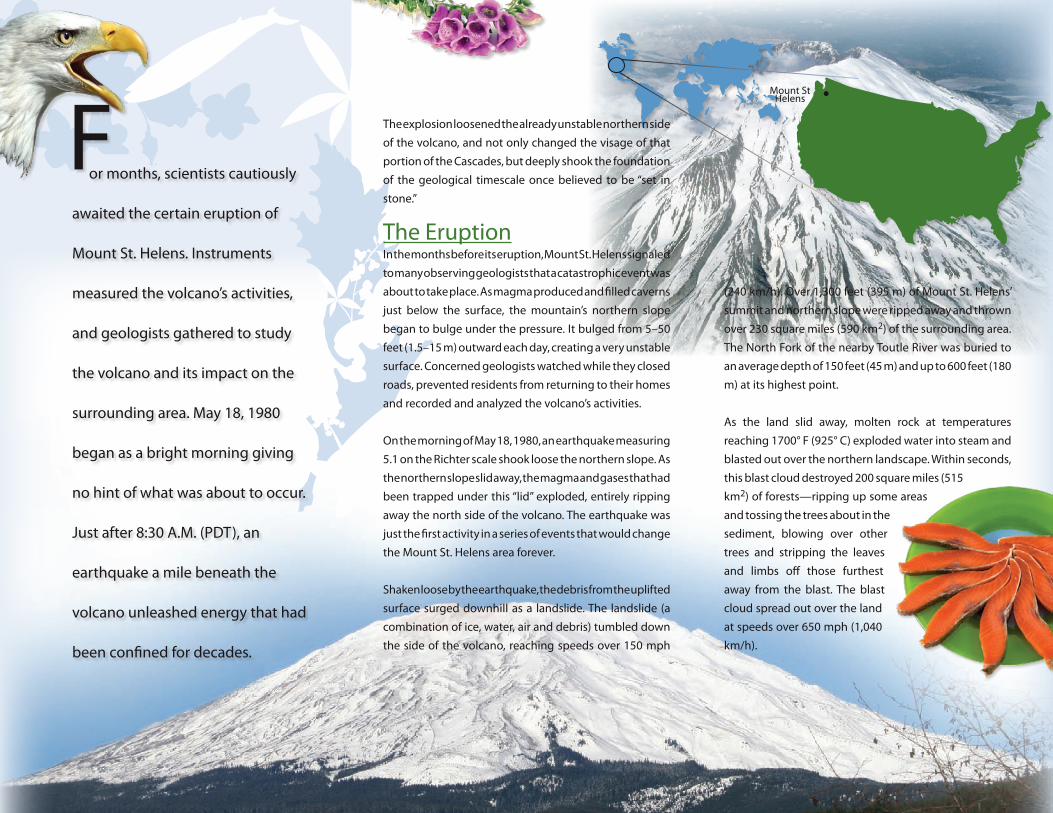
Mount St Helens
F(240 km/h). Over 1,300 feet (395 m) of Mount St. Helens’
summit and northern slope were ripped away and thrown
over 230 square miles (590 km2) of the surrounding area.
The North Fork of the nearby Toutle River was buried to
an average depth of 150 feet (45 m) and up to 600 feet (180
m) at its highest point.
As the land slid away, molten rock at temperatures
reaching 1700° F (925° C) exploded water into steam and
blasted out over the northern landscape. Within seconds,
this blast cloud destroyed 200 square miles (515
km2) of forests—ripping up some areas
and tossing the trees about in the
sediment, blowing over other
trees and stripping the leaves
and limbs off those furthest
away from the blast. The blast
cloud spread out over the land
at speeds over 650 mph (1,040
km/h).
or months, scientists cautiously
awaited the certain eruption of
Mount St. Helens. Instruments
measured the volcano’s activities,
and geologists gathered to study
the volcano and its impact on the
surrounding area. May 18, 1980
began as a bright morning giving
no hint of what was about to occur.
Just after 8:30 A.M. (PDT), an
earthquake a mile beneath the
volcano unleashed energy that had
been confined for decades.
The explosion loosened the already unstable northern side
of the volcano, and not only changed the visage of that
portion of the Cascades, but deeply shook the foundation
of the geological timescale once believed to be “set in
stone.”
The EruptionIn the months before its eruption, Mount St. Helens signaled
to many observing geologists that a catastrophic event was
about to take place. As magma produced and filled caverns
just below the surface, the mountain’s northern slope
began to bulge under the pressure. It bulged from 5–50
feet (1.5–15 m) outward each day, creating a very unstable
surface. Concerned geologists watched while they closed
roads, prevented residents from returning to their homes
and recorded and analyzed the volcano’s activities.
On the morning of May 18, 1980, an earthquake measuring
5.1 on the Richter scale shook loose the northern slope. As
the northern slope slid away, the magma and gases that had
been trapped under this “lid” exploded, entirely ripping
away the north side of the volcano. The earthquake was
just the first activity in a series of events that would change
the Mount St. Helens area forever.
Shaken loose by the earthquake, the debris from the uplifted
surface surged downhill as a landslide. The landslide (a
combination of ice, water, air and debris) tumbled down
the side of the volcano, reaching speeds over 150 mph