Embed Size (px)
Citation preview
1.800.3.DROP-IN
OFFICIALAshtabula
County Driving Tour Map
Remove at the perforation
Ashtabula County Covered Bridge Festival 25 West Jefferson Street Jefferson, Ohio 44047 • 440-576-3769 SAVE THE DATE! 2nd Full Weekend of October Hours 8am-6pm Sat • 8 am - 5pm Sun
Grand River
GenevaState Park
Seven Hills Rd
New Lyme
Netcher Rd.
Graham Rd.
Caine Rd.
Marcy Rd.Denmark Center
Dibble Rd.Green Rd.
Keefus Rd.
Creek Rd.
Ambo
y
Gidd
ings R
d.
Brown
Riverdale Rd.
Reger
Forbes Rd.
Mill
St.
Whit
ney R
d.
Days
Blv
d.
Madison
Kirtland
PainesvilleMentor
Willoughby
Perry
84
Emer
son
Rd.Griswold Doty
Chardon Rd.
Ledge Rd.
Harpersfield Rd
South River
Cork Cold Springs Rd.Atki
ns Tote
St.
Mech
anics
ville
Rd.
Doyl
e Rd
.
Munson
Airport Rd
Plymouth
Beck Rd.
Brow
n Rd.
Plymouth Ridge Rd.
Ashtabula Austinburg Rd.
WoodmanWest
Denmark Rd.
Root Rd.
Midd
le Rd
.
Stan
hope
Kell
oggs
ville
Rd.
Hatches Corners Rd.
South Ridge Rd.
Benetka Rd.
Church St.
Monroe Ctr. Rd.
Tische Rd.
Allen
Lampson
Eaglevi
lle Jeffe
rson
Hague Rd.
Moore
Penn
iman
Winters
Penn
iman
Wisw
ell R
d.
Windsor Rd.
Wisw
ell R
d.
Stan
hope
Kell
oggs
ville
Rd.
Pada
naru
m R
d.W
heele
r Cre
ek R
d.
Buffa
lo S
t.
Mill St.
Park Ave.
State St.
Coun
ty Lin
e Rd.
Pym
atun
ing
Lake
Rd.
615
83
2
AshtabulaCounty Airport
Ashtabula River
Allen Comp Rd.
Hayes Rd.Hayes Rd.
Underwood Rd.
Sim
ons S
.Py
matu
ning
Pym
atun
ing
Lake
1
2
3
5
6
7
9
10
12
8
Calleder Rd.
Ketcham
Fillingham
Dodg
e Rd.
Windsor 4
13
14
15
16
18
19
20
24
P
P
P
P
25
2122
23
17
11
PP
Trailhead/Parking
Mile Marker
Px
P
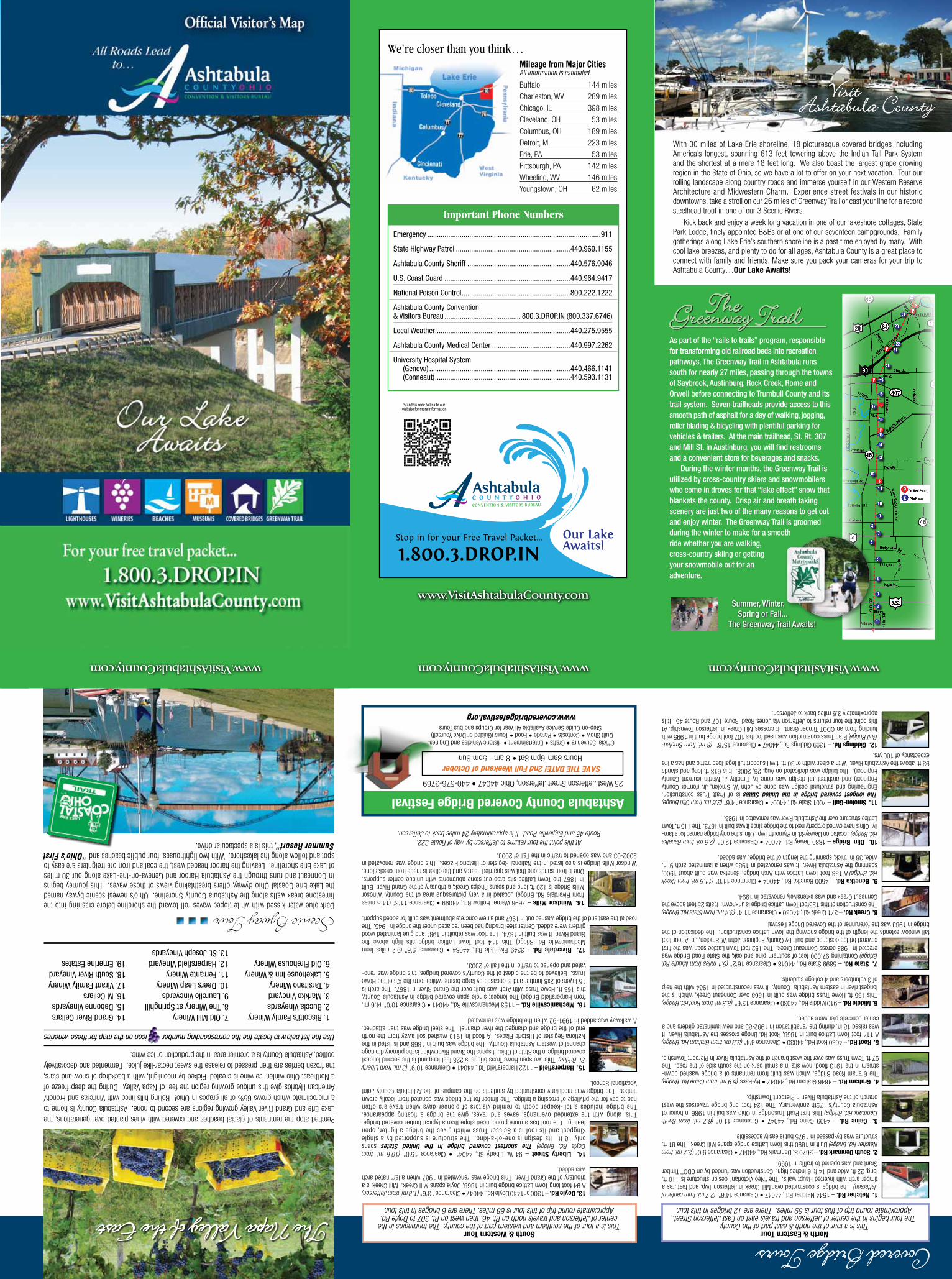
As part of the “rails to trails” program, responsible for transforming old railroad beds into recreation pathways, The Greenway Trail in Ashtabula runs south for nearly 27 miles, passing through the towns of Saybrook, Austinburg, Rock Creek, Rome and Orwell before connecting to Trumbull County and its trail system. Seven trailheads provide access to this smooth path of asphalt for a day of walking, jogging, roller blading & bicycling with plentiful parking for vehicles & trailers. At the main trailhead, St. Rt. 307 and Mill St. in Austinburg, you will find restrooms and a convenient store for beverages and snacks. During the winter months, the Greenway Trail is utilized by cross-country skiers and snowmobilers who come in droves for that “lake effect” snow that blankets the county. Crisp air and breath taking scenery are just two of the many reasons to get out and enjoy winter. The Greenway Trail is groomed during the winter to make for a smooth ride whether you are walking, cross-country skiing or getting your snowmobile out for an adventure.
TheGreenway Trail
The Greenway Trail Awaits!
Summer, Winter, Spring or Fall...
With 30 miles of Lake Erie shoreline, 18 picturesque covered bridges including America’s longest, spanning 613 feet towering above the Indian Tail Park System and the shortest at a mere 18 feet long. We also boast the largest grape growing region in the State of Ohio, so we have a lot to offer on your next vacation. Tour our rolling landscape along country roads and immerse yourself in our Western Reserve Architecture and Midwestern Charm. Experience street festivals in our historic downtowns, take a stroll on our 26 miles of Greenway Trail or cast your line for a record steelhead trout in one of our 3 Scenic Rivers.
Kick back and enjoy a week long vacation in one of our lakeshore cottages, State Park Lodge, finely appointed B&Bs or at one of our seventeen campgrounds. Family gatherings along Lake Erie’s southern shoreline is a past time enjoyed by many. With cool lake breezes, and plenty to do for all ages, Ashtabula County is a great place to connect with family and friends. Make sure you pack your cameras for your trip to Ashtabula County…Our Lake Awaits!
www.VisitAshtabulaCounty.comwww.VisitAshtabulaCounty.com
Visit Ashtabula County
Dark blue water kissed with white tipped waves roll toward the shoreline before crashing into the limestone break walls along the Ashtabula County Shoreline. Ohio’s newest scenic byway named the Lake Erie Coastal Ohio Byway, offers breathtaking views of those waves. This journey begins in Conneaut and runs through the Ashtabula Harbor and Geneva-on-the-Lake along our 30 miles of Lake Erie shoreline. Leaving the harbor headed west, the coal and iron ore freighters are easy to spot and follow along the lakeshore. With two lighthouses, four public beaches and “Ohio’s First Summer Resort”, this is a spectacular drive.
Scenic Byway Tour
Use the list below to locate the the corresponding number icon on the map for these wineries
Perched atop the remnants of glacial beaches and covered with vines planted over generations, the Lake Erie and Grand River Valley growing regions are second to none. Ashtabula County is home to a microclimate which grows 65% of all grapes in Ohio! Rolling hills lined with Viniferas and French/American Hybrids give this unique growing region the feel of Napa Valley. During the deep freeze of a Northeast Ohio winter, ice wine is created. Picked by moonlight, with a backdrop of snow and stars, the frozen berries are then pressed to release the sweet nectar-like juice. Fermented and decoratively bottled, Ashtabula County is a premier area in the production of ice wine.
1. Biscotti’s Famly Winery2. Buccia Vineyards3. Markko Vineyard4. Tarsitano Winery5. Lakehouse Inn & Winery6. Old Firehouse Winery
7. Old Mill Winery 8. The Winery at Springhill9. Laurello Vineyards 10. Deers Leap Winery11. Ferrante Winery12. Harpersfield Vineyard13. St. Joseph Vineyards
14. Grand River Cellars 15. Debonne Vineyards16. M Cellars17. Virant Family Winery18. South River Vineyard19. Emerine Estates
The Napa Valley of the East
www.VisitAshtabulaCounty.com
Mileage from Major Cities All information is estimated.
Buffalo 144 miles Charleston, WV 289 milesChicago, IL 398 miles Cleveland, OH 53 milesColumbus, OH 189 milesDetroit, MI 223 miles Erie, PA 53 miles Pittsburgh, PA 142 milesWheeling, WV 146 miles Youngstown, OH 62 miles
We’re closer than you think…
Scan this code to link to our website for more information
Emergency ...........................................................................................911
State Highway Patrol ............................................................440.969.1155
Ashtabula County Sheriff ......................................................440.576.9046
U.S. Coast Guard ..................................................................440.964.9417
National Poison Control .........................................................800.222.1222
Ashtabula County Convention & Visitors Bureau ........................................ 800.3.DROP.IN (800.337.6746)
Local Weather .......................................................................440.275.9555
Ashtabula County Medical Center .........................................440.997.2262
University Hospital System (Geneva) ..........................................................................440.466.1141 (Conneaut) .......................................................................440.593.1131
Important Phone Numbers
www.VisitAshtabulaCounty.com
Stop in for your Free Travel Packet...
1.800.3.DROP.IN
Covered Bridge Tours
Official Souvenirs • Crafts • Entertainment • Historic Vehicles and Engines Quilt Show • Contests • Parade • Food • Tours (Guided or Drive Yourself)
Step-on Guide Service Available All Year for Groups and bus Tours
www.coveredbridgefestival.org
.
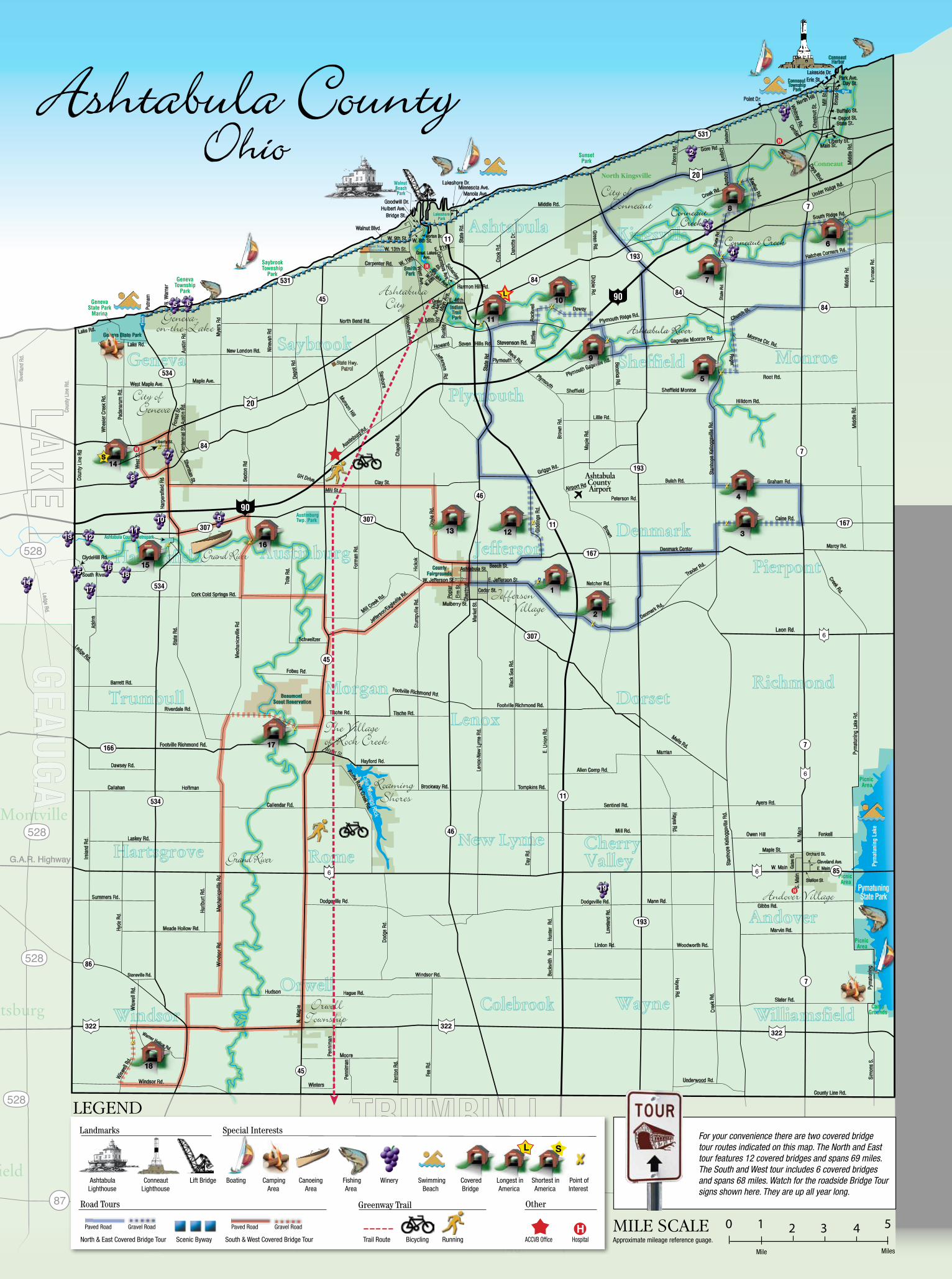
South & Western TourThis is a tour of the southern and western part of the county. The tourbegins in the center of Jefferson and travels north on Rt. 46, then west on Rt. 307 to Doyle Rd. Approximate round trip of this tour is 68 miles. There are 6 bridges in this tour.
13. Doyle Rd. – 1300 or 1440 Doyle Rd., 44047 • Clearance 13’6” (1.8 mi. from Jefferson) A 94 foot long Town Lattice bridge built in 1868, Doyle spans Mill Creek. Mill Creek is a tributary of the Grand River. This bridge was renovated in 1987 when a laminated arch was added.
14. Liberty Street – 94 W. Liberty St., 44041 • Clearance 15’0” (10.6 mi. fromDoyle Rd. Bridge) The shortest covered bridge in the United States spansonly 18 ft. Its design is one-of-a-kind. The structure is supported by a single Kingpost and its roof is a Scissor Truss which gives the bridge a lighter, open feeling. The roof has a more pronounced slope than a typical timber covered bridge.
This, along with the extended overhangs, eaves and rakes, give the bridge a floating appearance. The bridge includes a toll-keeper booth to remind visitors of pioneer days when travelers often had to pay for the privilege of crossing a bridge. The timber for the bridge was donated from locally grown timber. The bridge was modularly constructed by students on the campus of the Ashtabula County Joint Vocational School.
15. Harpersfield – 1122 Harpersfield Rd., 44041 • Clearance 10’9” (3 mi. from Liberty St. Bridge) This two span Howe Truss bridge is 228 feet long and is the second longest covered bridge in the State of Ohio. It spans the Grand River which is the primary drainage channel of western Ashtabula County. The bridge was built in 1868 and is listed in the NationalRegister of Historic Places. A flood in 1913 washed soil away from the north end of the bridge and changed the river channel. The steel bridge was then attached.
A walkway was added in 1991-92 when the bridge was renovated.
16. Mechanicsville Rd. – 1153 Mechanicsville Rd., 44041 • Clearance 10’0” (4.6 mi. from Harpersfield Bridge) The longest single span covered bridge in Ashtabula County, this 156 ft. Howe Truss with Arch was built over the Grand River in 1867. The arch is 15 layers of 2x8 lumber and is encased by large beams which form the X’s of the Howe Truss. Believed to be the oldest of the County’s covered bridges, this bridge was reno-vated and opened to traffic in the Fall of 2003.
17. Riverdale Rd. - 3349 Riverdale Rd., 44084 • Clearance 9’6” (9.2 miles fromMechanicsville Rd. Bridge) This 114 foot Town Lattice bridge sits high above the Grand River. It was built in 1874. The floor was rebuilt in 1981 and glue laminated wood girders were added. Center steel bracing had been replaced under the bridge in 1945. The
road at the east end of the bridge washed out in 1987 and a new concrete abutment was built for added support.
18. Windsor Mills – 7696 Warner Hollow Rd., 44099 • Clearance 11’3” (14.5 miles from Riverdale Rd. Bridge) Located in a very picturesque area of the County, Windsor Mills Bridge is 120 ft. long and spans Phelps Creek, a tributary of the Grand River. Built in 1867 the Town Lattice sits atop cut stone abutments with unique center supports. One is from sandstone that was quarried nearby and the other is made from creek stone.
Windsor Mills Bridge is also listed in the National Register of Historic Places. This bridge was renovated in 2002-03 and was opened to traffic in the Fall of 2003.
At this point the tour returns to Jefferson by way of Route 322, Route 45 and Eagleville Road. It is approximately 24 miles back to Jefferson.
1. Netcher Rd. – 1544 Netcher Rd., 44047 • Clearance 14’6” (2.7 mi. from center of Jefferson) The bridge is constructed over Mill Creek in Jefferson Twp. and features atimber arch with inverted Haupt walls. The “Neo Victorian” design structure is 110 ft. long, 22 ft. wide and 14 ft. 6 inches high. Construction was funded by an ODOT Timber Grant and was opened to traffic in 1999.
2. South Denmark Rd. – 2670 S. Denmark Rd., 44047 • Clearance 9’0” (2.7 mi. from Netcher Rd. Bridge) Built in 1890 this Town Lattice bridge spans Mill Creek. The 81 ft. structure was by-passed in 1975 but is easily accessible.
3. Caine Rd. – 4699 Caine Rd., 44047 • Clearance 11’0” (6.7 mi. from SouthDenmark Rd. Bridge) This first Pratt Trusbridge in Ohio was built in 1986 in honor of Ashtabula County’s 175th anniversary. The 124 foot long bridge traverses the west branch of the Ashtabula River in Pierpont Township.
4. Graham Rd. – 4646 Graham Rd., 44047 • By-Pass (5.9 mi. from Caine Rd. Bridge) The Graham Road Bridge, which was built from remnants of a bridge washed down-stream in the 1913 flood, now sits in a small park on the south side of the road. The 97 ft. Town Truss was over the west branch of the Ashtabula River in Pierpont Township.
5. Root Rd. – 4680 Root Rd., 44030 • Clearance 8’4” (3.9 mi. from Graham Rd. Bridge)A 114 foot Town Lattice built in 1868, Root Rd. Bridge crosses the Ashtabula River. It was raised 18 in. during the rehabilitation in 1982-83 and new laminated girders and a center concrete pier were added.
6. Middle Rd. – 910 Middle Rd., 44030 • Clearance 13’6” (8.3 mi. from Root Rd. Bridge) This 136 ft. Howe Truss bridge was built in 1868 over Conneaut Creek, which is the longest river in eastern Ashtabula County. It was reconstructed in 1984 with the help of 3 volunteers and 4 college students.
7. State Rd. – 5899 State Rd., 44048 • Clearance 16’2” (5.1 miles from Middle Rd. Bridge) Containing 97,000 feet of southern pine and oak, the State Road Bridge was erected in 1983 across Conneaut Creek. The 152 foot Town Lattice span was the first covered bridge designed and built by County Engineer, John W. Smolen, Jr. A four foot
tall window extends the length of the bridge showing the Town Lattice construction. The dedication of the bridge in 1983 was the forerunner of the Covered Bridge Festival.
8. Creek Rd. – 371 Creek Rd., 44030 • Clearance 11’4” (3.4 mi. from State Rd. Bridge) The construction of this 125foot Town Lattice bridge is unknown. It sits 25 feet above the Conneaut Creek and was extensively renovated in 1994.
9. Benetka Rd. – 4500 Benetka Rd., 44004 • Clearance 11’0” (11.5 mi. from Creek Rd. Bridge) A 138 foot Town Lattice with Arch bridge, Benetka was built about 1900, spanning the Ashtabula River. It was renovated in 1985 when a laminated arch 9 in. wide, 38 in. thick, spanning the length of the bridge, was added.
10. Olin Bridge – 1880 Dewey Rd., 44004 • Clearance 12’0” (2.5 mi. from Benetka Rd. Bridge) Located on DeweyRd. in Plymouth Twp., Olin is the only bridge named for a fam-ily. Olin’s have owned property next to the bridge since it was built in 1873. The 115 ft. Town Lattice structure over the Ashtabula River was renovated in 1985.
11. Smolen-Gulf – 7001 State Rd., 44004 • Clearance 14’6” (2.6 mi. from Olin Bridge) The longest covered bridge in the United States is of Pratt Truss construction.Engineering and structural design was done by John W. Smolen, Jr. (former CountyEngineer) and architectural design was done by Timothy J. Martin (current County Engineer). The bridge was dedicated on Aug. 26, 2008. It is 613 ft. long and stands
93 ft. above the Ashtabula River. With a clear width of 30 ft. it will support full legal load traffic and has a life expectancy of 100 yrs.
12. Giddings Rd. – 1399 Giddings Rd., 44047 • Clearance 15”6’ (8 mi. from Smolen-Gulf Bridge) Pratt Truss construction was used for this 107 foot bridge built in 1995 with funding from an ODOT Timber Grant. It crosses Mill Creek in Jefferson Township. At this point the tour returns to Jefferson via Jones Road, Route 167 and Route 46. It is approximately 3.5 miles back to Jefferson.
North & Eastern TourThis is a tour of the north & east part of the County.
The tour begins in the center of Jefferson and travels east on East Jefferson Street. Approximate round trip of this tour is 69 miles. There are 12 bridges in this tour.
Stat
e Rd
.
Love
land
Rd.
Stat
e R
d.S
tate
Rd.
Liberty St.
Lake Roaming Rock
L
1
2
3
4
5
6
7
8
9
10
11
1213
15
16
17
18
S14
11
22
33
44
6655
88
99
11111010
12121313
1515
1717
1919
77
1414
16161818
0 1 2 3 4 5
legend
Mile scale Approximate mileage reference guage.
Ashtabula Conneaut Lift Bridge Boating Camping Canoeing Fishing Winery Swimming Covered Longest in Shortest in Point of Lighthouse Lighthouse Area Area Area Beach Bridge America America Interest
Landmarks Special Interests
Mile Miles
L S
Other
H
Road Tours
North & East Covered Bridge Tour Scenic Byway South & West Covered Bridge Tour Trail Route Bicycling Running ACCVB Office Hospital
Greenway Trail
Paved Road Gravel Road Paved Road Gravel Road
For your convenience there are two covered bridge tour routes indicated on this map. The North and East tour features 12 covered bridges and spans 69 miles. The South and West tour includes 6 covered bridges and spans 68 miles. Watch for the roadside Bridge Tour signs shown here. They are up all year long.


![MILEAGE PLUS[1]](https://img.pdfslide.us/doc/110x75/5571fa6e49795991699233d2/mileage-plus1.jpg)