Embed Size (px)
Citation preview
Colin, T. M. Donahue, V. I. Moroz, Eds. (Univ. of Arizona Press, Tucson, 1983), pp. 484-564; D. Men and J. W. Crawford, Nature 307,222 (1984); V . M. L i i et al., Science 231,1417 (1986); S. S. Limaye, Icatus 73, 212 (1988); D. Crisp et al., Science 246,506 (1989); W. B. Rossow, A. D. Del Genio, T. Eichler, J. Atmos. Sci. 47, 2053 (1990).
4. M. J. S. Belton et al., J. Atmos. Sci. 33, 1383 (1976); M. J. S. Belton, G. R. Smith, G. Schubert, A. D. Del Genio, ibid., p. 1394.
5. A. D. Del Genio and W. B. Rossow, ibid. 47,293 (1990).
6. K. Kawabata et al., J. Geophys. Res. 85, 8129 (1980).
7. R. G. Knollenberg and D. M. Hunten, ibid., p. 8039.
8. B. O'Leary, J. Atmos. Sci. 32, 1091 (1975). 9. D. Wdach and B. Hapke, I c a m 63, 354 (1985).
10. G. Schubert, in Venus, D. M. Hunten, L. Colin, T. M. Donahue, V. I. Moroz, Eds. (Univ, of Arizona Press, Tucson, 1983), pp. 681-765.
11. P. J. Schinder, P. J. Gierasch, S. S. Leroy, M. D. Smith, J. Atmos. Sci. 47, 2037 (1990).
12. M. J. S. Belton et al . , Adv . Space Res., in press. 13. W. M. Irvine, J. Atmos. Sci. 25, 610 (1968). 14. P. J. Gierasch, A. P. Ingersoll, R. T. Williams, Icanrs
19,473 (1973); S. J. Ghan, J. Atmos. Sci. 46,2529 (1989).
15. G. Schubea, personal communication. 16. D. Crisp, I r a w 67,484 (1986); ibid. 77, 391 (1989). 17. G. M. Yagi, J. J. Lorre, P. L. Jepsen, in P r e d i t g s &the
Confkence on AhnospM Environment ofAeoospace Sys- tems and Applied Meterology (American Metemlogical Society, Boston, 1978), pp. 110-117.
18. See, for example, C. C. Councelman, S. A. Goure- vitch, R. W. King, G. B. Loriot, and E. S. Ginzberg [J. Geophys. Res. 85, 8026 (1980)l.
19. S. S. Limaye and V. E. Suomi, J. Atmos. Sci. 38, 1220 (1981).
20. S. S. Limaye, C. J. Grund, S. P. Burre, Icatus 51, 416 (1982); S. S. Limaye, C. Grassom, M. J. Kuetemeyer, ibid. 73, 191 (1988).
21. M. A. Williams, E. P. Krider, D. M. Hunten, Rev. Geophys. Space Phys. 21, 892 (1983); Z. Levin, W. J . Borucki, 0. B. Toon, Icatus 56, 80 (1983).
22. W. J . Bomcki et al . , Geophys. Res. Lett. 10, 961 (1983).
23. J. B. Pollacket al., J. Geophys. Res. 92,15037 (1987). 24. We g r a ~ W y adolowledge an internal review of the
manusaipt by G. Schubert and the assistance of H. Breneman, B. Carcich, C. Cumqham, E. DeJong, S. Howell, B. Paakowski, T. Thompson, A. Toigo, and L. Wainio in the planning and execution of the SSI cent and the subsequent reduction of the data.
21 June 1991; accepted 29 Jdy 1991
Middle Infirared Thermal Maps of Venus at the Time of the Galileo Encounter
Images of the disk of Venus, taken at waveletlghs between 8 and 22 micrometers, were obtained a few days after the Galileo spacecraft's dosest approach on 8 February 1990; these images show variations in the thickness of the main H,SO, cloud deck and the overlying temperature structure. Several features are qualitatively similar to those of earlier obsewations, such as a hot region at the south pole, surrounded by a cold "collar," and brightening toward the lower latitudes, where low-contrast banding appears. The collar does have a northern counterpart that is warmer, however. Equatorial limb darkening is quantitatively similar to that of previous obsewations; fairly constant at wavelengths up to 20 micrometers, where limb darkening increases substantially. In contrast to what was found in previous observations, polar and equatorial limb darkening are nearly the same at most wavelengths. A longitudinal variation is observable that is consistent with a wavenumber-2 behavior and a brighmess maximum near local midnight.
A S PART OF A PROGRAM TO SUPPORT Galileo Venus science analysis and compare observations of the atmo-
sphere of Venus with previous observations of the main H,SO, cloud deck and overly- ing temperature structure, we imaged Venus on the mornings of 10,11, and 12 February 1990 in the middle infrared. Poor weather prevented us from observing on 8 February, the day of the spacecraft's closest approach to Venus, or the following morning. We made the observations at the National Aero- nautics and Space Administration (NASA) lnfrared Telescope Facility at the summit of
-
G. S. Orton, A. J. Friedson, T. Z. Martin, Jet Propulsion Laboratory, California Institute of Technology, 4800 Oak Grove Drive, MS 169-237, Pasadena, CA 91109. J. Caldwell, Physics Depamnent, York University, 4700 Keele Street, North York, Ontario, Canada M3J 1P3.
Mauna Kea at wavelengths of 8.57, 11.52, 13.00, 18.00, 20.24, and 21.88 pm. The wavelengths were chmen for comparison with earlier ground-based images (1,Z) and spatially resolved spacecraft data (3-5); the three longest wavelengths also overlap the spectral range of the Galileo Phoropolarimeter-Radiometer (PPR) radiometric channels A, B, and C. The 60 pixel by 60 pixel images were produced by raster scanning in a regular grid pattern with 1-arc sec spacing in 'both directions; the en- trance aperture was just under 2 arc sec in diameter. The disk of Venus, 23 to 25 days past inferior conjunction, subtended 49 arc sec, and the evening terminator was located about 42" east (Fig. 1) of the central meridian. We used the results of well-calibrated spacecraft experi- ments (4, 5) to normah our absolute intensi- ties.
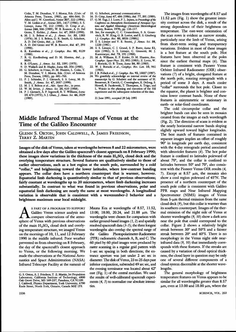
The images from wavelengths of 8.57 and 11.52 pm (Fig. 1) show the greatest inten- sity contrast across the disk, a result of the strong dependence of their brightness on temperature. The east-west orientation of the scan rows is evident as narrow streaks, particularly near the limb of Venus, arising from short-term seeing and transparency variations. Evident in most of these images is a hot feature at the south pole. Hot features have been observed at the poles since the earliest thermal maps (6). This feature is consistent with Pioneer Venus Orbiter Infrared Radiometer (OIR) obser- vations (7) of a bright, elongated feature at the north pole, rotating retrograde with a period of some 3 days. A much cooler "collar" surrounds the hot pole. Closer to the equator, the planet is brighter and con- tains lower contrast bands. None of these features is axisyrnmetric or stationary in earth- or solar-fixed coordinates.
The cold circumpolar collar and the brighter bands can also be seen in mosaics created from the images at each wavelength (Fig. 2). The direction of scans is evident as the nearly horizontal narrow bands sloping slightly upward toward higher longitudes. The best match of features contained in separate images implies an offset of roughly 90" in longitude per earth day, consistent with the 4-day retrograde period associated with ultraviolet features (8). The hot polar feature is contined to latitudes poleward of about 70", and the collar is confined to latitudes between 50" and 70°, also consis- tent with the Pioneer Venus OIR results (4, 7). Except at 8.57 pm, the mosaics also show a cool region poleward of 45"N. The presence of a northern counterpart of the south pole collar is consistent with Galileo PPR maps and Near Infrared Mapping Spectrometer (NIMS) images of Venus from 5-pm thermal emission from the same cloud deck (9) , but this collar is warmer than its southern counterpart. Images of the ther- mal emission of the night side of Venus at shorter wavelengths (9, 10) show a dark area near the pole that could correspond to the collar. Figure 2 shows a relatively bright streak between 30" and 50"s and a fainter streak between 20" and 40"s. There is no morphology in the Venus night side near- infrared data (9, 10) that immediately corre- sponds with these features. If the streaks are caused by a variation of cloud optical thick- ness, the cloud layer in question may be only one of several different components of a cloud system discernible at the shorter wave- lengths.
The general morphology of brightness temperature features on Venus appears to be similar for all wavelengths greater than 8.57 pm, even at 13.00 and 18.00 pm, where the
SCLENCE, VOL. 253

Table 1. Mean brighmess temperature changes.
A (wm)
Polar Equatorial (northern
hemisphere)
'Emission an& cosine is denoted by p.
radiation should be emerging fmm shghdy higher levels in the atmosphere, owing to the i n d CO, absorption. On the other hand, the morphology and limb dar- of the images at 8.57 pm (see Fig. 1 and Table 1) are suf3iaendy cliihmt to raise the possibility that there may be some additional opacity iduenc- ing this spectral region. This wavelength is
close to a band of SO,, but the 1983 Venera infrared spectra (5) do not show SO, absorp- tion as a dominant iduence on the 8.57-pm region, and the SO, atmospheric abundance was lower in 1990 than that in 1983 (1 1). More detailed modeling of the outgoing spec- trum must be done in the context of latitudi- nally dependent temperature srmcture to re- solve this issue.
We also compared the limbdarkenq char- acteristics of the images with ground-based data in the 8- to 20-clm region (2) and with the Pioneer Venus OIR experiment (4). The mean bnghmess temperature (TB) change between emission angle cosines of 1.0 and 0.5 are shown in Table 1 for all ofthe u x f d observa- tions for two cases: (i) along the equator, similar to table 4 ofDiner (Z), and (ii) along the central meridian north of the sub-Earth point (more udbrm in appearance than southward), similar to Diner's table 6 (2). For the equatorial data, the bnghmess temperature cliihmces are quite udbrm to 18.00 pm and are similar in
Flg. 1. Raster scan images of Venus at two of the six wavelengths used in this study; (A) 8.57 p,m, (B) 11.52 pm. The oval shapes of some images r d t from deviations of telescope tracking from the true motion of Venus in the sky. The diagram of the planet shown to scale has latitudes and longitudes displayed at 30" intervals. A circle at the upper right illustrates the aperture size.
Fig. 2. Mosaics of the images at each wave- length. We created these by correcting for limb darkening using a two- term polynomial in emission angle cosine, converting to brighmess temperature, and map- ping onto a linear grid in latitude and longitude. We used only portions of images corresponding to 92% or less of the disk radius, avoiding sam- pling cold space near the limb and inaccuracies in fitting the planetary shape. The mosaics were created by joining the in- dividual maps together to overlap features. The zero of longitude is arbitrary. The striking discontinuity at the longer wavelengths is a result of an asymmetric structure in each map, which is enhanced by a limb-darkening correction.
value (9.7 to 11.2 K) to those of Diner. The values are much hlgher at 20.24 and 21.88 pm. Polar values are not measurably cliihmt, ex- cept at 8.57 pm and possibly 21.88 pm, in contrast with Diner's d t s (2) for data taken in 1975, which were charamxized by consis- tendy sponger limb d a r k n q toward the poles than along the equator. This d&rnce may indicate some variation over time of fea- tures on the disk, such as the circumpolar collar. The agreement between our observed 11.52-pm center-to-limb behavior and that of the Pioneer Venus OIR at 11.5 pm is also good. By implication, the vertical structure of clouds along the equator has not changed in any fundamental way since the 1975 ground- based or 1978-1979 Pioneer Venus OIR data. If we use a smgle deep cloud to model the atmospheric opacity at 11.52 and 20.24 pm in the context of a longi- averaged tem- perature structure derived from Pioneer Ve- nus (12), the observed mean center-to-limb structure at the eauator and middle latitudes is consistent with a: scale height slight- ly smaller than the gas scale height. This result is consistent with the analysis of ground- based (13) and Pioneer Venus OIR (14) results. Furthermore, the ratio of the cloud opacity at 11.52 to 20.24 pm is about 1.4, &hichchis consistent with the wavelength vari- ation of the extinction of droplets of 75% by weight H,SO, for a mean particle size of 1.5 pm (15).
Also present is a longitudinally dependent bfication of the center-to-limb structure. This dependence is also present at all wave- lengths longer than 8.57 pm and can be seen quite dearly in the mosaics shown in Fig. 2 as a discontinuity between different maps, particularly at the longer wavelengths. This behavior is consistent with the presence of a wavenumber-2 longitudinal structure that produces greater thermal emission in the region near local midnight than near local dawn or dusk, as determined by ground- based (12) and spacecraft (4) results.
REFERENCES AND NOTES
1. Noteworthy ground-based middle infrared imaging studies of Venus are reported by D. J. Diner, J. A. Westphal, and F. P. Schloerb [Icaruc 27, 191 (1976)l; D. J. Diner and J. A. Westphal [ibid. 36, 119 (1978)l; R A. B m m and R. M. Goody [ibid. 35,189 (1978)l; J . Apt and R. Goody [ J. Geaphys. Ru. 84, 2529 (1979)l; J. Apt and R. Goody [Science 203,785 (1979)l; and J. Apt, R A. Brown, and R. M. Goody [J. Geophys. Res. 85, 7934 (1980)l.
2. D. J. Diner, J . Atmos. Sci. 35,2356 (1978). 3. S. C. Chase, E. D. Miner, D. Morrison, G . Miinch,
G. Neugebauer, Science 183,1291 (1974). 4. F. W. Taylor et at., J. Geaphys. Ru. 85, 7963
(1980). 5. V. I. Moroz et at., Appt. Opt. 25, 1710 (1986). 6. B. C. Murray, R L. Wiey , J. A. Westphal, J.
Geophys. Ru. 68,4813 (1963). 7. J. T. Schofidd and D. J. Diner, Nature 305, 116 (1983).
8. The earliest evidence for a 4day retrograde period
REPORTS 1537

of the winds at the cloudtop level, confirmed and refined by a variety of ground-based and spacecraft observations, was reported by C. Boyer and H. Camichel [Ann. Artrophys. 24, 531 (1961)l.
9. R. W. Carlson et al., Science 253, 1541 (1991). 10. D. Crisp et al., ibid., p. 1538. 11. L. W. Esposito et al., J. Geophys. Res. 93, 5267
(1988); C. Y. Na, L. W. Esposito, T. E. Skinner, ibid. 95, 74 (1990); L. W. Esposito, personal com- munication.
12. G. M. Keating et at., Adv. Space Res. 5, 117 (1985).
13. D. J. Diner, J. Apt, L. S. Elson, Icarus 52, 301 (1982), and references therein.
14. J. T. Schofield and F. W. Taylor, Q. J. R. Meterol. SOC. 109, 57 (1983).
15. Assuming optical constants given by K. F. Palmer and D. Williams [Appl. Opt. 14, 208 (1975)l.
16. G.S.O., J. C., and T.Z.M. were visiting astronomers
at the Infrared Telescope Facility (IRTF), which is operated by the University of Hawaii under contract to NASA. We thank the staffand management of the IRTF for their support, particularly site superinten- dent R. Koehler, and we thank IRTF Division Chief R. Joseph for his scheduling of these observations. NASA sponsored the work performed at the Jet Propulsion Laboratory (JPL), California Institute of Technology, and the National Research Council of Canada sponsored work performed at York Univer- sity. G.S.O. and T.Z.M. particularly acknowledge support from the Galileo Project. We also appreciate the advice of D. J. Diner, J. V. Martonchik, and J. T. Schofield at various points in this work. N. Ha also provided essential data reduction support during his tenure at JPL as a Caltech Summer Undergraduate Research Fellow.
26 April 1991; accepted 18 July 1991
Ground-Based Near-Infrared Imaging Observations of Venus During the Galileo Encounter
Near-infrared images of Venus, obtained from a global network of ground-based observatories during January and February 1990, document the morphology and motions of the night-side near-hf?ared markings before, during, and after the Galileo Venus encounter. A dark cloud extended halfway around the planet at low latitudes (< 240") and persisted throughout the observing program. It had a rotation period of 5.5 k 0.15 days. The remainder of this latitude band was characterized by small-scale (400 to 1000 kilometers) dark and bright markings with rotation periods of 7.4 + 1 days. The different rotation periods for the large dark cloud and the smaller markings suggests that they are produced at different altitudes. Mid-latitudes (+40" to 60") were usually occupied by bright east-west bands. The highest observable latitudes (+60° to 70") were always dark and featureless, indicating greater cloud opacity. Maps of the water vapor distribution show no evidence for large horizontal gradients in the lower atmosphere of Venus.
I MAGES OF THE NIGHT SIDE OF VENUS taken at near-infrared (NIR) wave- lengths (1 to 2.5 pm) reveal bright and
D. Crisp, MS 169-237, Jet Propulsion Laboratory, Cal- ifornia Institute of Technology, Pasadena, CA 91109; visiting astronomer, Palomar Observatory, California Institute of Technology, Pasadena, CA 91125. S. McMuldroch and S. K. Stephens, Division of Geolo ical and Planetary Sciences, California Institute of ~eci?: nolo'gy, Pasadena, CA 91125; visiting astronomers, Las Campanas Observatory, Casilla 601, La Serena, Chile. W. M. Sinton, Institute for Astronomy, University of Hawaii, Honolulu, HI 96822. B. Ragent, San Jose State University Foundation, San Jose, CA 95192; visiting astronomer, University of Hawaii 0.6-m and 2.2-m telescopes at Mauna Kea Ob- servatory, Mauna Kea, Hawaii. K.-W. Hodapp, Institute for Astronomy, University of Hawaii, Honolulu, HI 96822. R. G. Probst. Kin Peak National Observatory, Tucson, AZ 85719. L. R. Doyle, National Aeronautics and Space Adminis- tration (NASA) Ames Research Center, Moffett Field, CA 94035; visiting astronomer, Kin Peak National Observatory, Tucson, AZ 85719. D. A. Allen. Annlo-Australian Observatorv. Post Office ~ 0 x 2 9 6 , ~ p ~ i n g , New South Wales, ~us&alia. J. Elias, Cerro Tololo Inter-American Observatory, Casilla 603, La Serena, Chile.
*Present address: Lowell Observatory, Flagst&, AZ 86001.
dark markings that rotate from east to west with periods of about 6 days (1, 2). This infrared emission is produced by hot gases in the lower atmosphere (0 to 50 km). It is most intense at wavelengths near 1.74 and 2.3 pm, in the relatively transparent "spectral windows" between strongly absorbing CO, and H,O bands in the Venus atmosphere. The planet- wide s u h i c acid (H,SO,) clouds provide the primary source of opacity in these win- dows (2-6). Karnp et al. (4, 5 ) found that 10 to 20% differences in the optical depths of the clouds could account for the contrast between bright and dark markings. They also derived water vapor mixing ratios near 40 parts per million by volume (ppmv) below the cloud base (47 km). This is 112.5 to 115 of that inferred from Pioneer Venus and Venera entry-probe measurements (7-9). More re- cent NIR imaging and spectroscopic obser- vations (6, 10-12) support these conclusions and place new constrain^ on the composition and dynamics of the lower Venus atmo- sphere.
The Galileo spacecraKs flyby of Venus on 10 February 1990 provided a novel opportu- nity to study the night-side NIR emission. The Weo Near-Intkared Mapping Spectrometer (NIMS) acquired two high spatial resolution (25 to 50 krn) maps of the Venus night side at 1 7 NIR wavelengths between 0.7 and 5.2 pm. This instrument also acquired complete NIR spectra of selected regions (13). To comple- ment these spacecrd observations, a broad range of new NLR imaging and spectroscopic observations of Venus were acquired from a global network of ground-based observatories. The spectroscopic observations have been pre- sented elsewhere (6, 10-12, 14, 15). The prin- cipal objective of the ground-based imaging program was to document the morphology and motions of the NLR markings before, during, and d e r the Galileo encounter. Thou- sands of NIR images were taken during the first week of January md during the first 2 weeks of February. These observing times were ideal for high-resolution imaging of the night side because Venus was near inferior conjunc- tion (18 January 1990) with its night side facing Earth. Its a n d a r size was about 50 arc sec, allowing about 50 resolution elements across the night side. Most images were taken in twilight or during the day because Venus was usually less than 30" from the sun. Images were collected almost continuously for 5- to 17-hour periods each observing day from sites that were widely separated in longitude (16). This high-resolution, long-duration time series allowed us to track a large number of distinct markings for periods ranging from 3 hours to 46 days (1 7).
The appearance of the Venus night side during January and February is shown in Figs. 1 and 2, respectively. These images were taken in the 2.3-pm spectral window where the NLR markings usually have the highest contrast. Low latitudes (+40°) were characterized by a persistent large-scale (zonal wave number 1) pattern that moved from east to west (right to left in Figs. 2 and 3). The spatial extent of the bright and dark components of this pattern is more obvious in Fig. 3, A and B, where the imaging data from January and February, re- spectively, have been projected onto cylindrical latitude-longitude maps and combined to form global mosaics. A large, long-lived, dark patch that occupies this entire latitude range and covers about 180" of longitude was first seen on 1 to 2 January (Fig. 1, B and C), and again on 6 to 7 January (Fig. 1, F and G). P m of it were also seen on 31 January, 5 February, and 10 to 12 February (Fig. 2, B and C and F through H). This dark patch, and a very similar feature seen in images taken in May and June 1988 ( 4 , indicates the presence of increased H,SO, cloud opacity (4-6, 12, 15).
Simulations of NIR spectra (12, 15) indicate that the darkest markings have 10 to 25%
SCIENCE, VOL. 253