Embed Size (px)
Citation preview
1
Mid-latitude Cyclones andMid-latitude Cyclones andWeather ForecastingWeather Forecasting
AT351AT351Lab 9Lab 9
March 26, 2008March 26, 2008
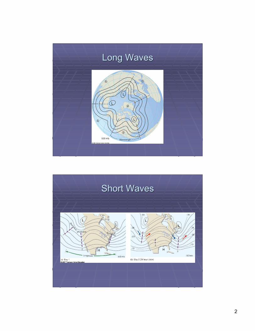
Long Waves Long Waves vsvs Short Waves Short Waves Uneven heating causes troughs and ridges toUneven heating causes troughs and ridges to
form around the globeform around the globe An almost constant ring of trough/ridge patternsAn almost constant ring of trough/ridge patterns
exist, called exist, called longwaveslongwaves Waves usually move west-east, but canWaves usually move west-east, but can
sometimes appear to move westwardsometimes appear to move westward Called retrograde motionCalled retrograde motion
Within these Within these longwaveslongwaves, disturbances exist, disturbances existcalled called shortwavesshortwaves ShortwavesShortwaves deepen in deepen in longwavelongwave troughs troughs ShortwavesShortwaves weaken in weaken in longwavelongwave ridges ridges
2
Long WavesLong Waves
Short WavesShort Waves
3
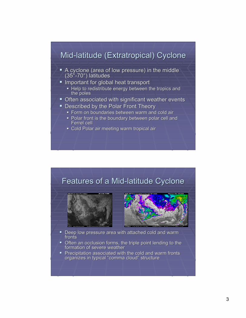
Mid-latitude (Mid-latitude (ExtratropicalExtratropical) Cyclone) Cyclone
A cyclone (area of low pressure) in the middleA cyclone (area of low pressure) in the middle(35°-70°) latitudes(35°-70°) latitudes
Important for global heat transportImportant for global heat transport Help to redistribute energy between the tropics andHelp to redistribute energy between the tropics and
the polesthe poles Often associated with significant weather eventsOften associated with significant weather events Described by the Polar Front TheoryDescribed by the Polar Front Theory
Form on boundaries between warm and cold airForm on boundaries between warm and cold air Polar front is the boundary between polar cell andPolar front is the boundary between polar cell and
FerrelFerrel cell cell Cold Polar air meeting warm tropical airCold Polar air meeting warm tropical air
Features of a Mid-latitude CycloneFeatures of a Mid-latitude Cyclone
Deep low pressure area with attached cold and warmDeep low pressure area with attached cold and warmfrontsfronts
Often an occlusion forms, the triple point lending to theOften an occlusion forms, the triple point lending to theformation of severe weatherformation of severe weather
Precipitation associated with the cold and warm frontsPrecipitation associated with the cold and warm frontsorganizes in typical organizes in typical ““comma cloudcomma cloud”” structure structure
4
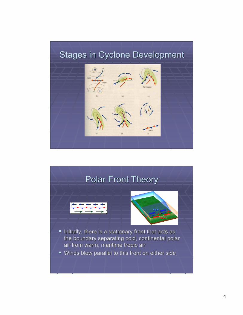
Stages in Cyclone DevelopmentStages in Cyclone Development
Polar Front TheoryPolar Front Theory
Initially, there is a stationary front that acts asInitially, there is a stationary front that acts asthe boundary separating cold, continental polarthe boundary separating cold, continental polarair from warm, maritime tropic airair from warm, maritime tropic air
Winds blow parallel to this front on either sideWinds blow parallel to this front on either side
5
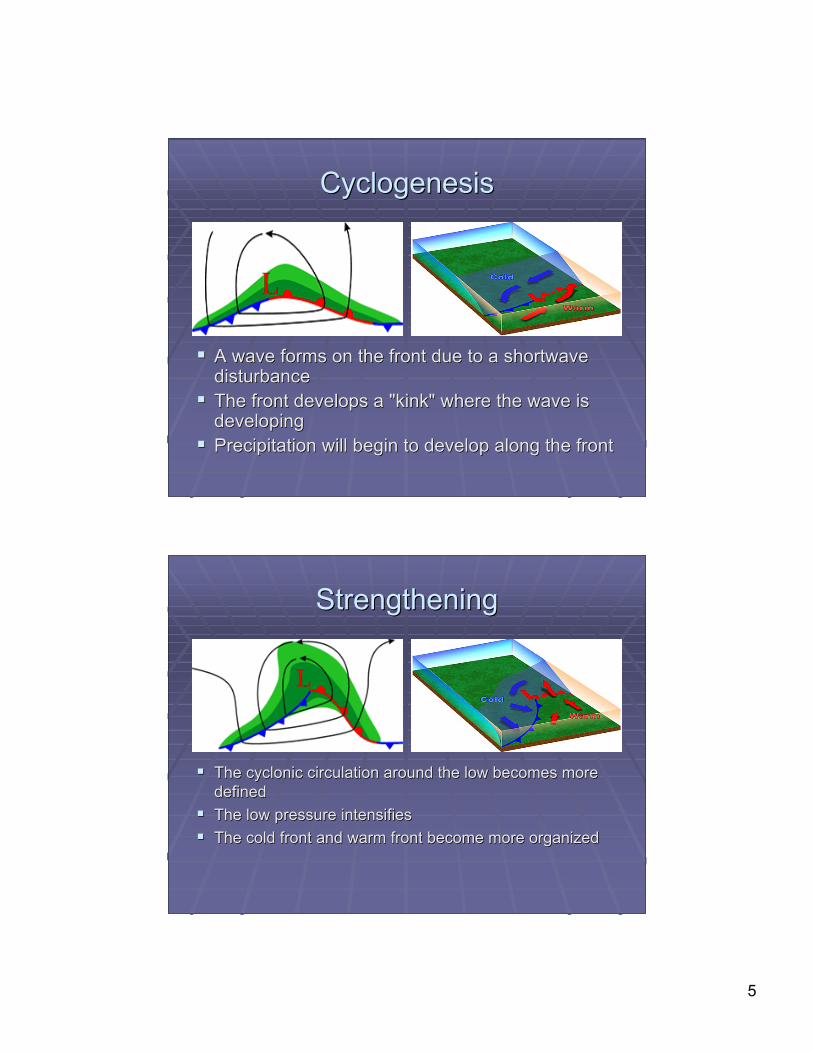
CyclogenesisCyclogenesis
A wave forms on the front due to a shortwaveA wave forms on the front due to a shortwavedisturbancedisturbance
The front develops a "kink" where the wave isThe front develops a "kink" where the wave isdevelopingdeveloping
Precipitation will begin to develop along the frontPrecipitation will begin to develop along the front
StrengtheningStrengthening
The cyclonic circulation around the low becomes moreThe cyclonic circulation around the low becomes moredefineddefined
The low pressure intensifiesThe low pressure intensifies The cold front and warm front become more organizedThe cold front and warm front become more organized
6
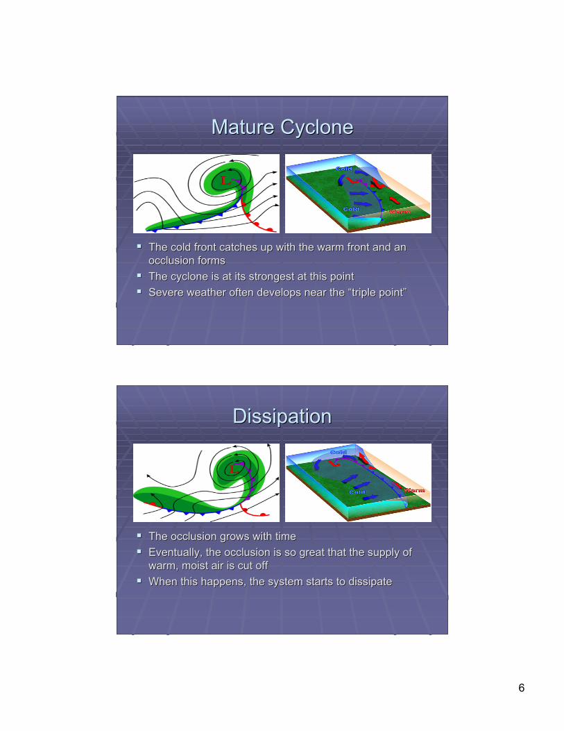
Mature CycloneMature Cyclone
The cold front catches up with the warm front and anThe cold front catches up with the warm front and anocclusion formsocclusion forms
The cyclone is at its strongest at this pointThe cyclone is at its strongest at this point Severe weather often develops near the Severe weather often develops near the ““triple pointtriple point””
DissipationDissipation
The occlusion grows with timeThe occlusion grows with time Eventually, the occlusion is so great that the supply ofEventually, the occlusion is so great that the supply of
warm, moist air is cut offwarm, moist air is cut off When this happens, the system starts to dissipateWhen this happens, the system starts to dissipate
7
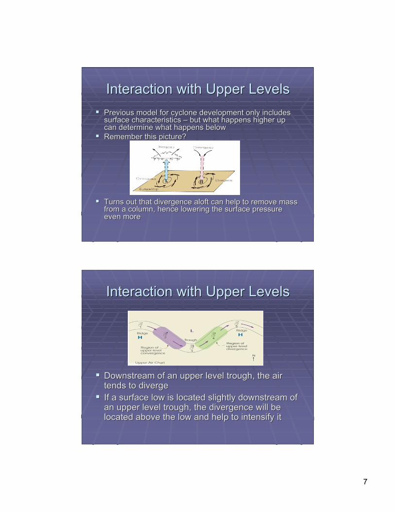
Interaction with Upper LevelsInteraction with Upper Levels Previous model for cyclone development only includesPrevious model for cyclone development only includes
surface characteristics surface characteristics –– but what happens higher up but what happens higher upcan determine what happens belowcan determine what happens below
Remember this picture?Remember this picture?
Turns out that divergence aloft can help to remove massTurns out that divergence aloft can help to remove massfrom a column, hence lowering the surface pressurefrom a column, hence lowering the surface pressureeven moreeven more
Interaction with Upper LevelsInteraction with Upper Levels
Downstream of an upper level trough, the airDownstream of an upper level trough, the airtends to divergetends to diverge
If a surface low is located slightly downstream ofIf a surface low is located slightly downstream ofan upper level trough, the divergence will bean upper level trough, the divergence will belocated above the low and help to intensify itlocated above the low and help to intensify it
8
Another Example Another Example –– Jet Streaks Jet Streaks
A jet streak is an area within a jet streamA jet streak is an area within a jet streamthat has the highest wind speedsthat has the highest wind speeds
Typically jet streaks are thought of asTypically jet streaks are thought of asmade up of four quadrants made up of four quadrants –– separated by separated byleft and right, entrance and exitleft and right, entrance and exit
The right entrance region and the left exitThe right entrance region and the left exitregion both contain divergence (aloft) andregion both contain divergence (aloft) andso they promote the development ofso they promote the development ofsurface low pressure systemssurface low pressure systems
Mid-latitude Cyclones :Mid-latitude Cyclones :The Upper LevelThe Upper Level
A 500 A 500 mbmb trough moves into place directly above a trough moves into place directly above asurface stationary frontsurface stationary front
If a shortwave trough moves into the main flow, theIf a shortwave trough moves into the main flow, theflow pattern is disturbedflow pattern is disturbed
As the 500 As the 500 mbmb trough deepens, the associated upper trough deepens, the associated upperlevel divergence strengthens, helping to intensify thelevel divergence strengthens, helping to intensify thesurface lowsurface low
Stronger winds aloft force the upper level trough to moveStronger winds aloft force the upper level trough to moveeastward faster, and eventually it becomes locatedeastward faster, and eventually it becomes locatedabove the surface lowabove the surface low
When the surface and upper level low are When the surface and upper level low are ““stackedstacked””,,convergence at both levels starts to convergence at both levels starts to ““fillfill”” the low pressure the low pressurearea, weakening the cyclonearea, weakening the cyclone
9
Weather Forecasting - QualitativeWeather Forecasting - Qualitative
Most information for a qualitative forecast can be seenMost information for a qualitative forecast can be seenon a simple weather mapon a simple weather map
If you see a low pressure area that has been movingIf you see a low pressure area that has been movingeastward towards Colorado, what type of weather mighteastward towards Colorado, what type of weather mightyou expect?you expect?
If a cold front is moving southward through Wyoming,If a cold front is moving southward through Wyoming,what would you expect the temperature to do?what would you expect the temperature to do?
If itIf it’’s going to be cloudy tomorrow, will it be warmer ors going to be cloudy tomorrow, will it be warmer orcolder than it was today?colder than it was today?
Often the best forecast is persistence: if itOften the best forecast is persistence: if it’’s warm ands warm andsunny today, and it was warm and sunny yesterday, thesunny today, and it was warm and sunny yesterday, theodds are pretty good that it will be warm and sunnyodds are pretty good that it will be warm and sunnytomorrow (unless you know something else)tomorrow (unless you know something else)
Weather Forecasting - QuantitativeWeather Forecasting - Quantitative
In order to predict specific quantities in aIn order to predict specific quantities in aforecast (temperature, humidity, rainfall) we relyforecast (temperature, humidity, rainfall) we relyon computer modelson computer models
Numerical weather prediction (NWP) uses aNumerical weather prediction (NWP) uses asystem of equations that describes the behaviorsystem of equations that describes the behaviorof the atmosphereof the atmosphere
NWP model uses the current state of theNWP model uses the current state of theatmosphere as its initial condition and stepsatmosphere as its initial condition and stepsthrough a small time step, recalculating everythrough a small time step, recalculating everynumber for each step until the forecast time isnumber for each step until the forecast time isreachedreached
10
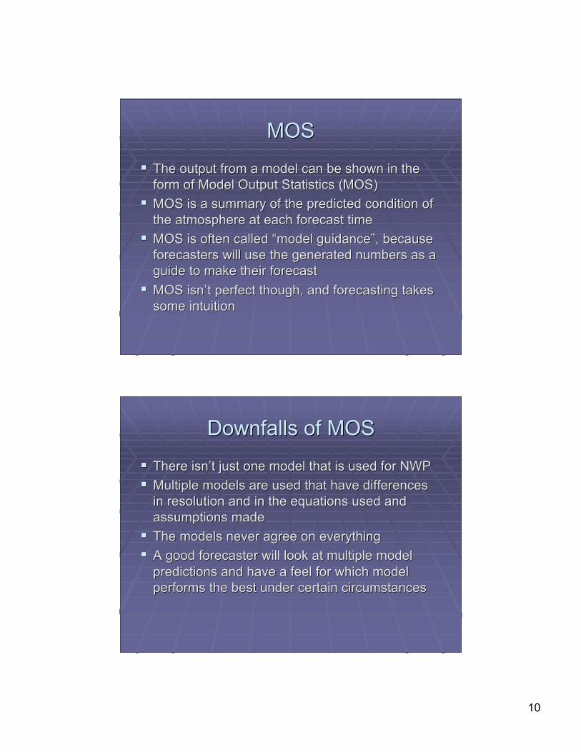
MOSMOS
The output from a model can be shown in theThe output from a model can be shown in theform of Model Output Statistics (MOS)form of Model Output Statistics (MOS)
MOS is a summary of the predicted condition ofMOS is a summary of the predicted condition ofthe atmosphere at each forecast timethe atmosphere at each forecast time
MOS is often called MOS is often called ““model guidancemodel guidance””, because, becauseforecasters will use the generated numbers as aforecasters will use the generated numbers as aguide to make their forecastguide to make their forecast
MOS isnMOS isn’’t perfect though, and forecasting takest perfect though, and forecasting takessome intuitionsome intuition
Downfalls of MOSDownfalls of MOS
There isnThere isn’’t just one model that is used for NWPt just one model that is used for NWP Multiple models are used that have differencesMultiple models are used that have differences
in resolution and in the equations used andin resolution and in the equations used andassumptions madeassumptions made
The models never agree on everythingThe models never agree on everything A good forecaster will look at multiple modelA good forecaster will look at multiple model
predictions and have a feel for which modelpredictions and have a feel for which modelperforms the best under certain circumstancesperforms the best under certain circumstances
11
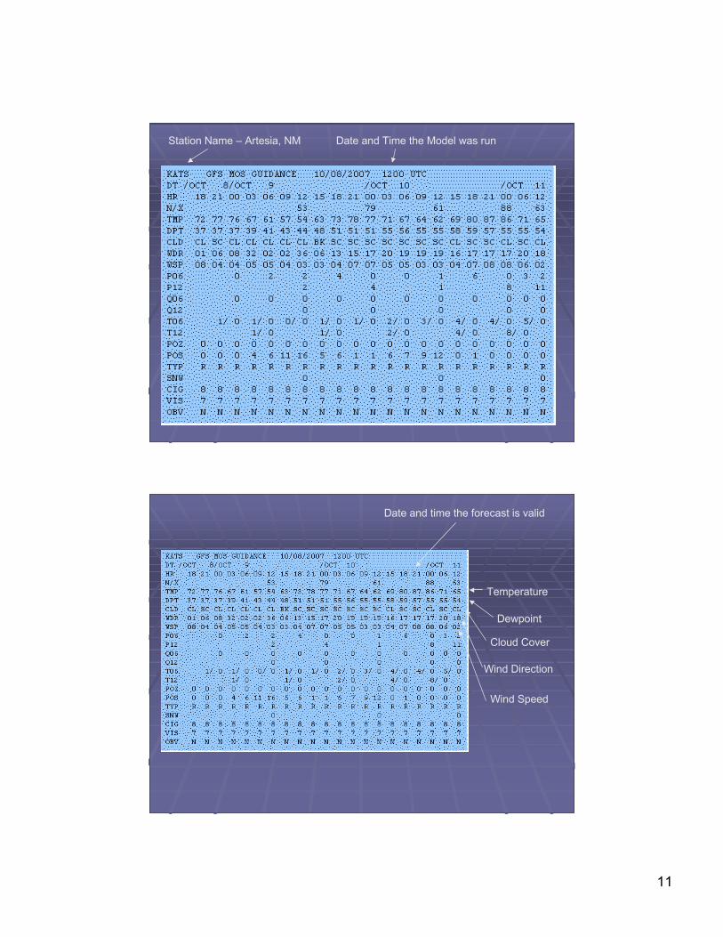
Station Name – Artesia, NM Date and Time the Model was run
Date and time the forecast is valid
Temperature
Dewpoint
Cloud Cover
Wind Direction
Wind Speed
12
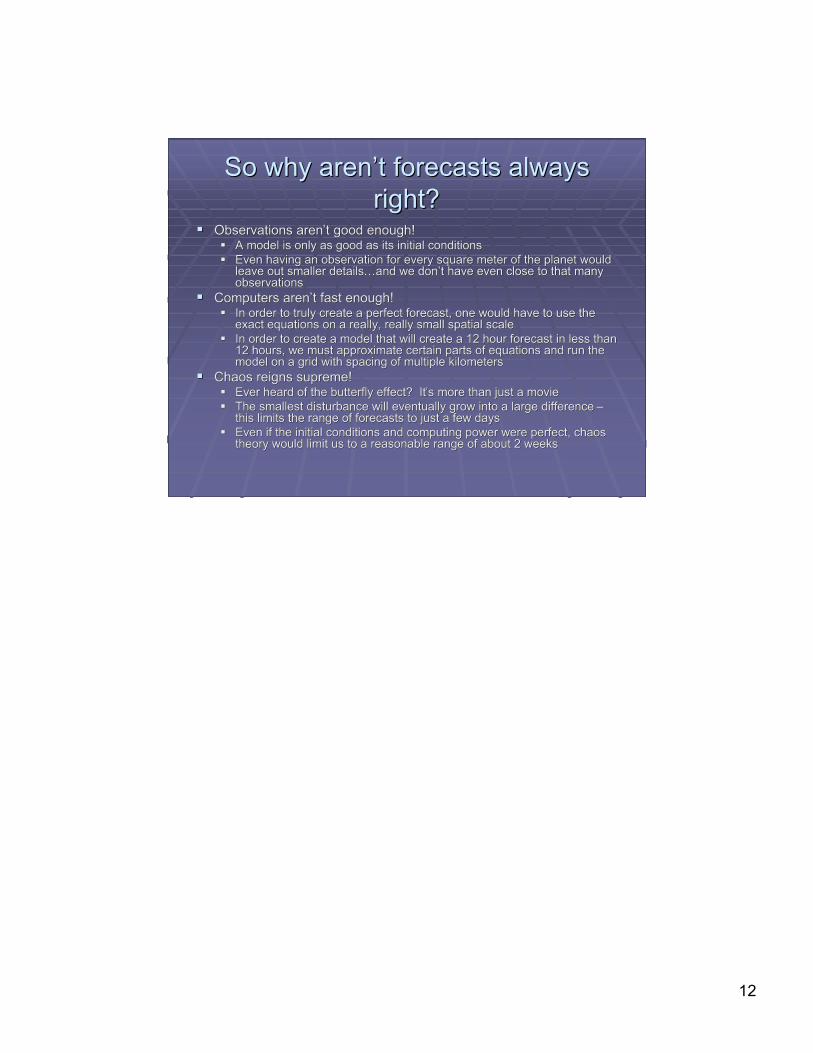
So why arenSo why aren’’t forecasts alwayst forecasts alwaysright?right?
Observations arenObservations aren’’t good enough!t good enough! A model is only as good as its initial conditionsA model is only as good as its initial conditions Even having an observation for every square meter of the planet wouldEven having an observation for every square meter of the planet would
leave out smaller detailsleave out smaller details……and we donand we don’’t have even close to that manyt have even close to that manyobservationsobservations
Computers arenComputers aren’’t fast enough!t fast enough! In order to truly create a perfect forecast, one would have to use theIn order to truly create a perfect forecast, one would have to use the
exact equations on a really, really small spatial scaleexact equations on a really, really small spatial scale In order to create a model that will create a 12 hour forecast in less thanIn order to create a model that will create a 12 hour forecast in less than
12 hours, we must approximate certain parts of equations and run the12 hours, we must approximate certain parts of equations and run themodel on a grid with spacing of multiple kilometersmodel on a grid with spacing of multiple kilometers
Chaos reigns supreme!Chaos reigns supreme! Ever heard of the butterfly effect? ItEver heard of the butterfly effect? It’’s more than just a movies more than just a movie The smallest disturbance will eventually grow into a large difference The smallest disturbance will eventually grow into a large difference ––
this limits the range of forecasts to just a few daysthis limits the range of forecasts to just a few days Even if the initial conditions and computing power were perfect, chaosEven if the initial conditions and computing power were perfect, chaos
theory would limit us to a reasonable range of about 2 weekstheory would limit us to a reasonable range of about 2 weeks