Embed Size (px)
Citation preview

INTERNATIONAL JOURNAL OF GEOMATICS AND GEOSCIENCES
Volume 2, No 3, 2012
© Copyright 2010 All rights reserved Integrated Publishing services
Research article ISSN 0976 – 4380
Submitted on February 2012 published on February 2012 878
Micro-Hazard Evaluation and validation of landslide in a part of North
Western Garhwal Lesser Himalaya, India Kishor Kumar
1, Rahul Devrani
2, Anil Kathait
1, Neha Aggarwal
2
1- Geotechnical Engineering Division, Central Road Research Institute, Mathura Road, New
Delhi, India
2- Department Of Geology, University of Delhi, India
ABSTRACT
A large number of natural factors control the occurrence of landslide phenomenon. However,
anthropogenic activities, added with natural factors contribute handsomely to destabilize the
hill slopes. The Himalaya being unique in its physiographic, tectonic and climatic
characteristics coupled with many natural and man-made factors is inherently prone to
landslides. Present article includes a study of certain parameters (as factors), selected as per
their role in inducing landslides in one of the hazard prone regions of Northwestern Himalaya.
A base map on 1:500 scale was prepared using high precision Total Station and GPS that was
further divided into equal sized grids measuring 45m X 45m. The parameters such as
lithology, structures, slope gradients, landuse and landcover and groundwater condition have
been quantified and statistically analyzed for evaluating the landslide hazard potential of each
of the grid.
Based on the integration of qualitative and quantified weightages given to each factor of each
grid, a micro-hazard zonation map of the area has been developed for guiding the remedial
actions required for preventing the landslides. The results were compared with results of
geomechanical classification .i.e. RMR and SMR; of same site to support modified
methodology .The map has been physically verified and was found to be mostly accurate.
Keywords: Landslide, Zonation, Scale, Hazard, Parameters and Weightage
1. Introduction
Landslide Hazard Zonation (LHZ) is one of the commonly used methodologies for ranking
different parts of an area according to the degree of potential hazard from landslide (Varnes,
1980 & 1984). It has been argued well and accepted that geomorphologic and geological data
apart from the historical data on landslides is an important source parameter for landslide
hazard zonation (Hutchinson, 1995). The landslide hazard zonation (Anbalagan, 1992) is a
method to divide the landscape of into different zones characterizing by its degree of
instability and potential. Many researchers have proposed this method Brabb(1984), Varnes
(1984), Carrara (1983,1988), Gupta and Joshi (1990), Carrara et al(1990,1991), Anbalagan
(1992), Carrara et al(1992), Mehrotra et al(1992),Pachauri and Pant(1992), Gupta et
al(1993),Sarkar et al (1995),Anbalagan and Singh (1996), Panikkar and Subramanyan (1996),
Gupta et al(1999), Uromeihy and Madavifar (1999), Saha et al(2002), Carro et al(2003). The
zonation of most geological hazards and prediction of their risks remain largely unsolved
problems (Carrara et al 1999) but the large scale hazard maps can provide us more details
(Westen et al 1997) which can decipher this problem.

Micro-Hazard Evaluation and validation of landslide in a part of North Western Garhwal Lesser Himalaya,
India
Kishor Kumar, Rahul Devrani, Anil Kathait, Neha Aggarwal
International Journal of Geomatics and Geosciences
Volume 2 Issue 3, 2012 879
The Kaliasaur Landslide (Figure 1) is taken as case study where the new ratings have been
specified to the parameters, data is been analysed statically where the values is been obtained
from the data itself or is defined to it. As defined works-scale is 1:500, where earlier workers
scale were too small to be fit in a model of site specific; also scale varies with different
factors ( Aleotti and Chowdhry,1998) in our study chosen scale is site specific. Aim of study
is to go into a large scale zonation map, where the weightage of parameters were unfitted as
convolution gets increase with large scale (Sarkar et al, 1995).
2. Study Area
The Kaliasaur Landslide has been a threat since more than five decades on the strategic
Highway of the nation (NH-58) (Figure 1). The history of Kaliasaur landslide dates back to
1920 (Kishor Kumar et. al., 2005), the presence of fault zones, shear zones, extensive mass
are major causative factors of the sliding activity in this region. Also there are many other
significant landslides, both active and dormant, occurring in the Srinagar – Rudraprayag
region (Sinha et al 2002). The landslides along the Rishikesh – Badrinath National Highway
are mostly debris slides, debris flows, rock slides and rock falls (S. Sarkar et al., 2006). The
study area being tectonically active is a sensitive region consisting of complex topographic,
geological and geomorphic setup (Kishor Kumar et. al. 2008a).
Figure 1: Location map of study area (Kaliasaur Landslide)
These conditions coupled with extrinsic factors such as high precipitation and seismic
vibrations, rapid weathering and erosional processes, make the area susceptible to variety of
landslides of different magnitudes such as landslides, rock fall, debris fall, debris slide,
slumps and rockslides etc. (Kishor Kumar et. al. 2008b).These soil creeps could easily be
identified as slowly moving unconsolidated soils and overburden manifested in typical
bending of tree trunk along the movement direction and associated with tension cracks on the
road pavements or a down slope tilting of stone walls.. Since then, the slide has been
experiencing frequent recurrences. Heavy landslides have occurred in 1952, 1963, and 1965

Micro-Hazard Evaluation and validation of landslide in a part of North Western Garhwal Lesser Himalaya,
India
Kishor Kumar, Rahul Devrani, Anil Kathait, Neha Aggarwal
International Journal of Geomatics and Geosciences
Volume 2 Issue 3, 2012 880
and in subsequent years as well. Besides the major events, minor failures kept on taking place
in this zone which houses rocks of very weak condition. During 1970, 1971 and 1972
occurrence, Kaliasaur landslide damaged the highway severely. The traffic was restored by
having new formation cut of length 215 m, 100 m, and 125 m respectively (Kishor Kumar et.
al. 2008c). Again in 1984, due to heavy precipitation, comparatively major slide took place
and damaged road considerably. The crown portion of the slide has extended more than 20 m
since 1984. Two-third landslides initiated by human activities are mostly because of removal
of slope toes at road cuts. The study conducted required selection of known parameters that
had contributed as causes of the slope failure in the area (Kishor Kumar et. al., 1996). The
selected parameters of Landslide Hazard Evaluation Factor (LHEF) rating scheme have been
defined for further analysis described in following section. A total estimated hazard (TEHD)
value for each grid is obtained which is then classified into Landslide Hazard Zones.
2.1 Geology and Tectonics of study area
The study area belongs to one of the Lesser Himalayan divisions, i.e. Rudraprayag Formation
of Garhwal Group. Rudraprayag Formation has five litho-types (members) viz. Uttyasu
Quartzite, Lameri Member, Haryali Quartzite, Thalasu Schistose Grit, and Karanprayag
Metavolcanics. Kaliasaur area comprises of Uttyasu Quartzite (the oldest stratigraphic unit
exposed). This member consists of white, pink, purple, medium to coarse grained, profusely
ripple marked quartzite and subordinate purple/greenish gray slates with Basic Metavolcanics.
Kumar and Agrawal (1975) have referred this unit as “Rudraprayag Quartzite “of
Rudraprayag Formation. As the Formation and the Member unit cannot be designated by the
single term, R.N. Srivastava and A. Ahmad (1979) have replaced the term “Rudraprayag
Quartzite” with Uttyasu Quartzite.
3. Methodology and Procedure
The objective of this study basically was to prepare a micro-hazard zonation map having risk/
hazard prone areas which could guide the road maintenance agencies so as to take appropriate
safety measures for risk free unhindered flow of traffic particularly in rainy seasons. The
process of accomplishment of the above said objectives began with a detailed field study of
the selected site that included structural and lithological mapping of the area and collection of
the necessary geological and geotechnical data. Prior to detailed field investigation a large
scale topographic map on 1:500 scale was prepared. All subsequent field mapping was
carried out in the same scale. Thereafter the map was divided into grids measuring 45 x 45 m
(Figure 2) to individually study each grid for a realistic and accurate evaluation of stability of
the slope and inferring the type of possible failure for each of the grids. Following the above
mentioned methodology each grid has been classified into different zones of potential
landslide hazard. These grids with their landslide hazard potential have been utilized to
develop a landslide hazard map of the whole area. Stability has also been assessed for rock
slopes of the area by quantifying the various parameters viz. lithology, structural relationships,
slope gradient, landuse/ landcover, and water conditions that define the susceptibility of
slopes to failure, for each of the grids of the study area. The Landslide Hazard Evaluation
Factor (LHEF) rating scheme used in this study, is a field investigation based technique and
is being effectively used for Landslide Hazard Zonation in India (BIS Code 14496)[5]
i.e. the
classification of an area into small zones on the basis of their relative susceptibility to
landslides. The parameters of investigation usually consist of information regarding
geological and geotechnical has been modified to some extent as per the site condition (Table
1).

Micro-Hazard Evaluation and validation of landslide in a part of North Western Garhwal Lesser Himalaya,
India
Kishor Kumar, Rahul Devrani, Anil Kathait, Neha Aggarwal
International Journal of Geomatics and Geosciences
Volume 2 Issue 3, 2012 881
Figure 2: Grid map of the study area.
Table 1: Proposed LHEF Rating Scheme
Parameter Rating
Lithology 2
Structural Relationships 3
Slope Gradient 2
Landuse/ Landcover (including Road Construction)) 2
Groundwater Condition 1
TOTAL 10
The ratings have been assigned to the selected parameters for each of the grids. The obtained
ratings for all the parameters in each of the grids were then added to get a resultant total
estimated hazard (TEHD) value for each of the grids. This TEHD value is then used to define
the micro hazard zonation class (Table 2). For each of the five selected factors, based on the
gathered information, separate layers have been created. These five layers have been
superimposed to obtain the TEHD value and the final micro-hazard zonation map.
Table 2: Micro Hazard Zonation on the basis of Total Estimated Hazard
Zone TEHD Value Description of Zones
I <2 Very Low Hazard VLH) Zone
II 2 – 4 Low Hazard (LH) Zone
III 4 – 6. Moderate Hazard (MH) Zone
IV 6 – 8 High Hazard (HH) Zone
V >8 Very High Hazard (VHH) Zone
4. Rating Scheme of Parameters
4.1 Lithology
Lithology of an area combined with various conditions of the rocks, i.e. compaction,
deformation, fracturing, intrusions, alteration etc. holds good significance as a factor
responsible for causing landslides. The stability of a site, thus, can be inferred from the
lithology/ rock type it inhibits and its conditions ( Brabb, 1972). The study done by Gupta
and Joshi (1990) in Ramganga catchment area shows that the landslide is more prone in

Micro-Hazard Evaluation and validation of landslide in a part of North Western Garhwal Lesser Himalaya,
India
Kishor Kumar, Rahul Devrani, Anil Kathait, Neha Aggarwal
International Journal of Geomatics and Geosciences
Volume 2 Issue 3, 2012 882
Figure 4: (a) Pink Quartzite (b) White Quartzite (c)
Brown Quartzite (d) Metavolcanics
a b
c d
quartzite, where the study area is also rich in the quartzite. The grids of 45 X 45 m were
placed over the geological map of the area which was prepared over the surveyed area
(Figure 3). Different types of quartzite, i.e. pink, white and brown (Figure 4. a,b,c) having
varying degree of weathering and other conditions are intruded by scattered patches of
metavolcanics (Figure 4. d). The rock type falling in each of the grids was noted and given a
rating. The rating was then corrected for various weathering condition (Table 3) of the rocks.
If within a grid, two or more rock types are encountered, the one holding higher percentage
was considered for the whole grid, but the grid was further subdivided in cases where the
occurring rock types are in approximately equal proportion .On the basis of the obtained
ratings and lithological rating map have been prepared (Figure 6.a).
Figure 3: Geological and Structure map of study area
Micro-Hazard Evaluation and validation of landslide in a part of North Western Garhwal Lesser Himalaya,
India
Kishor Kumar, Rahul Devrani, Anil Kathait, Neha Aggarwal
International Journal of Geomatics and Geosciences
Volume 2 Issue 3, 2012 883
Table 3: Proposed LHEF Rating Scheme for Lithology
Factor Category Rating Remarks
Lithology Correction factor for weathering:
Rock Type
Type – I
Quartzite (white,
pink & brown)
Type – II
Metavolcanics
0.2
0.4
(a) Highly weathered – rock discolored,
joints open with weathering products, rock
fabric altered to a large extent; Correction factor
C1.
(b) Moderately weathered – rock
discolored with fresh rock patches, weathering
more around joint planes, but rock intact in
nature; Correction factor C2.
(c) Slightly weathered – rock slightly
discolored along joint planes, which may be
moderately tight to open, intact rock; Correction
factor C3.
The correction factor for weathering should
be multiplied with the fresh rock rating to
get corrected rating.
For rock type I
C1 = 4, C2 = 3, C3 = 2
For rock type II
C1 = 1.5, C2 = 1.25, C3 = 1.0
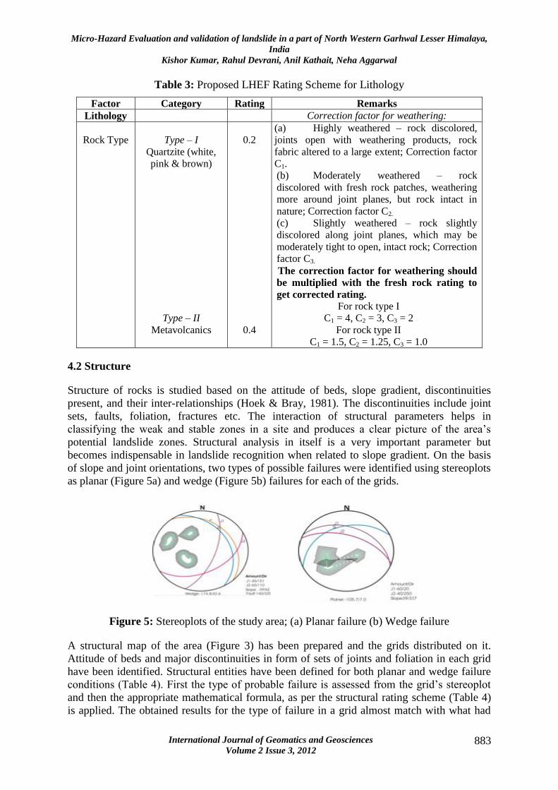
4.2 Structure
Structure of rocks is studied based on the attitude of beds, slope gradient, discontinuities
present, and their inter-relationships (Hoek & Bray, 1981). The discontinuities include joint
sets, faults, foliation, fractures etc. The interaction of structural parameters helps in
classifying the weak and stable zones in a site and produces a clear picture of the area’s
potential landslide zones. Structural analysis in itself is a very important parameter but
becomes indispensable in landslide recognition when related to slope gradient. On the basis
of slope and joint orientations, two types of possible failures were identified using stereoplots
as planar (Figure 5a) and wedge (Figure 5b) failures for each of the grids.
Figure 5: Stereoplots of the study area; (a) Planar failure (b) Wedge failure
A structural map of the area (Figure 3) has been prepared and the grids distributed on it.
Attitude of beds and major discontinuities in form of sets of joints and foliation in each grid
have been identified. Structural entities have been defined for both planar and wedge failure
conditions (Table 4). First the type of probable failure is assessed from the grid’s stereoplot
and then the appropriate mathematical formula, as per the structural rating scheme (Table 4)
is applied. The obtained results for the type of failure in a grid almost match with what had
Micro-Hazard Evaluation and validation of landslide in a part of North Western Garhwal Lesser Himalaya,
India
Kishor Kumar, Rahul Devrani, Anil Kathait, Neha Aggarwal
International Journal of Geomatics and Geosciences
Volume 2 Issue 3, 2012 884
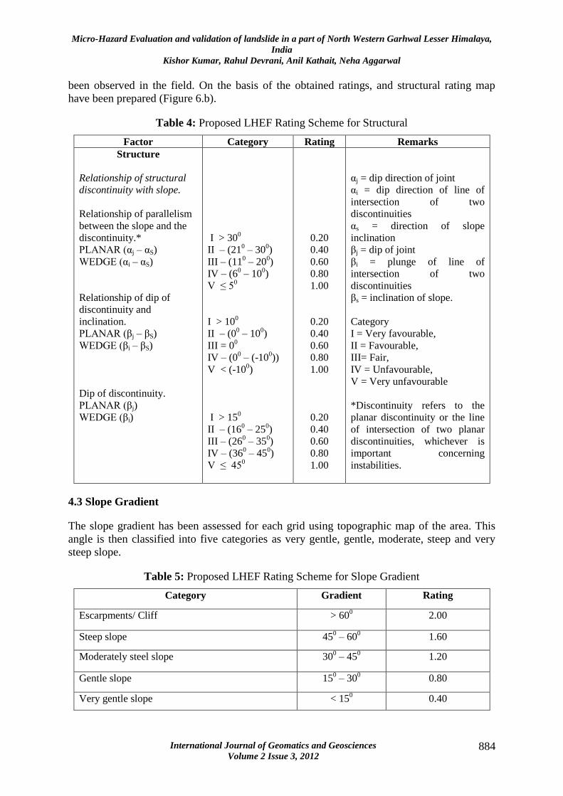
been observed in the field. On the basis of the obtained ratings, and structural rating map
have been prepared (Figure 6.b).
Table 4: Proposed LHEF Rating Scheme for Structural
Factor Category Rating Remarks
Structure
Relationship of structural
discontinuity with slope.
Relationship of parallelism
between the slope and the
discontinuity.*
PLANAR (αj – αS)
WEDGE (αi – αS)
Relationship of dip of
discontinuity and
inclination.
PLANAR (βj – βS)
WEDGE (βi – βS)
Dip of discontinuity.
PLANAR (βj)
WEDGE (βi)
I > 300
II – (210 – 30
0)
III – (110 – 20
0)
IV – (60 – 10
0)
V ≤ 50
I > 100
II – (00 – 10
0)
III = 00
IV – (00 – (-10
0))
V < (-100)
I > 150
II – (160 – 25
0)
III – (260 – 35
0)
IV – (360 – 45
0)
V ≤ 450
0.20
0.40
0.60
0.80
1.00
0.20
0.40
0.60
0.80
1.00
0.20
0.40
0.60
0.80
1.00
αj = dip direction of joint
αi = dip direction of line of
intersection of two
discontinuities
αs = direction of slope
inclination
βj = dip of joint
βi = plunge of line of
intersection of two
discontinuities
βs = inclination of slope.
Category
I = Very favourable,
II = Favourable,
III= Fair,
IV = Unfavourable,
V = Very unfavourable
*Discontinuity refers to the
planar discontinuity or the line
of intersection of two planar
discontinuities, whichever is
important concerning
instabilities.
4.3 Slope Gradient
The slope gradient has been assessed for each grid using topographic map of the area. This
angle is then classified into five categories as very gentle, gentle, moderate, steep and very
steep slope.
Table 5: Proposed LHEF Rating Scheme for Slope Gradient
Category Gradient Rating
Escarpments/ Cliff > 600
2.00
Steep slope 450 – 60
0 1.60
Moderately steel slope 300 – 45
0 1.20
Gentle slope 150 – 30
0 0.80
Very gentle slope < 150 0.40

Micro-Hazard Evaluation and validation of landslide in a part of North Western Garhwal Lesser Himalaya,
India
Kishor Kumar, Rahul Devrani, Anil Kathait, Neha Aggarwal
International Journal of Geomatics and Geosciences
Volume 2 Issue 3, 2012 885
The highest frequency of landslides occurs in the slope class 15-25 followed by 25°-35° and
35°-45° (S. Sarkar et al., 1995) Each of the grids is then assigned an appropriate rating on the
basis of proposed LHEF rating scheme (Table 5 and Figure 6.c).
4.4 Landuse / Landcover
Land when utilized efficiently can be saved from erosion and weathering and hence,
stabilized. Landcover/ Landuse, thus, need to be studied for potential landslide assessment.
Landcover can be inferred as dense forest, barren land, agricultural land and industrial or
commercial land. The slope stability generally increases with better forestation and
vegetation. Barren land is most susceptible to landslides whereas a dense forest or highly
vegetated landcover is least susceptible. It has been observed that the slopes which are barren
have been utilized for the purpose of road construction and in current study is considered one
of the most influencing anthropogenic factors on slope stability.Based on the landuse and
vegetation cover, the rating system has been given as indicated in Table 6 and Figure 6(d)
Table 7: Proposed LHEF Rating Scheme for Landuse/ Landcover
Landuse and Landcover Rating
Agricultural land/ Populated flat land 0.40
Thickly vegetated area 0.80
Moderately vegetated area 1.20
Sparsely vegetated area with lesser ground cover 1.60
Barren land/ road construction 2.00
Table 8: Proposed LHEF Rating Scheme for Groundwater conditions
Groundwater Condition Rating
Dripping
Flowing
Wet
Damp
Dry
1.00
0.80
0.50
0.20
0.00
4.5 Water Conditions
Hydrology of an area plays vital role in determining the susceptibility of rock/ soil to failure.
Hydrological properties of an area include presence of streams, rivers, underground water
conditions, saturation state of rock/soil, and drainage pattern of the area. Dislocated water
bodies due to presence of discontinuities and shallow water-table conditions in hilly terrains
along with heavy rainfall make the slopes prone to instability.During the prolonged monsoon
phases, increased pore-water pressure creates favorable conditions for deep-seated landslides
(Y.P. Sundriyal et al., 2007).The hydrological conditions at the chosen site do not pose much
of the challenge for slopes as the investigations reveal, the area is almost dry. Only near the
toe of the slope along the bank of river Alaknanda, the slopes are found damp. Drainage
Micro-Hazard Evaluation and validation of landslide in a part of North Western Garhwal Lesser Himalaya,
India
Kishor Kumar, Rahul Devrani, Anil Kathait, Neha Aggarwal
International Journal of Geomatics and Geosciences
Volume 2 Issue 3, 2012 886
density in the area is also low. Thus, ratings for dry condition have been assigned to the study
area (Table 7).Included in landuse is also the road construction factor. Toe cutting for road
construction in hilly terrains like this is one of the most powerful triggering factors of the
landslide, as after cutting the slope face is left barren that gets easily degraded. Thus, the
areas along the highway, where slope has been cut have been assigned rating two.
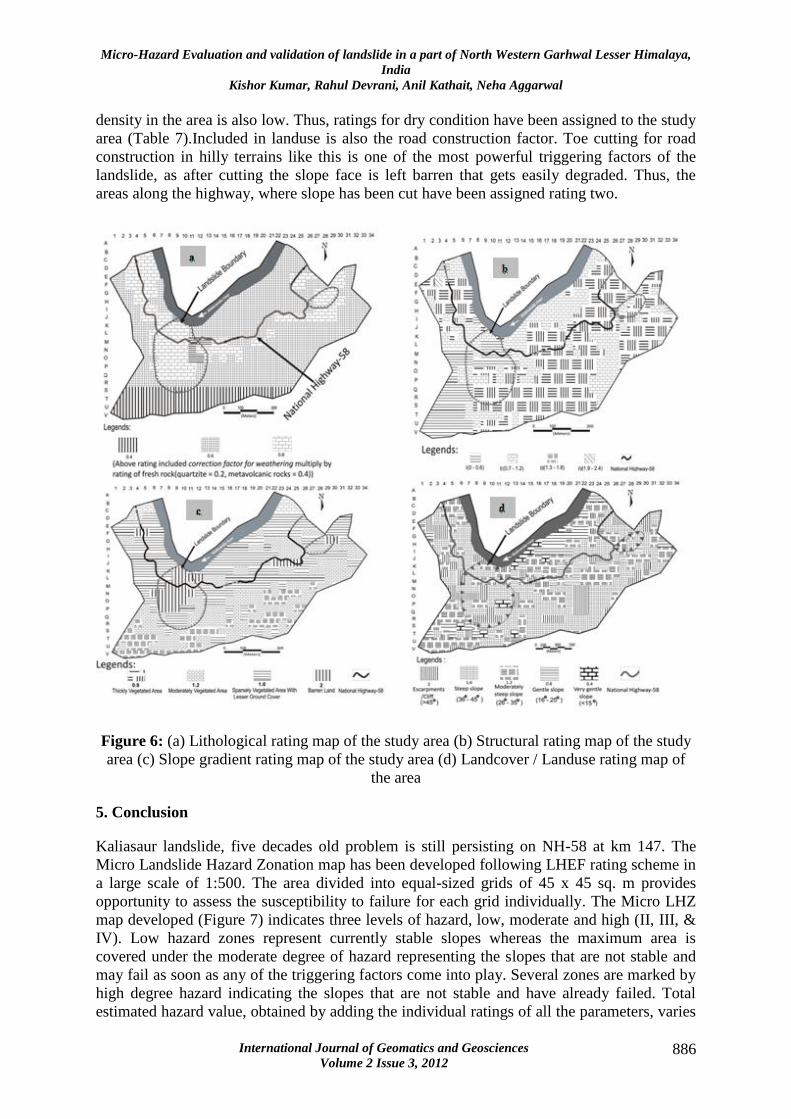
Figure 6: (a) Lithological rating map of the study area (b) Structural rating map of the study
area (c) Slope gradient rating map of the study area (d) Landcover / Landuse rating map of
the area
5. Conclusion
Kaliasaur landslide, five decades old problem is still persisting on NH-58 at km 147. The
Micro Landslide Hazard Zonation map has been developed following LHEF rating scheme in
a large scale of 1:500. The area divided into equal-sized grids of 45 x 45 sq. m provides
opportunity to assess the susceptibility to failure for each grid individually. The Micro LHZ
map developed (Figure 7) indicates three levels of hazard, low, moderate and high (II, III, &
IV). Low hazard zones represent currently stable slopes whereas the maximum area is
covered under the moderate degree of hazard representing the slopes that are not stable and
may fail as soon as any of the triggering factors come into play. Several zones are marked by
high degree hazard indicating the slopes that are not stable and have already failed. Total
estimated hazard value, obtained by adding the individual ratings of all the parameters, varies
Micro-Hazard Evaluation and validation of landslide in a part of North Western Garhwal Lesser Himalaya,
India
Kishor Kumar, Rahul Devrani, Anil Kathait, Neha Aggarwal
International Journal of Geomatics and Geosciences
Volume 2 Issue 3, 2012 887
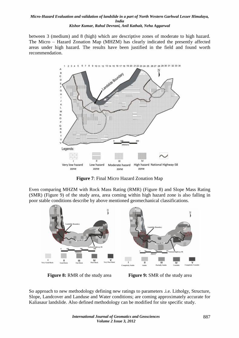
between 3 (medium) and 8 (high) which are descriptive zones of moderate to high hazard.
The Micro – Hazard Zonation Map (MHZM) has clearly indicated the presently affected
areas under high hazard. The results have been justified in the field and found worth
recommendation.
Figure 7: Final Micro Hazard Zonation Map
Even comparing MHZM with Rock Mass Rating (RMR) (Figure 8) and Slope Mass Rating
(SMR) (Figure 9) of the study area, area coming within high hazard zone is also falling in
poor stable conditions describe by above mentioned geomechanical classifications.
Figure 8: RMR of the study area Figure 9: SMR of the study area
So approach to new methodology defining new ratings to parameters .i.e. Litholgy, Structure,
Slope, Landcover and Landuse and Water conditions; are coming approximately accurate for
Kaliasaur landslide. Also defined methodology can be modified for site specific study.

Micro-Hazard Evaluation and validation of landslide in a part of North Western Garhwal Lesser Himalaya,
India
Kishor Kumar, Rahul Devrani, Anil Kathait, Neha Aggarwal
International Journal of Geomatics and Geosciences
Volume 2 Issue 3, 2012 888
6. References
1. Ahmad, T., Harris, N., Bickle, M., Chapman, H., Bunbury, J., and Prince, C., (2000),
Isotopic constraints on the structural relationships between the Lesser Himalayan
Series and the High Himalayan Crystalline Series, Garwhal Himalaya: Geological
Society of America Bulletin, 112, pp 467–477, doi: 10.1130/0016-7606(2000)
112<0467:ICOTSR>2.3.CO;2.
2. Anbalagan, (1992), Landslide hazard evaluation and zonation mapping in mountainous
terrain, Engineering Geology, 32, pp 269-277.
3. Bordet, P., (1961), Recherches géologiques dans l’Himalaya du Népal, région du
Makalu: Paris, Editions du Centre National de la Recherche Scientifique.
4. Bordet, P., Colchen, M., and Le Fort, P., (1972), Some features of the geology of the
Annapurna range Nepal Himalaya: Himalayan Geology, 2, pp 537–563.
5. Brabb, E.E., (1972), Landslide susceptibility in San Mateo County, California. U.S. 1.
Geological Survey, Miscellaneous Field Studies Map, MF360, Scale 1:62,500.
6. Brabb, E.E., (1984), Innovative approach to landslide hazard and risk mapping, in
Proceedings of the 4th
International Symposium on Landslides Toronto, pp 307-324.
7. Bureau of Indian Standards Code 14496.
8. Carrara, A., (1983), Multivariate models for landslide hazard evaluation, Mathematical
Geology, 15(3), pp 403-427.
9. Carrara, A., (1988), Multivariate models for landslide hazard evaluation, A “Black
Box” approach, Workshop on Natural Disasters in European Mediterranean
Countries, Perugia, Italy, pp 205-224.
10. Carrara, A., M.Cardinali, F. Guzzetti., (1992), Uncertainty in assessing landslide
hazard and risk, ITC Journal, 2, pp 172-183.
11. Carrara, A., M. Cardinali, R. Detti, and F. Guzzetti., (1991), GIS techniques and
statistical models in evaluating landslide hazard: Earth surface process, Landform v.
16(5), pp 427-445.
12. Carrara, A., M. Cardinali, R. Detti, and F. Guzzetti, V. Pasqui, and P. Reichenbach,
(1990), Geographical Information Systems an multivariate models in landslide hazard
evaluation, Proc. ALPS 90-6th
Int. Conf. and Field workshop on Landslides, August
31- September 12, 1990, Milano, Italy, pp 17-28.
13. Carrara, A., F. Guzzetti, M. Cardinali, and P. Reichenbach., (1999), Use of GIS
technology in the prediction and monitoring of landslide hazard, Natural hazards, 20,
pp 117- 135.

Micro-Hazard Evaluation and validation of landslide in a part of North Western Garhwal Lesser Himalaya,
India
Kishor Kumar, Rahul Devrani, Anil Kathait, Neha Aggarwal
International Journal of Geomatics and Geosciences
Volume 2 Issue 3, 2012 889
14. Carro M, De Amicis, M Luzi, Marzorati S., (2003), The application of predictive
modeling techniques to landslides induced by earthquakes, the case study of the 26
September 1997, Umbria-Marche Earthquake (Italy), Eng Geol, 69, pp 139-159.
15. Célérier, J., Harrison, T.M., Webb, A.A.G., and Yin, A., (2009), The Kumaun and
Garwhal Lesser Himalaya, India. Part 1: Structure and stratigraphy. Geological
Society of America Bulletin, doi: 10.1130/B26344.1; published online 21 July 2009.
16. Gehrels, G.E., DeCelles, P.G., Martin, A.J., Ojha, T.P., Pinhassi, G., and Upreti, B.N.,
(2003), Initiation of the Himalayan orogen as an early Paleozoic thin-skinned thrust
belt: GSA Today, 13(9), pp 4–9, doi: 10.1130/1052-
5173(2003)13<4:IOTHOA>2.0.CO;2.
17. Gehrels, G.E., DeCelles, P.G., Ojha, T.P., and Upreti, B.N., (2006), Geologic and U-
Th-Pb geochronologic evidence for early Paleozoic tectonism in the Kathmandu
thrust sheet, central Nepal Himalaya: Geological Society of America Bulletin, 118, pp
185–198.
18. Gupta RP, Joshi BC., (1990), Landslide hazard zoning using the GIS approach- A
case study from the Ramganga catchment, Himalayas, Engineering Geology,1990, 28,
pp 119-131.
19. Gupta V, Sah MP, Virdi NS, Bartarya SK., (1993), Landslide hazard zonation in the
upper Satlej Valley, District Kinnaur, Himachal Pradesh, J Himal Geol, 4, pp 81-93.
20. Gupta RP, Saha AK, Arora MK, Kumar A., (1999), Landslide hazard zonation in a
part of Bhagirathy Valley, Garhwal Himalayas, using integrated remote sensing-GIS,
J Himal Geol, 20(2), pp 71-85.
21. Hashimoto, S., Ohta, Y., and Akiba, C., (1973), Geology of the Nepal Himalayas:
Tokyo, Saikon.
22. Hoek, E. and Bray, J.W., (1981), Rock slope engineering. Institute of Mining and
Metallurgy, London, pp 1-100.
23. Hughes, N.C., Peng, S.C., Bhargava, O.N., Ahluwalia, A.D., Walia, S., Myrow, P.M.,
and Parcha, S.K., (2005), Cambrian biostratigraphy of the Tal Group, Lesser
Himalaya, India, and early Tsanglangpuan (late Early Cambrian) trilobites from the
Nigali Dhar syncline: Geological Magazine, 142, pp 57–80, doi:
10.1017/S0016756804000366.
24. Hutchinson, J.N., (1995), Keynote paper: Landslide Hazard Assessment. Proc. 6th
International Symposium on Landslides, February, (ed. Bell DH), Christchurh, New
Zealand, pp 1805-1841.
25. Kumar, G. and Agarwal, N.C., (1975), Geology of Srinagar-Nandprayag area
(Alaknanda Valley), Chamoli-Garhwal and Tehri-Garhwal Districts, Kumaun
Himalaya. U.P. Himalayan Ecology, 5, pp 29-59.

Micro-Hazard Evaluation and validation of landslide in a part of North Western Garhwal Lesser Himalaya,
India
Kishor Kumar, Rahul Devrani, Anil Kathait, Neha Aggarwal
International Journal of Geomatics and Geosciences
Volume 2 Issue 3, 2012 890
26. Kumar, Kishor, Kimothi, S., Goyal, Nitesh, Prasad, P.S., Rawat, S., Mathur, S.,
(2008a), Dynamic Nature of Kaliasaur Landslide: A Geomorphological Appraisal.
Diamond Jubilee Conference on “Landslide Management: Present Scenario and
Future Directions”, Central Building Research Institute, Roorkee, Uttarakhand, India,
10th
– 12th
February, 2008.
27. Kumar, Kishor, Kimothi, S., Mathur, S., (2008b), Topographic Control on the Spatial
Distribution of Landslide and Topographic Conditions Favourable to Landslides.
National Conference on “Mass Instability and Earthquake Risk Management in
Mountainous Regions: Challenges, Lessons Learnt and Future Strategy”, Disaster
Mitigation and Management Centre, Government of Uttaranchal, Dehradun.
28. Kumar, Kishor, Kimothi, Shivashish, Mathur, Sudhir, (2008c), Implications of
Ignoring Seismogenic Landslides in Himalayas. International Symposium on
Mountain building and Climate – Tectonic Interaction, Wadia Institute of Himalayan
Geology, Dehradun, India, October 23rd
– 25th
, 2008.
29. Kumar, Kishor, and Sati, D., (2005), Exploring the History of Alaknanda –
Patalganga Tragedy of 1970 and Possibility of its Recurrence and Impacts on
Patalganga Basin – A GIS and Remote Sensing Based Study. Proc. Of 8th
Annual
International Conference, Map India, New Delhi, 2005.
30. Kumar, Kishor, Tolia, D.S., Kumar, S., (1996), Landslide Hazard Evaluation in a part
of Himalaya, Proc. Of 7th
International Symposium on Landslides, Trondhem,
Norway. Balkema, Rotterdam.
31. Mehrotra, G.S., Sarkar, S., and Dharmaraju,R., (1992), Landslide hazard assessment
in Rishikesh-Tehri area, Garhwal Himalaya,India, Proceedings of Sixth International
Symposium on Landslides, Christchurch, New Zealand.
32. Metcalfe, R.P., (1993), Pressure, temperature and time constraints on metamorphism
across the Main Central Thrust zone and High Himalayan Slab in the Garhwal
Himalaya. In: Treloarand, P.J., Searle, M.P. ŽEds., Himalayan Tectonics. Geol. Soc.
Spec. Publ., 74, pp 485–509.
33. Miller, C., Klotzli, U., Frank, W., Thoni, M., and Grasemann, B., (2000), Proterozoic
crustal evolution in the NW Himalaya (India) as recorded by circa 1.80 Ga mafi c and
1.84 Ga granitic magmatism: Precambrian Research, 103, pp 191–206, doi:
10.1016/S0301-9268(00)00091-7.
34. Pachauri AK, Pant M., (1992), Landslide hazard mapping based on geological
attributes, Eng Geol, 32, pp 81-100.
35. Panikkar SV, Subramanyan V., (1996), A geomorphic evaluation of landslides around
Dehradun and Mussoorie,Uttar Pradesh ,India, Geomorphology, 15, pp 169-181.

Micro-Hazard Evaluation and validation of landslide in a part of North Western Garhwal Lesser Himalaya,
India
Kishor Kumar, Rahul Devrani, Anil Kathait, Neha Aggarwal
International Journal of Geomatics and Geosciences
Volume 2 Issue 3, 2012 891
36. Patrick L. Barnard, P.L., Owen, L.A., Sharma, M.C., Finkel, R.C., (2001), Natural
and human-induced landsliding in the Garhwal Himalaya of northern India.
Geomorphology, 40, pp 21-35.
37. Richards, A., Argles, T., Harris, N., Parrish, R., Ahmad, T., Darbyshire, F., and
Draganits, E., (2005), Himalayan architecture constrained by isotopic tracers from
clastic sediments: Earth and Planetary Science Letters, 236, pp 773–796, doi:
10.1016/j.epsl.2005.05.034.
38. Saha AK, Gupta RP, Arora MK,(2002), GIS – based landslide hazard zonation in a
part of the Himalayas, Int J Remote Sens, 23, pp 357-369.
39. Sarkar, S., Kanungo, D.P., Mehrotra, G.S., (1995), Landslide Hazard Zonation: A
Case Study in Garhwal Himalaya, India. Mountain Research and Development, 15(4),
pp 301-309.
40. Sarkar, S., Kanungo, D.P., and Patra, A.K., (2006), Landslides in the Alaknanda
Valley of Garhwal Himalaya, India. Quarterly Journal of Engineering Geology and
Hydrogeology, 39, pp 79–82.
41. Sati, S.P., Sundriyal, Y.P., and Rawat, G.S., (2007), Geomorphic indicators of
neotectonic activity around Srinagar (Alaknanda basin), Uttarakhand. Research
Communications, Current Science, 92(6).
42. Srivastava R.N. and Ahmad, A., (1979), Geology and structure of Alaknanda valley,
Garhwal Himalaya. Himalayan Geology, 9(1), pp 225-254.
43. Sundriyal, Y.P., Tripathi, J.K., Sati, S.P., Rawat, G.S., and Srivastava, P., (2007),
Landslide-dammed lakes in the Alaknanda Basin, Lesser Himalaya: Causes and
implications. Research Communications, Current Science, 93(4).
44. Valdiya, K.S., (1980a), Geology of Kumaun Lesser Himalaya, Interim Record:
Dehradun, Wadia Institute of Himalayan Geology.
45. Valdiya, K.S., (1988), Tectonics and evolution of the central sector of the Himalaya.
Philos. Trans. R. Soc. London A 326, pp 151–175.
46. Varnes, D.J., (1980), Landslide Hazard Zonation- Review of principle and practices.
Bulletin IAEG.
47. Varnes, D.J., (1984), Landslide Hazard Zonation: A review of principles and
practices. UNESCO, Paris, pp 1-63.
48. Westen, C.J. , Rengers, N., Terlien, M.T.J., Soeters, R., (1997), Prediction of the
occurrence of slope instability phenomenal through GIS-based hazard zonation,
Geologische Rundschau, 86(2), pp 404-414.