Embed Size (px)
Citation preview
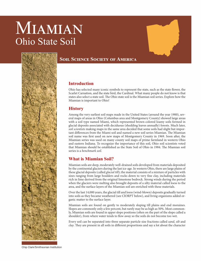
MiamianOhio State Soil
Chip Clark/Smithsonian Institution
Soil Science Society of America
IntroductionOhio has selected many iconic symbols to represent the state, such as the state flower, the Scarlet Carnation, and the state bird, the Cardinal. What many people do not know is that states also select a state soil. The Ohio state soil is the Miamian soil series. Explore how the Miamian is important to Ohio!
HistoryAmong the very earliest soil maps made in the United States (around the year 1900), sev-eral maps of areas in Ohio (Columbus area and Montgomery County) showed large areas with a soil type named Miami, which represented brown-colored loamy soils formed in glacial deposits associated with deciduous (shedding leaves annually) forests. Much later, soil scientists making maps in the same area decided that some soils had slight but impor-tant differences from the Miami soil and named a new soil series Miamian. The Miamian soil name was first used on new maps of Montgomery County in 1969. Soon after, the Miamian series was used on many county soil maps of prime farmland in western Ohio and eastern Indiana. To recognize the importance of this soil, Ohio soil scientists voted that Miamian should be established as the State Soil of Ohio in 1984. The Miamian soil series is a benchmark soil.
What is Miamian Soil?Miamian soils are deep, moderately well-drained soils developed from materials deposited by the continental glaciers during the last ice-age. In western Ohio, there are large plains of these glacial deposits (called glacial till); the material consists of a mixture of particles with sizes ranging from large boulders and rocks down to very fine clay, including materials rich in lime derived from the original limestone bedrock. Strong winds during the period when the glaciers were melting also brought deposits of a silty material called loess to the area, and the surface layers of the Miamian soil are enriched with these materials.
Over the last 14,000 years, the glacial till and loess (wind-blown) deposits gradually turned into soils as they became weathered (see ClORPT below), and living organisms added or-ganic matter to the surface layer.
Miamian soils are found on gently to moderately sloping till plains and end moraines. Slopes are commonly only a few percent, but rarely may be as high as 50%. Most common-ly, Miamian soils are found in upper slope positions (often on the part of the slope called a shoulder), from where water tends to flow away so the soils do not become too wet.
Every soil can be separated into three separate particle size fractions called sand, silt and clay. They are present in all soils in different proportions and say a lot about the character
2
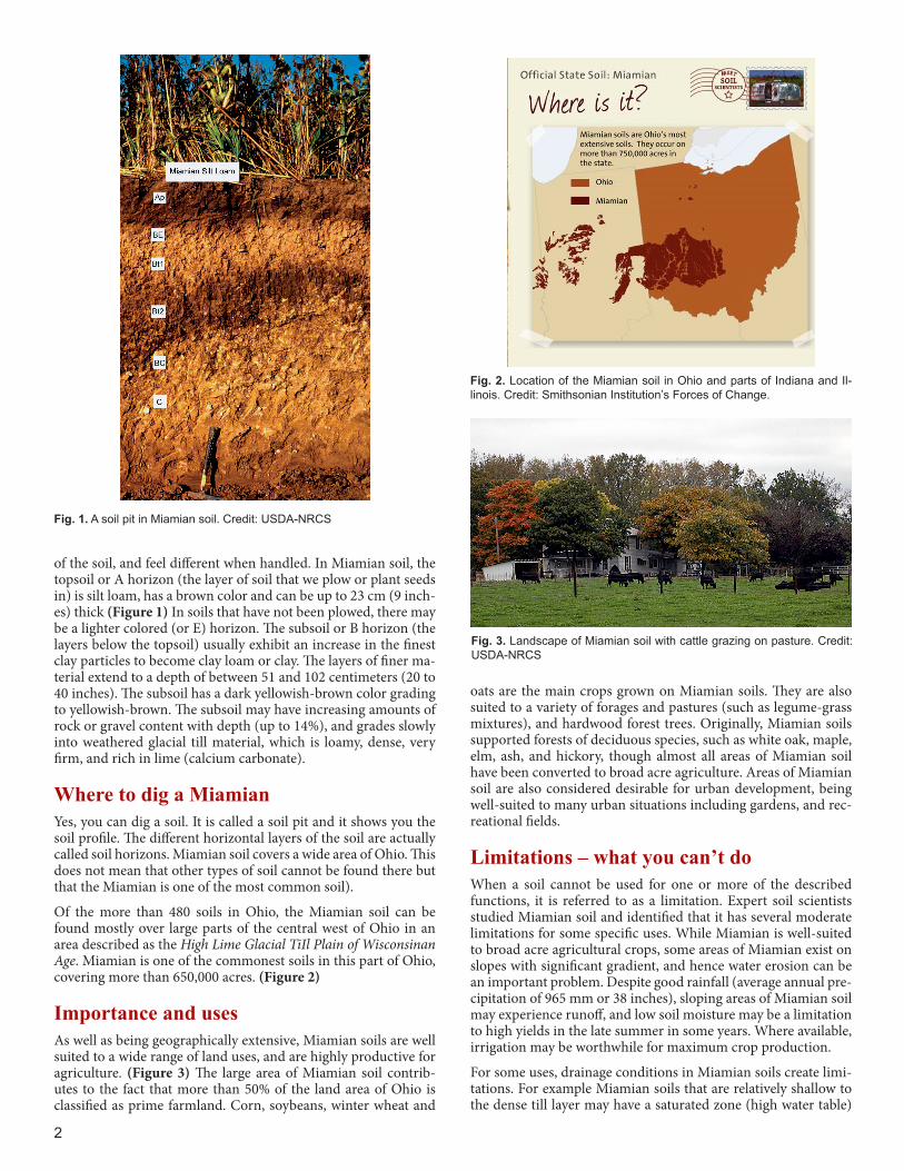
of the soil, and feel different when handled. In Miamian soil, the topsoil or A horizon (the layer of soil that we plow or plant seeds in) is silt loam, has a brown color and can be up to 23 cm (9 inch-es) thick (Figure 1) In soils that have not been plowed, there may be a lighter colored (or E) horizon. The subsoil or B horizon (the layers below the topsoil) usually exhibit an increase in the finest clay particles to become clay loam or clay. The layers of finer ma-terial extend to a depth of between 51 and 102 centimeters (20 to 40 inches). The subsoil has a dark yellowish-brown color grading to yellowish-brown. The subsoil may have increasing amounts of rock or gravel content with depth (up to 14%), and grades slowly into weathered glacial till material, which is loamy, dense, very firm, and rich in lime (calcium carbonate).
Where to dig a MiamianYes, you can dig a soil. It is called a soil pit and it shows you the soil profile. The different horizontal layers of the soil are actually called soil horizons. Miamian soil covers a wide area of Ohio. This does not mean that other types of soil cannot be found there but that the Miamian is one of the most common soil).
Of the more than 480 soils in Ohio, the Miamian soil can be found mostly over large parts of the central west of Ohio in an area described as the High Lime Glacial TiIl Plain of Wisconsinan Age. Miamian is one of the commonest soils in this part of Ohio, covering more than 650,000 acres. (Figure 2)
Importance and usesAs well as being geographically extensive, Miamian soils are well suited to a wide range of land uses, and are highly productive for agriculture. (Figure 3) The large area of Miamian soil contrib-utes to the fact that more than 50% of the land area of Ohio is classified as prime farmland. Corn, soybeans, winter wheat and
oats are the main crops grown on Miamian soils. They are also suited to a variety of forages and pastures (such as legume-grass mixtures), and hardwood forest trees. Originally, Miamian soils supported forests of deciduous species, such as white oak, maple, elm, ash, and hickory, though almost all areas of Miamian soil have been converted to broad acre agriculture. Areas of Miamian soil are also considered desirable for urban development, being well-suited to many urban situations including gardens, and rec-reational fields.
Limitations – what you can’t doWhen a soil cannot be used for one or more of the described functions, it is referred to as a limitation. Expert soil scientists studied Miamian soil and identified that it has several moderate limitations for some specific uses. While Miamian is well-suited to broad acre agricultural crops, some areas of Miamian exist on slopes with significant gradient, and hence water erosion can be an important problem. Despite good rainfall (average annual pre-cipitation of 965 mm or 38 inches), sloping areas of Miamian soil may experience runoff, and low soil moisture may be a limitation to high yields in the late summer in some years. Where available, irrigation may be worthwhile for maximum crop production.
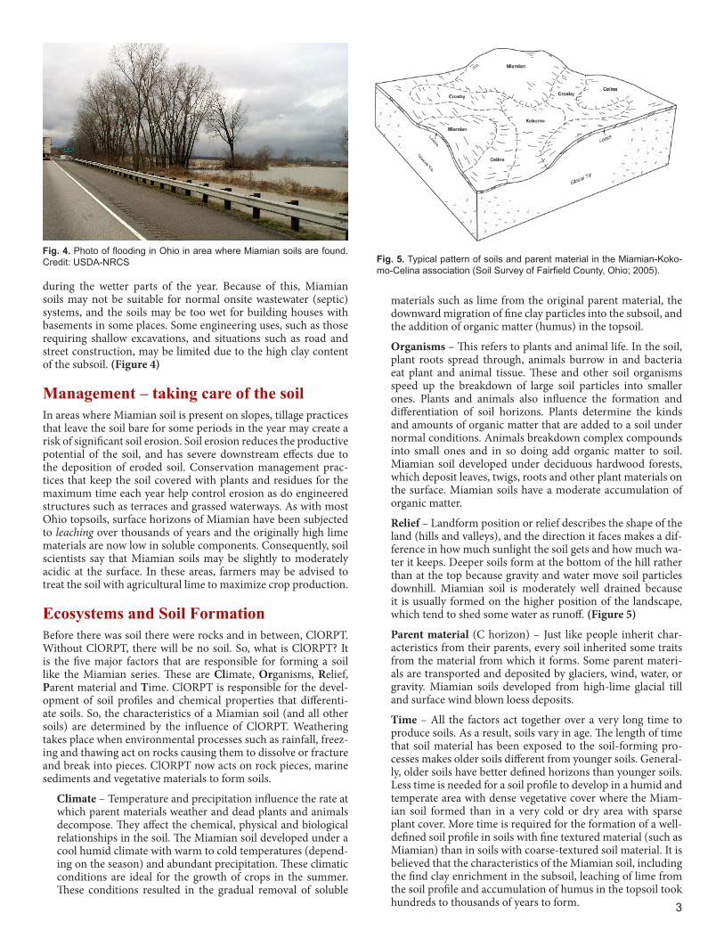
For some uses, drainage conditions in Miamian soils create limi-tations. For example Miamian soils that are relatively shallow to the dense till layer may have a saturated zone (high water table)
Fig. 1. A soil pit in Miamian soil. Credit: USDA-NRCS
Fig. 3. Landscape of Miamian soil with cattle grazing on pasture. Credit: USDA-NRCS
Fig. 2. Location of the Miamian soil in Ohio and parts of Indiana and Il-linois. Credit: Smithsonian Institution’s Forces of Change.
3
during the wetter parts of the year. Because of this, Miamian soils may not be suitable for normal onsite wastewater (septic) systems, and the soils may be too wet for building houses with basements in some places. Some engineering uses, such as those requiring shallow excavations, and situations such as road and street construction, may be limited due to the high clay content of the subsoil. (Figure 4)
Management – taking care of the soilIn areas where Miamian soil is present on slopes, tillage practices that leave the soil bare for some periods in the year may create a risk of significant soil erosion. Soil erosion reduces the productive potential of the soil, and has severe downstream effects due to the deposition of eroded soil. Conservation management prac-tices that keep the soil covered with plants and residues for the maximum time each year help control erosion as do engineered structures such as terraces and grassed waterways. As with most Ohio topsoils, surface horizons of Miamian have been subjected to leaching over thousands of years and the originally high lime materials are now low in soluble components. Consequently, soil scientists say that Miamian soils may be slightly to moderately acidic at the surface. In these areas, farmers may be advised to treat the soil with agricultural lime to maximize crop production.
Ecosystems and Soil Formation Before there was soil there were rocks and in between, ClORPT. Without ClORPT, there will be no soil. So, what is ClORPT? It is the five major factors that are responsible for forming a soil like the Miamian series. These are Climate, Organisms, Relief, Parent material and Time. ClORPT is responsible for the devel-opment of soil profiles and chemical properties that differenti-ate soils. So, the characteristics of a Miamian soil (and all other soils) are determined by the influence of ClORPT. Weathering takes place when environmental processes such as rainfall, freez-ing and thawing act on rocks causing them to dissolve or fracture and break into pieces. ClORPT now acts on rock pieces, marine sediments and vegetative materials to form soils.
Climate – Temperature and precipitation influence the rate at which parent materials weather and dead plants and animals decompose. They affect the chemical, physical and biological relationships in the soil. The Miamian soil developed under a cool humid climate with warm to cold temperatures (depend-ing on the season) and abundant precipitation. These climatic conditions are ideal for the growth of crops in the summer. These conditions resulted in the gradual removal of soluble
Fig. 4. Photo of flooding in Ohio in area where Miamian soils are found. Credit: USDA-NRCS Fig. 5. Typical pattern of soils and parent material in the Miamian-Koko-
mo-Celina association (Soil Survey of Fairfield County, Ohio; 2005).
materials such as lime from the original parent material, the downward migration of fine clay particles into the subsoil, and the addition of organic matter (humus) in the topsoil.
Organisms – This refers to plants and animal life. In the soil, plant roots spread through, animals burrow in and bacteria eat plant and animal tissue. These and other soil organisms speed up the breakdown of large soil particles into smaller ones. Plants and animals also influence the formation and differentiation of soil horizons. Plants determine the kinds and amounts of organic matter that are added to a soil under normal conditions. Animals breakdown complex compounds into small ones and in so doing add organic matter to soil. Miamian soil developed under deciduous hardwood forests, which deposit leaves, twigs, roots and other plant materials on the surface. Miamian soils have a moderate accumulation of organic matter.
Relief – Landform position or relief describes the shape of the land (hills and valleys), and the direction it faces makes a dif-ference in how much sunlight the soil gets and how much wa-ter it keeps. Deeper soils form at the bottom of the hill rather than at the top because gravity and water move soil particles downhill. Miamian soil is moderately well drained because it is usually formed on the higher position of the landscape, which tend to shed some water as runoff. (Figure 5)
Parent material (C horizon) – Just like people inherit char-acteristics from their parents, every soil inherited some traits from the material from which it forms. Some parent materi-als are transported and deposited by glaciers, wind, water, or gravity. Miamian soils developed from high-lime glacial till and surface wind blown loess deposits.
Time – All the factors act together over a very long time to produce soils. As a result, soils vary in age. The length of time that soil material has been exposed to the soil-forming pro-cesses makes older soils different from younger soils. General-ly, older soils have better defined horizons than younger soils. Less time is needed for a soil profile to develop in a humid and temperate area with dense vegetative cover where the Miam-ian soil formed than in a very cold or dry area with sparse plant cover. More time is required for the formation of a well-defined soil profile in soils with fine textured material (such as Miamian) than in soils with coarse-textured soil material. It is believed that the characteristics of the Miamian soil, including the find clay enrichment in the subsoil, leaching of lime from the soil profile and accumulation of humus in the topsoil took hundreds to thousands of years to form.
4
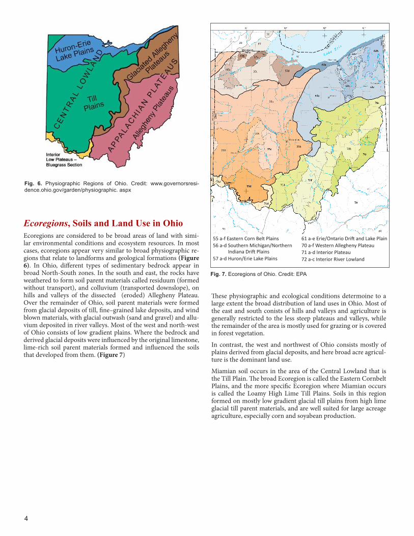
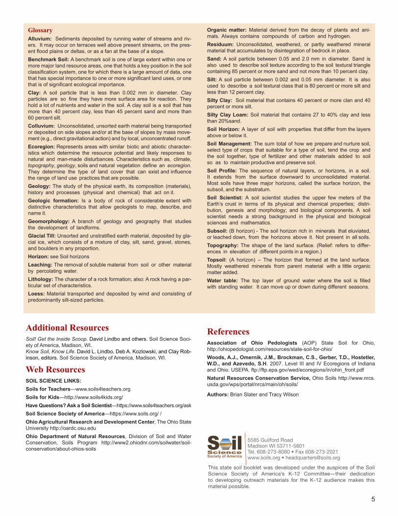
Ecoregions, Soils and Land Use in OhioEcoregions are considered to be broad areas of land with simi-lar environmental conditions and ecosystem resources. In most cases, ecoregions appear very similar to broad physiographic re-gions that relate to landforms and geological formations (Figure 6). In Ohio, different types of sedimentary bedrock appear in broad North-South zones. In the south and east, the rocks have weathered to form soil parent materials called residuum (formed without transport), and colluvium (transported downslope), on hills and valleys of the dissected (eroded) Allegheny Plateau. Over the remainder of Ohio, soil parent materials were formed from glacial deposits of till, fine–grained lake deposits, and wind blown materials, with glacial outwash (sand and gravel) and allu-vium deposited in river valleys. Most of the west and north-west of Ohio consists of low gradient plains. Where the bedrock and derived glacial deposits were influenced by the original limestone, lime-rich soil parent materials formed and influenced the soils that developed from them. (Figure 7)
Fig. 6. Physiographic Regions of Ohio. Credit: www.governorsresi-dence.ohio.gov/garden/physiographic. aspx
55 a-f Eastern Corn Belt Plains56 a-d Southern Michigan/Northern
Indiana Drift Plains57 a-d Huron/Erie Lake Plains
61 a-e Erie/Ontario Drift and Lake Plain70 a-f Western Allegheny Plateau71 a-d Interior Plateau72 a-c Interior River Lowland
Fig. 7. Ecoregions of Ohio. Credit: EPA
These physiographic and ecological conditions determoine to a large extent the broad distribution of land uses in Ohio. Most of the east and south conists of hills and valleys and agriculture is generally restricted to the less steep plateaus and valleys, while the remainder of the area is mostly used for grazing or is covered in forest vegetation.
In contrast, the west and northwest of Ohio consists mostly of plains derived from glacial deposits, and here broad acre agricul-ture is the dominant land use.
Miamian soil occurs in the area of the Central Lowland that is the Till Plain. The broad Ecoregion is called the Eastern Cornbelt Plains, and the more specific Ecoregion where Miamian occurs is called the Loamy High Lime Till Plains. Soils in this region formed on mostly low gradient glacial till plains from high lime glacial till parent materials, and are well suited for large acreage agriculture, especially corn and soyabean production.
5
Additional ResourcesSoil! Get the Inside Scoop. David Lindbo and others. Soil Science Soci-ety of America, Madison, WI.Know Soil, Know Life. David L. Lindbo, Deb A. Kozlowski, and Clay Rob-inson, editors. Soil Science Society of America, Madison, WI.
Web Resources SOIL SCIENCE LINKS:Soils for Teachers—www.soils4teachers.orgSoils for Kids—http://www.soils4kids.org/Have Questions? Ask a Soil Scientist—https://www.soils4teachers.org/askSoil Science Society of America—https://www.soils.org/ /Ohio Agricultural Research and Development Center, The Ohio State University http://oardc.osu.eduOhio Department of Natural Resources, Division of Soil and Water Conservation, Soils Program http://www2.ohiodnr.com/soilwater/soil-conservation/about-ohios-soils
5585 Guilford RoadMadison WI 53711-5801Tel. 608-273-8080 • Fax 608-273-2021www.soils.org • [email protected]
This state soil booklet was developed under the auspices of the Soil Science Society of America’s K-12 Committee—their dedication to developing outreach materials for the K-12 audience makes this material possible.
GlossaryAlluvium: Sediments deposited by running water of streams and riv-ers. It may occur on terraces well above present streams, on the pres-ent flood plains or deltas, or as a fan at the base of a slope.Benchmark Soil: A benchmark soil is one of large extent within one or more major land resource areas, one that holds a key position in the soil classification system, one for which there is a large amount of data, one that has special importance to one or more significant land uses, or one that is of significant ecological importance.Clay: A soil particle that is less than 0.002 mm in diameter. Clay particles are so fine they have more surface area for reaction. They hold a lot of nutrients and water in the soil. A clay soil is a soil that has more than 40 percent clay, less than 45 percent sand and more than 60 percent silt.Colluvium: Unconsolidated, unsorted earth material being transported or deposited on side slopes and/or at the base of slopes by mass move-ment (e.g., direct gravitational action) and by local, unconcentrated runoff.Ecoregion: Represents areas with similar biotic and abiotic character-istics which determine the resource potential and likely responses to natural and man-made disturbances. Characteristics such as, climate, topography, geology, soils and natural vegetation define an ecoregion. They determine the type of land cover that can exist and influence the range of land use practices that are possible.Geology: The study of the physical earth, its composition (materials), history and processes (physical and chemical) that act on it.Geologic formation: Is a body of rock of considerable extent with distinctive characteristics that allow geologists to map, describe, and name it.Geomorphology: A branch of geology and geography that studies the development of landforms.Glacial Till: Unsorted and unstratified earth material, deposited by gla-cial ice, which consists of a mixture of clay, silt, sand, gravel, stones, and boulders in any proportion.Horizon: see Soil horizonsLeaching: The removal of soluble material from soil or other material by percolating water.Lithology: The character of a rock formation; also: A rock having a par-ticular set of characteristics.Loess: Material transported and deposited by wind and consisting of predominantly silt-sized particles.
Organic matter: Material derived from the decay of plants and ani-mals. Always contains compounds of carbon and hydrogen.Residuum: Unconsolidated, weathered, or partly weathered mineral material that accumulates by disintegration of bedrock in place.Sand: A soil particle between 0.05 and 2.0 mm in diameter. Sand is also used to describe soil texture according to the soil textural triangle containing 85 percent or more sand and not more than 10 percent clay.Silt: A soil particle between 0.002 and 0.05 mm diameter. It is also used to describe a soil textural class that is 80 percent or more silt and less than 12 percent clay.Silty Clay: Soil material that contains 40 percent or more clan and 40 percent or more silt.Silty Clay Loam: Soil material that contains 27 to 40% clay and less than 20%sand.Soil Horizon: A layer of soil with properties that differ from the layers above or below it.Soil Management: The sum total of how we prepare and nurture soil, select type of crops that suitable for a type of soil, tend the crop and the soil together, type of fertilizer and other materials added to soil so as to maintain productive and preserve soil.Soil Profile: The sequence of natural layers, or horizons, in a soil. It extends from the surface downward to unconsolidated material. Most soils have three major horizons, called the surface horizon, the subsoil, and the substratum.Soil Scientist: A soil scientist studies the upper few meters of the Earth’s crust in terms of its physical and chemical properties; distri-bution, genesis and morphology; and biological components. A soil scientist needs a strong background in the physical and biological sciences and mathematics.Subsoil: (B horizon) - The soil horizon rich in minerals that eluviated, or leached down, from the horizons above it. Not present in all soils.Topography: The shape of the land surface. (Relief: refers to differ-ences in elevation of different points in a region.)Topsoil: (A horizon) – The horizon that formed at the land surface. Mostly weathered minerals from parent material with a little organic matter added.Water table: The top layer of ground water where the soil is filled with standing water. It can move up or down during different seasons.
ReferencesAssociation of Ohio Pedologists (AOP) State Soil for Ohio, http://ohiopedologist.com/resources/state-soil-for-ohio/Woods, A.J., Omernik, J.M., Brockman, C.S., Gerber, T.D., Hostetler, W.D., and Azevedo, S.H. 2007. Level III and IV Ecoregions of Indiana and Ohio. USEPA. ftp://ftp.epa.gov/wed/ecoregions/in/ohin_front.pdfNatural Resources Conservation Service, Ohio Soils http://www.nrcs.usda.gov/wps/portal/nrcs/main/oh/soils/
Authors: Brian Slater and Tracy Wilson