Embed Size (px)
Citation preview
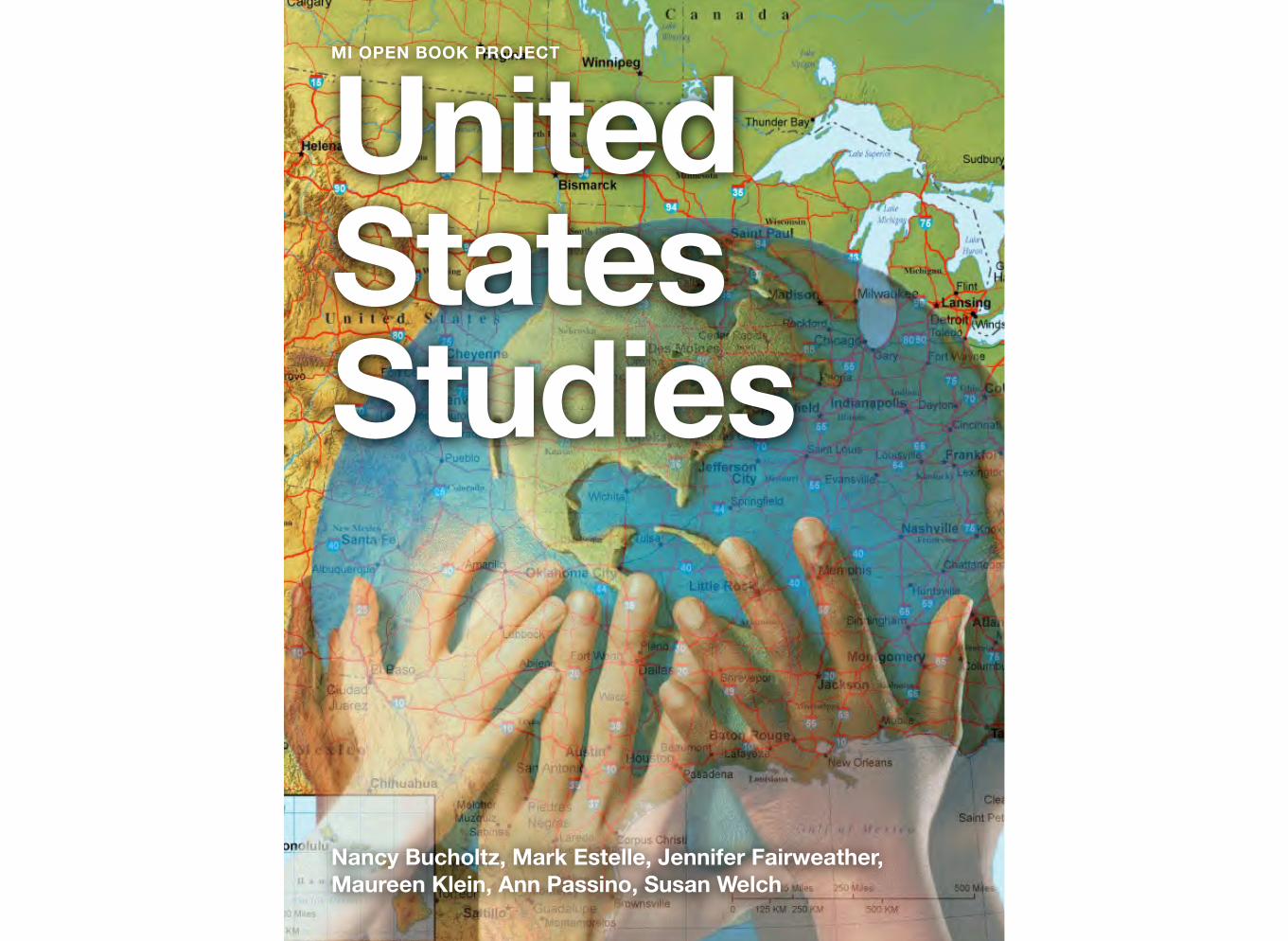
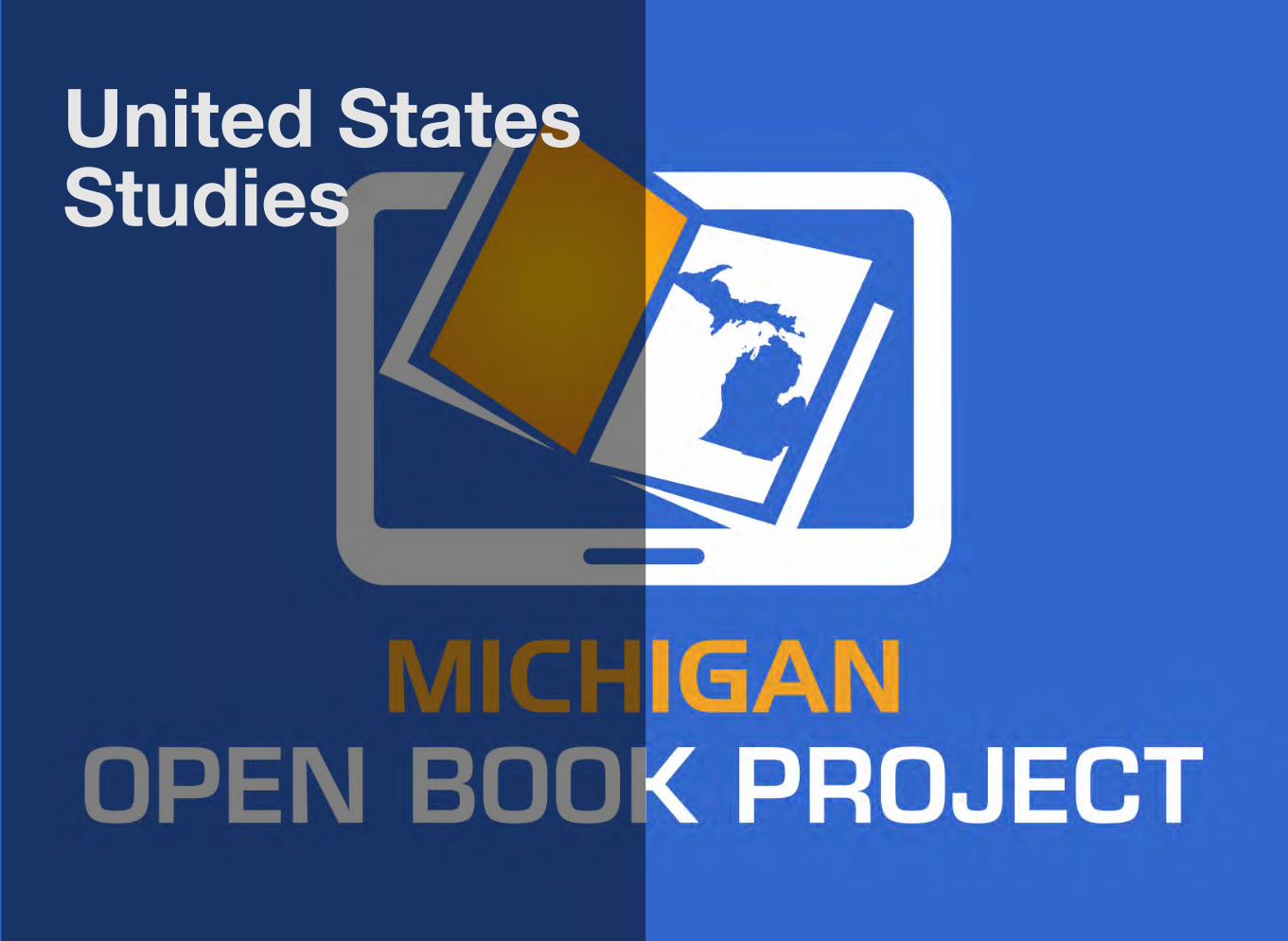
United States Studies
Nancy Bucholtz, Mark Estelle, Jennifer Fairweather, Maureen Klein, Ann Passino, Susan Welch
MI OPEN BOOK PROJECT
United States Studies
nCommercial-Sii
Attribution-No hareAlike CC BY-NC-SA
This is version 2.0.1 of this resource, released in August of 2016.
Information on the latest version and updates are available on the project homepage: http://textbooks.wmisd.org/dashboard.html
The text of this book is licensed under a Creative Commons NonCommercial-ShareAlike (CC-BY-NC-SA) license as part of Michigan’s participation in the national #GoOpen movement.
United States Studies
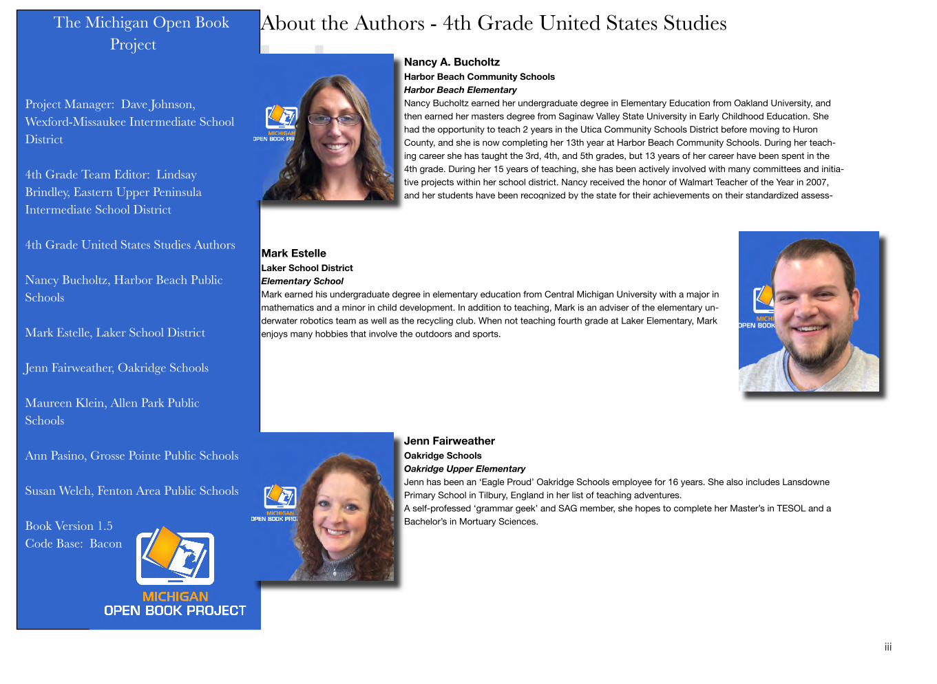
About the Authors - 4th Grade United States Studies
Jenn has been an ‘Eagle Proud’ Oakridge Schools employee for 16 years. She also includes Lansdowne Primary School in Tilbury, England in her list of teaching adventures. A self-professed ‘grammar geek’ and SAG member, she hopes to complete her Master’s in TESOL and a Bachelor’s in Mortuary Sciences.
Oakridge Upper Elementary
Jenn Fairweather Oakridge Schools
The Michigan Open Book Project
Project Manager: Dave Johnson, Wexford-Missaukee Intermediate School District
4th Grade Team Editor: Lindsay Brindley, Eastern Upper Peninsula Intermediate School District
4th Grade United States Studies Authors
Nancy Bucholtz, Harbor Beach Public Schools
Mark Estelle, Laker School District
Jenn Fairweather, Oakridge Schools
Maureen Klein, Allen Park Public Schools
Ann Pasino, Grosse Pointe Public Schools
Susan Welch, Fenton Area Public Schools
Book Version 1.5 Code Base: Bacon
Nancy A. Bucholtz Harbor Beach Community Schools Harbor Beach Elementary Nancy Bucholtz earned her undergraduate degree in Elementary Education from Oakland University, and then earned her masters degree from Saginaw Valley State University in Early Childhood Education. She had the opportunity to teach 2 years in the Utica Community Schools District before moving to Huron County, and she is now completing her 13th year at Harbor Beach Community Schools. During her teach-ing career she has taught the 3rd, 4th, and 5th grades, but 13 years of her career have been spent in the 4th grade. During her 15 years of teaching, she has been actively involved with many committees and initia-tive projects within her school district. Nancy received the honor of Walmart Teacher of the Year in 2007, and her students have been recognized by the state for their achievements on their standardized assess-
Mark Estelle Laker School District Elementary School Mark earned his undergraduate degree in elementary education from Central Michigan University with a major in mathematics and a minor in child development. In addition to teaching, Mark is an adviser of the elementary un-derwater robotics team as well as the recycling club. When not teaching fourth grade at Laker Elementary, Mark enjoys many hobbies that involve the outdoors and sports.
iii
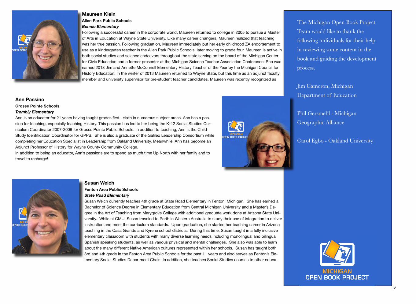
Following a successful career in the corporate world, Maureen returned to college in 2005 to pursue a Master of Arts in Education at Wayne State University. Like many career changers, Maureen realized that teaching was her true passion. Following graduation, Maureen immediately put her early childhood ZA endorsement to use as a kindergarten teacher in the Allen Park Public Schools, later moving to grade four. Maureen is active in both social studies and science endeavors throughout the state serving on the board of the Michigan Center for Civic Education and a former presenter at the Michigan Science Teacher Association Conference. She was named 2013 Jim and Annette McConnell Elementary History Teacher of the Year by the Michigan Council for History Education. In the winter of 2013 Maureen returned to Wayne State, but this time as an adjunct faculty member and university supervisor for pre-student teacher candidates. Maureen was recently recognized as
Bennie Elementary Allen Park Public Schools
Maureen Klein
Ann Passino Grosse Pointe Schools Trombly Elementary Ann is an educator for 21 years having taught grades first - sixth in numerous subject areas. Ann has a pas-sion for teaching, especially teaching History. This passion has led to her being the K-12 Social Studies Cur-riculum Coordinator 2007-2009 for Grosse Pointe Public Schools. In addition to teaching, Ann is the Child Study Identification Coordinator for GPPS. She is also a graduate of the Galileo Leadership Consortium while completing her Education Specialist in Leadership from Oakland University. Meanwhile, Ann has become an Adjunct Professor of History for Wayne County Community College. In addition to being an educator, Ann’s passions are to spend as much time Up North with her family and to travel to recharge!
Susan Welch Fenton Area Public Schools State Road Elementary Susan Welch currently teaches 4th grade at State Road Elementary in Fenton, Michigan. She has earned a Bachelor of Science Degree in Elementary Education from Central Michigan University and a Master’s De-gree in the Art of Teaching from Marygrove College with additional graduate work done at Arizona State Uni-versity. While at CMU, Susan traveled to Perth in Western Australia to study their use of integration to deliver instruction and meet the curriculum standards. Upon graduation, she started her teaching career in Arizona teaching in the Casa Grande and Kyrene school districts. During this time, Susan taught in a fully inclusive elementary classroom with students with many diverse learning needs including monolingual and bilingual Spanish speaking students, as well as various physical and mental challenges. She also was able to learn about the many different Native American cultures represented within her schools. Susan has taught both 3rd and 4th grade in the Fenton Area Public Schools for the past 11 years and also serves as Fenton’s Ele-mentary Social Studies Department Chair. In addition, she teaches Social Studies courses to other educa-
The Michigan Open Book Project Team would like to thank the following individuals for their help in reviewing some content in the book and guiding the development process.
Jim Cameron, Michigan Department of Education
Phil Gersmehl - Michigan Geographic Alliance
Carol Egbo - Oakland University
iv
David A. Johnson Project Manager Michigan Open Book Project Dave began his career teaching 8th grade United States History in Mesick, Michigan. After almost a decade in the classroom, he took a job at Wexford-Missaukee Intermediate School District (WMISD) as an Instructional Consultant for Social Studies. He is shared across 11 ISDs in Northern Michigan that form the Northern Michigan Learning Consortium. He com-pleted his Masters in Educational Leadership through Central Michigan University in 2011 and is Co-Project Director of the Performance Assessments of Social Studies Thinking (PASST) Project in addition to his duties as the Project Manager for MI Open Book.
v
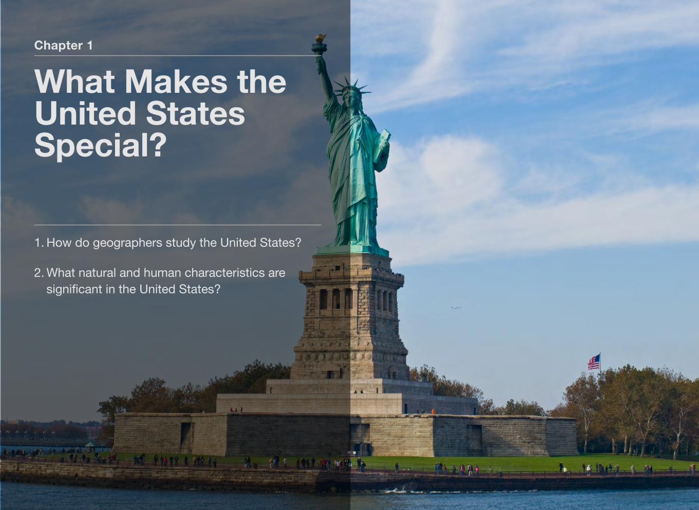
Chapter 1
What Makes the United States Special?
1. How do geographers study the United States?
2. What natural and human characteristics are significant in the United States?
Section 1
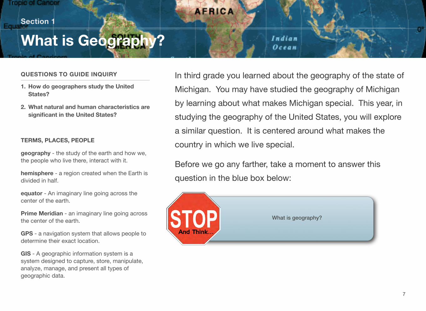
What is Geography?
QUESTIONS TO GUIDE INQUIRY
1. How do geographers study the UnitedStates?
2. What natural and human characteristics are significant in the United States?
TERMS, PLACES, PEOPLE
geography - the study of the earth and how we,the people who live there, interact with it.
hemisphere - a region created when the Earth is divided in half.
equator - An imaginary line going across the center of the earth.
Prime Meridian - an imaginary line going across the center of the earth.
GPS - a navigation system that allows people todetermine their exact location.
GIS - A geographic information system is asystem designed to capture, store, manipulate, analyze, manage, and present all types of geographic data.
In third grade you learned about the geography of the state of Michigan. You may have studied the geography of Michigan by learning about what makes Michigan special. This year, in studying the geography of the United States, you will explore a similar question. It is centered around what makes the country in which we live special.
Before we go any farther, take a moment to answer this question in the blue box below:
What is geography?
7
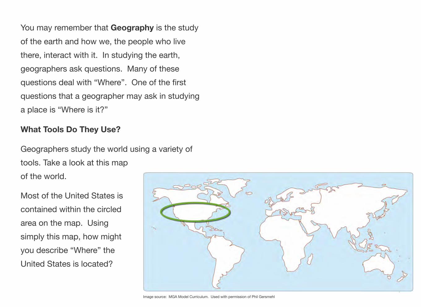
You may remember that Geography is the study of the earth and how we, the people who live there, interact with it. In studying the earth, geographers ask questions. Many of these questions deal with “Where”. One of the first questions that a geographer may ask in studying a place is “Where is it?”
What Tools Do They Use?
Geographers study the world using a variety of tools. Take a look at this map of the world.
Most of the United States is contained within the circled area on the map. Using simply this map, how might you describe “Where” the United States is located?
8 Image source: MGA Model Curriculum. Used with permission of Phil Gersmehl
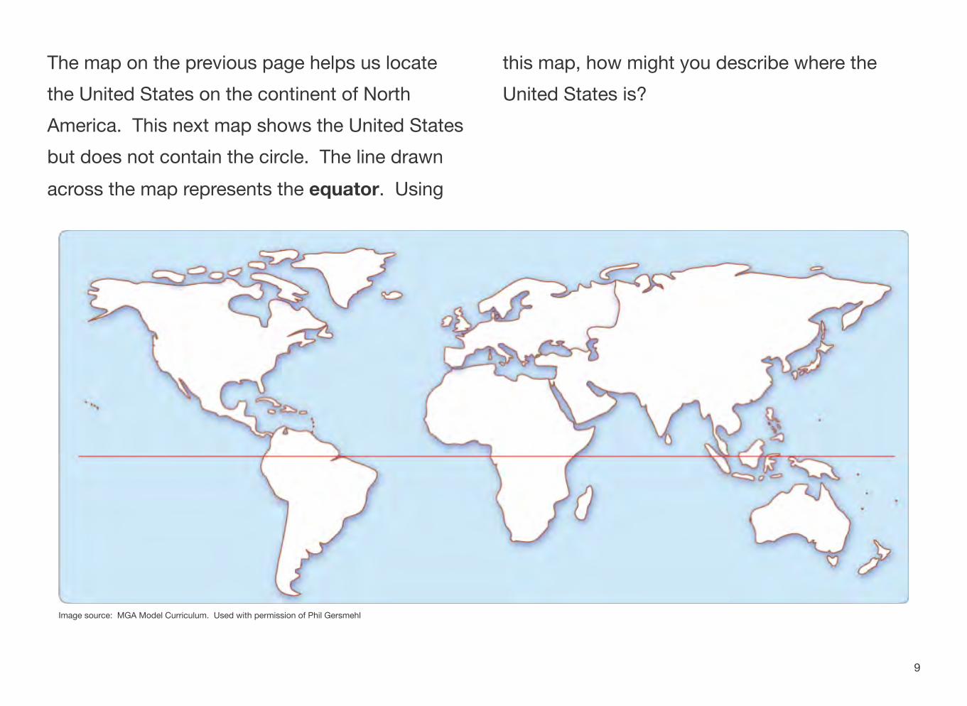
The map on the previous page helps us locate the United States on the continent of North America. This next map shows the United States but does not contain the circle. The line drawn across the map represents the equator. Using
this map, how might you describe where the United States is?
Image source: MGA Model Curriculum. Used with permission of Phil Gersmehl
9
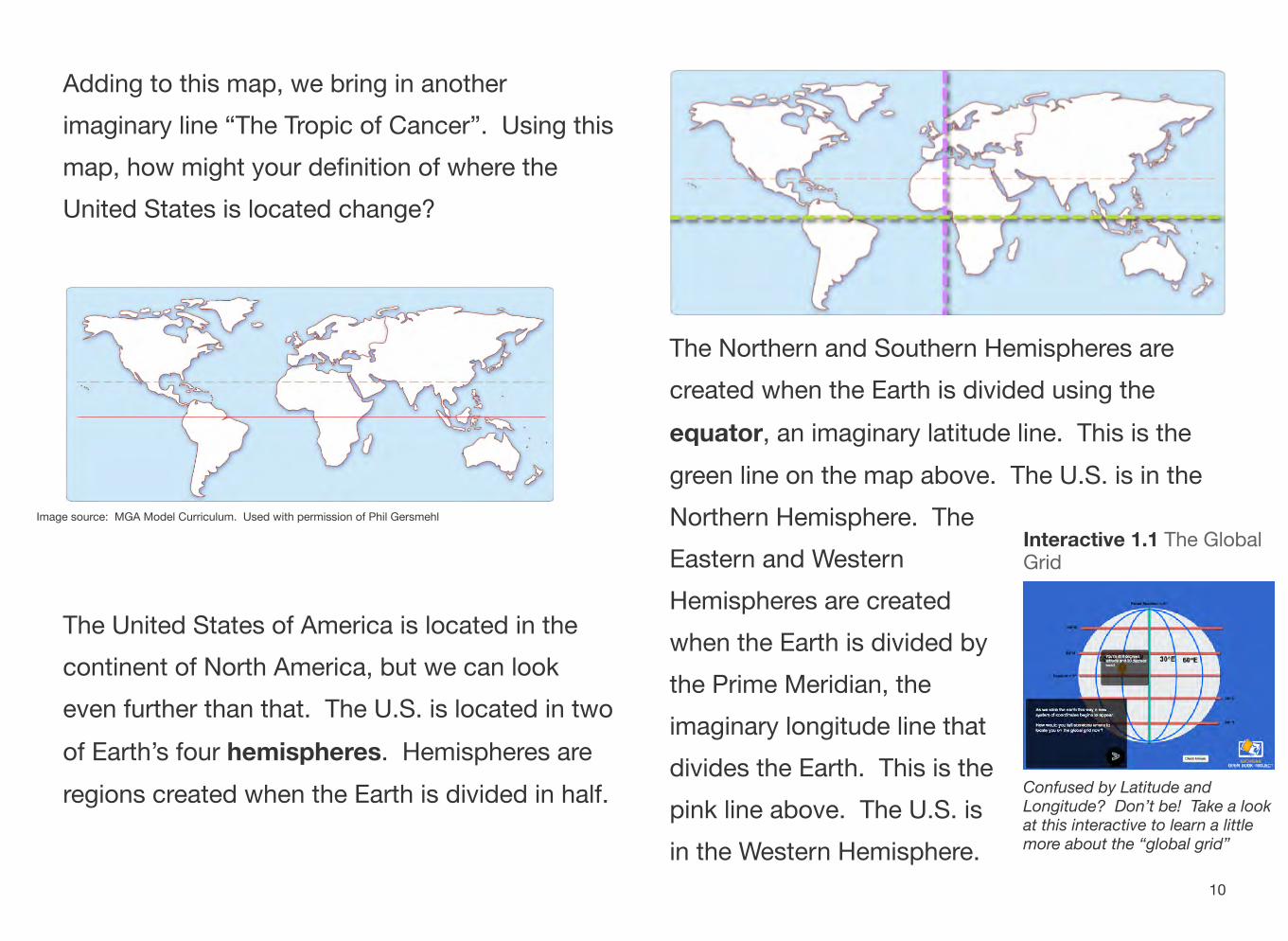
Adding to this map, we bring in another imaginary line “The Tropic of Cancer”. Using this map, how might your definition of where the United States is located change?
Image source: MGA Model Curriculum. Used with permission of Phil Gersmehl
The United States of America is located in the continent of North America, but we can look even further than that. The U.S. is located in two of Earth’s four hemispheres. Hemispheres are regions created when the Earth is divided in half.
Northern Hemisphere. The Eastern and Western Hemispheres are created when the Earth is divided by the Prime Meridian, the imaginary longitude line that divides the Earth. This is the pink line above. The U.S. is in the Western Hemisphere.
The Northern and Southern Hemispheres are created when the Earth is divided using the equator, an imaginary latitude line. This is the green line on the map above. The U.S. is in the
Interactive 1.1 The Global Grid
Confused by Latitude andLongitude? Don’t be! Take a look at this interactive to learn a little more about the “global grid”
10
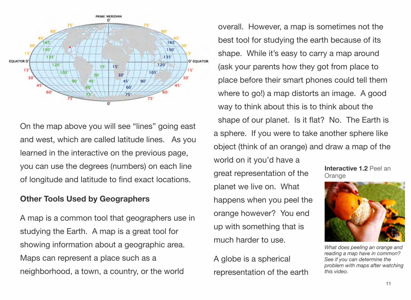
On the map above you will see “lines” going east and west, which are called latitude lines. As you learned in the interactive on the previous page, you can use the degrees (numbers) on each line of longitude and latitude to find exact locations.
Other Tools Used by Geographers
A map is a common tool that geographers use in studying the Earth. A map is a great tool for showing information about a geographic area. Maps can represent a place such as a neighborhood, a town, a country, or the world
overall. However, a map is sometimes not the best tool for studying the earth because of its shape. While it’s easy to carry a map around (ask your parents how they got from place to place before their smart phones could tell them where to go!) a map distorts an image. A good way to think about this is to think about the shape of our planet. Is it flat? No. The Earth is
a sphere. If you were to take another sphere like object (think of an orange) and draw a map of the world on it you’d have a
Interactive 1.2 Peel angreat representation of the Orange planet we live on. What happens when you peel the orange however? You end up with something that is much harder to use.
What does peeling an orange andreading a map have in common?
A globe is a spherical See if you can determine theproblem with maps after watching this video.representation of the earth
11
and is much more accurate. Does your classroom have a globe? Would a globe be useful if you were taking a road trip? Why or why not?
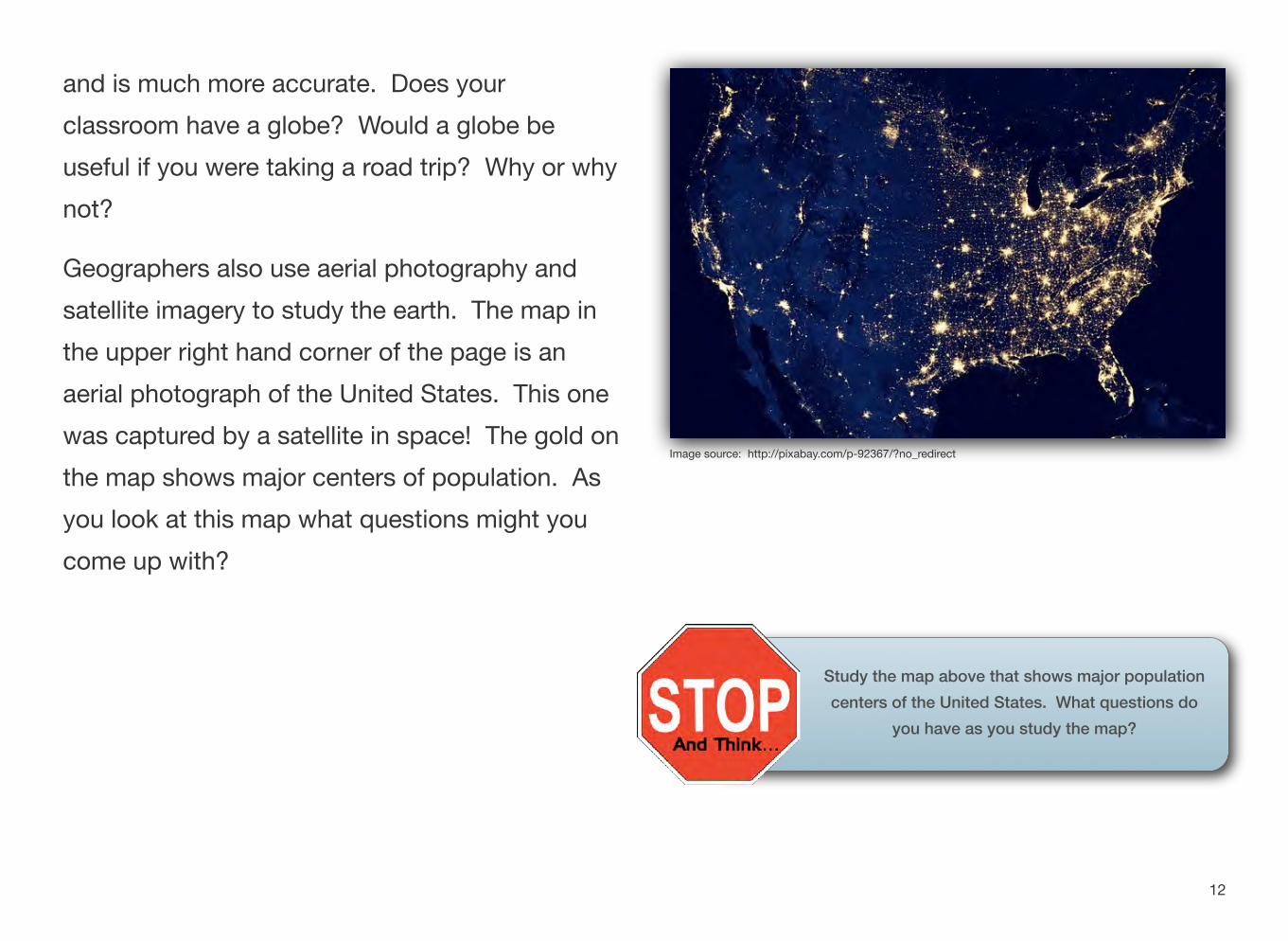
Geographers also use aerial photography and satellite imagery to study the earth. The map in the upper right hand corner of the page is an aerial photograph of the United States. This one was captured by a satellite in space! The gold on the map shows major centers of population. As you look at this map what questions might you come up with?
Image source: http://pixabay.com/p-92367/?no_redirect
Study the map above that shows major population centers of the United States. What questions do
you have as you study the map?
12
Have you ever been on a long road trip? When your grandparents were kids they probably relied heavily on a map to travel from place to place. Your parents may have as well. As we have entered the information age, they probably got from place to place using a GPS device. It also probably came on their smart phones. GPS stands for “global positioning system” and it makes use of satellites in orbit to collect information about where a user is on earth.
How might a geographer use a GPS device?
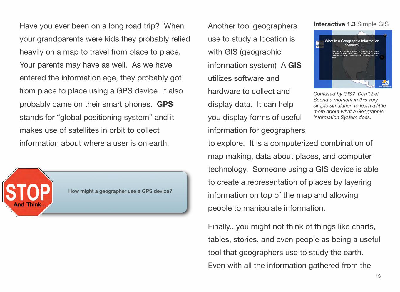
Another tool geographers Interactive 1.3 Simple GIS
use to study a location is with GIS (geographic information system) A GIS utilizes software and hardware to collect and Confused by GIS? Don’t be!
Spend a moment in this verydisplay data. It can help simple simulation to learn a little more about what a Geographic
you display forms of useful Information System does.
information for geographers to explore. It is a computerized combination of map making, data about places, and computer technology. Someone using a GIS device is able to create a representation of places by layering information on top of the map and allowing people to manipulate information.
Finally...you might not think of things like charts, tables, stories, and even people as being a useful tool that geographers use to study the earth. Even with all the information gathered from the
13
tools we’ve already explored, sometimes more knowledge is needed. Geographers may look at historical data, interview people who were at a place a long time ago, and even read stories from the past to help study a place.
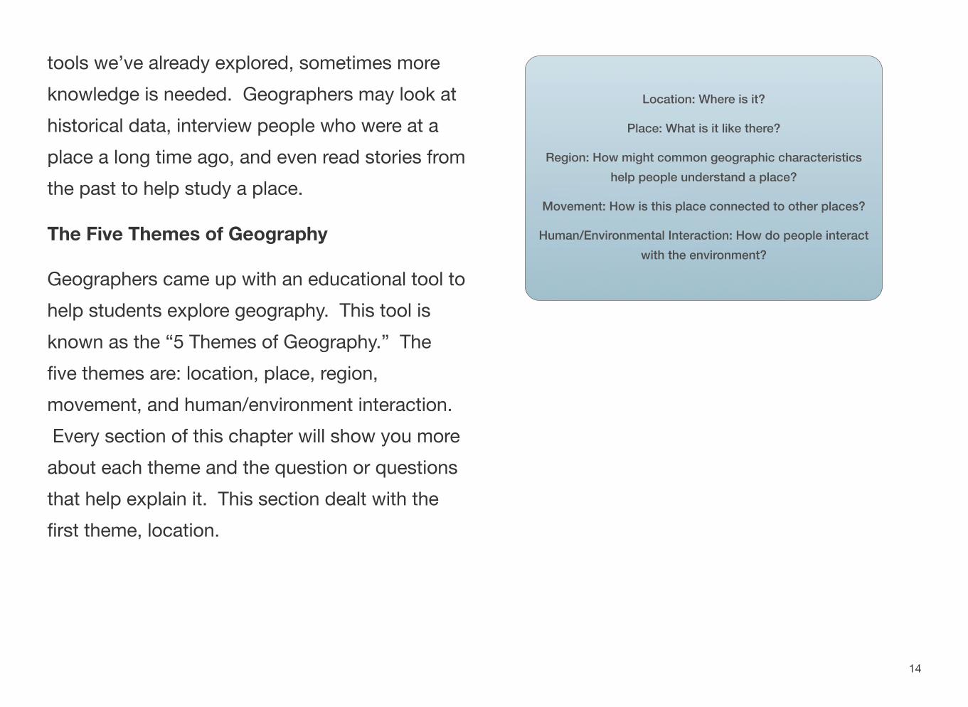
The Five Themes of Geography
Geographers came up with an educational tool to help students explore geography. This tool is known as the “5 Themes of Geography.” The five themes are: location, place, region, movement, and human/environment interaction. Every section of this chapter will show you more
about each theme and the question or questions that help explain it. This section dealt with the first theme, location.
Location: Where is it?
Place: What is it like there?
Region: How might common geographic characteristics help people understand a place?
Movement: How is this place connected to other places?
Human/Environmental Interaction: How do people interact with the environment?
14
Section 2
Place - What is it Like There?
QUESTIONS TO GUIDE INQUIRY
1. How do geographers study the UnitedStates?
2. What natural and human characteristics are significant in the United States?
TERMS, PLACES, PEOPLE
physical characteristics - another term for natural characteristics, parts of a place not madeby humans.
special purpose maps - maps showingcharacteristics of an area such as elevation, temperature, population, or the location of metropolitan areas
Physical Characteristics
Now that you understand more about how to define where the United States is located, it’s time to tackle another question that geographers ask in examining the United States – What is it like there? Students around the
Interactive 1.4 Eight MajorUnited States study the major physical Physical Features of the
United Statesfeatures of the United States that help us answer this question. Take a moment to take a look at this video that describes some of the physical features of the United States.
This short video highlights eight ofthe major physical features from the United States. .
15
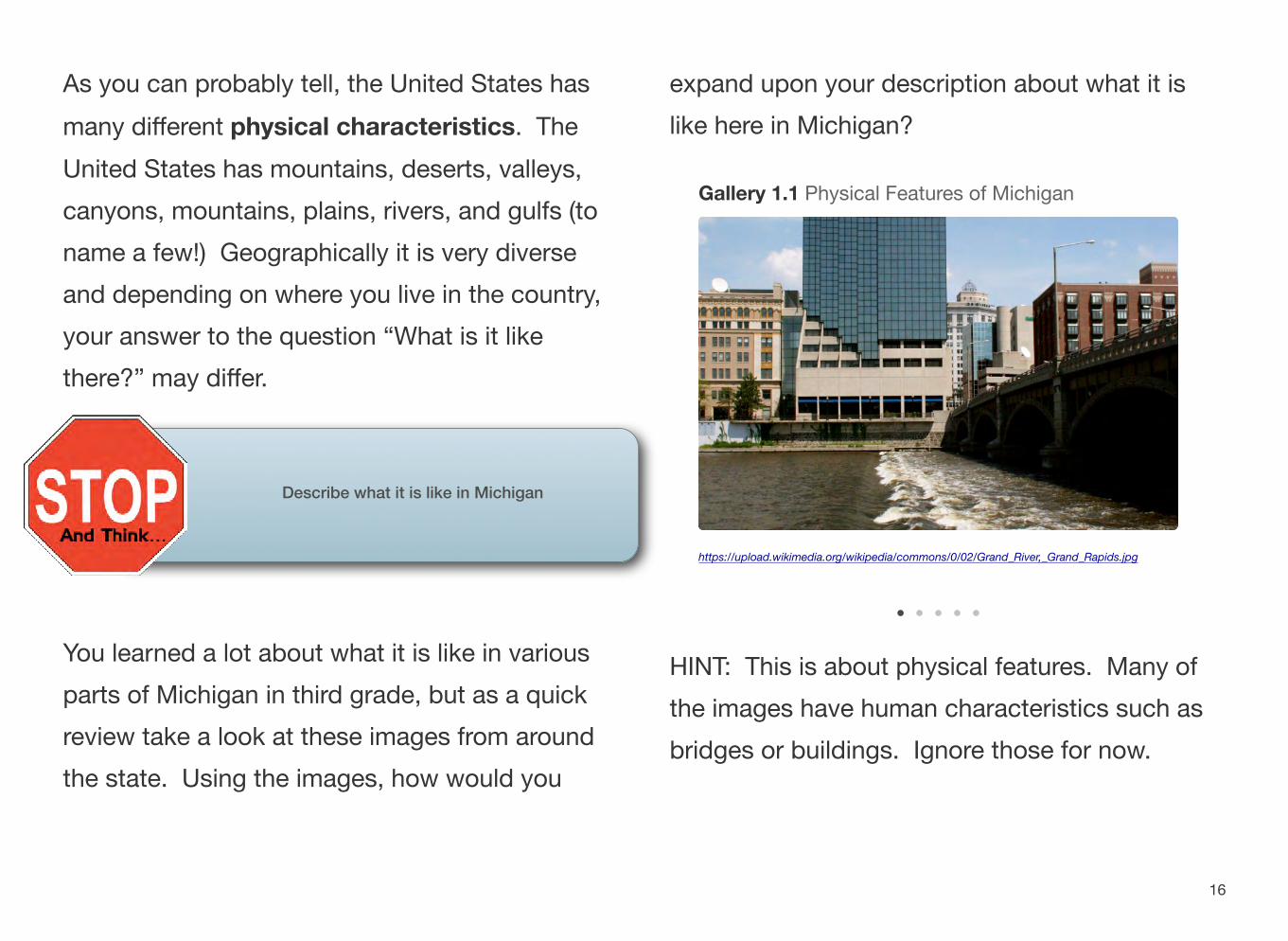
As you can probably tell, the United States has many different physical characteristics. The United States has mountains, deserts, valleys, canyons, mountains, plains, rivers, and gulfs (to name a few!) Geographically it is very diverse and depending on where you live in the country, your answer to the question “What is it like there?” may differ.
Describe what it is like in Michigan
You learned a lot about what it is like in various parts of Michigan in third grade, but as a quick review take a look at these images from around the state. Using the images, how would you
expand upon your description about what it is like here in Michigan?
Gallery 1.1 Physical Features of Michigan
https://upload.wikimedia.org/wikipedia/commons/0/02/Grand_River,_Grand_Rapids.jpg
HINT: This is about physical features. Many of the images have human characteristics such as bridges or buildings. Ignore those for now.
16
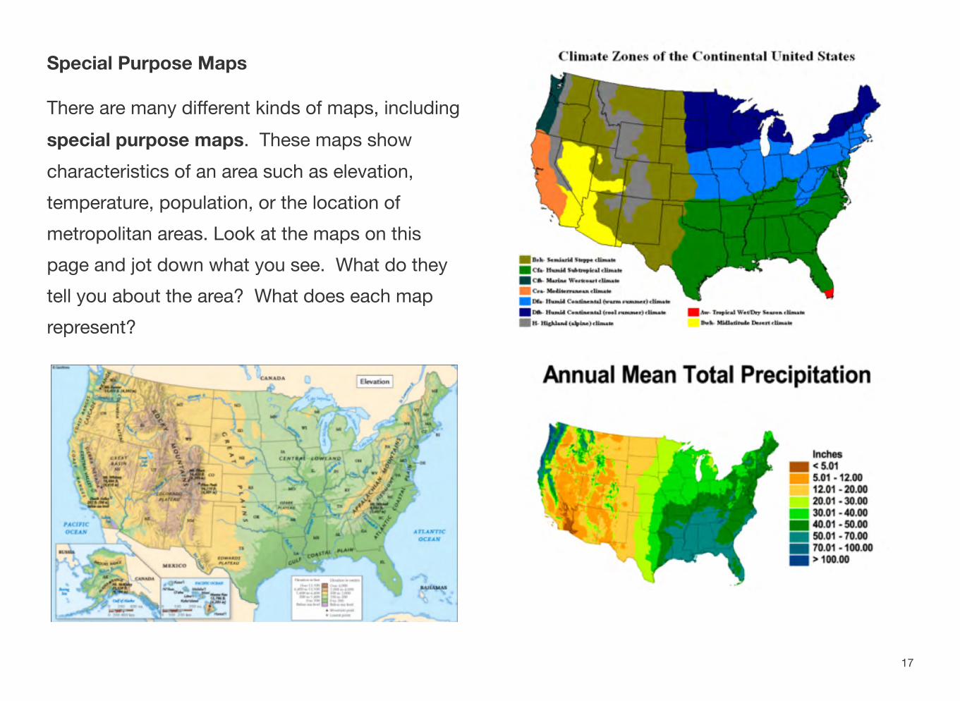
Special Purpose Maps
There are many different kinds of maps, including special purpose maps. These maps show characteristics of an area such as elevation, temperature, population, or the location of metropolitan areas. Look at the maps on this page and jot down what you see. What do they tell you about the area? What does each map represent?
17
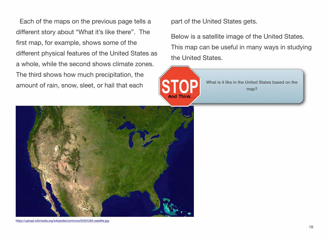
Each of the maps on the previous page tells a different story about “What it’s like there”. The first map, for example, shows some of the different physical features of the United States as a whole, while the second shows climate zones. The third shows how much precipitation, the amount of rain, snow, sleet, or hail that each
part of the United States gets.
Below is a satellite image of the United States. This map can be useful in many ways in studying the United States.
What is it like in the United States based on the map?
https://upload.wikimedia.org/wikipedia/commons/0/03/USA-satellite.jpg
18
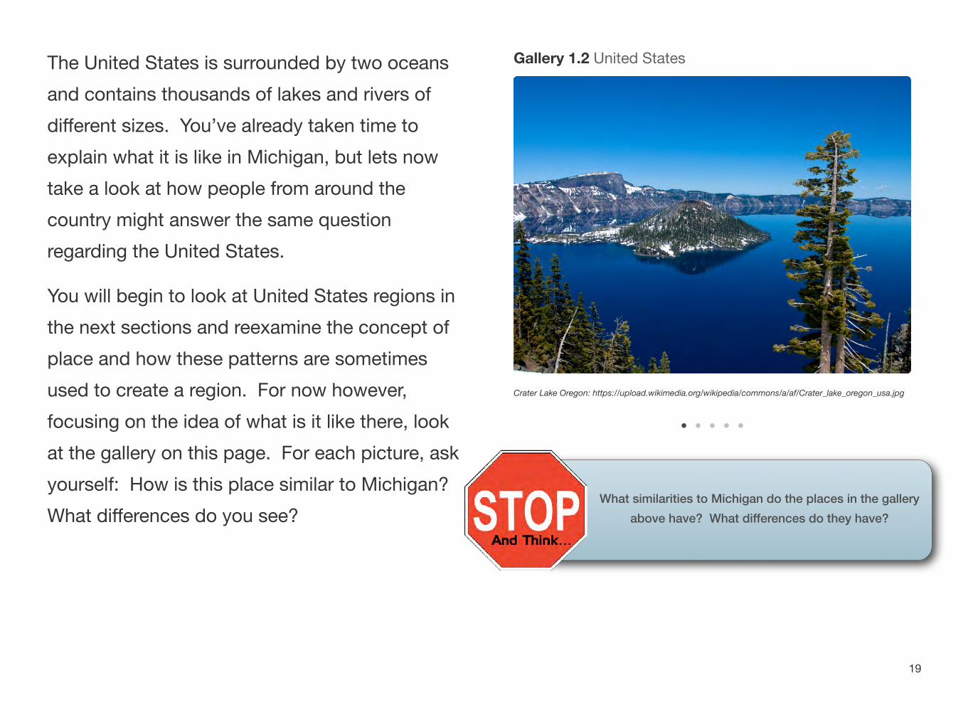
The United States is surrounded by two oceans and contains thousands of lakes and rivers of different sizes. You’ve already taken time to explain what it is like in Michigan, but lets now take a look at how people from around the country might answer the same question regarding the United States.
You will begin to look at United States regions in the next sections and reexamine the concept of place and how these patterns are sometimes used to create a region. For now however, focusing on the idea of what is it like there, look at the gallery on this page. For each picture, ask yourself: How is this place similar to Michigan? What differences do you see?
Gallery 1.2 United States
Crater Lake Oregon: https://upload.wikimedia.org/wikipedia/commons/a/af/Crater_lake_oregon_usa.jpg
What similarities to Michigan do the places in the gallery above have? What differences do they have?
19
Human Characteristics of Place
Next, we will take a look at the human characteristics of the U.S. Human characteristics are the geographic features that were made by people such as roads, bridges, and cities or towns. Michigan has many special human characteristics which you probably learned about last year. Some of these include lighthouses, bridges and locks.
Write about a human characteristic in Michigan that you learned about last year.
Roads
Roads are important! They help us travel from one place to another. They are human characteristics because they were built by humans to help us get from place to place. There are many different kinds of roads. Some people in rural areas live on old dirt roads. Others live on paved city or country roads which are maintained by local governments. Highways are a common way to travel from Michigan to another state. Some of the major highways in Michigan are I-94 which connects Detroit and Chicago, US 131 which connects the northern part of the Lower Peninsula to the southern part, then heads into Indiana. I-96 and I-69 help connect the western and eastern parts of the state. These roads are important because we can travel on them, but they are also a major way we carry out economic activities. Trucks ship
20
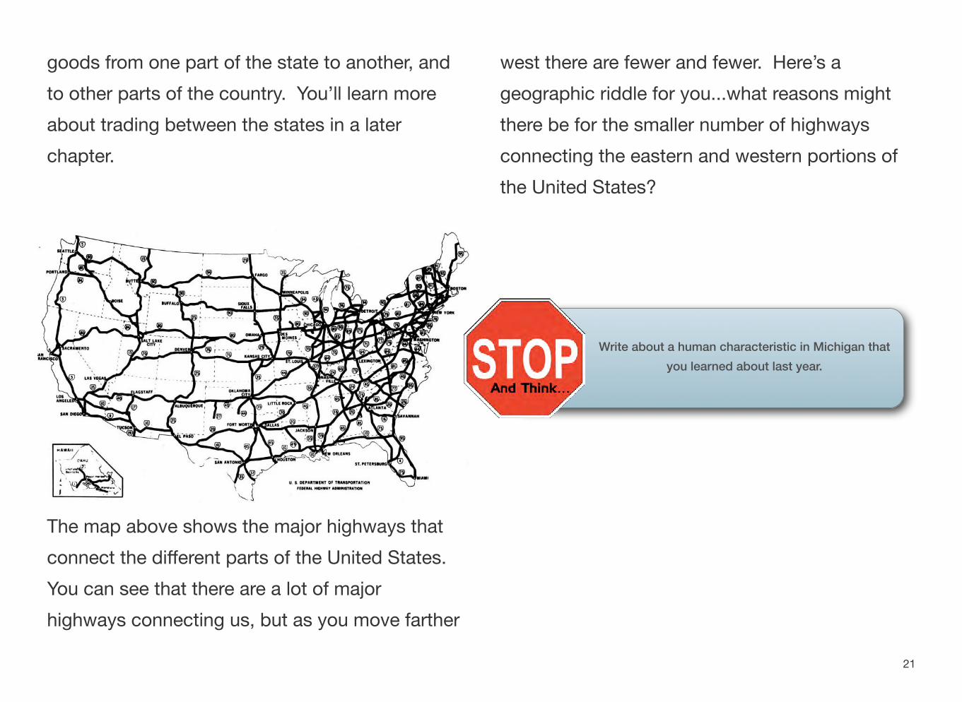
goods from one part of the state to another, and west there are fewer and fewer. Here’s a to other parts of the country. You’ll learn more geographic riddle for you...what reasons might about trading between the states in a later there be for the smaller number of highways chapter. connecting the eastern and western portions of
the United States?
Write about a human characteristic in Michigan that you learned about last year.
The map above shows the major highways that connect the different parts of the United States. You can see that there are a lot of major highways connecting us, but as you move farther
21
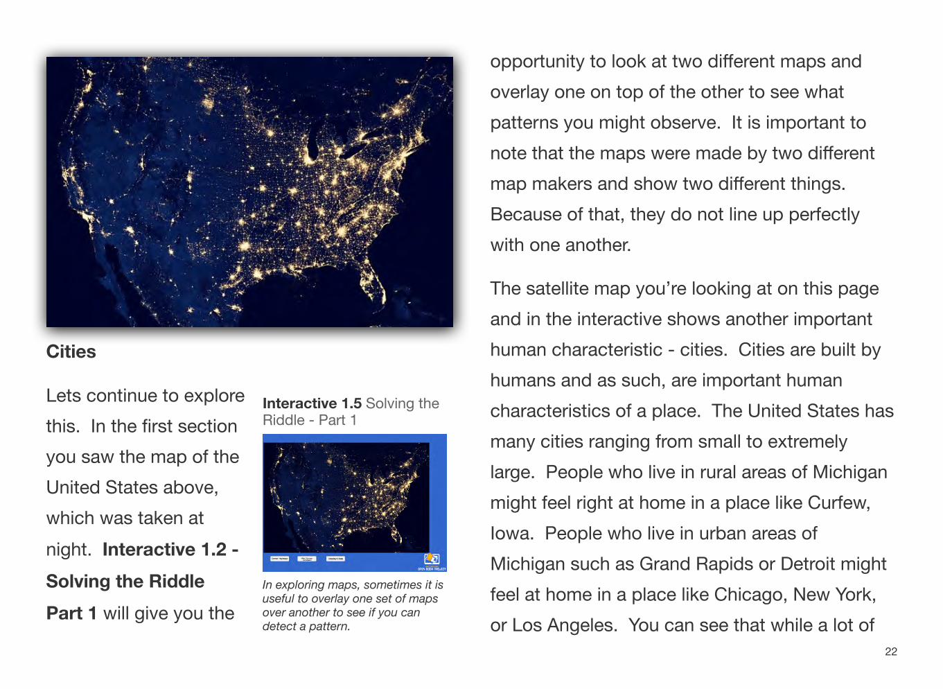
Cities
Lets continue to explore this. In the first section you saw the map of the United States above, which was taken at night. Interactive 1.2 -Solving the Riddle Part 1 will give you the
Interactive 1.5 Solving theRiddle - Part 1
In exploring maps, sometimes it isuseful to overlay one set of mapsover another to see if you candetect a pattern.
opportunity to look at two different maps and overlay one on top of the other to see what patterns you might observe. It is important to note that the maps were made by two different map makers and show two different things. Because of that, they do not line up perfectly with one another.
The satellite map you’re looking at on this page and in the interactive shows another important human characteristic - cities. Cities are built by humans and as such, are important human characteristics of a place. The United States has many cities ranging from small to extremely large. People who live in rural areas of Michigan might feel right at home in a place like Curfew, Iowa. People who live in urban areas of Michigan such as Grand Rapids or Detroit might feel at home in a place like Chicago, New York, or Los Angeles. You can see that while a lot of
22
the cities in the United States are centered in certain places, there are places on the map that do not show very much in the way of “light at night”. Does that mean that no one lives there?
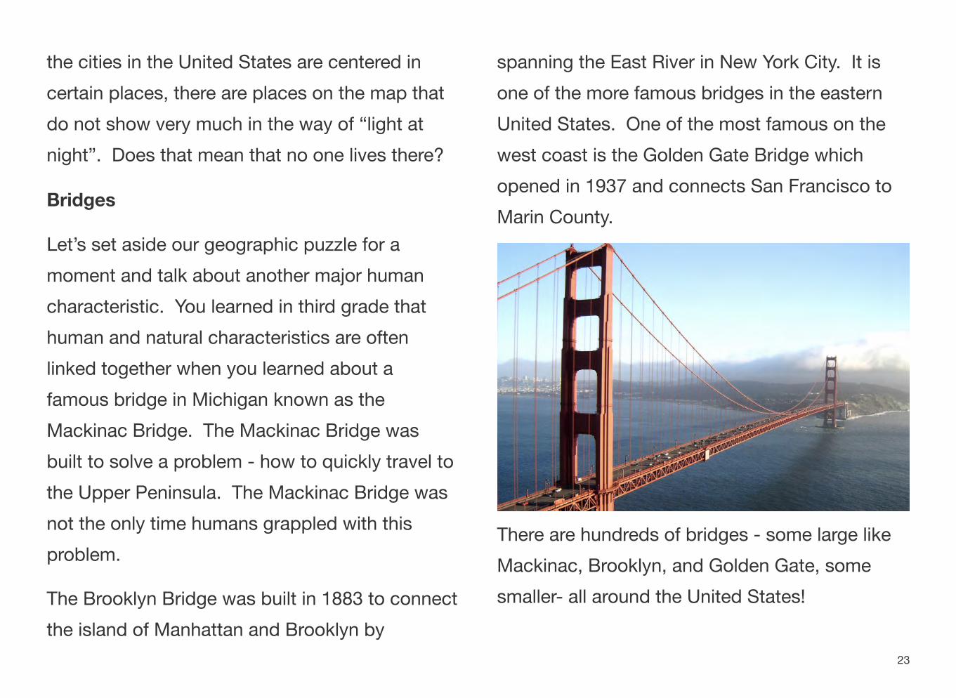
Bridges
Let’s set aside our geographic puzzle for a moment and talk about another major human characteristic. You learned in third grade that human and natural characteristics are often linked together when you learned about a famous bridge in Michigan known as the Mackinac Bridge. The Mackinac Bridge was built to solve a problem - how to quickly travel to the Upper Peninsula. The Mackinac Bridge was not the only time humans grappled with this problem.
The Brooklyn Bridge was built in 1883 to connect the island of Manhattan and Brooklyn by
spanning the East River in New York City. It is one of the more famous bridges in the eastern United States. One of the most famous on the west coast is the Golden Gate Bridge which opened in 1937 and connects San Francisco to Marin County.
There are hundreds of bridges - some large like Mackinac, Brooklyn, and Golden Gate, some smaller- all around the United States!
23
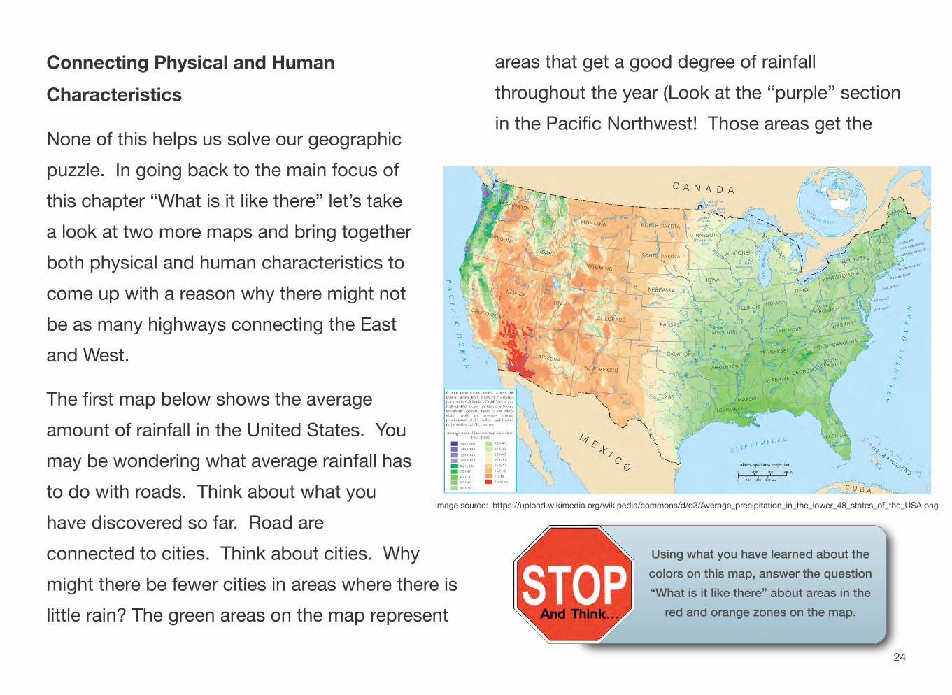
might there be fewer cities in areas where there is little rain? The green areas on the map represent
Connecting Physical and Human areas that get a good degree of rainfall Characteristics throughout the year (Look at the “purple” section
None of this helps us solve our geographic in the Pacific Northwest! Those areas get the
puzzle. In going back to the main focus of this chapter “What is it like there” let’s take a look at two more maps and bring together both physical and human characteristics to come up with a reason why there might not be as many highways connecting the East and West.
The first map below shows the average amount of rainfall in the United States. You may be wondering what average rainfall has to do with roads. Think about what you
Image source: https://upload.wikimedia.org/wikipedia/commons/d/d3/Average_precipitation_in_the_lower_48_states_of_the_USA.png
have discovered so far. Road are connected to cities. Think about cities. Why
24
Using what you have learned about the colors on this map, answer the question “What is it like there” about areas in the
red and orange zones on the map.
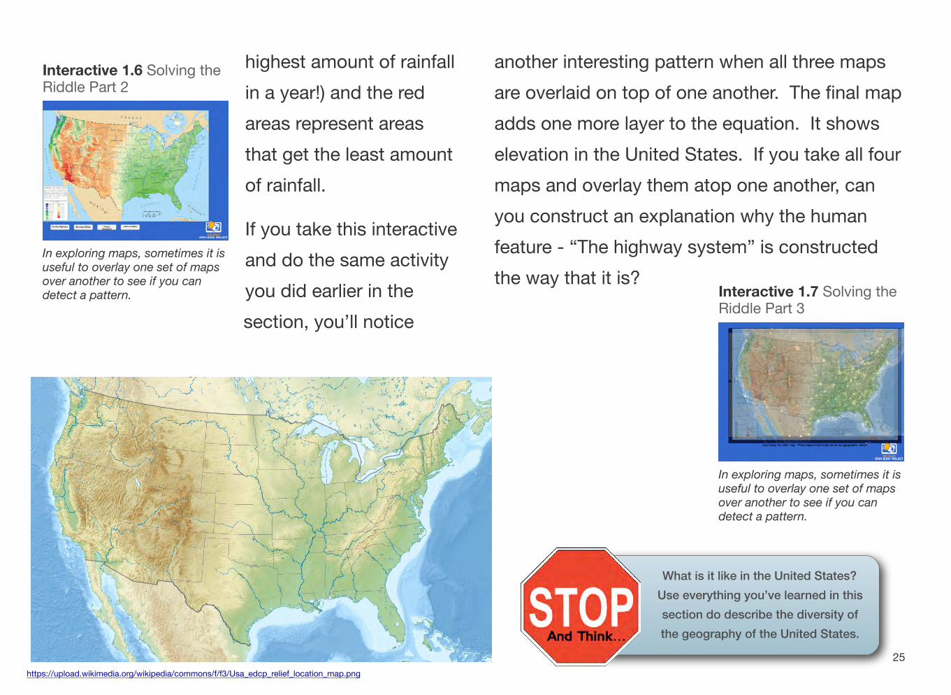
Interactive 1.6 Solving theRiddle Part 2
In exploring maps, sometimes it isuseful to overlay one set of mapsover another to see if you candetect a pattern.
highest amount of rainfall in a year!) and the red areas represent areas that get the least amount of rainfall.
If you take this interactive and do the same activity you did earlier in the section, you’ll notice
https://upload.wikimedia.org/wikipedia/commons/f/f3/Usa_edcp_relief_location_map.png
another interesting pattern when all three maps are overlaid on top of one another. The final map adds one more layer to the equation. It shows elevation in the United States. If you take all four maps and overlay them atop one another, can you construct an explanation why the human feature - “The highway system” is constructed the way that it is?
Interactive 1.7 Solving theRiddle Part 3
In exploring maps, sometimes it isuseful to overlay one set of mapsover another to see if you candetect a pattern.
25
What is it like in the United States? Use everything you’ve learned in this section do describe the diversity of the geography of the United States.
Section 3
Movement - How is This Place Connected to Other Places?
QUESTIONS TO GUIDE INQUIRY
1. How do geographers study the UnitedStates?
2. What natural and human characteristics are significant in the United States?
TERMS, PLACES, PEOPLE
push factors - the events that “push” people outof their place of living
pull factors - the reasons or events surrounding a new location that encourage people to move
migration - moving from one place to another
How Are Places in the United States Connected to Other Places in the United States?
“How is this place connected to other places?” This is the question that the “Movement” theme of geography is mainly about. To begin, let’s think of Michigan because that is a “place” you have already learned a lot about in third grade.
Take a moment and talk with some of your classmates about the questions on the next page. While the discussion is taking
place, have one member be the notetaker so that your ideas will be ready to share with the bigger group when you are finished.
26
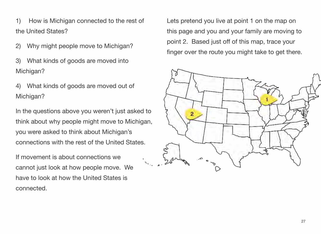
1) How is Michigan connected to the rest of the United States?
2) Why might people move to Michigan?
3) What kinds of goods are moved into Michigan?
4) What kinds of goods are moved out of Michigan?
In the questions above you weren’t just asked to think about why people might move to Michigan, you were asked to think about Michigan’s connections with the rest of the United States.
If movement is about connections we cannot just look at how people move. We have to look at how the United States is connected.
Lets pretend you live at point 1 on the map on this page and you and your family are moving to point 2. Based just off of this map, trace your finger over the route you might take to get there.
27
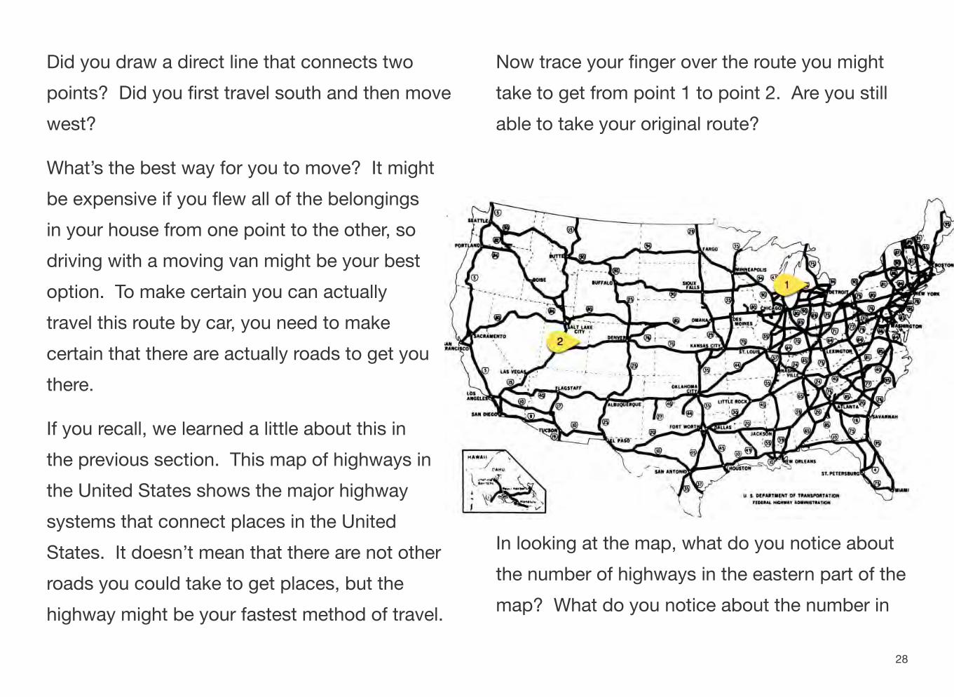
Did you draw a direct line that connects two points? Did you first travel south and then move west?
What’s the best way for you to move? It might be expensive if you flew all of the belongings in your house from one point to the other, so driving with a moving van might be your best option. To make certain you can actually travel this route by car, you need to make certain that there are actually roads to get you there.
If you recall, we learned a little about this in the previous section. This map of highways in the United States shows the major highway systems that connect places in the United States. It doesn’t mean that there are not other roads you could take to get places, but the highway might be your fastest method of travel.
Now trace your finger over the route you might take to get from point 1 to point 2. Are you still able to take your original route?
In looking at the map, what do you notice about the number of highways in the eastern part of the map? What do you notice about the number in
28
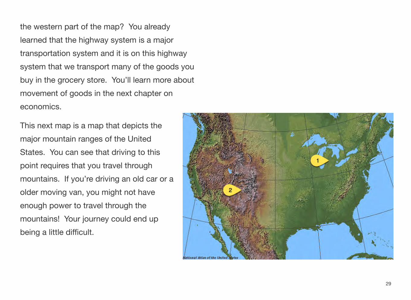
the western part of the map? You already learned that the highway system is a major transportation system and it is on this highway system that we transport many of the goods you buy in the grocery store. You’ll learn more about movement of goods in the next chapter on economics.
This next map is a map that depicts the major mountain ranges of the United States. You can see that driving to this point requires that you travel through mountains. If you’re driving an old car or a older moving van, you might not have enough power to travel through the mountains! Your journey could end up being a little difficult.
29
What Causes Human Movement From One Location To Another?
Perhaps it started with a dream. Perhaps it came from hope, wishes, or a yearning for more. Or did the idea of packing a suitcase and coming to America come from fear and a necessary escape from a life of worry?
How many times have you studied the story of the Pilgrims? What do you know about the sinking of the Titanic and the passengers that sailed on that mighty ship? America has been the beginning of a new life for thousands upon thousands of people who have sought change for many reasons.
In this section, you will explore some of the causes of human movement into the United States of America.
The Pushing and Pulling Puzzle
If you were to take a survey of your classmates, you may be surprised as to how many of them have moved sometime in their lives. If you were to ask those classmates why they had moved, what do you think their answers might include?
For hundreds of years, people have been on the move, whether into the United States or into Michigan. Situations in peoples’ lives, whether your friends’ or your relatives’, can lead to a need for a change.
The events that might lead to a person leaving one location for another are called either “push factors” or “pull factors.” Push factors are the events that “push” people out of their place of living. Some examples in history have included a lack of freedom or choice, a shortage of jobs,
30
war or unsafe living, scarcity of resources, or a high cost of living there.
Pull factors are the reasons or events surrounding a new location that encourage people to move. Opportunities like better jobs, being closer to family, a greater sense of safety, freedom are some of the pull factors causing people to move today.
Migration, moving from one place to another, is not a new event. When a person decides to leave their home for another location, the reasons for movement can be very personal.
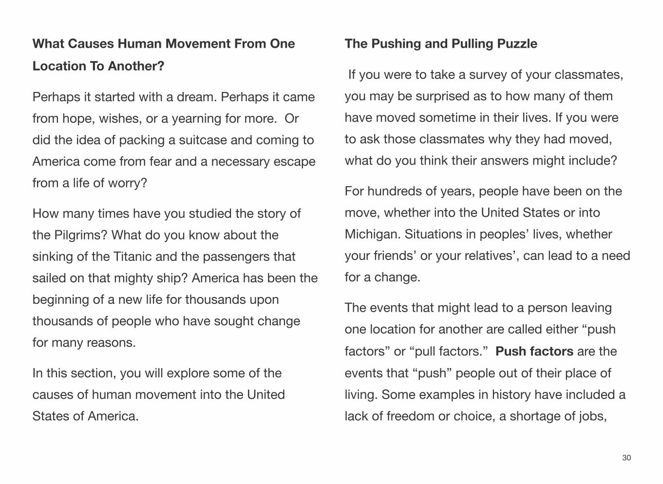
What do you pay attention to first in this picture?
What story does this picture tell?
31
If you had to move today, what item would you carry with you to demonstrate your sense of family or cultural pride?
Consider This..
Migration doesn’t just include the stories of the people who have entered the United States in hope of a better life. Migrating individuals also moved across this land by choice or by force. For instance, during the 1800s, many settlers and pioneers chose to move across the United States for greater chances at land ownership and better economic opportunities. The thrill of new adventure was also an incentive for settlers to travel west.
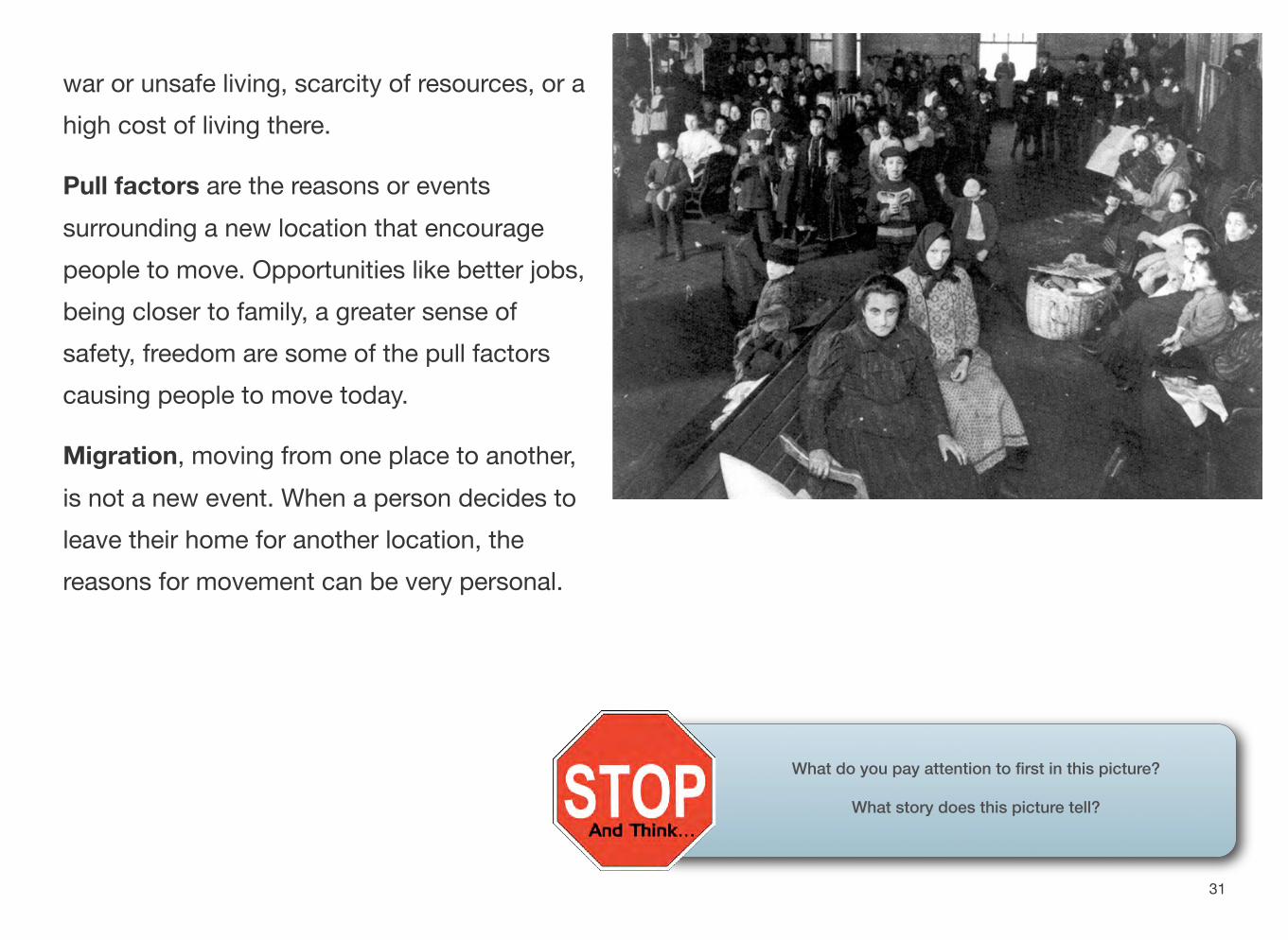
Ellis Island Part of Statue of Liberty National Monument
The movement of people, and the import and export of goods, have all played major roles in shaping our country. People everywhere interact through movement. They travel from place to place and they communicate.
32
A Breakfast Example
If you had cereal for breakfast, it’s possible you used a brand that was created in Michigan. Kelloggs foods has their headquarters in Battle Creek, Michigan, and their cereals are manufactured and sold world wide. The factory in Battle Creek, as well as others around the country and world produces many kinds of cereal which you may have eaten this morning.
Some might be tempted to say that the journey of the product from the store to a home begins at the factory, but that is still not the case. All of the parts of a product, such as ingredients for making cereal, come from places outside of the factory. It could come from local sources, or much farther away - across a state, the country, or even the world.
Activity - Use the internet and find out the ingredients in one breakfast cereal of your choice. Then, pick any three ingredients (such as rice, sugar, or salt) to find out where in the United States these materials might come from.
The journey of an ingredient for cereal could begin hundreds or thousands of miles away from your house. If you live in Michigan, however, it is quite possible that they made their way to Battle Creek to be made into your breakfast this morning.
It doesn’t necessarily matter where your cereal was created. Often times after production it is taken to centralized warehouses which deliver the products to many regional stores. The goods travel over land and by air depending on the distance they must travel.
33
All goods and products move in this way. If your family goes to a local farmers market and purchases apples, the journey from the farm to you may have been a relatively short one, but the product still moved. If your family purchases an American made car from Ford, GM, or Chrysler, the parts came from all over the world, and it’s possible that it wasn’t even assembled in the state that you live in.
From apples to cars, to the breakfast you ate this morning, the theme of movement is taking place all across your town, your state, the country, and the world.
Moving Ideas
People and products move constantly, but a third major type of movement also exists. The third type of movement is the movement of ideas. Prior to the 1830s, movement of ideas could be
very slow. To communicate across vast distances people either had to travel to a place themselves or send a letter which could take days, weeks, or months to arrive at its final destination.
Fast forward many years and communication has gotten much faster. The telegraph was invented in the 1830s. People could now send a message to someone across a large distance much faster, though it still required people to both send and receive the transmission, decode it, and deliver it to a recipient. The telegraph did however make the spread of information and ideas much faster.
Just forty years later, the telephone was invented. For the first time people could communicate with their voice over large distances. This also helped ideas and information spread faster.
34
As faster methods of travel became available, this also led to a faster spread of information. Today many people carry a phone in their pocket which allows them to communicate with people all over the world instantaneously.
That phone isn’t just used to send your voice. Many phones come equipped with cameras
allowing easy face to face communication. You can text a message, a picture, or a video to friends almost anywhere in the world and they can receive it within seconds.
The movement of people, goods, and ideas is constantly taking place.
35
Section 4
Region - What Relationships Do We Use To Think About and Organize Places? QUESTIONS TO GUIDE INQUIRY
1. How do geographers study the UnitedStates?
2. What natural and human characteristics are significant in the United States?
TERMS, PLACES, PEOPLE
region - an area of land that has common features
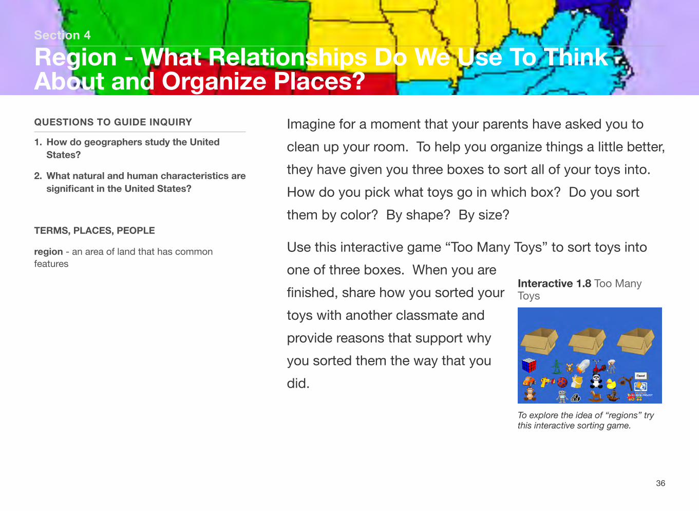
Imagine for a moment that your parents have asked you to clean up your room. To help you organize things a little better, they have given you three boxes to sort all of your toys into. How do you pick what toys go in which box? Do you sort them by color? By shape? By size?
Use this interactive game “Too Many Toys” to sort toys into one of three boxes. When you are
Interactive 1.8 Too Many finished, share how you sorted your Toys
toys with another classmate and provide reasons that support why you sorted them the way that you did.
To explore the idea of “regions” try this interactive sorting game.
36
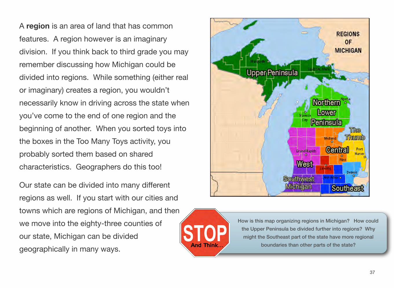
A region is an area of land that has common features. A region however is an imaginary division. If you think back to third grade you may remember discussing how Michigan could be divided into regions. While something (either real or imaginary) creates a region, you wouldn’t necessarily know in driving across the state when you’ve come to the end of one region and the beginning of another. When you sorted toys into the boxes in the Too Many Toys activity, you probably sorted them based on shared characteristics. Geographers do this too!
Our state can be divided into many different regions as well. If you start with our cities and towns which are regions of Michigan, and then we move into the eighty-three counties of our state, Michigan can be divided geographically in many ways.
How is this map organizing regions in Michigan? How could the Upper Peninsula be divided further into regions? Why might the Southeast part of the state have more regional
boundaries than other parts of the state?
37
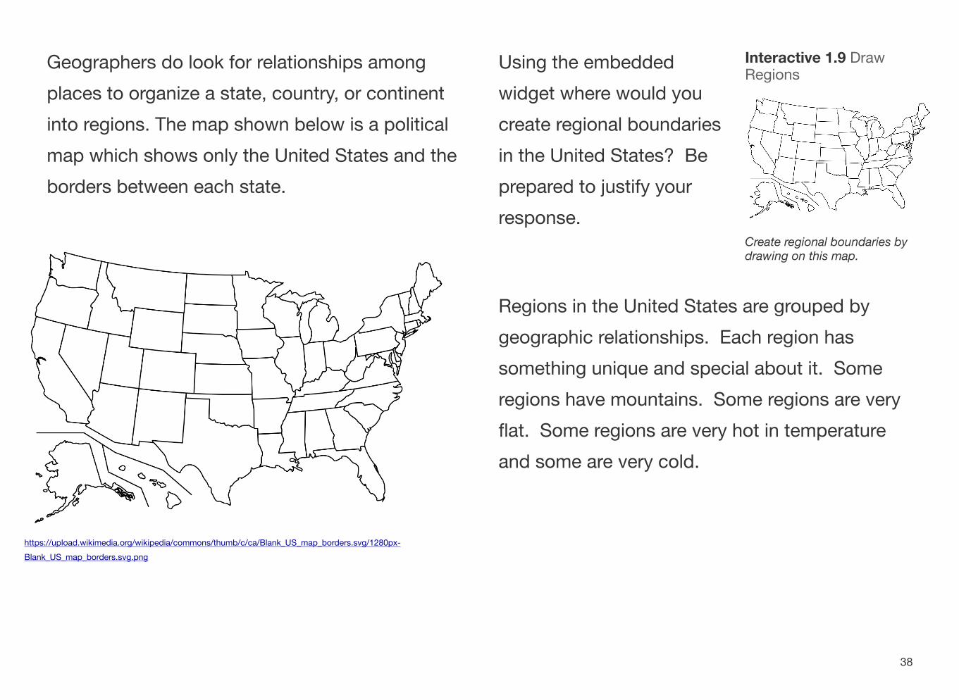
Geographers do look for relationships among places to organize a state, country, or continent into regions. The map shown below is a political map which shows only the United States and the borders between each state.
https://upload.wikimedia.org/wikipedia/commons/thumb/c/ca/Blank_US_map_borders.svg/1280px-Blank_US_map_borders.svg.png
Using the embedded Interactive 1.9 Draw Regions
widget where would you create regional boundaries in the United States? Be prepared to justify your response.
Create regional boundaries by drawing on this map.
Regions in the United States are grouped by geographic relationships. Each region has something unique and special about it. Some regions have mountains. Some regions are very flat. Some regions are very hot in temperature and some are very cold.
38
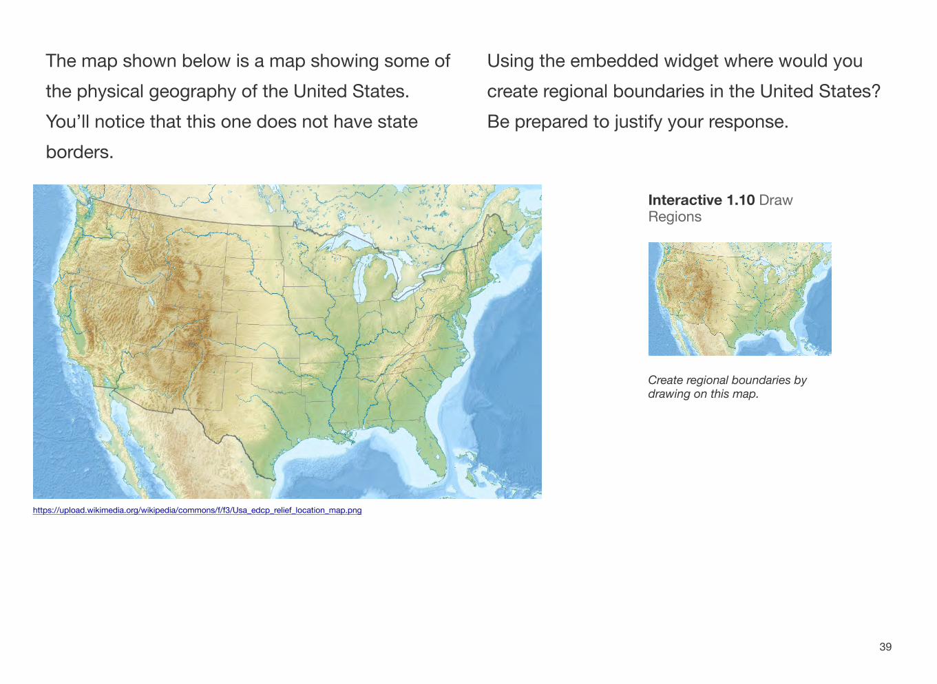
The map shown below is a map showing some of Using the embedded widget where would you the physical geography of the United States. create regional boundaries in the United States? You’ll notice that this one does not have state Be prepared to justify your response. borders.
Interactive 1.10 Draw Regions
Create regional boundaries by drawing on this map.
https://upload.wikimedia.org/wikipedia/commons/f/f3/Usa_edcp_relief_location_map.png
39

Having just created some of your own regional boundaries, here is one way the United States has been divided by geographers. You’ll notice that Michigan is located in the Midwest region. You may have chosen in dividing your own map up to use the entire mountain range in the east as one boundary. How has this map categorized the region differently?
https://c2.staticflickr.com/4/3936/15416129687_df0cb4a466_b.jpg 40
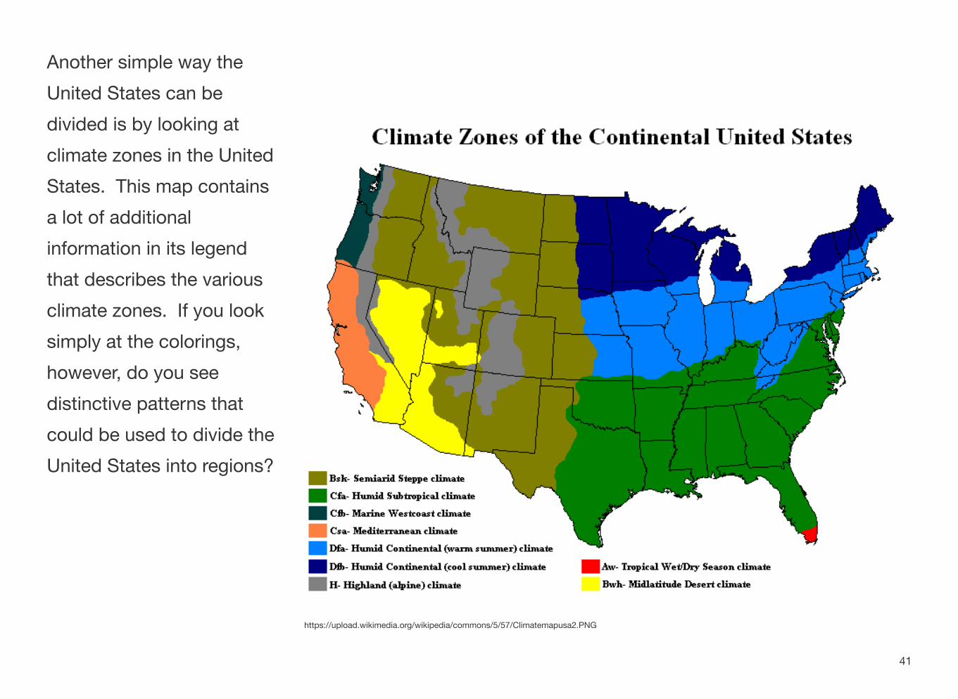
Another simple way the United States can be divided is by looking at climate zones in the United States. This map contains a lot of additional information in its legend that describes the various climate zones. If you look simply at the colorings, however, do you see distinctive patterns that could be used to divide the United States into regions?
https://upload.wikimedia.org/wikipedia/commons/5/57/Climatemapusa2.PNG
41
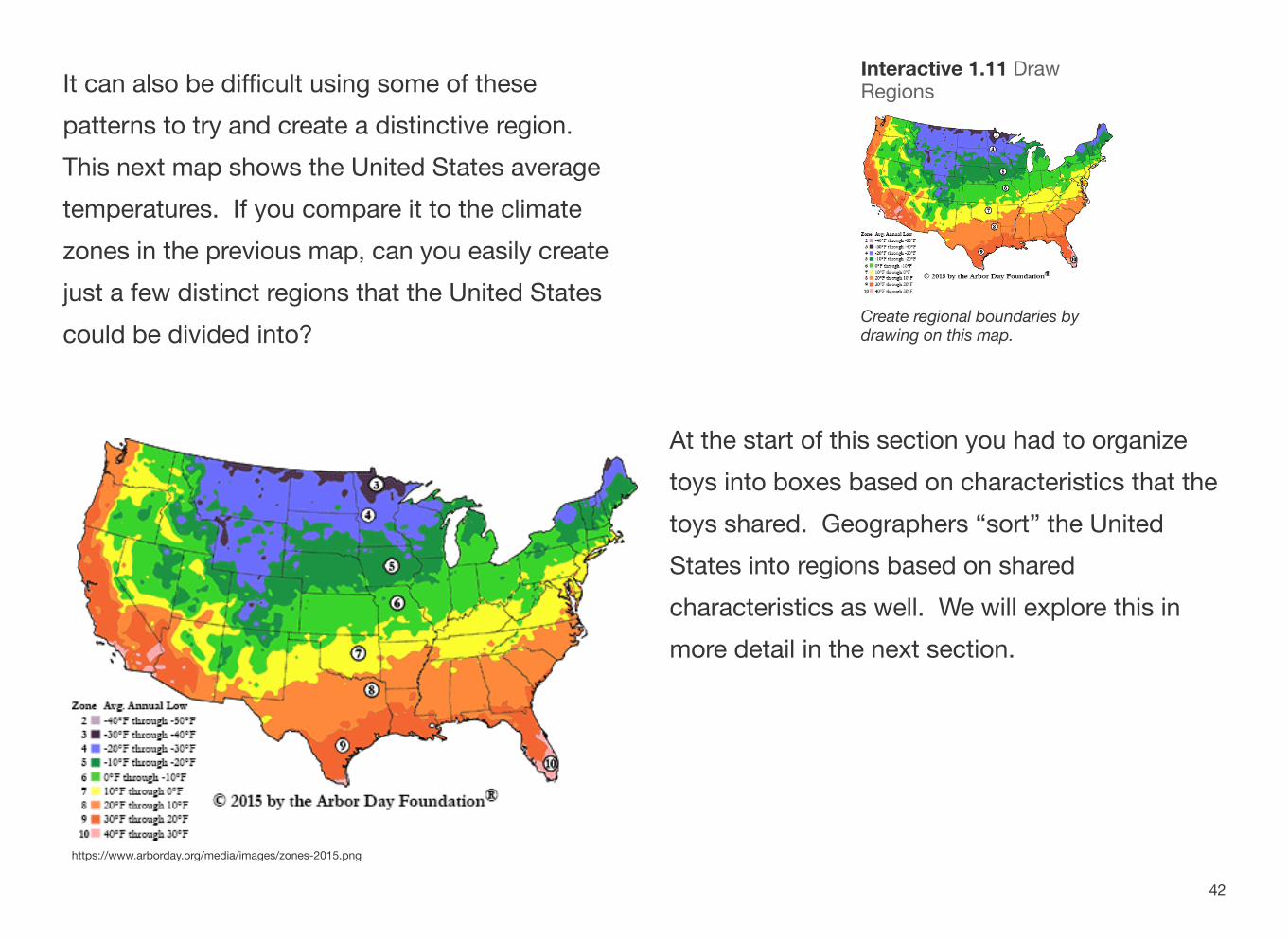
It can also be difficult using some of these patterns to try and create a distinctive region. This next map shows the United States average temperatures. If you compare it to the climate zones in the previous map, can you easily create just a few distinct regions that the United States could be divided into?
https://www.arborday.org/media/images/zones-2015.png
Interactive 1.11 Draw Regions
Create regional boundaries by drawing on this map.
At the start of this section you had to organize toys into boxes based on characteristics that the toys shared. Geographers “sort” the United States into regions based on shared characteristics as well. We will explore this in more detail in the next section.
42
Section 5
How do Environmental Conditions Influence Human Activities in a Place QUESTIONS TO GUIDE INQUIRY
1. How do geographers study the UnitedStates?
2. What natural and human characteristics are significant in the United States?
TERMS, PLACES, PEOPLE
agriculture - the growing of crops
irrigation - taking water from a local water source and moving it for farmers to use to grow their crops
reservoir - a large natural or artificial lake used as a source of water supply.
You have already learned that geography is the study of the earth and how we, the people who live there, interact with it. We have already discussed the study of the earth itself. In the previous section we spent time talking about how the United States can be divided into regions. It is now time to use regions to discuss how we live and interact with the environment.
When learning about how humans and the environment interact with one another it is important to think about some of the questions a geographer would ask. Several questions will guide this section:
1. What is it like there?
2. How is the answer to "What is it like there?" an influence on what humans do there?
3. How does what humans do in a place influence the environment?
43
4. Are the consequences of human actions different from place to place?
We've talked about natural resources in a previous section. What are some activities we do with the
natural resources in Michigan?
What is it Like There?
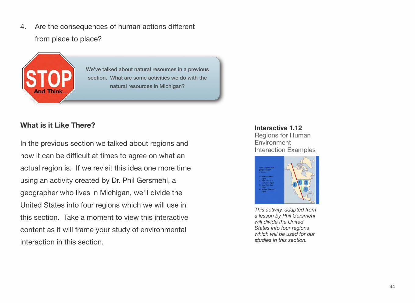
In the previous section we talked about regions and how it can be difficult at times to agree on what an actual region is. If we revisit this idea one more time using an activity created by Dr. Phil Gersmehl, a geographer who lives in Michigan, we'll divide the United States into four regions which we will use in this section. Take a moment to view this interactive content as it will frame your study of environmental interaction in this section.
Interactive 1.12 Regions for HumanEnvironment Interaction Examples
This activity, adapted from a lesson by Phil Gersmehlwill divide the United States into four regions which will be used for our studies in this section.
44
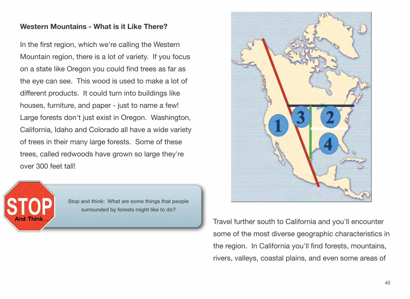
Western Mountains - What is it Like There?
In the first region, which we're calling the Western Mountain region, there is a lot of variety. If you focus on a state like Oregon you could find trees as far as the eye can see. This wood is used to make a lot of different products. It could turn into buildings like houses, furniture, and paper - just to name a few! Large forests don't just exist in Oregon. Washington, California, Idaho and Colorado all have a wide variety of trees in their many large forests. Some of these trees, called redwoods have grown so large they're over 300 feet tall!
Stop and think: What are some things that people surrounded by forests might like to do?
Travel further south to California and you'll encounter some of the most diverse geographic characteristics in the region. In California you'll find forests, mountains, rivers, valleys, coastal plains, and even some areas of
45
desert. We're going to focus in on California as part of our human/environment interaction studies.
Throughout history, cities have tended to spring up around water. One of the main reasons for this is that water is necessary for agriculture, the growing of crops.
Many early civilizations practiced something called irrigation which takes water from a local water source and moves it easily for farmers to use to grow their crops.
Fast forward several thousand years. With such a variety of geographic characteristics, it shouldn't be a surprise to you that farming also takes place in California today. Farmers in California grow over 200 different crops - everything from grapes, almonds, and oranges to lettuce, tomatoes, and broccoli.
California wasn't always the agricultural powerhouse. As people moved to the state throughout its history, people brought with them things that they had
historically grown, foods that were important to their culture. It really became known for farming in the 1920s and 30s when large numbers of farmers began to settle there because of its clean air, plentiful water, and cheap land. Today more than 1/3 of the produce grown in the United States comes from California.
They are able to produce so much in the way of agriculture because many of the farms are located in parts of the state that are warm year round, allowing for long growing seasons. Historically they have been able to use the state's water supply to grow these crops year round. Much of the water they use for agriculture comes from melting snow in the mountains to the north of the state.
Recently however farmers in California have faced some difficulties. As of 2016, California has found itself in the fifth year of a drought, a long period of low rainfall that results in a shortage of water. The snowpack from the mountains provides almost 1/3 of
46
the water used by cities and farms, but without wet weather, this snowpack has not been replenished.
How Has the Drought Affected California and the Country?
The farms in California send Interactive 1.13 California Drought Infographic their products around the
entire world. Take a moment to look at the interactive to learn a little more about how you yourself are affected by
How have people impacted theconditions in California! California water supply? Learn
more in this article. (California Drought Infographic).
Farmers who grow their crops further away from water sources have used irrigation to bring water to their crops. But with the shortage of water available to everyone, this has been more difficult to do. There is less water available for everyone.
The farmers who grow their food in California haven't been able to provide as much water to their crops, which means that for the rest of the world, shortages of certain goods have resulted. While food from California is still sold around the world, many Americans have seen the price of these goods rise as fewer are produced.
A wet winter in 2015-16 had made this problem a little better, Interactive 1.14 California’s
Severe Drought Explained but because the water levels in reservoirs, a large natural or artificial lake used as a source of water supply, have not returned to normal. Some think it could take five more years of
Learn more about the drought in this video from the New York wet winters like the last one to Times.
refill all that has been lost! The drought in California continues to be a problem that faces both the farmers in the region, and the rest of the country.
47
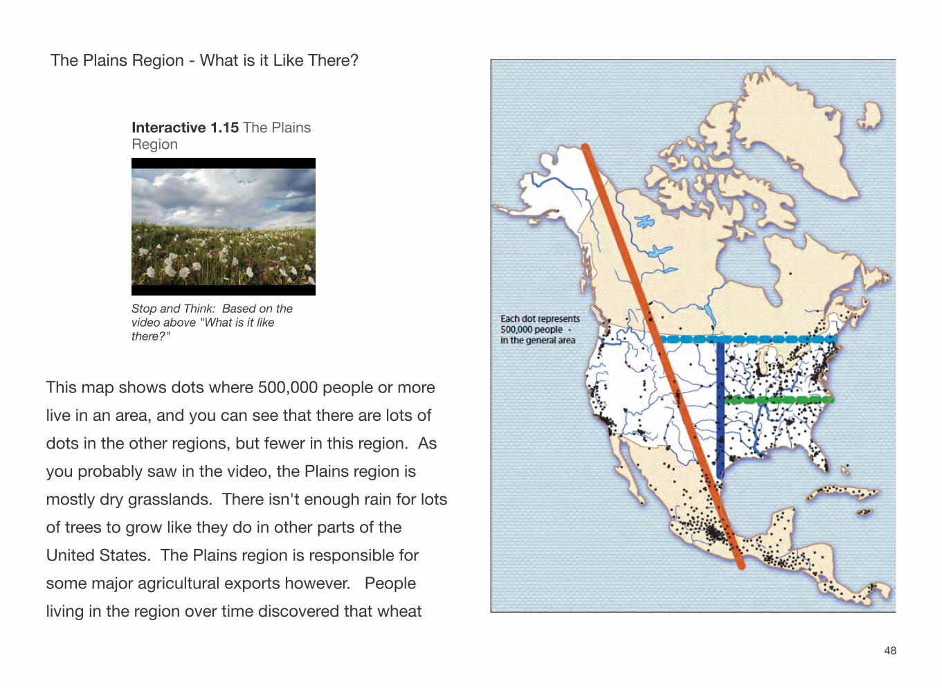
The Plains Region - What is it Like There?
Interactive 1.15 The Plains Region
Stop and Think: Based on the video above "What is it like there?"
This map shows dots where 500,000 people or more live in an area, and you can see that there are lots of dots in the other regions, but fewer in this region. As you probably saw in the video, the Plains region is mostly dry grasslands. There isn't enough rain for lots of trees to grow like they do in other parts of the United States. The Plains region is responsible for some major agricultural exports however. People living in the region over time discovered that wheat
48
can thrive in a drier climate. This region became a major wheat producing area of the United States.
Agriculture brought a lot of people to the region as America grew and expanded. Unfortunately, however, drought conditions are also a problem in the plains. It took time for people to learn that in many parts of this region corn couldn't survive a drought, but wheat could. It is drought-resistant crops that have been the most successful as agriculture in the region grew.
Think for a minute…if there's lots of grassland available, what else might this region be known for? If you guessed animals, you're correct! Because of the environment around them, people living in the plains region don't just produce wheat, they also raise livestock. In fact, cattle ranching is one of the primary economic activities in the region.
How Does the Answer to "What is it Like There?" Affect what People Do There?
The Plains region is the most fertile grassland in the country. However, in the 1930s, over farming combined with extended drought caused massive problems. As a drought hit the area and high winds caused an effect known as the Dust Bowl. The dry earth was carried by high winds across the plains region, sometimes causing large dust storms to reach over two thousand miles away. The national government at the time organized a group known as the Soil Conservation Service to help farmers in the area plant trees and grass to keep the soil from blowing away. They also taught them farming practices that allowed the farm land to rest by rotating crops and crop location.
Today people have begun exploring a way that they can use the environment of the region in a new way in the form of wind farms. You may have learned about wind farms in Michigan last year as part of your
49
studies on the state. Parts of this region have been called the Saudi Arabia of wind energy because of the potential to harness great amounts of wind power for energy around the whole country. Right now wind power is the fastest growing source of energy in the world. Because the turbines do not take up a lot of room, farmers can still harvest wheat and other crops in the plains while also serving as "wind farmers". While this is an important part of their future, one that they are able to explore because of the geography of the region, manufacturing wind turbines is expensive. Another problem is that some people who live nearby report noise from the turbines and don't like them because of that. Some also feel that they are eyesores. In some cases they've proven hazardous to the local wildlife. Still, the potential is there for the people living in the plains region to harvest wind energy not just for themselves, but for the entire country!
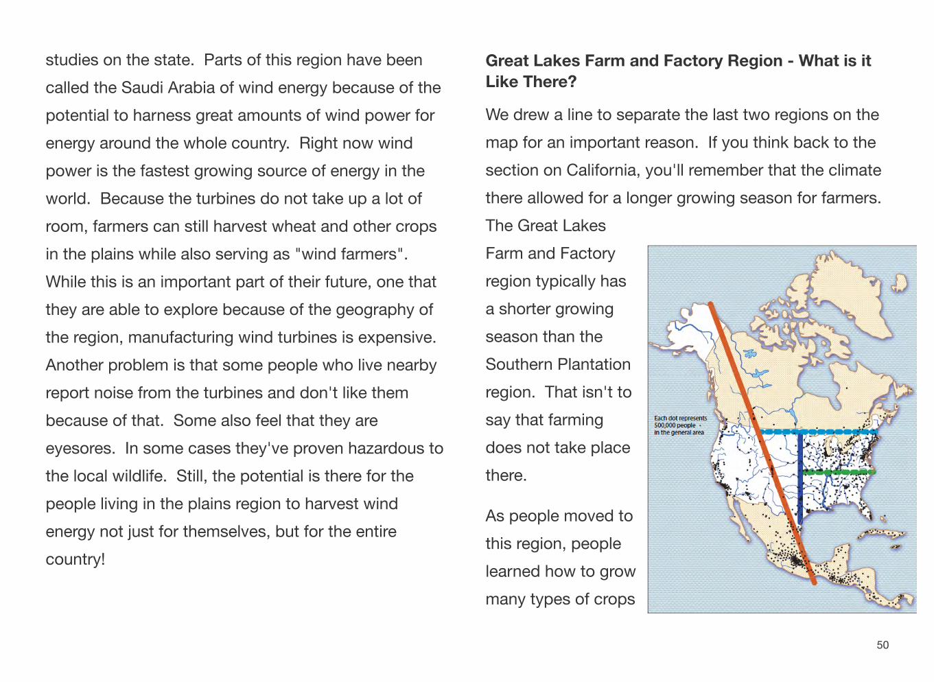
Great Lakes Farm and Factory Region - What is it Like There?
We drew a line to separate the last two regions on the map for an important reason. If you think back to the section on California, you'll remember that the climate there allowed for a longer growing season for farmers. The Great Lakes Farm and Factory region typically has a shorter growing season than the Southern Plantation region. That isn't to say that farming does not take place there.
As people moved to this region, people learned how to grow many types of crops
50
including cranberries, apples, strawberries, corn, blueberries, and a very important one to Michigan -cherries! These are some of the main agricultural exports of places like Wisconsin, Indiana, Michigan, and other states in the region.
This region is also known for water - the five Great Lakes are important to all the states that border one or more of them. They provide fun activities for people of all ages, and are important for shipping and transportation of goods around the country and the rest of the world.
How Does the Answer to "What is it Like There?" Affect what People Do There?
People in this region have always practiced some forms of agriculture. Throughout our nation's history however, as industry took off thanks to the industrial revolution, this has always been an important region for factories that make goods that are shipped out to other parts of the world.
The Great Lakes were a huge part of why manufacturing took off in this region. Other reasons included the abundance of paved roads and the growth of the railroad system. Whatever the main reason was, the abundance of available ways to get goods from one place to another is the primary reason why this entire region saw industrial growth.
In 1825 the Erie Canal was completed and allowed people to carry goods east easily. Over 100 years later the St. Lawrence Seaway was completed. The St. Lawrence Seaway is a system of locks, canals, and channels that lets vessels travel from the Atlantic Ocean to the Great Lakes. It is recognized as one of the most challenging engineering feats in history, but one that has helped the factories of this region rely on the environment around the region to expand their reach.
The water of the Great Lakes is important for shipping, agriculture, recreation and daily life of the people who live in the region. The amount of water in the Great
51
Lakes (6 quadrillion gallons) makes up 1/5 of the world's fresh surface water. Because the region is "water rich" there have been talks about the possibility of sending water from the Great Lakes to places that do not have as much. For people in the region this is a very touchy subject! If you think of it this way, the water was a one time gift, the result of melting glaciers that would be nearly impossible to replenish once gone. You'll have an opportunity to explore this issue more in the last section of this book.
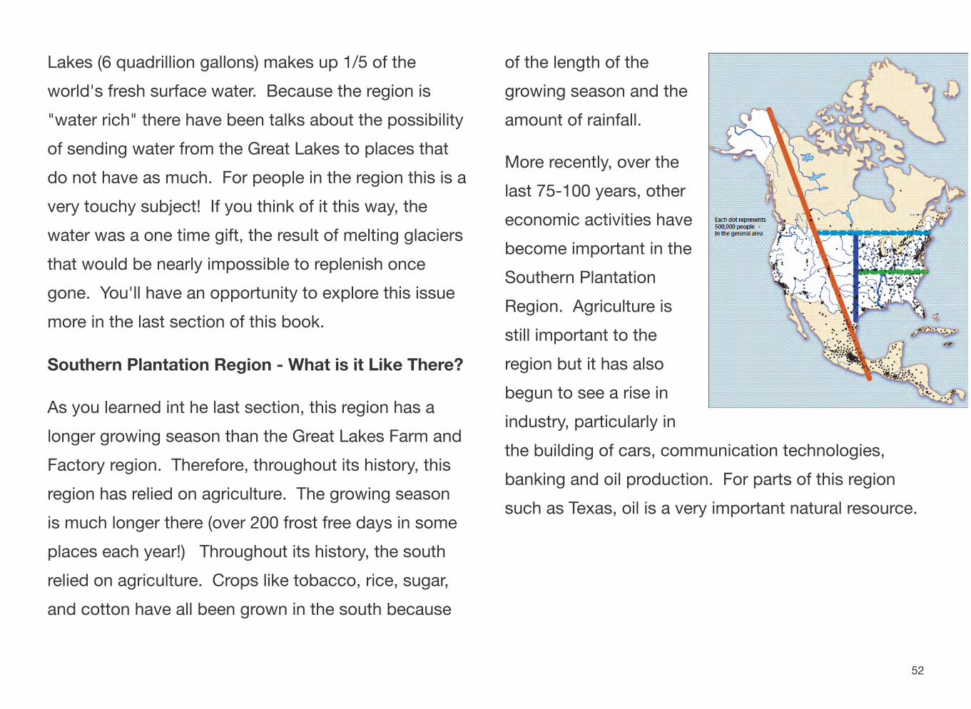
Southern Plantation Region - What is it Like There?
As you learned int he last section, this region has a longer growing season than the Great Lakes Farm and Factory region. Therefore, throughout its history, this region has relied on agriculture. The growing season is much longer there (over 200 frost free days in some places each year!) Throughout its history, the south relied on agriculture. Crops like tobacco, rice, sugar, and cotton have all been grown in the south because
of the length of the growing season and the amount of rainfall.
More recently, over the last 75-100 years, other economic activities have become important in the Southern Plantation Region. Agriculture is still important to the region but it has also begun to see a rise in industry, particularly in the building of cars, communication technologies, banking and oil production. For parts of this region such as Texas, oil is a very important natural resource.
52
How Does the Answer to "What is it Like There?" Affect what People Do There?
The Southern Plantation Region has always relied on agriculture, particularly cotton as a large part of what it exports to the rest of the world. You have learned that drought has affected agriculture in places like California in the Western Mountains region. In the Southern Plantation region the opposite has been a problem: flooding. In the 1930s, a governmental program called the Tennessee Valley Authority was created to try and help with the problem. It was initially begun to control flooding in the region from the Tennessee River. But why was it needed?
The Tennessee Valley was prone to flooding which washed soil and nutrients away making it difficult to farm in the area. The people living there were having a hard time surviving.
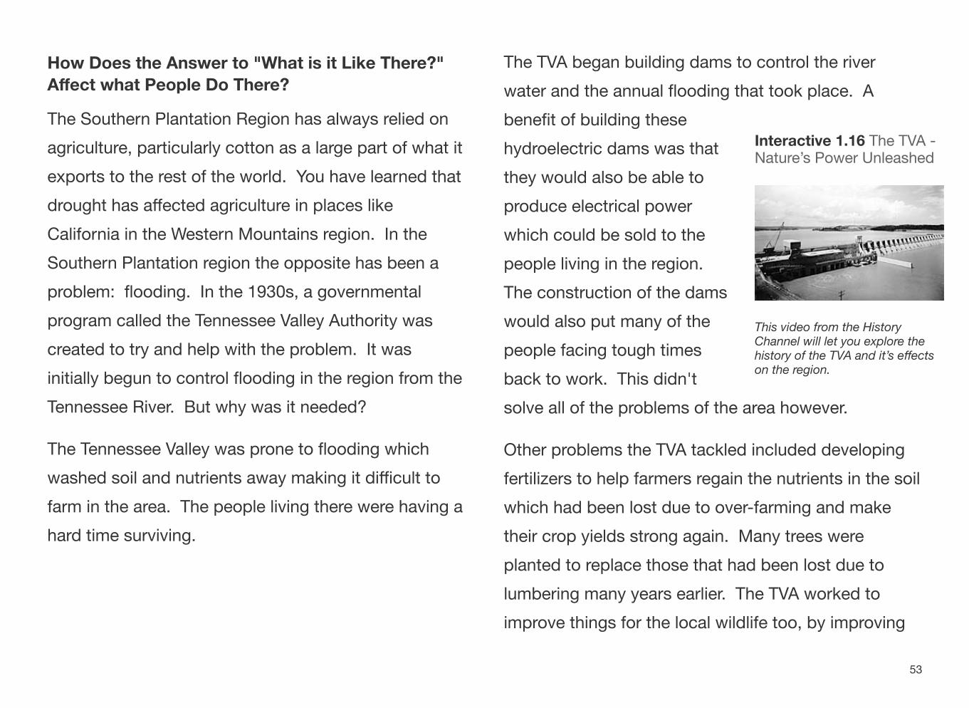
The TVA began building dams to control the river water and the annual flooding that took place. A benefit of building these
Interactive 1.16 The TVA - hydroelectric dams was that Nature’s Power Unleashed they would also be able to produce electrical power which could be sold to the people living in the region. The construction of the dams would also put many of the This video from the History
Channel will let you explore the people facing tough times history of the TVA and it’s effects on the region. back to work. This didn't
solve all of the problems of the area however.
Other problems the TVA tackled included developing fertilizers to help farmers regain the nutrients in the soil which had been lost due to over-farming and make their crop yields strong again. Many trees were planted to replace those that had been lost due to lumbering many years earlier. The TVA worked to improve things for the local wildlife too, by improving
53
the habitats of fish and the other animals that lived in the region.
The TVA is still around today as a publicly owned power company. It not only generates and sells the power created by the dams, but it maintains the existing structure of what was created in the 1930s as well.
PUTTING IT ALL TOGETHER
You’ve now taken a trip around the United States and explored some regions in an attempt to answer the question geographers ask.
Writing assignment: Pick one of the four regions we used in this section and briefly write to answer these two questions: What is it like there? How does that answer affect what people do there?
54