Embed Size (px)
Citation preview
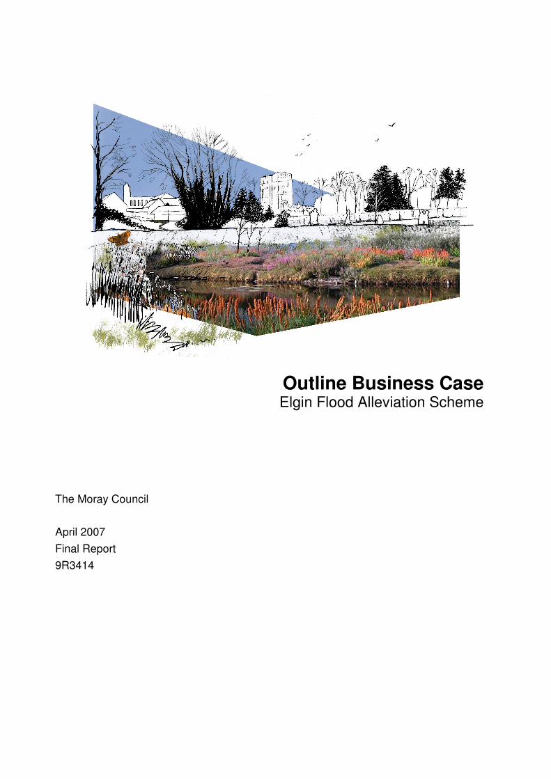
Outline Business Case Elgin Flood Alleviation Scheme
The Moray Council
April 2007 Final Report 9R3414

������������
Document title Outline Business Case
Elgin Flood Alleviation Scheme
Document short title
Status Final Report
Date April 2007
Project name Elgin Flood Alleviation Scheme
Project number 9R3414
Client The Moray Council
Reference 9R3414/MFAG463
Rightwell House
Bretton
Peterborough PE3 8DW United Kingdom
+44 (0)1733 334455 Telephone 01733 262243 Fax
[email protected] E-mail www.royalhaskoning.com Internet
����� �����������
��������� �� �����
Drafted by Jenny Evans and Kate Darlington
Checked by Mick Newman Trevor Amis
Date/initials check …………………. ………………….
Approved by Barbara Hellett
Date/initials approval …………………. ………………….

- i - 9R3414/MFAG463 Final Report April 2007
EXECUTIVE SUMMARY This report describes the flooding problem in Elgin and establishes the need for a Flood Prevention Scheme. The scheme options and decision process are outlined and the proposed Flood Prevention Scheme is described. The report also outlines the Business Case associated with the proposed Scheme and outlines the next steps associated with taking the Scheme forward. The proposed flood alleviation scheme represents value for money, having a positive benefit-cost ratio, and offers many advantages for Elgin, including: • Protection of approximately 765 residential and 230 commercial properties at
risk from flooding including vulnerable areas of the City’s infrastructure. • Protection of Johnston’s of Elgin woollen mill, the City’s principal non-
government employer. • The continuing sustainability of Elgin as a major centre for tourism and the
economic hub of Moray. • Environmental enhancements to stretches of the River Lossie including
improvement of green corridors and creation of wetland habitat. • Improved access routes through the city with considerably reduced impact to the
passage of traffic during flood events. The Moray Council intend to promote the flood alleviation scheme outlined in this report to the Scottish Executive in June 2007.

- ii - 9R3414/MFAG463 Final Report April 2007
CONTENTS Page
1 INTRODUCTION 1 1.1 Background 1 1.2 Purpose of this report 1
2 THE PROBLEM 1 2.1 The catchment 1 2.2 Flood history 2 2.3 Existing flood risk 2
3 SCHEME OPTIONS 2 3.1 Option Development 2 3.2 Choice of Preferred Option 3 3.3 Preferred Option Development 3 3.4 Consultation 3
4 THE SCHEME 4 4.1 Standard of Protection 4 4.2 Description of the Work 4
5 SCHEME MERITS 5
6 SCHEME RISKS 6 6.1 Approach to Risk 6 6.2 Key Scheme Risks and Mitigation 6
7 BUSINESS CASE 8 7.1 Cost-Risk Assessment 8 7.2 Benefit Assessment 9 7.3 Economic appraisal 10 7.4 Expenditure profile 10
8 NEXT STEPS 11 Draft Flood Prevention Operations 1

9R3414/MFAG463 Final Report - 1 - April 2007
1 INTRODUCTION
1.1 Background
Elgin is one of Scotland’s oldest cities and has developed beside the River Lossie for over 900 years. Elgin is a thriving city located at the heart of Moray which continues to out perform Scotland’s national average with respect to both population and economic growth. Between 1991 and 2001 Moray’s population grew by 4% compared to a national (Scotland) decline of 0.4% (CENSUS 2005). Elgin is the distilling and distribution centre of Scotland’s whisky industry which is estimated to support 41,000 Scottish jobs and contribute £800million to Scotland’s economy annually. The River Lossie and Elgin have a well documented history of flooding dating back to 1750. Elgin has suffered severe flooding in recent years (1997 and 2002). In these severe events over 600 residential and 170 commercial properties were inundated. Key transport infrastructure was affected. The A96 trunk road was disrupted for several days and the Inverness to Aberdeen railway line was closed for several weeks. The 1997 and 2002 flood events combined are estimated to have caused in excess of £100million damage. As a consequence of Elgin’s flood problem, flood alleviation is The Moray Council’s number one priority (The Moray Council Corporate Development Plan 2004 – 2007). Moray Flood Alleviation was formed in 2001 and currently comprises The Moray Council, Royal Haskoning and Morrison Construction.
1.2 Purpose of this report
The purpose of this report is to: 1. Describe the flooding problem in Elgin and establish the need for a Flood
Prevention Scheme; 2. Outline the scheme options and decision process; 3. Describe the proposed Flood Prevention Scheme; 4. Outline the Business Case associated with the proposed Scheme; and 5. Outline the next steps in taking the Scheme forward.
2 THE PROBLEM
2.1 The catchment
The River Lossie and its major tributaries, the Black Burn, Mosstowie Canal and the Linkwood Burn, drains an area of approximately 270 km2, flowing from the foothills of the Grampian mountains to the Sea at Lossiemouth. Black Burn and Mosstowie Canal flow in a north easterly direction joining with the River Lossie just upstream of Elgin. The River Lossie then turns east before meandering through urban Elgin. The Tyock Burn, a short urban tributary of the River Lossie flows through Elgin before joining with the River Lossie at the eastern end of the city. Downstream of Elgin the Linkwood Burn joins with the River Lossie before the river turns north and flows to Lossiemouth in a fairly linear course through an area of predominantly agricultural land.
9R3414/MFAG463 Final Report - 2 - April 2007
2.2 Flood history
Flooding in Elgin is a natural occurrence and not a new problem. The River Lossie has a documented history of flooding dating back 250 years (MFAG008). Twenty flood events have been recorded since 1750, with 11 floods in the last 50 years. Elgin has therefore flooded on average every 13 years since 1750. Severe flooding occurred in Elgin in July 1997 and in November 2002. During both events extreme rainfall fell for over 48 hours on the upper part of the River Lossie catchment on already saturated ground. The 1997 event affected approximately 600 residential and 170 commercial properties and is estimated to have a return period of 1 in 35 years. The 2002 event affected approximately 650 residential and 180 commercial properties and is estimated to have a return period of 1 in 60 years. In 2002 over 200 households were evacuated and 10 people had to be air lifted to safety. During both these events key transport links were disrupted. The A96 trunk road was closed for more than 48 hours, whilst the Aberdeen to Inverness railway line suffered considerable damage and was closed for several weeks. The losses due to the floods in 1997 and 2002 are estimated to jointly exceed £100million.
2.3 Existing flood risk
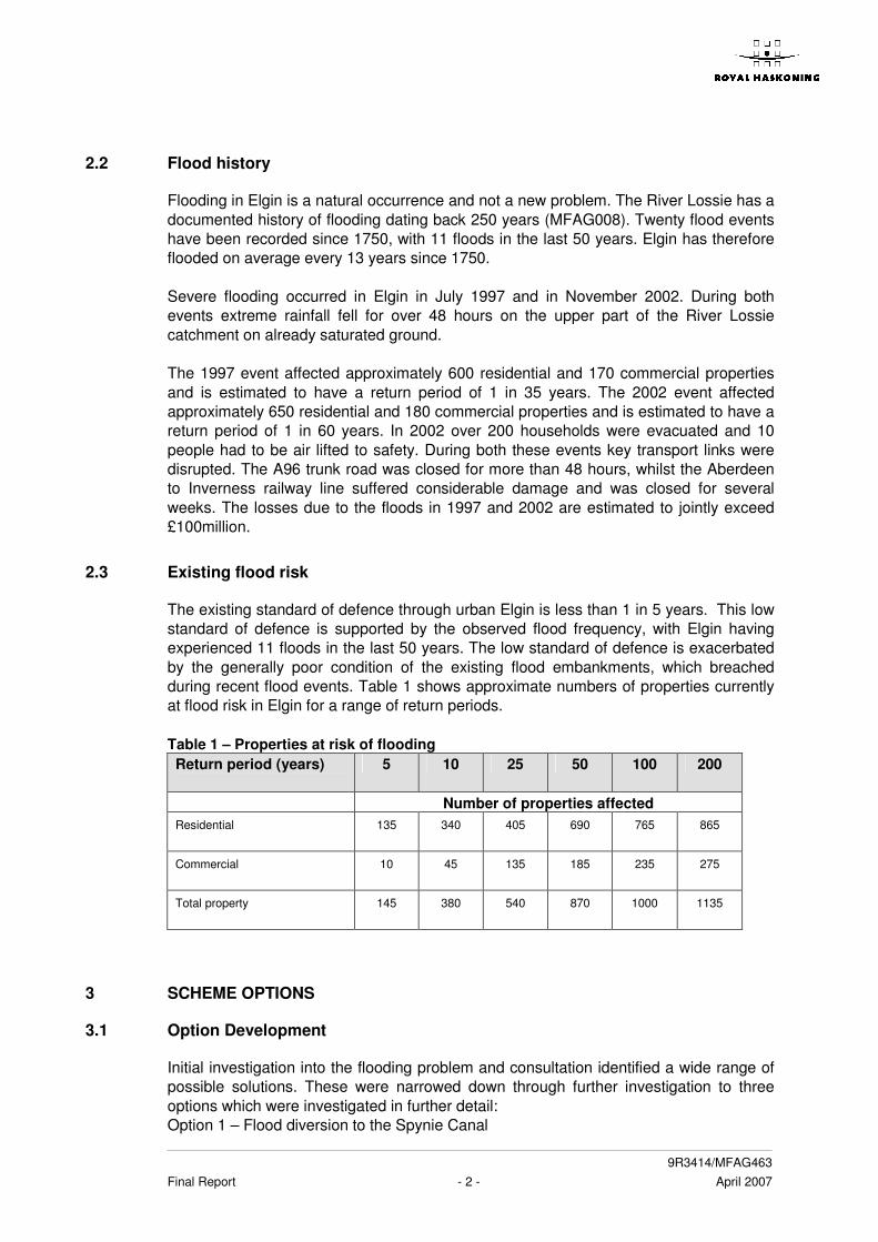
The existing standard of defence through urban Elgin is less than 1 in 5 years. This low standard of defence is supported by the observed flood frequency, with Elgin having experienced 11 floods in the last 50 years. The low standard of defence is exacerbated by the generally poor condition of the existing flood embankments, which breached during recent flood events. Table 1 shows approximate numbers of properties currently at flood risk in Elgin for a range of return periods. Table 1 – Properties at risk of flooding Return period (years)
5 10 25 50 100 200
Number of properties affected Residential
135 340 405 690 765 865
Commercial
10 45 135 185 235 275
Total property
145 380 540 870 1000 1135
3 SCHEME OPTIONS
3.1 Option Development
Initial investigation into the flooding problem and consultation identified a wide range of possible solutions. These were narrowed down through further investigation to three options which were investigated in further detail: Option 1 – Flood diversion to the Spynie Canal
9R3414/MFAG463 Final Report - 3 - April 2007
Option 2 – Channel widening and embankments through Elgin Option 3 – Flood storage with walls and embankments through Elgin Each scheme provided Elgin with a standard of flood protection equivalent to at least 1 in 100 years. The schemes all provided a direct benefit to the community and businesses in Elgin.
3.2 Choice of Preferred Option
Following further investigation and consultation on the three options outlined above, an evaluation process was undertaken and this was presented in the Recommendation Report (MFAG 155). This report evaluated the options against a number of criteria including performance, sustainability, environmental impact, scheme operation, maintenance, health and safety, cost and risk. The report recommended Option 2 – Channel Widening and Embankments through Elgin be taken forward as the preferred option. The recommendation was approved at a special meeting of The Moray Council held on 25th February 2004.
3.3 Preferred Option Development
The preferred scheme has been developed further through an Optioneering phase. This has refined the scheme through consideration of a number of specific issues. The Optioneering Summary (MFAG358) documents the key decisions made during this phase.
3.4 Consultation
Consultation has formed an integral part of the option development and appraisal with a range of consultees being consulted in a number of different ways since 2002. The consultees include:
• Statutory Stakeholders including Scottish Environmental Protection Agency, Scottish Natural Heritage and Historic Scotland;
• Non-Statutory Stakeholders including RSPB, the Forestry Commission and local business groups;
• Councillors and Council Officers • Landowners • General Public • Others including Network Rail and Scottish Water
To reach this wide group of consultees a number of different consultation methods have been used which include:
• Meetings • Workshops • Public Meetings • Public Exhibitions (held in November 2001, July 2003, October 2003, October
2004 with the next planned for April 2007) • Council Meetings • Press coverage and press releases
9R3414/MFAG463 Final Report - 4 - April 2007
The Environmental Statement will detail the consultation that has been undertaken, the comments received and details about how the comments have helped guide the design process and/or have been incorporated into the design of the scheme.
4 THE SCHEME
4.1 Standard of Protection
The Scheme protects the community of Elgin from the risk of flooding to a standard of at least 1 in 100 years. Climate change predictions have been considered during development of the scheme.
4.2 Description of the Work
The proposed scheme aims to increase conveyance of flood flows through Elgin utilising the following recognised flood management techniques:
• Provision of an improved flood channel within and downstream of the City; • Construction of flood defence structures and embankments (set back where
possible); and • Removal and/or replacement of in-channel flow constrictions including
bridge structures.
The objective of the works arrangement is to make best use of the natural floodplain and provide a sustainable flood corridor through the city The flood channel improvement is to be achieved by the excavation of a lowered flood plain alongside the natural channel over a 3.5km length, mostly downstream of the City centre. A new channel will be constructed to divert the Tyock and Linkwood confluences with the River Lossie downstream of their current locations. There will be approximately 8km of new flood embankment works bounding both the natural and improved flood channels. The embankments range in height from 0.6 to 3.5m. Walls will be utilised where space restrictions preclude the use of embankments. The Scheme also requires the demolition and replacement of a highway bridge and a listed former highway bridge that is currently used as a footbridge. The scheme comprises a number of elements of work and these are described and shown on drawings number 9R3414/8011-F0 – 9R3414/8012-F0 in Appendix A. The work is described in terms of the flood defence operations which will form part of the Flood Prevention Order submission. It should be noted that at this stage the operations described in Appendix A are draft, and may be amended before the submission of the FPO. In addition to the flood defence operations a number of ancillary operations will be required and are summarised in Appendix A.
9R3414/MFAG463 Final Report - 5 - April 2007
5 SCHEME MERITS
The Scheme has been developed using sound engineering principals. The scheme takes due cognisance of health & safety and environmental constraints and has been developed through a thorough consultation process with both the public and statutory consultees. At all stages, the scheme development has had the approval of the Moray Council. The scheme design to date has been based on a peak water inflow of 218m3/s at Sheriffmills, which is estimated to have a return period of 1 in 200 years. Allowing for the effects of climate change, the scheme will achieve the Scottish Executive’s guideline standard of defence for grant assistance of 1 in 100 years. The final design flow, hence design standard, has not yet been determined although sensitivity analysis shows that the key decisions relating to the scheme proposals would not be different for a reduced flow of 171m3/s at Sheriffmills, which equates to a 1 in 100 year event. The actual scheme design standard will be determined as part of the development work for the Technical Report that will accompany the FPO submission. The Scheme proposals have, as far as is practicable, kept demolition works within essential areas to a minimum to limit upheaval within the community. Mature trees within the river corridor have been identified as critical to the overall aesthetics of Elgin and as such the number of mature trees requiring removal has also been kept to a minimum. The key merits, which form an integral part of the Elgin flood alleviation scheme, are summarised below:
• Protection of approximately 765 residential and 230 commercial properties at
risk from flooding including vulnerable areas of the City’s infrastructure. • Protection of Johnston’s of Elgin woollen mill, the City’s principal non-
government employer. • The continuing sustainability of Elgin as a major centre for tourism and the
economic hub of Moray. • Environmental enhancements to stretches of the River Lossie including
improvement of green corridors and creation of wetland habitat. • Management of significant areas of organic contamination including areas of
invasive species such as Giant Hogweed, Japanese Knotweed and Himalayan Balsam.
• Linking recreational areas and provision of new public amenity areas for the use
of both the local community and tourists. • Creation of new cycle routes including their linking into the Sustrans national
cycleway network. • Improved access routes through the city with considerably reduced impact to the
passage of traffic during flood events.
9R3414/MFAG463 Final Report - 6 - April 2007
6 SCHEME RISKS
6.1 Approach to Risk
Effective risk management is a fundamental part of the development of the Elgin Flood Alleviation Scheme. The aim of the risk management process is to identify key project risks early and to ensure that they are effectively managed through the development of timely mitigation and / or avoidance strategies. Some of the key scheme risks are discussed in the sections below:
6.2 Key Scheme Risks and Mitigation
6.2.1 Funding allocation
The scheme will be constructed with grant aid funding from the Scottish Executive. At present grant aid funding is available to Local Authorities in Scotland that: • promote a flood alleviation scheme that complies with the Flood Prevention
(Scotland) Act 1961; • obtain confirmation of the scheme from the Scottish Ministers; • obtain planning permission from the relevant authority; and • demonstrate that the scheme provides value for money through a benefit/cost
ratio that exceeds one. The Scottish Executive published, in October 2005, a structure for guidance to Local Authorities which aims to set out in 10 chapters the approach to be taken with respect to designing flood alleviation schemes. Two chapters have currently been issued, with drafts of a further three being available from the Scottish Executive website. This guidance has been taken into consideration during the development of the Scheme. The Scottish Executive has also issued guidance that discusses the inevitable pressures on public funds and foresees the requirement for a prioritisation system. It is therefore essential to identify any planned changes to the requirements for funding as early as possible and to manage the effects of such changes.
6.2.2 Affected parties
The Elgin scheme will directly affect property owners, occupiers and other stakeholders. Due to the setback nature of the defences, the scheme will require the removal of a number of residential and commercial properties and the loss of some commercial land. There have been a number of stakeholder and public meetings held to consult and inform about the scheme and local newspapers routinely report any scheme developments as they are agreed or noted by the Council. The Council has decided to purchase properties that have been identified as being “severely affected” as and when these properties are offered for sale (Environmental Services Committee 31 August 2005). In addition, the Moray Council’s Estates Department meet regularly with the residents and businesses that are likely to be affected by the proposals to keep people informed and to explore opportunities for relocation or to mitigate the effects of the scheme.
9R3414/MFAG463 Final Report - 7 - April 2007
Whilst the scheme design and consultation process within Elgin itself has reduced the potential for objections to the statutory processes, there remains a significant risk of objection from those stakeholders downstream of Elgin where the peak water flows are expected to increase and the time to peak is estimated to decrease as the result of constructing the upstream flood defence works. A number of stakeholder and public meetings were held during 2006 specifically aimed at addressing the areas downstream of Elgin and a number of scheme proposals were discussed with individual landowners. Although this work will assist the Council in responding to any objections that are received, there remains a significant risk to both the expenditure profile and programme should downstream stakeholders object to the scheme.
6.2.3 Contaminated land
The Council’s Contaminated Land Team initially identified approximately 100 sites within the footprint of the scheme as potentially being contaminated. Since then, modifications to the scheme have significantly mitigated this risk by reducing the footprint of the scheme and thus the number of potentially contaminated sites within the footprint. In addition the ongoing Phase 2 intrusive investigations are identifying the actual contamination and pollutant linkages thus managing the remaining risk by identifying the scope of remediation that will be required as part of the proposed Scheme. The intrusive investigations are currently ongoing (programmed for completion in summer 2007) and there remains a significant risk to both the expenditure profile and programme until these investigations are complete.
6.2.4 Services
The Scheme will affect many of the utilities and services that serve Elgin and the surrounding communities. The Team have investigated and recorded the existing services and are now in discussion with most of the utility companies and service providers with a view to managing and understanding the risks associated with promoting a flood alleviation scheme within an urbanised area. Scottish Water agreed in 2006 to undertake a Drainage Area Study of their infrastructure within Elgin. This study will allow the effects of the Scheme proposals on the Scottish Water infrastructure to be assessed and any necessary mitigation measures to be incorporated into the Flood Alleviation Scheme proposals. The study will also allow Scottish Water to identify and manage any insufficiencies in their own infrastructure that may currently be masked by fluvial flooding. The first stage of the study is the construction, calibration and verification of a numerical model of the existing systems. Scottish Water has appointed MWH to undertake this work on their behalf, and it is currently understood that the model will be available during April 2007. This allows a small window for the interaction of the Scheme and the Scottish Water infrastructure to be assessed. However, any delay in the availability of the model or the subsequent assessment work represents a significant risk to both the expenditure profile and programme associated with the Scheme.
9R3414/MFAG463 Final Report - 8 - April 2007
7 BUSINESS CASE
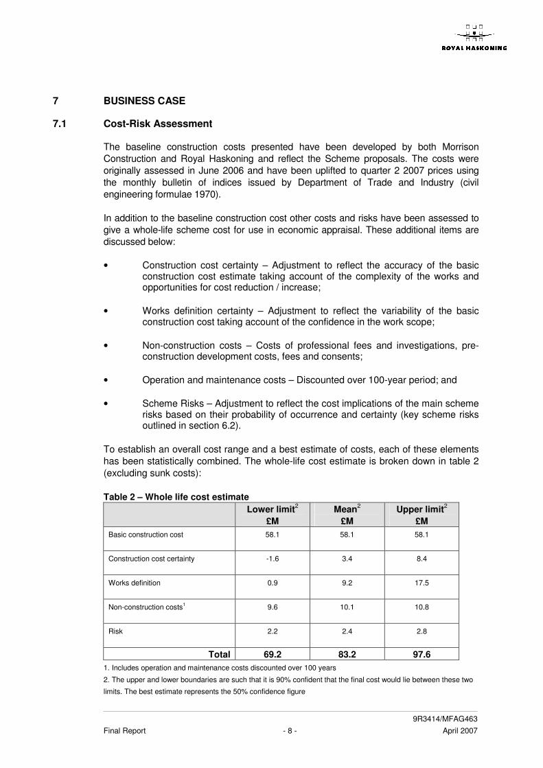
7.1 Cost-Risk Assessment
The baseline construction costs presented have been developed by both Morrison Construction and Royal Haskoning and reflect the Scheme proposals. The costs were originally assessed in June 2006 and have been uplifted to quarter 2 2007 prices using the monthly bulletin of indices issued by Department of Trade and Industry (civil engineering formulae 1970). In addition to the baseline construction cost other costs and risks have been assessed to give a whole-life scheme cost for use in economic appraisal. These additional items are discussed below: • Construction cost certainty – Adjustment to reflect the accuracy of the basic
construction cost estimate taking account of the complexity of the works and opportunities for cost reduction / increase;
• Works definition certainty – Adjustment to reflect the variability of the basic
construction cost taking account of the confidence in the work scope; • Non-construction costs – Costs of professional fees and investigations, pre-
construction development costs, fees and consents; • Operation and maintenance costs – Discounted over 100-year period; and • Scheme Risks – Adjustment to reflect the cost implications of the main scheme
risks based on their probability of occurrence and certainty (key scheme risks outlined in section 6.2).
To establish an overall cost range and a best estimate of costs, each of these elements has been statistically combined. The whole-life cost estimate is broken down in table 2 (excluding sunk costs): Table 2 – Whole life cost estimate Lower limit2
£M Mean2
£M Upper limit2
£M Basic construction cost 58.1 58.1
58.1
Construction cost certainty -1.6 3.4
8.4
Works definition 0.9 9.2
17.5
Non-construction costs1
9.6 10.1 10.8
Risk
2.2 2.4 2.8
Total 69.2 83.2 97.6 1. Includes operation and maintenance costs discounted over 100 years
2. The upper and lower boundaries are such that it is 90% confident that the final cost would lie between these two
limits. The best estimate represents the 50% confidence figure

9R3414/MFAG463 Final Report - 9 - April 2007
It is the intention to develop and refine the whole-life cost estimate prior to final submission to the Scottish Executive. Anticipated work includes:
• Obtaining an updated baseline cost estimate for the scheme from Morrison Construction; and
• Updating the cost-risk evaluation report (MFAG150) based on the latest risk profile
and scheme designs.
7.2 Benefit Assessment
The benefits of the Elgin Flood Alleviation Scheme (i.e. avoided damages) are currently being assessed in order to identify and quantify the full range of property and non-property related flood benefits. At present only the “Do Minimum” direct damages for residential and commercial properties have been calculated using values from the Multi-Coloured Manual (The Benefits of Flood and Coastal Management: A Manual of Assessment Techniques, Flood Hazards Research Centre, 2005). All damages are based on quarter one 2007 prices and are updated from Multi-Coloured Manual figures using the Retail Prices Index. “Do Something” damages / residual damages and therefore flood defence benefits for the scheme will be calculated in further detail prior to the final submission to the Scottish Executive. The “Do Minimum” damages are presented in Table 3 below.
Table 3 – Do Minimum Damages Residential Commercial Total Property
PV “Do Minimum” Damage £M 33.7 85 118.7
It is the intention to develop and refine the benefits assessment further prior to final submission to the Scottish Executive. Anticipated work includes calculation of the “Do Something” damages and therefore scheme benefits, refinement of property damages by data checking, including confirmation of property threshold levels by surveying selected sites, and incorporation of capping values for residential and commercial properties in accordance with Scottish Executive guidelines. Anticipated work also includes assessment of non-property damages including:
• Cleaning costs, temporary housing costs and land damage; • Public infrastructure and traffic disruption costs; • Loss of utilities and services; • Additional costs to emergency services; • Economic damage to local commerce, production and tourism; • Lost working time; • Social effects including stress, illnesses and personal injuries; • Environmental and recreational damages; and • Damage to archaeology and built heritage.
9R3414/MFAG463 Final Report - 10 - April 2007
7.3 Economic appraisal
Based on current information a range of benefit-cost ratios has been calculated. This information confirms that a positive benefit-cost ratio is expected with a final ratio of between 1 and 2. The benefit cost ratio will be confirmed in the technical report and investment appraisal document, which will accompany the full Flood Prevention Order submission in June 2007.
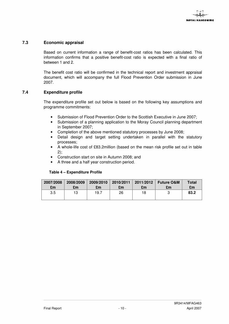
7.4 Expenditure profile
The expenditure profile set out below is based on the following key assumptions and programme commitments:
• Submission of Flood Prevention Order to the Scottish Executive in June 2007; • Submission of a planning application to the Moray Council planning department
in September 2007; • Completion of the above mentioned statutory processes by June 2008; • Detail design and target setting undertaken in parallel with the statutory
processes; • A whole-life cost of £83.2million (based on the mean risk profile set out in table
2); • Construction start on site in Autumn 2008; and • A three and a half year construction period.
Table 4 – Expenditure Profile
2007/2008
£m 2008/2009
£m 2009/2010
£m 2010/2011
£m 2011/2012
£m Future O&M
£m Total £m
3.5
13
19.7
26
18
3
83.2
9R3414/MFAG463 Final Report - 11 - April 2007
8 NEXT STEPS
The programme identifies the following steps to be completed over the next few months: Progress engineering design; prepare design calculations for structures; prepare AIP for proposed new bridges; manage and mitigate key identified construction risks
On going
Submit Outline Business Case to the Scottish Executive
April 2007
Public exhibition of Elgin FAS
24 – 25 April 2007
Finalise FPO operations
By end May 2007
Prepare Appropriate Assessment criteria for Loch Spynie SPA
By end May 2007
Update baseline cost estimate
May 2007
Update economic damages, including tangible and intangible benefits
By end May 2007
Draft Technical Report and Investment Appraisal document to support FPO
June 2007
Finalise FPO drawings
June 2007
Submit FPO to Scottish Executive By end June 2007 In addition, it is intended to submit a planning application, complete with Environmental Statement, to the Moray Council planning department by the end of September 2007.
=o=o=o=

9R3414/MFAG463 Final Report April 2007
������������
Appendix A Draft Flood Prevention Operations

9R3414 – Elgin Flood Alleviation Scheme MFAG463 Appendix A A1
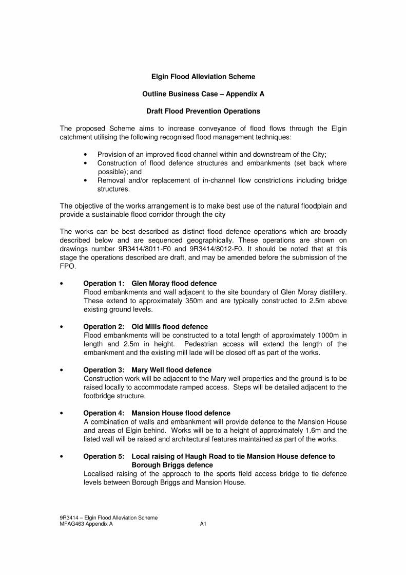
Elgin Flood Alleviation Scheme
Outline Business Case – Appendix A
Draft Flood Prevention Operations The proposed Scheme aims to increase conveyance of flood flows through the Elgin catchment utilising the following recognised flood management techniques:
• Provision of an improved flood channel within and downstream of the City; • Construction of flood defence structures and embankments (set back where
possible); and • Removal and/or replacement of in-channel flow constrictions including bridge
structures.
The objective of the works arrangement is to make best use of the natural floodplain and provide a sustainable flood corridor through the city The works can be best described as distinct flood defence operations which are broadly described below and are sequenced geographically. These operations are shown on drawings number 9R3414/8011-F0 and 9R3414/8012-F0. It should be noted that at this stage the operations described are draft, and may be amended before the submission of the FPO. • Operation 1: Glen Moray flood defence
Flood embankments and wall adjacent to the site boundary of Glen Moray distillery. These extend to approximately 350m and are typically constructed to 2.5m above existing ground levels.
• Operation 2: Old Mills flood defence
Flood embankments will be constructed to a total length of approximately 1000m in length and 2.5m in height. Pedestrian access will extend the length of the embankment and the existing mill lade will be closed off as part of the works.
• Operation 3: Mary Well flood defence Construction work will be adjacent to the Mary well properties and the ground is to be raised locally to accommodate ramped access. Steps will be detailed adjacent to the footbridge structure.
• Operation 4: Mansion House flood defence A combination of walls and embankment will provide defence to the Mansion House and areas of Elgin behind. Works will be to a height of approximately 1.6m and the listed wall will be raised and architectural features maintained as part of the works.
• Operation 5: Local raising of Haugh Road to tie Mansion House defence to Borough Briggs defence
Localised raising of the approach to the sports field access bridge to tie defence levels between Borough Briggs and Mansion House.
9R3414 – Elgin Flood Alleviation Scheme MFAG463 Appendix A A2
• Operation 6: Borough Briggs flood defence Embankment work extending approximately 700m around the football stadium and leisure centre to a height of typically 3m.
• Operation 7: Elgin Showground defence Localised ground raising to provide level access to the height of the surrounding defences whilst still maintaining a level area for fairgrounds and car parking.
• Operation 8: Decora flood defence Inspection and localised improvement to existing defences.
• Operation 9: Lossie Wynd Bridge Replacement (including demolition of existing bridge and abutments) A new bridge and abutments, architecturally designed, with sufficient height to the underside of bridge to accommodate design flows.
• Operation 10: Cooper Park defence Combination of embankments and hard landscaping extending approximately 800m through the park to heights up to 2m.
• Operation 11: Floodplain lowering Deanshaugh House Reduction in levels and landscaping of finished surfaces (approximately 2m below existing ground levels) to assist conveyance.
• Operation 12: Deanshaugh House replacement flood embankment Localised work to make good current defences at a revised alignment.
• Operation 13: Floodplain lowering Cooper Park (downstream end) Reduction in levels and landscaping of finished surfaces (approximately 2m below existing ground levels) to assist conveyance.
• Operation 14: Kingsmill flood defence Flood defences approximately 1m above existing ground levels and extending approximately 100m along both the left and right banks constructed using hard engineering works – possibly sheet piling.
• Operation 15: Channel re-alignment upstream of Brewery Bridge Approach channel to Brewery Bridge to be realigned to smooth the approach to the bridge and flood relief channel to avoid adverse effects to river geomorphology and associated deposition. Exact extents to be confirmed, likely to be 150m of river channel.
• Operation 16: Bypass channel in Cathedral area and associated flood Embankments
Creation of a flood relief channel to convey large flows adjacent to the current Lossie channel. Extent is approximately 200m and 3m depth.
• Operation 17: New brewery footbridge Construction of a new footbridge over the flood relief channel.
9R3414 – Elgin Flood Alleviation Scheme MFAG463 Appendix A A3
• Operation 18: Replacement of Pansport bridge and abutments with second
span over new bypass channel. Construction of a replacement road bridge and approaches to span the Lossie and flood relief channel – span approximately 50m.
• Operation 19: Johnstons flood defence Works to strengthen/replace the existing defences over approximately 250m including provision for remediation of contaminated materials contained within the current embankment.
• Operation 20: Floodplain lowering Pansport Bridge to Old Railway Bridge Flood plain lowering to a depth of up to 2.5m and set back approximately 30m from the existing rivers edge. Works to extend approximately 800m.
• Operation 21: Grampian Road flood defence Flood bank approximately 1.5m high to the landward side of the river channel lowering. Construction techniques will vary along the extents depending on physical constraints.
• Operation 22: Old Railway bridge high level bypass channel Railway embankment to be removed to provide a 50m flood relief channel to the South of the existing Old Railway Bridge. The bridge and sufficient approach embankment to give structural stability will be retained.
• Operation 23: Scottish water site flood defence Localised embankment work along the current Scottish Water site which will be constructed to a height of approximately 1.5m.
• Operation 24: Moycroft flood defence Embankment work extending approximately 500m and to a height of approximately 1.5m.
• Operation 25: Moycroft floodplain lowering Reduction in levels and landscaping of finished surfaces (approximately 2m below existing ground levels) to assist conveyance.
• Operation 26: Tyock industrial estate flood defence Earth embankment adjacent to the Lossie extending approximately 500m along the riverbank and to a height of approximately 1.5m above existing ground level.
• Operation 27: Tyock industrial estate flood plain lowering Reduction in levels and landscaping of finished surfaces (approximately 2m below existing ground levels) to assist conveyance.
• Operation 28: Diversion of Tyock Burn Creation of a 1500m long channel (approx) extending from the point of the existing confluence to a new point downstream.
9R3414 – Elgin Flood Alleviation Scheme MFAG463 Appendix A A4
• Operation 29: Tyock Burn flood defence Approximately 1000m of flood embankment to a height of 2m above existing ground levels.
• Operation 30: Diversion of Linkwood Burn Closure of the existing Burn discharge to the Lossie and creation of a new discharge point into the diverted Tyock channel.
• Operation 31: A96 flood defence Embankment works to approximately 1.5m above existing ground level extending from high ground prior to the new Tyock confluence to a suitable high point along the A96.
• Operation 32: Kirkhill Cottages flood defence (not included on drawing) Localised works consisting of embankments and localised raising of infrastructure.
• Operation 33: Pitgaveny flood defence (not included on drawing) Localised works consisting of embankments and localised raising of infrastructure.
• Operation 34: Palmerscross flood defence (not included on drawing) Localised defences to eliminate the flooding mechanism at Palmercross, details TBC.
In addition to the flood defence operations outlined above a number of ancillary operations will be required as part of the flood defence scheme: Services There are a number of key locations where the works are likely to require adjustment or alteration of services in the vicinity of the works. This work will be planned and undertaken in close consultation with the party responsible for the service. Other ancillary operations
• Surface water drainage works • Glen Moray drain outfall • Footpath accommodation/re-routing works (various locations) • Landscaping various (inc. Cooper Park) • Environmental enhancements • Contaminated land remediation (inc. Johnston’s embankment) • Grampian Road re-alignment • Temporary bridge (Pansport) • Bridge approach and road re-alignments (Pansport) • Old Railway Bridge footpath works • Farm access (over Tyock diversion) • Flood defence operation and maintenance permanent access (various locations) • Invasive species management • Site establishment and remedial works