Embed Size (px)
Citation preview
NELSON MANDELA BAY
METROPOLITAN MUNICIPALITY
Metropolitan
Spatial Development
Framework 2015
TABLE OF CONTENTS
1. EXECUTIVE SUMMARY ....................................................................................... 1
1.1 Factual Overview .......................................................................................... 1
1.2 Proposals ...................................................................................................... 2
1.3 Implementation and Prioritisation .................................................................. 6
1.4 Incorporating Sectoral Plans ......................................................................... 7
1.5 Status of the MSDF ....................................................................................... 8
2. INTRODUCTION ................................................................................................. 9
2.1 Background and Purpose .............................................................................. 9
2.2 Metropolitan Spatial Development Framework Approach ........................... 12
2.3 Overview of Nelson Mandela Bay ............................................................... 13
2.4 Document Structure .................................................................................... 15
3. LEGISLATIVE AND POLICY CONTEXT ......................................................... 16
3.1 Legislative Context ................................................................................... 16
3.2 National Policy Objectives ....................................................................... 21
3.3 Provincial Policy Objectives .................................................................... 24
3.4 Local Policy Objectives ............................................................................ 26
4. SPATIAL DEVELOPMENT ANALYSIS ............................................................ 34
4.1 Biophysical Analysis .................................................................................... 34
4.2 Challenges and Opportunities ..................................................................... 47
4.3 Socio Economic Analysis ............................................................................ 48
4.4 Built Environment Analysis .......................................................................... 61
4.5 Infrastructure ............................................................................................... 65
4.6 Pattern of Activities ..................................................................................... 66
5. SPATIAL PLANNING DIRECTIVES ................................................................. 85
5.1 Primary Structuring Elements...................................................................... 86
5.2 Consolidation and Densification .................................................................. 87
5.3 Growth Management ................................................................................... 88
5.4 Other Supporting Strategies ........................................................................ 89
5.5 Incorporating Sector Plan Developments ................................................. 130
6. SPATIAL PROPOSALS .................................................................................. 138
6.1 Spatial Vision ............................................................................................ 138
6.2 Spatial Principles informing the NMBM SDF ............................................. 138
6.3 Spatial Development Concept ................................................................... 140
7. IMPLEMENTATION FRAMEWORK .................................................................. 204
7.1 Capital Investment Framework ..................................................................... 204
8. BIBLIOGRAPHY ................................................................................................ 217
LIST OF FIGURES:
Figure 1: Distance to Facilities ................................................................................... 4
Figure 2: Nelson Mandela Bay Overview ................................................................. 13
Figure 3: Horizontal alignment at local level ............................................................. 26
Figure 4: Nelson Mandela Bay Local Spatial Development Frameworks ................. 29
Figure 6: Global Significance of the biodiversity. (Source: NMBM, Bioregional Plan
2014) ........................................................................................................................ 34
Figure 10: Fresh Water Features. (Source: NMBM GIS, 2015) ................................ 43
Figure 12: Employment trends within the Nelson Mandela Bay. (Source: StatsSA
2011 Census) ........................................................................................................... 55
Figure 15: Urban Network Strategy - Township Clusters ......................................... 90
Figure 16: Urban Network Strategy: Cluster Densities (Persons/ha) ....................... 91
Figure 17: Urban Network Strategy - Income Levels per Cluster ............................. 91
Figure 18: NMBM Urban Nodes. [(Source: NMBM Draft Urban Network Strategy
2014)] ..................................................................................................................... 142
Figure 20: Major Industrial Nodes. [(Source: NMBM Draft Urban Network Strategy
2014)] ..................................................................................................................... 149
Figure 22: Major Movement Directions. [Source: NMBM Draft Urban Network
Strategy 2014)] ....................................................................................................... 152
Figure 23: Existing Roads of Metropolitan Significance. (Source: Source: NMBM,
CITP 2011/12) ........................................................................................................ 155
Figure 24: Non-Motorised Transportation Concept (Source: NMBM, CITP 2011/12)
............................................................................................................................... 157
Figure 25: Long Term Public Transport Routes. (Source: NMBM, CITP 2011/12) . 160
Figure 26 : Long Term Rail Network. (Source: NMBM, CITP 2011/12) .................. 162
Figure 28: Activity & Emerging Corridors. [Source: NMBM Draft Urban Network
Strategy 2014)] ....................................................................................................... 165
Figure 32: Walmer Node. (Source: NMBM Greater Walmer LSDF, 2013) ............. 177
Figure 34: N2 Baywest Node. (Source: Western Suburbs LSDF, 2013) ................ 179
Figure 35: Densification within 10Km of CBD. (Source: NMBM, Human Settlement
Plan 2011) .............................................................................................................. 184

Figure 37: Densification within 10Km of Uitenhage. (Source: NMBM, Human
Settlement Plan 2011) ............................................................................................ 185
Figure 38: NMBM Restructuring Zones. (Source: NMBM, Human Settlement Plan
2011) ...................................................................................................................... 186
Figure 40: NMBM Spatial Development Plan 2015 ................................................ 193
LIST OF TABLES:
Table 1: Biodiversity Area Categories. (Source: NMBM Bioregional Plan 2014) ...... 37
Table 8: Employment Status. (Source: StatsSA 2011 Census) ................................ 55
Table 9: Existing and Projected Housing Circumstances (2007-2020). (Source:
Shisaka Development Management Services, 2012) ............................................... 58
Table 10: Summary of Land Requirements by Housing Programme. (Source: Shisika
Development Management Services, 2012) ............................................................ 59
Table 11: Social Facilities ......................................................................................... 77
LIST OF ANNEXURES:
ANNEXURE A - Urban Nodes
ANNEXURE B - Major Industrial Nodes
ANNEXURE C - Critical Biodiversity Areas
ANNEXURE D- Activity Corridors
ANNEXURE E- Hubs and Integrated Zones
ANNEXURE F- Urban Edge/Urban Growth Boundary
ANNEXURE G- Flood lines and Coastal Setback Line
ANNEXURE H- Local Spatial Development Frameworks
ANNEXURE I- Mining Activities
ANNEXURE J- Spatial Development Framework 2015
ABBREVIATIONS
BEPP Built Environment Performance Plan
BPO Business Process Outsourcing
BRT Bus Rapid Transport
CBAs Critical Biodiversity Areas
CBD Central Business District
CDC Coega Development Corporation
CETT Corporate Environmental Task Team
CIDZ Coega Industrial Development Zone
CITP Comprehensive Integrated Transport Plan
DEDEAT Department of Economic Development,
Environmental Affairs and Tourism
DORA Division of Revenue Act
DTI Department of Trade and Industry
DWA Department of Water Affairs
EDRS Economic Development & Recreational
Services
EIA Environmental Impact Assessment
EMF Environmental Management Framework
GGP Gross Geographic Product
GVA Gross Value Added
HDA Housing Development Agency
HIV/AIDS Human Immunodeficiency Virus causing the
Acquired Immunodeficiency Syndrome
HDMS Housing Delivery Management System
HSDG Human Settlements Development Grant
ICDG Integrated City Development Grant
IDP Integrated Development Plan
IDZ Industrial Development Zone
IZ Integration Zone
IPTS Integrated Public Transport System
ITP Integrated Transport Plan
LAMS Land Asset Management System
LDO’s Land Development Objectives
LED Local Economic Development
LSDF Local Spatial Development Framework
MBDA Mandela Bay Development Agency
MDTTT Multi-Disciplinary Technical Task Team
MOSS Metropolitan Open Space System
MSDF Metropolitan Spatial Development
Framework
NMT Non-Motorized Transportation
NDP National Development Plan
NDPG Neighbourhood Partnership Development
Gant
NEMA National Environmental Management Act
NLLS Nooitgedacht Low Level Scheme
NMBM Nelson Mandela Bay Municipality
NMBLP Nelson Mandela Bay Logistics Park
NMBM IDP Nelson Mandela Bay Municipality’s
Integrated Development Plan
NMBMM
Nelson Mandela Bay Metropolitan
Municipality
NMMOSS
Nelson Mandela Metropolitan Open Space
System
NT National Treasury
PDoHS Provincial Department of Human Settlements
PRASA Passenger Rail Agency of South Africa
PTIG Public Transport Infrastructure Grant
PTIS Public Transport Infrastructure and Systems
PTP Public Transport Plan
ROD Record of Decision
SCU Sustainable Community Unit
SCUs Sustainable Community Units
SDR Strategic Development Review
SEZs Special Economic Zones
SIPs Strategic Infrastructure Projects
SMP Sanitation Master Plan
SPLUMA Spatial Planning and Land Use Management
Act, 2013
Stats SA Statistics South Africa
SRVM Sunday River Valley Municipality
UNS Urban Network Strategy
USDG Urban Settlements Development Grant
W&S Water and Sanitation
WMP Water Master Plan
1 | P a g e
1. EXECUTIVE SUMMARY
This document is the result of a review of the Metropolitan Spatial Development
Framework (MSDF) which was approved in March 2009. As a core Integrated
Development Plan (IDP) component, the MSDF is a plan outlining the desired spatial
development of the metropolitan area as contemplated in the Spatial Planning and
Land Use Management Act, 2013 (SPLUMA), which replaced disparate apartheid
era laws with a coherent legislative system designed to spatially transform the
country in its democratic era. This tool must therefore not be used in isolation, but
must support decision-making within the context of the IDP and a City-wide
Development Strategy. In addition to setting out basic guidelines for a land use
management system, the MSDF also highlights priority investment and development
areas and will therefore serve as a guide to decision-makers and investors.
The MSDF is aligned with and does not conflict with other development strategies,
Nationally, Provincially and Regionally. The MSDF is a statutory requirement in
terms of the Municipal Systems Act, No 32 of 2000 and is approved every five (5)
years and refined annually. As approval of the current MSDF occurred in 2009; it is
necessary that a revised MSDF be commissioned in the 2014/15 financial year. This
document therefore contains the reviewed MSDF for adoption again by Council in
2015.
1.1 Factual Overview
The Nelson Mandela Bay Metropolitan Municipality (NMBMM) is the largest
Metropolitan Municipality in the Eastern Cape. After the Ekurhuleni Metropolitan
Municipality in Gauteng, it is the second largest Metropolitan Municipality in area in
the country covering an area of 1950km² in extent.
According to the 2001 Population Census, the population in the Nelson Mandela Bay
Municipality was approximately 1 million people. Demographic research undertaken
as part of the refinement of the MSDF indicates the 2011 census population of about
1, 15 million revealing a very low population growth since 2001.
2 | P a g e
The Nelson Mandela Bay Municipality plays a fundamental role in the economy of
the Eastern Cape Province, one of the poorest of the Provinces, contributing
approximately 42% to the Gross Geographic Product (GDP) (Global Insight, 2013).
Unemployment is still high at 36.6% (Census 2011). However, a more recent
estimate of the GDP of 32, 34% (Global Insight, 2013) suggests that there may be
some improvement in economic growth.
Housing remains a challenge with a backlog of approximately 72 411 units (BEPP
2014). The Municipality is currently verifying these figures through a study to
determine the number of backyard shacks and is also engaged in an audit of
informal settlements. This study commenced in April 2014.
1.2 Proposals
The Human Settlements Strategic Framework adopted by Council in December 2012
recommends spatial restructuring through the following interventions:
Urban Renewal Precincts: including Inner City areas, Motherwell, Happy Valley,
Lower Baakens Valley, Walmer Gqebera, Korsten, Helenvale and Greater Ibhayi-
Northern Areas Hub;
Spatial Transformation Precincts: such as Parsonsvlei, Coega IDZ /
Motherwell, Bay West and N2 Developments;
Implementation of an Integrated Zoning Scheme and Land Use System;
Assembly of well-located public and private land for development of
Integrated Human Settlements.
The following focal points in the MSDF are regarded as key in achieving
restructuring, integration and sustainability of the city and they are as follows:
3 | P a g e
1.2.1 Built Environment Performance Plan (BEPP) (Draft) 2015/16
The BEPP is a requirement of the Division of Revenue Act (DoRA) in respect of the
various infrastructure grants related to the built environment of Municipalities. It is
regarded as complementary to the key strategic documents of the Municipality,
together with the IDP, Budget, MSDF, Integrated Public Transport Strategy (IPTS)
and Human Settlements Plan. The BEPP aims to demonstrate the use of these
grants for the purpose of spatial restructuring through targeting the expenditure in
areas that will maximise the positive impact on citizens, leverage private sector
investment and support growth and development. Amongst other proposals, the
BEPP has identified various Hubs and Integrated Zones where investment is
recommended to be channelled in order to facilitate development of the city.
1.2.2 Sustainability Community Planning Methodology
The existing pattern of development in the Nelson Mandela Bay Municipality is the
result of segregation-based planning. The structuring not only separates different
racial groupings in geographical terms, but has also resulted in great disparities in
standards of living, as well as access to infrastructural services, employment and
cultural and recreational facilities. As these imbalances serve as constraints for
redevelopment, they should be addressed and rectified.
Sustainable Community Units (SCUs) have been introduced to achieve a more
balanced structure in Nelson Mandela Bay, in order to reduce discrepancies in terms
of service provision and standards; promote integration in socio-economic and
functional terms; and provide for economic activities and employment opportunities.
The urban areas of the Nelson Mandela Bay Municipality have been divided into a
number of planning units or entities, known as Sustainable Community Units (SCUs).
These are defined by the distance that an average person can comfortably walk to
access basics, i.e. a 2 km radius (See Figure 2). The planning methodology aims to
provide the requirements for a minimum standard of planning and living within those
areas; in other words, amenities, facilities and job opportunities must be within
walking distance of all residents.
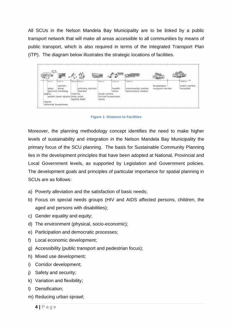
4 | P a g e
All SCUs in the Nelson Mandela Bay Municipality are to be linked by a public
transport network that will make all areas accessible to all communities by means of
public transport, which is also required in terms of the Integrated Transport Plan
(ITP). The diagram below illustrates the strategic locations of facilities.
Figure 1: Distance to Facilities
Moreover, the planning methodology concept identifies the need to make higher
levels of sustainability and integration in the Nelson Mandela Bay Municipality the
primary focus of the SCU planning. The basis for Sustainable Community Planning
lies in the development principles that have been adopted at National, Provincial and
Local Government levels, as supported by Legislation and Government policies.
The development goals and principles of particular importance for spatial planning in
SCUs are as follows:
a) Poverty alleviation and the satisfaction of basic needs;
b) Focus on special needs groups (HIV and AIDS affected persons, children, the
aged and persons with disabilities);
c) Gender equality and equity;
d) The environment (physical, socio-economic);
e) Participation and democratic processes;
f) Local economic development;
g) Accessibility (public transport and pedestrian focus);
h) Mixed use development;
i) Corridor development;
j) Safety and security;
k) Variation and flexibility;
l) Densification;
m) Reducing urban sprawl;
5 | P a g e
To achieve both sustainability and integration, six functional elements have been
identified as needing attention in relation to the above principles.
These six functional elements are as follows:
a) Housing;
b) Work;
c) Services;
d) Transport;
e) Community;
f) Character and Identity;
Focusing on these six elements, minimum standards are pursued to achieve an
acceptable planning quality that will result in an improved quality of life for residents
in these areas (for more detail on the planning methodology outlined above, refer to
the Sustainable Community Planning Guide dated June 2007, which is available on
the municipal website (http://www.nelsonmandelabay.gov.za).
1.2.3 Corridors and Accessibility
In restructuring the Nelson Mandela Bay Municipality, the development of corridors
along major routes that have potential for integrated mixed land use development,
supported by improved public transport services (e.g. the Khulani Corridor), is also
envisaged. ITP has been developed as a key component of the MSDF.
The primary goal of the ITP is to improve accessibility for all residents of Nelson
Mandela Bay Municipality with a strong focus on public transport provision.
1.2.4 Economic Development and Growth
This crucial component of the MSDF seeks to generate means to support and
enhance urban development. Various interventions may be utilised to support
economic growth and development, based on a number of considerations, such as:
6 | P a g e
a) The importance of linking the residents of the Nelson Mandela Bay Municipality to
opportunities;
b) Directing investments to places where they will have the greatest effect;
c) Protecting and enhancing natural and cultural resources for sustainability and
enriching the experience of Nelson Mandela Bay Municipality; and
d) Weaving the growth of Nelson Mandela Bay strongly into the economic fabric of
the Eastern Cape Province.
1.2.5 Activity nodes or areas
A wide range of activity nodes or areas exist which accommodates a variety of
activities. These can be divided into four main core areas, namely
Port Elizabeth
Uitenhage
Despatch
Coega IDZ and the Port of Ngqura.
1.3 Implementation and Prioritisation
The MSDF provides strategic guidance on the areas on which the Municipality
should focus the allocation of its resources. In order to assist in prioritising projects
and allocating resources, four main elements of the MSDF were isolated as
geographic entities that could give guidance as to where the priority capital
investment areas lie. These areas are:
a) Core economic areas
b) Infill priority areas
c) Strategic development areas
d) Service upgrading priority areas
National Treasury has prioritised the development of what is termed an Urban
Network Strategy. This Strategy defines areas such as nodes, hubs and corridors
into which government grant funding from National Treasury will be channelled. The
7 | P a g e
NMBM, in conjunction with National Treasury, is working on defining an acceptable
Urban Network Strategy, which will be approved by Council and form part of this
MSDF.
1.4 Incorporating Sectoral Plans
The various sectoral plans incorporated into the MSDF are identified in this section.
These sectoral plans, which have major spatial implications for the MSDF, are as
follows:-
a) Coastal Management Plan;
b) Disaster Management Plan;
c) Environmental Policy;
d) Infrastructure Development Plan;
e) Comprehensive Integrated Transport Plan;
f) Integrated Waste Management Plan;
g) Local Economic Development Strategy;
h) Metropolitan Open Space System;
i) Tourism Master Plan;
j) Integrated HIV and AIDS Plan;
k) Water Services Master Plan;
l) Sewerage Master Plan;
m) Human Settlements Plan;
n) Land Use Management System.
In addition to these, with the preparation of more detailed Local Spatial Development
Frameworks and their approval, the MSDF becomes more detailed.
Furthermore, a number of large developmental initiatives are mooted in and around
Nelson Mandela Bay. If all the proposed initiatives were developed comprehensively
and in support of one another, a collective momentum would be generated.
Together, these projects would place Nelson Mandela Bay in a highly competitive
8 | P a g e
position to attract tourism and other investment, both nationally and internationally,
and would promote domestic economic growth.
1.5 Status of the MSDF
It should be noted that in terms of the Spatial Planning and Land Use Planning
Acting 2013 (SPLUMA) Chapter 4, Part F, 22(1 & 2), a Municipal Planning Tribunal
or any other authority required or mandated to make a land development decision in
terms of this Act or any other law relating to land development, may not make a
decision which is inconsistent with a municipal spatial development framework,
unless if site - specific circumstances justify a departure from such provisions.
However it should be also noted that the MSDF in not site - specific and is therefore
a broad level guide. Reference should be made to the Local Spatial Development
Frameworks (LSDFs) which are deemed to be a detailed interpretation of the
broader MSDF. The LSDFs are to be used together with the MSDF for the evaluation
of land development applications
9 | P a g e
2. INTRODUCTION
2.1 Background and Purpose
The quality of life for many persons living in the Nelson Mandela Bay Municipality is
extremely poor. An important contributing factor to this is the structure and form of
the city. The urban policies and practices of the past have resulted in a city which
aggravates poverty and inequality, which is highly inconvenient for many and which
uses resources inefficiently. The causes of these problems are complex and include
a serious shortage of public investment to enable what needs to be done to remedy
the situation. A primary contributing factor has been the lack of consistency and
poor decision making about the spatial development of the city.
Therefore, this document aims to address the afore-mentioned challenges by
providing spatial representation of vision of the City by providing parameters within
which initiatives at a sector level and local level should translate spatial objectives
into tangible and attainable development objectives, targets and projects.
Furthermore, it intends to guide and manage public and investment development in
order to ensure the best possible outcome for the City.
2.1.1 Terms of Reference and Scope of Work
The main objective is to provide a long term vision of the desired spatial form and
structure of the Nelson Mandela Bay Municipality by creating a credible Metropolitan
Spatial Development Framework through the implementation of the Comprehensive
SDF Guidelines. The MSDF must give effect to the development principles contained
in the Spatial Planning & Land Use Management Act, 2013 (SPLUMA) including the
principles of:
spatial Justice;
spatial Sustainability;
efficiency;
spatial Resilience; and
10 | P a g e
good Administration.
2.1.2 Purpose of the MSDF
The MSDF and associated more detailed LSDF’s seek to achieve, over time and in a
controlled way, a radical restructuring of the city to make it more equitable,
integrated and efficient.
Furthermore, it seeks to guide overall spatial form and identify current and future
desirable land uses within the municipality, in order to give physical effect to the
vision, goals and objectives of the Municipal IDP. The MSDF informs development
decisions and creates a framework for investment that facilitates both public and
private spending. It also provides a basis for land use management and is ‘indicative’
of broad land uses within the municipal area of jurisdiction and directions of future
development. It reflects key land uses such as major transport routes, future
transport links, environmentally important areas and key potentials and constraints.
The MSDF, has a strong spatial focus. Spatial planning is a public sector activity
that creates a public investment and regulatory framework within which private
sector decision making and investment occurs. Spatial planning is important due to
the fact that most development decisions have spatial implications.
Spatial planning has two broad dimensions, namely:
(a) proactive planning, which defines desirable directions, actions and outcomes in
relation to the spatial dimensions and relationships of the city, and which guides
public investment;
(b) land development and management, which is concerned with regulating land use
change (usually driven by private sector initiatives), and with protecting individual
and group rights in land.
11 | P a g e
These two facets of spatial planning cannot be seen in isolation from each other.
They need to be integrated and should inform each other. These two aspects of
spatial planning and the issue of how to integrate them form the core focus of the
MSDF.
2.1.3 MSDF Objectives
The following development objectives are confirmed in order to support sustainable
development with the Nelson Mandela Bay Metropolitan Municipality:-
to analyse spatial opportunities, constraints, patterns and trends;
identify the need for spatial restructuring and land reform;
provide spatial solutions to developmental issues;
identify national spatial development principles and their spatial application in
the metropolitan area;
provide an understanding of and allow for the spatial implications of social,
economic and environmental sustainability;
produce a document that will guide decision-making with regard to
developable and non-developable areas including the sequencing of
development, and;
create a framework for public and private investment decisions to facilitate
investor confidence.
12 | P a g e
2.2 Metropolitan Spatial Development Framework Approach
2.2.1. Approach
The Department of Rural Development and Land Reform (DRDLR) Guideline was
used as the method to draft the Nelson Mandela Bay Spatial Development
Framework.
2.2.2. Public Participation
The MSDF is concerned with public involvement at two levels. The first is with
participation in relation to the MSDF itself. The second is with public involvement as
an ongoing part of spatial planning and urban management systems.
Implementation of the principles and recommendations of the MSDF will affect every
resident and visitor to Nelson Mandela Bay in some way or another. It is therefore
important that its citizens are engaged in the formulation of the MSDF.
2.2.3 Time- Frames
The MSDF presents a long term vision of the desired spatial form of the
metropolitan, and thus is critical informant to bulk infrastructure planning which
normally has a 20-year planning lifespan.
After adoption of the IDP by the Council, the Spatial Development Framework is
binding on the local authority for a period of 5 years (linked to the term of office of the
Council). The newly elected Council may adopt the IDP of the preceding Council or
develop a new IDP taking into account the existing documentation. The MSDF may
be reviewed annually which could result in amendments that can only be effected by
following a statutory process.
13 | P a g e
2.3 Overview of Nelson Mandela Bay
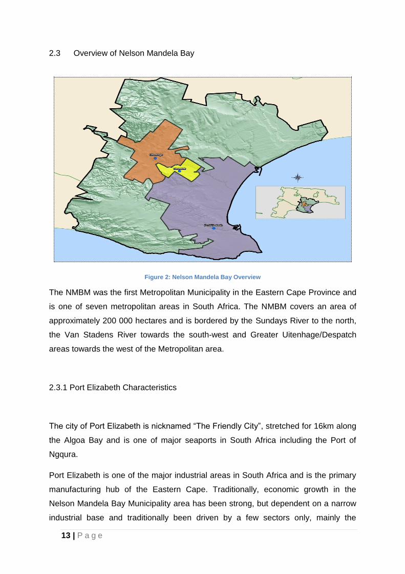
Figure 2: Nelson Mandela Bay Overview
The NMBM was the first Metropolitan Municipality in the Eastern Cape Province and
is one of seven metropolitan areas in South Africa. The NMBM covers an area of
approximately 200 000 hectares and is bordered by the Sundays River to the north,
the Van Stadens River towards the south-west and Greater Uitenhage/Despatch
areas towards the west of the Metropolitan area.
2.3.1 Port Elizabeth Characteristics
The city of Port Elizabeth is nicknamed “The Friendly City”, stretched for 16km along
the Algoa Bay and is one of major seaports in South Africa including the Port of
Ngqura.
Port Elizabeth is one of the major industrial areas in South Africa and is the primary
manufacturing hub of the Eastern Cape. Traditionally, economic growth in the
Nelson Mandela Bay Municipality area has been strong, but dependent on a narrow
industrial base and traditionally been driven by a few sectors only, mainly the
14 | P a g e
automotive vehicle and component manufacturing and exports, these include
General Motors, Ford, Continental Tyres and other automotive related companies.
The Port Elizabeth region has a large pool of both skilled and unskilled labour. It has
well developed infrastructure in terms of road and rail, and provides easy access to
both the Port Elizabeth and the nearby towns of Uitenhage and Despatch. With the
advent of democracy a new Industrial Development Zone (IDZ) has been established
at Coega, known as the Coega Industrial Development Zone (CIDZ). The Coega IDZ
under stewardship of the Coega Development Corporation has managed to attract
billions of investments into economy of the Eastern Cape and thus enabling
thousands of jobs to be created.
The wider area of Port Elizabeth features a number of historic attractions linked to
the Donkin Reserve Park and Monument, old heritage buildings and opportunities for
game viewing such as the Addo Elephant National Park.
2.3.2 Uitenhage/Dispatch Characteristics
The Greater Uitenhage/ Despatch area covers an area of approximately 237 km2
(23 745 ha) and includes the towns of Uitenhage and Despatch, as well as the
township areas of KwaNobuhle, Khayamnandi, Rosedale, Kabah-Langa and Joe
Slovo. Uitenhage/ Despatch is characterised by significant residential component
with an approximate population of 280 000 in 16 wards.
Known as the Garden Town, Uitenhage was first a farm community on the banks of
the Swartkops River, now it is a thriving commercial and industrial town and has
managed to keep its picturesque beauty. Uitenhage is known for its large industrial
base. The largest of these industries are the Volkswagen South Africa and Good-
year factories. An automotive supplier park, the NMBLP, has been developed
directly next to the Volkswagen factory, thus allowing automotive
component manufacturers to construct their manufacturing plants close by.
15 | P a g e
Major access corridors are the R75 between Port Elizabeth and Graaff-Reinet, the
R334 Motherwell link and a well-developed internal road hierarchy and railway
linkages. The Central Business Districts of Uitenhage and Despatch are well-
established and fulfil a local and district wide commercial trade function.
2.4 Document Structure
The document is made up of seven sections.
Following Sections 1 and 2 of the report being the Executive Summary and
Introduction to the MSDF respectively, Section 3 defines an approach to planning
and also provides a short comment on National, Provincial and Local legislation and
policy guidelines including the “Vision” for Nelson Mandela Bay. Section 4 presents
a broad analysis of the current situation with regard to spatial planning and the
existing Metropolitan structure, the desired spatial logic and relationships between
different elements which make up the city’s structure (biophysical analysis, socio-
economic analysis, built environment analysis, including various sector plans which
have major spatial implications for the MSDF). Section 5 outlines the spatial
planning directives which are designed to maintain consistent approaches in proving
direction and scope for integration of all aspects of spatial planning such as land use,
roads and service infrastructure, pedestrian and vehicular movement, open space
systems and other development patterns. Section 6 introduces the spatial proposals
and restructuring of the city highlighting major nodes and growth management
scenarios defined by the urban edge. This section concludes by identifying some
important projects being undertaken. Section 7 identifies urban networks,
integration zones and hubs. It further sets out the various development phases and
strategies for the implementation of the MSDF, drawing together specific and
significant follow up studies and planning projects.
16 | P a g e
3. LEGISLATIVE AND POLICY CONTEXT
This Chapter describes the National and Provincial legislation, and policy guidelines
relevant to the Metropolitan Spatial Development Framework.
3.1 Legislative Context
3.1.1 Constitution of the Republic of South African, 1996
The constitutional provisions on local government are in section 152 and 153.Section
152 is very clear on the objective of Local Government which includes:
“To provide democratic and accountable government for local communities
To ensure provision of services to communities in a sustainable manner,
To promote social and economic development
To promote a safe and healthy environment , and
To encourage the involvement of communities and community organizations in
the matters of local government.”
The developmental duties of local government are stated in Section 153 that a
municipality must:
“Structure and manage its administration, and budgeting and planning process to
give priority to the basic needs of the community, and to promote the social &
economic development of the municipality;
Participate in national & provincial development programmes.”
The MSDF aims to address the social, economic and environmental developmental
needs of NMBMM on a spatial level as contemplated in the Constitution of the
Republic of South Africa, with respect to duties of Local Government. In doing so, it
encourages spatial planning for the community which involves the community while
creating safe and healthy environments.
17 | P a g e
3.1.2 Local Government: Municipal Systems Act, 2000
The MSDF, as part of the Integrated Development Plan (IDP) gives legal status in
terms of the Municipal Systems Act (Act 32, 2000) and the Municipal Planning and
Performance Management Regulations published on 24 August 2001.
3.1.3 Local Government: Municipal Planning and Performance Management
Regulations (GN R796 of 2001)
The Regulations promulgated in terms of the Municipal System Act (2000) set out
the following requirements for the development of a Spatial Development
Framework:
“A spatial development framework reflected in a municipality’s integrated
development plan must:
(a) set out objectives that reflect the desired spatial form of the municipality;
(b) contain strategies and policies regarding the manner in which to achieve the
objectives referred to in paragraph (b), which strategies and policies must-
(i) indicate desired patterns of land use within the municipality;
(ii) address the spatial reconstruction of the municipality; and
(iii) provide strategic guidance in respect of the location and nature of
development within the municipality.
(c) set out basic guidelines for a land use management system in the municipality;
(d) set out a capital investment framework for the municipality’s development
programs;
(e) contain a strategic assessment of the environmental impact of the spatial
development framework;
(f) identify programs and projects for the development of land within the municipality;
(g) be aligned with the spatial development frameworks reflected in the integrated
development plans of neighbouring municipalities; and
(i) provide a visual representation of the desired spatial form of the municipality,
which representation -
18 | P a g e
(ii) must indicate where public and private land development and infrastructure
investment should take place;
(iii) must indicate desired or undesired utilisation of space in a particular area;
(iv) may delineate the urban edge;
(v) must identify areas where strategic intervention is required; and must indicate
areas where priority spending is required.”
3.1.4 Municipal Finance Management Act (2003) (MFMA)
The objective of the MFMA is to secure sound and sustainable management of the
financial affairs of municipalities.
Section 16. (1) of the MFMA requires the municipality to approve an annual budget
for the municipality and any decision must be accompanied by among others, the
following documents:
17 (b) measurable performance objectives for revenue from each source and for
each vote in the budget, taking into account the municipality's integrated
development plan; and
17(d) any proposed amendments to the municipality’s IDP following its annual
review of the integrated development plan in terms of section 34 of the Municipal
Systems Act.
In order to align with the objective of this act, the MSDF utilizes the Capital
Investment Framework to indicate the spatial priorities and budget provisions.
3.1.5. Spatial Planning and Land Use Management Act, 2013 (SPLUMA)
The Spatial Planning and Land Use Management Act (SPLUMA), Act 16 of 2013
was promulgated on 5 August 2013. Chapter 4 of SPLUMA provides clear directives
with regard to the preparation of Spatial Development Frameworks at national,
Provincial, Regional and Local Municipal level. The SPLUMA will replace the
Development Facilitation Act (67 of 1995), Removal of Restrictions Act (84 of 1967),
the Physical Planning Act (88 of 1967) and other planning legislations. It
aims to rationalise planning by ensuring the following objectives are achieved:
19 | P a g e
(a) “provide for a uniform, effective, efficient and integrated regulatory framework
for spatial planning, land use and land use management in a manner that
promotes the principles of co-operative government and public interest;
(b) provide for and determine development principles, compulsory norms and
standards for land use management;
(c) maintain essential standards for land use management, spatial development
and land use;
(d) promote-
(i) co-operative governance;
(ii) socio-economic benefits; and
(iii) sustainable and efficient use of land;
(e) establish planning tribunals; and
(f) redress the imbalances of the past and ensure that there is equity in land use
and land use management.”
Section 20, prescribes the processes with regard to the adoption of MSDF and
furthermore emphasises the relationship between the SDF and IDP. This process is
as follows:
“20. (1) The Council of a municipality must by notice in the Provincial Gazette adopt
a municipal spatial development framework for the municipality.
(2) The municipal spatial development framework must be prepared as part of a
municipality’s integrated development plan in accordance with the provisions of the
Municipal Systems Act.
(3) Before adopting the municipal spatial development framework contemplated in
subsection (1) and any proposed amendments to the municipal spatial development
framework, the Municipal Council must—
(a) give notice of the proposed municipal spatial development framework in the
Gazette and the media;
20 | P a g e
(b) invite the public to submit written representations in respect of the proposed
municipal spatial development framework to the Municipal Council within 60 days
after the publication of the notice referred to in paragraph (a); and
(c) consider all representations received in respect of the proposed municipal spatial
development framework."
Section 21 states that the SDF must among other things give effect to the
development principles and applicable norms and standards set out in Chapter 2.
The Nelson Mandela Bay SDF has adopted these Chapter 2 development principles
and applicable norms and standards in developing the spatial vision.
3.1.6. National Environment Management Act, 1998 (NEMA)
The National Environmental Management Act (NEMA), Act 19 of 1998, provides for
“co-operative environmental governance” on matters affecting the environment. This
Act inter alia regulates the preparation of Environmental Management Plans at all
spheres of Government, which then influences the spatial extent of developable and
un-developable land. The key principles of NEMA that inform the SDF include the
following:
environmental , social and economic sustainable development;
the provision of access to resources and environmental management that
puts people and their needs first;
the protection of natural resource and the maintenance of natural systems.
The MSDF takes into consideration among other things, the protection of natural
resource and the maintenance of natural systems. MSDF spatially represent the
critical biodiversity areas that need to be protected.
21 | P a g e
3.1.7 National Heritage Act
This legislation aims to promote good management of the national estate, and to
enable and encourage communities to nature and conserve their legacy so that it
may be bequeathed to future generations. The National Heritage Resources Act, No.
25 of 1999, demands the establishment of a heritage resources management system
involving a national heritage resources authority, a Provincial Heritage Resources
Authority (PHRA) in each region or province and the local authorities which, once the
system is established, will be responsible for Grade 1, 2 and 3 heritage resources
respectively.
3.2 National Policy Objectives
The MSDF has used alignment as an instrument to synthesize and integrate the top-
down and bottom-up planning process between different spheres of Government.
The MSDF must embody the ideals for planning that have been set at a National
level. This vertical alignment is thus important in ensuring that the National vision
and objectives are incorporated into the spatial direction and/ or focus.
Below are the most significant National strategies and/ or policies relevant to the
MSDF.
3.2.1 National Development Plan: Vision 2030 (NDP)
The National Planning Commission has developed a National Development
Plan which focuses on enabling sustainable and inclusive development. The
Plan aims to eliminate poverty and reduce inequality by 2030. The Plan has a target
of developing people’s capabilities to improve their lives through education and skills
development, health care, better access to public transport, jobs, social protection,
rising income, housing and basic services, and safety. It proposes to the following
strategies to address the above goals:
22 | P a g e
Creating jobs and improving livelihoods
Expanding infrastructure
Transition to a low-carbon economy
Transforming urban and rural spaces
Improving education and training
Providing quality health care
Building a capable state
Fighting corruption and enhancing accountability
Transforming society and uniting the nation
The National Development Plan: Vision 2030 is central to the formulation of the
MSDF’s spatial vision and strategies. The MSDF proposes to bring lower income
people into areas where there are major economic opportunities through social
housing programmes; thereby promoting spatial, social and economic restructuring.
This will enhances access to job opportunities, which is key in the alignment of the
NDP: Vision 2030 and the SDF.
3.2.2. National Spatial Development Perspective (NSDP) (2006)
The NSDP is a critical tool for bringing about coordinated government action and
alignment to meet social, economic and environmental goals. It is the basis for
maximizing the overall social and economic impact of government development
spending by interpreting the strategic direction, promoting policy coordination and
fitting government actions into a coherent spatial term of reference. The purpose of
the NSDP is “to fundamentally reconfigure apartheid spatial relations and to
implement spatial priorities that meet the constitutional imperatives of providing basic
services to all and alleviating poverty and inequality.”
23 | P a g e
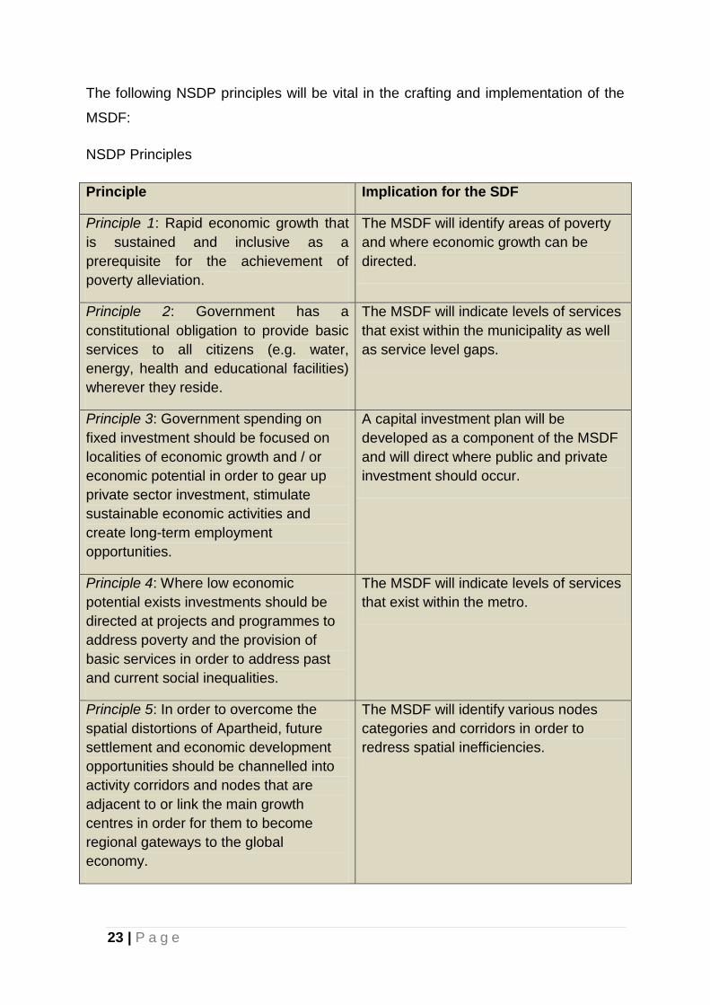
The following NSDP principles will be vital in the crafting and implementation of the
MSDF:
NSDP Principles
Principle Implication for the SDF
Principle 1: Rapid economic growth that
is sustained and inclusive as a
prerequisite for the achievement of
poverty alleviation.
The MSDF will identify areas of poverty
and where economic growth can be
directed.
Principle 2: Government has a
constitutional obligation to provide basic
services to all citizens (e.g. water,
energy, health and educational facilities)
wherever they reside.
The MSDF will indicate levels of services
that exist within the municipality as well
as service level gaps.
Principle 3: Government spending on
fixed investment should be focused on
localities of economic growth and / or
economic potential in order to gear up
private sector investment, stimulate
sustainable economic activities and
create long-term employment
opportunities.
A capital investment plan will be
developed as a component of the MSDF
and will direct where public and private
investment should occur.
Principle 4: Where low economic
potential exists investments should be
directed at projects and programmes to
address poverty and the provision of
basic services in order to address past
and current social inequalities.
The MSDF will indicate levels of services
that exist within the metro.
Principle 5: In order to overcome the
spatial distortions of Apartheid, future
settlement and economic development
opportunities should be channelled into
activity corridors and nodes that are
adjacent to or link the main growth
centres in order for them to become
regional gateways to the global
economy.
The MSDF will identify various nodes
categories and corridors in order to
redress spatial inefficiencies.
24 | P a g e
3.2.2 New Growth Path (NGP) (2010)
The policy’s principal target is to create five million new jobs by 2020. This
framework reflects government’s commitment to prioritising employment creation in
all economic policies. It identifies strategies that will enable South Africa to grow in a
more equitable and inclusive manner while attaining South Africa’s developmental
agenda.
Central to the New Growth Path is a massive investment in infrastructure as a
critical driver of jobs across the economy.
The framework identifies investments in five key areas namely: energy,
transport, communication, water and housing. Sustaining high levels of public
investment in these areas will create jobs in construction, operation and
maintenance of infrastructure.
The new growth path sees the infrastructure programme as a trigger to build a
local supplier industry for the manufacture of the components for the build-
programme.
Specific measures, particularly changes to procurement policy and
regulations, are identified to ensure that this is achieved. Risks include the still
fragile global recovery; competition and collaboration with the new fast
growing economies; and competing interests domestically.
3.3 Provincial Policy Objectives
The Municipal IDP is also informed by Provincial spatial planning policy directives
that help provide a policy context for the formulation of the MSDF. The MSDF
contributes to the attainment of the spatial development targets and objectives
outlined in these policies and also deal with the spatial issues facing the municipal
area. Some of the most significant strategies and/ or policies are as follows:
25 | P a g e
3.3.1 The Provincial Growth and Development Plan (2004 - 2014).
Within the broad understanding of the Eastern Cape as having the highest poverty
rate, the second lowest per capita income and the highest provincial unemployment;
the Provincial Growth and Development Plan has prioritised the following needs
which are addressed through a series of interventions, namely :-
Agrarian Transformation and Food Security
Poverty Eradication
Manufacturing Diversification and Tourism
Public Sector Transformation
Infrastructure Development, and
Human Resource Development
The MSDF identifies areas for focused investment as a catalyst for job creation and
poverty alleviation. This will sensitise economic development while creating
opportunities for social and economic inclusion.
3.3.2 The Eastern Cape Provincial Spatial Development Plan (2010 Final Draft)
(ECPSDP)
One of the aims of ECPSDP is to provide a framework within which local authorities
in the Province can prepare their IDP’s and Land Development Objectives (LDO’s).
Apart from aligning the Provincial priorities with National goals and objectives, the
following issues are raised in relation to the Nelson Mandela Bay Municipality from a
Provincial spatial perspective.
The Coega IDZ is one of the two (2) in the Province and is seen as having
significant growth potential requiring Provincial attention;
The Nelson Mandela Bay Municipality area is recognised as having Provincial
tourism potential;
26 | P a g e
Economic activity in the Province is focussed towards Nelson Mandela Bay
Metropolitan Municipality;
The relevant strategic approach of the Province in regard to Nelson Mandela Bay
is to maximise the strategic advantage of industry and commerce in order to have
a positive effect on the region;
The Province will encourage the development of the tourism industry;
Nelson Mandela Bay is identified as one of 12 provincial nodes to be targeted for
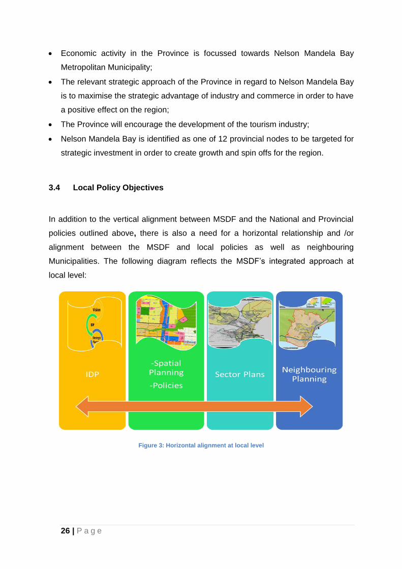
strategic investment in order to create growth and spin offs for the region.
3.4 Local Policy Objectives
In addition to the vertical alignment between MSDF and the National and Provincial
policies outlined above, there is also a need for a horizontal relationship and /or
alignment between the MSDF and local policies as well as neighbouring
Municipalities. The following diagram reflects the MSDF’s integrated approach at
local level:
Figure 3: Horizontal alignment at local level
27 | P a g e
3.4.1. Integrated Development Framework (IDP)
The IDP is the principal strategic planning document for the municipality. Importantly,
it ensures close co-ordination and integration between projects, programmes,
activities and the Budget, both internally (between directorates) and externally (with
other spheres of government). The IDP ultimately enhances integrated service
delivery and development and promotes sustainable, integrated communities,
providing a full basket of services, as communities cannot be developed in a
fragmented manner.
As the key strategic plan of the Municipality, the priorities identified in the IDP inform
all financial planning and budgeting undertaken by the institution.
As a strategic document, the IDP in terms of the Municipal Systems Act Section 35 is
required to contain an SDF. The SDF is thus a spatial translation of the IDP of the
Municipality.
3.4.3 Local Spatial Development Frameworks (LSDFs)
MSDF is supported by a number of LSDFs which serve as a second tier/level of
planning with respect to spatial planning hierarchy (Refer to Figure 4). These LSDFs
are important in ensuring the realisation of the SDF’s Spatial Vision through the
promotion of land uses which are in line with the spatial principles as contained in
the MSDF. The LSDFs that have been approved by the Council include:
Lorraine LSDF (almost ready to be reviewed);
2010 Stadium Precinct LSDF;
Helenvale LSDF;
Motherwell and Wells Estate LSDF;
Western Suburbs LSDF;
Happy Valley LSDF;
Uitenhage and Despatch LSDF;
Inner City LSDF;
28 | P a g e
Greater Walmer LSDF; and
Cape Road LSDF.
The following LSDFs are currently under development:
Ibhayi LSDF
Summerstrand LSDF;
Bethelsdorp LSDF; and
Zanemvula (Soweto-on-Sea/Veeplaas).
The following LSDFs are to be revised:
Greater Walmer LSDF
- Erven on the Northern portion along Circular Drive to be recommended for
business development in light of the characteristics of the area that are
conducive for such developments. The erven to be considered are from
the corner of Circular Drive and William Moffett Expressway up to the
intersection of Circular Drive and William Road/Clermont Street.
- Villiers Road to be considered for mixed use development.
Cape Road LSDF
- Erven on the northern side fronting Cape Road, between Disa
Avenue/William Moffett Expressway and Wykeham Avenue are
recommended for mixed use development.
Western Suburbs LSDF
- It should be amended to include the rezoning TPA 8418 and subdivision
4222B which were approved by Council prior to the approval of the LSDF
and Erf 8 Parsonsvlei.
29 | P a g e
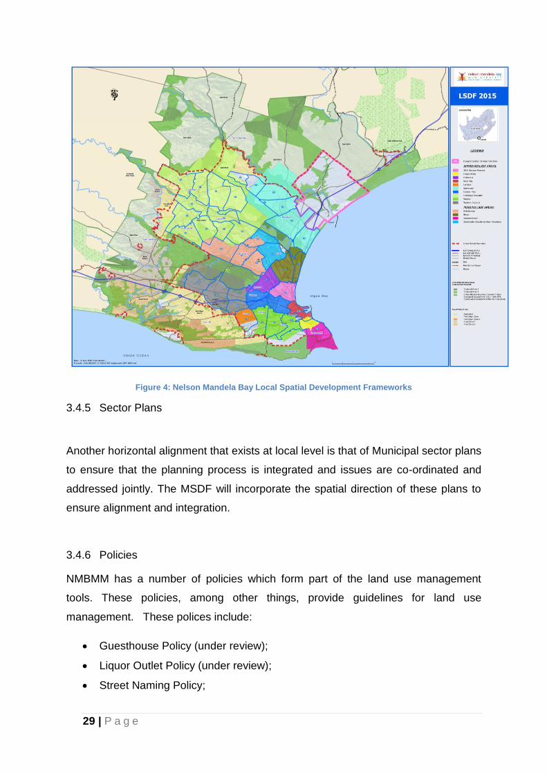
Figure 4: Nelson Mandela Bay Local Spatial Development Frameworks
3.4.5 Sector Plans
Another horizontal alignment that exists at local level is that of Municipal sector plans
to ensure that the planning process is integrated and issues are co-ordinated and
addressed jointly. The MSDF will incorporate the spatial direction of these plans to
ensure alignment and integration.
3.4.6 Policies
NMBMM has a number of policies which form part of the land use management
tools. These policies, among other things, provide guidelines for land use
management. These polices include:
Guesthouse Policy (under review);
Liquor Outlet Policy (under review);
Street Naming Policy;
30 | P a g e
Rural Management Policy;
Outdoor Dining Policy (draft format); and
Student Accommodation.
3.4.7 Neighbouring Planning
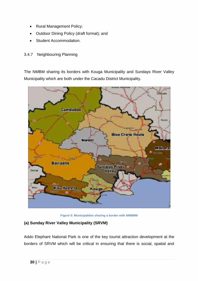
The NMBM sharing its borders with Kouga Municipality and Sundays River Valley
Municipality which are both under the Cacadu District Municipality.
Figure 5: Municipalities sharing a border with NMBMM
(a) Sunday River Valley Municipality (SRVM)
Addo Elephant National Park is one of the key tourist attraction development at the
borders of SRVM which will be critical in ensuring that there is social, spatial and
31 | P a g e
economic integration between NMBMM and Sunday River Valley Municipality. It is
key in unlocking development at the border of these two Municipalities.
According to the SRVM 2013/2014 IDP report, the Greater Addo Park is of critical
importance, specifically regarding future planning and development and the
integration of park activities and settlement patterns within the SRVM area.
Expansion plans for the Park will be focused around the establishment of a 372 000
ha terrestrial zone in addition to a 120 000 ha marine reserve which would include
the Bird and St Croix Islands group in Algoa Bay. These plans would see Addo
becoming the third largest conservation area in South Africa after the Kgalagadi
Transfrontier Park and Kruger National Park.
It is important for the MSDF to take note of this development potential. The
Implications for the MSDF will be that of ensuring that there is a tourism linkage
between the Addo Elephant Park and NMBMM. Furthermore, the MSDF will ensure
linkages in terms of rail and road infrastructure to the agricultural holdings in the
hinterland that contribute to the economic growth and development of the region, in
terms of agricultural produce and shipping services provided by the two (2) parts and
the airport.
Colchester as the nearest NMBMM suburb to the park has a potential to benefit from
the tourism industry through the provision of related facilities such as ‘’Guest-house’,
‘Bed and Breakfast’, ‘Public Garage’ and even Shopping facilities. It is envisaged
that there will be a growing interest of investing in the area, it is thus anticipated that
investors or developers will take advantage of the development potential at the
borders of these two (2) Municipalities.
(b) Kouga Municipality
The two municipalities share one the busiest transport corridor, the N2 to Cape
Town. The N2 is the main transport link between these two Municipalities. The Port
Elizabeth harbour and airport services have an impact in the utilization of this
transport corridor, and both municipalities are benefiting economically from
movement activities along this corridor. An environmental assessment process is
32 | P a g e
currently underway for establishment of a nuclear power generation facility at
Thyspunt, within the Kouga Local Municipality. Should this project be implemented,
there are considerable implications for the movement of goods and services along
the N2 and for the development of the area.
Bay West Shopping Centre is one of the latest developments along this corridor
which will enhance economic opportunities for the NMBM. It is envisaged that people
travelling through this transport corridor will among other things utilise the Bay West
facilities to refresh and explore before caring on with the journey.
3.5.1 Guiding Principles
The key focus areas and planning guidelines for the MSDF arising from the above -
mentioned legislation and policies can be summarised as follows:
Integration should be aimed for at all levels of planning. This entails
physical, social and economic integration.
Planning should aim at creating efficient cities. This implies reducing urban
sprawl and encouraging densification to make the city more efficient, to
reduce the need to travel and to contribute towards the viability of public
transportation;
Cities must be planned for economic and environmental sustainability;
The principles of democracy, equity and a people driven approach
towards planning should apply. This includes gender sensitivity, people with
physical disabilities and awareness. Public participation is a critical element
of the planning processes in order to establish ownership of planning
products and processes;
33 | P a g e
The principles of good governance and institutional practices must apply
to all spheres of government and planning;
An environment must be created wherein people are able to satisfy basic
needs such as housing, land, water, health and social security;
The conservation of natural and built environments including the
preservation of areas of historical significance (i.e. heritage);
Urgent and radical steps must be taken to counteract trends towards peri-
urban settlement on the outskirts of towns;
Councils need to adopt mechanisms to achieve rapid land sub division and
allocation procedures so that settlement areas can be opened up in competition
with peri-urban areas.
34 | P a g e
4. SPATIAL DEVELOPMENT ANALYSIS
4.1 Biophysical Analysis
The purpose of this section is to analyse biodiversity priorities and accompanying
guidelines to inform land-use planning, environmental assessment and
authorisations, and natural resource management by a range of sectors whose
policies and decisions impact on biodiversity, as stipulated in the Nelson Mandela
Bay Bioregional Plan 2014 (which is currently under review). NEMA requires that all
organs of stake take biodiversity considerations into account in their decision-
making. The Nelson Mandela Bay Bioregional Plan 2014 facilitates this by serving as
the official reference for biodiversity priorities within the bioregion, superseding all
the previous non-published spatial biodiversity plans.
4.1.1 The Biodiversity within Nelson Mandela Bay Municipality Area
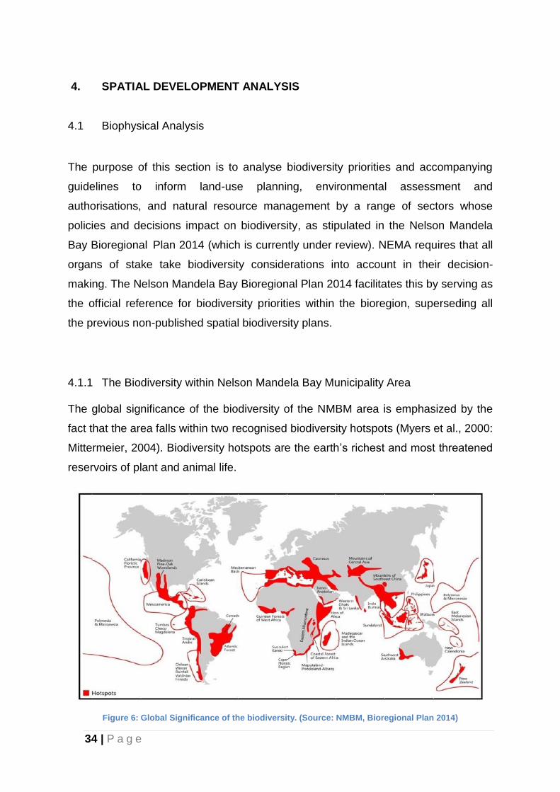
The global significance of the biodiversity of the NMBM area is emphasized by the
fact that the area falls within two recognised biodiversity hotspots (Myers et al., 2000:
Mittermeier, 2004). Biodiversity hotspots are the earth’s richest and most threatened
reservoirs of plant and animal life.
Figure 6: Global Significance of the biodiversity. (Source: NMBM, Bioregional Plan 2014)
35 | P a g e
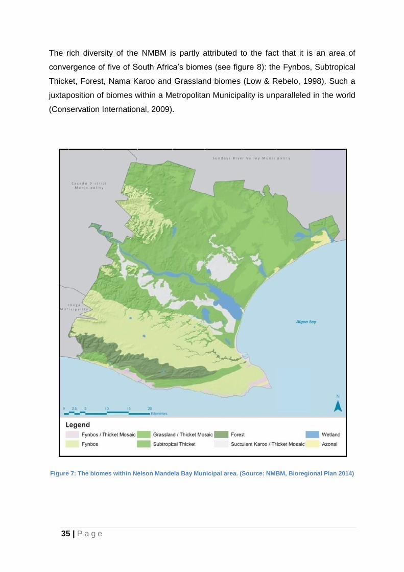
The rich diversity of the NMBM is partly attributed to the fact that it is an area of
convergence of five of South Africa’s biomes (see figure 8): the Fynbos, Subtropical
Thicket, Forest, Nama Karoo and Grassland biomes (Low & Rebelo, 1998). Such a
juxtaposition of biomes within a Metropolitan Municipality is unparalleled in the world
(Conservation International, 2009).
Figure 7: The biomes within Nelson Mandela Bay Municipal area. (Source: NMBM, Bioregional Plan 2014)
36 | P a g e
4.1.2 Critical Biodiversity Areas (CBAs)
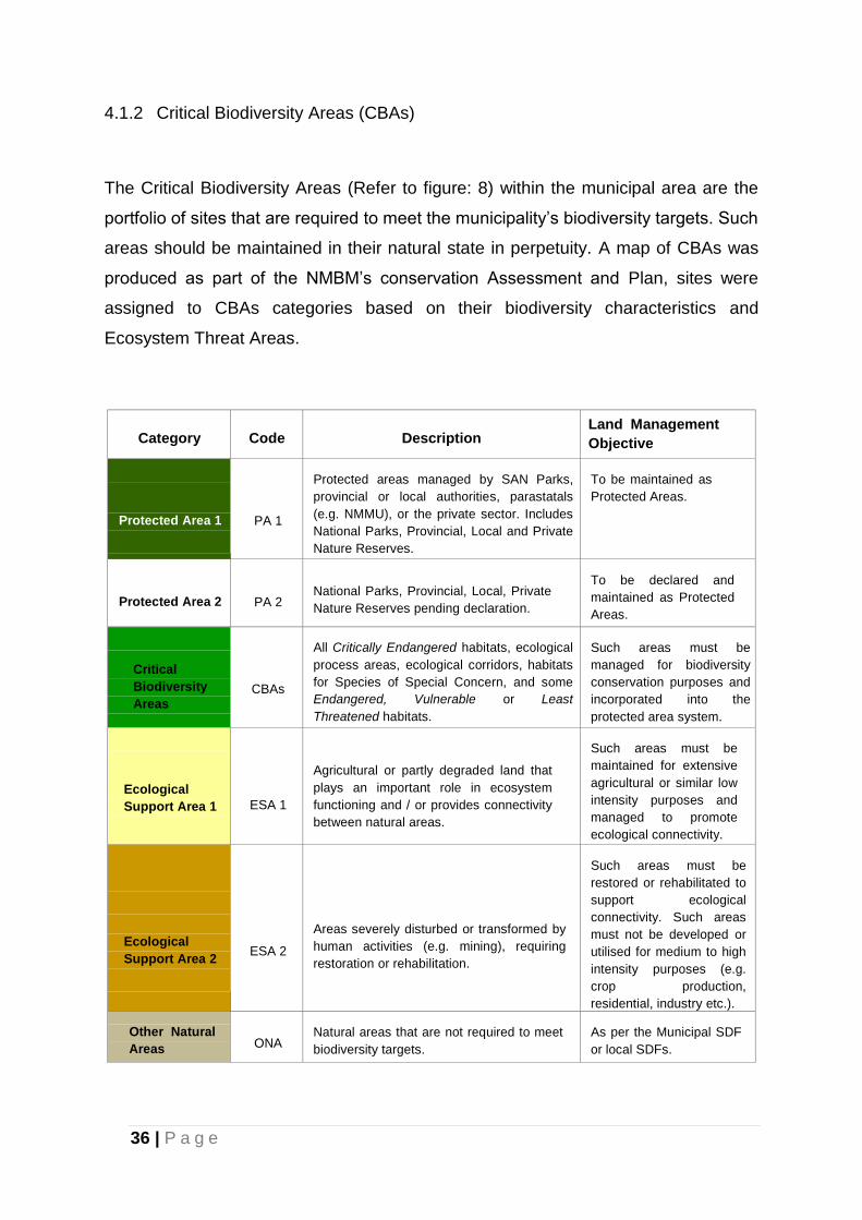
The Critical Biodiversity Areas (Refer to figure: 8) within the municipal area are the
portfolio of sites that are required to meet the municipality’s biodiversity targets. Such
areas should be maintained in their natural state in perpetuity. A map of CBAs was
produced as part of the NMBM’s conservation Assessment and Plan, sites were
assigned to CBAs categories based on their biodiversity characteristics and
Ecosystem Threat Areas.
Category
Code
Description
Land Management
Objective
Protected Area 1
PA 1
Protected areas managed by SAN Parks,
provincial or local authorities, parastatals
(e.g. NMMU), or the private sector. Includes
National Parks, Provincial, Local and Private
Nature Reserves.
To be maintained as
Protected Areas.
Protected Area 2
PA 2
National Parks, Provincial, Local, Private
Nature Reserves pending declaration.
To be declared and
maintained as Protected
Areas.
Critical
Biodiversity
Areas
CBAs
All Critically Endangered habitats, ecological
process areas, ecological corridors, habitats
for Species of Special Concern, and some
Endangered, Vulnerable or Least
Threatened habitats.
Such areas must be
managed for biodiversity
conservation purposes and
incorporated into the
protected area system.
Ecological
Support Area 1
ESA 1
Agricultural or partly degraded land that
plays an important role in ecosystem
functioning and / or provides connectivity
between natural areas.
Such areas must be
maintained for extensive
agricultural or similar low
intensity purposes and
managed to promote
ecological connectivity.
Ecological
Support Area 2
ESA 2
Areas severely disturbed or transformed by
human activities (e.g. mining), requiring
restoration or rehabilitation.
Such areas must be
restored or rehabilitated to
support ecological
connectivity. Such areas
must not be developed or
utilised for medium to high
intensity purposes (e.g.
crop production,
residential, industry etc.).
Other Natural
Areas
ONA
Natural areas that are not required to meet
biodiversity targets.
As per the Municipal SDF
or local SDFs.
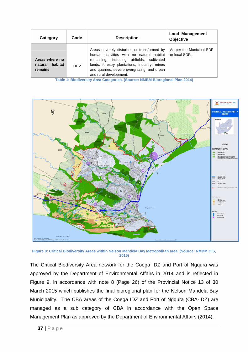
37 | P a g e
Category
Code
Description
Land Management
Objective
Areas where no
natural habitat
remains
DEV
Areas severely disturbed or transformed by
human activities with no natural habitat
remaining, including airfields, cultivated
lands, forestry plantations, industry, mines
and quarries, severe overgrazing, and urban
and rural development.
As per the Municipal SDF
or local SDFs.
Table 1: Biodiversity Area Categories. (Source: NMBM Bioregional Plan 2014)
Figure 8: Critical Biodiversity Areas within Nelson Mandela Bay Metropolitan area. (Source: NMBM GIS, 2015)
The Critical Biodiversity Area network for the Coega IDZ and Port of Ngqura was
approved by the Department of Environmental Affairs in 2014 and is reflected in
Figure 9, in accordance with note 8 (Page 26) of the Provincial Notice 13 of 30
March 2015 which publishes the final bioregional plan for the Nelson Mandela Bay
Municipality. The CBA areas of the Coega IDZ and Port of Ngqura (CBA-IDZ) are
managed as a sub category of CBA in accordance with the Open Space
Management Plan as approved by the Department of Environmental Affairs (2014).
38 | P a g e
4.1.3 Agricultural Activity
Fresh produce is required on a daily basis. The Metropolitan area is favourably
located in that agricultural land with potential for intensive farming is situated around
the urbanised areas. Whilst farming in the Sundays and Gamtoos River Valleys
meets some of the needs, there is still opportunity for large scale farming nearer the
urban areas. The most suitable and fertile agricultural land for intensive farming and
market gardening purposes is located west of the built-up areas. This is broadly
depicted on the spatial plan as agricultural land.
Agricultural land not only fulfils a role in providing fresh produce but also acts as a
green lung. Its presence should therefore contribute to an “urban edge” which limits
expansion of the adjacent urban areas. Areas towards the north and northwest,
although of less value for crop farming, include pockets of land suitable for irrigated
farming and vast areas for livestock and wildlife farms.
Urban inhabitants and their related activities also produce a considerable amount of
organic waste. The potential of turning this into compost has been investigated as
part of the Integrated Waste Management Plan and a number of composting pilot
projects have been identified. Market gardening areas need to be investigated as
possible outlets for the use of any compost produced in this process. This will
contribute further to recycling and sustainability principles.
The supply of agricultural produce and other consumer goods to urban areas from
the immediate surroundings has great significance for long-term sustainable
development. The MSDF map identifies areas for agricultural use within which the
existing practices will be retained or more intensive farming encouraged.
Aquaculture is a form of agricultural activity to be accommodated within the spatial
planning framework for the NMBM. A number of studies have been undertaken to
establish marine aquaculture (mariculture) and terrestrial based aquaculture. An
aquaculture development zone has been established within the Coega IDZ. The
location of aquaculture development projects and mix of species to be cultivated are
to be informed by specialist studies to ensure compatibility with existing land uses.
39 | P a g e
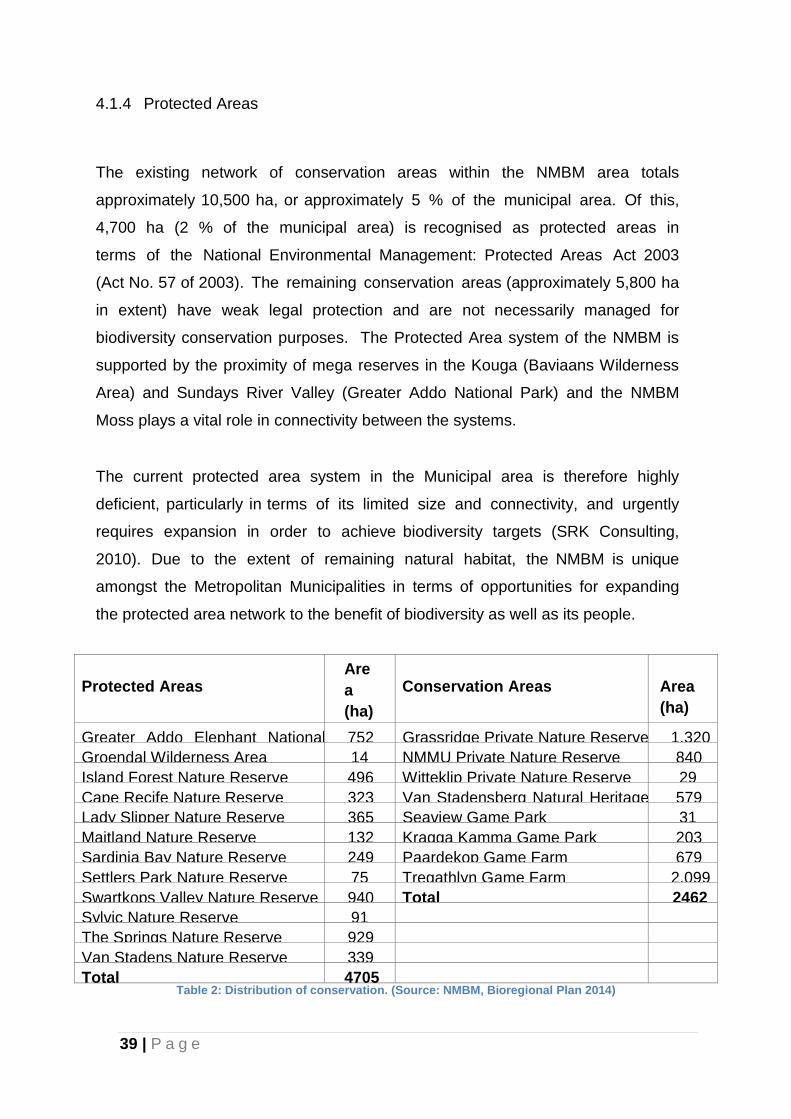
4.1.4 Protected Areas
The existing network of conservation areas within the NMBM area totals
approximately 10,500 ha, or approximately 5 % of the municipal area. Of this,
4,700 ha (2 % of the municipal area) is recognised as protected areas in
terms of the National Environmental Management: Protected Areas Act 2003
(Act No. 57 of 2003). The remaining conservation areas (approximately 5,800 ha
in extent) have weak legal protection and are not necessarily managed for
biodiversity conservation purposes. The Protected Area system of the NMBM is
supported by the proximity of mega reserves in the Kouga (Baviaans Wilderness
Area) and Sundays River Valley (Greater Addo National Park) and the NMBM
Moss plays a vital role in connectivity between the systems.
The current protected area system in the Municipal area is therefore highly
deficient, particularly in terms of its limited size and connectivity, and urgently
requires expansion in order to achieve biodiversity targets (SRK Consulting,
2010). Due to the extent of remaining natural habitat, the NMBM is unique
amongst the Metropolitan Municipalities in terms of opportunities for expanding
the protected area network to the benefit of biodiversity as well as its people.
Protected Areas
Are
a
(ha)
Conservation Areas
Area
(ha)
Greater Addo Elephant National
Park
752
Grassridge Private Nature Reserve
1,320
Groendal Wilderness Area
14
NMMU Private Nature Reserve
840
Island Forest Nature Reserve
496
Witteklip Private Nature Reserve
29
Cape Recife Nature Reserve
323
Van Stadensberg Natural Heritage
Site
579
Lady Slipper Nature Reserve
365
Seaview Game Park
31
Maitland Nature Reserve
132
Kragga Kamma Game Park
203
Sardinia Bay Nature Reserve
249
Paardekop Game Farm
679
Settlers Park Nature Reserve
75
Tregathlyn Game Farm
2,099
Swartkops Valley Nature Reserve
940
Total
2462
Sylvic Nature Reserve
91
The Springs Nature Reserve
929
Van Stadens Nature Reserve
339
Total
4705
Table 2: Distribution of conservation. (Source: NMBM, Bioregional Plan 2014)
40 | P a g e
4.1.5 Threatened Ecosystem
The NMBM Conservation Assessment identified a total of 58 vegetation types
within the Municipal area. A high proportion of the vegetation types within the
municipal area are threatened (twenty-three are Critically Endangered and a
further ten are Endangered) and now face collapse unless efforts are made to
ensure their persistence (Stewart et al., 2008).
The threatened status of these habitats is mirrored by the number of threatened
species within the Municipal area – the Nelson Mandela Bay Municipality has the
highest number of red listed species of all the Municipalities in the Eastern Cape
(CSIR, 2004).
The most threatened vegetation types within the NMBM area are Lowland
Fynbos, Subtropical Thicket mosaic and Forest vegetation types. The Lowland
Fynbos vegetation types in the NMBM area are predominantly grassy Fynbos
systems. Due to the fact that much of the urban expanse of Port Elizabeth
was developed on these ecosystems, they are also some of the most
threatened vegetation types within the Municipal area. The most threatened
Lowland Fynbos vegetation types within the municipal area are Critically
Endangered Colleen Glen Grassy Fynbos, Lorraine Transitional Grassy Fynbos,
Baakens Grassy Fynbos and Walmer Grassy Fynbos. Threatened plant
species in these systems include South Africa’s national flower, the king
protea Protea cynaroides (Critically Endangered), Cyclopia pubescens
(Critically Endangered) and Brunsvigia litoralis (Endangered). Pressures on the
Lowland Fynbos within the NMBM area include iinvasion by alien vegetation,
urban expansion, inappropriate fire regimes, habitat fragmentation and global
climate change (Pierce-Cowling, 2009).
41 | P a g e
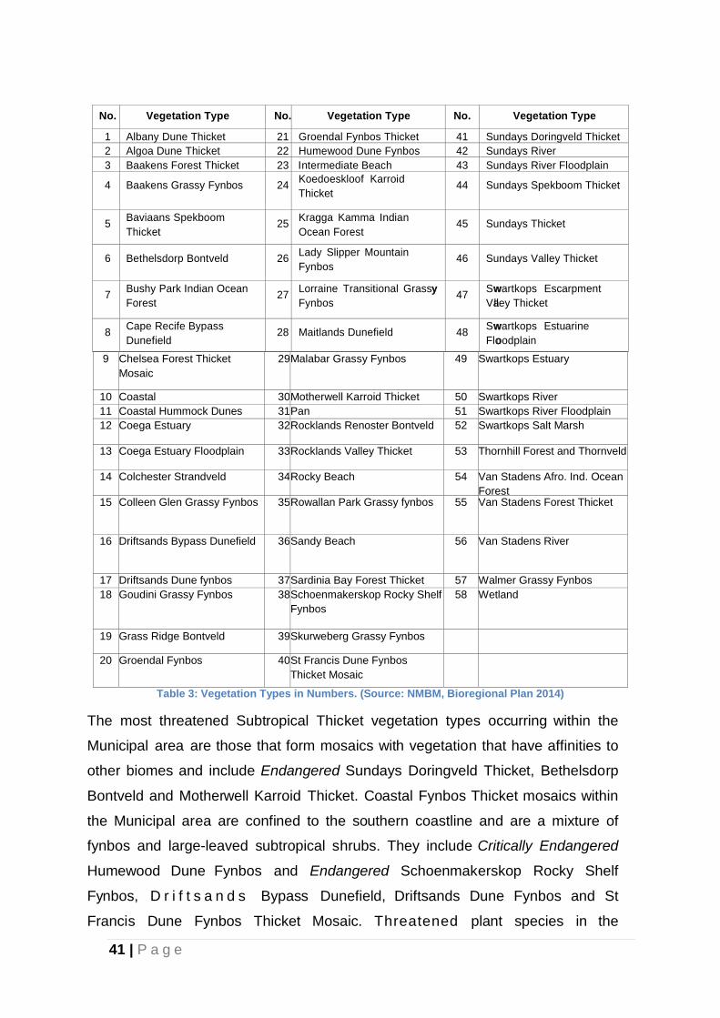
No.
Vegetation Type
No.
Vegetation Type
No.
Vegetation Type
1
Albany Dune Thicket
21
Groendal Fynbos Thicket
41
Sundays Doringveld Thicket
2
Algoa Dune Thicket
22
Humewood Dune Fynbos
42
Sundays River
3
Baakens Forest Thicket
23
Intermediate Beach
43
Sundays River Floodplain
4
Baakens Grassy Fynbos
24
Koedoeskloof Karroid
Thicket
44
Sundays Spekboom Thicket
5
Baviaans Spekboom
Thicket
25
Kragga Kamma Indian
Ocean Forest
45
Sundays Thicket
6
Bethelsdorp Bontveld
26
Lady Slipper Mountain
Fynbos
46
Sundays Valley Thicket
7
Bushy Park Indian Ocean
Forest
27
Lorraine Transitional Grassyy
Fynbos
47
Swwartkops Escarpment
Valley Thicket
8
Cape Recife Bypass
Dunefield
28
Maitlands Dunefield
48
Swwartkops Estuarine
Flooodplain
9
Chelsea Forest Thicket
Mosaic
29
Malabar Grassy Fynbos
49
Swartkops Estuary
10
Coastal
30
Motherwell Karroid Thicket
50
Swartkops River
11
Coastal Hummock Dunes
31
Pan
51
Swartkops River Floodplain
12
Coega Estuary
32
Rocklands Renoster Bontveld
52
Swartkops Salt Marsh
13
Coega Estuary Floodplain
33
Rocklands Valley Thicket
53
Thornhill Forest and Thornveld
14
Colchester Strandveld
34
Rocky Beach
54
Van Stadens Afro. Ind. Ocean
Forest
15
Colleen Glen Grassy Fynbos
35
Rowallan Park Grassy fynbos
55
Van Stadens Forest Thicket
16
Driftsands Bypass Dunefield
36
Sandy Beach
56
Van Stadens River
17
Driftsands Dune fynbos
37
Sardinia Bay Forest Thicket
57
Walmer Grassy Fynbos
18
Goudini Grassy Fynbos
38
Schoenmakerskop Rocky Shelf
Fynbos
58
Wetland
19
Grass Ridge Bontveld
39
Skurweberg Grassy Fynbos
20
Groendal Fynbos
40
St Francis Dune Fynbos
Thicket Mosaic
Table 3: Vegetation Types in Numbers. (Source: NMBM, Bioregional Plan 2014)
The most threatened Subtropical Thicket vegetation types occurring within the
Municipal area are those that form mosaics with vegetation that have affinities to
other biomes and include Endangered Sundays Doringveld Thicket, Bethelsdorp
Bontveld and Motherwell Karroid Thicket. Coastal Fynbos Thicket mosaics within
the Municipal area are confined to the southern coastline and are a mixture of
fynbos and large-leaved subtropical shrubs. They include Critically Endangered
Humewood Dune Fynbos and Endangered Schoenmakerskop Rocky Shelf
Fynbos, D r i f t s a n d s Bypass Dunefield, Driftsands Dune Fynbos and St
Francis Dune Fynbos Thicket Mosaic. Threatened plant species in the
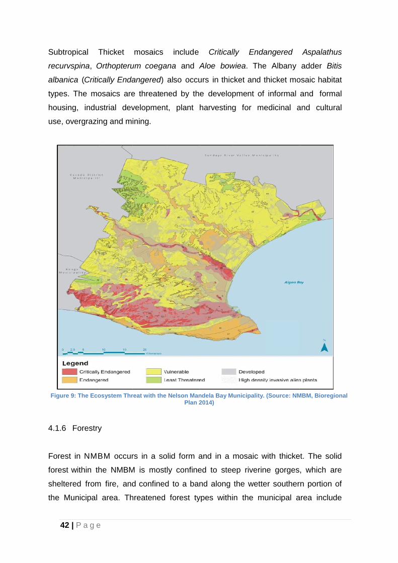
42 | P a g e
Subtropical Thicket mosaics include Critically Endangered Aspalathus
recurvspina, Orthopterum coegana and Aloe bowiea. The Albany adder Bitis
albanica (Critically Endangered) also occurs in thicket and thicket mosaic habitat
types. The mosaics are threatened by the development of informal and formal
housing, industrial development, plant harvesting for medicinal and cultural
use, overgrazing and mining.
Figure 9: The Ecosystem Threat with the Nelson Mandela Bay Municipality. (Source: NMBM, Bioregional
Plan 2014)
4.1.6 Forestry
Forest in NMBM occurs in a solid form and in a mosaic with thicket. The solid
forest within the NMBM is mostly confined to steep riverine gorges, which are
sheltered from fire, and confined to a band along the wetter southern portion of
the Municipal area. Threatened forest types within the municipal area include
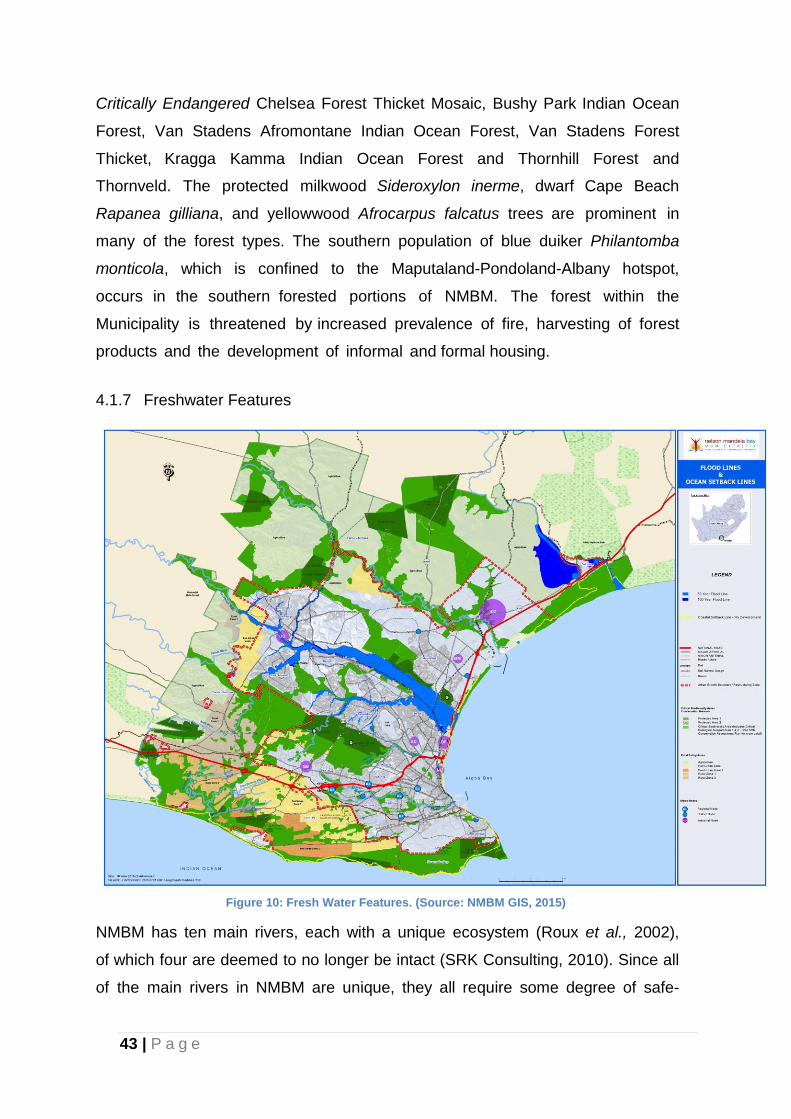
43 | P a g e
Critically Endangered Chelsea Forest Thicket Mosaic, Bushy Park Indian Ocean
Forest, Van Stadens Afromontane Indian Ocean Forest, Van Stadens Forest
Thicket, Kragga Kamma Indian Ocean Forest and Thornhill Forest and
Thornveld. The protected milkwood Sideroxylon inerme, dwarf Cape Beach
Rapanea gilliana, and yellowwood Afrocarpus falcatus trees are prominent in
many of the forest types. The southern population of blue duiker Philantomba
monticola, which is confined to the Maputaland-Pondoland-Albany hotspot,
occurs in the southern forested portions of NMBM. The forest within the
Municipality is threatened by increased prevalence of fire, harvesting of forest
products and the development of informal and formal housing.
4.1.7 Freshwater Features
Figure 10: Fresh Water Features. (Source: NMBM GIS, 2015)
NMBM has ten main rivers, each with a unique ecosystem (Roux et al., 2002),
of which four are deemed to no longer be intact (SRK Consulting, 2010). Since all
of the main rivers in NMBM are unique, they all require some degree of safe-
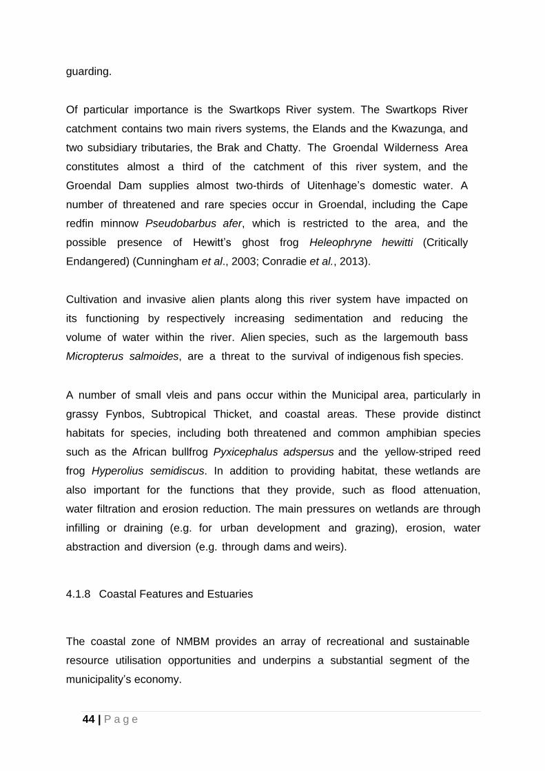
44 | P a g e
guarding.
Of particular importance is the Swartkops River system. The Swartkops River
catchment contains two main rivers systems, the Elands and the Kwazunga, and
two subsidiary tributaries, the Brak and Chatty. The Groendal Wilderness Area
constitutes almost a third of the catchment of this river system, and the
Groendal Dam supplies almost two-thirds of Uitenhage’s domestic water. A
number of threatened and rare species occur in Groendal, including the Cape
redfin minnow Pseudobarbus afer, which is restricted to the area, and the
possible presence of Hewitt’s ghost frog Heleophryne hewitti (Critically
Endangered) (Cunningham et al., 2003; Conradie et al., 2013).
Cultivation and invasive alien plants along this river system have impacted on
its functioning by respectively increasing sedimentation and reducing the
volume of water within the river. Alien species, such as the largemouth bass
Micropterus salmoides, are a threat to the survival of indigenous fish species.
A number of small vleis and pans occur within the Municipal area, particularly in
grassy Fynbos, Subtropical Thicket, and coastal areas. These provide distinct
habitats for species, including both threatened and common amphibian species
such as the African bullfrog Pyxicephalus adspersus and the yellow-striped reed
frog Hyperolius semidiscus. In addition to providing habitat, these wetlands are
also important for the functions that they provide, such as flood attenuation,
water filtration and erosion reduction. The main pressures on wetlands are through
infilling or draining (e.g. for urban development and grazing), erosion, water
abstraction and diversion (e.g. through dams and weirs).
4.1.8 Coastal Features and Estuaries
The coastal zone of NMBM provides an array of recreational and sustainable
resource utilisation opportunities and underpins a substantial segment of the
municipality’s economy.
45 | P a g e
The Swartkops Estuary lies about 8 km north of the Port Elizabeth city centre
and is an important nursery for marine fish, including several angling species. The
estuary forms the basis of an informal bait collecting industry and is ranked as
South Africa’s top temperate estuary in terms of subsistence value (Turpie &
Clark, 2007). The bait collecting industry is also, however, responsible for
destruction of the mudflats, leading to significant impacts on the functioning of
the system (Baird et al., 1988). The functioning of the estuary is also threatened
by pollution, enrichment, sand mining, overfishing, insufficient inflow of
freshwater due to damming, and inappropriate development. Relevant
sections of the Swartkops River and Estuary are currently proposed for
declaration as either a Protected Environment or Nature Reserve in terms of the
NEM: Protected Areas Act, 2003 (Act No. 57 of 2003). Declaration thereafter as a
RAMSAR site is also being considered. Under the auspices of the Department of
Water and Sanitation (DWS), a Catchment Management Forum has been formed
with the objective of safeguarding the welfare of the Swartkops River and Estuary
from source to sea (T Potts 2014, pers. comm., 30 Oct).
The foredune vegetation along the NMBM coastline helps to buffer against the
high energy influences of the tides, wind and waves. These systems are sensitive
to disturbance and are susceptible to the formation of blow-outs. The coastal
area is often targeted for development, primarily due to the desirability of
ocean views. The protection of the coastal foredune system is important in
order to safeguard the scenic attributes of the coastal zone and to provide
protection against the natural coastal agents of change, particularly in light of
the implications of global sea-level rise.
The Alexandria Dunefield has its beginnings at the north-eastern extent of the
municipal area. The dunefield is considered to be one of the largest and most
pristine active coastal dunefields in the world. Larger and more extensive
dunefields are only found in desert areas. As such, it has been incorporated into
the Addo Elephant National Park and was nominated by South African National
Parks as a World Heritage Site (UNESCO, 2009).

46 | P a g e
The Maitlands Dunefield, between the resort villages of Beachview and Blue
Horizon Bay on the south-western part of the NMBM coastline, supports what is
believed to be the highest density of black oystercatcher in the country (Bornman
& Klages, 2003). The black oystercatcher is Near Threatened and is highly
susceptible to disturbance during its breeding cycle. The Maitland area, in
general, is one of the most visually spectacular areas in the Municipality and has
significant value in terms of recreation and tourism.
Although the prohibition of off-road vehicles on the dunefields has substantially
reduced threats to these systems, they continue to be threatened principally by
encroachment of invasive alien plants and are vulnerable to insensitive recreational
use.
4.1.9 Ecological Corridors
A number of ecological corridors were identified as part of the NMBM
conservation assessment. These corridors were designed to promote connectivity
between natural areas in order for ecological processes (such as migration and
seed dispersal) to continue.
While all of the identified corridors are important, the Baakens River Valley,
which forms an east-west corridor through the urban expanse of the Municipal
area, deserves a special mention. It is the Municipality’s most extensive corridor
through fynbos habitats and is of critical importance for the continuation of
ecological processes that sustain biodiversity. The area also provides
numerous ecosystem services, playing an i m p o r t a n t role in flood
attenuation, storm water management, environmental education and nature-
based recreation.
47 | P a g e
4.2 Challenges and Opportunities
This section provides a brief analysis of the Challenges and Opportunities related
biodiversity conservation. They are as follows:
Challenges Opportunities Public and private areas not sufficient
to secure a representative proportion of
all the municipality’s biodiversity;
Insufficient funds exist for NMBM to
acquire and manage all of the property
required for conservation, protected area
expansion will require the conservation of
a combination of privately-owned and
municipally-owned land parcels;
The existing network of conservation areas
within the NMBM area totals approximately
10,500 ha, or approximately 5 % of the
municipal area. Of this, only 4,700 ha (2
% of the municipal area) is recognised
as protected areas in terms of the
NEM: Protected Areas Act. The remaining
conservation areas (approximately 5,800
ha in extent) have weak legal protection
and are not managed for biodiversity
conservation purposes;
Legal protection of natural habitats of
high conservation value outside of
statutory protected areas in NMBM is not in
place.
Building a biodiversity economy involves promoting
economic activity that uses biodiversity in a sustainable
way. This includes the creation of opportunities through
biodiversity for economic development in previously
disadvantaged communities, the promotion of sustainable
agriculture and fisheries, and the promotion of land-uses that
are compatible with biodiversity such as:
Ecotourism
The NMBM is unique in South Africa in that it is an
area of convergence for five of South Africa’s biomes.
Thus, by visiting the NMBM, the eco-tourist can
experience a small taste of what the country as a whole
has to offer from a natural perspective.
Nature-based Development Models
During the period between approximately 2002 and
2008, marked growth occurred in the number of actual
and proposed rural lifestyle residential developments
within the municipal area. These developments have
the potential to support biodiversity conservation
objectives if they are appropriately planned and
managed.
Development models that support the conservation of
CBAs, in alignment with the NMBM’s land-use policies,
and are underpinned by a legitimate conservation
management ethic should be encouraged.
Game Reserves and Game Farming
The northern portion of the NMBM is well suited to the
development of the game reserve and game farming
industry. Farming with game in the thicket biome has
the potential to be more ecologically and economically
sustainable than farming with livestock. The main activity
for which game is utilised is hunting, including both
recreational and trophy hunting. With the Eastern Cape
being recognised as the most preferred destination for
overseas hunters (Smith & Wilson, 2002), this industry
has potential to contribute to a biodiversity based
economy in the NMBM, provided that it is correctly
managed and controlled (for example, preventing or
limiting the introduction of non-indigenous species).
Skills Development and Training
The development of a biodiversity economy within the
municipal area will create a demand for a new set of
skills within the workforce. Skills development and
48 | P a g e
training opportunities linked to biodiversity include those
associated with the development of indigenous
plant nurseries, ecotourism establishments and
secondary industries centred on invasive alien plant
biomass.
An opportunity for skills development is the creation of
indigenous plant nurseries to supply plants for cultural
and medicinal use. The nurseries should be linked to the
establishment of a training college, potentially supported
by the SANBI Green Futures Programme, in order
to train previously disadvantaged individuals in
horticulture. An additional benefit of the nurseries would
be the reduced demand on natural systems for plants of
cultural, landscaping and medicinal use.
Payment for Ecosystem Services
Payment for Ecosystem Services is the practice of
offering incentives to farmers or landowners in
exchange for managing their land to provide some
sort of ecological service. Amongst the ecosystem
services receiving the most attention worldwide is climate
change mitigation and, related to this, there is an
opportunity to develop the carbon sequestration industry
within the NMBM.
4.3 Socio Economic Analysis
4.3.1 Population Growth Estimates
As per the NMBM 2014 Socio Economic Profile, population increase in the general
Eastern Cape Province has been nearly stagnant showing a population of 6 562 053
in 2011. This equates to an increase of 6.7% on the 1996 population and a 4.5% on
the 2001 population as sited in Census 2011 results. This is attributed to out-
migration as the Eastern Cape has experienced the largest case in comparison with
other provinces in the country.
Recent research indicates that the situation and sequence of demographic
development has for many reasons become more complex compounded by
uncertainty regarding economic development and HIV/Aids. There is insufficient
data, information and knowledge to make any firm population forecast and any
estimates must be seen as tentative. However, demographic experts are of the
opinion that earlier forecasts may have been too high.
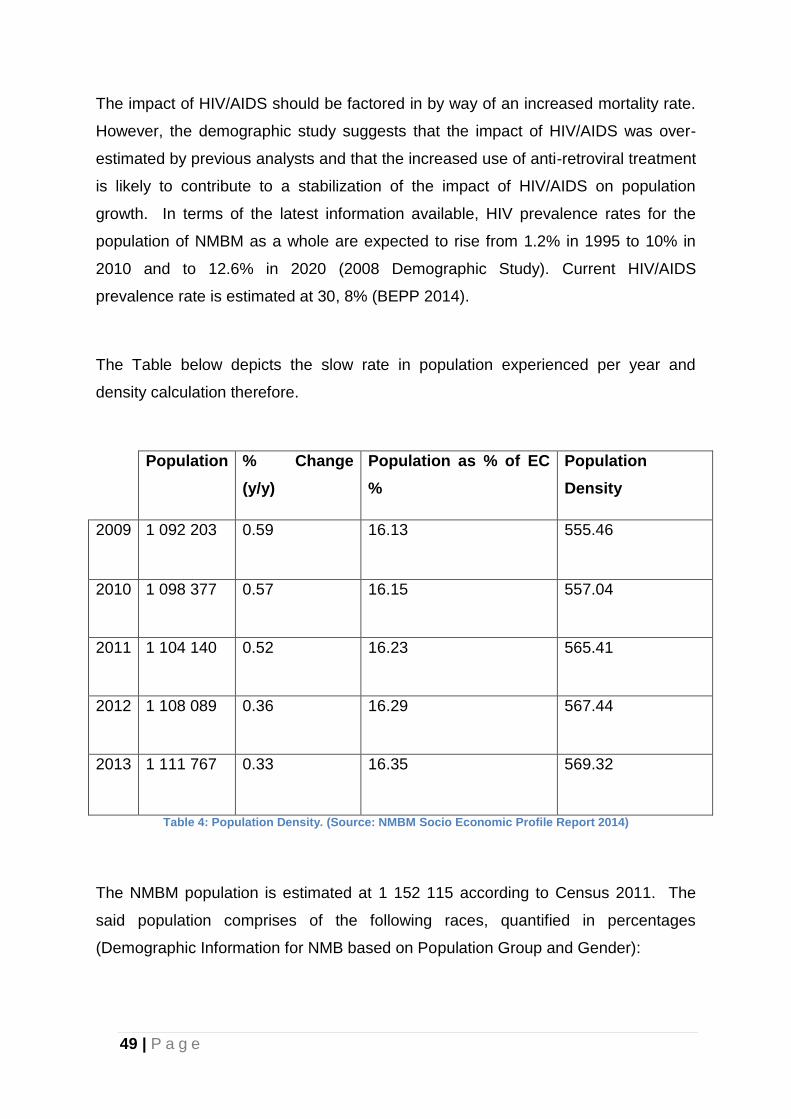
49 | P a g e
The impact of HIV/AIDS should be factored in by way of an increased mortality rate.
However, the demographic study suggests that the impact of HIV/AIDS was over-
estimated by previous analysts and that the increased use of anti-retroviral treatment
is likely to contribute to a stabilization of the impact of HIV/AIDS on population
growth. In terms of the latest information available, HIV prevalence rates for the
population of NMBM as a whole are expected to rise from 1.2% in 1995 to 10% in
2010 and to 12.6% in 2020 (2008 Demographic Study). Current HIV/AIDS
prevalence rate is estimated at 30, 8% (BEPP 2014).
The Table below depicts the slow rate in population experienced per year and
density calculation therefore.
Population % Change
(y/y)
Population as % of EC
%
Population
Density
2009 1 092 203 0.59 16.13 555.46
2010 1 098 377 0.57 16.15 557.04
2011 1 104 140 0.52 16.23 565.41
2012 1 108 089 0.36 16.29 567.44
2013 1 111 767 0.33 16.35 569.32
Table 4: Population Density. (Source: NMBM Socio Economic Profile Report 2014)
The NMBM population is estimated at 1 152 115 according to Census 2011. The
said population comprises of the following races, quantified in percentages
(Demographic Information for NMB based on Population Group and Gender):
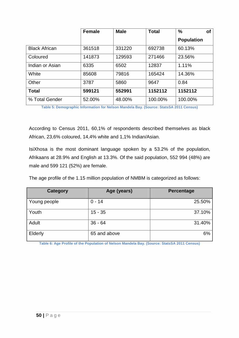
50 | P a g e
Female Male Total % of
Population
Black African 361518 331220 692738 60.13%
Coloured 141873 129593 271466 23.56%
Indian or Asian 6335 6502 12837 1.11%
White 85608 79816 165424 14.36%
Other 3787 5860 9647 0.84
Total 599121 552991 1152112 1152112
% Total Gender 52.00% 48.00% 100.00% 100.00%
Table 5: Demographic Information for Nelson Mandela Bay. (Source: StatsSA 2011 Census)
According to Census 2011, 60,1% of respondents described themselves as black
African, 23,6% coloured, 14,4% white and 1,1% Indian/Asian.
IsiXhosa is the most dominant language spoken by a 53.2% of the population,
Afrikaans at 28.9% and English at 13.3%. Of the said population, 552 994 (48%) are
male and 599 121 (52%) are female.
The age profile of the 1.15 million population of NMBM is categorized as follows:
Category Age (years) Percentage
Young people 0 - 14 25.50%
Youth 15 - 35 37.10%
Adult 36 - 64 31.40%
Elderly 65 and above 6%
Table 6: Age Profile of the Population of Nelson Mandela Bay. (Source: StatsSA 2011 Census)
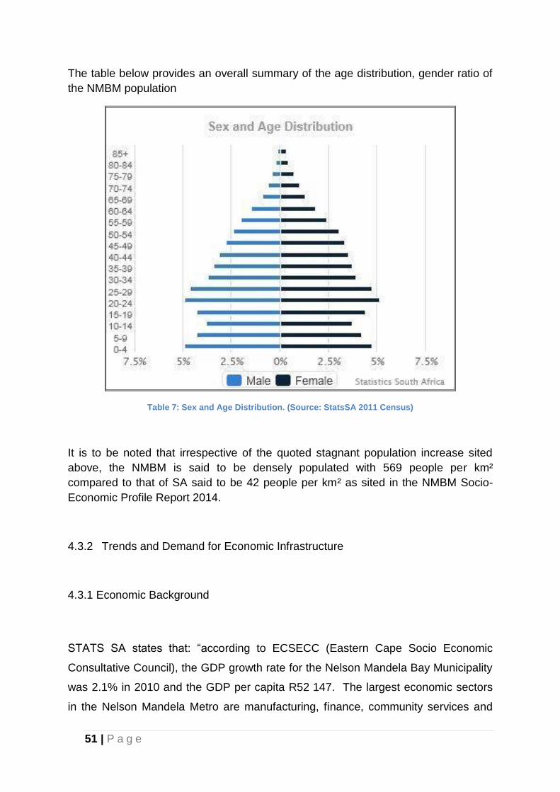
51 | P a g e
The table below provides an overall summary of the age distribution, gender ratio of
the NMBM population
Table 7: Sex and Age Distribution. (Source: StatsSA 2011 Census)
It is to be noted that irrespective of the quoted stagnant population increase sited
above, the NMBM is said to be densely populated with 569 people per km²
compared to that of SA said to be 42 people per km² as sited in the NMBM Socio-
Economic Profile Report 2014.
4.3.2 Trends and Demand for Economic Infrastructure
4.3.1 Economic Background
STATS SA states that: “according to ECSECC (Eastern Cape Socio Economic
Consultative Council), the GDP growth rate for the Nelson Mandela Bay Municipality
was 2.1% in 2010 and the GDP per capita R52 147. The largest economic sectors
in the Nelson Mandela Metro are manufacturing, finance, community services and
52 | P a g e
transport. Community services, trade and manufacturing sectors are the sectors that
create the most employment in the Metro”.
A breakdown of each sectors contribution to the economy is represented below:
Figure 11: Nelson Mandela Bay's Sector contribution to the economy. (Source: NMBMM Socio Economic Profile Report 2014)
Good quality infrastructure is key to sustainable social, economic and industrial
development. Poor infrastructure hampers development, growth and ability to trade
in the domestic and global economy.
Economic infrastructure, which includes transport, energy, telecommunications,
water and sanitation provides services which are of fundamental importance for
development. In NMBM it is deficient and this is exacerbated by inadequate
maintenance and thus prematurely deteriorating installations and services.
Infrastructural services are often overlooked as a means to alleviate poverty and
improve environmental conditions.
In order for Nelson Mandela Bay to grow and develop a sustainable economy, it is
important to build new economic drivers to replace or augment the ones that have
served the region in the past.
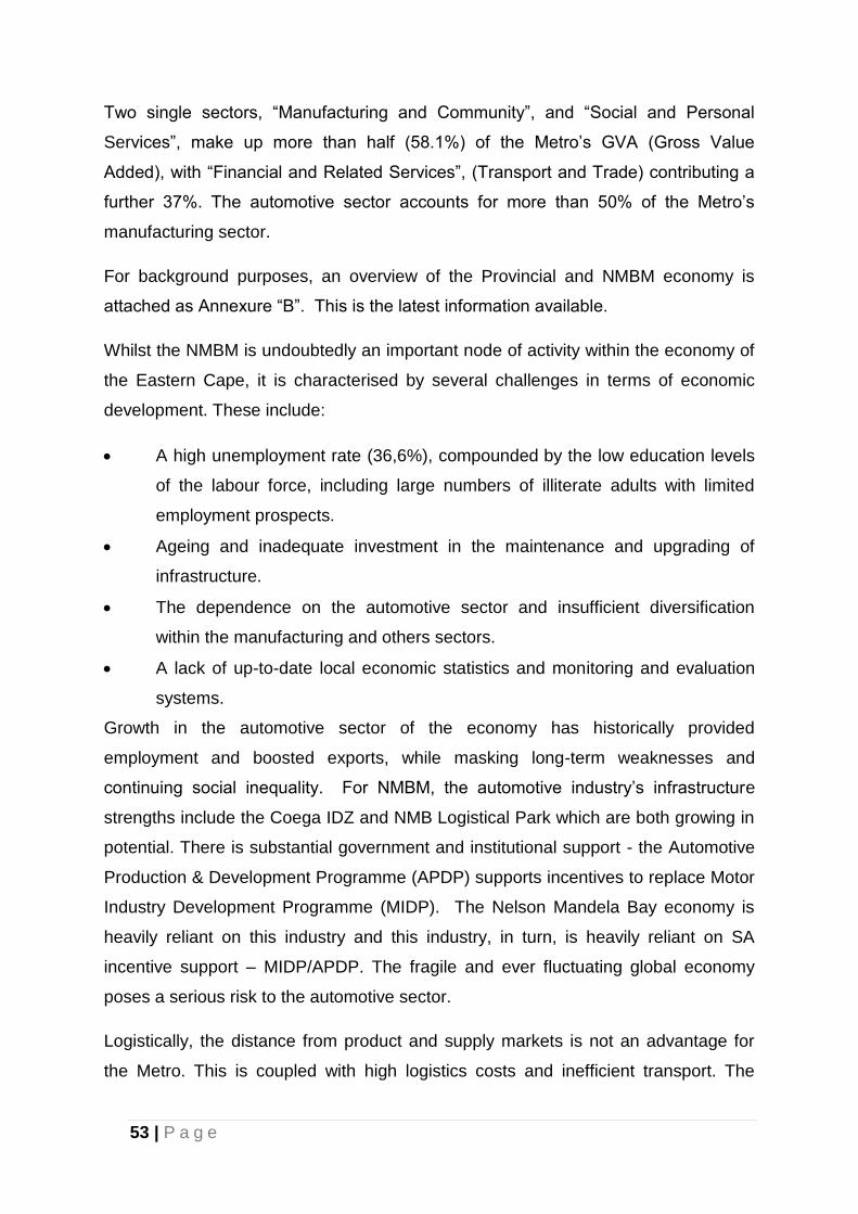
53 | P a g e
Two single sectors, “Manufacturing and Community”, and “Social and Personal
Services”, make up more than half (58.1%) of the Metro’s GVA (Gross Value
Added), with “Financial and Related Services”, (Transport and Trade) contributing a
further 37%. The automotive sector accounts for more than 50% of the Metro’s
manufacturing sector.
For background purposes, an overview of the Provincial and NMBM economy is
attached as Annexure “B”. This is the latest information available.
Whilst the NMBM is undoubtedly an important node of activity within the economy of
the Eastern Cape, it is characterised by several challenges in terms of economic
development. These include:
A high unemployment rate (36,6%), compounded by the low education levels
of the labour force, including large numbers of illiterate adults with limited
employment prospects.
Ageing and inadequate investment in the maintenance and upgrading of
infrastructure.
The dependence on the automotive sector and insufficient diversification
within the manufacturing and others sectors.
A lack of up-to-date local economic statistics and monitoring and evaluation
systems.
Growth in the automotive sector of the economy has historically provided
employment and boosted exports, while masking long-term weaknesses and
continuing social inequality. For NMBM, the automotive industry’s infrastructure
strengths include the Coega IDZ and NMB Logistical Park which are both growing in
potential. There is substantial government and institutional support - the Automotive
Production & Development Programme (APDP) supports incentives to replace Motor
Industry Development Programme (MIDP). The Nelson Mandela Bay economy is
heavily reliant on this industry and this industry, in turn, is heavily reliant on SA
incentive support – MIDP/APDP. The fragile and ever fluctuating global economy
poses a serious risk to the automotive sector.
Logistically, the distance from product and supply markets is not an advantage for
the Metro. This is coupled with high logistics costs and inefficient transport. The
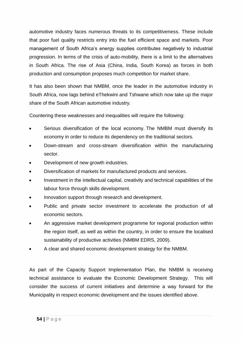
54 | P a g e
automotive industry faces numerous threats to its competitiveness. These include
that poor fuel quality restricts entry into the fuel efficient space and markets. Poor
management of South Africa’s energy supplies contributes negatively to industrial
progression. In terms of the crisis of auto-mobility, there is a limit to the alternatives
in South Africa. The rise of Asia (China, India, South Korea) as forces in both
production and consumption proposes much competition for market share.
It has also been shown that NMBM, once the leader in the automotive industry in
South Africa, now lags behind eThekwini and Tshwane which now take up the major
share of the South African automotive industry.
Countering these weaknesses and inequalities will require the following:
Serious diversification of the local economy. The NMBM must diversify its
economy in order to reduce its dependency on the traditional sectors.
Down-stream and cross-stream diversification within the manufacturing
sector.
Development of new growth industries.
Diversification of markets for manufactured products and services.
Investment in the intellectual capital, creativity and technical capabilities of the
labour force through skills development.
Innovation support through research and development.
Public and private sector investment to accelerate the production of all
economic sectors.
An aggressive market development programme for regional production within
the region itself, as well as within the country, in order to ensure the localised
sustainability of productive activities (NMBM EDRS, 2009).
A clear and shared economic development strategy for the NMBM.
As part of the Capacity Support Implementation Plan, the NMBM is receiving
technical assistance to evaluate the Economic Development Strategy. This will
consider the success of current initiatives and determine a way forward for the
Municipality in respect economic development and the issues identified above.
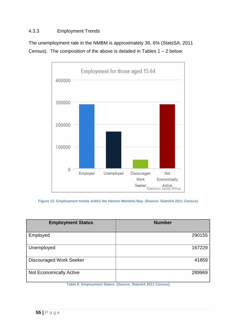
55 | P a g e
4.3.3 Employment Trends
The unemployment rate in the NMBM is approximately 36, 6% (StatsSA, 2011
Census). The composition of the above is detailed in Tables 1 – 2 below:
Figure 12: Employment trends within the Nelson Mandela Bay. (Source: StatsSA 2011 Census)
Employment Status Number
Employed 290155
Unemployed 167229
Discouraged Work Seeker 41859
Not Economically Active 289969
Table 8: Employment Status. (Source: StatsSA 2011 Census)
56 | P a g e
4.3.4 The Demand for Housing Units
The existing housing stock is approximately 276 850 formal dwellings (Census
2011). While progress have been made to meet the demand for housing, the
housing backlog is still a major issue with the housing backlog estimated to be 72
411 units (Informal areas of 23 411 + Backyard shacks of 49000) (BEPP 2014).
Considerable effort is therefore required to address this backlog particularly when
projected growth demand of some 6000 to 7000 units per annum is included.
Housing backlog and projected growth demand therefore place considerable
pressure on the need for land that is recognised as a finite resource. It is imperative
therefore that the utilisation of available infrastructure and existing road networks be
done efficiently to achieve the objectives of the IDP. To avoid urban sprawl, the
development of new housing areas must therefore recognise and implement
principles that promote integration, sustainable use of resources, densification and
mixed land uses. Whilst encouraged, it is recognised that densification is largely
dependent on the initiatives of land owners, developers and investors in the housing
market. As a result, densification will only occur over time and will consequently not
have an immediate impact on meeting the demand for residential land.
The bulk of the housing need falls within the subsidised housing categories. Based
on a reduced household size of 4 persons per unit, population projections suggest
that the demand for new dwellings (including the backlog) is about 26 000 units to
the end of 2020 (Shisaka, 2012). Assuming that subsidised households represent
85% of the total number of units, the need for subsidised housing would be
approximately 22 100 units for this period.
The number of houses provided through the Municipal housing programme will not
be sufficient to satisfy the total demand. It is therefore important that the private
sector and NGOs become involved in low-income housing provision. Special efforts
and conditions would be required to facilitate low-cost housing projects run by these
stakeholders.
57 | P a g e
The estimated Housing backlog figures for NMBM are being verified through a study
to determine the number of backyard shacks and an audit of informal settlements.
This study commenced in April 2014 to verify the following:
Households living in stressed areas (servitudes, floodplains and overcrowded
areas);
Land and spatial planning challenges;
Shortage of government-owned land in inner-city and serviced areas;
Lack of visible spatial restructuring;
Lack of integrated sustainable human settlements.
4.3.5 Land Demand
For estimated requirements related to population increases, and in particular for the
purposes of calculating land demand, the population figure to the year 2020 has
been escalated to 1,5 million in order to allocate sufficient land in case population
growth patterns unexpectedly increase. Furthermore, in view of the focus on
housing delivery and the need to plan accordingly, predictions that household sizes
will decrease from 4.5 to 4.0 persons per household in the medium and long-term
perspectives are noted.
In order to create a better understanding of residential demand and supply, a joint
exercise between the NMBM, the Housing Development Agency (HDA) and the
MBDA was undertaken in 2012, conducted by Shisaka Development Management
Services in collaboration with Bagale Consulting (Pty) Ltd. (Shisaka Development
Management Services, 2012).
The following table shows the socio-economic distribution of local households from
2007 to 2020:
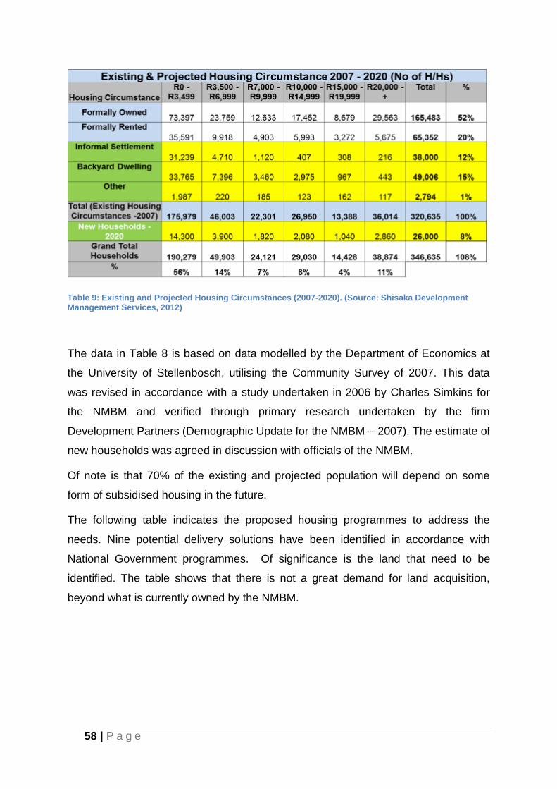
58 | P a g e
Table 9: Existing and Projected Housing Circumstances (2007-2020). (Source: Shisaka Development Management Services, 2012)
The data in Table 8 is based on data modelled by the Department of Economics at
the University of Stellenbosch, utilising the Community Survey of 2007. This data
was revised in accordance with a study undertaken in 2006 by Charles Simkins for
the NMBM and verified through primary research undertaken by the firm
Development Partners (Demographic Update for the NMBM – 2007). The estimate of
new households was agreed in discussion with officials of the NMBM.
Of note is that 70% of the existing and projected population will depend on some
form of subsidised housing in the future.
The following table indicates the proposed housing programmes to address the
needs. Nine potential delivery solutions have been identified in accordance with
National Government programmes. Of significance is the land that need to be
identified. The table shows that there is not a great demand for land acquisition,
beyond what is currently owned by the NMBM.
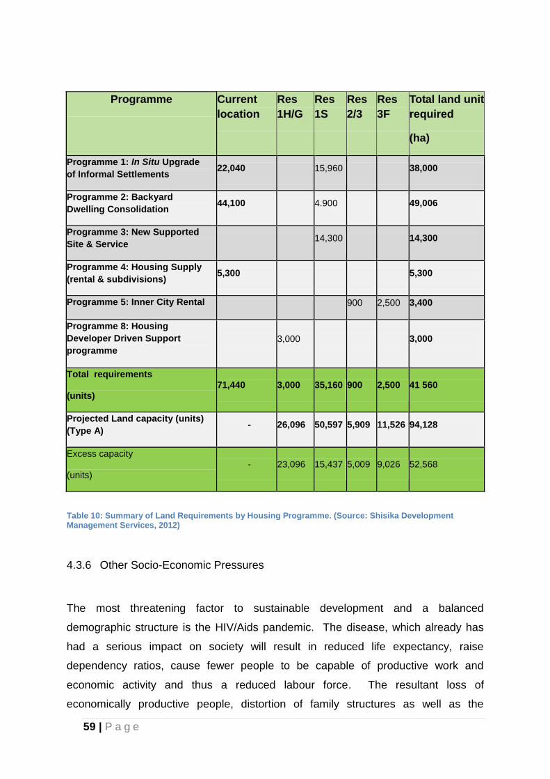
59 | P a g e
Programme Current
location
Res
1H/G
Res
1S
Res
2/3
Res
3F
Total land unit
required
(ha)
Programme 1: In Situ Upgrade
of Informal Settlements 22,040 15,960 38,000
Programme 2: Backyard
Dwelling Consolidation 44,100 4.900 49,006
Programme 3: New Supported
Site & Service 14,300 14,300
Programme 4: Housing Supply
(rental & subdivisions) 5,300 5,300
Programme 5: Inner City Rental 900 2,500 3,400
Programme 8: Housing
Developer Driven Support
programme
3,000 3,000
Total requirements
(units) 71,440 3,000 35,160 900 2,500 41 560
Projected Land capacity (units)
(Type A) - 26,096 50,597 5,909 11,526 94,128
Excess capacity
(units) - 23,096 15,437 5,009 9,026 52,568
Table 10: Summary of Land Requirements by Housing Programme. (Source: Shisika Development Management Services, 2012)
4.3.6 Other Socio-Economic Pressures
The most threatening factor to sustainable development and a balanced
demographic structure is the HIV/Aids pandemic. The disease, which already has
had a serious impact on society will result in reduced life expectancy, raise
dependency ratios, cause fewer people to be capable of productive work and
economic activity and thus a reduced labour force. The resultant loss of
economically productive people, distortion of family structures as well as the
60 | P a g e
increase in number of orphans and the associated cost for health care and social
services all herald fundamental implications for the future. HIV/Aids, if left
unchecked, will retard the natural population growth rate both nationally and
regionally. It is also likely to impact on the local growth rate as well as on migration
trends.
Statistics also indicate that the average life expectancy in South Africa for all
population groups is expected to decrease between 2005 and 2020 from 63 to 56
years respectively. Although these are averages, the most affected are Blacks with
an estimated average life span of 54 years in 2005 reducing to 44 years in 2020. It
can be assumed that the number of orphans in the city will increase dramatically, as
well as the number of terminally ill who will be unable to take care for themselves.
This will have a large impact on the type of housing to be provided as well as the
types, quantities and location of social services necessary – all of which will have
spatial implications. The number of maternal orphans (children under 18 years of
age whose mother is dead) is projected to rise from 25 930 in 2005 to 44 050 in
2020. These include children whose mothers have died from non-AIDS causes as
well as AIDS causes. Current estimations are that 12.9% of all children under the
age of 18 will be maternal orphans in 2020.
The number of paternal orphans (children under 18 years of age whose father is
dead) is expected to rise from 38 220 in 2005 to 48 450 in 2020. These include
children whose fathers have died from non-AIDS causes as well as AIDS causes.
Current estimations are that 13.6% of all children under the age of 18 will be paternal
orphans in 2020. The increase in AIDS deaths will thus lead to a changing
demographic profile of the city. It is important therefore that spatial planning does
not exacerbate the social problems caused by this disease and that improvement of
the situation is facilitated where possible.
The impact of HIV/Aids on housing, health care, social services, crime, social
segregation, payment backlogs for services and employment has not been
thoroughly investigated or quantified. Further research into the overall implications
of HIV/Aids is necessary in order to address these problems effectively.
61 | P a g e
Furthermore, pollutants from industry, sewerage, waste generation and air pollution
sources contribute to environmental problems. Moreover, the use of vehicles,
consumption of substantial amounts of water, energy and consumer products
constitutes a high load per capita on the environment and on scarce natural
resources. The challenge for decision makers is to achieve environmental, social
and economic sustainability in the city where the requirements of all sectors are
balanced to ensure the protection of scarce resources such as open space for the
future.
4.4 Built Environment Analysis
The purpose of this section is to present a broader explanation of land uses within
the NMBM.
4.4.1 Current Quality of Built Form
The metropolitan area is characterised by three axis of development spreading from
the central city area to the west towards Hunter’s Retreat, in a north-westerly
direction towards Uitenhage and towards Motherwell. Approximately 35% of the
metropolitan area can be considered “built up.”
The remaining areas are largely undeveloped and comprise small agricultural land
holdings, land earmarked for future urban expansion, open spaces and major
conservation protected areas.
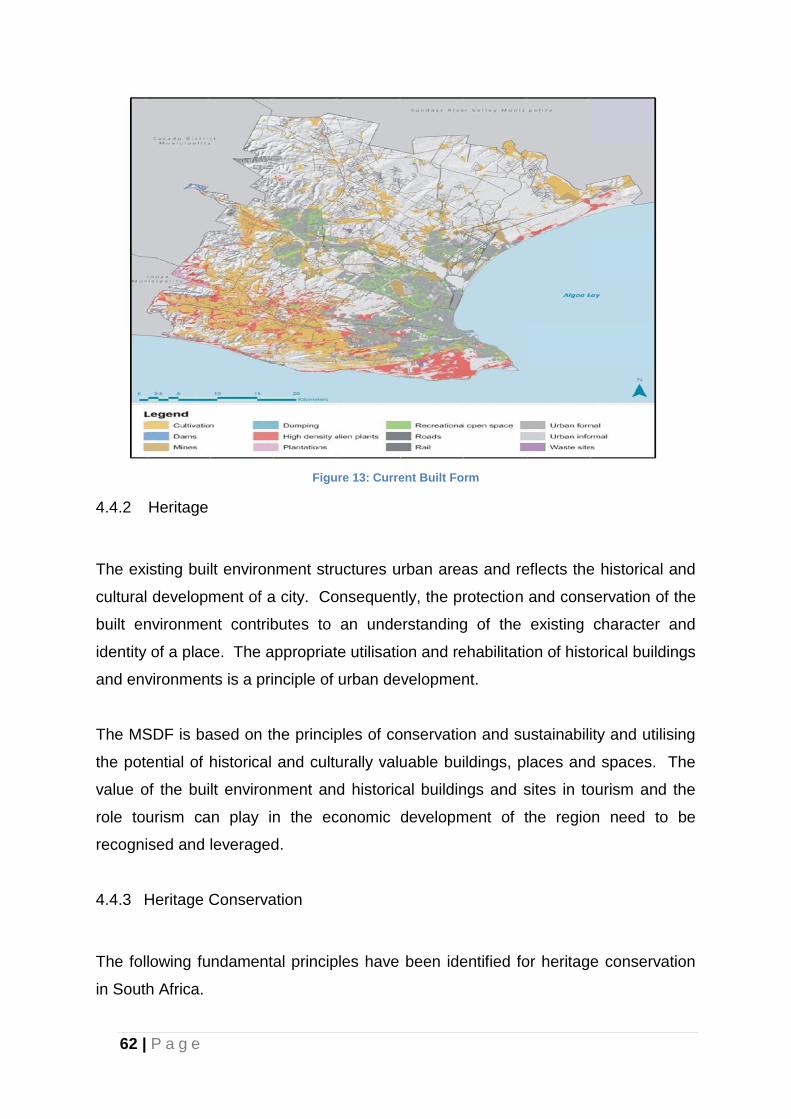
62 | P a g e
Figure 13: Current Built Form
4.4.2 Heritage
The existing built environment structures urban areas and reflects the historical and
cultural development of a city. Consequently, the protection and conservation of the
built environment contributes to an understanding of the existing character and
identity of a place. The appropriate utilisation and rehabilitation of historical buildings
and environments is a principle of urban development.
The MSDF is based on the principles of conservation and sustainability and utilising
the potential of historical and culturally valuable buildings, places and spaces. The
value of the built environment and historical buildings and sites in tourism and the
role tourism can play in the economic development of the region need to be
recognised and leveraged.
4.4.3 Heritage Conservation
The following fundamental principles have been identified for heritage conservation
in South Africa.
63 | P a g e
Heritage is a valuable, finite, non-renewable and irreplaceable resource that
must be carefully managed to ensure its survival;
Every generation has a moral responsibility to act as a trustee of the natural
and cultural heritage for succeeding generations;
South Africa has a rich heritage, both natural and man-made, which is unique
and worthy of conservation;
Numerous cultures, both past and present, have contributed to that heritage
and all have the right to be protected;
Every person, community and institution has an obligation to ensure that
significant elements of the natural and cultural heritage are not damaged or
destroyed.
4.4.4 Heritage Resources
The National Heritage Resources Act, No. 25 of 1999, demands the establishment of
a heritage resources management system involving a national heritage resources
authority, a Provincial Heritage Resources Authority (PHRA) in each region or
province and the local authorities which, once the system is established, will be
responsible for Grade 1, 2 and 3 heritage resources respectively.
Heritage resources are places or objects of cultural significance, including objects or
places of aesthetic, architectural, historical, scientific, social, spiritual, linguistic or
technological value. Heritage resources may include buildings, structures,
equipment of cultural significance, places associated with living heritage, historical
settlements and townscapes, landscapes and natural features of cultural
significance, graves and burial sites, archaeological and paleontological sites,
geological sites and sites relating to the history of slavery.
The system requires that these graded heritage resources be formally identified as
national and provincial heritage sites that must be placed on heritage registers and
local heritage resources, which may be placed on a heritage register. The system
also provides for the identification of protected areas and heritage areas. All these
64 | P a g e
formal identifications must follow exhaustive procedures, after which these formally
identified sites, areas and resources may be described as being formally protected.
The heritage resources management obligations placed on local authorities are
varied. All registered heritage practitioners are required to meet these obligations.
The Act stipulates these requirements as follows:
Identification of places of cultural significance including objects or places of
aesthetic, architectural, historical, scientific, social, spiritual, linguistic or
technological value.
Grading and management of Grade 3 heritage resources.
Management of heritage areas.
Management of sites on the heritage register.
Management of monuments and memorials.
Proper management of properties of heritage value owned by the local authority.
Preservation and promotion of places of cultural significance.
In order to fulfil its legal obligations, the Municipality needs to identify and grade
heritage resources to ultimately provide a heritage resources management plan for
the heritage resources in its care. One of the MSDF’s implementation strategies is
the completion of a Heritage Register, in compliance with the requirements of the
Heritage Resources Act.
In compliance with the Act, the preparation of a Heritage Register has been
commissioned and all major sites have been evaluated. Remaining sites older than
60 years still need to be evaluated, and funding is needed for this purpose. It entails,
inter alia, the identification of the resources that will fall under the jurisdiction of the
NMBM to manage in the future.
Presently, development is hampered to a certain extent, as all approvals for
development on sites with buildings older than 60 years need to go through the
Provincial Heritage Authority, the Municipality has, through certain prescribed
processes, assumed responsibility for certain heritage roles, in certain instances
speeding up the heritage application approval process. An application for
65 | P a g e
competency in relation to certain built environment functions was submitted to the
Provincial Heritage Resources Agency in January 2012 and stumbling blocks in
relation to the Provincial Heritage Resources Authority approval were being
addressed politically, with little progress having been made since December 2012.
4.4.5 Current Heritage Initiatives
The state of the built heritage in NMBM is a cause for concern. Consequently, the
Municipality took a decision to prioritise the preservation of heritage and the built
environment. A Problem Buildings By-law and a Heritage By-law have been
developed in line with the provisions of the Heritage Resources Act.
4.5 Infrastructure
One of the main aims of the MSDF is to minimise the need to extend bulk
infrastructure and to optimise existing infrastructure. The strategic planning of
infrastructure, (water, stormwater, sewerage, and electricity) will need to be
elaborated on in special studies that are based on the urban expansion proposed.
Directorates will need to prepare development programmes for investments in the
infrastructure required to support the development of and implementation of the IDP.
Attention should be paid to the sustainable development of infrastructure in terms of
economy, natural resources as well as environmental and health protection.
Existing bulk infrastructure systems, with minimal extensions, are expected to meet
the needs of urban expansion for the near future. However, it is imperative that new
technologies be explored and applied in the longer term, promoting sustainability
with special emphasis on the use of resources and recycling principles.
Infrastructure expansion cannot be allowed to continue in the way it has done in the
past. All over the world the challenge being faced is to limit urban sprawl in an
attempt to make cities more compact and efficient and to reduce the extension of
expensive bulk service infrastructure networks. Consequently, higher densities will
have to become a reality despite the lack of community support for densification as
the extensions to bulk services required to sustain low density sprawl, either the
capital works or the on-going maintenance, are not affordable.
66 | P a g e
4.6 Pattern of Activities
4.6.2 Industry
(a) Coega Industrial Development Zone (IDZ) and the Port of Ngqura
The Coega IDZ and the Port of Ngqura warrant particular attention from an economic
development perspective. The Coega Industrial Development Zone (IDZ) is located
adjacent to the modern deep-water Port of Ngqura. This 11,500 ha complex aims to
drive local and foreign direct investments in export-oriented industries, thereby
positioning South Africa as a hub for International, African and Southern African
trade. The Coega IDZ is purpose-built for manufacturing, including: the beneficiation
of export goods; foreign direct investment and local socio-economic growth; skills
development, and; job creation. The integrated IDZ and Port of Ngqura have
established world-class infrastructure to support the industrial development
objectives of the Eastern Cape.
The Port of Ngqura, positioned as a trans-shipment hub, had three container berths
operational by the end of 2013, while the further expansion of both the container and
bulk capacity is underway, having reached the point of being able to accommodate
four container berths. In 2013, the Port of Ngqura was the fastest growing port in the
world. A process is underway for the closure of the bulk fuel tanks in the Port
Elizabeth Harbour. A new bulk tanking facility is to be established at the Port of
Ngqura and is due to be operational by 2018. The existing Manganese export
terminal in the Port of Port Elizabeth will be closed upon completion of a new
manganese ore export terminal at the Port of Ngqura. Construction of the
Manganese export terminal at Ngqura is scheduled for commencement in 2016 and
due for completion in 2019.
The Coega IDZ, managed by the Coega Development Corporation (CDC), and the
Port of Ngqura (Transnet National Port Authority), provide the necessary
infrastructure for the establishment of industrial clusters intended to stimulate
agglomerative economies in key sectors, in accordance with the Development
Framework Plan which is approved by the NMBM. The automotive, agro-
67 | P a g e
processing, logistics and metallurgical clusters, amongst others, are dependent on
competitive logistics as enablers of growth. Investments in air, road and rail are
required, in order to facilitate growth within these sectors.
A key linkage is the Nelson Mandela Bay Logistics Park in Uitenhage, operated by
the CDC, to enhance the logistical competitiveness of the automotive cluster. A
major new automotive manufacturer (FAW) plant has been established in the Coega
IDZ with further expansions planned. The development of the Coega IDZ and
NMBLP automotive facilities will provide impetus to the enhancement of the logistical
competitiveness of the region through investment in key enabling infrastructure.
A direct linkage between the NMBLP and Port of Ngqura will enhance the logistical
competitiveness of the NMBM. As depicted in the 2009 SDF proposals, ring
connectivity can be served through the enhancement of a transportation corridor
from the NMBLP along the R75 and R334 to join an extension of Neptune Road at
the intersection of the R334 and R335. The ring linkage would assist the
development of Motherwell North (Coega Ridge) housing development, a key
contributor of domestic effluent to the proposed Coega IDZ Waste Water Treatment
Works, whilst mitigating congestion along the R75 (Uitenhage – PE road) and R367
(Redhouse Road). The construction of the Neptune R334 / R335 linkage would
enhance the competitiveness of the Port of Ngqura by providing optimized logistics
linkages to the Addo Road and Uitenhage while servicing a potential linkage to a
future cargo airport at Coega through an extension of the IDZ Ring road to the Addo
Road.
Provision is made on the NMBM SDF for a cargo airport within Zone 14 of the Coega
IDZ. Feasibility studies for the airport are underway and master planning for an
aeronautical and advanced manufacturing cluster have been completed.
The development of the metallurgical cluster will support progress towards the goal
of the local beneficiation of South Africa’s natural resources. The ferrous metals
cluster will provide the business case for developing a source of industrial water
(from return effluent) for the IDZ. The petro-chemicals cluster will be a further user
of industrial water, and further growth in the Coega IDZ is dependent upon the
availability of sufficient and reliable sources of potable and industrial water. It is
expected that the partnership lobby between the NMBM, the Province of the Eastern
68 | P a g e
Cape, the CDC, business chambers and civic and social partners, will develop the
necessary impetus for the provision of infrastructure which will attract investments in
the targeted sectors..
The training and academic cluster in Zone 4 continues to grow, having secured key
investments in Business Process Outsourcing (BPO). Further growth in this sector
will promote the need for the integration of the IDZ with the residential areas of
Motherwell and public transportation infrastructure. The further development of
commercial developments and housing units in the CDC Vulindlela (Construction)
Village at Wells Estate highlight the need to integrate the commercial and
transportation infrastructure of Motherwell with the key focus areas of the IDZ.
Investments in the energy sector, with the purpose of feeding into the electrical grid,
will continue in the IDZ, with the focus on renewable energy, peaking power
generation capacity base load and associated beneficiation opportunities. .
The Dedisa Peaking Power Plant is under construction, schedule for completion in
2015. The IDZ is well positioned to establish a Liquefied Natural Gas handling facility
and associated power generation facilities. Logistical service providers are
continuing to show an interest in the IDZ, with a number of investors locating in Zone
1 of the IDZ. .
The IDZ has secured two suppliers of industrial gas, namely Afrox and Air Products.
The agri-processing sector has shown strong growth with the expansion of Dynamic
Commodities and the establishment of Coega Dairy in Zone 3, which are market
leaders in their field.
It is expected that the legislative process for Special Economic Zones (SEZs), being
undertaken by the Department of Trade and Industry (DTI), will remove many of the
constraints that have been experienced within the IDZ Programme and will provide a
package of competitive incentives and further investments in the infrastructure
needed to further develop the IDZ.
69 | P a g e
(b) Other Industrial areas.
Other Industrial areas include the following:
Markman – This industrial area caters primarily for the heavier and noxious types
of industry. Although there has historically not been much demand for industrial
land here due to its perceived distance from the city, this is expected to change
because of its strategic proximity to the Coega IDZ. The logistical and industrial
synergy linkages between Markman and the neighbouring Coega IDZ need to be
optimized in order to stimulate development in both the Coega IDZ and Markman
industrial areas.
Perseverance – This area has the advantage of being located close to the Ibhayi
residential area and thus provides conveniently located employment
opportunities. Two large recent developments (SAB and Corning) have resulted
in this area being almost fully developed.
Port Elizabeth Airport – Developed as an area for industries dependent on air
transport. While vacant space does exist, demand is increasing for industrial,
commercial and residential purposes.
Struandale – This is an older industrial area close to labour sources with limited
expansion potential.
Korsten – This is an older industrial area with older buildings and smaller
industries.
Deal Party – This is an old industrial area and is fully developed.
Uitenhage –Capacity for expanding the Uitenhage industrial complex exists at
Jagtvlakte and is integrated into the Jachtvlakte Sustainable Human Settlement
Planning Process. The first phase of the NMBLP (Precinct A) is nearing
completion with available land now fully let to industrial tenants. The
development of Precinct B of the NMBLP will be undertaken by the CDC,
operators of the NMBLP, and will further enhance the competitiveness of the
Uitenhage automotive cluster with the value offering being the improvement of
logistics efficiencies. Greenbushes – This is a relatively new industrial area
which started with the rezoning of residential holdings in the area known as
Ericadene. Due to demand, additional properties north of the Old Cape Road
have also been rezoned in the form of upmarket industrial parks. These
70 | P a g e
industries provide much needed economic opportunities to the impoverished
Kuyga settlement nearby.
Generally, the existing industrial areas are environmentally degraded with poor
aesthetics and poor pollution control. An exception has been the world class safety,
health, environmental and quality practices at both the Coega IDZ and NMBLP, as
implemented by the CDC. The lessons and experiences from the Coega IDZ and
NMBLP need to be replicated and extended to other industrial areas within the
NMBM and leveraged into the redevelopment of brownfield industrial areas such as
Markman Township in order to enhance environmental quality, aesthetics and
operational efficiencies.
As part of the Capacity Support Implementation Plan, the NMBM is receiving
technical assistance to evaluate the Economic Development Strategy. This will
consider the success of current initiatives and determine a way forward for the
Municipality in respect economic development and the issues identified above.
There is a portfolio of sectors discussed in the Nelson Mandela Bay Industrial
Development Strategy (2012) that focuses on industrial (or secondary) sectors as
opposed to primary and tertiary sectors.
Local/Light Manufacturing:
The majority of job seekers are excluded from obtaining work purely due to the high
cost and time of commuting to commute to work areas. Places of work ideally need
to be within walking distance of where people are living. Significant impact can be
achieved by revisiting the traditional concepts of urban order that tend to over-
emphasize heavy industry and to re-link local production to local consumer markets
through light industry that is more responsive to local needs and demand.
71 | P a g e
Tourism and Hospitality:
This is a consumption industry, rather than a productive industry. Tourism numbers
are stagnant or falling, and the tourism-related manufacturing industry is
undeveloped. However, there are production opportunities in the manufacture of
handcrafts, mementoes, local fabrics, etc. There are also agricultural spin-offs in the
supply of ingredients to restaurants and hotels.
Agro-Processing:
Cacadu, adjacent to NMBM, has a relatively strong agricultural sector. The biggest
employers in the Coega IDZ are agro processing plants. This sector is a crucial
priority for government. Agro-processing has linkages through into the Cacadu
economy. Agro-processing has strong backward and forward linkages and value
chains of processing and distribution. Strengths of this sector in NMB include
existing industries, natural resources and IDZs to support industry. This sector is
constrained by trade policies, lack of skills, loss of productive land and zoning
limitations as well as a lack of coordination between stakeholders.
Pharmaceutical:
There is a huge demand for low-cost drugs in the developing world and an ageing
population in the developed world is a market for an expanding range of drugs.
Nelson Mandela Bay is home to a number of world-class pharmaceutical companies
and Nelson Mandela Metropolitan University has a pharmacy department. Rhodes
Pharmaceutical department is another asset. Threats to this sector of industry are
the lack of access to technology and intellectual property and the lack of will by “big
pharma” to invest.
Sport and Leisure:
Sport and Leisure dovetails with Tourism and Hospitality and provides the
opportunity to utilize the natural assets of the area. This industry promotes light
72 | P a g e
industry (sport equipment, goods and clothing). It is a means for rapid positive
exposure and revenue generation - local sports events have demonstrated the
capacity to attract large numbers of people to NMBM.
Capital goods:
South Africa is on track to become a manufacturer of locomotives for the rest of
Africa. This provides the Metro with its best opportunity for growing its presence in
the capital goods sector in the short to medium term, and is therefore the focus of
the strategy. A large percentage of the wagons should be made in Nelson Mandela
Bay. Transnet Rail Engineering has a manufacturing facility in Uitenhage, which has
been identified by Transnet as its main export manufacturing facility.
Renewable/Green Industries:
Green industries in this context fall within the broader category of energy, which
includes electricity and the various types of fuel used in combustion processes. A
Government development incentive is proposed “in order to increase local demand
of alternative energy and DEDEAT on the other hand, must strive to influence policy
towards developing certain underdeveloped areas in South Africa including the
Eastern Cape to be used as manufacturing centres for renewable energy.”
(Provincial Industrial Development Strategy, 2010).
Besides the above-mentioned opportunities, the Municipality has also introduced a
number of strategic initiatives and identified a number of key large-scale projects, as
reflected in the Spatial Development Framework, the LED Strategy and the IDP of
the Municipality, with the objectives being:
Serving as significant catalysts for economic growth;
Stimulating economic development;
Enabling the Metro to become nationally and internationally competitive;
Creating jobs;
Alleviating poverty;
Attracting investors and/or tourists;
Changing the face of the Metro.
73 | P a g e
4.6.3 Residential
Repeal of the notorious “influx control” regulations during the 1990’s resulted in
extremely rapid urbanization from the rural areas into the city. As people moved into
the city, informal settlements established themselves in areas not suitable for
residential development and the resultant poor quality of life in these areas became
planning, social and economic issues. The increase in the number of informal
settlements is also attributed to the backlog of housing which is estimated to be 72
411 units (BEPP 2014) for lower income groups.
In order to meet this demand, most new residential developments catering for this
segment of the market are taking place north of the Swartkops River in Wells Estate
and to the north-west of Motherwell, as well as towards Uitenhage along the main
Uitenhage Road axis. Furthermore, in-situ upgrading is also taking place within
existing township areas primarily on sites set aside for other uses like school sites
which have been invaded.
A number of long standing informal settlements also exist in the peri-urban areas of
the Metro. Part of the upgrading plans of the erstwhile Western District Council (now
inherited by the NMBMM) was the establishment of properly planned and serviced
residential townships in the following areas:
Rocklands
Kuyga
Seaview
St Albans (since found to be undevelopable due to environmental constraints)
Witteklip
With the formalisation of these isolated settlements as part of the housing program,
they need to be contained as such developments are not in line with the Provincial
Spatial Development Plan. Their development will cost the Council considerable
amounts of money and there are insufficient employment opportunities in those peri-
urban areas to sustain large numbers of people. Servicing is difficult and very
74 | P a g e
expensive and the residents will forever be burdened by a lack of access to social,
economic and cultural facilities and services which are available in the established
urban areas.
The southern and western parts of Port Elizabeth as well as the northern sector of
Uitenhage comprise the middle to upper income residential areas with well-
established infrastructure and social and recreational facilities.
4.6.4 Open Space
The municipal area covers an area of 1950km², out of which built-up areas comprise
approximately 20%, agricultural land and rural settlements 15%, Municipal Open
Space System (MOSS) and areas still under assessment for inclusion in the MOSS
15%. In addition to the MOSS there is valuable open space used for agriculture,
grazing, recreational purposes that are important features in the structure. Within
the built-up areas local open space, food gardens, parks, non-motorized
transportation and play-fields all contribute to the positive impact that green areas
have on the micro-climate, aesthetics, drainage and biodiversity.
(a) Municipal Open Space System (MOSS)
At present, many open spaces exist in isolation having been provided on an ad hoc
basis as part of township design and development. An opportunity therefore exists
to link the various spaces together to allow residents to move on foot (or by bicycle in
places) through the system. A metropolitan open space system (MOSS) has
therefore been conceptualised with a view to linking together important open spaces
and to gain some recognition for their importance within the urban framework.
A metropolitan open space system must not only be seen as a system of green open
spaces kept for aesthetic or conservation reasons. The system has great value in
terms of:-
non-motorized transportation corridors
recreation;
stormwater management;
75 | P a g e
air and water pollution control;
aesthetics;
urban agriculture potential;
traditional land sites (land for the abakwetha);
biodiversity;
protection and promotion of flora and fauna;
conservation of unique species;
environmental education
Based on other studies and experiences elsewhere, it could be calculated that a
metropolitan open space system can save considerable amounts of money in
dealing with problems such as stormwater disposal and reducing the need for the
installation of expensive infrastructure.
A refined metropolitan open space system has been formulated as part of the
strategic environmental assessment (SEA) of the SDF. The metropolitan open
space system includes a great variety of environments, all with specific
characteristics and value. The most predominant areas in physical terms are, inter
alia, the coastal and marine areas, rivers and estuaries, coastal dune systems,
mountains, valleys etc.
(b) Other Open Spaces
Whilst provision of other open spaces within residential areas will continue in
accordance with current standards, attention should be given to linking these open
spaces to the MOSS system where possible. Furthermore, the practice of
compromising open space standards in lower income housing developments should
be avoided. Higher density residential developments require more access to open
space as they have less private garden space and consequently a more urgent need
for an improved quality of living environment.
76 | P a g e
Of importance therefore is the need to curb the slow attrition of public open spaces
through ad hoc applications for development needs. If not, the very purpose for
which the public open space was reserved in the first place will be lost. Furthermore,
if the aim of densification is to be actively pursued, open spaces become even more
necessary to maintain an acceptable quality of urban environment.
4.6.5 Social and Community Services
Social and community services include a wide range of facilities that require space
and have great impact on the function of urban areas and on the standard and way
of living. The SDF however is at too broad a scale to show the detailed provision of
all of these facilities. Suffice to note at this point that if the population is to increase
as anticipated by 2020, such an increase will obviously impact on the need for
schools, health clinics, community halls, recreational facilities etc. The applied SCU-
concept will incorporate all such needs at a more local level and the detailed layout
planning that will follow will set aside land for such facilities.
In many cases, central or provincial government authorities determine the standard
and size of social and community facilities. There is a need for close co-operation
between the Municipality and the Province of the Eastern Cape to make the demand
for services known and to obtain information about the resources that may become
available. Based on the available standards, approximately 775ha will be required
for educational purposes plus a further 163ha to meet institutional needs by 2020.
(a) Social and Community Facilities in the SCU-concept
In reality, sustainable community units (SCU) will vary in size, shape and content
depending on densities, topography and other constraints. The population of a unit
could for example include about 20 000 dwellings. Based on the standards indicated
above, an SCU in addition to the residential, industrial and central component would
contain the following number of facilities:
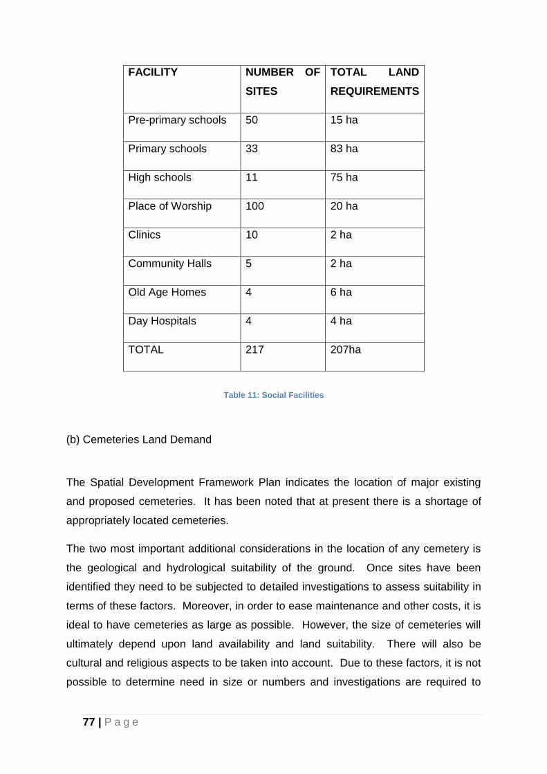
77 | P a g e
FACILITY NUMBER OF
SITES
TOTAL LAND
REQUIREMENTS
Pre-primary schools 50 15 ha
Primary schools 33 83 ha
High schools 11 75 ha
Place of Worship 100 20 ha
Clinics 10 2 ha
Community Halls 5 2 ha
Old Age Homes 4 6 ha
Day Hospitals 4 4 ha
TOTAL 217 207ha
Table 11: Social Facilities
(b) Cemeteries Land Demand
The Spatial Development Framework Plan indicates the location of major existing
and proposed cemeteries. It has been noted that at present there is a shortage of
appropriately located cemeteries.
The two most important additional considerations in the location of any cemetery is
the geological and hydrological suitability of the ground. Once sites have been
identified they need to be subjected to detailed investigations to assess suitability in
terms of these factors. Moreover, in order to ease maintenance and other costs, it is
ideal to have cemeteries as large as possible. However, the size of cemeteries will
ultimately depend upon land availability and land suitability. There will also be
cultural and religious aspects to be taken into account. Due to these factors, it is not
possible to determine need in size or numbers and investigations are required to
78 | P a g e
determine areas suitable for new cemeteries and to assess more accurately land
demand for this use on a long term basis.
A cemetery audit indicates that there are 15 cemeteries totalling some 224ha.
However of these, three are now full, leaving 12 cemeteries operational. Estimated
available capacity at current burial rates indicates that these cemeteries will be full in
less than 30 years. This estimated time span may well reduce considerably should
the spread of the HIV/Aids pandemic not be curbed.
Burials are taking place at a rate of approximately 11 000 burials per annum. Based
on a 2011 population of 1, 16 million, this equates to a death rate of approximately
0.95%. Assuming this remains at a constant 0.95%, an escalated 2020 population
projection of 1,5 million will see this burial rate increase to approximately 15 000
burials per annum and will require an additional area of approximately 189ha to be
set aside for cemetery purposes. Investigations are under way to identify and secure
land that is geologically suitable for this purpose. Such investigations must consider
the impact of alternate policy options and instruments in managing death and burial.
(C) Abakwetha Land Demand
The urban structure needs to accommodate the requirements of the Abakwetha
custom. Such requirements include that land identified for this purpose should be
reasonably vegetated so that shelters and activities are screened from view.
It is proposed that the Land Use Management Scheme be revised to accommodate
a special zone for this land use as part of a detailed study into the identification of
suitable sites. Such a study should be carried out in conjunction with the
communities involved.
79 | P a g e
4.6.7 Trends and Demand for Sustainable Development
4.6.7.1 How the ecological (natural/green) infrastructure supports and constrains
urban growth and development, procedures, standards and performance.
The National Environmental Management Biodiversity Act, Act 10 of 2004 and other
environmental legislation require municipalities to develop strategic environmental
planning tools (i.e. Conservation Assessment, Environmental Management
Framework and Bioregional Plan) and management programmes aimed at informing
and guiding land use planning and decision-making processes, thereby promoting
sustainable biodiversity management.
The Municipal Systems Act, Act 32 of 2000 requires that the environmental impacts
of the Municipal Spatial Development Framework (MSDF) be evaluated. In 2007, the
NMBM completed a systematic biodiversity planning assessment process that
spatially represented a network of its biodiversity resources and processes. This was
used to inform the Strategic Environmental Assessment of the MSDF. The Municipal
Systems Act 32 of 2000 also states that municipalities must deliver their services in a
sustainable manner.
The biodiversity network represented within the MSDF was later used to inform the
Environmental Management Framework (EMF) at a Metro-wide scale, guiding
development to appropriate areas and limiting development in environmentally
sensitive areas. Geographical areas were identified and mapped to facilitate a
reduction in the legal requirements and streamline the Environmental Authorisation
process at a strategic level, thereby ensuring that biodiversity priorities would be
taken into the sector planning of the NMBM. It is anticipated that the review and
refinement of the Metro’s EMF will be completed in the 2015/16 financial year.
The NMBM Bioregional Plan is aimed at conserving biodiversity at a regional level
and is primarily concerned with guiding land use planning and decision making
through improving the legal standing and consideration of Biodiversity/Conservation
areas by all organs of state. The National Environmental Management Act, 107 of
1998, the Environmental Impact Assessment (EIA) regulations, as amended in 2010,
and further amended in 2014 make specific mention of threatened ecosystems,
80 | P a g e
Critical Biodiversity Areas, Bioregional Plans and systematic biodiversity plans to act
as EIA triggers. The NMBM has completed the Bioregional Plan, which has been
gazetted.
A Corporate Environmental Impact Assessment Task Team (CETT) and Bilateral
meetings between the Nelson Mandela Bay Municipality and the Provincial
Department of Economic Development and Environmental Affairs (DEDEAT) are
further instruments employed towards ensuring integration at social, economic and
environmental levels.
The National Environmental Management: Integrated Coastal Management Act, Act
24 of 2008, allows for the development of a Coastal Management Programme that
calls for an integrated, coordinated and uniform approach to coastal management
within the Metro by all stakeholders in ensuring the sustainable use of coastal
resources. The programme is currently being updated and will be subjected to a
public review process. The Coastal Development Line (hazard lines) study, has been
completed in association with the Eastern Cape Provincial Department of Economic
Development, Environmental Affairs and Tourism (DEDEAT). The delineated
development lines (hazard lines) will, once promulgated, be used to inform
appropriate development along the coastline of the Metro by means of specific
regulations as well as the updated Coastal Management Programme and other
sector plans of the NMBM. These plans are due for completion in the 2015/16
financial period.
The natural resources planning, inventory and operational management of the
NMBM's nature reserve network and green infrastructure network is concerned with
conserving ecosystem values, functions and the restoration of natural systems that
underpin watershed health and hydrological integrity supporting natural resources
necessary for agriculture and aquaculture.
Municipal policies, such as the Integrated Environmental Policy and the Integrated
Energy Plan, are specifically geared to address the response and resilience of all
communities to climate change impacts.
The Integrated Environmental Policy specifically, provides guidelines for the Land
Use and Planning sector of the Municipality, which (amongst others) are to:
81 | P a g e
Undertake spatial planning that reduces urban sprawl, promotes densification,
mixed use development, and corridor developments, and
Encourage green buildings and sustainable design and development
practices.
The NMBM has set out to achieve the following sustainable goals:
Providing an affordable and secure energy supply that increases the
development and use of renewable, less toxic and less carbon intensive
sources.
Providing affordable and secure energy for all, while minimising demand and
consumption.
Increasing the percentage of energy derived from renewable sources.
Policies promoting the use of clean and efficient energy.
Achieving greenhouse gas emissions and air pollution reduction in both
municipal operations and the community at large, with attention given to the
reduction and prevention of inequalities.
Improving the response and resiliency of all communities to climate change
impacts on the built, natural and social environments, with the emphasis on
public health and historically underserved populations.
Ensuring that outdoor air quality is healthy for all segments of the human
population and the natural environment.
The current areas of focus for climate change in the city include:
Greenhouse gas emissions tracking and reduction.
Maintenance and growth of current initiatives, whilst looking at others.
Addressing the roles and responsibilities of every directorate in climate
change related issues.
Responding to vulnerability and aligning it with adaptation.
Education and awareness.
Ensuring alignment with provincial and national strategies and actions, and
managing in-house policies and strategies.
82 | P a g e
In 2013, a municipal Community Awareness Campaign, called the Go Green
Advocacy Programme, was launched. This Programme is aimed at providing
residents with the resources they need to think critically about and address
environmental problems and solutions, and include the environment as an important
consideration in their work and daily living. This awareness programme built on the
Go Green Campaign, which was initiated in 2008 to showcase municipal-led projects
and initiatives which demonstrated sustainability.
The Integrated Energy Plan aims to provide a high level perspective of the energy
trends and needs of Nelson Mandela Bay over the next 10 years. The Green
Procurement Implementation Strategy is aimed at moving the NMBM toward the
inclusion of environmental criteria in its Supply Chain Management Policy in order to
encourage the development and diffusion of goods and services which have the
least impact on the environment.
An Environmental Management System (EMS) is in operation at the Nelson Mandela
Bay Multi-Purpose Stadium. This Stadium was built on Green Goal principles,
sourced from the 2006 FIFA World Cup held in Germany. An EMS is a management
tool aimed at reducing and managing the environmental impacts of activities, and is
a condition of the Stadium’s environmental authorization.
The NMBM adopted the national standard for energy efficiency or SANS 204 in
municipal buildings, which greatly raised awareness of the consumption of energy
resources and the type of energy resource that is being used.
The Disaster Management Sub-Directorate (Safety & Security Directorate) has
identified in its’ Risk Assessment (2010) that the highest rated risks to the NMBM are
Hydro-metereological (Floods & Storms) and Hydro-metereological (Droughts), and
then Environmental Degradation (in order of importance). This has implications for
city planning. Preventative and disaster-proof city planning and design must become
the norm in future where the effects of climate change are not linear or always
predictable.
The Waste Management sub-directorate has embarked on Metro-wide project aimed
at the betterment of the waste management infrastructure, processes and existing
83 | P a g e
systems to offer better efficiency and offer operational cost savings to the NMBM.
The project is entitled: “Municipal Solid Waste (MSW) Diversion and Beneficiation in
the NMBM” (NMBM, 2015).
Key to this project is the implementation of waste management infrastructure which
is to be constructed on strategically located sites including the possible construction
of a waste-to-energy (WtE) plant. A detailed feasibility study has been carried out
recently by Royal HaskoningDHV, which has identified the project to be
economically, environmentally, technically and socially feasible. The project may
introduce approximately 300 new sustainable jobs.
The Waste Management infrastructure for this project comprises the construction of
what is described as “Waste Parks” including waste transfer stations, waste sorting
and recovery facilities (also called Materials Recovery Facilities – MRF’s), and waste
treatment which may include composting, anaerobic digestion (AD), aggregate
crushing and sieving and waste-to-energy (WtE).
Five (5) sites where identified for Waste Management Infrastructure and the
establishment of “Waste Parks” within the NMBM. These are:
Greenbushes - Approximately size 200 x 220m
Markman (Motherwell) - Approximately size 400 x 1000m
Koedoeskloof - Approximately size 330 x 150 m
PPC West - Approximately size 46ha
Coega - CDC Zone 5
The sites earmarked for the “Waste Parks” are PPC West and Koedoeskloof,
whereas Coega is earmarked for a waste-to-energy plant site only and Waste
management infrastructure is earmarked to be installed and constructed at
Greenbushes; Markman/Motherwell; PPC West; and Koedoeskloof.
The South African National Framework for Sustainable Development (NFSD) was
approved in 2008, and is the precursor to the National Strategy for Sustainable
Development and Action Plan 2011-2014 (NSSD 1), approved by Cabinet in 2011. In
the NSSD 1, sustainable development is accepted as a long-term vision for the
84 | P a g e
country’s prosperity. Through 5 key priorities, it sets out to guide the implementation
of all three tenets of sustainability (environmental protection, social equity and
economic efficiency).
Priority 3 relates to the green economy and provides interventions to unlock the
potential of this “mindshift” in developmental thinking. Infrastructure, and indeed the
built environment, must become sustainable to serve both the needs of present and
future communities. Another intervention is to implement a “Green Building
Regulator Enforcement Programme”, and municipalities can develop Green Building
by-laws, as an example. The NMBM’s IDP provides a strong focus on Local
Economic Development and job-creation projects for waste minimization,
beautification and education and awareness-raising for residents on climate change.
One of the biggest challenges to the sustainability of ‘green’ infrastructure (ecological
services such as wetlands, biodiversity corridors, natural habitat spaces, and other
biophysical systems) is a failure to address the impacts of climate change and
unsustainable resource use. The National Strategy for Sustainable Development and
Action Plan 2011-2014 (NSSD 1) states that ecosystem resilience must not be
disturbed, and that adaptive capacity in communities must be built. These goals
relate to Specific Priority 5 of the NSSD 1, which relates to “responding effectively to
climate change”.
As one example of infrastructure’s ‘adaptive capacity’ (ability to respond to changes
in conditions), the Water and Sanitation Sub-Directorate has embarked on an
externally-funded project to increase the energy and water efficiencies of 74 pump
stations throughout the Metro. These pump stations are under strain due to
population increase and cyclical droughts.
The integration of municipal and provincial spatial planning instruments are
encouraged as a means of integration and alignment of strategic sustainability
priorities. The overlaying of municipal spatial development frameworks, the
conservation status layers, and collaboration with Environmental Management and
other relevant Directorates are all efforts which speak to this integration and
alignment. In addition, the multi-sectoral internal municipal forums, as well as
bilateral discussions (such as those between the local Department of Economic
Development, Environmental Affairs and Tourism and the NMBM) with local
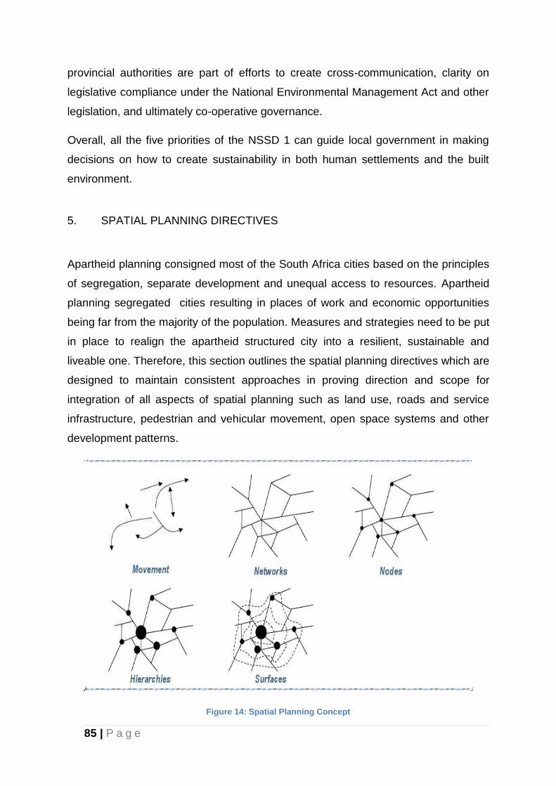
85 | P a g e
provincial authorities are part of efforts to create cross-communication, clarity on
legislative compliance under the National Environmental Management Act and other
legislation, and ultimately co-operative governance.
Overall, all the five priorities of the NSSD 1 can guide local government in making
decisions on how to create sustainability in both human settlements and the built
environment.
5. SPATIAL PLANNING DIRECTIVES
Apartheid planning consigned most of the South Africa cities based on the principles
of segregation, separate development and unequal access to resources. Apartheid
planning segregated cities resulting in places of work and economic opportunities
being far from the majority of the population. Measures and strategies need to be put
in place to realign the apartheid structured city into a resilient, sustainable and
liveable one. Therefore, this section outlines the spatial planning directives which are
designed to maintain consistent approaches in proving direction and scope for
integration of all aspects of spatial planning such as land use, roads and service
infrastructure, pedestrian and vehicular movement, open space systems and other
development patterns.
Figure 14: Spatial Planning Concept
86 | P a g e
5.1 Primary Structuring Elements
5.1.1 Activity Nodes
Nodes are places of high accessibility which are characterised by intense
concentration of mixed use activities such as retail, office, entertainment, community
facilities and residential components. Such places are usually located at strategic
transport interchange and should be examined in terms of their potential
significance.
These nodes should be positive performing environments that are able to attract
business and economic developments to these points. Well-functioning urban nodes
are vibrant areas comprising shopping, work, social and cultural opportunities and
public transport facilities in a high quality, safe public environment.
Furthermore, they are regarded as priority areas for densification, integration,
intensification and improvement of environmental quality. There is a great need to
identify a hierarchy of nodes within the metropolitan area in order to integrate the
spatial structure and maximize opportunities. Nodes are mostly targeted for public
and private invest investment as they can enhance economic opportunities and
enable more efficient service delivery intensifying activities. Nodes are identified in
terms of their function, economic use, intensity, density, walkability, public facilities
and public transport.
5.1.2 Urban Corridors
Urban corridors consist of a combination of structuring elements which reinforce a
hierarchy of nodes characterised by the mix of uses resulting in varying development
intensity and width. However, activity spines are more focused on promoting intense
concentration of mixed uses along a major transportation route. These structuring
elements are significant in maximising the objectives of restructuring and the
creation of economic opportunities by intensifying various activities. Mixed used
activities should be created and promoted within such structuring elements which
include different modes of transport, thus minimising travelling costs and the costs of
87 | P a g e
transport infrastructure by increasing accessibility to employment opportunities
especially for previously disadvantaged communities.
5.1.3 Activity Spines
The network of activity nodes is reinforced by a system of activity spines which
connect with these nodes. Activity spines can be defined as concentrated urban
development along movement routes which are typically also major public transport
routes. Development can either take the form of continuous linear development or a
series of nodes along the activity spine. The activity spines must have a degree of
demonstrated development potential.
5.1.4 Natural Open Space and Green System
The open space and green system within the metro provide a diverse range of
environments which are characterised by conservation areas, recreation activities,
corridor parks and servitudes, watercourses, ridges, heritages sites etc. Existing
natural environmental resources are economic assets as they promote livability and
viability of communities. The open space and green system should be protected and
enhanced to ensure that the ecosystems within it are able to effectively deliver
services. It also strengthens social bonds in places where those kinds of ties are so
badly needed. Planning should allow the City to confront and manage aspects of
growth and development in ways that preserve, protect, and enhance the
environment. The protection of the natural visual quality of the area increases the
attractiveness, livability and investment potential of the area.
5.2 Consolidation and Densification
Consolidation and Densification approach promotes more compact urban
development, especially to those areas which are well serviced and centrally located.
This approach contributes to the restructuring of the urban environment and
discourages urban sprawl by promoting development that is adjacent to existing
urban areas. Furthermore, it promotes more efficient use of the existing
88 | P a g e
infrastructure, especially along existing urban centres, urban corridors, urban nodes
and other areas which represent important opportunities. There, the most important
rules that should apply to densification are the following:
Higher density development should be focused around and within walking
distance from major activity areas and transport services.
Densities should decrease as the distance away from major activity areas
increases. Higher densities in the wrong locations or which are removed from
major activity areas and transport routes can be harmful to urban efficiency
and sustainability.
5.3 Growth Management
Most urban areas in South Africa are characterised by urban sprawl, resulting to a
majority of people spending a lot of time and money travelling long distances to
work, shops, schools and social facilities. It also means that local authorities must
spend large amounts on providing and maintaining excessive amounts of
infrastructure. In dealing with this undesirable development pattern, a key
consideration of the spatial development framework must be growth management
through the demarcation of an urban growth boundary (or urban edge). The “urban
edge” can be briefly defined as a conceptual boundary delineating the urban area
with the sole purpose of containing physical development and sprawl and re-
directing growth towards a more integrated, compact and efficient urban form and
guided by detailed plans.
Outside the “urban edge” the land use will be predominantly agricultural with
allowances and regulations for different types of agricultural activities and for rural
developments. The “urban fence” is not a physical element, but rather identified by a
spatial differentiation in proposed land use intensity between what is inside the fence
(urban development) and what is outside the fence (peri- urban and rural
developments including small Metropolitan open space, agricultural small-holdings,
intensive farming, grazing and game farms). The delineation of an urban edge is vital
for achieving an efficient and sustainable municipality through -
Containment of urban sprawl;
89 | P a g e
Intensification of development;
Integration of urban areas;
Protection of valuable agricultural, natural and cultural resources;
The optimum use of existing resources in established urban areas, such as
bulk service infrastructure, roads and public facilities; and
Reducing the need for commuting as well as commuting distances.
5.4 Other Supporting Strategies
5.4.1 Urban Network Strategy
An Urban Network Strategy (UNS) Framework was approved by the Council as part
of the 2014/15 Built Environment Performance Plan (BEPP) submission. This
framework was also accepted by the NDP Unit at National Treasury. The key
elements of this broad Urban Network Framework are briefly highlighted as follows:
(a) Cluster Identification
This approach has divided the NMBM into six township clusters, they are as follows
(as depicted on Figure 17):
Uitenhage, Despatch, KwaNobuhle and Bloemendal Cluster. The total
population for this cluster, which includes Uitenhage farms and Colchester wards,
is 305 458 persons.
Motherwell-Wells Estate Cluster, including Swartkops, Amsterdamhoek and
Bluewater Bay, with a population of 165 457.
Ibhayi-Bethelsdorp Cluster, which includes Ibhayi, KwaDwesi, KwaMagxaki, Joe
Slovo, Govan Mbeki, New Brighton, Soweto-on-Sea, Veeplaas, Zwide, Helenvale
and Algoa Park, with a population of 425 847.
The CBD Cluster, which includes the inner-city areas of Central, North End,
Korsten, Newton Park and Mill Park, with a population of 52 538.
The Southern Areas Cluster, comprising Summerstrand, South End, Humerail,
Walmer, Fairview, Theescombe and Schoenmakerskop, with a population of
95 172.
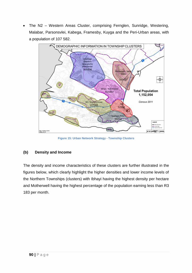
90 | P a g e
The N2 – Western Areas Cluster, comprising Fernglen, Sunridge, Westering,
Malabar, Parsonsvlei, Kabega, Framesby, Kuyga and the Peri-Urban areas, with
a population of 107 582.
Figure 15: Urban Network Strategy - Township Clusters
(b) Density and Income
The density and income characteristics of these clusters are further illustrated in the
figures below, which clearly highlight the higher densities and lower income levels of
the Northern Townships (clusters) with Ibhayi having the highest density per hectare
and Motherwell having the highest percentage of the population earning less than R3
183 per month.
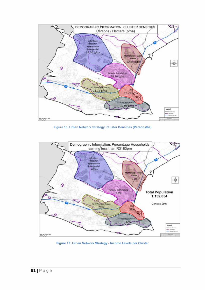
91 | P a g e
Figure 16: Urban Network Strategy: Cluster Densities (Persons/ha)
Figure 17: Urban Network Strategy - Income Levels per Cluster
92 | P a g e
5.4.2 Sustainable Community Unit (SCU)
The sustainable communities unit (SCU) concept aims to establish a structure that
will assist achieving the overall planning principles set out by Government in a
spatial context. The SCU in its physical form is the main planning zone of the overall
metropolitan structure.
The purpose of using this urban unit as a building block is to improve accessibility to
services, employment opportunities and cultural and recreational facilities by
providing them closer to places of residence and along main transportation routes. It
is envisaged that it will result in a more balanced and integrated physical and socio-
economic structure.
The objectives of the SCU are to :-
• reduce discrepancies between different sections of the society in terms of
service provision and standards;
• promote integration in socio-economic and functional terms;
• provide for economic activities and employment opportunities;
• improve accessibility to services and facilities; and
• facilitate other requirements as identified in Government policy statements,
goals and objectives.
Sustainable community units should include a range of housing types for different
household categories including mixed densities. Areas for social facilities such as
clinics, schools, crèches and libraries as well as industrial, commercial and other
formal and informal economic activities should also be included. While major
recreational areas are incorporated in the broader metropolitan open space structure
(MOSS), units should provide for local open space and local recreational needs.
Mixed land uses should be considered, particularly in centrally located sections of
the unit and along transport routes and activity corridors.

93 | P a g e
It is envisaged that the vast majority of citizens will depend on public transport and
walking for mobility. The approach within the SCU therefore focuses on pedestrian
movement, public transport and the provision of access to services and job
opportunities. Consequently the main criterion determining the size of an SCU is
proposed as the maximum walking distance from the centre to the periphery. The
walking distance in this context is assumed to be 2 kilometres or a 30 minute walk.
In theory, the maximum SCU size is approximately 1000ha with a population of
approximately 100 000 inhabitants. In reality though, SCU’s will vary in size
depending upon location, densities, built-up areas, topography, physical constraints
and existing land uses.
An SCU is intended to be a predominantly self-contained unit of development that is
designed to minimise the need to travel while at the same time offering employment
opportunities closer to places of residence. They will also be linked to one another
by some form of transportation route. The core of the SCU’s can comprise
commercial or employment centres, service and educational centres, transport
junctions or a combination of these. The efficient use of land and services will
require variations in densities depending on proximity to centres or transport links.
5.4.3 NMMB Human Settlements Plan
The Human Settlement Plan / Housing Sector Plan integrate the housing chapter of
the Integrated Development Plan (IDP), Spatial Development Framework (SDF),
Land Use Management Strategy (LUMS) and Infrastructure Development Planning
all of which are essential parts of the Spatial Policy Plans and Strategies for
Sustainable Human Settlement Planning.
The Human Settlement Plan has the following objectives:
Outline the housing / human settlement dynamics in the NMBM;
Document housing and human settlement delivery, best practices and
lessons;
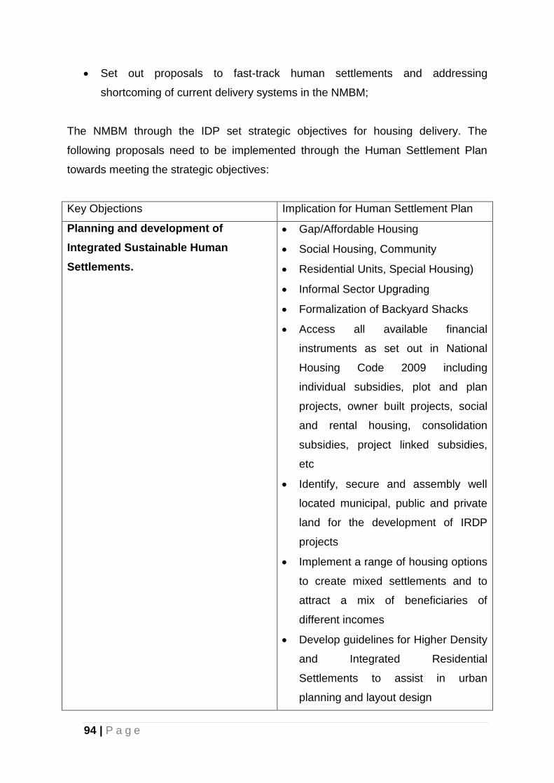
94 | P a g e
Set out proposals to fast-track human settlements and addressing
shortcoming of current delivery systems in the NMBM;
The NMBM through the IDP set strategic objectives for housing delivery. The
following proposals need to be implemented through the Human Settlement Plan
towards meeting the strategic objectives:
Key Objections Implication for Human Settlement Plan
Planning and development of
Integrated Sustainable Human
Settlements.
Gap/Affordable Housing
Social Housing, Community
Residential Units, Special Housing)
Informal Sector Upgrading
Formalization of Backyard Shacks
Access all available financial
instruments as set out in National
Housing Code 2009 including
individual subsidies, plot and plan
projects, owner built projects, social
and rental housing, consolidation
subsidies, project linked subsidies,
etc
Identify, secure and assembly well
located municipal, public and private
land for the development of IRDP
projects
Implement a range of housing options
to create mixed settlements and to
attract a mix of beneficiaries of
different incomes
Develop guidelines for Higher Density
and Integrated Residential
Settlements to assist in urban
planning and layout design
95 | P a g e
Open up housing delivery to other
agencies to reduce reliance on
Municipality as the main delivery
vehicle. This will free the metro to
play a facilitative and supporting role
To eradicate housing backlog Engage National and Provincial
Government to obtain priority funding
for mass housing delivery models
through submitting Business Plans
and Project Plans for priority projects.
Focus on spending allocated budgets
to prevent return of unspent funds
Facilitate policy changes in order to
allocate land to financial institutions,
private developers, and community
based partners to assist the
municipality in housing delivery at
scale and to address the massive and
growing backlog within the horizon
set out in the IDP.
Identify partners and secure
agreements through MOU's for
Turnkey Projects that will deliver
projects at scale, with Financial
Institutions, Private Developers, Big
and Small Contractors and
Community Based Organizations
(CBO's).
Identify delivery bottlenecks and
develop proactive and innovative
plans to address these as part of the
Level Two Accreditation Strategy
Accelerate the provision of serviced
96 | P a g e
stands and rapid land release to
enable individuals, emerging
developers and medium sized
developers to build houses on a "plot
and plan" basis alongside the big
projects by the NMBM.
Put out Requests for Proposals
(RFP's) calling on Developers,
Private Land owners, financial
institutions and Informal Sector
Organizations, Savings Clubs,
Cooperatives to submit housing
proposals according to their technical
ability, capacity and financial strength
from which the Metro can choose.
Improve project management skills,
among the staff, simplify procurement
methods to open up the housing
delivery process beyond the metro(
and “metro house” approach) etc.
To eradicate informal
settlement by 2016
Facilitate in -situ upgrading and
minimise relocations of informal areas
Provide funding for the registration of
beneficiaries and the planning of
informal settlements in order to build
a comprehensive data base. This
should include the social and physical
surveys of each settlement, marking
and numbering of all shacks,
proliferation survey, etc.
Support a range of housing options
and typologies
Review Current Plan and Prepare an
97 | P a g e
Updated Informal Settlement Plan
and Master Plan for the City
Provide basic services incrementally
and allow for regularization to create
security of tenure over time.
Accelerate provision of serviced sites
to alleviate poverty and promote
dignity while communities wait for top
structures.
Establish community partnerships
and networks to curb illegal land
invasions.
Develop campaigns to informal land
owners about responsibilities towards
prevention of illegal land ownership.
Develop relations with SAPS and
Community Police Forums to prevent
illegal land invasions.
Identify land for housing that is well
located in relation to work
opportunities which in turn will act as
a preventative measure against illegal
land invasion. Find resources to
acquire the land as set out in the land
assembly strategy.
Identify and develop land with
rudimentary services for reception
areas where people can settle
lawfully as part of the IDP and SDF
Procure agreements with major land
owners (Government Departments) to
allow Municipality to act swiftly
against invasion.

98 | P a g e
To implement community and people
driven housing development
processes
Enhance stakeholder participation in
the planning and development of
policies.
Build partnerships with informal
settlement communities and their
representatives and agents, including
savings clubs, forums for various
informal settlements (e.g. Informal
Sector Networks (ISN), FEDUP,
NGO's, micro finance organisations
(e.g. Ubutyebi Trust), private land
owners of illegally occupied land.
Incorporate EPWP and EPHP
procedures for housing construction
programmes and projects
Facilitate partnership with key
stakeholders including local emerging
builders, representatives of major
employers, housing finance lenders,
accredited social housing institutions.
To develop a competent and
professional housing team
Recruit and appoint competent staff
and project managers.
Staff training and capacity
development of staff
Develop an Implementation Plan for
Level Two Accreditation and
implement systems starting from
2011- 2012.
Facilitate Level Three Accreditation
for period 2012- 2013.
To ensure fair, efficient and
transparent system for the allocation
of houses
Establish a Comprehensive Housing
Waiting list.
Obtain access to HSS System and
99 | P a g e
obtain hardware and software to
manage a Comprehensive HSS
System and Electronic database.
Train Staff to render effective
services.
Introduce monitoring mechanisms to
ensure full compliance with criteria.
Develop criteria for allocating per
project.
To review land use management
policies to facilitate integrated
housing development
Implement Sustainable Communities
Planning Guidelines.
Prepare innovative land use and
planning guidelines to promote
sustainable settlements in line with
national policies.
Complete the Integrated Zoning
Scheme Project to usher in an
integrated scheme across the City.
Integrate the various LSDF's
prepared for the various parts of the
City to ensure development that is
consistent with the national policy
framework.
To investigate alternative sources of
funding for housing delivery
Approach national and provincial
housing departments for additional
funding.
Identify Donor Agencies and External
Partners that can contribute funding
towards housing delivery and
management.
The SDF has identified the integration, sustainability, mobility and activity corridors,
enforcement, urban fence, central city upgrading and conservation of the built
100 | P a g e
environment as the main pillars for the restructuring the City. The Human Settlement
Plan proposes to respond to this framework through the following spatial
interventions:
(a) Integration
PURPOSE
Maximise choice in all aspects of life
STRATEGIC POLICY INTERVENTIONS
Increase densities.
Promote mixed use and sustainable settlement patterns.
BENEFITS OF INTEGRATION BASED PLANNING
Improve urban mobility
Improve access to services.
Create opportunities close to where people live.
Makes provision for facilities more efficiently.
Better utilisation of land, buildings and services.
Improve housing quality through delivery at scale.
Better and bigger green areas to improve environmental and aesthetic quality in
human settlement.
Protect agricultural land against urban encroachment.
RECOMMENDED SPATIAL POLICY INTERVENTIONS
Adopt minimum residential density guidelines for new development areas, even
those removed from the City Centre, which are to be planned at higher densities
(at least 40 units/ ha). Future development densities to average at least 40--50
units/ Ha (not 20 units/ Ha as is the case at present in some of the current
existing residential developments).
Promote integration of various uses though mixed use development approaches.
101 | P a g e
Infill development on vacant and derelict land and underutilized buildings not
required for other purposes.
Increase densities on and along Transport Routes and activity
Corridors, through development of Nodes and Activity Streets for higher building
and residential density (multi-unit and mixed use buildings) (±400-800m).
Promote smaller residential erven for lower income developments (80-120m²) as
the 200-250m² currently used/ or preferred are no longer sustainable.
Set maximum erf sizes of say 120m2 for low cost housing projects in good
locations.
Layouts to contain and make provision for corridor planning that will promote
mixed development in terms of:
Housing typology (move away from single house per stand to row, semi and
duplex units and walk-up).
Tenure: Promote mixed tenure within residential areas, (Freehold, Rental, Social
Housing, Sectional Title) Land Use Mix: (Business, Commercial & Residential,
Light/ Clean Industry, etc.).
(b) Sustainability
PURPOSE
Meet current needs without compromising the ability for future generations to
meet own needs.
STRATEGIC POLICY INTERVENTIONS
Sustainable Community Planning Principles to be applied in planning and
decision making.
BENEFITS OF SUSTAINABILITY
Self-sufficient neighbourhoods within walking distance of most community
residents.
102 | P a g e
Reduce travel costs, time and effort.
Increase individual choice and accessibility.
RECOMMENDED SPATIAL POLICY INTERVENTIONS
Protection of human health through provision of basic services to all.
Preservation of biological diversity.
Protection of natural and cultural resources.
Poverty alleviation, through Local Economic Development.
Public and Community involvement to harness all local resources and built pride
and good citizenship.
Create neighbourhood planning units that contain all facilities, services and job
opportunities close to place of residence.
Accommodate different housing typologies, income groups, densities, within
residential neighbourhoods, etc.
Enforce densification of residential areas within 2kms of most nodes in order to
create higher population thresholds around major nodes (e.g. Greenacres,
Walmer Park, Cleary Park, Motherwell, Njoli Square, etc.).
(c) Mobility and Activity Corridors
PURPOSE
Use infrastructure and land efficiently.
Prevent unnecessary extension of road networks and keep extensions (roads
and rail) to the absolute minimum.
Development of Non Motorized Transportation Networks
STRATEGIC POLICY INTERVENTIONS
Densification and mixed use along public transport corridors, along railway lines
and around railway stations and nodes.
Establishing connections between disparate NMT Infrastructure such as cycling
103 | P a g e
and pedestrian paths
BENEFITS OF CORRIDORS
Promote better use of infrastructure.
Minimise the need to extend networks unnecessarily. Make public transport to be
more viable than private transport.
Reduction in the opportunity cost of NMT
RECOMMENDED SPATIAL POLICY INTERVENTIONS
Review services standards (narrower road widths, shared service connections
and promote use of mid-blocks services where it is efficient and cheaper).
Development of Green Lane networks2 for NMT by connecting existing NMT
infrastructure and developing new NMT infrastructure
Increase residential and commercial densities along transportation corridors not
merely permit low intensity businesses (±50-100 units/ ha)
Transform main routes into activity and development corridors
Make the environments along corridors conducive to residential development to
attract more people to live there
Prepare a Transport Plan for the City that will:
-Incorporate a focus on NMT networks and the provision of Green Lanes
-Initiate the development of transport corridors looking at type, location, nature
of corridors, etc.
- Study transport routes in NMBM and develop policy guidelines to make them
successful public transport routes integrated with land-use.
- Focus on Khulani Corridor as a start and apply lessons learnt to other parts of
the Metro.
- Develop public spaces and plazas as part of public transport corridors to
attract more residential development.
-Develop strategies to enhance cycling as a form of non-motorized transportation
by the providing networks of cycling infrastructure to support urban mobility.
104 | P a g e
(d) Enforcement
PURPOSE
Enforce innovative land use policies and by laws (e.g. land invasion)
STRATEGIC POLICY INTERVENTIONS
More effective enforcement of land use policies in order to prevent illegal uses
Amend outdated policies that promote illegal uses, low density urban sprawl and
mono-functional land uses as appropriate.
BENEFITS OF ENFORCEMENT
Protect public good and health.
Provide certainty and prevent ad-hoc development by planning ahead instill
investor confidence through consistent decision making.
RECOMMENDED SPATIAL POLICY INTERVENTIONS
Dealing with illegal uses, identify sites for rapid settlement to address emergency
Situations.
Prevent illegal invasion through rapid land release of well-located land.
Purchase well located land to develop low cost housing will help to discourage
illegal settlement as people seek to be closer to jobs by settling on land illegally.
(e) Urban Growth and Inner Urban Core Boundary
PURPOSE
Urban Edge is a conceptual boundary that delineates the urban area from areas
outside (peri-urban and rural areas) is agricultural holdings, etc.
Urban Core is an inner focus area (+-10kms of the CBD) in which priority should
be focused to bring low income persons into the City in the next 5 years.
105 | P a g e
STRATEGIC POLICY INTERVENTIONS
Adopt urban edge to contain urban sprawl and contain development within
designated areas for urban development.
Development of a policy framework for urban edge demarcation through the
establishment of a framework for urban services limits.
BENEFITS OF URBAN EDGE POLICY
Promote integrated sustainable and functionally efficient settlements at high
urban densities (minimum ±40 units/ Ha)
Improve accessibility to employment and services by developing human
settlements on well-located land.
Utilise land and infrastructure optimally and curtail servicing costs through
innovative sharing of services and higher density planning.
Protect agricultural land and other bio-physical natural resources to safeguard
food and conserve environmental areas
Keep transportation distances to the minimum.
RECOMMENDED SPATIAL POLICY INTERVENTIONS
Define an inner city core area (say 10kms from CBD) to be the main focus of
densification. Encourage the relocation of low cost housing into the inner core to
reverse the trend of relocating families to the periphery.
Offer incentives to land owners to offer land and/or develop land to accommodate
low cost housing in the inner core over and above their target markets
Infill development and recycling land and buildings in the inner core. All state and
municipal land in the core to be assembled for housing and mixed use
development to create impact.
Adopt minimum residential densities that promote the provision of efficient public
transport (at least 50 units/ Ha) particularly in the inner core. This would
necessitate the amendment to current minimum erf size restrictions applicable to
areas in the inner core.
Phasing and managing development to prevent sprawl and ad hoc development
106 | P a g e
Promote Land Use Management Policies that promote integration, efficiency and
higher residential densities and amend old policies that discourage change.
Develop policy for urban, peri-urban and rural areas as appropriate but
concentrate on making the inner core more attractive to dissuade people and
developers from favouring development on the periphery.
Introduce a set of incentives and disincentives for appropriate development inside
and outside the Urban edge, including the use of a urban services limit as a
policy intervention.
Discontinue the policy to relocate informal settlements on private land in
Parsonsvlei, Greenbushes, Ericadene and Kragga Kamma to areas outside of
the Urban Edge such as Rocklands, St Albans, etc to municipal, state land inside
the urban edge. Where no State or municipal land is available the metro should
engage with land owners to either allocate part of their land for in-situ upgrading
of informal settlements, assemble land to be the destination point for a number of
informal settlements on various private properties.
(f) Reinforce Central City
CURRENT STATUS AND/OR PROBLEM DEFINITION
The City Centre is often the oldest node and is the heart of the City.
It needs to be protected in order to promote social integration
Decentralisation of business from City of Port Elizabeth to detriment of the CBD
and North End, Sidwell & Korsten industrial and commercial areas has been
identified as a major concern.
Decentralization has been followed by the relocation of retail offices and industrial
uses to Walmer, Newton Park and Fairview for North End.
Although this trend is being gradually traversed in the PE CBD and Uitenhage
CBD as borne out by the recent development of small offices and service
business the rate is still slow.
Despatch CBD has remained largely unchanged due to its small size
107 | P a g e
PROPOSED STRATEGIC POLICY INTERVENTIONS
CBD Revitalisation and Urban Renewal through the recycling of land and
buildings, especially upper floors, derelict Transnet land in Harbour Precinct, etc
Create City Improvement Districts (CID’s) to focus efforts into specific areas(e.g.
Baakens) Valley Precinct
Recycling of vacated buildings and offices and underutilised/ derelict land for
Social Housing
Recycling of vacated industrial premises into smaller SMME type and mixed use
enterprises that can co-exist and are compatible with residential environments
Promote CBD revitalisation through environmental upgrading to prevent decay
that tends to promote or exacerbate the flight from CBD. Lend support to
initiatives of the MBDA to improve the CBD and extend initiative to the Uitenhage
and Despatch CBD.
Promote intensification of residential densities and mixed use within and adjacent
the decentralised nodes through the recycling of underutilised buildings and
single residential erven for Social (Rental and Institutional) Housing.
BENEFITS OF CBD RENEWAL
Prevent and discourage further decentralization of business from the CBD
through incentives and policy and density penalties as appropriate.
Maximise on location, main civic facilities and retain civic role of the CBD.
Recycling of derelict and underutilised land and buildings.
Infill development on land within existing and well served residential areas.
RECOMMENDED SPATIAL POLICY INTERVENTIONS FOR HUMAN
SETTLEMENT PLAN
Compliment the Mandela Bay Development Agency (MBDA) in its efforts
upgrade the PE CBD. Include the Uitenhage and Despatch CBD areas as
Mandate Areas for MBDA or other similar agency.
Spatial Strategic Implementation Framework for Mandate Area for PE,
Uitenhage and Despatch to be updated to reflect latest policy changes.
108 | P a g e
Promote Social Housing and Rental Housing Initiatives in the CBD's of PE,
Uitenhage and Despatch on State, municipal and private land.
Precinct Environmental Upgrading in City Centre to improve aesthetic appeal
and create sense of confidence in the area. This in turn is expected to attract
more private investment into focus areas.
Focus on land assembly to develop higher density residential development in
the CBD to increase population threshold within walking distance of the CBD
Upgrade Transport Interchange into a multi-modal interchange to bring buses,
taxis and commuter and passenger trains together. This will encourage
people to travel to CBG by public transport, facilitate the improvement in retail
and office demand and offerings in the City
Upgrade Harbour and Station precincts to make the CBD an attractive
investment and entertainment destination.
ACTION PLAN
Draw up register of buildings and land suitable for redevelopment.
Allocate Budget to assess feasibility for conversion of buildings and to facilitate
proactive planning in the 3-5 year expenditure framework.
Build partnership with Architectural Institutions and Private – Public Sector to
ensure protection of heritage buildings in the City.
Procurement of buildings suitable for recycling for the development of Rental and
Social housing.
(g) Built Form Proposals
i) Focus Housing along Development Axis
The Housing Settlement Plan should address built form in the following manner:
CURRENT STATUS AND/ OR PROBLEM STATEMENT
Development Axis spreading north-westerly from Central City towards Uitenhage
Approximately 35% of NMBM area is considered built up except for:
- Small agricultural holdings

109 | P a g e
- Undeveloped areas
- Land for future urban expansions
Major conservation and protected areas.
- Development Axis which
OPPORTUNITIES PRESENTED
Development Axis passes through well-established Commercial, Retail and
Residential areas of North End, Govan Mbeki, and significant facilities and
Community Nodes, e.g. NMMU Missionvale Campus, Dora Nginza Hospital
Development Axis supported by Public Transport Infrastructure, (including
existing and declared public transport routes, proposed modal Interchanges to be
built in PE, Uitenhage CBD, KwaDwesi, etc)
IMPLICATIONS FOR HUMAN SETTLEMENT PLAN
Reinforce the development axis by utilising vacant land along the Development
Axis for infill development at high density and mixed use (e.g. Algoa Park, Joe
Slovo, KwaMagxaki) (Refer to Figure below)
In-situ upgrading of all informal areas along and close to the Axis instead of
promoting de-densification and relocations to areas far from the Development
Axis and on the urban periphery.
Recycling of land and buildings including state land, public open space and
privately owned property within 10km of the CBD and within 400-800m of the
main development axis. Land along the public transport routes (±400m) and
close to proposed modal interchanges and local nodes (±800 metres) to be
developed more intensively.
POTENTIAL DEVELOPMENT SITES
Missionvale Garden Lots: Private and Public Land to be secured to promote in-
situ upgrading of the area.
Missionvale NMMU Informal Settlement in-situ upgrading.
Khanya Training Centre Redevelopment for Social/ Rental Housing and High
Density Housing.
110 | P a g e
Algoa Park Infill: Secure State land for social, rental and group housing within
and adjacent existing flats and residential in Algoa Park.
Infill Development on the old Vista Site owned by the State adjacent Dora Nginza
Hospital.
Development of land set aside for Higher Density in Joe Slovo West,
Khayamnandi, Chatty through calling for proposals from Developers, Banks and
Individuals to develop the land designated for higher density development in
approved layouts. This should be done ahead of opening up new areas beyond
Motherwell NU29, Jacktvlakte and amongst others.
Facilitate the development of new Integrated Residential on land Development
adjacent to Perseverance, Redhouse, Azalea Park Extension (to include the
extension to Perseverance Industrial Area along the Swartkops – Redhouse
Road). This project to follow on after the densification of Chatty, Joe Slovo West,
Khayamnandi, has been implemented.
KwaMagxaki Infill: Between Perseverance – Existing KwaMagxaki and
undeveloped school sites within KwaMagxaki
Promote the subdivision of undeveloped residential sites and other non-
residential sites in existing residential areas, e.g. KwaDwesi and KwaMagxaki to
increase residential opportunities
Identify other infill areas along the Development Axis and facilitate rapid land
release.
The metro to call for proposals, once a policy for private land acquisition, and
partnerships is developed to facilitate quick development.
ACTION PLAN
State Land Assembly: NMBM to approach the State to donate and/ or reserve
land in select areas along the axis for housing development in line with the
Human Settlement.
Proposal call for partners to deliver the housing jointly with the Municipality.
111 | P a g e
ii) Innovative Settlement Design and Densification
CURRENT STATUS AND/OR PROBLEM DEFINITION
Housing development in the metro is largely characterised by urban sprawl low
residential densities, limited socio-economic integration in residential areas, in
efficient provision of public transport, low population threshold in general and in
particular in and along the most accessible parts of the City. Authorities choose
the path of least resistance giving “communities” what they want resulting in low
density settlement typologies and resulting in low density settlement typologies
and relocation of beneficiaries to the periphery which results in high travel time
and cost to the poor.
OPPORTUNITIES PRESENTED AND IMPLICATIONS FOR HUMAN SETTLEMENT
PLAN
National policy settlement paradigm shift towards densification on general and in
well located land, along public transport routes and in order to maximise the use
of available land and services.
Opportunity to use densification to restructure the City, increase population
thresholds in well located areas (close to jobs, services, public transport and
nodes.
Promote the recycling of derelict land and buildings, respectively in restructuring
zones.
Development of a range of financial instruments that contribute to improving the
quality and variety of housing provided in the various settlements.
POTENTIAL DEVELOPMENT SITES AND/OR STRATEGIES:
Introduce and adopt design guidelines that contribute to the creation of a varied
attractive housing typologies and densities.
TRADE OFF SPACE FOR DENSITY:
Infrastructure costs are related to levels of density. High density settlements
result in lower infrastructure costs per unit and cost savings can be re-invested in
112 | P a g e
the housing and improvement of public areas.
PROMOTE USE OF ALTERNATIVE CONSTRUCTION MATERIALS
While conventional brick or block and mortar are the predominant materials used,
the use of alternative materials needs to be considered due to potential to reduce
construction costs. The high level of quality and structural integrity and the
advantage of rapid creation results in limited theft and damage to materials.
ERF AND ROOF CONFIGURATIONS FOR EASE TO EXTEND HOUSING
Designs should promote narrow frontages in order to maximise the number of
sites per given length of services and to length. Housing typologies should
promote linear extension towards the back or front as illustrated.
SERVICING AND ON-SITE PARKING OPTIONS
On small and narrow sites it is best that services are positioned in the street and
the house is best extended backwards. The drainage and bathroom therefore
need to be placed to the front (street) side to take advantage of short pipe runs to
street based connection points.
This is not only serves to lease the back available for extension, it also helps to
resolve the street elevations and prevent ad-hoc and un-coordinated extensions
along the street edges.
On-site parking should preferably be accommodated in 5m building line in front of
the house otherwise side parking will result in increase side frontage. Side
parking for semi-detached or free standing units requires an erf frontage of 7.5m
minimum as illustrated below.
iii) Reinforce Industrial Areas and Locate Residential Close to Industry
COEGA IDZ INDUSTRIAL DEVELOPMENT
CURRENT STATUS:
Coega: The establishment of Coega IDZ will change the epi-centre of industrial
113 | P a g e
growth towards the north of the City.
OPPORTUNITIES PRESENTED:
Housing development adjacent and close to Coega IDZ in short, medium and
long term will become a necessity as the IDZ Regulations preclude residential
development inside the Coega IDZ.
IMPLICATIONS FOR THE HUMAN SETTLEMENT PLAN:
Integrated Residential Development (Higher Density) Housing in Motherwell,
Wells Estate, Motherwell North, Development Axis between Motherwell and
Uitenhage and in general within 10kms of the Coega IDZ.
POTENTIAL DEVELOPMENT SITES AND STRATEGIES:
The Human Settlement Plan to promote densification in Motherwell – Wells
Estate at a density of 40 units (minimum) in general and 80-100 units/ Ha close to
nodes and along public transport corridor.
Densification of the existing Coega Vulindlela Construction Village and
introduction of commercial development to support mixed use development and
SCUs.
Target vacant land for development of IRDS at high density with a mix of housing
typologies, tenure, income and cultural groups to compensate for poor location in
respect of the CBD and other nodes of economic developers.
MARKMAN INDUSTRY
CURRENT STATUS :
Is designated for heavy industry but has developed slowly due to perceived long
distance from the CBD and poor environmental quality. It now enjoys a more
strategic position in relation to the Coega IDZ.
OPPORTUNITIES PRESENTED:
Improve environmental quality in the area and facilitate recycling of derelict and
underutilised land for industrial development in cooperation with the CDC.
Underutilised rail infrastructure and land.
Proximity to Coega IDZ makes it marketable area.
Feasibility study for the alignment of Markman township to the Coega IDZ with
114 | P a g e
the assistance of the CDC and Department of Trade and Industry.
IMPLICATION FOR HUMAN SETTLEMENT PLAN:
Mixed use along main routes into and part of Markman (Addo Road /MR450)
Brownfields redevelopment to promote recycling of derelict land and to promote
industrial infill in Markman and Brickfields Industrial Areas).
POTENTIAL DEVELOPMENT SITES AND/OR/ STRATEGIES:
Brownfield redevelopment of Markman and Brickfields Industry to attract more
industrial investment
Prepare a precinct improvement plan for Markman and Brickfields Industrial
areas to make the area more attractive and marketable.
Strategic development of the area to complement the development of the
Coega IDZ.
PERSEVERANCE INDUSTRIAL AREA
CURRENT STATUS:
Well located close to Ibhayi, KwaDwesi and KwaMagxaki residential areas and
along the PE- Uitenhage-Despatch Development Axis.
Perseverance Industrial area is almost being fully developed.
OPPORTUNITIES PRESENTED:
Possible extension of industrial area on adjacent vacant land towards Despatch
to maximise on location and synergy with the developed portion of Perseverance
is considered appropriate
IMPLICATIONS FOR THE HUMAN SETTLEMENT PLAN:
Need to prioritise the LSDF for the area.
Prepare a Master Plan for area adjacent the R75, Azalea Park, Swartkops
Estuary/Redhouse and Perseverance to facilitate it being developed as a mixed
use area Development.
POTENTIAL DEVELOPMENT SITES AND/ OR STRATEGIES:
Possible extension of Perseverance Industrial area onto vacant land in the area
115 | P a g e
and towards Azalea Park/ Despatch.
Development of the area as a mixed use development.
AIRPORT INDUSTRIAL AREA
CURRENT STATUS:
Industry related to Air Transport but area is underdeveloped and vacant spaces
are still Prevalent
OPPORTUNITIES PRESENTED:
Infill development on vacant and underutilised land within and adjacent the
Airport precinct.
Recycling of underutilised buildings and land north of Alistair Miller
Development of Modal Interchanges to promote public transport use to and from
the Airport, the CBD and adjacent residential areas
The residential area of Walmer is characterised by low density, one house on one
big plot. It has great potential for subdivision, densification and conversion of land
and buildings to mixed use and/ or light industrial development close to Gqebera
Township which is characterised by informal dwellings, housing shortages and
significant labour pool.
Municipal land along Buffelsfontein Road and up to Villiers Road to be targeted
for densification and infill development.
IMPLICATIONS FOR HUMAN SETTLEMENT:
Promote densification of Walmer to provide much needed population threshold
close to industrial area, airport and CBD and accommodate housing needs in the
Gqebera area.
In-situ upgrading at high densities to retain most people in, and attract more
people, into the area.
Designate vacant land south of Airport for integrated Residential Development
(part of Madiba Bay Lease Area) as an extension to Gqebera Township
Densification of Gqebera Township to ensure that most residents are not
relocated to areas far from the City and Airport.
116 | P a g e
POTENTIAL DEVELOPMENT SITES AND /OR STRATEGIES:
Extend Airport related industry from Airport into Walmer Area south of Heugh
Road and West of 3rd Avenue top to 7th Avenue.
Infill development for Airport Industry and Related Development.
Develop vacant land along Alistair Miller Road for Airport related Industry and
public transport node.
Extension of Gqebera Township towards Driftsands to retain communities in the
areas close to the Airport and the CBD.
STRUANDALE INDUSTRIAL AREA
CURRENT STATUS AND/OR PROBLEM STATEMENT:
Established industrial area situated close to labour sources but land for
expansion is limited.
OPPORTUNITIES PRESENTED:
Limited opportunity to extend Struandale area which is home to significant motor
related industries
Recycling of land and buildings, infill industrial development (e.g. Mentone
Factory) into SMME type facilities.
Redevelop Gas Station Site, Incinerator Site and Vacant land in Sheya Kulati
Road for industrial infill as extension to Struandale and Deal Party Industrial
Areas
IMPLICATIONS FOR HUMAN SETTLEMENT PLAN:
Target infill residential development in Ibhayi (former PPC dump site, Algoa Park
and land along Uitenhage-PE Development (Axis) to bring people closer to CBD
and in order to bridge former buffer zone and the promote recycling of land.
Upgrade Iqhayiya College area to accommodate social/ rental housing where
appropriate.
In-situ upgrading of developable informal areas to retain most people in the
immediate area.
117 | P a g e
POTENTIAL DEVELOPMENT SITES AND/OT STRATEGIES:
Retain most settlements in Ibhayi area to minimize relocation.
State owned land adjacent the New Brighton Tip Site, land in Algoa Park, the
former PPC Lease Area which forms part of the Sheya Kulati Node to be used for
Residential Development.
KORSTEN INDUSTRIAL AREA AND CBD
CURRENT STATUS :
Established industrial area close to significant buildings, small-scale industries
and community facilities (Mercantile and Livingstone Hospital).
OPPORTUNITIES PRESENTED:
Derelict land and buildings suitable for recycling, rehabilitation and re-introduction
of residential uses above ground floor, especially in Korsten CBD area.
Proximity to the Standford Road Corridor, Durban Road Taxi Rank and Bus
Depot, designated as IPT’s Routes and Modal Interchange for the Khulani
Corridor and Standford Road Corridors.
IMPLICATIONS FOR HUMAN SETTLEMENT:
Development of Social Housing (Rental, Institutional Housing via recycling of
derelict buildings and land.
Development of SMME Hives to replace large industrial structures.
Develop Urban Renewal Plan for Korsten CBD Revitalisation as an extension of
the Zosa Street Project and Public Transport Corridor Project in order to open up
the area to the bigger market.
Promote full implementation of the Modal Interchanges Project in Korsten CBD
Budget for land assembly and purchase of derelict buildings as part of the Land
Assembly S strategy.
DEAL PARTY INDUSTRIAL AREA
CURRENT STATUS :
Established industrial area that is fully developed except for land belonging to
118 | P a g e
Transnet situated close to the existing low income areas of Ibhayi and parts of
North End, Algoa Park and Sydenham.
Traversed by N2, IPTS Routes and other major roads in the City and therefore
highly accessible.
OPPORTUNITIES PRESENTED:
Transnet owned land and buildings along railway lines (that are underutilised
(e.g. Early Learning Centre that appears to be underutilised
Recycling of big industries into smaller SMME type and bigger industries to be
encouraged to relocate to the Coega IDZ.
IMPLICATIONS FOR HUMAN SETTLEMENT PLAN:
Infill industrial development and SMME Hives on Transnet land and buildings
where appropriate adjacent to the Ibhayi area (New Brighton & KwaZakhele)
Informal settlements to be upgraded in-situ to minimise relocation away from
potential job opportunities.
UITENHAGE INDUSTRIAL AREA
CURRENT STATUS:
Well established industrial area but still contains pockets of underutilised land
and buildings.
Home to the VW Motor Plant and associated NMBLP.
OPPORTUNITIES:
Adequate Municipal land to extend industrial development towards Jachvlakte
IMPLICATIONS FOR HUMAN SETTLEMENT PLAN:
Open up Jachtvlakte for Industrial Development
Facilitate the expansion of precinct B of the NMBLP
Link Road to the N2 from KwaNobuhle and PE – Uitenhage via Standford Road
Develop residential extension to KwaNobuhle towards Jachtvlakte Industrial Area
to promote physical integration with Khayamnandi and Chatty areas.
119 | P a g e
GREENBUSHES INDUSTRIAL AREA
CURRENT STATUS:
New industrial area some ±10kms to the west of City Centre. Well located close
to the Kuyga low income area and informal settlements in adjacent private farms
and on major IPTS Route and Road of Metropolitan significance (Cape Road).
Greenbushes is designated as western end for IPTS from the CBD through
Greenacres along Cape Road
OPPORTUNITIES PRESENTED:
Large tracts of vacant and underutilised private land.
Situated on and along Cape Road, a designated IPTS Route
IMPLICATIONS FOR HUMAN SETTLEMENT PLAN:
Develop more land for industry and mixed use (offices, retail and residential to
take advantage of location along IPTS, (low and middle income) good market
potential of the land in the area.
Develop vacant land for residential development, at high densities to
accommodate informal settlements on private, state and municipal land, evicted
farm workers and labour tenants, that are converging in the area and migrate
from rural areas in search of jobs
POTENTIAL DEVELOPMENT SITES AND/OR STRATEGIES
Greenbushes
Ericadene
Parsonsvlei
Kuyga Extension.
(h) Residential Proposals
CURRENT STATUS AND/ OR PROBLEM STATEMENT:
Growth in informal settlement due to:
120 | P a g e
- Increased rural-urban migration following the repeal of “influx control”
regulations in the 1990’s.
- Slow housing delivery resulting in escalating backlogs.
Relocation of beneficiaries from informal settlements being upgraded to the
periphery of the City and in lower density settlements thus worsening inherited
and distorted settlement disparities and urban sprawl.
The Metro’s reluctance to purchase well located privately owned land for the in-
situ upgrading of informal settlements on private property but focusing instead of
relocating to municipal land, often far away from places where the beneficiary
families are currently living.
Opposition to locating informal settlements within well-established and higher
income suburbs areas from property owners afraid to lose property values.
Inadequate delivery of integrated residential settlement projects where
beneficiaries of different income, tenure, economic and social status particularly
in well located areas can live. The City has delivered over 42 000 low cost
housing since year 2000 but none in the affordable and gap housing markets,
and very few in the Rental Social Housing Market.
Private Sector have not been able to deliver housing in the affordable market
(±R115 000 – R250 000) for a variety of reasons, including lack of policy
incentives to encourage them to enter this market.
Proliferation of housing (especially low cost) to the north and north-west of the
City as a natural extension to existing township areas declared as part of
apartheid City planning to the virtual exclusion of settlements in other parts of the
City, closer to the CBD and along public transport routes and commuter railway
lines and more affluent suburbs that offer domestic employment opportunities to
township residents. This often results in the relocation of beneficiaries living in
informal settlements close to affluent suburbs far away from employment in
domestic services and in adjacent small holdings and farms
Proliferation of low density development and urban sprawl, which manifests in
excessive de-densification of informal settlements (even those that are well
located), focus on “one house per one plot” housing typologies on large
residential erven (±150- 200m²), to the north and north west of the City and the
over reliance on the Municipality as the main(and only) housing delivery agent in
121 | P a g e
the low income sector to the virtual exclusion of other delivery agents (e.g. private
developers, co-operatives, social housing agencies, financial institutions, etc.)
OPPORTUNITIES PRESENTED:
In-situ upgrading of developable and well located informal settlements
Purchase well located public and private land that can accommodate relocated
informal settlements and green field housing projects to minimise relocations.
Land release for low income housing and integrated residential development
closer to places of employment
Opening up housing delivery to the Private Sector with the municipality playing a
facilitative role rather than being the main and only developer for low cost
housing which will increase the rate of delivery.
IMPLICATION FOR HUMAN SETTLEMENT PLAN:
Promote gradual and incremental in-situ upgrading of informal settlements to
reduce the need to relocate families to Greenfield areas where they often stay for
long periods in shacks and without facilities. The relocation of informal
settlements should be undertaken only as a last resort
De-densification of well-located settlements to be discontinued in favour of
retaining all residents, and where possible, even increase densities by bringing
more beneficiaries into well located informal areas.
Shack to shack relocation to be undertaken in emergency situations only. The
City Policy should concentrate on building mixed housing settlements where the
allocation of housing shall be done in accordance with beneficiary preferences,
family size, age, etc. The City shall give preference to the provision of housing on
well-located land (within 10kms of the CBD along public transport route) and in
high residential densities( > 40 units/Ha or more) and let those people that prefer
low density settlements either develop their own housing solutions far away from
the City or wait for their turn.
POTENTIAL DEVELOPMENT SITES AND/ OR STRATEGIES:
Start development with high density residential typologies and place less
emphasis on detached, low density development. The latter should receive less
122 | P a g e
priority and be built after high density settlements are built.
Beneficiaries opting for low density units to be dealt with last and be located
further from well-located areas and nodes
(I) Master Plan for Informal Settlements Upgrading
CURRENT STATUS AND/ OR PROBLEM STATEMENT:
Poor quality of life in informal settlements due to:
- Lack of basic services
- Lack of facilities and amenities
- Lack of adequate shelter in respect of minimum standards
- Located on undevelopable areas (tip sites, floodplains, etc.)
A number of poorly located informal settlements on the peri-urban periphery
(Rocklands, Kuyga, Seaview, St Albans, Witteklip) characterised by:
- Insufficient employment opportunities close by
- Difficult and expensive provision of bulk services
- High travel costs for residents to and from other parts of the City thus reducing their
purchasing power even further
Lack of access to social, economic, cultural facilities and services found in other
well located and established areas
Over 42% of households in existing informal settlement, even those that are well
located, are being relocated away rather than closer to the CBD thus
exacerbating urban sprawl, promoting the de-densification of existing informal
settlements and consequently breaking up existing social networks and income
streams.
OPPORTUNITIES PRESENTED:
Upgrading of informal settlement through in-situ upgrading as the primary policy
focus.
Retain existing income streams and socio-economic relations among the poor
and marginalized.
123 | P a g e
Ensure continued use of existing facilities in well-established areas rather than
relocating beneficiaries to urban periphery where amenities are often lacking and
take a long time to be provided.
IMPLICATION FOR HUMAN SETTLEMENT PLAN:
Introduce incremental services upgrading in terms of the National Settlement
Upgrading Programme (NSUP) and upgrading of Informal Settlement Programme
(UISP).
Undertake comprehensive surveys of informal settlements to determine the
priorities of beneficiaries (basic services vs. top structures, etc.).
All informal areas along and close to the public transport routes (±800m) of the
route e.g. Khulani Corridor, Standford Road, TR75, etc. to be upgraded.
Upgrade all Informal settlement on undeveloped school sites (within existing
settlements and well located areas) that are no longer required for educational
purposes, and other undeveloped community sites. The informal areas should be
developed in situ and at higher residential densities to accommodate as many
households possible.
Well located informal settlements earmarked for de-densification where project
implementation has not commenced and/ or where Council is in legal dispute with
beneficiaries (who are not willing to relocate), to be replanned at higher
residential densities.
ACTION PLAN
It is important to obtain view of the households in informal areas that have not yet
been upgraded about how their area should be upgraded by asking the following
questions amongst others:
Beneficiary and willingness to accept alternative housing typologies
Beneficiary willingness to relocate
De-densification vs. retention of current densities
Preference for gradual incremental upgrading starting with basic services and
ending up with top structures over a period of few years The potential
124 | P a g e
beneficiaries need to, if given a choice, indicate if they would:
- Prefer to stay where they are or relocate and why
- Receive services only and a house later
- Stay rather than relocate due to need to be close to current jobs, social and
community amenities, even if they do not receive a metro house and end up staying
in denser settlements utilising alternative housing models
- Prefer rental (Rental Housing Subsidy) vs freehold tenure on dense settlements
closer to the City.
PROPOSED CHANGES TO POLICY ON INFORMAL SETTLEMENTS
UPGRADING TO INCLUDE:
Review the current informal settlement upgrading policy that promotes de-
densification and relocation to prioritise in-situ upgrading on site by site basis.
Prepare an updated Implementation Master Plan for Informal Settlement
Upgrading for the City that will encourage residents to improve own living
environment in current settlements, while drawing down state subsidies over a
phased period. The plan will amongst others:
- Set out guidelines for choosing settlements for in-situ upgrading versus
relocation. It may be necessary to review the current NMBM priority listing and
where possible recommend changes in priorities and manner in which the
process of upgrading will take place.
- Develop design parameters aimed at the retention of the maximum number of
beneficiaries (erf size, densities, housing typologies, road widths, etc.). If this
is not achieved in current plans, it is proposed that the plans in the seven (7)
year Turn Around Strategy be amended accordingly prior to implementation to
prioritise more in-situ upgrading.
- Develop a strategy to extend tenure to all residents living in the settlements
progressively over time through a gradual process of regularisation in line with
lessons learnt from similar initiatives by the City of Johannesburg.
- Stimulate small business expansion and retain existing business as it is not
enough to merely focus on housing and services provision to the exclusion of
business and SMME’s development.
- Develop incremental upgrading programmes taking into account funding
availability, affordability and skills, ability to work on the upgrading project
125 | P a g e
amongst the beneficiary for all informal settlements
- Develop financial mechanisms and set up appropriate structures to deal with
upgrading process based on maximum participation of the beneficiary
communities (e.g. skills, deployment of local use of own materials, participate
in construction work, post construction management, participation in
environmental improvement programmes in the settlement, to protect
settlements against further invasion, etc.)
- Identify a range of sources to be approached for funding and technical
assistance with implementation of upgrading programmes instead of focusing
on relocation as the only solution to informal settlements upgrading.
- Build partnerships with communities and their representatives and partners in
informal settlements projects, (e.g. Informal Sector Network (ISN), FEDUP,
Homeless Peoples Federation, etc) and the Various Savings Clubs and Micro
Finance Lending Institutions (e.g. Ubutyebi Trust).
Relocation are being considered for a number of reasons which include the
following and it is suggested that the decisions to relocate some of the
settlements should be reviewed where ever possible on the following basis:
- Land in Private Ownership: Consideration to acquire the land for housing
purposes from private owners if informal settlements merits retention with
respect to size, location, proximity to job opportunities, etc.
- Land Zoned for Open Space: Consider closing the Public Open Space and
rezone the erven for in-situ upgrading.
- Development Area (undeveloped school site or land been allocated to
potential development, etc.): If possible it is proposed that the development
plan for the area be reviewed to enable the settlement to be upgraded in situ
- Area prone to Flooding: Investigate flood attenuating interventions to see if
this would allow part of the settled area to be developed at high density to
accommodate the Assess development potential of the site and if developable
NMBM to approach State for land to be made available to the metro for
housing development.
Acquire State land and plan for the development of high density housing for some
of the beneficiaries from the New Brighton tip site to minimise the relocation away
from the CBD.
126 | P a g e
(J) Backyard Shacks Upgrading Policy
CURRENT STATUS AND/OR PROBLEM STATEMENT
Backyard Shacks accommodate over 49 000 households in the declared
municipal housing backlog.
Metro approach which is currently focused on the relocation of backyards fails to
recognise the role they play in housing delivery
OPPORTUNITIES PRESENTED:
Outcome 8 Policy supports in-situ upgrading of backyard shacks creates huge
opportunity to address the burden without the need to open up large greenfields
projects
Backyard shacks provide valuable source of income for landlords and protects
existing income streams.
Ensure existing social and other economic ties to be retained
Families in the backyards continue to access facilities in the existing
IMPLICATIONS FOR HUMAN SETTLEMENT PLAN:
Recognise backyard shacks as a legitimate housing delivery model
Formalise backyard shacks and enable occupants to access subsidies on their
current sites and formalise arrangements with current landlords Allow separate
connections to municipal services to families living in the backyard so they can
also enjoy access to municipal services
Develop a Backyard Shack Formalisation Policy Plan
ACTION PLAN FOR BACKYARD SHACKS FORMALISATION POLICY
Infill sites need to be identified to accommodate backyard shacks within the
existing areas. Other innovative options for in-situ upgrading of backyard shacks
should also be investigated (e.g. utilising land within the primary erf on which the
backyards are located, the subdivision of properties, construction of multiple
127 | P a g e
dwellings on main erf and/ or other alternative tenure arrangements where
feasible and supported by the
landowners in line with Rental Subsidy Policy). A comprehensive policy for the
formalisation of backyard shacks needs to be developed for the City to
accommodate the families in the backyards that do not want to relocate to
Greenfield areas but would rather access their subsidy in their current place of
residence. Such a policy should be informed by a broad based questionnaire
survey that will elicit views of the beneficiaries living in the backyard directly and
the property owners.
It is also proposed that the City undertakes a comprehensive survey of backyard
shacks to better understand their profile, housing needs and housing
preferences. The survey should include the following questions, amongst others:
- Are they members of the family living in the main house that are now old
enough to want to get their own property, or have they moved out due to
overcrowding in the main house.
- Do they prefer to rent rooms in backyard rather than obtain a their own house
due to affordability or social reasons (e.g. cannot afford their own unit yet, still
wish to live closer to main family and maintain socio-economic relations with
members of the extended family, etc.?)
- Are they looking for a house but either do not qualify for a subsidy and/ or
have not yet been allocated a subsidy house before or do not like the location
of the current housing project?
- Are they on the waiting list for a Municipal Housing Subsidy Scheme Project?
- Are they unwilling to relocate to Greenfield areas where RDP housing is being
built, and if so, why? (e.g. distance from work, social amenities, educational
facilities, etc.)
- Would they prefer an individual subsidy and build own house if such an option
were available.
- Where do they work at present, and will relocation result in either the potential
of loss of a job or increased travel costs to and from current place of
employment or other?
- Do they prefer to continue living with the family at their current place of
residence?
128 | P a g e
- Would they be willing to access a rental or other housing subsidy instrument
to formalise the rental accommodation at the backyard.
(K) Commercial & Business Areas
CURRENT STATUS:
Concentrated in the CBD of Port Elizabeth and Uitenhage and to a lesser extent
Despatch.
OPPORTUNITIES PRESENTED
Significant floor space for the redevelopment is still available in the CBD Core
and Outer CBD.
Good accessibility of Central Locations from main routes into the CBD makes
them ideal places for residential development.
High Demand for rental accommodation characterised by less than 3% vacancy
in flat occupancy in the PE CBD.
Proposed development of modal interchanges in the PE and Uitenhage CBD and
upgrading of routes into the City as part of the Integrated Public Transport
System (IPTS).
The PE, Uitenhage and Despatch CBD are home to the main municipal offices,
Council Chambers and State Departments.
Derelict land and buildings which include disused municipally owned playgrounds
and underdeveloped open spaces and Transnet land and buildings that can be
recycled for redevelopment.
IMPLICATIONS FOR HUMAN SETTLEMENT PLAN
CBD is ideal for revitalisation based on principles of integration, mixed land uses
and densification.
Port Elizabeth and Uitenhage CBD are ideal for revitalisation for leisure,
entertainment, cultural activities to bring life into the City.
129 | P a g e
PE Waterfront development to facilitate CBD revitalisation, promote tourism and
development of high value residential leisure and entertainment.
POTENTIAL DEVELOPMENT SITES AND/OR STRATEGIES:
Social housing (rental and institutional housing) through the recycling of
derelict land and buildings, infill development on vacant or underdeveloped
land in inner City
Development of PE Harbour Waterfront with significant residential
opportunities at higher densities (>100 units/ Ha)
Recycle land in CBD in areas with high re-development potential such as
Baakens Valley, North End, South End, Mount Croix, Newton Park, etc
ACTION PLAN:
Identify derelict land and buildings in the inner City of Port Elizabeth,
Uitenhage and Despatch that are suitable for recycling for Social Housing.
Ensure that at least 3 sites for Social Housing are identified and approved by
Council and project funding applications are submitted to relevant authorities
and/or ±800 units are delivered per year.
Allocate rolling budget to carry out feasibility assessments of the potential
sites; to identify planning steps to be undertaken to ready the land for
development, costs of acquisition, commence with steps to obtain preliminary
planning permission.
Approach National Government for funding for the acquisition of land and
buildings to assemble suitable for Social Housing over the next 3-5 years.
Advertise the municipality’s intention to acquire land and buildings in the inner
City thus attract land owners to offer their properties for redevelopment.
Develop a Generic Land Availability Agreement and Memorandum of
Understanding that sets out payment terms and other legal incentives.
Undertake proactive rezoning of properties for Social Housing prior to
Request for Proposals to develop the land.
Empower MBDA to act as a Lead Agent and Project Manager for Inner City
130 | P a g e
housing projects in the CBD of Uitenhage and Despatch that fall outside the
PE Mandate Area.
Increase capacity of City Social Housing Unit to handle all Social and Rental
Housing Projects in the City employing qualified project managers and or
training current staff.
Formalise the approval of other Restructuring Zones and/or amend
boundaries in the Despatch and Uitenhage CBD to ensure that most
appropriate areas are included.
5.5 Incorporating Sector Plan Developments
The various sector plans incorporated into the MSDF are identified in this section.
These sector plans, which have major spatial implications for the MSDF, are tabled
as follows:-
5.5.1 Integrated Environmental Plan
The purpose of the Integrated Environmental Plan is to assist the NMBMM in
complying with environmental legislation and to promote sustainable development by
improving the integration of environmental issues into social and economic
development. As environmental legislation develops, more components need to be
added to the Environmental Plan.
Initially, the Integrated Environmental Plan comprised a Spatial Biodiversity Plan
(NMB MOSS), an Environmental Policy and an Environmental Management System.
Over the last six years, legislation has necessitated the inclusion of several other
plans such as alien organism control programmes, a state of the environment report,
an integrated air quality management plan, and an integrated waste management
plan into the MSDF planning process
131 | P a g e
5.5.2 Coastal Management Plan
The National Environmental Management: Integrated Coastal Management Act (No.
24 of 2008) requires coastal municipalities to develop Coastal Management Plans or
Programmes. A Coastal Management Programme Plan for the NMBM was finalised
in 2006 and approved by Council. The CMP was updated in 2014, was released for
public comment in early 2015, and is currently being finalised. Principles/values for
coastal zone management which will be taken into consideration are as follows:
Maintain coastal integrity and protect natural resources
Promote sustainable development and natural resource utilisation
Ensure equitable access to the coastal zone for the whole community
Prioritise safe use of the coastal zone for all people
Transparent and inclusive decision-making and diverse participation in coastal
zone management
Collective responsibility in coastal zone management
Focus on education and awareness.
In Chapter 5 of Coastal Management Plan 2015, a summary table of management
recommendations is given per segment for natural resource management and
coastal pollution. Coastal development is assessed strategically (rather than on a
segment basis) by dividing the coast into ‘management areas’ – Northern Beaches,
Southern Beaches and ‘the Wildside’. A summary table of coastal development
recommendations for the entire coastline is given at the end of the Chapter. It
includes broad recommendations (i.e. common to all segments/general areas of the
coastal zone) to achieve objectives per priority area. It is important that those
involved in coastal zone management do not read these in isolation of the
management recommendations given per segment in Chapter 5.
5.3 Environmental Policy
The Environmental Framework and Environmental Policy (adopted 1 October 2004)
provides a statement of the environmental situation and aims to guide environmental
132 | P a g e
management and the development of an Environmental Management System with
the overarching aim of ensuring the compliance of the activities of the NMBMM with
environmental legislation. The Environmental Policy includes a policy statement,
backed by principles supporting the policy statement. It also documents
management actions (the basis of an Environmental Management System) required
to implement the policy statement. The Environmental Legal Register is updated
annually
5.5.4 Disaster Management Plan
Disaster management is a continuous and integrated multi-sectoral and multi-
disciplinary process of planning and implementing measures aimed at disaster
prevention, mitigation, preparedness, response, recovery and rehabilitation (Disaster
Management Act, 2002). It was adopted by Council in 2005 and revised in 2010.
Similarly, the Policy Framework was adopted in 2005 and revised in 2010. A disaster
risk assessment was conducted in 2005 and revised in 2010. The Flood
Contingency Plan was drafted in 2010 and the Disaster Management By-law which
was gazetted in 2009 is currently being reviewed.
Disaster management is aimed at:
(a) Preventing or reducing the risk of disasters.
(b) Mitigating the severity or consequences of disasters.
(c) Emergency preparedness.
(d) A rapid and effective response to disasters.
(e) Post-disaster recovery and rehabilitation.
133 | P a g e
5.5.5 Environmental Policy
The Environmental Framework and Environmental Policy (adopted 1 October 2004)
provides a statement of the environmental situation and aims to guide environmental
management and the development of an Environmental Management System with
the overarching aim of ensuring the compliance of the activities of the NMBMM with
environmental legislation. The Environmental Policy includes a policy statement,
backed by principles supporting the policy statement, and documents management
actions (the basis of an Environmental Management System) required to implement
the policy statement. The Environmental Legal Register is updated annually.
5.5.6 Infrastructure Development Plan
Improving service delivery is an integral part of the Municipality’s mandate. The
Municipality is acutely aware of the many service delivery challenges confronting it,
and has developed a number of plans to address these challenges. Road
infrastructure, which includes stormwater, is critical for the support of economic
activities in Nelson Mandela Bay and has the capacity to support the current major
public transport network routes.
5.5.7 Comprehensive Integrated Transport Plan (CITP)
In terms of section 36(1) of the National Land Transport Act, 2009 (Act No.5 of 2009), the
Minister of Transport has published minimum requirements and guidelines of the preparation
of Comprehensive Integrated Transport Plans (CITP’s). The integrated Transport Plans
prepared by municipalities must comply, as a minimum, with the requirements. In terms of
the above, the Nelson Mandela Municipality is required to prepare a Type 1 Comprehensive
Integrated Transport Plan every five years, which must be updated annually.
The municipality’s CITP covers the five year period from July 2011 to June 2016 and
provides an overview of the current transport situation, identified transport transport needs
and the strategies required to address these needs.
134 | P a g e
5.5.8 Integrated Waste Management Plan (IWMP)
The first generation Integrated Waste management Plan was adopted by Council in
July 2005 and set objectives for creating an appropriate, sustainable waste
management system. This plan ended in 2010 and the drafting of the second
generation plan (which was held in abeyance pending approval of the provincial
plan) is in final draft format.
5.5.9 Water Master Plan (WMP)
Sufficient internal bulk infrastructure exists to convey water to all developments
within the metropolitan boundaries. Link water mains are installed as part of
developments, when required. A constraint that does exist is the completion of the
Nooitgedacht Low Level Scheme, which provides water for all new developments, as
well as the Coega Industrial Development Zone.
5.5.10 Sanitation Master Plan (SMP)
Sufficient internal bulk infrastructure exists to connect all developments within the
metropolitan boundaries to sewers. Link sewers are installed, as and when required.
Currently, sufficient hydraulic capacity exists to meet the requirements of the current
developments. All waste water treatment works are being upgraded to meet future
development and capacity demands, including effluent compliance.
5.5.11 Local Economic Development Plan
The situational analysis of Nelson Mandela Bay indicates high levels of poverty and
unemployment. Forty four percent of the economically active population is
unemployed and 38% of the total households are indigent. This indicates the need
to accelerate a poverty alleviation strategy as well as the implementation of
programmes and projects with huge potential for growth and development.
Investment is central to this. Economic growth is a catalyst for all other government
135 | P a g e
initiatives. Amongst the focus areas in terms of the growth of Nelson Mandela Bay
are SMME and co-operative development, urban agriculture, tourism, broad based
economic empowerment, investment and economic diversification. Furthermore, the
national government initiated programmes under Accelerated and Shared Growth
Initiative South Africa (ASGIGSA) and Expanded Public Works Programme (EPWP)
play an important role in poverty alleviation and job creation. The Municipality is
aware that to implement various programmes needed to create jobs and reduce
unemployment, skills development is key. Most of the people who are unemployed
are also unskilled hence the need to develop a comprehensive skills development
strategy.
5.5.12 Public Transport Plan
The first Public Transport Plan for the NMB area was completed in May 2006. It
consists of a Long-term Strategic Plan and a Short-term Implementation Plan.
Alternative scenarios consisting of different combinations of rail lines, bus trunk
routes, local bus routes and minibus feeders were formulated and tested with the
VISUM Transport Demand Model for 2020 land use and population forecasts.
The conclusions from the scenario analysis were as follows:
An integrated public transport system with scheduled services will serve the city
best. The non-intervention development of the existing situation should not be
accepted.
A system based on trunk bus route corridors and local bus and minibus-taxi
services will best serve Nelson Mandela Bay for the next ten years.
The Khulani Corridor (Motherwell – Njoli – Korsten – CBD) should be the
backbone of the future public transport system.
An expanded railway system will not attract enough passengers in the next ten
years to justify large expenditure, except for possibly a short rail spur into
Motherwell, which can be extended to a loop through the Coega IDZ when
warranted by sufficient concentration of residential development in Motherwell
and employment in the IDZ.
136 | P a g e
5.5.13 Tourism Master Plan
During 2005, a Strategic Tourism Development Plan (Tourism Master Plan) was
developed for Nelson Mandela Bay. The plan was commissioned as an integral part
of the implementation framework of the Economic Growth and Development Strategy
which identified a number of key and strategic development initiatives and prioritised
the need for a planning framework that would position Nelson Mandela Bay as a
unique and competitive visitor destination within South Africa and in the African
continent. A final Tourism Master Plan was produced and accepted by Council
during 2007.
5.5.14 Nelson Mandela Bay Municipality Heritage Asset Register
This document describes NMBM as the first unicity in South Africa, and comprises
the towns and cities of Despatch, Uitenhage and Port Elizabeth. The NMBM is a
Metro that has a diverse and large amount of built environment heritage. This ranges
from pre 1820 to settler to modern to struggle heritage that are evidenced in the built
environment and planning of the Metro. The built and place specific heritage of the
NMBM is important. It is valuable to the NMBM citizens in helping create an identity
as well as providing economic opportunities such as through tourism.
Furthermore, this document mentions that there is debate about the roles of various
components of a city that define its identity – some cities are well known for a
particular built or national element. Some cities are well known for a greater
environment and ‘feel’, and other cities are made famous by events or festivals.
There is growing support in the Metro for identifying and built the unique features of
the Metro. One of these features is the specific heritage of our Metro visibly shown
through our built and place specific heritage.
It is in this spirit of identifying and accentuating a uniqueness of the Metro that this
document is prepared so that we understand a process that can be followed to
further identify our heritage.
137 | P a g e
5.5.15 Nelson Mandela Bay Municipality Environmental Management Framework,
2014 (EMF)
The Nelson Mandela Bay Municipal Environmental Management Framework is the
main tool the municipality has at its disposal to manage the natural environment in its
area of jurisdiction, and as such all development proposals should be evaluated
against this framework. The main purpose of an EMF is to proactively identify areas
of potential conflict between development proposals and critical and sensitive
environment. It assists in focusing EIA‟s and other decision-supporting instruments
on the most important issues by pro-actively red-flagging areas of high
environmental importance.
138 | P a g e
6. SPATIAL PROPOSALS
6.1 Spatial Vision
The vision of the municipality is as follows: ‘To be a globally competitive and
preferred Metropole that works together with the people’.
The Spatial Development Framework being guided by the National Development
Plan-Vision 2030 translate the abovementioned municipal vision, to have a spatial
focus and/ or direction. The municipality’s envisaged SDF spatial vision is to, by
2030, turn Nelson Mandela Bay into a Metropole that is socially and
economically inclusive, an environmentally sustainable city, with integrated
human settlements- a place of opportunities where people can live, study and
participate in the growth of the city.
6.2 Spatial Principles informing the NMBM SDF
Chapter 8 of the National Development Plan (NDP) states that all spatial
development should conform to the following normative principles: spatial justice,
spatial sustainability, spatial efficiency, spatial resilience, and spatial quality.
On the basis of the findings of the analysis of spatial implications identified in the
previous chapters in this SDF, the aforementioned NDP spatial principles are
adopted to remedy the spatial form of the Nelson Mandela Bay Municipality. The
metro’s Spatial Vision is expanded upon through the respective desired outcomes of
the spatial principles, as follows:
Principles Desired Outcomes
Spatial Justice Reduce travelling distances between people
and places with economic activities.
Effective public transport.
Adequate access to affordable housing
opportunities.
Rectifying imbalances between economic and
development logic.

139 | P a g e
Principles Desired Outcomes
Improved urban mobility
Spatial Sustainability A well-managed and balanced spatial form.
Protection and conservation of the
metropolitan area’s natural and cultural
heritage.
Safe and secure urban environment.
Enhanced positive qualities of the
metropolitan area.
Sustainable use of the natural resources.
Promotion of the image of the city and
economic growth.
Spatial Efficiency Optimal use of land opportunities.
More compact development.
Cost effective movement system
A well-organized urban form and structure.
Spatial Resilience Sustainable livelihoods in communities within
the jurisdiction of the Metro that are most
likely to suffer the impacts of economic and
environmental shock.
Spatial Quality The improvement of the aesthetic and
functional features of housing and the built
environment to create liveable, vibrant and
valued places.
In general, the SDF vision and the aforementioned Spatial Principles must
promote:
Economic growth;
Social inclusion;
140 | P a g e
Urban mobility through public and non-motorized transportation
Efficient land development;
Minimal impact on public health, the environment and natural resources;
Urban growth;
An integrated and sustainable city and urban areas;
Economic development and growth;
Densification and contain urban sprawl;
Social development and inclusion;
Efficient, functional and integrated land development;
Residential and employment opportunities;
Public partnership;
The conservation of natural resources;
Sustainable design and development practices;
The natural environment;
The quality and physical appearance of the built environment.
6.3 Spatial Development Concept
This section provides strategic guidance for the spatial restructuring of the
metropolitan area. Having determined what the objectives for spatial development in
NMBM are, the following phase is the formulation of those development proposals
and strategies which are essential to achieve the objectives. The spatial
development concept therefore indicates the desired spatial distribution of various
land uses and activities across the Metro. It indicates where certain types of
developments should or could take place, how these areas relate to other areas, and
what development standards should apply. The spatial development concept is
based on a system of interrelated and integrated spatial elements which together
141 | P a g e
make up the desired spatial development form for the municipal area. These spatial
elements are made up of nodes, networks, surfaces etc.
Generally, land is a scarce resource. Consequently, the unwise allocation of land
uses will result not only in the waste of the land itself, but will also lead to the
inefficient use of other resources. It is essential therefore that land, as a scarce
resource, should be planned in the most optimum way.
The purpose of the MSDF is to provide a guide to promote the wise demarcation and
responsible allocation of land. Moreover, land use planning is a strategic and
integrative process and needs to embody a wide range of considerations and
interests. It is imperative therefore that once planning is done that it be reviewed
continually as situations change.
Planning therefore implies a commitment. This commitment must extend to both the
planning process and to the plan itself. The process must be transparent,
democratic and just. It is only through a legitimate process that a legitimate plan can
be produced. Once the plan has been produced the owners of the plan must ensure
both its enforcement and adaptability to new circumstances, otherwise the question
“Why Plan?” may justifiably be asked.
This report and accompanying plans attempt to allocate land to specific uses in a
balanced way. It proposes a sequence of development and identifies priorities for
further attention. Lastly, in order to achieve the vision identified and embodied within
the spatial development framework, the support and commitment of politicians,
officials, investors and the general public will be required.
Therefore, the general purpose of the MSDF is to co-ordinate and harmonise the
development of an area to which it relates in such a way as will most effectively tend
to promote the health, safety, good order, amenity, convenience and general welfare
of such area as well as the efficiency and economy in the process of such
development.
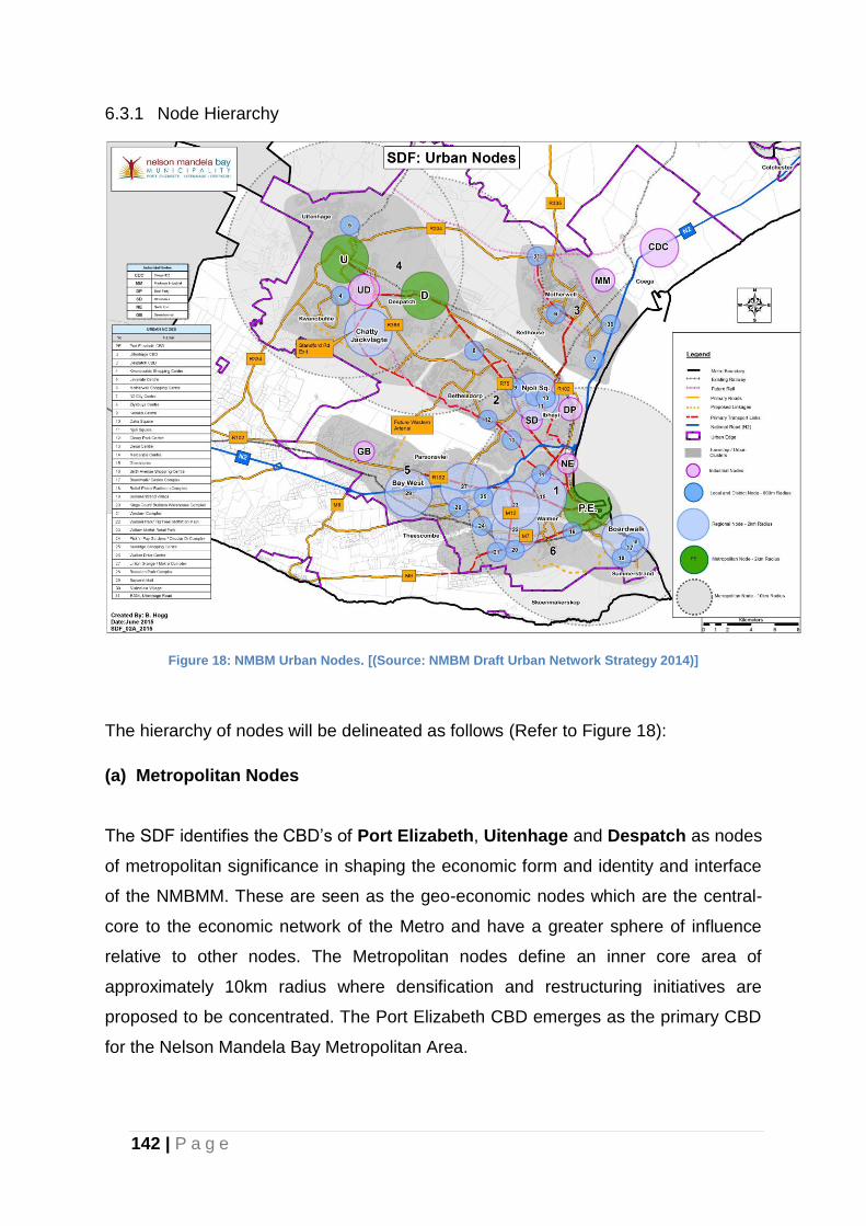
142 | P a g e
6.3.1 Node Hierarchy
Figure 18: NMBM Urban Nodes. [(Source: NMBM Draft Urban Network Strategy 2014)]
The hierarchy of nodes will be delineated as follows (Refer to Figure 18):
(a) Metropolitan Nodes
The SDF identifies the CBD’s of Port Elizabeth, Uitenhage and Despatch as nodes
of metropolitan significance in shaping the economic form and identity and interface
of the NMBMM. These are seen as the geo-economic nodes which are the central-
core to the economic network of the Metro and have a greater sphere of influence
relative to other nodes. The Metropolitan nodes define an inner core area of
approximately 10km radius where densification and restructuring initiatives are
proposed to be concentrated. The Port Elizabeth CBD emerges as the primary CBD
for the Nelson Mandela Bay Metropolitan Area.
143 | P a g e
Developments to address the following in these nodes are supported:
i. urban decay and the erosion of quality urban environments leading to
disinvestment;
ii. encourage the relocation of low cost housing into the inner core to reverse
the trend of relocating families to the periphery;
iii. decentralisation of core functions of urban core;
iv. unsustainable public transport system;
v. influx of informal and incompatible land use;
vi. serious loss of valuable heritage assets and open space;
vii. infiltration of illegal and non-conforming land uses into previously well-
established developments;
viii. vehicular and pedestrian traffic congestion;
ix. encouragement of industrial expansion;
x. possibility if densification and infill development in areas in the vicinity of
the CBD;
xi. consolidation of smaller erven for integrated and bigger developments.
Housing development initiatives and recommendations contained in the NMBMM
Human Settlement Plan with respect to inner core development to be upheld and
promoted.
(b) Regional Nodes
These are nodes located more or less central to places of residence i.e. residential
suburbs and with a bigger sphere of influence and have a potential of stimulating
growth which may lead to integration with the core economic areas. The nodes offer
significant retail, commercial and ancillary functions that have contributed to, and
resulted from, the decline of the CBD (Metropolitan Nodes).
Njoli/Kenako Node is identified as the Regional Node for urban/catalytic
intervention with the objective of linking and integrating the previously segregated
townships of Ibhayi and Bethelsdorp. The key elements in this node include: Njoli
Square a National Treasury funded Civic Complex that forms an anchor
144 | P a g e
development initiative around the historic Njoli Square. Development is encouraged
along routes that link Njoli Square, Kenako Mall, Eastern Cape Training Centre
(ETC), Straundale Industrial Area, Vista Campus, Dora Nginza hospital, and
developments at the corner of Spondo and Njoli Road in order to integrate and
strengthen the linkage between these areas. Mixed-use development is
recommended along strategic intersections along the Khulani Corridor, a major
transport link and development corridor, designed to link the Port Elizabeth CBD with
the townships of Ibhayi and Motherwell.
Housing provision be made for the Vistarus informal settlement next to the Vista
Campus.
Chatty Jachtvlakte: The Chatty Jachtvlakte Node is identified as the second
primary node in great need of catalytic interventions to unlock the development
potential of this newly developed area. It is situated to the West of Njoli around the
intersection of the Bloemendal Arterial and Stanford Road. This Node is at the core
of the greenfields component of the Zanemvula Mega Project, developed as an
initiative of the National Department of Human Settlements; Provincial Department of
Human Settlements and the Municipality.
Key elements in this node include:
The convergence of Standford Road, Bloemendal Arterials and the MR448
(Old Uitenhage Road). Standford Road is one of the primary links between
the Port Elizabeth CBD and Uitenhage. The Bloemendal Arterial on the
other hand is not yet fully developed, but serves as an important
North/South linkage between the R75 and Standford Road. MR 368 still
serves as an important secondary link between Port Elizabeth and
Uitenhage and has the potential to link the Njoli and Chatty Jachtvlakte
nodes.
An estimated 54 000 residential development opportunities in Joe Slovo
West; Bethelsdorp North; Khayamnandi; the Chatty developments and the
Jachtvlakte/Kwanobuhle is envisaged to provide densities adequate
enough to sustain socio-economic activities in the area.
145 | P a g e
It is recommended that large tracts of vacant and serviced land in the
greenfield development areas be utilized for catalytic high density infill and
mixed-use development.
N2 Development/Bay West Node: The Baywest node is recognised as a regional
node due to the magnitude of the projects taking place. The N2 Development/Bay
West project includes a super-regional shopping centre, a mixed-use residential
development (8000 residential opportunities), a 400 000m² high-tech warehouse,
offices, a motor city, and light industrial area. The development of the Baywest Mall
and the ancillary developments/services is seen as an anchor that will stimulate
developments in the immediate vicinity i.e. opportunity to promote intensification of
residential densities, light industries etc. within ±2 kms of the node.
Greenacres Node: Greenacres is an existing and well established node and
pressure for expansion which stretches over to Fernglan and Cotswold is
recognised. Notwithstanding recommendations of the Newton Park Local Spatial
Development Framework, with regard to Fernglan and Cotswold Park, it is
recommended that the policy plan be reviewed to address the development pressure
around these two (2) areas. Title Deed Restrictions that relate to, and contradict
Municipal land use management issues, which do not invoke mandates of other
legislative instruments, must be removed.
Boardwalk/Casino Complex Node: The boardwalk node is centred in the
Boardwalk extending to Pick ‘n Pay in 8th Avenue, Sasol Garage at the Corner
Strandfontein Road and 2nd Avenue,. The following are recommended for this node:
Support, sustain and maintain existing and new hotel accommodation facilities
between Second Avenue and Happy Valley;
Promote tourism activities and related recreation land uses in support of existing
and proposed tourist accommodation;
Ensure linkages between accommodation facilities, existing Boardwalk and
beachfront developments and proposed SANDF precinct development.
Mixed uses development with a strong component of recreational facilities to
strengthen the beach front.
146 | P a g e
(c) Secondary and Primary Nodes
The following nodes are recognised as potential nodes to stimulate development.
Motherwell Interchange Node (Vulindlela Village)
Red Location Cultural Precinct
Kwanobuhle Shopping Centre
Levyvale Centre
Motherwell Shopping Centre
Ziyabuya Centre
Cleary Park Centre
Mercantile Centre
Sixth Avenue Shopping Centre
Summerstrand Village
Retief Plein / Radisson Complex
Kings Court/ Builders Warehouse Complex
Western Complex
Walmer Park/ Fig Tree/ Moffat on Main
William Moffat Retail Park
Pick ‘n Pay Gardens / Circular Dr Complex
Sunridge Shopping Centre
Walker Drive Centre
Linton Grange / Makro Complex
Rowallan Park Complex
The MSDF proposes detailed studies to determine the categories and the potential
of the emerging nodes in the Municipality. Intensification of mixed use developments
around the node and major transportation routes in the immediate vicinity is
encouraged.
The municipal spatial vision in the form of Precinct plans need to be formulated with
respect to the following areas:
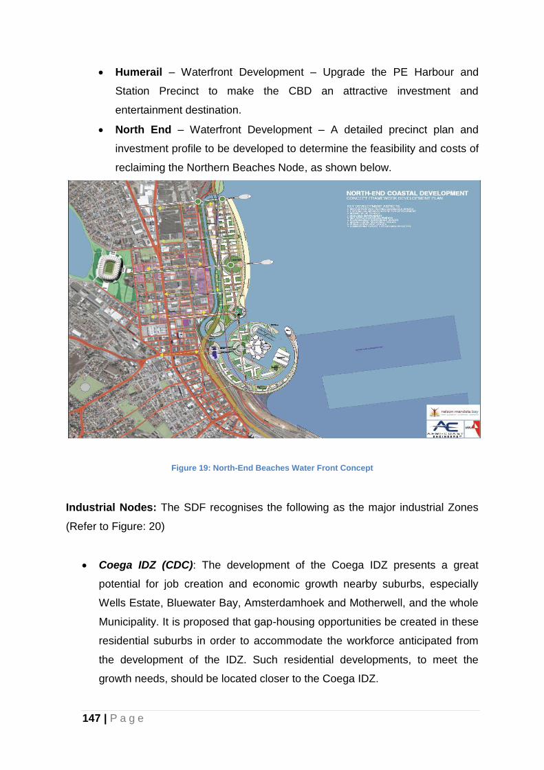
147 | P a g e
Humerail – Waterfront Development – Upgrade the PE Harbour and
Station Precinct to make the CBD an attractive investment and
entertainment destination.
North End – Waterfront Development – A detailed precinct plan and
investment profile to be developed to determine the feasibility and costs of
reclaiming the Northern Beaches Node, as shown below.
Figure 19: North-End Beaches Water Front Concept
Industrial Nodes: The SDF recognises the following as the major industrial Zones
(Refer to Figure: 20)
Coega IDZ (CDC): The development of the Coega IDZ presents a great
potential for job creation and economic growth nearby suburbs, especially
Wells Estate, Bluewater Bay, Amsterdamhoek and Motherwell, and the whole
Municipality. It is proposed that gap-housing opportunities be created in these
residential suburbs in order to accommodate the workforce anticipated from
the development of the IDZ. Such residential developments, to meet the
growth needs, should be located closer to the Coega IDZ.
148 | P a g e
Deal Party (DP): The area comprises small, medium and large industrial
enterprises. There is a need to recycle big industries into smaller SMME type
and larger industries to be encouraged to relocate to the Coega IDZ. Need for
the upgrade of Burman Road, Baxter Street and Old Grahamstown Road.
Struandale (SD): The industrial zone forms part of the Njoli/Kenako Node.
Infill development and recycling of land buildings for light industries and
SMME type facilities must be promoted. State owned land in the area to be
used for housing developments in line with the Human Settlement Plan
proposals. An upgrade of Straunway and a portion of Mavuso Road linking
Straunway and Njoli Road is proposed.
North End (NE): The area comprises small, medium and large industrial
enterprises. It boasts of major industries such as Coca Cola, Cadbury,
Firestone and Aspen Pharmaceutical and General Motors (South Africa).
There is a need to resuscitation of the Northend industrial area. Road linkages
and street upgrades needed.
Greenbushes (GB): Industrial land uses in these areas are recommended to
be developed as light industries which are envisaged to be compatible with
residential developments in the area. Noxious uses may be permitted on merit
taking into consideration the impacts it may have on living conditions.
Markman (MM): The sites set aside for industry have not yet been taken up
and there is a need to promote developments in the vicinity that will
resuscitate the Markman precinct, whilst complementing the development of
the Coega IDZ. There is a need to improve aesthetic appeal at Markman
Industrial by introducing attractive gateways along MR450, relocating noxious
industries, improving safety and security and generally improving the quality
of the environment in the area. Approximately 28% (60Ha) of this 220Ha
industrial estate remains unsold and is owned by the Local Authority and a
further 30Ha is vacant but in private ownership (CDC, Property Market Study
2005 quoted in Urban Econ, 2008). Potential exists for integrating the
redevelopment of the area with the Coega IDZ.
Uitenhage Industrial (UD): Well established industrial area but still contains
pockets of underutilised land and buildings. Home to VW Motor Plant and
associated NMBLP. Develop residential extensions to Kwanobuhle towards
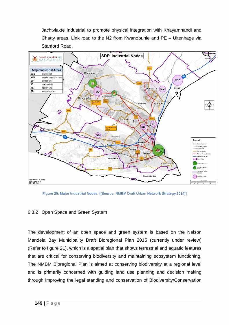
149 | P a g e
Jachtvlakte Industrial to promote physical integration with Khayamnandi and
Chatty areas. Link road to the N2 from Kwanobuhle and PE – Uitenhage via
Stanford Road.
Figure 20: Major Industrial Nodes. [(Source: NMBM Draft Urban Network Strategy 2014)]
6.3.2 Open Space and Green System
The development of an open space and green system is based on the Nelson
Mandela Bay Municipality Draft Bioregional Plan 2015 (currently under review)
(Refer to figure 21), which is a spatial plan that shows terrestrial and aquatic features
that are critical for conserving biodiversity and maintaining ecosystem functioning.
The NMBM Bioregional Plan is aimed at conserving biodiversity at a regional level
and is primarily concerned with guiding land use planning and decision making
through improving the legal standing and conservation of Biodiversity/Conservation
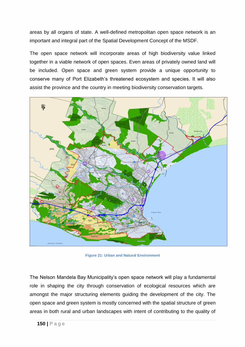
150 | P a g e
areas by all organs of state. A well-defined metropolitan open space network is an
important and integral part of the Spatial Development Concept of the MSDF.
The open space network will incorporate areas of high biodiversity value linked
together in a viable network of open spaces. Even areas of privately owned land will
be included. Open space and green system provide a unique opportunity to
conserve many of Port Elizabeth’s threatened ecosystem and species. It will also
assist the province and the country in meeting biodiversity conservation targets.
Figure 21: Urban and Natural Environment
The Nelson Mandela Bay Municipality’s open space network will play a fundamental
role in shaping the city through conservation of ecological resources which are
amongst the major structuring elements guiding the development of the city. The
open space and green system is mostly concerned with the spatial structure of green
areas in both rural and urban landscapes with intent of contributing to the quality of
151 | P a g e
life and sustainable development. Green System also plays a very fundamental role
in formulating planning and management tools since it has spatial, social and
technical dimensions. The open space network will provide opportunities for all
residents within the Metro to access natural resources that improve the quality of
urban and rural fabric.
The Main objectives of the open space network are to:
Conserve, protect and develop natural resources in the Metro;
Provide interaction between the built and natural environment;
To address the interface between the land use typology green system;
To promote the sustainable use and management of the open space network.
The natural resources planning, inventory and operational management of the
NMBM’s nature reserve network and green infrastructure network is concerned with
conserving ecosystem values, functions and restoration of natural systems that
underpin watershed health and hydrological integrity supporting natural resources
necessary for agriculture and aquaculture. Different types of Open space and green
systems which will shape the city’s development and merit protection are as follows:
Biodiversity conservation areas;
Parks and river corridors;
High-potential Agricultural Land;
Coastal Areas and beaches.
The following generic principles should apply to the natural open space system:
The natural open space system should be protected from intrusive,
irresponsible and ad hoc developments that damage the ecological integrity
as well as visual quality of these areas. These include urban development,
mining activities and agriculture etc.
PE MOSS must integrate and link recreational opportunities that promote
ecological, economic and social objectives.
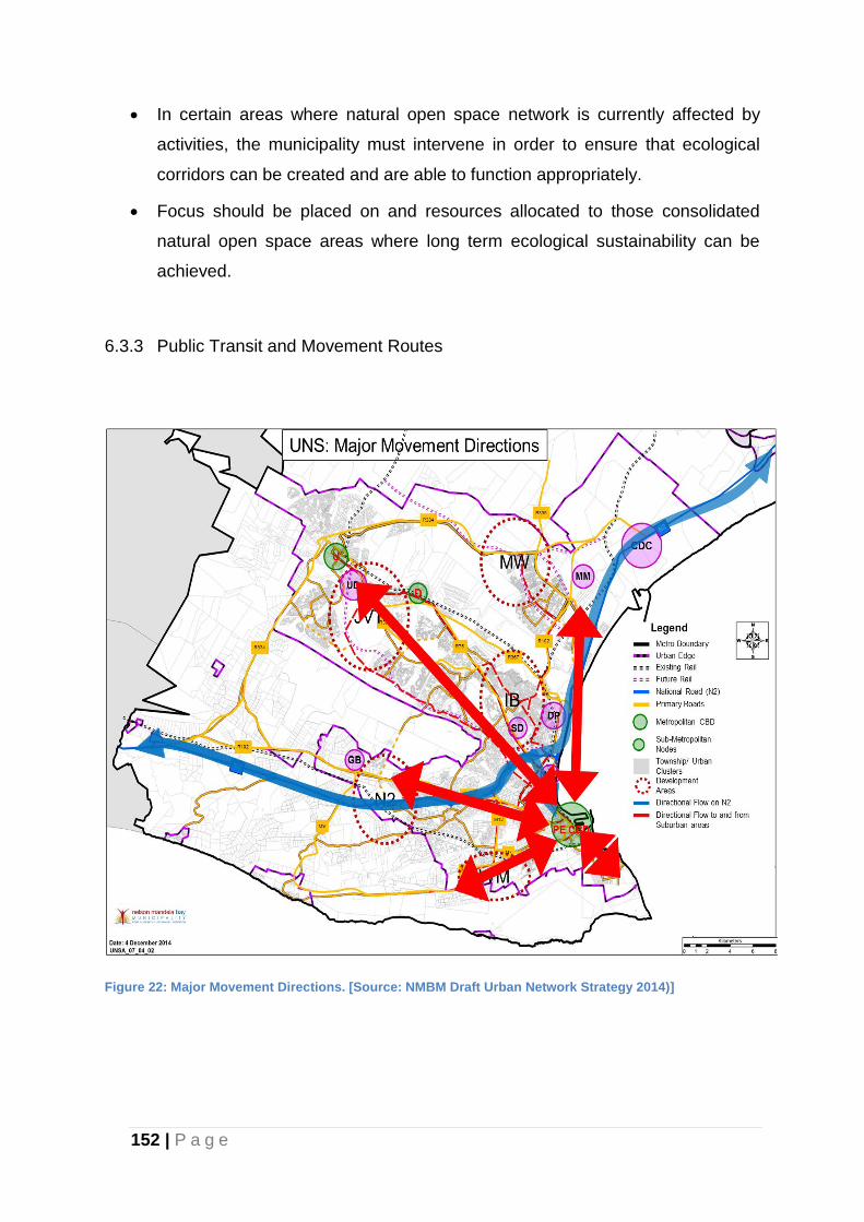
152 | P a g e
In certain areas where natural open space network is currently affected by
activities, the municipality must intervene in order to ensure that ecological
corridors can be created and are able to function appropriately.
Focus should be placed on and resources allocated to those consolidated
natural open space areas where long term ecological sustainability can be
achieved.
6.3.3 Public Transit and Movement Routes
Figure 22: Major Movement Directions. [Source: NMBM Draft Urban Network Strategy 2014)]
153 | P a g e
6.3.3.1 Transport Networks
As expansion takes place, an important challenge that arises is the need to minimise
the extension of road infrastructure and, where it is imperative that it be extended, to
ensure that maximum benefit is derived from the investment.
Based on current economic growth patterns and predictions for the future it is
assumed that as much as 80% of the future population of the metropolitan area will
not own cars. This means that the majority of the population will use public
transport. Therefore, coupled with endeavours to reduce travel distances to and
from work and facilities, there is a dire need to develop a public transportation
system that will be attractive to commuters and reduce the need to continually build
bigger and more expensive roads merely for single occupant motor vehicles. It is
probable that such a public transportation system will not be in the form of
underground rail or some other sophisticated system. Initially it is likely to be an
Integrated Public Transport System (IPTS) accommodating High Occupancy Vehicle
(HOV’s) in dedicated lanes where they can move rapidly from one point to another.
Expansion proposals have therefore been based on the potential to develop an
integrated public transportation network that will serve the area to the best
advantage. Existing road and rail routes have been analysed to determine whether
they could be utilised as public transportation routes. Possible extensions to that
network have been examined and SCU’s have been located in a pattern that will
allow logical expansion and extension of the transportation network. Each SCU is
therefore linked to others by a proposed public transport route or a route along which
public transport can be accommodated.
The goals and objectives stated in the IDP with specific regard to the transportation
sector include the following:
To improve public transport infrastructure planning.
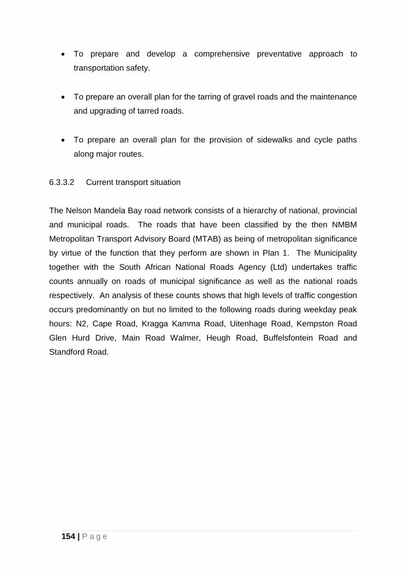
154 | P a g e
To prepare and develop a comprehensive preventative approach to
transportation safety.
To prepare an overall plan for the tarring of gravel roads and the maintenance
and upgrading of tarred roads.
To prepare an overall plan for the provision of sidewalks and cycle paths
along major routes.
6.3.3.2 Current transport situation
The Nelson Mandela Bay road network consists of a hierarchy of national, provincial
and municipal roads. The roads that have been classified by the then NMBM
Metropolitan Transport Advisory Board (MTAB) as being of metropolitan significance
by virtue of the function that they perform are shown in Plan 1. The Municipality
together with the South African National Roads Agency (Ltd) undertakes traffic
counts annually on roads of municipal significance as well as the national roads
respectively. An analysis of these counts shows that high levels of traffic congestion
occurs predominantly on but no limited to the following roads during weekday peak
hours: N2, Cape Road, Kragga Kamma Road, Uitenhage Road, Kempston Road
Glen Hurd Drive, Main Road Walmer, Heugh Road, Buffelsfontein Road and
Standford Road.
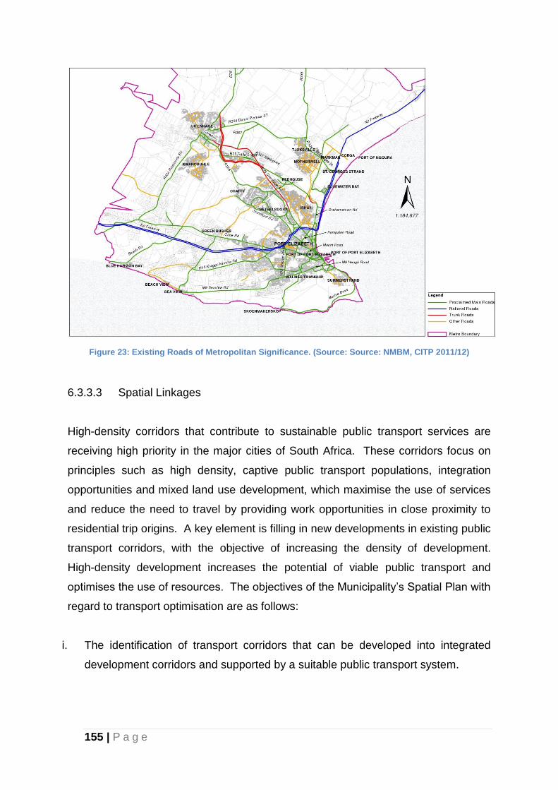
155 | P a g e
Figure 23: Existing Roads of Metropolitan Significance. (Source: Source: NMBM, CITP 2011/12)
6.3.3.3 Spatial Linkages
High-density corridors that contribute to sustainable public transport services are
receiving high priority in the major cities of South Africa. These corridors focus on
principles such as high density, captive public transport populations, integration
opportunities and mixed land use development, which maximise the use of services
and reduce the need to travel by providing work opportunities in close proximity to
residential trip origins. A key element is filling in new developments in existing public
transport corridors, with the objective of increasing the density of development.
High-density development increases the potential of viable public transport and
optimises the use of resources. The objectives of the Municipality’s Spatial Plan with
regard to transport optimisation are as follows:
i. The identification of transport corridors that can be developed into integrated
development corridors and supported by a suitable public transport system.
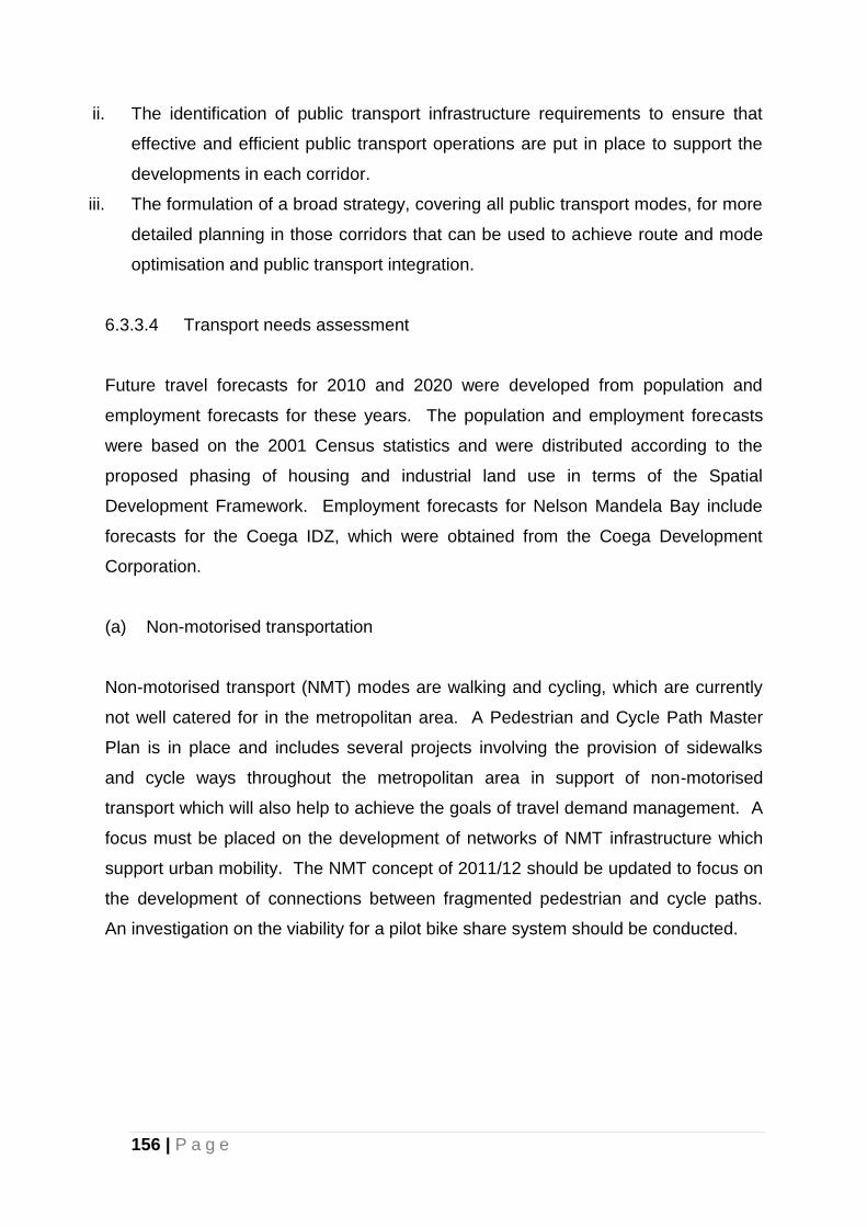
156 | P a g e
ii. The identification of public transport infrastructure requirements to ensure that
effective and efficient public transport operations are put in place to support the
developments in each corridor.
iii. The formulation of a broad strategy, covering all public transport modes, for more
detailed planning in those corridors that can be used to achieve route and mode
optimisation and public transport integration.
6.3.3.4 Transport needs assessment
Future travel forecasts for 2010 and 2020 were developed from population and
employment forecasts for these years. The population and employment forecasts
were based on the 2001 Census statistics and were distributed according to the
proposed phasing of housing and industrial land use in terms of the Spatial
Development Framework. Employment forecasts for Nelson Mandela Bay include
forecasts for the Coega IDZ, which were obtained from the Coega Development
Corporation.
(a) Non-motorised transportation
Non-motorised transport (NMT) modes are walking and cycling, which are currently
not well catered for in the metropolitan area. A Pedestrian and Cycle Path Master
Plan is in place and includes several projects involving the provision of sidewalks
and cycle ways throughout the metropolitan area in support of non-motorised
transport which will also help to achieve the goals of travel demand management. A
focus must be placed on the development of networks of NMT infrastructure which
support urban mobility. The NMT concept of 2011/12 should be updated to focus on
the development of connections between fragmented pedestrian and cycle paths.
An investigation on the viability for a pilot bike share system should be conducted.
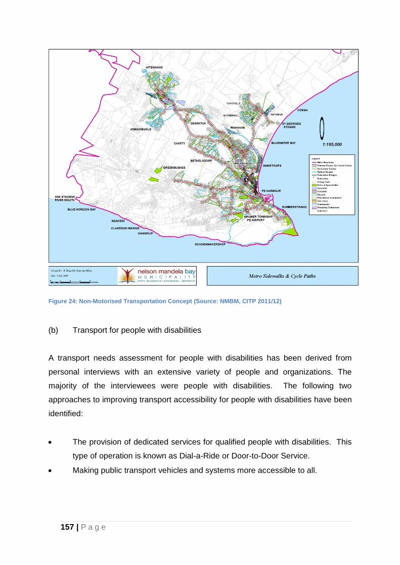
157 | P a g e
Figure 24: Non-Motorised Transportation Concept (Source: NMBM, CITP 2011/12)
(b) Transport for people with disabilities
A transport needs assessment for people with disabilities has been derived from
personal interviews with an extensive variety of people and organizations. The
majority of the interviewees were people with disabilities. The following two
approaches to improving transport accessibility for people with disabilities have been
identified:
The provision of dedicated services for qualified people with disabilities. This
type of operation is known as Dial-a-Ride or Door-to-Door Service.
Making public transport vehicles and systems more accessible to all.
158 | P a g e
The Municipality has commenced with the improvement of public transport facilities
and sidewalks to make them accessible to people with disabilities. One example of
such an improvement is the construction of the concrete platform for all IPTS bus
stations within the city to have the same floor level as the bus level. This ensures a
smooth transfer of people on wheelchairs from the platform into the bus and vice
versa without any difficulties.
(c) Pedestrian bridges
Pedestrians have to cross some of the busy arterial roads in Nelson Mandela Bay;
hence pedestrian bridges have become necessary. These crossing locations have
been examined in the preparation of the ITP and where it is not possible to install
traffic signals at these locations, pedestrian bridges have been proposed in the
following locations:
Uitenhage Road (Dora Nginza)
Papenkuils Canal/N2
Commercial Road/N2
Stanford Road (Cleary Park)
(d) Tourism
The ITP has identified the need to improve the transport facilities that are critical to
promoting the major tourist attractions in and around Nelson Mandela Bay.
The Addo National Elephant Park is an international tourist attraction less than one
hour’s travel by road from the Port Elizabeth Airport. The section of Addo Road after
the Motherwell Depot to the Elephant Park’s main gate is in poor condition. An
investigation into the upgrading of this road northwards from Motherwell, which is the
responsibility of the Provincial Department of Transport, is in progress.
The Narrow Gauge Apple Express railway line started as a freight line to bring fruit
from the scenic Hankey/Patensie/Kareedouw area to the Port Elizabeth Harbour for
159 | P a g e
export. The railway has become a tourist attraction, but its future is uncertain due to
the fact that road trucks have taken over the transport of freight previously carried by
the Apple Express.
The Provincial Department of Transport is currently investigating the revitalisation of
branch railway lines that have lost their freight services to the road trucking industry.
This ITP supports the revitalisation of the Apple Express, in the interest of promoting
tourism. Shifting freight traffic from road back to rail will reduce the damage being
done to the road pavement by heavily loaded trucks.
(e) Transport authority
The National Land Transport Transition Act (Act No 22 of 2000) (NLTTA) made
provision for a Municipality to establish a Transport Authority (TA) to administer,
plan, manage and monitor the public transport system. Section 6.5.1 of the NMBM
CITP provides detailed information the proposed Transport Forum.
(f) IPTS Infrastructure Projects
Funding for the implementation of the following projects has been sourced from the
National Government (Public Transport Infrastructure and Systems Fund):
Public transport lanes (construction commenced and on-going)
Public transport shelters and facilities (construction commenced and on-
going)
Public transport corridors
Modal interchanges
Bridges
Sidewalks and cycle tracks (construction commenced and on-going)
Traffic control systems
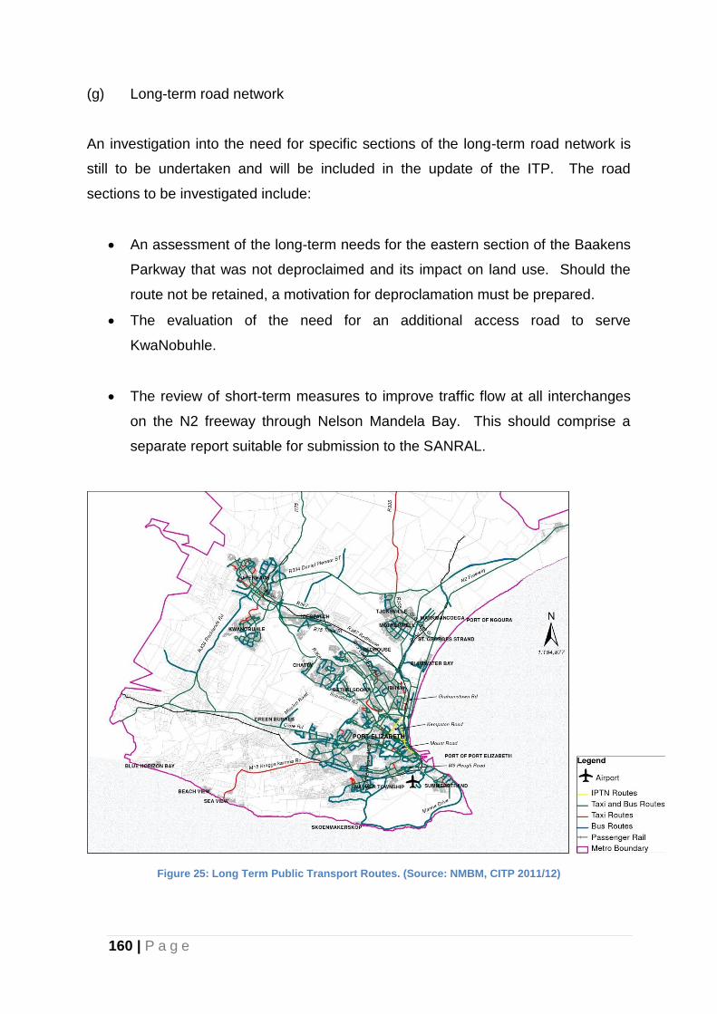
160 | P a g e
(g) Long-term road network
An investigation into the need for specific sections of the long-term road network is
still to be undertaken and will be included in the update of the ITP. The road
sections to be investigated include:
An assessment of the long-term needs for the eastern section of the Baakens
Parkway that was not deproclaimed and its impact on land use. Should the
route not be retained, a motivation for deproclamation must be prepared.
The evaluation of the need for an additional access road to serve
KwaNobuhle.
The review of short-term measures to improve traffic flow at all interchanges
on the N2 freeway through Nelson Mandela Bay. This should comprise a
separate report suitable for submission to the SANRAL.
Figure 25: Long Term Public Transport Routes. (Source: NMBM, CITP 2011/12)
161 | P a g e
6.3.3.5 Public transport strategies
The first Public Transport Plan was completed in May 2006 and contained a Long-
term Strategic Plan and a Short-term Implementation Plan. Alternative scenarios
consisting of different combinations of rail lines, bus trunk routes, local bus routes
and minibus feeders were formulated and tested with the VISUM Transport Demand
Model for 2020 land use and population forecasts.
The conclusions from the scenario analysis were as follows:
a) An integrated public transport system with scheduled services will serve
NMBMM best. The non-intervention development of the existing situation
should not be accepted.
b) A system based on trunk bus route corridors and local bus and minibus-taxi
services will best serve NMBMM for the next ten years.
c) The Khulani Corridor (Motherwell – Njoli – Korsten – CBD) should be the
backbone of the future public transport system.
d) An expanded railway system will not attract enough passengers in the next
ten years to justify large expenditure, except for possibly a short rail spur into
Motherwell, which can be extended to a loop through the Coega IDZ when
warranted by sufficient concentration of residential development in Motherwell
and employment in the IDZ.
e) In accordance with the Provincial public transportation plan, the option of
utilizing the Apple Express servitude between Chelsea and Port Elizabeth
railway stations for the purpose of public transportation should be
investigated.
The long-term public transport development strategy will include a modern and
attractive public transport system offering seamless travelling and an integrated and
scheduled service. This will include contracted operators and payment through
ticketing. High-density development along the public transport corridors will be
served through a high-frequency public transport service, which will persuade more
people to use the public transport system.
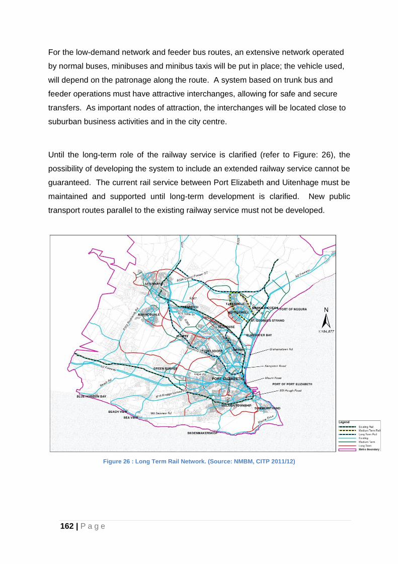
162 | P a g e
For the low-demand network and feeder bus routes, an extensive network operated
by normal buses, minibuses and minibus taxis will be put in place; the vehicle used,
will depend on the patronage along the route. A system based on trunk bus and
feeder operations must have attractive interchanges, allowing for safe and secure
transfers. As important nodes of attraction, the interchanges will be located close to
suburban business activities and in the city centre.
Until the long-term role of the railway service is clarified (refer to Figure: 26), the
possibility of developing the system to include an extended railway service cannot be
guaranteed. The current rail service between Port Elizabeth and Uitenhage must be
maintained and supported until long-term development is clarified. New public
transport routes parallel to the existing railway service must not be developed.
Figure 26 : Long Term Rail Network. (Source: NMBM, CITP 2011/12)
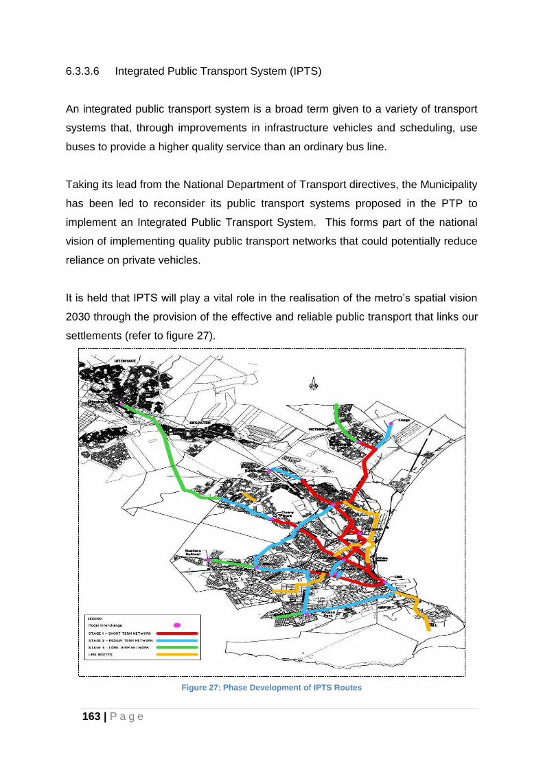
163 | P a g e
6.3.3.6 Integrated Public Transport System (IPTS)
An integrated public transport system is a broad term given to a variety of transport
systems that, through improvements in infrastructure vehicles and scheduling, use
buses to provide a higher quality service than an ordinary bus line.
Taking its lead from the National Department of Transport directives, the Municipality
has been led to reconsider its public transport systems proposed in the PTP to
implement an Integrated Public Transport System. This forms part of the national
vision of implementing quality public transport networks that could potentially reduce
reliance on private vehicles.
It is held that IPTS will play a vital role in the realisation of the metro’s spatial vision
2030 through the provision of the effective and reliable public transport that links our
settlements (refer to figure 27).
Figure 27: Phase Development of IPTS Routes
164 | P a g e
The IPTS system has been designed to include a median island and closed stations
on trunk routes. These median islands were constructed in phases, with the first
phase being Govan Mbeki Avenue, Fettes Road, Harrower Road and Kempston
Road (see Map 3). In the short term, it is proposed that the IPTS system will reach
Motherwell, Cleary Park and Newton Park. The remainder of the trunk bus routes
will be serviced through a normal bus service.
a) Funding plan
The Capital Programme includes infrastructure that is to be funded from the
Consolidated Metropolitan Transport Fund (CMTF), the Municipal Infrastructure
Grant (MIG) and Public Transport Infrastructure and the Systems Fund (PTIS), which
now includes public transport systems funding provided by Treasury through the
DOT and replaces the former Public Transport Infrastructure Fund (PTIF). It
excludes infrastructure that is the funding responsibility of other authorities, notably
the proposed upgrading of the N2 and ramps between the Kragga Kamma
Interchange and Creek Interchange, which is the responsibility of SANRAL.
6.3.3.7 Major Infrastructure Networks
One of the main aims of the MSDF is to minimise the need to extend bulk
infrastructure and to optimise existing infrastructure. The strategic planning of
infrastructure, (water, stormwater, sewerage, and electricity) will need to be
elaborated on in special studies that are based on the urban expansion proposed.
Directorates will need to prepare development programmes for investments in the
infrastructure required to support the development of and implementation of the IDP.
Attention should be paid to the sustainable development of infrastructure in terms of
economy, natural resources as well as environmental and health protection.
6.3.4 Urban Corridors and Activity Spines
The city structure needs to be developed in a manner that uses infrastructure more
efficiently and minimises the need to extend infrastructure networks unnecessarily.
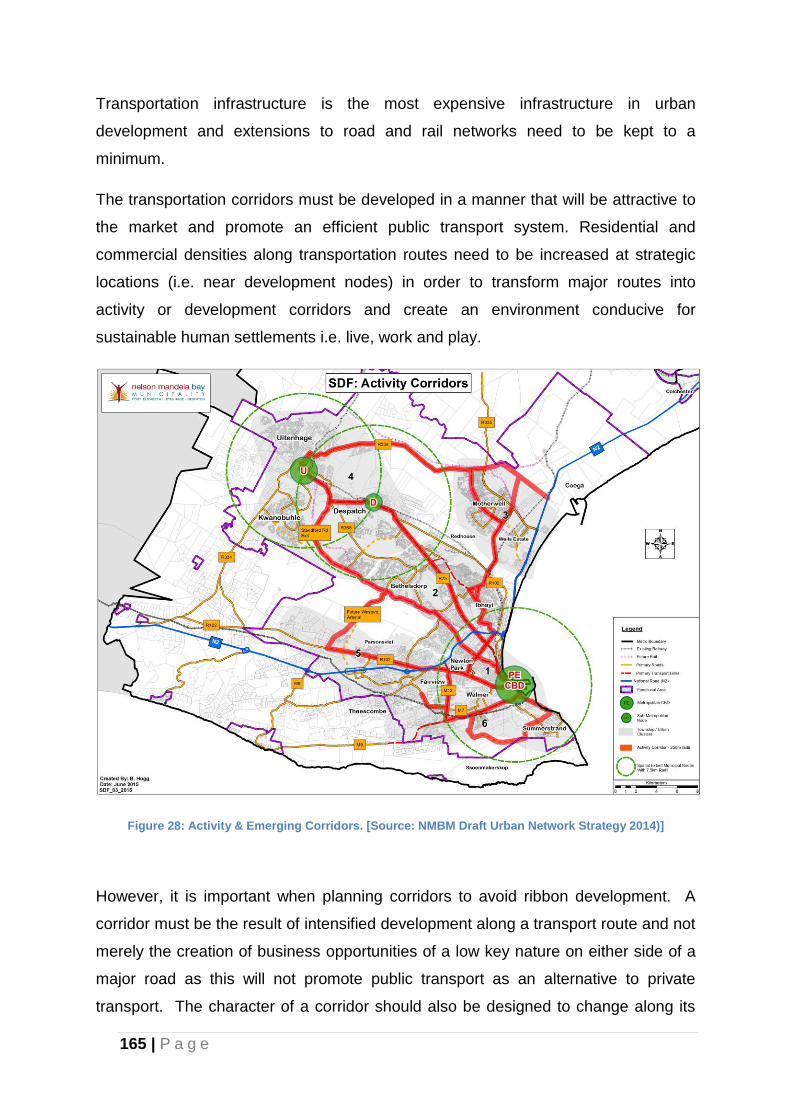
165 | P a g e
Transportation infrastructure is the most expensive infrastructure in urban
development and extensions to road and rail networks need to be kept to a
minimum.
The transportation corridors must be developed in a manner that will be attractive to
the market and promote an efficient public transport system. Residential and
commercial densities along transportation routes need to be increased at strategic
locations (i.e. near development nodes) in order to transform major routes into
activity or development corridors and create an environment conducive for
sustainable human settlements i.e. live, work and play.
Figure 28: Activity & Emerging Corridors. [Source: NMBM Draft Urban Network Strategy 2014)]
However, it is important when planning corridors to avoid ribbon development. A
corridor must be the result of intensified development along a transport route and not
merely the creation of business opportunities of a low key nature on either side of a
major road as this will not promote public transport as an alternative to private
transport. The character of a corridor should also be designed to change along its
166 | P a g e
length to order to break monotony and become attractive. Open spaces and squares
or plazas need to form part of the urban design embodied in corridor development.
Primary Network/Transport Links
Corridor development studies need to be initiated following lessons learnt from the
Khulani Corridor Study (Kempston Road to Motherwell via Njoli Square and Daku
Road). The primary network in this Urban Network includes three of the five major
transport arteries, being:
(a) Harrower/Stanford Road in a north-westerly direction, linking the PE CBD with
the Gelvandale, Helenvale, Bethelsdorp and Bloemendal (Chatty) Townships.
(b) R75 in a north-westerly direction, linking Port Elizabeth with Despatch and
Uitenhage, as well as the townships of Ibhayi, Algoa Park, Missionvale, Govan
Mbeki, KwaDwesi and KwaMagxaki with Port Elizabeth, Despatch and
Uitenhage.
(c) North-south linkage through Ibhayi along Sheya-Kulati, Njoli, Daku and Dibanisa
Roads, linking the PE CBD and Ibhayi with Motherwell, also referred to as the
Khulani Corridor.
The other significant network/transport links include:
(a) Heugh/Buffelsfontein Road (East to West) being the most southern route.
(b) Old Cape Road (R101) (east to west).
(c) The N2 runs from the West to the North through the urban area, serving as a
further primary linkage between the urban areas of Nelson Mandela Bay.
These arteries/transport links form the structure of the Integrated Public Transport
System in Nelson Mandela Bay and comprise road as well as rail network links. The
primary network in this Urban Network includes three of the five major transport
arteries, being:
(a) Harrower/Stanford Road in a north-westerly direction, linking the PE CBD with
the Gelvandale, Helenvale, Bethelsdorp and Bloemendal (Chatty) Townships.
167 | P a g e
(b) R75 in a north-westerly direction, linking Port Elizabeth with Despatch and
Uitenhage, as well as the townships of Ibhayi, Algoa Park, Missionvale, Govan
Mbeki, KwaDwesi and KwaMagxaki with Port Elizabeth, Despatch and
Uitenhage.
(c) North-south linkage through Ibhayi along SheyaKulati, Njoli, Daku and Dibanisa
Roads, linking the PE CBD and Ibhayi with Motherwell, also referred to as the
Khulani Corridor.
The other significant network/transport links include:
(a) Heugh/Buffelsfontein Road (East to West) being the most southern route.
(b) Old Cape Road (R101) (east to west).
(c) The N2 runs from the West to the North through the urban area, serving as a
further primary linkage between the urban areas of Nelson Mandela Bay.
These arteries/transport links form the structure of the Integrated Public Transport
System in Nelson Mandela Bay and comprise road as well as rail network links.
The other two major arteries, i.e. Buffelsfontein/Heugh Road and Old Cape Road
are, for the purposes of this discussion, included as part of the Secondary Network
Links.
Road network:
Public transport serves the metropolitan area along the following existing and
planned routes:
North-South linkage between the PE CBD and Motherwell via Ibhayi along the
Khulani Corridor (Sheya-Khulati, Njoli, Daku and Dibanisa Roads).
North-West linkage between the PE CBD and Bloemendal/Bethelsdorp along
Stanford Road, currently terminating near the Cleary Park Shopping Centre, but
with planned future extension to Uitenhage via the Chatty, Jachtvlakte and
KwaNobuhle Estate areas.
South-West linkage between the PE CBD and the Western Suburbs via Old Cape
Road, currently terminating in the vicinity of Rowallan Park, but with planned
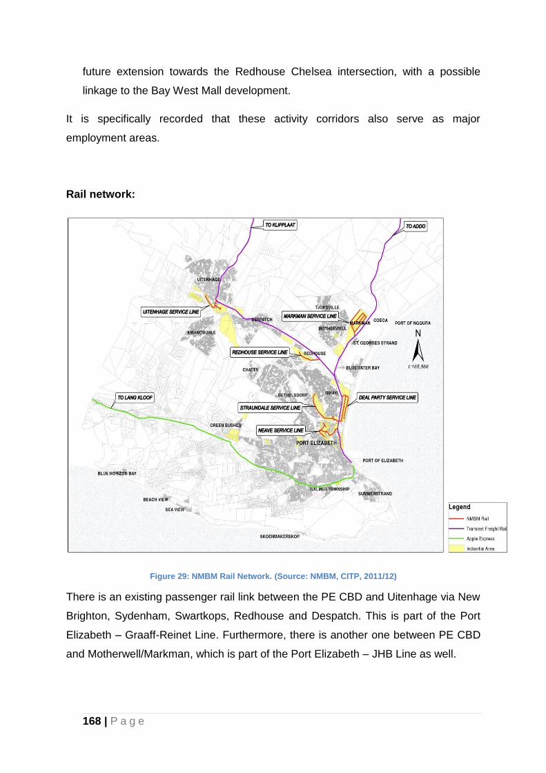
168 | P a g e
future extension towards the Redhouse Chelsea intersection, with a possible
linkage to the Bay West Mall development.
It is specifically recorded that these activity corridors also serve as major
employment areas.
Rail network:
Figure 29: NMBM Rail Network. (Source: NMBM, CITP, 2011/12)
There is an existing passenger rail link between the PE CBD and Uitenhage via New
Brighton, Sydenham, Swartkops, Redhouse and Despatch. This is part of the Port
Elizabeth – Graaff-Reinet Line. Furthermore, there is another one between PE CBD
and Motherwell/Markman, which is part of the Port Elizabeth – JHB Line as well.
169 | P a g e
There is a planned future passenger rail link between Port Elizabeth Centre and
Motherwell via the planned new Motherwell Rail Corridor parallel to Tyinira Street
(Motherwell).
There is also a possible long-term linkage between Coega and Uitenhage. This is a
high-priority project driven by Passenger Rail Agency of South Africa (PRASA) and
about to be assessed in terms of NEMA processes for the portion between
Swartkops and Motherwell.
A long-term passenger rail link route exists between Port Elizabeth and Uitenhage
via Bethelsdorp, Chatty, Jachtvlakte and KwaNobuhle. This route alignment has
been in existence for a long time but is compromised in places by existing
developments. PRASA, however, maintains its long-term interest in this line,
particularly to serve the KwaNobuhle community.
A narrow-gauge rail line exists between Humerail (Port Elizabeth) and Loerie. This
line originally served as a goods line between Port Elizabeth and Loerie, but has
fallen into disuse over recent years. It has the potential to carry passengers between
the Port Elizabeth harbour nodal areas and the new Bay West Mall.
Other Activity Corridors:
The Nelson Mandela Bay Urban Network further identifies other existing mixed use
activity corridors that are important. These are:
(a) Walmer: Starting at Marine Drive as Walmer Boulevard, increasing in activity at
1st Avenue intersection, from where the road becomes Heugh Road, continuing to
the intersection of Buffelsfontein Road and 17th Avenue.
(b) Walmer Main Road: Commencing from Heugh Road, to Walmer Main Road, to
the intersection with the William Moffat Expressway.
(c) William Moffat Expressway: Starting from the intersection of Buffelsfontein and
17th Avenue, along William Moffat Expressway to Cape Road.
(d) Cape Road: Starting at the intersection of William Moffat Drive and Cape Road,
to Greenacres, terminating in the CBD.
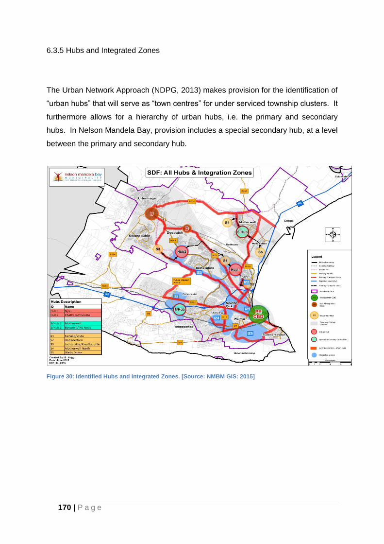
170 | P a g e
6.3.5 Hubs and Integrated Zones
The Urban Network Approach (NDPG, 2013) makes provision for the identification of
“urban hubs” that will serve as “town centres” for under serviced township clusters. It
furthermore allows for a hierarchy of urban hubs, i.e. the primary and secondary
hubs. In Nelson Mandela Bay, provision includes a special secondary hub, at a level
between the primary and secondary hub.
Figure 30: Identified Hubs and Integrated Zones. [Source: NMBM GIS: 2015]
171 | P a g e
PRIMARY URBAN HUBS
The Primary Hubs are identified as follows:
Port Elizabeth CBD
The Port Elizabeth CBD is the administrative heart of the City and is recognised in
the Urban Network Strategy as a Primary Hub.
Njoli Hub (Hub 1)
Spatial targeting and the eradication of spatial inequalities, as envisaged in the
National Development Plan, is an underlying principle of the Urban Network
Approach, hence the focus on catalytic development of urban hubs in under-serviced
township clusters. The Njoli Hub is identified as the Primary Hub, Hub 1.
This hub is identified as the Primary Hub for urban/catalytic intervention with the
objective of linking and integrating the previously segregated townships of Ibhayi and
Bethelsdorp. Its identification was informed inter alia, by:
its importance as an historical public space for meeting and informal trading;
the convergence of major routes in Ibhayi;
the development of the Njoli transportation nodal interchange and hub along
the Khulani Corridor; and
the underlying potential to creatively plan and implement public facilities and
amenities that will act as catalyst for wider and more intensified
developments that will enhance the scale of economies for the installation of
public infrastructure in these areas.
The key elements in this hub include:
Njoli Square, a multi-million rand redevelopment initiative around the historic
Njoli Square;
172 | P a g e
Khulani Corridor, a major transport link and development corridor, designed to
link the Port Elizabeth CBD with the townships of Ibhayi and Motherwell;
Kenako shopping Centre, a recently completed shopping centre;
The Vista Campus of the Nelson Mandela Metropolitan University (NMMU),
also known as the Vista Campus;
The Eastern Cape Training Centre (ETC) opposite the Kenako Centre;
The Dora Nginza hospital which is envisaged as a future academic hospital
for the NMMU Medical School Facility; and
The Vistarus informal settlement next to the Vista Campus, which is to be
redeveloped as part of the Zanemvula Project, one of the first
Mega/Presidential Projects initiated in 2006/07 in terms of the Breaking New
Ground Strategy.
The Red Location Cultural Precinct which includes the Red Location Museum
of Apartheid, an art gallery, an electronic library; a backpackers’ lodge as well
as the regeneration of Singapi Street can be considered as a Secondary Hub
to the Ibhayi/ Bethelsdorp Hub.
Chatty Jachtvlakte Hub (Hub 2)
The Chatty Jachtvlakte Hub is identified as the second Primary Hub. It is in great
need of catalytic intervention to unlock the development potential of this newly
developed area. It is situated to the West of Njoli around the intersection of the
Bloemendal Arterial and Stanford Road.
This Hub is at the core of the greenfields component of the aforementioned
Zanemvula Mega Project, developed as an initiative of the National Department of
Human Settlements; Provincial Department of Human Settlements and the
Municipality. The Housing Development Agency (HDA) is the implementing agent.
Key elements in this hub include:
The convergence of Standford Road, Bloemendal Arterials and the MR448
(Old Uitenhage Road). Standford Road is one of the primary links between

173 | P a g e
the Port Elizabeth CBD and Uitenhage. The Bloemendal Arterial on the other
hand is not yet fully developed, but serves as an important North/South
linkage between the R75 and Standford Road. MR 368 still serves as an
important secondary link between Port Elizabeth and Uitenhage and has the
potential to link the Njoli and Chatty Jachtvlakte Hubs.
The new greenfield residential developments of Joe Slovo West; Bethelsdorp
North; Khayamnandi; the Chatty developments and the
Jachtvlakte/Kwanobuhle extensions currently in the planning stage, will yield
in the order of 54000 residential opportunities, once fully developed.
Approximately 14000 units have already been completed and are in need of
social facilities and amenities.
There are large tracts of vacant and serviced land in the greenfield
development areas that can be utilized for catalytic high density infill and
mixed used development.
SPECIAL SECONDARY HUB
The Motherwell Township is very high on the transformation agenda of the
Municipality, primarily because of its establishment history as a dormitory town for
the Markman Industrial Area. It is under serviced in terms of economic as well as
social facilities and amenities and even where those facilities and amenities exist,
the quality is substandard. Major extensions to the township area (Motherwell
Extensions 12, 29, 30 and 31) are currently under construction as part of the
municipal human settlement programme. This development, which is rolled out as an
integrated residential development, will yield almost 12 500 residential opportunities,
home to approximately 50 000 people. A proposed private sector development to
the North of Motherwell (Coega Ridge) will, if developed to full potential, yield
another 25 000 to 30 000 residential opportunities (100 000 to 120 000 people).
It is against the background that a Special Secondary Hub has been identified at the
centre of Motherwell around the Motherwell Shopping Centre and Clinic. Other
existing facilities such as a Thusong Centre (to be redeveloped as a Traffic Centre),
the Motherwell Community Centre and the higher density Sakhasonke housing
project are located in this node. The node will also serve as the terminal point for the
174 | P a g e
Khulani Corridor, as well as future nodal interchange for the Integrated Public
Transport System (IPTS).
This hub is currently not well defined as a strong nodal point, but it holds the
potential to develop as such, particularly when the planned Motherwell Rail Corridor
is implemented. The future Motherwell rail station will be in close proximity and
forms a strong focal point in this node. It is therefore important that this node be
identified and targeted for catalytic intervention in the near future.
Detail precinct planning will be undertaken during the 2015/16 period.
SECONDARY HUBS
The Uitenhage and Despatch CBD’s have are identified as secondary hubs as a
result of their role and function as sub-regional metropolitan (sub-metropolitan)
nodes.
The Urban Network Framework includes the following Secondary Hubs:
Secondary Hub 1 (S1) (Kenako/Vista):
This hub is situated in the Ibhayi / Bethelsdorp area around the Kenako Centre;
Eastern Cape Training Centre (ETC); Dora Nginza Provincial Hospital; and the Vista
Campus of the Nelson Mandela Metropolitan University (NMMU). It forms a logical
link and extension to the Njoli Hub (Hub1) and holds significant potential for
development interventions that will link two previously spatially (and socially)
separated communities. The precinct planning for this hub will be undertaken as
part of the Hub 1-precinct planning which runs concurrently with the preparation of
the Ibhayi and Bethelsdorp LSDF’s.
Secondary Hub 2 (S2) (Red Location):
This hub is located around the Red Location Cultural Precinct which includes the
Red Location Museum of Apartheid, art gallery, electronic library; a backpackers’
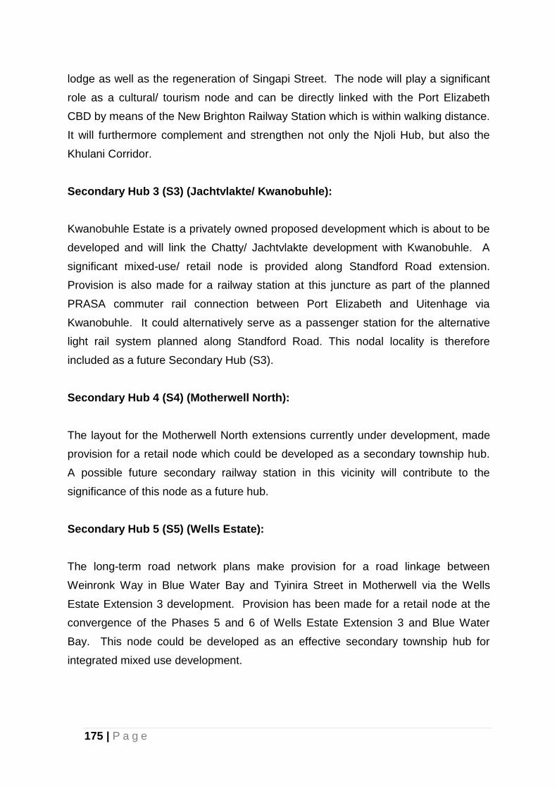
175 | P a g e
lodge as well as the regeneration of Singapi Street. The node will play a significant
role as a cultural/ tourism node and can be directly linked with the Port Elizabeth
CBD by means of the New Brighton Railway Station which is within walking distance.
It will furthermore complement and strengthen not only the Njoli Hub, but also the
Khulani Corridor.
Secondary Hub 3 (S3) (Jachtvlakte/ Kwanobuhle):
Kwanobuhle Estate is a privately owned proposed development which is about to be
developed and will link the Chatty/ Jachtvlakte development with Kwanobuhle. A
significant mixed-use/ retail node is provided along Standford Road extension.
Provision is also made for a railway station at this juncture as part of the planned
PRASA commuter rail connection between Port Elizabeth and Uitenhage via
Kwanobuhle. It could alternatively serve as a passenger station for the alternative
light rail system planned along Standford Road. This nodal locality is therefore
included as a future Secondary Hub (S3).
Secondary Hub 4 (S4) (Motherwell North):
The layout for the Motherwell North extensions currently under development, made
provision for a retail node which could be developed as a secondary township hub.
A possible future secondary railway station in this vicinity will contribute to the
significance of this node as a future hub.
Secondary Hub 5 (S5) (Wells Estate):
The long-term road network plans make provision for a road linkage between
Weinronk Way in Blue Water Bay and Tyinira Street in Motherwell via the Wells
Estate Extension 3 development. Provision has been made for a retail node at the
convergence of the Phases 5 and 6 of Wells Estate Extension 3 and Blue Water
Bay. This node could be developed as an effective secondary township hub for
integrated mixed use development.
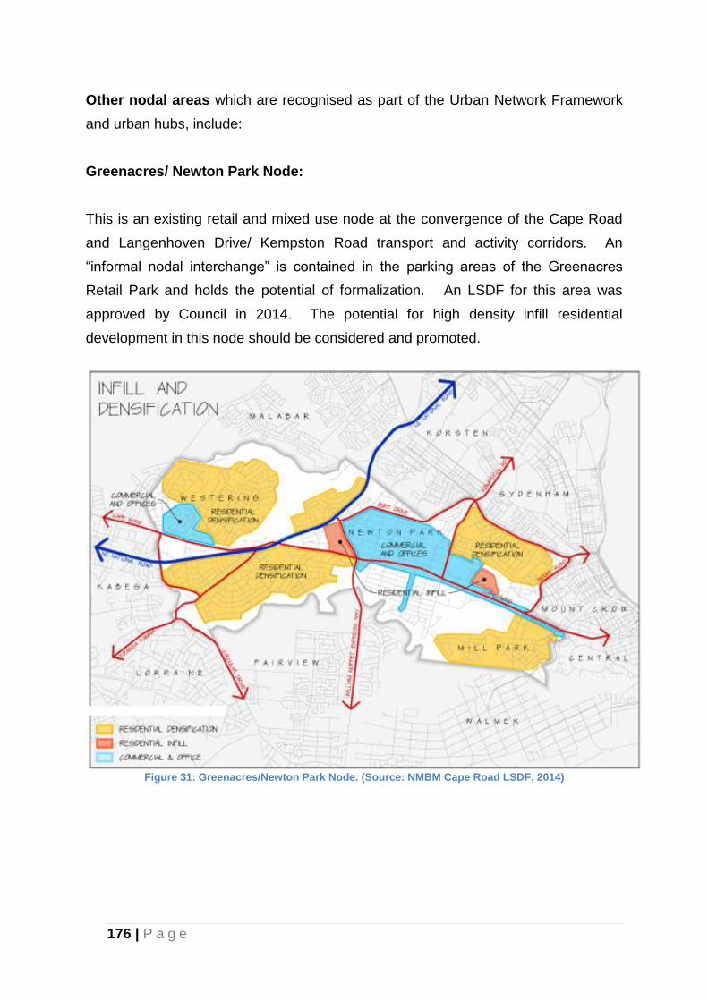
176 | P a g e
Other nodal areas which are recognised as part of the Urban Network Framework
and urban hubs, include:
Greenacres/ Newton Park Node:
This is an existing retail and mixed use node at the convergence of the Cape Road
and Langenhoven Drive/ Kempston Road transport and activity corridors. An
“informal nodal interchange” is contained in the parking areas of the Greenacres
Retail Park and holds the potential of formalization. An LSDF for this area was
approved by Council in 2014. The potential for high density infill residential
development in this node should be considered and promoted.
Figure 31: Greenacres/Newton Park Node. (Source: NMBM Cape Road LSDF, 2014)
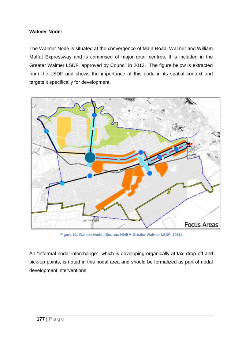
177 | P a g e
Walmer Node:
The Walmer Node is situated at the convergence of Main Road, Walmer and William
Moffat Expressway and is comprised of major retail centres. It is included in the
Greater Walmer LSDF, approved by Council in 2013. The figure below is extracted
from the LSDF and shows the importance of this node in its spatial context and
targets it specifically for development.
Figure 32: Walmer Node. (Source: NMBM Greater Walmer LSDF, 2013)
An “informal nodal interchange”, which is developing organically at taxi drop-off and
pick-up points, is noted in this nodal area and should be formalized as part of nodal
development interventions.
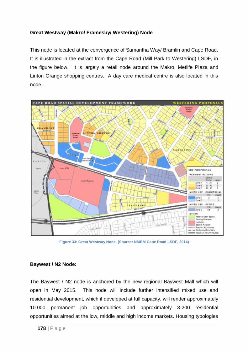
178 | P a g e
Great Westway (Makro/ Framesby/ Westering) Node
This node is located at the convergence of Samantha Way/ Bramlin and Cape Road.
It is illustrated in the extract from the Cape Road (Mill Park to Westering) LSDF, in
the figure below. It is largely a retail node around the Makro, Metlife Plaza and
Linton Grange shopping centres. A day care medical centre is also located in this
node.
Figure 33: Great Westway Node. (Source: NMBM Cape Road LSDF, 2014)
Baywest / N2 Node:
The Baywest / N2 node is anchored by the new regional Baywest Mall which will
open in May 2015. This node will include further intensified mixed use and
residential development, which if developed at full capacity, will render approximately
10 000 permanent job opportunities and approximately 8 200 residential
opportunities aimed at the low, middle and high income markets. Housing typologies
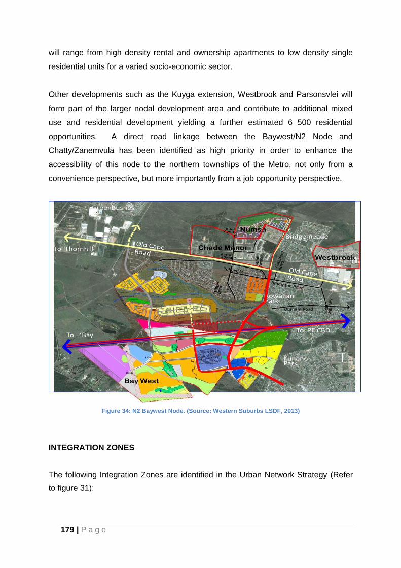
179 | P a g e
will range from high density rental and ownership apartments to low density single
residential units for a varied socio-economic sector.
Other developments such as the Kuyga extension, Westbrook and Parsonsvlei will
form part of the larger nodal development area and contribute to additional mixed
use and residential development yielding a further estimated 6 500 residential
opportunities. A direct road linkage between the Baywest/N2 Node and
Chatty/Zanemvula has been identified as high priority in order to enhance the
accessibility of this node to the northern townships of the Metro, not only from a
convenience perspective, but more importantly from a job opportunity perspective.
Figure 34: N2 Baywest Node. (Source: Western Suburbs LSDF, 2013)
INTEGRATION ZONES
The following Integration Zones are identified in the Urban Network Strategy (Refer
to figure 31):
180 | P a g e
Integration Zone 1 (IZ1) (Inner City):
Integration Zone 1 is comprised of the Inner City area and includes the Port
Elizabeth CBD as well as Newton Park; 2010 Stadium and Inner City LSDF areas.
The mandate area of the Mandela Bay Development Agency falls within this
Integration Zone. This integration zone holds significant potential for inner city
revitalization with projects such as the Mermaids Precinct and Lower Baakens
Catalytic Projects.
Integration Zone 2 (IZ2) (Khulani/ Njoli):
This Integration Zone serves links the Inner City area (Integration Zone 1) and the
Njoli Hub and incorporates a portion of the Khulani Corridor between the Standford
Road and Njoli Square. It includes Secondary Hubs S1 (Kenako/ Vista) and S2 (Red
Location) and holds potential for urban regeneration and intensified mixed use
development along the Khulani corridor and around the Njoli Hub. Intensified mixed
use around the S1 (Kenako/ Vista) Secondary Hub would be possible, but may
require intense community participation particularly around the Vistarus area.
Integration Zone 3 (IZ3) (Standford Road):
This Integration Zone 3 along Standford Road serves as a spatial link between
Integration Zone 1 and the Chatty Jachtvlakte Hub. Environmental and spatial
constraints makes it a very narrow corridor with limited scope for catalytic and
development intervention. These would mostly be limited to nodal interchanges
along Standford Road such as the Cleary Park Nodal interchange. The
Chatty/Jachtvlakte Mega Housing Project is partially part of this integration zone.
Integration Zone 4 (IZ4) (Fairview West):
Fairview West area is located within a 6 to 8 kilometer radius from the CBD and is
adjacent to the William Moffat Expressway and Circular Drive activity corridors. It
forms part of a land restitution area from where large numbers of people were
relocated. A number of housing projects, comprising of mixed residential typologies
181 | P a g e
aimed at the lower income groups, contribute to the area being identified as an area
of substantial spatial development and enormous potential to illustrate spatial
transformation. The area is also identified as a Mega Project in the Human
Settlements Programme.
Integration Zone 5 (IZ5) (Walmer/ Summerstrand)
This integration zone is highlighted as a new development zone for one of the large
scale integrated residential development Mega Project in the Human Settlements
Programme.
Integration Zone 6 (IZ6) (Baywest / N2 Node)
The potential, capacity and significance of the Baywest/ N2 Node as catalyst for
intensified integrated and mixed use development at scale, has contributed to the
inclusion of the larger development area of this node as a sixth Integration Zone
(IZ6). This integration zone holds the potential to attract private sector investment in
the development of the node/ zone which should be harnessed because of its
potential to be a significant generator of rates income.
6.3.6 Consolidation and Densification
Consolidation and densification approach (Refer to figure 35, 36 & 37) is vital in
creating a sustainable and efficient city. It is also a mechanism for achieving
integration. As it has been mentioned above, the densities should mostly be
increased or concentrated around existing primary urban centres, urban nodes,
corridors and along urban activity spines. Higher densities could also result in more
green space remaining in and around the city thus improving the environment. The
main intent of this section will to make sure that fragmented, inequitable and
inefficient urban form is restructured in order to save land and servicing
infrastructural costs as well as enhancing the viability of public transport system.
Furthermore, this concept will create a more equitable, efficient and environmentally
sustainable urban form.
182 | P a g e
The main objective of densification is to ensure the following:
Making more efficient use of land;
Increase the marketability of the city;
Minimise inequality;
Reduce private vehicle dependency through the investment in sustainable
modes of public transport;
Create quality and sustainable urban environment, while assisting in protecting
agricultural land and conservation areas;
Improve use of service infrastructure;
The programme for consolidation and densification ensures that the urban
environment encompasses essential qualities such as diversity, opportunity, sense
of place, uniqueness and place of choice. To effectively increase density and thereby
reduce urban sprawl, future densities should average at least 30 to 40 units per
hectare (gross) in new areas. Current densities average 20 units per hectare. It is
predicted that more than 80% of future residential demand will be for low-income
housing. In view of the need for densification, it is this sector that will, of necessity,
be most affected. The practice of creating erven of 200 - 300m² for low-income
housing is unsustainable from an economic and land utilisation point of view.
Increased densities on the other hand can decrease land and servicing infrastructure
costs as well as enhancing the viability of public transport systems. Densification can
be achieved through a number of mechanisms, these include:
Higher density urban development;
Mixing of compatible land uses;
Concentration of high residential and non-residential uses along viable public and
higher-order economic activities.
This approach is not only encouraged within nodes and corridors but it should be
rolled out in various suburban areas within a short distance ride from the CBD.
However, higher densities should be contextually appropriate with the surrounding
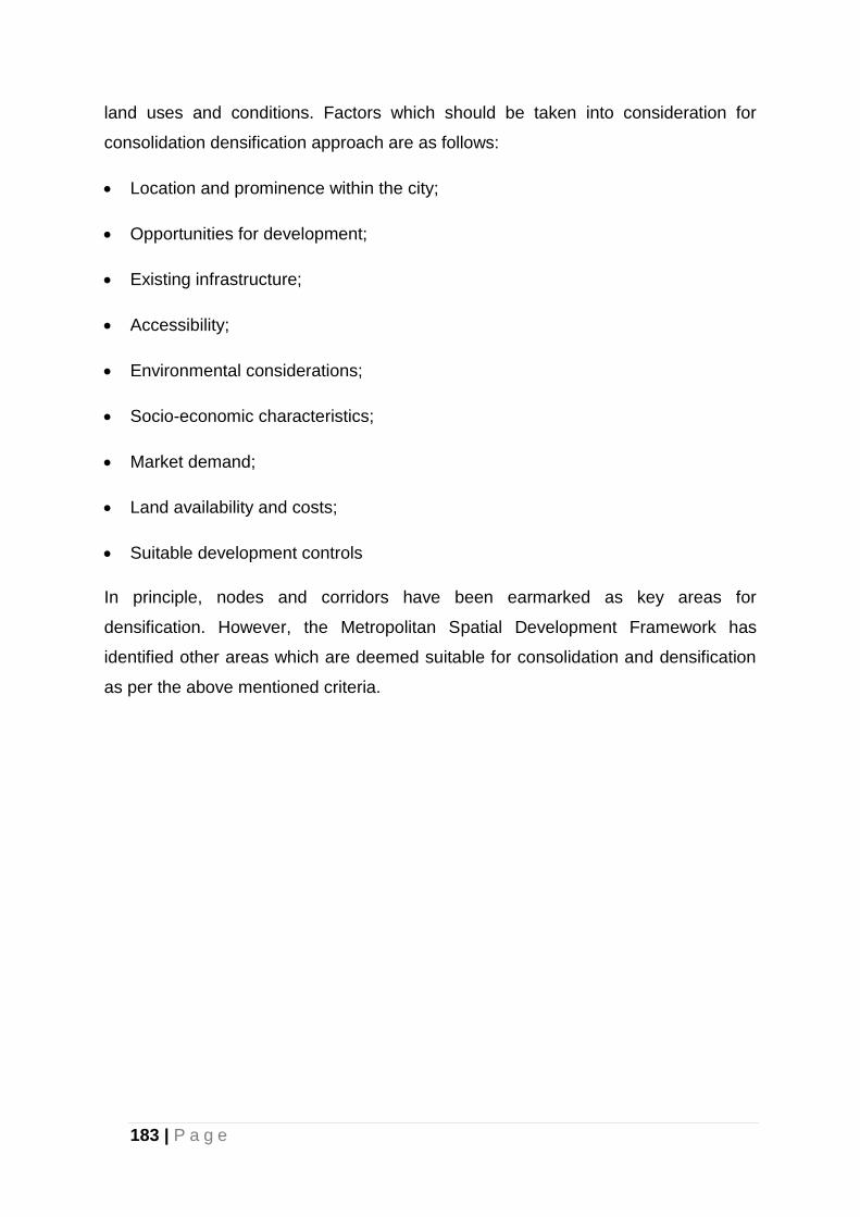
183 | P a g e
land uses and conditions. Factors which should be taken into consideration for
consolidation densification approach are as follows:
Location and prominence within the city;
Opportunities for development;
Existing infrastructure;
Accessibility;
Environmental considerations;
Socio-economic characteristics;
Market demand;
Land availability and costs;
Suitable development controls
In principle, nodes and corridors have been earmarked as key areas for
densification. However, the Metropolitan Spatial Development Framework has
identified other areas which are deemed suitable for consolidation and densification
as per the above mentioned criteria.
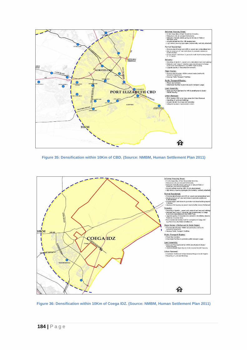
184 | P a g e
Figure 35: Densification within 10Km of CBD. (Source: NMBM, Human Settlement Plan 2011)
Figure 36: Densification within 10Km of Coega IDZ. (Source: NMBM, Human Settlement Plan 2011)
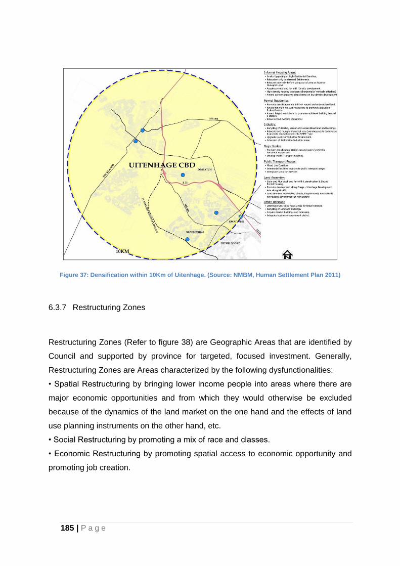
185 | P a g e
Figure 37: Densification within 10Km of Uitenhage. (Source: NMBM, Human Settlement Plan 2011)
6.3.7 Restructuring Zones
Restructuring Zones (Refer to figure 38) are Geographic Areas that are identified by
Council and supported by province for targeted, focused investment. Generally,
Restructuring Zones are Areas characterized by the following dysfunctionalities:
• Spatial Restructuring by bringing lower income people into areas where there are
major economic opportunities and from which they would otherwise be excluded
because of the dynamics of the land market on the one hand and the effects of land
use planning instruments on the other hand, etc.
• Social Restructuring by promoting a mix of race and classes.
• Economic Restructuring by promoting spatial access to economic opportunity and
promoting job creation.
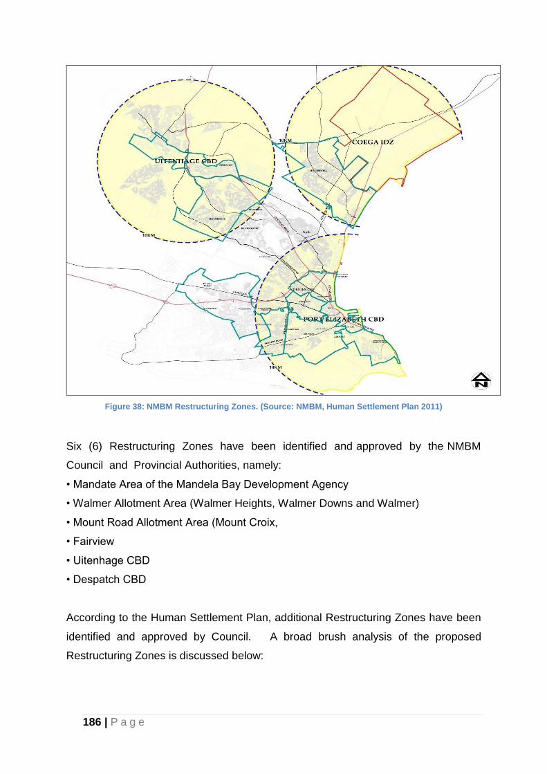
186 | P a g e
Figure 38: NMBM Restructuring Zones. (Source: NMBM, Human Settlement Plan 2011)
Six (6) Restructuring Zones have been identified and approved by the NMBM
Council and Provincial Authorities, namely:
• Mandate Area of the Mandela Bay Development Agency
• Walmer Allotment Area (Walmer Heights, Walmer Downs and Walmer)
• Mount Road Allotment Area (Mount Croix,
• Fairview
• Uitenhage CBD
• Despatch CBD
According to the Human Settlement Plan, additional Restructuring Zones have been
identified and approved by Council. A broad brush analysis of the proposed
Restructuring Zones is discussed below:
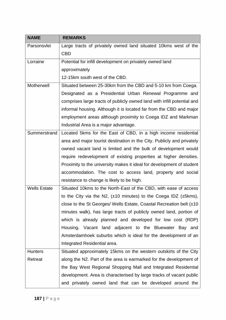
187 | P a g e
NAME REMARKS
Parsonsvlei Large tracts of privately owned land situated 10kms west of the
CBD
Lorraine Potential for infill development on privately owned land
approximately
12-15km south west of the CBD.
Motherwell Situated between 25-30km from the CBD and 5-10 km from Coega.
Designated as a Presidential Urban Renewal Programme and
comprises large tracts of publicly owned land with infill potential and
informal housing. Although it is located far from the CBD and major
employment areas although proximity to Coega IDZ and Markman
Industrial Area is a major advantage.
Summerstrand Located 5kms for the East of CBD, in a high income residential
area and major tourist destination in the City. Publicly and privately
owned vacant land is limited and the bulk of development would
require redevelopment of existing properties at higher densities.
Proximity to the university makes it ideal for development of student
accommodation. The cost to access land, property and social
resistance to change is likely to be high.
Wells Estate Situated 10kms to the North-East of the CBD, with ease of access
to the City via the N2, (±10 minutes) to the Coega IDZ (±5kms),
close to the St Georges/ Wells Estate, Coastal Recreation belt (±10
minutes walk), has large tracts of publicly owned land, portion of
which is already planned and developed for low cost (RDP)
Housing. Vacant land adjacent to the Bluewater Bay and
Amsterdamhoek suburbs which is ideal for the development of an
Integrated Residential area.
Hunters
Retreat
Situated approximately 15kms on the western outskirts of the City
along the N2. Part of the area is earmarked for the development of
the Bay West Regional Shopping Mall and Integrated Residential
development. Area is characterised by large tracks of vacant public
and privately owned land that can be developed around the
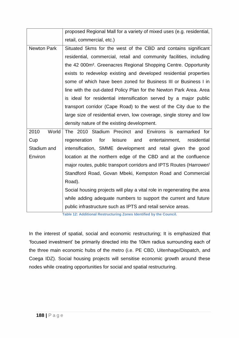
188 | P a g e
proposed Regional Mall for a variety of mixed uses (e.g. residential,
retail, commercial, etc.)
Newton Park Situated 5kms for the west of the CBD and contains significant
residential, commercial, retail and community facilities, including
the 42 000m². Greenacres Regional Shopping Centre. Opportunity
exists to redevelop existing and developed residential properties
some of which have been zoned for Business III or Business I in
line with the out-dated Policy Plan for the Newton Park Area. Area
is ideal for residential intensification served by a major public
transport corridor (Cape Road) to the west of the City due to the
large size of residential erven, low coverage, single storey and low
density nature of the existing development.
2010 World
Cup
Stadium and
Environ
The 2010 Stadium Precinct and Environs is earmarked for
regeneration for leisure and entertainment, residential
intensification, SMME development and retail given the good
location at the northern edge of the CBD and at the confluence
major routes, public transport corridors and IPTS Routes (Harrower/
Standford Road, Govan Mbeki, Kempston Road and Commercial
Road).
Social housing projects will play a vital role in regenerating the area
while adding adequate numbers to support the current and future
public infrastructure such as IPTS and retail service areas.
Table 12: Additional Restructuring Zones Identified by the Council.
In the interest of spatial, social and economic restructuring; It is emphasized that
‘focused investment’ be primarily directed into the 10km radius surrounding each of
the three main economic hubs of the metro (i.e. PE CBD, Uitenhage/Dispatch, and
Coega IDZ). Social housing projects will sensitise economic growth around these
nodes while creating opportunities for social and spatial restructuring.
189 | P a g e
6.3.8 Growth Management: Urban Edge/Urban Growth Boundary
The “urban edge or urban growth boundary” is a conceptual boundary delineating
the urban area from peri-urban and rural hinterland. Outside the “urban fence” the
land use will be predominantly agricultural with allowances and regulations for
different types of agricultural activities and for rural developments. The “urban fence”
is not a physical element, but rather identified by a spatial differentiation in proposed
land use intensity between what is inside the fence (urban development) and what is
outside the fence (peri- urban and rural developments including small Metropolitan
open space, agricultural small-holdings, intensive farming, grazing and game farms).
The urban edge is aimed at redirecting patterns of growth and encouraging
development towards the greater Spatial Vision of the NMBMM. The urban edge
boundary line will apply for the next 5 years and may be amended in subsequent
reviews of the MSDF. The Development Principles contained in Chapter 2 and
Section 42. (1) of SPLUMA and other cross-sectoral mandates must be taken into
account when considering applications within and outside the urban edge boundary.
6.3.7.1 Land Uses within the Urban Edge/urban growth boundary:
Land uses within the urban edge that are consistent with the relevant NMBMM-SDF,
Local Spatial Development Plans (LSDFs)/Structure Plans, the Land Use
Management Plan and/or Town Planning Scheme (s), Precinct Plans and spatial
development management resolutions passed by the Council will be permitted
subject to the normal procedures and legislation e.g. environmental, transportation
and desirability requirements, among other issues. The area inside the urban edge
does not imply that development rights are guaranteed. However the intensification
of development within the urban edge will be encouraged, inlight of the fact that
higher densities promote conglomerate economies, efficient utilization of services
and infrastructure among various factors, and subsequently sustainable growth of
the City.
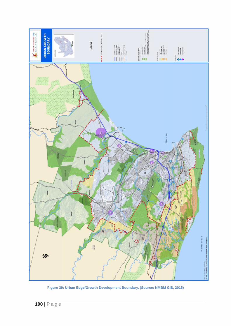
190 | P a g e
Figure 39: Urban Edge/Growth Development Boundary. (Source: NMBM GIS, 2015)
191 | P a g e
The Baywest Shopping Mall, the biggest in the Eastern Cape, emerges as an anchor
development in the Western Suburbs and a significant node. Notwithstanding the
environmental sensitivity the land to the west of the Baywest Shopping Mall, mixed
residential densities are encouraged on land surrounding the Baywest Node. Urban
sprawl is discouraged on the northern side of the urban edge with the exception of
areas close to the main urban nodes of Uitenhage and Dispatch.
The following urban edge/urban growth boundary adjustments have been made
(Refer to Figure: 39):
1. Driftsands to include Mega Project 2 in terms of the Human Settlement Plan;
2. Land parcels on the Western and Southern side of the Bay West Development to
include Grogro Informal Settlement and also create opportunities for diversified
development in the small farm holdings in the vicinity. With no prospects of being
used for viable agricultural activities.
3. Remainder Erf 8 Parsonsvlei and the PPC owned land in Parsonsvlei that
currently falls into Van Der Kemps Kloof Reserve to permit some urban
development based on conservation ethos.
4. Western section of Kwanobuhle to create opportunities for residential
developments in light of the shortages of land for housing development in the
Greater Uitenhage area.
5. Amanzi Estate, North of Motherwell, to create development potential for mixed
use housing typologies and integration opportunities (Middle Income and, or High
Income developments).
6. Inclusion of Van Der Kemp’s Kloof. The development around this area is
envisaged to integrate the built urban form and the natural conservation areas in
the same manner as that of Settler’s Park Nature Reserve.
7. The expansion of the urban edge to include the Van Der Kemp’s Kloof enabled a
synergy with the St. Albans development which shall form part of the greater
urban edge.
In addition to the main objectives of this SDF the final SDF will be submitted to the
Eastern Cape MEC for Economic Development, Environmental Affairs and Tourism
for adoption of the determined urban edges in terms of the 2014 National
Environmental Impact Assessment [EIA] Regulations. The developments in the “new
192 | P a g e
urban edge” extension should take cognisance of bio-physical natural resources and
development designs to integrate the critical environmental areas with human
settlements.
6.3.7.2 Land Uses outside the Urban Edge/urban growth boundary
Local and Provincial legislation relating to the development of areas outside the
urban edge must be taken into account, where applicable.
The existing residential nodes of Rocklands, Seaview and Witteklip located outside
the urban edge are recognised as satellite growth-points and their expansion must
be managed with the notion of convergence with the development in the City in the
long-run. Land uses that are peri-urban in nature are more desirable outside the
boundaries of the main urban edge and the boundaries of growth-points of
Rocklands, Seaview and Witteklip. Agricultural use of the properties abutting these
residential nodes must be encouraged to stimulate economic development within
these nodes and the City. Low-intensity land, such as agricultural holdings, peri-
urban residential uses, low-intensity service industries (typically those occurring on
agricultural holdings), as well as urban agriculture are encouraged in the fringe area
around the urban edge to save as a transition with the rural hinterland.
Road networks linking the rural hinterland and the city should be upgraded in order
to strengthen the economic ties taking into cognisance the services provided by the
Port for the shipping of farm produce.
There is also a need to provide land for cultural uses (Abakwetha) and animal
rearing. Detailed studies in the form of precinct plans and the identification of land for
such uses need to be commissioned and budgeted for.
6.3.8 Proposals per Focus Area
The Municipality has a number of strategic initiatives that aim to enhance economic
development of the city. These are spatially illustrated in the Figure 38 (below). The
Municipality is currently evaluating and prioritising these initiatives.
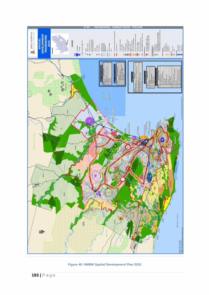
193 | P a g e
Figure 40: NMBM Spatial Development Plan 2015
194 | P a g e
6.3.8.1 Mega Projects
The National Minister of Human Settlements in her July 2014 Budget Speech
identified the need for strategic and integrated spatial master planning and the
identification and implementation of Mega Projects in priority areas. The identified
Mega Projects which are in the process of being prepared for consideration by
Council are as follows (Refer to Figure: 39):
Mega Project 1: Motherwell West NU 12, 29-31
Mega Project 2: Walmer/Summerstrand Ext./Driftsands Mixed Housing
Mega Project 3: Fairview West
Mega Project 4: Greater Happy Valley Project Area
Mega Project 5: Greater Uitenhage-Despatch-Kwanobuhle Project Area
6.3.8.2 Mandela Bay Development Agency (MBDA) Projects
The strategic projects implemented by the Municipality’s developmental entity, the
MBDA, have resulted in increases in property valuations and renewed economic
activity, with increased rates income for the Municipality. A study conducted for the
Municipality in the Central Business District has confirmed that investments by the
entity have resulted in significant property value increases, increased business
turnover, and increased rates, business expansion and upgrades.
The following projects are now ready for implementation or are being implemented:
· Tramways Building redevelopment (under implementation)
· Telkom Park / EPRU Stadium redevelopment
· 2010 Stadium Precinct development
· Mermaids Precinct mixed-use development
· International Convention Centre
195 | P a g e
6.3.8.3 Coega Industrial Development Zone (IDZ)
The Coega IDZ was established to stimulate investment in the region. It is required
to fund and provide the infrastructure dedicated to its operations. The NMBM and the
Coega Development Corporation (CDC) have agreements in place which outlines
the developmental relationship. To date, the CDC has funded all projects specifically
related to internal services and major road linkages. However, shortcomings in water
and sanitation have been identified as an area of concern by both the NMBM and
CDC. Consequently, a plan was developed to identify the gap. Failure to address the
gap will mean that the IDZ will not be able to develop further. It will cost
approximately R4,3 billion to provide bulk water and sewer infrastructure.
To date, the NMBM has commenced with planning the following projects, which are
critically required for the development of the Coega IDZ:
(i) Nooitgedacht Low Level Scheme (NLLS):
Contracts for the commencement of Phase 2 of the Scheme have been awarded and
work is scheduled for completion by March 2017. Funding remains a constraint to
commence with Phase 3 to complete the project. This is discussed in more detail
later in this document.
(ii) Coega Waste Water Treatment Works and Sea Outfall:
Preliminary planning has commenced, but designs cannot proceed, because of
funding constraints, given the size of the project.
(iii) Coega Return Effluent Scheme:
Due to the scale (finance) of the projects, the NMBM is unable to commence with
detailed design. The NMBM has commenced with preliminary planning and as such
an ROD has been issued for the system. With the cooperation of the Coega
196 | P a g e
Development Corporation (CDC), detailed design has commenced and the Return
Effluent Reservoir with the outlet pipework at the Coega Kop site is being
constructed with funding from the CDC.
The City Support Programme includes an exercise to evaluate infrastructure services
and financing. The need and options for the provision of the above Schemes is
presently being evaluated by a team from the World Bank.
(iv) Project Mthombo
Project Mthombo is an oil refinery planned to be located in the Coega Industrial
Development Zone. The pre-feasibility study was undertaken by PETROSA,
identifying Nelson Mandela Bay as the preferred site for the oil refinery. A number of
studies to support the establishment of the refinery have been completed and have
been referred to the Department of Energy for further consideration. The project is
expected to create 1000 direct jobs at an operational level, 23 000 jobs during
construction, and 17 000 indirect jobs. The Municipality is engaged with processes to
determine whether the project will be located in Nelson Mandela Bay or not.
v) Coega IDZ – Uitenhage NMBLP Logistics Corridor
To improve logistics efficiencies between the Coega IDZ and Uitenhage, provision is
made for the extension of Neptune Road to the intersection of the MR450 and
MR460. The infrastructure will improve the competitiveness of the Port of Ngqura
and enhance the development of the NMBLP and Coega IDZ whilst servicing the
development of Motherwell North residential area.
6.3.8.4 N2 Nodal Development
Urban development in the N2 Node is driven by the private sector and comprises
largely mixed-use and residential developments aimed, at the high, middle and
affordable market segments. The anchor in this development node is the just
completed Bay West Shopping Mall at a cost of R2 billion. The greater N2 node is
197 | P a g e
identified as a Catalytic Project of NMBM and the full development of the greater
node will be actively pursued.
6.3.8.5 Red Location Cultural Precinct
Located in the historic Red Location area of Ibhayi, the precinct has been developed,
consisting of the Apartheid Museum, Art Gallery, Electronic Library and
Backpackers’ Lodge. The Apartheid Museum was completed in 2004.
The Art Gallery and Electronic Library buildings are complete and were handed over
to Council during April 2011. The business plan for the performing arts complex has
been completed and the National Department of Arts and Culture has made R500
million available for this project. The last phase of the project will consist of a school
of music.
The success of the Red Location Initiative is partly depended on the Urban
Renewal of the Greater Ibhayi Area as this would enable broader urban
renewal beyond the localised impact of the Red Location and Njoli Square
Precincts upgrades.
6.3.8.6 Van der Kemp’s Kloof
Van der Kemp’s Kloof has been identified as a priority area for biodiversity
conservation in terms of the Nelson Mandela Metropolitan Open Space System
(NMMOSS) and is in the process of being proclaimed as a nature reserve.
The Van Der Kemp’s Kloof project stretches from Helenvale to Chatty (beyond
Booysens Park), including the Chatty Gorge east of Stanford Road, up to the
Hopewell Conservation Area. It is a sizeable area with the potential to be developed
holistically and in an environmentally sensitive way. The area offers opportunities for
the development of hiking trails, picnic sites, recreational dams, game farming, gorge
activities, tourism facilities and accommodation. The Kloof is divided into different
nodes; the Kuyga Node, which was completed at the end of October 2010, and the
198 | P a g e
Grootkloof Node, which was completed earlier this year (2014). Work on the
Mountain Bike and Hiking Trail, which commenced in November 2010, is now
completed. The short- to medium-term plan is to find investors who will help develop
and manage some of the proposed facilities and activities; however, this will required
the Nelson Mandela Bay Municipality to source funding to provide basic
infrastructure.
6.3.8.7 Revitalisation of Uitenhage CBD
Phases one and two of the Uitenhage CBD upgrade, which focused on the
upgrading of the historic Uitenhage Market Square located in the heart of Uitenhage,
are complete.
Funded by the Nelson Mandela Bay Municipality, the MBDA has spent R30 million
on the upgrading of the Market Square, which included the transformation of the
space from a parking area to a civic and pedestrian central space.
6.3.8.8 Njoli Square Development
This project entails the development of a major community taxi/commercial centre
where the Njoli Centre presently exists. After more than five years of planning,
negotiation and sourcing of funding, the project is moving towards the
implementation stage.
The development is anticipated to have a positive economic impact on Nelson
Mandela Bay, with initial projections indicating that the project will, directly and
indirectly, contribute R189 million to the Eastern Cape GDP during the construction
period. During the first five years of operation, the Project will contribute around
R107 million to the Eastern Cape GDP. As many as 2000 jobs can be created during
construction, with approximately 200 permanent jobs being created.
199 | P a g e
The success of the Njoli Square Upgrading Initiative is closely linked to the
upgrading of the Greater Ibhayi area. Njoli is linked to Ibhayi and Bethelsdorp Hubs
in the Urban Network Strategy.
Njoli Square upgrading is funded by the Neighbourhood Development Partnership
Grant (NDPG) and is located in the Urban Network Strategy as a catalytic project.
6.3.8.9 Mermaid’s Precinct
The project known as the Mermaid’s Precinct is located in the heart of the CBD
between Russell Road and the Donkin Row houses. The mixed use area will
comprise social housing, residential development and an urban recreational node
and complimentary mixed uses.
The area is currently derelict and vandalised and comprises both municipal and
privately owned erven. It is ripe for redevelopment. All necessary studies and master
planning are complete and implementation has commenced.
It is envisaged that the Municipality in conjunction with the MBDA, private sector and
social housing institution will develop the area. Presently, funding is a constraint in
taking the project forward. The project is identified as a catalytic project and
conforms to the definition of a Catalytic Urban Development Projects in the BEPP
Guidance note 2015/16- 2017/18.
6.3.8.10 North End Coastal Development
The North End Coastal Development project aims to reinstate the existing degraded
coastal environment north of the Port Elizabeth Harbour over a 30- year period,
creating an attractive urban gateway entrance to Nelson Mandela Bay. The project
will help stimulate tourism and the economic development of the region. The first
phase of the project will create a 500m long beachfront, with a direct link to the
adjacent Nelson Mandela Bay Stadium, New Brighton and neighbouring
communities. The project can be implemented only in partnership with Transnet and

200 | P a g e
the National Ports Authority. A task team comprising the Nelson Mandela Bay
Municipality, Transnet and other relevant stakeholders is to be established to
develop a process plan.
6.3.8.11 Waterfront Development-Port / Baakens Precinct:
There has been recent focus on plans to develop the Waterfront at King’s Beach
area. Transnet have agreed to move the oil tanks in 2016 and the manganese ore
facility to the Coega IDZ in 2019. In the port planning for the port post-relocation,
Transnet has agreed that a portion of land will be set aside for a marina/commercial
development and this portion will not fall under the strict port security controls.
A Steering Committee comprising of Transnet, the MBDA, NMBM and the ECDC is
currently working to ensure there is a well formulated Master Plan to determine the
extent and depth of retail, residential, office, leisure/entertainment/tourism
development as well as a Master Plan that can be implemented over time. The Port
/ Baakens precinct between the port and the Bridge Street Brewery as part of the
broader Waterfront Development plan is envisaged to become a new
tourism/leisure/entertainment precinct and it will be a further catalyst for the re-
development of the area over time for non-industrial purposes.
The development of the Baakens Valley Precinct is identified as one of the Catalytic
Projects and has been through a preliminary viability assessment by the DBSA
Project Preparation Facility which has concluded that the project is viable.
6.3.8.12 Bayworld Revival:
Bayworld was one of the key tourism attractions in the region, however, the facility
has had funding challenges especially after the closing of the oceanarium.
Due to the importance of this facility, a special intervention needs to be made in
order to ensure the revival of this facility and the plans once again include an
aquarium, sea water features, dolphinarium and other tourist facilities.
Bayworld is presently owned by the Department of Sports, Recreation, Arts and
Culture (DSRAC) and a proposal that the operations and management of the facility
be handed over to the Nelson Mandela Bay Municipality was made to the
Department of Sports, Recreation, Arts and Culture (DSRAC).
201 | P a g e
It is intended that the Nelson Mandela Bay Municipality will enter into an agreement
with the Department of Sports, Recreation, Arts and Culture and later hand over the
facility to MBDA for project management purposes. The MBDA will therefore be
responsible for the final design, sourcing the funding, which will be around R600
million, overseeing construction and the appointment of an operator as per case of
the Nelson Mandela Bay Stadium. A Provincial Cabinet Memorandum has been
prepared and submitted to the Department’s HOD, the Director-General of DSRAC
for approval. There are on-going discussions with the Department to fast track the
hand-over process.
6.3.8.13 Apple Express Rail Link
The closure of the Apple Express has negatively impacted the local tourism industry.
In a process of reviving the Apple Express, it became important that a study be done
to ascertain the development potential of the Apple Express line between Port
Elizabeth and Avontuur in the Western Cape, or a portion of the development of this
line for the purposes of real estate, freight, passenger and tourism. The study
concluded that this line was not suitable for pure tourism purposes as this will not be
sustainable.
Through the intervention of the MEC for Department of Economic Affairs,
Environment and Tourism (DEAET), an amount of R3,8 million was made available
for a feasibility study around the Apple Express. The Apple Express study will
commence shortly.
The study’s objective is to make a compelling argument to Transnet to make the line
available on a lease basis to a development agent.
202 | P a g e
6.3.8.14 Statue of Liberation
This project is seen to help grow the tourism products in Nelson Mandela Bay and
serve as an iconic attraction that will be compel visitors to come to Nelson Mandela
Bay. This will also provide an identity for the Nelson Mandela Bay region. Critical to
the way forward and the implementation of the project is the identification of a
suitable site.
6.3.8.15 Motherwell Node
Development in the Motherwell area will comprise municipal and private sector
developments, of which the municipal component will largely entail mixed residential
development opportunities in the lower income segments. The private sector
component will focus on mixed land use and residential development in the low,
middle and higher end housing segments.
6.3.8.16 Greater Addo National Elephant Park and Baviaanskloof Conservancy
The Greater Addo National Elephant Park and the Baviaanskloof Mega-Reserve
projects seek to develop and increase the sustainability of two prime conservation
areas in the Eastern Cape. Although located outside the jurisdiction of the Nelson
Mandela Bay Municipality, they will, on their successful development, form vital
components of the tourism and natural attractions in the region.
6.3.8.17 Private sector developments
A number of private sector developments are taking place in the city, in tandem with
municipal developments. These include the N2 node, incorporating the Bay West
Mall Shopping Complex, and Jachtvlakte/KwaNobuhle. The municipal capital
investment in these projects is reflected in the Budget.
203 | P a g e
Figure 40, highlights the major development areas and urban growth directions in the
Metro. They show areas of new development, largely residential and mixed-use
development, the major industrial development areas, as well as areas in which
urban renewal and infill development (regeneration development) is taking place.
Growth directions are mainly in a western, north-western and northerly direction.
Urban development in the N2 Node is driven by the private sector and comprises
largely mixed-use and residential developments aimed, at the high, middle and
affordable market segments. The anchor in this development node is the Bay West
Shopping Mall, currently under construction at a cost of R2 billion.
The development in the Chatty Jachtvlakte Node involves mixed-use and residential
development by the private sector and the Municipality, with an estimated yield of
32000 new residential opportunities in the middle, affordable (rental and ownership)
and subsidised housing segments.
204 | P a g e
7. IMPLEMENTATION FRAMEWORK
There are various land use policies which are aimed at addressing certain issues
associated with certain land uses by setting guidelines. Some of these policies are
new while others have been approved but are under review. These are summarised
below:
In addition to the above mentioned policies, the municipal spatial vision and form
needs to be formulated in the form of Local Spatial Development Framework and
Precinct Plans. As the land use policies, these spatial guidelines are aimed at
guiding development at a larger scale. The MSDF proposes detailed studies to
determine the categories and the potential of the emerging nodes in the Municipality.
Intensification of mixed use developments around the node and major transportation
routes in the immediate vicinity is encouraged.
7.1 Capital Investment Framework
Subsequent to assessing and evaluating the municipal area in terms of its unique
characteristics and development challenges as well as potential opportunities, a
number of key project proposals or initiatives have been identified that would serve
to drive the key development imperatives for the city. The following investment
framework is a summary of strategic, long term projects identified as a result of
numerous planning processes which identifies specific target areas for public
investment. The concept of targeting capital spending in specific areas is to
maximise service delivery to communities, leverage private sector investment and
support growth of the city, the spatial transformation and efficient functioning of the
city being the underpinning principles.
7.1.1 Strategic Infrastructure Projects (SIPs):
It should be noted that the usual Capital Budget provision for planned infrastructure
projects has been made for the entire Metropolitan area and would be indicated in
205 | P a g e
the municipal Budget. The following projects however have been identified as being
key development infrastructure investment requirements for future development.
7.1.2 Mega Projects
As mentioned earlier, the National Minister of Human Settlements emphasized the
need for the municipality to embark and on “Mega Projects” in order to maximise the
scale and impact of housing projects through close collaboration between the
various spheres of government. The following key outcomes are applicable:
Eradication of the bucket system within 2 years
Prioritising housing for military veterans within 12 months:
Shelter for vulnerable children
Employer assisted housing
Land and Buildings for Social Housing
Affordable and Rental housing provision at scale
Land assembly for Spatial Restructuring starting with well-located public
owned land
Increase capacity for municipality to deliver housing
In addition to the USDG and HSDG grant allocations, the National Department of
Human Settlement has also allocated approximately R77, 1 million Rand for the
utilisation for the planning and implementation of the megaprojects in the MTEF
period as follows:
2014/2015 : R37,7 million
2015/2016 : R12.5 million
2016/2017 : R12.5 million
2017/2018 R14.4 million
206 | P a g e
This funding will only be made if the Mega Projects are included as part of the
Accreditation Business Plan and approved by Council.
The Human Settlements Directorate has identified 6 Priority Mega Project Areas in
which a number of “mega projects” to address the above outcomes are planned in
response to the challenges set by the above outcomes. The six priority areas have
been identified within which a number of small, medium and large projects are
various stages of planning and implementation.
7.1.3 Economic Development Strategic Initiatives/Catalytic Projects
In terms of the requirements of the Urban Network Strategy the municipality has to
develop a Built Environment Performance Plan (BEPP) which seeks to identify and
integrate key development initiatives in order to improve the sustainability of the
municipality from spatial, institutional and financial perspective. A major focus of the
BEPP and the capital budget is the upgrading and development of informal areas in
terms of the ongoing implementation of the housing programme. At the time of
compiling this SDF review, the most recent draft of the BEPP (i.e. for the 2015/2016
financial years) is currently being undertaken and the process has not been
concluded. The document is therefore still being refined and is to be consulted with
various stakeholders prior to its approval by Council and submission to National
Treasury.
From a strategic perspective, the BEPP can be seen as representing the investment
strategy of the Municipality in fulfilling its objectives towards a more equitable city,
transformed spatial realties and a more compact city development. (Source:
BEPP.2015/2016)
7.1.4 Area Based Initiatives: Urban Renewal (ARI’’s)
There are five area-based management initiatives. These are:
(a). Mandela Bay Development Agency (MBDA)
The Mandela Bay Development Agency (MBDA), established in 2003 by the Nelson
Mandela Bay Municipality (NMBM) with the support of the Industrial Development
Corporation (IDC), implements urban regeneration in Nelson Mandela Bay's inner
city. The aim is to promote economic and tourism development against the backdrop
207 | P a g e
of urban renewal. The MBDA is a Municipal Entity. The MBDA’s mandate also
extends to the Uitenhage Inner-city and other development and township areas.
The philosophy of the MBDA which applies to their projects is to create well
researched, community participated, catalytic infrastructure projects and services
through public sector investment to attract private sector investment. In this way, a
more diverse economy including tourism and real estate is created.
A study conducted for the Municipality in the Central Business District has confirmed
that investments by the entity have resulted in significant property value increases,
increased business turnover, business expansion and upgrades and consequent
increased rates.
(b). Uitenhage-Despatch Development Initiative (UDDI)
The UDDI was established in 2000 as an initiative between the private sector
(Volkswagen), and NMBM to focus on development in the Uitenhage and Despatch
area. The UDDI, as a facilitation body for the promotion of sustainable development
in Nelson Mandela Bay, with the main focus on Uitenhage and Despatch, is an
implementer for some of the Metro’s programmes in the Uitenhage/Despatch area.
The UDDI’s goal is to stimulate special and economic sector development in the sub-
region to regenerate the ailing economies of this region of Nelson Mandela Bay.
The UDDI has three strategic focus areas, aligned to the IDP of the Nelson Mandela
Bay Municipality. These three areas are:
- Town improvement
- Enterprise development
- Spatial economic linkages between Uitenhage and Despatch
The initiatives under the three focus areas have been set in line with the UDDI’s
three-year strategic plan, with a strong bias towards job creation, skills development,
education improvement, SMME sector development and the general socio-economic
improvement of the Uitenhage and Despatch communities.
(c). Motherwell Urban Renewal Programme (MURP)
208 | P a g e
Motherwell is one of eight pilot areas targeted by the Presidential programme for
Urban Renewal. The main objectives of this programme are to eradicate crime,
poverty and joblessness in the targeted areas.
Motherwell was established in 1982to accommodate people from informal and illegal
dwellings built on the flood plains in Soweto-on-Sea, and to cater for the influx of
people into the urban area.
Motherwell was primarily developed as a residential area and the necessary
infrastructure for recreational facilities, basic amenities and job creation did not keep
pace with the growth of the area.
MURP facilitated a number of projects including Hawkers Trading Facilities, Car
Washes, a hydroponics project, a Business Development Service Centre, Cleaning
and Greening project, a peace park and the NU 2 Stadium.
(d) Helenvale Urban Renewal Programme (HURP)
Helenvale, as an area urgently in need of upgrading, led to the establishment of the
Helenvale Urban Renewal Programme, based on the Motherwell Urban Renewal
Programme. This Programme has also adopted a multi-faceted approach to the
upgrading of amenities and services in Helenvale and to fostering employment and
community participation. The MBDA is assisting with development implementation.
(e) Coega Development Corporation
The Coega Development Corporation (Pty) Ltd (“CDC”) was established in 1999 to
develop and operate the Coega Industrial Development Zone (“IDZ”). The IDZ is
intended to be the major employment generator of the metro and region. As such the
relationship and cooperation between NMBM and the CDC is very important.
The NMBM and the CDC have an agreement in place that outlines this
developmental relationship. To date, the CDC has funded all projects specifically
related to internal services and major road linkages.
Water and sanitation for the CDC and NMBM have been identified as areas of
concern by the NMBM. Consequently, a plan was developed to identify the gap.
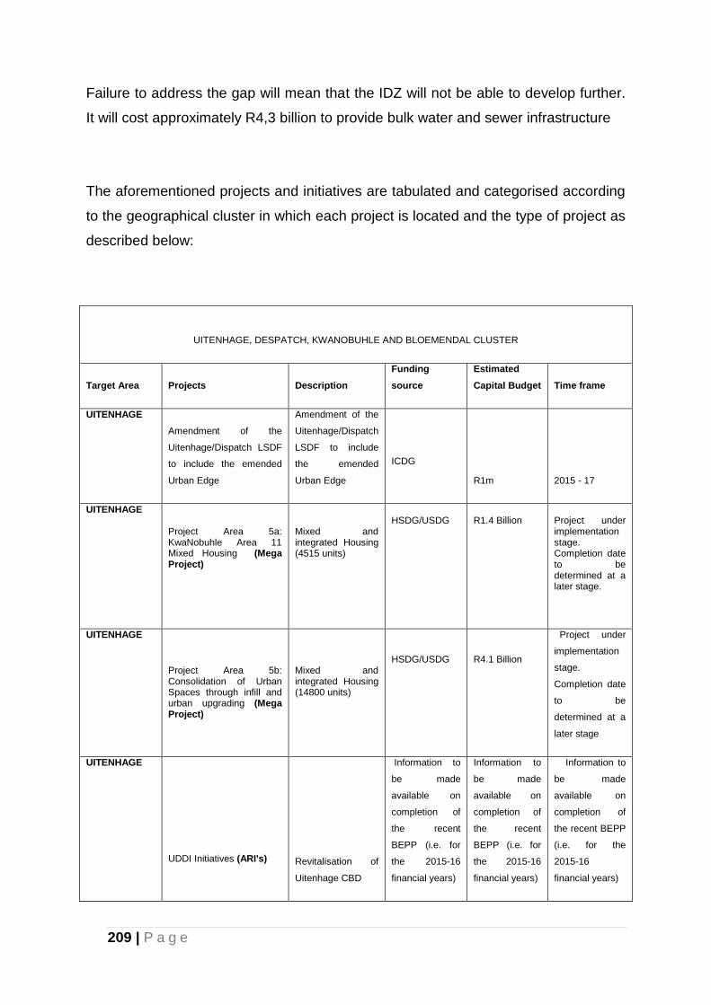
209 | P a g e
Failure to address the gap will mean that the IDZ will not be able to develop further.
It will cost approximately R4,3 billion to provide bulk water and sewer infrastructure
The aforementioned projects and initiatives are tabulated and categorised according
to the geographical cluster in which each project is located and the type of project as
described below:
UITENHAGE, DESPATCH, KWANOBUHLE AND BLOEMENDAL CLUSTER
Target Area Projects Description Funding
source Estimated
Capital Budget Time frame
UITENHAGE Amendment of the
Uitenhage/Dispatch LSDF
to include the emended
Urban Edge
Amendment of the
Uitenhage/Dispatch
LSDF to include
the emended
Urban Edge
ICDG
R1m 2015 - 17
UITENHAGE
Project Area 5a: KwaNobuhle Area 11 Mixed Housing (Mega Project)
Mixed and integrated Housing (4515 units)
HSDG/USDG
R1.4 Billion
Project under implementation stage. Completion date to be determined at a later stage.
UITENHAGE
Project Area 5b: Consolidation of Urban Spaces through infill and urban upgrading (Mega Project)
Mixed and integrated Housing (14800 units)
HSDG/USDG
R4.1 Billion
Project under
implementation
stage.
Completion date
to be
determined at a
later stage
UITENHAGE
UDDI Initiatives (ARI's)
Revitalisation of
Uitenhage CBD
Information to
be made
available on
completion of
the recent
BEPP (i.e. for
the 2015-16
financial years)
Information to
be made
available on
completion of
the recent
BEPP (i.e. for
the 2015-16
financial years)
Information to
be made
available on
completion of
the recent BEPP
(i.e. for the
2015-16
financial years)
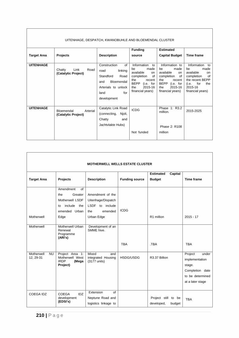
210 | P a g e
UITENHAGE, DESPATCH, KWANOBUHLE AND BLOEMENDAL CLUSTER
Target Area Projects Description Funding
source Estimated
Capital Budget Time frame
UITENHAGE Chatty Link Road (Catalytic Project)
Construction of
road linking
Standford Road
and Bloemendal
Arterials to unlock
land for
development
Information to be made available on completion of the recent BEPP (i.e. for the 2015-16 financial years)
Information to be made available on completion of the recent BEPP (i.e. for the 2015-16 financial years)
Information to be made available on completion of the recent BEPP (i.e. for the 2015-16 financial years)
UITENHAGE Bloemendal Arterial (Catalytic Project)
Catalytic Link Road
(connecting, Njoli,
Chatty and
Jachtvlakte Hubs)
ICDG Not funded
Phase 1: R3.2 million. Phase 2: R108
million
2015-2025
MOTHERWELL WELLS ESTATE CLUSTER
Target Area Projects Description Funding source Estimated Capital
Budget Time frame
Motherwell
Amendment of
the Greater
Motherwell LSDF
to include the
emended Urban
Edge
Amendment of the
Uitenhage/Dispatch
LSDF to include
the emended
Urban Edge
ICDG
R1 million 2015 - 17
Motherwell
Motherwell Urban Renewal Programme (ARI's)
Development of an SMME hive.
TBA .TBA TBA
Motherwell NU 12, 29-31
Project Area 1: Motherwell West IRDP (Mega Project)
Mixed and integrated Housing (3177 units)
HSDG/USDG
R3.37 Billion
Project under
implementation
stage.
Completion date
to be determined
at a later stage
COEGA IDZ
COEGA IDZ development (EDSI's)
Extension of
Neptune Road and
logistics linkage to
Project still to be
developed, budget
TBA
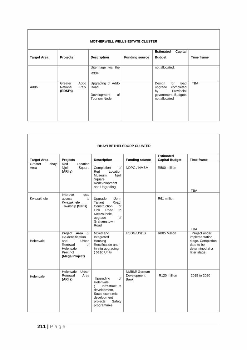
211 | P a g e
MOTHERWELL WELLS ESTATE CLUSTER
Target Area Projects Description Funding source Estimated Capital
Budget Time frame
Uitenhage via the
R334. not allocated.
Addo
Greater Addo National Park (EDSI's)
Upgrading of Addo Road Development of Tourism Node
Design for road upgrade completed by Provincial government. Budgets not allocated
TBA
IBHAYI BETHELSDORP CLUSTER
Target Area Projects Description Funding source Estimated Capital Budget Time frame
Greater Ibhayi Area
Red Location Njoli Square (ARI's)
Completion of Red Location Museum. Njoli Square Redevelopment and Upgrading
NDPG / NMBM
R500 million TBA
Kwazakhele
Improve road access to Kwazakhele Township (SIP's)
Upgrade John Tallant Road, Construction of Link Road to Kwazakhele, upgrade of Grahamstown Road
R61 million TBA
Helenvale
Project Area 6: De-densification and Urban Renewal of Helenvale Precinct (Mega Project)
Mixed and Integrated Housing Rectification and In-situ upgrading, ( 5110 Units
HSDG/USDG
R885 Million
Project under implementation stage. Completion date to be determined at a later stage
Helenvale
Helenvale Urban Renewal Area (ARI's)
Upgrading of Helenvale ( Infrastructure development, Socio-economic development projects, Safety programmes
NMBM/ German Development Bank
R120 million
2015 to 2020
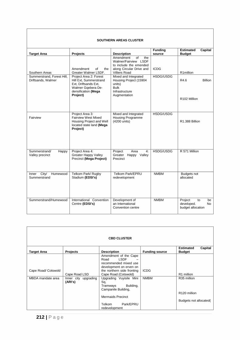
212 | P a g e
SOUTHERN AREAS CLUSTER
Target Area Projects Description Funding source
Estimated Capital Budget
Southern Areas Amendment of the Greater Walmer LSDF.
Amendment of the Walmer/Fairview LSDF to include the emended along Circular Drive and Villiers Road
ICDG R1million
Summerstrand, Forest Hill, Driftsands, Walmer
Project Area 2: Forest Hill Ext, Summerstrand Ext, Driftsands Ext, Walmer Gqebera De-densification (Mega Project)
Mixed and Integrated Housing Project (15904 units) Bulk Infrastructure Augmentation
HSDG/USDG
R4.6 Billion R102 Million
Fairview
Project Area 3: Fairview West Mixed Housing Project and Well located state land (Mega Project)
Mixed and Integrated Housing Programme (4200 units)
HSDG/USDG
R1.388 Billion
Summerstrand/ Happy Valley precinct
Project Area 4: Greater Happy Valley Precinct (Mega Project)
Project Area 4: Greater Happy Valley Precinct
HSDG/USDG
R 571 Million
Inner City/ Humewood Summerstrand
Telkom Park/ Rugby Stadium (EDSI's)
Telkom Park/EPRU redevelopment
NMBM Budgets not allocated
Summerstrand/Humewood International Convention Centre (EDSI's)
Development of an International Convention centre
NMBM Project to be developed. No budget allocation
CBD CLUSTER
Target Area Projects Description Funding source Estimated Capital Budget
Cape Road/ Cotswold Cape Road LSD
Amendment of the Cape Road LSDF – recommended mixed use development on erven on the northern side fronting Cape Road (Cotswold)
ICDG R1 million
MBDA mandate area
Inner city upgrading (ARI's)
Upgrading Vuyisile Mini Sq, Tramways Building, Campanile Building, Mermaids Precinct Telkom Park/EPRU redevelopment
NMBM
R35 million R120 million Budgets not allocated(
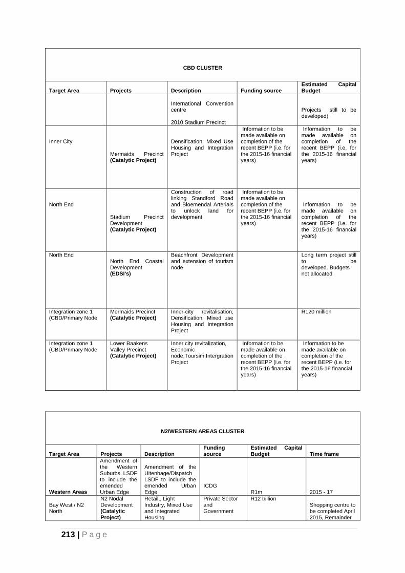
213 | P a g e
CBD CLUSTER
Target Area Projects Description Funding source Estimated Capital Budget
International Convention centre 2010 Stadium Precinct
Projects still to be developed)
Inner City
Mermaids Precinct (Catalytic Project)
Densification, Mixed Use Housing and Integration Project
Information to be made available on completion of the recent BEPP (i.e. for the 2015-16 financial years)
Information to be made available on completion of the recent BEPP (i.e. for the 2015-16 financial years)
North End
Stadium Precinct Development (Catalytic Project)
Construction of road linking Standford Road and Bloemendal Arterials to unlock land for development
Information to be made available on completion of the recent BEPP (i.e. for the 2015-16 financial years)
Information to be made available on completion of the recent BEPP (i.e. for the 2015-16 financial years)
North End
North End Coastal Development (EDSI's)
Beachfront Development and extension of tourism node
Long term project still to be developed. Budgets not allocated
Integration zone 1 (CBD/Primary Node
Mermaids Precinct (Catalytic Project)
Inner-city revitalisation, Densification, Mixed use Housing and Integration Project
R120 million
Integration zone 1 (CBD/Primary Node
Lower Baakens Valley Precinct (Catalytic Project)
Inner city revitalization, Economic node,Toursim,Intergration Project
Information to be made available on completion of the recent BEPP (i.e. for the 2015-16 financial years)
Information to be made available on completion of the recent BEPP (i.e. for the 2015-16 financial years)
N2/WESTERN AREAS CLUSTER
Target Area Projects Description Funding source
Estimated Capital Budget Time frame
Western Areas
Amendment of the Western Suburbs LSDF to include the emended Urban Edge
Amendment of the Uitenhage/Dispatch LSDF to include the emended Urban Edge
ICDG R1m 2015 - 17
Bay West / N2 North
N2 Nodal Development (Catalytic Project)
Retail,, Light Industry, Mixed Use and Integrated Housing
Private Sector and Government
R12 billion
Shopping centre to be completed April 2015, Remainder
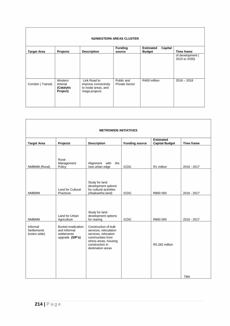
214 | P a g e
N2/WESTERN AREAS CLUSTER
Target Area Projects Description Funding source
Estimated Capital Budget Time frame
of development ( 2015 to 2030)
Corridor ( Transit)
Western Arterial (Catalytic Project)
Link Road to improve connectivity to nodal areas, and mega projects
Public and Private Sector
R400 million
2016 – 2018
METROWIDE INITIATIVES
Target Area Projects Description Funding source Estimated Capital Budget Time frame
NMBMM (Rural)
Rural Management Policy
Alignment with the new urban edge ICDG R1 million 2016 - 2017
NMBMM Land for Cultural Practices
Study for land development options for cultural activities (Abakwetha land) ICDG R800 000 2016 - 2017
NMBMM Land for Urban Agriculture
Study for land development options for rearing ICDG R800 000 2016 - 2017
Informal Settlements (metro wide)
Bucket eradication and Informal settlements upgrade (SIP's)
Construction of bulk services, reticulation services, relocation communities from stress areas, housing construction in destination areas
R5.282 million TBA
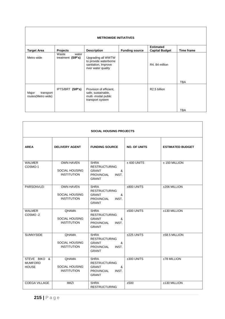
215 | P a g e
METROWIDE INITIATIVES
Target Area Projects Description Funding source Estimated Capital Budget Time frame
Metro wide
Waste water treatment (SIP's)
Upgrading all WWTW to provide waterborne sanitation, Improve river water quality
R4. 84 million TBA
Major transport routes(Metro wide)
IPTS/BRT (SIP's)
Provision of efficient, safe, sustainable, multi -modal public transport system
R2.5 billion
TBA
SOCIAL HOUSING PROJECTS
AREA
DELIVERY AGENT
FUNDING SOURCE
NO. OF UNITS
ESTIMATED BUDGET
WALMER
COSMO-1
OWN HAVEN
SOCIAL HOUSING
INSTITUTION
SHRA
RESTRUCTURING
GRANT &
PROVINCIAL INST.
GRANT
± 600 UNITS ± 150 MILLION
PARSONVLEI OWN HAVEN
SOCIAL HOUSING
INSTITUTION
SHRA
RESTRUCTURING
GRANT &
PROVINCIAL INST.
GRANT
±800 UNITS ±206 MILLION
WALMER
COSMO -2
QHAMA
SOCIAL HOUSING
INSTITUTION
SHRA
RESTRUCTURING
GRANT &
PROVINCIAL INST.
GRANT
±500 UNITS ±130 MILLION
SUNNYSIDE QHAMA
SOCIAL HOUSING
INSTITUTION
SHRA
RESTRUCTURING
GRANT &
PROVINCIAL INST.
GRANT
±225 UNITS ±58.5 MILLION
STEVE BIKO &
MUMFORD
HOUSE
QHAMA
SOCIAL HOUSING
INSTITUTION
SHRA
RESTRUCTURING
GRANT &
PROVINCIAL INST.
GRANT
±300 UNITS ±78 MILLION
COEGA VILLAGE IMIZI SHRA
RESTRUCTURING
±500 ±130 MILLION
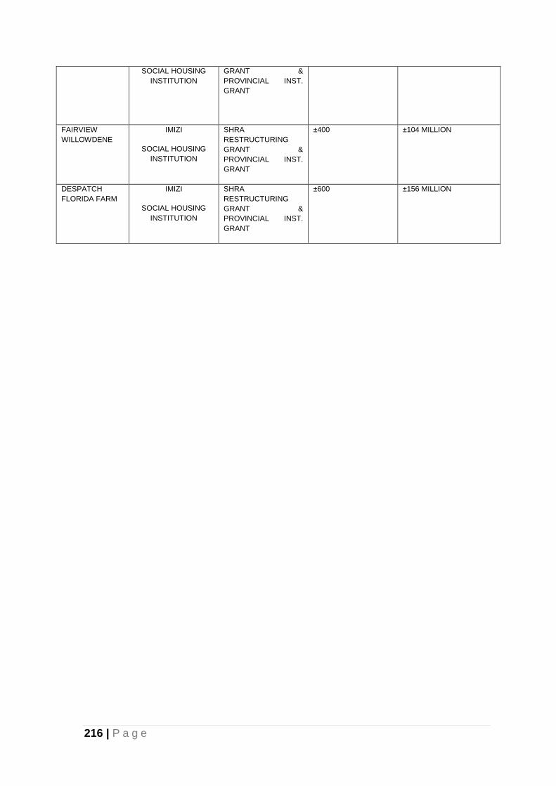
216 | P a g e
SOCIAL HOUSING
INSTITUTION
GRANT &
PROVINCIAL INST.
GRANT
FAIRVIEW
WILLOWDENE
IMIZI
SOCIAL HOUSING
INSTITUTION
SHRA
RESTRUCTURING
GRANT &
PROVINCIAL INST.
GRANT
±400 ±104 MILLION
DESPATCH
FLORIDA FARM
IMIZI
SOCIAL HOUSING
INSTITUTION
SHRA
RESTRUCTURING
GRANT &
PROVINCIAL INST.
GRANT
±600 ±156 MILLION
217 | P a g e
8. BIBLIOGRAPHY
Department of Rural Development and Land Affairs. 2014. Spatial Development
Framework Guidelines (Final Draft). Pretoria.
Department of Rural Development and Land Affairs. 2013. Spatial Planning and
Land Use Management Act (SPLUMA). Pretoria.
Development Partners. (2007). Demographic Update for the Nelson Mandela Bay
Metropolitan. Port Elizabeth: Nelson Mandela Bay Municipality.
Minister of Finance, Pravin Gordhon. (2014, February 26). 2014 Budget Speech.
Nelson Mandela Bay Industrial Development Strategy 2012. A report by:
Development
NMBM. (2009). Metropolitan Spatial Development Framework. Port Elizabeth:
Nelson Mandela Bay Municipality.
NMBM CorpGIS. (2010). Unpublished Report: Access to Facilities in terms of SCU
Planning Methodology. Nelson Mandela Bay Municipality.
NMBM Corporate Drawing Office. (2012). Development Areas in Nelson Mandela
Bay
NMBM Infrastructure & Engineering: Water & Sanitation. (2009). Business Plan for
Water and Sanitation Services for the Coega IDZ. Port Elizabeth: NMBM.
NMBM Infrastrucutre & Engineering (Water & Sanitation). (2011). Draft Water Master
Plan for Nelson Mandela Bay. NMBM.
NMBM. (January 2014). Draft Urban Network Strategy. Port Elizabeth: Nelson
Mandela Bay Municipality.
NMBM Land Planning & Management Sub-Directorate. (2007). Sustainable
Community.
Planning Guide. Port Elizabeth: Nelson Mandela Bay Municipality.
NMBM Budget & Treasury. (2014). NMBM Draft Capital Budget 2014 - 15. Port
Elizabeth: Nelson Mandela Bay Municipality.
NMBM EDRS. (2009). Draft Economic Development Strategy for Nelson Mandela
Bay. Port Elizabeth: Nelson Mandela Bay Municipality.
218 | P a g e
NMBM Human Settlements Directorate. (2008). Informal Settlements Upgrading
Plan. Port Elizabeth: Nelson Mandela Bay Municipality.
NMBM Human Settlements Directorate. (2012). Human Settlement Plan. NMBM.
NMBM Human Settlements Directorate - Land Planning. (2014, April). Spatial
Illustration of Urban Development Trends and Growth Directions in Nelson
Mandela Bay. NMBM.
NMBM IDP Office. (2014). NMBM Integrated Development Plan. NMBM
Integrated Development Plan 2011 - 2016, 12th Edition (2013/14 Financial Year).
Port Elizabeth: Nelson Mandela Bay Municipality.
NMBM Infrastructure & Engineering Directorate. (2006). Water Master Plan for
Nelson Mandela Bay. Port Elizabeth.
NMBM Infrastructure & Engineering Directorate. (2011). Infrastructure Maintenance
Backlog Assessment. Port Elizabeth: Nelson Mandela Bay Municipality.
NMBM Infrastructure & Engineering Directorate. (2012). Nelson Mandela Bay
Sanitation Master Plan. Port Elizabeth: Nelson Mandela Bay Municipality.
NMBM Office of the COO. (2013). Built Environment Performance Plan: 2013/14
USDG Submission. Port Elizabeth: Nelson Mandela Bay Municipality.
Shisaka Development Management Services. (2012). Proposed High-level Housing
Strategy for the Nelson Mandela Bay Municipality. Port Elizabeth: Nelson
Mandela Bay Municipality.
SSI Consultants. (March 2011). NMBM Comprehensive Integrated Transport Plan
2011/12. Port Elizabeth: Nelson Mandela Bay Municipality.
SSI Engineers & Environmental Consultants. (March 2011). NMBM Comprehensive
Integrated Transport Plan 2011/12. Port Elizabeth: Nelson Mandela Bay
Municipality.
South Africa. 1998. National Environment Management Act, 1998, Act 107 0f 1998).
(NEMA).
South Africa. National Environmental Management: Biodiversity Act, 2004 (Act No.
10 of 2004). Pretoria.
South Africa. 1999. National Heritage Resources Act, 1991 (Act 25 of 1999).
219 | P a g e
Srk Consultants. 2010. Disaster Risk Assessment Report. Port Elizabeth: Nelson
Mandela Bay Municipality.
Srk Consultants. 2014. NMBM Environmental Management Framework. Port
Elizabeth: Nelson Mandela Bay Municipality.
Srk Consultants. 2014. NMBM Bioregional Plan. Port Elizabeth: Nelson Mandela Bay
Municipality.
Stats SA. (2001). Census 2001. Pretoria: Statistics South Africa.
Stats SA. (2011). Census 2011. Pretoria: Statistics South Africa.