Embed Size (px)
Citation preview
This article was downloaded by: [University of Arizona]On: 18 December 2014, At: 17:02Publisher: RoutledgeInforma Ltd Registered in England and Wales Registered Number: 1072954Registered office: Mortimer House, 37-41 Mortimer Street, London W1T 3JH,UK
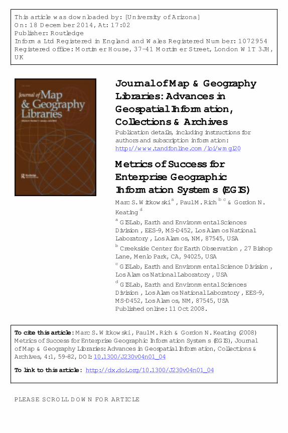
Journal of Map & GeographyLibraries: Advances inGeospatial Information,Collections & ArchivesPublication details, including instructions forauthors and subscription information:http://www.tandfonline.com/loi/wmgl20
Metrics of Success forEnterprise GeographicInformation Systems (EGIS)Marc S. Witkowski a , Paul M. Rich b c & Gordon N.Keating da GISLab, Earth and Environmental SciencesDivision , EES-9, MS-D452, Los Alamos NationalLaboratory , Los Alamos, NM, 87545, USAb Creekside Center for Earth Observation , 27 BishopLane, Menlo Park, CA, 94025, USAc GISLab, Earth and Environmental Science Division ,Los Alamos National Laboratory , USAd GISLab, Earth and Environmental SciencesDivision , Los Alamos National Laboratory , EES-9,MS-D452, Los Alamos, NM, 87545, USAPublished online: 11 Oct 2008.
To cite this article: Marc S. Witkowski , Paul M. Rich & Gordon N. Keating (2008)Metrics of Success for Enterprise Geographic Information Systems (EGIS), Journalof Map & Geography Libraries: Advances in Geospatial Information, Collections &Archives, 4:1, 59-82, DOI: 10.1300/J230v04n01_04
To link to this article: http://dx.doi.org/10.1300/J230v04n01_04
PLEASE SCROLL DOWN FOR ARTICLE
Taylor & Francis makes every effort to ensure the accuracy of all theinformation (the “Content”) contained in the publications on our platform.However, Taylor & Francis, our agents, and our licensors make norepresentations or warranties whatsoever as to the accuracy, completeness,or suitability for any purpose of the Content. Any opinions and viewsexpressed in this publication are the opinions and views of the authors, andare not the views of or endorsed by Taylor & Francis. The accuracy of theContent should not be relied upon and should be independently verified withprimary sources of information. Taylor and Francis shall not be liable for anylosses, actions, claims, proceedings, demands, costs, expenses, damages,and other liabilities whatsoever or howsoever caused arising directly orindirectly in connection with, in relation to or arising out of the use of theContent.
This article may be used for research, teaching, and private study purposes.Any substantial or systematic reproduction, redistribution, reselling, loan,sub-licensing, systematic supply, or distribution in any form to anyone isexpressly forbidden. Terms & Conditions of access and use can be found athttp://www.tandfonline.com/page/terms-and-conditions
Dow
nloa
ded
by [
Uni
vers
ity o
f A
rizo
na]
at 1
7:02
18
Dec
embe
r 20
14
Metrics of Success for EnterpriseGeographic Information Systems (EGIS)
Marc S. WitkowskiPaul M. Rich
Gordon N. Keating
ABSTRACT. An enterprise geographic information system (EGIS) ad-dresses the institutional challenge of providing common infrastructure toshare geospatial data and associated services. We propose a comprehen-sive definition and conceptual framework for EGIS, and we apply thisframework to analyze and assess the success of a prototype EGIS imple-mentation. We define EGIS as institutional GIS capability with three at-tributes: (1) integrated components (common infrastructure); (2) services(shared data, analysis, modeling, and visualization capabilities); and (3)institutional management (administration and leadership). Further distil-lation yields nine specific implementation requirements: (1) common net-worked infrastructure; (2) high reliability and availability; (3) spatial datawarehouse; (4) documentation of data and services; (5) coordination ofdataflow and workflow; (6) coordination of personnel roles and responsi-bilities; (7) formalized management; (8) institutional financing; and (9) in-
Marc S. Witkowski, GISLab, Earth and Environmental Sciences Division, EES-9,MS-D452, Los Alamos National Laboratory, Los Alamos, NM 87545 (E-mail: [email protected]).
Paul M. Rich, Creekside Center for Earth Observation, 27 Bishop Lane, MenloPark, CA 94025 USA (E-mail: [email protected]). (Formerly GISTeam Leader for GISLab, Earth and Environmental Science Division, Los Alamos Na-tional Laboratory.)
Gordon N. Keating, GISLab, Earth and Environmental Sciences Division, EES-9,MS-D452, Los Alamos National Laboratory, Los Alamos, NM 87545 (E-mail: [email protected]).
Acknowledgements: This work was funded in part by the Cerro Grande Rehabilita-tion Project Office and the Earth and Environmental Sciences Division at Los AlamosNational Laboratory.
Journal of Map & Geography Libraries, Vol. 4(1) 2007Available online at http://jmgl.haworthpress.com
doi:10.1300/J230v04n01_04 59
Dow
nloa
ded
by [
Uni
vers
ity o
f A
rizo
na]
at 1
7:02
18
Dec
embe
r 20
14
stitutional leadership. We tested the hypothesis that a project-based GIScould be used as a prototype EGIS for a large institution. Evaluation of theCerro Grande Rehabilitation Project GIS (CGRP- GIS), study system,yielded a comprehensive taxonomy of direct metrics (e.g., server down-time) and indirect metrics (e.g., increases in productivity) for evaluatingEGIS. Some elements of the CGRP-GIS did not scale well to EGIS (e.g.,management, financing, and leadership), since projects allocate resourcesprimarily to achieve project goals, whereas EGIS allocates resources tolong-term infrastructure. An EGIS, constructed on a solid conceptualframework, holds tremendous potential to advance sharing of geospa-tial data and associated services; to better allocate institutional andproject resources; and to aid in problem solving, communication, and de-cision making. doi:10.1300/J230v04n01_04 [Article copies available for a feefrom The Haworth Document Delivery Service: 1-800-HAWORTH. E-mail ad-dress: <[email protected]> Website: <http://www.HaworthPress.com>
KEYWORDS. Enterprise GIS, EGIS, management
INTRODUCTION
The use of geospatial data and analyses is growing beyond the tra-ditional project-based, desktop driven geographic information sys-tem (GIS), challenging institutions to provide common infrastructurefor more effective sharing of geospatial data and associated services(Keating et al. 2002, 2003). Ensuring availability of high quality geo-spatial data and elimination of redundant project-based GIS infrastruc-ture (hardware, software, networks, etc.) are foremost among the incen-tives. In the past, numerous technological roadblocks hampered aninstitution’s ability to design and implement a solution. With the ad-vance of high-speed networks, increasingly fast computers, and intelli-gent geospatial-data serving technologies, the newest challenge involvesintegration of the various technological and institutional componentsfrom project-based GIS to an enterprise GIS (EGIS). This migration canbe viewed as an inevitable stage in the evolution of GIS.
Three fundamental questions arise as GIS practitioners face the prob-lem of migrating existing GIS capabilities from a traditional pro-ject-based GIS to an institutional or enterprise solution. First, what isEGIS, in terms of a definition that serves as the basis for a rigorousEGIS conceptual framework? Second, how can EGIS be implemented,
60 JOURNAL OF MAP & GEOGRAPHY LIBRARIES
Dow
nloa
ded
by [
Uni
vers
ity o
f A
rizo
na]
at 1
7:02
18
Dec
embe
r 20
14
in terms of methodology, design, and metrics of success? Third, is EGISa better solution, in terms of the key differences in scale and structurebetween project-based GIS and EGIS?
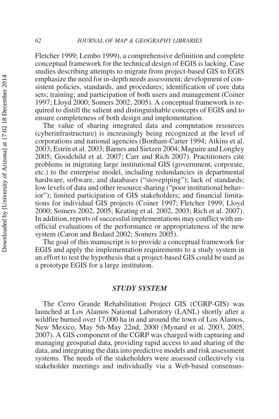
EGIS has been defined as providing access to shared geospatial in-formation and analysis resources for a large number of concurrent us-ers located in different parts of an organization (Rich et al. 2001;Somers 2002, 2005; Maguire and Longley 2005). EGIS has also beendefined by the components that comprise it (hardware, software, sharedgeospatial data), and distinct roles of participants (Oppmann 1999).However, describing EGIS by what it provides or the components itcontains does not fully define EGIS or its necessary requirements. Anadditional three elements are critical for EGIS: (1) integration of dataflow with a set of necessary work processes (a “complete geospatialdata cycle”) (Figure 1); (2) consideration of diverse stakeholder needs(data managers, GIS users, and customers); and (3) application of exist-ing information management techniques, such as those developed fordata warehousing (Keating et al. 2003; Witkowski et al. 2002, 2003).EGIS is more a complete approach to geospatial resource managementthan simply the collection of technologies that enable it (Somers 2005).
Although there are a number of management approaches and institu-tional models that have been developed to describe a particular EGISimplementation from a management perspective (e.g., Oppmann 1999;
Witkowski, Rich, and Keating 61
FIGURE 1. A complete geospatial data cycle ensures that data are complete,secure, documented, and accessible to GIS usersD
ownl
oade
d by
[U
nive
rsity
of
Ari
zona
] at
17:
02 1
8 D
ecem
ber
2014
Fletcher 1999; Lembo 1999), a comprehensive definition and completeconceptual framework for the technical design of EGIS is lacking. Casestudies describing attempts to migrate from project-based GIS to EGISemphasize the need for in-depth needs assessment; development of con-sistent policies, standards, and procedures; identification of core datasets; training; and participation of both users and management (Coiner1997; Lloyd 2000; Somers 2002, 2005). A conceptual framework is re-quired to distill the salient and distinguishable concepts of EGIS and toensure completeness of both design and implementation.
The value of sharing integrated data and computation resources(cyberinfrastructure) is increasingly being recognized at the level ofcorporations and national agencies (Bonham-Carter 1994; Atkins et al.2003; Estrin et al. 2003; Barnes and Sietzen 2004; Maguire and Longley2005; Goodchild et al. 2007; Carr and Rich 2007). Practitioners citeproblems in migrating large institutional GIS (government, corporate,etc.) to the enterprise model, including redundancies in departmentalhardware, software, and databases (“stovepiping”); lack of standards;low levels of data and other resource sharing (“poor institutional behav-ior”); limited participation of GIS stakeholders; and financial limita-tions for individual GIS projects (Coiner 1997; Fletcher 1999; Lloyd2000; Somers 2002, 2005; Keating et al. 2002, 2003; Rich et al. 2007).In addition, reports of successful implementations may conflict with un-official evaluations of the performance or appropriateness of the newsystem (Caron and Bedard 2002; Somers 2005).
The goal of this manuscript is to provide a conceptual framework forEGIS and apply the implementation requirements to a study system inan effort to test the hypothesis that a project-based GIS could be used asa prototype EGIS for a large institution.
STUDY SYSTEM
The Cerro Grande Rehabilitation Project GIS (CGRP-GIS) waslaunched at Los Alamos National Laboratory (LANL) shortly after awildfire burned over 17,000 ha in and around the town of Los Alamos,New Mexico, May 5th-May 22nd, 2000 (Mynard et al. 2003, 2005,2007). A GIS component of the CGRP was charged with capturing andmanaging geospatial data, providing rapid access to and sharing of thedata, and integrating the data into predictive models and risk assessmentsystems. The needs of the stakeholders were assessed collectively viastakeholder meetings and individually via a Web-based consensus-
62 JOURNAL OF MAP & GEOGRAPHY LIBRARIES
Dow
nloa
ded
by [
Uni
vers
ity o
f A
rizo
na]
at 1
7:02
18
Dec
embe
r 20
14
building and conflict-clarification tool (Keating et al. 2001). ExistingLANL spatial databases and infrastructure, along with legacy spatialdata resources were thoroughly evaluated for incorporation into theCGRP-GIS.
CGRP-GIS was deemed an adequate study system because it differedfrom typical project-based GIS in three ways: (1) the effort transcendedmany organizational divides and required participation from diverseGIS stakeholders throughout a large and complex institution; (2) hard-ware, software, and other required common infrastructure were de-signed to address the data sharing needs of all GIS stakeholders; and (3)a major goal was to develop the CGRP-GIS into a sustainable EGIS thatwould serve the institution (Keating et al. 2003; Witkowski et al. 2003).
METHODS
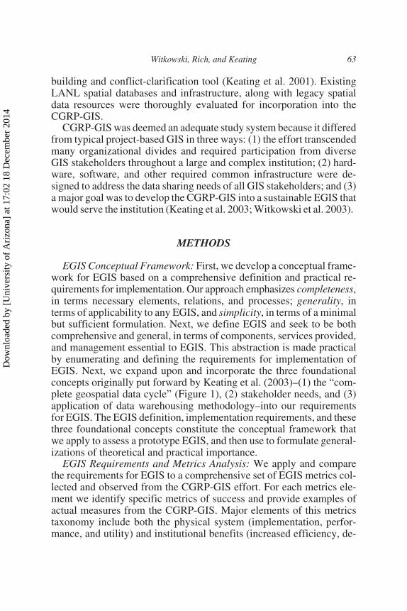
EGIS Conceptual Framework: First, we develop a conceptual frame-work for EGIS based on a comprehensive definition and practical re-quirements for implementation. Our approach emphasizes completeness,in terms necessary elements, relations, and processes; generality, interms of applicability to any EGIS, and simplicity, in terms of a minimalbut sufficient formulation. Next, we define EGIS and seek to be bothcomprehensive and general, in terms of components, services provided,and management essential to EGIS. This abstraction is made practicalby enumerating and defining the requirements for implementation ofEGIS. Next, we expand upon and incorporate the three foundationalconcepts originally put forward by Keating et al. (2003)–(1) the “com-plete geospatial data cycle” (Figure 1), (2) stakeholder needs, and (3)application of data warehousing methodology–into our requirementsfor EGIS. The EGIS definition, implementation requirements, and thesethree foundational concepts constitute the conceptual framework thatwe apply to assess a prototype EGIS, and then use to formulate general-izations of theoretical and practical importance.
EGIS Requirements and Metrics Analysis: We apply and comparethe requirements for EGIS to a comprehensive set of EGIS metrics col-lected and observed from the CGRP-GIS effort. For each metrics ele-ment we identify specific metrics of success and provide examples ofactual measures from the CGRP-GIS. Major elements of this metricstaxonomy include both the physical system (implementation, perfor-mance, and utility) and institutional benefits (increased efficiency, de-
Witkowski, Rich, and Keating 63
Dow
nloa
ded
by [
Uni
vers
ity o
f A
rizo
na]
at 1
7:02
18
Dec
embe
r 20
14
creased redundancy, and cost saving). Then, we discuss design featuresof the CGRP-GIS and evaluate the success or failure of implementation.
Scaling from Project-Based GIS to EGIS: We identify key differ-ences between project-based GIS and EGIS, with consideration of whatis needed to make the transition to an EGIS based on the EGIS defini-tion and implementation requirements. Then, we compare financial dif-ferences between project-based GIS and EGIS with two models ofinvestment: one that involves a project-based GIS conducted with noinitial investment in common infrastructure (cyberinfrastructure), andanother with initial investment in EGIS, followed by the same series ofprojects. We evaluate differences in overall investment in infrastruc-ture, long-term stability as measured by oscillation in investment, andability to meet project goals.
RESULTS
Conceptual Framework for EGIS
Definition and Requirements for EGIS: We build on the definition ofEGIS as an effort to design integrated geospatial management tech-niques to serve a complex institution (Peng et al. 1998). More specifi-cally, we define EGIS as an institutional GIS capability with three setsof attributes: (1) integrated components that provide a common infra-structure (hardware, software, networks); (2) services that facilitate ac-cess to shared geospatial data and associated capabilities (spatial analysis,modeling, visualization); and (3) institutional management that ensuresthat stakeholder needs are met (operational, research, and administra-tive).
Further distillation of these three attributes yields nine specific im-plementation requirements for EGIS (Table 1).
CGRP-GIS Design
At the beginning of the development of CGRP-GIS a web-based sur-vey was conducted to identify areas of conflict and agreement and toprovide documentation for GIS design (Keating et al. 2001). The surveywas administered and analysed using a web-based consensus tool,which utilized mind-maps as a means to illustrate the connections anddistinctions among the views of different stakeholders. The consensustool highlighted a need for a central institutional data repository, which
64 JOURNAL OF MAP & GEOGRAPHY LIBRARIES
Dow
nloa
ded
by [
Uni
vers
ity o
f A
rizo
na]
at 1
7:02
18
Dec
embe
r 20
14
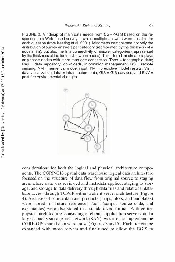
was most strongly correlated with the need for storing topographic data,predictive model results, remotely sensed data, and infrastructure data(roads, utilities, and buildings) (Figure 2). Stakeholders voiced con-cerns about potential problems with data access, ownership, and main-tenance; costs; and redundancy of spatial data management efforts. It
Witkowski, Rich, and Keating 65
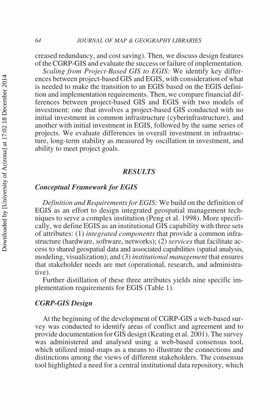
TABLE 1. EGIS Attributes and Implementation Requirements
Dow
nloa
ded
by [
Uni
vers
ity o
f A
rizo
na]
at 1
7:02
18
Dec
embe
r 20
14
was also determined from the results of the consensus tool that spatialdata would need to be accessed in several ways, including direct GISclient software connections to the database, network transfers of filesstored hierarchically in a directory structure, and the Internet through anInternet Map Service (IMS) (Figure 3). In an effort to address stake-holder concerns and institutional data management needs, a five-stepmethodology was adopted to implement the CGRP-GIS (Table 2).
In an effort to address stakeholders’ data and access requirements,the spatial data warehouse was constructed for CGRP-GIS with design
66 JOURNAL OF MAP & GEOGRAPHY LIBRARIES
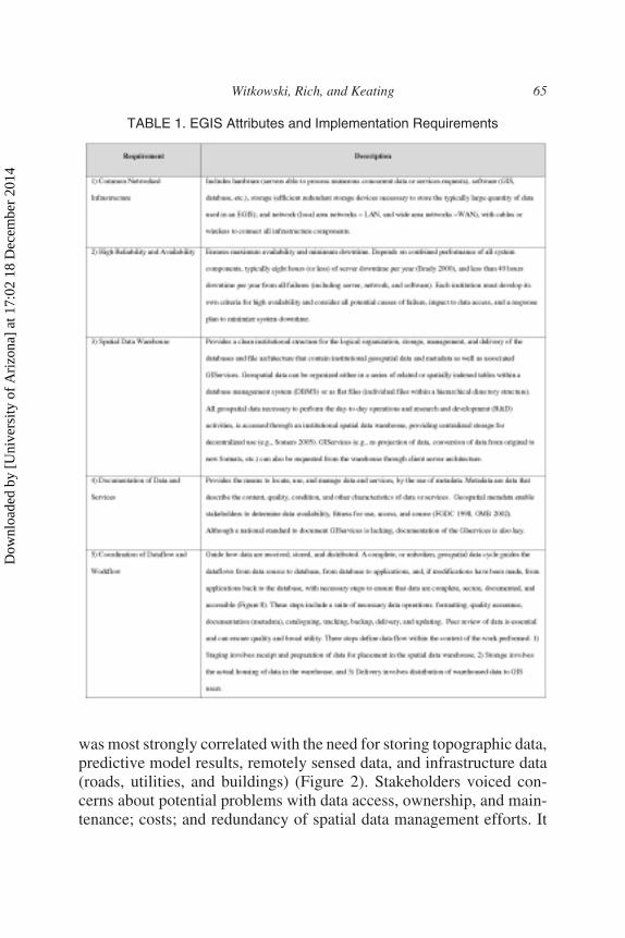
TABLE 1 (continued)
Dow
nloa
ded
by [
Uni
vers
ity o
f A
rizo
na]
at 1
7:02
18
Dec
embe
r 20
14
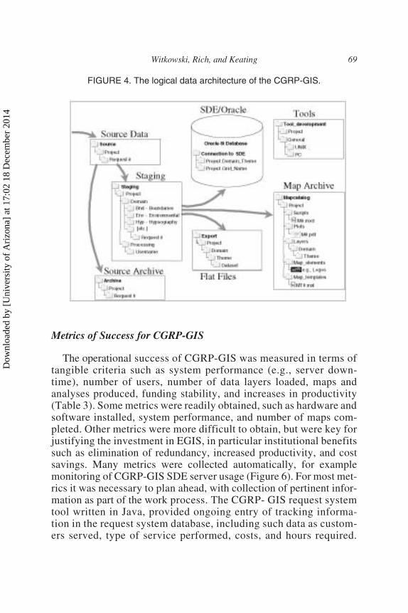
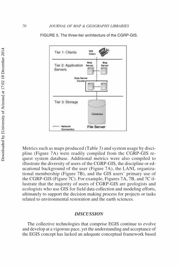
considerations for both the logical and physical architecture compo-nents. The CGRP-GIS spatial data warehouse logical data architecturefocused on the structure of data flow from original source to stagingarea, where data was reviewed and metadata applied, staging to stor-age, and storage to data delivery through data files and relational data-base access through TCP/IP within a client-server architecture (Figure4). Archives of source data and products (maps, plots, and templates)were stored for future reference. Tools (scripts, source code, andexecutables) were also stored in a standardized format. A three-tierphysical architecture–consisting of clients, application servers, and alarge capacity storage area network (SAN)–was used to implement theCGRP-GIS spatial data warehouse (Figures 3 and 5). Each tier can beexpanded with more servers and fine-tuned to allow the EGIS to
Witkowski, Rich, and Keating 67
FIGURE 2. Mindmap of main data needs from CGRP-GIS based on the re-sponses to a Web-based survey in which multiple answers were possible foreach question (from Keating et al. 2001). Mindmaps demonstrate not only thedistribution of survey answers per category (represented by the thickness of anode’s rim), but also the Interconnectivity of answer categories (representedby the thickness of the tie lines between nodes). This filtered mindmap displaysonly those nodes with more than one connection. Topo = topographic data;Rep = data repository, downloads, information management; RS = remotesensing; NM = numerical model input; PM = predictive model results; Vis =data visualization; Infra = infrastructure data; GIS = GIS services; and ENV =post-fire environmental changes.
Dow
nloa
ded
by [
Uni
vers
ity o
f A
rizo
na]
at 1
7:02
18
Dec
embe
r 20
14
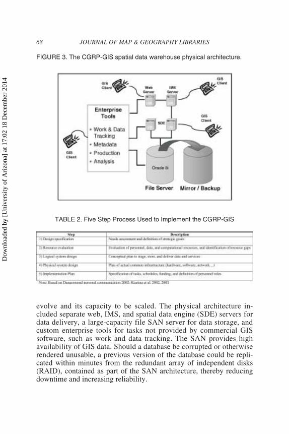
evolve and its capacity to be scaled. The physical architecture in-cluded separate web, IMS, and spatial data engine (SDE) servers fordata delivery, a large-capacity file SAN server for data storage, andcustom enterprise tools for tasks not provided by commercial GISsoftware, such as work and data tracking. The SAN provides highavailability of GIS data. Should a database be corrupted or otherwiserendered unusable, a previous version of the database could be repli-cated within minutes from the redundant array of independent disks(RAID), contained as part of the SAN architecture, thereby reducingdowntime and increasing reliability.
68 JOURNAL OF MAP & GEOGRAPHY LIBRARIES
FIGURE 3. The CGRP-GIS spatial data warehouse physical architecture.
TABLE 2. Five Step Process Used to Implement the CGRP-GIS
Dow
nloa
ded
by [
Uni
vers
ity o
f A
rizo
na]
at 1
7:02
18
Dec
embe
r 20
14
Metrics of Success for CGRP-GIS
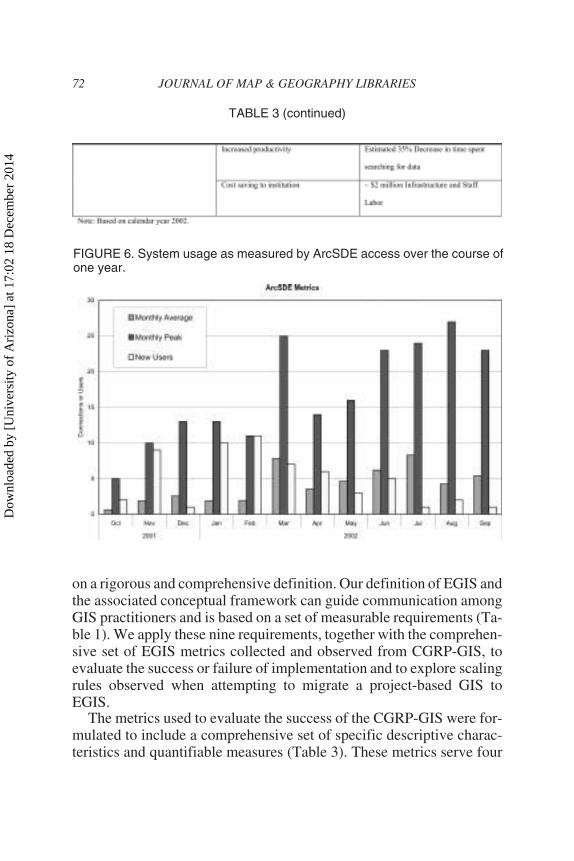
The operational success of CGRP-GIS was measured in terms oftangible criteria such as system performance (e.g., server down-time), number of users, number of data layers loaded, maps andanalyses produced, funding stability, and increases in productivity(Table 3). Some metrics were readily obtained, such as hardware andsoftware installed, system performance, and number of maps com-pleted. Other metrics were more difficult to obtain, but were key forjustifying the investment in EGIS, in particular institutional benefitssuch as elimination of redundancy, increased productivity, and costsavings. Many metrics were collected automatically, for examplemonitoring of CGRP-GIS SDE server usage (Figure 6). For most met-rics it was necessary to plan ahead, with collection of pertinent infor-mation as part of the work process. The CGRP- GIS request systemtool written in Java, provided ongoing entry of tracking informa-tion in the request system database, including such data as custom-ers served, type of service performed, costs, and hours required.
Witkowski, Rich, and Keating 69
FIGURE 4. The logical data architecture of the CGRP-GIS.
Dow
nloa
ded
by [
Uni
vers
ity o
f A
rizo
na]
at 1
7:02
18
Dec
embe
r 20
14
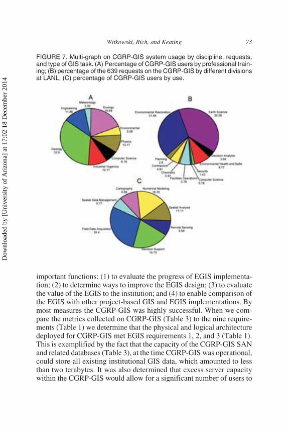
Metrics such as maps produced (Table 3) and system usage by disci-pline (Figure 7A) were readily compiled from the CGRP-GIS re-quest system database. Additional metrics were also compiled toillustrate the diversity of users of the CGRP-GIS, the discipline or ed-ucational background of the user (Figure 7A), the LANL organiza-tional membership (Figure 7B), and the GIS users’ primary use ofthe CGRP-GIS (Figure 7C). For example, Figures 7A, 7B, and 7C il-lustrate that the majority of users of CGRP-GIS are geologists andecologists who use GIS for field data collection and modeling efforts,ultimately to support the decision making process for projects or tasksrelated to environmental restoration and the earth sciences.
DISCUSSION
The collective technologies that comprise EGIS continue to evolveand develop at a vigorous pace, yet the understanding and acceptance ofthe EGIS concept has lacked an adequate conceptual framework based
70 JOURNAL OF MAP & GEOGRAPHY LIBRARIES
FIGURE 5. The three-tier architecture of the CGRP-GIS.
Dow
nloa
ded
by [
Uni
vers
ity o
f A
rizo
na]
at 1
7:02
18
Dec
embe
r 20
14
Witkowski, Rich, and Keating 71
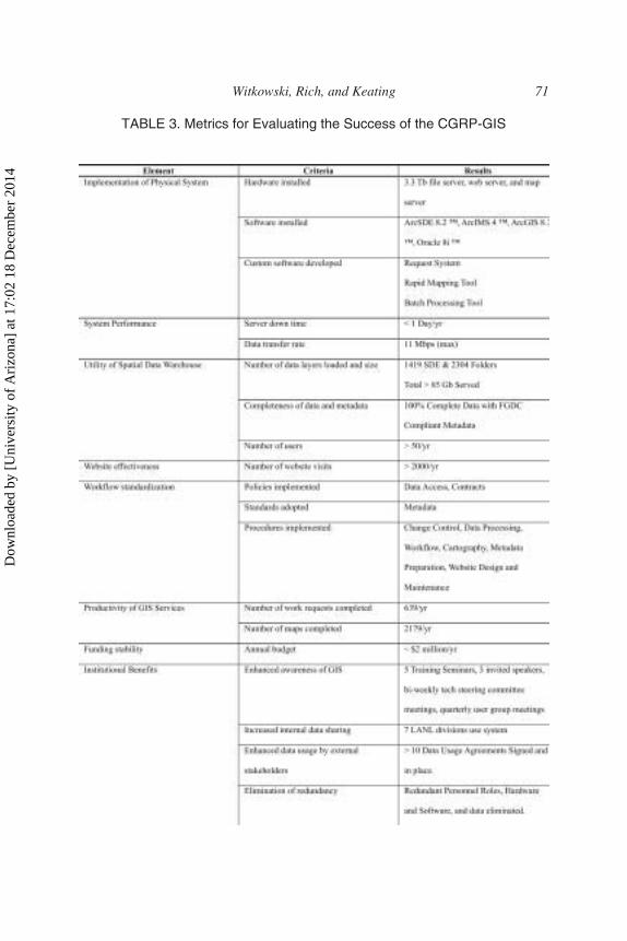
TABLE 3. Metrics for Evaluating the Success of the CGRP-GIS
Dow
nloa
ded
by [
Uni
vers
ity o
f A
rizo
na]
at 1
7:02
18
Dec
embe
r 20
14
on a rigorous and comprehensive definition. Our definition of EGIS andthe associated conceptual framework can guide communication amongGIS practitioners and is based on a set of measurable requirements (Ta-ble 1). We apply these nine requirements, together with the comprehen-sive set of EGIS metrics collected and observed from CGRP-GIS, toevaluate the success or failure of implementation and to explore scalingrules observed when attempting to migrate a project-based GIS toEGIS.
The metrics used to evaluate the success of the CGRP-GIS were for-mulated to include a comprehensive set of specific descriptive charac-teristics and quantifiable measures (Table 3). These metrics serve four
72 JOURNAL OF MAP & GEOGRAPHY LIBRARIES
TABLE 3 (continued)
FIGURE 6. System usage as measured by ArcSDE access over the course ofone year.
Dow
nloa
ded
by [
Uni
vers
ity o
f A
rizo
na]
at 1
7:02
18
Dec
embe
r 20
14
important functions: (1) to evaluate the progress of EGIS implementa-tion; (2) to determine ways to improve the EGIS design; (3) to evaluatethe value of the EGIS to the institution; and (4) to enable comparison ofthe EGIS with other project-based GIS and EGIS implementations. Bymost measures the CGRP-GIS was highly successful. When we com-pare the metrics collected on CGRP-GIS (Table 3) to the nine require-ments (Table 1) we determine that the physical and logical architecturedeployed for CGRP-GIS met EGIS requirements 1, 2, and 3 (Table 1).This is exemplified by the fact that the capacity of the CGRP-GIS SANand related databases (Table 3), at the time CGRP-GIS was operational,could store all existing institutional GIS data, which amounted to lessthan two terabytes. It was also determined that excess server capacitywithin the CGRP-GIS would allow for a significant number of users to
Witkowski, Rich, and Keating 73
FIGURE 7. Multi-graph on CGRP-GIS system usage by discipline, requests,and type of GIS task. (A) Percentage of CGRP-GIS users by professional train-ing; (B) percentage of the 639 requests on the CGRP-GIS by different divisionsat LANL; (C) percentage of CGRP-GIS users by use.
Dow
nloa
ded
by [
Uni
vers
ity o
f A
rizo
na]
at 1
7:02
18
Dec
embe
r 20
14
be provided with simultaneous access to the CGRP-GIS and that all re-quired services could be delivered through the client-server architecture(Figures 3 and 5). As more users were added to CGRP-GIS there was anincrease in the amount of data stored. This was in part due to thediversity of users of the CGRP-GIS (Figure 7C) and the changing needsof other project-based GIS utilizing CGRP-GIS.
When we compare metrics of documentation and metadata, we findthat they are not dependent on additional users added to CGRP-GIS. Wedetermine that the standards, procedures, and policies (Table 3), to-gether with tight coupling of dataflow and workflow, along with thedocumentation of all data and services developed for CGRP-GIS, couldeasily have been adapted to guide all EGIS users at LANL; and there-fore the effort met EGIS requirements four, five, and seven (Table 1).
While informal ad hoc personal exchanges are crucial to data shar-ing and collaboration (Pinto and Onsrud 1995; Nedovic-Budic andPinto 1999a, 1999b, 2000, 2001; Nedovic-Budic et al. 2004), formal-ized processes and procedures for data exchange among users producea better flow of information because of a better understanding of indi-vidual responsibilities and expectations. Effective data sharing withinthe CGRP-GIS, through the establishment of a complete geospatial datacycle (Figure 1) ensured that all necessary elements and processes of anEGIS were present. For example, meaningful sharing of data is difficultwhen metadata are lacking or incomplete, when data are not well orga-nized, and when an effective delivery system using common architec-ture is not in place. Somers (2002) suggested that institutions shouldview geospatial data as a “corporate asset” and protect it as such. The in-tegrity of the geospatial data cycle is the fundamental means to protectthese EGIS assets, and our request system allows for the required track-ing of workflow within the EGIS. This tracking provides a convenientlyavailable record of what processes have been completed and whetheradditional work is required. This method is analogous to “cradle tograve” tracking, is instead “source to archive.”
Additional comparison between the CGRP-GIS metrics and EGISrequirements illustrate those metrics that did not meet the EGIS require-ments, specifically EGIS requirements eight and nine regarding institu-tional financing and leadership (Table 1). Although initial project-levelinvestment in CGRP-GIS was substantial (Table 3), the lack of institu-tional financing after CGRP-GIS funding ceased, hindered the ability ofCGRP-GIS to maintain a critical threshold of staff to support the re-quired roles (Table 4) necessary to maintain an EGIS. In particular,
74 JOURNAL OF MAP & GEOGRAPHY LIBRARIES
Dow
nloa
ded
by [
Uni
vers
ity o
f A
rizo
na]
at 1
7:02
18
Dec
embe
r 20
14
Internet GIS, web administration, and database administration lackedadequate funding and could no longer be supported.
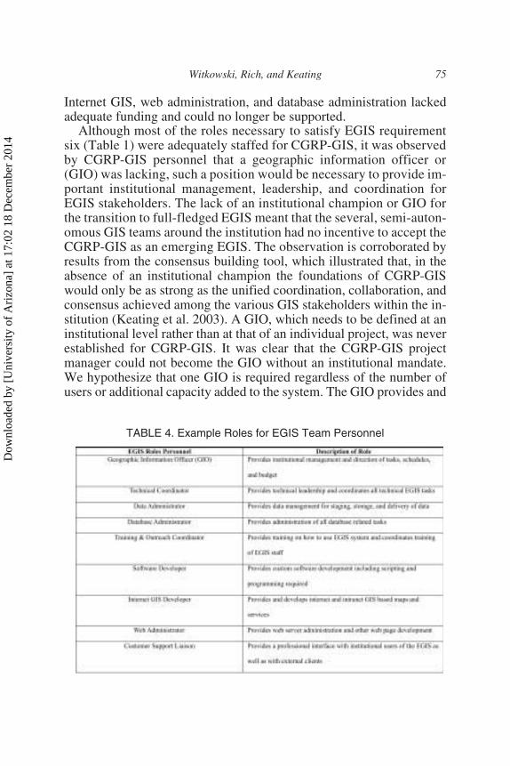
Although most of the roles necessary to satisfy EGIS requirementsix (Table 1) were adequately staffed for CGRP-GIS, it was observedby CGRP-GIS personnel that a geographic information officer or(GIO) was lacking, such a position would be necessary to provide im-portant institutional management, leadership, and coordination forEGIS stakeholders. The lack of an institutional champion or GIO forthe transition to full-fledged EGIS meant that the several, semi-auton-omous GIS teams around the institution had no incentive to accept theCGRP-GIS as an emerging EGIS. The observation is corroborated byresults from the consensus building tool, which illustrated that, in theabsence of an institutional champion the foundations of CGRP-GISwould only be as strong as the unified coordination, collaboration, andconsensus achieved among the various GIS stakeholders within the in-stitution (Keating et al. 2003). A GIO, which needs to be defined at aninstitutional level rather than at that of an individual project, was neverestablished for CGRP-GIS. It was clear that the CGRP-GIS projectmanager could not become the GIO without an institutional mandate.We hypothesize that one GIO is required regardless of the number ofusers or additional capacity added to the system. The GIO provides and
Witkowski, Rich, and Keating 75
TABLE 4. Example Roles for EGIS Team Personnel
Dow
nloa
ded
by [
Uni
vers
ity o
f A
rizo
na]
at 1
7:02
18
Dec
embe
r 20
14
promotes the vision for the EGIS, and the presence of multiple GIOscontributes to a lack of coherence in the institutional vision for GIS. TheCGRP-GIS supports the idea that EGIS requirements one through seven(Table 1) could develop initially at the bottom team level of manage-ment or be mandated from the top, but that EGIS requirements eight andnine (Table 1) could only develop from an institutional mandate at thehighest levels of the institution.
The CGRP-GIS metrics represent a starting point toward developinga truly comprehensive taxonomy of EGIS metrics. There is a need tostandardize metrics so different EGIS implementations can be mean-ingfully compared against EGIS requirements. The value of this initialtaxonomy of metrics goes beyond EGIS, in that similar metrics could beapplied to evaluate the success of any integrated GIS design implemen-tation.
In addition to metrics about users and the tangible elements listedin Table 3, several other less tangible contributions were made at theinstitutional level in the process of developing CGRP-GIS. Our needsassessment and design efforts raised awareness among users of the im-portance and interrelationships of GIS at LANL in the areas of facilitiesand operations, emergency management, environmental monitoringand restoration, and earth science research. At the same time, Federalstandards for metadata (FGDC 1998) were being implemented acrossthe DOE complex (e.g., Bleakly and Lee 2001; Rush 2001), and theconcepts for a metadata clearinghouse for fire rehabilitation and envi-ronmental restoration data, consistent with national standards, were tothe institution as a whole. Progress made in establishing efficient spatialinformation management focused scrutiny on the inefficiency, redun-dancy, and incompatibility of the independent project-based GIS struc-ture within LANL (Keating et al. 2002, 2003).
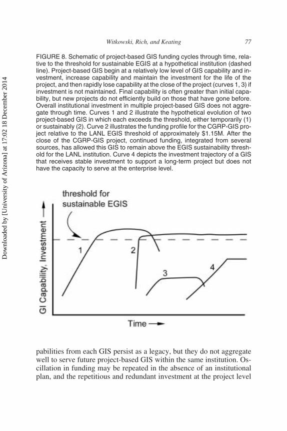
Beyond comparing metrics to requirements it is also important toidentify the important differences between a project-based GIS andEGIS. One of the most significant differences between project-basedGIS and EGIS is that of financial stability. The trajectory of investmentand GIS capability for an individual project-based GIS (Figure 8) mighttypically begin at a low level, rapidly build to a peak, be sustained forsome period of time, and then decay when the project ends or issuperceded. In the case of CGRP-GIS there was a large investment dur-ing a two-year period with no gradual increase in investment (Figure 8,curve 2). While there may be a legacy of GI capability remaining at theend of each project, it may not be entirely available to the next pro-ject-based GIS, which then must reinvest during start-up. Remnant ca-
76 JOURNAL OF MAP & GEOGRAPHY LIBRARIES
Dow
nloa
ded
by [
Uni
vers
ity o
f A
rizo
na]
at 1
7:02
18
Dec
embe
r 20
14
pabilities from each GIS persist as a legacy, but they do not aggregatewell to serve future project-based GIS within the same institution. Os-cillation in funding may be repeated in the absence of an institutionalplan, and the repetitious and redundant investment at the project level
Witkowski, Rich, and Keating 77
FIGURE 8. Schematic of project-based GIS funding cycles through time, rela-tive to the threshold for sustainable EGIS at a hypothetical institution (dashedline). Project-based GIS begin at a relatively low level of GIS capability and in-vestment, increase capability and maintain the investment for the life of theproject, and then rapidly lose capability at the close of the project (curves 1, 3) ifinvestment is not maintained. Final capability is often greater than initial capa-bility, but new projects do not efficiently build on those that have gone before.Overall institutional investment in multiple project-based GIS does not aggre-gate through time. Curves 1 and 2 illustrate the hypothetical evolution of twoproject-based GIS in which each exceeds the threshold, either temporarily (1)or sustainably (2). Curve 2 illustrates the funding profile for the CGRP-GIS pro-ject relative to the LANL EGIS threshold of approximately $1.15M. After theclose of the CGRP-GIS project, continued funding, integrated from severalsources, has allowed this GIS to remain above the EGIS sustainability thresh-old for the LANL institution. Curve 4 depicts the investment trajectory of a GISthat receives stable investment to support a long-term project but does nothave the capacity to serve at the enterprise level.
Dow
nloa
ded
by [
Uni
vers
ity o
f A
rizo
na]
at 1
7:02
18
Dec
embe
r 20
14
may exceed the costs necessary to maintain an EGIS. Development ofsome of the larger project-based GISs, such as CGRP-GIS, may (for atime) exceed the threshold of investment and capability necessary tosustain an EGIS for the institution (Figure 8, curves 1 and 2). In the caseof CGRP-GIS the original investments in physical and logical infra-structure have persisted to continue to serve the institution to date, de-spite the fact that the original CGRP investment has long since faded. Insuch cases, the resulting window of opportunity in the short run may beleveraged to serve as the seed to develop an EGIS, but only with cham-pions in senior management and sufficient long-term financial invest-ment to sustain it. Nonetheless, CGRP-GIS provided the impetus for thecreation of the current GISLab and served as a model for othersembarking on EGIS implementations.
The stability of an enterprise GIS, in contrast to the oscillations of pro-ject-based GIS, has other benefits as well. Data developed in individualproject-based GIS may have institutional value but will be essentially lostin the absence of a central data warehouse and metadata clearinghouse.Future project-based GIS will not realize the benefits of efficient accessto centralized data and documentation and will instead depend on ad hocrelationships to find and exchange data. Investments in personnel andtraining may disappear at the conclusion of an individual project ratherthan persisting as part of an institutional plan for GIS capability. Like-wise, in the absence of a comprehensive plan, GI tools and services de-veloped for an isolated GIS project must repeatedly be reproduced byfuture efforts. In short, project-based GIS can be performed more simply,efficiently, and with more lasting value to the institution if they are exe-cuted within the framework of an EGIS. The eventual result will be a new“collective geographic awareness,” whereby both GIS specialists andnon-specialists can access a wealth of map-based data and analysis capabil-ities that are continuously available with minimal assistance, for the benefitof day-to-day institutional operations, research, and decision making.
CONCLUSION
Many traditional project-based GIS are now challenged with provid-ing an enterprise GIS solution–an EGIS–in order to realize greater effi-ciency and cost savings through investment in shared infrastructure. Weview EGIS as a phenomenon whose time has arrived. Now that keytechnological components are widely available–high-speed networks,fast computers, and sophisticated GIS analysis and visualization capa-
78 JOURNAL OF MAP & GEOGRAPHY LIBRARIES
Dow
nloa
ded
by [
Uni
vers
ity o
f A
rizo
na]
at 1
7:02
18
Dec
embe
r 20
14
bilities–we are ready for the next stage in the evolution of GIS, imple-mentation of GIS at the enterprise level. Our conceptual framework forEGIS, based on a rigorous definition and specific requirements, canhelp guide the transition and facilitate communication among stake-holders. EGIS design must include by definition integrated compo-nents and services, and institutional management. The success ofEGIS can be defined by the recognition and successful completion ofthe nine implementation requirements and most notably can fail if thereis a lack of institutional funds and management support. A standardizedset of metrics on EGIS enables meaningful comparison between EGISrequirements and their implementation. Importantly, a project-basedGIS completed within an EGIS, as compared to an isolated project-based GIS, can expectantly devote more resources to project goalsrather than to infrastructure (cyberinfrastructure), to have greater lon-gevity, and to provide many benefits to the institution itself.
AUTHORS NOTE
The authors thank Marcia Jones, Richard Kelley, Thomas Riggs, and Doug Waltherfor their valuable input. The manuscript benefited from thoughtful reviews by MichaelGoodchild, Jordan Hastings, Bruce Robinson, Randy Mynard, and Cathy Wilson.
Los Alamos National Laboratory, an affirmative action/equal opportunity em-ployer, is operated by the Los Alamos National Security, LLC for the National NuclearSecurity Administration of the U.S. Department of Energy under contract DE-AC52-06NA25396. By acceptance of this article, the publisher recognizes that the U.S. Gov-ernment retains a nonexclusive, royalty-free license to publish or reproduce the pub-lished form of this contribution, or to allow others to do so, for U.S. Governmentpurposes. Los Alamos National Laboratory requests that the publisher identify this ar-ticle as work performed under the auspices of the U.S. Department of Energy. LosAlamos National Laboratory strongly supports academic freedom and a researcher’sright to publish; as an institution, however, the Laboratory does not endorse the view-point of a publication or guarantee its technical correctness.
REFERENCES
Atkins, D. E., K. K. Droegemeier, S. I. Feldman, H. Garcia-Molina, M. L. Klein, D. G.Messerschmitt, P. Messina, J. P. Ostriker, and M. H. Wright. 2003. RevolutionizingScience And Engineering Through Cyberinfrastrucure: Report Of The NationalScience Foundation Blue-Ribbon Advisory Panel On Cyberinfrastructure. In Na-tional Science Foundation Report.
Barnes, S., and F. Sietzen. 2004. Congress Gets A Geospatial Progress Report. InGeospatial Solutions.
Witkowski, Rich, and Keating 79
Dow
nloa
ded
by [
Uni
vers
ity o
f A
rizo
na]
at 1
7:02
18
Dec
embe
r 20
14
Bleakly, D., and R. Lee. 2001. Issues for consideration for long-term spatial data ar-chiving. Paper read at 13th DOE Technology Information Exchange (TIE) Meet-ing, November 13, 2001, at Albquerque, NM.
Bonham-Carter, G. F. 1994. Geographic Information Systems For Geoscientists: Mod-eling With GIS. Pergamon/Elsevier Science.
Brady, D. 2000. Designing GIS For High Availability And High Performance. Paperread at The Fourth International Conference/Exhibition on High PerformanceComputing in the Asia-Pacific Region, May 14-17, 2000, at Beijing, China.
Butler, J. A., and K. J. Dueker. 2001. Implementing The Enterprise GIS In Transporta-tion Database Design. URISA Journal 13 (1):17-28.
Carr, T.R., P.M. Rich, and J.D. Bartley. 2007. The NATCARB Geoportal: LinkingDistributed Data from the Carbon Sequestration Regional Partnerships. Journal ofMap and Geography Libraries 4(1): 131-147.
Caron, C., and Y. Bedard. 2002. Lessons Learned From Case Studies On The Imple-mentation Of Geospatial Information Technologies. Journal of the Urban and Re-gional Information Systems Association (14):17-36.
Coiner, J. C. 1997. Transferability of the Quatar Enterprise GIS Model: Experience inVietnam and Jamaica. Paper read at GIS/GPS Conference ’97, March 2-4, 1997, atDoha, Qatar.
Dangermond, J. 2002. Personal Communication.Dueker, K. J., and J. A. Butler. 2000. A Geographic Information System Framework
For Transportation Data Sharing. Transportation Research Part C: EmergingTechnologies (8):13-36.
Estrin, D., W. Michener, and G. Bonito. 2003. Environmental CyberinfrastructureNeeds For Distributed Sensor Networks. A Report from the National Science Foun-dation Sponsored Workshop, 12-14 August 2003, Scripps Institute of Oceanogra-phy.
Federal Geographic Data Committee. 1998. Content Standard For Digital GeospatialMetadata.
Fletcher, D. R. 1999. The Interoperable Enterprise. Enterprise GIS:7-16.Goodchild, M.F., P. Fu, and P.M. Rich. 2007. Sharing Geographic Information: An As-
sessment Of The Geospatial One-Stop. Annals of the Association for American Ge-ographers. 97(2): 250-266.
Keating, G. N., S. Rasmussen, and M. Raven. 2001. Consensus-Building Tools ForPost-Wildfire GIS Design. Los Alamos, NM: Los Alamos National Laboratory.
Keating, G. N., P. M. Rich, M. S. Witkowski, C. M. Batts, J. H. Deming, M. A. Jones,S. P. Linger, C. R. Mynard, T. L. Riggs, and D. Walther. 2002. Challenges ForEGIS In Post-Wildfire Hazard Mitigation And Emergency Management. Los Alamos,NM: Los Alamos National Laboratory.
Keating, G. N., P. M. Rich, and M. S. Witkowski. 2003. Challenges for Enterprise GIS.URISA Journal 15 (2):25-39.
Lembo., A. J. Jr. 1999. Implementing Enterprise-Wide GIS for Government: An Ex-ample from Nassau County, New York. Enterprise GIS:62-79.
Lloyd, W. A. 2000. Beyond Enterprise GIS. Paper read at Twentieth Annual ESRI In-ternational User Conference, June 26-30, 2000, at San Diego, CA.
80 JOURNAL OF MAP & GEOGRAPHY LIBRARIES
Dow
nloa
ded
by [
Uni
vers
ity o
f A
rizo
na]
at 1
7:02
18
Dec
embe
r 20
14
Maguire, D. J., and P. A. Longley. 2005. The Emergence Of Geoportals And Their Role InSpatial Data Infrastructures. Computers, Environment, and Urban Systems 29:3-14.
Mynard, C.R., G.N. Keating, P.M. Rich, and D. Bleakly. 2003. GIS emergency supportfor the May 2000 Cerro Grande Wildfire, Los Alamos, New Mexico. Los AlamosNational Laboratory Report LA-14007-MS.
Mynard, C.R., G.N. Keating, and P.M. Rich. 2005. GIS emergency support for the May2000 Cerro Grande Wildfire, Los Alamos, NM. Journal of Emergency Manage-ment 3:19-28.
Mynard, C.R., G.N. Keating, and P.M. Rich. 2007. Mutualism among GIS communitypays off in a New Mexico fire emergency. Best Practices for Success: GIS for Fed-eral Progress and Accountability. ESRI Press, Redlands, CA. In Press.
Nedovic-Budic, Z., and J.K. Pinto. 1999a. Understanding Interorganizational GIS Ac-tivities: A Conceptual Framework. Journal of the Urban and Regional InformationSystem Association 1(1): 53-64.
Nedovic-Budic, Z., and J. K. Pinto, 1999b, Interorganizational GIS: Issues And Pros-pects. Annals of Regional Science 33:183-195.
Nedovic-Budic, Z., and J. K. Pinto. 2001. Organizational (soft) GIS Interoperability:Lessons From The U.S. International Journal of Applied Earth Observation andGeoinformation 3(3): 290-298.
Nedovic-Budic, Z., and J. K. Pinto. 2000. Information Sharing In An Interorganiza-tional GIS Environment. Environment and Planning B: Planning and Design27:455-474.
Nedovic-Budic, Z., J.K. Pinto, and L. Warnecke. 2004. GIS Database Developmentand Exchange: Interaction Mechanisms and Motivations. Journal of the Urban andRegional Information System Association 16(1): 15-29.
Office of Management and Budget. 2002. Coordination Of Geographic InformationAnd Related Spatial Data Activities. http://www.whitehouse.gov/omb/circulars/a016/a016_rev.html#2b2 (accessed February 5, 2007).
Oppmann, R. S. 1999. An Organizational Model for Successful Enterprise GIS. Enter-prise GIS:44-52.
Peng, Z. R., J. N. Groff, and K. J. Dueker. 1998. An Enterprise GIS Database DesignFor Agency-Wide Transit Applications. Journal of the Urban and Regional Infor-mation Systems Association (10):46-55.
Pinto, J. K., and H. J. Onsrud. 1995. Sharing Geographic Information Across Organiza-tional Boundaries: A Research Framework. In Sharing Geographic Information,eds. H. J. Onsrud and G. Rushton, 44-64. New Brunswick, NJ: Center for UrbanPolicy Research, Rutgers.
Rich, P.M., J.S. Bollinger, B. Bhaduri, and D.R. Bleakly. 2007. Perspective On Depart-ment of Energy Geospatial Science: Past, Present, and Future. Journal of Map andGeography Libraries 4(1): 29-58.
Rich, S., A. Das, and C. Kroot. 2001. Spatial Data Management In An Enterprise GIS.Paper read at Twenty-first Annual ESRI International User Conference, July 9-13,2001, at San Diego, CA.
Rush, S. F. 2001. Improving Access to Hanford Geospatial. Paper read at 13th DOETechnical Information Exchange (TIE) Meeting, November 13, 2001, at Albuquer-que, NM.
Witkowski, Rich, and Keating 81
Dow
nloa
ded
by [
Uni
vers
ity o
f A
rizo
na]
at 1
7:02
18
Dec
embe
r 20
14
Somers, R. 2002. Managing Your Move To Enterprise GIS. Geospatial Solutions(12):22-26.
Somers, R. 2005. Achieving Enterprise GIS. Geospatial Solutions (15):37-40.Witkowski, M. S., P. M. Rich, and G. N. Keating. 2003. A Prototype for Enterprise
GIS. Los Alamos, NM: Los Alamos National Laboratory.Witkowski, M. S., P. M. Rich, G. N. Keating, S. P. Linger, and T. L. Riggs. 2002. Spa-
tial Data Warehouse Design for Enterprise GIS. Paper read at GIScience 2002, Sec-ond International Conference on Geographic Information Science, September 25-28, 2002, at Boulder, CO.
Received: August 2, 2006Revised: September 29, 2006
Accepted: December 14, 2006
doi:10.1300/J230v04n01_04
82 JOURNAL OF MAP & GEOGRAPHY LIBRARIES
For FACULTY/PROFESSIONALS with journal subscriptionrecommendation authority for their institutional library . . .
Please send me a complimentary sample of this journal:
(please write complete journal title here–do not leave blank)
If you have read a reprint or photocopy of this article, would you like tomake sure that your library also subscribes to this journal? If you havethe authority to recommend subscriptions to your library, we will send youa free complete (print edition) sample copy for review with your librarian.
1. Fill out the form below and make sure that you type or write out clearly both the nameof the journal and your own name and address. Or send your request via e-mail [email protected] including in the subject line “Sample Copy Request” andthe title of this journal.
2. Make sure to include your name and complete postal mailing address as well as yourinstitutional/agency library name in the text of your e-mail.
[Please note: we cannot mail specific journal samples, such as the issue in which a specific article appears.Sample issues are provided with the hope that you might review a possible subscription/e-subscription withyour institution's librarian. There is no charge for an institution/campus-wide electronic subscriptionconcurrent with the archival print edition subscription.]
I will show this journal to our institutional or agency library for a possible subscription.Institution/Agency Library: ______________________________________________
Name: _____________________________________________________________
Institution: __________________________________________________________
Address: ___________________________________________________________
City: ____________________Return to: Sample Copy Department,The Haworth Press, Inc.,
10 Alice Street, Binghamton, NY 13904-1580
State: __________ Zip: ____________________
Dow
nloa
ded
by [
Uni
vers
ity o
f A
rizo
na]
at 1
7:02
18
Dec
embe
r 20
14