Embed Size (px)
Citation preview
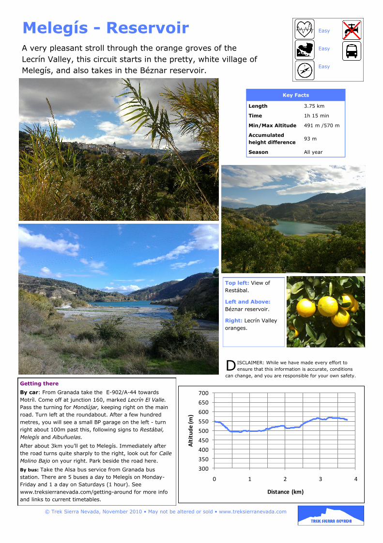
Melegís - Reservoir Easy
Easy
Easy
Key Facts
Length 3.75 km
Time 1h 15 min
Min/Max Altitude 491 m /570 m
Accumulated
height difference 93 m
Season All year
300
350
400
450
500
550
600
650
700
0 1 2 3 4
Alt
itu
de
(m)
Distance (km)
Getting there
By car: From Granada take the E-902/A-44 towards
Motríl. Come off at junction 160, marked Lecrín El Valle.
Pass the turning for Mondújar, keeping right on the main
road. Turn left at the roundabout. After a few hundred
metres, you will see a small BP garage on the left - turn
right about 100m past this, following signs to Restábal,
Melegís and Albuñuelas.
After about 3km you’ll get to Melegís. Immediately after
the road turns quite sharply to the right, look out for Calle
Molino Bajo on your right. Park beside the road here.
By bus: Take the Alsa bus service from Granada bus
station. There are 5 buses a day to Melegís on Monday-
Friday and 1 a day on Saturdays (1 hour). See
www.treksierranevada.com/getting-around for more info
and links to current timetables.
D ISCLAIMER: While we have made every effort to
ensure that this information is accurate, conditions
can change, and you are responsible for your own safety.
© Trek Sierra Nevada, November 2010 • May not be altered or sold • www.treksierranevada.com
A very pleasant stroll through the orange groves of the
Lecrín Valley, this circuit starts in the pretty, white village of
Melegís, and also takes in the Béznar reservoir.
Top left: View of
Restábal.
Left and Above:
Béznar reservoir.
Right: Lecrín Valley
oranges.
1. Take the track
on the opposite
side of the main
road from Calle
Molino Bajo.
Follow it down
towards the
reservoir,
keeping left.
You’ll
immediately get
great views of
the reservoir and the village of Restábal.
2. At the bottom of the hill, turn right
onto a road going around the reservoir.
3. You need to cross a branch of the river
- the easiest place is a little to the right
of the road.
4. Follow the road alongside the river and
up to the
right onto
the main
road bridge.
Take the GR-
7 path, which
is signposted
to your left.
The next
section is
marked with
the red and
white GR-7
signing.
Shortly
afterwards,
turn right at a T-junction (marked).
5. Turn left onto a footpath (marked).
The path takes you down towards the
river. When you get to the river turn right
and carry on along the near bank (not
marked).
6. Turn right onto the road (marked). In
the following uphill section, keep left
(generally marked).
7. Turn right at a T-junction.
8. When you reach the outskirts of
Melegís, you’ll see a GR-7 signpost
pointing back towards Restábal. At this
point you leave the GR-7 route,
continuing straight ahead into the village.
Follow the road straight on through the
village, heading in the direction of the
church. You will meet a bigger road,
where there is a sign pointing to
Lavadero. Keep going straight on here.
9. You’ll soon get to the Lavadero or
traditional washing place.
After this, turn right into Calle Naranjo.
At the end of the road, turn left, then
take a right into Calle El Rosal. Follow
this round then take a left out to the
starting point by the main road.
© Trek Sierra Nevada, November 2010 • www.treksierranevada.com
© INSTITUTO GEOGRÁFICO NACIONAL DE ESPAÑA, Original Scale 1:25,000


![Gear Pump Units - SKF · 1-1202-EN Medium Flow rate Reservoir capacity Reservoir material Order No. 1) Oil Fluid grease [l/min] [litres] Plastic Metall Design features / Special technical](https://img.pdfslide.us/doc/110x75/5f0f04427e708231d44212ad/gear-pump-units-skf-1-1202-en-medium-flow-rate-reservoir-capacity-reservoir-material.jpg)