Embed Size (px)
Citation preview

Copyright © 2009 PHASE ONE INC. All rights reserved
Record Search with
Risk Assessment (Meets or exceeds SBA SOP 50 10 (5) standard)
Site Location: 2680 Walnut Ave
Tustin, CA 92780
Client:
Phase One Inc.
PHASE ONE INC .
THE NATIONWIDE ENVIRONMENTAL SPECIALISTS "Setting the Due Diligence Industry Standard”
www.phasei.com (800-524-8877)

1 Copyright © 2009 PHASE ONE INC. All rights reserved SAMPLE REPORT
SBA-Record Search with
Risk Assessment (Premium)
Executive Summary
Environmental Risk Determination: High Low (For the Subject Site)
This Sample report presents the results of the Record Search with Risk Assessment
(RSRA) prepared by PHASE ONE INC. (POI) for the subject site located at:2680 Walnut
Ave, Tustin, CA 92780 (see cover of report for Site Location Map). The RSRAp was
undertaken at the request of Lender Phase One Inc. in accordance with POI’s Standard
Terms and Conditions and as outlined in the Limitations and Liabilities below for Project
No 31423731.
The conclusions, of this RSRA report are based upon the following:
• Fully Completed Environmental Questionnaire(s) supplied to POI from the
Lender, and/or the borrower.
• A review of the subject properties History through reasonably ascertainable
historical fire insurance maps and/or historical city directories.
• A review of the LenderCheck Environmental Records Search (LenderCheck, a
one-mile radius regulatory database search). LenderCheck report attached.
• Overseen and/or Reviewed by an Environmental Professional as defined by
US Environmental Protection Agency’s All Appropriate Inquiry (AAI).
Site Facts:
Address(es) Provided by Client: 2680 Walnut Ave, Tustin, CA 92780
Current Owner(s): Tustin Business Group
Current Use: Office for Web design services|
Current Occupants: Webs R Us
Identified Historical Use(s): Accounting services, Legal services, Real estate office
Persons Responsible for completing the Environmental Questionnaires:
Lender Name: Phase One Tele # (949) 222-0000 FAX/E-mail: Jon@$$bank.com
Owner/Borrower:Name:Clint Red Tele # (714) 333-4422 FAX/E-mail:[email protected]

1 Copyright © 2009 PHASE ONE INC. All rights reserved SAMPLE REPORT
SBA-Record Search with
Risk Assessment (Premium)
Conclusions and Recommendations
Environmental Risk Determination: High Low
Summary of Environmental Risk Determination
Environmental Professional Certification (EPC)
PHASE ONE INC’s. Environmental Professional [(as defined by US Environmental Protection Agency’s All Appropriate Inquiry (AAI)] hereby, certifies that this report has been overseen by the identified Environmental Professional below. This report is fully covered (based solely on the policy form coverage’s) by PHASE ONE INC’s insurance
policies up to, but not exceeding the total insured levels ($2 million).
Dated: June 27, 2008
Research
Area
High
Risk
Low
Risk
Comments
Questionnaire
SBA/Lender
� No identified risks.
Questionnaire
Owner/Borrower
� No identified risks
Historical Source
Fire Ins. Map � No identified risks.
Years Reviewed: 1970, 1980, 1990
Historical Source
City Directories � No identified risks
Years Reviewed: 1958, 1990,1995, 2000, 2005
LenderCheck � No identified risks.
(see attached Lender-Check√ report)
Overall
Environmental Risk
� The environmental risk for the subject site is low; no further investigation is recommended at this time.

Copyright 2008 PHASE ONE INC. All Rights Reserved 2620 Walnut Ave, Suite A, Tustin, CA 92780 Tel (714) 669-8055 · Fax (714) 669-8025
Historical Research For
SBA-Record Search with Risk Assessment
Based on the review of reasonably ascertainable city directories and/or fire insurance maps, the following are the known historical uses and their time spans for the subject site, located at 2680 Walnut Avenue, Tustin, California, extending back to first development (if available). Known Historical Uses:
Property Use Begin Date End Date High
Risk
Low
Risk
None listed 1958 Current X
Environmental Professional Certification (EPC) PHASE ONE INC’s. Environmental Professional (as defined by US Environmental Protection Agency’s All Appropriate Inquiry (AAI)) hereby, certifies that this research has been overseen by the below identified Environmental Professional and prepared in accordance with the ASTM E 1528-06 standards. This report is fully covered (based solely on the policy form coverage’s) by PHASE ONE INC’s insurance policies up to, but not exceeding the total insured levels ($2 million).

2 Copyright © 2009 PHASE ONE INC. All rights reserved SAMPLE REPORT
SBA-Record Search with
Risk Assessment (Premium)
Limitations and Liabilities
SBA SOP 50 10 (5) standard AND NON-SCOPE CONSIDERATIONS
This report meets guidelines set by SBA SOP 50 10 (5) standard, Standard Practices for Records Search with Risk Assessment(RSwRA). The Records Search with Risk Assessment cannot wholly eliminate uncertainty regarding the potential for recognized environmental conditions and/or concerns, but is intended to reduce uncertainty regarding such potential within reasonable cost and time constraints. Environmental issues or concerns might exist at the property, which are outside of the scope of this practice. Such non-scope considerations that are not addressed by this Records Search with Risk Assessment include asbestos, radon, lead-based paint, lead in drinking water and wetlands, etc.
NO TESTING
This Records Search with Risk Assessment does not include any testing or sampling of materials of any kind what-so-ever, such as soil, water, air, or building materials, nor sampling to determine the existence of radon, lead-containing products, or lead-contaminated potable water.
CONFIDENTIALITY
This Records Search with Risk Assessment has been prepared for the sole use of the Client as limited by the terms of the proposal and contract between the Client and PHASE ONE INC. The report is confidential, and no other person or entity may rely on this assessment or any part thereof without the written consent of PHASE
ONE INC. Such third party consent will require payment of a fee to PHASE ONE INC. This report meets guidelines set by SBA SOP 50 10 (5) standard, Standard Practices for Records Search with risk Assessment(RSwRA). The Records Search with Risk Assessment cannot wholly eliminate uncertainty regarding the potential for environmental concerns, but is intended to reduce uncertainty regarding such potential within reasonable cost and time constraints.
RELIANCE ON INFORMATION
PHASE ONE INC. will rely on information provided by others (such as questionnaires) and is not required to verify that information is accurate and/or correct in anyway unless PHASE ONE INC. has actual knowledge that certain information is incorrect, or unless it is obvious that the information is incorrect based on other information obtained during the assessment.
LIMITATIONS
It is understood that the preparation of this RSwRA by PHASE ONE INC. has been performed within the limits of the contract between the consultant and (Client) in accordance with current generally accepted principles and practices of environmental consulting. No other warranty or representation, either expressed or implied, is included in the completion of the RSwRA. Any conclusions presented in the RSwRA are professional opinions based on the data obtained from others. The conclusions presented are based on the assumption that conditions do not deviate from those observed during the inspection by others.. It is recognized that this RSwRA is not intended to be a definitive study of environmental conditions at the site. It is understood that other conditions may exist at the site that could not be identified from the site observation questionnaire. Any opinions presented apply to site conditions existing at the time of the inspection and those reasonably foreseeable; they cannot necessarily apply to site changes made of which the Environmental Professional could not or did not observe and has not had the opportunity to evaluate. Changes in the conditions of the subject property can occur with time because of the natural processes or the works of man on the subject site or on adjacent properties. Accordingly the data presented in the questionnaire may be invalidated, wholly or in part, by changes beyond the control of the Environmental Professional and maybe unknown due to lack of historical data and searches normally found within a Phase I Environmental Site Assessment performed under ASTM and AAI standards.
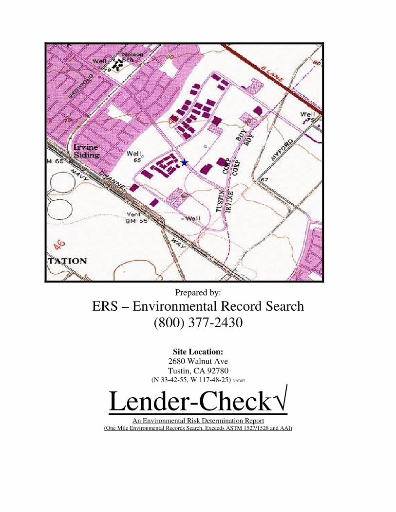
Prepared by:
ERS – Environmental Record Search (800) 377-2430
Site Location:
2680 Walnut Ave Tustin, CA 92780
(N 33-42-55, W 117-48-25) NAD83
Lender-Check√ An Environmental Risk Determination Report
(One Mile Environmental Records Search, Exceeds ASTM 1527/1528 and AAI)
CONTENTS
EXECUTIVE SUMMARY .............................................................................................. 1
LISTED OCCURRENCE SUMMARY .......................................................................... 4
SITE LOCATION TOPOGRAPHIC MAP ................................................................... 5
SITE LOCATION STREET MAP .................................................................................. 6
1-MILE RADIUS STREET MAP W/OCCURRENCES .............................................. 7
1/4-MILE RADIUS STREET MAP W/OCCURRENCES ........................................... 8
1-MILE TOPOGRAPHIC MAP W/OCCURRENCES ................................................ 9
1/2-MILE RADIUS STREET MAP .............................................................................. 10
LISTED OCCURRENCE DETAILS ............................................................................ 11
RECORD SOURCES SEARCHED .............................................................................. 26
OCCURENCES NOT MAPPED ................................................................................... 37
DISCLAIMER, LIMITS AND LIABILITIES ............................................................. 38

Copyright2007, Environmental Record Search, All rights reserved. www.RecCheck.com (800) 377-2430
1
EXECUTIVE SUMMARY
INFORMATION ON THE REQUESTED LOCATION Site Address: 2680 Walnut Ave
Tustin, CA 92780
Client Project Number: Test 3
Coordinates: N 33-42-55, W 117-48-25 (NAD 83)
ERS Project Number: 31423731
Subject Site Listed on the following lists: Not Listed
Subject Site Listed as Map ID#: N/A
USGS 7.5 Minute Quad Map: Tustin
Township, Section and Range: Township: 05S Range: 09W Section: 27
Baseline: San Bernardino
Flood Zone:
(FEMA Q3 Digital Data)
Panel: 06059C0039E
Zone X500 - Areas between limits of the 100-year flood and
the 500-year flood; or certain areas subject to 100-year
flooding with average depths of less than one (1) foot
Fire Insurance Map Coverage: No
Date of Report July 2, 2008
POTENTIAL RISK TO SUBJECT SITE
Levels: Low - The subject property is not listed with a known or
potential contamination issue; however there are sites with
known open or potential contamination issues within ¼ - mile
which may have impacted the subject site.
Recommendation: Groundwater contamination does not appear to constitute a
health hazard to the site's occupants unless the occupants have
or will come into contact with the groundwater and/or vapors
from groundwater. As long as groundwater is not used for
domestic or irrigation purposes on site and the groundwater is
not at a shallow depth, the risk from these sites is likely to be
low. If either of the above conditions is not met then contact
PHASE ONE INC. (800-524-8877) to discuss appropriate
next step actions.
Note: This report assumes that the subject site has never been used for automotive, dry cleaning, trucking, industrial, manufacturing, gas station, or similar uses that involve any chemicals or petroleum products. It is recommended that a Phase I Environmental Site Assessment be performed on these types of sites. ERS assumes no liability what so ever for these risk determinations and recommends that the user interprets the risk for each site listed for themselves.

Copyright2007, Environmental Record Search, All rights reserved. www.RecCheck.com (800) 377-2430
2
KEY TO POTENTIAL RISK FOR IDENTIFIED OCCURRENCES Level: Description:
High The subject site is listed with a known contamination issue that is still listed
as an open case by the regulatory agency.
Medium High The subject site is listed with a regulatory agency with a potential
contamination issue.
Medium The listed site is a known or potential contamination issue within ¼ - mile
which may have impacted the subject site.
Medium Low The listed site is a known or potential contamination issue within one mile
which may have impacted the subject site.
Low The listed site is not a known or potential contamination issue and is
unlikely to have impacted the subject site.
MAP ID # LIST DISTANCE LOW MEDIUM
LOW
MEDIUM MEDIUM
HIGH
HIGH
16 RCRA-COR 0.516 X
12 ERNS 0.096 X
14 CERCLIS-
Archived
0.23 X
15 LUST-Closed 0.234 X
1 LUST-Closed 0.024 X
1 UST 0.024 X
12 RCRA 0.096 X
8 RCRA 0.066 X
11 RCRA 0.082 X
5 RCRA 0.031 X
10 HWIS-CA 0.074 X
13 HWIS-CA 0.102 X
2 HWIS-CA 0.024 X
6 HWIS-CA 0.049 X
7 HWIS-CA 0.06 X
12 HWIS-CA 0.096 X
8 HWIS-CA 0.066 X
5 HWIS-CA 0.031 X
4 HWIS-CA 0.031 X
9 HWIS-CA 0.067 X
1 HWIS-CA 0.024 X
3 HWIS-CA 0.029 X
7 HWIS-CA 0.06 X
13 HWIS-CA 0.102 X
2 HWIS-CA 0.024 X
10 HWIS-CA 0.074 X
9 HWIS-CA 0.067 X

Copyright2007, Environmental Record Search, All rights reserved. www.RecCheck.com (800) 377-2430
3
Soil Type: (USGS STATSGO Data) BEACHES 1% to 5% slopes, 1% of total CHINO 0% to 2% slopes, 3% of total CHINO 0% to 2% slopes, 2% of total CROPLEY 2% to 5% slopes, 6% of total DELHI 0% to 2% slopes, 1% of total DIABLO 4% to 9% slopes, 1% of total ELDER 0% to 2% slopes, 1% of total GREENFIELD 2% to 5% slopes, 2% of total HANFORD 0% to 2% slopes, 17% of total HANFORD 2% to 5% slopes, 2% of total HUENEME 0% to 2% slopes, 1% of total METZ 0% to 2% slopes, 2% of total RAMONA 2% to 5% slopes, 2% of total RIVERWASH 0% to 2% slopes, 1% of total SORRENTO 0% to 2% slopes, 2% of total SORRENTO 0% to 2% slopes, 7% of total SORRENTO 0% to 2% slopes, 2% of total TUJUNGA 0% to 2% slopes, 2% of total TUJUNGA 0% to 2% slopes, 1% of total URBAN LAND 0% to 2% slopes, 43% of total BEACHES 1% to 5% slopes, 1% of total
In-House Aerial Photos or Historical Topo Maps
1995 Aerial File:FSXL3124 Rank: 4 1994 Aerial File:FSXL3124 Rank: 4 1980 Aerial File:28D80a1c053 Rank: 1 1980 Aerial File:28D80a1c054 Rank: 2 1980 Aerial File:28D80a1c055 Rank: 1 1980 Aerial File:28D80a1c065 Rank: 4 1980 Aerial File:28D80a1c066 Rank: 4 1980 Aerial File:28D80a1c067 Rank: 2 1963 Aerial File:28D63a1c004 Rank: 3 1963 Aerial File:28D63a1c005 Rank: 4 1963 Aerial File:28D63a1c006 Rank: 2 1963 Aerial File:28D63a1c011 Rank: 2 6/14/38 Aerial File:27D38OC1506 Rank: 3
KEY TO AERIAL RANK OR HISTORICAL TOPO MAPS
Rank: Description:
4 The subject site located near center of Aerial or Topographical map.
3 The subject site located towards edge of Aerial or Topographical map.
2 The subject site is likely covered and located near outer edge of Aerial or Topographical map.
1 The subject site is likely covered and located near outer corner of Aerial or Topographical map.
Radon For County: 0.5% of homes predicted to be over 4 Pico Curies/Liter For zip code 92780 Number of tests per zip code: 1 Number of tests where radon is > 4 pCi/L: 0 Percentage of test where radon is > 4 pCi/L: 0.00% Note: Radon is a naturally occurring colorless, odorless, tasteless radioactive gas that is formed from the
normal radioactive decay of uranium. Uranium is present in small amounts in most rocks and soil. The US
EPA's National Voluntary Action Level for Radon is set at or above 4 picocuries per liter (pCi/L). If radon
levels are greater than 4 pCi/L, it is recommended that you contact an environmental firm to conduct radon
sampling in the on-site structure(s). If radon levels are less than 4 pCi/L then testing is not recommended,
however, the occurrence of radon is site-specific; only testing can determine the actual radon level at a
particular site.

Copyright2007, Environmental Record Search, All rights reserved. www.RecCheck.com (800) 377-2430
4
LISTED OCCURRENCE SUMMARY
LIST
SEARCHED
DISTANCE
SEARCHED
0.125 0.25 0.5 1.0 TOTAL
NPL 1 0 0 0 0 0
CERCLIS 0.5 0 0 0 - 0
CalSites 1 0 0 0 0 0
LUST-Open 0.5 0 0 0 - 0
CalSites-VCP 0.5 0 0 0 - 0
SLIC-Open 0.5 0 0 0 - 0
CalSites-REF 0.5 0 0 0 - 0
CalSites-NFE 0.5 0 0 0 - 0
CalSites-SCH 0.5 0 0 0 - 0
SWIS 0.5 0 0 0 - 0
RCRA-COR 1 0 0 0 1 1
RCRA-TSD 0.5 0 0 0 - 0
Controls-CA 0.5 0 0 0 - 0
Tribal-
UST_&_or_LUST
0.5 0 0 0 - 0
OGW 0.25 0 0 - - 0
ERNS 0.125 1 - - - 1
CERCLIS-
Archived
0.5 0 1 0 - 1
CalSites-NFA 0.5 0 0 0 - 0
LUST-Closed 0.5 1 1 0 - 2
SLIC-Closed 0.5 0 0 0 - 0
UST 0.125 1 - - - 1
Hist-UST 0.125 0 - - - 0
RCRA 0.125 4 - - - 4
HWIS-CA 0.125 17 - - - 17
Water_Wells 0.5 0 0 0 - 0

SITE LOCATION TOPOGRAPHIC MAP
U.S. Geological Survey. Tustin Quadrangle, California
7.5 Minute Series, Approximate Scale: 1: 24000
Phase One Inc. 2680 Walnut Ave
Tustin, CA 92780
FIGURE: 1
JOB: Test 3
DATE: 4/16/2009
N

SITE LOCATION STREET MAP
Approximate Scale: 1: 24000
Phase One Inc. 2680 Walnut Ave
Tustin, CA 92780
FIGURE:
JOB: Test 3
DATE: 4/16/2009
N

1-MILE RADIUS STREET MAP W/OCCURRENCES
All plotted occurrences represent approximate locations based on geographic information provided by the respective agency. Actual locations may vary due to numerous reasons such as: the size of the property, accuracy of the provided location, accuracy of the software used to determine the location, etc. Occurrences are shown in three colors to give a visual indication of the potential risk of the listed site based on the type of list and the current status of the site. Occurrences shown in RED are locations with known contamination that have not received a “case closed” or “no further action” status. Occurrences shown in YELLOW have been listed by the respective agency, but do not always represent an environmental risk. The detailed status information and description of the list should be reviewed for further information. Occurrences shown in GREEN are occurrences that have active permits or have had contamination in the past but have received a “case closed” or “no further action” status and therefore do not likely present an environmental risk.
1/4-MILE RADIUS STREET MAP W/OCCURRENCES
All plotted occurrences represent approximate locations based on geographic information provided by the respective agency. Actual locations may vary due to numerous reasons such as: the size of the property, accuracy of the provided location, accuracy of the software used to determine the location, etc. Occurrences are shown in three colors to give a visual indication of the potential risk of the listed site based on the type of list and the current status of the site. Occurrences shown in RED are locations with known contamination that have not received a “case closed” or “no further action” status. Occurrences shown in YELLOW have been listed by the respective agency, but do not always represent an environmental risk. The detailed status information and description of the list should be reviewed for further information. Occurrences shown in GREEN are occurrences that have active permits or have had contamination in the past but have received a “case closed” or “no further action” status and therefore do not likely present an environmental risk.

1-MILE TOPOGRAPHIC MAP W/OCCURRENCES
All plotted occurrences represent approximate locations based on geographic information provided by the respective agency. Actual locations may vary due to numerous reasons such as: the size of the property, accuracy of the provided location, accuracy of the software used to determine the location, etc. Occurrences are shown in three colors to give a visual indication of the potential risk of the listed site based on the type of list and the current status of the site. Occurrences shown in RED are locations with known contamination that have not received a “case closed” or “no further action” status. Occurrences shown in YELLOW have been listed by the respective agency, but do not always represent an environmental risk. The detailed status information and description of the list should be reviewed for further information. Occurrences shown in GREEN are occurrences that have active permits or have had contamination in the past but have received a “case closed” or “no further action” status and therefore do not likely present an environmental risk.

1/2-MILE RADIUS STREET MAP
Showing all Street Names
Within a ½-mile Radius
Approximate Scale: 1: 7000
Phase One Inc. 2680 Walnut Ave
Tustin, CA 92780
FIGURE:
JOB: Test 3
DATE: 4/16/2009
N
LISTED OCCURRENCE DETAILS
LIST STATUS DISTANCE DIRECTION MAP ID
LUST-Closed Case Closed 0.02 miles NW
1 SITE NAME AGENCY ID#
CONSOLIDATED BEVERAGE DISTRIBUTION T0605901147
ADDRESS CITY ZIP
2681 WALNUT TUSTIN 92680
DETAILS
Case Number: 083001504T
Lead Agency: LOCAL AGENCY
Local Case Number: 90UT103
Discovered: 1990-04-17
Stop Date: 9999-09-09
Case Closed: 1991-12-18
Case Type: Other Groundwater affected (uses other than drinking water)
LIST STATUS DISTANCE DIRECTION MAP ID
UST Listed 0.02 miles NW
1 SITE NAME AGENCY ID#
CONSOLIDATED BEVERAGE DIST 11192
ADDRESS CITY ZIP
2681 WALNUT AVE TUSTIN 92780
DETAILS
No Additional Details Found
LIST STATUS DISTANCE DIRECTION MAP ID
HWIS-CA Listed 0.02 miles NW
1 SITE NAME AGENCY ID#
CONSOLIDATED BEVERAGE DIST CAL000043510
ADDRESS CITY ZIP
2681 WALNUT AVE TUSTIN 92705
DETAILS
Year: 1994
CAT_DESC: Unspecified organic liquid mixture
METH_DESC: Transfer station
TONS: 0.2502

LIST STATUS DISTANCE DIRECTION MAP ID
HWIS-CA Listed 0.02 miles SE
2 SITE NAME AGENCY ID#
AUTO PHOTO SYTEMS CAC000977832
ADDRESS CITY ZIP
2722 WALNUT AVE. TUSTIN 92681
DETAILS
Year: 1995
CAT_DESC: Waste oil and mixed oil
METH_DESC: Transfer station
TONS: 0.417
LIST STATUS DISTANCE DIRECTION MAP ID
HWIS-CA Listed 0.02 miles SE
2 SITE NAME AGENCY ID#
AUTO PHOTO SYSTEM CAL000144483
ADDRESS CITY ZIP
2722 WALNUT AVENUE TUSTIN 92681
DETAILS
Year: 2001
CAT_DESC: Photochemicals/photoprocessing waste
METH_DESC: Transfer station
TONS: 0.45
Year: 2000
CAT_DESC: Photochemicals/photoprocessing waste
METH_DESC: Transfer station
TONS: 0.91
Year: 1999
CAT_DESC: Photochemicals/photoprocessing waste
METH_DESC: Transfer station
TONS: 0.4586
Year: 1998
CAT_DESC: Photochemicals/photoprocessing waste
METH_DESC: Transfer station
TONS: 1.3758
Year: 1997
CAT_DESC: Photochemicals/photoprocessing waste
METH_DESC: Transfer station
TONS: 1.155
Year: 1996
CAT_DESC: Photochemicals/photoprocessing waste
METH_DESC: Transfer station
TONS: 0.4587

LIST STATUS DISTANCE DIRECTION MAP ID
HWIS-CA Listed 0.03 miles S
3 SITE NAME AGENCY ID#
SUBSURFACE PUMPING SYSTEMS CAL000065231
ADDRESS CITY ZIP
14711 BENTLEY CIR STE B TUSTIN 92680
DETAILS
Year: 1997
CAT_DESC: Unspecified oil-containing waste
METH_DESC: Recycler
TONS: 0.2668
Year: 1996
CAT_DESC: Unspecified solvent mixture
METH_DESC: Recycler
TONS: 0.2293
LIST STATUS DISTANCE DIRECTION MAP ID
HWIS-CA Listed 0.03 miles NW
4 SITE NAME AGENCY ID#
G-TECH PLATING CAL000009707
ADDRESS CITY ZIP
2670 WALNUT AVE SUITE G TUSTIN 92680
DETAILS
Year: 1995
CAT_DESC: Liquids with cyanides >= 1,000 Mg./L
METH_DESC: Recycler
TONS: 0.2293
LIST STATUS DISTANCE DIRECTION MAP ID
RCRA LISTED 0.03 miles S
5 SITE NAME AGENCY ID#
SECOND SOURCE COMPUTERS INC CAD981642549
ADDRESS CITY ZIP
14712 BENTLEY CIR TUSTIN 92780
DETAILS
Subject to corrective action: NO
Generator type: Small Quantity Generator

LIST STATUS DISTANCE DIRECTION MAP ID
HWIS-CA Listed 0.03 miles S
5 SITE NAME AGENCY ID#
SECOND SOURCE COMPUTERS INC CAD981642549
ADDRESS CITY ZIP
14712 BENTLEY CIRCLE TUSTIN 92680
DETAILS
Year: 1997
CAT_DESC: Halogenated solvents (chloroforms, methyl chloride, perchloroethylene, etc)
METH_DESC: Recycler
TONS: 0.2293
LIST STATUS DISTANCE DIRECTION MAP ID
HWIS-CA Listed 0.05 miles NW
6 SITE NAME AGENCY ID#
FARR'S CUSTOM CARBIDE TOOLING CAC001352024
ADDRESS CITY ZIP
2650 WALNUT AVE UNIT I TUSTIN 92780
DETAILS
Year: 1997
CAT_DESC: Other inorganic solid waste
METH_DESC: Transfer station
TONS: 0.45
Year: 2001
CAT_DESC: Unspecified solvent mixture
METH_DESC: Recycler
TONS: 0.22
Year: 2002
CAT_DESC: Unspecified solvent mixture
METH_DESC: Recycler
TONS: 0.22
LIST STATUS DISTANCE DIRECTION MAP ID
HWIS-CA Listed 0.06 miles SW
7 SITE NAME AGENCY ID#
CAPE ENVIRONMENTAL INC CAC002549867
ADDRESS CITY ZIP
14761 BENTLEY CIR TUSTIN 92780

DETAILS
Year: 2002
CAT_DESC: Laboratory waste chemicals
METH_DESC: Transfer station
TONS: 0.2
Year: 2002
CAT_DESC: Laboratory waste chemicals
METH_DESC: Transfer station
TONS: 0.08
Year: 2002
CAT_DESC: Laboratory waste chemicals
METH_DESC: Transfer station
TONS: 0.01
Year: 2002
CAT_DESC: Laboratory waste chemicals
METH_DESC: Transfer station
TONS: 0.16
LIST STATUS DISTANCE DIRECTION MAP ID
HWIS-CA Listed 0.06 miles SW
7 SITE NAME AGENCY ID#
CET ENVIRONMENTAL SERVICES INC CAL000111784
ADDRESS CITY ZIP
14761 BENETLEY CIRCLE TUSTIN 92680
DETAILS
Year: 1996
CAT_DESC: Other organic solids
METH_DESC: Transfer station
TONS: 0.5
Year: 1996
CAT_DESC: Unspecified aqueous solution
METH_DESC: Transfer station
TONS: 0.0115
Year: 1994
CAT_DESC: Contaminated soil from site clean-up
METH_DESC: Transfer station
TONS: 1.25
Year: 1994
CAT_DESC: Laboratory waste chemicals
METH_DESC: Transfer station
TONS: 0.068
Year: 1994
CAT_DESC: Laboratory waste chemicals
METH_DESC: Treatment, tank
TONS: 0.05
LIST STATUS DISTANCE DIRECTION MAP ID
RCRA LISTED 0.07 miles NW
8 SITE NAME AGENCY ID#
CIRCUIT TECH CAD052817301
ADDRESS CITY ZIP
2640 WALNUT AVE STE D & E TUSTIN 92780
DETAILS
Subject to corrective action: NO
Generator type: Small Quantity Generator
LIST STATUS DISTANCE DIRECTION MAP ID
HWIS-CA Listed 0.07 miles NW
8 SITE NAME AGENCY ID#
CIRCUIT TECH CAD052817301
ADDRESS CITY ZIP
2640 WALNUT AVE, STE D&E TUSTIN 92680
DETAILS
Year: 1998
CAT_DESC: Liquids with pH <= 2 with metals
METH_DESC: Treatment, tank
TONS: 26.271
Year: 1997
CAT_DESC: Liquids with pH <= 2 with metals
METH_DESC: Treatment, tank
TONS: 24.3945
Year: 1996
CAT_DESC: Liquids with pH <= 2 with metals
METH_DESC: Treatment, tank
TONS: 25.854
Year: 1993
CAT_DESC: Photochemicals/photoprocessing waste
METH_DESC: Recycler
TONS: 0.0625
LIST STATUS DISTANCE DIRECTION MAP ID
HWIS-CA Listed 0.07 miles NW
9 SITE NAME AGENCY ID#
TRANSIT CONTROL SYSTEMS CAL000038722
ADDRESS CITY ZIP
2641 WALNUT AVENUE TUSTIN 92780
DETAILS
Year: 1997
CAT_DESC: Unspecified aqueous solution
METH_DESC: Transfer station
TONS: 0.1251
Year: 1997
CAT_DESC: Other inorganic solid waste
METH_DESC: Recycler
TONS: 0.05
Year: 1997
CAT_DESC: Alkaline solution without metals pH >= 12.5
METH_DESC: Transfer station
TONS: 0.1251
Year: 1995
CAT_DESC: Liquids with halogenated organic compounds >= 1,000 Mg./L
METH_DESC: Transfer station
TONS: 0.2085
Year: 1995
CAT_DESC: Alkaline solution without metals pH >= 12.5
METH_DESC: Transfer station
TONS: 0.1251
Year: 1995
CAT_DESC: Waste oil and mixed oil
METH_DESC: Recycler
TONS: 0.1251
LIST STATUS DISTANCE DIRECTION MAP ID
HWIS-CA Listed 0.07 miles NW
9 SITE NAME AGENCY ID#
BRAXTON MFG CO OF CALIF INC CAL000229778
ADDRESS CITY ZIP
2641 WALNUT AVE TUSTIN 92780
DETAILS
Year: 2002
CAT_DESC: Waste oil and mixed oil
METH_DESC: Recycler
TONS: 0.41
Year: 2002
CAT_DESC: Waste oil and mixed oil
METH_DESC: Recycler
TONS: 0.45
Year: 2002
CAT_DESC: Waste oil and mixed oil
METH_DESC: Recycler
TONS: 0.41
Year: 2002
CAT_DESC: Waste oil and mixed oil
METH_DESC: Recycler
TONS: 0.41
Year: 2002
CAT_DESC: Waste oil and mixed oil
METH_DESC: Recycler
TONS: 0.41
Year: 2001
CAT_DESC: Waste oil and mixed oil
METH_DESC: Recycler
TONS: 0.54
LIST STATUS DISTANCE DIRECTION MAP ID
HWIS-CA Listed 0.07 miles NW
10 SITE NAME AGENCY ID#
NIEDWICK MACHINE COMPANY CAC000743880
ADDRESS CITY ZIP
2630 WALNUT AVE STE H TUSTIN 92780
DETAILS
Year: 1997
CAT_DESC: Waste oil and mixed oil
METH_DESC: Recycler
TONS: 2.1684
Year: 1998
CAT_DESC: Waste oil and mixed oil
METH_DESC: Recycler
TONS: 2.2934
LIST STATUS DISTANCE DIRECTION MAP ID
HWIS-CA Listed 0.07 miles NW
10 SITE NAME AGENCY ID#
NIEDWICK MACHINE CO CAL000189436
ADDRESS CITY ZIP
2630 WALNUT AVE UNIT H TUSTIN 92780

DETAILS
Year: 1999
CAT_DESC: Waste oil and mixed oil
METH_DESC: Recycler
TONS: 5.7337
Year: 1998
CAT_DESC: Waste oil and mixed oil
METH_DESC: Recycler
TONS: 1.1467
LIST STATUS DISTANCE DIRECTION MAP ID
RCRA LISTED 0.08 miles SE
11 SITE NAME AGENCY ID#
PALTEX EDITING & PROD SYS LTD CAD981583115
ADDRESS CITY ZIP
2752 WALNUT AVE TUSTIN 92780
DETAILS
Subject to corrective action: NO
Generator type: Small Quantity Generator
LIST STATUS DISTANCE DIRECTION MAP ID
ERNS Reported 0.1 miles SE
12 SITE NAME AGENCY ID#
388273
ADDRESS CITY ZIP
2761 WALNUT AVE TUSTIN 92780
DETAILS
Type: FIXED Cause: OPERATOR ERROR Date: 5/22/1997 9:15:00 AM
Medium Affected: LAND:CONCRETE FLOOR
Description: 4-LITRE BOTTLE IN CHEMICAL BOX / DROPPED DURING UNLOADING
Remediation: MATERIAL HAS BEEN CLEANED AND CONTAINED BY ON SITE PERSONNEL
Material: 4 LITER(S) CHLOROFORM
LIST STATUS DISTANCE DIRECTION MAP ID
RCRA LISTED 0.1 miles SE
12 SITE NAME AGENCY ID#
FISHER SCIENTIFIC TUSTIN CAD040524332
ADDRESS CITY ZIP
2761 WALNUT AVE TUSTIN 92780
DETAILS
Subject to corrective action: NO

LIST STATUS DISTANCE DIRECTION MAP ID
HWIS-CA Listed 0.1 miles SE
12 SITE NAME AGENCY ID#
FISHER SCIENTIFIC LLC CAD040524332
ADDRESS CITY ZIP
2761 WALNUT AVE TUSTIN 92680

DETAILS
Year: 1995
CAT_DESC: Laboratory waste chemicals
METH_DESC: Transfer station
TONS: 0.136
Year: 1998
CAT_DESC: Off-specification, aged or surplus organics
METH_DESC: Recycler
TONS: 0.7095
Year: 1998
CAT_DESC: Off-specification, aged or surplus organics
METH_DESC: Transfer station
TONS: 0.35
Year: 2001
CAT_DESC: Liquids with pH <= 2
METH_DESC: Transfer station
TONS: 0
Year: 1999
CAT_DESC: Off-specification, aged or surplus organics
METH_DESC: Transfer station
TONS: 0.16
Year: 1999
CAT_DESC: Off-specification, aged or surplus organics
METH_DESC: Recycler
TONS: 0.7
Year: 1999
CAT_DESC: Liquids with mercury >= 20 Mg./L
METH_DESC: Transfer station
TONS: 0.025
Year: 1994
CAT_DESC: Liquids with mercury >= 20 Mg./L
METH_DESC: Transfer station
TONS: 0.02
Year: 1997
CAT_DESC: Liquids with pH <= 2
METH_DESC: Transfer station
TONS: 0.017
Year: 1997
CAT_DESC: Liquids with mercury >= 20 Mg./L
METH_DESC: Transfer station
TONS: 0.017
Year: 2001
CAT_DESC: Off-specification, aged or surplus organics
METH_DESC: Transfer station
TONS: 0
Year: 2001
CAT_DESC: Off-specification, aged or surplus organics
METH_DESC: Recycler
TONS: 0.36
Year: 1999
CAT_DESC: Off-specification, aged or surplus inorganics
METH_DESC: Transfer station
TONS: 0.0625
Year: 1999
CAT_DESC: Liquids with pH <= 2 with metals
METH_DESC: Transfer station
TONS: 0.1
Year: 1999
CAT_DESC: Other organic solids
METH_DESC: Transfer station
TONS: 0.17
Year: 1997
CAT_DESC: Off-specification, aged or surplus organics

METH_DESC: Recycler
TONS: 0.385
Year: 1997
CAT_DESC: Off-specification, aged or surplus organics
METH_DESC: Transfer station
TONS: 0.0215
Year: 1993
CAT_DESC: Laboratory waste chemicals
METH_DESC: Recycler
TONS: 0.0375
Year: 1993
CAT_DESC: Liquids with mercury >= 20 Mg./L
METH_DESC: Transfer station
TONS: 0.01
Year: 2002
CAT_DESC: Off-specification, aged or surplus organics
METH_DESC: Transfer station
TONS: 0
Year: 2002
CAT_DESC: Liquids with pH <= 2 with metals
METH_DESC: Transfer station
TONS: 0
Year: 2002
CAT_DESC: Off-specification, aged or surplus organics
METH_DESC: Transfer station
TONS: 0.12
Year: 2002
CAT_DESC: Off-specification, aged or surplus inorganics
METH_DESC: Transfer station
TONS: 0.01
Year: 2002
CAT_DESC: Laboratory waste chemicals
METH_DESC: Transfer station
TONS: 0.12
Year: 2002
CAT_DESC: Off-specification, aged or surplus organics
METH_DESC: Recycler
TONS: 0.37
Year: 2002
CAT_DESC: Off-specification, aged or surplus organics
METH_DESC: Recycler
TONS: 0.01
Year: 2002
CAT_DESC: Off-specification, aged or surplus organics
METH_DESC: Transfer station
TONS: 0
Year: 2002
CAT_DESC: Laboratory waste chemicals
METH_DESC: Transfer station
TONS: 0.12
Year: 2002
CAT_DESC: Off-specification, aged or surplus organics
METH_DESC: Transfer station
TONS: 0
Year: 2002
CAT_DESC: Off-specification, aged or surplus organics
METH_DESC: Recycler
TONS: 0.25
Year: 2002
CAT_DESC: Off-specification, aged or surplus organics
METH_DESC: Recycler
TONS: 1.2
Year: 2002
CAT_DESC: Laboratory waste chemicals
METH_DESC: Recycler
TONS: 0.12
Year: 1994
CAT_DESC: Laboratory waste chemicals
METH_DESC: Treatment, incineration
TONS: 0.0458
Year: 1993
CAT_DESC: Pharmaceutical waste
METH_DESC: Treatment, incineration
TONS: 0.275
Year: 1993
CAT_DESC: Pharmaceutical waste
METH_DESC: Transfer station
TONS: 0.0575
Year: 1998
CAT_DESC: Off-specification, aged or surplus inorganics
METH_DESC: Transfer station
TONS: 0.07
Year: 1996
CAT_DESC: Off-specification, aged or surplus organics
METH_DESC: Recycler
TONS: 0.075
Year: 2000
CAT_DESC: Laboratory waste chemicals
METH_DESC: Transfer station
TONS: 0.13
Year: 2000
CAT_DESC: Off-specification, aged or surplus organics
METH_DESC: Transfer station
TONS: 0.12
Year: 2000
CAT_DESC: Off-specification, aged or surplus organics
METH_DESC: Recycler
TONS: 0.92
Year: 2000
CAT_DESC: Liquids with mercury >= 20 Mg./L
METH_DESC: Transfer station
TONS: 0.0025
Year: 2000
CAT_DESC: Liquids with polychloronated biphenyls >= 50 Mg./L
METH_DESC: Transfer station
TONS: 0.07
Year: 2000
CAT_DESC: Liquids with pH <= 2
METH_DESC: Transfer station
TONS: 0.1
Year: 2000
CAT_DESC: Off-specification, aged or surplus inorganics
METH_DESC: Transfer station
TONS: 0.36
Year: 2000
CAT_DESC: Other inorganic solid waste
METH_DESC: Transfer station
TONS: 0.08
Year: 1995
CAT_DESC: Oxygenated solvents (acetone, butanol, ethyl acetate, etc.)
METH_DESC: Recycler
TONS: 0.1668
Year: 1996
CAT_DESC: Liquids with mercury >= 20 Mg./L
METH_DESC: Transfer station
TONS: 0.0325
Year: 1997
CAT_DESC: Off-specification, aged or surplus inorganics

METH_DESC: Transfer station
TONS: 0.004
LIST STATUS DISTANCE DIRECTION MAP ID
HWIS-CA Listed 0.1 miles SE
13 SITE NAME AGENCY ID#
BARRETT BROWN CAC000913392
ADDRESS CITY ZIP
14711 SINCLAIR CIRCLE TUSTIN 92680
DETAILS
Year: 1995
CAT_DESC: Halogenated solvents (chloroforms, methyl chloride, perchloroethylene, etc)
METH_DESC: Transfer station
TONS: 0.3544
LIST STATUS DISTANCE DIRECTION MAP ID
HWIS-CA Listed 0.1 miles SE
13 SITE NAME AGENCY ID#
ARCO INDUSTRIES/WESTERN CAL000124761
ADDRESS CITY ZIP
14711 SINCLAIR CIRCLE TUSTIN 92680
DETAILS
Year: 2000
CAT_DESC: Aqueous solution with total organic residues less than 10 percent
METH_DESC: Transfer station
TONS: 0.12
Year: 1999
CAT_DESC: Unspecified solvent mixture
METH_DESC: Transfer station
TONS: 0.1251
Year: 1997
CAT_DESC: Unspecified solvent mixture
METH_DESC: Transfer station
TONS: 0.1251
Year: 1996
CAT_DESC: Unspecified solvent mixture
METH_DESC: Transfer station
TONS: 0.1251
LIST STATUS DISTANCE DIRECTION MAP ID
CERCLIS-Archived NFA 0.23 miles SE
14 SITE NAME AGENCY ID#
RICH HEALTH 0901321
ADDRESS CITY ZIP
2792 WALNUT AVE. TUSTIN 92680

DETAILS
EPA ID: CAD040525826 NPL STATUS: Not on the NPL
ACTIONS:
ACTION TYPE: PRELIMINARY ASSESSMENT ACTION DATE: 01/06/1992 ACTION LEAD TYPE: EPA Fund-Financed
ACTION QUALIFIER: NFRAP (No Futher Remedial Action Planned
COMMENTS:
LIST STATUS DISTANCE DIRECTION MAP ID
LUST-Closed Case Closed 0.23 miles E
15 SITE NAME AGENCY ID#
SMITH IND. (TUNGSTON-CARBIDE) T0605900457
ADDRESS CITY ZIP
14451 MYFORD RD TUSTIN 92680
DETAILS
Case Number: 083000571T
Last Reviewed: 2002-12-10
Lead Agency: REGIONAL WATER QUALITY CONTROL BOARD
Local Case Number: 86UT135
Pollution Characterization Underway: 1987-07-20
Remediation Workplan (Corrective Action Plan) Submitted: 1990-01-01
Remediation Underway: 2003-03-12
Case Type: Aquifer used for drinking water supply affected
Substance released: Chlorinated hydrocarbons
Misc: WDR ADOPTED 9/90. GROUNDWATER TREATMENT SYSTEM ONLINE QUARTERLY GROUNDWATER
MONITORING IS ONGOING.
LIST STATUS DISTANCE DIRECTION MAP ID
RCRA-COR Listed 0.52 miles NE
16 SITE NAME AGENCY ID#
MORTON ELECTRONIC MATERIALS CAD008334260
ADDRESS CITY ZIP
2631 MICHELLE DRIVE TUSTIN 92680
DETAILS
Subject to corrective action: YES
Generator type: Large Quantity Generator
This site is involved with the storage of hazardous waste.

Copyright2007, Environmental Record Search, All rights reserved. www.RecCheck.com (800) 377-2430
26
RECORD SOURCES SEARCHED NPL
National Priorities List
Description: The National Priorities List is the list of national priorities among the known
releases or threatened releases of hazardous substances, pollutants, or contaminants throughout
the United States and its territories. The NPL is intended primarily to guide the EPA in
determining which sites warrant further investigation.
Agency: United States Environmental Protection Agency
Phone Number: 8004249346
Date last updated: 2/28/2007 2:18:00 PM
Date last checked: 10/1/2007
Distance searched: 1 mile
Sites:
None Found
CERCLIS
Comprehensive Environmental Response, Compensation, and Liability Information System
Description: CERCLIS is the Comprehensive Environmental Response, Compensation, and
Liability Information System. CERCLIS contains information on hazardous waste sites, potential
hazardous waste sites, and remedial activities across the nation, including sites that are on the
National Priorities List (NPL) or being considered for the NPL.
Agency: United States Environmental Protection Agency
Phone Number: 8004249346
Date last updated: 2/28/2007
Date last checked: 10/1/2007
Distance searched: 0.5 miles
Sites:
None Found
CalSites
CalSites Database or Site Mitigation and Brownfields Reuse Program Database (SMBRPD)
or State (NPL and CERCLIS)
Description: The Department of Toxic Substances Control (DTSC) maintains an automated
database that contains information on properties in California where hazardous substances have
been released, or where the potential for a release exists. This database is known as “CalSites.”
For over a decade, CalSites has assisted DTSC staff, the public, the Legislature, federal, state and
local agencies by providing a brief history of cleanup activities, contaminants of concern, and
scheduled future cleanup activities. This category contains properties where hazardous substance
releases have been confirmed. These sites are considered to pose the greatest threat to the public
and the environment. These confirmed sites are generally high priority, high potential risk, and
include military facilities, state "funded" or Responsible Party (RP) lead, and National Priorities
List (NPL) sites.

Copyright2007, Environmental Record Search, All rights reserved. www.RecCheck.com (800) 377-2430
27
Agency: CA Environmental Protection Agency, Department of Toxic Substances Control
Phone Number: 9163233400
Date last updated: 1/30/2007 1:21:00 PM
Date last checked: 10/1/2007
Distance searched: 1 mile
Sites:
None Found
LUST-Open
Leaking Underground Storage Tanks, Open Cases
Description: The California State Water Resources Control Board's Underground Storage Tank
Program keeps a list of all underground storage tanks which have been reported as having had a
release. This subset of sites is those that have not yet been updated as having been closed and
now have a status of Case Open.
Agency: CA State Water Resources Control Board, Underground Storage Tank Program
Phone Number: 9163415808
Date last updated: 8/10/2007
Date last checked: 10/1/2007
Distance searched: 0.5 miles
Sites:
None Found
CalSites-VCP
Voluntary Cleanup Program Sites
Description: The Department of Toxic Substances Control (DTSC) maintains an automated
database that contains information on properties in California where hazardous substances have
been released, or where the potential for a release exists. This database is known as “CalSites.”
For over a decade, CalSites has assisted DTSC staff, the public, the Legislature, federal, state and
local agencies by providing a brief history of cleanup activities, contaminants of concern, and
scheduled future cleanup activities. This category contains low threat level properties with either
confirmed or unconfirmed releases and the project proponents have requested that DTSC oversee
investigation and/or cleanup activities and have agreed to provide coverage for DTSC's costs.
Agency: CA Environmental Protection Agency, Department of Toxic Substances Control
Phone Number: 9163233400
Date last updated: 1/30/2007 1:21:00 PM
Date last checked: 4/23/2007
Distance searched: 0.5 miles
Sites:
None Found
SLIC-Open
The Spills, Leaks, Investigation & Cleanup, Open Cases

Copyright2007, Environmental Record Search, All rights reserved. www.RecCheck.com (800) 377-2430
28
Description: The Spills, Leaks, Investigation & cleanup (SLIC) Program deals with site
investigation and corrective action involving sites not overseen by the Underground Tank
Program and the Well Investigation Program. This program is not restricted to particular
pollutants or environments; rather, the program covers all types of pollutants (such as solvents,
petroleum fuels, and heavy metals) and all environments (including surface and water,
groundwater, and the vadose zone). Upon confirming that an unauthorized discharge is polluting
or threatens to pollute regional water bodies, the Regional Board oversees site investigation and
corrective action. Statutory authority for the program is derived from the California Water Code,
Division 7, Section 13304. Guidelines for site investigation and remediation are promulgated in
State Board Resolution No. 92-49 entitled Policies and Procedures For Investigation and Cleanup
and Abatement of Discharges Under Water Code Section 13304.
Agency: CA State Water Resources Control Board (Spills, Leaks, Investigation & cleanup
Program)
Phone Number: 2135766717
Date last updated: 8/3/2007
Date last checked: 10/1/2007
Distance searched: 0.5 miles
Sites:
None Found
CalSites-REF
Unconfirmed Properties Referred to Another Local or State Agency
Description: The Department of Toxic Substances Control (DTSC) maintains an automated
database that contains information on properties in California where hazardous substances have
been released, or where the potential for a release exists. This database is known as “CalSites.”
For over a decade, CalSites has assisted DTSC staff, the public, the Legislature, federal, state and
local agencies by providing a brief history of cleanup activities, contaminants of concern, and
scheduled future cleanup activities. This category contains properties that are suspected of being
contaminated. These are unconfirmed contaminated properties that need to be assessed using the
PEA process.
Agency: CA Environmental Protection Agency, Department of Toxic Substances Control
Phone Number: 9163233400
Date last updated: 1/30/2007 1:19:00 PM
Date last checked: 4/23/2007
Distance searched: 0.5 miles
Sites:
None Found
CalSites-NFE
Unconfirmed Properties Needing Further Evaluation
Description: The Department of Toxic Substances Control (DTSC) maintains an automated
database that contains information on properties in California where hazardous substances have
been released, or where the potential for a release exists. This database is known as “CalSites.”
For over a decade, CalSites has assisted DTSC staff, the public, the Legislature, federal, state and

Copyright2007, Environmental Record Search, All rights reserved. www.RecCheck.com (800) 377-2430
29
local agencies by providing a brief history of cleanup activities, contaminants of concern, and
scheduled future cleanup activities. This category contains properties where contamination has
not been confirmed and which were determined as not requiring direct DTSC Site Mitigation
Program action or oversight. Accordingly, these sites have been referred to another state or local
regulatory agency.
Agency: CA Environmental Protection Agency, Department of Toxic Substances Control
Phone Number: 9163233400
Date last updated: 1/30/2007 1:19:00 PM
Date last checked: 4/23/2007
Distance searched: 0.5 miles
Sites:
None Found
CalSites-SCH
School Property Evaluation Program Properties
Description: The Department of Toxic Substances Control (DTSC) maintains an automated
database that contains information on properties in California where hazardous substances have
been released, or where the potential for a release exists. This database is known as “CalSites.”
For over a decade, CalSites has assisted DTSC staff, the public, the Legislature, federal, state and
local agencies by providing a brief history of cleanup activities, contaminants of concern, and
scheduled future cleanup activities. This category contains proposed and existing school sites that
are being evaluated by DTSC for possible hazardous materials contamination. In some cases,
these properties may be listed in the CalSites category depending on the level of threat to public
health and safety on the environment they pose.
Agency: CA Environmental Protection Agency, Department of Toxic Substances Control
Phone Number: 9163233400
Date last updated: 1/30/2007 1:20:00 PM
Date last checked: 4/23/2007
Distance searched: 0.5 miles
Sites:
None Found
SWIS
Solid Waste Information System
Description: The Solid Waste Information System (SWIS) database contains information on
solid waste facilities, operations, and disposal sites throughout the State of California. The types
of facilities found in this database include landfills, transfer stations, material recovery facilities,
composting sites, transformation facilities, waste tire sites, and closed disposal sites.
Agency: CA Integrated Waste Management Board
Phone Number: 9163416320
Date last updated: 8/3/2007
Date last checked: 10/1/2007
Distance searched: 0.5 miles
Sites:
None Found

Copyright2007, Environmental Record Search, All rights reserved. www.RecCheck.com (800) 377-2430
30
RCRA-COR
Resource Conservation and Recovery Act - Corrective Actions (CORRACTS)
Description: In 1965, to encourage environmentally sound methods for disposal of household,
municipal, commercial, and industrial refuse, Congress passed the first federal law to require
safeguards on these activities, the Solid Waste Disposal Act. Congress amended this law in 1976
by passing the Resource Conservation and Recovery Act (RCRA) (pronounced "Ric-ra"). The
primary goals of RCRA are to: Protect human health and the environment from the potential
hazards of waste disposal. Conserve energy and natural resources. Reduce the amount of waste
generated. Ensure that wastes are managed in an environmentally sound manner.
EPA estimates that between 50 and 70 percent of all TSDFs have some degree of environmental
contamination requiring detailed investigation and perhaps cleanup. Under a program entitled
Corrective Action, EPA has the statutory authority to require permitted and interim status TSDFs
to clean up hazardous waste contamination.
Agency: United States Environmental Protection Agency
Phone Number: 8004249346
Date last updated: 2/28/2007 2:42:00 PM
Date last checked: 10/1/2007
Distance searched: 1 mile
Sites:
MORTON ELECTRONIC MATERIALS MapID: 16 Listed
RCRA-TSD
Resource Conservation and Recovery Act - Treatment, Storage, and Disposal sites
Description: In 1965, to encourage environmentally sound methods for disposal of household,
municipal, commercial, and industrial refuse, Congress passed the first federal law to require
safeguards on these activities, the Solid Waste Disposal Act. Congress amended this law in 1976
by passing the Resource Conservation and Recovery Act (RCRA) (pronounced "Ric-ra"). The
primary goals of RCRA are to: Protect human health and the environment from the potential
hazards of waste disposal. Conserve energy and natural resources. Reduce the amount of waste
generated. Ensure that wastes are managed in an environmentally sound manner.
Treatment, Storage and Disposal Facility - Facilities that receive hazardous waste from
generators or other facilities for treatment, storage or disposal of waste are known as TSDFs.
Agency: United States Environmental Protection Agency
Phone Number: 8004249346
Date last updated: 2/28/2007 2:41:00 PM
Date last checked: 10/1/2007
Distance searched: 0.5 miles
Sites:
None Found

Copyright2007, Environmental Record Search, All rights reserved. www.RecCheck.com (800) 377-2430
31
Controls-CA
Calsites with Deed Restrictions or other Controls
Description: A deed restricted site is a property where DTSC has placed limits or requirements
on future use of the property due to varying levels of cleanup possible, practical, or necessary at
the site. The DTSC Site Mitigation and Brownfield's Reuse Program (SMBRP) list includes sites
cleaned up under the program's oversight and generally does not include current or former
hazardous waste facilities that required a hazardous waste facility permit. The list represents deed
restrictions that are active. Some sites have multiple deed restrictions. Not all deed restrictions are
available at this time.
Agency: CA Environmental Protection Agency, Department of Toxic Substances Control
Phone Number: 9162553745
Date last updated: 1/30/2007 1:18:00 PM
Date last checked: 4/11/2007
Distance searched: 0.5 miles
Sites:
None Found
Tribal-UST_&_or_LUST
Tribal Underground Storage Tanks and/or Leaking Underground Storage Tanks
Description: Underground Storage Tanks and/or Leaking Underground Storage Tanks on Native
American Land identified by the United States Environmental Protection Agency.
Agency: United States Environmental Protection Agency
Phone Number: 8004249346
Date last updated: 3/31/2006 3:51:00 PM
Date last checked: 4/20/2007
Distance searched: 0.5 miles
Sites:
None Found
OGW
California Oil and Gas Wells
Description: The Division of Oil, Gas, and Geothermal Resources (DOGGR) was formed in
1915 to address the needs of the state, local governments, and industry by regulating statewide oil
and gas activities with uniform laws and regulations. The Division supervises the drilling,
operation, maintenance, and plugging and abandonment of onshore and offshore oil, gas, and
geothermal wells, preventing damage to: (1) life, health, property, and natural resources; (2)
underground and surface waters suitable for irrigation or domestic use; and (3) oil, gas, and
geothermal reservoirs.
Agency: California Department of Conservation, Division of Oil, Gas & Geothermal Resources
Phone Number: 9163231779
Date last updated: 8/13/2007
Date last checked: 10/1/2007

Copyright2007, Environmental Record Search, All rights reserved. www.RecCheck.com (800) 377-2430
32
Distance searched: 0.25 miles
Sites:
None Found
ERNS
Emergency Response Notification System
Description: The primary function of the National Response Center is to serve as the sole
national point of contact for reporting all oil, chemical, radiological, biological, and etiological
discharges into the environment anywhere in the United States and its territories. In addition to
gathering and distributing spill data for Federal On-Scene Coordinators and serving as the
communications and operations center for the National Response Team, the NRC maintains
agreements with a variety of federal entities to make additional notifications regarding incidents
meeting established trigger criteria.
Agency: National Response Center
Phone Number: 8004248802
Date last updated: 2/6/2007 2:40:00 PM
Date last checked: 5/11/2007
Distance searched: 0.125 miles
Sites:
MapID: 12 Reported
CERCLIS-Archived
CERCLIS sites that have been archived (NFRAP)
Description: The Archive designation means that assessment at a site has been completed and
EPA has determined no steps will be taken to designate the site as a priority by listing it on the
National Priorities List (NPL). No further remedial action is planned for these sites under the
Superfund Program.
Agency: United States Environmental Protection Agency
Phone Number: 8004249346
Date last updated: 5/9/2006 3:23:00 PM
Date last checked: 7/11/2007
Distance searched: 0.5 miles
Sites:
RICH HEALTH MapID: 14 NFA
CalSites-NFA
Properties with No Further Action Determination
Description: The Department of Toxic Substances Control (DTSC) maintains an automated
database that contains information on properties in California where hazardous substances have
been released, or where the potential for a release exists. This database is known as “CalSites.”
For over a decade, CalSites has assisted DTSC staff, the public, the Legislature, federal, state and
Copyright2007, Environmental Record Search, All rights reserved. www.RecCheck.com (800) 377-2430
33
local agencies by providing a brief history of cleanup activities, contaminants of concern, and
scheduled future cleanup activities. This category contains properties at which DTSC has made a
clear determination that the property does not pose a problem to the environment or to public
health. This determination is typically based on findings of a PEA.
Agency: CA Environmental Protection Agency, Department of Toxic Substances Control
Phone Number: 9163233400
Date last updated: 1/30/2007 1:18:00 PM
Date last checked: 4/23/2007
Distance searched: 0.5 miles
Sites:
None Found
LUST-Closed
Leaking Underground Storage Tanks, Closed Cases
Description: The California State Water Resources Control Board's Underground Storage Tank
Program keeps a list of all underground storage tanks which have been reported as having had a
release. This subset of sites is those that have received closure and now have a status of Case
Closed.
Agency: CA State Water Resources Control Board, Underground Storage Tank Program
Phone Number: 9163415808
Date last updated: 8/10/2007
Date last checked: 10/1/2007
Distance searched: 0.5 miles
Sites:
CONSOLIDATED BEVERAGE DISTRIBUTION MapID: 1 Case Closed
SMITH IND. (TUNGSTON-CARBIDE) MapID: 15 Case Closed
SLIC-Closed
The Spills, Leaks, Investigation & Cleanup, Closed Cases
Description: The Spills, Leaks, Investigation & cleanup (SLIC) Program deals with site
investigation and corrective action involving sites not overseen by the Underground Tank
Program and the Well Investigation Program. This program is not restricted to particular
pollutants or environments; rather, the program covers all types of pollutants (such as solvents,
petroleum fuels, and heavy metals) and all environments (including surface and water,
groundwater, and the vadose zone). Upon confirming that an unauthorized discharge is polluting
or threatens to pollute regional water bodies, the Regional Board oversees site investigation and
corrective action. Statutory authority for the program is derived from the California Water Code,
Division 7, Section 13304. Guidelines for site investigation and remediation are promulgated in
State Board Resolution No. 92-49 entitled Policies and Procedures For Investigation and Cleanup
and Abatement of Discharges Under Water Code Section 13304.
Agency: CA State Water Resources Control Board (Spills, Leaks, Investigation & cleanup
Program)
Phone Number: 2135766717
Copyright2007, Environmental Record Search, All rights reserved. www.RecCheck.com (800) 377-2430
34
Date last updated: 8/3/2007
Date last checked: 10/1/2007
Distance searched: 0.5 miles
Sites:
None Found
UST
Underground Storage Tanks
Description: The California State Water Resources Control Board keeps this list of registered
underground storage tanks.
Agency: CA State Water Resources Control Board, Underground Storage Tank Program
Phone Number: 9163415808
Date last updated: 8/3/2007
Date last checked: 10/1/2007
Distance searched: 0.125 miles
Sites:
CONSOLIDATED BEVERAGE DIST MapID: 1 Listed
Hist-UST
Historical Underground Storage Tanks
Description: The California State Water Resources Control Board keeps the Hazardous
Substances Storage Container Information on file. This is a database of historical underground
storage tanks that was kept until the late 1980's, but has been discontinued and is no longer
updated.
Agency: California State Water Resources Control Board
Phone Number: 9163415851
Date last updated: 10/26/2005 12:21:00 PM
Date last checked: 7/6/2007
Distance searched: 0.125 miles
Sites:
None Found
RCRA
Resource Conservation and Recovery Act
Description: In 1965, to encourage environmentally sound methods for disposal of household,
municipal, commercial, and industrial refuse, Congress passed the first federal law to require
safeguards on these activities, the Solid Waste Disposal Act. Congress amended this law in 1976
by passing the Resource Conservation and Recovery Act (RCRA) (pronounced "Ric-ra"). The
primary goals of RCRA are to: Protect human health and the environment from the potential
hazards of waste disposal. Conserve energy and natural resources. Reduce the amount of waste
generated. Ensure that wastes are managed in an environmentally sound manner.
Agency: United States Environmental Protection Agency

Copyright2007, Environmental Record Search, All rights reserved. www.RecCheck.com (800) 377-2430
35
Phone Number: 8004249346
Date last updated: 2/28/2007 2:38:00 PM
Date last checked: 10/1/2007
Distance searched: 0.125 miles
Sites:
SECOND SOURCE COMPUTERS INC MapID: 5 LISTED
CIRCUIT TECH MapID: 8 LISTED
PALTEX EDITING & PROD SYS LTD MapID: 11 LISTED
FISHER SCIENTIFIC TUSTIN MapID: 12 LISTED
HWIS-CA
Hazardous Waste Information Summary
Description: The Hazardous Waste Summary Report (formerly the Tanner Report) is prepared
from data extracted from the copies of hazardous waste manifests received each year by DTSC.
The volume of manifests is typically 900,000 - 1,000,000 annually, representing approximately
450,000 - 500,000 shipments.
Agency: CA Environmental Protection Agency, Department of Toxic Substances Control
Phone Number: 9162553745
Date last updated: 4/28/2005 7:27:00 AM
Date last checked: 7/30/2007
Distance searched: 0.125 miles
Sites:
CONSOLIDATED BEVERAGE DIST MapID: 1 Listed
AUTO PHOTO SYTEMS MapID: 2 Listed
AUTO PHOTO SYSTEM MapID: 2 Listed
SUBSURFACE PUMPING SYSTEMS MapID: 3 Listed
G-TECH PLATING MapID: 4 Listed
SECOND SOURCE COMPUTERS INC MapID: 5 Listed
FARR'S CUSTOM CARBIDE TOOLING MapID: 6 Listed
CAPE ENVIRONMENTAL INC MapID: 7 Listed
CET ENVIRONMENTAL SERVICES INC MapID: 7 Listed
CIRCUIT TECH MapID: 8 Listed
TRANSIT CONTROL SYSTEMS MapID: 9 Listed
BRAXTON MFG CO OF CALIF INC MapID: 9 Listed
NIEDWICK MACHINE COMPANY MapID: 10 Listed
NIEDWICK MACHINE CO MapID: 10 Listed
FISHER SCIENTIFIC LLC MapID: 12 Listed
BARRETT BROWN MapID: 13 Listed
ARCO INDUSTRIES/WESTERN MapID: 13 Listed
Water_Wells
Ground Water Site Inventory for California

Copyright2007, Environmental Record Search, All rights reserved. www.RecCheck.com (800) 377-2430
36
Description: The ground-water site inventory consists of records of wells, springs, test holes,
tunnels, drains, and excavations in California. Available site descriptive information includes well
location information such as latitude and longitude, well depth, aquifer and water levels.
Agency: United States Geological Survey, Water Resources Program
Phone Number: 9162783000
Date last updated: 8/7/2007
Date last checked: 4/19/2007
Distance searched: 0.5 miles
Sites:
None Found

Copyright2007, Environmental Record Search, All rights reserved. www.RecCheck.com (800) 377-2430
37
OCCURENCES NOT MAPPED
The following occurrences were not mapped due to various reasons mostly resulting from incomplete or inaccurate address information. All of the following occurrences were determined to share the same zip code as the subject site. General status information is given with each occurrence along with any address information entered by the agency responsible for the list.
No unplottable sites requested.
Copyright2007, Environmental Record Search, All rights reserved. www.RecCheck.com (800) 377-2430
38
DISCLAIMER, LIMITS AND LIABILITIES
All of the data presented in this report was garnered from public information maintained by
governmental agencies. Environmental Record Search (ERS) cannot ensure that the data, which
has been entered and maintained by others, is complete or accurate. Any, and all omissions, errors,
negligence, accidentally or otherwise within the data received by ERS is assumed to be caused by
others and ERS cannot and does not assume, take, or acknowledge any liability whatsoever for data.
The extrapolation of the mapped locations is based solely on the accuracy of the data provided by
others. Prior to relying completely on any mapped location within this report, its accuracy should be
verified using other means such as further documentation or a field visit. ERS makes no
representation, warranty or guaranty, express or implied regarding the accuracy of the data entered
and maintained by others or the suitability of this report for a certain task.
The data presented in this report should only be interpreted by an experienced environmental
professional that completely understands the potential inaccuracy of the data, the possible existence
of contaminated occurrences that have not been listed, and the possibility that the governmental
database misrepresents the actual status of an occurrence. Prior to relying completely on any of the
data within this report, an environmental professional should verify the accuracy of the
information presented.
It is important that the reader and/or end user of this information realize that the data gathered has
not been verified for accuracy or completeness in any way by ERS. As much as possible, the
data is presented unchanged to represent the actual data produced by these agencies.
ERS does however stand behind its representation of the data, any manually plotted occurrences,
and all other items directly under its control. This report does comply (as far as the data is
reasonably ascertainable as outlined in both the following standards) with section 8.2.1 of ASTM
1527-05 – Standard Environmental Record Sources and EPA’s 40 CFR Part 312, All Appropriate
Inquiries. ERS does ensure that the data is accurately reproduced from the original source. ERS
backs the reporting of the data with $2,000,000 of insurance.
The ERS logo, name, report design, presentation, maps, tables, etc., are the exclusive property of
ERS and its parent company and affiliates. Except as provided below, information or images
contained in this report may not be reproduced or distributed in whole or in part by any means
without the prior written permission from ERS. United States and international copyright laws
protect any and all reports produced by ERS.
The person or entity that purchased this report may make up to five (5) copies of the entire report or
any part of it for archival purposes or to include as part of another report. All copyright information
must remain intact and not be modified in any way.
Environmental Record Search (ERS) and Phase One, Inc. (POI) and their respective
products/reports (i.e. RecCheck, LenderCheck, etc.) as well as their respective business
operations, are NOT associated in any way with nor related to, First American Commercial Real
Estate, Inc. (FACRES) and/or the First American Family of Companies.