Embed Size (px)
Citation preview
Meeting Wetland Criteria David Dewald
Wetland Mitigation Specialist

Meeting Wetland Criteria
• USACE Data Form
• Hydrophytic vegetation
• Hydrology
• Growing Season

Meeting Wetland Criteria
• USACE Data Form

Typical Climatic/Hydrologic Conditions
• How do you know if you are conducting a wetland delineation under typical conditions
• WETS Tables
• http://efotg.sc.egov.usda.gov/efotg_locator.aspx?map=US

Normal Circumstances
• Understanding the landscape
• NDDOT Wetland Delineations take place in:
– Existing linear transportation system
• Cuts/Fill/Culverts/Water Diversion by road ditches
– Proposed new road/bypass/truck reliever route
– Proposed mitigation site/bank site
– Created mitigation site
– Restored mitigation site

http://rsgisias.crrel.usace.army.mil/NWPL/#
Hydrophytic Vegetation

Procedure for using Hydrophytic Vegetation Indicators
Page 23 GP Regional Supplement
1. Apply Indicator 1 (Rapid Test for Hydrophytic Vegetation (all dominates are OBL or FACW)).
a. If the plant community passes the rapid test for hydrophytic vegetation, then the vegetation is hydrophytic and no further vegetation analysis is required.
b. If the rapid test for hydrophytic vegetation is not met, then proceed to step 2.

Procedure for using Hydrophytic Vegetation Indicators
2. Apply Indicator 2 (Dominance Test).
a. If the plant community passes the dominance test, (>50% OBL,FACW, FAC) then the vegetation is hydrophytic and no further vegetation analysis is required.
b. If the plant community fails the dominance test, and indicators of hydric soil and/or wetland hydrology are absent, then hydrophytic vegetation is absent unless the site meets requirements for a problematic wetland situation (see Chapter 5).
c. If the plant community fails the dominance test, but indicators of hydric soil and wetland hydrology are both present, proceed to step 3.

Procedure for using Hydrophytic Vegetation Indicators
3. Apply Indicator 3 (Prevalence Index, ≤ 3.0).
This and the following step assume that at least one indicator of hydric soil and one primary or two secondary indicators of wetland hydrology are present.
a. If the plant community satisfies the prevalence index, then the vegetation is hydrophytic. No further vegetation analysis is required.
b. If the plant community fails the prevalence index, proceed to step 4.

Procedure for using Hydrophytic Vegetation Indicators
4. Apply Indicator 4 (Morphological Adaptations).
a. If the indicator is satisfied, the vegetation is hydrophytic.
b. If none of the indicators is satisfied, then hydrophytic vegetation is absent unless indicators of hydric soil and wetland hydrology are present and the site meets the requirements for a problematic wetland situation (Chapter 5).

Procedure for using Hydrophytic Vegetation Indicators
Chapter 5 –Problematic Hydrophytic Vegetation
“To the extent possible, the hydrophytic vegetation decision should be based on the
plant community that is normally present during the wet portion of the growing season in a
normal rainfall year.”

Procedure for using Hydrophytic Vegetation Indicators
Chapter 5 –Problematic Hydrophytic Vegetation Procedure
1. Verify hydric soils and wetland hydrology
2. Verify landscape position
a) Concave surface
b) Floodplain
c) Level or nearly level area
d) Toe slope
e) Fringe of another wetland or water body
f) Area with a restrictive layer or aquitard within 24 in of the surface
g) Area where groundwater discharges (seep)
h) Other (explain in field notes why the area is likely to be inundated or saturated for long periods)

Procedure for using Hydrophytic Vegetation Indicators
Chapter 5 –Problematic Hydrophytic Vegetation Procedure, cont.
3. Use one or more of the following approaches:
4. Specific Problematic Vegetation Situations (pg.100)
a. Temporal shifts in vegetation: seasonal or drought
b. Sparse and patchy vegetation (saline basins)
c. Riparian areas
d. Areas affected by grazing (use reference site)
e. Managed plant communities (use reference site)
f. Areas affected by fires, floods, and other natural disturbances (use reference site)
g. Vigor and stress responses to wetland conditions (use reference site)

Procedure for using Hydrophytic Vegetation Indicators
Chapter 5 –Problematic Hydrophytic Vegetation Procedure, cont.
5. General Approaches to Problematic Hydrophytic Vegetation
a. Direct hydrologic observations (return visits)
b. Reference Sites – Most often used for disturbed sites
c. Technical Literature – NRCS Ecological Site Descriptions - where available http://efotg.sc.egov.usda.gov/efotg_locator.aspx?map=US

Wetland Hydrology Indicators
“Indicators of hydrophytic vegetation and hydric soil generally reflect a site’s medium to long
term wetness history”. GP Supplement
“Wetland hydrology indicators provide evidence that the site has a continuing wetland hydrologic
regime and that hydric soils and hydrophytic vegetation are not relics of a past hydrologic
regime”. GP Supplement
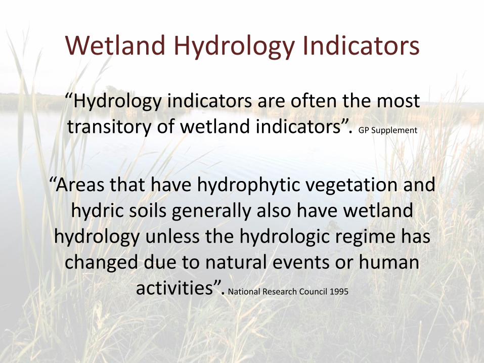
Wetland Hydrology Indicators
“Hydrology indicators are often the most transitory of wetland indicators”. GP Supplement
“Areas that have hydrophytic vegetation and hydric soils generally also have wetland
hydrology unless the hydrologic regime has changed due to natural events or human
activities”. National Research Council 1995

Wetland Hydrology Indicators
“Therefore, when wetland hydrology indicators are absent from an area that has indicators of hydric soil and hydrophytic vegetation, further
information may be needed to determine whether or not wetland hydrology is present”.
GP Supplement

Wetland Hydrology Indicators
“Wetland hydrology determinations are based on indicators, many of which were designed to be used during dry periods when the direct observation of the source water or shallow water table is not possible”. GP Supplement

Wetland Hydrology Indicators
• Indicate as many hydrology indicators observed
• Do not stop with only one when more are present

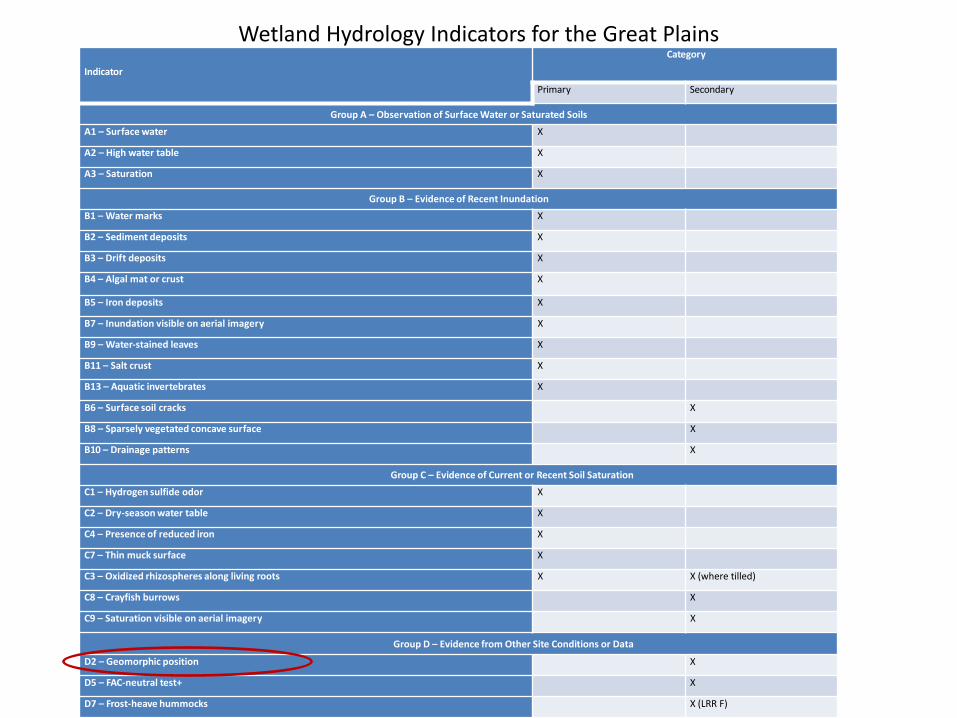
Wetland Hydrology Indicators for the Great Plains Indicator
Category
Primary Secondary
Group A – Observation of Surface Water or Saturated Soils
A1 – Surface water X
A2 – High water table X
A3 – Saturation X
Group B – Evidence of Recent Inundation
B1 – Water marks X
B2 – Sediment deposits X
B3 – Drift deposits X
B4 – Algal mat or crust X
B5 – Iron deposits X
B7 – Inundation visible on aerial imagery X
B9 – Water-stained leaves X
B11 – Salt crust X
B13 – Aquatic invertebrates X
B6 – Surface soil cracks X
B8 – Sparsely vegetated concave surface X
B10 – Drainage patterns X
Group C – Evidence of Current or Recent Soil Saturation
C1 – Hydrogen sulfide odor X
C2 – Dry-season water table X
C4 – Presence of reduced iron X
C7 – Thin muck surface X
C3 – Oxidized rhizospheres along living roots X X (where tilled)
C8 – Crayfish burrows X
C9 – Saturation visible on aerial imagery X
Group D – Evidence from Other Site Conditions or Data
D2 – Geomorphic position X
D5 – FAC-neutral test+ X
D7 – Frost-heave hummocks X (LRR F)
Page 121 GP Supplement

Wetland Hydrology Indicators for the Great Plains
• Saturation (pg. 76 GP Supplement)
– This indicator must be associated with an existing water table located immediately below the statured zone; however, this requirement is waived under episaturated conditions if there is a restrictive soil layer or bedrock within 12 in. of the surface.
Wetland Hydrology Indicators for the Great Plains Indicator
Category
Primary Secondary
Group A – Observation of Surface Water or Saturated Soils
A1 – Surface water X
A2 – High water table X
A3 – Saturation X
Group B – Evidence of Recent Inundation
B1 – Water marks X
B2 – Sediment deposits X
B3 – Drift deposits X
B4 – Algal mat or crust X
B5 – Iron deposits X
B7 – Inundation visible on aerial imagery X
B9 – Water-stained leaves X
B11 – Salt crust X
B13 – Aquatic invertebrates X
B6 – Surface soil cracks X
B8 – Sparsely vegetated concave surface X
B10 – Drainage patterns X
Group C – Evidence of Current or Recent Soil Saturation
C1 – Hydrogen sulfide odor X
C2 – Dry-season water table X
C4 – Presence of reduced iron X
C7 – Thin muck surface X
C3 – Oxidized rhizospheres along living roots X X (where tilled)
C8 – Crayfish burrows X
C9 – Saturation visible on aerial imagery X
Group D – Evidence from Other Site Conditions or Data
D2 – Geomorphic position X
D5 – FAC-neutral test+ X
D7 – Frost-heave hummocks X (LRR F)
Wetland Hydrology Indicators for the Great Plains
• Geomorphic Position
Not applicable to
Drained wetlands – surface or subsurface hydrology completely removed by modification
Applicable to artificial wetlands
Excavated depressional
Excavated slope
Dams

Indicator
Category
Primary Secondary
Group A – Observation of Surface Water or Saturated Soils
A1 – Surface water X
A2 – High water table X
A3 – Saturation X
Group B – Evidence of Recent Inundation
B1 – Water marks X
B2 – Sediment deposits X
B3 – Drift deposits X
B4 – Algal mat or crust X
B5 – Iron deposits X
B7 – Inundation visible on aerial imagery X
B9 – Water-stained leaves X
B11 – Salt crust X
B13 – Aquatic invertebrates X
B6 – Surface soil cracks X
B8 – Sparsely vegetated concave surface X
B10 – Drainage patterns X
Group C – Evidence of Current or Recent Soil Saturation
C1 – Hydrogen sulfide odor X
C2 – Dry-season water table X
C4 – Presence of reduced iron X
C7 – Thin muck surface X
C3 – Oxidized rhizospheres along living roots X X (where tilled)
C8 – Crayfish burrows X
C9 – Saturation visible on aerial imagery X
Group D – Evidence from Other Site Conditions or Data
D2 – Geomorphic position X
D5 – FAC-neutral test+ X
D7 – Frost-heave hummocks X (LRR F)

Wetland Hydrology Indicators
Chapter 5 – Wetlands that periodically lack indicators of wetland hydrology
1. Verify that indicators of hydrophytic vegetation and hydric soil are present, or are absent due to disturbance or other problem situations. If so, proceed to step 2.
2. Verify that the site is in a landscape position that is likely to collect or concentrate water. Appropriate settings are listed below. If the landscape setting is appropriate, proceed to step 3.

Wetland Hydrology Indicators
Step 2. Continued
a. Concave surface (e.g., depression or swale)
b. Floodplain
c. Level or nearly level area (e.g., 0- to 3-percent slope)
d. Toe slope or an area of convergent slopes . Fringe of another wetland or water body
e. Area with a restrictive soil layer or aquitard within 24 in. of the surface
f. Area where groundwater discharges (e.g., a seep)
g. Other (explain in field notes why this area is likely to be inundated or saturated for long periods)
Wetland Hydrology Indicators
3. Use one or more of the following approaches to determine whether wetland hydrology is present and the site is a wetland. In the remarks section of the data form or in the delineation report, explain the rationale for concluding that wetland hydrology is present even though indicators of wetland hydrology described in Chapter 4 were not observed.

Wetland Hydrology Indicators
a. Site visits during the dry season –
If the site visit occurred during the dry season on a site that contain hydric soils and hydrophytic vegetation and no significant hydrologic manipulation, then consider the site to be wetland (pg. 118 GP Supplement)
b. Periods with below-normal rainfall –
If precipitation was below normal prior to the site and the site contains hydric soils and hydrophytic vegetation and no significant hydrologic manipulation, it should be identified as a wetland. (pg. 119 GP Supplement)

Wetland Hydrology Indicators
c. Drought years –
If wetland hydrology indicators appear to absent on the site that has hydrophytic vegetation and hydric soils, no significant hydrologic manipulation, and the region has been a affected by drought, then the area should be identified as a wetland. (pg. 119 GP Supplement)

Wetland Hydrology Indicators
d. Reference Sites –
If indicators of hydric soil and hydrophytic vegetation are present on a site that lacks wetland hydrology indicators, the site may be considered to be a wetland if the landscape setting, topography, soils and vegetation are substantially the same as those on nearby wetland reference areas. (pg. 120 GP
Supplement)
Wetland Hydrology Indicators
e. Hydrology tools – 7 tools listed in GP Supplement (page 120 GP Supplement)
(3) Evaluate the frequency of wetness signatures on
aerial photography (pg. 120 GP Supplement)

Wetland Hydrology Indicators
f. Evaluating multiple years of aerial photography –
If wetness signatures are observed on photos in more than half of the years included in the analysis, then wetland hydrology is present – Normal precipitation years are used
References NRCS Wetland Mapping Conventions (see pg. 121 GP Supplement for additional information) http://efotg.sc.egov.usda.gov/efotg_locator.aspx?map=US

Wetland Hydrology Indicators
g. Long-term hydrologic monitoring –
NDDOT does not anticipate the need to use this approach

Growing Season
Growing season has begun (Page 70 – 71 GP Supplement)
1. Two or more different non-evergreen vascular plant species growing in the wetland or surrounding are exhibit one or more:

Growing Season
a) Emergence of herbaceous plants from the ground
b) Appearance of new growth from vegetative crowns
c) Coleoptile/cotyledon emergence from seed
d) Bud burst in woody plants
e) Emergence or elongation of leaves of woody plants
f) Emergence or opening of flowers

Growing season has begun (Page 70 – 71 GP Supplement)
2. When soil temperature measured at 12 inches is 41o F. One time measurement is sufficient. http://ndawn.ndsu.nodak.edu/soil-temps.html
* If growing season information is needed and can not be obtained through on-site collection, growing season can be approximated by the median dates of 28o F air temp. http://efotg.sc.egov.usda.gov/efotg_locator.aspx?map=US
Growing Season

Questions??
David Dewald
Wetland Mitigation Specialist
701.328.4484