Embed Size (px)
Citation preview
THESE TERMS GOVERN YOUR USE OF THIS DOCUMENT
Your use of this Ontario Geological Survey document (the “Content”) is governed by the terms set out on this page (“Terms of Use”). By downloading this Content, you (the
“User”) have accepted, and have agreed to be bound by, the Terms of Use.
Content: This Content is offered by the Province of Ontario’s Ministry of Northern Development and Mines (MNDM) as a public service, on an “as-is” basis. Recommendations and statements of opinion expressed in the Content are those of the author or authors and are not to be construed as statement of government policy. You are solely responsible for your use of the Content. You should not rely on the Content for legal advice nor as authoritative in your particular circumstances. Users should verify the accuracy and applicability of any Content before acting on it. MNDM does not guarantee, or make any warranty express or implied, that the Content is current, accurate, complete or reliable. MNDM is not responsible for any damage however caused, which results, directly or indirectly, from your use of the Content. MNDM assumes no legal liability or responsibility for the Content whatsoever. Links to Other Web Sites: This Content may contain links, to Web sites that are not operated by MNDM. Linked Web sites may not be available in French. MNDM neither endorses nor assumes any responsibility for the safety, accuracy or availability of linked Web sites or the information contained on them. The linked Web sites, their operation and content are the responsibility of the person or entity for which they were created or maintained (the “Owner”). Both your use of a linked Web site, and your right to use or reproduce information or materials from a linked Web site, are subject to the terms of use governing that particular Web site. Any comments or inquiries regarding a linked Web site must be directed to its Owner. Copyright: Canadian and international intellectual property laws protect the Content. Unless otherwise indicated, copyright is held by the Queen’s Printer for Ontario. It is recommended that reference to the Content be made in the following form: <Author’s last name>, <Initials> <year of publication>. <Content title>; Ontario Geological Survey, <Content publication series and number>, <total number of pages>p. Use and Reproduction of Content: The Content may be used and reproduced only in accordance with applicable intellectual property laws. Non-commercial use of unsubstantial excerpts of the Content is permitted provided that appropriate credit is given and Crown copyright is acknowledged. Any substantial reproduction of the Content or any commercial use of all or part of the Content is prohibited without the prior written permission of MNDM. Substantial reproduction includes the reproduction of any illustration or figure, such as, but not limited to graphs, charts and maps. Commercial use includes commercial distribution of the Content, the reproduction of multiple copies of the Content for any purpose whether or not commercial, use of the Content in commercial publications, and the creation of value-added products using the Content. Contact:
FOR FURTHER INFORMATION ON PLEASE CONTACT: BY TELEPHONE: BY E-MAIL:
The Reproduction of Content
MNDM Publication Services
Local: (705) 670-5691 Toll Free: 1-888-415-9845, ext.
5691 (inside Canada, United States)
The Purchase of MNDM Publications
MNDM Publication Sales
Local: (705) 670-5691 Toll Free: 1-888-415-9845, ext.
5691 (inside Canada, United States)
Crown Copyright Queen’s Printer Local: (416) 326-2678 Toll Free: 1-800-668-9938
(inside Canada, United States)
LES CONDITIONS CI-DESSOUS RÉGISSENT L'UTILISATION DU PRÉSENT DOCUMENT.
Votre utilisation de ce document de la Commission géologique de l'Ontario (le « contenu ») est régie par les conditions décrites sur cette page (« conditions d'utilisation »). En
téléchargeant ce contenu, vous (l'« utilisateur ») signifiez que vous avez accepté d'être lié par les présentes conditions d'utilisation.
Contenu : Ce contenu est offert en l'état comme service public par le ministère du Développement du Nord et des Mines (MDNM) de la province de l'Ontario. Les recommandations et les opinions exprimées dans le contenu sont celles de l'auteur ou des auteurs et ne doivent pas être interprétées comme des énoncés officiels de politique gouvernementale. Vous êtes entièrement responsable de l'utilisation que vous en faites. Le contenu ne constitue pas une source fiable de conseils juridiques et ne peut en aucun cas faire autorité dans votre situation particulière. Les utilisateurs sont tenus de vérifier l'exactitude et l'applicabilité de tout contenu avant de l'utiliser. Le MDNM n'offre aucune garantie expresse ou implicite relativement à la mise à jour, à l'exactitude, à l'intégralité ou à la fiabilité du contenu. Le MDNM ne peut être tenu responsable de tout dommage, quelle qu'en soit la cause, résultant directement ou indirectement de l'utilisation du contenu. Le MDNM n'assume aucune responsabilité légale de quelque nature que ce soit en ce qui a trait au contenu. Liens vers d'autres sites Web : Ce contenu peut comporter des liens vers des sites Web qui ne sont pas exploités par le MDNM. Certains de ces sites pourraient ne pas être offerts en français. Le MDNM se dégage de toute responsabilité quant à la sûreté, à l'exactitude ou à la disponibilité des sites Web ainsi reliés ou à l'information qu'ils contiennent. La responsabilité des sites Web ainsi reliés, de leur exploitation et de leur contenu incombe à la personne ou à l'entité pour lesquelles ils ont été créés ou sont entretenus (le « propriétaire »). Votre utilisation de ces sites Web ainsi que votre droit d'utiliser ou de reproduire leur contenu sont assujettis aux conditions d'utilisation propres à chacun de ces sites. Tout commentaire ou toute question concernant l'un de ces sites doivent être adressés au propriétaire du site. Droits d'auteur : Le contenu est protégé par les lois canadiennes et internationales sur la propriété intellectuelle. Sauf indication contraire, les droits d'auteurs appartiennent à l'Imprimeur de la Reine pour l'Ontario. Nous recommandons de faire paraître ainsi toute référence au contenu : nom de famille de l'auteur, initiales, année de publication, titre du document, Commission géologique de l'Ontario, série et numéro de publication, nombre de pages. Utilisation et reproduction du contenu : Le contenu ne peut être utilisé et reproduit qu'en conformité avec les lois sur la propriété intellectuelle applicables. L'utilisation de courts extraits du contenu à des fins non commerciales est autorisé, à condition de faire une mention de source appropriée reconnaissant les droits d'auteurs de la Couronne. Toute reproduction importante du contenu ou toute utilisation, en tout ou en partie, du contenu à des fins commerciales est interdite sans l'autorisation écrite préalable du MDNM. Une reproduction jugée importante comprend la reproduction de toute illustration ou figure comme les graphiques, les diagrammes, les cartes, etc. L'utilisation commerciale comprend la distribution du contenu à des fins commerciales, la reproduction de copies multiples du contenu à des fins commerciales ou non, l'utilisation du contenu dans des publications commerciales et la création de produits à valeur ajoutée à l'aide du contenu. Renseignements :
POUR PLUS DE RENSEIGNEMENTS SUR VEUILLEZ VOUS
ADRESSER À : PAR TÉLÉPHONE : PAR COURRIEL :
la reproduction du contenu
Services de publication du MDNM
Local : (705) 670-5691 Numéro sans frais : 1 888 415-9845,
poste 5691 (au Canada et aux États-Unis)
l'achat des publications du MDNM
Vente de publications du MDNM
Local : (705) 670-5691 Numéro sans frais : 1 888 415-9845,
poste 5691 (au Canada et aux États-Unis)
les droits d'auteurs de la Couronne
Imprimeur de la Reine
Local : 416 326-2678 Numéro sans frais : 1 800 668-9938
(au Canada et aux États-Unis)
ONTARIO
DEPARTMENT OF MINES
Mineral Resources Circular No. 6
Phosphate in Ontario
By
D. F. HEWITT
1967
Crown copyrights reserved. This book may not be reproduced,
in whole or in part, without the permission of the
Ontario Department of Mines
Publications of the Ontario Department of Mines
and pricelists
are obtainable through the
Publications Office, Ontario Department of Mines,
Parliament Buildings, Queen's Park,
Toronto, Ontario, Canada.
Orders for publications should be accompanied by cheque, or
money order, payable in Canadian funds to Treasurer
of Ontario. Stamps are not acceptable.
Page
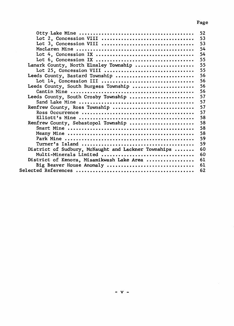
Otty Lake Mine ......................................... 52Lot 2, Concession VIII ................................. 53Lot 3, Concession VIII ........................,........ 53MacLaren Mine .......................................... 54Lot 4, Concession IX ................................... 54Lot 6, Concession IX ................................... 55
Lanark County, North Elmsley Township ..................... 55Lot 25, Concession VIII ................................ 55
Leeds County, Bastard Township ............................ 56Lot 14, Concession III ................................. 56
Leeds County, South Burgess Township ...................... 56Cantin Mine ............................................ 56
Leeds County, South Crosby Township ....................... 57Sand Lake Mine ......................................... 57
Renfrew County, Ross Township ............................. 57Ross Occurrence ........................................ 57Elliott 1 s Mine ......................................... 58
Renfrew County, Sebastopol Township ....................... 58Smart Mine ............................................. 58Meany Mine ............................................. 58Park Mine .............................................. 59Turner T s Island ........................................ 59
District of Sudbury, McNaught and Lackner Townships ....... 60Multi-Minerals Limited ................................. 60
District of Kenora, Misamikwash Lake Area ................. 61Big Beaver House Anomaly ............................... 61
Selected References .......................................... 62
- v -
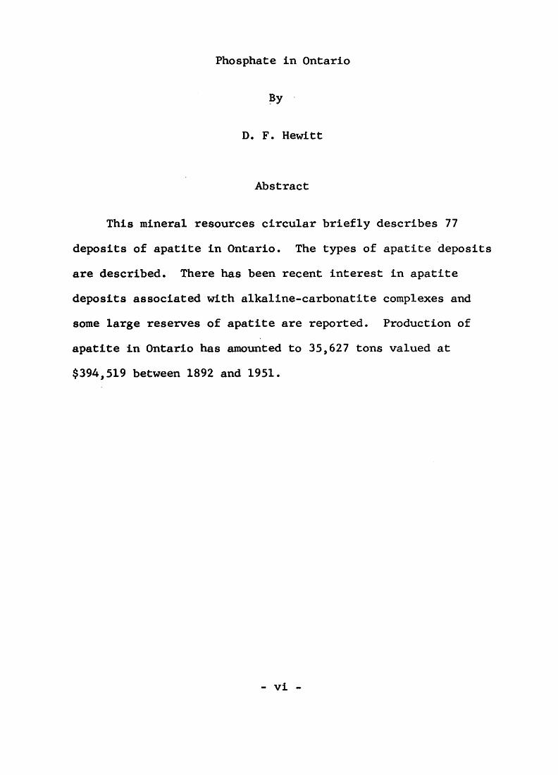
Phosphate in Ontario
By
D. F. Hewitt
Abstract
This mineral resources circular briefly describes 77
deposits of apatite in Ontario. The types of apatite deposits
are described. There has been recent interest in apatite
deposits associated with alkaline-carbonatite complexes and
some large reserves of apatite are reported. Production of
apatite in Ontario has amounted to 35,627 tons valued at
$394,519 between 1892 and 1951.
- vi -
Page
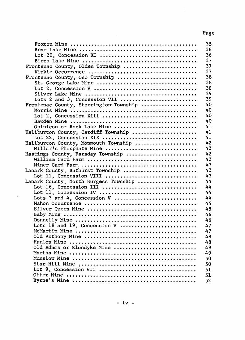
Foxton Mine ........................................... 35Bear Lake Mine ........................................ 36Lot 20, Concession XI ................................. 36Birch Lake Mine ....................................... 37
Frontenac County, Olden Township ......................... 37Vinkle Occurrence ..................................... 37
Frontenac County, Oso Township ........................... 38St. George Lake Mine .................................. 38Lot 2, Concession V ................................... 38Silver Lake Mine ...................................... 39Lots 2 and 3, Concession VII .......................... 39
Frontenac County, Storrington Township ................... 40Morris Mine ........................................... 40Lot 2, Concession XIII ................................ 40Bawden Mine ........................................... 40Opinicon or Rock Lake Mine ............................ 41
Haliburton County, Cardiff Township ...................... 41Lot 22, Concession XIX ................................ 41
Haliburton County, Monmouth Township ..................... 42Millar ! s Phosphate Mine ............................... 42
Hastings County, Faraday Township ........................ 42William Card Farm ..................................... 42Miner Card Farm ....................................... 43
Lanark County, Bathurst Township ......................... 43Lot 11, Concession VIII ............................... 43
Lanark County, North Burgess Township .................... 44Lot 16, Concession III ................................ 44Lot 11, Concession IV ................................. 44Lots 3 and 4, Concession V ............................ 44Mahon Occurrence ...................................... 45Silver Queen Mine ..................................... 45Baby Mine ............................................. 46Donnelly Mine ......................................... 46Lots 18 and 19, Concession V .......................... 47McMartin Mine ......................................... 47Old Anthony Mine ...................................... 48Hanlon Mine ........ -................................... 48Old Adams or Klondyke Mine ............................ 49Martha Mine ........................................... 49Munslow Mine .......................................... 50Star Hill Mine ........................................ 50Lot 9, Concession VII ................................. 51Otter Mine ............................................ 51Byrne f s Mine .......................................... 52
- iv -
PHOSPHATE IN ONTARIO
TABLE OF CONTENTS
Page
Abstract ................................................. viIntroduction ............................................. l
Uses and Specifications of Phosphate ............... 2Prices ............................................. 4Production ......................................... 4Types of Deposits .................................. 9
Silicated Marble With Disseminated Apatite ...... 9Metamorphic Pyroxenite With Apatite ............. 10
Occurrence ................................... 10Mineralogy ................................... 17Origin of Metamorphic Pyroxenite Deposits .... 18
Hydrothermal Vein Deposits ...................... 21Alkaline-Carbonate Complexes .................... 22
Descriptions of Deposits ................................. 24Frontenac County, Bedford Township .................... 24
Martin Occurrence .................................. 24Lot 6, Concession IV ............................... 24Bobs Lake or Taggart Mine .......................... 25Lot 7, Concession VII .............................. 25Hilliard Bedore Occurrence ......................... 26McLaren Mine ....................................... 26Lot 28, Concession XI .............................. 28Opinicon Lake Mine ................................. 28Lot 3, Concession XII .............................. 28
Frontenac County, Hinchinbrooke Township .............. 29Hickey Occurrence .................................. 29Eagle Lake Mine .................................... 29Kenehan Occurrence ................................. 30Ernie Campsall Occurrence .......................... 30
Frontenac County, Loughborough Township ............... 31Lacey Mine ......................................... 31Coe Mine ........................................... 31Amey Mine .......................................... 32Lot 6, Concession IX ............................... 32Lot 7, Concession IX ............................... 33Lot 16, Concession IX .............................. 33Gould Lake Mine ............... ................. .... 33McClatchey Mine .................................... 34Lot 10, Concession X ............................... 35
- iii -
- l -
Phosphate in Ontario
By
D. F. Hewitt1
Introduction
The phosphate mining industry began in Ontario about 1870,
and flourished until 1892, when competition from cheaper Florida
phosphate rock reduced the price. There has been intermittent
phosphate production from 1892 until 1951 when mining ceased.
The cessation of phosphate production has been largely due to
the competition of cheap sources of phosphate rock in Florida,
Tennessee and Montana. Most of the Ontario deposits operated
during these years have been small and irregular in shape and
size. The vein deposits are pockety.
The recent discovery of alkaline-carbonatite complexes
with large tonnages of apatite and magnetite has revived
interest in the Ontario phosphate industry and renewed
production of phosphate in Ontario in the future seems likely.
In 1964, 1,406,424 short tons of phosphate rock valued at
$11,719 > 401 were imported into Canada, mainly from Montana and
Florida. The phosphate rock was worth between $7.00 and $8.00
a ton.
1 Senior Geologist, Ontario Department of Mines, Toronto. Manuscript received by the Director, Geological Branch,
4 Aug. 1967.
- 2 -
Uses and Specifications of Phosphate
The principal use of phosphate is in the phosphate
fertilizer industry. J.E. Reeves (1964) has given the
following summary of developments in the phosphate fertilizer
field:
"In early 1964 The Consolidated Mining and Smelting Company of Canada Limited completed a 100,000 ton-a-year extension of its ammonium phosphate plant at Kimberley, British Columbia, and its subsidiary, Montana Phosphate Products Company, completed the development of the Douglas Creek mine and construction of a 300,000 ton-a-year phosphate rock concentrator near Maxwell in southwestern Montana. In addition, it began construction of a 100,000 ton-a-year ammonium phosphate plant at Regina, Saskatchewan, and an extension of the phosphoric acid plant at Kimberley to feed the Regina plant - both to be completed in 1965."
"At Fort Saskatchewan, Alberta, Sherritt Gordon Mines, Limited, started construction of a plant capable of producing 125,000 tons of ammonium phosphate a year. Completion is scheduled for the latter part of 1965. Phosphate rock will be imported from Florida via Vancouver."
Late in 1964 Border Fertilizer Limited began producing ammonium phosphate at Transcona, Manitoba, from a new plant with a capacity of 80,000 tons a year. Phosphate rock is imported from Wyoming."
"During the year construction was begun on an expansion of the ammonium phosphate plant of Northwest Nitro-Chemicals Limited at Medicine Hat, Alberta, and on a new fertilizer plant at Calgary, Alberta, to be operated by Western Co operative Fertilizers Limited. The latter plant is being financed by three large co-operatives - The Alberta Wheat Pool, The Saskatchewan Wheat Pool and Federated Co-operatives Limited - and will include in its production 520 tons of ammonium phosphate a day."
- 3 -
"Plans for several new phosphate fertilizer plants have been announced. Brunswick Fertilizer Corporation Limited, owned jointly by Brunswick Mining and Smelting Corporation and the British parent company of Electric Reduction Company of Canada Limited, Albright 6e Wilson Limited, will build a plant for the production of 680,000 tons of ammonium phosphate a year, mainly for export. The plant, which will be located near Belledune, north of Bathurst, New Brunswick, will consume byproduct sulphuric acid from the proposed nearby iron ore (pyrite) plant and imported phosphate rock. St. Lawrence Fertilizers Limited was incorporated to operate a wet-process phosphoric acid plant and related fertilizer plants at Valley- field, Quebec, using byproduct sulphuric acid from the smelter of Canadian Electrolytic Zinc Limited and phosphate rock imported probably from Morocco. The acid plant will reportedly have a capacity of about 300 tons a day. Canadian Industries Limited will build a large fertilizer complex, including units for making phosphoric acid and ammonium phosphate, at Courtright, south of Sarnia, Ontario. J.R. Simplot Company will build a fertilizer complex at Winnipeg, including an ammonium phosphate plant with a capacity of 225,000 tons a year. It will import the necessary phosphoric acid from its expanded facilities in Pocatello, Idaho."
For the manufacture of fertilizer, phosphate rock should
contain at least 68 percent bone phosphate of lime (B.P.L.)
and may contain as high as 77 percent B.P.L. depending on
the process. For electric furnace use, a lower B.P.L. content
is acceptable but the rocks must have no excess calcium, a
maximum of 3 percent Fe203 plus A1203, and be mostly coarser
than 5 mesh (Reeves 1964, p. 483).
- 4 -
and detergents. Reeves (1964) states that the food-processing
industry uses considerable amounts as a leavening agent in
baking powders, cake mixes, etc. and in food preservatives.
Phosphorous chemicals are also used in paints, plastic and
paper manufacturing, pharmaceutical preparations and other
products.
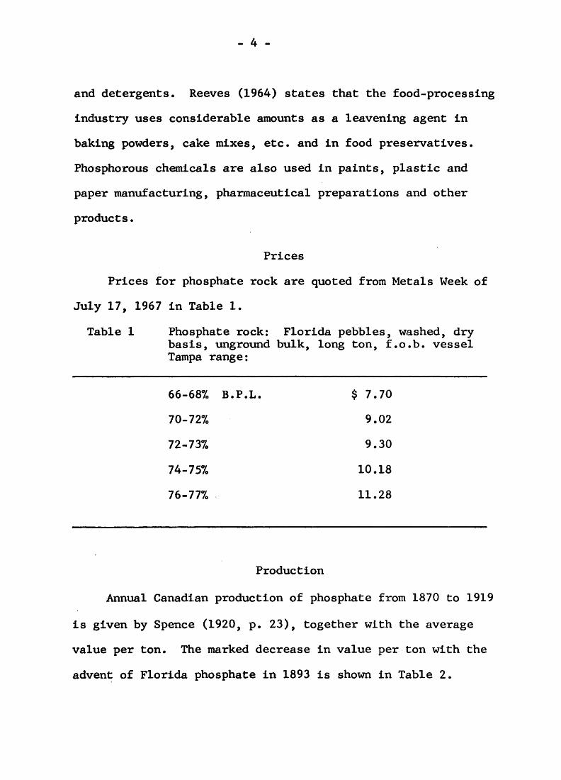
Prices
Prices for phosphate rock are quoted from Metals Week of
July 17, 1967 in Table 1.
Table l Phosphate rock: Florida pebbles, washed, dry basis, unground bulk, long ton, f.o.b. vessel Tampa range:
66-687o B.P.L. $ 7.70
70-727o 9.02
72-737o 9.30
74-757o 10.18
76-777o 11.28
Production
Annual Canadian production of phosphate from 1870 to 1919
is given by Spence (1920, p. 23), together with the average
value per ton. The marked decrease in value per ton with the
advent of Florida phosphate in 1893 is shown in Table 2.

- 5 -
Table 2 Annual Production of Phosphate from 1870 to 1919
Year
*1870..
*1871..
1872..)
1873..)
1874..- No
1875..)
1876..)
**1877..
1878..
1879..
1880..
1881..
1882..
1883..
1884..
1885..
**1886..
1887..
1888..
1889..
Amount
tons.
1,200
200
Records
2,823
10,743
8,446
13,060
11,968
17,153
19,716
21,709
28,969
20,495
23,690
22,485
30,988
Value
$
13,600
2,100
47,084
208,109
122,035
190,086
218,456
338,357
427,668
424,240
496,293
304,338
319,815
242,285
316,662
Average value per ton
$
11.33
10.50
16.68
19.37
14.45
14.55
18.25
19.73
21.69
19.54
17.13
14.85
13.50
10.77
10.21
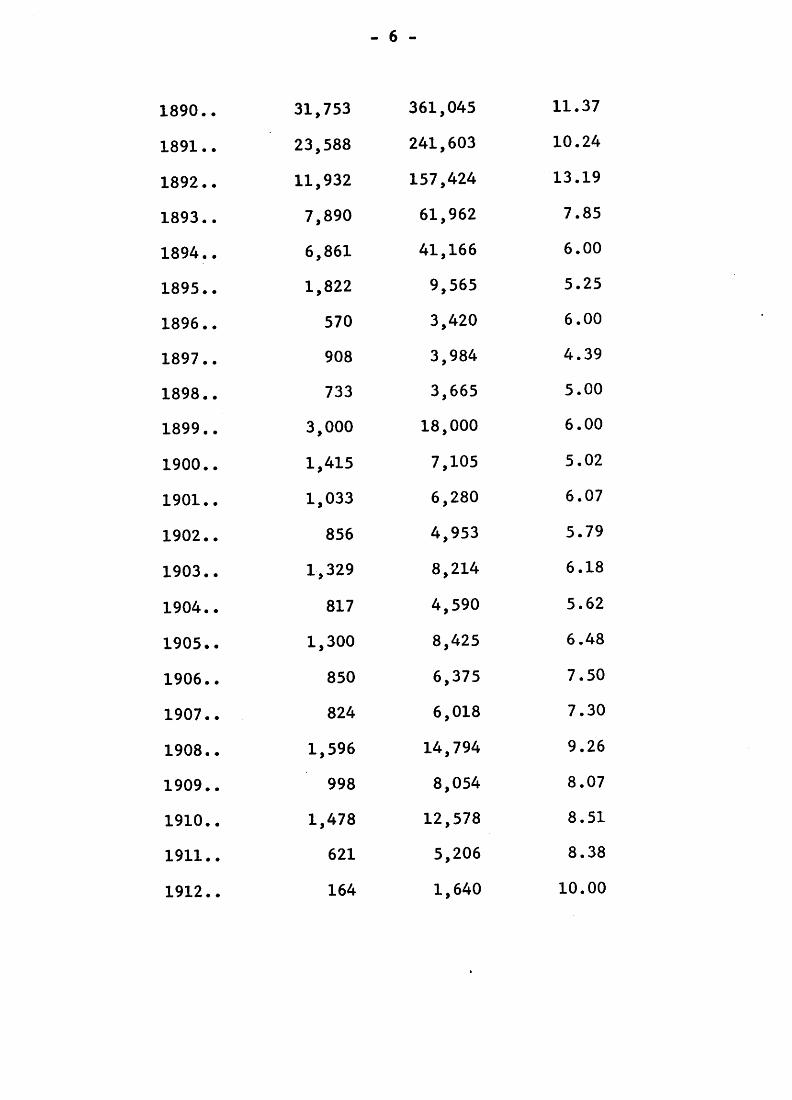
- 6 -
1890..
1891..
1892..
1893..
1894..
1895..
1896..
1897..
1898..
1899..
1900..
1901..
1902..
1903..
1904..
1905..
1906..
1907..
1908..
1909..
1910..
1911..
1912..
31,753
23,588
11,932
7,890
6,861
1,822
570
908
733
3,000
1,415
1,033
856
1,329
817
1,300
850
824
1,596
998
1,478
621
164
361,045
241,603
157,424
61,962
41,166
9,565
3,420
3,984
3,665
18,000
7,105
6,280
4,953
8,214
4,590
8,425
6,375
6,018
14,794
8,054
12,578
5,206
1,640
11.37
10.24
13.19
7.85
6.00
5.25
6.00
4.39
5.00
6.00
5.02
6.07
5.79
6.18
5.62
6.48
7.50
7.30
9.26
8.07
8.51
8.38
10.00
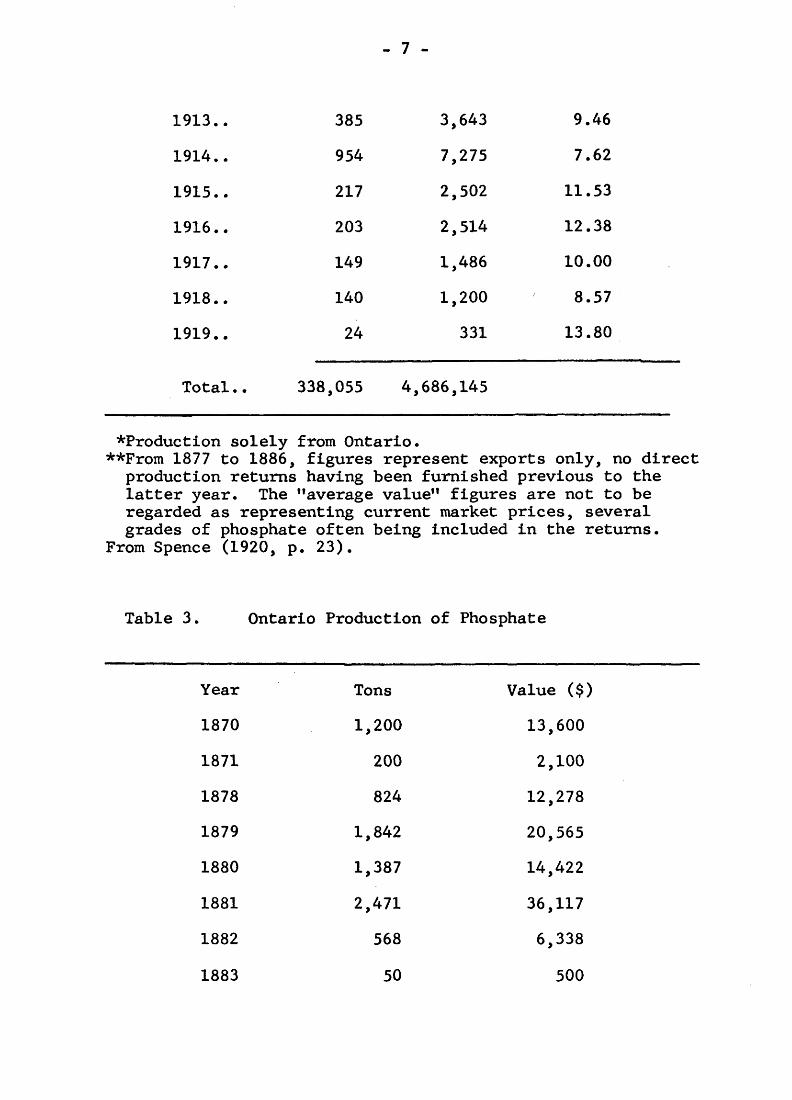
- 7 -
1913..
1914..
1915..
1916..
1917..
1918..
1919.,
Total . .
385
954
217
203
149
140
24
338,055
3,643
7,275
2,502
2,514
1,486
1,200
331
4,686,145
9.46
7.62
11.53
12.38
10.00
8.57
13.80
*Production solely from Ontario.**From 1877 to 1886, figures represent exports only, no direct
production returns having been furnished previous to the latter year. The "average value11 figures are not to be regarded as representing current market prices, several grades of phosphate often being included in the returns.
From Spence (1920, p. 23).
Table 3. Ontario Production of Phosphate
Year
1870
1871
1878
1879
1880
1881
1882
1883
Tons
1,200
200
824
1,842
1,387
2,471
568
50
Value ^)
13,600
2,100
12,278
20,565
14,422
36,117
6,338
500
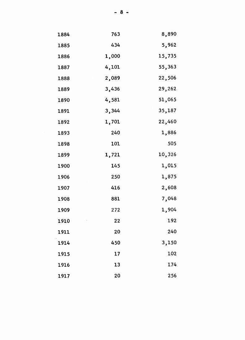
- 8 -
1884
1885
1886
1887
1888
1889
1890
1891
1892
1893
1898
1899
1900
1906
1907
1908
1909
1910
1911
1914
1915
1916
1917
763
434
1,000
4,101
2,089
3,436
4,581
3,344
1,701
240
101
1,721
145
250
416
881
272
22
20
450
17
13
20
8,890
5,962
15,735
55,363
22,506
29,262
51,065
35,187
22,460
1,886
505
10,326
1,015
1,875
2,608
7,048
1,904
192
240
3,150
102
174
256
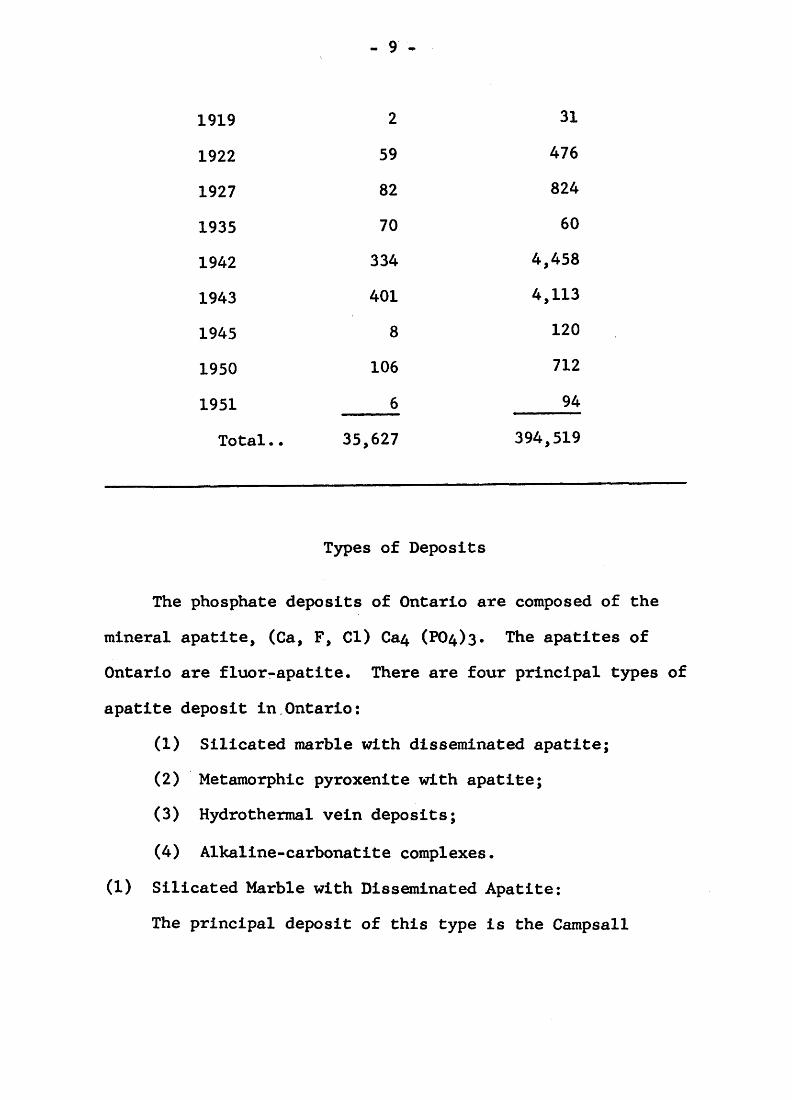
- 9 -
1919
1922
1927
1935
1942
1943
1945
1950
1951
Total . .
2
59
82
70
334
401
8
106
6
35,627
31
476
824
60
4,458
4,113
120
712
94
394,519
Types of Deposits
The phosphate deposits of Ontario are composed of the
mineral apatite, (Ga, F, CI) Ca4 (^4)3. The apatites of
Ontario are fluor-apatite. There are four principal types of
apatite deposit in Ontario:
(1) Silicated marble with disseminated apatite;
(2) Metamorphic pyroxenite with apatite;
(3) Hydrothermal vein deposits;
(4) Alkaline-carbonatite complexes.
(1) Silicated Marble with Disseminated Apatite:
The principal deposit of this type is the Campsall
- 10 -
occurrence in lot 3, concession II, Hinchinbrooke township,
Frontenac county* Fine-grained apatite and magnetite is
disseminated in medium-grained crystalline limestone. In
places apatite makes up as much as 25 percent of the rock* It
is likely that this fine-grained, evenly disseminated apatite
is of sedimentary origin and has been metamorphosed with the
crystalline limestone.
(2) Metamorphic Pyroxenite with Apatite:
Occurrence
The most common type of apatite deposit in Ontario is
the metamorphic pyroxenite type which occurs in two principal
areas of the Grenville geologic province of southeastern
Ontario. There are a large number of apatite deposits south
of Perth, mainly centred in North Burgess township, Lanark
county. The second large group of apatite deposits occurs north
of Kingston in Loughborough and Bedford townships, Frontenac
county.
The metamorphic pyroxenite deposits occur in terranes of
high grade metamorphic gneisses and granite gneisses associated
with marble and paragneiss. The metamorphic pyroxenite is
thought to be altered marble.
There are 3 varieties of metamorphic pyroxenite deposits:
- 11 -
The vein or fissure type, where the pyroxenite and apatite
form a vein or fissure-filling in the country rock; the pocket
type where the apatite is segregated in clusters or pockets in
pyroxenite which pinches and swells; and thirdly the contact
type where apatite occurs on the contact of pyroxenite and
country rock or pegmatite.
Several varieties of metamorphic pyroxenite deposits are
illustrated in the accompanying figures from de Schmid (1912).
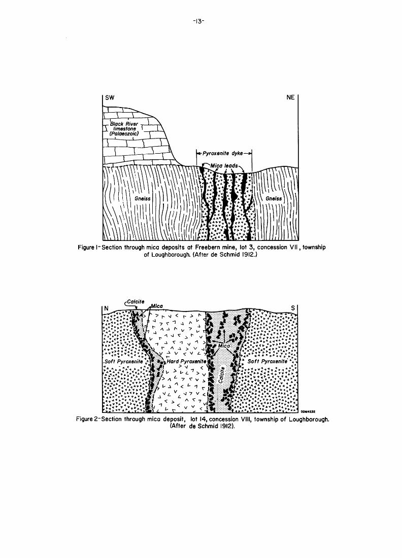
Figure l is the Freeburn mine in lot 3, concession VII,
Loughborough township, Frontenac county. The pyroxenite dike
cuts gneiss and carries vein-like leads of phlogopite, apatite
and calcite.
Figure 2 is a mica deposit in lot 14, concession VIII,
Loughborough township, Frontenac county. The mica and minor
apatite occur in calcite veins in pyroxenite.
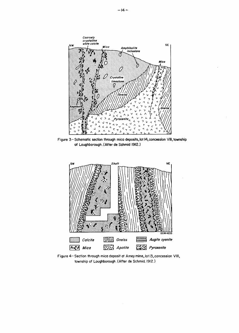
Figure 3 is a mica-apatite deposit in lot 14, concession
VIII, Loughborough township, Frontenac county. A coarsely
crystalline calcite vein carrying mica and apatite cuts
pyroxenite and crystalline limestone. Some mica occurs along
the vein contact in the crystalline limestone.
Figure 4 is the Amey mine in lot 13, concession VIII,
Loughborough township, Frontenac county. The country rock is
gneiss; the main ore bodies are calcite carrying mica and
apatite. The calcite is enclosed in pyroxenite which in turn
- 12 -
is margined by augite syenite.
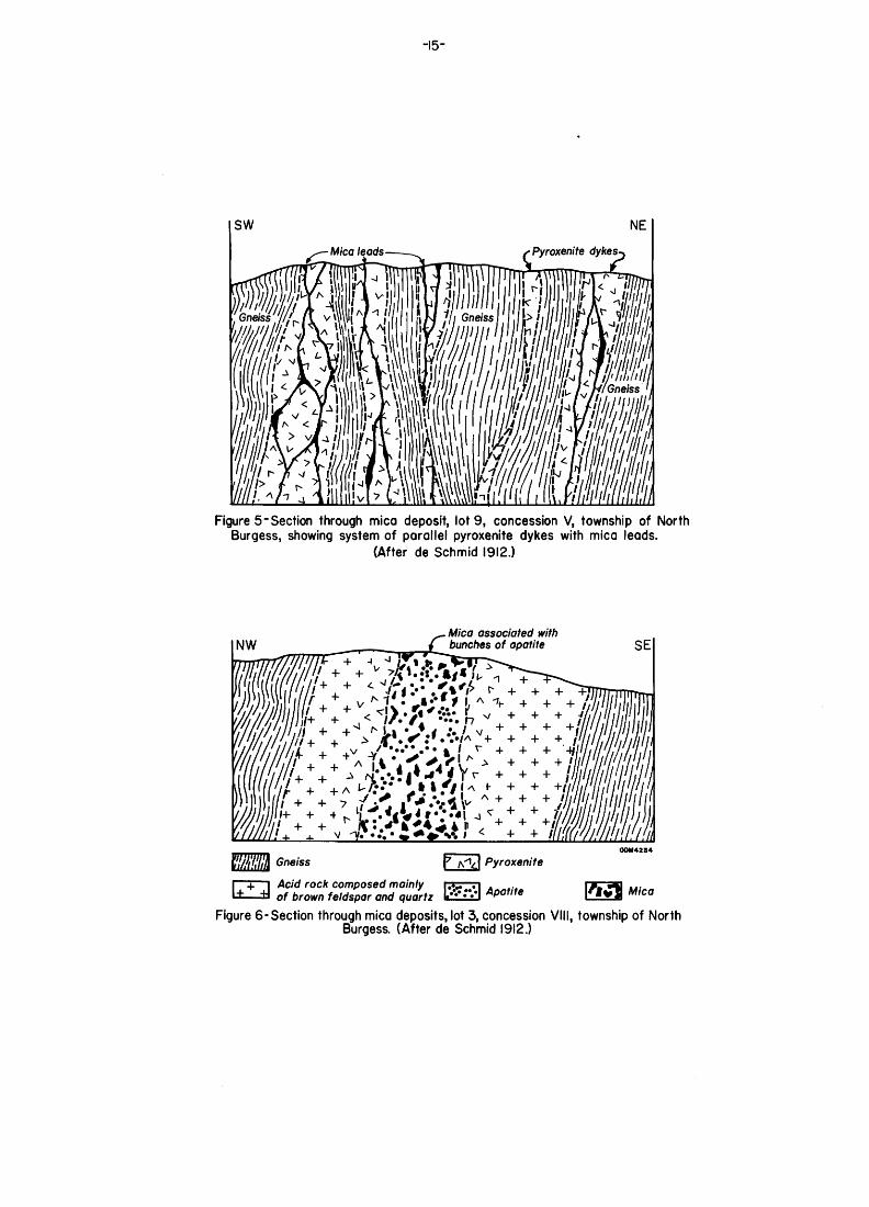
Figure 5 is a mica-apatite deposit in lot 9, concession
V, North Burgess township, Lanark county. The country rock is
gneiss cut by veins of metamorphic pyroxenite which carries
irregular, branching, pockety leads of mica with minor apatite.
Figure 6 is a mica-apatite deposit in lot 3, concession
VIII, North Burgess township, Lanark county. The mica-apatite
vein occurs in metamorphic pyroxenite which is margined by a
granitic rock. The banded complex cuts gneiss country rock.
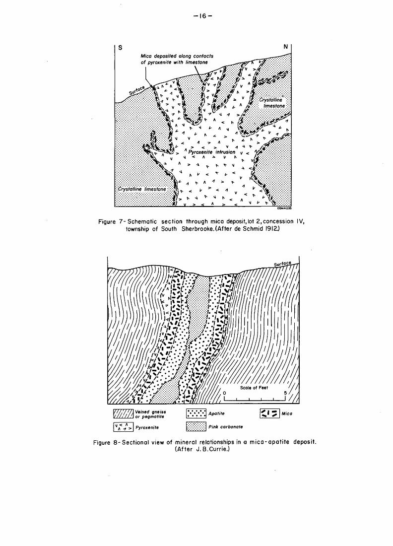
Figure 7 is a mica deposit in lot 2, concession IV, South
Sherbrooke township. This is a contact deposit with mica
occurring in marble along the contact of metamorphic pyroxinite
in branching form.
Figure 8 is a sectional view of Currie 1 s typical mineral
relationships in a mica-apatite deposit (Currie 1951, p. 774).
-13-
-r- Black River j. limestone
(Palaeozoic)
Figure l-Section through mica deposits at Freebern mine, lot 3, concession VII, township of Loughborough. (After de Schmid 1912.)
Figure 2-Section through mica deposit, lot 14, concession VIII, township of Loughborough.(After de Schmid 1912).
-14-
Coarsely crystalline white calcite
Figure 3-Schematic section through mica deposits,lot 14,concession VIII,township of Loughborough. (After de Schmid 1912,)
OD M 4233
Calcite
Mica
Gneiss
Apatite
Xlwg/'/e syenite
Pyroxenite
Figure 4- Section through mica deposit at Amey mine, lot 13,concession VIII, township of Loughborough.(After de Schmid. 1912.)
-15-
Figure 5-Section through mica deposit, lot 9, concession V, township of North Burgess, showing system of parallel pyroxenite dykes with mica leads.
(After de Schmid 1912.)
NW— Mica associated with
{ bunches of apatitem
SE
Gneiss Pyroxenite
Acia rocK composea mainly i.*.. .i . . of brown feldspar and quartz h* •"•'l APatlfe Mica
Figure 6-Section through mica deposits, lot 3, concession VIII, township of North Burgess. (After de Schmid 1912.)
-16-
NMica deposited along contacts of pyroxenite with limestone
alline limestone :X;S!
Figure 7-Schematic section through mica deposit,lot 2,concession IV, township of South Sherbrooke.(After de Schmid 1912.)
Surface
Veined gneiss or pegmatite
Pyroxenite
Apatite
Pink carbonate
Figure 8-Sectional view of mineral relationships in a mica-apatite deposit.(After J. B.Currie.)
- 17 -
The zonal sequence of country rock-metamorphic pyroxenite
- calcite with apatite and mica is noteworthy and characteristic
of many of these deposits. Phlogopite and apatite are almost
invariably associated in the metamorphic pyroxenite type of
deposit, but occasionally apatite or mica will predominate to
the exclusion of the other. The phlogopite-apatite deposits
occur in veins, pockets or marginal to the metamorphic pyroxenite.
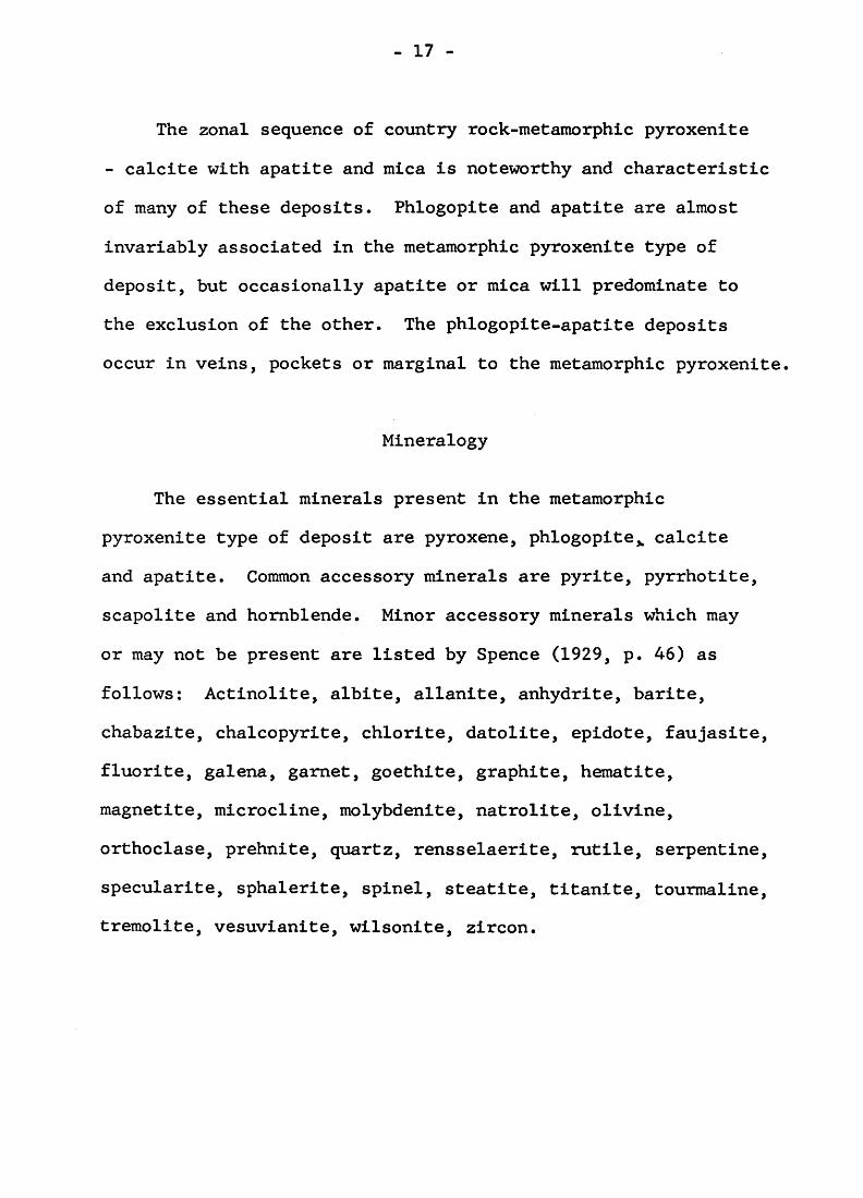
Mineralogy
The essential minerals present in the metamorphic
pyroxenite type of deposit are pyroxene, phlogopite,, calcite
and apatite. Common accessory minerals are pyrite, pyrrhotite,
scapolite and hornblende. Minor accessory minerals which may
or may not be present are listed by Spence (1929, p. 46) as
follows: Actinolite, albite, allanite, anhydrite, barite,
chabazite, chalcopyrite, chlorite, datolite, epidote, faujasite,
fluorite, galena, garnet, goethite, graphite, hematite,
magnetite, microcline, molybdenite, natrolite, olivine,
orthoclase, prehnite, quartz, rensselaerite, rutile, serpentine,
specularite, sphalerite, spinel, steatite, titanite, tourmaline,
tremolite, vesuvianite, wilsonite, zircon.
- 18 -
Origin of Metamorphic Pyroxenite Deposits
The origin of this type of apatite-mica deposit has been
the subject of much controversy. The two principal hypotheses
are (1) that the pyroxenite is the product of metamorphism of
crystalline limestone and (2) that the pyroxenites are basic
intrusives akin to basic pegmatites. A detailed summary of
early views of the problem is given by de Schmid (1912, p.
250-272). He gives his later views in 1920 (Spence 1920, p.
122), and states that:
"the mica-apatite deposits possess the form of irregular, pockety masses enclosed in pyroxenite ..... The pyroxenites represent metamorphosed limestones which have been invaded, disrupted and engulfed, by immense batholithic masses of granite to which latter rock a gneissic character has been imparted by subsequent dynamic movements."
"The origin of the mica-apatite-calcite bodies is probably to be attributed to the agency of late pegmatitic phases of this granite and of the aqueous solutions accompanying the pegmatites. These solutions were charged with phosphoric acid, and the apatite is, therefore, to be considered of igneous origin, rather than to have been derived from the original limestones. The calcite probably represents calcium carbonate dissolved from the limestones by heated waters, and redeposited in cavities in the pyroxenites, while the mica is of contact metamorphic origin."
These views agree well with the writer's opinions on
origin.
In discussing the origin of the deposits de Schmid (1912,
p. 266) states that:
"R.A. Penrose (1888) regards the occasional, parallel
- 19 -
bands in some pyroxenites as probable joint planes, and mentions the frequent absence of any sharp contact between gneiss and pyroxenite, the border zone being a gradual transition from one to the other with the formation of a pyroxene gneiss."
de Schmid (1912, p. 270) states that:
"Penrose recognizes what seems actually to be the case in many deposits - namely, the gradual transition from pyroxenite to gneiss, and this type of the latter rock is probably the grey, sedimentary gneiss of Adams and Barlow and others."
In 1929 Spence had swung to favour the igneous hypothesis
and Spence (1929, p. 40) states that:
"Various characteristics of the pyroxenites and mica- apatite bodies lend considerable support to the view that they are of igneous origin, and are basic intrusives, akin to pegmatites. Chief of these is the fact that the pyroxenite exhibits sharp, frozen contacts with the enclosing gneiss or limestone. The writer has observed no instance of a gradual transition of mica-bearing pyroxenite to country rock, as might be expected if the pyroxenite were a product of metamorphism."
K.K. Landes (1938, p. 359-388) also discusses the origin
of the Quebec phlogopite-apatite deposits. He concluded that
the theory of contact metamorphism is untenable because of
crosscutting relationships of pyroxenite to country rock.
The calcite is thought to be hydrothermal not residual. A
granite pegmatite magma unusually rich in phosphorus became
contaminated by dolomite. This contaminated magma moved
upward into rock now exposed and crystallized. Pyroxenite
was the earliest product followed by microcline and several
minerals. Finally aqueous solutions from a deeper crystallizing
- 20 -
magma introduced a hydrothermal phase during which calcite,
apatite, phlogopite and other minerals were deposited. Landes
makes the following points: (1) The pyroxenite has crosscutting
relations with the country rock; (2) Some of the minerals are
characteristic of contact metamorphism of magnesian limestone.
Such minerals as diopside, scapolite and phlogopite are formed
where interaction has taken place between siliceous emanations
and dolomitic country rock; (3) Magnesian limestone is scarce
in the vicinity of the majority of miea-phosphate deposits;
(4) The abundance of microcline pegmatite necessitates a
source magma high in potash and not essentially a pyroxenitic
magma.
J.B. Currie (1951, p. 765-778) has described the occurrence
and relationships of some mica-apatite deposits in North
Burgess township. He gives evidence that the pyroxenite in
the mica-apatite deposits has originated through contact
metamorphism of crystalline limestone by pegmatitic solutions.
Pegmatitic solutions are thought to be responsible for the
depositon of the mica and apatite. The calcite is considered
to be of sedimentary origin.
The writer favours a contact metamorphic origin for the
metamorphic pyroxenite which is frequently in close association
with limy paragneiss and amphibolite. Hydrothermal solutions
- 21 -
associated with the intrusion and contact metamorphism of the
crystalline limestones are responsible for depositing the
phlogopite, apatite and other minerals. Mobility and
injection of marble into associated country rocks explains
the apparent intrusive relations of the metamorphic pyroxenite.
Metamorphic pyroxenite deposits are a common type of deposit
in the Bancroft area where molybdenite and uraninite deposits
are found in metamorphic pyroxenite. Examples of uraninite
deposits occurring in metamorphic pyroxenite are those at the
McLean-Hogan property, Halo mine and Bicroft mine. The uraninite
-bearing metamorphic pyroxenite at Bicroft mine was an old
mica prospect.
(3) Hydrothermal Vein Deposits:
Hydrothermal vein deposits consisting predominantly of
calcite with accessory purple fluorite, apatite and phlogopite,
with or without uraninite and uranothorite, occur in the
Wilberforce-Bancroft area of eastern Ontario. Examples of
this type of deposits are Cardiff Uranium mine, Fission mine,
the Nu-Age (Tripp) mine and several other occurrences in the
area (Hewitt 1957, p. 56). Accessory minerals often include
hornblende, pyroxene, magnetite, titanite,betafite and
scapolite. The veins occur as lenticular, discontinuous,
fissure fillings from a few inches to 12 feet wide and up to
- 22 -
300 feet long. None of the hydrothermal vein deposits has
been a commercial source of apatite.
(4) Alkaline-Carbonatite Complexes;
The most promising new apatite deposits recently found
in Ontario occur in association with alkaline-carbonatite
plugs, a number of which have been found in Ontario. The
best-known and most highly developed ore bodies are those of
Multi-Minerals Limited in McNaught and Lackner townships,
District of Sudbury, 7 miles northeast of Nemegos station.
Diamond drilling has outlined several ore zones. Zones 3 and
4 are estimated to contain 37,000,000 tons grading 21.3
percent apatite, 13.7 percent magnetite and 0.198 percent
columbium oxide. No. 6 zone is estimated to contain 5,024,250
tons to 500-foot depth, grading 69.6 percent magnetite, 21.9
percent apatite and 0.173 percent columbium oxide (Canadian
Mines Handbook, 1966-1967, p. 219).
Several of the alkaline-carbonatite complexes are
described by Parsons (1961). The Nemegos deposit has been
described by Hodder (1961). Regarding the occurrence and
origin of the magnetite-apatite bodies he states (Hodder 1961,
p. 53),
"the magnetite-apatite bodies at Nemegos are pod-shaped and lie within the malignite. The walls of the bodies are vertical or dip steeply and the strike of the contacts and
- 23 -
foliation conforms roughly to that of the foliation in the malignite. Blocks of malignite are included within the orebodies and bear no evidence of alteration. Unaltered nepheline syenite is also present within magnetite-apatite but whether it is intrusive into the magnetite-apatite or included within it, is not clear. The minerals of these orebodies magnetite, apatite, sulphides, pyrochlore, aegirinaugite, are also common to ijolite, malignite and carbonate rock and to the metasomatized gneiss outside the nepheline syenite."
"The hypothesis is proposed that the magnetite-apatite bodies were intruded into steeply dipping cone-sheet fractures and zones of brecciation within the malignite. Foliation is attributed to flow banding and their mineral composition to crystallization from fluids very similar to those responsible for the alteration of the regional gneiss and the formation of ijolites and malignites. It is concluded that the magnetite- apatite bodies formed from aqueous solutions rich in iron, lime and components of the accessory minerals and some
- 24 -
DESCRIPTIONS OF DEPOSITS
FRONTENAC COUNTY
Bedford Township
Martin Occurrence
Location: Lot 4, concession II, Bedford township, Frontenac county.
Minerals Present: Apatite, phlogopite, pyroxene.
Development: Worked early in the century by A. Martin and John Bragg. A shaft 40 feet deep was sunk.
Geology: Vein of apatite, phlogopite and pyroxene cuts pink paragneiss which strikes N27OE and dips 30 to 60 degrees southeast.
Reference: Harding (1947, p. 36).
Lot 6, Concession IV
Location: Lot 6, concession IV, Bedford township, Frontenac county.
Minerals Present: Apatite.
Reference: Spence (1920, p. 44).
- 25 -
Bobs Lake or Taggart Mine
Location: Lot 30, concession VI, Bedford township, Frontenac county.
Minerals Present: Apatite and phlogopite.
Development: The earliest mining was carried out in 1891 by the Montreal Mining Company, in a search for phosphate. Later mica was discovered by William Lewis, and mica was produced from 1897 to 1900 by Tom Taggart of Westport. Mica was produced by Kent Bros, and Stoness from 1903 to 1925. Other operators of the Bobs Lake mine were William Lee, S.O. Fillion and William Kent. In 1945 some mica was produced by Clayton Orser and Damon Smith. Production came from a series of closely spaced parallel veins worked by separate open pits. Some of the named workings were the Taggart, Butternut, Jones and King pits, The largest of several old workings is 125 feet long, 9 feet wide and about 125 feet deep.
Geology: Mica and phosphate occur in parallel veins 2 to 9 feet wide cutting altered greywackes and other Grenville metasediments.
References: Harding (1947, p. 86); Spence (1920, p. 42); de Schmid (1912, p. 159).
Lot 7, Concession VII
Location: Lot 7, concession VII, Bedford township, Frontenac county.
Minerals Present: Apatite.
Development: Reported to have been worked in a small way.
Reference: Spence (1920, p. 44).
- 26 -
Hilliard Bedore Occurrence
Location: Lot 32, concession VII, Bedford township, Frontenac county. Near the north shore of Bobs Lake.
Minerals Present: Apatite, phlogopite, pink calcite,pyroxene.
Development: Three or four dozen pits and trenches were putdown, the largest of which is 75 feet by 40 feet and 25 feet deep. Between 1880 and 1890 phosphate was produced by R.C. Adams and the Anglo-Canadian Phosphate Company.
Geology: Apatite occurs in massive form and in crystals.Calcite, apatite, pyroxene, phlogopite veins strike northeast parallel to the north shore of Bobs Lake. The veins dip vertically. Most of the veins are less than 5 feet wide. The country rock is Pre cambrian greywacke striking northeast and dipping 40 to 80 degrees southeast.
References: Spence (1920, p. 43); Harding (1947, p. 36).
McLaren Mine
Location: Lots 25, 27, 28, 29, concession X, Bedfordtownship, Frontenac county. Shaft on lot 27.
Minerals Present: Apatite, hornblende, pyroxene, calcite,phlogopite, pyrite, actinolite.
Development: Apatite was produced at the McLaren mine between 1888 and 1890 by Edmund Watts and Peter McLaren from shallow pits scattered over a belt 1200 feet long. About 500 tons of apatite are reported to have been shipped. The deepest of the early workings was about 35 feet. In 1941 or 1942 Canadian Phosphate Mining Company was formed by Bruce Robson. In 1942 this company produced 244 tons of apatite. Later in 1942 the company optioned the property to Pioneer Gold
- 27 -
Mines Limited who in the fall did 1521 feet of diamond drilling in 10 holes in the northeastern section of the property. The drilling indicated some apatite present at a shallow depth but the option was dropped. C. Riley of Toronto operated the property in 1943 and shipped 68 tons of apatite from the Riley pit on lot 28. Later in 1943 the property was leased to H.C. Cordick and 147 tons of phosphate were produced. During 1943 an additional 102 tons of phosphate were mined by Canadian Phosphate Mining Company who still owned the property. Production in 1943 was from the Cordick pit.
Later the property was taken over by Ontario Phosphate Industries Limited. During 1944 eight drill holes totalling 2234 feet were drilled. During 1944 and 1945 a vertical 3 compartment shaft was sunk to depth of 175 feet; at the 150-foot horizon a crosscut was run northwest from the shaft for 245 feet; 411 feet of drifting was carried out and 25 feet of raising. Harding (1947, p. 39) states that the results of underground exploration were disappointing. Small lenses and veins of apatite were encountered in crosscutting and drifting but none of the bodies was of sufficient size to yield more than a ton or two of apatite. The drift, which was designed to follow the main apatite-bearing zone where bodies of apatite were thought likely to exist, was largely in barren rock.
Geology: The country rocks are largely pink and greygranitized paragneiss. Apatite occurrences are largely confined to a northeastward-striking belt of gneiss over 1200 feet long and 150 feet wide. Veins and lenses of green apatite are widespread. The best showings are in the Riley and Cordick pits. The strike and dip of most of the apatite veins conform approximately to the strike and dip of the enclosing gneisses.
References: Spence (1920, p. 43); Harding (1947, p. 37).
- 28 -
Lot 28, Concession XI
Location: Lot 28, concession XI, Bedford township, Frontenac county. Near the northeast shore of Wolf or West Rideau Lake.
Minerals Present: Apatite, phlogopite.
Development: Worked by W.J. Webster of Westport in 1890 and intermittently until 1903.
Reference: Spence (1920, p. 43-44).
Opinicon Lake Mine
Location: Lot l, concession XVII, Bedford township, Frontenac county.
Minerals Present: Green and red apatite.
Development: Mine opened in 1870 by Alexander Cowan; by the end of 1871 about 550 tons of apatite were mined. Mining was resumed in 1892 for a year; a pit 50 feet deep was sunk and 150 feet of vein was opened.
Geology: Apatite leads 2 to 4 feet wide.
Reference: Spence (1920, p. 44).
Lot 3, Concession XII
Location: Lot 3, concession XII, Bedford township, Frontenac county.
Minerals Present: Apatite.
Development: Worked in a small way.
Reference: Spence (1920, p. 44).
- 29 -
Hinchinbrooke Township
Hickey Occurrence
Location: Lot 2, concession I, Hinchinbrooke township, Frontenac county.
Minerals Present: Apatite.
Development: A pit about 30 feet long and 10 feet deep was sunk in gneiss near a band of crystalline limestone.
Geology: Country rock consists of northeastward-strikinggranite gneiss containing bands of paragneiss and marble.
Reference: Harding (1947, p. 35).
Eagle Lake Mine
Location: Lots 29 and 30, concession I, Hinchinbrooke township, Frontenac county.
Minerals Present: Apatite, magnetite, hornblende, pyroxene,calcite.
Development: Numerous pits over a length of 400 feet; shaft to 175 feet. Operated for phosphate from 1887 to 1891 by Boyd Smith with a production of 4000 tons of apatite.
Geology: Veins of apatite and magnetite 6 inches to 6 feet wide cut Grenville gneiss. The veins strike northeast - southwest and are traceable over the length of a mile. The apatite occurs in pockets and chimneys.
References: Spence (1920, p. 44); Harding (1947, p. 35).
- 30 -
Kenehan Occurrence
Location: Lot 2, concession II, Hinchinbrooke township, Frontenac county.
Minerals Present: Apatite.
Development: Pit sunk by Lake and Taggart in 1907 measures 30 by 15 feet and 35 feet deep.
Geology: An apatite vein 2 feet wide strikes east-west, cutting granite and granite gneiss.
Reference: Harding (1947, p. 35).
Ernie Campsall Occurrence
Location: Lot 3, concession II, Hinchinbrooke township, Frontenac county.
Minerals Present: Apatite, magnetite, calcite.
Development: Six-foot pit; property diamond drilled by 3 holes 24 feet, 112 feet and 674 feet in 1950 by Quebec Smelting and Refining Limited. Optioned to Strategic Metals Limited in 1953.
Geology: Fine-grained apatite and magnetite is disseminated in medium-grained white crystalline limestone. In places the apatite makes up as much as 25 percent of the rock.
Reference: Harding (1947, p. 36).
- 31 -
Loughborough Township
Lacey Mine
Location: W%, lot 11, concession VII, Loughborough township, Frontenac county.
Minerals Present: Apatite, mica.
Development: Worked for phosphate in 1882, then mica.Production of about 200 tons of phosphate. One large open pit.
Geology: Apatite and phlogopite in pipe-like mass.
Reference: Spence (1920, p. 45).
Coe Mine
Location: W^, lot 5, concession IX, Loughborough township, Frontenac county. Near Gould Lake.
Minerals Present: Apatite, mica.
Development: First opened in the 1880 T s by Mr. Coe, it was later worked by C. Sterling, and Webster and Company. The property has been worked for apatite and mica. There is one deep pit and several surface workings. Production is reported at 150 tons of phosphate.
Geology: The phosphate leads are narrow.
Reference: Spence (1920, p. 46).
- 32 -
Amey Mine
Location: E^, lot 13, concession VIII, Loughborough township, Frontenac county.
Minerals Present: Phlogopite, apatite, calcite, pyroxene.
Development: First worked in the 1870 T s by Mr. N. Amey for phosphate, and later by Webster and Company, Mica Product Company and the Loughborough Mica Company. There are numerous pits on the property, ranging from 20 to 100 feet deep and up to 8 feet wide.
Geology: Veins of calcite carry mica and phosphate striking northwest and southeast.
Reference: de Schmid (1912, p. 148-9).
Lot 6, Concession IX
Location: Lot 6, concession IX, Loughborough township, Frontenac county.
Minerals Present: Apatite, mica.
Development: An old phosphate mine worked many years ago by Smith and Lacey of Sydenham. Also worked by Webster and Company.
Geology: The country rock is pinkish garnetiferous granite gneiss.
Reference: de Schmid (1912, p. 149).
- 33 -
Lot 7, Concession IX
Location: Lot 7, concession IX, Loughborough township, Frontenac county.
Minerals Present: Apatite, phlogopite in pink calcite.
Development: Worked for phosphate and mica by J.W. Trousdale of Sydenham.
Geology: Vein of pink calcite carries mica and apatite.
References: de Schmid (1912, p. 149); Spence (1920, p. 46).
Lot 16, Concession IX
Location: Lot 16, concession IX, Loughborough township, Frontenac county.
Minerals Present: Apatite, mica.
Development: About 100 tons of apatite was mined from the property in 1890 and 1891 by C. Sterling of Kingston as a by-product of mica mining.
Reference: Spence (1920, p. 46).
Gould Lake Mine
Location: Lots 6 and 7, concession X, Loughborough township, Frontenac county.
Minerals Present: Apatite, mica.
Development: Opened in early 1880 T s as a phosphate mine by T. Holland. Subsequently mined for phosphate and mica by Smith and Lacey. Taken over in 1910 by the Birch Lake Mining Syndicate. The Holland pit is 115 feet deep, 100 feet long at
- 34 -
the bottom and 12 feet wide. A parallel lead was worked to a depth of 110 feet. The Woodruffe pit is 85 feet deep.
Geology: The fissure-filling calcite veins carry apatite and mica, and strike north-south. They occur in grey pyroxenite enclosed in grey to red gneiss.
References: de Schmid (1912, p. 152-3); Spence (1920, p. 46).
McClatchey Mine
Location: Lot 8, concession X, Loughborough township, Frontenac county.
Minerals Present: Apatite, mica, calcite, pyrite.
Development: Worked in the early phosphate days by Messrs. Freeman and Snyder of Perth Road, who subsequently sold to Messrs. McClatchey and Hayden of Belleville who commenced operations for mica. In 1901 the property was acquired by J.W. Trousdale of Sydenham who operated for several years. Workings include several surface pits and a shaft down 100 feet.
Geology: The leads are calcite with apatite, mica and pyrite in grey pyroxenite which cuts garnetiferous dark gneiss.
Reference: de Schmid (1912, p. 153).
- 35 -
Location:
Minerals Present: Apatite, mica.
Development: Worked first by Mr. Sloan of Perth about 1897 and subsequently by W. Mace of Tamworth in 1898. In 1908 the mine was worked for a year by the Excelsior Mining Company of Toronto. There were 6 pits, the largest being 40 feet deep.
Geology: The apatite and mica occur on more or less parallel fissures in red granite gneiss underlain by pyroxenite.
References: de Schmid (1912, p. 153); Spence (1920, p. 47).
Foxton Mine
Location: Lot 13, concession X, Loughborough township, Frontenac county.
Minerals Present: Apatite, pyroxene, scapolite, epidote,mica.
Development: Mining was commenced by James Foxton of Perth Road in 1886 and continued until 1892 with the production of over 5000 tons of apatite. The apatite vein was 2^ feet wide at surface, 10 feet wide at 50 feet and 15 feet wide at 115 feet.
Geology: The apatite vein is almost vertical and occurs in coarse-grained, greenish-grey pyroxene enclosed in dark gneiss. The strike is northwest-southeast.
Reference: Spence (1920, p. 47-8).
- 36 -
Bear Lake Mine
Location: Lot 18, concession XI, Loughborough township, Frontenac county.
Minerals Present: Mica, apatite, calcite.
Development: First produced phosphate, then mica. Theproperty was worked by W. Wallace of Perth Road and by J.H. Roberts of Perth Road from 1900 to 1906. The main pit is 105 feet deep and is sunk on an incline. There are numerous surface pits.
Geology: The calcite vein carrying niica and apatite is on the contact of pyroxenite and gneiss, with a northeast strike and an average width of 12 feet. The main lead has been traced for 1400 feet on surface.
Reference: de Schmid (1912, p. 154).
Lot 20, Concession XI
Location: Lot 20, concession XI, Loughborough township, Frontenac county.
Minerals Present: Mica, apatite.
Development: The property produced phosphate, then mica; few surface pits were opened, none exceeding 20 feet in depth. Work was begun by Kent Bros, and Stoness in 1903.
Reference: de Schmid (1912, p. 154).
- 37 -
Birch Lake Mine
Location: Lot 14, concession XIV, Loughborough township, Frontenac county.
Minerals Present: Mica, apatite, calcite, pyroxene.
Development: This mine was worked in the early phosphatedays by Mr. McKay of Wisconsin and was acquired in the early 1890 f s by Webster and Company who mined for mica. It was later worked by the Birch Lake Mining Syndicate. A 75-foot shaft was sunk on an incline of 80O southwest.
Geology: Fissure veins of calcite, mica and apatite in pyroxenite strike northwest and southeast.
Reference: de Schmid (1912, p. 154-5).
Olden Township
Vinkle Occurrence
Location: Lot 3, concession X, Olden township, Frontenac county.
Minerals Present: Apatite, calcite.
Development: Pit 10 feet deep. Early work done by JohnTaggart of Westport, with further work by John Laurie of Perth and John Vinkle.
Geology: Green apatite in irregular masses and well-formed crystals in pink calcite in a vertically-dipping vein striking north-south. The vein cuts light- coloured paragneiss.
Reference: Harding (1947, p. 33).
- 38 -
Oso Township
St. George Lake Mine
Location: Lot 6, concession I, Oso township, Frontenac county.
Minerals Present: Apatite, calcite, hornblende, mica, pyriteand pyroxene.
Development: This was one of the largest phosphate mines in the district and was opened in 1885 by Mr. Boyd Smith of Washington,D.C. It operated until 1891 producing approximately 1500 tons. One pit measures 200 feet long, 40 feet wide and 50 feet deep. A second pit measures 100 feet by 25 feet by 65 feet deep.
Geology: The apatite occurs in a vein striking northeast- southwest and dips 40 degrees southeast. The footwall is marble, and the hangingwall reddish gneiss.
References: Spence (1920, p. 48); Harding (1947, p. 34).
Lot 2, Concession V
Location: Lot 2, concession V, Oso township, Frontenac county.
Minerals Present: Apatite, mica, pyroxene, calcite.
Development: The mine was opened for phosphate about 1890 by Messrs. Wilson and McMartin of Perth. In 1905 the General Electric Company worked the mine for mica. There are several surface pits
Geology: Apatite-phlogopite veins are up to 4 feet wide and cut paragneiss.
References: de Schmid (1912, p. 163); Spence (1920, p. 49); Harding (1947, p. 76).
- 39 -
Silver Lake Mine
Location: Lot 14, concession VI, Oso township, Frontenac county.
Minerals Present: Apatite, phlogopite, hornblende, pyroxene,magnetite.
Development: The mine was opened for phosphate in 1891 by Wm. Davis of Perth, and was subsequently acquired by Boyd Smith of Washington, D.C. Some 250 tons of apatite were produced. There are more than 20 pits, most of them shallow.
Geology: Veins and lenses of pinkish-brown apatite cut pink gneiss and mafic intrusives. The country rock is pink syenite gneiss grading into diorite and gabbro.
References: Spence (1920, p. 49); Harding (1947, p. 34).
Lots 2 and 3, Concession VII
Location: Lots 2 and 3, concession VII, Oso township, Frontenac county.
Minerals Present: Apatite, mica.
Development: Worked by T. Cooke of Harrowsmith for mica and phosphate. The workings are surface pits.
Reference: de Schmid (1912, p. 163).
- 40 -
Storrington Township
Morris Mine
Location: Lot 14, concession VI, Storrington township, Frontenac county.
Minerals Present: Apatite, mica.
Development: About 300 tons of apatite were produced about 1880 by W.J. Morris.
Geology: A narrow lead averaging under 12 inches in width carries red phosphate and mica.
Reference: Spence (1920, p. 49).
Lot 2, Concession XIII
Location: Lot 2, concession XIII, Storrington township, Frontenac county.
Minerals Present: Apatite.
Development: Worked by William Mace.
Reference: G.S.C. map sheet, Westport, 28-1959.
Bawden Mine
Location: Lots 4 and 5, concession XIV, Storrington township, Frontenac county.
Minerals Present: Apatite, mica.
Development: Messrs. Bawden and Machar mined about 500 tons of phosphate in 1885. The property was worked for mica in 1900.
Reference: Spence (1920, p. 50).
- 41 -
Opinicon or Rock Lake Mine
Location: Lot 21, concession XV, Storrington township, Frontenac county.
Minerals Present: Red to green massive crystalline phosphate,
Development: James Bell of Arnprior mined 500 tons of phosphate in 1888 and 1889. The Kingston Phosphate Company mined the property in 1891 and 1892. An inclined pit 75 feet long was sunk on a 45O incline to 225 feet. A second pit 40 feet deep measured 20 by 30 feet, widening as it went down. About 1500 tons of phosphate was produced.
Geology: The vein widened from 2 feet at the surface to 8 feet at 225 feet depth.
Reference: Spence (1920, p. 50).
HALIBURTON COUNTY
Cardiff Township
Location: Lot 22, concession XIX, Cardiff township, Haliburton county.
Minerals Present: Green-brown apatite crystals in whitecalcite.
Development: Pit 8 by 4 feet and 2 feet deep.
Geology: The country rock is granite.
Reference: Satterly (1943, p. 20).
- 42 -
Monmouth Township
Millar's Phosphate Mine
Location: Lot 15, concession XI, Monmouth township, Haliburton county.
Minerals Present: Apatite, calcite, hornblende, phlogopite,titanite.
Development: The mine was worked about 1900; there areseveral pits and an adit. There is a trench45 feet long, 4 to 5 feet wide and 8 feet deep.
Geology: A carbonate vein 2 to 5 feet wide trending N40OW carries apatite. The country rock is graphic granite pegmatite.
Reference: Satterly (1943, p. 20).
HASTINGS COUNTY
Faraday Township
William Card Farm
Location: Lot 14, Monck Road North, Faraday township, Hastings county, farm of William Card.
Minerals Present: Apatite, calcite, pyroxene, titanite,zircon.
Development: Pit 20 feet by 4 feet by 5 feet deep.
Geology: Fissures and vugs in crystalline limestone inclusions in red granitic rock are filled with crystals of calcite, apatite, titanite and pyroxene.
Reference: Thomson (1943, p. 15-16).
- 43 -
Miner Card Farm
Location: Lot 16, Monck Road North, Faraday township, Hastings county, farm of Miner Card.
Minerals Present: Apatite, fluorite, cyrtolite, pyroxene,hornblende, titanite and feldspar.
Development: Opening 25 by 3 feet by 5 feet deep.
Geology: A fissure in pink granite is lined with crystals of apatite, quartz, fluorite, pyroxene, hornblende, cyrtolite and pink feldspar. The fissure filling is calcite, apatite and titanite. Radioactive minerals are reported.
Reference: Thomson (1943, p. 16).
LANARK COUNTY
Bathurst Township
Lot 11, Concession VIII
Location: Lot 11, concession VIII, Bathurst township, Lanark county.
Minerals Present: Apatite.
Reference: Spence (1920, p. 59).
- 44 -
North Burgess Township
Lot 16, Concession III
Location: Lot 16, concession III, North Burgess township, Lanark county.
Minerals Present: Red apatite.
Development: One hundred tons of apatite was mined from this lot in 1871 by M. Philips.
Reference: Spence (1920, p. 50-51).
Lot 11, Concession IV
Location: Lot 11, concession IV, North Burgess township, Lanark county.
Minerals Present: Apatite.
Development: The mine was worked in 1871 by S. Clark of Sherbrooke.
Reference: Spence (1920, p. 51).
Lots 3 and 4, Concession V
Location: Lots 3 and 4, concession V, North Burgess township, Lanark county.
Minerals Present: Apatite, mica.
Development: The mine was worked as early as 1867 by the Rideau Mining Company. Six narrow pits were put down on parallel leads of apatite and mica. The average width of the pits is 5 feet and the deepest pit has a depth of 75 feet. The mine was worked for phosphate and mica.
- 45 -
Geology: Parallel leads of phosphate and mica strike north west and southeast.
Reference: de Schmid (1912, p. 164-5), Spence (1920, p. 51).
Mahon Occurrence
Location: Lot 10, concession V, North Burgess township, Lanark county.
Minerals Present: Apatite, mica, calcite.
Development: Workings consist of open pits. This was an old phosphate producer worked later for mica.
Geology: Mica-apatite-calcite leads strike N75OE. The country rock is green pyroxenite.
Reference: de Schmid (1912, p. 166).
Silver Queen Mine
Location: E^, lot 13, concession V, North Burgess township, Lanark county.
Minerals Present: Fine-grained, greenish-white, sugar phosphate,mica, pyrite, diopside, garnet, tremolite, graphite, actinolite.
Development: The mine produced mica and apatite from 1903 to 1912 under the direction of R. Mcconnell and later C. Ellsner. The orebody has been mined by three pits, the chief of which was sunk vertically for 35 feet, from which point an inclined stope was carried 65 feet to the northwest, drifts being run along the deposit in a northeast direction. The total length of the pit is about 60 feet.
- 46 -
Geology: The deposit occurs on the contact of a pyroxenite dike with gneiss and crystalline limestone and has a direction of N30OE with a dip to the northwest.
References: de Schmid (1912, p. 167); Spence (1920, p. 51).
Baby Mine
Location: W^, lot 13, concession V, North Burgess township, Lanark county.
Minerals Present: Apatite, phlogopite, calcite, scapolite.
Development: A former phosphate producer, the lease wasobtained in 1893 by the Lake Girard Mica System and a pit was sunk to a depth of nearly 100 feet. In 1903 T.J. Smith secured an option and worked the property until it was taken over by the Kingston Feldspar Mining Company. Several surface pits were opened up.
Geology: The apatite and mica leads occur in fissure veins in pyroxenite.
Reference: de Schmid (1912, p. 168).
Donnelly Mine
Location: Lot 16, concession V, North Burgess township, Lanark county.
Minerals Present: Apatite, mica in pink calcite.
Development: Opened prior to 1870 as a phosphate producer, it later produced mica. Several pits were put down on the vein the largest being 35 feet long, 6 feet wide and 35 feet deep. The early producer was R. Leekie and Company; it was later operated in 1901 by Gemmell and Thompson of Perth. Subsequently mining was done by Mcconnell, Gemmell and Ewen and in 1905 by Thompson and Noonan. Apatite production was approximately 100 tons.
- 47 -
Geology: A vein of pink calcite with apatite and phlogopite has a length of 150 feet, a width of 8 feet at the bottom of the pit and strikes northwest with a dip of 800 northeast. The vein is on the contact of gneiss and pyroxenite.
References: de Schmid (1912, p. 169); Spence (1920, p. 53).
Lots 18 and 19, Concession V
Location: Lots 18 and 19, concession V, North Burgess township, Lanark county.
Minerals Present: Apatite.
Development: Two pits 40 feet deep. Production of approximately 200 tons of phosphate in 1871 by Matheson and Bell.
Reference: Spence (1920, p. 53).
McMartin Mine
Location: Lot l, concession VI, North Burgess township, Lanark county.
Minerals Present: Apatite.
Development: Worked extensively in the early phosphate days.
Reference: Spence (1920, p. 53).
- 48 -
Old Anthony Mine
Location: Lot 10, concession VI, North Burgess township, Lanark county.
Minerals Present: Red apatite, mica.
Development: The mine was operated in 1871, 1873-4 and 1906* The workings extend to a depth of over 125 feet
Geology: A f our-foot wide vein strikes N35OE and occurs on the contact of dark green pyroxenite with red granite gneiss.
References: de Schmid (1912, p. 170); Spence (1920, p. 54).
Hanlon Mine
Location: Lot 11, concession VI, North Burgess township, Lanark county.
Minerals Present: Mica, apatite, calcite.
Development: The mine was opened in the late 1890 T s andworked until 1901 by Webster and Company. It was operated from 1901 to 1909 by the General Electric Company. The workings reached 175 feet in depth, the lead having been stoped out for a distance of 200 feet at the bottom. 50 feet north of the main pit a shaft was sunk to 35 feet depth.
Geology: The vein strikes northeast and southwest and dips750SE. The greatest width is 20 feet. The country rock is pyroxenite.
Reference: de Schmid (1912, p. 171).
- 49 -
Old Adams or Klondyke Mine
Location: Lot 12, concession VI, North Burgess township, Lanark county.
Minerals Present: Apatite, mica, calcite.
Development: This mine was exploited for mica and phosphate. There are several pits and shafts, none exceeding 40 feet in depth. The mine was originally opened for phosphate and was worked after 1901 by the General Electric Company. In 1906 the mine was worked by Watts and Mcconnell. The main pit is 60 feet long.
Geology: The main leads of calcite, apatite and mica run north and south, and are associated with spurs of light grey pyroxenite cutting granite gneiss. Large bodies of pink calcite containing green apatite occur in pockets along the veins.
Reference: de Schmid (1912, p. 172).
Martha Mine
Location: E^, lot 13, concession VI, North Burgess township, Lanark county.
Minerals Present: Mica, apatite, calcite, scapolite.
Development: The mine was opened about 1871 for phosphateand later worked for mica. In 1891 Lake Girard Mica System took over the property and carried on extensive work for 2 years. In 1893 the mine was purchased by the Mica Manufacturing Company of London and worked until 1902. In 1905 the mine was worked by Messrs. Sewell and Smith. A main pit and several smaller pits were put down on the vein.
Geology: The vein of mica, calcite, apatite and scapolite was 25 feet wide and cut augite syenite.
Reference: de Schmid (1912, p. 172).
- 50 -
Munslow Mine
Location: W^, lot 13, concession VI, North Burgess township, Lanark county.
Minerals Present: Apatite, mica, calcite.
Development: The mine was first worked for phosphate in 1871 by Edward Schultze who opened several surface pits. The mine was worked for mica from 1891 to 1907 by T.J. Smith of Micaville. The main pit is 200 feet long, 15 to 20 feet wide, and 130 feet deep.
Geology: Mica and apatite are associated with a series ofpyroxenite bands cutting gneiss, the total width of pyroxenite being 100 feet. The general strike of the leads is N20OE.
Reference: de Schmid (1912, p. 173).
Star Hill Mine
Location: Lots 20 and 21, concession VI, North Burgess township, Lanark county.
Minerals Present: Phlogopite, green apatite, calcite, feldspar,
Development: The property was owned by Messrs. Wilson and Greene of Montreal and was worked by P.C. McParland of Westport, Messrs. Clemow and Powell of Ottawa, and Messrs. Thompson, Donnelly and Gemmell. The old workings reached a depth of 50 feet, the newer pits do not exceed 25 feet. The main opening is an open cut 22 feet deep driven into the side of a ridge. This cut was driven on a mica lead 3 feet wide which pinched out along strike.
Geology: The mica-apatite leads trend northeast and southwest with a dip to the northwest. The minerals occur in pockets and fissures in pyroxenite. Some leads carry pink calcite. Mica generally occurs on the hangingwall contact of pyroxenite with country rock gneiss.
- 51 -
Reference: de Schmid (1912, p. 174).
Lot 9, Concession VII
Location: Lot 9, concession VII, North Burgess township, Lanark county.
Minerals Present: Apatite, mica, calcite.
Development: Two narrow pits 35 and 90 feet deep were opened in 1883 on well defined parallel leads of apatite and mica. The total tonnage of apatite produced was estimated at 2000 tons. The mine was later worked for mica by Edward Smith of Perth from 1904 to 1906. The main pit is 90 feet deep, 65 feet long and 5 feet wide. Several other openings were carried to depths of 40 to 50 feet.
Geology: Mica, apatite and calcite occur in fissures in a series of narrow pyroxenite dikes cutting granite gneiss in a northwest-southeast direction.
References: de Schmid (1912, p. 175); Spence (1920, p. 54).
Otter Mine
Location: E^, lot 11, concession VII, North Burgess township, Lanark county.
Minerals Present: Mica, brown phosphate, calcite.
Development: The mine was worked about 1891 by Messrs. Cross and Foster and later by Mr. McLaurin of Perth. Initial work on the property was carried out about 1870 and an estimated 2000 tons of phosphate was produced. There are a number of small pits, the largest being 45 by 8 feet and 35 feet deep.
- 52 -
Geology: Leads of mica and apatite strike N20OE and dip 80OSE at the contact of pyroxenite and dark gneiss.
References: de Schmid (1912, p. 175); Spence (1920, p. 54).
Byrne's Mine
Location: W^, lots 11 and 12, concession VII, North Burgess township, Lanark county.
Minerals Present: Red apatite, hematite, pyrite, mica.
Development: The mine was opened by A. Cowan in 1870.Several pits were opened, the largest being about 55 feet deep. It operated until 1874 producing about 1500 tons of apatite. The property was later mined for mica by P. Byrne and in 1901 by the General Electric Company.
Geology: Narrow leads carry mica and phosphate trendingnorthwest and southeast. The veins seldom exceed 10 feet in width and occur marginal to and within pyroxenite.
References: de Schmid (1912, p. 176); Spence (1920, p. 55).
Otty Lake Mine
Location: Lot l, concession VIII, North Burgess township, Lanark county.
Minerals Present: Apatite, mica, scapolite, pyrite, marcasite
Development: The mine was worked in 1871 by Edward Schultze, in 1873 by Messrs. Morris and Griffin and in 1908 to 1910 by R. Mcconnell. The main opening is 100 feet long, 15 feet wide and about 40 feet deep.
- 53 -
Geology: Mica and apatite occur in pink calcite at the contact of dark pyroxenite and dark biotite gneiss. The mica crystals are badly crushed.
References: de Schmid (1912, p. 176); Spence (1920, p. 55).
Lot 2, Concession VIII
Location: Lot 2, concession VIII, North Burgess township, Lanark county.
Minerals Present: Apatite, mica, calcite, scapolite, wilsonite,
Development: This phosphate mine is reputed to be the firstworked in Canada having been opened in 1855. It was worked in 1870 by R. Matheson of Perth who opened a pit 60 feet long and 15 feet deep. The property was acquired by Kent Brothers in 1907 and the largest pit was 60 feet long, 25 feet wide and 25 feet deep.
Geology: Mica and apatite occur irregularly in pockets in leads in light grey pyroxenite.
Reference: Spence (1920, p. 55).
Lot 3, Concession VIII
Location: Lot 3, concession VIII, North Burgess township, Lanark county.
Minerals Present: Apatite, mica.
Development: Apatite was mined on this lot in 1870 from an 8-foot vein by Messrs. Ritchie and Jackson of Belfast. A shaft was sunk to 30 feet on a 3- foot vein and drifting was carried out in both directions on the vein. Several smaller pits were opened and about 1000 tons of apatite is said to have been mined. The mine was worked in 1908 by Kent Brothers of Kingston for mica.
- 54 -
Geology: The mica-apatite veins strike northwest and south- east and average 2 feet in width. Narrow bands of pyroxenite separate the veins from the country rock quartz-syenite.
References: de Schmid (1912, p. 178); Spence (1920, p. 56).
MacLaren Mine
Location: Lots 4,5 and 6, concession VIII, North Burgess township, Lanark county.
Minerals Present: Apatite, mica, calcite.
Development: Mining for phosphate on these lots commenced about 1870 by Watts Bros, of Perth. Over 200 tons of apatite were mined. Between 1878 and 1883 these lots were worked by P.C. Adams of Montreal and over 5000 tons of apatite was produced. In 1888 the Anglo-Canadian Phosphate Company acquired the property and mined about 2000 tons of apatite. The main pits were 100 and 80 feet deep. Several smaller pits were opened up. One promising lead was opened up to a depth of 75 feet, the cut being 10 feet wide.
Geology: The mica-apatite leads strike northwest-southeastand dip vertically. Some of the leads can be traced for a length of 200 feet.
References: de Schmid (1912, p. 178); Spence (1920, p. 56).
Lot 4, Concession IX
Location: Lot 4, concession IX, North Burgess township, Lanark county.
Minerals Present: Apatite, mica, calcite.
Development: The property was worked by Messrs. Watts, Adams and Noble. The mine was originally worked for apatite, and numerous old pits exist. The largest
- 55 -
pit is 15 feet long, 6 feet wide and 30 feet deep. The mine has been worked both for apatite and mica.
Geology: The main pit exposes a vein of mica, green apatite and pink calcite between walls of pyroxenite. The vein strikes northwest and southeast and has a width of about 5 feet.
References: de Schmid (1912, p. 179); Spence (1920, p. 57).
Lot 6, Concession IX
Location: Lot 6, concession IX, North Burgess township, Lanark county.
Minerals Present: Apatite, mica, calcite.
Development: A large number of pits have been opened forphosphate on this lot. The property was worked in 1906 by Messrs. Adams and Noble of Perth and in 1910 by J.H. Mendels.
Geology: Leads of mica and apatite with some calcite strike N750W.
References: de Schmid (1912, p. 180); Spence (1920, p. 57).
North Elmsley Township
Lot 25, Concession VIII
Location: Lot 25, concession VIII, North Elmsley township, Lanark county.
Minerals Present: Apatite, calcite.
Development: Work on the property was done prior to 1870 and over 100 tons of phosphate was raised.
Geology: A vein of pink calcite 10 feet wide carries apatite.
Reference: Spence (1920, p. 58).
- 56 -
LEEDS COUNTY
Bastard Township
Lot 14, Concession III
Location: Lot 14, concession III, Bastard township, Leeds county.
Minerals Present: Mica, apatite.
Development: The mine was first worked in 1906 by J. Stoness of Perth Road. In 1908 H. Adams carried out mining. About 18 tons of apatite were extracted, together with brittle yellow mica. There are 2 pits, one being down 20 feet.
Geology: Leads of mica and apatite strike east-west and cut decomposed pyroxenite.
Reference: de Schmid (1912, p. 191).
South Burgess Township
Cantin Mine
Location: Lot l, concession IV, South Burgess township, Leeds county.
Minerals Present: Apatite, mica, calcite, pyrite.
Development:
Geology:
The mine was worked for apatite in the early 1870 T s and later for mica by Webster and Company, and the General Electric Company. The main pit is 110 feet deep, 85 feet long and 12 to 25 feet wide .
Mica and apatite are disseminated in pockety aggregates in a vein of compact pinkish-white calcite, which strikes N80OE. The vein occurs at the contact of pyroxenite and granite gneiss.
Reference: Spence (1920, p. 58).
- 57 -
South Crosby Township
Sand Lake Mine
Location: Lots 14 and 15, concession VII, South Crosby township, Leeds county.
Minerals Present: Apatite, mica, pyrite, calcite.
Development: The mine was opened for apatite in the 1870 ! s and was later worked for mica. It was worked in 1900 by the Brockville Mining Company and later by Messrs. Mendels and Smith of Perth. The main pit is 25 feet in diameter and 75 feet deep.
Geology: A chimney-like pipe of pyroxenite carries aggregates of mica and apatite.
References: de Schmid (1912, p. 187); Spence (1920, p. 58).
RENFREW COUNTY
Ross Township
Ross Occurrence
Location: Lot 4, concession VI, Ross township, Renfrew county.
Minerals Present: Apatite, calcite, fluorite, zircon.
Development: There are two prospect pits; the west one is 10 feet in diameter and 4 feet deep; the east one is 30 feet long, 10 feet wide and 4 feet deep.
Geology: Reddish-brown apatite crystals occur in calcite which forms part of a hornblende-microcline pegmatite.
Reference: Satterly (1944, p. 17).
- 58 -
Elliott 1 s Mine
Location: Lot 7, concession IX, Ross township, Renfrew county.
Minerals Present: Apatite, scapolite, titanite, calcite,fluorspar, spinel, hornblende.
Development: Several openings have been made on a limestone band containing apatite. Production of about one ton of apatite was reported in 1883.
Geology: A limestone band contains an abundance of apatite, scapolite, hornblende and titanite crystals.
Reference: Satterly (1944, p. 17).
Sebastopol Township
Smart Mine
Location: Lot 31, concession X, Sebastopol township, Renfrew county.
Minerals Present: Apatite, zircon, titanite, calcite.
Development: The mine was opened prior to 1880 and yielded a considerable quantity of phosphate.
Geology: A band of crystalline limestone carries fine crystals of zircon, titanite and apatite.
Reference: Satterly (1944, p. 17).
Meany Mine
Location: Lot 31, concession XI, Sebastopol township, Renfrew county.
Minerals Present: Apatite, pyroxene, calcite.
- 59 -
Development: Several pits have been opened on the property. The mine was first opened in 1880 and in the following three years 300 tons of apatite were mined. The largest pit is 25 feet in depth.
Geology: The deposit is a mixed vein of apatite and pyroxene, intersected by veins of pink calcite. The vein strikes northeast and southwest and varies from 6 to 16 feet in width.
Reference: Satterly (1944, p. 18).
Park Mine
Location: Lot 23, concession XII, Sebastopol township, Renfrew county.
Minerals Present: Apatite, calcite, orthoclase, hornblende,pyroxene.
Geology: Walls of fissures in crystalline limestone are lined with crystals of apatite, orthoclase, hornblende and pyroxene.
Reference: Satterly (1944, p. 18).
Turner's Island
Location: Turner's Island, Clear Lake, Sebastopol township, Renfrew county.
Minerals Present: Apatite, calcite, titanite, scapolite,pyroxene, hornblende.
Development: Apatite was first mined on Turner's Island in1879 and up to 1882 about 200 tons were produced The largest working is near the north point of the island and is an open cut 175 feet long, 3 to 15 feet wide and 2 to 12 feet deep.
- 60 -
Geology: The vein, consisting of salmon-orange calcitecontaining apatite, trends N70OE and dips 55O south. The vein is 4 to 10 feet wide. Titanite is an accessory. The footwall of the vein consists of large crystals up to 6 inches in diameter of scapolite, pyroxene and apatite.
Reference: Satterly (1944, p. 18).
DISTRICT OF SUDBURY
McNaught and Lackner Townships
Multi-Minerals Limited
Location: 75 claims in McNaught and Lackner townships,District of Sudbury, 7 miles northeast of Nemegos station.
Minerals Present: Magnetite, apatite, pyrochlore, calcite.
Development: Magnetic and geological surveys as well as extensive diamond drilling from 1953 to the present. Mill and metallurgical test work. Diamond drilling has outlined several ore zones. Zones 3 and 4 are estimated to contain 37,000,000 tons grading 21.37o apatite, 13.77o magnetite and 0.1987o columbium oxide. No. 6 zone is estimated to contain 5,024,250 tons grading 69.67o magnetite, 21.97o apatite and 0.1737o columbium oxide to 500 foot depth. (Reference: Canadian Mines Handbook, 1966-1967, p. 219). These are the largest known apatite reserves in Ontario.
Geology: Apatite and magnetite replace foliated to massivedark green ijolitic rock in an alkaline-carbonatite complex.
Reference: Parsons (1961, p. 61).
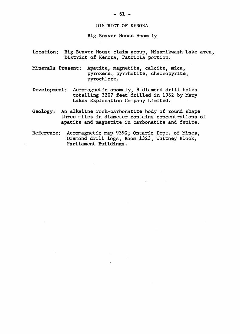
- 61 -
DISTRICT OF KENORA
Big Beaver House Anomaly
Location: Big Beaver House claim group, Misamikwash Lake area, District of Kenora, Patricia portion.
Minerals Present: Apatite, magnetite, calcite, mica,pyroxene, pyrrhotite, chalcopyrite, pyrochlore.
Development: Aeromagnetic anomaly, 9 diamond drill holes totalling 3207 feet drilled in 1962 by Many Lakes Exploration Company Limited.
Geology: An alkaline rock-carbonatite body of round shapethree miles in diameter contains concentrations of apatite and magnetite in carbonatite and fenite.
Reference: Aeromagnetic map 939G; Ontario Dept. of Mines, Diamond drill logs, Room 1323, Whitney Block, Parliament Buildings.
- 62 -
Selected References
Currie, J.B.
1951: The occurrence and relationships of some mica and apatite deposits in southeastern Ontario; Econ. Geol., Vol. 46, p. 765-778.
Harding, W.D.
1947: Geology of the Olden-Bedford area; Ontario Dept. Mines, Vol. 56, pt. 6. (Published 1951)
Hewitt, D.F.
1957: Geology of Cardiff and Faraday townships; Ontario Dept. Mines, Vol. LXVI, pt. 3. (Published 1959)
Hodder, R.W.
1961: Alkaline rocks and niobium deposits near Nemegos, Ontario; Geol, Surv. Canada, Bull. 70.
Landes, K.K.
1938: Origin of the Quebec phlogopite-apatite deposits; Amer. Minerslogist, Vol. 23, p. 359-388.
Parsons, G.E.
1961: Niobium-bearing complexes east of Lake Superior; Ontario Dept. Mines, G.R. No. 3.
Penrose, R.A.
1888: Bull. U.S. Geol. Surv. No. 46.
Reeves, J.E.
1964: Phosphate; Canadian Minerals Yearbook; Dept. Mines and Technical Surveys.
Satterly, J.
1943: Mineral occurrences in the Haliburton area; Ontario Dept. Mines, Vol. 52, pt. 2.
- 63 -
Satterly, J.
1944: Mineral occurrences in the Renfrew area; Ontario Dept. Mines, Vol. 53, pt. 3.
de Schmid, H.S.
1912: Mica, its occurrence, exploitation and uses; Canada Dept. Mines, report 118.
Spence, H.S.
1920: Phosphate in Canada; Canada Dept. Mines, report No. 396.
1929: Mica; Canada Dept. Mines, report No. 701.
Thomson, J.E.
1943: Mineral occurrences in the North Hastings area; Ontario Dept. Mines, Vol. 52, pt. 3.