Embed Size (px)
Citation preview
Maylands Gateway Development Brief Revised May 2013
1
Prepared by the Strategic Planning and Urban Design team at URS 6-8 Greencoat Place, London SW1P 1PL Contact: [email protected]
This publication is the Revised Maylands Gateway Development Brief. It sets out how we envisage the Gateway area of the Maylands business park in Hemel Hempstead developing over the coming years, in order to meet the aspirations of the adopted Maylands Masterplan. If you would like this information in your own language, or you would like to contact the Council about any other issue, please call 01442 867212. If you would like this information in another format, such as large print or audio tape, please call 01442 228660 or for Minicom only 01442 867877.
2
CONTENTS 1. Introduction 4 1.1 Background 4 1.2 The Vision for Maylands Gateway 4 1.3 This Document 5 1.4 Relationship with the Maylands Master Plan 5 1.5 The wider planning context 6 1.6 The Gateway’s location 6 2. Policy Background 9 2.1 Introduction 9 2.2 Relationship with the current planning context 9 2.3 Current Local Plan Allocations for the Maylands Gateway 10 2.4 Pre-Submission Core Strategy (October 2011) 12 2.5 Planning Policy Documents 14 2.6 Key Contacts 15 3. Site and Context Appraisal 16 3.1 Introduction 16 3.2 Transport and traffic 16 3.3 Environmental and Ecological Constraints 17 3.4 Buncefield and HSE Guidance 20 3.5 Economic and Property Market Conditions 21 3.6 Opportunities in the Maylands Gateway area 27 4. Planning and Design Principles 28 4.1 Introduction 28 4.2 Vision 28 4.3 Design Concept 28 4.4 Mix of Uses 31 4.5 Sustainability 31 4.6 Structure and Urban Grain 33 4.7 Appearance and Building Form 34 4.8 Open Space and Environment 34 4.9 Uses to be Retained and Relocated 36 5. Transport and Movement 37 5.1 Introduction 37 5.2 Roads 37 5.3 Car Parking 38 5.4 Walking and Cycling 39 5.5 Public Transport 39 5.6 Infrastructure 40 5.7 Services 41 6. Delivery and Management 42 6.1 Objective 42 6.2 Property 42 6.3 Delivery and funding 43

3
Reproduced from the Ordnance Survey mapping with the permission of the controller of Her Majesty's Stationary Office © Crown Copyright. Unauthorised reproduction infringes Crown Copyright and may lead to prosecution and civil proceedings. Dacorum Borough Council, Licence No. 100018935 2009 and St. Albans City & District Council, Licence No. LA079227.
4
1. Introduction
1.1. Background 1.1.1. In 1947 the architect and landscape designer Geoffrey Jellicoe produced a master
plan for the development of the new town at Hemel Hempstead. This guided the development of Hemel Hempstead in the second half of the 20th century and led to the development of a town characterised by a series of residential areas with neighbourhood centres at their core, plus the provision of a network of parks and open spaces, and thriving business areas.
1.1.2. Hemel Hempstead new town is now over 60 years old and, in many ways, has proved to be a successful new town. Despite these successes, the pre-submission Dacorum Core Strategy notes that “regeneration is the main priority for the Council and must be underpinned by growth and investment in business, homes and infrastructure” (para 20.3).
1.1.3. The pre-submission Core Strategy then states that “the Council’s regeneration ambitions will concentrate on Hemel Hempstead”, and lists the following priorities:
1. The town centre – to modernise the centre and improve the public environment.
2. Maylands – to rejuvenate and grow the business area and promote the use of ‘green’ energy.
3. Neighbourhood centres - to reinvigorate and improve the environment of the neighbourhood local centres.
4. Green spaces - to extend the network and use of open spaces.
1.1.4. It is the second of these that underpins both the Maylands Master Plan and, as a key driver of this, the Maylands Gateway Development Brief.
1.2 The Vision for Maylands Gateway 1.2.1 The Maylands Gateway is intended to be a visible sign of the regeneration of
Maylands and emphasise the role of the area as a high quality environment in which to invest, do business, and work.
1.2.2 The Gateway is a key part of Maylands becoming a ‘green’ business park. The Gateway will aim for high levels of sustainability, incorporating sustainable building design, energy use, transport and ecology. Development in the Gateway is expected to be employment-led. Businesses operating in the areas of technology will be especially welcome. There will also be some housing development.
1.2.3 To fulfil the vision for the Gateway, high quality design and layout is expected, set within a high quality environment. This requires careful consideration of the design of the buildings, the public realm, as well as the location and treatment of parking areas. The provision of good quality, accessible open space is a key feature of the vision. This provides amenity value, is an environmental and ecological asset, and is important in creating a place of choice for investors and businesses.

5
1.3 This Document 1.3.1 This document updates the previous Maylands Gateway Development Brief,
adopted by the Council in 2009. It has been updated to reflect the changes in the policy and also in market conditions since that time.
1.3.2 This Development Brief presents background site, planning and design information and presents the aspirations for the development of the Gateway area.
1.3.3 Development Briefs are planning policy documents that relate to a particular site. They aim to distil planning and design information into a clear statement of what kinds of development are expected to come forward on the site(s).
1.3.4 The aim of this Development Brief is to provide clear guidance on how the Maylands Gateway should be developed, whilst not being overly prescriptive on the design of specific buildings or spaces, or on the uses that individual buildings will have.
1.3.5 Recommendations are provided for land uses, building scale and form, landscaping quality, environmental performance of buildings, parking standards, and the intended transport and landscape conditions proposed as part of the Gateway, as well as guidance to the kinds of infrastructure provision expected from developments.
1.3.6 As these requirements may change or evolve over time, those with an interest in the development of the area are advised to contact the Council at an early stage for further advice.
1.3.7 The Development Brief is intended to ensure the desired level of quality in the design, construction, maintenance and management of the Gateway in order to contribute to the regeneration of the Maylands area as a whole. It will be a visible sign of the area’s regeneration and embodiment of the kind of business environment that investors and employers want to see in Hemel Hempstead.
1.4 Relationship with the Maylands Master Plan 1.4.1 The Gateway forms part of the wider area covered by the Maylands Master Plan.
This Development Brief is intended to supplement the Master Plan and provide a more detailed, yet complementary strategy for the Gateway area.
1.4.2 The planning status of the Gateway Development Brief is the same as the Maylands Master Plan for this area, and will remain so until the Core Strategy is adopted. At that point, this document may be adopted as a formal planning guidance.
1.4.3 The Gateway site, due to its prominent location within Maylands and its potential for change afforded by the availability of sites, is seen as a key priority for the regeneration of Maylands. It is vital for the future development of Hemel Hempstead.
1.4.4 The creation of a Development Brief separate to the main Master Plan reflects the importance of the Gateway in terms of delivery and timing.
1.4.5 One of the underlying aims of the Master Plan, which the Development Brief takes forward, is to bolster higher value sectors of the economy, such as advanced
6
engineering and technology businesses. It is also the intention of the Master Plan to move towards more sustainable ways of working through changing travel behaviour, providing a greater mix of uses on site and encourage sustainable forms of building. This is another key theme of the Development Brief.
1.4.6 A consistent strategy is particularly important in relation to land use and distribution of uses, the transport and movement strategy, the character of development and landscaping, the Green Strategy and as the approach taken to management and branding.
1.5 The wider planning context 1.5.1 As well as its intrinsic relationship with the Maylands Master Plan, the Gateway
Development Brief is set within the wider planning policy context, specifically the Council’s emerging Core Strategy and the National Planning Policy Framework.
1.5.2 The implications of these documents, as well as other relevant planning guidance, are explained in more detail in Chapter 2.
1.6 The Gateway’s location
Figure 1.1: Aerial photograph of area covered by this Brief
1.6.1 Maylands is one of the largest business parks in the Eastern Region and home to around 630 businesses employing an estimated 16,500 people. It is located on the eastern side of Hemel Hempstead, bounded to the south by Breakspear Way, to the north by the B487 Redbourn Road and Three Cherry Trees Lane, to the east by Green Lane and roughly demarcated to the west by the A4147 Redbourn Road and High Street Green (see Figure 1.2).
7
1.6.2 The estate formed part of the post-war master plan for Hemel Hempstead New Town and was developed as the main employment area for the town. Early development at Maylands was mainly to cater for the demands from manufacturing industry and major companies such as Lucas Aerospace were located on the estate. The construction of the M1 improved Maylands’ connections to all parts of the UK and the estate was seen by the property market as a well located, prime estate within the south east of England.
1.6.3 Maylands currently provides a mix of ages and qualities of employment space, with office, industrial/warehousing/distribution and manufacturing stock, although the industrial accommodation continues to be the dominant use. It is largely well tenanted, and continues to provide the largest concentration of employment floorspace in Hemel Hempstead, with approximately 6.2M sqft of commercial accommodation on the estate.
1.6.4 The area covered by this Brief lies to the south of the Maylands Business Area, north of Breakspear Way. It is bounded by Green Lane, Maylands Avenue (although a site to the west of Maylands Avenue is included), Boundary Way and the housing development at Hales Park. The whole area is approximately 32 hectares.
1.6.5 The Gateway Brief covers a larger area than the Gateway Character Area as defined within the Maylands Master Plan. The northern section, fronting Boundary Way, falls within the Service Centre Character Area.
1.6.6 Current uses within the Gateway area includes the Woodwells Caravan Park, Woodwells Cemetery, the former Lucas sports ground and part of the Aviva-owned Peoplebuilding site.
8
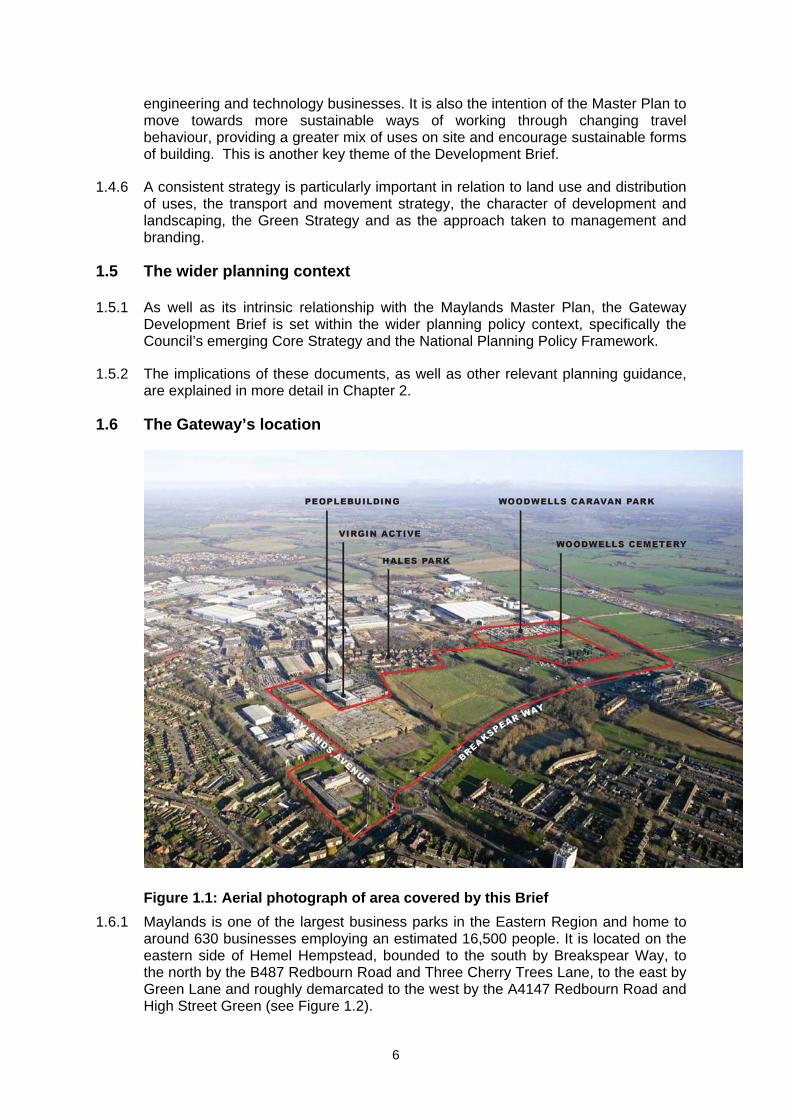
Figure 2.2: Location Plans
9
2. Policy Background 2.1 Introduction
2.1.1 This section provides the existing planning policy context for the Maylands Gateway. This is explained in terms of its relationship with the current Local Plan and the pre-submission Core Strategy (October 2011) which was submitted to the Planning Inspectorate in June 2012. The public hearing was held in October 2012. Consultation on main modifications has been carried out and the final report is awaited.
2.1.2 A summary of the key policies specifically related to the Gateway sites and to the Maylands Business Area when relevant is also provided.
2.2 Relationship with the current planning context 2.2.1 The Development Brief for the Maylands Gateway is being produced ahead of the
adoption of the Core Strategy for Dacorum, and therefore it has a relationship with both the current Local Plan and the forthcoming Core Strategy.
2.2.2 The Dacorum Borough Local Plan 1991-2011 was adopted in 2004 and remains the main component of the current statutory Development Plan for the Borough. The Core Strategy, when adopted, will replace part of the Local Plan as the principal local planning policy document. However, at the present time, whilst the pre-submission Core Strategy represents the most up to date statement of current Council policies, Due to the stage it has reached in the examination process it can be given considerable weight in the development management decisions.
2.2.3 Where the Development Brief reinforces, elaborates and supplements the adopted Local Plan, it attracts the highest weight in Development Management decisions (i.e. the establishment of clear urban design principles). Some key elements of the Development Brief, such as the proposed development on areas of Open Land, are contrary to the adopted Local Plan. The justification for the proposals is set out in the Master Plan and accompanying Technical Report and relates to the demand for office space, the need to overcome constraints such as the quality of the built environment and the attractiveness of the wider Maylands business area to potential investment.
2.2.4 This Development Brief is a material planning consideration that may justify proposals which are contrary to the Local Plan. The Council will also need to take account of emerging information (for example relating to the employment land supply and guidance from the Health and Safety Executive) and consider how this affects the proposals outlined here.
2.2.5 The Development Brief indicates the Council’s intentions for the future formal planning policy framework for the area and the Council wishes it to be taken into account now.
2.2.6 The Development Brief and associated documents will inform production of the East Hemel Hempstead Action Area Plan, to be progressed jointly by Dacorum Borough Council and St Albans City and District Council. The AAP's easterly extent will be determined by St Albans Council through collaboration.
10
2.2.7 A summary of the current site-specific Local Plan policies that are applicable for Maylands Gateway is provided below. The Pre-Submission Core Strategy policies and designations relevant to Maylands are also reviewed in this chapter.
2.3 Current Local Plan Allocations for Maylands Gateway
Figure 2.1: Local Plan (Adopted 2004) Extract for Maylands Gateway
2.3.1 The following Local Plan designations apply to the Gateway land:
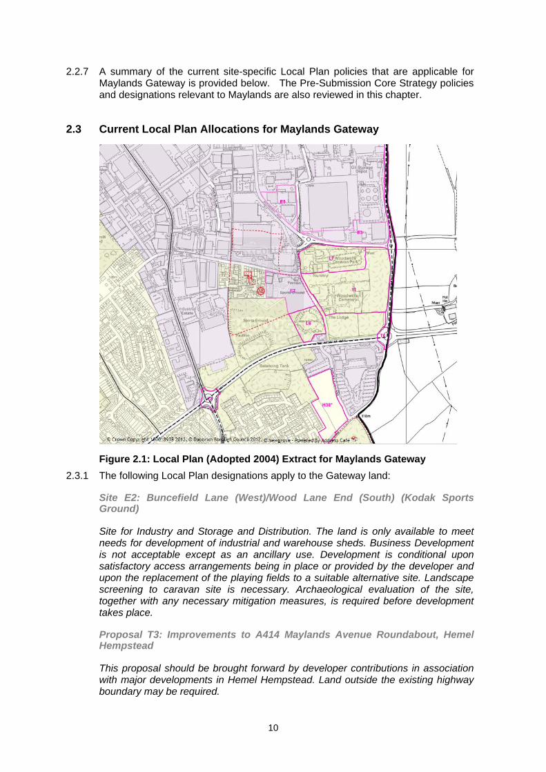
Site E2: Buncefield Lane (West)/Wood Lane End (South) (Kodak Sports Ground)
Site for Industry and Storage and Distribution. The land is only available to meet needs for development of industrial and warehouse sheds. Business Development is not acceptable except as an ancillary use. Development is conditional upon satisfactory access arrangements being in place or provided by the developer and upon the replacement of the playing fields to a suitable alternative site. Landscape screening to caravan site is necessary. Archaeological evaluation of the site, together with any necessary mitigation measures, is required before development takes place.
Proposal T3: Improvements to A414 Maylands Avenue Roundabout, Hemel Hempstead
This proposal should be brought forward by developer contributions in association with major developments in Hemel Hempstead. Land outside the existing highway boundary may be required.
11
Proposal T4: Junction Improvements to increase the capacity of A414 Breakspear Way Roundabout, Hemel Hempstead
This proposal should be brought forward by developer contributions in association with major developments in Hemel Hempstead. Land outside the existing highway boundary may be required. Local Highway Authority scheme to be co-ordinated with works as part of Scheme T1 (M1 widening).
T7: Widening and junction improvements to complete North East Relief Road (line of existing Three Cherry Trees/ Green Lane)
This proposal should be brought forward by developer contributions in association with development at North East Hemel Hempstead. Potential dual carriageway line to be safeguarded where appropriate. Initial single carriageway route could also be completed on dualling line shown in Hemel Hempstead Transportation Plan. This alternative line follows Punchbowl Lane in St Albans City and District. Landscaping to enhance boundary with Green Belt.
Tiv: Widening to dual carriageway of North East Relief Road, Hemel Hempstead
Details of scheme to be decided. This will be a follow up to Scheme T7. Land to be reserved as part of development of Proposal Site E4 (see Schedule of Employment Proposal Sites).
Tv: Hemel Hempstead Cycle Route Network
Advisory routes and junction/crossing improvements including Buncefield Lane. Further details to be decided.
Txi: Hemel Hempstead Park and Ride Schemes
Study carried out in 2002 to assess the potential for additional park and ride facilities identified two locations: Gadebridge Park and Breakspear Way. The Gadebridge site ceased operating in April 2008. The ‘Hemel Hempstead Park and Ride Study’ was published in 2004 as part of the Hemel Hempstead Transportation Plan 2003/4. This concluded that a scheme near to Breakspear Way serving Maylands Avenue area would be feasible, though a scheme serving the town centre may not be justified due to the price of parking in the town centre. The Highway Authority has however advised that further technical work is required (see section 6). The Borough Council has established a Task and Finish Group to consider this issue in more detail.
Site C6: Woodwells Cemetery
Land safeguarded for cemetery.
Site L6: Buncefield Lane, Hemel Hempstead
Existing touring, camping and caravan site. Land to be safeguarded from alternative development unless a satisfactory alternative is available.
Site L7: Woodwells Farm, Buncefield Lane
Existing caravan storage site. Land to be safeguarded from alternative development.
12
2.3.2 Parts of the Gateway are also designated as Open Land (Local Plan Policy 116) and hence protected from building and other inappropriate development.
2.4 Pre-submission Core Strategy (October 2011)1 2.4.1 The pre-submission Core Strategy sets out the Council’s objectives for the
regeneration of Maylands Business Park which will be delivered through environmental improvements, a new local centre and delivery of the Maylands Gateway and other projects within the East Hemel Hempstead Area Action Plan (AAP). It emphasises that the role of the Maylands Business Park will remain complementary to that of the town centre.
2.4.2 In East Hemel Hempstead, which includes Maylands Business Park, the objective is to deliver:
Around 1000 new homes2;
New jobs;
A new local centre and open space in the Heart of Maylands;
A primary school;
A district heating network;
Better waste management facilities;
A low carbon economy;
New transport infrastructure, linked to parking management;
The North East Hemel Hempstead Relief Road;
A new access road from Breakspear Way to Boundary Way; and
New community sports facilities.
2.4.3 Figure 18 of the Core Strategy sets out the character zones and opportunities within East Hemel Hempstead which must be considered by developers when submitting proposals for the area. The strategy states that Maylands Gateway, which is the subject of this Development Brief, offers around 29.7ha of developable land which will deliver a large proportion of the Borough’s employment needs over the plan period (excluding the as yet undeveloped Peoplebuilding phases).
2.4.4 It describes Breakspear Way as a primary route and green gateway into Maylands Business Park, and the town itself. This includes greenfield and some brownfield land, together with existing businesses.
2.4.5 Figure 18 also states that ‘the area to the north of Breakspear Way offers opportunities to provide an additional access road into Maylands Business Park, deliver prestigious landmark buildings at key nodes and enhance open space. The types of uses suited to this area will be primarily HQ offices, conference facilities
1 This review includes minor wording changes agreed since submission in June 2012 2 Excludes any new homes in St Albans District, which are built on the edge of the town
13
and a hotel. There may also be opportunities for other development that accords with its high-status and green character. There are opportunities for decentralised heating systems or combined heat and power (CHP). Development must be designed to integrate with and enhance the open land’.
2.4.6 It also notes that woodland and open space to the south of Breakspear Way will be retained.
2.4.7 The pre-submission Core Strategy also includes a ‘Delivering the Vision’ section for East Hemel Hempstead which includes the Maylands Gateway site. The key points for the area are:
The focus will be on regenerating the employment area and becoming the economic beacon for the town, drawing in new employers, organisations and HQ offices. A new residential neighbourhood will be built at Spencer’s Park.
There are a range of issues for planning at East Hemel Hempstead, including the size and character of the business park, both now and in the future; the supporting range of facilities, transport and additional housing and services; the area’s location close to the edge of town, the countryside and the Local Authority boundary with St Albans.
Growth of the business park will be based on regeneration of the existing area, followed by expansion. Previously developed sites will be the priority for redevelopment, followed by undeveloped, Greenfield land in the Gateway. Where this land is not suitable, other land will be required for planned needs and as a contingency.
Some facilities are difficult to accommodate within the existing town boundary or are more sensibly located outside. These may include:
o A public transport hub linked to public car parking;
o Waste management facilities and a green energy park;
o Services for the Spencers Park neighbourhood estate, including public open space and a primary school;
o A community sports facility; and
o Landscaping on land between Hemel Hempstead and the motorway to provide a ‘green gateway’ to the town.
2.4.8 The strategy also notes that the North East Hemel Hempstead Relief Road, park and ride, lorry parking and other proposals will be designed to accommodate and manage necessary traffic demands and their effects.
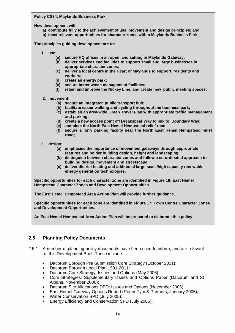
2.4.9 Policy CS34: Maylands Business Park is reproduced below.
14
2.5 Planning Policy Documents 2.5.1 A number of planning policy documents have been used to inform, and are relevant
to, this Development Brief. These include:
Dacorum Borough Pre Submission Core Strategy (October 2011); Dacorum Borough Local Plan 1991-2011; Dacorum Core Strategy: Issues and Options (May 2006); Core Strategies: Supplementary Issues and Options Paper (Dacorum and St
Albans, November 2006); Dacorum Site Allocations DPD: Issues and Options (November 2006); East Hemel Gateway Options Report (Roger Tym & Partners, January 2005); Water Conservation SPD (July 2005); Energy Efficiency and Conservation SPD (July 2005);
Policy CS34: Maylands Business Park New development will:
a) contribute fully to the achievement of use, movement and design principles; and b) meet relevant opportunities for character zones within Maylands Business Park.
The principles guiding development are to:
1. use: (a) secure HQ offices in an open land setting in Maylands Gateway; (b) deliver services and facilities to support small and large businesses in
appropriate character zones; (c) deliver a local centre in the Heart of Maylands to support residents and
workers; (d) create an energy park; (e) secure better waste management facilities; (f) retain and improve the Nickey Line, and create new public meeting spaces;
2. movement: (a) secure an integrated public transport hub; (b) facilitate easier walking and cycling throughout the business park; (c) establish an area-wide Green Travel Plan with appropriate traffic management
and parking; (d) create a new access point off Breakspear Way to link to Boundary Way; (e) complete the North East Hemel Hempstead relief road; (f) secure a lorry parking facility near the North East Hemel Hempstead relief
road;
3. design: (a) emphasise the importance of movement gateways through appropriate
features and bolder building design, height and landscaping; (b) distinguish between character zones and follow a co-ordinated approach to
building design, movement and streetscape; (c) deliver district heating and additional large-scale/high capacity renewable
energy generation technologies. Specific opportunities for each character zone are identified in Figure 18: East Hemel Hempstead Character Zones and Development Opportunities. The East Hemel Hempstead Area Action Plan will provide further guidance.
Specific opportunities for each zone are identified in Figure 17: Town Centre Character Zones and Development Opportunities. An East Hemel Hempstead Area Action Plan will be prepared to elaborate this policy.
15
Open Space Study (March 2008); Urban Nature Conservation Study (March 2006); Hemel Hempstead Urban Design Assessment (January 2006); Hemel Hempstead Urban Transport Plan (January 2009); Hertfordshire Local Transport Plan 3 (April 2011); Hertfordshire Infrastructure and Investment Strategy (October 2009); and Maylands Sustainable Transport Strategy (September 2011).
2.6 Key Contacts 2.6.1. Key organisations and relevant officers in relation to Maylands and the Gateway
Development Brief include:
Dacorum Borough Council
James Doe, Assistant Director (Planning, Development & Regeneration) [email protected]
Laura Wood, Strategic Planning and Regeneration Team Leader [email protected]
Paul Newton, Team Leader – Development Management [email protected]
Kevin Langley, Regeneration Officer (Maylands) [email protected]
Maylands Partnership
Andy Cook, Chair – Maylands Partnership [email protected]
St Albans City and District Council
Manpreet Kanda, Principal Planning Officer (Policy) [email protected]
Hertfordshire LEP
Charles Osimen, Key Sites and Regeneration Manager [email protected]
Hertfordshire County Council Highways
Nick Gough, Development Manager - SW Hertfordshire [email protected]
16
3. Site and Context Appraisal 3.1 Introduction 3.1.1 This section describes the current situation of the Gateway in terms of issues
relating to transport and traffic, any potential environmental or ecological constraints of the sites, and an appraisal of the current economy and local property market.
3.2 Transport and traffic 3.2.1 Being adjacent to the M1 and close to the M25, Maylands Gateway is well served
by the strategic road network. 86% of journeys to work are by car, compared to equivalent figures of 69% for Hemel Hempstead and 64% for Hertfordshire, this car dependence is not sustainable and the Maylands Area Travel Plan (MATP)3 seeks to redress the balance as the business park evolves. The MATP should guide transport approaches for the Gateway site.
Traffic Movement
3.2.2 The existing road system around the Maylands Gateway site - Maylands Avenue on the west, the A414 Breakspear Way passing through the southern part of the area and Green Lane on the eastern flank - carries significant flows during the day. In particular the AM and PM peak hours between 8.00 and 9.00 and 17.00 and 18.00 hours respectively cause some congestion on this road system.
3.2.3 There is significant conflict between traffic flowing east/west along A414 Breakspear Way and traffic flowing north/south along Maylands Avenue and to some extent Leverstock Green Road meeting at the Maylands Avenue roundabout on the A414. Wood Lane End also suffers from localised congestion during peak hours turning onto Maylands Avenue by traffic attempting to cut out the Maylands Avenue/Breakspear Way junction.
Walking and Cycling
3.2.4 In relation to cycling and walking, footways exist on both sides of Maylands Avenue, though only on the north side of the A414. There is a footbridge over the A414 east of Maylands Avenue roundabout and a traffic signal-controlled pedestrian crossing to the west of this junction. An advisory cycle route to Adeyfield and the town centre is signposted from Maylands Avenue north of the junction.
3.2.5 On Maylands Avenue at the junction with the access to the Peoplebuilding estate, there is a fully controlled signalised junction allowing pedestrian and cycle movements. Otherwise, Maylands Avenue is seen as a barrier to pedestrians and cyclists wishing to cross the road. Indeed, the Maylands Gateway area is not particularly well served by good safe pedestrian and cycle linkages, a situation that the MATP seeks to address and which development on the site will be expected to significantly improve.
3 Maylands Area Travel Plan, prepared for Hertfordshire County Council, 2011
17
Public Transport
3.2.6 Although Hemel Hempstead is generally well served by buses, the services tend to follow routes that connect the residential areas and the town centre. Services visiting Maylands are currently somewhat limited.
3.2.7 The most comprehensive amongst the 12 routes that serve Maylands include:
Route 6/A/B/D/W6 running on a frequency of 5 buses per hour between Hemel Hempstead and Maple Cross, providing links to the railway station and town centre;
Route 4/5 running on a frequency of 4 per hour between Grovehill and Nash Mills (circular), providing links to Woodhall Farm and Chaulden;
Route H13, Rail Station circular, provides 3 per hour in the AM peak and 3 per hour in the PM peak between Maylands and Hemel Hempstead railway station; and
Route PB1/PB2 provides 3 buses in the AM peak and 5 buses in the PM peak between Maylands and Hemel Hempstead railway station.
3.2.8 However, it should be noted that as the above routes are indirect routes, they do not tend to represent the quickest routes to Maylands.
3.2.9 Longer distance services include Greenline service 758 which provides an hourly link from Hemel Hempstead bus station to London via Adeyfield, Maylands Avenue and M1. A further strategic route (300/301) links Stevenage, Hatfield and St Albans with Hemel Hempstead bus station via Leverstock Green (and the southern section of Maylands Avenue in the peak hours). There is also a Uno service (634) to Hatfield Business Park/University of Hertfordshire (via A414), Lister Hospital and Hitchin. Currently there are bus stops on Breakspear Way (near Green Lane eastbound) and at the BP petrol station (westbound).
3.2.10 In terms of rail links, Maylands is located 4km east of Hemel Hempstead Station, with direct links to London Euston, at a frequency of approximately 4 per hour. Northbound links are to Milton Keynes via Tring.
3.3 Environmental and Ecological Constraints
Services and Utilities National Grid Gas
3.3.1 Initial enquiries indicate no presence of high pressure gas plant in the Maylands Gateway area. The A414 houses a medium pressure main which runs from the Maylands Avenue roundabout (and beyond) to the Holiday Inn Hotel.
Fibre Optics and Cabling
3.3.2 Buncefield Lane, Green Lane and Boundary Way house GEO (fibre optic) apparatus. Cabling runs along the western fringe of Maylands Avenue along its entire length before branching eastwards along the northern edge of Redbourn Road.
18
Water
3.3.3 A review of Affinity Waters’ asset plans indicates that the majority of their supply mains follow the road network. Where small public spurs from the main line do occur they appear to be confined to areas of existing hardstanding. The location of public supply mains is therefore unlikely to represent a significant constraint.
Oil Pipelines
3.3.4 3 major oil pipelines connect to the Buncefield Terminal from the east of the area, with one pipeline flowing out to the north. Whilst none of these flow under the business park site they would be a major consideration for development of the wider area.
Urban Hydrology
3.3.5 The most notable drainage feature in or around the Gateway area of interest is the large surface water attenuation pond to the south of the A414, between Leverstock Green Way and Buncefield Lane. The pond is a Thames Water (TW) asset and approximately 8450 m2 in area. The pond is believed to accept urban run-off from the adjacent residential development as well as a large portion of the Maylands area itself. The pond has several inlets, the largest of which is a 1000 mm by 1500 mm culvert running southwards beneath the A414. The pond’s outfall is to the River Ver approximately 5 km to the east.
3.3.6 There is also the possible presence of smaller, underground run-off attenuation tanks throughout the Maylands area, although these are more likely to be associated with the existing developed areas. Should any such tanks be removed during the development of Maylands Gateway their storage function will need to be replaced.
Groundwater and Surface Water
3.3.7 The site does not fall within a flood risk zone.
3.3.8 The site is located in an area of moderate groundwater sensitivity (a Ground Water Protection Zone). The main environmental receptor is the underlying Chalk aquifer, which is abstracted for drinking water supplies within 2km of the site. The underlying chalk is a major aquifer and is highly vulnerable to pollution.
3.3.9 Developers will need to demonstrate adequate protection to the underlying groundwater resource.
3.3.10 Sustainable Drainage Systems (SuDS) should be used to attenuate surface water run-off whilst being compatible with the protection of underlying vulnerable groundwater resources.
3.3.11 Development should maximise opportunities to:
Reuse grey water; Install green roofs; Design for efficient use of water resources; and Implement SuDS compatible with the protection of vulnerable underlying
groundwater resources.
19
3.3.12 Further information on water conservation measures are provided in the Council’s Supplementary Planning Document (SPD) on Water Conservation (July 2005), and from the Building Futures website at www.hertslink.org/buildingfutures.
Topography
3.3.13 The site is generally flat.
Ecology
3.3.14 There are no sites designated for their nature conservation value within the boundaries of the Gateway sites. However there are mature hedgerows in the area. These should be retained.
3.3.15 There are records of bats and badger activity within the wider area that will require further detailed investigation.
3.3.16 Ecological surveys would need to be undertaken prior to development and any necessary mitigation measures put in place. Compensation would be required for features lost to development where loss is completely unavoidable.
3.3.17 Development should maximise opportunities to:
Create new, and improve existing habitats and landscape features which could be of benefit to wildlife including the provision of brown roofs;
Innovate in designs of buildings and shared spaces; Incorporate green infrastructure; Link and connect isolated and fragmented habitats, important species
populations and landscape features through creation of wildlife corridor networks; and
Protect the ‘green entrances’ to Hemel Hempstead – an important part of the new town concept and a feature of the original master plan.
Archaeology
3.3.18 The northern part of the Gateway lies within an Area of Archaeological Significance. There was a great deal of activity in the Roman period in Hemel Hempstead, (buildings, villas and roads, as well as the Temple/Mausoleum at Wood Lane End). Recent excavations for the M1 widening project also support this view. South of junction 8, a late Iron Age and Roman settlement was uncovered down the slope, with medieval occupation on the higher ground nearer the junction. North of the junction access road was a length of what may be part of a Roman road leading in the general direction of Wood Lane End.
3.3.19 A Scheduled Ancient Monument (SAM), a Romano-Celtic Temple/Mausoleum, is located at Wood Lane End. Several Historic Environment Records (HERs) are also located in close proximity to the SAM and beyond the Gateway site’s boundaries to the South East.
3.3.20 Although no SAMs or HERs exist within the boundary of the Gateway site, there may be additional artefacts in the area which are as yet unrecorded. Therefore archaeological evaluation will be required prior to development with suitable mitigation measures put in place to avoid negative effects if necessary. This should include a geophysical survey and excavation of trial trenches in consultation with the County Council’s Archaeological Unit.
20
3.3.21 Development should maximise opportunities to:
Ensure there are strong and robust design standards relevant to the local historic environment;
Ensure development is sensitive to the Historic Environment Records (HER); Ensure that development has regard to settlement patterns, the local
vernacular style and incorporates local materials; and Ensure archaeology is recorded or preserved in situ prior to development.
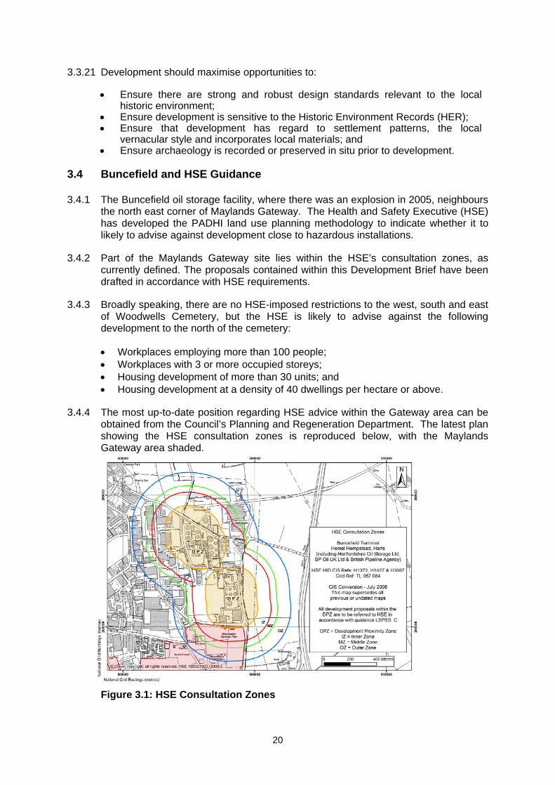
3.4 Buncefield and HSE Guidance 3.4.1 The Buncefield oil storage facility, where there was an explosion in 2005, neighbours
the north east corner of Maylands Gateway. The Health and Safety Executive (HSE) has developed the PADHI land use planning methodology to indicate whether it to likely to advise against development close to hazardous installations.
3.4.2 Part of the Maylands Gateway site lies within the HSE’s consultation zones, as currently defined. The proposals contained within this Development Brief have been drafted in accordance with HSE requirements.
3.4.3 Broadly speaking, there are no HSE-imposed restrictions to the west, south and east of Woodwells Cemetery, but the HSE is likely to advise against the following development to the north of the cemetery:
Workplaces employing more than 100 people; Workplaces with 3 or more occupied storeys; Housing development of more than 30 units; and Housing development at a density of 40 dwellings per hectare or above.
3.4.4 The most up-to-date position regarding HSE advice within the Gateway area can be obtained from the Council’s Planning and Regeneration Department. The latest plan showing the HSE consultation zones is reproduced below, with the Maylands Gateway area shaded.
Figure 3.1: HSE Consultation Zones
21
3.5 Economic and Property Market Conditions
Current property market conditions4 3.5.1 Within the Maylands Business Area there are two main market sectors, industrial
property (distribution and warehousing) and office property.
3.5.2 The industrial market exists mainly towards the north of the Maylands area, with a diversity of uses ranging from small workshop accommodation, trade counter units, mid-range manufacturing and storage facilities, and large “mega-shed” logistics and distribution uses.
3.5.3 There are older office properties dating from the 1960s scattered across the estate, but modern office development is focused particularly within the Maylands Gateway area and along Maylands Avenue.
3.5.4 Adjoining the Maylands Gateway area is Hales Park, a small residential area of around 200 homes. Fronting Wood Lane End, it overlooks the former Lucas Aerospace sports ground.
3.5.5 The industrial, office, residential and other land uses are considered in more detail below.
Industrial and distribution
3.5.6 The Maylands area is still considered to be a very good location in the industrial market, in particular for distribution uses. This is due to its ease of access to the M1 motorway at Junction 8 and therefore good access to London. In addition, the availability of parcels of land that can accommodate large distribution units makes it attractive for large scale distribution uses. The road widening and junction improvements around junction 8 have improved access further.
3.5.7 Research indicates that the demand in the industrial market, particularly from distribution and warehouse operators, is slowly starting to return since the global financial crisis. This sector did not suffer such a significant downturn as the office market, and, as existing supply is being taken up, occupier demand is starting to improve.
3.5.8 Recent industrial transactions include the letting of the 465,000 sq ft Mammoth unit to Amazon for £6 per sq ft and of Gazeley’s 167,000 sq ft unit to Palmer & Harvey for £5.95 per sq ft. Prime rents at Maylands for the smaller units are at around £7.75 per sq ft. This has increased the level of take up substantially to over the last 5 years.
3.5.9 In terms of industrial stock, there is currently over 1m sq ft of industrial stock available (UK Property Market Information Service (PROMIS) Report July 2012). However, there is only 1 large modern distribution unit available at Maylands, namely, the 160,000 sq ft Prologis-built ‘dc160’ at the northern end of Maylands Avenue currently quoting £7.50 per sq ft.
3.5.10 With a limited supply of new stock and no new industrial buildings under construction, agents expect to see some occupier-led development of new units and speculative warehouse development may return in the medium term.
4 The property market information is correct as of August 2012.
22
3.5.11 In terms of recent expressions of interest in the Maylands area, there are a number of active enquiries on the site from B8 (industrial and distribution) operators. This demonstrates that, in spite of challenging market conditions and limited funding opportunities, the Maylands area remains a sought after industrial location.
3.5.12 There have been some recent sales of industrial land at Maylands, including land at Hemel Park sold to owner occupiers. Employment land values for the area is in the order of £600,000 to £700,000 per acre.
Offices
3.5.13 In the 2007 Development Brief, office market commentary included the following paragraph:
The office market...despite there being a large number of office occupiers present in Maylands as a whole (including landmark HQ offices and a range of accommodation to meet all budgets, specifications and floorspace requirements) currently suffers from a lack of demand and corresponding low values for a number of reasons.
3.5.14 This picture remains relevant. However, since then we have also experienced a global economic crisis resulting in recession and an absence of bank funding for development.
3.5.15 A suitable example within Maylands of the performance of the office sector is the Aviva-owned land that includes the Peoplebuilding estate. The land extends to approximately 12 acres with planning permission for over 600,000 sq ft of high quality offices. The 1st phase was completed in 2005, although it took over three years to secure the first tenant. It continued to struggle until the Buncefield disaster, which forced occupiers to relocate from their affected premises. It is now virtually fully let and commands headline rents of £18.50 per sq ft. No further office development has taken place here. As the consented office space has not come forward, Aviva are not sufficiently confident in the office market to speculatively build another phase and are currently considering alternative uses on the remaining land.
3.5.16 In terms of office take up, this has performed at an average of 100,000 sq ft per annum (PROMIS report – July 2012). Recent lettings of modern stock range from £11.50 to £15 per sq ft. Segro’s 88,000 sq ft Maylands Wood Estate office building has recently let to a Data Centre operator.
3.5.17 Current office availability is around 600,000 sq ft, representing a 6 year supply. There is no office stock in construction. Within the development pipeline, there is over 2.1m sq ft of allocated office sites (PROMIS report – July 2012), including Maylands Gateway. Agents report a substantial level of Grade B office stock, with some buildings quoting rents below £10 per sq ft.
3.5.18 Developers report that, even if development finance were available, the market rental values of up to £20 per sq ft do not make office schemes viable in the current market.
3.5.19 In spite of the attempts by Aviva, other developers and Dacorum Borough Council through the preparation of the 2007 Development Brief, there is little evidence to suggest that the Maylands Gateway area could sustain a development of predominantly high quality offices.
23
3.5.20 There have been no recent transactions of land for office-led development. Whilst, in theory, we would expect there to be more such transactions than for industrial land, the lack of demand in the location means that this is unlikely in the current market.
Residential
3.5.21 Maylands Gateway has the potential to accommodate a mix of land uses that could also include residential. Within the Maylands area is Hales Park, a small residential estate of around 200 homes, accessed off Wood Lane End.
3.5.22 As part of the Growing Places funding application to create employment opportunities and places to live, it has been suggested that part of the Maylands Gateway could accommodate around 150 new homes.
3.5.23 Discussions have been held with local residential surveyors to get an opinion of the suitability of this proposal. Feedback received generally concluded that, although not a particularly sought after residential location, it could be of interest to national housebuilders. It was suggested that the homes would need to be built adjoining and to the east of Hales Park with sufficient screening and distance between the neighbouring commercial uses.
3.5.24 Recent transactions in the area include the sale of former Crown Estate land on Green Lane, to the rear of Breakspear Park, to Crest Nicholson. With consent for 86 homes (2, 3 and 4 bed houses) on 6 acres, the land was sold for in excess of £7 million which equates to over £1.1 million per acre. This site has a Leverstock Green address and is considered to be a better location.
3.5.25 Agents indicate that sales values within Maylands Gateway could achieve around £275 per sq ft. Assuming affordable housing at 35%, it is expected that land values of around £750,000 - £850,000 per acre could be achieved. Comments were made that if there is a greater requirement for affordable housing or an onerous design guide that increased cost, then potential land values would be lower.
3.5.26 The HCA-owned land at Spencer’s Park to the north of Maylands Gateway is proposing a housing site with capacity for around 1000 new homes over 2 phases. Agents are currently inviting expressions of interest from housebuilders. In preparing their bids housebuilders will reflect the requirement for 40% affordable housing and costs associated with meeting the design guidance including the Code for Sustainable Homes.
3.5.27 Our investigations conclude that there would be demand for a housing scheme adjoining Hales Park that represents a suitable ancillary use to the main employment uses.
Other uses
3.5.28 Given the size of the study area, it is important that land uses that support the primary employment focus are considered. These help to create a sustainable business and residential community. Potential uses that could be included within the Gateway include hotel, conference centre and care home.
3.5.29 Concerning the hotel and conference centre market, a new 108 bedroom Travelodge development has recently opened on a key corner site entering into Maylands which includes two restaurants and conference facilities. Given that this has recently
24
opened, agents report that there are no further requirements for this type of development.
3.5.30 The care home sector has already been explored by owners of one of the sites on Maylands Avenue. No serious interest was received. Feedback indicates that this is not a suitable location for this sector and the local demographic does not support such an investment.
3.5.31 Cafes and/or restaurants could be provided to serve the Maylands Area. This is expected to be delivered as part of the Heart of Maylands initiative.
Development considerations
3.5.32 Taking into consideration the current and anticipated market conditions and the physical characteristics of the study area, key considerations for its development include:
Continued domination of warehouse uses - the Maylands area provides a range of employment uses including offices, workshop, manufacturing, trade counter and distribution uses. Current and future market demand over the plan period is expected to be dominated by warehouse/distribution uses (B8). In order for the Development Brief to be market facing, this needs to be a key consideration in the proportion of different land uses.
Other uses - the study area extends over 30 hectares. This is of sufficient size for other uses to be incorporated such as quasi office/distribution uses, office and manufacturing.
Need to increase market interest - the previous brief sought to create a high quality business park. In doing so, this narrowed the market opportunities for other employment uses. This updated development brief seek to reflect the poor performance of the office market at Maylands and the need to encourage a range of uses to the area to increase market interest.
The proposed new east-west link road – this new road between Maylands Avenue and Green Lane (see Figure 5.1) could improve service connections to the study area and create serviced development plots that could be attractive to developers and owner occupiers. This investment will reduce the initial capital outlay for developers and encourage investment. The link road could also assist in easing traffic congestion within Maylands and reduce the pressure on the Maylands Avenue and Green Lane roundabouts; this, in turn could ease congestion between Hemel and the M1 Motorway.
Plot sizes - consideration needs to be given to the siting and extent of this new link road. Severing the land could limit available plot sizes. With many distribution operators now requiring sites for ‘mega-sheds’, such sub-division could act as a restriction on size. According to Knight Frank, the average size of a new distribution unit over the last 5 years is 353,000 sq ft. Recent food distribution sheds start at 510,000 sq ft. Such a unit would require a minimum site area of 10Ha (25 acres).
Location of office buildings - the land fronting Breakspear Way offers excellent prominence for high profile office development. This opportunity should be retained, particularly at its junction with Green Lane. Such a
25
gateway site could attract interest for a high quality office/headquarters premises.
Promotion of distribution uses - Maylands has seen a range of modern distribution units completed in the last 10 years. Not all of these are basic, functional warehouses. In spite of this being the primary land use, there are opportunities to encourage distribution uses that are of good quality design, provide a high office content and create the level of jobs over and above standard distribution facilities. For example, the Amazon premises include 30,000 sq ft of office space.
3.5.33 The finding of the update study demonstrates that to only promote the land for a high quality business park is, in effect, ‘putting all your eggs in one basket’. Added to this, the market demonstrated - even in the peak economy up to 2007 - that this was not a sought after location for the high end business/science park sector. Economic forecasts, combined with current land availability, mean that such levels of take-up are highly unlikely over the plan period.
3.5.34 For the development brief to be embraced by the market, it needs to be flexible and encourage a range of land uses. It should also play to its strengths as a prime location for the warehouse and distribution market.
Employment Land Study 3.5.35 Dacorum Borough Council commissioned consultants Roger Tym and Partners to
examine the current and future supply, demand and quality of employment land in the Borough and the implications on policy. The content of the study, the Employment Land Update 2011 (published in July 2011), needs to be recognised as part of the evidence base for the proposals contained in the Master Plan and Development Brief.
3.5.36 This is an update of a study undertaken in 2008 (published in 2009). There have been two very significant changes since the 2008 local economic forecast was undertaken: the country has been hit by recession and the Council is proposing to provide less housing than was required by the East of England Plan.
3.5.37 Both of these have resulted in a greatly reduced level of forecast employment growth for Dacorum. Between the 2008 and 2011 forecasts, the forecast demand for industry/warehousing land is broadly unchanged (it is lower, but within the margin for error) but the forecast demand for office space has nearly halved.
3.5.38 The Study recommends that Dacorum’s land provision target for industry/warehousing over the plan period to 2031 should be zero net change and that the target for office be 131,000 sq m of net additional floorspace.
3.5.39 Importantly for this Development Brief, the Employment Land Update 2011 makes specific recommendations for Maylands Gateway. The recommendations are that 122,200 sq m of offices and 18,500 sq m of industrial/warehouse space be provided. This is less office and more industry/warehousing than envisaged in the original Maylands Gateway Development Brief, and even this comes with the warning that “we fear that the land provided for offices at the site will exceed demand and much of it may not be taken up over the plan period” (paragraph 5.17). This suggests that, if the priority is maximising employment growth in the plan period, then more industry/warehousing and less office provision is made.
26
Key Land Ownerships 3.5.40 There is a substantial area of land in the Gateway area (around 32ha) which is either
currently undeveloped, or contains development which does not enhance the employment role of Maylands.
3.5.41 The availability of this extent of contiguous commercial land for development in a well-known and well-connected location is an exciting opportunity given the tight land supply of the South-East as a whole and the frequency with which other similar locations are often priced out of the marketplace by higher value residential uses.
3.5.42 The largely undeveloped nature of this land as shown in the aerial photograph extract (figure 1.1.) means that there should be minimal land remediation costs required. This should keep the cost of development to a competitive level compared to many other such urban locations, which in turn should make the area attractive to the development market.
3.5.43 The following plan (Figure 3.2) shows the key landowners in the area and the table below (Table 3.1) gives some brief details on each area (including non-developable land).
Figure 3.2: Land Ownership
27
Table 3.1: Maylands Gateway Land Ownerships
Site
number Site known as Freeholder Approx.
site area
1 Former Post Office site Kier Property 2 ha
2 The Peoplebuilding estate Aviva Investors 6.5 ha
3 Former Lucas sports ground, former caravan park and former Kodak sports ground
Homes and Communities Agency
13 ha
4
Woodwells Cemetery and caravan store
Dacorum Borough Council 15.5 ha
3.6 Opportunities in the Maylands Gateway area 3.6.1 The Maylands Gateway area provides the opportunity to address many of the key
factors identified above.
3.6.2 With the area under two main ownerships, and the majority previously undeveloped, the potential exists through comprehensive design to create a new, well defined employment area. This should be capable not only of providing the sort of accommodation required to attract major occupiers to the estate, but will also have a ripple effect on development and enhancement throughout the wider Maylands area.
3.6.3 The majority of the land within the Gateway area is also currently under public sector ownership. This opens up the potential for partnering arrangements with the private sector to deliver public realm, infrastructure and green business park initiatives.
3.6.4 The concept of comprehensive development to deliver a higher quality environment has already been embraced, with planning consent for office development having been granted for the redevelopment of part of the Gateway area. Whilst this should not prejudice the development of adjacent sites, it offers the opportunity to stimulate development across the remaining area.
3.6.5 The capacity exists within the large, previously undeveloped areas of land to create a significant mass of employment accommodation. The Gateway area is visible from junction 8 of the M1 motorway. Development should enhance this visibility and competitive advantage and define Breakspear as the gateway to the wider Maylands business area, improving its prominence and market perception.
3.6.6 Further information regarding design expectations for the Gateway area is set out in the next section.
28
4. Planning and Design Principles 4.1 Introduction 4.1.1 This section translates the vision and expectations for the Maylands Gateway into a
series of design-led principles for development to which all proposals must adhere, relating to buildings, parking, landscape and appearance. It is primarily based upon the principles set out in the Maylands Master Plan, but also reflects current property market conditions which suggests that more industry/warehousing and less office provision is made within the Gateway.
4.2 Vision 4.2.1 The Maylands Gateway will be a visible sign of the regeneration of Maylands
business area and will provide an attractive environment in which to invest, do business, and work.
4.2.2 The Gateway will be an employment-led (B1, B2 and B8) development. It will provide a range of high quality accommodation for a range of employment uses, supported by other uses which may include a hotel and conference venue. There will also be a housing element, being complementary to the Gateway’s existing housing and that which is planned for the Heart of Maylands.
4.2.3 To fulfil the vision for the Gateway, high quality buildings, public realm and landscaping will be expected, including the treatment of parking areas. An element of good quality open space within the Gateway is also important to provide amenity value and to help create a pleasant working environment.
4.3 Design Concept 4.3.1 The design and landscape principles on which the Gateway is based are intended to
create the conditions and environment to attract a mix of users. The environment will create and encourage the market conditions to make Maylands into one of the premier business locations in the region.
4.3.2 The design concept for the Maylands character areas are established within the Maylands Master Plan. For the Gateway this includes the following requirements:
Design & Materials:
To create a positive visual impact on people approaching the southern end of Maylands, buildings should be set within a landscaped setting, create an active frontage and have a positive relationship to Breakspear Way. This will provide a visible sign of the regeneration of Maylands, and of Hemel Hempstead as a whole.
Special attention should be paid to the frontage with Breakspear Way with high
quality design and office elements facing onto Breakspear Way. The Gateway will be reinforced by encouraging a “landmark” office building of a
suitable design and scale at the Maylands roundabout at the junction of Breakspear Way and Green Lane (up to a maximum of 6 storeys).
Specific architectural styles, detail or materials are not prescribed, but high
quality buildings set within a landscaped setting will be expected.
29
Company signage should be integrated into the overall building design. High
quality exterior lighting may be acceptable which should avoid unnecessary light spill.
Parking & Access: The location and treatment of parking is a particularly important part of the
design. If used, at-grade parking should be at the rear of development. Underground or undercroft parking is preferable and should be explored where viable. The location of parking should not detract from the quality of the environment, nor dominate the movement of people. Parking should not dominate new buildings and should be avoided on the Breakspear Way frontage Parking should be landscaped and use permeable, high quality materials to maintain the quality of environment where practicable.
High levels of connectivity into the site to encourage walking and cycling will be
expected. Prominently located cycle parking should be provided.
Landscaping & Boundary Treatments: An element of high quality open space will be important within the development
to provide amenity for the Gateway sites and rest of Maylands. Open space will need to include high quality landscaping, seating, street furniture and footpaths where practicable. Fencing should be avoided between commercial plots where possible, so as not to detract from the open landscaped character of the area, although this will need to be balanced against the security and operational requirements of individual businesses.
High quality landscaping of the frontage to Breakspear Way will be expected, in
a way that presents a green aspect to the Gateway but without compromising the visibility and quality of the buildings as viewed from Breakspear Way.
The proposals for the Development Brief clearly impact upon the area of housing
within the Gateway to the south of Wood Lane End. New housing will help to integrate this area into the wider built fabric. There is a need to provide a separation between the residential and employment uses, which will be achieved through landscaping. But there is also a need to make connections and provide the residential areas with access to the new open space that is being created. This will be done by incorporating the existing north-south public footpath/cycleway through the site, through the residential area and north through Maylands, providing strong pedestrian connections within and beyond the Gateway.
Development should seek to reduce the incidence and perception of crime
through careful design, including opportunities for natural surveillance wherever possible.
30
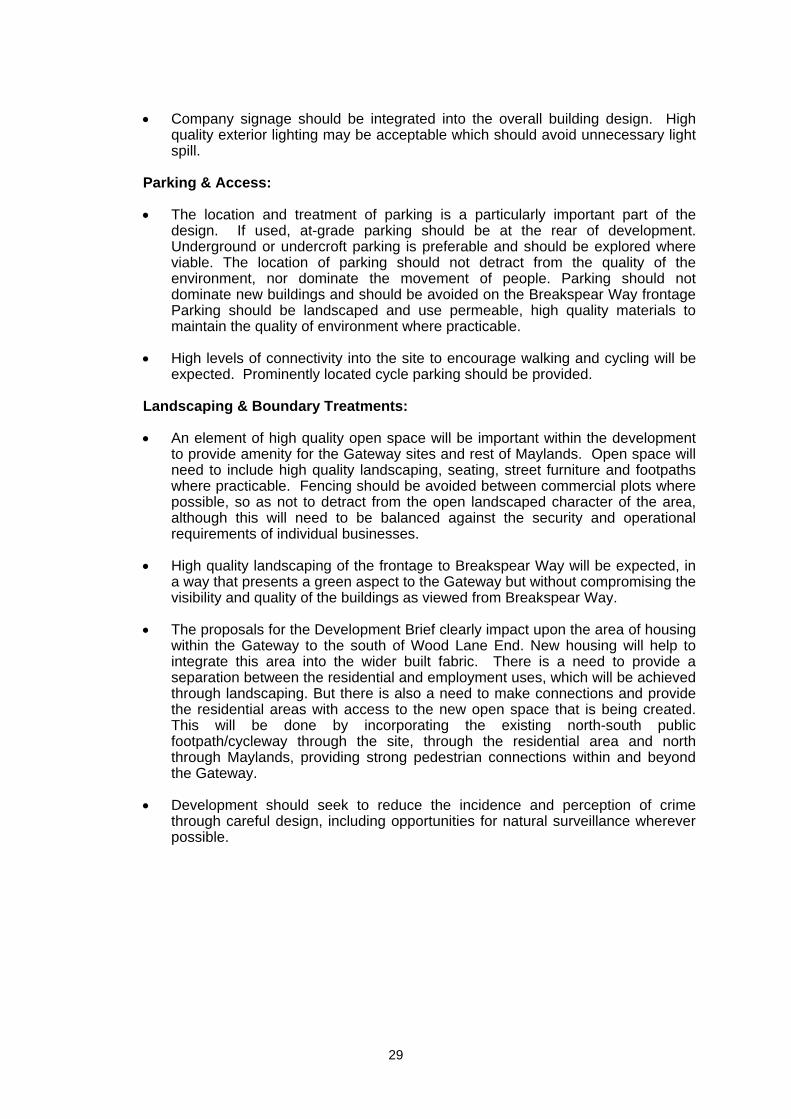
Figure 4.1: Indicative plot layouts for office (top) and industrial/distribution (bottom) uses
4.3.3 The following considerations relating to the current environment should strongly
inform the proposed development layout:
Respecting current land uses, such as the cemetery and the residential areas, and the need to maintain a degree of separation between these and new business uses;
The relationship that the new development will have with Breakspear Way; Connecting the movement network of the Gateway into the existing movement
network; The relationship and integration the new development should have with the
Peoplebuilding, and adjacent land; The visibility of the Gateway and the visual impact that developments can offer; The delicate relationship with existing and new housing within Maylands – some
degree of separation with employment uses is important as they are conflicting uses and there are security issues, but some integration is also required to allow access into new development from residential areas; and
Ensuring that the proposals and design recommendations reinforce the principles established in the Maylands Master Plan.
31
4.3.4 The Gateway, of course, does not sit in isolation and its design relates to the rationale and analysis presented in the Maylands Master Plan that accompanies this Development Brief.
4.4 Mix of Uses 4.4.1 The Gateway must maintain the character of an employment-led, ‘green’ mixed use
area with supporting facilities. However, other uses may be permitted providing they contribute to overall quality and character of the Gateway development. The following land use principles apply:
Development will be employment-led, particularly but not exclusively encouraging those businesses in the areas of high technology;
High quality B8 developments that meet the quality aspirations will be
considered; Small-scale food and drink and childcare provision may be permitted. Such
uses should not detract from the aim of the Maylands Master Plan to create a specific social ‘heart’ for the business area along Maylands Avenue, but facilities to suit the local market within the Gateway may be appropriate;
Buildings should be constructed to allow sub-divisions to enable them to act as
‘incubator’ type units. This would encourage small businesses which may especially benefit from the presence of a higher education or support network, to locate here.
4.5 Sustainability 4.5.1 Sustainable development is a fundamental design issue that needs to be a guiding
principle through all the stages of the design process. It cannot be achieved through the addition of technologies to a building or development that is, in itself, unsustainable, and any attempts to do so are frequently expensive. For this reason a number of objectives and principles have been identified to ensure that sustainability is considered from the start in the Gateway.
Protect and enhance the area’s natural resources and minimise resource use
4.5.2 Development proposals should take their lead from what the area currently has to offer and seek to establish a rich variety of species and habitats as appropriate to the area. Landscape design within the Gateway should aim to achieve a high level of ecological connectivity and minimise run-off.
4.5.3 Further detailed design will seek to create both general and niche habitats, linked by functional ecological corridors, at strategic locations between Maylands and the surrounding countryside. The proposals may also include measures such as green and brown roofs, rainwater harvesting, and a hierarchy of sustainable urban drainage schemes (SUDs) to optimise the efficiency of resource use associated with the development. Protecting and enhancing the natural resources of the area will also require attention to pollution prevention (air, water, ground, noise, and light), and safeguarding of specific sensitive resources.
32
Maximise energy efficiency
4.5.4 New developments will need to demonstrate that they: maximise energy efficiencies; minimise the use of natural resources and waste; and reduce carbon emissions. Developments which use renewable and low carbon sources to generate energy will be encouraged, and all developments should thoroughly explore options for on-site renewables.
4.5.5 Maylands is a designated District Heating Opportunity Area (DHOA) where non-residential development greater or equal to 235sq m, or developments of five or more dwellings, must achieve a reduction of CO2 emissions by at least 25% compared to the Target Emission Rate (TER) Building defined by Part L of the Building Regulations.
4.5.6 Applications for new commercial development will need to be accompanied by a Sustainability Statement and an Energy Statement, as will applications for developments or more than one home. Further guidance is provided within Dacorum Borough Council’s Sustainable Development Advice Note (March 2011).
Search for innovative solutions for the handling and treatment of waste and recycling
4.5.7 Maylands offers an opportunity to implement innovative approaches to waste management. The feasibility of an automated waste collection system, such as that to be implemented for the new housing complex near Wembley Stadium in north west London, is one possibility that could be considered. Further detailed investigations will explore these and similar options as part of a bid to create the highest quality, business-led environment.
Plan for sustainable transport
4.5.8 Planning for the integration with public transport is a fundamental requirement for achieving sustainable development. The Gateway proposals seek to achieve this, and further aim to reduce reliance on the private car, by encouraging other forms of sustainable transport (e.g. cycling) and by complementary measures such as the potential Park and Ride and establishment of Green Travel Plans. Walking should be promoted through the creation of a pedestrian-friendly environment.
Ensure social sustainability of local communities and workers
4.5.9 The design proposals should seek to contribute to a socially integrated and vibrant mixed community within the wider area, where all workers and residents have access to good quality recreation, education, healthcare and employment opportunities. This will require an approach focused on inclusive spaces that people will want to use, and feel safe to use.
Ensure economic sustainability of local communities
4.5.10 To ensure the economic sustainability of the area, the proposals seek to create a place where people would like to work and spend time. Economic sustainability also requires consideration of the mix of businesses, and the need for ancillary functions (infrastructure and services) required to make this business park work well in the long term.
33
4.6 Structure and Urban Grain 4.6.1 The Gateway adopts a consistent urban grain through the development, consisting of
large block development, whilst allowing for a range of sizes of buildings and floorplates to build in flexibility in terms of the offer to the market.
4.6.2 North-south and west-east routes should be provided through the development to allow ease of vehicular movement (including public transport) both through the Gateway site and also connect with the wider street pattern and road hierarchy of the rest of the Maylands area.
4.6.3 Buildings should create an active frontage and positive relationship with the access roads to promote pedestrian movement and human activity within the site. Buildings should also address Breakspear Way, as their scale and the natural topography of the site means they will be visible from Breakspear Way. Proposals should also promote activity adjacent to the water feature and open space.
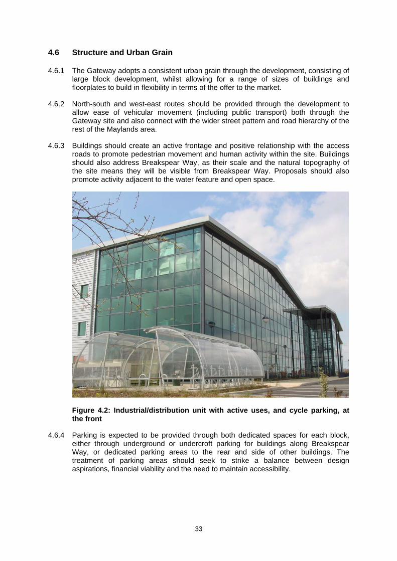
Figure 4.2: Industrial/distribution unit with active uses, and cycle parking, at the front
4.6.4 Parking is expected to be provided through both dedicated spaces for each block, either through underground or undercroft parking for buildings along Breakspear Way, or dedicated parking areas to the rear and side of other buildings. The treatment of parking areas should seek to strike a balance between design aspirations, financial viability and the need to maintain accessibility.
34
4.7 Appearance and Building Form
4.7.1 Specific architectural guidelines are not specified for the new development. However, all buildings will be expected to be of a high quality.
4.7.2 Distinct architecture to provide an identity for this part of the Maylands will be encouraged at the Maylands roundabout at the junction of Breakspear Way and Green Lane.
4.7.3 In terms of building form, a key aspect is for buildings to have entrances facing the Breakspear Way and the new access road, with servicing to the rear wherever possible. The location of servicing will need careful consideration. Incorporating flexibility in the building floorplates through allowing subdivision between occupants will be encouraged to ensure their suitability to a range of possible tenants and to extend the lifetime of the buildings beyond a single tenant.
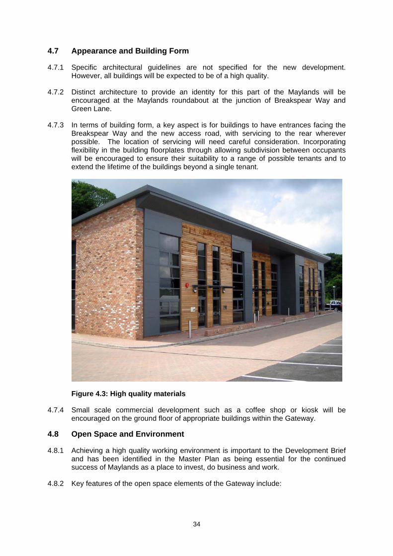
Figure 4.3: High quality materials
4.7.4 Small scale commercial development such as a coffee shop or kiosk will be encouraged on the ground floor of appropriate buildings within the Gateway.
4.8 Open Space and Environment
4.8.1 Achieving a high quality working environment is important to the Development Brief and has been identified in the Master Plan as being essential for the continued success of Maylands as a place to invest, do business and work.
4.8.2 Key features of the open space elements of the Gateway include:
35
A landscaped belt is proposed for the southern edge of the development site, which will strengthen the existing tree line and maintain ecological links with the woodland on the southern side of Breakspear Way. This should comprise low-level planting to protect the visibility of new buildings from Breakspear Way. Appropriately spaced gaps in this belt will allow views of the new development from Breakspear Way.
A buffer will be created between the commercial Gateway uses and other uses
such as the residential area and the cemetery, primarily through tree planting. Materials used, including natural stone, timber and stainless steel will create a
robust and high quality environment, whilst cowled street lighting and ground recessed feature lighting will create a safe and dynamic working environment, avoiding unnecessary glare.
Public art should be provided, with careful consideration given to appropriate
themes and locations.
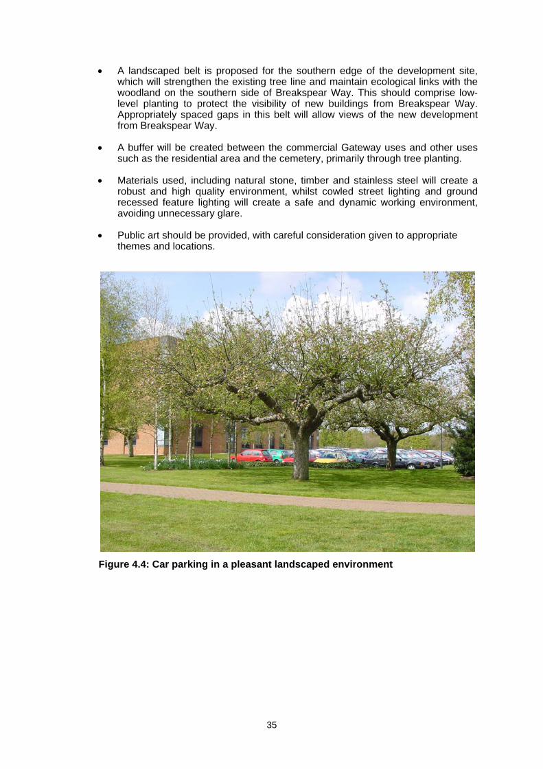
Figure 4.4: Car parking in a pleasant landscaped environment
36
4.9 Uses to be Retained and Relocated 4.9.1 There are a number of sites within or adjacent to the Gateway where current uses
are either to be retained or relocated as stated in the Local Plan.
4.9.2 The existing Woodwells Cemetery is to be retained. For sports pitches, the Woodwells caravan storage facility north of the cemetery and land allocated for the expansion of Woodwells Cemetery, redevelopment is not precluded. However, these existing uses must be relocated or appropriate relocation assistance should be provided, when the current site is developed as part of the Gateway.
37
5. Transport and Movement 5.1 Introduction
5.1.1 This section incorporates the main transport and movement principles of the Master Plan. However, that document contains the important proviso (paragraph 1.3.3) that the highways and transportation schemes are at a conceptual level. More detailed investigative work will be required. It will be necessary to review the proposals in the light of:
(a) the Hertfordshire Infrastructure and Investment Strategy (transportation infrastructure investment requirements);
(b) the transport model for the Hemel Hempstead area; and
(c) the Hemel Hempstead Urban Transport Plan. 5.1.2 Developers with an interest in the Maylands Gateway should contact the Highway
Authority at an early stage to discuss their plans for the redevelopment of this area in the context of the above advice.
5.2 Roads 5.2.1 A preliminary appraisal of the level of traffic that would be generated by
development on this site has been undertaken and this has been used to develop a strategy for the provision of access onto the existing highway network. For the most part it is intended that existing access points should be utilised such as the existing Peoplebuilding junction and the priority junction on Boundary Way.
5.2.2 A number of new roads will be required to serve Maylands Gateway, as illustrated in figure 5.1. The principal of these will be an east-west route linking Maylands Avenue to Green Lane. This connects to the Peoplebuilding junction but will require a new junction onto Green Lane. It is anticipated that this will take the form of a roundabout to maintain traffic flows. These new links will assist in the distribution of traffic so that there is not a concentration of traffic at any one point as it joins or leaves the adjacent highway network and managed to ensure that the principal route is not used as a bypass or rat run
5.2.3 Consideration has been given to the creation of a full movements junction on Breakspear Way, between the roundabouts where it meets Maylands Avenue and Green Lane, to replace the simple left in/left out junction where Buncefield Lane meets Breakspear Way. However there is a policy in the Hertfordshire Local Transport Plan 3 (Volume 2, page 52) that strongly discourages new access onto Primary Routes. The relevant part of the policy is reproduced below.
The county council will develop and maintain strategies for roads within the urban and inter urban network that:
A. On Primary Routes: - Encourage through traffic and HGVs to use primary routes; - Not allow existing or new developments to have direct access
except where special circumstances can be demonstrated and such limitations will be rigorously applied.
38
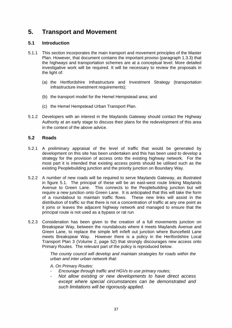
Figure 5.1: Principal Roads and Anticipated Junction Improvements
5.2.4 In the light of the proposed changes to the nature of development on this site the preliminary nature of the highway appraisal means that there is as yet insufficient evidence to demonstrate ‘special circumstances’. In any event it is considered that the approach of seeking to intensify the use of the existing connections to the non-primary routes and the creation of a new access onto Green Lane is the most appropriate way forward. The proposed layout of the internal highway network does not preclude that solution, if at a later date it becomes necessary.
5.2.5 Improvements may also be required to the existing Green Lane/Breakspear Way roundabout junction.
5.2.6 It is anticipated that improvements will need to be made to Buncefield Lane, if required, this could include re-opening the route to the north onto Wood Lane End. However the scale of these improvements could be minimised if a restriction, either by vehicle weight or width, were introduced to exclude its use by heavy goods vehicles.
5.3 Car Parking
5.3.1 Saved Policy 58 of the Dacorum Borough Local Plan 1991 - 2011 sets out the current policy with regard to the level of parking provision to be provided in new development. That provision will be assessed using the demand based parking guidelines and approach to parking set out in Appendix 5 of the Plan. These are based on ‘accessibility zones’ which identify the level of demand for parking provision that a particular area should provide.
5.3.2 The following table represents the four accessibility zone types that apply.
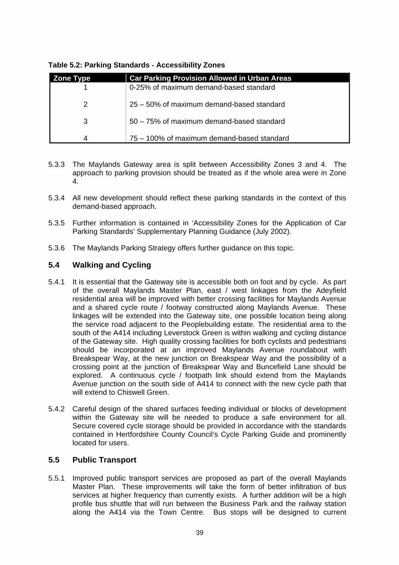
39
Table 5.2: Parking Standards - Accessibility Zones
Zone Type Car Parking Provision Allowed in Urban Areas 1
2
3
4
0-25% of maximum demand-based standard 25 – 50% of maximum demand-based standard 50 – 75% of maximum demand-based standard 75 – 100% of maximum demand-based standard
5.3.3 The Maylands Gateway area is split between Accessibility Zones 3 and 4. The approach to parking provision should be treated as if the whole area were in Zone 4.
5.3.4 All new development should reflect these parking standards in the context of this demand-based approach.
5.3.5 Further information is contained in ‘Accessibility Zones for the Application of Car Parking Standards’ Supplementary Planning Guidance (July 2002).
5.3.6 The Maylands Parking Strategy offers further guidance on this topic.
5.4 Walking and Cycling
5.4.1 It is essential that the Gateway site is accessible both on foot and by cycle. As part of the overall Maylands Master Plan, east / west linkages from the Adeyfield residential area will be improved with better crossing facilities for Maylands Avenue and a shared cycle route / footway constructed along Maylands Avenue. These linkages will be extended into the Gateway site, one possible location being along the service road adjacent to the Peoplebuilding estate. The residential area to the south of the A414 including Leverstock Green is within walking and cycling distance of the Gateway site. High quality crossing facilities for both cyclists and pedestrians should be incorporated at an improved Maylands Avenue roundabout with Breakspear Way, at the new junction on Breakspear Way and the possibility of a crossing point at the junction of Breakspear Way and Buncefield Lane should be explored. A continuous cycle / footpath link should extend from the Maylands Avenue junction on the south side of A414 to connect with the new cycle path that will extend to Chiswell Green.
5.4.2 Careful design of the shared surfaces feeding individual or blocks of development within the Gateway site will be needed to produce a safe environment for all. Secure covered cycle storage should be provided in accordance with the standards contained in Hertfordshire County Council’s Cycle Parking Guide and prominently located for users.
5.5 Public Transport 5.5.1 Improved public transport services are proposed as part of the overall Maylands
Master Plan. These improvements will take the form of better infiltration of bus services at higher frequency than currently exists. A further addition will be a high profile bus shuttle that will run between the Business Park and the railway station along the A414 via the Town Centre. Bus stops will be designed to current
40
specification allowing easy boarding and alighting of the bus and will take into account Disability Discrimination Act requirements and existing stops upgraded. High quality bus shelters will be provided, along with real time passenger information
5.5.2 Specific Local Sustainable Transport Funded project taking place in 2012 – 2015 include:
Improved and new walking and cycle routes to Maylands Business Park; Urban Realm improvements to enable increased walking at Maylands Business
Park; Maylands Business Park Bus Link and Infrastructure Improvements between
Hemel Hempstead Station, Town Centre and Maylands; Maylands Area Travel Plan and Car Club (to provide a dedicated travel planning /
behavioural change programme in Maylands Business Park); Bus infrastructure upgrades (including real-time information screens, smart cards
and better buses). 5.6 Infrastructure
Highways
5.6.1 The need for new and improved roads and junctions is highlighted in section 5.2
above.
5.6.2 Any new section of road to serve employment uses should be constructed to Hertfordshire County Council design standards as specified in their document ‘Roads in Hertfordshire – Highway Design Guide’ (Feb 2011). It would comprise a 7.3m carriageway with 3m combined footway / cycleway and should create the boulevard-style landscape envisaged within the over-arching Master Plan.
5.6.3 Minor service roads will connect to the new east-west section of road to feed into the Maylands Gateway site itself. These service roads will be low speed, with the potential for shared surface type construction to be considered at junctions with the main road.
5.6.4 Improvements to Maylands Avenue junction with the A414 will be undertaken if identified in the Hemel Hempstead Urban Transport Plan (HHUTP). It is intended to improve the signalised junction on Maylands Avenue at its junction with Wood Lane End to form high quality pedestrian and cycling crossing facilities. Bus priority measures would also be built into these improvements.
Surface Water Drainage
5.6.5 Surface water management for the Maylands Gateway will take advantage of the opportunity to provide source control drainage elements. This should include elements such as permeable paving and green roofs. Permeable paving will be encouraged as it offers both interception as well as storage (depending on its design).
41
5.6.6 The use of open surface features will be encouraged for the (horizontal) conveyance of surface water within each building plot. The method of conveying surface water from each plot’s outfall to larger on-site balancing features (lakes) will be related to issues of adoption. Swales/grassed ditches will again be encouraged for such conveyance and their design should meet all necessary adoption standards.
5.6.7 It is expected that the maintenance of sustainable drainage elements within the curtilage of each building will form part of that building’s general maintenance contract. The contract will also identify ‘post storm’ checks to be carried out following large rainfall events (to be defined).
5.6.8 Maintenance of those sustainable drainage features in areas of public open space will require either section 106 agreement with the Local Authority or a legal agreement between those companies/buildings feeding said features.
5.7 Services
5.7.1 The utility demand for each building should be complemented by including facilities for on-site power generation and water reuse and treatment.
5.7.2 Building designs should include complementary energy saving and water harvesting technologies subject to the latest available guidance for the installation of such technologies.
Electricity
5.7.3 It is likely that two ring mains will be required as part of the main infrastructure to provide loops around the various buildings. This will enable sub-stations to connect to the ring mains for each building and will enable the provision of electricity supply on a phased basis. It is likely that the Gateway development will be fed by one 33KV primary high voltage sub-station.
Gas
5.7.4 A phased approach is proposed with possibly a new primary Governor Station feeding a medium pressure on-site distribution system around the Gateway site. Low pressure supplies to individual plots via a low pressure governor will then be put in place.
Water
5.7.5 Within the Gateway site, it is proposed that a ring main will be created to link the various plots, from which connections to each building will be made as the building phases come on stream.
42
6. Delivery and Management 6.1 Objective 6.1.1 The vision for the Gateway has been established to create a flexible development
that encourages high quality development that responds to the needs of the market. This enables Maylands to confirm its status as a highly sought after industrial location.
6.1.2 Investment into Maylands has been constrained by challenging economic conditions and a historic Development Brief that has restricted the range of employment and ancillary land uses. The updated development brief aims to offer that flexibility and create the right conditions for private sector investment.
6.1.3 The section provides some guidance as to how the Gateway vision can be achieved.
6.2 Property 6.2.1 The Gateway is the key area of the Maylands employment area that is capable of
providing land for expansion, primarily because the majority of the land is previously undeveloped, or developed with relatively low-intensity uses.
6.2.2 Within the boundary of the defined gateway area the land is split between two key ownerships as shown on Figure 3.2. This pattern of large ownership will make a significant contribution to facilitating the delivery of the Gateway vision.
Market Opportunity and Risk
6.2.3 Putting measures in place to address potential barriers to development of the Gateway area is crucial.
6.2.4 The involvement of public sector partners, who can work outside of normal commercial constraints, will be extremely beneficial in overcoming potential private sector constraints to achieving the longer-term objectives of holistic regeneration.
6.2.5 Some intervention is likely to be required in the marketplace to create the economic and property market conditions that would enable the development. Investment in infrastructure and quality of environment is proposed as this intervention. The reasons for this are:
Investment in infrastructure to create service development land removes considerable risk and upfront cost to the private sector; and
In an environment of limited bank funding, such public sector investment
increases the number of potential developers that could invest in the Maylands Gateway.
6.2.6 Phasing needs to be carefully considered, to backload costs and frontload receipts
into development programmes as much as possible, to increase the financial viability and minimise risk.
6.2.7 Three principal options for delivery were considered, with varying degrees of commitment from the public sector:
Option A – minimal intervention;
43
Option B – publicly funded single-layer of infrastructure and sale of serviced plots; and
Option C – securing a development partner.
6.2.8 Option A is not considered to be realistic given current market conditions. With the investment required to service the land and limited occupier demand, we do not expect a developer to acquire the land and pay for infrastructure upfront.
6.2.9 Option B represents an opportunity for Dacorum BC to secure Growing Places funding to contribute towards the construction of the new east-west link road. With this in place, it could then sell serviced land to developers/owner occupiers. This option enables the landowners to remain in control of the land and potentially maximise capital receipts as it is developed. However, it could lead to an incoherent plot by plot development and lower quality development.
6.2.10 Option C could include the investment from Option B, but would also include selecting a development partner across the whole study area to deliver quality development across the entire area.
6.2.11 The benefits of Option C are that there will be a reduced outlay for the public purse, the land can develop organically according to the marketplace with the landowners securing a share of the end values.
6.2.12 This option also captures the opportunity to benefit from further private sector investment to optimise the potential of the Maylands Gateway. We are aware of property companies that could have funds to invest into employment led development as part of a public/private partnership.
6.3 Information to Support a Planning Application
6.3.1 A range of information will be required to support any planning application(s). The following list indicates the likely scope of information required. It is not necessarily exhaustive and developers will be expected to engage with the Borough Council at an early stage to discuss the appropriate type and range of information required to support their proposals.
A statement setting out how the application meets the requirements of the Development Brief, over-arching Master Plan, Local Plan and emerging Local Development Framework
Design and Access Statement
Sustainability Statement (to include consideration of climate change proofing)
Transport Assessment (to meet the requirements of both the Highway Authority with regard to the local road network, and the Highways Agency with regard to the impact on Junction 8 of the M1)
Green Travel Plan (to link with any Maylands-wide plan that is under development)
Flood risk assessment and outline drainage strategy
Tree and hedge survey
Ecological assessment
Assessment of archaeological potential
44
Land contamination report
Landscape strategy
Energy and Renewables Assessment
Soil Management Plan.
6.3.2 Certain aspects of the proposed development will need to be covered by a legal agreement. Further information regarding the likely range and scale of contributions can be obtained from the Borough Council and Hertfordshire County Council.