Embed Size (px)
Citation preview
REPUBLIC OF CYPRUS
Prepared for Noble Energy International
on behalf of the
Ministry of Energy, Commerce, Industry and Tourism
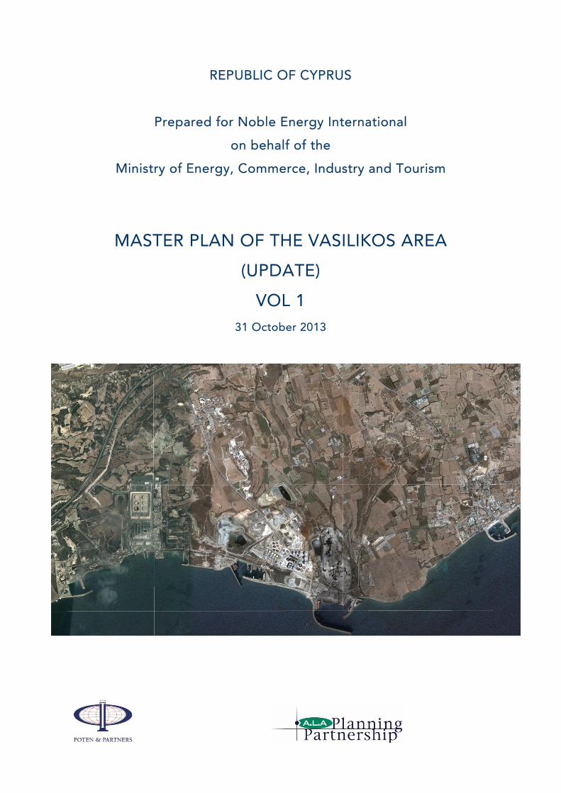
MASTER PLAN OF THE VASILIKOS AREA
(UPDATE)
VOL 1
31 October 2013

Noble Energy International
Master Plan of the Vasilikos Area
NOTICE:
The Vasilikos Master Plan (the “Master Plan”) has been prepared
by Poten & Partners, Inc. (“Poten”) and ALA Planning Ltd. (“ALA”)
for the Government of the Republic of Cyprus and paid for by
Noble Energy International Ltd (“Noble Energy”) within the context
of the necessary planning in the area, in order to host an LNG
Plant. Noble Energy has not participated in the preparation of the
Master Plan and it is not the work product of Noble Energy.
No representations or warranties, however, either expressed,
implied, or statutory are made by Poten, ALA or Noble Energy with
respect to the Master Plan, or any of the contents thereof,
including any representation or warranty with respect to (i) the
condition, quality or suitability of the land upon which the Facility
is intended to be constructed, (ii) the condition, quality, or
suitability of the architectural, engineering, or technical designs, or
(iii) any other information that is made available or communicated
herein. Poten, ALA and Noble Energy furthermore disclaim any
representation or warranty, express or implied, of merchantability,
fitness for a particular purpose, conformity to models or samples of
materials of any equipment, or condition. In no event shall Poten,
ALA, Noble and/or any of their respective affiliates have any
liability to any party in connection with this Master Plan.

Poten & Partners
Report Prepared for Noble Energy International on behalf of
Ministry of Energy, Commerce, Industry & Tourism
MASTER PLAN FOR THE VASILIKOS AREA (UPDATE)
Contents
Volume 1 – The Master Plan for the Vasilikos Area: Report
Section Page
1. Introduction ................................................................................................................ 1‐1
2. Terms of Reference .................................................................................................... 2‐1
3. Methodology .............................................................................................................. 3‐1
4. Characterisation of the Vasilikos area ........................................................................ 4‐1
5. Current establishments, activities & plans ................................................................. 5‐1
6. Safety, security & environment .................................................................................. 6‐1
7. Baseline Master Plan .................................................................................................. 7‐1
8. Master Plan Summary and Conclusions ..................................................................... 8‐1
Vol 2 – The Master Plan for the Vasilikos Area: Plans
Vasilikos Area Master Plan Update
1
Glossary
amsl Above mean sea level
BEMRS British East Mediterranean Relay Station
Bgl, b.g.l.
Below ground level
BLEVE Boiling liquid expanding vapour explosion
BOD Basis of Design
CBM Conventional buoy mooring
CPA Cyprus Ports Authority
CPSCL Cyprus Petroleum Storage Company Ltd
DC Direct current
DEFA Public Natural Gas Company (∆ΕΦΑ)
DFMR Department of Fisheries and Marine Research
DLI Department of Labour Inspection
DSM Transmission System Operator for Cyprus
DTPH Department of Town Planning and Housing
EAC Electricity Authority of Cyprus
EC European Commission
EEZ Exclusive Economic Zone
EIA Environmental Impact Assessment
EU European Union
GOC Government of Cyprus
ha Hectare
HFO Heavy fuel oil
HV High voltage
ISPS Code
International Ship and Port Facility Security Code
JV Joint venture
km Kilometre
LNG Liquefied natural gas
LOA Length overall
LPG Liquefied petroleum gas
M, m3 Metre, cubic metre
MECIT Ministry of Energy, Commerce, Industry & Tourism
MOD Ministry of Defence
mt Metric tonne (1000 kg)
Mtpa Million tonnes per year
MW, MWe
Megawatt (1000 kilowatts) of electricity
MWth Megawatt thermal (heat)
NFPA National Fire Protection Agency (US)
nm Nautical mile
OHTL Overhead transmission lines
QRA Quantitative Risk Assessment
PIANC The World Association for Waterborne Transport Infrastructure (formerly the Permanent International Association of Navigation Congresses)
PSC Policy Statement for the Countryside
ro-ro Roll-on, roll-off loading or unloading facility
SBA Sovereign Base Area
SEA Strategic Environmental Assessment
SPM Single Point Mooring
tdwt Tonnes deadweight, i.e. the carrying capacity of a ship
TSO Transmission System Operator in Cyprus, DSM
VCW Vassiliko Cement Works
VEC Vasilikos Energy Centre
VTTV VTT Vasilikos Ltd

Vasilikos Area Master Plan Update
1-1
Section 1 Introduction
1.1 BACKGROUND The Government of Cyprus expropriated land at Vasilikos in 2003 and 2008 for the construction of the Vasilikos Energy Centre (VEC), which was to comprise an LNG regasification terminal to import LNG and storage for white and black oil products. The policy to import gas would benefit EAC by eliminating the need to retrofit flue gas desulphurization (FGD) at two oil-fired units at Vasilikos power station and also by reducing CO2 emissions because the availability of natural gas would permit the construction of more efficient gas-fired combined cycle gas turbine (CCGT) power plants.
The government commissioned a Master Plan for the Vasilikos area in 2009, which was based on an onshore LNG import terminal by the coast east of the Vasilikos power station and oil products storage in the north closer to the Larnaca-Limassol motorway. The strategic location of the Area and the accessibility from the national road network is shown in Plan 1, Volume 2.
The original plans of the Cyprus Government for the design of the VEC have changed since the discovery of natural gas. Noble Energy discovered gas in significant quantities in late 2011 in deepwater Block 12. Recent results of the appraisal of the Aphrodite gas field indicate gross mean reserves of 5 trillion cubic feet (Tcf), with a range of 3.6 to 6.0 Tcf. The Cyprus domestic market will consume some of this gas, particularly for power generation where it would replace expensive fuel oil and gasoil, but the bulk would need to be sold in international markets to make development of the field viable. Noble Energy and its partner in Block 12, Israel’s Delek Group, signed a Memorandum of Understanding with the Cyprus government in June 2012 to develop a LNG liquefaction plant within the VEC site. The government awarded Production Sharing Contracts for additional Blocks in early 2013 to consortia led by Total (Blocks 10, 11) and Eni (Blocks 2, 3, 9).
Given the potential for further gas discoveries – the government has estimated 39 Tcf of possible gas reserves offshore – this update of the 2009 Vasilikos Area Master Plan has to take account of the additional space requirements to enable construction of several LNG liquefaction plants as well as government policy to move hydrocarbon storage from Larnaca to Vasilikos.
1.2 STUDY TEAM Poten & Partners has been engaged by Noble Energy to update the 2009 Master Plan, and has subcontracted ALA Planning Partnership to provide local planning expertise and capability. ALA Planning was co-author of the 2009 report. Poten & Partners is a consultant with specialized knowledge and capability relating to natural gas and LNG, including extensive project development and energy master planning experience.
1.2.1 Poten & Partners
Poten & Partners has been operating for more than 60 years, and while it originated as a ship broker it has expanded into providing a range of commercial and consulting services related to supply, cargo trading, and transportation of crude oil, petroleum products, condensates, naphtha, LPG, natural gas, & LNG, chemicals, and chemical gases. The company currently employs 135 staff members and has offices in New York, Houston, London, Athens, Perth, Singapore and Guangzhou.
Poten’s Natural Gas & LNG Consulting group provides consulting services to a wide range of natural gas supply projects, buyers, lenders and other industry participants. With a full-time team of 35 natural gas

Section 1 Introduction
Vasilikos Area Master Plan Update
1-2
and LNG professionals in London, New York, Houston and Perth (Australia), Poten has the largest LNG advisory team in the world. Poten’s team consists of seasoned industry professionals who have been involved in a majority of the world’s major LNG projects, and a large number of gas pipeline and electricity projects. We are able to advise clients across strategic, technical, commercial and operational levels.
1.2.1.1 Poten project team
Poten’s project team for the Vasilikos Area Master Plan includes the following:
James Briggs
An experienced senior consultant in the energy business, with a track record of developing major projects internationally and a combination of in-depth, industry wide, technical knowledge and strategic commercial vision. Extensive experience in project development, including preparation of Master Plans for major hydrocarbon projects, financing and new technologies. Jim is based in Poten’s New York office and leads Poten’s Natural Gas & LNG Consulting Group. Responsible for evaluation of technical and safety aspects of hydrocarbon developments.
Captain Douglas Brown
Doug joined Poten & Partners in April 2013 as LNG Shipping Specialist. He spent over 40 years working for BP in shipping, both as a serving ship’s officer up to the rank of Master and as a marine advisor to a large number of LPG, LNG and offshore oil loading projects. He has also acted as Technical Adviser to the Society of International Gas Tanker & Terminal Operators (SIGTTO) and had a major involvement in the preparation of a number of LPG/LNG industry best practice publications, including Liquefied Gas Handling Principles on Ships and in Terminals and LNG Operations in Port Areas. Doug was also responsible for co-chairing a working group carrying out extensive revision to operational sections of the IMO International Code for the Construction and Equipment of Ships Carrying Liquefied Gases in Bulk. Since joining Poten, Doug has already been involved in a number of high profile projects from the Russian Arctic to Southern Africa and Australia. Responsible for marine aspects of the Master Plan.
J Blair MacIntyre
With nearly 45 years of experience in Shipping Technology and an extensive background in LNG, Blair is responsible for development and implementation of technical aspects of shipping projects for Poten. Responsible with Capt. Brown for marine aspects of the Master Plan.
Martin Massy
An engineering graduate from Cambridge University, Martin Massy has over 30 years experience working in the energy industry. He has a practical engineering background in power generation, especially coal-, oil- and gas-fired technologies and a wide range of experience in planning, restructuring and privatization, power plant construction, project management, and consultancy. He has international consulting experience in management, restructuring, privatisation, power generation and transmission planning, and commercial agreements and analysis in the electricity and gas industries. Responsible for Master Plan coordination and evaluation of electricity infrastructure.

Section 1 Introduction
Vasilikos Area Master Plan Update
1-3
1.2.2 ALA Planning Partnership
1.2.2.1 Company Scope
ALA Planning Partnership is a multi-disciplinary consultancy based in Cyprus, providing full consultancy services on Planning, Transport and Environmental issues. The company’s philosophy is to design and undertake actions through an integrated approach with a focus on the fundamentals of sustainable development. The company offers a full range of regional/strategic, town, environmental and transport planning services in a responsible and highly professional manner, backed up by scientific expertise and extensive experience. According to the specific needs of each project, professional experts are drawn from a pool of external national and international associates specialising in a wide range of disciplines such as coastal engineering, mining engineering, tourism, economics, ecology, architecture, geology, chemistry, chemical engineering, marine biology, architecture, etc.
In the context of the current project, ALA Planning Partnership has been appointed by Poten & Partners on behalf of Noble Energy, to provide Consulting Services with regard to the preparation of an up-to date and comprehensive new Master Plan for the Vasilikos Area. In 2009 ALA Planning Partnership, in collaboration with Wardell-Armstrong prepared a Master Plan of the Vasilikos Area that defined the planning zones and land uses, mapped out the existing and planned transport infrastructure and other basic infrastructure such as drinking water, sewage, electricity networks etc.
1.2.2.2 ALA Project Team
The Project Team of ALA comprised the following experts:
Anna Caramondani
Civil Engineer and Town and Regional Planner. Has done the Project Management on behalf of the ALA Project Team and provided input on all issues involving land use and planning zones, committed and other developments in the immediate and wider area and on land transport planning. Has organised and attended a number of the meetings of the Project Team with all the relevant Government Departments and other stake holders and kept records and minutes.
Dr. Achilleas Kalopedis‐Civil Engineer.
Has acted as the assistant Project Manager of the Project and provided input and coordination on all issues concerning the existing and proposed basic infrastructure such as electricity, telecommunications, drinking water, and sewage networks. Has organised and attended a number of the meetings of the Project Team with all the relevant Government Departments and other stake holders and kept records and minutes.
Michalis Michael‐Town and Regional Planner and GIS expert.
Has organised and supervised the collection of all the necessary data from various Government Departments and other key stake holders and has prepared all the maps of the Project.
Demos Kyriakou‐Transport Engineer.
Has done all the work involving traffic counts, meetings with the Public Works Department and the Department of Town Planning and Housing, has recorded the existing road network and prepared the plan for the proposed road network of the immediate and wider area.

Vasilikos Area Master Plan Update
2-1
Section 2 Terms of Reference
2.1 OBJECTIVES The new Master Plan is required to record the existing facilities, examine their compatibility with the proposed facilities and assist in the planning of the development of this area in such a way that both current and future establishments operate in an efficient, cooperative, safe and environmentally sound manner.
The overall objective is to offer a complete picture of the area and to examine whether the existing facilities and the proposed future projects and general development of the area for the next 30 years will be compatible with current facilities, based on risk, safety, security, environmental and social consideration. The Master Plan of the Vasilikos area will constitute a tool for the optimum development of the entire area within the time horizon of the next 30 years.
The Master Plan will evaluate and make recommendations to ensure the safety, security – including the possibility of a terrorist attack or a severe natural disaster (e.g. seismic activity, tsunami, extreme climate conditions) – and environmental compatibility of the future developments, especially the LNG plants and Cyprus operational and strategic stocks.
It should be noted that the level of detail of the proposed Master Plan concerning the proposals for Planning Zones and other proposed facilities such as the compressor station do not always follow the boundaries of specific plots. These refinements can be made by the appropriate Authorities after the Master Plan is approved. The road layout is also a diagrammatic proposal which took into account constraints such as contours and major existing uses but it will need refinement and detailed drawing after the approval of the Master Plan.
2.2 STUDY AREA The area under study is the greater Vasilikos Area located on the south coast of Cyprus, approximately 25 km east of the town of Limassol, 30 km southwest of the town of Larnaca and 40 km south of the island’s capital city, Nicosia.
The Study Area of the current Master Plan as specified by the Ministry of Energy, Commerce, Industry and Tourism (MECIT) in 2013 for the purposes of this Study is shown in Plan 2 in Volume 2 of the Master Plan report. This 2013 Study Area as compared to the 2009 Study Area has been extended to the west to include the ‘Evangelos Florakis’ Naval Base.
The 2013 MECIT Study Area is delimited to the west by the western boundary of the ‘Evangelos Florakis’ Naval Base, to the north by the A1-motorway connecting Nicosia with Limassol, to the east by the Vasilikos river valley and to the south by the southern coastline of Cyprus including the relevant offshore area including the fisheries and aquaculture activities located in the entire Vasilikos Bay as well as EAC’s fuel importation buoy.
During the course of the Study preparation, the Project Team has examined various aspects affecting the Master Plan as discussed with various stakeholders and with the MECIT. As a result of this consultation procedure, the Project Team extended the Study Area limits, mainly to the east and to the north, to cover the various issues that were discussed during the Study preparation. As a result the proposed Master Plan covers a wider area than originally specified by the MECIT. The extended Study Area is shown in Figure 2-1.The only community located within the Study Area is Mari village which is situated approximately 1

Section 2 Terms of Reference
Vasilikos Area Master Plan Update
2-2
km north of the coast. The nearest coastal community is Zygi village, which is located just to the east of the Study Area and is mainly being used for tourism and fishing activities. The extended Study Area also includes part of the coastal area of the administrative boundaries of the community of Tochni, which is a village situated to the north of the Nicosia-Limassol motorway but with administrative boundaries reaching the coastline. The community of Kalavasos is located to the north of the Study Area. The communities of Mari, Tochni, Zygi and Kalavasos are within the administrative boundaries of Larnaca District. To the West and North West of Mari are the communities of Pentakomo and Asgata respectively, which are located within the administrative boundaries of Limassol District.
Figure 2-1 Extended study area for the Vasilikos Master Plan
The study area also includes the road network serving the Vasilikos area, comprising the old Nicosia-Limassol main road between the Zygi and Governor’s Beach junctions (including the junctions themselves).
2.3 POTENTIAL FUTURE DEVELOPMENTS The primary new developments anticipated over the short to medium term will be a number of LNG liquefaction plants for the production, export and sale of liquefied natural gas (LNG), and a major Oil Products Storage Terminal, including storage for LPG.
The first phase of LNG development is expected to consist of three LNG trains (with a possibility for further expansion) and the relevant infrastructure (offshore installations, berth, pipeline system, etc.). The
Section 2 Terms of Reference
Vasilikos Area Master Plan Update
2-3
necessary land for these establishments has been expropriated. The pre-FEED study of the LNG Plant has been nearly completed.
The Vasilikos Oil Products Storage Terminal will comprise an oil products storage terminal for Cyprus’s operational stocks as well as the strategic stock requirements and will also allow for transit trading. The establishment of an area for the storage of oil products will enable the existing storage facilities in Larnaca to be closed and transferred to Vasilikos. A key requirement is the urgent transfer of LPG storage facilities to the Vasilikos area.
Apart from the above there are plans for several other facilities within the area such as a HVDC converter station for an electrical submarine cable (the EurAsia Interconnector), a wind farm, warehouses, fish food manufacturing plants, etc. In addition, VTTV Ltd is in the process of establishing an oil storage depot in the area, and is also planning the expansion of this depot on reclaimed land near the Vasilikos Industrial Port. Another major development is the current expansion of the existing oil storage depot owned and operated by Petrolina (Holdings) Public Ltd. A complete list of the future facilities expected to be developed in the area, with an indication of the area needed for each facility, has been provided by the MECIT (see Appendix A).

Vasilikos Area Master Plan Update
3-1
Section 3 Methodology
Given the objectives for the Master Plan, the priority has been to ensure that adequate space has been allocated for the potential development of up to five LNG liquefaction plants (LNG Trains 1-5) each of 5 million tons per year (Mtpa) capacity. Other key parameters for the overall zoning plan are:
The requirement to accommodate potentially large volumes of hydrocarbon storage (including an urgent requirement to move LPG storage from Larnaca to Vasilikos and to store some or all of the island’s strategic oil stocks),
Safety, and the need to incorporate adequate separation distances both between adjacent facilities and between facilities and the general public,
Recognition of planned developments in the area.
The Study Team has consulted widely with companies and government departments that have plans for future development in the area or jurisdiction over safety, security and planning aspects. Appendix B lists the organisations contacted and information received. Appendix C details the documentation received.
The team has also visited the Vasilikos area and Vasilikos Port to assess options and practicability of siting new installations, and also to Limassol, in that case specifically to assess potential alternative sites for bitumen import and storage.
The conclusions of preliminary studies of noise and risk assessment carried out by Noble Energy for LNG Trains 1-3 have been taken into account in the Master Plan, although they will clearly evolve as the LNG projects are developed.
There is insufficient information available at this stage to determine how emissions of pollutants such as nitrogen oxides (NOx) (primarily from the proposed LNG plants) would affect ambient air quality. The Master Plan assumes that emissions will not affect the proposed zoning or the ability of the Vasilikos area to accommodate the proposed industrial facilities. Companies planning new facilities will be required to carry out further analysis (air dispersion modelling), which will also take account of emissions from existing industries in the area (including the Vassiliko Cement Works and the Vasilikos power station).
The Vasilikos Master Plan proposes zones for future development; these are not intended to be prescriptive in the sense of allocating plots to individual companies or developments (with the exception of LPG), but rather providing areas within which future development can take place in an optimal fashion. The Master Plan also includes corridors (rights of way for pipelines and utilities) and roads (proposed and existing) that provide access to all major establishments in the area.
The Master Plan is presented as a Base Case, with scenarios to address different planning assumptions. The Base Case assumptions are that existing facilities and activities will remain (except for the Archirodon Port, which will be used to offload materials for construction of the LNG plant and as a harbour for tugs – a new port should be found for the Archirodon construction company) and that space should be allocated for the possible construction of five x 5 Mtpa LNG trains. Every endeavour has been made to incorporate the requirements of all organisations within the Master Plan. Where those requirements are incompatible with Master Plan constraints (available locations and safety distances for new installations such as LPG), the Master Plan presents alternative proposals.

Section 3 Methodology
Vasilikos Area Master Plan Update
3-2
The following planning scenarios have been analysed (see section 8):
Naval base closure and relocation outside the Vasilikos area, which would permit the land to be used for development and remove the restriction on structures within the restricted zone;
Relocation of Mari village, which would remove constraints on safety and emissions caused by its proximity to potential installations and hence allow facilities to be built further north.

Vasilikos Area Master Plan Update
4-1
Section 4 Characterisation of the Vasilikos Area
4.1 GENERAL DESCRIPTION OF THE EXISTING SITUATION The area that will be covered by the Master Plan is a brownfield site used for the past 3-4 decades for industrial and other purposes, both onshore and offshore. The current facilities and industries located in the area include the largest cement manufacturing plant on the island (Vasilikos Cement Company), the largest power plant of Cyprus, EAC’s Vasilikos Power Plant and the ‘Evangelos Florakis’ Naval Base. There is also a port for dry bulk and other general cargo, mostly used by the cement factory, a small port (Archirodon port) which includes a small floating dry dock for ship maintenance and repairs, a shelter for fishing boats, two (2) active clay quarries and a small petroleum products storage depot, which is expanding, owned by Petrolina (Holdings) Public Ltd, a local oil company. Furthermore, VTT Vasiliko Ltd (VTTV Ltd), a private company, is developing an oil terminal, in three phases, close to the already established Petrolina depot, for the storage and management of petroleum and oil products with an eventual storage capacity of 858,000 m3. The major facilities of the area are shown in Figure 4-1.
In the area there are many other small industrial facilities and workshops in operation, some habitation and agricultural land and also available land for new developments. This area is the only coastal heavy industry zone available in Cyprus and therefore the only one providing opportunities for the creation of the proposed LNG Plant, the location of oil storage and LPG facilities, and is the only site with the potential to expand to cover future needs and uses associated with the current Government plans for industrial development in the area.
Figure 4-1 Vasilikos Area Major Facilities
The topography of the Study Area is quite varied as can be seen from the contours shown in Plan 3, Volume 2. The central hill with its highest point at approximately 120m above mean sea level (amsl) to the north and 85m high cliff of “Mandres tou Mikhali” overlooking the sea to the south stands between two river valleys. The village of Mari lies at an approximate level of 80m amsl and the eastern slopes

Section 4 Characterisation of the Vasilikos Area
Vasilikos Area Master Plan Update
4-2
which lead down to the valley of the river Vasilikos where the Vassiliko Cement Works (VCW) is located. To the west is the Vasilikos Power Station adjacent to a low-lying area with a small watercourse, which was formed into level platforms to accommodate the construction of the former Hellenic Chemical Industries (HCI) plant, and which was demolished to ground level in 2006. Along the shoreline there are areas of reclamation with the Archirodon Port at the centre and the Vasilikos industrial port to the East.
The ‘Evangelos Floraki’ Naval Base is situated at the western part of the Study Area. The British East Mediterranean Relay Station (BEMRS), which will soon be dismantled, occupies a large site of the eastern part of the Study Area. The HCI site, together with a large area of land to the north and part of the “Mandres tou Mikhalis” hill to the east, was expropriated by MECIT for the construction of the Vasilikos Energy Centre (VEC) as proposed in 2009. It should be noted that the topography of the central part of the study area is changing due to the quarrying activities carried out by the VCW.
Figure 4-2 Location of ‘Mandres tou Mikhali’
4.2 GEOLOGY AND HYDROGEOLOGY The local geology of the study area can be seen in Plan 4, Volume 2. The central section of the study area consists generally of the Nicosia Formation, comprising yellow brown marls, khaki sands and limestone and the Marine Terrace Formation comprising sands and gravels. Surrounding the Nicosia and the Marine Terrace Formations are alluvium and colluvium soils (sand, silts, clays and gravels). To the west of the study area, located at the site of the existing Vasilikos Power Station and part of the site of the proposed VEC are areas comprising the Pachna Formation consisting of chalk and chalky marls. Small areas of beach sand and gravel also exist at the south-west sections of the study areas.
The local hydrogeology map of the area can be seen in Plan 5, Volume 2. The figure shows that a central section of the study area consists of unconfined water, generally at shallow depth in connection with riverbeds, deltaic gravel-sand deposits and including estuarine deposits. Located at the west part of the study area are sections of ground water in highly retentive rocks such as chalk interbedded with marl.
The locations of three identified contaminated sites have been provided by the Geological Survey Department and can be seen in Plan 4, Volume 2.
The report, Validation Report, Demolition of the Former Hellenic Chemical Industries Plant, prepared by Environmental Protection Engineering SA and Van Vliet Sloopwerken BV, dated May 2007, states the following with regard to the area expropriated for the construction of the proposed Vasilikos Energy Centre:

Section 4 Characterisation of the Vasilikos Area
Vasilikos Area Master Plan Update
4-3
“The site is founded on sedimentary rocks or alluvial materials. During construction of the plant the area was cut and filled slightly to achieve a relatively flat site. Generally the pre-construction site investigation found sandy clays, sands and gravels of alluvial nature overlying a grey clay confining layer stratum, which extends to the gypsum aquifer at 125-150m depth below ground level (b.g.l.). The gypsum aquifer was proved to over 250m depth b.g.l. Groundwater was found occasionally in the gravels in channelised deposits at 2-3 metres depth. The general groundwater table is at a depth of 70-150 metres depth b.g.l.”
4.2.1 Parcel Permits and Quarrying Licences
A copy of the Parcel Permit for the Vassiliko Cement Works has been provided by the Department of Mines. Vassiliko Cement Works has been granted quarrying licences for six separate parcel areas under the licence issued by the Department of Mines in 1966 and modified in 1996. Two of the parcels, Parcels B and C lie within the study area and are shown in Plan 4, Volume 2, as are the extents of the quarrying licences. Parcel B is the parcel for the clay quarry whereas Parcel C is the location of the cement factory. The quarrying licences are valid until 2042. In 2009 we were informed that there was currently a government process for revising the boundaries of Parcel B, although this revision has not yet been confirmed.
4.3 ANTIQUITIES The Antiquities Department categorises antiquities either as Class A or Class B:
Class A: No development allowed. These antiquities usually involve compulsory acquisition of the land by the Antiquities Department.
Class B: Any development requires authorisation by the Antiquities Department.
All the existing important antiquities within or near the Study Area as provided by the Antiquities Department are shown on Plan 6, Volume 2 (Existing Planning Zones and Antiquities). According to the Antiquities Department there are ten (10) important archaeological sites in and near the Study Area The Antiquities Department first informed the Project Team during the preparation of the 2009 Master Plan of the existence of antiquities numbered 8, 9 and 10 on Plan 6 in Volume 2.
The sites numbered as 1-7 on Plan 6 were identified as antiquities by the Department of Antiquities during the preparation of the current 2013 Master Plan. Sites 9 and 10 are in the Kalavasos administrative area to the north of the Study Area and include both Class A and Class B antiquities. The rest of the sites are currently classified as Class B antiquities. Some of the sites are protected with planning Zones Z2 but most of the sites are not protected by any special protection zones.
The Antiquities Department has specifically stated that if any construction work within the Master Plan area is foreseen for archaeological sites 3-9 then the Department should be notified to discuss the handling of the matter. The critical Archaeological sites that may affect the Master Plan are sites 2 and 6.
Site 2 is named as “Mari Mazera” and according to the Antiquities Department, is a Cemetery of the Archaic Period. In the cases of cemeteries the standard practice of the Department of Antiquities is to evaluate and identify the antiquities found and then move them to the Museum. Based on this, site 2 is not expected to cause any real delays in the implementation of the Master Plan.
Site 6, named as “Tochni Lakkia”, is a settlement of the late Bronze Age. According to the Antiquities Department (information notified in late October 2013) once a settlement such as site 6 is excavated it

Section 4 Characterisation of the Vasilikos Area
Vasilikos Area Master Plan Update
4-4
becomes a Class A Monument belonging to the Government, and is a protected area which may be visited by the public. At the moment it is not possible to know the exact extent of the area of the settlement because there has been no excavation yet. It will therefore be imperative that more details are given by the Department of Antiquities concerning the exact location and the extent of the area of Site 6, should the Government decide to select the LPG 1(A) location as the preferred option for installation of LPG storage facilities. The Department of Antiquities should also comment on the compatibility of the reclamation proposed on the final Master Plan for the LPG 1(B) location with archaeological site 6.
4.4 CURRENT PLANNING ZONES AND LAND USE STATUS
4.4.1 Planning Legislation and Background Information
The responsibility for spatial planning in the rural areas of Cyprus rests with the Minister of Interior, the Department of Town Planning and Housing, as well as the Planning Board, an independent body with advisory power over large areas of planning policy. Before the 1974 forced division of Cyprus, planning in the rural areas was promoted, guided and controlled by the “Island Plan”. After the division of the island, the “Island Plan” was replaced by the Policy Statement for the Countryside (PSC) which refers to all government-controlled territory. The PSC is a legally binding Development Plan in the form of an adapted regional plan for the planning of development, development control and environmental protection in villages and rural areas. The PSC consists of a written statement of policies for various sectors of development (residential, commercial, tourist, industrial etc.) together with Planning Zones which indicate the plot ratios and land use of various areas. Planning zones in Cyprus are reviewed every five years.
The last review of the planning zones in Pentakomo Village which is in the Limassol District was published on 11 January 2013 and the last review of the planning zones of the rest of the communities of the Study Area including Mari village, which are in the Larnaca District, was published on 2 August 2013. It should be noted that in 2009 there was a Coastal Protection Zone covering the coastal area within the Mari Administrative Area. The part of the Marie Coastal Protection Zone affecting the Heavy Industry Zone of the area was abolished in 2010. . However, part of the Coastal Protection Zone in the Mari administrative boundaries and in the coastal area of the administrative boundaries of Tochni which is within the Study Area of the current (2013) Master Plan is still valid (see Plan 6, Volume 2). No development is permitted in the Coastal Protection Zone.
4.4.2 Planning Zones in the Study Area
The planning zones and the Coastal Protection Zone of the Study Area are shown in Plan 6, Volume 2. Planning zones are usually divided into two major categories, those within development boundaries, where various forms of organized development are allowed, and those which lie outside development boundaries. Zones within development boundaries are usually residential, commercial, industrial, tourist and animal husbandry zones.
The wider area that could be affected by future industrial development in the Vasilikos area contains the villages of Mari, Tochni, Kalavasos, Psematismenos, Zygi, Maroni and Pentakomo. All these communities except Pentakomo are part of Larnaca District. Pentakomo falls within the administrative boundaries of Limassol District. The planning zones of these communities consist mainly of residential zones around the core of the village which are usually inland, of tourist zones along the coast and of agricultural zones between the coast and the village core. The tourist zones that are very near the study area are those of the communities of Pentakomo, Zygi, Psematismenos and Maroni. Zones in the coastal area of Tochni, which is adjacent to the eastern boundary of the study area, are mainly agricultural zones

Section 4 Characterisation of the Vasilikos Area
Vasilikos Area Master Plan Update
4-5
and one zone for second homes. This second homes zone of the Tochni Village which is quite near and to the east of the Study Area has not been developed as the land ownership is mainly Turkish Cypriot.
The Planning zones in the area under study as indicated in Plan 6, Volume 2 are the following:
B2 Heavy Industry Zone. (Industry Zone Category A). The uses allowed in this zone are described in detail in the PSC document and include:
- Production and processing of metal materials;
- Mineral industries (excluding metal minerals);
- Chemical industries;
- Industries dealing with paper production, car industries, etc;
- Energy industries; (industries with a thermal input of greater than 50 MWth, crude oil refineries, installations for gasification and coal liquefaction and bitumen plants)
- Metal recycling;
- Waste treatment (sewage etc), waste recycling producing energy etc;
- Leather production industries;
- Slaughter houses;
- Nuclear energy production;
- Ship production/repairs;
- Aeronautical industries;
- Mushroom production.
- Warehouses which store the following materials: scrap metal, ashes, mining or quarrying materials, used building or similar materials, old cars, old machinery, organic fertilisers, and combustible or dangerous materials.
A special part of Zone B2 (Zone B2* in Plan 6) at the north-western part of the zone adjacent to the old Nicosia-Limassol road has been allocated for uses such as offices or similar uses associated with the operation of the Vasilikos Energy Centre as it was proposed in 2009.
Z1, Z2 and Z3 are protection zones with varying plot ratios according to the degree of protection of each zone. Z3 (plot ratio 0.01:1), is the strictest protection zone and it protects the banks of the Vasilikos River. Z2 is a less strict protection zone but with a quite high degree of protection (plot ratio 0.03:1). This zone covers a wider “buffer” zone on each side of the Vasilikos River and also a smaller area to the east of the Mari animal husbandry zone. Zone Z1 has the least degree of protection with a plot ratio of 0.06:1. It forms a buffer zone to the Heavy Industry Zone and around the A1 Nicosia-Limassol highway.
Γ3 is a general agricultural zone with a plot ratio of 0.10:1. This zone also covers most of the rural areas of Cyprus which lie outside development boundaries.
Δ1 is the Animal Husbandry Zone of the village of Mari.
H1 and H2 are the residential zones of Mari village which are developed around the village core of the community in the eastern part of the study area.

Section 4 Characterisation of the Vasilikos Area
Vasilikos Area Master Plan Update
4-6
The maximum plot ratios, plot coverage percentages, numbers of floors and heights allowed in each planning zone of the study area are given in Table 4-1, below.
Table 4-1 Planning Zone Parameters
Zone Maximum Plot Ratio
Maximum number of floors
Maximum height (metres)
Maximum plot coverage
Η1 1.20:1 2/3 8.30/11.40 0.70:1
Η2 0.90:1 2 8.30 0.50:1
B2 0.90:1 2 - 0.50:1
∆1 As given in the Policy Statement for the Countryside (PCS)
Γ3 0.10:1 2 8.30 0.10:1
Ζ1 0.06:1 2 8.30 0.06:1
Ζ2 0.03:1 1 5.00 0.03:1
Ζ3 0.01:1 1 5.00 0.01:1
According to the current legal status of the Coastal Protection Zone in the study area, no development is allowed within this zone. Since the current Master Plan may suggest some activities such as the LPG installations within this Coastal Protection Zone, it is suggested that the Department of Town Planning and Housing advises the Ministry of Interior (the relevant Authority), to abolish the Coastal Protection Zone within the extended Study Area of the current (2013) Master Plan, as shown in Plan 6, Volume 2.
4.4.3 Current Land Use and Land Ownership
The current land uses within the boundaries of the Heavy Industry Zone are the Vasilikos Power Station to the west, the Vassiliko Cement Works to the east, the Vasilikos Port used for the import and export of raw materials and cement, fuel tanks at the eastern coastal part of the area and the Archirodon port which is currently used for ship repairs. There is also a derelict quarry at the northern part of the study area, and two quarries that are active and used by the Vassiliko Cement Works. One of these quarries is at the eastern border of the Heavy Industry Zone and a large part of it is located in the protection zone Z2 which lies at the east of the Heavy Industry Zone.
The village of Mari, with around 180 inhabitants, is located at the east side of the main road which connects the B1 Nicosia-Limassol Road with the Vasilikos port. The village is a Turkish Cypriot Village and the inhabitants are mainly refugees. Development around the old village core which mainly consists of old houses is very limited because most of the land belongs to Turkish Cypriots. South of the inhabited area of Mari there is an animal husbandry zone with goats and sheep.
The Cyprus Government has proposed the relocation of the existing inhabitants of Mari to a coastal area in Zygi. The Government has already allocated land for this residential development within the Zygi tourist zone Τ2α. The plot ratio allocated for this development is 0.60:1. The Mari inhabitants consider that the financial incentives given to them for relocation are not attractive and they are reluctant to relocate.

Section 4 Characterisation of the Vasilikos Area
Vasilikos Area Master Plan Update
4-7
The land ownership of the study area is shown in Plan 7, Volume 2. The majority of the land within the study area is classed as Private Land. The details of the land ownership within the area which was acquired by the Government for the Vasilikos Energy Centre is shown in Plan 7.
To the west of the study area is the ‘Evangelos Floraki’ Naval Base. Directly to the east of the study area and located in the community of Tochni is the British East Mediterranean Relay Station (BEMRS) (see Plan 8, Volume 2). Further information on the BEMRS is provided in section 5.
Two fish packaging and processing centres have been constructed along the Vasilikos-Zygi coastal road by the companies Blue Island Holdings Ltd and Seawave Ltd. Similar fish farming companies are renting coastal land from the Cyprus Ports Authority for the construction of small warehouses for fish packaging within the Archirodon and Vasilikos Port areas.

Vasilikos Area Master Plan Update 2013
5-1
Section 5 Current establishments, activities & plans
The following paragraphs describe the current establishments and facilities within and immediately adjacent to the study area. The major existing land installations are shown in Plans 8 & 9, Volume 2. These were identified by a combination of site visits, (both in 2009 for the preparation of the 2009 Master Plan and in 2013 for the preparation of this Master Plan), communication with the owners and internet based satellite imaging. It should be noted that only major establishments and facilities have been recorded. There may be a few scattered single dwellings within the extended Study Area which will have to be taken into consideration when detailed plans are prepared by the relevant Authorities after the Master Plan is approved.
The main proposals and commitments relevant to the area are presented in Plan 15, Volume 2.
5.1 ELECTRICITY PRODUCTION FACILITIES
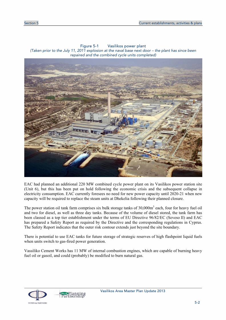
5.1.1 Vasilikos power station
The existing electricity production facilities in the Vasilikos area comprise the generating units at EAC’s flagship Vasilikos power station and some small units at the Vassiliko Cement Works.
Vasilikos is the largest and newest of EAC’s three power stations – the others being located at Moni, about 10 km to the west, and Dhekelia, some 50 km to the east. The Vasilikos power station has three 130 MW heavy fuel oil-fired steam units and two 220 MW combined cycle gas turbine units. All are relatively recent, the oil-fired units having been completed between 2000 and 2002, and the combined cycle units in 2012 and 2013. There is also a 37.5 MW open cycle gas turbine, which was primarily installed to provide black start capability, i.e. to provide power for station auxiliaries to restart the main units in the event of a grid collapse. The total installed capacity at the site is 867.5 MW, representing 59 % of the thermal generating capacity in the southern part of Cyprus.
Unit 3 of the steam units has been retrofitted with seawater flue gas desulphurisation (FGD), which can reduce sulphur emissions by up to 98 % and is compliant with the requirements of the EU’s Large Combustion Plant Directive (2001/80/EC). EAC buys HFO with a maximum sulphur content of 0.23 %, and gasoil with maximum 0.1 %. Units 1 and 2 have already been modified to enable them to burn natural gas when it becomes available; Unit 3 will be converted when the date for first gas delivery is known. The combined cycle units (4 & 5) are designed to burn natural gas, but currently burn (expensive) gasoil.
The photograph shown in Figure 5-1 was taken before the 11 July 2011 explosion at the adjacent ‘Evangelos Floraki’ Naval Base. It shows the steam units 1-3 to the left of the stack, and the two combined cycle units 4-5 under construction to the right of the stack. The oil storage tanks are in the background. In the foreground is the cooling water outfall. The plant has since been repaired and all the units are now fully operational.
Section 5 Current establishments, activities & plans
Vasilikos Area Master Plan Update 2013
5-2
Figure 5-1 Vasilikos power plant (Taken prior to the July 11, 2011 explosion at the naval base next door – the plant has since been
repaired and the combined cycle units completed)
EAC had planned an additional 220 MW combined cycle power plant on its Vasilikos power station site (Unit 6), but this has been put on hold following the economic crisis and the subsequent collapse in electricity consumption. EAC currently foresees no need for new power capacity until 2020-21 when new capacity will be required to replace the steam units at Dhekelia following their planned closure.
The power station oil tank farm comprises six bulk storage tanks of 30,000m3 each, four for heavy fuel oil and two for diesel, as well as three day tanks. Because of the volume of diesel stored, the tank farm has been classed as a top tier establishment under the terms of EU Directive 96/82/EC (Seveso II) and EAC has prepared a Safety Report as required by the Directive and the corresponding regulations in Cyprus. The Safety Report indicates that the outer risk contour extends just beyond the site boundary.
There is potential to use EAC tanks for future storage of strategic reserves of high flashpoint liquid fuels when units switch to gas-fired power generation.
Vassiliko Cement Works has 11 MW of internal combustion engines, which are capable of burning heavy fuel oil or gasoil, and could (probably) be modified to burn natural gas.

Section 5 Current establishments, activities & plans
Vasilikos Area Master Plan Update 2013
5-3
5.1.2 Wind farm
Wincono Cyprus Ltd plans to build four wind turbines in the northern part of the Vasilikos Energy Centre site, with a combined capacity of 6 MW. However, average wind speeds are low (4.9 m/s), which will result in relatively low output and therefore casts doubt on the likely economic viability. The proposed turbines are Vensys 1.5 MW class, with hub height 85 or 100 m and rotor diameter up to 87 m. The direct-drive design eliminates the need for a gearbox, and should result in a quieter machine. These wind turbines have already been installed in Cyprus by the same company at the Alexigros wind farm.
5.1.3 PEC Power
PEC Power has proposed a 230 MW combined cycle gas turbine power station to be located on land leased from the Cyprus Ports Authority north of the ‘Evangelos Florakis’ Naval Base. The project has a generation licence for 230 MW supply to the Cyprus electricity transmission grid.
5.1.4 Vouros Power
Vouros Power Industries plans to build a power station at Vasilikos in conjunction with Israel Electric Corporation (IEC). Vouros has a generation licence for a 50 MW heavy fuel oil-fuelled power plant although, according to the Vouros website, planned capacity is 300 MW combined cycle. Vouros has leased a 27 ha site on reclaimed land controlled by the CPA located just east of the Archirodon port, which would provide ample room for the proposed plant.
5.2 VASSILIKO CEMENT WORKS The Vassiliko Cement Works (VCW) has been in operation since 1967 and has a production capacity of approximately 2.0 million tonnes of cement per annum. In 1983, the Company constructed the Vasilikos Port next to the cement plant, through which half a million tonnes of cement are exported each year. This port is also available to third parties for the import and export of bulk cargoes. A 25,000 tonne cement silo has been in operation since 2000, and in 2002 a new modern and energy efficient cement mill was installed.
Raw products for the cement works are extracted from nearby quarries, clay from the clay quarry on the east side of the Mandres tou Michalis hill within the study area, and limestone from the Kalavasos quarry to the north of the A1 motorway, outside the study area. These minerals are transported by lorry from the quarries to the works. The quarry licences are valid until 2042.
Meetings with the Vassiliko Cement Works Company took place on 26th and 30th September 2013. During these meetings and in an email dated 3 October 2013, the following was stated/requested by the VCW (see also Figure 5-2).
1) The Moni quarry (located to the north west of the study area) should be directly handed over to Vassiliko Cement Works since part of the land that they are now using will be used for the proposed LNG installations. Large amounts of the clay expected to arise from the excavations that will be carried out at the Energy Centre area can be stored within the quarry for VCW’s future use.
2) Land to the north and adjoining the VCW factory cannot be handed over for other uses (e.g. fuel storage) since it is used for keeping piles of raw materials and other alternative fuels, etc. It has recently been requested by the VCW that the MECIT would grant to the VCW some Turkish-occupied plots in that area in exchange for some VCW owned plots.

Section 5 Current establishments, activities & plans
Vasilikos Area Master Plan Update 2013
5-4
3) Some areas within Parcel B can be handed over immediately by VCW (see Plan 4, Volume 2).
4) The two clay quarries NE and SW of the main Mari Road (which are located within Parcel B), together with the gypsum stock (which will be gradually moved) can be handed over progressively (in phases), according to the work progress and according to the overall agreement that will be made for all the above mentioned items.
Figure 5-2 Vassiliko Cement Works proposal regarding parcel rights

Section 5 Current establishments, activities & plans
Vasilikos Area Master Plan Update 2013
5-5
5.3 PETROLINA The local oil company and filling station operator, Petrolina (Holdings) Public Ltd, operates a tank farm on the cliff just inland of the Archirodon port (Figure 5-3). The original facility comprises seven above-ground tanks, with a capacity of 5,000m3 each (35,000m3 in total), storing a range of petroleum products. Petrolina are currently expanding their facilities to incorporate an additional 7 storage tanks of 22m diameter and 20m height, to the north of their existing facilities, as seen in Plan ???. The expansion includes facilities for fire protection systems and fire-fighting automation. There are currently three underground tanks containing approximately 5,000m3 of sea water and fresh water for emergency fire fighting which are planned to be demolished in the near future. Petrolina currently uses five of their existing tanks for Jet and Heavy Fuel Oil (380 and 60cst).
Figure 5-3 Petrolina Facilities
Products are offloaded at the West Berth in Vasilikos Port from Petrolina’s own tankers via a pipeline passing through reclaimed land and up the cliff by means of a booster pump. The installations include flexible hoses to pipe manifolds set back 10m from the jetty face to allow Vassiliko Cement Works to handle bulk materials at the same berth. There are six lines in total for gasoline, diesel, gasoil, jet fuel & HFO as well as a line for flushing.
Products are distributed by road tankers using an unofficial access road located to the north and west of the Petrolina Site. Petrolina (Holdings) Public Ltd are keen that this road becomes an official road recognised by the Land and Surveys Department.
Petrolina (Holdings) Public Ltd also store 35,000m3 of fuel products in their own tanks located in Larnaca. Storage tanks in Larnaca, owned by Petrolina (Holdings) Public Ltd and totalling 50,000m3, are rented to the Cyprus Petroleum Storage Company Ltd (CPSCL) for the storage of crude oil. Petrolina also operates three LPG depots in the Larnaca area. It is intended that the fuel currently stored in Larnaca will be transferred to Vasilikos when the tanks are completed.
The current LPG storage in the Larnaca area is 4,000m3. Α ministerial decision has been taken to move the LPG facilities from Larnaca to Vasilikos and locations for these facilities are proposed in the current Master Plan. The intention is to have 8,000m3 capacity for LPG storage (spheres and/or bullets).
Section 5 Current establishments, activities & plans
Vasilikos Area Master Plan Update 2013
5-6
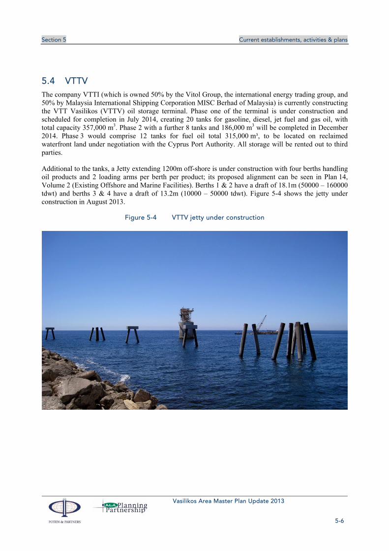
5.4 VTTV The company VTTI (which is owned 50% by the Vitol Group, the international energy trading group, and 50% by Malaysia International Shipping Corporation MISC Berhad of Malaysia) is currently constructing the VTT Vasilikos (VTTV) oil storage terminal. Phase one of the terminal is under construction and scheduled for completion in July 2014, creating 20 tanks for gasoline, diesel, jet fuel and gas oil, with total capacity 357,000 m3. Phase 2 with a further 8 tanks and 186,000 m3 will be completed in December 2014. Phase 3 would comprise 12 tanks for fuel oil total 315,000 m³, to be located on reclaimed waterfront land under negotiation with the Cyprus Port Authority. All storage will be rented out to third parties.
Additional to the tanks, a Jetty extending 1200m off-shore is under construction with four berths handling oil products and 2 loading arms per berth per product; its proposed alignment can be seen in Plan 14, Volume 2 (Existing Offshore and Marine Facilities). Berths 1 & 2 have a draft of 18.1m (50000 – 160000 tdwt) and berths 3 & 4 have a draft of 13.2m (10000 – 50000 tdwt). Figure 5-4 shows the jetty under construction in August 2013.
Figure 5-4 VTTV jetty under construction

Section 5 Current establishments, activities & plans
Vasilikos Area Master Plan Update 2013
5-7
5.5 VASILIKOS PORT Vasilikos Port (see Figure 5-5) is leased by the Cyprus Ports Authority to the Vassiliko Cement Works for a period of 50 years, i.e. to 2036. The port handles all kinds of dry and liquid bulk cargoes, such as:
Imports
Raw materials for cement production e.g. pet coke, perlite, calcium fluoride, white clinker
Liquid fuel
Soya
Silica sand
Exports
Cement and clinker
Bentonite
Wheat
Soil
Gravel
Scrap metal
The port is protected by two breakwaters, the southern and the eastern. There are two main quays, the northern of 360m length and the western of 125m. It has turning circle of 280m diameter, and the water depth is about 9m. The maximum length of ship which can berth is 180m with a maximum draught of 8.6m. Situated about 100m outside the harbour wall, there is a redundant ‘loading pylon’ which used to be connected to the shore by an aerial ropeway. Older plans also show a ‘tanker berth’ located about 700m outside the harbour wall and 500m offshore and an oil pipeline is shown on some charts connecting this point to the shore, although there is no evidence of this on site. It appears therefore that there has been a floating mooring at this point which has now been removed.
Figure 5-5 Vasilikos Port

Section 5 Current establishments, activities & plans
Vasilikos Area Master Plan Update 2013
5-8
5.6 ARCHIRODON PORT The small harbour (see Figure 5-6), located to the west of the Vasilikos Port is occupied by marine plant and a small floating dry dock belonging to the contractors, Archirodon. This harbour also contains a small harbour used by local fishing vessels. Currently the Archirodon Port is used as a repair and maintenance centre for sea-going vessels. A metal covered structure, located at the east end of the Archirodon Port, is used as a working area for Archirodon’s activities.
It is understood that the Archirodon Port’s operations will be terminated owing to the western part of the port having been expropriated by the Government of Cyprus for the needs of the Vasilikos Energy Centre and the fact that its operations are unrelated to the Vasilikos Energy Centre.
Archirodon are currently operating on a 6-month renewable lease basis and, according to information received at a meeting held at their offices on the 26 September 2013, their preference would be to stay at their existing location until a new location for them is ready. In order to relocate, Archirodon would require an area of approximately 160,000m2, including a protected harbour (ideally 140m by 350m by 10m deep with 100m of adjacent land apron). Such a move could cost about €10m.
Options for relocating the Archirodon Facilities are at the small boat harbour area outside the Vasilikos Port fence at the eastern end ( a location also identified for bitumen storage and distribution), by the Relay Station, or in the vicinity of the Naval Base.
Figure 5-6 Archirodon Port
5.7 ‘EVANGELOS FLORAKIS’ NAVAL BASE To the west of Vasilikos Bay is the ‘Evangelos Florakis’ Naval Base, a small harbour of about 150m x 150m used for naval coastal patrol boats and dredged to a depth of 4m. It was constructed in 2004 and is located at the south west corner of the study area (see Plan 8, Volume 2 and Figure 4-1) within the administrative boundaries of Mari. Cyprus Government chart 1001 depicts a 500m restricted area around this base (offshore and inland), centred on the light (Fl R 9m 3M) at the end of the southern breakwater. It often carries out naval and shooting exercises in the Zygi firing range area.

Section 5 Current establishments, activities & plans
Vasilikos Area Master Plan Update 2013
5-9
On the 11 July 2011, containers of explosives stored within the Naval Base self-detonated causing an explosion which severely damaged hundreds of nearby buildings including many buildings in Zygi as well as the nearby EAC power station, responsible for supplying over half of Cyprus' electricity.
The Project Team held a number of meetings with the Ministry of Defence (MoD) on the 5th and 28th August 2013 as well as a meeting with the Cyprus Joint Rescue Coordination Centre on the 2nd September 2013 in which various defence and security issues were discussed.
The following information has been received from the MoD:
A coastal safety zone of the Naval Base, exists and is defined by a semicircle of radius of 500m centred on the edge of the windward southern breakwater of the Naval Base port (see Plan 16, Volume 2). This zone is closed to shipping, fishing and any other activity or approach by anyone who has not secured a license from the Ministry of Defence. Also, as mentioned above the installation of any underwater cables and / or pipelines is forbidden.
A Naval Base jurisdiction area (also called exclusion zone) exists (see Plan 16, Volume 2). The coordinates that characterise this zone, as given formally by the Minister of Defence are:
34° 43' 458, 033° 17' 335
34° 42' 533, 033° 16' 313
34° 42' 500, 033° 17' 600
Vessels may approach the planned LNG jetty through the sea area of the exclusion zone, both temporarily and permanently, after obtaining permission by the Ministry of Defence. Also, within the exclusion zone, underwater cables and / or pipes may be installed in the area outside the safety zone and the approach channel at the port entrance. These facilities should not create sediment movement that may reduce the approach depths at the port entrance or within the Naval Base basin.
There are no plans to relocate the ‘Evangelos Florakis’ Naval Base unless an imperative need emerges during the final design of the Master Plan. In that case, the Ministry of Defence would examine the possible relocation of the Naval Base, but only on the condition that the necessary funding is ensured for the establishment of a new base, and provided that the move will take place when the new Naval Base is built and its continuous operation without any time gap is ensured.

Section 5 Current establishments, activities & plans
Vasilikos Area Master Plan Update 2013
5-10
Figure 5-7 Cyprus Chart 1001-Naval Base Exclusion Zone
5.8 LNG LIQUEFACTION PLANT Noble Energy and its partner, Israel’s Delek Group, discovered gas in the Aphrodite field in Block 12 185 km offshore southern Cyprus in late 2011 and in June 2013 signed a Memorandum of Understanding with the Cyprus government to build a liquefaction plant at Vasilikos next to the power station. Natural gas would be sourced from the Aphrodite field, and the plant would export 5 million tonnes per year (Mtpa) of LNG to international markets. Following drilling of an appraisal well completed in early October 2013, the amount of gas has been calculated in the range 3.6 to 6.0 Tcf, with a gross mean of 5.0 Tcf. The Front End Engineering Design (FEED) phase of an LNG project would typically take one to two years depending on the envisaged contracting strategy for the plant. The construction phase of an LNG plant typically takes four years and for the Vasilikos site, there are early works to prepare a level pad for the plant. Hence the probable earliest date, as of October 2013, for an operational LNG plant at Vasilikos is late 2018 and probable date would be 2020.
Noble Energy and the Cyprus government are also discussing the earlier provision of gas in the 2015-16 timeframe for domestic consumption (primarily for EAC’s Vasilikos power station).
From comparison with Poten’s data base on LNG plants around the world and early pre-FEED work carried out by Noble Energy, the space allocated in Phase 1 LNG should be sufficient for three LNG trains each of approximately 5 million tonnes per year (Mtpa) of capacity. The range of 4 to 6 Mtpa is a commonly-built size of LNG plant. Only one train will be needed for the gas discovered to date. The first LNG train will bear the cost burden of excavating the site and building infrastructure that only later can be shared with subsequent trains. This infrastructure includes LNG storage tanks, LNG jetty and LNG berth 1 together with necessary power generation units and utilities. It is therefore important that the Master Plan does not impose on the first train any unnecessary pre-investment for subsequent LNG trains. If it did, it is possible that the first LNG train would become uneconomic.
Trains 2 and 3 on the Phase 1 site would be built once additional gas resource is discovered or if agreement is reached to process gas from a neighbouring country.

Section 5 Current establishments, activities & plans
Vasilikos Area Master Plan Update 2013
5-11
The area allocated for LNG Phase 1 has space for:
Three 5 Mtpa LNG trains (liquefaction plants);
Utility corridor carrying gas for power generation, LNG for export and power and other utilities to the LNG plants
Gas receiving facilities and LNG storage tanks on land to be reclaimed south of the LNG trains. The LNG storage tanks are assumed to be full containment tanks and it is believed that there is sufficient space on the plot to accommodate storage tanks for both Phase 1 and 2. This needs to be confirmed from logistical modelling of the LNG loading. Full containment tanks reduce the risk to the surrounding areas, including other storage tanks and the Master Plan spacing of facilities assumes this type of tank. It may be possible that other types of LNG tanks can be shown as suitable for the site; this would be established during the FEED process
Common areas for power generation and utilities. These are assumed to be placed on the northern end of the site to create an additional separation distance for Mari village to the main process plant areas. This does not help with reducing noise impacts on Mari as the utility area will include gas turbine driving power generation equipment.
Site road ways. A wide strip has been allocated to the north of the site for the road way and for space for safely terracing the difference in level between the excavated site for the LNG plant and existing ground levels. The access gate to the LNG plant will be on the western end of this strip. In normal operation, no access will be permitted to the LNG plant except from this gate.
LNG loading facilities are discussed in section 7.10.1.1.
5.8.1 Offshore gas pipelines
Natural gas will be brought ashore from the offshore fields in pipelines around 20"-24" diameter. The pipeline landing point will be the southeast corner of an area of land to be reclaimed for the gas receiving area and LNG storage tanks. The Master Plan drawing (Plan 19 in Volume 2) shows the main gas pipeline corridor as an inverted V with its apex at the landing point and angled approximately NW-SE. The corridor lies between the LNG jetty on the west and the VTTV jetty on the east. Between the two jetties and as far as the 60m depth contour pipelines will need to be buried in trenches to a minimum depth of backfill of around 3m, depending on the seabed material. Directional drilling may be used to achieve the required depth near the landing point.
Early gas may be delivered via a smaller, separate pipeline, known as the “Early Gas Pipeline” that would approach from directly south of the Vasilikos power station between the cooling water intake culvert and the subsea fuel oil pipeline from the EAC SPM. Its landing point would be the southeastern corner of EAC’s property. The Ministry of Defence would need to give their approval for this pipeline which runs along the eastern edge of the exclusion zone of the Evangelos Florakis Naval Base. The early gas facility would be located onshore by the utility corridor between the EAC storage tanks and the Phase 1 LNG.
5.9 DC CONVERTER STATION The DEH Quantum Energy consortium – a JV of the Public Power Corporation, (PPC/DEH) of Greece, Cyprus-based Quantum Energy, the Bank of Cyprus Group and the electricity utilities of Cyprus and Israel, EAC and the Israel Electric Corporation respectively – is planning to build the EuroAsia

Section 5 Current establishments, activities & plans
Vasilikos Area Master Plan Update 2013
5-12
Interconnector, a 1518 km, 2000 MW subsea cable connection linking Israel to Athens in Greece via Cyprus and Crete. The currently planned route is shown in Figure 5-8. The project itself will be challenging, with more electricity being transferred over a greater distance and in deeper water than any existing project whilst negotiating plate boundaries and sharp changes in sea bed gradient.
Figure 5-8 EuroAsia Interconnector route
The project was recently added to the EU’s list of 248 Projects of Common Interest1, which are competing to secure a share of potential € 5.85 bn funding. The project includes a 500 MW DC converter station at Vasilikos, which is currently planned to be sited adjacent to the proposed Vasilopotamos substation, where EAC owns some land in plot 548 north of the Vassiliko Cement Works and the existing Mari substation and east of the Vasilikos River. The converter station would be approximately 1.6 km from the shoreline. The DSM2 estimates the converter station would occupy an area of 5.7 ha.
1 Projects of Common Interest are key infrastructure projects, which will help Member States to physically integrate their energy markets, enable them to diversify their energy sources and help bring an end to the energy isolation some of them are facing. They will also enable the power grid to cope with increasing amounts of electricity generated from renewable energy sources and consequently help reduce CO2 emissions (http://europa.eu/rapid/press-release_MEMO-13-880_en.htm, 14 October 2013). 2 DSM is the Transmission System Operator (TSO) for Cyprus, and is a wholly-owned but independently-managed subsidiary of the Electricity Authority of Cyprus (EAC).

Section 5 Current establishments, activities & plans
Vasilikos Area Master Plan Update 2013
5-13
Figure 5-9 Proposed DC converter and Vasilopotamos substation
The Vasilopotamos substation has been planned by DSM to accommodate the rerouting of a 132 kV overhead transmission line, which will be required prior to the start of construction of the first LNG liquefaction plant (the areas allocated for the power generation and utilities blocks for the LNG plant conflict with the route of the existing line). The planned location of the substation and converter station and the route of the overhead lines conflict with the Master Plan zoning; the Master Plan therefore recommends that these facilities be located elsewhere (see section 7.8).
5.10 QUARRYING ACTIVITIES
5.10.1 Quarrying
Four quarries, three clay and one limestone, are operated within the Mari boundaries under the supervision of Vassiliko Cement Works (see Plan 3, Volume 2).
Two of the clay quarries, known as the “Vassiliko” and “Fragma” clay quarries (located west and east respectively of the Mari–Vasilikos road), are located southeast of the Mari community, close to the Vassiliko Cement Works, and produce feedstock for the cement production. The Vasiliko Clay Quarry can be seen in Figure 5-10.
The third clay quarry (named Mari quarry) is located west of Mari Village and north of the Vasilikos Power Station and was previously used by the Cyprus Cement Company. Vassiliko Cement Works are

Section 5 Current establishments, activities & plans
Vasilikos Area Master Plan Update 2013
5-14
requesting use of this quarry since part of the land that they are now using will be used for the proposed LNG installations (see section 5.2).
Figure 5-10 Vasilikos Clay Quarry
The Kalavasos limestone quarry lies northwest of the study area and provides limestone to Vassilikos Cement Works for the production of cement.
The former underground pyrite mines at Vasilikos are now derelict. The primary crusher, ball mills, thickener tanks, etc. have been removed and only the concrete foundations remain. The pyrite was exported directly overseas and there was little waste. The small settling lagoon that was on the site has been incorporated into adjoining fields and is largely overgrown.
5.10.2 Parcel Permits and Quarrying Licences
A copy of the Parcel Permit for the Vassiliko Cement Works has been provided by the Department of Mines. Vassiliko Cement Works has been granted quarrying licences for six separate parcel areas under the licence issued by the Department of Mines in 1966 and modified in 1996. Two of the parcels, Parcels B and C lie within the study area and are shown in Plan 4, Volume 2, as are the extents of the quarrying licences. Parcel B is the parcel for the clay quarry whereas Parcel C is the location of the cement factory. The quarrying licences are valid until 2042.
5.11 OTHERS
5.11.1 British East Mediterranean Relay Station
The British East Mediterranean Relay Station (BEMRS), (coordinates 34.721212° Β, 33.324644° Α) is located on the coast within the administrative boundaries of Tochni and just outside the eastern study area boundary, but within the extended Study Area (see Figure 2-1). It has been used until now to provide
Section 5 Current establishments, activities & plans
Vasilikos Area Master Plan Update 2013
5-15
BBC broadcasting and telecommunications services (television, radio and mobile telephone) to the Middle East.
Following concerns raised by the local communities, including those voiced during the meeting with the communities held on the 18 February 2009, regarding the potential effect of the BEMRS on the health of nearby residents, it has been agreed to add consideration of this aspect to the ToR of the 2009 Master Plan.
Furthermore, due to the fact the BEMRS ceased transmission on the 31 March 2013 the possible land availability of the Relay Station site has been taken into account in the current Master Plan. It should be noted that according to informal information obtained from MECIT, the BEMRS land which currently belongs to the British Government should eventually return to the original owners if and when the BEMRS ceases to operate.
Due to concern, by the nearby communities, during the preparation of the 2009 Master Plan regarding the potential effect of the BEMRS on the health of nearby residents communication took place with the Department of Electronic Communication of the Ministry of Communications and Works who carry out measurements of electromagnetic fields of all telecommunication and mobile telephone installations in Cyprus. Details of these measurements can be obtained from their website which can be found at http://www.emf.mcw.gov.cy/.
The Department of Electronic Communication has confirmed that measurements were carried out at the BEMRS at three locations, during October 2006, based on EU standard methodology, as described in the recommendation of CEPT/ECC/REC/(02)04 entitled "Measuring Non-Ionizing Electromagnetic Radiation (9 kHz - 300 GHz)”, as listed in Table 4.11 below.
Table 5-1 Frequencies Measured
Frequency Name Frequency Type Frequency Range
FM Radio Frequencies 87.5 - 108 MHz
VHF TV Television Frequencies 174 - 230 MHz
UHF TV Television Frequencies 470 - 862 MHz
GSM 900 Mobile Telephone Frequencies 935.2 - 959.8 MHz
Custom 1-1.75 GHz Frequencies 1-1.75 GHz 1000 - 1750 MHz
GSM 1800 Mobile Telephone Frequencies 1805.2 - 1855 MHz
3G UMTS Mobile Telephone Frequencies 2110 - 2140 MHz
There is no continuous monitoring programme and new measurements are only carried out when the installations are altered. The measuring locations with the dates of the most recent measurements can be seen in Table 5-2 below:

Section 5 Current establishments, activities & plans
Vasilikos Area Master Plan Update 2013
5-16
Table 5-2 Measurement Locations and Dates
Measuring Location
Coordinates Distance from BEMRS
Date taken
Exposure Quotient (EQ, %)
1 34.43.18 N - 033.19.45 E 60 m 29-11-2006 48.3
2 34.43.15 N - 033.19.43 E 70 m 02-11-2006 70.6
3 34.43.15 N - 033.19.43 E 200 m 29-11-2006 41.8
The national limits adopted for Cyprus are those recommended in the Council Recommendation 1999/519/EC of the 12 July 1999 on the limitation of exposure of the general public to electromagnetic fields (0 Hz to 300 GHz), namely an Exposure Quotient of 100%. The results show that the magnitude of the electromagnetic radiation, measured at all three locations is well below the national limits The Department of Electronic Communication has also confirmed that electromagnetic radiation measurements were carried out near the BEMRS site, on 30 March 2009 at three additional locations near he site which also show that the electromagnetic fields were below the national limits.
Further concern was raised during the meeting with the communities on 18 February 2009 with regard to exposure to persons on boats travelling along the coast in front of the relay station. The Department of Electronic Communication stated that, while some exceedance had been identified towards the seaward side very close to the station, since the wave field travels upwards at an angle of 5-10 degrees, there is no danger to any persons travelling by boat, or on land for that matter.
Additional communication took place in August 2013 with the Department of Electronic Communication in order to get an update on the levels of emissions., the Department of Electronic Communication responded in September 2013 that “the levels of electromagnetic fields that have been recorded in the area have been reduced to a minimum amount as the emissions by the British have reduced significantly compared with the results given to you in 2009”.
5.11.2 Former Hellenic Chemical Industries Site
The area of flat land to the east of the power station and now proposed as part of the site for the Vasilikos Energy Centre (VEC) was previously occupied by Hellenic Chemical Industries (HCI), which produced sulphuric acid, phosphoric acid and composite artificial fertilisers. The plant was decommissioned and demolished to ground level under the control of the Ministry of Commerce, Industry & Tourism in 2006. The “Validation Report, Demolition of the Former Hellenic Chemical Industries Plant” (prepared by Environmental Protection Engineering SA and Van Vliet Sloopwerken BV, dated May 2007) together with the Construction Phase Environmental Management Plan, Health and Safety Plan, Programme of Works and Technical Specifications and an extract from the Georadar Report, have been made available to the consultants. The validation report presents a summary of actions taken during decommissioning of the plant, the majority relating to remediation of identified contamination.
Contaminated soil and surface wastes were reported to have been either disposed of offsite to licensed waste management facilities or re-used on site after treatment to make inert. Treatment comprised mixing of various materials and chemical testing to ensure that the mixed product was not significantly contaminated. There has been a general ban on the mixing of hazardous wastes as a form of treatment throughout European Union countries for many years, but there are some limited exceptions to this. Foundations have not been demolished and the Validation Report indicates that the ground beneath the
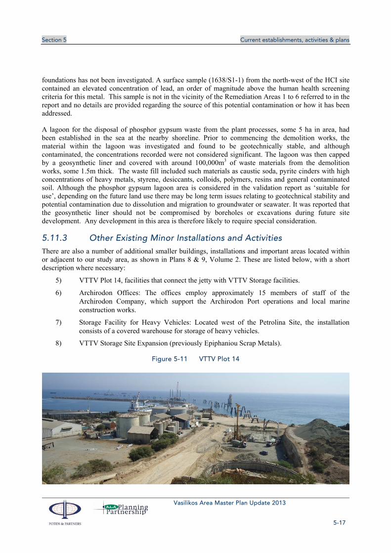
Section 5 Current establishments, activities & plans
Vasilikos Area Master Plan Update 2013
5-17
foundations has not been investigated. A surface sample (1638/S1-1) from the north-west of the HCI site contained an elevated concentration of lead, an order of magnitude above the human health screening criteria for this metal. This sample is not in the vicinity of the Remediation Areas 1 to 6 referred to in the report and no details are provided regarding the source of this potential contamination or how it has been addressed.
A lagoon for the disposal of phosphor gypsum waste from the plant processes, some 5 ha in area, had been established in the sea at the nearby shoreline. Prior to commencing the demolition works, the material within the lagoon was investigated and found to be geotechnically stable, and although contaminated, the concentrations recorded were not considered significant. The lagoon was then capped by a geosynthetic liner and covered with around 100,000m3 of waste materials from the demolition works, some 1.5m thick. The waste fill included such materials as caustic soda, pyrite cinders with high concentrations of heavy metals, styrene, desiccants, colloids, polymers, resins and general contaminated soil. Although the phosphor gypsum lagoon area is considered in the validation report as ‘suitable for use’, depending on the future land use there may be long term issues relating to geotechnical stability and potential contamination due to dissolution and migration to groundwater or seawater. It was reported that the geosynthetic liner should not be compromised by boreholes or excavations during future site development. Any development in this area is therefore likely to require special consideration.
5.11.3 Other Existing Minor Installations and Activities
There are also a number of additional smaller buildings, installations and important areas located within or adjacent to our study area, as shown in Plans 8 & 9, Volume 2. These are listed below, with a short description where necessary:
5) VTTV Plot 14, facilities that connect the jetty with VTTV Storage facilities.
6) Archirodon Offices: The offices employ approximately 15 members of staff of the Archirodon Company, which support the Archirodon Port operations and local marine construction works.
7) Storage Facility for Heavy Vehicles: Located west of the Petrolina Site, the installation consists of a covered warehouse for storage of heavy vehicles.
8) VTTV Storage Site Expansion (previously Epiphaniou Scrap Metals).
Figure 5-11 VTTV Plot 14
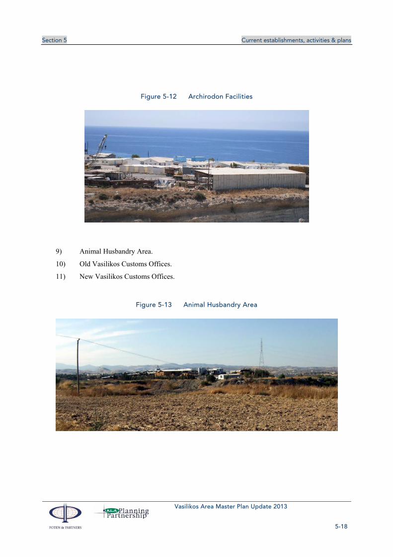
Section 5 Current establishments, activities & plans
Vasilikos Area Master Plan Update 2013
5-18
Figure 5-12 Archirodon Facilities
9) Animal Husbandry Area.
10) Old Vasilikos Customs Offices.
11) New Vasilikos Customs Offices.
Figure 5-13 Animal Husbandry Area

Section 5 Current establishments, activities & plans
Vasilikos Area Master Plan Update 2013
5-19
Figure 5-14 Old Vasilikos Customs Offices
Figure 5-15 New Vasilikos Customs Offices
12) Church: This is located south of the east-west road approaching the Petrolina fuel storage installations.
13) Telia Vasiliko Ltd - Fish Food Storage Warehouse: This warehouse is in good condition and is used primarily for fish food storage.
14) Booster Pump Building (Petrolina): The booster pump, located to the east of the Fish Food Warehouse, is used to pump the fuel unloaded from the Vasilikos Industrial Port to the Petrolina Fuel Storage Installations.
15) Ecofuel Installations, now dismantled.
16) Vouros Healthcare Clinical Waste Processing Unit, abandoned.
Figure 5-16 Church
Figure 5-17 Telia Vasiliko

Section 5 Current establishments, activities & plans
Vasilikos Area Master Plan Update 2013
5-20
Figure 5-18 Booster Pump Building
Figure 5-19 Vouros Healthcare Clinical Waste
17) Vassilikos Cement Crusher.
18) Animal Feed Storage Unit (Cyprus Soya): The unit is a metal structure warehouse, housing Animal Feed Products for the company Cyprus Soya.
19) Ecofuel - Water Waste Processing Unit: The Ecofuel installations, store and process waste/bilge water and oils from sea vessels.
20) Sulphuric Acid Storage: Located east of the Vasilikos Industrial Port, two 5m high tanks used for the storage of Sulphuric Acid.
Figure 5-20 Animal Feed Storage
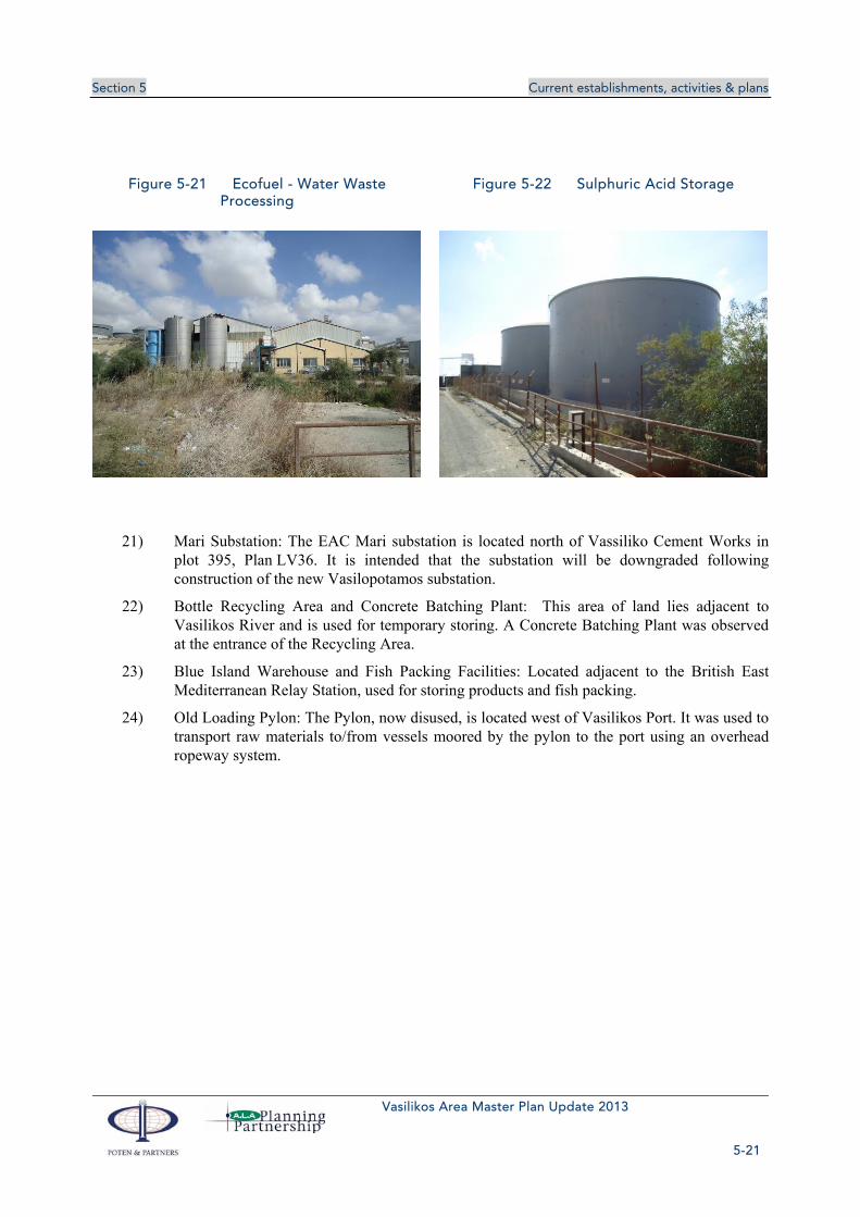
Section 5 Current establishments, activities & plans
Vasilikos Area Master Plan Update 2013
5-21
Figure 5-21 Ecofuel - Water Waste Processing
Figure 5-22 Sulphuric Acid Storage
21) Mari Substation: The EAC Mari substation is located north of Vassiliko Cement Works in plot 395, Plan LV36. It is intended that the substation will be downgraded following construction of the new Vasilopotamos substation.
22) Bottle Recycling Area and Concrete Batching Plant: This area of land lies adjacent to Vasilikos River and is used for temporary storing. A Concrete Batching Plant was observed at the entrance of the Recycling Area.
23) Blue Island Warehouse and Fish Packing Facilities: Located adjacent to the British East Mediterranean Relay Station, used for storing products and fish packing.
24) Old Loading Pylon: The Pylon, now disused, is located west of Vasilikos Port. It was used to transport raw materials to/from vessels moored by the pylon to the port using an overhead ropeway system.

Section 5 Current establishments, activities & plans
Vasilikos Area Master Plan Update 2013
5-22
Figure 5-23 Mari Substation
Figure 5-24 Bottle and Concrete Storage
Figure 5-25 Blue Island Warehouse
Figure 5-26 Old Loading Pylon
25) Scrap metal storage (electricity equipment). Includes a metal structure warehouse and a scrap yard.
26) Economides Metal Recycling, scrap metal yard.
27) Scrap storage facility, metal structure warehouses and scrap yard.

Section 5 Current establishments, activities & plans
Vasilikos Area Master Plan Update 2013
5-23
Figure 5-27 Scrap metal storage
Figure 5-28 Economides Metal Recycling
Figure 5-29 Scrap storage facility
28) Cement Storage Silo.
29) General Storage Yard.
30) Simona Construction.
31) Football Field.
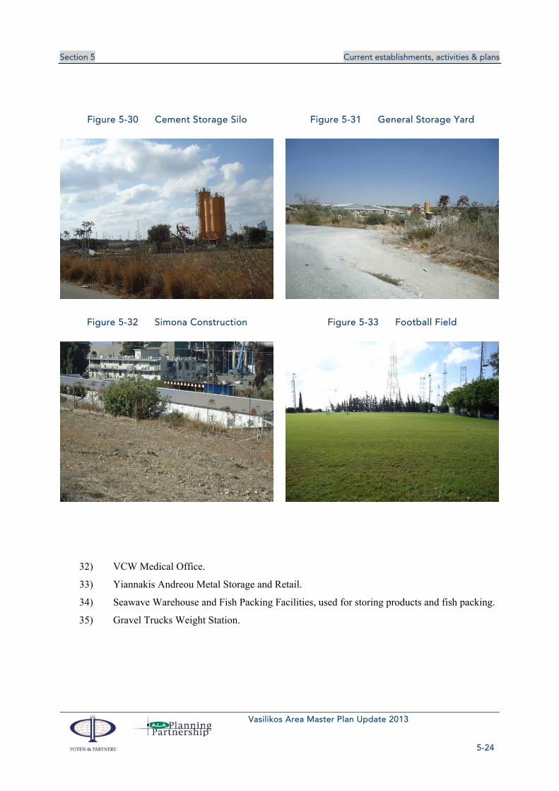
Section 5 Current establishments, activities & plans
Vasilikos Area Master Plan Update 2013
5-24
Figure 5-30 Cement Storage Silo
Figure 5-31 General Storage Yard
Figure 5-32 Simona Construction
Figure 5-33 Football Field
32) VCW Medical Office.
33) Yiannakis Andreou Metal Storage and Retail.
34) Seawave Warehouse and Fish Packing Facilities, used for storing products and fish packing.
35) Gravel Trucks Weight Station.
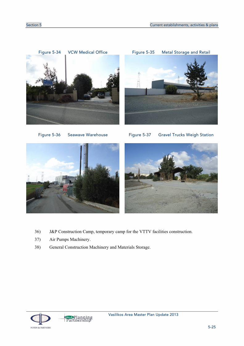
Section 5 Current establishments, activities & plans
Vasilikos Area Master Plan Update 2013
5-25
Figure 5-34 VCW Medical Office Figure 5-35 Metal Storage and Retail
Figure 5-36 Seawave Warehouse
Figure 5-37 Gravel Trucks Weigh Station
36) J&P Construction Camp, temporary camp for the VTTV facilities construction.
37) Air Pumps Machinery.
38) General Construction Machinery and Materials Storage.

Section 5 Current establishments, activities & plans
Vasilikos Area Master Plan Update 2013
5-26
Figure 5-38 Construction Camp
Figure 5-39 Air Pumps Machinery
Figure 5-40 Construction Machinery
5.11.4 Agriculture and Animal Husbandry
The Department of Agriculture has stated that there are intense agricultural and husbandry activities within the study area, including the Mari Husbandry Area which was created in 1988 on Turkish Cypriot land. The husbandry area is divided into seven agricultural plots, five of which are leased for cattle farming and two for sheep farming. Outside the husbandry area, there are five further sheep farming units and a single cattle farming unit. Under Measure 1.7 “Spatial Livestock Development” from the Rural Development Scheme 2007-2013, the Department creates the required infrastructure in husbandry areas in order to assist with their smooth operation. Due to the minimal amount of waste created, the Mari Husbandry Area does not have a negative impact on the environment and the wider area does not lie within a nitrate sensitive area. Should the Mari residents relocate, this would be at a nearby area (2 to 3 km away) and the husbandry activities would not be affected. The creation of the LNG and other heavy industry uses in the area may affect the wellbeing of the livestock in the Mari animal husbandry zone due

Section 5 Current establishments, activities & plans
Vasilikos Area Master Plan Update 2013
5-27
to the amount of heavy vehicle movement expected in the area. In any case, if the LNG Phase 3 scenario is adopted the animal husbandry area of Mari will have to be relocated or abolished.
There are large areas of irrigated arable land, twenty greenhouse units growing vegetables and flowers and one unit growing mushrooms. The location of these units can be seen in Table 5-3 and Table 5-4 below and in Plan 9, Volume 2.
Table 5-3 Greenhouse Units in the Vasilikos Area
Unit No. Dept. of Land and Registry Plan No. Plot No. Area (hectares)
1 55/20 559 0.40
2 55/20 559 0.30
3 55/20 558 0.30
4 55/20 473,728 0.25
5 55/20
55/20 W1
516
53, 55
0.35
0.40
6 55/20 570, 640, 71 0.18
7 55/28 329, 345, 335, 703
0.20
8 55/28 109 0.15
9 55/28 284, 285, 432
559
0.15
0.25
10 55/28 284, 285, 432 0.10
11 55/28 653, 608 0.70
12 55/28 614 0.80
13 55/28 614 0.80
14 55/28 614 0.40
15 55/29 474 0.40
16 55/29 434, 443, 442 0.70
17 55/29 24 0.20
18 55/37 60 0.20
19 55/37 60 0.20
20 55/37 61, 62 0.65
Table 5-4 Mushroom Growing/Cultivation Units in the Vasilikos Area
Unit No. Dept. of Land and Registry Plan No. Plot No. Area (hectares)
1 55/20 568 0.25

Section 5 Current establishments, activities & plans
Vasilikos Area Master Plan Update 2013
5-28
In addition there are important areas of irrigated land growing citrus fruit, olive trees, deciduous trees, vegetables, strawberries, carob trees and plants used for feedstuff (corn, grain etc). The soil within these areas is deep and fertile and of good quality (see Figure 5-41).
Figure 5-41 Good Agricultural Land
5.12 INFRASTRUCTURE
5.12.1 Roads
The existing road network of the study area includes the official inter-urban and rural road hierarchy and also unofficial and private roads as is typical of many rural areas of Cyprus. A road survey has been conducted which identifies the roads and summarises their standard/type, function, ownership, road surfacing and condition. The local road network within and around the study area is presented in Plans 10 & 11, Volume 2. Plan 10 shows the road hierarchy distinguishing between five different types of road, based on the Geometric Design Standards of the Public Works Department (PWD), as follows:
Primary Distributor Motorway (e.g. A1 Nicosia-Limassol highway)
Primary Distributor Class A (e.g. B1 Nicosia-Limassol road)
District Distributor Class B (e.g. Mari-Vasilikos road)
Main Local Network (asphalt road)
Main Local Network (gravel/dirt road)
The two main roads which form the backbone of the network are the A1 Nicosia-Limassol highway and the old B1 Nicosia-Limassol road. The inter-urban national road network is shown in Plan 1, Volume 2. District and local distributors connect to this network. A road inventory and condition survey, to a level of detail appropriate for of this study, has been conducted which identifies the roads and summarises their standard/type, function, ownership, road surfacing and condition. The results of this survey are presented in Plan 11, Volume 2.

Section 5 Current establishments, activities & plans
Vasilikos Area Master Plan Update 2013
5-29
A1 Nicosia-Limassol Highway
The A1 Nicosia-Limassol highway provides excellent accessibility to the national and regional road network. The area can be accessed from the highway via the Zygi and Governor’s Beach grade-separated junctions, Junctions 15 and 16 (see Plan 10), by traffic travelling from the east and west respectively. The section of highway in the vicinity of the study area is a dual 2- lane standard with a 100 kph speed limit. A motorway overpass secures access from the Kalavasos Quarry to Vasilikos Cement Works (VCW) installations (node A, Plan 11). Several narrow underpasses are also built so that agricultural vehicles can cross the motorway. PWD official data estimate an average of 17,300 vehicles per day for each direction of the motorway at the section near Vasiliko.
Figure 5-42 Nicosia – Limassol Motorway near Vasiliko
B1 Nicosia-Limassol Road
Joining the A1 highway at the two highway junctions is the old B1 Nicosia-Limassol road, which runs parallel to the highway. It connects to the local distributor road network and the access roads to the various sites within the study area (nodes B, C, D and I1 to I7, Plan 10). The B1 Nicosia-Limassol road is a single 2–lane road, of around 6m – 8m in width, with a 65 – 80 kph speed limit. According to the PWD, relatively high accident rates have been observed at the junctions between the B1 Nicosia-Limassol road and the district distributor roads. Thus a roundabout has been built at the B1/Zygi Road junction (node B, Plan 10).
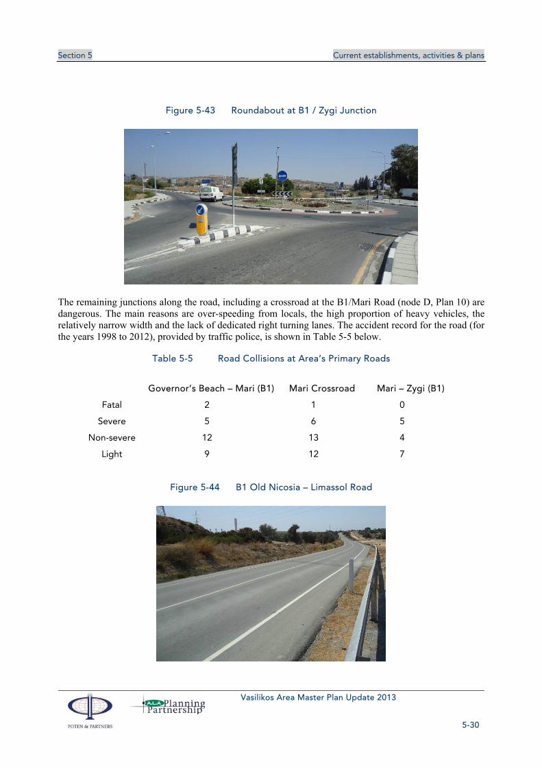
Section 5 Current establishments, activities & plans
Vasilikos Area Master Plan Update 2013
5-30
Figure 5-43 Roundabout at B1 / Zygi Junction
The remaining junctions along the road, including a crossroad at the B1/Mari Road (node D, Plan 10) are dangerous. The main reasons are over-speeding from locals, the high proportion of heavy vehicles, the relatively narrow width and the lack of dedicated right turning lanes. The accident record for the road (for the years 1998 to 2012), provided by traffic police, is shown in Table 5-5 below.
Table 5-5 Road Collisions at Area’s Primary Roads
Governor’s Beach – Mari (B1) Mari Crossroad Mari – Zygi (B1)
Fatal 2 1 0
Severe 5 6 5
Non-severe 12 13 4
Light 9 12 7
Figure 5-44 B1 Old Nicosia – Limassol Road

Section 5 Current establishments, activities & plans
Vasilikos Area Master Plan Update 2013
5-31
Mari - Vasilikos Road
The Mari – Vasilikos Road can be classified as a district distributor. The road connects B1 Nicosia – Limassol Road with Vasilikos area (link A-D-E-F, Plan 10). The road provides access to the Mari village, Vassiliko Cement Works, the Vasilikos Industrial Port, Petroleum Storage facilities (Petrolina, VTTV) and other industrial and construction installations. The road is of a 2-lane standard and asphalt-surfaced. Five priority junctions at the north part of the road grant access to Mari Village (nodes M1 to M5, Plan 10).
Figure 5-45 Mari – Vasilikos Road near Mari Village
Part of the road (link D-E, Plan 10) consists of 2 lanes of total 6 metres asphalted width and a gravel shoulder of sufficient width on the east side of the road. Officially it is not a public road, as the land corridor has not been expropriated . The southern half, at the industrial and port zone of Vasilikos (link E-F, Plan 10) is a public road. It has been fully constructed including pedestrian footways, bus stop bays and street lighting .The road is heavily used by dump trucks. There could be 50 to 60 trucks per hour using the road especially during the Kalavasos Quarry operating hours. The road can be considered potentially dangerous due to heavy traffic, dirt from trucks and construction and lack of asphalted shoulders.
Figure 5-46 Heavy Trucks West of Mari Village

Section 5 Current establishments, activities & plans
Vasilikos Area Master Plan Update 2013
5-32
Motorway – Zygi Road
The road connecting the village of Zygi with the Nicosia – Limassol motorway, is also a major district distributor road. The road connects the south part of J15 motorway junction (from Nicosia / to Limassol) with B1 road and Zygi. A roundabout has been constructed in order to cope with the safety issues of the former crossroad (node B, Plan 10). Further south, the road connects the village of Zygi with the inter-urban road network. The road is of a 2-lane standard and asphalt-surfaced, with a concrete / asphalted shoulder. Pedestrian footways have also been built along some parts of the road. Within the boundaries of Zygi village, traffic calming measures have been implemented, to the west of the community school. The road serves the village efficiently, although over speeding could take place, due to the straight and flat layout of the road. The major problem for the road is the large number of trucks from the VCW installations to Nicosia – Limassol motorway that use the road.
Figure 5-47 Zygi Road towards Motorway
Minor (Secondary) Public Roads
There is an important number of public roads in the area, usually narrow, either asphalt or gravel surfaced. These are indicated with a double dotted line on the official Land and Registry Plans and hence fall into the category of “public roads”. These roads are in some cases useful roads giving access to various land uses and having some continuity. The most important example is the road that connects B1 road with the Mari – Zygi road, east of the Vasilikos River and the VCW installation (link C-G, Plan 10). In other cases these roads give access to single uses, usually of agricultural nature. It was observed after site visits that, in some instances, the public roads indicated on the official Land and Registry Plans do not exist on the ground.

Section 5 Current establishments, activities & plans
Vasilikos Area Master Plan Update 2013
5-33
Figure 5-48 Typical Minor Road of the area
Some of the public roads have been built with sufficient road standards. Most of them are located around VCW, VTTV and Petrolina facilities. Pedestrian paths, lighting, signing, public parking and bus stop bays have also been constructed along these roads.
Figure 5-49 Minor Road upgraded to industrial standards
Public Paths
These roads are indicated as a single dotted line on the official Land and Registry Plans and do not form official public access for the purpose for most types of development. Usually they follow tracks along the borders of private plots which in the past served as agricultural access roads for fields which were cultivated. Some of these public paths have been upgraded on the ground into asphalt roads but they are still not considered as official roads for the purposes of most types of development.
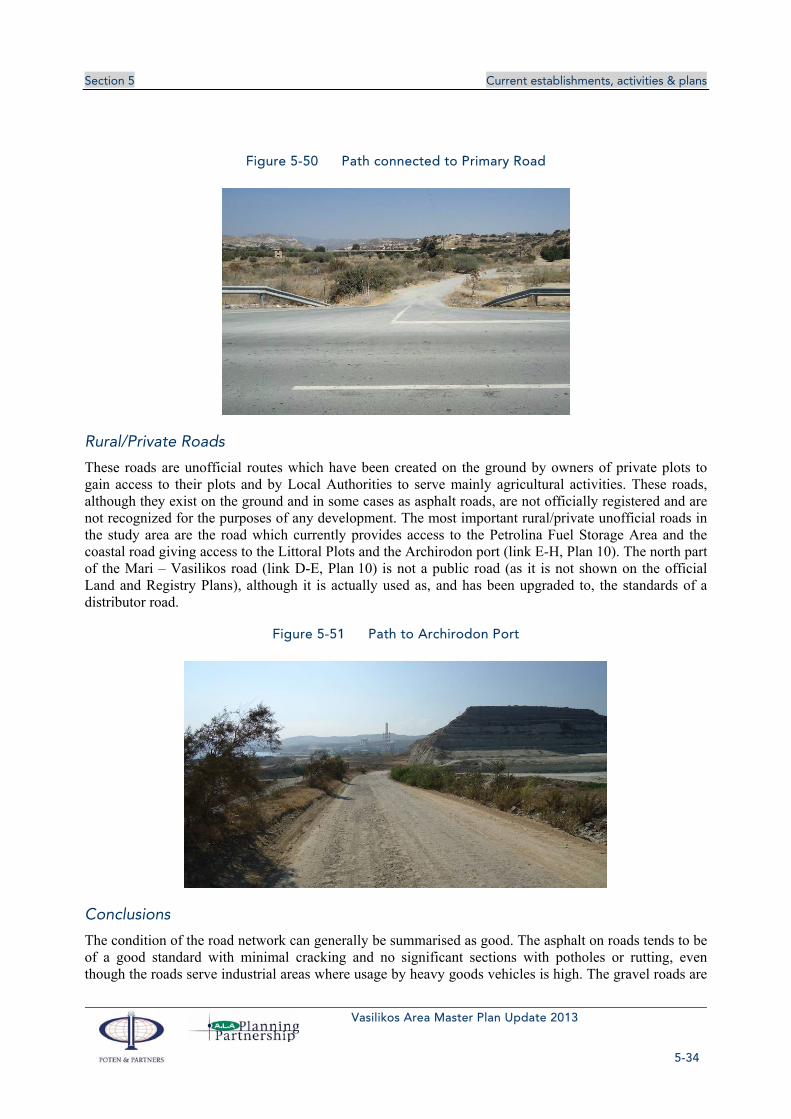
Section 5 Current establishments, activities & plans
Vasilikos Area Master Plan Update 2013
5-34
Figure 5-50 Path connected to Primary Road
Rural/Private Roads
These roads are unofficial routes which have been created on the ground by owners of private plots to gain access to their plots and by Local Authorities to serve mainly agricultural activities. These roads, although they exist on the ground and in some cases as asphalt roads, are not officially registered and are not recognized for the purposes of any development. The most important rural/private unofficial roads in the study area are the road which currently provides access to the Petrolina Fuel Storage Area and the coastal road giving access to the Littoral Plots and the Archirodon port (link E-H, Plan 10). The north part of the Mari – Vasilikos road (link D-E, Plan 10) is not a public road (as it is not shown on the official Land and Registry Plans), although it is actually used as, and has been upgraded to, the standards of a distributor road.
Figure 5-51 Path to Archirodon Port
Conclusions
The condition of the road network can generally be summarised as good. The asphalt on roads tends to be of a good standard with minimal cracking and no significant sections with potholes or rutting, even though the roads serve industrial areas where usage by heavy goods vehicles is high. The gravel roads are

Section 5 Current establishments, activities & plans
Vasilikos Area Master Plan Update 2013
5-35
also of a fairly good standard, with generally good level surfaces and few pot-holes. This is probably due to fact that these roads are not used by goods vehicles and only lightly used for local access traffic and farm vehicles.
Strategic access to the study area is very good by virtue of the proximity of the A1 Nicosia-Limassol highway. The road network within the study area also provides a good standard of accessibility. For instance, the EAC power station has direct access from the B1 Nicosia-Limassol road (node I3, Plan 10) and the cement works at Vasilikos is accessed by the key district distributor road from the B1 Nicosia-Limassol road at Mari (Mari – Vasilikos road, link D-E-F, Plan 10).
Regarding road safety, challenges include the relatively high volume of heavy goods vehicles, the absence of asphalted or concrete shoulders, lack of dedicated right turning lanes, the potentially dangerous crossroad at the B1/Mari – Vasilikos junction (node D, Plan 10) and over speeding from frequent users.
5.12.2 Traffic
For the purposes of the new Vasilikos area Master Plan (2013), a robust assessment of the existing traffic volumes is needed. A very detailed estimation of the existing traffic volumes was carried out for the previous master plan for the Vasilikos Area (2009). After consulting with the Public Works Department, it was decided that verification counts would be needed to confirm that the 2009 conditions still apply. The major conclusions from 2009 surveys were that traffic volumes are well below road network capacity and that a very high percentage of heavy goods vehicles is recorded in the area. The economic slowdown of the past three years and the absence of major new developments indicated that there should be no important changes for the traffic patterns in the area. The above estimation had to be verified by traffic counts in key junctions.
In order to obtain the baseline conditions and the nature of traffic activity in the study area, the project team of the previous Master Plan for the Vasilikos Area (2009) carried out a series traffic counts. The location of the 2009 traffic counts, the description of the counts and the major results are included in Appendix TA. The basic types carried out for the 2009 study were Classified Turning Counts (conducted at three key junctions), Automatic Traffic Counts (conducted at six locations which formed a cordon around the study area) and Vehicle Classification Survey (conducted on the Mari-Vasilikos road to obtain representative details of the vehicle types using the local road network).
The two major junctions of the local network were chosen for the verification counts the B1/Zygi road roundabout (node B, Plan 10) and the B1/Mari road junction (node D, Plan 10). Counts included all turning movements and classification of vehicles for all arms of the junctions (Classified Turning Counts). Traffic counts took place during a two-hour peak period (07:00-09:00 am) on a weekday. Peak periods were identified from the ATC data of the 2009 master plan as agreed with the PWD. The verification counts, carried out on the 10th of September 2013 (raw data included in Appendix C) showed more or less what was actually expected. There is no significant change in the traffic volumes for the area and the percentage of heavy goods vehicles still is well above the national average value. Thus traffic related challenges for the Master Plan still include the environmental and road safety impacts of heavy traffic to the residential areas and the general traffic. Current traffic volume though does not raise any capacity issues.
A comparison between the results of the 2009 survey and the 2013 verification counts is included in Appendix C. The traffic flow diagram for the area (based on 2009 surveys and validated with the 2013 data) is also included in Appendix C. The conclusion from the comparison between the results of the 2009 and 2013 counts is that there is no significant increase of traffic volumes in the area.

Section 5 Current establishments, activities & plans
Vasilikos Area Master Plan Update 2013
5-36
The conclusion is supported by the PWD estimations for the general traffic in the area (Table Traf 5-2). An increase in only recorded for private cars leaving Zygi at the morning peak hours. This can be explained by the recent increase of Zygi population. The 2001 census recorded 505 residents, with the 2011 census recording 589, an increase of 16.6% over 10 years.
Table 5-6 Number of Vehicles per year
Road Section 2008 2009 2010 2011 2012
Kofinou – Zygi (B1) 1,175 1,199 1,223 1,223 1,229
Zygi – Pareklisia (B1) 3,102 3,164 3,227 3,227 3,243
Zygi – Vasiliko 1,567 1,599 1,630 1,630 1,639
The 2009 survey sites that best represent traffic patterns in the area are the B1 Nicosia-Limassol road (for east-west movements), and the Mari-Vasilikos-Zygi road (for north-south movements). The flow patterns for these sites are presented graphically in Figure 5-52 and Figure 5-53. They show that for a typical weekday there is an AM peak period between 07:00 and 09:00 and a PM peak period between 14:00 and 16:00. The flows are tidal to a degree with westbound and southbound flows predominating in the AM peak period and the eastbound and northbound flows predominating in the PM peak period. Similar profiles, both in volume and direction terms, should be expected for 2013.
Figure 5-52 Hourly Flows, B1 Road, 2009
Figure 5-53 Hourly Flows, Mari Road, 2009
The percentages of each vehicle type (as recorded with the 2013 surveys) are presented in Figure 5-54 and Figure 5-55 below. The proportion of cars and light vans for the B1/Zygi Road roundabout is 83%, close to the recorded percentage for the rest of the island. Unlikely the percentage for Mari Road, at around 67%, is quite low in comparison with a more typical figure for Cyprus of 85% of traffic composition. As a consequence, the goods vehicle proportion is relatively high at around 32%, compared with typical figures of 10% to 15%. The larger goods vehicles, i.e. 3 axles plus, either rigid or articulated, comprise around 27% of the traffic composition, which is very high. Taking into account that the Kalavasos quarry was at a low level of activity, the proportion of heavy vehicles could rise further at peak

Section 5 Current establishments, activities & plans
Vasilikos Area Master Plan Update 2013
5-37
activity days. Nonetheless, this is what would be expected of this area, with the various industrial and quarrying activities.
Figure 5-54 Vehicles Classification (Cargo Type)
Figure 5-55 Vehicles Classification (Vehicle Type)

Section 5 Current establishments, activities & plans
Vasilikos Area Master Plan Update 2013
5-38
As outlined above, the comprehensive data collection exercise carried out for the 2009 master plan was validated with sufficient verification surveys for 2013. Discussions with relevant organisations concerned with roads and traffic matters (Public Works Department, Traffic Police and Department of Town Planning and Housing) also took place. Consequently, the following key issues have been identified which will help to shape the transport components of the Master Plan:
Traffic volumes are low and do not create any congestion or delays. However, the volume of heavy goods vehicles is relatively high. This leads to concern regarding the environmental and road safety impact of heavy goods traffic.
Heavy goods vehicles accessing the sites within the study area, particularly the Vassiliko Cement Works, use the Mari-Vasilikos road that runs by Mari Village. This is the route used by lorries from the Kalavasos limestone quarry to the VCW and by cement tankers leaving the VCW. As a consequence, there are concerns relating to noise, vibration, air quality and road safety. A large number of heavy goods vehicles also use the Zygi road.
Road safety concerns have been voiced by the PWD relating to the junction between the B1 Nicosia-Limassol road and the Mari-Vasilikos road. They consider this location to be an accident blackspot which needs to be specifically considered in this study and remedial measures formulated. PWD is considering applying a scheme for a raised table at this junction but this is not a definite commitment and other options (preferably a roundabout) could be considered.
5.12.3 Electricity transmission and distribution networks
5.12.3.1 Electricity Transmission
The Electricity Utilities, both Generation and Transmission can be seen in Plan 12, Volume 2. The main transmission lines from the Vasilikos Power Station consist of three 132 kV overhead lines (OHTL) heading in a north-westerly direction. These then diverge to supply various districts of the island and have no further relevance to the Vasilikos area. A fourth 132 kV OHTL leaves the power station in an easterly direction and connects to the Mari Substation located at the northern end of the Vassiliko Cement Works. Here the voltage is stepped down to 11 kV and the power distributed at this voltage to various users in the area, including:
Vassiliko Cement Works;
Mari, Zygi and other nearby villages;
HMC/Petrolina/proposed RJA site;
British East Mediterranean Relay Station;
Contractors at Vasilikos Power Station (to be converted to supply the proposed temporary desalination plant on the same site);
Vasilikos Power Station west gate;
Governor’s Beach.
The Transmission System Operator plans to reroute the OHTL running to the Mari substation because it crosses the area allocated to LNG Phase 1 that would include the power generation and utility areas, and would conflict with the construction and operation of the plant. A new substation, Vasilopotamos, is therefore planned about 1.5 km north of the Mari substation. A new OHTL line running northeast from the Vasilopotamos substation will also help to reinforce the grid network. EAC has already purchased the

Section 5 Current establishments, activities & plans
Vasilikos Area Master Plan Update 2013
5-39
land for the substation. EAC also plans to locate the proposed DC converter station next to the substation site (see section 0).
Figure 5-56 Planned rerouting of 132 kV transmission lines
5.12.3.2 Local Distribution
Mains power is distributed to consumers by means of pole mounted substations, located at various points along the 11 kV overhead lines, which step the voltage down to domestic mains supply levels.
5.12.4 Water supply network and desalination plants
5.12.4.1 Water Supply Network
The Water Supply Network within our Study Area can be seen in Plan 13, Volume 2.
Local Water Distribution
The study area is covered by the Government Water Network. The water comes from the desalination plant in Larnaca and then passes through the waterworks at Tersefanou and Chirokitia before entering the study via a 300mm diameter main running along the southern verge of the old Nicosia-Limassol road. A 200mm diameter main tees off this main and runs along the Mari-Vasilikos road to feed the 500m3 storage tank at Mari village. This tank receives a supplementary supply from Borehole No 66/99 on the

Section 5 Current establishments, activities & plans
Vasilikos Area Master Plan Update 2013
5-40
north side of the A1 motorway, outside the study area, via 90mm diameter pipe. Water is distributed from the storage tank to Mari village and to the southern Vasilikos area via two mains of 100mm and 110mm diameter running along the Mari-Vasilikos road. These mains supply the Vassiliko Cement Works and a 30m3 storage tank adjacent to the Petrolina oil depot. The 500m3 tank at Mari also supplies a 90 m3 storage tank, which previously supplied the village but is now used to supply the animal husbandry area just south of the village. The VCW has a supplementary supply of raw water from the Limassol Water Board. A 150mm diameter main continues westward along the old Nicosia-Limassol road to supply the Vasilikos Power Station.
Southern Conveyor
The Southern Conveyor is a major aqueduct carrying water from the Kouris Dam along the south coast of the Island to Larnaca and Nicosia. It provides domestic water to the main population centres and to the villages en route, as well as irrigation water to the agricultural areas of the coastal region. Across the study area, the Southern Conveyor runs in the northern verge of B1 Nicosia-Limassol road. It comprises a ductile iron pipe up to 1400mm in diameter. There are no connections made to the pipe in the study area. Water for domestic purposes and for irrigation is fed from connections to the east of the study area.
Irrigation
The Vasilikos-Pendaskinos irrigation project is an element of the Southern Conveyor scheme located mainly to the east of the study area. A small part of the project lies between the study area eastern boundary and the Vasilikos River to the east of Mari village. A network of pipes, ranging from 100mm to 300mm in diameter, is fed from the Southern Conveyor to the north and supplies water to the arable fields in this area. A 150mm diameter spur from this system feeds a 500m3 irrigation water tank at Mari village.
5.12.4.2 EAC Desalination Plant
EAC began the construction of a 60,000m3/day capacity desalination plant in summer 2010, and it was initially expected to commence commercial operation in early 2012. After the explosion at the ‘Evangelos Floraki’ Naval Base and the destruction of Vasilikos Power Station the erection work of the desalination unit stopped. Construction of the desalination plant restarted again soon after and was completed in August 2013. Currently a pipeline network is being constructed which will connect towards Pentakomo and Choirokitia and so provide these and the surrounding communities with drinking water.

Section 5 Current establishments, activities & plans
Vasilikos Area Master Plan Update 2013
5-41
Figure 5-57 EAC Desalination Plant
5.12.5 Sewage network
There is currently no sewage network within the study area. The sewage system in Mari Village consists of individual septic tanks and absorption pits. The Water Development Department has stated that no sewage network is being proposed in the area in the near future. We have been informed that the transfer of recycled and treated water and sludge from the Zygi and Tochni Waste Water Treatment Plant originally proposed for irrigation and composting uses has been postponed.
5.12.6 Rain and surface waters networks
5.12.6.1 Surface Water Drainage Network
The Vasilikos River flows south through the eastern part of the study area and directly east of the Vassiliko Cement Works. The Kalavasos Dam has been constructed along the route of the Vasilikos River as part of the Vasilikos-Pendaskinos Irrigation Project. The objective of this project is to provide surface and ground water resources from the Vasilikos, Pendaskinos and Maroni rivers both for the agricultural development of the area and the augmentation of the domestic water supply of Nicosia, Larnaca and Famagusta districts. The average annual flow of the Vasilikos River at the Kalavasos Dam site has been estimated by the Water Development Department at approximately 11Mm3. A watercourse flows from Pentakomo and Kalavasos through the western part of the study area to the northern part of the Vasilikos Power Station. During construction of the station, the stream was diverted and a concrete channel was constructed along the western boundary of the station.
Plots within the Vassiliko Cement Works quarrying parcel are lower than sea level causing surface water run-off to pond, mostly due to the low permeability of the clay soil. This has been particularly noted in Plot 88, Plan LV 36, which floods regularly after continued rainfall.

Section 5 Current establishments, activities & plans
Vasilikos Area Master Plan Update 2013
5-42
Recent Developments, such as the VTTV and Petrolina expansion provide their own stormwater drainage network directed to the sea. Stormwater from operational areas first has to pass through collection or treatment facilities before discharge.
5.12.7 Telecommunications networks (ALA)
The three telecommunication companies of Cyprus have provided information with regard to their existing and proposed installations. All three companies have stated that it is important to know more about the planned future installations before any decisions are made on upgrading their networks. However, the following information regarding their existing and future telecommunication installations was provided:
5.12.7.1 CYTA
Within or adjacent to the study area, CYTA has an existing telecommunications network along the A1 Nicosia-Limassol highway and along the B1 Nicosia- Limassol road. There are also networks in Mari Village, Vasilikos Power Station, Vasiliko Cement Works, the Evaggelou Floraki Naval Base and along the coastal road between the Vasilikos Industrial Port and the Archirodon Port. There is a further network in the Governor’s Beach area, located to the west of the study area. A network has also been installed surrounding the parcelated area directly west of Vasiliko Cement Works and around the VTTV installations.
CYTA informed the Project Team on 18 September 2003 that their position is that the network drawings, provided are confidential and should not be published. No plans showing the existing or proposed telecommunications network are therefore included in the current Master Plan.
5.12.7.2 PrimeTel
Within or adjacent to the study area, PrimeTel has an existing telecommunications network along the A1 Nicosia-Limassol highway and the B1 Nicosia- Limassol road from Limassol to Zygi and from Zygi to Larnaca (via Mazotos). Additional installations are proposed along all A1 highway exits towards villages with gradual deployment.
5.12.7.3 CableNet
Cable Net has stated that it does not own any telecommunications infrastructure within the study area. However, it does have the ability to provide telecommunication services should they be required.
5.13 MARINE ACTIVITIES IN VASILIKOS BAY The study area in Vasilikos Bay includes three ports and a Single Point Mooring (SPM), which is used to import fuel to the Vasilikos power station. The ports are:
‘Evangelos Florakis’ Naval Base, located to the west
The SPM south of Vasilikos power station
Archirodon port, which, as its name suggests, is used primarily by the Archirodon construction company
Vasilikos Port, operated by the Vassiliko Cement Works

Section 5 Current establishments, activities & plans
Vasilikos Area Master Plan Update 2013
5-43
5.13.1 Fuel oil importation to EAC
A single point mooring (SPM), located about 2 km offshore the Vasilikos Power Station, is used for unloading fuel for the station (see Figure 5-58 and Figure 5-59). The SPM consists of a surface buoy attached by chains to anchors on the seabed. One or more mooring hawsers are used to hold a tanker attached to a turntable or rotating arm which is mounted to the top of the buoy by a slewing bearing or a wheel and track assembly. This allows the rotating part to freely rotate around 360° allowing a tanker to weathervane and take up the position of least resistance to the effects of winds, wave action and local currents. Unloading of fuel is carried out through submarine pipelines. An exclusion zone prohibiting anchoring and fishing is indicated on the charts, measuring 500m radius from the buoy and 200m either side of the pipelines.
Heavy fuel oil and diesel fuel are offloaded from oil tankers up to 80,000 tdwt capacity at the SPM, which take about 32 hours to discharge a full cargo. Fuel is transferred via twin 16” diameter double-carcass flexible hoses and twin 20” submarine pipelines. The hoses are designed for a maximum velocity of 15 m/s at 10 bar and 80°C. In normal operation, heavy fuel oil is transferred at around 2500 tonnes/hour at 7.0-7.5 bar and 55-60°C. Currently the SPM is used for about three days every 4 to 5 weeks.
Figure 5-58 EAC Single Point Mooring (SPM)

Section 5 Current establishments, activities & plans
Vasilikos Area Master Plan Update 2013
5-44
Figure 5-59 EAC Single Point Mooring
Some additional fuel oil imports are carried out over the West Berth of Vasilikos Port (see Clean Oil Importation in next section).
5.13.2 Clean Oil Importation
Clean oil (e.g., Jet fuel) is imported over the west berth in Vasilikos Port in small vessels of approximately 5-10,000 tdwt capacity. Discharge is effected through flexible hoses to an underground pipeline manifold located on the berth. From there it is pumped to the Petrolina tank storage facility.

Section 5 Current establishments, activities & plans
Vasilikos Area Master Plan Update 2013
5-45
Figure 5-60 Vasilikos Port layout Diagram of Vasilikos Port from Cyprus Chart 1001
5.13.3 Cement and Bulk Aggregate Import/Export
The main activity within the port of Vasilikos is the import and export of cement and bulk aggregate cargoes. Vasilikos Cement Works has primary operating rights within the port and has a fixed loading elevator structure on the main quayside within the port. This quayside is 360m in length and is usually used by vessels of about 100m in length and having a deadweight of around 6000 tonnes. The maximum acceptable ship length is 180m. In recent years Vasilikos Port has handled about 200 ships per year (Cyprus Ports Authority data). Further information on shipping statistics is contained in section 6.10.
5.13.4 Ro/Ro and General Cargo Handling
Vasilikos Port has a roll on/roll off (Ro/Ro) ramp located at the extreme western end of the quayside and can be used by vessels fitted with a stern door ramp berthed at the west berth. This berth is about 120m in length. It is not clear how often this Ro/Ro ramp is used at the moment.
General cargo handling can take place anywhere within the port – either on the main quay face or the west berth. The number of general cargo and Ro/Ro ships using the port are included within the 200 ships/year referenced above.
5.13.5 VTTV Jetty and Tank Farm Construction
The eastern end of Vasilikos Port is currently being used for the construction and preparation of piles prior to load out for VTTV jetty construction. This activity takes up the 75m long slip berth at the eastern end of the 360m quay face and the adjacent dockside area, together with rough ground to the north and east of the slip berth. It is anticipated that this area will be unused on completion of the VTTV jetty piling and construction.
Archirodon Port is a small port development located along the coast of Vasilikos Bay, which is used for general construction activities, with flat top barges and other support craft associated with works being carried out in the area.

Section 5 Current establishments, activities & plans
Vasilikos Area Master Plan Update 2013
5-46
5.13.6 Fisheries and aquaculture
5.13.6.1 Fisheries
Fisheries have always been economically important to Cyprus despite the economics of the sector showing negative growth in recent years. Fish still remains a main dish in Cypriot cuisine and large amounts are consumed by the local population and tourists. Fishing is administered by the Department of Fisheries and Marine Research (DFMR) of the Ministry of Agriculture, Natural Resources and Environment.
In 2007 the total commercial fisheries production was 2440 tonnes valued at €13.82M of which the inshore fisheries made up 1054 tonnes (43%) valued at €8.45M. This has increased substantially and in 2011 the production value of processed fishery products reached an amount of more than € 28.3 million and approximately 5014 tonnes.
The main elements of the Cyprus fishery affecting Vasilikos are the inshore and the trawl fisheries. The inshore fishery is practiced by small wooden boats of 6m to 12m length overall using bottom nets and long lines (passive gears) and fish traps. The trawl fishery (mobile gears) consist of bottom fishing trawlers of 20m to 26m overall length that dredge the seabed at depths of 50m to 100m. The fish stocks of principal interest to local fishermen are demersal species although small pelagic species exist also. Dominant catch species include picarels, boque, striped red mullet, common cuttlefish, hake, red mullet and Atlantic bluefin tuna, swordfish, sea bream and sea bass.
In the last few years there has been a reduction in the bottom trawling boats operating in Cyprus waters. Due to EU fishing regulations and fish management quotas, the number has decreased from a peak of eight vessels to four. Furthermore, trawl fishing is suspended between 8 May and 8 November each year.
Local fisheries shelters are found at the existing Vasilikos Port and the Archirodon Industrial Port. Although these shelters provide necessary facilities for local fishermen, no formalised agreements with the CPA or land managers exist for the shelters. Ideally, new facilities for local fisheries (and aquaculture) should be developed as part of the new port development. Zygi is the main fishing village close to the Vasilikos area with approximately 50 licensed fishermen; the Zygi fishing shelter and marina were completed in 2012 with a capacity for berthing approximately 250 vessels.
A major concern of the fishing community is the risk of damage to fishing equipment by large vessels anchoring and/or mooring on SPMs. Local fishermen are advised of any military activities in advance and are required to cease fishing during MoD firing exercises on the Zygi firing range.
5.13.6.2 Aquaculture
Aquaculture, or fish farming, is administered by the Department of Fisheries and Marine Research (DFMR) of the Ministry of Agriculture, Natural Resources and Environment. The sector has expanded in recent years and the DFMR has provided active support to realise further economic potential. Fish farms are legally permitted by the DFMR. Total aquaculture production in 2011 from marine open cages reached 3240 tonnes of sea bass, 1650 tonnes of sea bream. Vasilikos Bay is very important to the Cypriot aquaculture sector as it hosts the largest concentration of fish farms. Currently, the total aquaculture production in the Vasilikos area totals 6800 tonnes, with production in the region as well as the movement of vessels servicing the units expected to increase in the coming years. Expansion and development of aquaculture in the Vasilikos area is covered in the report “Prospects for Marine Aquaculture in Cyprus 2006”.

Section 5 Current establishments, activities & plans
Vasilikos Area Master Plan Update 2013
5-47
Fish farming is a significant business activity in the Vasilikos area with 7 out of 9 fish farms in Cyprus being based in this area, focusing mainly on sea bream, sea bass and tuna. The aquaculture cages are situated both inshore and offshore between Vasilikos Port and west of Cape Dolos. The production of the units in the region represents 65% of the total aquaculture production in Cyprus and about 35% of the total fisheries production in Cyprus. In total (directly and indirectly involved) it is estimated that about 300 jobs are dependent on fish farming. Future expansion of fish farming will take place, increasing both production and the number of people employed. This activity has to be accommodated in the offshore waters without interference with shipping movements associated with the LNG, VTTV and other marine operations.
Figure 5-61 Fish farm locations
The fish farms operating within the study area can be seen in Figure 5-61 and Plan 14, Volume 2 and are mainly located between the 30m and 50m bathymetric contours and to the west of Cape Dolos and the Vasilikos Master Plan Area. However, two farms (Telia Aqua Marine Public Ltd and Seawave Fisheries Ltd) lie directly south of the Vasilikos Master Plan Area and are likely to have some impact on operations.
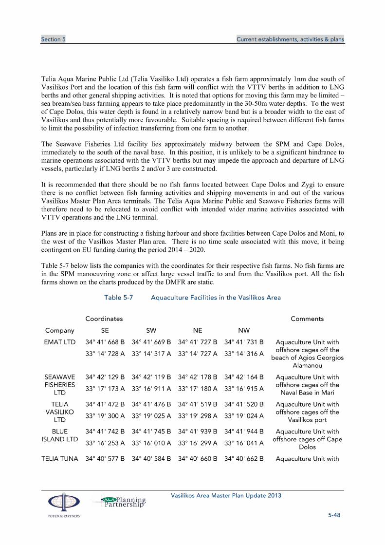
Section 5 Current establishments, activities & plans
Vasilikos Area Master Plan Update 2013
5-48
Telia Aqua Marine Public Ltd (Telia Vasiliko Ltd) operates a fish farm approximately 1nm due south of Vasilikos Port and the location of this fish farm will conflict with the VTTV berths in addition to LNG berths and other general shipping activities. It is noted that options for moving this farm may be limited – sea bream/sea bass farming appears to take place predominantly in the 30-50m water depths. To the west of Cape Dolos, this water depth is found in a relatively narrow band but is a broader width to the east of Vasilikos and thus potentially more favourable. Suitable spacing is required between different fish farms to limit the possibility of infection transferring from one farm to another.
The Seawave Fisheries Ltd facility lies approximately midway between the SPM and Cape Dolos, immediately to the south of the naval base. In this position, it is unlikely to be a significant hindrance to marine operations associated with the VTTV berths but may impede the approach and departure of LNG vessels, particularly if LNG berths 2 and/or 3 are constructed.
It is recommended that there should be no fish farms located between Cape Dolos and Zygi to ensure there is no conflict between fish farming activities and shipping movements in and out of the various Vasilikos Master Plan Area terminals. The Telia Aqua Marine Public and Seawave Fisheries farms will therefore need to be relocated to avoid conflict with intended wider marine activities associated with VTTV operations and the LNG terminal.
Plans are in place for constructing a fishing harbour and shore facilities between Cape Dolos and Moni, to the west of the Vasilkos Master Plan area. There is no time scale associated with this move, it being contingent on EU funding during the period 2014 – 2020.
Table 5-7 below lists the companies with the coordinates for their respective fish farms. No fish farms are in the SPM manoeuvring zone or affect large vessel traffic to and from the Vasilikos port. All the fish farms shown on the charts produced by the DMFR are static.
Table 5-7 Aquaculture Facilities in the Vasilikos Area
Coordinates Comments
Company SE SW NE NW
EMAT LTD 34° 41' 668 Β 34° 41' 669 Β 34° 41' 727 Β 34° 41' 731 Β Aquaculture Unit with offshore cages off the
beach of Agios Georgios Alamanou
33° 14' 728 Α 33° 14' 317 Α 33° 14' 727 Α 33° 14' 316 Α
SEAWAVE FISHERIES
LTD
34° 42' 129 Β 34° 42' 119 Β 34° 42' 178 Β 34° 42' 164 Β Aquaculture Unit with offshore cages off the
Naval Base in Mari 33° 17' 173 Α 33° 16' 911 Α 33° 17' 180 Α 33° 16' 915 Α
TELIA VASILIKO
LTD
34° 41' 472 Β 34° 41' 476 Β 34° 41' 519 Β 34° 41' 520 Β Aquaculture Unit with offshore cages off the
Vasilikos port 33° 19' 300 Α 33° 19' 025 Α 33° 19' 298 Α 33° 19' 024 Α
BLUE ISLAND LTD
34° 41' 742 Β 34° 41' 745 Β 34° 41' 939 Β 34° 41' 944 Β Aquaculture Unit with offshore cages off Cape
Dolos 33° 16' 253 Α 33° 16' 010 Α 33° 16' 299 Α 33° 16' 041 Α
TELIA TUNA 34° 40' 577 Β 34° 40' 584 Β 34° 40' 660 Β 34° 40' 662 Β Aquaculture Unit with

Section 5 Current establishments, activities & plans
Vasilikos Area Master Plan Update 2013
5-49
Coordinates Comments
Company SE SW NE NW LTD
33° 15' 911 Α 33° 15' 753 Α 33° 15' 910 Α 33° 15' 754 Αoffshore cages off the area between Agios
Georgios Alamanou and cape Dolos
KITIANA FISHERIES
LTD
34° 40' 910 Β 34° 40' 913 Β 34° 40' 998 Β 34° 41' 005 Β Aquaculture Unit with offshore cages off the area between Agios
Georgios Alamanou and cape Dolos
33° 14' 956 Α 33° 14' 655 Α 33° 14' 970 Α 33° 14' 668 Α
ICHTHYS ECO-FARM
34° 41. 870 B 34° 41. 870 Β 34° 41. 816 Β 34° 41. 816 Β Aquaculture Unit with offshore cages openly
and in the South-East of the Moni Power Station
33° 12. 120 Α 33° 12. 087 Α 33° 12. 087 Α 33° 12. 120 Α
34° 41. 870 B 34° 41. 870 Β 34° 41. 816 Β 34° 41. 816 Β
33° 11. 870 Α 33° 11. 837 Α 33° 11. 837 Α 33° 11. 870 Α
Two companies, namely Blue Island Holdings Ltd and Seawave Fisheries Ltd, have constructed onshore installations which include packing areas, warehouses and office space along the Zygi – Vasiliko road. Other aquaculture companies rent land onshore from the Cyprus Ports Authority for the installation of small warehouses within the Archirodon and Vasilikos Port areas.
The aquaculture sector benefits from restrictions placed on trawler activities, i.e. no fishing in depths to 50m, and there is a 5km nautical limit excluding trawlers for Vasilikos only. Furthermore, no fishing is allowed within 200m of marine installations. There are no plans at this stage for new facilities in the area, but an expansion of existing ones is expected in the future – Blue Island Holdings Ltd and Seawave Fisheries Ltd have already secured environmental approval for the gradual increase of their production. With regard to the expansion issue, the Department of Fisheries’ policy is that expansions should be towards deeper water.
All fish farms are marked by buoys and have radar reflector devices to warn shipping. It is unlikely that these fish farms are properly lit, however, and thus pose a potential risk for night-time navigation in this area. If not already suitably marked, it is recommended that the Telia (Tuna) Ltd fish farm to the south of Cape Dolos in particular be marked with appropriate navigational aids to avoid conflict with arriving or departing vessels.
Oil spills are a concern of the aquaculture sector with a need for better oil spill management, training of aquaculture staff to deal with spills and better equipment. This concern arises from recent oil spills and the fear of fish contamination.
5.13.6.3 Servicing of Fish Farms
The fish farms along this part of the coast are serviced by regular small boat movements from Vasilikos Port, Archirodon Port and Zygi on a daily basis. It has been stated by the DFMR that 34 vessels travel from two to four times a day to and from the fish farms and the Archirodon and Vasilikos Ports. According to the DFMR the vessels do not follow specific routes. The number of vessels is likely to increase in the future depending on the needs of the aquaculture activities.

Section 5 Current establishments, activities & plans
Vasilikos Area Master Plan Update 2013
5-50
Currently there are limited landing facilities for fish farming. There is a need for better loading/off-loading facilities, cage repair facilities, diving support, feeds, packaging and storage. At present, Archirodon port is used informally as a fishing shelter, but is very limited. There is a need to develop infrastructure that can be used by the aquaculture sector in the area. Collective co-operation between all fish farming companies is seen as the most desirable way due to the high building costs and the need for financial economies. Currently, in the area between Cape Dolos and Moni a study is being prepared for the placement and construction of new port and land facilities to serve the needs of aquaculture units operating in the area
Loading and unloading of fish and fish foods takes place regularly at the Archirodon and Vasilikos ports. Each company unloads fish 2 or 3 times per week, but on different days. In total, approximately 50 tonnes a week are unloaded, depending on the seasonal period. In volume, this corresponds to 100 to 150 cubic metres of fish landings per week (100-150 crates).
5.14 DEVELOPMENT CONTROL AND PLANNING APPLICATIONS Development control in the study area is carried out by the Central Office and Larnaca Regional Office of the Department of Town Planning and Housing, which is the relevant Authority for issuing planning permits. The Larnaca District Officer is responsible for issuing building permits.
The following Table 5-8 shows the Approved Planning Applications according to the Department of Town Planning and Housing.
Table 5-8 Approved Planning Applications
Applicant Description Plot Number
Sheet Number
Application Number
Vassiliko Cement Works Clay Quarry 71 55/27 ΛAP-2000/00379
Ketonis Developments Ltd Wind Farm 650 55/28 ΛAP-2001/00376
Guardian of Turkish Cypriots Properties (For Ketonis Developments Ltd)
Wind Farm (Addition of substation)
99 55/36 ΛAP-2001/00376Γ
Ketonis Developments Ltd Wind Farm (Review of existing planning permit)
650 55/28 ΛAP-2001/00376∆
Guardian of Turkish Cypriots Properties (For Iosef Stefanide)
Extension of existing Bentonite Factory
149 55/19 55/20
ΛAP-2001/00445A
Electricity Authority of Cyprus
3rd Energy Production Unit 304 55/27 ΛAP-2002/00465A
Electricity Authority of Cyprus
Rebuilding/ Upgrade of Overhead Transmission Line
55/27 ΛAP-2003/00047
Vassiliko Cement Works and Others
Land Parcellation into Industrial Plots
471 55/36 ΛAP-2003/00157E

Section 5 Current establishments, activities & plans
Vasilikos Area Master Plan Update 2013
5-51
Applicant Description Plot Number
Sheet Number
Application Number
Vassiliko Cement Works and Others
Public Parking Spaces 248 55/36 ΛAP-2003/00157Γ
Cyprus Ports Authority Bilge Water Processing Plant 492 55/36 ΛAP-2003/01501
Electricity Authority of Cyprus
4th Energy Production Unit at Vasilikos Power Station
304 55/27 ΛAP-2004/00728
Electricity Authority of Cyprus
4th Energy Production Unit at Vasilikos Power Station
304 55/27 ΛAP-2004/00728A
Vassiliko Cement Works Metal and Solid Waste Processing Plant
130 55/36 ΛAP-2004/01137
Guardian of Turkish Cypriots Properties
Car tyre repair workshop 152 55/28 ΛAP-2005/00750
Guardian of Turkish Cypriots Properties
Workshop 179 55/28 ΛAP-2005/01346
Nicos Asprou (Guardian of Turkish Cypriots Properties)
Industrial Workshop 179 55/28 ΛAP-2005/01346A
Vassiliko Cement Works Additions to Cement Factory Unit (Silo and Clinker)
466 55/36 ΛAP-2005/01458
Epiphaniou Scrap Metals Ltd Solid Waste Processing Plant 306 55/27 ΛAP-2006/01037
Nicos Aspri Cheese manufacturing workshop
179 55/28 ΛAP-2006/01371
Vassiliko Cement Works New Production line for material mixing with a warehouse
496 55/36 ΛAP-2007/00158
Hellenic Mining Company and Vassiliko Cement Works
Petroleum Distribution Facilities
292 55/36 ΛAP-2007/01784
VTT Vasiliko Ltd Petroleum Distribution Facilities
503 55/36 ΛAP-2007/01784A
Vassiliko Cement Works EAC Substation 365 55/36 ΛAP-2009/00183
Customs and Excise Department
Fencing 318 55/36 ΛAP-2009/00831
Customs and Excise Department
Land Parcellation 318 55/36 ΛAP-2009/00836
Vassiliko Cement Works Solid Waste Management Plant
303 55/19 ΛAP-2009/00943
Electricity Authority of Cyprus
Desalination Plant at Vasilikos Power Station
305 55/35 ΛAP-2010/00302

Section 5 Current establishments, activities & plans
Vasilikos Area Master Plan Update 2013
5-52
Applicant Description Plot Number
Sheet Number
Application Number
Electricity Authority of Cyprus
5th and 6th Energy Production Unit at Vasilikos Power Station
304 55/27 ΛAP-2010/00387
Vassiliko Cement Works Industrial Complex (Reissuing of existing of previous planning permit)
248 55/36 ΛAP-2010/00605
Vassiliko Cement Works Land Parcellation 303 55/19 ΛAP-2011/00167
Guardian of Turkish Cypriots Properties (For Mari Community Council)
Additions to existing church 231 55/28 ΛAP-2012/00038
Vassiliko Cement Works Tires Storage Unit 57 55/19 ΛAP-2012/00074
VTT Vasiliko Ltd Administration Offices and Customs and Excise Department Offices
318 55/36 ΛAP-2012/00202
VTT Vasiliko Ltd Land Parcellation 318 55/36 ΛAP-2012/00313
VTT Vasiliko Ltd Expansion of Petroleum Distribution Facilities
502 55/36 ΛAP-2012/00366
VTT Vasiliko Ltd Petroleum Distribution Facilities
504 55/36 ΛAP-2012/00367
Vassiliko Cement Works Land Parcellation 57 55/19 ΛAP-2012/00393
The following Table 5-9 shows the planning applications that have been submitted to the Department of Town Planning and Housing, but not yet approved.
Table 5-9 Planning applications not yet approved
Applicant Description Plot Number
Sheet Number
Application Number
Vassiliko Cement Works and Others
Land Parcellation into Industrial Plots
29 55/36 ΛAP-2003/00157ΣΤ
Cyprus Ports Authority Production of Animal Food 492 55/36 ΛAP-2004/01502
Cyprus Ports Authority Oil Products Station 492 55/36 ΛAP-2007/00330
Cyprus Ports Authority Animal Feed Storage Unit 321 55/36 ΛAP-2007/00490

Section 5 Current establishments, activities & plans
Vasilikos Area Master Plan Update 2013
5-53
Applicant Description Plot Number
Sheet Number
Application Number
Cyprus Ports Authority Storage Units for Raw Materials (under study)
492 55/36 ΛAP-2007/01111
Ministry of Energy, Commerce, Industry and Tourism (Energy Service)
Vasilikos Energy Centre 381 55/27 ΛAP-2008/00913
Electricity Authority of Cyprus
Overhead Transmission Line Removal
55/27 ΛAP-2009/00047
Electricity Authority of Cyprus
Connection of Vasiopotamos and Kofinou substations with an overhead transmission line
47 55/39 ΛAP-2010/00059
Cyprus Ports Authority (For Telia Aqua Marine Public Ltd)
Storage Unit and residential apartments for staff
55/36 ΛAP-2012/00141
Cyprus Ports Authority Works at the Vasilikos Port 492 55/36 ΛAP-2012/00182
Cyprus Ports Authority (For Cyprus Cattle breeding company)
Production of Animal Food 492 55/36 ΛAP-2012/00928
Vassiliko Cement Works and Others
Energy Production Unit 511 55/36 ΛAP-2013/00019
Cyprus Ports Authority (M.D. Cyprus)
Animal Feed Storage Unit 492, 321 55/36 ΛAP-2013/00161
Bioland Project 13 Ltd Solar Park 1,25 MW 462 55/27 ΛAP-2013/00257
Power Energy Cyprus Independent Electricity Power Station
307 55/35 ΛAP-2013/00286
Cyprus Ports Authority (VTT Vasiliko Ltd)
Additions to VTTV oil storage tanks
492 55/36 ΛAP-2013/00462

Vasilikos Area Master Plan Update 2013
6-1
Section 6 Safety, security & environment
6.1 SECURITY The concentration of the Cyprus energy sector and strategic country reserves within the area covered by the Vasilikos Master Plan will result in the facility taking on strategic national importance, and it will be necessary to provide appropriate levels of security.
As a marine terminal facility, security requirements are dictated by the International Ship and Port Facility Security Code (ISPS Code). However, there will be parts of the Vasilikos Area industrial complex that handle locally quarried material, local distribution of imported oil products and fairly extensive associated traffic flows, and it will be impractical for these facilities to come under the wider security umbrella. On this basis, it is proposed that non-strategic facilities (e.g. Vassiliko Cement Works, local petroleum distributors, Archirodon, etc.) within the complex have their own access routes which are separate from access to the strategic reserves sites. However, with a large number of pipeline and other interconnections between facilities, it is essential that security is maintained along these corridors to eliminate any weak links in the overall security profile through those areas having a lesser security importance.
Any part of the Energy Centre having access to marine facilities will be required to have strictly controlled access to the jetties and appropriate controls on ships’ crew leaving vessels on shore leave. Security passes, scanners and other appropriate security measures will need to be implemented to ensure that only bona fide visitors to ships are allowed in the marine facilities. Consideration needs to be given to whether jetty access is via public access roads or through any outer security gate covering the Energy Centre.
Specific details of security requirements should be determined in conjunction with MECIT, Ministry of Defence and other appropriate entities and should be reviewed as each facility within the Energy Centre complex is developed. Captain Constantinos Fitiris of the Joint Rescue Coordination Centre (JRCC), is currently preparing a study for the security of the area. It should be noted that the presence of the ‘Evangelos Floraki’ Naval Base adds greatly to the security of the area.
6.1.1 ISPS Code Requirements
6.1.1.1 Introduction and ISPS Overview
The International Ship and Port Facility Security Code (ISPS Code) is a comprehensive set of measures to enhance the security of ships and port facilities, developed in response to the perceived threats to ships and port facilities in the wake of the 9/11 attacks in the United States. The ISPS Code is implemented through chapter XI-2 Special Measures to Enhance Maritime Security of the International Convention for the Safety of Life at Sea (SOLAS), 1974.
The Code takes the approach that ensuring the security of ships and port facilities is a risk management activity and that, to determine what security measures are appropriate, an assessment of the risks must be made in each particular case. The purpose of the Code is to provide a standardised, consistent framework for evaluating risk, enabling Governments to offset changes in threat with changes in vulnerability for ships and port facilities through determination of appropriate security levels and corresponding security measures.

Section 6 Safety, security & environment
Vasilikos Area Master Plan Update 2013
6-2
6.1.1.2 What is the ISPS Code?
The ISPS Code provides a framework through which ships and port facilities can co-operate to detect and deter acts which pose a threat to maritime security. Implementation of the ISPS Code enables the assessment, detection and deterrence of security threats within an international framework and provides a methodology for assessing security. From this, adequate security measures can be put in place, particularly to restrict access to port facilities to only appropriately authorized personnel commensurate with the perceived threat level.
No two ports are the same, either in layout, mix of products handled, activities undertaken or location but a security risk assessment/gap analysis can be used to identify specific measures that need to be taken to ensure appropriate port facility security plans are developed.
The Cyprus Department of Merchant Shipping is responsible for identifying those ports which are considered to be covered under the requirements of the ISPS Code. Within the Vasilikos area, Vasilikos Port is designated as a port facility and, separately, the SPM Oil berth attached to Vasilikos Power Station. The Archirodon port is not currently designated as a port facility.
This responsibility of the Department of Merchant Shipping extends to implementation of the Port Facility Security Assessment and ensuring that the Port Facility Security Plan provides measures to protect the port facility, ships, persons, cargo and infrastructure within the port facility from the risks of a security incident.
At a high level, the security assessment identifies weaknesses in infrastructure and physical facilities, information and communications systems, personnel protection, process activities and other operations that may lead to a risk to persons or property in the event of a security breach.
At a lower level, the security assessment should:
Identify and evaluate important assets and infrastructure that are important to protect
Identify possible threats to the assets and infrastructure and the likelihood of their occurrence (along with consequences) to establish and prioritise security measures
Identify, select and prioritise counter measures and procedural changes and their effectiveness in reducing vulnerability
Identify weaknesses (including human factors) in the infrastructure, policies and procedures.
The ISPS Code also places a requirement upon ships to undergo a security assessment and develop a Shipboard Security Plan. Ships are required to be in possession of a valid International Ship Security Certificate and to comply with the requirements of the Code when in a port of a Contracting Party to SOLAS, which include Cyprus.
Three levels of security are defined in the ISPS Code and both ship and shore facilities are required to operate to the same level, based on the perceived level of threat, normally determined by the Government in which a port is located or the flag administration of the ship. Where a ship and terminal may be operating on different security levels, the most stringent level is to be implemented.
Additional security may be implemented for any installation deemed to be of strategic or national importance, such measures being over and above the requirements of the ISPS Code.

Section 6 Safety, security & environment
Vasilikos Area Master Plan Update 2013
6-3
6.1.2 Application of the ISPS Code in the Vasilikos Master Plan
Considering the overall Master Plan development, the whole Vasilikos marine area should be designated as a port facility in future, comprising:
LNG berths
VTTV berths
Archirodon port (handling construction modules and tug berths)
Vasilikos port (possibly handling oil cargoes < 10,000 tdwt, bulk and ro-ro cargoes)
Any conventional buoy moorings located east of Vasilikos port in the vicinity of the relay transmitter station and associated hydrocarbon activity (e.g. methanol)
Any other marine unloading facility within the Vasilikos Master Plan area (e.g. LPG, Bitumen, etc.)
Access to and from any of these berths and, where appropriate, directly connected facilities should be strictly controlled, particularly as it may be impossible to strictly delineate separate access to individual facilities for road traffic and, in addition, there will be a number of interconnecting pipeline corridors and other connections between different terminal facilities.
6.2 SAFETY
6.2.1 Risk assessment
Most of the industries proposed for the Vasilikos Master Plan area fall under the highest risk category (upper tier) of the Seveso Directives. We have assumed that the plan should take account of the most recent directive, Directive 2012/18/EU of the European Parliament and the Council of 4 July 2012 on the control of major-accident hazards involving dangerous substances, amending and subsequently repealing Council Directive 96/82/EC (Seveso III). The Directive is due to come into force on or before 1 June 2015 and we understand that the Government of Cyprus is in the process of implementing the necessary legislation to enact this Directive. The process of the Master Plan complies with the relevant Articles of the Directive, including:
Article 9 – Domino Effects – This requires the identification of establishments where the risk or consequences of a major accident may be increased because of the geographical position and the proximity of such establishments and their inventories of dangerous substances. The Master Plan provides a mechanism for sharing such information between the various establishments and we have also given recommendations on allowing safety zones between facilities. The safety zones are subject to confirmation of their adequacy by the individual establishments through the use of a Quantitative Risk Assessment based on their particular hazards and design of facilities.
Article 13 – Land Use Planning – This requires Member States to ensure that the objectives of preventing major accidents and limiting the consequences of such accidents on human health and the environment are taken into account in their land use policies. The Article also requires appropriate safety distances between establishments covered by the Directive and residential areas, buildings and areas of public use, etc. It further requires appropriate consultation. In respect of this requirement, the Master Plan has recommended establishing a Restricted Development Zone between the area to be developed and residential development.
Section 6 Safety, security & environment
Vasilikos Area Master Plan Update 2013
6-4
Article 14 – Information to the Public – The Article requires that information on the hazards is kept up to date and permanently available to the public.
Article 15 – Public Consultation and Participation in Decision-making – The Master Plan is intended to be released for public consultation as required by the Directive.
The facilities that exist or are proposed for the Vasilikos area and that would fall under the Upper Tier of hazardous facilities of the Directive include the following:
Existing or under construction facilities:
VTTV oil products storage
Petrolina oil products storage
EAC oil storage
Proposed facilities:
LNG Liquefaction Plant, LNG storage tanks and gas treatment facilities
LPG storage, bottle filling and road tanker loading facility
Additional oil products storage facilities for strategic storage; importation and distribution; and commercial trading / merchant storage.
Gas based industries, such as methanol production and storage and ammonia / urea production and storage
The Directive does not apply to the following facilities that are within the Vasilikos area:
Military establishments, installations and storage facilities, e.g.: the naval base
Transporting of oil products by sea or road, including docks and wharves, e.g.: all the berths and marine facilities or inventory on vessels alongside those berths
Transport by pipeline of dangerous substances including pumping stations, e.g.: the proposed gas compressor station and pipeline to Greece
The HVDC converter station and subsea cable
Quarries, e.g.: the Vasilikos clay and limestone quarries
Waste land fill sites, e.g.: the phosphorgypsum pit
The assessment of these facilities is the concern of the Government of Cyprus and we recommend that the various berths handling hydrocarbons and the gas compressor station and pipeline to Greece are assessed using a similar methodology as applied to the onshore storage and processing facilities.
6.2.2 Risk management
In land use planning, it is recognised that it is uneconomic and impractical to require a completely risk free situation. There is a trade-off between accepting a level or risk and minimizing the area of land blighted by a hazardous facility. The Government of the Netherlands has been the pioneer in adopting a consistent methodology and we understand that this approach is being recommended for adoption in Cyprus. The approach is described in Recommendations on land use and planning and the control of societal risk around major hazard sites, Buncefield Major Incident Investigation Board, 2008.
Section 6 Safety, security & environment
Vasilikos Area Master Plan Update 2013
6-5
This approach requires each company with a facility or planning a new facility that could create a major accident to undertake a Quantitative Risk Assessment (QRA) using a consistent computational methodology, e.g. SAFETI produced by Det Norske Veritas. A Quantitative Risk Assessment (Analysis) is a systematic analytical technique for quantifying the risks associated with hazardous installations, based on assessing a range of foreseeable failure scenarios. The risk to an individual at a specific location is the summation of risks arising from different scenarios and is calculated as the result from the QRA.
Risk is usually expressed in terms of fatalities per million people per year. A risk of one fatality per million per year is shown as 10-6. Society has a different tolerance for some risks than others. Cyprus road fatality statistics show 51 fatalities in 2012, i.e. a rate of 59 per million per year (7th Road Safety PIN Report, ETSC, Brussels). For hazardous industries, industries, society is generally less tolerant of risk and the Netherlands approach is to apply a risk of one per million (10-6) for the general public. This risk level is also used in several other countries, including parts of Australia and the UK. A higher level of risk may be accepted by some authorities for fatalities in the workplace. In the UK, a higher risk than 10-6 may be acceptable and even as high as 10-4 (i.e. twice the risk from a road accident in Cyprus) could be accepted providing this is mitigated to a level representing As Low As Reasonably Practical (ALARP). In the Netherlands system a 10-5 risk may be allowed temporarily for less vulnerable objects such as small offices and work places, playing fields, etc.
Societal risk is concerned with the risk that an accident may generate a number of fatalities. Society is generally averse to the risk of a large loss of life from a single incident. This would be for Cyprus to decide but some studies suggest facilities should avoid any probability of fatalities exceeding the range 200 to 300, i.e. at probabilities less than one in ten thousand million (10-10).
The current UK methodology for assessing land use around an existing hazardous facility (HSE’s Current Approach to Land Use Planning, and HSE publication: PADHI – HSE’s Land Use Planning Methodology, May 2011) uses a slightly different approach of assessing the risk of an individual receiving a “dangerous dose”. This is defined as something that would lead to: severe distress to all; a substantial number requiring medical attention; some requiring hospital attention; and some (about 1%) fatalities. The area around a hazardous facility is divided into three zones:
Inner zone where the risk is ten per million per year and no permission would be granted for factories.
Middle zone where the risk is one per million per year and permission would normally only be granted for factories and residential houses.
Outer zone where the risk is 0.3 per million per year and permission would normally be granted for factories, houses and facilities for vulnerable members of society, such as primary schools and residential homes for the elderly.
Highly sensitive facilities such as large stadium or large hospitals would only be permitted outside these zones.
The mapping of the zones under the HSE’s Land Use Planning procedure is the responsibility of the Health and Safety Executive. The HSE determines this from information about the hazardous facility and is based on previous serious incidents and experience. The Buncefield incident where there was a large fire and explosion at an oil storage facility due to overfilling a gasoline storage tank has resulted in the UK reviewing its procedures. The Buncefield incident resulted in severe damage to office and residential buildings which were close to the oil storage facility; fortunately the incident occurred on a Sunday. The

Section 6 Safety, security & environment
Vasilikos Area Master Plan Update 2013
6-6
Buncefield Major Incident Investigation Board has made a number of recommendations in view of this incident and a key one is to move to a risk based (QRA) land use planning system.
The concept of allowing factories or small offices to accept higher risk levels is based on the assumption that workers are generally alert to their surroundings and fit. They are therefore able to notice a danger and move away from it. In addition, they are only normally present for part of any 24 hour period.
The application of QRA methodologies is well established in the process plant industries and routinely applied during the design process. There are several QRA computer programs available to undertake the necessary computation and these incorporate databases on the probability of failure of different items of equipment. However, to apply QRA requires the completion of some design work to provide the data and assumptions to be fed into the models. An extreme example of this would be a design for an LPG storage facility with either conventional LPG storage sphere or one with mounded storage spheres. In the conventional sphere case, the radius of the 10-6 contour may be around 500m, while for a mounded storage may be less than 100m. At the master planning level, this design work has not been completed and only a very vague idea of the different facilities is available. This makes it impossible to obtain meaningful QRA simulations at this stage. However, at the master plan stage, sufficient spatial separation must be allowed to make the developments feasible in the space allocated. During the design process and planning approval for individual facilities, the space allocations given in the Master Plan are likely to be revised around individual facilities. The allocation of space in this Master Plan does not mean that a particular facility is deemed sufficiently “safe” – this can only be determined based on the facilities design. In order to progress the Master Plan, we have based our planning on the following:
LNG Plant, storage tanks and loading berth – assumptions are based on early preliminary QRA estimates that have been carried out for Noble Energy on a three train LNG plant located on the Phase 1 site and the QRA carried out for the Government of Cyprus for the Energy Centre. The Energy Centre included an LNG import facility, including LNG storage that was approximately 60% of the size for the export plant – typically LNG storage has to be the same size as, or greater than the capacity of an LNG Tanker plus a margin to allow for delays etc. Due to its large inventory, the LNG storage tank is a major part of the hazard of an LNG facility. However, the design of the LNG storage tank can substantially change the risk profile. The LNG loading or unloading facilities present similar hazards. The QRA data for both of these indicated that the 10-6 zone would be limited by the change in ground elevation to the east and north and would only encroach over part of the power plant. Any gas cloud would be kept in the plant areas and is not likely to spread to the Mari village to the north east. This needs to be confirmed by the final design and QRA for this design.
We have therefore assumed that the LNG plants can be located in the areas allocated to LNG Phase 1 and Phase 2 and that these can be designed such that their 10-6 QRA contour can be kept largely within the site and the sea offshore the site. We believe that we have left sufficient space between Phase 1 and Phase 2 sites for a ridge of unexcavated ground to be left. This should help minimize the domino effect between the Phase 1 and Phase 2 sites. The final approval of the design of the LNG facilities in Phase 1 will be dependent on the QRA to be undertaken for the project. Similarly, the QRA for Phase 2 would have to take account of the impacts of Phase 1 and the additional impacts of Phase 2. The design and necessity for leaving this ridge separating the phases would only be determined at that stage.
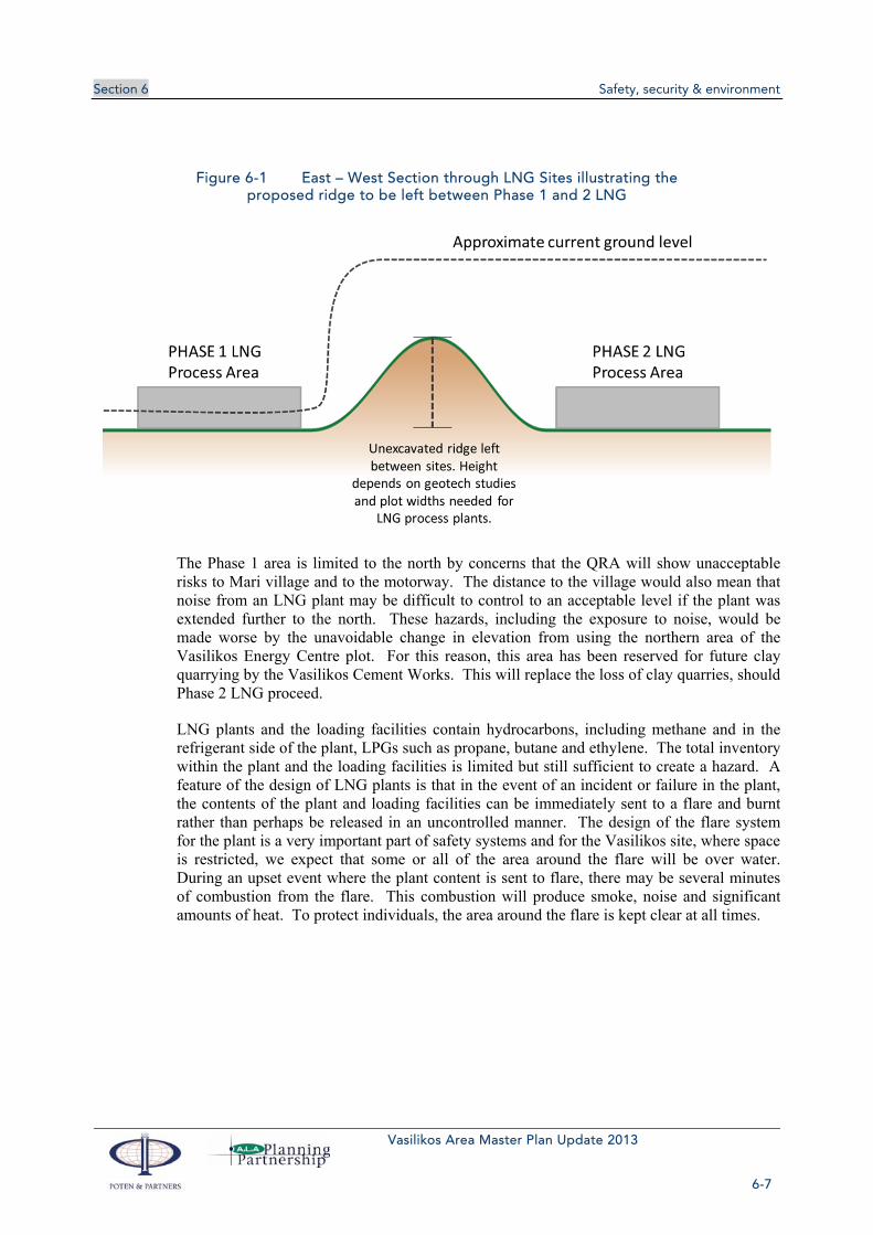
Section 6 Safety, security & environment
Vasilikos Area Master Plan Update 2013
6-7
Figure 6-1 East – West Section through LNG Sites illustrating the proposed ridge to be left between Phase 1 and 2 LNG
The Phase 1 area is limited to the north by concerns that the QRA will show unacceptable risks to Mari village and to the motorway. The distance to the village would also mean that noise from an LNG plant may be difficult to control to an acceptable level if the plant was extended further to the north. These hazards, including the exposure to noise, would be made worse by the unavoidable change in elevation from using the northern area of the Vasilikos Energy Centre plot. For this reason, this area has been reserved for future clay quarrying by the Vasilikos Cement Works. This will replace the loss of clay quarries, should Phase 2 LNG proceed.
LNG plants and the loading facilities contain hydrocarbons, including methane and in the refrigerant side of the plant, LPGs such as propane, butane and ethylene. The total inventory within the plant and the loading facilities is limited but still sufficient to create a hazard. A feature of the design of LNG plants is that in the event of an incident or failure in the plant, the contents of the plant and loading facilities can be immediately sent to a flare and burnt rather than perhaps be released in an uncontrolled manner. The design of the flare system for the plant is a very important part of safety systems and for the Vasilikos site, where space is restricted, we expect that some or all of the area around the flare will be over water. During an upset event where the plant content is sent to flare, there may be several minutes of combustion from the flare. This combustion will produce smoke, noise and significant amounts of heat. To protect individuals, the area around the flare is kept clear at all times.

Section 6 Safety, security & environment
Vasilikos Area Master Plan Update 2013
6-8
Figure 6-2 Areas allocated for marine flares
LPG Storage and Distribution Facility – This has been extensively discussed in a separate report, Cyprus – LPG Import Facility, October 2013, Poten & Partners. The proposed locations have been marked on the Master Plan. The final choice of a location will be for the Government of Cyprus and the LPG import businesses to determine. For the purpose of allocating space, we have identified a plot size based on US NFPA recommendations and then also drawn a circle around the plant to denote the possible 10-6 risk contour. This has been set at 600m, which is larger than we believe will be calculated for conventional storage spheres once the QRA is carried out. It is possible to design the LPG facilities with much tighter risk contours by, for example, covering the spheres with a mound of inert material approximately 0.6 to 1m thick. This adds to the cost of the facility and would need to be considered during the design phase. The 600m radius results in a very large area of land being blighted for use. The land within this area will be usable for agriculture.
Oil Storage Facilities - The areas marked Phase 1 and Phase 2 Oil Storage should be more than sufficient to cover Cyprus needs for oil storage. The Master Plan team recommends that to avoid domino effects, safety zones are left between further oil storage facilities (see Figure 6-3). The safety zones should be calculated based on the QRAs for the storage facilities but for the purpose of planning, we have assumed that these would be approximately 200m wide. These safety zones could be used by Vasilikos Cement for working stockpiles of clay and limestone or remain being used for agriculture. If the QRAs show this is not necessary, then this could be requirement could be relaxed.

Section 6 Safety, security & environment
Vasilikos Area Master Plan Update 2013
6-9
Figure 6-3 Sketch showing Safety Zone Concept between Oil Storage Depots
Gas Based Industries – at this stage, these are envisaged to be either Methanol or Ammonia / Urea. The space available appears sufficient for one World Scale plant. If a second plant was planned, then this could be accommodated by extending a little into the Phase 2 Oil Storage area. If the Government of Cyprus wishes to encourage these industries, then it would be prudent to restrict development to the east of this zone – marked “Restricted Development Zone”. We envisage that the 10-6 risk contour for the gas based industries could be designed to fall within this zone. Once the QRAs for the industries are completed or a decision is taken to no longer reserve the land for gas based industries, then the zone could be revised and reduced.
Phase 3 - Future LNG / Gas Based Industries – If Cyprus is particularly successful in finding gas, then additional gas processing areas will be needed. The area around Mari would then be needed. We have also extended the “Restricted Development Zone” so that it forms a buffer around this area as well. In view of the time interval before this land may be needed and the possibility that the QRA may show the “Restricted Development Zone” is unduly conservative, we have zoned the area to the north east of Mari for use by small offices / workshops and light industry.
Naval Base Area – The Master Plan does not believe that Naval Base area is ideal for use by hydrocarbon based industries and we have assumed that either the Navy would continue to occupy the site or that if the Navy decide to relocate, then the site would be used for workshops and repair facilities to support the industries in the Vasilikos area. If the Naval Base were used for hydrocarbon based industries, the QRA for these would need to consider the close proximity of the Governor’s Beach recreation area, the motorway and the power station. For the power station, the additional risks of a hazardous facility on its western side would be additive to the LNG facility on the east. The proximity to Governor’s Beach and the lack of any major change in elevation would restrict the naval base site to a small

Section 6 Safety, security & environment
Vasilikos Area Master Plan Update 2013
6-10
hydrocarbon development, such as a single LNG train. The western side of Vasilikos Bay is relatively shallow and any marine facilities to support hydrocarbon development in this area would require extensive dredging. This would probably be uneconomic.
6.2.3 Hazardous materials
6.2.3.1 Hydrocarbons
Almost all the facilities proposed for the Vasilikos area are hydrocarbon storage or processing facilities and hence present similar hazards. Except where listed below for the gas based industries and for the phosphorgypsum waste currently stored on site (the management of existing phosphorgypsum waste from the former fertiliser plant is discussed in section 6.3.2.2.), the facilities do not present any acute toxic materials. The hydrocarbon hazards do present the possibility of the following which could create impacts outside the individual site:
Flash fires (gas, liquefied gas and flammable liquid releases)
Torch fires (gas and liquefied gas releases)
Pool fires (liquefied gas and flammable liquids releases)
Vapour cloud explosions (from flammable liquid releases or gas releases)
Boiling Liquid Expanding Vapour Explosions (BLEVE) from a release of liquefied gas
In addition, the process plant areas are also likely to create additional hazards and nuisances that affect the spacing between industries and between those industries and residential areas:
Noise from gas turbines, compressors, fans etc.
Atmospheric emissions
Liquid effluent discharges
Heat emissions to atmosphere and to the marine environment
There are a number of other hazards that these facilities can create but these are not likely to impact outside the site and would be considered in the evaluation of each site. They are not relevant at the Master Plan level. This type of hazard includes:
Exposure to cryogenic liquids, gases or aerosols – these are very local hazards
Asphyxiation hazards – again these are likely to be very local hazards around or inside vessel
Rapid Phase Transition of cryogenic material spilled on water. This is only feasible locally around the loading arms at the LNG or LPG berths.
All the onshore hydrocarbon facilities would be designed with secondary and, if appropriate, tertiary containment to prevent a failure of, say, an oil storage tank resulting in a major accident to the environment from the spillage. If there were a major spill, the facilities should all have appropriate response plans and equipment to contain and clean up spills. Usually, these facilities are provided on a “club” basis with one set of equipment being paid for and maintained by all the facilities in the local area. If appropriate, additional equipment for major spills is also usually provided on a regional basis. These should all be set out in the environmental impact statement for each facility. For the Vasilikos area, a major spill from the Phase 1 and 2 Oil Storage Areas that was not contained on the individual sites, may

Section 6 Safety, security & environment
Vasilikos Area Master Plan Update 2013
6-11
flow down the Vasilikos River and out to sea. Even a relatively small quantity of oil can form a large area slick when spilled on water with consequences to the environment. The Master Plan assumes that these oil storage facilities will have appropriate secondary containment (i.e. the bunds around tanks sufficient to contain a spill greater than the contents of a tank) and tertiary containment (i.e. walls and drainage traps around the sites to capture any spills from the secondary containment and prevent direct discharge to the environment).
6.2.3.2 Other materials
Future gas based industries may create additional and different hazards should these industries be built. The hazards include:
Methanol manufacture – methanol would present similar hazards to the hydrocarbon facilities. In addition methanol is toxic and a spill from a storage tank say located within the Oil Storage areas could harm wildlife in the Vasilikos area and particularly the river. However, methanol is fully miscible with water and readily biodegradable once diluted down to less than approximately 0.1% by volume. This level of dilution would be achieved for say a spill reaching the sea. There would be only a small demand for Methanol in Cyprus – possibly the largest use may be as a low cost addition to gasoline; up to 15% of methanol is often suggested as being feasible without major modifications to car fuel systems. A World-scale methanol plant would of the order of one to three million tonne / year of capacity. The majority of the product would be exported and this could be done either over a dedicated berth, over a berth designated for gasoline or over a dedicated buoy mooring located off the BEMRS site. Methanol storage would have similar fire and explosion hazards to gasoline storage and handling.
Ammonia can also be manufactured from natural gas. Ammonia is a toxic gas with a short term exposure limit of around 35 ppm (US NIOSH REL). It is normally stored under pressure or refrigerated as a liquid to about -33°C, essentially similar to LPG. Liquid ammonia is traded internationally in modest quantities and the tankers used are the same as used for the LPG trade. If large scale ammonia manufacture was planned, then the Master Plan would need revision to accommodate the marine loading of ammonia. This would look very similar to an LPG export facility but a typical World-scale ammonia plant may produce around 750,000 tonne/year of product – i.e. approximately ten times the scale of LPG imports. To export this would require a larger berth to accommodate the larger ships needed.
Urea is the more likely end product from an ammonia plant. Urea is the most widely used nitrogenous fertiliser and is a relatively inert solid, granular material. No additional major hazards that would need to be considered at the Master Plan level should be created by a urea plant – although the plant would need to be designed to minimize air pollution and dust nuisance.
Syngas manufacture – Both methanol and ammonia/urea plants start with the production of syngas, i.e. hydrogen / carbon monoxide gas mixture. This is not stored, which reduces the scale of the hazard but syngas plants operate at temperature and pressure. In addition to the Syngas plant, modern methanol and ammonia plants will also have air separation plants producing oxygen and nitrogen for use in the process. These plants all create hazards and explosions in them have occurred but usually the consequences are kept within the site. Well designed, built and operated facilities should not be a major concern providing the appropriate separation distances calculated from the QRA are respected.

Section 6 Safety, security & environment
Vasilikos Area Master Plan Update 2013
6-12
Ammonium Nitrate is the other major product that can be produced directly from ammonia. Ammonium nitrate when mixed with a fuel (e.g. diesel or light fuel oil) is used as a commercial explosive. If this plant Were to be proposed, then the Master Plan should be revised to see if it could be accommodated. Many countries prefer not to manufacture ammonium nitrate due to its application as an explosive and recent history of its use by terrorists. In most countries, its use is strictly controlled to ensure that it is only used as a fertiliser or as an industrial explosive in mining.
Industries that may be planned for the region that present specific hazards other than the risks of fire etc. from hydrocarbons include:
Methanol – Methanol is one of the gas based industries proposed for the Vasilikos area. If a plant is built, then this is dependent on there being sufficient gas found, a methanol plant would require 1 to 2 TCF of gas and the economics being suitable. Methanol is toxic and exposure limits are approximately 200 ppm (Cyprus may have different limits). Entry into the body may be by ingestion and inhalation (both major) and moderate by skin or eye contact. It is flammable with a flash point of 11°C and lower and upper explosive limits in air of 6% and 36%. Methanol can burn without a visible flame and is completely soluble in water. Apart from the toxicity to the environment, large scale storage and handling of methanol has hazards that are essentially similar to gasoline. If spilled into the environment due to a failure of containment, methanol will readily biodegrade once diluted (e.g. to around <0.1%).
Ammonia – Ammonia is a feasible gas based industry for the Vasilikos area, either produced for export or as an intermediate for the production of urea. Ammonia is a toxic gas that can be easily contained under pressure as a liquid. Any commercial scale production of ammonia feasible for Cyprus would be an Upper-tier hazardous activity under the Seveso III Directive. Ammonia has a short term threshold limit for exposure of 35 ppm. Ammonia can burn and is usually treated similarly to LPG. It is extremely soluble in water, and could have a severe impact on local fisheries if spilled in any quantity. Any large scale storage of ammonia would require careful design and consideration of the QRA at the approval stage.
Bitumen – Bitumen is planned to be imported through the Vasilikos area to meet Cyprus needs. Bitumen is stored at a temperature of around 135-170°C (depending on grade). Bitumen is considered low hazard, and the primary hazards are all localized, e.g. due to handling hot liquid or inhaling gases driven off overheated bitumen. In the latter case, toxic hydrogen sulphide can be released. A major release of bitumen is unlikely to cause anything but localized damage as the bitumen will rapidly cool and set. While bitumen facilities are not an issue at the Master Plan level, they need to be correctly designed and operated to provide a safe working environment for operations personnel.
Other hazardous materials that need to be considered and are known to be in the area include:
Phosphorgypsum Pit – This is located at the southern end of the Energy Centre site. This pit was studied and reported on (Chemical And Radiological Pollution At A Fertilizer Plant At Vasiliko, Cyprus-Case Study For Site-Specific Risk Assessment, by A. Charalambides, M. Lysandrou; Geological Survey Department of Cyprus, Dept. of Environmental Geology,). As is common with the waste products from a phosphate processing facility, this pit contains heavy metals and low level radioactive material. The site was surveyed and remediation work carried out. This consisted of covering the material with a membrane and burying this under a layer of inert fill about 0.6 to 1m deep. A visual inspection of the site shows areas

Section 6 Safety, security & environment
Vasilikos Area Master Plan Update 2013
6-13
where the membrane is now visible and suggestions that the sea has entered the area during winter storms. The original remediation was intended to make the area suitable for light construction. i.e. raft type foundations that would not penetrate the membrane. If the pit is left undisturbed, it should not be a hazard.
The area currently occupied by the pit is allocated in the Master Plan to the LNG plant and the pit would be located between the storage tanks and the process plant area. The LNG plant design has still to be worked in detail and it may be possible that the pit can be left undisturbed and capped with concrete. This would be best option. It may also be possible that building work can take place on top of the pit. However, as this is likely to require piles being driven through the pit and membrane covering the pit, this requires a specialist assessment to determine if this can be safely done and if there are no adverse effects on the piles. If neither of these options is feasible and the contents of the pit must be moved, then these will have to be excavated by specialists and then reburied in a new pit on the LNG plant site. The choice of location would be determined during the design phase. The Master Plan envisages that this alternative location would be in an area which would not be subsequently disturbed and that does not require piled foundations – possibilities would be either under a car park, site road or under a green area left between other facilities. Removal of the material entirely from the Master Plan area appears to be unnecessary and would be costly.
Sulphuric Acid Storage – A sulphuric acid storage facility of approximately ?? t capacity is located adjacent to, and west of, Vasilikos Port. The facility imports 98% sulphuric acid from ocean going tankers by hoses and a dedicated pipeline on the West Berth. The storage tanks in the facility appear to be appropriately bunded to provide safety in the event of a failure of the storage tank. Sulphuric acid is a corrosive liquid that has a severe dehydration action. It is not very volatile and hazards are mainly concerned with accidental splashes or leaks when transferring from storage into containers or road tankers. It does react violently with water. It should, however, be a relatively localized hazard and should not present a major hazard to the region.
6.2.4 Marine Safety and Exclusion Zones
Within the Vasilikos Port Master Plan area, there are a number of different marine safety and exclusion zones that cause potential confusion and conflict in their impact on shipping and marine activities. The purpose of this section of the Report is to clarify the derivation of marine safety and exclusion zones and to identify any specific limitations that should apply with respect to extent and application of such zones.
6.2.4.1 Maritime zones subject to special regulations
Safety and security concerns result in special regulations being applied to certain maritime zones restricting activities within designated areas. The areas have various classifications including Exclusion Zone, Restricted Access Area, Security Zone, Safety Zone and Regulated Navigation Area.
The designation Exclusion Zone or Restricted Access Area is typically applied to an area such as one surrounding a sensitive military installation or a military conflict area and is not generally applied around a commercial port or conventional oil or gas terminal.
One exception concerns the regulations applicable to offshore installations and facilities where a 500m Exclusion Zone can be applied within a country’s Economic Exclusion Zone (EEZ), which usually extends 200 nautical miles offshore, and is permitted under Article 60 of the United Nations Convention

Section 6 Safety, security & environment
Vasilikos Area Master Plan Update 2013
6-14
on the Law of the Sea (UNCLOS). In this context the effect of the Exclusion Zone is not to restrict all activity but to permit entry to only those vessels having authorisation to approach the offshore facility.
A Security Zone is usually established over water and or land to safeguard persons, vessels, assets and infrastructure from sabotage or subversive acts. The application of a Security Zone is a matter for authorities responsible for national security and is based on security risk rather than on any hazard risk.
A Safety Zone may be an area over water and / or shoreline for safety hazard or environmental reasons limiting access to authorized vessels, vehicles and persons. The zone may be stationary around a berth or moving around a vessel in transit and is the most frequently designated area around oil and gas assets.
A Regulated Navigation Area is typically applied to control vessel traffic, restrict movements due to hazardous conditions or restrict movements of vessels carrying hazardous cargoes.
Safety Zones and Regulated Navigational Areas are the two designations typically applicable to ports and harbours handling a mix of cargoes including hazardous substances such as oils and gases.
Zones De-regulated from Port Authority Control are areas within established port boundaries where the Port Authority does not have jurisdiction for the collection of dues, levies or other taxes nor authority to impose regulations applicable elsewhere within the port. The de-regulation addresses administrative matters within the zone and is not related to vessel access, safety or security.
6.2.4.2 National Regulations
The European Union (EU) published Council Directive 2012/18/EU, known as the Seveso III Directive, on 4th July 2012. EU Member States are required to bring into force laws, regulations and administrative provisions necessary for compliance with the Directive no later than 31st May 2015. The Directive lays down rules for the prevention of major accidents which involve dangerous substances and the limitation of their consequences for human health and the environment, with a view to ensuring a high level of protection throughout the Union in a consistent and effective manner. In Cyprus, we understand that implementation of Seveso II and the new Seveso III Directive is the responsibility of the Department of Labour Inspection, which is the Competent Authority (CA).
The SEVESO III Directive applies to the storage and handling of materials inside a facility, (which includes facilities on a marine jetty), but does not apply to transportation to or from a facility by road, rail, pipeline or ship. However, in the UK, the Health and Safety Executive exercise regulation over ship loading and unloading operations under the Carriage of Dangerous Goods Act and LNG Terminal – Consent and Operational Issues. This involves many other UK regulatory bodies with responsibilities as follows.
Marine operations and shipping issues are addressed by the Hazardous Substances Authority in consultation with the Maritime & Coastguard Agency (MCA). Ports and harbours used for the loading or unloading of hazardous cargoes are managed by statutory harbour authorities having duties under the Dangerous Substances in Harbour Areas Regulations 1987. Harbour authorities control the marine traffic into and through the harbour, and the berthing and moving of ships. They are bound by the Port Marine Safety Code, compliance with which is monitored by the Maritime and Coastguard Agency (MCA).
In Europe marine regulations around oil and gas facilities are risk based. All new onshore facilities are required to produce an Environmental Impact Assessment, and the Seveso III Directive requires a Quantified Risk Assessment (QRA) to be undertaken. The data from these studies, including risk

Section 6 Safety, security & environment
Vasilikos Area Master Plan Update 2013
6-15
contours, is used by the regulatory bodies to determine the appropriate dimensions for any required safety or regulated zones.
In the USA the US Coast Guard (USCG) Captain of the Port is responsible for establishing any special zones in his or her area of responsibility. A special regulation, USCG Navigation & Vessel Inspection Circular (NVIC) 1-11 applicable to LNG facilities, requires the Captain of the Port to carry out a Waterway Suitability Assessment (WSA). Any special marine restrictions around the LNG facility are based on the finding of the WSA and defined in a Transit Management Plan. The US regulations are prescriptive rather than being risk based and prescriptive distances may vary from one Coast Guard District to another. There is no similar process for oil terminals in the USA and any special zones around them are determined by the Captain of the Port. Many zones in US waters relate to security and protection of infrastructure from perceived terrorist attack rather than from pure operational safety concerns.
The US National Fire Protection Agency (NFPA) issues special regulations applicable to LNG facilities, NFPA 59A in which Section 11.5 refers to Marine Shipping and Receiving. Sub Section 11.5.2.2. states “General cargo, other than ships’ stores for the LNG tank vessel, shall not be handled over a pier or dock within 100ft (30 m) of the point of transfer connection while LNG or flammable fluids are being transferred through piping systems.” The regulation does not impose any other specific restriction on spacing around a pier or dock.
6.2.4.3 International Regulations
There are no international standards governing the application or dimensions of special maritime zones around oil and gas terminals. Individual nations, as per the above examples, apply their own standards. The major international oil and gas operators have for many years promoted best practice standards for operations at their facilities. These have been promulgated through industry organisations such as the Oil Companies International Marine Forum (OCIMF) and the Society of International Gas Tanker & Terminal Operators (SIGTTO). In some more remote and less developed areas industry standards have often substitute for weak or no existent national standards.
A new standard, EN ISO 28460 2010 “Petroleum and Natural Gas Industries – Installation and equipment for liquefied natural gas ship-to-shore interface and port operations” – lists issues that need to be taken into consideration in jetty siting. The standard makes reference to exclusion and safety zones noting that these should be the result of risk assessment but does not recommend any dimensions. In most areas it refers back to the industry recommendations of OCIMF and SIGTTO.
Recognising the lack of common international regulations, recommendations or standards regarding the safety aspects and risks for taking large oil and gas tankers to a terminal the World Association for Waterborne Transport Infrastructure (PIANC) formed a working group in 2007 to report on the issues. The working group made up of representatives from OCIMF, SIGTTO, major petroleum ports including Rotterdam and Antwerp, oil majors including Shell and Total, marine port consulting companies, the Panama Canal Authority and the US Coast Guard delivered their report in 2012. The full title of the report is “Safety Aspects Affecting the Berthing Operations of Tankers to Oil and Gas Terminals”, PIANC Report No. 116-2012.

Section 6 Safety, security & environment
Vasilikos Area Master Plan Update 2013
6-16
6.2.4.4 PIANC Report No. 116-2012
The International Navigation Association (PIANC, formerly Permanent International Association of Navigation Congresses) has been the international leader in the development and improvement of inland and maritime navigation and its infrastructure. The PIANC report having been compiled in 2012 by an international cross section of expertise is considered a state of the art document providing the most appropriate expert guidance regarding the safe berthing of oil and gas tankers.
Section 9 of the PIANC report specifically addresses “Required Space for Safe Berthing”. The recommendations take into consideration several factors including:
Clearance between vessels moored at adjacent berths or manoeuvring into berths
Distance between navigational channel and moored vessels
Safety zone around manifolds of berths and tankers
The PIANC report provides typical berth arrangements and illustrates how safe distances are applied including clearances between vessels and channels, tug operating areas and safety zones around manifolds. The actual dimensions are site specific and are determined from a range of data including risk assessment, type and size of vessel, product handled and environmental conditions. Except in ports where there are unusual circumstances or extreme environmental conditions the determined safe distances are generally similar for similar operations. The PIANC report gives examples of typical distances applied within the oil and gas industry for the various areas identified as requiring safe clearances.
There is nothing unusual about the conditions at Vasilikos and the PIANC examples indicate that the layout and spacing between adjacent berths and navigation channels for the VTTV oil berths are in line with the recommended standards.
In the PIANC examples, safety zones are given as distances from the offshore side of berthed oil tankers and as a radius around the cargo manifold or point of cargo transfer for LPG and LNG carriers. Typical safety zone figures quoted for oil tankers range from 15 m to 30 m from the moored ship’s offshore side. This range would typically be applicable to oil tanker berth arrangements such as at Vasilikos.
For LPG and LNG tankers safety distances are greater where there is potential for a flammable vapour cloud that may result from a credible leak or spillage of liquid. Typical figures at LPG and LNG terminals can range from 30 m up to 200 m or 300 m (but not 2,000m) measured from the moored ship’s cargo manifold. The zones do not determine the spacing of marine structures or facilities but place restrictions on operations within the zone while liquid gas transfers are taking place. It is also typical to describe a smaller safety zone of 30 m around an unoccupied LPG or LNG jetty if it is of the type where refrigerated product is continuously circulated to maintain unloading systems in a cold condition.
Oil cargo manifold transfer areas where a leak or spillage would not result in the formation of a flammable vapour cloud do not normally have specific safety zones. Transfer operations of oil products do not have any impact on the spacing of marine facilities or on operations at other adjacent facilities. The spacing of marine oil facilities is therefore based on safe manoeuvring and berthing of vessels at the facilities as described in the PIANC report.
An area of 2 km radius around the centre of the currently under construction VTTV oil berths at Vasilikos has been designated as an Exclusion Zone. Vessel manoeuvring will be permitted within this zone but installation of any permanent structures within the zone will not be permitted. The effect of the 2km

Section 6 Safety, security & environment
Vasilikos Area Master Plan Update 2013
6-17
exclusion zone around the VTTV jetty is to sterilise the enclosed area including the Port of Vasilikos and the waters east and west of it thus severely limiting the scope for port development under the Vasilikos Port Master Plan. The 2,000 m zone apparently applied around the VTTV berths is greatly in excess of the industry norm and has no basis in current practice or industry recommendations. We are not aware of any other hydrocarbon port where such a large exclusion zone has been imposed.
6.2.4.5 Recommendations for Vasilikos
There is no requirement stated or implied anywhere within international conventions, national legislation or industry recommendations and guidelines that imposes an exclusion zone of 2km around an oil installation fixed to the shore. Within the industry no examples of such a large zone have been identified, except for the one enacted around the VTTV berths at Vasilikos. It is recommended that this zone be rescinded and replaced by appropriate safety zones based on the following recommendations for all berths handling dangerous products within the Vasilikos port area.
Naval Restricted Area/Exclusion Zone
Two separate zones exist around the Evangelos Florakis Naval Base to the west of Vasilikos Bay. A Restricted or Safety Area is designated in a 500m radius from the end of the breakwater and is closed to shipping, fishing and any other activity, including the installation of underwater cables and pipelines. No vessel is allowed in this restricted area without the written authority of the Ministry of Defence.
A larger zone has been designated as an exclusion zone in which vessels may approach the proposed LNG berths (with Ministry of Defence approval) and in which underwater cables and pipelines may be installed provided that they do not result in sediment movement that may affect the depths in the approach to the Naval Base or the Naval Base Basin.
Distance between navigational channel and moored vessels
At Vasilikos there is no passing traffic other than vessels manoeuvring with the assistance of tugs into berths or departing from berths. Approach and departure is straight in from seaward and there is no passing coastal traffic in the vicinity of the berths. For VTTV berths, an appropriate offshore safety zone would extend about 30m at the most from the side of the ship. This zone should only be applicable when a ship is on the berth and would be stated in Port Regulations issued by the Harbour Master.
Safety zone around manifolds of berths and tankers
A safety zone centred on a berthed tanker’s manifold should be determined from the risk assessment. Clearance should be available to enable a second tanker to manoeuvre, berth and unberth on an adjacent jetty without the vessel’s safety zones overlapping.
For an oil tanker typical zones range from 15 to 30m from the ship’s offshore side. Safety zones at LNG terminals are around 100m from a ship’s offshore side as used in many Japanese ports, and can extend to 200m or 300m from the manifold depending upon local conditions at some large LNG and LPG terminals.
Vasilikos VTTV berths
It is recommended that the existing 2 km exclusion zone be rescinded to allow greater flexibility in developing the effective and efficient use of the limited coastal waters in the vicinity of Vasilikos. From a marine safety perspective there does not appear to be any requirement for a special zone around the

Section 6 Safety, security & environment
Vasilikos Area Master Plan Update 2013
6-18
VTTV facilities. An appropriate safety zone would be 30m from the offshore side of any berthed vessel with no special restriction in place when a berth is unoccupied.
Vasilikos LNG berths
The appropriate safety zone for Vasilikos LNG terminal should be determined after completion of a detailed risk analysis. Based on experience at other similar LNG terminals an appropriate safety zone is expected to be in the range of 200m from the cargo manifold of a berthed LNG vessel and 30 m from any unoccupied LNG berth.
Other berths within Vasilikos Port
The requirements for safety zones around any future development berths with the port area should be determined from a detailed risk assessment looking at each of the berths, products handled and environmental conditions.
It is important to ensure that conflicting activities do not take place within Vasilikos Port which could result in an incident occurring. Dry bulk cargo operations would not be able to take place whilst LPG is transferred within the enclosed harbour area where uncontrolled ignition risks may be present. For this reason, it is recommended that LPG transfer takes place outside the Vasilikos Port breakwaters, which would position such operations well clear of bulk cargo transfer, and any accidental release of LPG would be carried downwind (either in NW’ly or SW’ly winds).
In the event that an offshore LPG conventional buoy mooring berth is installed, this will be located in suitable water depth to the east of Vasilikos Port. A zone of 150m radius from the manifold of the LPG carrier should provide a sufficiently large safety zone and all shipping entering or departing Vasilikos Port will pass upwind of the LPG berth in SW’ly winds and should remain clear of any accidental vapour release in NW’ly winds. The provision of an LPG berth is considered in more detail in section 6.10.1.
Application of Safety Zones
The above zones would regulate the movement of non-authorised vessels but would not restrict developments within the port area. The regulations should be discussed and agreed with the Cyprus Port Authority and Harbour Master then promulgated through Port Regulations and Notices to Mariners. They should also be notified to national and international hydrographic societies producing navigational charts and sailing guides.
In a busy or congested port the designation of separate safety zones around different facilities, all of which are handling hazardous cargoes, can be eliminated by having the marine facilities under the control of a single supervising port entity. Under such an arrangement, vessel movements can be closely coordinated to avoid conflict between competing operations and requirements.

Section 6 Safety, security & environment
Vasilikos Area Master Plan Update 2013
6-19
6.2.4.6 Listing of relevant marine safety regulations and standards
EU Seveso II Directive. Directive 96/82/EC, as amended by Directive 2003/105/EC
EU Seveso III Directive. Directive 2012/18/EU, issued 24th July 2012, in force 1st June 2015.
OCIMF /ICS / IAPH 2006. International Safety Guide for Oil Tankers and Terminals (ISGOTT), 5th edition.
PIANC Report 116-2012. Safety Aspects Affecting the Berthing Operations of Tankers at Oil and gas Terminals
Port Marine Safety Code. UK Department of Transport 2012
A Guide to Good Practice on Port Marine Operations. UK Department of Transport 2013
EN ISO 28460: 2010. Petroleum and natural gas industries. Installation and equipment for liquefied natural gas. Ship-to-shore interface and port operations.
LNG Operations in Port Areas. SIGTTO 2003
Site Selection and Design for LNG Ports and Jetties. SIGTTO 1997
6.2.5 Evacuation plans
According to the SEVESO II Directive, Member States must ensure that emergency plans are in place for areas with industrial establishments (falling within the SEVESO Directive) where dangerous substances are used or stored in large quantities as well as the surrounding areas. Member States must also ensure mitigation actions are planned.
An Evacuation Plan or Plans should be prepared for the Vasilikos Area installations and put into effect. It should be noted that a perimeter fence will also be erected around the LNG facilities for security reasons.
There are two types of plans, the so called internal plans for dealing for the incident within the boundaries of establishments and the so called external plans for the protection of nearby communities. Apart from the general emergency plan for the Vasilikos Area it is expected that individual establishments falling under the SEVESO directive will prepare and implement (together with the Fire Service and the Department of Labour Inspection) their own Evacuation and Emergency Response Plans.
General external evacuation plans in Cyprus are the responsibility of the Cyprus Civil Defence, whose role is to protect the population and their properties from the consequences of natural and man-made disasters. Generally there are two types of plans, one for industries falling under SEVESO II directive and another for communities and neighbouring forest areas. The Civil Defence Law of 1996 and Civil Defence Regulations of 1997 are relevant for implementation of this mandate.
The Civil Defence has stated that it does not have responsibility for evacuation plans inside our study area unless the infrastructure within the area is designated as European Critical Infrastructure. However, given the definition of critical infrastructure as “an asset or system which is essential for the maintenance of vital societal functions” it is almost certain that installations such as the Vasilikos power station and tank

Section 6 Safety, security & environment
Vasilikos Area Master Plan Update 2013
6-20
farms holding Cyprus strategic stocks should be designated as EU Critical Infrastructure. “The damage to critical infrastructure, its destruction or disruption by natural disasters, terrorism, criminal activity or malicious behaviour, may have a significant negative impact for the security of the EU and the well-being of its citizens.” Designation of infrastructure is carried out as stated in the EU Directive 2008/114/EC “on the identification and designation of European critical infrastructures and the assessment of the need to improve their protection” and the relevant Cyprus Regulations ΚΔΠ 15/2012.
It is likely, therefore, that the Civil Defence will have some kind of responsibility within the perimeter fence, to coordinate preparation of evacuation plans and emergency response. The Civil Defence could be involved by:
Coordinating preparation of emergency response and evacuation plans: routes, numbers of people, safe areas (coordination with LNG Plant and other emergency services)
Chairing local safety & security coordination committee
Identification of resources required and available such as emergency response personnel (fire and medical teams at each site plus local, regional and national resources), infrastructure requirements (fire and security detection, fire-fighting and medical equipment at each site and locally/ regionally/ nationally, communications equipment), incident control room.
Training – standards/ qualifications, joint training, emergency exercises
Management of emergency response – coordination with the Fire Service, Army, Police, Joint Rescue Coordination Centre etc.
After the detection of the emergency and the Alarm is raised, the evacuation plan will be put into effect. The designated responsible person at the facilities where an incident occurs will be in charge of coordinating the emergency response unless the severity and/or extent is such that the civil authorities should take charge.
The sequence of an evacuation plan can be divided into the following phases:
1) Detection
2) Decision
3) Alarm
4) Reaction
5) Movement to an area of refuge or an assembly station
6) Transportation
Personnel will assume designated positions, each with specific duties to coordinate the evacuation and transportation off site. Certain emergency actions will require emergency response from off-site emergency organisations. Effective emergency response planning and response is therefore dependent on close, ongoing coordination between the site and those off-site emergency organizations.
Designated assembly areas will have to be clearly identified in the evacuation plans and on site. A designated Emergency Director will declare either a Limited Area Evacuation or a Total Evacuation of the site dependent upon the type and location of the emergency situation. If a total evacuation of the site is ordered, personnel will use primary escape routes and will assemble at the designated assembly points for a headcount and transportation of site.

Section 6 Safety, security & environment
Vasilikos Area Master Plan Update 2013
6-21
6.2.6 Fire service
The Master Plan envisages that each hydrocarbon facility will have their own facilities for the initial response to a fire in their hydrocarbon storage or process areas. For example, this would include water drench equipment to cool oil storage tanks to reduce the risk of domino effects. Each facility will also have their own equipment and trained staff to deal with small incidents promptly. The Master Plan also envisages that the various facilities would also have:
Agreements for mutual cooperation in an emergency, e.g. fire fighting equipment from one site would be deployed, as needed to fight fires on neigbouring sites, installed fire fighting water pumps could be connected to supply neighbours or resources deployed to provide water curtain/boundary cooling between one facility and another.
Clear management plans for responding to an emergency that places nominated individuals in control until the fire service takes control
The fire service should be located close to the Vasilikos area but not within the immediate Vasilikos Master Plan area. The objective being that they are able to quickly reach an incident but their station and any Incident Management/Control Centre should not be affected by the incident. Suitable locations are:
North edge of the Naval Base / near Governor’s Beach exit from the motorway
Kalavasos area near the exit from the motorway
Both these locations are close to the motorway junctions. This has the advantage that emergency services would be able to quickly travel to the incident from other areas of the island when needed –and evacuate casualties if necessary. If there were a major incident at Vasilikos, then the fire station Incident Management/Control Centre would be used as a marshalling point for assistance and emergency responders drawn from the Civil Defence Force, Fire Service, National Security Authority and other involved entities.

Section 6 Safety, security & environment
Vasilikos Area Master Plan Update 2013
6-22
Figure 6-4 Possible Fire Station Locations
6.3 SOCIAL AND ENVIRONMENTAL IMPACT
6.3.1 Social Impact
The proposed Master Plan will definitely have social impacts mostly on the neighbouring communities but these impacts may also extend to cover wider areas in the Region.
It is estimated that during the construction phases 1 and 2 of the LNG plant, there will be a need for skilled labour force of the order of 5.700 persons. During the LNG 1 and 2 operation phases, 350 people will be permanently employed in the plant. The Vasilikos Master Plan also proposes expansion of the industrial activities of the area aiming to attract more gas based industries in the area. This proposal will create even more employment positions.
It is therefore estimated that the construction and operation of the LNG plant and the attraction of more gas based industries will have a positive social impact for the neighbouring communities because of the creation of employment opportunities which are likely to be utilised by the younger residents of the nearby villages. The creation of these employment opportunities may also attract new residents in the neighbouring villages enhancing their socio-economic growth.
The main negative social impacts will incur on the existing residents of Mari Village. According to the proposals of this Master Plan, new development in Mari Village should freeze since the whole area of Mari village is proposed to be used for the possible expansion of LNG plant Phase 3. Additionally, the
Section 6 Safety, security & environment
Vasilikos Area Master Plan Update 2013
6-23
Master Plan proposes that the current residents should gradually be relocated as the Mari village area will have negative environmental impacts from the construction of LNG plant Phases 1 and 2.
The closure of the BEMRS in March 2013, will also have positive social and environmental impacts in the surrounding communities, due to the minimal electromagnetic waves and the perception of increased health from the nearby residents. It should be noted, of course, that the closure of the BEMRS is not part of the Master Plan proposals. However, proposals for utilising the available land are recommended in the current Master Plan.
The more detailed social impacts on neighbouring villages will have to be further analysed and evaluated during the consultation process which will follow the completion of this Master Plan and in the analysis which will be carried out in the more detailed Strategic Environmental Assessment and the more Project specific Environmental Impact Studies which will be completed at a later stage.
6.3.2 Environmental Impact
6.3.2.1 Introduction
The Master Plan will undoubtedly have environmental impacts on the area and the wider region. These are described briefly in section 6.3.2.2 below. Environmental Impact Assessments (EIAs) have already been carried out for new major installations such as the VTTV Terminal and Jetty and the Petrolina Fuel Storage installation expansion. An EIA is a prerequisite in order to gain the required planning approval. Additionally, it should be noted that an Environmental Impact Assessment (BoD Environmental Assessment, Ref. FSE96539A EA Issue 2) was carried out in 2006 for the then proposed Vasilikos Energy Centre. Further information on the findings of the EIA for the Vasilikos Energy Centre can be found in the 2009 Vasilikos Master Plan.
The Environmental Impacts from the Vasilikos Master Plan will be identified during the Strategic Environmental Assessment (SEA) of the plan which is planned to take place immediately after the completion of the current Master Plan. More information regarding the proposed SEA is presented below in Section Error! Reference source not found. of the current Master Plan.
Further to the SEA and in order to gain Environmental and Planning Permits/Consents for certain individual projects/developments, an Environmental Impact Assessment (EIA) according to the EIA Law 140(I)/2005 may be required for each specific project. More information regarding the procedure for the preparation of Environmental Impact Assessments is presented below in Section 7.3.2.4 of the current Master Plan.
6.3.2.2 Expected Environmental Impacts
The current Master Plan, proposes the location of a number of new major installations, including installations related to the gas and petroleum product industries (see Plan 16, Volume 2), as well as changes to the current planning zones. Generally it is expected that the new installations will be compatible in environmental terms, with the area (particularly after the review of the planning zones). As described above and according to the EIA Law 140(I)/2005, Environmental Impact Assessments of the individual projects/installations will take place, identifying the major environmental impacts caused by the construction and operation of the installation. However, the two major areas where environmental impacts will be significant are on the environmental aspects of air quality and noise pollution. A section on the management of the existing contaminated soil found at the old Hellenic Chemical Industries Site is also presented below.

Section 6 Safety, security & environment
Vasilikos Area Master Plan Update 2013
6-24
Expected Environmental Impacts caused by the implementation of the Master Plan are briefly described below. These, of course, will have to be assessed with the completion of the SEA and relevant EIAs.
Air Quality – Expected Impacts and Considerations
The Study area currently includes privately owned tank farms by Petrolina and VTTV, both of which are looking to expand further. VTTV is currently constructing a Jetty for marine offloading. The implication of such marine off loading facilities is that there will be an increase in the level of shipping in the area (for both petroleum products and LPG). The increase in exhaust emissions from these ships may potentially have an impact on air quality as shipping can be a significant source of pollutants such as sulphur dioxide (SO2).
Vasilikos Power Station has been gradually repaired after the explosion that took place on 11 July, 2011. The 3 steam units (Units 1, 2 and 3) of 130mW each fuelled by heavy fuel oil are now in operation and can now also run on natural gas. The burning of HFO releases into the atmosphere mainly SO2, NOx and CO (carbon monoxide). Additional to this Units 4 and 5, the two combined cycle units are in operation which now run on low sulphur distillate fuel oil but will eventually run on natural gas. Once gas is available distillate fuel oil will only be used as the emergency fuel. The switch from fuel oil to eventually gas will have a positive effect on air quality in the region as gas is a relatively clean fuel.
Air emissions from LNG facilities include combustion sources for power and heat generation as well as emissions resulting from flaring and venting. Emissions from these sources include nitrogen oxides (NOx), carbon monoxide (CO), carbon dioxide (CO2), and sulphur dioxide (SO2). However, during operations, the LNG trains will not be a significant source of particulate matter or of SO2.
Noise Pollution – Expected Impacts and Considerations
The main noise emission sources in LNG facilities include pumps, compressors, generators and drivers, compressor suction/discharge, recycle piping, air dryers, heaters, air coolers at liquefaction facilities, vaporizers used during regasification and general loading/unloading operations of LNG carriers/vessels. These emission sources and the total noise pollution will be assessed at the EIA stage of the LNG facilities.
Noise emission sources will also include the vessels and the increased road traffic in the area for industrial use.
Soil Pollution – Expected Impacts and Considerations
The area of flat land to the east of the power station was previously occupied by the Hellenic Chemical Industries (HCI) Plant, which produced sulphuric acid, phosphoric acid and composite artificial fertilisers.
A lagoon for the disposal of phosphor gypsum waste from the plant processes, some 5 ha in area, had been established in the sea at the nearby shoreline. The Phosphor Gypsum Lagoon is located at the proposed site of the Boil-Off Gas (BOG) Area and part of the LNG Storage area
When the Plant was demolished, the lagoon was capped by a geosynthetic liner and covered with around 100,000 m3 of waste materials from the demolition works, some 1.5m thick. A validation report prepared for the area considered the lagoon as “suitable for use” depending on the future land use. Any development in the area (for the Boil-Off Gas and LNG Storage Area facilities), however, would have to take into account the existence of the phosphor gypsum and the geosynthetic liner.

Section 6 Safety, security & environment
Vasilikos Area Master Plan Update 2013
6-25
Alternatively, the phosphor gypsum, could be relocated within the site, capped with a membrane and stored permanently beneath, for example, car parking facilities.
6.3.2.3 Strategic Environmental Assessment
According to the (Strategic Environmental Assessment) SEA Directive (2001/42/EC), and the Cypriot SEA Law (Law 102 (I) / 2005), Strategic Environmental Assessments should be prepared for agriculture, forestry, fisheries, energy, industry, transport, waste/ water management, telecommunications, tourism, town & country planning or land use and which set the framework for future development consent of projects listed in the EIA Directive.
The central aim of SEA is to help ensure that the environment is given the same level of consideration as social and economic factors within the plan.
An SEA will be carried out for the Vasilikos Master Plan in order to assess the Environmental Impacts of the Plan. Both positive and negative environmental effects will be identified and appropriate mitigation measures will be proposed.
It should be noted however, that any potential impacts of individual proposals will be addressed through separate Environmental Impact Assessments during their implementation phase in accordance with the local Environmental Impact Assessment Law (N. 140(I)/2005).
More Information on the process for Environmental Impact Assessments of Individual Projects is presented below.
6.3.2.4 Environmental Impact Assessments of Individual Projects
In Cyprus Environmental Impact Assessments are carried out for individual projects in accordance with the local Environmental Impact Assessment Law (N. 140(I)/2005). For all projects requiring EIA’s the opinion of the Department of Environment is a prerequisite in order to secure a planning permit or consent.
According to the EIA Law, there are two types of EIAs carried out for projects in Cyprus generally depending on the scale of the project and the expected Environmental Impacts from the project. The type of EIA required (a full EIA, or a preliminary EIA) will depend on whether the proposed project is listed in Annex I or Annex II of the Law.
The First Annex of the Law refers to projects that may lead to serious consequences for the environment and require the preparation of a full Environmental Impact Assessment (EIA) (MEEΠ). Such projects are generally larger scale project which may lead to serious environmental impacts such as highways, quarries, marinas, golf courses, desalination plants, energy installations etc.
The Second Annex of the Law contains a list of projects for which the preparation of a Preliminary Environmental Impact Assessment (ΠΕΕΠ) is initially required. The Preliminary Environmental Impact Assessment is carried out by completing a form/questionnaire which has been prepared by the Department of the Environment,
Possible projects which are referred to in the current Vasilikos Master Plan and may be constructed within the Vasilikos Master Plan Study Area are listed in Table 6-1 below with an indication on whether they fall within Annex I or Annex II of the Law.

Section 6 Safety, security & environment
Vasilikos Area Master Plan Update 2013
6-26
It should be noted that the list below is not extensive or clear cut and it would be up to the owners/managers of each project/facility to determine the requirement for an EIA and the type of EIA required according to the lists in Annex I and Annex II of the Law and by consultations with the Department of Environment.
Table 6-1 Master Plan Projects listed under Annex I and Annex II of EIA Law (N. 140(I)/2005)
Projects listed under Annex I of EIA Law (N. 140(I)/2005) for which an EIA is required
Projects listed under Annex II of EIA Law (N. 140(I)/2005) for which a Preliminary EIA is required
Crude-oil refineries (excluding undertakings manufacturing only lubricants from crude oil) and installations for the gasification and liquefaction of coal or bituminous shale per day.
Installations for:
o Extraction of petroleum for commercial purposes where the amount extracted exceeds 100 tonnes/day
o Extraction of natural gas for commercial purposes where the amount extracted exceeds 100,000 cubic metres/day
Pipelines for the transport of gas, oil, chemicals with a diameter of more than 400 mm and a length of more than 10 km
Installations for storage of petroleum, petrochemical, or chemical products with a capacity of 2500 tonnes or more.
Integrated chemical installations, i.e. those installations for the manufacture on an industrial scale of substances using chemical conversion processes, in which several units are juxtaposed and are functionally linked to one another and which are:
1. for the production of basic organic chemicals;
2. for the production of basic inorganic chemicals;
3. for the production of phosphorous-, nitrogen- or potassium-based fertilisers (simple or compound fertilisers);
4. for the production of basic plant health products and of biocides;
Industrial installations for the production of electricity, steam and hot water (unless included in Annex I).
Industrial installations for carrying gas, steam and hot water; transmission of electrical energy by overhead cables.
Surface storage of natural gas.
Underground storage of combustible gases.
Surface storage of fossil fuels.
Industrial briquetting of coal and lignite.
Installations for the production or enrichment of nuclear fuels.
Installations for the reprocessing of irradiated nuclear fuels.
Installations for the collection and processing of radioactive waste (unless included in Annex I).
Installations for hydroelectric energy production.
Treatment of intermediate products and production of chemicals (unless included in Annex I).
Production of pesticides and pharmaceutical products, paint and varnishes, elastomers and peroxides.
Storage facilities for petroleum, petrochemical and chemical products.
Oil and gas pipeline installations.
Construction of roads, harbours, including fishing harbours, and airfields (projects not listed in Annex I).
Reclamation of land from the sea.

Section 6 Safety, security & environment
Vasilikos Area Master Plan Update 2013
6-27
5. for the production of basic pharmaceutical products using a chemical or biological process;
6. for the production of explosives.
Any EIA carried out will assess the environmental impacts during the construction and operation of individual projects and propose relevant mitigation measures for a number of Environmental Aspects such as:
Climatic Factors
Seascape
Geology, Marine Sediments and Seismic Characteristics
Water Resources
Atmospheric Quality
Noise / Vibration
Terrestrial Ecosystem
Marine Ecosystem
Socioeconomic Environment
Planning and Land Use
Transport, Infrastructure and Services

Vasilikos Area Master Plan Update
7-1
Section 7 Baseline Master Plan
7.1 FUTURE INDUSTRIAL DEVELOPMENT The Vasilikos Area has been earmarked by the Cyprus government for industrial development. It already has EAC’s Vasilikos power station, the Vassiliko Cement Works and quarries and VTTV and Petrolina’s oil products storage facilities. Nevertheless, there exists the opportunity to expand industrial development in the area, especially in the area formerly occupied by the Hellenic Chemical Industries’ fertiliser plant (land now expropriated for the Vasilikos Energy Centre), provided it is coordinated to ensure optimum land use and that developments can co-exist.
7.2 LNG LIQUEFACTION PLANTS
7.2.1 LNG Phase 2
The current plan for the LNG Phase 2 area is to accommodate two additional LNG trains each of approximately 5 Mtpa of capacity plus their associated utilities. These additional trains may require another LNG storage tank and an additional berth. The LNG berth arrangements shown have provision for up to three LNG berths, which will be more than sufficient for five LNG trains. No assumptions are made concerning the technology that might be selected for any LNG train.
It is estimated that the two additional trains could be built on the site without requiring the relocation of the Mari Village. The site would require the use of the clay quarry area currently used by the Vassiliko Cement Works Company. To replace this, the Mari quarry in the area to the north of Phase 1 LNG would be made available to Vasilikos Cement.
7.2.2 Phase 3 – LNG or Gas Based Industries
The gas resource that would require additional LNG trains or gas based industries to be built on the Phase 3 area is not currently known. The timing of this may be not until 2030.
If Mari Village is relocated, then this area appears suitable for additional LNG trains, preferably at the south end of the site to minimize the length of the expensive cryogenic run down lines to storage tanks. The north end could be used for gas based industries and/or if rich gas were discovered, petrochemicals based on a steam cracker producing ethylene.
The decision to allocate this land for future industries should be re-visited regularly over the next ten years as more is known about the hydrocarbon resource offshore Cyprus. It would be important not to blight the land use in this area unnecessarily.
7.3 OIL PRODUCTS STORAGE AREA The Master Plan is required to accommodate in the Vasilikos area a number of oil products storage facilities that fall into the following categories:
Approved – such as the VTTV and Petrolina Oil Storage facilities currently under construction.
Due to be relocated from other areas, such as LPG and oil storage facilities to be relocated from Larnaca – these are for serving the domestic market.

Section 7 Baseline Master Plan
Vasilikos Area Master Plan Update
7-2
Planned entirely new merchant storage facilities for use by commercial companies interested in investing in oil storage facilities in Cyprus.
Required storage facilities to meet Cyprus obligation under European Union COUNCIL DIRECTIVE 2009/119/EC of 14 September 2009, imposing an obligation on Member States to maintain minimum stocks of crude oil and/or petroleum products.
These requirements were summarized by the MECIT into the briefing document containing all known planned projects that had been identified as requiring land in the Vasilikos area. The Oil Storage requirements contained in this document have been reproduced in Table 7-2.
In addition, the Project Team reviewed the requirement for strategic storage set out in EU Directive 2009/119 and has calculated estimates of the volume of storage required to meet this directive once gas is available on Cyprus.
The area allocated in the Master Plan for oil storage is shown as Phase 1 and Phase 2, plus an additional area suggested for LPG storage, the LPG 2 site option (the LPG options are discussed in section 7.4 and in more detail in Appendix D). The intention is that initially only the Phase 1 area would be released for oil storage. This area includes the land already allocated for VTTV and Petrolina. Phase 2 would be released if needed, and if not needed would be allocated to future gas based industries.
7.3.1 Theoretical storage density
The land area required for a given volume of oil storage depends on the analysis of the hazards generated by the product and by the physical geometry of fitting circular tanks into an area of land. As discussed in the section on Major Hazards and Risks (Section 7.2), Cyprus is in the process of adopting the Seveso III EU Directive on hazardous facilities. This directive requires the analysis be based on a risk based assessment of the facilities and we understand that Cyprus is to apply a 10-6 risk criteria (one in a million probability) for the general public at the site boundary. In order to carry out this assessment a certain amount of design work needs to be carried out, which is not available at this stage in a Master Plan exercise.
For the purposes of allocating sufficient space in the Master Plan we have carried out an analysis of the land area required based on analogy to other new locations that have been built in the EU, to facilities which have carried out the necessary Quantitative Risk Assessment (QRA) and with reference to the more prescriptive standards, such as the US NFPA standards and the guidelines produced by the Institute of Petroleum. To minimize visual impacts of the storage facilities, we have also assumed that the heights of storage tanks will be limited to those used on the VTTV site, i.e. up to 27m, and limited the size of tanks to a similar pattern to the VTTV site.
The estimate for storage density used for planning purposes is 50,000 m3 per hectare of land. This includes allowances for ancillary facilities, plot boundaries and retaining walls. For comparison, the VTTV site is achieving a storage density of approximately 58,000 m3 per hectare of land.
Allocating one plot to contain all the island’s oil storage facilities creates a possible systemic risk that a major incident may impact all the storage facilities. This risk will be mitigated by the separation distances between the storage tanks and by the use of fire-fighting and water drenching. To further reduce the risk if this is shown to be an issue in the QRA, we recommend separating future storage facilities in the Phase 1 and 2 by plots say 200m wide that could be used by Vassiliko Cement Works for stockpiling working stocks of limestone and clay etc. In Table 7-1 we provide a column to show the
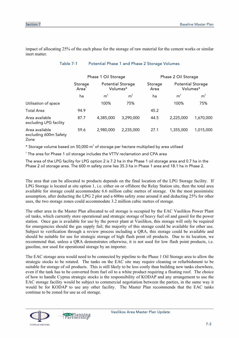
Section 7 Baseline Master Plan
Vasilikos Area Master Plan Update
7-3
impact of allocating 25% of the each phase for the storage of raw material for the cement works or similar inert matter.
Table 7-1 Potential Phase 1 and Phase 2 Storage Volumes
Phase 1 Oil Storage Phase 2 Oil Storage
Storage Area†
Potential Storage Volumes*
Storage Area
Potential Storage Volumes*
ha m3 m3 ha m3 m3
Utilisation of space 100% 75% 100% 75%
Total Area 94.9 45.2
Area available excluding LPG facility
87.7 4,385,000 3,290,000 44.5 2,225,000 1,670,000
Area available excluding 600m Safety Zone
59.6 2,980,000 2,235,000 27.1 1,355,000 1,015,000
* Storage volume based on 50,000 m3 of storage per hectare multiplied by area utilised † The area for Phase 1 oil storage includes the VTTV reclamation and CPA area
The area of the LPG facility for LPG option 2 is 7.2 ha in the Phase 1 oil storage area and 0.7 ha in the Phase 2 oil storage area. The 600 m safety zone lies 35.3 ha in Phase 1 area and 18.1 ha in Phase 2.
The area that can be allocated to products depends on the final location of the LPG Storage facility. If LPG Storage is located at site option 1, i.e. either on or offshore the Relay Station site, then the total area available for storage could accommodate 6.6 million cubic metres of storage. On the most pessimistic assumption, after deducting the LPG 2 plot and a 600m safety zone around it and deducting 25% for other uses, the two storage zones could accommodate 3.2 million cubic metres of storage.
The other area in the Master Plan allocated to oil storage is occupied by the EAC Vasilikos Power Plant oil tanks, which currently store operational and strategic storage of heavy fuel oil and gasoil for the power station. Once gas is available for use by the power plant at Vasilikos, this storage will only be required for emergencies should the gas supply fail; the majority of this storage could be available for other use. Subject to verification through a review process including a QRA, this storage could be available and should be suitable for use for strategic storage of high flash point oil products. Due to its location, we recommend that, unless a QRA demonstrates otherwise, it is not used for low flash point products, i.e. gasoline, nor used for operational storage by an importer.
The EAC storage area would need to be connected by pipeline to the Phase 1 Oil Storage area to allow the strategic stocks to be rotated. The tanks on the EAC site may require cleaning or refurbishment to be suitable for storage of oil products. This is still likely to be less costly than building new tanks elsewhere, even if the tank has to be converted from fuel oil to a white product requiring a floating roof. The choice of how to handle Cyprus strategic stocks is the responsibility of KODAP and any arrangement to use the EAC storage facility would be subject to commercial negotiation between the parties, in the same way it would be for KODAP to use any other facility. The Master Plan recommends that the EAC tanks continue to be zoned for use as oil storage.
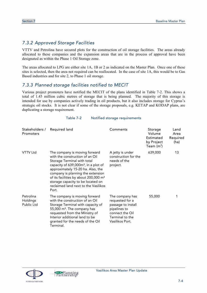
Section 7 Baseline Master Plan
Vasilikos Area Master Plan Update
7-4
7.3.2 Approved Storage Facilities
VTTV and Petrolina have secured plots for the construction of oil storage facilities. The areas already allocated to these companies and the expansion areas that are in the process of approval have been designated as within the Phase 1 Oil Storage zone.
The areas allocated to LPG are either site 1A, 1B or 2 as indicated on the Master Plan. Once one of these sites is selected, then the area not required can be reallocated. In the case of site 1A, this would be to Gas Based industries and for site 2, to Phase 1 oil storage.
7.3.3 Planned storage facilities notified to MECIT
Various project promoters have notified the MECIT of the plans identified in Table 7-2. This shows a total of 1.45 million cubic metres of storage that is being planned. The majority of this storage is intended for use by companies actively trading in oil products, but it also includes storage for Cyprus’s strategic oil stocks. It is not clear if some of the storage proposals, e.g. KETAP and KODAP plans, are duplicating a storage requirement.
Table 7-2 Notified storage requirements
Stakeholders / Promoters
Required land Comments Storage Volume
Estimated by Project Team (m3)
Land Area
Required (ha)
VTTV Ltd The company is moving forward with the construction of an Oil Storage Terminal with total capacity of 639,000m³, in a plot of approximately 15-20 ha. Also, the company is planning the extension of its facilities by about 200,000 m³ storage capacity to be located on reclaimed land next to the Vasilikos Port.
A jetty is under construction for the needs of the project.
639,000 13
Petrolina Holdings Public Ltd
The company is moving forward with the construction of an Oil Storage Terminal with capacity of 55,000 m³. The company has requested from the Ministry of Interior additional land to be granted for the needs of the Oil Terminal.
The company has requested for a passage to install pipelines to connect the Oil Terminal to the Vasilikos Port.
55,000 1

Section 7 Baseline Master Plan
Vasilikos Area Master Plan Update
7-5
Stakeholders / Promoters
Required land Comments Storage Volume
Estimated by Project Team (m3)
Land Area
Required (ha)
Strategic Investor (together with KETAP)
It is estimated that approximately 600,000 - 700,000 m3 of storage is required, depending on the facilities comprising the project and its capacity.
Relocation of Cyprus Storage Co from Larnaca. Replaces MECIT strategic storage project. Marine facilities are required.
400,000 8
KODAP KODAP examines the possibility to proceed with the construction of its own oil storage facilities to accommodate its needs. According to preliminary calculations by KODAP, it is estimated that the land required for the first phase is about 7 ha for a capacity of 360,000 m³ and at a later stage additional land of approximately 3-5 ha, depending on its future needs.
The project is currently under investigation by KODAP and no decisions have yet been taken.
360,000 7
1,454,000 29
7.3.4 Strategic Storage Required by EU Directive
The requirement for strategic stocks is laid down in European Union COUNCIL DIRECTIVE 2009/119/EC of 14 September 2009, imposing an obligation on Member States to maintain minimum stocks of crude oil and/or petroleum products (EU 2009/119). This approximates to around 90 days of oil product consumption, excluding products used externally such as marine bunker fuel. In conjunction with the MECIT, we have prepared Table 7-3 which summarizes the total imports of Cyprus and the corresponding obligation for storage. In view of the imminent arrival of natural gas, the Master Plan team has adjusted down the requirement for some products, such as heavy fuel oil, which is currently used by the power station. These products will no longer be required as natural gas will be a much lower cost alternative. It would not be economic to provide storage for these products given that the storage might only be built a year or two ahead of the availability of gas. Cyprus could continue to pay operators in other European countries to store on its behalf. We have also not applied any growth to products such as automotive fuels. The general trend in Europe has been stable to declining for automotive fuel consumption. Newer vehicles are significantly more efficient than in the past and overall growth in vehicle numbers is not offsetting this increase in efficiency. We suggest it is reasonable to apply no growth for the ten years. Beyond this, the EU objectives of reducing carbon emissions will impose even greater pressure on automotive fuel use and, if the policy objective is successful, would result in lower fuel imports into Cyprus.
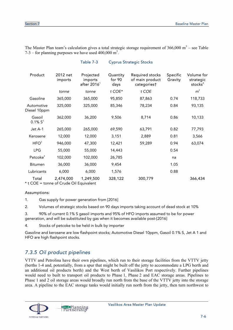
Section 7 Baseline Master Plan
Vasilikos Area Master Plan Update
7-6
The Master Plan team’s calculation gives a total strategic storage requirement of 366,000 m3 – see Table 7-3 – for planning purposes we have used 400,000 m3.
Table 7-3 Cyprus Strategic Stocks
Product 2012 net imports
Projected imports
after 20161
Quantity for 90 days
Required stocks of main product
categories†
Specific Gravity
Volume for strategic stocks2
tonne tonne t COE* t COE m3
Gasoline 365,000 365,000 95,850 87,863 0.74 118,733
Automotive Diesel 10ppm
325,000 325,000 85,346 78,234 0.84 93,135
Gasoil 0.1% S3
362,000 36,200 9,506 8,714 0.86 10,133
Jet A-1 265,000 265,000 69,590 63,791 0.82 77,793
Kerosene 12,000 12,000 3,151 2,889 0.81 3,566
HFO3 946,000 47,300 12,421 59,289 0.94 63,074
LPG 55,000 55,000 14,443 0.54
Petcoke4 102,000 102,000 26,785 na
Bitumen 36,000 36,000 9,454 1.05
Lubricants 6,000 6,000 1,576 0.88
Total 2,474,000 1,249,500 328,122 300,779 366,434 * t COE = tonne of Crude Oil Equivalent
Assumptions:
1. Gas supply for power generation from [2016]
2. Volumes of strategic stocks based on 90 days imports taking account of dead stock at 10%
3. 90% of current 0.1% S gasoil imports and 95% of HFO imports assumed to be for power generation, and will be substituted by gas when it becomes available post-[2016]
4. Stocks of petcoke to be held in bulk by importer
Gasoline and kerosene are low flashpoint stocks; Automotive Diesel 10ppm, Gasoil 0.1% S, Jet A 1 and HFO are high flashpoint stocks.
7.3.5 Oil product pipelines
VTTV and Petrolina have their own pipelines, which run to their storage facilities from the VTTV jetty (berths 1-4 and, potentially, from a spur that might be built off the jetty to accommodate a LPG berth and an additional oil products berth) and the West berth of Vasilikos Port respectively. Further pipelines would need to built to transport oil products to Phase 1, Phase 2 and EAC storage areas. Pipelines to Phase 1 and 2 oil storage areas would broadly run north from the base of the VTTV jetty into the storage area. A pipeline to the EAC storage tanks would initially run north from the jetty, then turn northwest to
Section 7 Baseline Master Plan
Vasilikos Area Master Plan Update
7-7
follow the existing road for about 1.7 km before turning due west to run along the top of the area allocated for Phase 1 LNG to EAC.
7.3.6 Oil Storage Conclusions and Recommendations
Two zones have been allocated in the Master Plan for Oil Storage Phase 1 and Phase 2. In addition, the storage tanks currently used by EAC will also be zoned for oil storage and once gas is available could be used for strategic storage of high flash point oil products, such as automotive diesel and kerosene etc.
To reduce the risk of a major incident in one tank farm affecting a neighbouring facility, it is recommended that future tank farms are separated by say 200m wide plots. These safety areas could be used for stockpiling of working stocks by Vassiliko Cement Works or used for other “inert” uses such as agriculture.
The areas allocated for in the Master Plan for Oil Storage could accommodate between 3.2 million cubic metres and 6.6 million cubic metres depending on the location of the LPG storage facility and the amount of land used for safety areas. This compares with a total of approximately 1.5 million cubic metres of notified storage requirements shown in Table 7-1, which includes the Cyprus strategic storage requirement. After allowing for approximately 400,000 m3 for long term strategic storage and around 200,000 m3 for operational storage for oil products import into Cyprus, the land area available for storage appears more than adequate for foreseeable plans. With just Phase 1 and deducting both the LPG storage areas and the additional safety zones, there is sufficient space for 2.6 million m3 of storage for trading operations. We have not carried out a full simulation, but we doubt if these trading storage volumes could be achieved without a major addition to the marine facilities. The addition of more marine facilities would be challenging.
The approval of any given plot for oil storage and its design will be subject to the official Government of Cyprus process and this should include a QRA as the key methodology for assessing the major hazards. Allocating the land in Phase 1 and 2 to oil storage does not guarantee that an individual facility is safe; it is intended to give priority to oil products storage use in these areas.
7.3.7 Technical Standards References
EU Seveso II Directive. Directive 96/82/EC, as amended by Directive 2003/105/EC
EU Seveso III Directive. Directive 2012/18/EU, issued 24th July 2012, in force 1st June 2015.
API STANDARD 650, Welded Steel Tanks for Oil Storage, Tenth Edition, Addendum 2 November 2001
Refining Safety Code, IP, 3rd Edition, November 1981
NFPA 30, Flammable and Combustible Liquids Code, Aboveground Tank Installation, Tank Storage 2008 Edition

Section 7 Baseline Master Plan
Vasilikos Area Master Plan Update
7-8
7.4 LIQUEFIED PETROLEUM GAS Liquefied Petroleum Gas (LPG) is currently discharged fully pressurised at ambient temperature from ships at an offshore buoy berth via a submarine pipeline to shore storage tanks located in Larnaca. The government has committed that the handling and storage of LPG be moved from Larnaca to Vasilikos. The location of a new LPG facility at Vasilikos is intended to be a permanent solution. There is a requirement to be able to store 8,000 m3 on the new site.
LPG is the most hazardous of the hydrocarbons that will be stored at Vasilikos. With vapour heavier than air, it has the potential to spread at ground level over a significant distance and can be ignited far from the source. Safety considerations have therefore been paramount in the evaluation of potential storage sites and import arrangements.
The Project Team has evaluated a wide range of options for both storage and offloading of LPG; detailed discussion may be found in the LPG report attached as Appendix D. The evaluation is based on two key assumptions:
LPG will be imported and stored in pressurised form, as at present;
There will be common LPG import and storage infrastructure, with companies having their own bottling and truck loading facilities.
The Master Plan presents three feasible options for LPG storage:
LPG 1A – onshore facility just east of the Vasilikos Port on land currently occupied by the BEMRS.
LPG 1B – a variant of LPG 1A built on land to be reclaimed off the BEMRS site. Offloading for LPG 1B would be via a dedicated berth on a short breakwater off the reclaimed land.
LPG 2 – about 1.6 km inshore.
The storage itself may be in spheres or bullets – larger volumes have traditionally been stored in spheres, but bullets are now available in sizes up to 5,000 m3 – and above-ground or mounded. Mounding has the benefit of reducing risk and required safety distances, albeit at a cost.
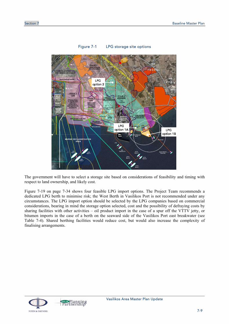
Section 7 Baseline Master Plan
Vasilikos Area Master Plan Update
7-9
Figure 7-1 LPG storage site options
The government will have to select a storage site based on considerations of feasibility and timing with respect to land ownership, and likely cost.
Figure 7-19 on page 7-34 shows four feasible LPG import options. The Project Team recommends a dedicated LPG berth to minimise risk; the West Berth in Vasilikos Port is not recommended under any circumstances. The LPG import option should be selected by the LPG companies based on commercial considerations, bearing in mind the storage option selected, cost and the possibility of defraying costs by sharing facilities with other activities – oil product import in the case of a spur off the VTTV jetty, or bitumen imports in the case of a berth on the seaward side of the Vasilikos Port east breakwater (see Table 7-4). Shared berthing facilities would reduce cost, but would also increase the complexity of finalising arrangements.
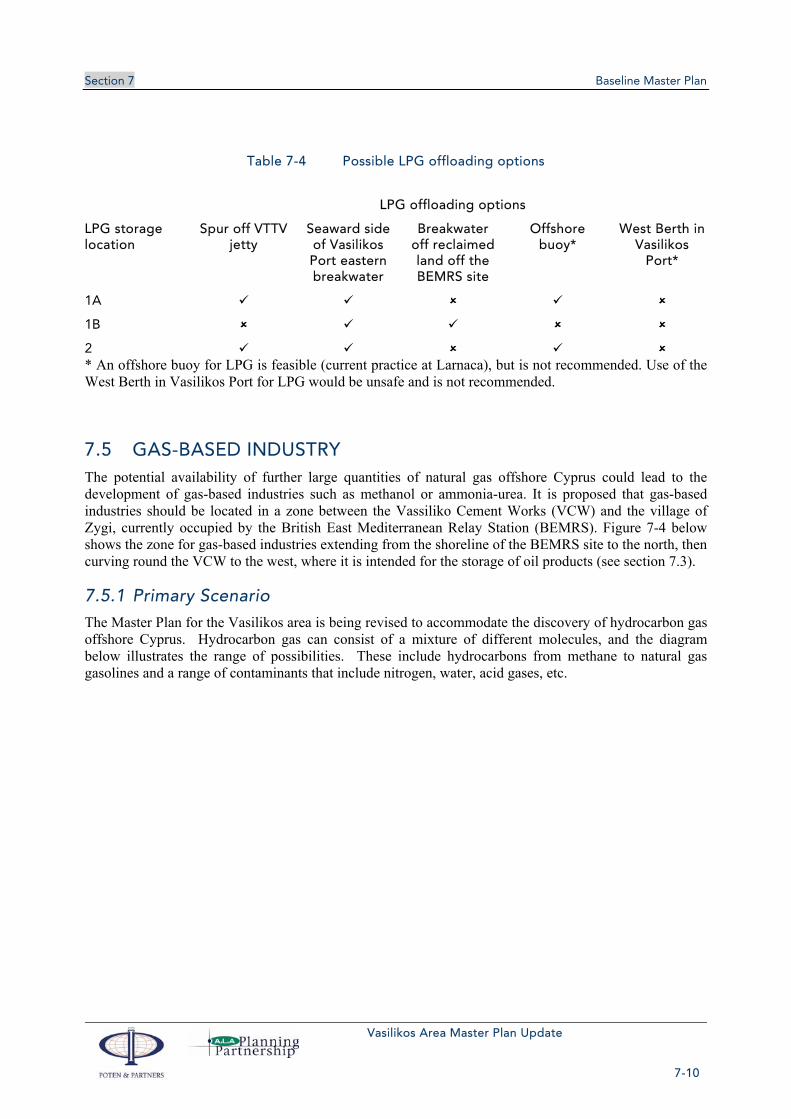
Section 7 Baseline Master Plan
Vasilikos Area Master Plan Update
7-10
Table 7-4 Possible LPG offloading options
LPG offloading options
LPG storage location
Spur off VTTV jetty
Seaward side of Vasilikos Port eastern breakwater
Breakwater off reclaimed land off the BEMRS site
Offshore buoy*
West Berth in Vasilikos
Port*
1A
1B
2 * An offshore buoy for LPG is feasible (current practice at Larnaca), but is not recommended. Use of the West Berth in Vasilikos Port for LPG would be unsafe and is not recommended.
7.5 GAS-BASED INDUSTRY The potential availability of further large quantities of natural gas offshore Cyprus could lead to the development of gas-based industries such as methanol or ammonia-urea. It is proposed that gas-based industries should be located in a zone between the Vassiliko Cement Works (VCW) and the village of Zygi, currently occupied by the British East Mediterranean Relay Station (BEMRS). Figure 7-4 below shows the zone for gas-based industries extending from the shoreline of the BEMRS site to the north, then curving round the VCW to the west, where it is intended for the storage of oil products (see section 7.3).
7.5.1 Primary Scenario
The Master Plan for the Vasilikos area is being revised to accommodate the discovery of hydrocarbon gas offshore Cyprus. Hydrocarbon gas can consist of a mixture of different molecules, and the diagram below illustrates the range of possibilities. These include hydrocarbons from methane to natural gas gasolines and a range of contaminants that include nitrogen, water, acid gases, etc.

Section 7 Baseline Master Plan
Vasilikos Area Master Plan Update
7-11
Figure 7-2 Natural gas well fluid composition and uses
The Primary Planning Scenario used in this Master Plan for the Vasilikos area assumes: that the Aphrodite gas discovery by Noble is representative of the region and that:
Further gas discoveries will be made, and that these gas discoveries will be lean gas, i.e. primarily methane, and typical of the region and of deep water gas
The feasible industries that can be developed around this resource are those based on methane alone. Methane comprises one carbon atom with four hydrogen atoms. Most petrochemicals are produced from more complex molecules, such as ethane (two carbon atoms), propane (three), butane (four) etc. Methane is the main component of natural gas and does not react chemically other than to fully or partially oxidise. The primary uses for methane are illustrated in Figure 7-3.
In the context of Cyprus, the priority use will be as a fuel for power generation. In addition, there may also be some use as a fuel for industrial and commercial applications. Cyprus has no oil production needing the reinjection of gas, so this use can be ignored.
The direct export options for natural gas are either by pipeline or as liquefied natural gas, LNG. The Master Plan has been asked to consider LNG Exports as the primary gas export option and to also ensure that space is allocated for a compressor station to enable pipeline exports of natural gas.

Section 7 Baseline Master Plan
Vasilikos Area Master Plan Update
7-12
Figure 7-3 Gas utilisation options
Methane can be used as a feedstock for the manufacture of syngas, i.e. a hydrogen and carbon monoxide gas mixture. Syngas can then be used for a family of different uses. The most common are Methanol and Ammonia / Urea production. These two industry options have been considered for space allocation in the Master Plan and have been termed Gas Based Industries. Typically, these two industries can be based on a smaller stranded gas resource than say LNG, i.e. around one trillion cubic feet (Tcf), compared to four Tcf for LNG. They tend to demand very competitive (low) feedstock pricing and the creation of such industries on Cyprus will be dependent on the market economics for these products and the availability of gas that is available at a price that can make them viable.
Other industries that can be based on syngas include direct reduced iron and gas to liquids. Direct reduced iron (sponge iron) utilizes the reducing properties of Syngas to chemically convert iron oxide ore to iron. This type of industry requires the importation of large quantities of a suitable iron ore and then the re-export of the iron pellets; a typical scale would be above one million ton of iron each year. This requires a large port facility to accommodate the bulk carrier ships. This does not appear feasible in the Vasilikos area. Gas To Liquids (GTL) plants that convert syngas to diesel have been built, two are now operating in Qatar. GTL plants are not currently on the list of options for Vasilikos and this may be due to their high capital costs and low yield.
A key feature of the proposed zone is a safety zone 500 m from the edge of the gas-based industry and oil products storage zone where the construction of residential or commercial buildings would not be permitted, although other activities such as agriculture and light industry
Section 7 Baseline Master Plan
Vasilikos Area Master Plan Update
7-13
7.5.2 Methanol
An investor has proposed to build a new, 1 Mtpa methanol plant, requiring a total of 17 ha (7 ha for production, 8 ha for storage and 2 ha for blending facilities). Such a plant could readily be accommodated on the BEMRS site with an offshore loading conventional buoy mooring located to the east of Vasilikos Port in sufficiently deep water and clear of the Vasilikos Port approaches (see Figure 7.10.1.6).
7.5.3 Gas-based industry and oil products storage zone
Gas-based industries are proposed to be located in the first instance in the Gas-based Industry and Oil Products Storage Zone near the coast on the BEMRS site (see Figure 7-4). Further developments would occupy land further north within the zone. Finally, land allocated for LNG Phase 3 could also be made available.
Figure 7-4 Gas-based industry zone Inverted V (pale blue) encompassing the Vassiliko Cement Works
7.6 GAS EXPORT A gas pipeline to export gas to Greece has been proposed and, together with the EuroAsia Interconnector for electricity, accepted in October 2013 as one of the EU’s 248 Projects of Common Interest (see section 5.9). The project would need an onshore gas compressor station plus pipeline access to gas landing and treatment point and to shore for routing to Greece or Turkey.

Section 7 Baseline Master Plan
Vasilikos Area Master Plan Update
7-14
Figure 7-5 Gas Projects of Common Interest Map shows gas export pipeline route(s) Cyprus-Greece
The gas compressors would most likely be powered by open-cycle gas turbines burning natural gas. Infrastructure requirements would be minimal, but would include road access and pipeline Rights of Way. The compressor station would occupy a plot of about 2.6 ha, and is proposed to be located in the gas-based industries zone by the shore in the southwest corner of the current BEMRS site.
7.6.1 Gas export pipeline
A gas export line to Greece would need to head off in a westerly direction, to the south of Limassol and Cape Gata (south of Akrotiri) before going “deep sea’ to Crete or mainland Greece.
Taking into account the VTTV berths, SPM and approaches to Vasilikos Port, along with a possible subsea LPG or Methanol pipeline to a conventional buoy mooring east of the VTTV berths, it would probably be appropriate for a gas export line to leave the coast on the eastern side of the BEMRS site and loop around to the south of all existing marine facilities as shown in the diagram below (N.B. diagrammatic only – the actual position of the pipe line heading to the west will be determined by water depth and edge of the continental shelf).
Section 7 Baseline Master Plan
Vasilikos Area Master Plan Update
7-15
Figure 7-6 Possible near shore gas export route
The pipeline will need to be buried sufficiently to prevent any possible damage from ship’s anchors or from possible terrorist activity until it is in sufficiently deep water. The beach crossing will need to be either trenched for the export line or an alternative is to directionally drill from onshore through to the edge of the continental shelf and run the pipe through that boring.
Irrespective of the method used to lay the pipeline, it should have a minimum depth of cover of at least 3m in water depths of less than 60m, and greater cover where vessels may require to use an anchor when manoeuvring within a port approach. The pipeline should run well clear of any designated anchorages.
7.7 POWER GENERATION The new power generation projects planned are described in Section 5.1. The planned thermal plants (PEC Power and Vouros Power) are negotiating site leases with the CPA. The four wind turbines apparently have permits. The EAC and Vouros Power plants are next to the sea and therefore have ready access to cooling water, although water circulation studies will be needed to confirm intake and outfall layouts. The Master Plan will provide for a N-S pipeline corridor along the western perimeter of the EAC Vasilikos site to give the PEC Power site access to cooling water if necessary, although air-cooled condensers may be used in the place of direct cooling.
Vasilikos is a major node on the Cyprus transmission network, so the Cyprus TSO will carefully study the concentration of power generation in this area and the grid connections and requirements for reinforcement. Transmission rights of way would be needed for the Vouros Power and PEC Power plants to connect to a substation on the transmission network. Given the concentration of hydrocarbon storage facilities lying between the Vouros Power plant and the Mari substation the connection would probably need to be undergrounded.

Section 7 Baseline Master Plan
Vasilikos Area Master Plan Update
7-16
There are no particular safety issues relating to conventional thermal power plants or wind turbines. However, when combined with the construction of other facilities, in particular the planned LNG plants, there could be issues relating to noise and ambient air quality that will need to be resolved by detailed noise surveys and studies and air dispersion modelling. Given this potential for conflict with the LNG plants it is recommended that these developments should be deferred or, better, relocated away from Vasilikos until studies have been completed for at least three LNG trains.
7.8 DC CONVERTER Current plans for a 500 MW capacity DC converter station are discussed in Section 5.9. The 132 kV transmission line to the Mari substation will have to be moved for the construction of the LNG plant, and will connect to the planned Vasilopotamos substation. The location proposed by EAC/DSM, however, conflicts with the area allocated for oil storage, in particular the safety zone associated with the LPG 2 option. It is recognised that moving the location will cause difficulties for EAC to obtain new Rights of Way, especially for the transmission lines, but this is necessary to meet MECIT’s objective to make land available for hydrocarbon storage., The Master Plan recommends the Vasilopotamos substation and DC converter station should be sited next to each other south of Kalavasos outside the hydrocarbon restricted development zone. The proposed location also provides road access.
High voltage DC underground cables supplying the DC converter station can run to the shore along the route of the adjacent road. High voltage overhead lines (OHTL) to connect the Vasilopotamos substation to Mari substation will need to avoid the safety zone associated with LPG Option 2, and the OHTL from Vasilikos power station to Vasilopotamos substation should be routed round the edge of the proposed Restricted Development Zone (see Plan 18, Volume 2).

Section 7 Baseline Master Plan
Vasilikos Area Master Plan Update
7-17
7.9 INFRASTRUCTURE
7.9.1 Electricity transmission & distribution
EAC plans to reroute a 132 kV transmission line connecting the Mari substation to Vasilikos power station to a new substation (Vasilopotamos), which would then connect to the existing Mari substation and new transmission line to [Larnaca] (see section 5.12.3). However, the proposal conflicts with the allocation of land for Phase 2 oil storage, and the route of the overhead lines passes directly over one of the options for siting LPG (LPG 2). The Master Plan proposes that the Vasilopotamos substation and the DC converter should be relocated to a site south of Kalavasos (see section 7.8). The Master Plan also proposes rerouting the transmission line from the grid substation associated with the Vasilikos power station to the Vasilopotamos substation round the north of the Vassiliko Cement Works quarry area and Mari village, and the edge of the restricted development zone, as shown in Plan 18 in Volume 2.
7.9.2 Roads
7.9.2.1 Future Traffic Volumes
Future developments within the study area will lead to increases in traffic volumes, particularly heavy goods vehicles. The estimated traffic generation for each future development and the total flows for the fully developed study area in 2030 are included in Appendix C. Although approximate, these estimates represent the best figures available at present and are sufficient for Master Planning purposes. It should be noted that all estimations take into account the worst case scenarios for traffic patterns (eg. daily peak hours, low public transport use, etc) and the optimistic scenarios for developments operation dates.
The total traffic generation from future developments in the study area by 2030 is estimated at 8,976 vehicle movements (2-way) over a 24 hour period, with a heavy goods vehicle proportion of 40%. During the AM peak period, a total of 1590 vehicles (2-way) are estimated to be generated, with a heavy goods vehicle proportion of 17%.
The 2030 projected flows are also included in Appendix C. The 24-hour 1-way flows range between 1,178 and 2,845 vehicles and the AM peak hour 1-way flows range between 112 and 340 vehicles. It is noted that traffic estimations form the worst case scenario. These flows are moderate and should not create any overall capacity issues. However, the traffic generated from the developments could have an impact on the environment and on road safety and needs to be considered. This will be exacerbated by the high proportion of goods vehicles that will access the site.
These estimated traffic flows may be ameliorated by proposals to transport materials used/produced in the study area by non-road means. There are several schemes currently being considered:
Limestone Conveyor – proposed by the VCW to deliver limestone from the Kalavasos quarry to the cement works. At present there are no definite plans regarding the route or details of the conveyor available, although it is understood to follow the Mari-Vasilikos Road. Implementation of the scheme would remove 615 trips of heavy gravel trucks per day from the road network.
Jet Fuel – a pipeline is proposed for transporting jet fuel from the VEC to Larnaca airport. It is estimated that 40 tank truck trips per day would not take place after implementation of the scheme.
Relocation of fish industries to a new location to the west of the study area. It is estimated that more than 300 vehicle trips daily could be removed from the network.

Section 7 Baseline Master Plan
Vasilikos Area Master Plan Update
7-18
Abandonment of the animal husbandry zone of Mari, which could remove up to 60 vehicle trips daily from the network.
Abandonment of Mari Village.
The effect of such schemes would reduce the levels of heavy goods vehicle traffic using the study area. However, as the implementation and the phasing of these schemes is still far from certain, they have not been accounted for in the estimates of future traffic flows.
7.9.2.2 Traffic Generation at the LNG Construction Stage
Unlike the operation stage of the developments, the construction stage of the new industrial establishments could have an impact on the road network. It is estimated that 5,750 employees will work on the site, for the development of the Gas Trains of the first two phases. Approximately 5,200 of the above employees will work between 06:30 and 17:00. One third of the workers will live in camps near the site and approximately half of the employees will reside in the rest of Cyprus. Approximately 15% of the workers will be recruited from the local area. The number of trucks movements is estimated to 200. In any case, the production of so many trips to and from the site at the peak of the construction period could raise capacity issues for the local road network.
The construction site of the LNG facilities will have sufficient accessibility from the road network and the Vasilikos Port. Construction site access points are shown in Plan 17, Volume 2 (nodes P1, P3, P4). After the construction stage only access P1 will be used, and the remaining access points will be used only in case of an emergency.
In order to mitigate the traffic impact from the implementation of the gas train schemes the following measures are proposed:
Use of buses for the transportation of employees. Primary routes should serve the major cities (preferably from park ‘n’ ride facilities) in order to minimize the private vehicle trips to the site. Routes of mid-sized buses could serve the surrounding communities. At least 60% of the employees should access the site with non-private vehicle modes.
Temporary pedestrian corridors should be built to connect the camps adjacent to the site with the construction yards. Corridors should provide separated and safe pedestrian movement for pedestrians.
The working shifts of employees should be staggered. If all vehicles try to approach the site at the same time, even a relatively small number of vehicles could cause capacity problems.
The Vasilikos Port should be utilized as much as possible. It is expected that a proportion of construction materials will arrive through the port, but all provisions should be made for the maximum use of the port and the minimum use of heavy vehicles.
All the above measures should be elaborated through a specific “traffic impact” and “travel-plans” study based on a more detailed construction plan for the area.
7.9.2.3 Future Road Network
The option of doing nothing and allowing the area to develop without the appropriate road infrastructure to support the long term Master Plan provisions would generally be detrimental. The issues of road safety and environmental degradation of the area would intensify and the predicted levels of generated traffic would damage the existing infrastructure. Consequently, this approach is not favoured and it is

Section 7 Baseline Master Plan
Vasilikos Area Master Plan Update
7-19
recommended to develop a network of appropriately strengthened and signed routes for heavy goods vehicle access to/from the study area and its main developments and the national highway network. The existing road network of the study area is shown in Plan 10, Volume 2 and the proposed future road network is shown in Plan 17, Volume 2.
As a first step, the structural integrity of the existing part of this network should be assessed, particularly its ability to withstand the future estimated traffic volumes. Any identified improvements should then be implemented so that a consistent standard of network construction is developed and maintained. The main uses in the study area should be accessed by properly designed public roads. The LNG zone and the EAC Vasilikos Power Station are both accessed from the west with roads (nodes I3 and I4, Plan 10, Volume 2) that are connected to the B1 old Nicosia-Limassol road. The VCW, the Vasilikos Industrial Port and the Oil Products Storage area (Petrolina and VTTV) are now accessed from the purpose built Mari-Vasilikos Road (link D-E-F, shown in Plan 10, Volume 2) and the Vasilikos – Zygi road (link F-G-L, shown in Plan 10, Volume 2). Access from this road should be granted to other future developments such as the LPG storage area, Strategic Storage area, office zones and the LNG / Gas Based Industrial zones (see Master Plan Map and Plan 16, Volume 2). So as to make due allowance for the all future developments, new roads are proposed and improvements are recommended to the network links and junctions.
The proposed road network is a comprehensive road network which has been developed after consultation with the Department of Town Planning and Housing and takes into account the proposed land use zoning of the Sturdy Area. The proposed road network comprises existing, new and realigned/upgraded roads. The hierarchy of the proposed road network consists of two road categories: Primary and Secondary Roads. As shown in Plan 17, Volume 2, the primary roads of the proposed future road network comprise a) the section of the B1 old Nicosia-Limassol road from the A1 highway junctions for Zygi and Governors Beach (Junctions 15 and 16 respectively) which has to be upgraded, b) the realigned and upgraded road to the east of the Vasilikos River (link C-K-G, Plan 17) that will connect the B1 old Nicosia-Limassol road and the Vasilikos – Zygi road and c)the new Mari – Zygi road (link D-K-L, Plan 17) The main access of the area will eventually be the road east of Vasilikos River (node P3, Plan 17). The proposed future road network will also include a number of secondary roads that will give access to existing and future developments in a safe and efficient manner.
For the purposes of Master Planning level, the capacity/efficiency of the proposed road network is assessed taking into account the future estimated traffic volumes based on projections of traffic counts and on estimates of the traffic generation of the expected land uses in the area. The distribution of existing and proposed land uses is also taken onto account. The proposals for new roads are based on the topographic data available from the Department of Lands and Surveys. It is proposed that an extensive topographic survey is carried out for the whole area in order to reassess the feasibility on the proposed road network with more accurate data. Thus the proposed road alignment is subject to changes until the proposed topographic survey is carried out. The main access of the LNG trains zone and EAC Vasilikos Power Station are two roads with junctions on the B1 road at the west of the Master Plan. These access points are further analysed below.
Major Road Network Standards
The new major road network of the area should be developed with specific standards suitable for industrial areas. The standards of the network are set by the heavy vehicles traffic that is expected for the area when the proposed uses will be developed. Minimum lane width should be 3,75m. A shoulder (preferably concrete or asphalted) of approximate 2-3 meters of width is needed for emergency stops of trucks. Roundabouts are the preferred alternative for the junctions of the major road network. Traffic

Section 7 Baseline Master Plan
Vasilikos Area Master Plan Update
7-20
lights are not an option due to relatively low traffic volumes. Separate right turning lanes are needed for junctions of collector roads on primary roads.
Figure 7-7 Current Layout of EAC Power Station Access Right turning lane should be considered
Lighting for all junctions should be included. At a later stage street lighting for all the length of the road network should be installed. . Delineators should temporarily be installed to road sections not lit. Pedestrian footways along the major roads should be included at sites where employees are expected to walk along the road. Otherwise they could be implemented at a later stage on land reserved for this purpose.
Figure 7-8 Existing footways and pedestrian crossing Similar layout should apply for all roads in the long term
B1 Old Nicosia-Limassol Road
Axis B1 old Nicosia – Limassol Road (link J15-B-C-D-J16, Plan 17) is the critical access to and from the study area and there are safety concerns associated with its operation. Major issues include the upgrading of existing standards, over speeding, the crossroad junction with Mari – Vasilikos road (node D, Plan 17) and the accesses of future developments. It is recommended that a detailed plan is prepared for this road based on the recommendations of this Master Plan which will indicated the type and location of the main junctions of the road taking into account road safety and efficiency criteria.

Section 7 Baseline Master Plan
Vasilikos Area Master Plan Update
7-21
The existing asphalted road width is 8 meters with 3 meters width for each lane and one meter of shoulder. The road can accommodate existing traffic efficiently, but it should be upgraded to the standards described above for main roads in the long term. Upgrading measures are needed for the east part of the road near Zygi where some asphalt failures have occurred (link B-C, Plan 17).
Figure 7-9 Old Nicosia – Limassol Road Cracked Surface
Two new roundabouts are proposed for the road in order to control over speeding along the road and to secure safe access to other major roads of the area. The first roundabout should be constructed at the existing crossroad with Mari – Vasilikos road (node D, Plan 17). The junction is considered a black-spot as there is a large number of gravel trucks using it. Thus a fairly large roundabout would be required with a centre island with wide overrun areas to facilitate the size of heavy goods vehicles that will use it. Extra land take may be required and the alignment of the Kalavasos road arm between the A1 Highway bridge and the roundabout may be an issue. Hence it needs more detailed study.
Figure 7-10 Layout of existing B1/Mari crossroads
The other roundabout proposed for the area is to the east of the Vasilikos River bridge (node C, Plan 17). It will connect B1 old Nicosia – Limassol road with the new proposed road parallel to Vasilikos River. The distance from the existing roundabout at B1/Zygi junction (node B, Plan 17) to the east is

Section 7 Baseline Master Plan
Vasilikos Area Master Plan Update
7-22
approximately 700 meters. The layout of the proposed roundabouts should be similar to the layout of the existing roundabout at B1/Zygi junction that seems to cope with the existing traffic well.
There is a number of minor and secondary roads connected to B1 axis (nodes I1 to I7, Plan 10). Some of these accesses may have to be closed in the future after the implementation of the Master Plan. These issues should be addresses by the proposed more detailed road plan for this road. No additional accesses are proposed by the Master Plan. For the north access to the EAC site that will be used as the main LNG trains access also (node I4, Plan 10), a right turning lane for the vehicles coming from Limassol is proposed. The south access to the EAC site (node I3, Plan 10), the proposed scheme for the access to new private power station (node I2, Plan 10) shown in Appendix C and ‘Evangelos Florakis’ Naval Base access (node I1, Plan 10) should be reconsidered, as they are located approximately 200 m. from each other. In case they are all needed, right turning lanes should be considered. There should be no development accesses on B1. Access to office zones proposed by this Master Plan along the road should be granted from secondary roads.
As mentioned above, the LNG Trains facilities will be accessed from B1 old Nicosia – Limassol Road (node P3, Plan 17). There is an existing road that needs to be upgraded in order to serve the site in efficient manner. At the end of this road an LNG gate will be formed shown in Plan 17. It is expected that this gate will be the only operating access to the facility. Due to strict safety regulations, typical for LNG facilities, all employees will enter the site only from this gate. Private trips will not be allowed inside the facility. Thus the road network inside the LNG area will be private and used only from designated vehicles for the LNG trains operation needs. Alternative accesses to the site (nodes P2, P4, Plan 17) will be permanently locked after the construction stage, and will be used only in case of an emergency. A turning area needs to be constructed to the west of the proposed gate as the road will actually be a dead-end for vehicles not allowed to access the site.
Vasilikos River Road
With the purpose of accommodating the heavy goods vehicles traffic volumes, a new road connecting the B1 Nicosia – Limassol road (at the east of Vasilikos River bridge, node C, Plan 17) and the Vasilikos – Zygi road (to the east of the VCW, node G, Plan 17) is proposed. The road will connect with other major roads (B1 axis, new Mari – Zygi road (node K, Plan 17) and Vasilikos Zygi road) with suitable layout roundabouts.
There is an existing public road connecting the B1 Old Nicosia-Limassol road at a point to the east of the Vasilikos River bridge to the Vasilikos-Zygi road near the VCW (link C-G, Plan 10). Although it is surfaced and generally in good condition, it is narrow in places and its horizontal alignment is generally poor, making it unsuitable as an alternative route to/from the study area. The new proposed road could partially follow the route of the existing road. Major upgrades and realignments are needed for the road to operate as a major spine road for the area. The road will connect with the new Mari – Zygi road (node K, Plan 17) with a roundabout of sufficient layout. The new Vasilikos River road will be the new spine road of the area that will relief the existing Zygi road from the traffic of heavy goods vehicles.
Section 7 Baseline Master Plan
Vasilikos Area Master Plan Update
7-23
Figure 7-11 Existing Layout of Vasilikos River Road
New Mari – Vasilikos – Zygi Road
Part of the existing Mari-Vasilikos road will be closed in the future due to the following reasons. The area where the south part of the existing Mari – Vasilikos road currently lies (link M-E, Plan 17) will be allocated for the second phase of the LNG Trains development (trains 4 and 5). The same area is also one of the options for the employees’ camp location during the construction of the first phase of the LNG plant. Thus the road will be used for the years prior to the LNG second phase development. During this period, minimum upgrade works will be needed (widening, marking, signage, etc) as the road will be closed before the construction of LNG Trains 4 and 5.
In order to serve the proposed Study Area land uses and replace the part of the Mari-Vasilikos road which will be closed, a new primary road (Mari-Vasilikos-Zygi) is proposed ( link D-M-K-L, Plan 17). Section K-L of this road could be constructed in the future if the need arises.
The first part of the new proposed road will follow the alignment on the north part of the existing Mari – Vasilikos road (link D-M, Plan 17). This part of the road should be upgraded to the standards specified for the area’s major roads above. Mitigation measures aiming to minimize environmental impacts on Mari Village are subject to the implementation of the strategic decision to gradually relocate all Mari residents to Zygi. If the trend is intensified no major mitigation measures are needed.
If the decision to relocate all residents is postponed for the long term future, some mitigation measures should be applied. The 500m section of the Mari-Vasilikos road that runs to the west of Mari village is at a higher level than the village itself. As a consequence, the road traffic using this section, mainly HGVs, has an adverse environmental impact on the village in terms of noise and air quality. Typical measures would be construction of an earth bund on the east side of the road, possible topped or replaced in some areas by a noise barrier fence and landscaped with dense planting. Ideally, the road should be set at a lower level than the village. The road should be lowered as far as possible within what could be achieved with an acceptable vertical alignment. This would then shield the village from the road and minimise the environmental impacts currently experienced, such as impacts on air quality, noise and vibration.
South of the Mari village, the new road realigns to the east and passes just north of the existing animal husbandry zone (link M-K, Plan 17). A secondary road leading south is connected, in order to grant access to the proposed and existing developments. The new Mari – Zygi road will connect with the new
Section 7 Baseline Master Plan
Vasilikos Area Master Plan Update
7-24
Vasilikos River road with a roundabout (node K, Plan 17). The east arm of the roundabout will lead to Zygi (link K-L, Plan 17). This part of the road is included as a future road, as there is no need to be constructed at this stage. The land should be reserved though as the road might be needed when the gas based industry zone develops.
A1 Junction 15 Improvement
The south part of A1 Highway Junction 15 incorporates a 4-arm roundabout junction (node B, Plan 17) that serves the area efficiently. Previous delay and road safety issues are resolved since the construction of the roundabout. The north part of A1 Highway Junction 15 is complicated and potentially dangerous as it has a somehow unconventional layout that can be misleading to non frequent users. Since the junction will be the main exit to Nicosia, a new safer layout should be applied. It is proposed to construct a roundabout (similar to the south part of the junction) in order to secure safe and efficient operation. Exit to Nicosia could be accommodated with a left-turning lane at the west arm of the roundabout. A four arm layout would leave enough space for a new entrance to Kalavasos village.
Figure 7-12 Location of Proposed Roundabout at Kalavasos Exit
New Grade Separated Junction on A1 Highway junction
There have been suggestions for the construction of an additional grade-separated junction between Junctions 15 and 16 of the A1 Highway, which could, potentially, better serve the Vasilikos area (node A, Plan 17). Such a scheme would be viable in engineering terms in that there would be adequate junction separation on the highway and sufficient space available at and to the west of the Kalavasos Quarry road bridge and would be desirable for road safety reasons, since it would relief the B1 old Nicosia- Limassol road from all heavy goods vehicles traffic. The distance though from the previous highway junction 15 to Kalavasos and Zygi is at the absolute minimum allowed for highways (about 2 km), thus creating problems for additional lanes. Additionally, there would be significant cost implications which would need to be justified. This suggestion could be re-examined in the future after the implementation and monitoring of the road improvement measures and the development of the Vasilikos Area.
LNG Train Eastern Access
An existing public road, connecting the Mari-Vasilikos road to the north-east corner of the Vasilikos Power Station (link I4-M5, Plan 10), crosses the land expropriated for the old VEC (2009) and will consequently need to be permanently closed to public use and used only as a private road for the LNG. It

Section 7 Baseline Master Plan
Vasilikos Area Master Plan Update
7-25
will be upgraded but it will be used as a private road (link P2-P3, Plan 17). As mentioned above, access P3 (Plan 17), will be the only access point to the LNG facilities. During the construction stage alternative access P2 (Plan 17) at the eastern boundary of the LNG Train Station will be upgraded, probably on a different alignment to suit the topography, to form an eastern access to the site (link P1-P2, Plan 17). After the construction stage, this gate will be permanently locked for security reasons. The road should remain in an operation form though in case of emergency.
Figure 7-13 Existing Road from EAC to Mari Village
Access to CPA Littoral Plots
The Cyprus Ports Authority has prepared a road layout plan for the land which it has reclaimed from the sea in order to serve the littoral plots which have been created and leased out for various developments. The proposed road network comprises a coastal road (currently partly asphalted) which leads from the existing Vasilikos Port to the Archirodon Port (link F-P4, Plan 17) and a smaller loop which provides a secondary access to the plots as shown in Appendix C. These roads would serve the present CPA plots in a satisfactory manner. For the purposes of the Master Plan, only the coastal section is necessary in order to give access to LNG trains from the south-east (node P4, P5 Plan 17), in case of an emergency. The above CPA road layout plan has no planning permission yet.
Figure 7-14 Existing Coastal Road
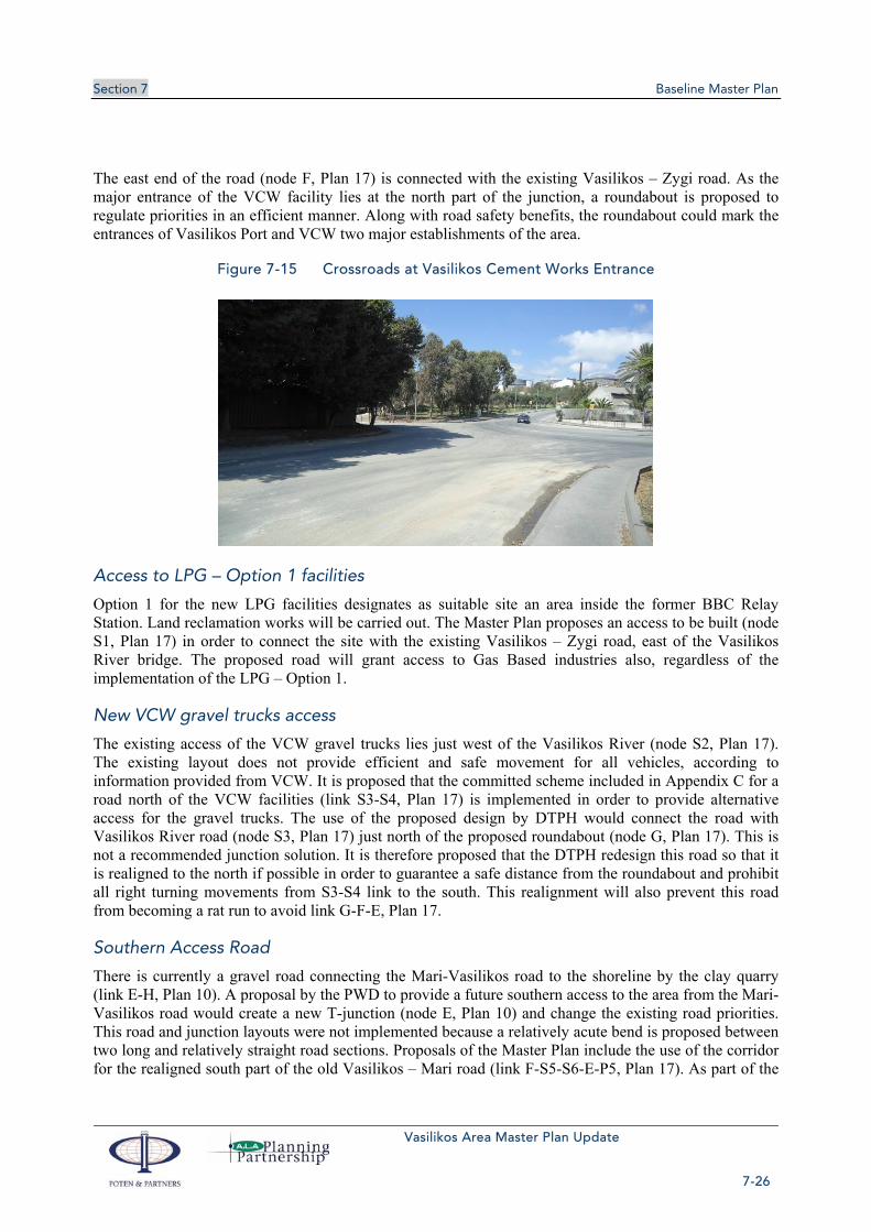
Section 7 Baseline Master Plan
Vasilikos Area Master Plan Update
7-26
The east end of the road (node F, Plan 17) is connected with the existing Vasilikos – Zygi road. As the major entrance of the VCW facility lies at the north part of the junction, a roundabout is proposed to regulate priorities in an efficient manner. Along with road safety benefits, the roundabout could mark the entrances of Vasilikos Port and VCW two major establishments of the area.
Figure 7-15 Crossroads at Vasilikos Cement Works Entrance
Access to LPG – Option 1 facilities
Option 1 for the new LPG facilities designates as suitable site an area inside the former BBC Relay Station. Land reclamation works will be carried out. The Master Plan proposes an access to be built (node S1, Plan 17) in order to connect the site with the existing Vasilikos – Zygi road, east of the Vasilikos River bridge. The proposed road will grant access to Gas Based industries also, regardless of the implementation of the LPG – Option 1.
New VCW gravel trucks access
The existing access of the VCW gravel trucks lies just west of the Vasilikos River (node S2, Plan 17). The existing layout does not provide efficient and safe movement for all vehicles, according to information provided from VCW. It is proposed that the committed scheme included in Appendix C for a road north of the VCW facilities (link S3-S4, Plan 17) is implemented in order to provide alternative access for the gravel trucks. The use of the proposed design by DTPH would connect the road with Vasilikos River road (node S3, Plan 17) just north of the proposed roundabout (node G, Plan 17). This is not a recommended junction solution. It is therefore proposed that the DTPH redesign this road so that it is realigned to the north if possible in order to guarantee a safe distance from the roundabout and prohibit all right turning movements from S3-S4 link to the south. This realignment will also prevent this road from becoming a rat run to avoid link G-F-E, Plan 17.
Southern Access Road
There is currently a gravel road connecting the Mari-Vasilikos road to the shoreline by the clay quarry (link E-H, Plan 10). A proposal by the PWD to provide a future southern access to the area from the Mari-Vasilikos road would create a new T-junction (node E, Plan 10) and change the existing road priorities. This road and junction layouts were not implemented because a relatively acute bend is proposed between two long and relatively straight road sections. Proposals of the Master Plan include the use of the corridor for the realigned south part of the old Vasilikos – Mari road (link F-S5-S6-E-P5, Plan 17). As part of the

Section 7 Baseline Master Plan
Vasilikos Area Master Plan Update
7-27
existing Mari road will be closed (link M-E, Plan 17) it is proposed that the remaining south part of the road realigns to the west to connect with the CPA coastal road near the south LNG Trains facility (node P5, Plan 17). The new road could follow the route of the existing path to Archirodon Port (link E-P5, Plan 17). The existing ground levels at the junction may also create road safety and operational issues, thus extensive earthworks are needed.
Figure 7-16 Existing Condition of Road to Archirodon Port
Vasilikos – Zygi road
Upgrade works to a typical industrial road standard will also be needed for the Vasilikos – Zygi road (link F-G-L, Plan 17). Works should include widening, lighting and construction of efficient at-grade intersections with the proposed Vasilikos River (node G, Plan 17) and new Mari – Zygi road (node L, Plan 17). Additional works will be needed for the widening of the Vasilikos River bridge to the east of the VCW facility.
Figure 7-17 Vasilikos – Zygi Road

Section 7 Baseline Master Plan
Vasilikos Area Master Plan Update
7-28
Oil Storage area access roads
In order to provide sufficient accessibility to the oil storage area, two roads are proposed by the Master Plan (link S5-S8, Plan 17 and link S7-S8-S9, Plan 17). Due to the topography of the area, an important amount of earthworks will be needed. As the development rate of the zone is uncertain, the construction of the roads should be part of the development process.
Public Transport Accessibility
Currently the site is serviced by typical rural bus lines from Larnaka (three routes per day) and Limassol (one route per day). The development of the proposed uses in the area would lead to significant increase of desired trips to and from the area. It is proposed that additional routes are scheduled to and from Larnaka and Limassol. The nature of the developments (storage, industrial, office) secures a typical schedule for the employees of the area that could be served at a great percentage by public transport. Interurban lines from the island’s major cities should also be incorporated in to area’s service schedules.
Signage
Extensive new signage will be required on the road network, both within the study area and on the external network, in order to assist drivers and reinforce the prescribed access route network. External signs directing vehicles to the facilities will be required at A1 Junction 15 (for traffic from the east) and Junction 16 (for traffic from the west). In addition, the Mari-Zygi and the Vasilikos River road junctions with the B1 old Nicosia-Limassol road will require this signage. For traffic within the study area, an internal signage system should be formulated, directing vehicles to the different industrial installations, for instance, the LNG facilities, VCW, power station, industrial port, and so forth. This will ensure that all the major land uses in the area can be accessed easily and efficiently.
Enforcement Measures
Suitable enforcement measures will be required in order to ensure that the prescribed access route network is being adhered by goods vehicles. A variety of measures are available, including lorry bans, weight limits, width restrictions, etc. At this stage, it is proposed that weight limits (of say, 7.5 tonnes) are considered for some of the sensitive minor roads in the area, for instance, the eastern routes towards Zygi. In the future, continuous monitoring should take place, and more severe measures should be adopted if required.
7.9.3 Gas pipelines
Gas pipeline(s) bringing gas to shore for the LNG liquefaction plant and for power generation (early gas) are described in section 5.8. A possible gas export pipeline is described in section 7.6.1.
The first use of natural gas brought to Cyprus will be for power generation at the existing Vasilikos power station. As well as power generation, gas could be used for natural gas vehicles (with compressed natural gas) and larger energy consumers, such as commercial centres and hotels. Once gas is available, its use will be expanded, with 12"-14" diameter pipelines being built initially to take gas to Dhekelia power station via Larnaca and to Moni/Limassol.
The proposed National Gas Pipeline network which is to (at the first stage) transfer natural gas to the three power stations of Vasilikos, Moni and Dhekelia is currently at the FEED stage. The project, however, is on hold until the current Vasilikos Masterplan is completed. The preferred route has been

Section 7 Baseline Master Plan
Vasilikos Area Master Plan Update
7-29
identified by taking into account a anumber of social, environmental and design parameters and by consultation with the communities and relevant Government Departments/Organisations.
Broadly speaking these pipelines will exit the LNG Phase 1 area and then run alongside the old Nicosia-Limassol road northeast to Larnaca/Dhekelia and southwest to Moni/ Limassol. The routing has already been developed by ALA Planning on behalf of the Cyprus Public Natural Gas Company (DEFA, ΔΕΦΑ). The preferred route is shown in Plan 15, Volume 2.
7.9.4 Telecommunications
As already discussed in Section 5 of this Master Plan, CYTA has informed the Project Team that their position is that the network drawings provided are confidential and should not be published. No plans showing the existing or proposed telecommunications network are therefore included in the current Master Plan.
However, CYTA has also requested the construction drawings of any new developments in order to determine how any new development would affect their own telecommunications network.
7.9.5 Water Supply, Desalination, Sewage and Irrigation Utilities
The proposed Water Supply, Desalination, Sewage and Irrigation Utilities are shown in Plan 19, Volume 2. A more detailed description of the proposed utilities networks is presented below.
7.9.5.1 Water Supply and Desalination Utilities
To support the proposed industrial developments in the study area, there will need to be an upgrade of the water supply network. Water will be needed for general industrial and domestic purposes and for fire fighting at the oil storage installations. Although there is a shortage of water for the Island as a whole, priority must be given to essential industry.
The most likely source of additional supply would be the new EAC desalination plant at Vasilikos Power Station. This is completed, but not yet operational until the distribution network is completed. A water distribution study will need to be carried out taking account for the new uses and the potential number of users in the area. The study may indicate the need and the sizing of additional storage tanks.
Borehole water is available in the area north of the A1 Highway, but unlikely to be a practical proposition for industrial supply. Similarly, tapping raw water from the Southern Conveyor is unlikely to be an appropriate solution.
7.9.5.2 Rain & surface waters networks
The existing road and surface waters network are presented in Plan 13, Volume 2. All new infrastructure has to take into account and include into their design a suitable surface water network.
Clean surface water run-off from the study area may continue to drain naturally to the sea, as at present. However, the industrial uses proposed for the area are potentially polluting and surface water run-off from these installations is likely to become contaminated, mainly by hydrocarbons. Suitable treatment facilities will be required to bring this water up to acceptable standards before it can be discharged to the sea in a controlled manner
Section 7 Baseline Master Plan
Vasilikos Area Master Plan Update
7-30
7.9.5.3 Sewage and Irrigation Utilities
As already discussed in Section 5 of the current Master Plan, there is currently no sewage network within the study area. The Water Development Department has stated that no sewage network is being proposed in the area in the near future. Additionally, we have been informed by the Water Development Department that the transfer of recycled and treated water and sludge from the Zygi and Tochni Waste Water Treatment Plant originally proposed for irrigation and composting uses has been postponed. All new developments for the time being will have to construct individual septic tanks and absorption pits which will be emptied regularly by lorry.
Although the study area cannot currently justify the construction of a new foul sewerage network, when fully developed with the uses proposed in the current Master Plan it might be feasible to construct a small waste water treatment plant which will serve the whole area. Subject to the necessary environmental controls, fully treated effluent may be discharged to the sea. However, a relevant study will have to be carried out before such a decision can be made.
No additional Irrigation Utilities are proposed within the study area.
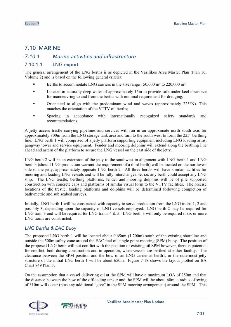
Section 7 Baseline Master Plan
Vasilikos Area Master Plan Update
7-31
7.10 MARINE
7.10.1 Marine activities and infrastructure
7.10.1.1 LNG export
The general arrangement of the LNG berths is as depicted in the Vasilikos Area Master Plan (Plan 16, Volume 2) and is based on the following general criteria:
Berths to accommodate LNG carriers in the size range 150,000 m³ to 220,000 m³;
Located in naturally deep water of approximately 15m to provide safe under keel clearance for manoeuvring to and from the berths with minimal requirement for dredging;
Orientated to align with the predominant wind and waves (approximately 225°N). This matches the orientation of the VTTV oil berths;
Spacing in accordance with internationally recognized safety standards and recommendations.
A jetty access trestle carrying pipelines and services will run in an approximate north south axis for approximately 800m from the LNG storage tank area and turn to the south west to form the 225° berthing line. LNG berth 1 will comprised of a jetty platform supporting equipment including LNG loading arms, gangway tower and service equipment. Fender and mooring dolphins will extend along the berthing line ahead and astern of the platform to secure the LNG vessel on the east side of the jetty.
LNG berth 2 will be an extension of the jetty to the southwest in alignment with LNG berth 1 and LNG berth 3 (should LNG production warrant the requirement of a third berth) will be located on the northwest side of the jetty, approximately opposite LNG berth 2. All three berths will have similar facilities for mooring and loading LNG vessels and will be fully interchangeable, i.e. any berth could accept any LNG ship. The LNG trestle, berthing platforms, fender and mooring dolphins will be of pile supported construction with concrete caps and platforms of similar visual form to the VTTV facilities. The precise locations of the trestle, loading platforms and dolphins will be determined following completion of bathymetric and sub seabed surveys.
Initially, LNG berth 1 will be constructed with capacity to serve production from the LNG trains 1, 2 and possibly 3, depending upon the capacity of LNG vessels employed. LNG berth 2 may be required for LNG train 3 and will be required for LNG trains 4 & 5. LNG berth 3 will only be required if six or more LNG trains are constructed.
LNG Berths & EAC Buoy
The proposed LNG berth 1 will be located about 0.65nm (1,200m) south of the existing shoreline and outside the 500m safety zone around the EAC fuel oil single point mooring (SPM) buoy. The position of the proposed LNG berth will not conflict with the position of existing oil SPM however, there is potential for conflict, both during construction and in operation, when vessels are berthed at either facility. The clearance between the SPM position and the bow of an LNG carrier at berth1, or the outermost jetty structure of the initial LNG berth 1 will be about 650m. Figure 7-18 shows the layout plotted on BA Chart 849 Plan F.
On the assumption that a vessel delivering oil at the SPM will have a maximum LOA of 250m and that the distance between the bow of the offloading tanker and the SPM will be about 60m, a radius of swing of 310m will occur (plus any additional “give” in the SPM mooring arrangement) around the SPM. This
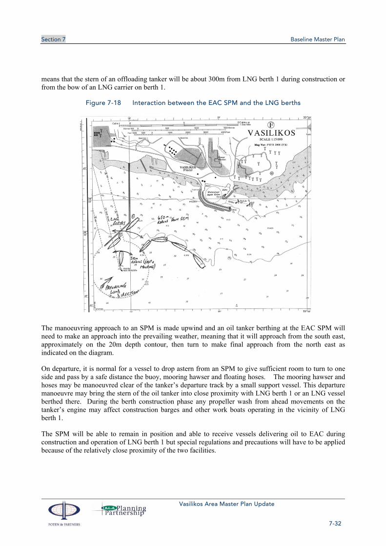
Section 7 Baseline Master Plan
Vasilikos Area Master Plan Update
7-32
means that the stern of an offloading tanker will be about 300m from LNG berth 1 during construction or from the bow of an LNG carrier on berth 1.
Figure 7-18 Interaction between the EAC SPM and the LNG berths
The manoeuvring approach to an SPM is made upwind and an oil tanker berthing at the EAC SPM will need to make an approach into the prevailing weather, meaning that it will approach from the south east, approximately on the 20m depth contour, then turn to make final approach from the north east as indicated on the diagram.
On departure, it is normal for a vessel to drop astern from an SPM to give sufficient room to turn to one side and pass by a safe distance the buoy, mooring hawser and floating hoses. The mooring hawser and hoses may be manoeuvred clear of the tanker’s departure track by a small support vessel. This departure manoeuvre may bring the stern of the oil tanker into close proximity with LNG berth 1 or an LNG vessel berthed there. During the berth construction phase any propeller wash from ahead movements on the tanker’s engine may affect construction barges and other work boats operating in the vicinity of LNG berth 1.
The SPM will be able to remain in position and able to receive vessels delivering oil to EAC during construction and operation of LNG berth 1 but special regulations and precautions will have to be applied because of the relatively close proximity of the two facilities.

Section 7 Baseline Master Plan
Vasilikos Area Master Plan Update
7-33
A number of mitigation measures, including the examples below, will need to be applied and should continue in force as long as the SPM occupies its current position:
In-water construction activities to be suspended and barges moved clear prior to berthing and during unloading of an oil tanker at the SPM;
Tug assistance will be required for escorting the tanker onto the SPM to ensure that it does not encroach on the construction area;
Tug to stand-by at all times whilst tanker is on the SPM;
Pilot/mooring master to remain on board tanker throughout operations;
Mooring hawser to be inspected before each offloading operation and replaced if any wear or external abrasion is noted;
Tanker engines to be on immediate standby and lookout to be placed at bow to provide visual watch on mooring hawser;
Tanker berthing to be suspended when an LNG vessel is at berth 1.
LNG carriers will arrive from time to time in an “inerted” condition (e.g. immediately after dry docking) and will require to take on natural gas to displace the inert gas in their tanks before cooling down in preparation for loading. It is normal for the mixture of inert gas and natural gas that results to be incinerated in a marine flare which is located away from the LNG plant. This flare can also be used as a means of managing excess tank pressures on the LNG carrier if it is not possible or desirable to take return gas back into the plant liquefaction process. A marine flare has been incorporated into the LNG Plant design and will be located offshore, between the LNG berths and the shore on a short trestle structure.
It will not be viable for the SPM to continue in operation during construction or operation of LNG berth 2 or subsequent LNG berths so alternative arrangements for oil supply to EAC’s storage tanks, if still required, will have to be made. See section 7.10.1.3 for additional details.
LNG Berth 1 construction activities will encroach on the “no fishing/no anchoring” area around the SPM and oil pipeline to the shore. For example, construction barge spread moorings may need to be laid within the no anchoring zone during pile driving for the LNG berth mooring and fender dolphins. A full survey of the SPM moorings and pipeline route will be required prior to commencement of any work.
Early Gas Project Pipeline
The early gas project will require a subsea pipeline to bring fuel gas ashore to supply the EAC power station as depicted in the Vasilikos Area Master Plan (Plan 16, Volume 2). The pipeline will be orientated from south to north passing to the east of the EAC cooling water intake culvert and to the west of the EAC sub-sea oil pipeline. The gas pipeline should be trenched offshore to a sufficient depth to avoid potential anchor damage and will make landfall at the extreme south west corner of the boundary between the LNG plant and the EAC power station.
LNG Project Pipeline
The LNG project will require a subsea pipeline corridor to bring feed gas into the LNG plant. The corridor will carry a gas pipeline to feed LNG train 1 and have sufficient capacity to accommodate additional pipelines as required for future expansion LNG trains. The corridor will run in a south-south-east to north-north-west orientation passing approximately midway between the VTTV berths and the

Section 7 Baseline Master Plan
Vasilikos Area Master Plan Update
7-34
LNG berths making landfall on the south east corner of the reclamation area. The pipeline will connect with the LNG plant “Inlet Area” as depicted in the Vasilikos Area Master Plan (Plan 16, Volume 2). All offshore gas pipelines should be trenched to a sufficient depth to avoid potential anchor damage.
7.10.1.2 LPG import
For safety considerations, the proposed LPG berth for discharge of LPG to shore storage within the area covered by the Vasilikos Port Master Plan is best located as shown in the following diagram as a spur off the VTTV jetty. No dredging would be required at this location and the berth could easily accommodate vessels of 100m or more in length. The spur off the VTTV jetty also provides opportunity for installation of an additional oil berth, as shown. This siting maintains the berth within the area in which shipping will be controlled by a port authority or entity, pilots or others having supervision of ship movements. It is clear of fish farms, passing traffic and other external influences.
Figure 7-19 Possible LPG berth locations Best location for safety considerations is a spur off the VTTV jetty ①
It is proposed that the ideal LPG berth be a conventional “alongside” berth having adequate fendering and hard arm connections for the safe transfer of LPG, facilitating emergency shutdown and limitation of any LPG release in the event of an incident. Dredging would not be required.
This proposed arrangement in the area covered by the Vasilikos Port Master Plan would replace an existing offshore multi-buoy mooring and submarine LPG pipeline to shore currently located off Larnaca. Appendix A.2 in the LPG report (Appendix D to this Master Plan report) provides an analysis of other suggested berth locations not discussed in this section and Appendix A.3 provides information on the risks and incidents associated with the use of flexible hoses for LPG transfer.
A range of berth options in the Vasilikos area for the import of LPG have been considered. These are:
An offshore buoy berth ④

Section 7 Baseline Master Plan
Vasilikos Area Master Plan Update
7-35
Use of a common user berth within the port of Vasilikos ⑤
A dedicated LPG berth:
- Off the VTTV trestle ①
- By land reclaimed off the BEMRS site ③, or
- On East Breakwater, outside Vasilikos Port ②
Dedicated LPG Berth
The preferred Vasilikos Master Plan solution has to be for a dedicated LPG berth, ideally connected to the VTTV trestle close to shore ① (or adjacent to any separate LPG facility, ② or ③), which is suitably equipped with fixed loading arms and permanent pipework for the safe and efficient transfer of pressurised LPG.
Using a dedicated berth and fixed arms, equipment can be installed that is intrinsically safe, an effective emergency shutdown system can be installed and the berth is spatially removed from other port users, conflicting port activities and other shipping traffic movements. Fixed LPG transfer arms ensure the highest degree of cargo transfer integrity and minimise the risk of accidental LPG release through the application of permanent “technical defences” (e.g. emergency shutdown valves, powered emergency release couplings, etc).
Although not the cheapest solution, a dedicated LPG berth reduces the overall risk profile to personnel and adjacent equipment/infrastructure by providing the highest level of cargo transfer system integrity and avoids disruption to other port users competing for use of the common user berth.
Having a dedicated LPG berth within the existing development area, sited between the LNG and VTTV oil berths, the transfer of LPG using fixed equipment will have no significant impact or increase in the overall risk contour associated with the proposed Vasilikos Port Master Plan layout.
For safety reasons the Project Team recommends against offloading LPG at the west berth within the Vasilikos Port or via an offshore buoy mooring with flexible hoses (which would be located southeast of the BEMRS site between the 10m and 20m submarine contours).
LPG Berth on Reclaimed Land
A berth adjacent to reclaimed land offshore from the Relay Station ③ can be installed parallel with the eastern edge of the reclaimed land. Some dredging may be required if the reclamation does not extend sufficiently far offshore to provide a water depth of about 9m at the LPG berth.
Using reclaimed land means that the LPG berth can be built integral to the reclamation work such that a very short jetty is required to the loading platform and breasting dolphins. Mooring points can be placed onshore, minimising the marine works required and hence cost as far as possible.
This option would allow installation of fixed loading arms on the berth – discharge arrangements that can be considered the safest means of transferring LPG, incorporating various technical defences to minimise any potential spillage and minimising the risk contour around the ship’s manifold.
An alternative arrangement would be to extend the berth further offshore (substantially reducing the dredging requirements) by building a breakwater out towards deeper water to provide a adequate

Section 7 Baseline Master Plan
Vasilikos Area Master Plan Update
7-36
protection for the berth. This arrangement, shown in the Vasilikos Area Master Plan section below would require a combination of dredging and breakwater construction.
LPG Berth on East, Outside Vasilikos Port
The eastern (seaward) sideof the eastern breakwater of Vasilikos Port ② could be used for as the basis for construction of an LPG berth to provide import facilities for the LPG storage facilities within the Vasilikos Master Plan area. Construction of an unloading platform and breasting dolphins would be required, together with a sufficiently large dredged area to allow manoeuvring of the LPG carrier alongside.
Although adjacent to the Port of Vasilikos, it is considered that LPG operations taking place outside the main harbour basin will not impact dry cargo loading/discharging operations within the port. The eastern breakwater will act as a barrier against the flow of heavier than air LPG vapour into the main port area and the berth location is such that any accidental vapour release will be carried clear of the main port area (and other operations) by the prevailing summer SW’ly or winter NW’ly winds.
The chart section shown below indicates the position of the berth with a representative 100m long LPG vessel alongside.
Figure 7-20 LPG berth option alongside Vasilikos Port Eastern Breakwater
Dredging to approximately 8m should provide adequate water depth for vessel manoeuvring and under keel clearance as vessels will be protected from sea and any swell by the southern breakwater of Vasilikos Port. This berth location has the added benefit of being suitable for the importation of bitumen in addition to LPG.

Section 7 Baseline Master Plan
Vasilikos Area Master Plan Update
7-37
Optimising LPG Berth location
The final selection of location for the LPG berth (whether an alongside berth or offshore sea berth) may be dependent on proximity to tankage, with the intention of minimizing the pipeline distance and complexity of the pipeline route. However, a pipeline from the fixed berth to the LPG tank farm can be equipped with several emergency shutdown valves which can minimise pipeline inventory loss versus a submarine pipeline from an offshore berth.
There are five possible options for the LPG berth – either within the Vasilikos Master Plan area or Vasilikos Port itself using a conventional jetty berth, or an offshore berth to the east of the existing Vasilikos Port, relatively close to the town of Zygi. The pros and cons of each berth option are summarized in the table below:
Table 7-5 Pros and cons of alternative LPG berth locations
Berth Pros Cons
VTTV Jetty Spur Maintained within the Vasilikos Master Plan area.
Subject to shipping controls for whole port area.
Requires VTTV agreement to build and run piping on their trestle.
Expensive construction of piled jetty and unloading platform1.
Lengthy construction period required
Offshore Buoy Berth
Relatively easy to install, well clear of other development activity.
Known technology – similar to existing Larnaca import arrangement.
Subsea facilities and pipeline required.
Very long pipeline run to LPG Storage option 2.
Lesser safety than a fixed installation.
Buoy berth represents a navigational danger to other port users.
NOT RECOMMENDED FOR LPG.
This berth site could, however, be the preferred location for a Methanol export berth.
Vasilikos Port West Berth
Potential use of an existing berth. Multi-user berth and port – Vasilikos Cement Works haS scheduling priority.
Poor mooring arrangements.
Requires use of flexible hoses.
Requires LPG line to be buried to avoid damage from other berth uses.
Conflict between LPG operations and other port activities.
NOT RECOMMENDED FOR LPG.
1 The LPG report in Appendix D discusses the comparative costs of each of the LPG offloading and storage options.

Section 7 Baseline Master Plan
Vasilikos Area Master Plan Update
7-38
Berth Pros Cons
Vasilikos Port Eastern Breakwater
Relatively easy and quick construction of unloading platform, close to breakwater.
Outside Vasilikos Port itself but protected by southern breakwater.
Reasonable distance to all potential LPG Storage locations.
Berth can be a shared facility between LPG and Bitumen imports, reducing the cost to each.
Requires a dredged approach in existing approaches to Vasilikos Port
Jetty off reclaimed land by BEMRS site
Adjacent to LPG Storage option 1B.
Requires extensive dredging and construction of breakwater to provide adequate protection.
Lengthy solution to implement – land reclamation and breakwater construction time
The preference should always be for the berth that offers the greatest safety, security and has the least impact on the community. Placing the berth within the Vasilikos Master Plan development ensures adequate control of shipping and removes the berth from potential conflict with vessels regularly using the small enclosed port of Vasilikos. The Vasilikos Port common user quayside (west berth or VTTV Berth 5) presents a number of scheduling and safety concerns associated with other “uncontrolled” port activities in close proximity to the handling of LPG.
The berth associated with LPG Storage on reclaimed land off the BEMRS site suffers the drawback of requiring both extensive dredging and breakwater construction to provide adequate protection from SW’ly sea and swell.
Installing a buoy berth with flexible hoses and a submarine pipeline to shore, although a workable solution, presents a greater safety risk through the technology used, the exposed nature of the berth (with respect to potential conflict with other shipping and subsequent damage) and its proximity to public access beaches and tourism in Zygi.
A dedicated berth off the VTTV trestle or off the seaward side of the Vasilikos Port eastern breakwater offers the safest and most secure location for the LPG berth from a marine perspective.

Section 7 Baseline Master Plan
Vasilikos Area Master Plan Update
7-39
7.10.1.3 Oil products
Marine loading and unloading facilities have been considered for each of the petroleum products to be stored at Vasilikos. These are:
Fuel oil
Clean oils (white products)
LPG
Bitumen
Each of these products and the respective berth locations is examined below.
In general terms, the VTTV jetty facility will be an import and export facility, the LNG terminal will be an export terminal (see section 7.10.1.1), and small scale oil transfers through the Vasilikos Port West Berth will be imports. LPG imports are considered in section 7.10.1.2 and bunkering in section 7.10.1.5.
The VTTV berths are already under construction and their location is fixed. It is not intended that these be examined in this section.
Fuel Oil
Long term, it will be impractical to continue operation of the SPM and the LNG berths, particularly with future extension of the LNG jetty trestle to accommodate berth 2. The most practical option for fuel oil import is then to bring it in across a fixed jetty and decommission the SPM and subsea pipeline.
Use of one of the VTTV oil berths would be an option but is likely to involve extensive negotiation and requirements for pipeline connections between EAC and the VTTV jetty. A simpler and more efficient solution would be to import fuel oil over the LNG berth as soon as this is completed (which would be considerably in advance of the LNG terminal being ready for LNG export), which would require the installation of fuel oil hard arms (and vapour return) on the LNG jetty head. Fendering arrangements would need to be suitable for the parallel body length of the 80,000 tdwt tankers that normally supply the EAC Power Station via the SPM. However, given the infrequency of future fuel oil imports when the EAC Power Station is operating on gas, the additional costs that would be incurred for fuel oil transfer arms and fuel oil lines to shore make this option uneconomic.
Clean Oil
Clean oil (“white products”) imports will take place using the VTTV jetty berths 1-4, but for small quantities (<10,000mt), import will be over the west berth at Vasilikos Port (designated by VTTV as Berth 5).
Petrolina currently imports cargoes at this berth. The ship’s manifold is connected to underground shore piping via flexible hoses which can be removed when the berth is required for other cargoes.
If necessary, small clean oil imports could take place on either the proposed LPG berth spurred off the VTTV jetty trestle or a separate clean oil berth adjacent to the LPG berth.
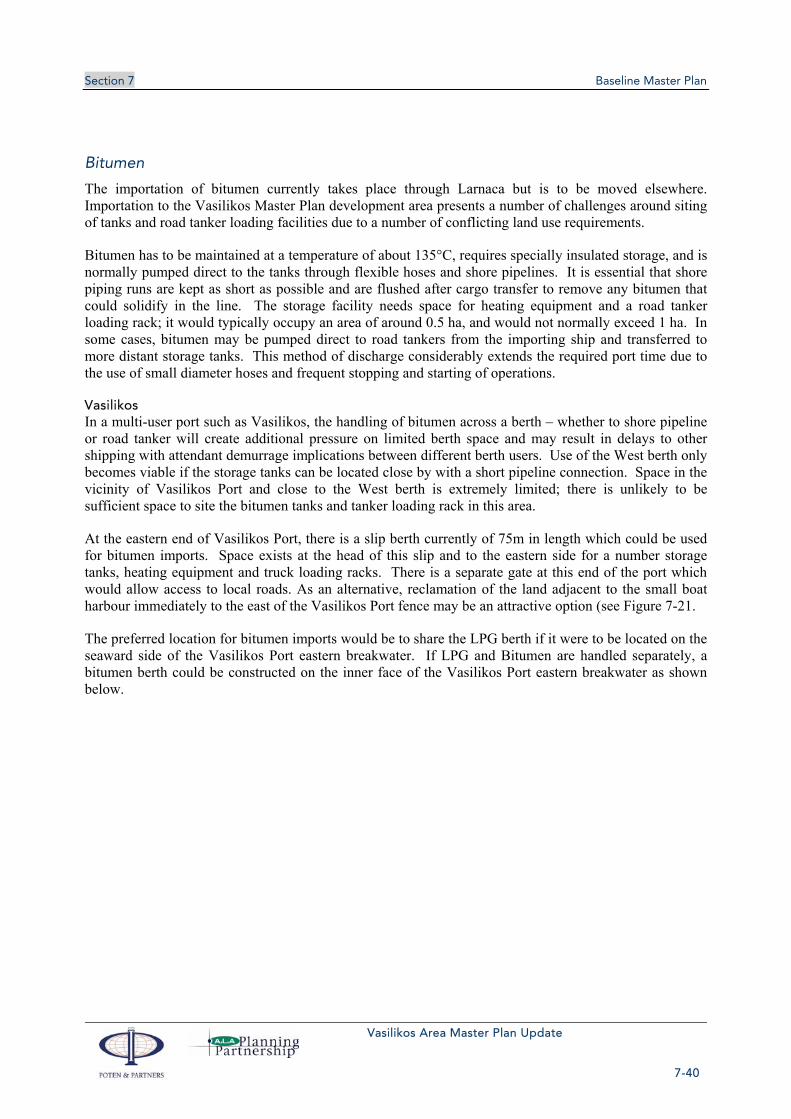
Section 7 Baseline Master Plan
Vasilikos Area Master Plan Update
7-40
Bitumen
The importation of bitumen currently takes place through Larnaca but is to be moved elsewhere. Importation to the Vasilikos Master Plan development area presents a number of challenges around siting of tanks and road tanker loading facilities due to a number of conflicting land use requirements.
Bitumen has to be maintained at a temperature of about 135°C, requires specially insulated storage, and is normally pumped direct to the tanks through flexible hoses and shore pipelines. It is essential that shore piping runs are kept as short as possible and are flushed after cargo transfer to remove any bitumen that could solidify in the line. The storage facility needs space for heating equipment and a road tanker loading rack; it would typically occupy an area of around 0.5 ha, and would not normally exceed 1 ha. In some cases, bitumen may be pumped direct to road tankers from the importing ship and transferred to more distant storage tanks. This method of discharge considerably extends the required port time due to the use of small diameter hoses and frequent stopping and starting of operations.
Vasilikos In a multi-user port such as Vasilikos, the handling of bitumen across a berth – whether to shore pipeline or road tanker will create additional pressure on limited berth space and may result in delays to other shipping with attendant demurrage implications between different berth users. Use of the West berth only becomes viable if the storage tanks can be located close by with a short pipeline connection. Space in the vicinity of Vasilikos Port and close to the West berth is extremely limited; there is unlikely to be sufficient space to site the bitumen tanks and tanker loading rack in this area.
At the eastern end of Vasilikos Port, there is a slip berth currently of 75m in length which could be used for bitumen imports. Space exists at the head of this slip and to the eastern side for a number storage tanks, heating equipment and truck loading racks. There is a separate gate at this end of the port which would allow access to local roads. As an alternative, reclamation of the land adjacent to the small boat harbour immediately to the east of the Vasilikos Port fence may be an attractive option (see Figure 7-21.
The preferred location for bitumen imports would be to share the LPG berth if it were to be located on the seaward side of the Vasilikos Port eastern breakwater. If LPG and Bitumen are handled separately, a bitumen berth could be constructed on the inner face of the Vasilikos Port eastern breakwater as shown below.
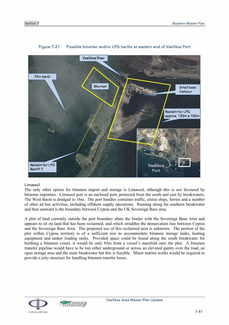
Section 7 Baseline Master Plan
Vasilikos Area Master Plan Update
7-41
Figure 7-21 Possible bitumen and/or LPG berths at eastern end of Vasilikos Port
Limassol The only other option for bitumen import and storage is Limassol, although this is not favoured by bitumen importers. Limassol port is an enclosed port, protected from the south and east by breakwaters. The West Basin is dredged to 16m. The port handles container traffic, cruise ships, ferries and a number of other ad hoc activities, including offshore supply operations. Running along the southern breakwater and then seaward is the boundary between Cyprus and the UK Sovereign Base area.
A plot of land currently outside the port boundary abuts the border with the Sovereign Base Area and appears to sit on land that has been reclaimed, and which straddles the demarcation line between Cyprus and the Sovereign Base Area. The proposed use of this reclaimed area is unknown. The portion of the plot within Cyprus territory is of a sufficient size to accommodate bitumen storage tanks, heating equipment and tanker loading racks. Provided space could be found along the south breakwater for berthing a bitumen vessel, it would be only 85m from a vessel’s manifold onto the plot. A bitumen transfer pipeline would have to be run either underground or across an elevated gantry over the road, an open storage area and the main breakwater but this is feasible. Minor marine works would be required to provide a jetty structure for handling bitumen transfer hoses.
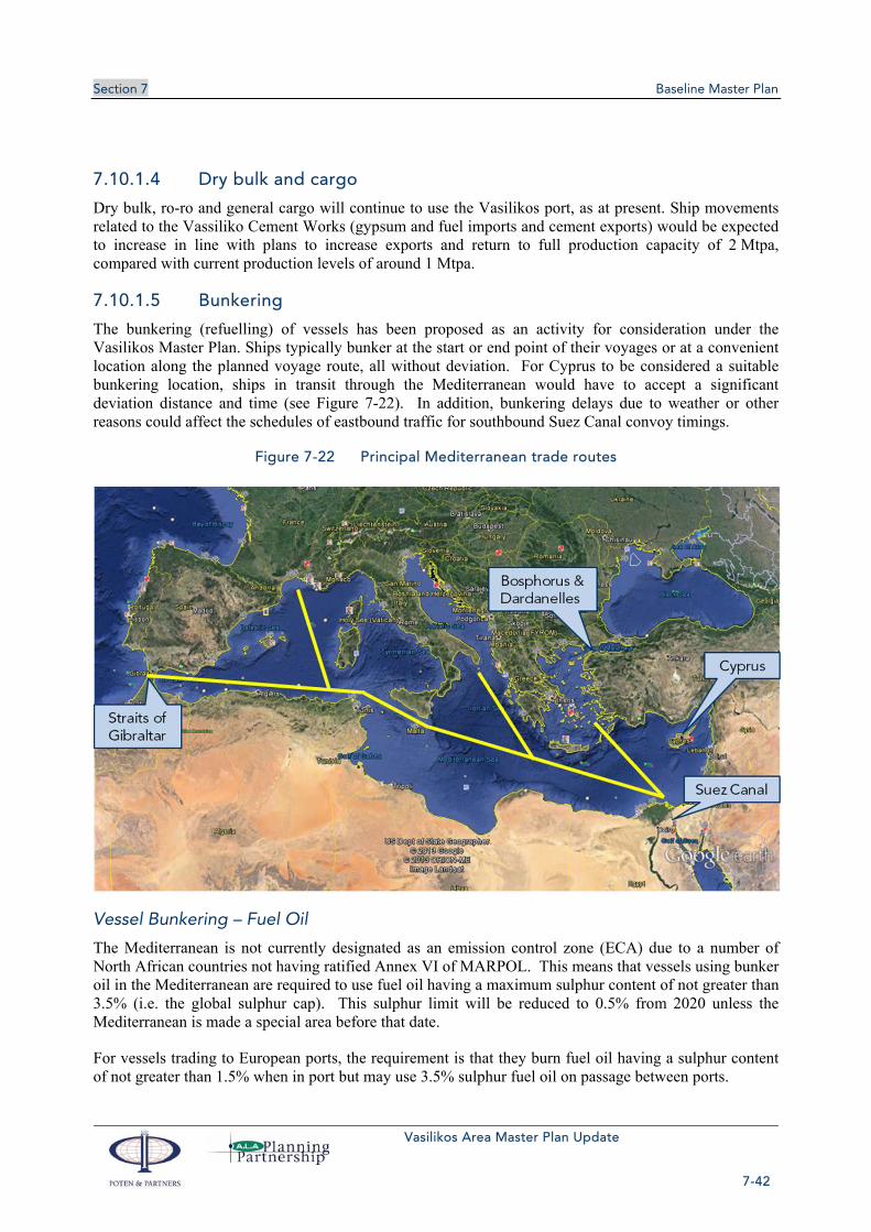
Section 7 Baseline Master Plan
Vasilikos Area Master Plan Update
7-42
7.10.1.4 Dry bulk and cargo
Dry bulk, ro-ro and general cargo will continue to use the Vasilikos port, as at present. Ship movements related to the Vassiliko Cement Works (gypsum and fuel imports and cement exports) would be expected to increase in line with plans to increase exports and return to full production capacity of 2 Mtpa, compared with current production levels of around 1 Mtpa.
7.10.1.5 Bunkering
The bunkering (refuelling) of vessels has been proposed as an activity for consideration under the Vasilikos Master Plan. Ships typically bunker at the start or end point of their voyages or at a convenient location along the planned voyage route, all without deviation. For Cyprus to be considered a suitable bunkering location, ships in transit through the Mediterranean would have to accept a significant deviation distance and time (see Figure 7-22). In addition, bunkering delays due to weather or other reasons could affect the schedules of eastbound traffic for southbound Suez Canal convoy timings.
Figure 7-22 Principal Mediterranean trade routes
Vessel Bunkering – Fuel Oil
The Mediterranean is not currently designated as an emission control zone (ECA) due to a number of North African countries not having ratified Annex VI of MARPOL. This means that vessels using bunker oil in the Mediterranean are required to use fuel oil having a maximum sulphur content of not greater than 3.5% (i.e. the global sulphur cap). This sulphur limit will be reduced to 0.5% from 2020 unless the Mediterranean is made a special area before that date.
For vessels trading to European ports, the requirement is that they burn fuel oil having a sulphur content of not greater than 1.5% when in port but may use 3.5% sulphur fuel oil on passage between ports.

Section 7 Baseline Master Plan
Vasilikos Area Master Plan Update
7-43
For bunkering to be effective, the bunker suppliers need to be able to provide bunkers of not more than 1.5% and 3.5% sulphur content to comply with current requirements. Heavy fuel oil supplies from the Black Sea are likely to have a higher sulphur content and will therefore be unsuitable for bunker use. Bunkering large quantities of low sulphur fuel oil may not be cost effective in Cyprus due to additional shipping, inventory and storage costs.
Vessel Bunkering – LNG
Generally speaking, the use of LNG as a marine propulsion fuel is not sufficiently mature that it is an attractive option for many ship owners, despite environmental benefits and perceived savings in fuel costs.
The cost and complication of converting existing ships will involve installation of LNG fuel tanks, modification or complete replacement of engines, improvement of safety and control systems and probable reduction of cargo carrying capacity. On a volume basis, LNG contains about 0.6 of the energy content of fuel oil which, coupled with the volume of insulation required will, result in LNG fuel tanks requiring about double the space of fuel oil tanks. Therefore conversion of existing ships is likely to be very limited or non-existent. Take-up of LNG fuel options on new builds will take many years before they become a significant part of the world-wide fleet.
The option of LNG bunkering would exist for vessels local to Cyprus or for which Cyprus is at one end of a dedicated trade route.
LNG bunkering could be considered for new build harbour tugs, offshore support vessels and other vessels operating out of the Vasilikos area and other ports within Cyprus capable of being supplied by either a small LNG bunker barge/vessel or by LNG road tanker. Examples of vessels that could be bunkered in this way might be tugs and offshore support vessels operating out of Limassol, ferries, cruise ships and any other vessels capable of using LNG as bunkers. However, such vessels do not exist at this time and there is no indication that they will in the near future. Fuel quantities required for certain vessel types would need to be determined such that facilities could be appropriately sized. Furthermore, the size of any potential “resident” LNG bunker market would need to be considered as it may well be too small to justify the investment required. Recent economic developments appear to have substantially reduced the number of ferry sailings to/from Cyprus to Lebanon, Turkey, Israel, Greece and Egypt. Limassol received 20 ferry/passenger vessels in July 2013 and 7 cruise ships according to CPA statistics.
As yet, there have been no LNG fuel conversions of significantly sized vessels and there are conflicting views on what vessels could be successfully converted, particularly on the issue of LNG fuel tank siting. It is generally accepted that LNG fuel tanks should not be located within or beneath accommodation spaces or within engine rooms. This means that options for most existing vessels are extremely limited and likely to take up valuable deck space. There are unlikely to be many LNG fuelled vessels unless and until LNG tanks are capable of being safely and efficiently integrated in the initial design of new vessels. Recent offshore support vessels have been successfully designed and built with LNG tanks beneath the main cargo deck, but at the loss of volume for internal mud, water and fuel tanks used for cargo purposes.
For LNG bunkering to take place, it will require investment from a local shipping/bunkering company to carry out bunkering operations having been satisfied of the viability of the scheme. It will not be part of the Master Plan other than identification of facilities (or location of suitable facilities) if required.

Section 7 Baseline Master Plan
Vasilikos Area Master Plan Update
7-44
If an LNG bunkering berth is required, it could be built at a later date in (relatively) shallow water on the inshore side of No. 1 LNG berth without affecting other operations or impeding future LNG berth construction.
7.10.1.6 Methanol export
Methanol has been proposed as a potential future export from the Vasilikos area. The potential methanol plant would need the capability for export of produced methanol, which is normally carried on vessels of around 40-45,000tdwt. Although VTTV berths could accept vessels of this size, it is questionable if VTTV would allow loading by a third party over their facilities.
Other options for methanol export are therefore using a berth that would be a southwestward extension of the proposed LPG berth on the VTTV jetty, providing the ability to berth a vessel of about 180m LOA or alternatively a sea berth (multi-buoy mooring) located between Vasilikos Port and Zygi. Such a berth would need to be located about 1nm offshore for adequate water depth for the vessel and to provide sufficient water depth to generate the required elasticity in the mooring system to prevent excessive mooring loads and potential breakout through progressive mooring line failure. The chart section below shows an approximate position for an offshore methanol berth but is limited by the extent of the detailed chart and is thus diagrammatic rather than a specifically recommended location.

Section 7 Baseline Master Plan
Vasilikos Area Master Plan Update
7-45
Figure 7-23 Potential methanol export berth
7.10.1.7 ‘Evangelos Florakis’ Naval Base
The ‘Evangelos Florakis’ naval base is not incompatible with the proposed Master Plan (see section 8). However, authorisation will be required from the Ministry of Defence for the construction of the early gas pipeline (if built) through the restricted area/ exclusion zone.
7.10.2 Vessels using marine terminals
The marine terminals within the Master Plan Area of Vasilikos Bay will be handling a number of different sized vessels which can be summarized in the table below, indicating length overall (LOA) and typical deadweight or volumetric capacity.

Section 7 Baseline Master Plan
Vasilikos Area Master Plan Update
7-46
Table 7-6 Types of vessel using marine terminals within Vasilikos Bay
Terminal Berth Maximum or Typical LOA Typical Capacity or Deadweight
LNG Berth 1 300 m 125,000 – 180,000 m3
LNG Berth 2 300 m 125,000 – 180,000 m3
LNG Berth 3 300 m 125,000 – 180,000 m3
VTTV Berth 1 250 m 50,000 - 160,000 tdwt
VTTV Berth 2 200 m 50,000 – 120,000 tdwt
VTTV Berth 3 150 m 10,000 – 50,000 tdwt
VTTV Berth 4 150 m 10,000 – 50,000 tdwt
VTTV Oil Products Berth 150 m <25,000 tdwt
LPG Berth(s) 100-110 m 4,500 m3/4,600 tdwt
Bitumen Berth 100-110 m 7,000 tdwt
Vasilikos Port (Quay) 100-180 m < 38,000 tdwt
Vasilikos Port Oil (West) 110 m < 10,000 tdwt
7.10.3 Marine terminal capacity and use
7.10.3.1 Vasilikos Port
The Vasilikos port has berths as follows:
One berth with a vertical bulk cargo elevator (identified in this document as berth 1)
One berth with no special facilities (identified in this document as berth 2)
One berth with oil connections and ro-ro ramp (identified in this document as the West berth). This berth is at approximately right angles to berths 1&2.
The short length of quayside in Vasilikos, the restriction of oil only being able to be handled at one berth (also used for Ro-Ro vessels) and the fixed offloading (loading?) structure on one berth for bulk cargoes means that there is little flexibility to absorb significant numbers of additional ships. Equally, the port is dimensionally restricted (length, breadth and draft), which means that it is not possible to import or export significantly greater volumes of cargo before congestion starts to occur.
Berths 1 & 2 have a combined length of 360m but the effective working length of this quay face is reduced to less than 300m after making allowance for spacing between vessels and any vessel that may be on the West berth at the same time.
Berth 1
If we assume that Berth 1 is used for bulk cargoes requiring the use of the bulk cargo elevator, discharge time is estimated to be about 36-42 hours, including moving the ship if necessary. On the basis of 48 hours alongside plus manoeuvring in and out of the port, the maximum berth capacity is estimated to be 182 ships per year.

Section 7 Baseline Master Plan
Vasilikos Area Master Plan Update
7-47
Berth2
Assuming all vessels alongside Berth 2 are general cargo requiring lift on/lift off handling, it is assumed that the ships will also be alongside for 48 hrs, again giving a maximum number of 182 ships per year.
West Berth
The West berth is a multipurpose berth providing roll-on, roll-off facilities, connection to oil pipelines and quayside for lift on/lift off operations. No data is available on the mix of vessels using this berth or the quantities of each type of cargo handled. Assuming one third of ships for each cargo type and assuming 24 hours alongside for tankers and ro-ro vessels and 48 hours alongside for cargo vessels, the maximum berth capacity would be 270 ships/yr (90 tankers @ 24 h, 90 ro-ros @ 24 h and 90 cargo vessels @48 h).
Estimation of Berth Occupancy/Port Capacity
Taking the port as a whole, total capacity may be 634 ships, but this assumes that all berths would operate at around 90% occupancy, which is unrealistic. Using an industry norm of about 40% berth occupancy to avoid queuing, the port capacity drops to 254 ships per annum. The first half of 2013 has seen the terminal operating at slightly above 40% with 136 ships visiting the port (equal to 272 ships in a full year). In practice, constraints on vessel length and increasing pressure on access to required facilities such as oil pipeline connections will impact port usage. The West Berth will come under additional pressure if it is to handle bitumen imports as well as increased VTTV and Petrolina oil imports.
7.10.3.2 VTTV Jetty
As designed, the VTTV jetty has 4 berths, capable of accommodating vessels of different sizes as summarised below.
Table 7-7 VTTV berthing ship sizes
Terminal Berth Maximum or Typical LOA Typical Capacity or Deadweight
VTTV Berth 1 250 m 50,000 - 160,000 tdwt
VTTV Berth 2 200 m 50,000 – 120,000 tdwt
VTTV Berth 3 150 m 10,000 – 50,000 tdwt
VTTV Berth 4 150 m 10,000 – 50,000 tdwt
Maximum or optimal berth occupancy for a multi-user oil terminal is normally taken as 40% after which queuing and consequent demurrage charges can easily accumulate. A 40% berth occupancy rate can also accommodate some occasional weather delays. Without specific detail of the size ranges of ships intending to use the terminal, it is assumed that each berth will be operated at 40% capacity and that each vessel will be alongside for a period of 24 hours. In practice, loading operations can normally be accomplished well within 24 hours; discharge may take 26-27 hours. Nevertheless, 24 hours represents a suitable average berth occupancy time.
At 40% berth occupancy and a planned 24 hours alongside, each berth is capable of taking 365 x 40% = 146 ships per year. Based on four VTTV berths, the total number of ships that can be handled at a 40%

Section 7 Baseline Master Plan
Vasilikos Area Master Plan Update
7-48
berth occupancy rate is therefore 584. VTTV have indicated about 550 intended ship movements per year which is about 37.7% berth occupancy.
Berth occupancy rates of 60% or higher can be achieved if the terminal has control of the shipping and can manage the scheduling of vessels by speeding them up or slowing them down on voyages to the terminal. However, where the terminal operator does not have control over the timing of vessel arrivals, lower berth occupancy rates must prevail.
The addition of a spur off the VTTV trestle for the discharge of LPG and possibly also the handling of petroleum products on smaller vessels will add further berth capacity to the Vasilikos Master Plan area. Based on LPG imports of about 50,000 mt/yr, the LPG berth is likely to be under-utilised (estimated 20 LPG cargoes a year at 2,500 mt/cargo) and could accommodate a further 120 vessels at about 40% berth occupancy. An oil berth on the opposite side of the spur to the LPG berth could accommodate a further 146 ships per year.
The construction of the LPG berth as a spur off the VTTV jetty (and hence the possible petroleum berth as well) will depend on the final choice of LPG berth location as one option is to combine the LPG and bitumen importation berth on the seaward side of Vasilikos Port eastern breakwater.
Based on the above, the VTTV berth arrangement as currently being constructed, and the projected number of ship movements, is at or very close to the theoretical maximum suitable berth occupancy rate for a common user terminal where the terminal operator has no control over the timing of vessel arrivals.
7.10.3.3 Marine activity
Table 7-8 summarises the estimated ship movements and capacity for each marine terminal. The LNG berths 2 & 3will be constructed in tandem with future expansion of the LNG liquefaction capacity. The Vasilikos Port and VTTV jetty berths 1-4 could both be operating close to capacity, so there is little upward flexibility there. The construction of LPG and petroleum berths on a spur off the VTTV jetty offer the potential for significantly expanding petroleum import/export capacity by up to about 270 ship movements per year. An LPG berth off the BEMRS siteor the eastern breakwater of Vasilikos Port, if also used for petroleum imports/exports, could increase capacity by up to 125 ship movements per year.
Table 7-8 Summary of marine activity
Infrastructure Activity Maximum draft
Frequency Capacity*
m ships/y ships/y
LNG berths south of the LNG plant(s)
LNG exports 12 70 ships for 5 Mtpa
180 ships/y †
VTTV jetty berths 1-4 Oil product imports and trading
10-15 550 ships/y About 580 ships/y
Additional berths off VTTV trestle
LPG import option 6-7 20 ships/y About 290 ships/y

Section 7 Baseline Master Plan
Vasilikos Area Master Plan Update
7-49
Infrastructure Activity Maximum draft
Frequency Capacity*
m ships/y ships/y
Possible LPG berth off BEMRS site or eastern breakwater of Vasilikos Port
LPG import option 6-7 20 ships/y About 145 ships/y
Vasilikos Port Dry bulk import and export
8.5 About 200 ships/y
About 250 ships/y
Oil product imports 8.5 No data Included above
Archirodon Port Material Offloading Facility for LNG plant construction
No data No data No data
* Capacity based on 40 % berth occupancy.
† 50 % berth occupancy (close control of shipping arrivals and departures)
Completion of the LNG and VTTV berths within Vasilikos Bay will limit opportunity for further marine development. The western side of the bay in the vicinity of the ‘Evangelos Florakis’ Naval Base is relatively shallow for merchant shipping and any additional berths build in this area would require extensive dredging for sufficient water depth. Expansion to the west could only take place once the Naval Base is relocated elsewhere. Within the main bay, the only option for additional berths is to construct a spur to the southwest off the VTTV trestle – as proposed as an option for an LPG and petroleum berth.
To the east, Vasilikos Port is unsuitable for further expansion, particularly for oil trades, due to draft and length limitations, existing incompatible operations and scheduling which is controlled by Vassiliko Cement Works. The west berth can be used for small tanker operations (< 10,000 tdwt) but is not a dedicated berth for oil operations, being used on occasions for roll-on/roll-off and bulk cargo handling.
To the east of Vasilikos Port, off the BEMRS site, the water is shallow and extensive dredging would be required for any port development, or a very long trestle jetty to extend out into sufficiently deep water. In addition, this area is more exposed to the prevailing south-westerly winds and seas, and berth downtime due to weather may be higher than within Vasilikos Bay, which gets some protection from Cape Dolos. The alternative solution for this area is the installation of sea berths (conventional buoy moorings) with subsea pipelines back to shore, but these will have to be some distance offshore to be in suitable water depth not only for the ship’s draft but also to provide sufficient “elasticity” in the mooring arrangements.
7.10.4 Shipping routes
From a navigational perspective, the approaches to Vasilikos port from offshore (shipping routes to/from Greece and the western Mediterranean, Suez Canal, Israel and Lebanon) are straightforward, with no offlying dangers other than fish farms lying mainly to the west of Vasilikos Bay, and very little passing or crossing coastal traffic. This allows for a direct approach from the south, east and westerly directions to a designated pilot station position which would serve the LNG, VTTV, Vasilikos Port and other berths. The pilot station should be sufficiently far offshore to allow time for an adequate Master/Pilot exchange before proceeding to the berth.

Section 7 Baseline Master Plan
Vasilikos Area Master Plan Update
7-50
Pilots would board about 3 miles offshore in water depths of 100-200 metres and vessels would proceed northwards towards the berths which are located in about 16-20 metres water depth. Tugs would attend vessels about 1.5 miles before the berth. Berthing of vessels will be on a SW/NE’ly axis with the preference (at least for LNG vessels) to be berthed heading in a SW’ly direction. This will require vessels to be turned through about 180° prior to berthing alongside so that they are bow into (facing) the prevailing weather (wind and waves).
Figure 7-24 Approaches to Vasilikos
Cyprus Ports Authority have indicated a preference for two (2) separate pilot stations, one for each facility (LNG and VTTV) but there is no specific or logical requirement for this and is likely to cause confusion for arriving vessels. From a marine traffic control perspective, and bearing in mind the large number of ship movements per annum (approximately 550 for VTTV berths, 200 for Vasilikos port, 70 per LNG train and other ad hoc movements for LPG, Bitumen and possibly Methanol), it is recommended that traffic to each of the terminals be coordinated through a single marine coordinating authority under the control of a single supervising port entity with one Pilot Station. Under such an arrangement, vessel movements can be closely monitored and coordinated to avoid conflict between competing operations and requirements. The coordinating marine authority should be responsible for the preparation of daily berthing and sailing schedules based on factors such as:
Any daylight manoeuvring restrictions
Expected daily wind profile (high freeboard vessels may be preferentially berthed in calm morning conditions)
Berth allocation and availability
Section 7 Baseline Master Plan
Vasilikos Area Master Plan Update
7-51
Cargo availability and handling requirements
With no navigational obstructions for approaching vessels, a precautionary manoeuvring area should be established south of the Pilot Station and vessels called forward for berthing as pilots and tugs are available. Any anchorage area is likely to be in waters to the east of Vasilikos and again has a straightforward approach from seaward which would not require pilotage services.
Consideration will need to be given to the construction of a Port Control Office with port radar and VHF coverage. The Port Control Office should ideally have an elevated view of Vasilikos Bay but could be located in any suitable location between Cape Dolos and the BEMRS site. However, if Pilots are to operate from this facility, it should be located reasonably close to the Pilot Boat berth – currently within Vasilikos Port.
7.10.5 Oil Pollution
Issues involving potential marine oil pollution have not been addressed elsewhere in the Vasilikos Master Plan. However, although tanker design has significantly improved to reduce the possibility of oil spillage through hull damage, the potential still exists for spills to occur during cargo transfer or bunkering operations.
It is assumed that oil pollution prevention equipment is being provided on site by VTTV to a scale appropriate to the volume and types of oils that will be handled through their facilities. In addition, there should be regional stockpiles of equipment that can be rapidly mobilised to tackle any spill. As a last means of defence, oil pollution equipment can be mobilised from an internationally funded stockpile in the UK (Oil Spill Response Ltd). This equipment can be transported from the Southampton, UK base to Cyprus within a matter of hours, using OSRL’s permanently chartered aircraft which are on continuous stand-by. OSRL are normally activated by a national government, a subscribing oil company or by the International Tanker Owners Pollution Federation working in conjunction with a vessel’s Protection and Indemnity (P&I) Club.
The likelihood of oil pollution arising from an LNG tanker incident are remote but nevertheless, all stakeholders operating within the Vasilikos Master Plan area and having dedicated or shared marine facilities should have an arrangement with VTTV for access to oil pollution prevention and clean-up equipment.
7.11 LAND RECLAMATION According to the proposed Master Plan (see Plan 19, Volume 2), land reclamation will take place in the following locations:
1) South of the LNG Plant Area, Phase 1, for the HC Storage, the LNG Storage Area the Sea Water Desalination and Inlet Area facilities.
2) The VTTV reclamation (approx 5.6 hectares) for petroleum storage facilities
3) Reclamation east of the Vasilikos Port for the Bitumen Storage Facilities
4) Reclamation for housing the LPG Facilities (option LPG 1B if selected)
Reclamation works are listed in Annex II of the EIA Law (N.140(I)/2005) and as such require at least a preliminary EIA. Depending on the size of the reclamation and the sensitivity of the area a full EIA may be requested by the Department of Environment.

Section 7 Baseline Master Plan
Vasilikos Area Master Plan Update
7-52
Environmental Impacts caused by the reclamation works will be assessed separately for each of the above reclamations during the EIA procedure and according to the local EIA Laws. However, in general terms the environmental impacts listed in section 6.3.2 are expected.

Vasilikos Area Master Plan Update
8-1
Section 8 Master Plan Summary and Conclusions
8.1 BASELINE The baseline Master Plan is discussed in detail in section 7. All of the planned and proposed facilities can be accommodated in the Vasilikos Area.
8.2 PLANNING SCENARIOS
8.2.1 Relocate naval base
8.2.1.1 ‘Evangelos Florakis’ Naval Base
The “Evangelos Florakis” Naval Base is located on the western boundary of the Vasilikos Master Plan Area, on the shallower side of Vasilikos Bay. Berth construction and offshore facilities will lay to the east of both the restricted area and exclusion zone around this base.
The restricted area is designated as a 500m zone around the end of the southern breakwater of the naval Base and is closed to shipping, fishing and any other activity, including the installation of underwater cables or pipelines. A larger exclusion zone has been designated to the west of the EAC Fuel Oil subsea pipeline running from the EAC SPM to the shore. Shipping movements to the LNG berths will be allowed within this area (with Ministry of Defence approval). It will also be necessary for an early gas pipeline to run northwards through the eastern edge of this exclusion zone.
The location of the Naval Base does not inhibit currently planned developments offshore within the Vasilikos Master Plan Area and the presence of the Naval Base adds to the overall security of the area. However, should further expansion of the Vasilikos Master Plan Area be required in future, the land associated with the Naval Base should be seriously considered and the Naval Base may have to be relocated at that time.
As previously stated, the western side of Vasilikos Bay in the vicinity of the Naval Base is relatively shallow water and for further offshore marine development, extensive dredging is likely to be required.
8.2.1.2 Potential uses for the naval base land
The naval base land could potentially be used for a number of activities, including relocation of the Archirodon Port, which will have to move when construction of the LNG plant begins, LPG or LNG facilities, DC converter station and gas compressor station.
The issue with endeavouring to plan new facilities on the naval base land relates to timing and cost– there is no indication of whether or when the site might become available, and a replacement naval base facility would cost an estimated €100m and take two years to construct.
The options are discussed below.
Archirodon Port
Archirodon Port is a small enclosed port development used by an offshore contractor (Archirodon) for a number of different purposes, including barging in and out of construction materials and maintenance of small craft on behalf of the Cyprus Ports Authority and others. Development of the LNG plant will require the western side of Archirodon Port to be used as a materials offloading facility (MOF) and a

Section 8 Master Plan Summary and Conclusions
Vasilikos Area Master Plan Update
8-2
future location for a marine base for tugs and other associated marine services to support the LNG terminal and VTTV operations. Part of the eastern end of Archirodon Port may be reclaimed.
Archirodon operate on a renewable 6 month lease basis and will require an alternative location where they are able to establish similar activities with good road access.
LPG/LNG
The proximity of the Naval Base to Governor’s Beach makes it unsuitable for siting LPG storage facilities, and it would be made doubly difficult by the need for extensive dredging to accommodate LPG vessels and the associated cost. The other factor against the use of the Naval Base for LPG shipments is that the basin is too small to accommodate vessels of about 100m in length as there is insufficient room for manoeuvring. The timing and need for certainty to implement the government’s policy on moving LPG storage from Larnaca to Vasilikos also mitigate against this option.
There would be some limited scope to locate a single LNG train on the site, but it has no advantage over the proposed LNG zone Phases 1 to 3.
DC converter
The naval base would be a good location for a DC converter station, since there would be ready access both to the Cyprus transmission grid and to the shore for the subsea cable to Israel and/or Crete/Greece (see section 7.8).
Gas compressor station
A gas compressor station to supply gas exports could also be sited on naval base land and would have good access to the shore for a submarine pipeline to Greece. However, it might be difficult to run a gas pipeline to the gas compressor station from the gas receiving facilities owing to congestion along the shoreline in front of the Vasilikos power station.
Summary
The naval base land could be used to accommodate minor facilities such as the DC converter station and gas compressor station. However, any advantages this might offer should be weighed against the significant benefit of greater security from the presence of the naval base close to the planned LNG and oil storage facilities, which are of national importance.
8.2.2 Relocate Mari village
The relocation of Mari village would primarily offer the opportunity to add up to a further two LNG trains in LNG Phase 3, i.e. in addition to the five that could be accommodated in LNG Phases 1 and 2. The land could also be used for gas-based industries once the land allocated in the southeast of the Oil Products Storage and Gas-Based Industries Zone is occupied. However, the location is not ideal given the distance from the coast.
The timing of any requirement for additional space would not be for many years. The first LNG train may not start until 2020, and subsequent trains would also take years to build. However, to keep the option open, it is recommended that the government freeze development in this area by classifying it as a “white zone” (see section 8.3.3) until there is more clarity on the probable hydrocarbon reserves offshore Cyprus. Reserves of lean gas less than approximately 30 Tcf could be processed in the Vasilikos area without

Section 8 Master Plan Summary and Conclusions
Vasilikos Area Master Plan Update
8-3
impacting Mari village (this needs to be confirmed by the QRAs of the individual facilities). A major rich gas find that could form the foundation for a major petrochemical complex would probably require the Mari village area for development.
8.2.3 Rich gas scenario
While it is believed to be a low probability, it is not inconceivable that future gas discoveries may be very different in nature to those already found in the region. If future gas discoveries were rich gas with significant quantities (i.e. around one million tons per year) of natural gas liquids (ethane, propane etc.), then an alternative scenario for gas developments would be feasible. The ethane in particular would be a valuable feedstock for the construction of a steam cracker to convert ethane into ethylene, the primary building block of the petrochemical industry. Ethane would be expensive to export as ethane and this would make it available for use as the foundation of petrochemicals.
If this scenario materialized, then the Master Plan would require a substantial revision. The areas allocated to LNG Phase 2 and 3 would have to be re-allocated to create space for a petrochemical industry. This would require the relocation of Mari village around five to ten years after discovering the rich gas resource. Due to the uncertainties around this Rich Gas Scenario, we cannot plan for this now, but simply highlight this possibility, although the likelihood at this time appears low. However, we believe that sufficient space will exist in the area to accommodate new petrochemical industry were Mari to be relocated.
Section 8 Master Plan Summary and Conclusions
Vasilikos Area Master Plan Update
8-4
8.3 MASTER PLAN FOR THE VASILIKOS AREA The alternative planning scenarios considered offer no significant advantages over the Baseline Master Plan. The final Master Plan is therefore the same as the Baseline.
8.3.1 Master Plan Summary
Priority has been given to allocating space for:
Five 5 Mtpa LNG trains (plants) and their associated power generation units and utilities
Oil storage to meet the requirements identified by the MECIT
Storage of LPG
One world-scale gas based industry such as methanol production
It is also important to ensure that existing businesses in the area, including the Vasilikos power station, Vassiliko Cement Works, Vasilikos Port, VTTV and Petrolina can continue to operate freely.
The main components of the Master Plan are zones dedicated as follows (see Plan 16, Volume 2):
The facilities of EAC Vasilikos power station, Vassiliko Cement Works (VCW), Vasilikos Port, VTTV and Petrolina will remain as they are.
- Note there will be changes over time for VCW in location of clay quarry and space for materials stockpiles.
- Security arrangements will need to be reviewed to ensure full International Ship and Port Facilities Security (ISPS) Code compliance for the marine facilities and appropriate levels of security for onshore strategic oil and other stocks. Those companies operating local haulage (e.g. quarried materials to VCW) and distribution of petroleum products to local markets may need to operate outside the security envelope for strategic storage and operations.
LNG zone comprising:
- Phase 1 LNG – space for up to three 5 Mtpa LNG trains plus storage and utilities and access
- Phase 2 LNG – space for up to two 5 Mtpa LNG trains plus storage and utilities
- Phase 3 LNG – space for additional LNG plants and/or gas-based industries
Oil storage and gas-based industries zone, comprising:
- Phase 1 oil storage – capacity at least 2.2 million m3 of oil products (depends on location of LPG storage) including VTTV and Petrolina storage
- Phase 2 oil storage – capacity at least 1.0 million m3 of oil products (depends on location of LPG storage)
- LPG storage – three options; government to decide based on feasibility relating to timing, land ownership and cost
- Gas-based industries, e.g. methanol and gas compressor station

Section 8 Master Plan Summary and Conclusions
Vasilikos Area Master Plan Update
8-5
A Restricted Development Zone 500m in width around the LNG and oil products storage & gas-based industries zones.
Future quarrying area for Vassiliko Cement Works – the old Mari quarry in the triangle at the apex of the land expropriated for the Vasilikos Energy Centre.
Zones for offices and workshops NW of the Vasilikos power station and in the northern part of the Restricted Development Zone.
The Master Plan also includes provisions for new import and export berths:
LNG jetty and berths
Dedicated LPG berth – five options, of which three are considered practical; final location to be decided and will depend on government’s decision on location of LPG storage facilities.
Bitumen berth – possibly combined with the LPG import berth, dependent on final LPG berth location.
Spur off the VTTV jetty to provide additional oil import capacity
Buoy offshore the BEMRS site (e.g. either for future Methanol exports or for LPG import – there is not sufficient room between the BEMRS site and Zygi for offshore buoy berths for both activities).
8.3.2 Development timeline
The primary development scenario for Vasilikos is shown on the following schedule. This has been developed on the basis of a best estimate of the timing for the various activities.

Section 8 Master Plan Summary and Conclusions
Vasilikos Area Master Plan Update
8-6
Figure 8-1 Vasilikos development timeline
The key dates for this scenario are:
2017 – Early Gas (either by LNG or gas from Aphrodite)
2018 – LPG import terminal in operation
2020/1 – First LNG Production
2021/2 – Second LNG train if based on imported gas from Israel
2024 – Subsequent LNG trains based on further exploration – i.e. 5+ TCF of additional gas discovered by end of 2015
2022 – Gas based industries; earliest date assuming natural gas from Aphrodite field, later if gas from other sources
The LNG plant is assumed to be built initially by the Aphrodite consortium, but the plant is assumed to be designed to allow future additional trains to be built.
Primary Development Scenario
Year 2014 2015 2016 2017 2018 2019 2020 2021 2022 2023 2024 2025 2026 2027 2028 2029 2030
LPG Depot
FEED & Environmental Approval
Construction
LPG Imports
Early Gas Development (if implemented)
FEED & Environmental Approval
Pipeline Laying and Buoy
LNG Delivery
FEED & Environmental Approval
Spar installation & Pipeline from Block 12
Gas Delivery
LNG Train 1 (Assumes Block 12 gas)
FEED & Environmental Approval
Site Development
Construction
LNG Exports
LNG Train 2 (Assumes Israel gas)
FEED & Environmental Approval
Construction
LNG Exports
Later Gas Developments
Seismic Survey (assumed completed 2013)
Seismic Assessment
Exploration Drilling
Appraisal
Pre‐FEED
FEED & Environmental Approval
Site Development
Construction
LNG Exports
Gas Based Industries (assumes sufficient Block 12 gas available)
FEED & Environmental Approval
Construction
Exports

Section 8 Master Plan Summary and Conclusions
Vasilikos Area Master Plan Update
8-7
The development of gas based industries, including LNG exports, is critically dependent on the discovery of additional gas. The Master Plan should be re-visited whenever new information suggests that the above assumptions on future gas discoveries are proven to be incorrect.
The Primary Scenario envisages that the first three trains would be in operation by 2024 (initial production being in 2020/1) and would complete the development of LNG Phase 1. Two additional LNG trains could be accommodated on LNG Phase 2. These would start construction once additional gas discoveries are made. The assumption is that the LNG Phase 2 area would not be needed prior to around 2022 for construction, with first LNG Phase 2 production commencing around 2024. Before this time, the Phase 2 area could continue to be used as a clay quarry by Vassiliko Cement Works and also could be used to stockpile clay excavated from the Phase 1 site.
The Phase 3 site would only be needed if even more gas is discovered – i.e. more than 25 to 30 TCF and prior to 2025. Phase 3 is likely to run several years behind the Phase 2 plan, i.e. the land may not be required prior to around 2025. In the meantime, the Mari village can continue to exist on the land. Unless it becomes clear that the gas discoveries will only be sufficient to utilize the Phase 1 & 2 areas, then additional development in the Mari village should be discouraged. The Phase 3 site could accommodate several more trains but it is likely that the area will become constrained on the marine operations and this will limit how many more trains can eventually be built.
Depending on the pace of gas discoveries, it may be that further gas discoveries would be allocated to backfilling the first five trains rather than building further trains – thereby extending the life of the industry. For gas discovered in say 2030, this could be used for backfilling train 1 once Aphrodite starts to deplete in the late 2030’s. This would not be very much later than the gas could be monetized by building a sixth train. LNG trains beyond five would only be needed if there were very large discoveries of gas well before 2030.
Gas based industries such as methanol and ammonia/urea require only modest quantities of gas for a world-scale plant – approx. 1 Tcf of reserves. The development of one or two of these will not have a major impact on the plans for LNG and therefore on these scenarios suggested. A major gas export pipeline could take more than one LNG train of gas and if developed, this would reduce the need to build LNG plants and reducing the probability that the Phase 3 land will be required.
8.3.3 Proposed planning zones
The existing Planning Zones of the study area are described in Section 4.4.1 of this Master Plan report.
The existing Heavy Industrial Zoning B2 on the coast of Vasilikos is currently the most significant Heavy Industrial Zone in Cyprus (Plan 6, Volume 2). The existing Zone comprises the existing Vasilikos Power Station, the proposed LNG Phase 1 and 2 sites, the Vasilikos Cement Works (VCW), private establishments and undeveloped land for future development.
New Planning Zones for the Study Area are recommended which conform to the recommendations of the current Master Plan. The new recommended Planning Zones are shown in Plan 20, Volume 2. The recommendations of the new planning zones which could be published with the next review of the planning zones due to take place in April 2014 and are shown in Plan 20, Volume 2, are the following:
According to the Cyprus Planning Legislation it is possible to create a “White Zone” which freezes any development until the Government completes its permanent land-use plans for the specific area. Based on this clause of the Planning legislation, it is recommended to

Section 8 Master Plan Summary and Conclusions
Vasilikos Area Master Plan Update
8-8
create a “White Zone” area in the Mari Residential and Animal Husbandry Zones as shown in Plan 20, Volume 2, where development would be frozen until the Government Plans concerning the LNG Phase 3 implementation are finalised.
In terms of the status of this area and the strategic significance of LNG to Cyprus it is recommended that the existing B2 planning zoning boundaries are extended mainly to the east as shown in Plan 20, Volume 2, to cover the needs for the location of gas based and other relevant industries. When the LNG Phase 3 is in place then this heavy industry zone should also be extended to the north in the recommended “White Zone” which includes the existing residential and animal husbandry zones of Mari to cover the needs of LNG Phase 3.
The existing B2* zoning area for offices should be abolished and should be replaced by the new planning zones for offices shown in Plan 20, Volume 2. Three new office zones (B2*) are proposed. One to the south-west of the existing office zone to be abolished, the second one to the north east of the Study Area and the third one in the coastal area of Tochni in the south-eastern end of the proposed Master Plan.
A Restricted Development Zone with a width of 500 m should be established around the boundaries of the proposed Heavy Industry Zone as shown in Plan 20, Volume 2. In this zone only agricultural uses should be permitted except in the northern area shown, where some light industry and small offices may be permitted. If Phase 3 were developed, then this light industry / offices may have to be relocated if the QRA showed an issue.
The Second Home Zone (Π1) of Tochni should be abolished with the next review of the Planning Zones due to the fact that this Zone has not yet been developed, as the land ownership is mainly Turkish Cypriot land and is quite far from Tochni’s Development Zone. Tochni Community Council is in agreement with abolishing this zone.
In addition to the above Planning Zoning recommendations it is also suggested that some modifications are also made in the policies of the written document of the PSC. The existing provisions and policies of the PSC allow the development of single dwelling housing in both the protection and general agriculture zones provided the plots have adequate access. This policy has contributed to the phenomenon of scattered and unsustainable development in many rural areas. It is strongly recommended that this existing single dwelling housing policy is not applied in:
The 500 m Restricted Development Zone described above;
The protection and agricultural areas between the Restricted Development Zone and the main Zygi road to the east of the Study Area;
The remaining administrative area of Mari to the west of the EAC Power Station and to the north of the Evangelos Florakis Naval Base.
The existing policy content of the PSC document which is relevant to the uses which could be located in heavy industry zones should be re-evaluated and re-defined so that it is suitable for the Study Area whilst optimizing the future of the Area in the context of activities conforming with energy and gas industries or associated secondary uses. This is to avoid the major opportunity of establishment or relocations of these uses being hindered by other, non-compatible uses within the zone which would show no synergy.
Section 8 Master Plan Summary and Conclusions
Vasilikos Area Master Plan Update
8-9
The existing planning policy for locating heavy industry as contained in the Development Plan of the study area is as follows:
“The Planning Authority may not allow the location of heavy industry uses falling in the categories of Energy, Metal production and processing, minerals/quarrying, waste treatment, leather production, slaughter houses, nuclear energy production, ship production/repairs, aeronautical industries and mushroom production in a Heavy Industry zone, if it is considered that such industries may be incompatible with other uses existing in the Zone. The Planning Authority may also indicate an alternative site for the location of such industries within the Heavy Industry Zone for environmental/ risk/ safety/ compatibility reasons”.
The above policy should be re-examined and redefined for the Vasilikos Heavy Industry Zone. A special, more site-specific planning policy should be introduced in the relevant Development Plan for the Heavy Industry Zone (B2), as proposed in the Master Plan. This planning policy should include the concept of flexibility contained in the above existing policy, allowing the Planning Authority to make the appropriate decisions and to judge cases on their own merits.
The following planning policy could be considered for the proposed Heavy Industry Zone of the Study Area: “In the case of the Vasilikos Heavy Industry Zone, the Planning Authority may allow the location of heavy industries such as gas, energy, metal production, minerals, chemical industries, recycling, waste producing energy and shipping or any other industries which do not create any compatibility/ environmental/ risk/ safety issues with existing or committed uses such as the LNG Plants.” Such a policy would strongly characterise the prime functions of the area’s planned future growth.
Based on the above recommendations, uses such as slaughter houses and mushroom production units should not be allowed in this Zone. It is therefore recommended that the new B2 Heavy Industry Planning Zone be restricted to the above strategically conforming uses within the study area.
It should be noted that the above recommendations for the planning zones and the PSC policies need further elaboration and refinement. The relevant Planning Authority responsible for the preparation of the Development Plan of the Study Area should examine in greater detail and refine all the above recommendations after the Master Plan is approved. Specific attention should be given to the boundaries of the recommended zones so that during their finalization, they follow plot boundaries wherever possible.

Section 8 Master Plan Summary and Conclusions
Vasilikos Area Master Plan Update
8-10
8.4 CONCLUSIONS & RECOMMENDATIONS
8.4.1 Conclusions
LNG Phase 1 – three 5 Mtpa LNG plants and their associated power generation units and utilities can be accommodated on land expropriated by the Cyprus government for the Vasilikos Energy Centre (VEC) plus land reclamation for gas receiving area and LNG storage tanks.
- LNG jetty berth 1 can handle exports of up to two LNG plants – berth 2 would possibly be required for a third LNG plant and would definitely be required for four operating LNG plants (see LNG Phase 2, below).
LNG Phase 2 – a further two 5 Mtpa LNG plants and their associated power generation units and utilities can be accommodated on land east of Phase 1 occupying a clay quarry used by Vassiliko Cement Works (VCW).
- Consequently, when LNG Phase 2 is built, the Master Plan proposes that VCW sources clay from the Mari quarry, which is in a triangular area in the north (apex) of the VEC area.
- The government may need to expropriate the quarry land to ensure that LNG Phase 2 can be built.
- LNG Phase 2 will not be built until 2025 at the earliest.
The LNG Phase 3 area could be used in the long term for future LNG plants and/or gas-based industries.
- In order to enable future Phase 3 development to take place the government should create a “White Zone” to cover the Mari Residential and Animal Husbandry Zones where development would be frozen until Government plans concerning the LNG Phase 3 implementation are finalised.
LPG storage: The Master Plan offers three options for LPG storage and bottling/ truck loading facilities:
- LPG 1A on land in southwest corner of the present BEMRS site
- LPG 1B on reclaimed land off the BEMRS site
- LPG 2 about 1.6 km inland, north of the cement works
LPG offloading: A dedicated LPG berth will be needed; the optimum location will depend on which LPG storage option is selected.
- The Master Plan evaluated five LPG offloading options and recommends a dedicated LPG berth alongside a spur off the VTTV jetty, alongside the eastern breakwater of the Vasilikos Port (which can be shared jointly with bitumen importation) or, for option LPG 1B only, alongside a new breakwater off reclaimed land off the BEMRS site.

Section 8 Master Plan Summary and Conclusions
Vasilikos Area Master Plan Update
8-11
Hydrocarbon storage and gas-based industries can be accommodated in an inverted V-shape area surrounding the Vassiliko Cement Works.
- Phase 1 oil storage in an area to the west of the cement works aligned N-S, including the existing, under construction and planned storage of VTTV and Petrolina: 95 ha of land could theoretically accommodate storage for over 4.7 million cubic metres of oil products.
- However, part of this area currently provides space for short term storage of materials for the cement works. The Master Plan therefore proposes that corridors of, say, 200m width should be provided between oil storage facilities for storage of materials.
- Locating LPG storage facilities at LPG 2 would reduce the space available for oil products. The reduction in area will depend on the storage design adopted and the results of a QRA. At most, assuming a 600m safety zone would reduce the area available to just under 60ha and possible storage volume – assuming 75% occupancy of the land to permit materials storage in the other 25% – to 2.2 million m3.
- Land within Phase 2 oil storage area would be released later as necessary. Phase 2 area is 45ha, which could theoretically accommodate over 2.2 million cubic metres of oil products.
- However, as with Phase 1, LPG stored at LPG 2 could reduce the area available by up to 18ha, leaving 27ha for hydrocarbon storage and possible storage volume of 1.0 million m3.
- The Master Plan envisages gas-based industries being located initially on the BEMRS site, with possible later expansion to the north towards and possibly into the Phase 2 oil storage area, depending on future developments and priorities.
- The gas-based industry area includes space allocated for one of the LPG options, LPG 1A, and for a possible gas compressor station for gas pipeline exports.
Bitumen storage tanks need to be close to (within 100m) a bitumen berth. Bitumen storage could be located in a small reclaimed area on the east side of Vasilikos Port immediately to the east of the current port fence line, with the bitumen berth (possibly shared with LPG imports) on the seaward side of the eastern breakwater.
- Alternatively, it may also be possible to import bitumen into a facility at Limassol, which could be built adjacent to the Akrotiri Sovereign Base Area provided a berth can be installed or made available on the Limassol Port southern breakwater.
The overhead lines associated with the planned Vasilopotamus substation and DC converter station need to be moved away from the LPG 2 and Phase 1 Oil Storage zone.
- The Master Plan therefore shows the substation and converter station located outside the Restricted Development Zone about 1.3 km NNE of the currently planned location.
There is not enough room to build another jetty in Vasilikos Bay after construction of the LNG jetty without relocation of the “Evangelos Florakis” Naval Base.

Section 8 Master Plan Summary and Conclusions
Vasilikos Area Master Plan Update
8-12
- Additional capacity would come from adding berths to existing port and/or jetty or a buoy offshore from the BEMRS site.
- Any marine berth construction on the western side of Vasilikos Bay (after relocation of the Naval Base) would require extensive dredging and may only be suitable for relatively small shallow draft vessels of up to about 10,000 tdwt.
The exclusion zones round the ‘Evangelos Florakis’ Naval Base do not hinder development provided authorisation is granted by the Ministry of Defence for construction of the early gas pipeline through, and for LNG vessels to manoeuvre in, the outer exclusion zone.
A 2km exclusion zone round the VTTV jetty head is completely unjustified and has no rational basis when compared with other such facilities world-wide. It could be argued that, in future, consideration should be given to creating an exclusion zone or restricted area covering the whole of Vasilikos Bay to keep any passing or unauthorised traffic clear of manoeuvring vessels. This should apply to the whole area rather than be applicable to each separate facility.
The Archirodon port will be needed for use as a Material Offloading Facility during construction of the LNG plants and as a base for harbour tugs and other marine operations craft (mooring boats, oil pollution clean-up vessels, etc.). The Archirodon construction company will need to move to an alternative location.
Extreme care will need to be exercised in the construction of the LNG Berth(s) to ensure that the integrity of the EAC subsea Fuel Oil importation pipeline is not compromised by construction vessel anchors and potential “dropped objects”.
Two fish farms –Telia Aqua Marine Public and Seawave Fisheries farms – need to be relocated as these present the only offshore hazards to navigation for vessels approaching Vasilikos bay from the south and southwest. In their current positions, they will impeded the safe manoeuvring (arrival and departure) of vessels berthing at the VTTV and LNG berths.
8.4.2 Recommendations
The project team makes the following recommendations (numbers in brackets indicate section references in this Master Plan report):
Zoning and development
The Vasilikos area should be dedicated for hydrocarbon based heavy industries and the existing industries.
- Other uses, such as wind turbines, that do not have to be in the area should not be permitted (7.7)
- Consideration should be given to rescinding the permit for the wind turbines on the Energy Centre site west of Mari village. The exclusion zone around these will hinder development in the area and the noise from them when added to the LNG plant may create a nuisance for the residents of the village
The government should adopt the planning zones described in section 8.3.3 and shown in Plans 16 and 20 in Volume 2
- Further elaboration and refinement of planning zones and PSC policies will be required to finalise the Master Plan after the general concepts have been approved.

Section 8 Master Plan Summary and Conclusions
Vasilikos Area Master Plan Update
8-13
- In addition to the industrial zones identified for LNG and oil products and LPG storage, a 500m Restricted Development Zone should be implemented between these zones and the general public, as shown on Plan 16, Volume 2 (6.2.1)
Create a “White Zone” area in the Mari Residential and Animal Husbandry Zones as shown in Plan 20, Volume 2, where development would be frozen until the Government Plans concerning the LNG Phase 3 implementation are finalised (8.3.3)
A detailed topographical survey for the whole Study Area should be carried out – this could be completed by aerial techniques
- The proposed Master Plan contains various recommendations involving the main land uses and road network of the Study Area. As already mentioned the proposed main road network needs to be refined and finalised taking into account existing developments and the topography of the area (contours, rivers etc.). This should be done after the approval of the Master Plan. From information received from the Department of Town Planning and Housing and from the MECIT, the Government intends to acquire some land in the Study Area which is within the proposed “Gas-based Industry Zone” for oil products storage and LPG facilities and to provide opportunities for the location of new gas based industries. In order to proceed with this acquisition the Department of Town Planning and Housing has to prepare detailed drawings of this potential industrial area that will include detailed road layouts giving access to individual industrial plots and also proposals for the creation of open spaces and green areas (about 10-15% of the total area). These open spaces could be located in land areas that are less suitable for industrial use (e.g. rugged terrain).
- The results of the topographical survey will be an absolutely necessary input for the finalisation of the road network design of the whole area and for the creation of industrial plots to be allocated for LPG, oil storage and gas based activities. The plans for the LNG plant also need the input from a detailed topographical survey.
LPG
The government to select location for LPG storage based on its evaluation of the feasibility and possible timing (7.4 and Appendix D)
LPG should be offloaded at a dedicated LPG berth (7.4 and Appendix D)
- The optimum location will depend on the site selected for LPG storage and cost
- The LPG industry should consider the possible benefits of combining an LPG import berth with bitumen – neither of which, because of small imported volumes, can bear the cost of dedicated facilities – or with additional oil import capacity.
Oil storage and other facilities
Major oil storage facilities should be separated by safety zones to avoid a possible domino effect of an incident in one area affecting other facilities (6.2.2, 7.3.6)
- These safety zones could be used for VCW stockpiles (quarried clay, gypsum, etc.) or agriculture, which do not entail a large continuous population

Section 8 Master Plan Summary and Conclusions
Vasilikos Area Master Plan Update
8-14
EAC’s oil tanks should be zoned for oil storage, but should not be used for low flash point products (gasoline) or for operational stocks (7.3.1)
Build spur off the VTTV jetty for LPG and small tankers, although it is recognised that this will be subject to commercial negotiations with VTTV, which will require to make a return on any investment.
- The VTTV jetty occupies the only feasible position in the Vasilikos Area, other than the LNG plant, for a major hydrocarbon jetty.
The planned Vasilopotomos substation and HVDC converter station should be moved from the currently planned site to a location outside the Restricted Development Zone; the incoming 132 kV overhead transmission line should also be rerouted as shown on Plan 18 in Volume 2
A water distribution study should be carried out to take account of new uses and the potential number of users in the area (7.9.5.1)
Marine
The 2 km exclusion zone round the VTTV jetty head should be rescinded to ensure this does not limit marine development or operations within Vasilikos Bay (6.2.4.5)
There should be no fish farms located between Cape Dolos and Zygi (5.13.6.2)
- This will ensure there is no conflict between fish farming activities and shipping movements in and out of the various Vasilikos Master Plan Area terminals.
- The Telia Aqua Marine Public and Seawave Fisheries farms will therefore need to be relocated
Consideration will need to be given to the construction of a Port Control Office with port radar and VHF coverage (7.10.4)
- The Port Control Office should ideally have an elevated view of Vasilikos Bay, but could be located in any suitable location between Cape Dolos and the BEMRS site
- If Pilots are to operate from this facility, it should be located reasonably close to the Pilot Boat berth, which is currently within Vasilikos Port. . The Naval Base would be an ideal location if this became available.
Safety, security & environment
The government should consider using the methodology used by the government of the Netherlands to implement appropriate risk assessment and risk management policies (6.2.2)
- A key element is to move to a risk-based land use planning system; all new hydrocarbon facilities would be required to undertake a Quantitative Risk Assessment as part of the permitting process
A Vasilikos Safety & Security Committee, possibly chaired by Civil Defence, should be formed to coordinate safety and security actions and emergency response and evacuation plans for the Vasilikos area (6.2.5)
- The committee would include representatives from establishments in the area; local communities could have observer status

Section 8 Master Plan Summary and Conclusions
Vasilikos Area Master Plan Update
8-15
For the purposes of the International Ship and Port Facility Security Code (ISPS Code) the whole Vasilikos marine area should be designated as a single port facility in future with strictly controlled access to all jetties and marine facilities
Environmental Impact Assessments undertaken for new installations in the Vasilikos area should recognise the impact against a base level of emissions, noise, etc. associated with at least three LNG trains (LNG Phase 1)