Embed Size (px)
Citation preview

MASTER PLAN AND PHASE ONECONCEPTUAL DESIGN CONCEPT
FOR THE
THE PARK OF EAST TEXAS FAIRGROUNDSIN TYLER, TEXAS
VOLUME ONEMASTER PLAN AND PHASE ONE NARRATIVE

Credits
Project Introduction Document Overview
I. Site Proximity Site Analysis Site Context/ Surrounding Uses
II. Master Planning Analysis Objectives Components
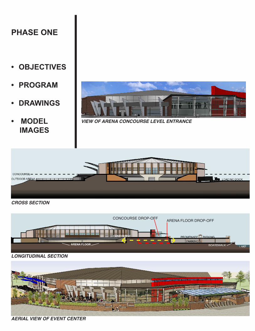
III. Phase One Phase One objectives Phase One facilities program Phase One area requirements Phase One drawings Model Images
IV. Phase One Cost Analysis ( VOL. II ) Site development and construction cost
CONTENTS

Thank you to the following for your participation and fact gathering phase allowing this project to be responsive to the future of Tyler and the East Texas region in terms of growth needs and economy.
Park of East Texas Executive Committee• DickSummers,Chairman• HaroldBeaird,ViceChairman• PrestonSmith,PastChairman• C.C.Baker,Jr.• TedConover• RandyRoberts• GillianBrasfield• KennethLewis• ArtTaucher• HerbertBuie• FelicityReedy• LonnyUzzell• JohnSykes,President&CEOofTheParkofEastTexas
Park of East Texas Design Committee• NathanMims• FrancisKay• GeneShull• TerryBrannon• TomMullins• DerekWatson• SamMezayek• FelicityReedy
Design Input Contributors City of Tyler• BarbaraBass…Mayor,Tyler• MarkMcDaniel…CityManager,Tyler• ScottWall…AssistantCityManager,Tyler• MartinHeines….CityCouncil,Tyler• SamMezayek…CityCouncil,Tyler• CarterDelleney…CityEngineeringDepartment,Tyler• BarbaraHolly…CityPlanning&Zoning,Tyler• GregMorgan…CityWaterUtilities,Tyler• StephanieRollings…CityPark&Recreation,Tyler• MichaelWilson…CityDevelopmentServices,Tyler
CREDITS

CREDITS
Smith County • HonorableJudgeJoelBaker….SmithCounty• JoAnnHampton…SmithCountyCommissionersCourt• JeffWarr….SmithCountyCommissionersCourt• TomMullins….TEDC
Higher Education• Dr.Mabry…UTTyler,President• GreggLassen…UTTyler,VicePresidentofBusinessAffairs• Dr.Fennell…TexasCollege,President• Dr.Metke…TJC,President• AubreySharpe…TJCDeanofContributingStudies• Dr.JohnnyMoore….TJCVicePresidentofStudentAffairs Public Schools• RandyReid….Superintendent,TISD
Private Schools• RandalEBrown….Headmaster,AllSaints,Tyler• JimFranz….Principal,T.K.Gorman• JayFerguson…HeadmasterGraceCommunitySchools,Tyler• RodFletcher…Headmaster,TheBrookHillSchoolArts and Education• MichaelShanklin…ExecutiveDirector,DiscoveryScience• HayesCaldwell…ExecutiveDirector,CaldwellZoo• KimTomio…ExecutiveDirector,TylerMuseumofArt• NancyWrenn...ExecutiveDirector,EastTexasSymphony
Orchestra
Chamber of Commerce• HenryBell…ChiefOperatingOfficer,ChamberofCommerce, Tyler• ShariRickman….VicePresident,Convention&Visitors Bureau,Tyler• ShelbieGlover…ExecutiveAssistant,ChamberofCommerce, Lindale
Tyler Morning Telegraph• DaveBerry…ManagingEditor,TylerMorningTelegraph• DannyMogle…AssistantManagingEditor,TylerMorning Telegraph• RoyMaynard…Editor,TylerMorningTelegraph• ChadThomas….BusinessEditor,TylerMorningTelegraph
Religious Community• VeryReverendAnthonyMcLaughlin…ImmaculateConception (Representative…TeriBoltonadministrativeassistant)

CREDITS
Consultants• M.E.PConsultants Estes McClure
• CivilEngineeringConsultants…TheBrannonCorporation TerryBrannon,PE BobBreedlove,PE ReaBoudreaux,PE • StructuralConsultants JohnHolland,HollandEngineering
• PlanningConsultants PlanningConcepts,MarkPreistner
Architects• EquestrianArchitecturalConsultants GH2Architects Lachlan Oldaker StanleyW.Gralla, JimLKudrna, Michael R. Hall KellySchomer KalaAde • RonMabryAssociatesArchitects Ron Mabry Myranda Diduch CharlesKellogg BillyBartush Heath Aggen Laura Fate ToniWallis JoyceCrawford

INTRODUCTIONproject introductiondocument overview
TheParkofEastTexas,Inc(POET)isthere-brandedcompanyoftheEastTexasStateFairAssociation,locatedinTyler,Texas.InJuneof2005,TheParkofEastTexasacquiredapproximately240acres,1milewestofLoop323betweenstatehighways31and64.
The intention of the land acquisition is to create a year rounddestinationcampusforentertainment,recreation,equestrianoperations,conventionandexhibitspace,andtorelocatethe97yearoldannualfallevent,TheEastTexas State Fair.
InMayof2010RonMabryandAssociatesArchitectsofTyler,TexasandGH2EquestrianArchitects,TulsaandNorman,OklahomawereselectedbytheParkofEastTexas to provide planning and design study services for the240acreMasterPlanwithemphasisonamultiuseevent center and equestrian complex.
Multi-use events such as graduations, concert venues, rodeos, dressage, sporting tournaments, outdoor events, East Texas State Fair, conventions,
farmer’s market, car and boat shows, etc.

The results of those planning and design studies are in-cluded in the following documents:
1. Proximityandsiteanalysisofthe240acresiteidentifyingsitespecificstrengthsandweaknessesandcorrelationtotheCityofTyler,TexasandtheEastTexasregion.2. AMasterPlanidentifyingmajorsitedevelopmentcomponents,siteaccessibility,onsitevehicularandpe-destriancirculation,greenspace,andPhaseIinfrastruc-ture requirements.3. PhaseIfacilitydesignprogram,designdocumentsand design illustrations. 4. ConceptualPhaseIsitedevelopmentandconstruc-tioncostanalysis(VolumeII)
SITEANALYSIS
MASTER PLANNING
PHASE IDESIGN
COSTANALYSIS
1 2 3 4
• DOCUMENT OVERVIEW

• PROXIMITY
• SITE ANALYSIS
• CONTEXT
Location
The approximate 240 acre site is locatedwithin the citylimitsofTyler,TexasonemilewestofLoop323,andisbor-deredbystatehighway64tothenorthandstatehighway31tothesouthandPattonLanetothewest.
PropertyusessurroundingthesiteareamixofR1A-singlefamilyresidential,PCD–plannedcommunity
development,M1–business.
The240acreparcelsiteitselfiscurrentlyzonedR1A.
PATT
ON
LA
NE
HWY. 64
HWY. 31
I. SITE ANALYSIS
SITE MAP
ZONING MAP
LOO
P 32
3
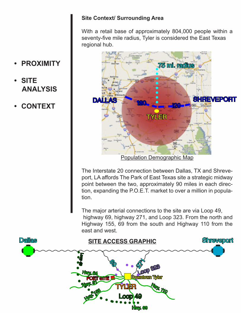
Site Context/ Surrounding Area
Witha retail baseofapproximately804,000peoplewithinaseventy-fivemileradius,TylerisconsideredtheEastTexasregional hub.
Population Demographic Map
TheInterstate20connectionbetweenDallas,TXandShreve-port,LAaffordsTheParkofEastTexassiteastrategicmidwaypointbetweenthetwo,approximately90milesineachdirec-tion,expandingtheP.O.E.T.markettooveramillioninpopula-tion.
ThemajorarterialconnectionstothesiteareviaLoop49,highway69,highway271,andLoop323.FromthenorthandHighway155, 69 from the southandHighway110 from theeast and west.
75 mi. radius• PROXIMITY
• SITE ANALYSIS
• CONTEXT
Dallas Shreveport
271 69
Loop 49
Downtown TylerPOET SITELoop 323
Hwy. 64
Hwy. 31
DALLAS SHREVEPORT
SITE ACCESS GRAPHIC
TYLER
I20 I20
Hwy. 110
Hwy. 155
Hwy. 69
TYLER
Loop 49

The site location is convenient to other local attractions such as Caldwell Zoo, Tyler Rose Garden, downtownrestaurants, galleries,museums,TheDiscovery SciencePlace,newlyrelocatedEastTexasSymphonyOrchestra,TylerMuseumofArt,TylerJuniorCollege,TexasCollege,and U.T. Tyler.
TheHighway31and64arteries thatborderTheParkofEast Texas converge on downtown Tyler and offer oppor-tunitiesforthedevelopmentofaneast-westattractiondes-tination link with The Park of East Texas as a west anchor
and downtown Tyler as the east anchor.
N O R T H
• PROXIMITY
• SITE ANALYSIS
• CONTEXT
OTHER ATTRACTIONS
PROPOSED HWY 64 & 31 DESTINATION COORIDOR
ATTRACTIONS MAP
1. The Park of East Texas2. Tyler Caldwell Zoo3. Multi Modal Facility4. Tyler Museum and Arts District5. Tyler Rose Garden Complex6. East Texas Symphony Orchestra7. Tyler Junior College8. Discovery Science Place9. Texas College10. University of Texas at Tyler11. Tyler Museum of Art12. Existing East Texas State Fair
DESTINATIONCORRIDOR

Other site location assets nearby are the new Tyler Pounds RegionalAirportTerminal located onHighway 64, theRe-gional Equestrian and Pedestrian Trails Master Plan, theCity ofTylerParks andTrailsMasterPlan, both tying intothe P.O.E.T. site. Plans for a light intercity rail system with connections to Lindsey Park, Downtown Tyler and to theTyler hospital district also offer nearby connection opportu-nities. Withinapproximatelyeightminutestravel timefromthesiteviashuttlearethreelargeparkingaccommodations,theoldTylerPoundsfieldterminalparking,existingstatefairgrounds parking and midway and Tyler Economic Develop-ment Campus parking offer remote parking options.
N O R T H
• PROXIMITY
• SITE ANALYSIS
• CONTEXT
REMOTE PARKING LOCATION OPTIONSREMOTE PARKING

The P.O.E.T site itself is a testimonial to the major assets andattractionsofEastTexas,withitsnaturalbeautyandlandscape. The rolling hills, elevation changes of up toseventyfeet,maturehardwoodsandpinetreestands,andwetlands areas offers a variety of microclimates within its borders.
N O R T H
1:100 Topography Model of the Site
• PROXIMITY
• SITE ANALYSIS
• CONTEXT
HPHP
HP
HPHP
HP
SITE PHOTOGRAPH SITE PHOTOGRAPH
LOW LA
ND AREAS

• PROXIMITY
• SITE ANALYSIS
• CONTEXT
Site Access
Fivesignificantaccesspointsarenaturallyplacedalongthe perimeter of the site. A west access point is located off PattonLane,whichwillbewideningtoafourlanebou-levard in the future. Two southern access points lie on ChandlerHighway,attractingtrafficfromLoop49,I20andLoop323.AnorthaccesspointplacedonHighway64createsanelongatedentrance,thiscorridorattractstraf-ficfromtheairport,Loop49,I20andLoop323.Aneastsmaller access point is placed on Suel Drive for the use of emergency vehicles and special egress services.
Topography
Generalsitetopographyconsistsofundulatingslopesfrom the notched perimeter of the site. There are six ma-jor high points on the site; the majority of them cluster towardstheeastsideofthesite,formingaridgeline.ThelandadjacenttoPattonLaneisaflat,clearedareawhichslopes to the low area outside of the site boundaries. A low area slopes towards the south and runs through the middle of the site. A microclimatic area diverges from the middle of the site that could most likely be designated asawet-land.Thesiteispredominatelydeciduouswithsparse evergreen and a mixed vegetation.
VIEWS

• PROXIMITY
• SITE ANALYSIS
• CONTEXT
SiteConfiguration
TheParkofEastTexassitehasanirregular,notchedpe-rimeter with a cell tower located in the approximate south east corner of the site. A major overhead power transmis-sion line and easement runs east and west through the site. This easement is located close to the boundary of the site.
Site Utilities
Water,sanitarysewer,gasandelectricalserviceareavail-ableatcloseproximitytothesite;however,someoff-siteinfrastructure improvements will be required.
TOPOGRAPHY, VEGETATION, DRAINAGE AND SOLAR
power lines
cell tower

The results of the site analysis exhibits a notable separa-tion of “active” and “passive” environments and micro cli-mates offering an understanding of “best use” type location within the site itself. This abstract axis dividing passive andactiveareasactsasatransitionzonetobeconsideredin the master planning of the site.
Theplanningconceptfocusesontheexistingnaturalnorth-south axis that delineates the separation of passive and
active site climates.
II. MASTER PLAN
• ANALYSIS
• OBJECTIVES
• COMPONENTS
SITE USE
TRANSMISSIONLINE

• ANALYSIS
• OBJECTIVES
• COMPONENTS
Duringthisprocessofdevelopingthisdocument,generalobjectivesforTheParkofEastTexasweredefinedTheseobjectives are:
• Defineacomplexthatutilizestheavailablesiteinafunc-tionally effective and aesthetically pleasing manner.
• Defineacomplexthatcanserveasamulti-functionaleventvenue,accommodatinglocalaswellasregionaleventsforTyler,Texas,itscommunitiesandthe surroundingmulti-stateregion.
• Defineamasterplanthatwouldincorporatetheannualoperation of the The East Texas State Fair.
• DefineacomplexthatcanhelpestablishTyler,Texasasan event destination.
• DefineacomplexthatwilladdtothequalityoflifeandcontributetotheeconomicdevelopmentofTyler,Texas,its communities and the surrounding area.
• Defineacampusthatwillhosta352daymenuofevent,recreational and educational opportunities.
• Defineamasterplantoaccommodateshortrangeandlong range phasing.
The primary components of Phase One and future master plan are as follows:

Major Project Facilities
The Phase One master plan components 1.MainArena 2.Conference/ExhibitArea 3. Covered Arena 4.OutdoorArena 5.Barns 6.Promenade 7.GeneralParkingandOn-SiteRoadways 8.Other(RV/TrailerPedestals)
(AfterPhaseOnecompletion)
Conceptual Master Plan Components 1.PromenadeCompletion 2.PedestrianandEquestriantrails 3. RV Park 4.Exhibit 5.Hotel 6.ParkingStructureoffHWY64. 7. Arboretum 8.Amphitheater 9. Academic Area 10.VisitorCenter 11.RecreationalAreas
• ANALYSIS
• OBJECTIVES
• COMPONENTS

12
34
5
6
7 8
10
9
(1)P
haseOne
Multi-UseArena
O
utdo
or A
rena
Warm-U
pArenas
P
ract
ice
Cov
ered
Are
na
StallBarns
(2)
Promenade/Parking
(3)
RVPark
(4)
Exhibit
(5)
Hotel
(6)
Parking
(7)
Arboretum
(8)
Amphitheater
(9)
Academic
(10)
VisitorC
enter
(11)
Trails
north-southpublic
vehiculartraffic
ou
ter l
oop
publ
ic
vehiculartraffic
ve
ndor
circ
ulat
ion
an
d se
rvic
es
si
te a
cces
s po
ints
Mas
ter P
lan
11

Promenade
Thenorth-southaxisandthenaturalsitegradesidentifiedinthesiteanalysisareutilizedincreatingacurvilinearnorth–southcorridorforvehiculartrafficcirculationandsiteac-cess,anda300’wide1200’longpedestrianpromenadethatisanchoredatthesouthbythemulti-eventcenterandequestriancomplexandatthenorthbyexhibitionfacilities,hotel,performancecenter.
The duel-use of vehicular traffic and pedestrian prome-nade along the same axis is separated by using the natural gradesanddesigningahorizontalseparationbetweenthetwo.
PRELIMINARYSKETCHES
• ANALYSIS
• OBJECTIVES
• COMPONENTS
PROMENADE
SECTION
PARKING TRAFFIC
EXISTING NATURAL GRADE

Theexchangeofvehicularandpedestrianflowisaccom-plished by vertical circulation at strategic locations along the upper level promenade and lower level parking and service areas. This stacking concept reduces the required constructionfootprintbyone-halfthusreducingthedevelopmentimpacttothesite,andplacingvisitorparkinga closer proximity to events.
Thispromenadeandcirculationcorridor,identifiespassiveandactiveboundarieswiththemulti-eventcenter,eques-triancomplex,exhibitfacilityandhoteltothewest,transi-tions by a boardwalk that leads to lakes,wetlands, na-turearea,trailsandhiking,arboretum,academiccampus,visitor’scenterandrecreationalareasandamphitheatertothe east. The stacked parking/ promenade concept with a transitional boardwalk separates pedestrian and vehicular trafficleavingapproximately204acresdedicatedforunin-terrupted pedestrian use.
• ANALYSIS
• OBJECTIVES
• COMPONENTS
Lowerparkingandlowerlevelvehicularcirculation(yellow)
Upper level pedestrian circulation and Phase I promenade and parking
N O R T H
N O R T H
north-southtrafficcirculation
and parking
ACTIVE
PASSIVE
boardwalk
ACTIVE
PASSIVE
boardwalk

Lakes, recreation and wet-land nature areas will be connected by 4.5 miles ofpedestrian and 4.2 miles ofequestrian trails. The natural terrain of elevation changes will offer opportunities for a variety of cross country, cy-cling and running events. The trails system will also tie into the regional trails and the city of Tyler parks and trails mas-terplan,extendingpedestriantrails into downtown Tyler.
• ANALYSIS
• OBJECTIVES
• COMPONENTS

The natural terrain of the site is also used as a visual and sound buffer to adjacent residential areas.
The Master plan will offer three primary site access points forthepublic,oneforvendorandservicetraffic,andonefor emergency and egress service. Improvements to Hwy 31 and Patton Lane include the addition of accelerationanddecelerationlanes,thewideningofPattonLanetoafour-laneboulevardandthecoordinatedvisitor,vendorcir-culation and car stacking space at site access points mini-mizing traffic congestion.ThecornerofHighway31andPatton Lane will also be improved with turning lanes and trafficcontroldevices.
• ANALYSIS
• OBJECTIVES
• COMPONENTS
RESIDENTIAL PROPERTY LINE P.O.E.T
SITE LINES

P.O.E.T. - PHASE ONE
PHASE I

PhaseOneof theP.O.E.TDevelopment includestheon-site and off-site infrastructure requirements, a multi-useevent center with separate conference and banquet ac-
commodations and the equestrian park complex.
III. PHASE ONE
• OBJECTIVES
• PROGRAM
• DRAWINGS
• MODEL IMAGES
**Colored Area inside site boundaries indicates Phase One
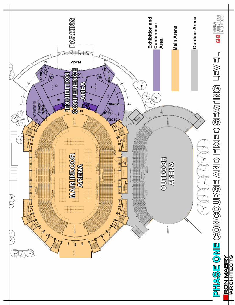
PHASE I SITE PLAN
EQUESTRIANCOMPLEX
EVENT CENTER
PARKING &PROMENADE
LAKE

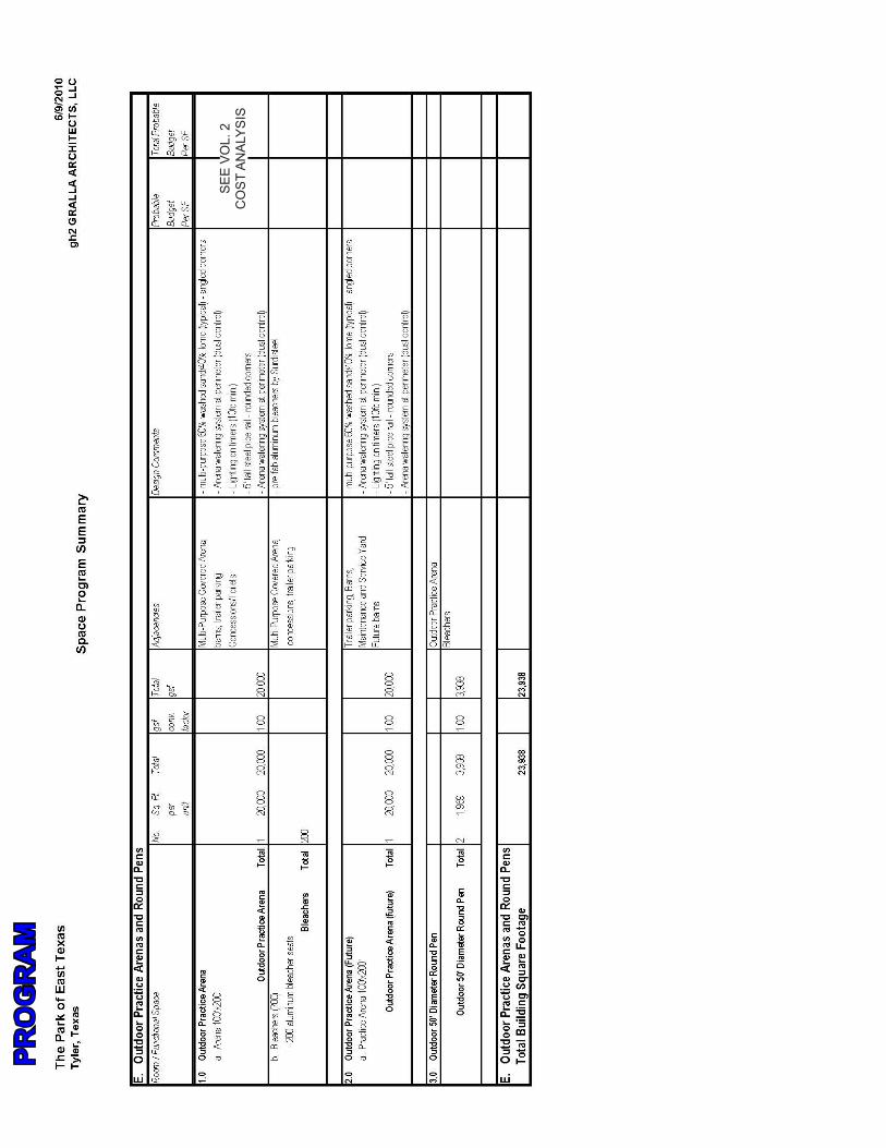
RonMabryArchitectsandGH2GrallaEquestrianArchi-tectsdefinedtheoutlineprogramofthespacesrequiredto develop Phase One of The Park of East Texas Fair-groundsinTyler,Texas.Thebuildingareasincludedintheprogram are based on previous experience with compa-rablefacilities,theaccumulated“needs”inputfromTheParkofEastTexas,probableusergroups,surroundingbusinesses,theeducationalcommunity,andthespecificphysical demands of the site.
Theprogramisaprimarilyquantitativedocumentdefin-ing the amount of plan area required to accommodate the definedfunctionalneeds.Thequantitiesarelistedasboth“net” and “gross” areas. The “net” areas include the spe-cificquantityofspacerequiredtohandleagivenfunctionoractivity.“Gross”areaincludedtheadditionalquantityof space required to assemble the “net” areas into a fully functionalbuilding:connectingcirculationandstairs,el-evatorshafts,buildingsupportsystems(e.g.HVACchas-es),wallthicknesses,etc.
• OBJECTIVES
• PROGRAM
• DRAWINGS
• MODEL IMAGES
PHASE ONE
SEEVOL.2
COSTANALYSIS
PRO
GR
AM

SEEVOL.2
COSTANALYSIS
SEEVOL.2
COSTANALYSIS
(4500)
PRO
GR
AM

PRO
GR
AM

SEEVOL.2
COSTANALYSIS
PRO
GR
AM
SEEVOL.2
COSTANALYSIS
PRO
GR
AM

SEEVOL.2
COSTANALYSIS
PRO
GR
AM
SEEVOL.2
COSTANALYSIS
PRO
GR
AM

SEEVOL.2
COSTANALYSIS
PRO
GR
AM

SEEVOL.2
COSTANALYSIS
PRO
GR
AM

SEEVOL.2
COSTANALYSIS
SEEVOL.2
COSTANALYSIS
PRO
GR
AM

SEEVOL.2
COSTANALYSIS
Ped
estri
an tr
ails
4.2miles
4.5miles
PRO
GR
AM

PH
AS
E O
NE
SIT
E P
LAN
1000 35
00
•
17,0
00 S
.F. E
XH
IBIT
ION
/ CO
NFE
REN
CE C
ENTE
R•
FO
OD
PRE
PARA
TIO
N F
ACU
LTY
•
BREA
K-O
UT
ROO
MS
•
OPE
RATI
ON
S O
FFIC
E

MAIN ARENA
Theprimaryeventfacilityforthemulti-purposearenaislocatednearthesouth-westcenterofthesite.Themainarena equine vendor access services and vendor parking is a west entry point off Patton Lane and surrounds the north,southandwestperimeterofthefacility.
The main arena functions as an environmentally con-trolled“covered”multi-purposearena.Themainarenape-destrian entrance is centered with a series of doors along the east facing the promenade and south side facing the outdoorarena.Administrationoffices,modularmeetingspaces,conferencerooms,storageandasnackareaarepart of the exhibition and conference area. A lobby wraps around the meeting spaces and intersects with the arena concourse.
The20’upperconcourseofthearenaessentiallyservesas general circulation for major events but is wide enough to accommodate exhibit or trade show booths when re-quired.Concessions,storageandrestrooms,etc.areprovided at the concourse. A series of doors connect the southsideoftheconcoursetoaconcoursespecificallyfor the outdoor arena with restrooms and concessions.
Thearenaflooris150’x300’toaccommodateavarietyofmulti-useeventsincludingdressage,sportstournaments,tradeshows,graduation,concerts,rodeosandlargecom-munityevents.Thebackofhouseandarenafloorincludehorseandlivestockcirculationaroundthearena,horseandlivestocksupportspace,holdingpens,officesandsupportareasfortradeshows,concerts,lecturers,sportstournaments,etc..Lockerroomsandtoiletsarelocatedin the back south west of the arena.
Upper Concourse Level Floor plan (orange)(Arena component)
Lower Level Floor plan (orange)(Arena component)
PHASE ONE
Main Arena
Outdoor Arena

EXHIBITION AND CONFERENCE
AREA
The exhibition and conference room area that is adjacent to the main arena is intended to accommodate community meetings,banquets,tradeshows,exhibitswithconfer-ence rooms and administration suite. The space is or-ganizedintoaflexibleplanwithmoveablewallsdividinglarger spaces into smaller ones. The modular space is a totalof17,000squarefeet.Moveablepartitionsbetweenspaces can be positioned to accommodate a variety of space requirements. The spaces will be served by rest rooms,kitchenfacilities,andstoragefortablesandchairsand exhibits.
Thelowerfloorleveloftheexhibitionareaconnectstoaneasyaccessibleprotecteddrop-offlocatedatthelowerparking level and a large covered drop off area at the promenade level leading directly to the exhibition/confer-ence center lobby and concourse level of the arena. The drop off areas will contain a vestibule inside the exhibition space with vertical circulation to the event center con-courseandarenafloorlevels.
Withfixedseatingof4,500,expandableseatingof1,000andarenafloorchairseatingof3,500thearenawillhaveatotalseatingcapacityofapproximately9,000.Thisseat-ing capacity is large enough to accommodate high school graduation’s,concertsandlargelectures.
PHASE ONE
Exhibit/ Conference Area (purple)
MA
IN IN
DO
OR
A
REN
A
OU
TDO
OR
AR
ENA
EXH
IBIT
ION
CO
NFE
REN
CE
AR
EAPA
RK
ING
PH
ASE
ON
E C
ON
CO
UR
SE A
ND
FIX
ED S
EATI
NG
LEV
EL
Exhi
bitio
n an
d C
onfe
renc
e A
rea
Mai
n A
rena
Out
door
Are
na

MA
IN IN
DO
OR
A
REN
A
OU
TDO
OR
AR
ENA
DROP OFF AREA
PAR
KIN
G
PH
ASE
ON
E SE
RVIC
E A
ND
BA
CK
OF
HO
USE
LEV
EL

FLO
OR
PLA
NS
OF
OTH
ER
PROGRAMMED
EV
EN
TSC
ON
CER
T/ G
RA
DU
ATIO
N
DO
UB
LE B
ASK
ETB
ALL
WR
ESTL
ING
TO
UR
NA
MN
ET
BA
RR
EL R
AC
ING
TRA
DE
SHO
W
CEN
TER
BA
SKET
BA
LL
IND
OO
R S
OC
CER
BU
LL R
IDIN
G A
REN
A85
’ X 1
30’
BO
AT S
HO
W
END
BA
SKET
BA
LL
DR
ESSA
GE
RO
PIN
G A
REN
A15
0’ X
250
’15
0’ X
300
’ A
REN
A
This150footx300foot
arenafloorislargeenough
to a
ccom
mod
ate
a va
riety
of
ven
ues.

EQUESTRIANCOMPONENT
The equestrian complex is designed as “stand alone” operation with its own arena and support facilities. How-everitisconnectedtothemulti-eventfacilityarenaandoutdoor arena with coordinated horse and livestock circu-lation.Thisconnectionprovidestwootherarenaoptions,the environmental controlled enclosed area and the out-door arena.
Theequestriancomplexitselfhasa80,000squarefeetcoveredarenawitha125footx250footshowarenawithroomfor171portablehorsestallsand416livestockstalls.
Withtwo100footx200footwarm-uparenas,horseandlivestock service area and public and vendor accommo-dationsthecoveredarenaisself-sufficientandcapableofprovidingequestrian,livestock,rodeoandcommunityevents.
Six livestock barns are also included in this complex with acapacityof102stallseach,totaling612stalls.Thehorse barns also have vendor toilet/ shower accommoda-tions and horse service areas.
PHASE ONE
covered arena (purple)
warm-up arenas (yellow)
horse barns (blue)

EQUESTRIANCOMPONENT
There are four loading areas placed at strategic points placed around the equestrian complex and main event arena.
Vendor parking and circulation are secure and kept sepa-rateofpublicparking.Exhibitorparkingfor130spacesareprovidedwithanadditional210trailer/R.V.parkingspaces.
All components of the equestrian complex are connect-ing and covered by a roof including the attachment to the main event arena and its outdoor arena.
PHASE ONE
Equestrian Covered Arena Elevation
loading areas (red)
vendor parking, trailer and R.V. parking (blue)
roof coverage (green)
12
34

WA
RM
-UP
AR
ENA
1
PH
ASE
ON
E EQ
UES
TRIA
N C
OM
PLEX
WA
RM
-UP
AR
ENA
2
CO
VER
ED
AR
ENA
LIVE
STO
CK
PEN
S
1
23
45
6H
OR
SE B
AR
NS
MA
IN A
REN
A
OU
TDO
OR
A
REN
A
VENDOR SERVICE

aerial view of equestrian complex and main event arena connection
phase I master plan
lower level phase one parking plan (green- phase one)
lake
lake
• OBJECTIVES
• PROGRAM
• DRAWINGS
• MODEL IMAGES
VIEW OF ARENA CONCOURSE LEVEL ENTRANCE
CROSS SECTION
LONGITUDINAL SECTION
AERIAL VIEW OF EVENT CENTER
PHASE ONE
ARENA FLOOR DROP-OFFCONCOURSE DROP-OFF

• OBJECTIVES
• PROGRAM
• DRAWINGS
• MODEL IMAGES
VIEW OF OUTDOOR ARENA
VIEW OF OUTDOOR ARENA
PHASE ONE
VIEW OF MULTI-EVENT CENTER

• OBJECTIVES
• PROGRAM
• DRAWINGS
• MODEL IMAGES
VIEW OF EVENT CENTER FROM PROMENADE
VIEW OF EXHIBITION AND CONFERENCE ENTRANCE AND COVERED DROP OFF AREA
ENTRANCE TO EXHIBITION AND CONFERENCE CENTER
PHASE ONE

• OBJECTIVES
• PROGRAM
• DRAWINGS
• MODEL IMAGES
VIEW SHOWING LOWER BOARDWALK, UPPER PROMENADE AND MULTI-EVENT ARENA WITH LOWER LEVEL VEHICULAR CIRCULATION BEYOND
INTERIOR VIEW OF EXHIBITION And CONFERENCE CENTER
VIEW OF PROMENADE/ CONCOURSE LEVEL DROP OFF
PHASE ONE

• OBJECTIVES
• PROGRAM
• DRAWINGS
• MODEL IMAGES
VIEW OF BOARDWALK AREA WITH LOWER LEVEL VEHICULAR CIRCULA-TION BEYOND
VIEW OF BOARDWALK AREA WITH LAKE AND NATURE AREA BEYOND
VIEW OF EVENT CENTER PLAZA AND ARENA ENTRANCE