Embed Size (px)
Citation preview
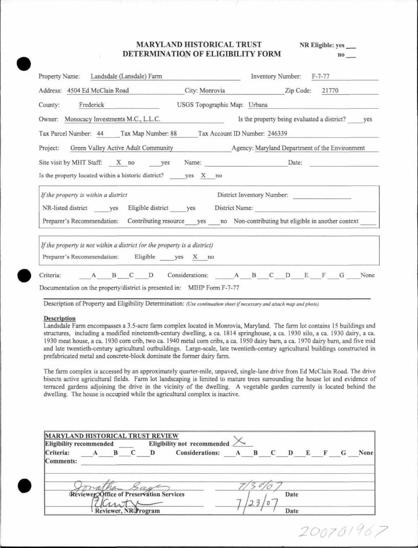
MARYLAND HISTORICAL TRUST DETERMINATION OF ELIGIBILITY FORM
NR Eligible: yes
no
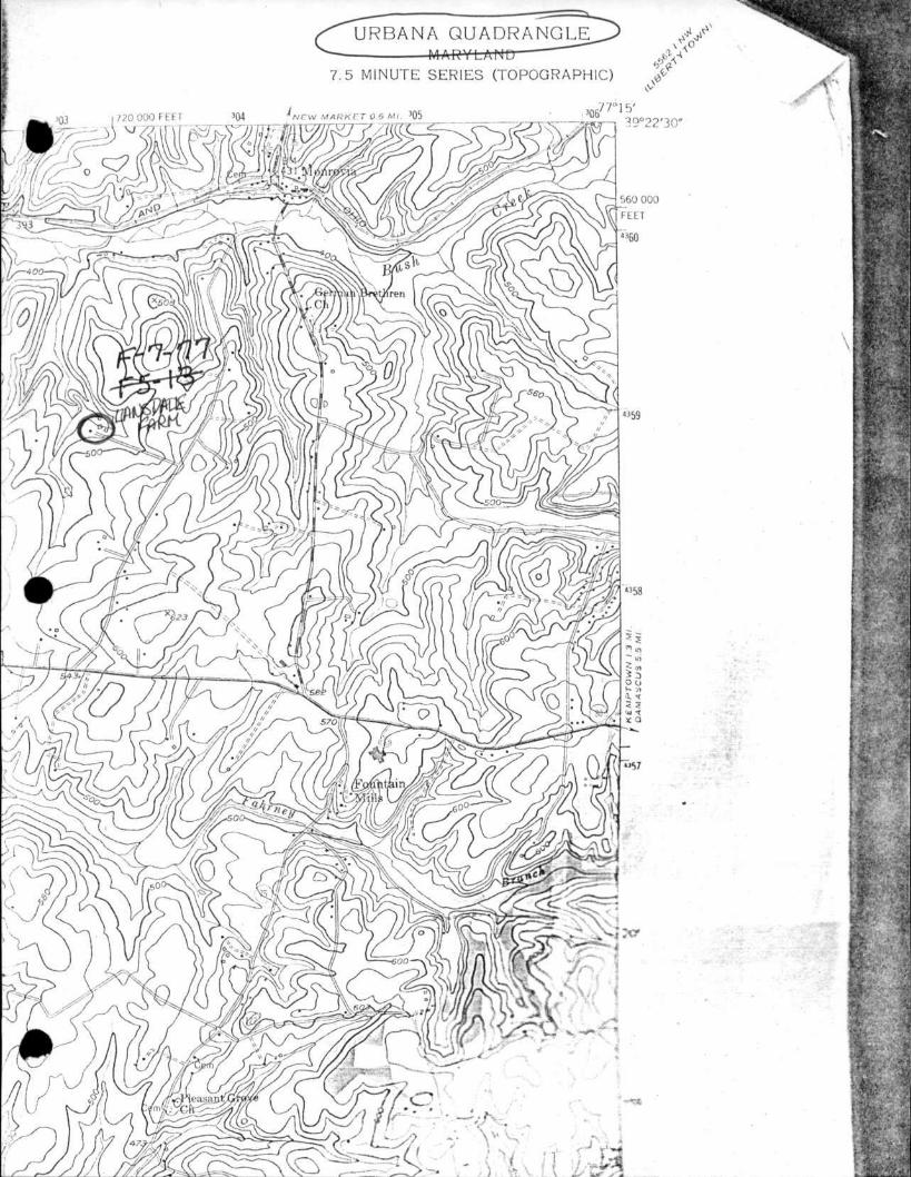
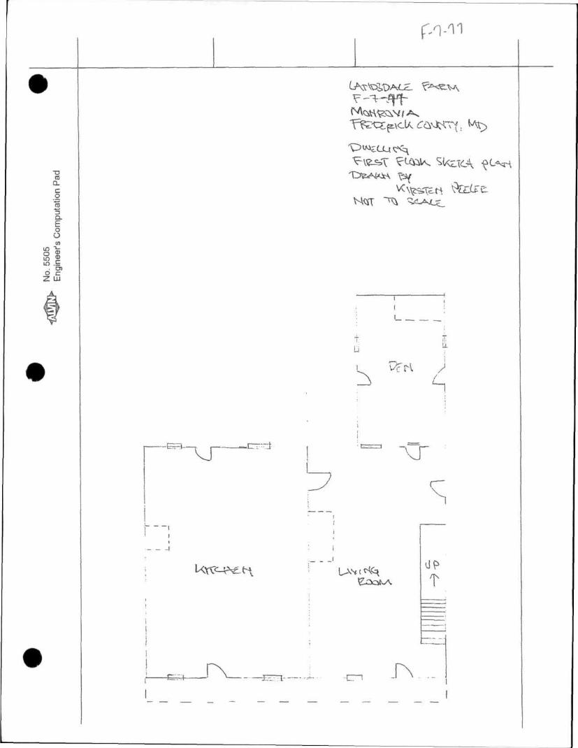
Property Name: Landsdale (Lansdale) Farm Inventory Number: F-7-77
Address: 4504 Ed McClain Road City: Monrovia Zip Code: 21770
County: Frederick USGS Topographic Map: Urbana
Owner: Monocacy Investments M.C, L.L.C. Is the property being evaluated a district? yes
Tax Parcel Number: 44 Tax Map Number: 88 Tax Account ID Number: 246339
Project: Green Valley Active Adult Community Agency: Maryland Department of the Environment
Site visit by MHT Staff: X no yes Name: Date:
Is the property located within a historic district? yes X no
If the property is within a district District Inventory Number:
NR-listed district yes Eligible district yes District Name:
Preparer's Recommendation: Contributing resource yes no Non-contributing but eligible in another context
If the property is not within a district (or the property is a district)
Preparer's Recommendation: Eligible yes X no
Criteria: A B C D Considerations: A B C _ D E F G None
Documentation on the property/district is presented in: MIHP Form F-7-77
Descr ip t ion o f Property and El ig ib i l i ty Determinat ion: (Use continuation sheet if necessary and attach map and photo)
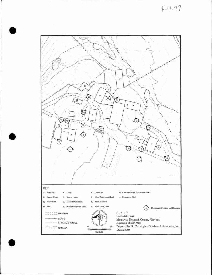
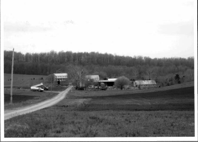
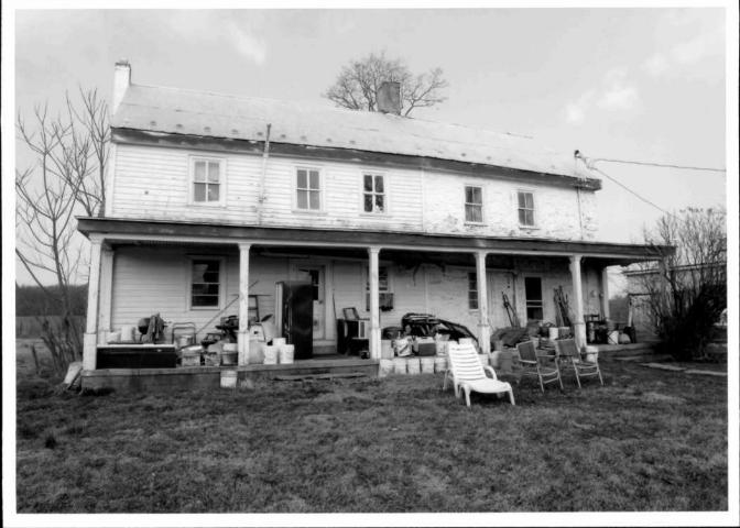
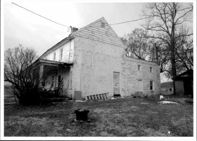
Description Landsdale Farm encompasses a 3.5-acre farm complex located in Monrovia, Maryland. The farm lot contains 15 buildings and structures, including a modified nineteenth-century dwelling, a ca. 1814 springhouse, a ca. 1930 silo, a ca. 1930 dairy, a ca. 1930 meat house, a ca. 1930 corn crib, two ca. 1940 metal corn cribs, a ca. 1950 dairy barn, a ca. 1970 dairy barn, and five mid and late twentieth-century agricultural outbuildings. Large-scale, late twentieth-century agricultural buildings constructed in prefabricated metal and concrete-block dominate the former dairy farm.
The farm complex is accessed by an approximately quarter-mile, unpaved, single-lane drive from Ed McClain Road. The drive bisects active agricultural fields. Farm lot landscaping is limited to mature trees surrounding the house lot and evidence of terraced gardens adjoining the drive in the vicinity of the dwelling. A vegetable garden currently is located behind the dwelling. The house is occupied while the agricultural complex is inactive.
MARYLAND HISTORICAL TRUST REVIEW Eligibility recommended Eligibility not recommended Xs** Criteria: A B C D Considerations: A B C D E F G None Comments:
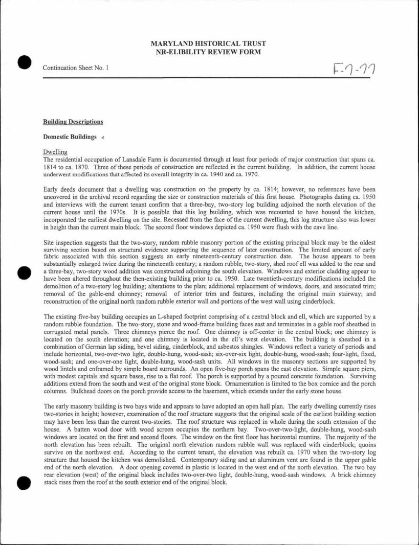
MARYLAND HISTORICAL TRUST NR-ELIBILITY REVIEW FORM
Continuation Sheet No. 1 F-7-77
Building Descriptions
Domestic Buildings <
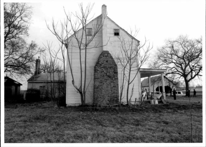
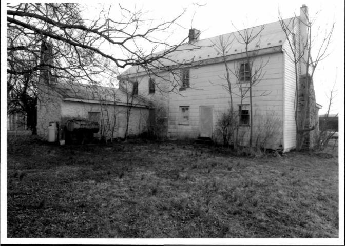
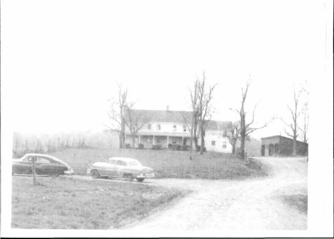
Dwelling The residential occupation of Lansdale Farm is documented through at least four periods of major construction that spans ca. 1814 to ca. 1870. Three of these periods of construction are reflected in the current building. In addition, the current house underwent modifications that affected its overall integrity in ca. 1940 and ca. 1970.
Early deeds document that a dwelling was construction on the property by ca. 1814; however, no references have been uncovered in the archival record regarding the size or construction materials of this first house. Photographs dating ca. 1950 and interviews with the current tenant confirm that a three-bay, two-story log building adjoined the north elevation of the current house until the 1970s. It is possible that this log building, which was recounted to have housed the kitchen, incorporated the earliest dwelling on the site. Recessed from the face of the current dwelling, this log structure also was lower in height than the current main block. The second floor windows depicted ca. 1950 were flush with the eave line.
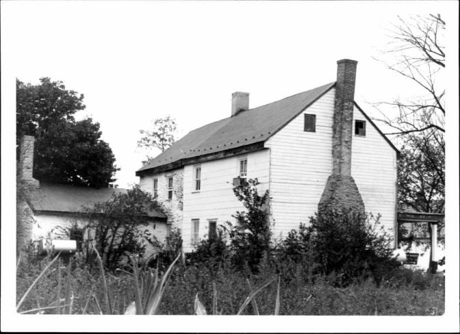
Site inspection suggests that the two-story, random rubble masonry portion of the existing principal block may be the oldest surviving section based on structural evidence supporting the sequence of later construction. The limited amount of early fabric associated with this section suggests an early nineteenth-century construction date. The house appears to been substantially enlarged twice during the nineteenth century; a random rubble, two-story, shed roof ell was added to the rear and a three-bay, two-story wood addition was constructed adjoining the south elevation. Windows and exterior cladding appear to have been altered throughout the then-existing building prior to ca. 1950. Late twentieth-century modifications included the demolition of a two-story log building; alterations to the plan; additional replacement of windows, doors, and associated trim; removal of the gable-end chimney; removal of interior trim and features, including the original main stairway; and reconstruction of the original north random rubble exterior wall and portions of the west wall using cinderblock.
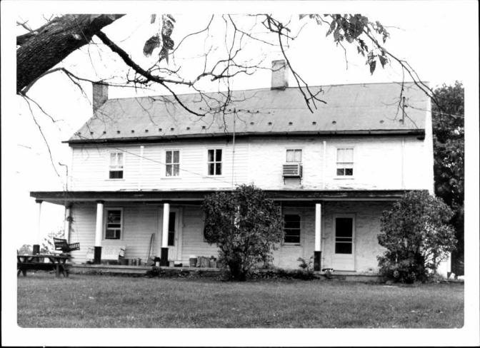
The existing five-bay building occupies an L-shaped footprint comprising of a central block and ell, which are supported by a random rubble foundation. The two-story, stone and wood-frame building faces east and terminates in a gable roof sheathed in corrugated metal panels. Three chimneys pierce the roof. One chimney is off-center in the central block; one chimney is located on the south elevation; and one chimney is located in the ell's west elevation. The building is sheathed in a combination of German lap siding, bevel siding, cinderblock, and asbestos shingles. Windows reflect a variety of periods and include horizontal, two-over-two light, double-hung, wood-sash; six-over-six light, double-hung, wood-sash; four-light, fixed, wood-sash; and one-over-one light, double-hung, wood-sash units. All windows in the masonry sections are supported by wood lintels and enframed by simple board surrounds. An open five-bay porch spans the east elevation. Simple square piers, with modest capitals and square bases, rise to a flat roof. The porch is supported by a poured concrete foundation. Surviving additions extend from the south and west of the original stone block. Ornamentation is limited to the box cornice and the porch columns. Bulkhead doors on the porch provide access to the basement, which extends under the early stone house.
The early masonry building is two bays wide and appears to have adopted an open hall plan. The early dwelling currently rises two-stories in height; however, examination of the roof structure suggests that the original scale of the earliest building section may have been less than the current two-stories. The roof structure was replaced in whole during the south extension of the house. A batten wood door with wood screen occupies the northern bay. Two-over-two-light, double-hung, wood-sash windows are located on the first and second floors. The window on the first floor has horizontal muntins. The majority of the north elevation has been rebuilt. The original north elevation random rubble wall was replaced with cinderblock; quoins survive on the northwest end. According to the current tenant, the elevation was rebuilt ca. 1970 when the two-story log structure that housed the kitchen was demolished. Contemporary siding and an aluminum vent are found in the upper gable end of the north elevation. A door opening covered in plastic is located in the west end of the north elevation. The two bay rear elevation (west) of the original block includes two-over-two light, double-hung, wood-sash windows. A brick chimney stack rises from the roof at the south exterior end of the original block.
MARYLAND HISTORICAL TRUST NR-ELIBILITY REVIEW FORM
Continuation Sheet No. 2 F-7-77
Although the early stone section retains its mass and bay proportions, the section's integrity of materials was compromised when the log structure was removed and the north and west walls repaired in cinderblock. The ca. 1950 photograph further documents a brick, interior-end chimney stack rose from the north elevation of the stone block; evidence of the base survives on the basement level. No original fabric survives on the first floor of the section, as discussed below.
A stone ell projects from the east elevation of the early stone dwelling. Quoins delineating construction joints and the intersection of window bays associated with the earlier house suggest that the ell was constructed as an addition. Archival research and the ell's construction suggest that the rear extension may have been added during the Pearce ownership between 1838 and 1856. The one-and-a-half-story ell is two bays and terminates in a shed roof sheathed in corrugated-metal panels. A vertical wood plank door occupies the easternmost bay of the north elevation. One one-over-one light, double-hung, wood-sash window flanks the door. The two windows on the upper level are four-light, fixed, wood-sash units. An interior brick chimney rises from the northwest corner. The west elevation is blind. The south elevation consists of one door and window opening covered in plastic and plywood. No interior historic fabric survives in the ell, as discussed below.
A two-story wood addition was constructed on the south elevation of the early stone dwelling. The three-bay building is clad in wood shiplap siding on the east elevation. The spacing of the bay openings of the extension is consistent with a hewn log structural system; however, this hypothesis could not be confirmed without destructive testing. A four-light, three-panel wood door is centered in the first floor. Two two-over-two light, double-hung, wood-sash windows with horizontal muntins flank the door. Second-floor windows are two-over-two light, double-hung, wood-sash units. An exterior shouldered chimney defines the south elevation. The lower part of the chimney is constructed of random rubble; cinderblock was employed above the shoulder. Two courses of brick above the chimney shoulder suggest an earlier brick stack. The flue extends above the stack. Two four-light, fixed, wood-sash windows flank the chimney in the gable end. Corner boards mark the ends of the elevation; a plain raking broad intersects the simple boxed cornice at the eave line. The west (rear) elevation is clad in asbestos shingles; original wood siding survives beneath this later cladding. Two two-over-two light, double-hung, wood-sash windows flank an off-centered door opening covered in plastic. Two poured-concrete steps lead to the door. Two two-over-two light, double-hung, wood-sash windows are found on the second floor.
Interior inspection indicated that the roof of the original stone block and the roof for the wood addition were unified during the expansion through a pegged common rafter roof system. Rafters in the attic were numbered. Bead board trim and wide baseboards selectively survive on the second floor of the extension.
The ca. 1950 photograph suggests that earlier windows have been replaced by two-light-over-two-light sash with wide muntins throughout the house by that date. The photograph further documents that the open front porch also was added by that date.
The dwelling was altered during the 1970s. The two-story log building was demolished and the kitchen was relocated to the first-floor of the south extension. All interior finishes to the first floor of the south extension were removed during this kitchen relocation. Cinderblock replaced the original north elevation random rubble wall and portions of the west elevation. It is probable that the exterior-end chimney on the north elevation of the stone block also was removed at this time; the rubble base for this chimney survives on the basement level. First floor interior woodwork of the masonry principal block was replaced with simple stock window and door surrounds as well as stock baseboards. A ca. 1970 replacement straight run stair with a Colonial Revival style balustrade is located on the north wall of the original stone mass. The location and configuration of the original stair has not been identified. All chimney pieces associated with the original house have been removed. The interior of the ell was gutted and replaced with a single room sheathed in wood paneling; a contemporary mantel was installed on the west interior wall of the ell. Several of the dwelling's windows also were replaced with two-light-over-two light units with horizontal sash divisions.
While the principal block and ell retain their overall scale, mass, and selective evidence of early design, renovations undertaken during the twentieth century resulted in the loss of substantial original interior and exterior fabric as well as a smaller overall footprint. The design of many character-defining features, including early windows, doors, interior plan, finishes, stairs, and interior chimney pieces, has been lost. The current overall configuration of surviving building is most closely associated with the last nineteenth-century expansion of the structure, while the architectural features and finishes most closely reflect the remodeling of the 1970s.
MARYLAND HISTORICAL TRUST NR-ELIBILITY REVIEW FORM
Continuation Sheet No. 3
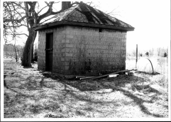
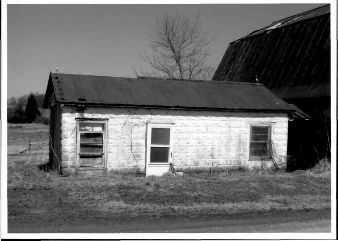
Smokehouse A ca. 1930 rusticated concrete-block smokehouse rests on a poured-concrete foundation. The one-story building faces east. The smokehouse occupies a rectangular footprint and terminates in a pyramidal roof with a simple wood cornice. The roof is sheathed in asphalt shingles. A finial is centered in the roof. Cladding material is rock-face concrete block. A vertical wood plank door is centered in the east elevation. Concrete-block quoins provide the building's only ornamentation. Small vents are located at the eaves on the north and south elevations.
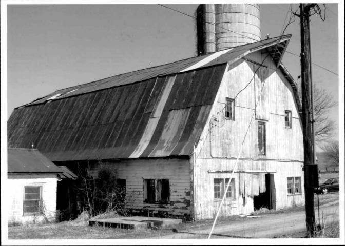
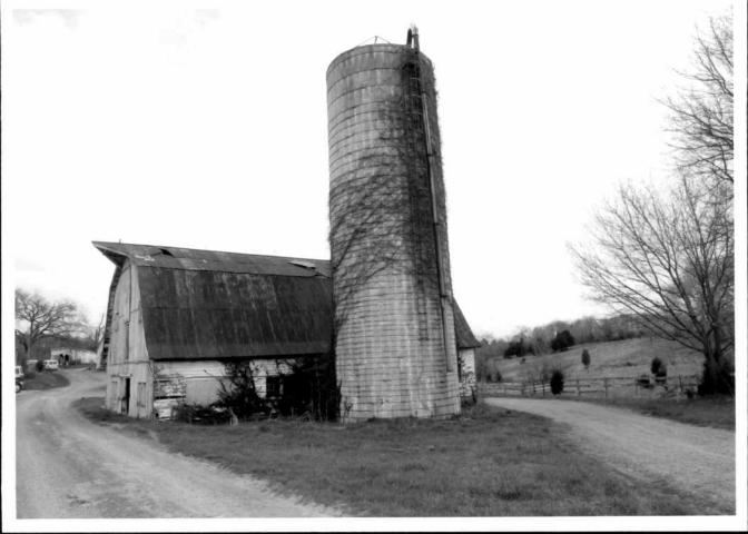
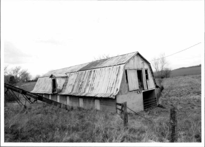
Agricultural Outbuildings Dairy Bam The single-story plus loft ca. 1950 dairy bam occupies a rectangular footprint. The building terminates in a gambrel roof sheathed in corrugated-metal panels. Lighting rods and vents characterize the roof. The building rests on a poured-concrete foundation. Cladding materials include vertical wood plank siding on the north elevation, beaded-board siding on the south elevation, and wood clapboard siding on the east and west elevations. Openings consist of beaded-board sliding track doors and nine-light, wood windows. A beaded-board sliding track door is centered on the lower level of the south elevation. Paired nine-light, fixed-sash windows flank the door. Two nine-light, fixed-sash wood windows and one beaded-board wood door are located in the loft level. The fenestration on the north elevation is similar to that on the south elevation. However, the sash is no longer extant in the easternmost window and the sash are no longer extant in the two windows located in the loft level. A sliding track door is located on the first floor; no door is present in the loft level.
The lower level is four bays. Fenestration consists of three sets of triple, nine-light, wood-sash windows and paired nine-light, wood-sash windows on the east and west elevations. The southernmost windows on the east elevation are covered in plywood. A wood door leading from the adjacent dairy is located on the west elevation. The stanchions remained in the building's interior.
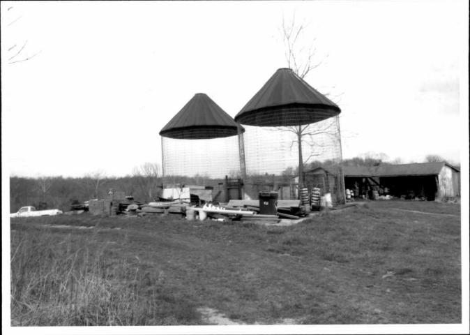
Silo A ca. 1930 poured-concrete silo with metal rings is located east of the barn. The silo's roof is no longer extant. A single-story concrete-block hyphen connects the silo to the bam. The hyphen terminates in a side-gable roof sheathed in corrugated metal panels. Plywood covers a door opening on the south elevation.
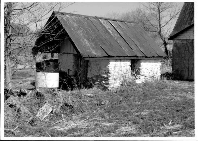
Dairy A ca. 1930 concrete-block dairy is located west of the dairy bam. The building faces south and occupies a rectangular footprint. The single-story building terminates in a side-gable roof sheathed in corrugated metal. Three lightening rods characterize the roof. Rock-face concrete block clads the building. The three-bay building has an asymmetrical facade. Openings are located on each elevation. Two two-over-two light, double-hung, wood-sash windows with horizontal muntins flank a two-light, single-panel vinyl storm door on the building's south elevation. A window opening is located on the west elevation; the sash is no longer extant and the opening is infilled with concrete block. Two one-over-one light double-hung, vinyl-sash windows characterize the north elevation. A wood door is located on the barn's east elevation. A concrete-block wall on the east elevation connects the dairy to the dairy bam. The dairy's roof extends over the wall, creating a partially enclosed bay.
Springhouse The early eighteenth-century rubble stone springhouse is located west of the dairy. The building occupies a rectangular footprint and faces west. The foundation was not visible. The front-gable roof is sheathed in corrugated metal. The roof overhangs the building on the west elevation. Vertical wood plank siding is located in the gable ends. Openings are centered on each elevation. A vertical wood plank door is located on the west elevation. One window is found in each of the north, east, and south elevations. A four-light, wood-sash casement window characterizes the north elevation. The sash were no longer extant on the south and east elevations.
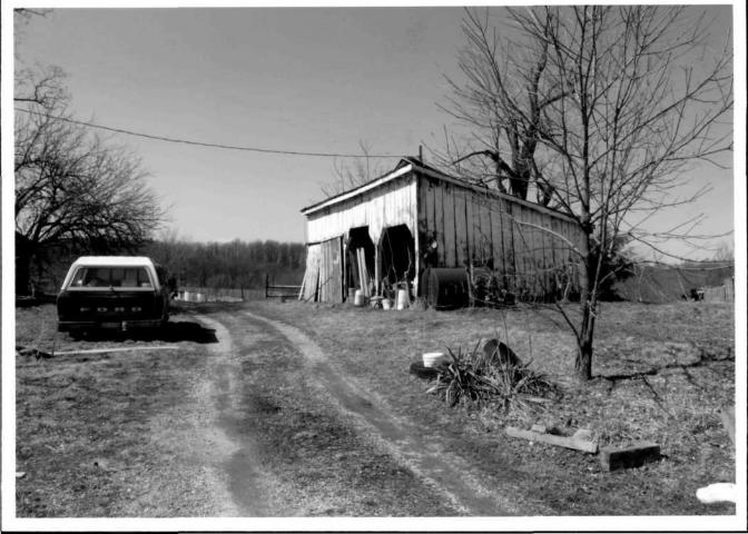
Second Dairy Bam A ca. 1970, one-story plus loft, dairy bam is located northeast of the dwelling. The concrete-block and wood-frame building occupies a rectangular footprint. The building faces south and terminates in a gambrel roof sheathed in crimped, standing-seam metal. A gable dormer is located on the west elevation. The lower level is constructed of concrete-block and the loft
F-7-77
MARYLAND HISTORICAL TRUST NR-ELIBILITY REVIEW FORM
Continuation Sheet No. 4
level is clad in vertical wood planks. Windows consist of six-over-six light, double-hung, wood-sash units and two-over-two light, double-hung, metal-sash units.
One opening is found on the lower level of the south elevation. No door was present at the lower level. A vertical wood-plank sliding tract door is centered in the loft level. Two six-over-six light, double-hung, wood-sash windows flank the door. Nearly all the muntins are missing from the easternmost window. The west elevation is seven bays. All the window openings on the lower level are covered in plywood. The sash is no longer extant in the dormer. Access to the east and north elevations was prohibited due to the presence of a barbed wire fence. The windows on the east elevation were visible through the opening on the south elevation's lower level. East elevation windows consist of two-over-two light, double-hung, metal sash windows.
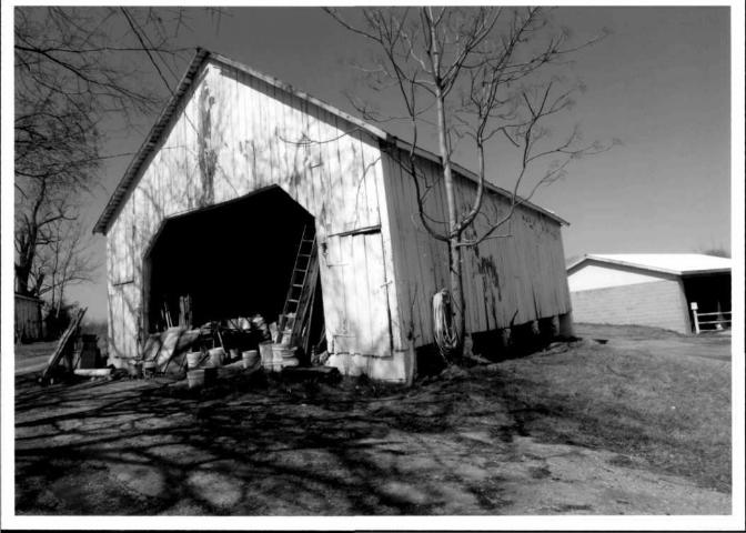
Wood Equipment Shed The mid-twentieth-century equipment shed occupies a rectangular footprint and faces south. The one-story wood-frame building terminates in a shed roof sheathed in corrugated metal. The three-bay building is clad in vertical wood plank siding. The wood posts dividing the bays rest in poured-concrete piers. One, vertical wood plank, sliding-track door is located in the west bay. One multi-light, fixed-sash wood window and one opening with the sash missing are located on the west and north elevations.
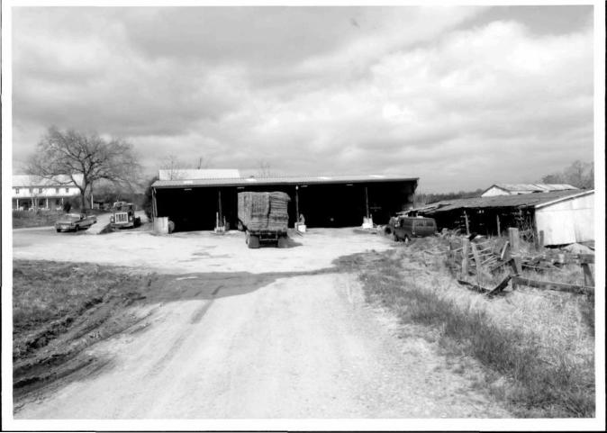
Corncrib / Wagon Shed A single-story, wood-frame, two-bent, three-bay corncrib/wagon shed is located northeast of the dwelling. The ca. 1930 building faces south and occupies a rectangular footprint. The building rests on concrete-block and rubble-stone piers and terminates in a front gable roof sheathed in corrugated metal. Vertical wood plank siding clads the building. The central passage located on the south elevation does not continue through to the north elevation. Two vertical wood-plank passage doors are located in the north and south elevations of each comcrib. There is visual evidence that a fire occurred in the corncrib, burning the corn crib's east wall.
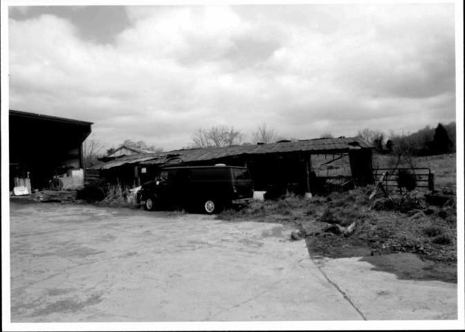
Metal Equipment Shed A late twentieth-century, metal-frame equipment shed occupies the footprint of a former bank barn. The building faces east. The one-story building occupies a rectangular footprint and terminates in a side-gable roof sheathed in a crimped, standing-seam metal roof. Eight plexiglass panels, centered over each bay, were inserted in the roof to provide light into the building's interior. The prefabricated building has four bays; the metal posts dividing the bays rest in concrete piers clad in metal. Window openings on the west and north elevations and a door opening on the south elevation were infilled with metal panels. The ramp for the former bank barn abuts the west elevation of the shed. Poured-concrete walls support the earthen ramp.
Animal Shelter A mid-twentieth-century wood-frame, single-story animal shelter is located north of the metal equipment shed. The south-facing building rests on a poured-concrete and dirt floor. The building has five bays; rough-hewn poles support the side-gable roof on the south elevation. The south slope of the roof is sheathed in standing-seam metal while the north slope is sheathed in corrugated metal panels. The poles rest in poured-concrete piers set in plastic buckets. Piers also support the building on the east and west elevations; some of the piers are constructed of concrete block. A poured-concrete retaining wall supports the building on the north and east elevations, suggesting that the building occupies the footprint of an earlier building. The building is clad in vertical wood planks of various widths.
Metal Corncribs Two metal wire corncribs are located north of the dwelling. The ca. 1940 corncribs rest on a poured-concrete slab on top of concrete-block. A conical standing-seam metal roof caps each corncrib.
Concrete-block Equipment Shed A late twentieth-century, single-story, three-bay equipment shed is located north of the corn crib. The building, which faces east, occupies a rectangular footprint and rests on a poured-concrete slab. The building terminates in a side-gable roof sheathed in corrugated-metal panels. Prefabricated metal panels are located in each gable end. Three metal I-beams resting on poured-concrete piers encased in metal define the east elevation. The north, west, and south elevations are blind. A poured-concrete pad extends from the east (front) of the building to the adjacent metal equipment shed and the animal shelter.
F-7-77
MARYLAND HISTORICAL TRUST NR-ELIBILITY REVIEW FORM
Continuation Sheet No. 5
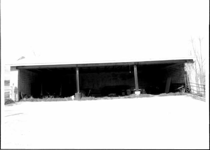
Equipment Shed A mid-twentieth-century wood-frame equipment shed rests on a dirt floor and faces south. The building occupies an L-shaped footprint and terminates in a side-gable roof sheathed in corrugated metal. Round wood posts support the roof on the south (front) elevation; the posts rest on concrete-block piers. Cladding material is vertical wood plank siding. The south elevation is open; no doors or windows are present on the elevation. The remaining elevations are blind.
Historic Overview
Lansdale Farm is part of a 970-acre tract owned by William Hall, Jr., who acquired the property from his brother, Nicholas Hall, in 1785. The land was part of a 2,030-acre tract conveyed to the Hall brothers in the will of their uncle, William Hall, of Elk Ridge, which was then part of Anne Arundel County. The younger Halls divided the 2,030-acre property into two parcels under separate deeds in 1785. The elder Hall's will could not be found at the Frederick County Courthouse or the Maryland State Archives; however, the land deed explained how the brothers obtained the land from their uncle (Frederick County Land Records WR5:560-564).
Two years later, in 1787, Nicholas Hall advertised the availability of lots in a town he wanted to establish. The effort was successful, and several years later the town of New Market was established along the road from Frederick to Baltimore. He already had built a family home on present-day Baldwin Road near the current New Market in 1780, a year after he married Anne Griffith (Seng 2005:9-13). He likely was not associated after 1785 with the 970 acres he conveyed to his brother.
Primary and secondary sources contradict assertions contained in the Maryland Inventory of Historic Properties form prepared for Landsdale Farm in 1978: that the uncle was named Nicholas Hall and was the founder of New Market, and that he divided a 970-acre parcel between two nephews, Nicholas and William Jr., in 1785 (Widell 1978).
The dwelling on the property likely was built during William Hall Jr.'s ownership, from 1785 to 1813. His 970-acre parcel encompassed part of Dorsey's Partnership, part of the Resurvey of Seth's Folly, all of Bush Creek Mountain, and all of the Original of Seth's Folly. The Frederick County assessment for 1798 listed no buildings on the property (Frederick County Commissioners of the Tax 1798), but an 1814 deed referred to a house. In February 1813, Hall sold a portion of his 970-acre parcel - 233 acres, 16 perches encompassing part of Seth's Folly and part of the Resurvey of Seth's Folly - to Samuel Poultney, who operated a saw mill in the vicinity (Frederick County Land Records WR 44:583). After Poultney's death 15 months later, most of that property, 232 acres, 26 perches, was sold at a public auction "held at the house on the premises" (Frederick County Land Records WR 46:639). The dwelling mentioned in the 1814 deed could have been constructed by William Hall, Jr. or by Samuel Poultney. No previous deeds mention a dwelling. William Coale acquired the property from the estate of Samuel Poultney.
While Nicholas Hall founded the town of New Market and his 1820 death was mentioned in the diary of Jacob Engelbrecht (Quynn 2001:25), William Hall, Jr.'s level of documented activity in the community is difficult to determine. The name "William Hall" surfaces in various local records, such as jury lists, but it is not clear whether these listings are for the same William Hall as the owner of this property. Local and county histories contain scant mention of Hall.
The property changed owners several times through the mid-nineteenth century. At the time of the 1850 census, Joseph and Cinderella Pearce and their five children occupied the property, which still totaled 232 acres, 26 perches. They had purchased the land in 1838 and sold it in 1856. The household included two slaves, an 11-year-old female mulatto and a 13-year-old male mulatto. Joseph Pearce farmed 140 improved acres and 80 unimproved acres, valued at $2,000 in both the agricultural and population censuses. Agricultural output focused on wheat, Indian corn, and tobacco, and also included oats, rye, wool, orchard products, butter, hay, and clover seed. Livestock was valued at $600 and included horses, milk cows, other cattle, and swine (Hitselberger and Dern 1978:270, 470, 532-3). The 1852 Frederick County assessment did not list buildings on the property or provide a separate value for improvements, but the total listed property value of $3,648 implies the land was worth $2,000, as indicated in the census, and that the buildings were assessed at $1,648 (Frederick County Board of County Commissioners 1852). The 1858 Map of Frederick County, Maryland depicted structures at this location owned by John Emery; deed research indicated he owned the property from 1856 to 1860 (Bond 1858; Frederick County Land Records ES 8:508; Frederick County Land Records BGF 5:235).
F-7-77
MARYLAND HISTORICAL TRUST NR-ELIBILITY REVIEW FORM
Continuation Sheet No. 6
The property's size and worth grew during the ownership of Henry S. Lansdale. The Washington, D.C. resident bought 229 acres in 1860 - the property of 232 acres, 26 perches minus three acres sold off by Pearce. Lansdale supplemented it with purchases of two adjacent parcels: two acres in 1864 and 67% acres in 1865 (Frederick County Land Records TG 4:7; Frederick County Land Records BGF 5:235). The 1870 population census for the New Market election district included the 53-year-old Lansdale, listed as a farmer, his 30-year-old wife, Sarah, eight children ranging in age from 8 to 21 years old, and an 83-year-old male mulatto farm laborer named Nace Smallwood (Frederick County Board of County Commissioners 1866, United States Census 1870).
In the 1866 assessment, Lansdale's 303-acre holding was valued at $7,575, more than double the 1852 assessment. Personal property, totaling $9,316, included $816 in livestock, $400 in household furniture, $200 in money in hand and on deposit, $150 worth of working tools, $100 worth of other property, and $75 in gold and silver watches (Frederick County Board of County Commissioners 1866).
By the 1870 census, the worth of Lansdale's property had grown. The agricultural census indicated a farm value of $18,000, while the population census listed a real estate value of $26,240. This increase in farm value in the immediate post-Civil War period appears to be an anomaly in Frederick County. The farm value nearly doubled between 1866 and 1870 at a time when farm value was decreasing.
Another explanation for the increase in farm values could be new construction at the farm or the construction of a tenant house. The focus on construction might have been a tenant house to the north of the main farmstead, the 67%-acre parcel he purchased in 1865; Lansdale might have improved existing buildings or built additional ones. The 1873 Atlas of Frederick County, Maryland depicted Lansdale's name in these two locations, indicating buildings were present (Lake 1873). Buildings also were present in 1858, when Bond's Map of Frederick County, Maryland depicted buildings on the 67%-acre parcel under its previous owner, Samuel Horning (Bond 1858). Indicating Lansdale's increasing wealth, the population census valued Lansdale's personal estate at $12,250, a growth of nearly $3,000 since the 1866 assessment (United States Census 1870).
Agricultural production focused on Indian corn, winter wheat, and oats; tobacco was not produced, in contrast to 1850. Other crops included rye, barley, Irish potatoes, hay, and orchard products. Livestock was valued at $2,585 and included horses, milk cows, oxen, other cattle, sheep, and swine (United States Census 1870).
Aside from data gleamed through census records, no additional biographical information was found on the Lansdale family in local history vertical files or published and unpublished county histories available at the Frederick County Historical Society. After he sold the property, he, his wife, and their underage children moved back to Washington, D.C, where they were documented in the 1880 census and his occupation was listed as "real estate agent" (United States Census 1880). Census records indicate several locations for the births of his children, including four children born in Washington, D.C. in 1840, 1854, 1856, and 1858; two children in Maryland in 1850 and 1862; one child in Virginia in 1849; and one child in Illinois in 1859, suggesting the family moved frequently. Lansdale could not be identified in the 1860 census (United States Census 1870, 1880). Deeds began referring to the property by the name "Lansdale Farm" during the early twentieth century; this is the name used on the MIHP form (Widell 1978).
In contrast to Lansdale's assessment, a later assessment indicated a drastically reduced value for the land and improvements. Reduced values can be attributed to the general economic instability and the agricultural depression that occurred after the Civil War. The federal government financed the Civil War by issuing greenbacks, paper currency that "appeared in such large quantity as to depreciate seriously in value" (Brugger 1990:328). As the government printed more paper money, the existing currency was devalued. In 1865 and 1866, many Western Maryland fanners borrowed money to make improvements to their farms that had been deferred because of the Civil War (Brugger 1990:328). In 1869, the federal government required public payments in gold, and in 1873, the government halted the use of silver coinage (Brugger 1990:328). As a result of the government policies, Maryland farmers were forced to "make payments in money that effectively was worth twice as much as the dollars they had borrowed" (Brugger 1990:328). Farmers had less money with which to purchase land, equipment, and supplies than they did before the 1869 and 1873 changes in polices. These post-Civil War monetary policies could have been the cause in the devaluation of the Lansdale property from $18,000 in the 1870 census to approximately $5,000 between 1875 and 1878.
F-7-77
MARYLAND HISTORICAL TRUST NR-ELIBILITY REVIEW FORM
Continuation Sheet No. 7 F-7-77
For Nicholas Rogers, who owned the 303-acre parcel from 1875 to 1878, the land was valued at $3,454 and improvements were valued at $2,000. Personal property, valued at $1,013, included $355 in livestock, $300 worth of furniture, $200 in private securities, $108 in farming implements, and a $50 buggy (Frederick County Board of County Commissioners 1876-1896). The 1876 assessor's field book identified Nicholas Rogers as owning a 303-acre tract named "Hickory Flat" and itemized the improvements as a frame house and barn and frame outbuildings (Frederick County Board of County Commissioners 1876). The acreage in the assessor's record matches the acreage purchased from Lansdale, but the description of a frame house does not match the stone building with frame addition currently on the property.
An 1880 assessment for the next owner, Louis F. Detrick, listed the same total real estate value of $5,454, but improvements increased by $300 in 1884, when a difficult-to-read notation indicated that either a house addition or a new house was built (Frederick County Board of County Commissioners 1876-1896).
Louis F. Detrick owned the property from 1878 to 1907. In an assessment conducted during an unknown year between 1896 and 1907, Derrick's 284-acre parcel was valued at $5,680, and improvements were valued at $1,704. Upon his death in 1906, the value of the land and improvements had not changed (Frederick County Board of County Commissioners Assessment Record 1896-1910; Historical Society of Frederick County genealogy files). While the Detrick family had extensive roots in Frederick County, Louis and his wife, Katherine, had moved by 1880 to Baltimore, where he was a fertilizer manufacturer (United States Census 1880; Historical Society of Frederick County genealogy files). The Detricks' move to Baltimore suggests that the farm was rented.
In his will, Detrick conveyed the land to his grandson, also named Louis F. Detrick. The younger Detrick was only 17 when his grandfather died in 1906, but his occupation was listed as farmer in the 1910 census, despite his residence in Baltimore (Frederick County Land Records STH 281:195; United States Census 1910). A 1912 assessment for the 289-acre parcel indicated that the land was worth $6,936 and improvements were worth $3,050. Improvements were itemized and included: a $1,000 dwelling, a $600 dwelling, a $600 barn, a $300 barn, a $300 barrack, a "corn shed and shed" valued at $200, and outbuildings valued at $50 (Frederick County Board of County Commissioners 1910-1917). The assessment reflects the continued presence of the main farm complex and the smaller farm complex; the latter location no longer contains standing structures and has been identified as archeological site 18FR866.
The younger Louis F. Detrick died in 1917. His widow, Jennie S. Derrick, retained the property and sold it in 1948 to the McClain family, who held the property until conveying it to the current owner, Monocacy Investments M.C., L.L.C., in 2006 (Frederick County Land Records 416:467; Frederick County Land Records 469:474; Frederick County Land Records 469:473).
Thematic Context: Domestic Architecture
The dwelling at Lansdale farm is a vernacular representation of domestic architecture that incorporates elements of English architectural influences. The building has changed and evolved over time to reflect prevailing house forms. In 1789, many rural dwellings in Maryland consisted of a single room on the first floor with an unheated room on the second floor (Bourne et al. 1998:7). Few of these dwellings survive because they were cheaply made and poorly maintained (Bourne et. al. 1988:7). Landowners such as farmers and merchants were able to construct larger, more substantial buildings of brick or frame, many of which survived into the twentieth century (Bourne et. al. 1998:7). Early buildings in the region did not have a particular architectural style (Lanier and Herman 1997:122). The choice of building material often reflected the wealth of the occupant and cultural ties (Koons and Hofstra 2000:84). The use of stone reflected an effort to build in locally available materials. Rarely were stone buildings constructed during the eighteenth century finely finished (Lanier and Herman 1997:96). These buildings generally were constructed of "roughly coursed masonry with raised mortar joints," while late-nineteenth century buildings were constructed of stucco-covered rubble stone walls (Lanier and Herman 1997:96).
Early dwellings consisted of an open plan, containing of one room referred to as the hall. A gable-end chimney provided heat to the room. In cases when the hall plan was expanded, the exterior gable-end chimney became the interior central chimney, with another chimney constructed at the gable-end of the addition. The addition of the second room, commonly referred to as
MARYLAND HISTORICAL TRUST NR-ELIBILITY REVIEW FORM
Continuation Sheet No. 8 F-7-77
the parlor, created a more formal space. In some cases, the parlor remained unheated. Visual observation suggests that the original stone mass of the Lansdale dwelling consisted of a hall plan.
Between 1810 and 1840, as dwellings became more substantial, the central passage became popular (Koons and Hofstra 2000:98). The single-pile, central-passage plan is commonly referred to as an I-house (Upton and Vlach 1986:7). Character-defining features of the I-house include side-gable roofs, two rooms in length, one room deep, and two full stories in height (Upton and Vlach 1986:8). In plan, a number of variations were possible. Stairs could be at the front or rear of the house; a central stair passage also was common. The I-house is an American architectural form based on English antecedents. The I-house architectural form is one of the most prominent symbols of the building boom that occurred between 1810 and 1840, particularly in rural areas (Koons and Hofstra 2000:98; Upton and Vlach 1986:9).
The rectangular footprint of the I-house later was modified through the construction of a gable-roof ell built perpendicular to the principal block (Koons and Hofstra 2000:103). The ell created a distinction between public and private space, as the "ell allowed families to move work and family living spaces to the rear of the house and consequently to redefine the front rooms as formal space" (Koons and Hofstra 2000:103). Early ells typically were one story; by 1830, two-story ells were common (Koons and Hofstra 2000:105).
Thematic Context: Regional Agricultural Practices during the Nineteenth and Twentieth Centuries
Small grain and livestock farming provided prosperity for Frederick County farmers during the eighteenth and nineteenth centuries (Reed 1993). Grain was exported to South America through the port of Baltimore. Livestock and cattle production grew during the nineteenth century due to the presence of rich grasslands; however, the raising of livestock accounted for a small percentage of farm operations during the period (Reed 1993; Grandine 2001; Peeler and Dixon 2005).
Several factors impacted the county's agriculture industry. Predominant influences on Frederick County's agriculture industry were the advances in transportation, specifically high-speed rail transportation (Peeler 2003). The post-Civil War agricultural depression and the shift of grain cultivation to the Midwest and west resulted in the diversification of crops to include products such as fruits and vegetables. Even as grain cultivation shifted to the Midwest and west after the Civil War, Frederick County farmers continued to cultivate wheat, corn, oats, and rye during the 1870s and 1880s (Peeler 2003). Although Frederick County farmers continued to grow grains during the post-Civil War period, they could not compete with Midwestern farmers. Midwestern farmers worked "relatively larger fields that yielded heavy crops," and consequently drove down grain prices (Brugger 1990:329).
Scientific and mechanized farming practices that evolved from 1830 to 1880 impacted the scale of farming (Lanier and Herman 1997:178). These changing practices affected the scale of farming as well as farm building size and design (Lanier and Herman 1997:178). Improvements in transportation, particularly refrigerated railroad cars, made the shipment of perishable crops such as fruits and seafood possible. During the early twentieth century, engine-driven tractors and trucks, the electrification of rural areas, and increased hygienic standards affected the agricultural industry (Lanier and Herman 1997:179). Truck farming and the canning industry also expanded during this period.
Dairy farming began to dominate the Frederick County farming industry during the early twentieth century. A total of 23,293 dairy cows were reported in the 1925 Agriculture Census (Bureau of the Census 1926). In the 1930s, the modern dairy barn supplanted the bank barn, particularly after the advent of pasteurization laws encouraged more hygienic dairy processing methods (Grandine and Cleven 2000). Increases in the population resulted in an increased demand for agricultural products, particularly dairy products (Grisby and Hoffsomer 1949:12). The trend towards dairy farming resulted in Frederick County becoming one of the largest dairy counties in the state by the end of the twentieth century (Frederick County Economic and Community Development Commission 1987:7).
The presence of both dairy barns represents the transition from the cultivation of grains to dairy farming. The farm produced a variety of grains, including wheat, Indian corn, oats, rye, and barley during the mid-nineteenth century. The construction of both twentieth-century dairy barns suggests that farm production was moving away from the cultivation of grains and towards the production of dairy goods. If the farm continued to produce grains, the construction of the dairy barns would not have been
MARYLAND HISTORICAL TRUST NR-ELIBILITY REVIEW FORM
Continuation Sheet No. 9
necessary. The concrete-block dairy reflects regulatory changes introduced during the early twentieth century. Regulatory changes required the sterilization of milk. The dairy barns illustrate the trend towards more hygienic dairy processing. Designs for dairy barns that used smooth surfaces and building materials that could be cleaned easily were promoted. Twentieth-century materials such as concrete floors, glass bricks, steel tubing, sliding doors, iron window and door frames, and steel trusses were common (Lanier and Herman 1997:221).
The construction of silos did not become common practice until the early quarter of the twentieth century. A silo census taken in 1882 by the Department of Agriculture recorded 91 silos in 16 states; two silos were reported in Maryland (Reynolds 1988:11). Silos were important in dairy farming. The silo enabled the year-round production of milk. Cows produced milk in spring and summer. Consequently, milk prices were higher in the fall and winter months when milk was unavailable (Beedle 2001:2). Through the construction of silos, farmers could store extra hay or corn to last through the winter, which allowed them to provide a winter's food supply for their herds (Reynolds 1988:13; Beedle 2001:3). Silos resulted in lower feeding costs and, by using green fodder, cows produced milk year round (Reynolds 1988:13). The silos provided airtight storage for ensilage and prevented fermentation by preserving the silage until it was needed (Beedle 2001:2).
Early silos were constructed of wood and were constructed in a rectangular or octagonal form (Reynolds 1988:14, 20; Beedle 2001:3). Some early silos were constructed of stone; however, such construction often required the skills of a mason, making the construction of stone silos expensive (Beedle 2001:5). By the 1920s, construction materials evolved from wood to reinforced concrete, poured concrete, or tile block (Reynolds 1988:41; Peeler and Dixon 2005; Beedle 2001:9). Brick and tile silos were common in regions where such materials were readily available or shipped at reasonable costs (McCalmont 1939:2). Silos typically were constructed adjacent to the barn and connected to the feeding area (Beedle 2001:12).
The circular silo became popular, although other forms continued to be used during the early twentieth century (Reynolds 1988:41). Round silos solved problems inherent in square or octagonal forms (Beedle 2001:6). The walls of a round silo were strong enough to withstand the lateral pressure caused by the silage (Beedle 2001:6). In addition, the cylindrical form eliminated the problem of air pockets in the corners, which were common in square silos (Beedle 2001:6). The inside lining of the silos often rotted due to contact with silage acids (Beedle 2001:6). By creating an air pocket between the interior wall and the outside, ventilation would reduce lining decay (Beedle 2001:6).
The number of silos constructed in the United States increased during the early decades of the twentieth century. By 1916, there were 100 silos in Maryland. The figure represented a nearly fifty-fold increase in the number of silos constructed between 1882 and 1916 (Reynolds 1988:51). According to the 1925 Census of Agriculture, a total of 2,022 silos were recorded in Maryland, with 295 silos, or 14.5 per cent of all silos, constructed in Frederick County (Department of Commerce 1926:13). Frederick County had the greatest number of silos in the state, suggesting its dominance in dairy farming (Peeler et al. 2006).
Another barn type common to the Maryland Piedmont region is the Pennsylvania bank barn. Landsdale Farm had a bank barn, as evidenced by the earthen ramp on the west elevation of the metal equipment shed. The bank barn was demolished during the last five years (Thometz personal communication 2007).
Farms in the Lowland South, including Maryland, were characterized by the number of small sheds, with a different shed for every purpose (Vlach 2003:124). The separation of uses required an "array of small buildings, including granaries, dovecotes, and chicken coops" (Vlach 2003:153). Springhouses, which generally were found in the Piedmont, provided space for storing and processing dairy products and other perishable food items (Lanier and Herman 1997:55). Generally, they were constructed of masonry over a spring or a running stream. A shallow pool of water was created by the springhouse walls (Lanier and Herman 1997:55). Earthenware pans, tubs, and jars then could be placed in the stone or brick pedestals that were submerged in the water (Lanier and Herman 1997:55). The unfinished loft-level was used for storage (Lanier and Herman 1997:55).
Another agricultural outbuilding, the corncrib, was "an obligatory building" because of the universality of the grain throughout the south (Vlach 2003:153; Peeler et al. 2006). Corn cribs were constructed to protect crops against the weather and animals and for drying field corn. Early corn cribs were constructed of rough, round, or split logs (Long 1972:28). Later corn cribs were constructed of "narrow lumber slats" (Noble and Cleek 1995:155). Doors were constructed at one or both ends to provide access to the crib's interior (Pennsylvania Historical & Museum Commission [PHMC] n.d.a). The buildings were designed to
F-7-77
MARYLAND HISTORICAL TRUST NR-ELIBILITY REVIEW FORM
Continuation Sheet No. 10 F-7-77
allow corn to dry slowly and steadily and to prevent mold and mildew (Noble and Cleek 1995:155). The cribs were narrow to enable the drying process (Noble and Cleek 1995:155).
Larger farms required more than one corn crib, particularly if the land was farmed by the property owner and a tenant. The corn yield was stored in separate corn cribs, if the land also was farmed by a tenant (Long 1972:29). The separate corn cribs may have been joined under one roof. Corn cribs with a single roof were constructed with an entrance at both ends of the building to allow a wagon or tractor to drive between the cribs to enable filling (Long 1972:29; Vlach 2003:116; Peeler et al. 2006). This area between the cribs also could be used for husking or for storing farm equipment such as cornshellers, baskets, bags, shovels, scoops, and other equipment (Long 1972:29; Vlach 2003:116; PHMC n.d.a).
Manufactured corn cribs were available during the early twentieth century. Corn cribs constructed of steel rods or heavy wire mesh became available during the 1930s (Wiss, Janney, Elstner Associates, Inc. 2003:1-76). Metal corn cribs fell out of favor during the metal shortages created by World War II (PHMC n.d.a). After the war, manufactured metal corn cribs once again became popular. Postwar corn cribs generally were cylindrical with conical roofs (PHMC n.d.a). Metal corn cribs, particularly the wire mesh type, were popular because they were cheap to construct, easy to maintain and fill, and sturdy (PHMC n.d.a; Wiss, Janney, Elstner Associates, Inc. 2003:1-76). By the mid-1950s, harvest technology changed. The use of combines made the shelling of corn in the fields possible, and the use of artificial dryers eliminated the need for long drying periods (PHMC n.d.a). These two technological changes made the com crib unnecessary (PHMC n.d.a).
Smokehouses were associated with the domestic operations of a farm. Due to the domestic nature of smokehouses, they were sited near the kitchen or summer kitchen. The smokehouse was used to cure meats. They were not constructed with chimneys or windows; the only opening was the door that provided access to the building's interior. Typically one story in height, smokehouses occupied rectangular footprints and had gable or pyramidal roofs. Wood or masonry was used in the construction of smokehouses. Often, metal bars were located across the door to deter potential thieves (PHMC n.d.b). Smokehouses were common during the nineteenth and the early twentieth centuries. By the 1930s, they fell out of favor because electrification and refrigeration made storing meat easier (PHMC n.d.b). Even though smokehouses were declining in use in other parts of the country, they remained popular in Frederick County because many farmers continued to butcher their own meat.
By the late twentieth century, a total of 215,927 acres were in farmland in Frederick County (Maryland Agricultural Statistics Service n.d.). The county rated first in the state in milk production (Maryland Agricultural Statistics Service n.d.). In addition, the county continued to produce the crops that historically have been grown. These crops include com for silage, wheat, hay, oats, and barley (Maryland Agricultural Statistics Service n.d.). In 2001, the county ranked first in hay production and first in cattle, sheep, and dairy cow inventories (Maryland Agricultural Statistics Service n.d.; Peeler et al 2006).
Evaluation
Lansdale Farm was evaluated applying the National Register Criteria for Evaluation (36 CFR 60.4 [a-d]). The dwelling and agricultural complex at Lansdale Farm have changed over time. The property was evaluated under Criterion A for its association with events that have made a significant contribution to broad patterns of local, state, or national history. The ca. 1814 through ca. 1930 potential period of significance for the farm complex spans three major periods of agricultural development in Frederick County. The agricultural industry of Frederick County during the late eighteenth and early nineteenth centuries focused on grain farming. The economic instability brought about by the Civil War forced Frederick County farmers to diversify. The post-Civil War era also saw an increase in tenant farming and truck farming. Dairying operations began to dominate the Frederick County agricultural industry during the early decades of the twentieth century. Throughout its history, Lansdale Farm production followed Frederick County agricultural trends. During the early through mid-nineteenth century, the farm produced a variety of grains in addition to tobacco. The farm was tenanted during the last quarter of the nineteenth century, while it was in the ownership of Louis Derrick. The presence of the dairy barns reflects the shift to dairying operations, a use that continued through the late twentieth century.
The farm complex currently represents three major periods of construction. The first period is documented by the early dwelling and springhouse. The second period is marked by the construction of the ca. 1930 smokehouse, the ca. 1930 silo, the
MARYLAND HISTORICAL TRUST NR-ELIBILITY REVIEW FORM
Continuation Sheet No. 11 F-7-77
ca. 1930 corncrib/wagon shed, the ca. 1930 dairy, and the ca. 1940 metal corncribs. A dairy barn was constructed in ca. 1950. The mid to late twentieth-century wood-frame equipment sheds, prefabricated metal equipment shed, wood-frame animal shelter, concrete-block equipment shed, and ca. 1970 concrete-block dairy barn represent the third phase of construction. Despite the selective survival of earlier agricultural and domestic support buildings, the character of the farm complex is dominated by mid- to late twentieth century construction and reflects its most recent use as a modern diary operation. The springhouse is the only nineteenth century surviving outbuilding. Existing agricultural buildings, including large-scale, prefabricated metal, concrete-block, and wood-frame outbuildings dating from the 1930s to the late-twentieth century, are most closely associated with the increased reliance on agricultural machinery, standardization, and mechanization that characterizes contemporary rather than historic dairy operations.
Today, the farm is no longer used as a dairy farm. Dairying operations ceased during ca. 1990 and the fields are cultivated under lease. The farm was modernized during the late twentieth century through the construction of the large-scale buildings, which currently house heavy equipment. The farm went from a labor-intensive dairying operation to a less-labor intensive operation requiring the use of heavy equipment. Although the farm has been in operation since ca. 1814, the majority of built resources date to the late twentieth century.
The property had a succession of owners from the late eighteenth century through the early twenty-first century. The first dwelling likely was constructed after 1798, the date of the Frederick County assessment and before 1814, the date of the deed transferring the property from Samuel Poultney to William Coale. Mid and late-nineteenth-century owners included the Rogers, Lansdale, and Derrick families. The McClain family acquired the property in 1948. Archival research has not identified significant historical events associated with any of the property owners (Criterion B).
Lansdale Farm also was evaluated for its ability to embody the distinctive characteristics of a type, period, or method of construction (Criterion C). The surviving early dwelling was constructed as an open hall plan that was expanded through the construction of the one-story stone ell. A third construction phase documented in the current building included the two-story, wood extension that significantly expanded the house. The design of the early masonry dwelling may have been influenced by vernacular housing traditions originating in the Chesapeake region owing to the Anne Arundel origin of the early owner, William Hall, Jr. However, few of the character-defining elements survive in the current building, aside from the open floor plan and portions of the original stone exterior. The hall plan was modified when the ell and wood-frame addition were constructed. The existence of a two-story log north section of the house has been documented; however, details of its design and construction have been lost.
Although the dwelling has been modified over time, the majority of alterations that have affected the dwelling's integrity occurred during the late twentieth century. These changes include removal of the log north section, selective window replacement; the installation of the north cinderblock wall; alterations to the plan to accommodate the relocated kitchen; removal of the interior gable-end chimney on the north elevation of stone block; and the replacement of the original stair with a late twentieth century open staircase; and replacement of interior finishes. While the dwelling retains much of its overall massing, scale, and proportion from its nineteenth century design, the building's materials, workmanship, and feeling have been compromised through demolition, replacement, and alteration.
In addition to the dwelling, the farm complex under went a number of modifications during the late twentieth century to accommodate a contemporary dairy operation. The most notable of these changes include the demolition of an early bank barn and the construction of the large-scale wood-frame, concrete-block, and prefabricated-metal agricultural outbuildings.
Today, the Lansdale Farm complex most closely represents a late-twentieth-century agricultural operation with selected earlier fabric. The springhouse is the only outbuilding that dates from the nineteenth century. The majority of the buildings in the complex were constructed between the 1930s and the late twentieth century. The complex does not retain the integrity of design, setting, materials, workmanship, feeling, or association necessary for inclusion in the National Register of Historic Places for a Frederick County farm during the period 1814 to 1930, nor do the twentieth century buildings and structures posses the qualities of significance and integrity for National Register consideration under Criteria Consideration G: Exceptional Importance.
MARYLAND HISTORICAL TRUST NR-ELIBILITY REVIEW FORM
Continuation Sheet No. 12 F-7-77
Works Cited
Bond, Isaac 1858 Map of Frederick County, Maryland. E. Sachse & Co., Baltimore, Md.
Bourne, Michael, Orlando Ridout V, Paul Touart, Donna Ware 1998 Architecture and Change in the Chesapeake. A Field tour on the Eastern and Western Shores. The
Vernacular Architecture Forum and the Maryland Historical Trust Press, Crownsville, Maryland.
Beedle, Peggy Lee 2001 Silos: An Agricultural Success Story. State Historical Society of Wisconsin and the Board of Regents of the
University of Wisconsin System, Madison, Wisconsin. Electronic Document. Available at http://learningstore.uwex.edu/pdf%5CG3660-4.pdf. Viewed on 10 April 2007.
Brugger, Robert J. 1990 Maryland A Middle Temperament 1634-1980. The Johns Hopkins University Press, Baltimore, Maryland.
Frederick County Board of County Commissioners 1852 Assessment Record, Assessment District 2 1866 Assessment Record, Election District 9 1876 Assessor's Field Book
1876-1896 Assessment Record, Election District 9 1896-1910 Assessment Record, Election District 9 1910-1917 Assessment Record, Election District 9
Frederick County Commissioners of the Tax 1798 Assessment Record, Sugarloaf and Linganore Hundreds
Frederick County Economic and Community Development Commission 1987 Facts about Frederick County Maryland. Frederick County Economic and Community Development
Commission, Frederick, MD.
Frederick County Land Records
Grandine, Katherine 2000 Architectural Evaluation of the Farmstead on Rosentock North Farm. Final Maryland Inventory of Historic
Properties Forms. Prepared for Buckeye Development Construction Company, Inc. 2001 National Register Nomination for Sheffer Farmstead.
Grandine, Katherine and Brian Cleven 2000 "Campbell Farmstead (F-8-23). Addendum to Maryland Inventory of Historic Properties Form." Prepared
for Riverside Investment Group, LLC, Frederick, Maryland.
Grisby, Earl S., and Harold Hoffsomer 1949 Rural Social Organization in Frederick County, Maryland. University of Maryland Agricultural Experiment
Station, College Park, MD.
Historical Society of Frederick County genealogy files
Hitselberger, Mary Fitzhugh, and John Philip Dern
MARYLAND HISTORICAL TRUST NR-ELIBILITY REVIEW FORM
Continuation Sheet No. 13
1978 Bridge in Time: The Complete 1850 Census of Frederick County, Maryland. Monocacy Book Company, Redwood City, Cal.
Koons, Kenneth, E. and Warren R Hofstra (editors) 2000 After the Backcountry. Rural Life in the Great Valley of Virginia 1800-1900. The University of Tennessee
Press, Knoxville, Tennessee.
Lake, D. J. 1873 Atlas of Frederick County, Maryland: From Actual Surveys. C. 0. Titus and Company, Philadelphia, Pa.
Lanier, Gabrielle M. and Bernad L. Herman 1996 Everyday Architecture of the Mid-Atlantic. Looking at Buildings and Landscapes. The Johns Hopkins
University Press, Baltimore, Maryland.
Long, Amos 1972 Farmsteads and their Buildings. Applied Art Publishers, Lebanon, Pennsylvania.
Maryland Agricultural Statistics Service n.d. "Frederick County 2001 Agricultural Profile." available at http://www.nass.usda.gov/md/fred.pdf. Visited on
8 May 2007.
McCalmont, J.R. 1939 Silos: Types and Construction. Farmers'Bulletin No. 1820. U.S. Department of Agriculture. Government
Printing Office, Washington, DC.
Noble, Allen G. and Richard K. Cleek 1995 The Old Barn Book A Field Guide to North American Barns and Other Farm Structures. Rutgers
University Press, New Brunswick, New Jersey.
Peeler, Kirsten 2003 "Krantz Farmstead, Frederick County, Maryland (F-3-202)." Maryland Inventory of Historic Properties form
prepared for Detrick Overlook, LLC, c/o Real Estate Development Services, LLC, Reston, Virginia.
Peeler, Kirsten and Kathryn Dixon 2005 "Determination of Eligibility form for Smith Farm (F-2-111)." Prepared for Jefferson Valley, LLC,
Frederick, Maryland.
Peeler, Kirsten, Kathryn Dixon, and Dean Doerrfeld 2006 "Maryland Inventory of Historic Properties Form for White Oak Spring Farm (F-3-230)." Prepared for
Ballenger Creek Development, LLC, Owings Mill, Maryland.
Pennsylvania Historical & Museum Commission n.d.a "Com Crib." Electronic Document. Available at
http://www.phmc.state.pa.us/bhp/Agricultural/Context/FieldGuide/Outbuilding/corncri.asp. Viewed on 6 April 2007.
n.d.b "Smoke House." Electronic Document. Available at http://www.phmc.state.pa.us/bhp/Agricultural/Context/FieldGuide/Outbuilding/smokehouse.asp. Viewed on 6 April 2007.
Quynn, William R., ed. 2001 The Diary of Jacob Engelbrecht, vol. 1. The Historical Society of Frederick County, Frederick, Maryland.
Reed, Paula
F-7-77
MARYLAND HISTORICAL TRUST NR-ELIBILITY REVIEW FORM
Continuation Sheet No. 14 F-7-77
1993 National Register Nomination for George Willard House (F-2-51).
Reynolds, Robert W. 1988 "The Silo." Unpublished paper. Available through the offices of R. Christopher Goodwin & Associates, Inc.,
Frederick, Maryland.
Seng, Joseph F. 2005 Back When: The Story of Historic New Market, Maryland. Heritage Books, Westminster, Maryland.
Thometz, Tony 2007 Personal communication, 20 March.
United States Census 1870-1910 Population 1870, 1880 Productions of Agriculture
Upton, Dell and John Michael Vlach (editors) 1986 Common Places. Readings in American Vernacular Architecture. The University of Georgia Press, Athens,
Georgia.
Vlach, John Michael 2003 Barns. W.W. Norton & Company, New York, New York.
Widell, Cherilyn 1978 Maryland Historical Trust Inventory Form for Historic Sites Survey, Landsdale Farm (F-7-77).
Wiss, Janney, Elstner Associates, Inc. 2003 Will County Rural Historic Structural Survey Historic Context. New Lenox Township. Electronic Document.
Available at http://www.willcountydata.com/landuse/New%20Lenox/04 NewLenoxChapterlc.pdf. Viewed on 6 April 2007.
MARYLAND HISTORICAL TRUST NR-ELIBILITY REVIEW FORM
Continuation Sheet No. 15 F-7-77
Photo Log
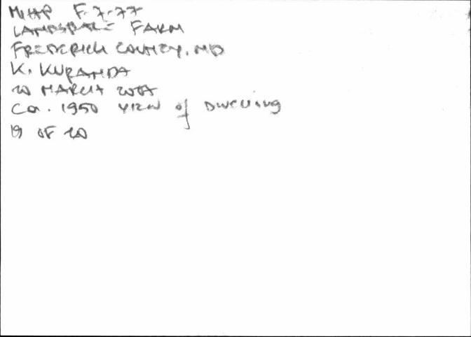
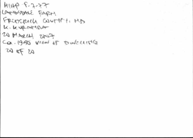
Photos Taken: 20 March 2007 Photos Taken By: K. Kuranda
1. Setting, looking west 2. Dwelling, east elevation looking west 3. Dwelling, north elevation looking south 4. Dwelling, south elevation looking north 5. Dwelling, west elevation looking northeast 6. Smokehouse, north elevation looking south 7. Dairy Barn, west elevation looking northeast 8. Dairy Barn and Silo, east elevation looking west 9. Dairy, south elevation looking north 10. Spring House, west elevation looking northeast 11. Second Dairy Barn, west elevation, looking northeast 12. Wood Equipment Shed, south elevation looking north 13. Corn Crib, south elevation looking north 14. Metal Equipment Shed, east elevation looking west 15. Animal Shelter, south elevation looking north 16. Metal Corn Cribs, looking northwest 17. Concrete-block Equipment Shed, east elevation looking west 18. Equipment Shed, south elevation looking north 19. Ca. 1950 view of Dwelling (Courtesy of Frederick County Historical Society) 20. Ca. 1950 view of Dwelling (Courtesy of Frederick County Historical Society)
Kirsten Peeler, Project Manager and Christine Heidenrich, Historian R. Christopher Goodwin & Associates, Inc. 241 East Fourth Street
Prepared by: Frederick, MP Date Prepared: 5 June 2007
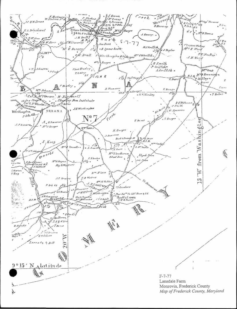
F-7-77 Lansdale Farm Monrovia, Fredenck County Map of Fredenck County, Maiyland
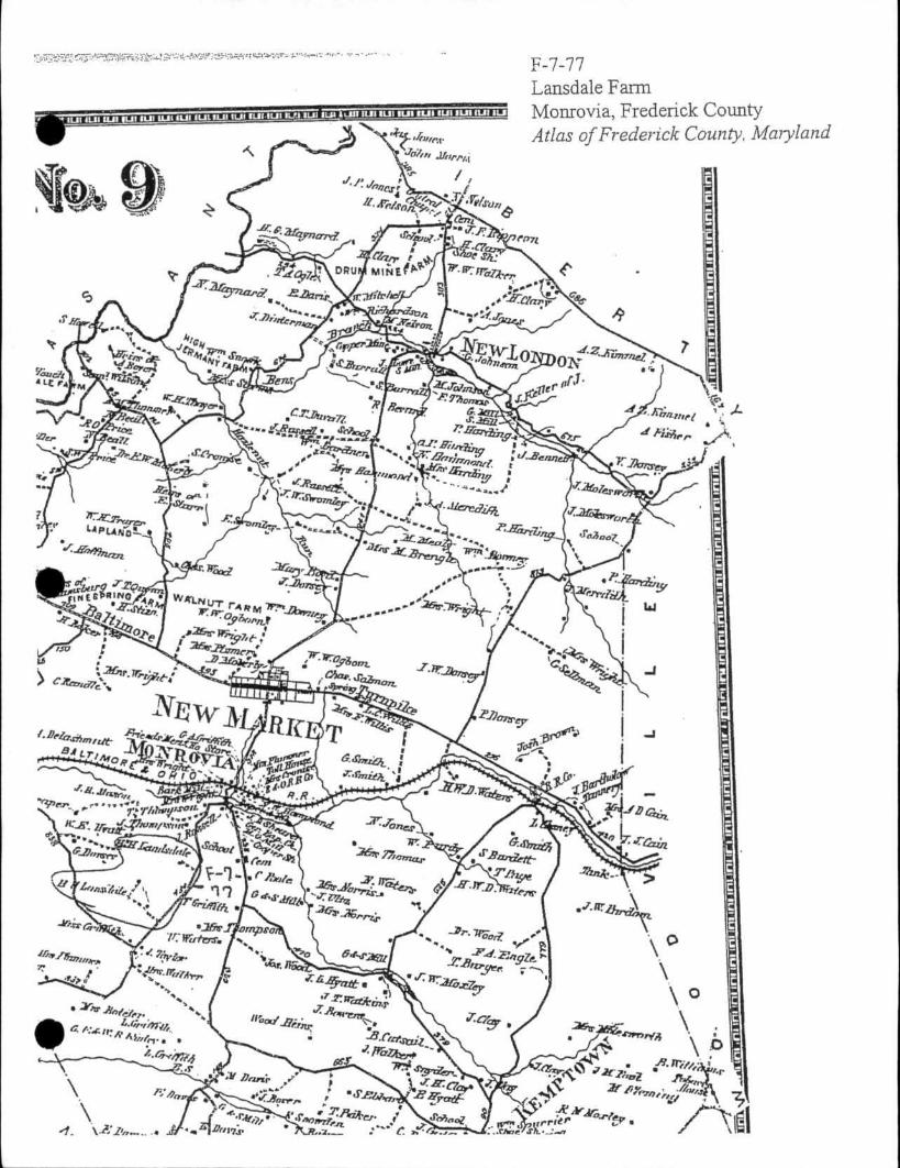
F-7-77 Lansdale Farm Monrovia, Frederick County Atlas of Frederick County, Maiyland
F-7-77
F-7-77
F - 7 - 7 7 Landsdaic Farm Monrovia, Frederick County, Maryland Resource Sketch Map Prepared by: R. Christopher Goodwin & Associates, Inc., March 2007
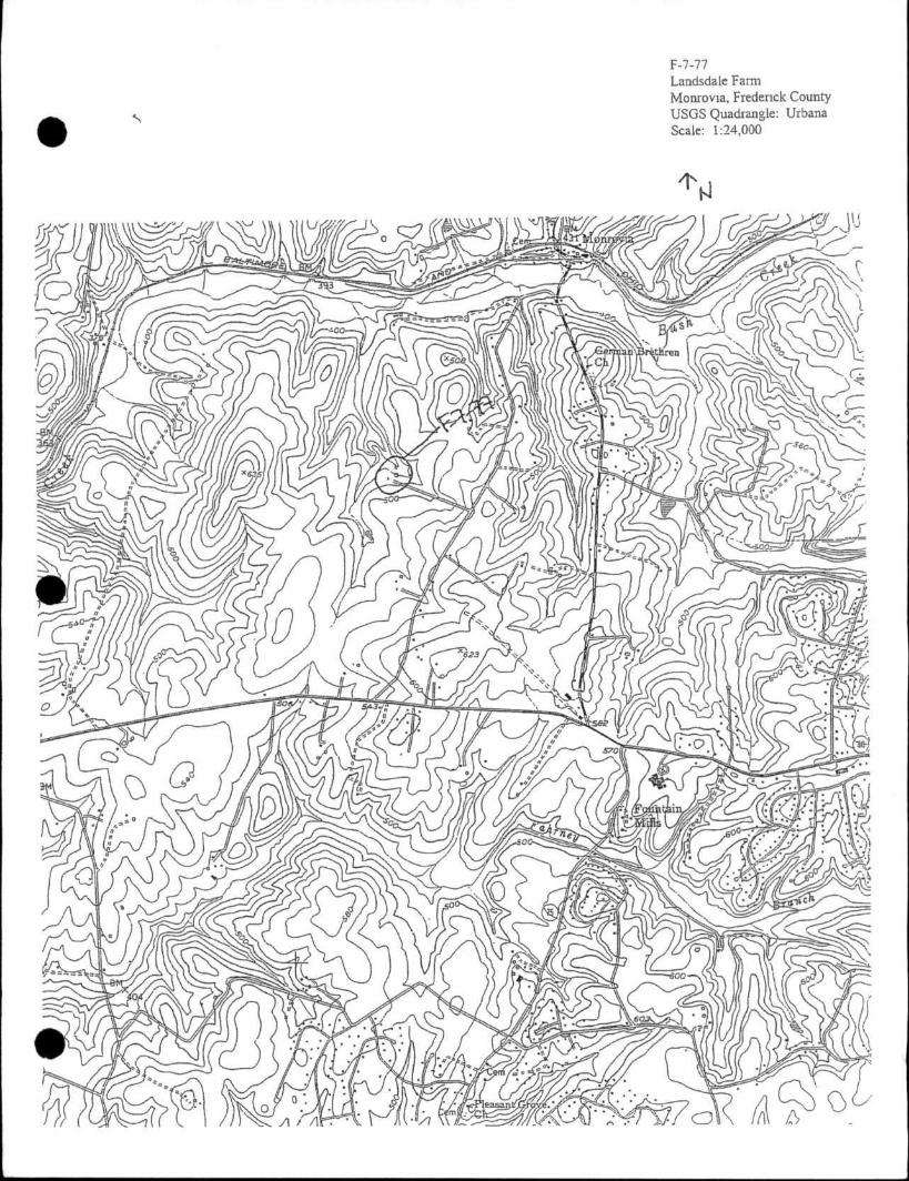
F-7-77 Landsdale Farm Monrovia, Frederick County USGS Quadrangle: Urbana Scale: 1:24,000

F-7-77
LANDSDALE FARM C. 1813 Monrovia Private
Landsdale Farm is a two story frame and random stone structure. A one story stone addition extends to the rear block and is believed to have been slave quarters. A two story log addition, once located on the north end of the residence, was recently replaced.
The farm was originally part of a 970 acre tract called "Seth's Folly", owned by Nicholas Hall, founder of New Market. In 1785, the property including, "houses, gardens, etc.," was divided between his nephews, Nicholas and William Jr. William became the owner of the 232 acres which eventually comprised Landsdale Farm. In 1814, at the death of Samuel Poultney, a public sale was held at the house on the premises. Although substantially altered, the building contributes significantly to the area.
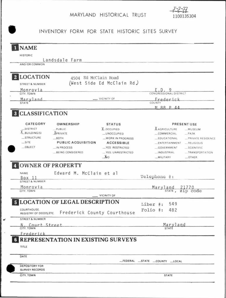
MARYLAND HISTORICAL TRUST 1100135304
INVENTORY FORM FOR STATE HISTORIC SITES SURVEY
NAME HISTORIC
Landsdale Farm AND/OR C O M M O N
LOCATION STREET & NUMBER
4504 Ed McClain Road (West Side Ed McClain RdJ
Monrov ia F , D . 9 CITY. TOWN CONGRESSIONAL DISTRICT
M a r y l a n d — VICINITY OF F r e c l e r i r k STATE COUNTY
M ft« P dd CLASSIFICATION
CATEGORY
—DISTRICT
X_BUILDING(S)
—STRUCTURE
_ S I T E
—OBJECT
OWNERSHIP
— P U B L I C
_XPRIVATE
_ B O T H
PUBLIC ACQUISIT ION
_ I N PROCESS
—BEING CONSIDERED
STATUS
X-OCCUPIED
—UNOCCUPIED
— W O R K IN PROGRESS
ACCESSIBLE
—YES RESTRICTED
— YES: UNRESTRICTED
_XJO
PRESENTUSE
^ A G R I C U L T U R E
— C O M M E R C I A L
—EDUCATIONAL
— ENTERTAINMENT
—GOVERNMENT
— I N D U S T R I A L
—MIL ITARY
— M U S E U M
_ .PAr tK
—PRIVATE RESIDENCE
—RELIGIOUS
—SCIENTIFIC
—TRANSPORTATION
—OTHER
OWNER OF PROPERTY NAME
Box 11 Edward M. McClain et al
Telephone # STREETS. NUMBER
Monrovi a Maryland 21770 STATE , z i p code
CITY. TOWN
VICINITY OF
|LOCATION OF LEGAL DESCRIPTION COURTHOUSE.
REGISTRY OF DEEDS, ETC Freder ick County Courthouse
L i b e r #: 549 F o l i o #: 48 2
STREET & NUMBER
N. Court Street Maryland CITY. TOWN STATE
Frederick REPRESENTATION IN EXISTING SURVEYS TITLE
DATE
—FEDERAL —STATE —COUNTY .LOCAL
DEPOSITORY FOR
SURVEY RECORDS
CITY. TOWN STATE
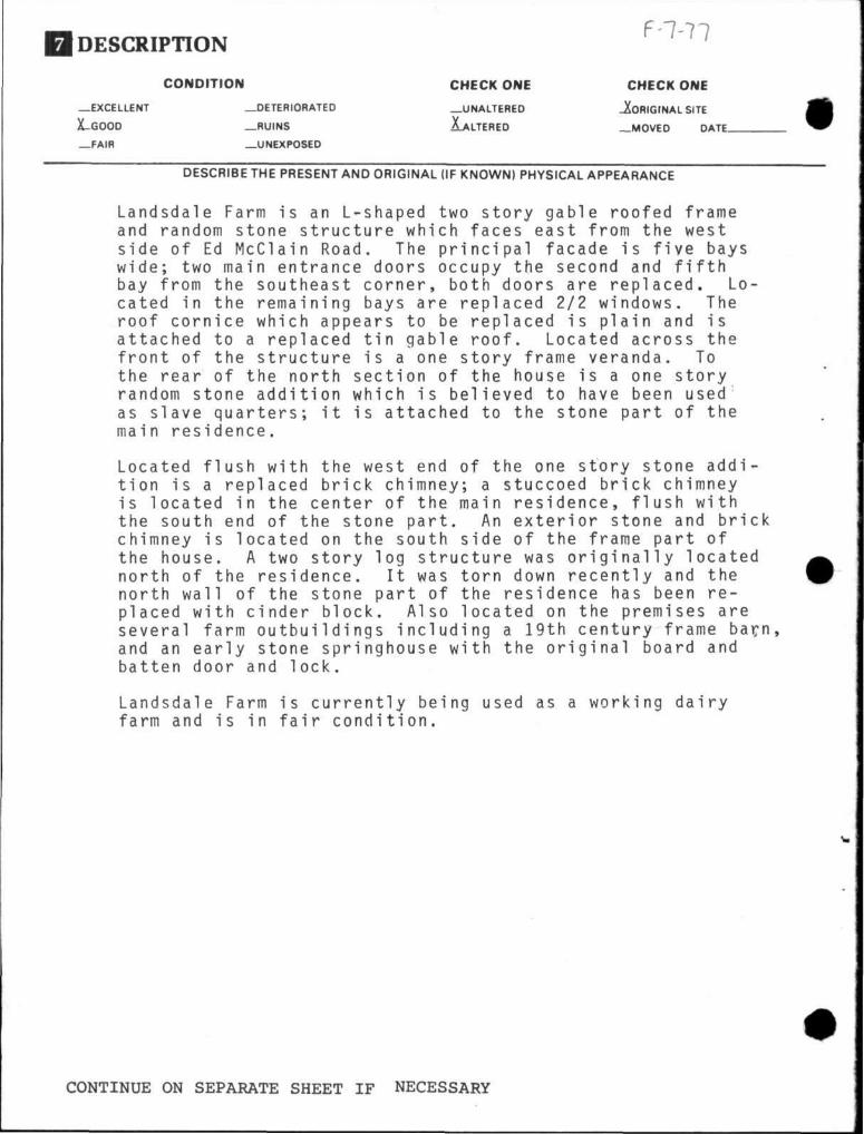
DESCRIPTION F-7-77
—EXCELLENT
X-GOOD
—FAIR
CONDITION
—DETERIORATED
—RUINS
—UNEXPOSED
CHECK ONE CHECK ONE
—UNALTERED JfofllGrNAL SITE
FALTERED —MOVED DATE.
DESCRIBE THE PRESENT AND ORIGINAL (IF KNOWN) PHYSICAL APPEARANCE
Landsdale Farm is an L-shaped two story gable roofed frame and random stone structure which faces east from the west side of Ed McClain Road. The principal facade is five bays wide; two main entrance doors occupy the second and fifth bay from the southeast corner, both doors are replaced. Located in the remaining bays are replaced 2/2 windows. The roof cornice which appears to be replaced is plain and is attached to a replaced tin gable roof. Located across the front of the structure is a one story frame veranda. To the rear of the north section of the house is a one story random stone addition which is believed to have been used as slave quarters; it is attached to the stone part of the main residence.
Located flush with the west end of the one story stone addition is a replaced brick chimney; a stuccoed brick chimney is located in the center of the main residence, flush with the south end of the stone part. An exterior stone and brick chimney is located on the south side of the frame part of the house. A two story log structure was originally located north of the residence. It was torn down recently and the north wall of the stone part of the residence has been replaced with cinder block. Also located on the premises are several farm outbuildings including a 19th century frame bacn, and an early stone springhouse with the original board and batten door and lock.
Landsdale Farm is currently being used as a working dairy farm and is in fair condition.
CONTINUE ON SEPARATE SHEET IF NECESSARY
SIGNIFICANCE F-7-77
|>ERIOO -PREHISTORIC
_ 1 4 0 0 1499
— 1500-1599
—1600-1699
— 1700-1799
X1800 1899
—1900-
AREAS OF SIGNIFICANCE - CHECK AND JUSTIFY BELOW
—ARCHEOLOGY-PREHISTORIC
—ARCHEOLOGY-HISTORIC
—AGRICULTURE
-ARCHITECTURE
—ART
—COMMERCE
—COMMUNICATIONS
—COMMUNITY PLANNING
—CONSERVATION
—ECONOMICS
—EDUCATION
—ENGINEERING
—EXPLORATION/SETTLEMENT
—INDUSTRY
—INVENTION
—LANDSCAPE ARCHITECTURE
— LAW
—LITERATURE
—MILITARY
—MUSIC
—PHILOSOPHY
—POLITICS/GOVERNMENT
—RELIGION
—SCIENCE
—SCULPTURE
—SOCIAL/HUMANITARIAN
—THEATER
—TRANSPORTATION
—OTHER (SPECIFY)
SPECIFIC DATES BUILDER/ARCHITECT
STATEMENT OF SIGNIFICANCE
The Landsdale Farm was originally part of a 970 acre tract called Seth's Folly and Resurvey on Seth's Folly owned by Nicholas Hall, founder of New Market.
In 1785, he divided the property including "houses, gardens, etc," between two nephews, Nicholas and William Jr.l William Jr. became the owner of the 232 acres which eventually comprised of the Landsdale Farm. By 1813, a house had been built on the property by Hall Since in 1814, after Samuel Poultney had purchased the land and died, a public sale was held at the house on the premises.2 The land changed hands often until 1917 when the farm was bought by Louis F. Detrick Landsdale Farm remained in the Detrick family until 1948
Frederick County Land Records Liber WR 5 Folio 560
0
Frederick County Land Records Liber WR 46 Folio 639
CONTINUE ON SEPARATE SHEET IF NECESSARY
F-7-77
MAJOR BIBLIOGRAPHICAL REFERENCES
CONTINUE ON SEPARATE SHEET IF NECESSARY
GEOGRAPHICAL DATA ACREAGE OF NOMINATED PROPERTY
VERBAL BOUNDARY DESCRIPTION
LIST ALL STATES AND COUNTIES FOR PROPERTIES OVERLAPPING STATE OR COUNTY BOUNDARIES
STATE COUNTY
STATE COUNTY
FORM PREPARED BY NAME/TITLE Cherilyn Widel l , S i t e s A n a l y s t
O f f i c e o f H i s t o r i c P r e s e r v a t i o n 3 / 8 / 7 8 ORGANIZATION DATE
Winrhpsfpr Hall 663-8300
STREET* NUMBER TELEPHONE
Frederick Maryland, 21701
CITY OR TOWN STATE
The Maryland Historic Sites Inventory was officially created by an Act of the Maryland Legislature, to be found in the Annotated Code of Maryland, Article 41, Section 181 KA, 19 74 Supplement.
The Survey and Inventory are being prepared for information and record purposes only and do not constitute any infringement of individual property rights.
RETURN TO: Maryland Historical Trust The Shaw House, 21 State Circle Annapolis, Maryland 21401 (301) 267-1438