Embed Size (px)
DESCRIPTION
Â
Citation preview
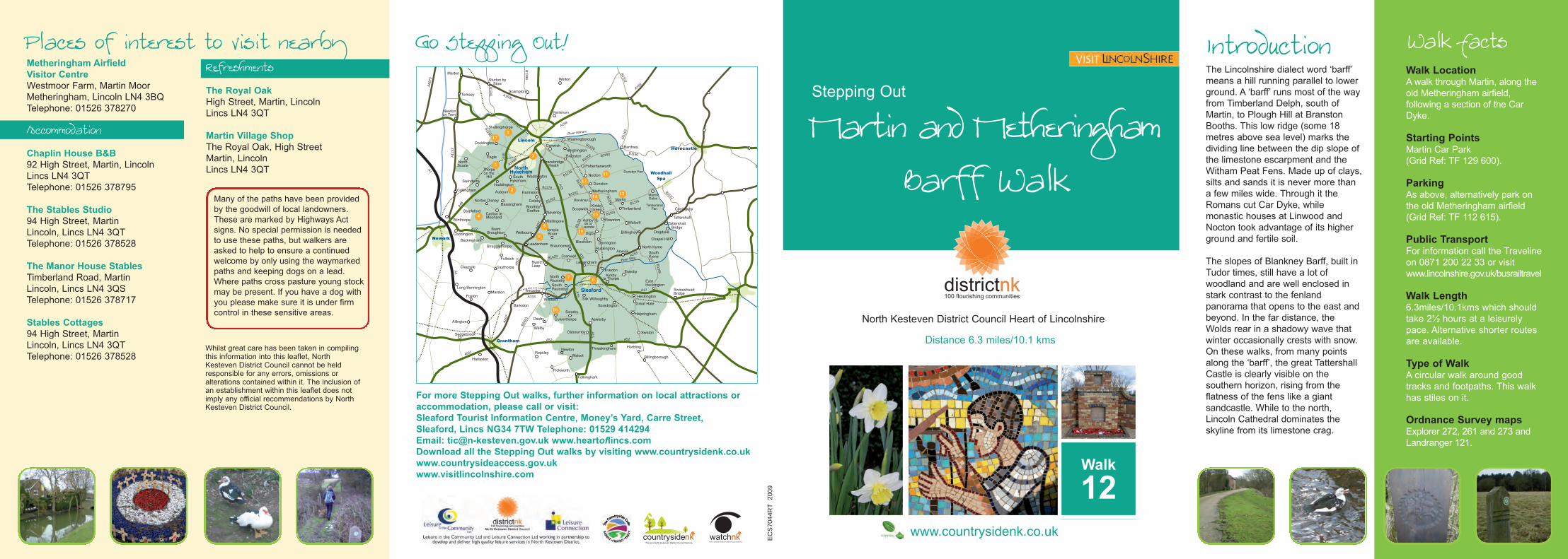
Walk FactsIntroductionMetheringham AirfieldVisitor CentreWestmoor Farm, Martin MoorMetheringham, Lincoln LN4 3BQTelephone: 01526 378270
AccommodationChaplin House B&B92 High Street, Martin, LincolnLincs LN4 3QTTelephone: 01526 378795
The Stables Studio94 High Street, MartinLincoln, Lincs LN4 3QTTelephone: 01526 378528
The Manor House StablesTimberland Road, MartinLincoln, Lincs LN4 3QSTelephone: 01526 378717
Stables Cottages94 High Street, MartinLincoln, Lincs LN4 3QTTelephone: 01526 378528
RefreshmentsThe Royal OakHigh Street, Martin, LincolnLincs LN4 3QT
Martin Village ShopThe Royal Oak, High StreetMartin, LincolnLincs LN4 3QT
The Lincolnshire dialect word ‘barff’means a hill running parallel to lowerground. A ‘barff’ runs most of the wayfrom Timberland Delph, south ofMartin, to Plough Hill at BranstonBooths. This low ridge (some 18metres above sea level) marks thedividing line between the dip slope ofthe limestone escarpment and theWitham Peat Fens. Made up of clays,silts and sands it is never more thana few miles wide. Through it theRomans cut Car Dyke, whilemonastic houses at Linwood andNocton took advantage of its higherground and fertile soil.
The slopes of Blankney Barff, built inTudor times, still have a lot ofwoodland and are well enclosed instark contrast to the fenlandpanorama that opens to the east andbeyond. In the far distance, theWolds rear in a shadowy wave thatwinter occasionally crests with snow.On these walks, from many pointsalong the ‘barff’, the great TattershallCastle is clearly visible on thesouthern horizon, rising from theflatness of the fens like a giantsandcastle. While to the north,Lincoln Cathedral dominates theskyline from its limestone crag.
Places of interest to visit nearby
EC
S70
44R
T20
09
A1
A11
33
A17
A1500
B1398
A60
7
A607
A15
A15
A52
B1189
B1190
A46
B1188
B1191
A60
7
B1429 A153
B1202
B1241
B12
02
B1190
B1178
B1190
B1202
B1395
B1188
A158
A15
A52
B1191
B11
91
B640
3
B1192
A1434
B1178
A153
B1190
B1202
EastHeckington
Haddington
1
2
3
4
5
67
8
910
11
12
13
14
15
16
17
Go Stepping Out!
Whilst great care has been taken in compilingthis information into this leaflet, NorthKesteven District Council cannot be heldresponsible for any errors, omissions oralterations contained within it. The inclusion ofan establishment within this leaflet does notimply any official recommendations by NorthKesteven District Council.
Stepping Out
Walk
12
North Kesteven District Council Heart of Lincolnshire
www.countrysidenk.co.uk
Distance 6.3 miles/10.1 kms
Martin and MetheringhamBarff Walk
Walk LocationA walk through Martin, along theold Metheringham airfield,following a section of the CarDyke.
Starting PointsMartin Car Park(Grid Ref: TF 129 600).
ParkingAs above, alternatively park onthe old Metheringham airfield(Grid Ref: TF 112 615).
Public TransportFor information call the Travelineon 0871 200 22 33 or visitwww.lincolnshire.gov.uk/busrailtravel
Walk Length6.3miles/10.1kms which shouldtake 2½ hours at a leisurelypace. Alternative shorter routesare available.
Type of WalkA circular walk around goodtracks and footpaths. This walkhas stiles on it.
Ordnance Survey mapsExplorer 272, 261 and 273 andLandranger 121.
Many of the paths have been providedby the goodwill of local landowners.These are marked by Highways Actsigns. No special permission is neededto use these paths, but walkers areasked to help to ensure a continuedwelcome by only using the waymarkedpaths and keeping dogs on a lead.Where paths cross pasture young stockmay be present. If you have a dog withyou please make sure it is under firmcontrol in these sensitive areas.
For more Stepping Out walks, further information on local attractions oraccommodation, please call or visit:Sleaford Tourist Information Centre, Money’s Yard, Carre Street,Sleaford, Lincs NG34 7TW Telephone: 01529 414294Email: [email protected] www.heartoflincs.comDownload all the Stepping Out walks by visiting www.countrysidenk.co.ukwww.countrysideaccess.gov.ukwww.visitlincolnshire.com

��Martin Metheringham Walk Reproduced from OS Mapping with the permission of the controller ofHMSO c Crown Copyright. Unauthorised reproduction infringes crowncopyright and may lead to civil proceedings. OS Licence 100017926.2009
factory dominating the skyline atBardney.
6. At the end of the wood take thetrack to the right and follow thisround until you reachMetheringham Barff Farm.Pass the farm which will be toyour right, follow this track andas you walk you will see areservoir to your left. You willreach a bridge which brings youto the junction where you meetthe site of the Car Dyke and theNocton and Dunston walk(leaflet 11).
7. Go over the Car Dyke and turnright, continuing along, keepingthe Car Dyke to your right. Asyou walk, keep an eye out onyour left for some steps goingdown to a carved seat as well asother small wooden sculpturescelebrating the heritage andhistory of the land.
8. Upon meeting a junction,continue straight ahead, signposted ‘Blankney Fen’. (A rightturn here will return you toMetheringham Airfield at Point 5.)Continue along the Car Dyke,passing Car Dyke Farm on yourright, until you meet a woodengate. Cross over the stile andcontinue along the grassy path.This will take you over a series
of stiles as the path bears leftuntil it reaches a minor roadwhich will take you back to theB1191. With care, cross theB1191 and return to your car.
B1199
B1189
B1189
Key
To Wood
hallSpa
ToBillinghay
Car Dyke
BlankneyWood
Car DykeFarm
MetheringhamBarff Farm
Martin
Barff Farm
Linwood Moor
RAF Metheringham opened inOctober 1943 and was soon hometo 106 Squadron formerlycommanded by Guy Gibson.Operational flying started onNovember 18th 1943 in time for theBattle of Berlin. By VE Day in May1945, 106 had flown over 200sorties from the airfield, losing 57Lancasters.
Local potato pioneer Alderman GFlintham OBE, JP, was an influentialfigure in the development of potatofertilisers. A century ago, his earlypotatoes, (ready in June) were agreat innovation and in 1909, afterpicking, the first crop was rushed inwicker baskets to Metheringhamstation for distribution to markets asfar away as Sheffield. By annuallyrotating his locally grown potatoeswith mustard, Flintham was able tokeep producing without exhaustingthe soil.
SteppingOut leafletnumber11
Car DykeStarts from theNorth end of thewalk at ThePlough.
1. From the Stepping Out Car Park,walk to the road and turn left, towalk through the village of Martinuntil you see Mrs Mary King’sSchool on your right. Cross overthe road.
2. Continue out of the village alongLinwood Road passing theschool on your left and thecemetery on your right. As youreach a group of trees, look for away marker leading off to yourleft, along North Moor Lane.
An alternative route can befound by carrying straight alongthe road. As the road becomesa track, continue to follow it,ensuring you keep the hedgerowon your right, until you crossfields which will eventually bringyou to the airfield at Point 4.
3. Turn left at the way marker,along North Moor Lane andfollow the tarmac road as itbecomes a grass track andwinds around a small copse,passing some old farm buildingson your left. Follow the waymarkers passing trees on yourright and cross over a woodenbridge on your right into a field.
Walk along the edge of the fieldkeeping the ancient hedgerow toyour left. At a T-junction turn leftand follow the track until youmeet the airfield.(If you turn left at this point andfollow the airfield road for a shortdistance you will find a memorialon your left).
4. At the junction turn right andfollow the old runway, passingthe Stepping Out car park untilyou reach a junction. In front ofyou is an RAF sign showing theformer RAF Metheringham.
5. (Turning right at this point willtake you on a shorter, alternativeroute rejoining the longer route atPoint 8. This route isapproximately 3.8 miles).To follow the longer route, crossover the road and at the metalbarrier follow the track as itwinds through countryside.Continue until you reach agrassy area with a way markerleading off to the right towardsan area of woodland. When youreach the wood follow the waymarkers, keeping the wood onyour left, with wonderful views toyour right of the Witham valleywith the former sugar beet
/
Car ParksMartin/Metheringham WalkCar DykeAlternative Stepping Out RouteRAF squadron war memorial
1
1
2
3
4
5
6
7
8
2
3
4
5
6
7
8
North