Embed Size (px)
Citation preview

p a
r k n
o t
e Barwon Bluff Marine Sanctuary
Colourful life on the reefAfter a long journey through the Otway Ranges, the Barwon River makes a final sweep to the west, past the crumbling bluff of Mount Colite, before emptying into the breaking waves of Bass Strait. At the tip of the bluff, a pincer-shaped reef juts out into the sea.
The composition of the reef reflects the complex geological history of the site. The eastern half of the pincer is basalt formed from a lava flow from nearby Mt. Duneed, the west pincer is old sandstone formed under ancient seas, while the bluff itself is calcarenite, the remains of an old dune that formed on top of the lava.
The reef is famous for the diversity of its sea- life, particularly in the intertidal areas. The far eastern edge of the reef falls under the influence of the river while to the west the sandstone reef is exposed to ocean swell.
The tip of the eastern reef supports many filter- feeding animals such as feather stars and barnacles that enjoy the fast currents. The basalt has weathered into numerous boulders, ledges and pools that provide shelter for a large variety of animals.
Snorkelling
Between the reef ‘pincers’, there is a small bay with a floor of sand and rock. Small colourful sea-slugs can be found along the reef sides. Stands of Giant Kelp sway with the waves, tempting snorkellers to swim through and experience an underwater forest. Giant rays regularly sweep along the sand. Offshore, small bommies are fringed with Bull Kelp, hiding colourful sponges below.
Barwon Bluff Marine Sanctuary is part of a system of 13 Marine National Parks and 11 smaller Marine Sanctuaries created by the Victorian Government to ensure that representative samples of Victoria’s diverse, distinctive and amazing marine environment are conserved for future generations.
These parks and sanctuaries now protect 5.3% of Victoria’s coastal waters, safeguarding important marine habitats and species, and complementing our world-class national parks system on land.
By keeping some of these marine areas in a natural state, free from potentially damaging human activities, we will protect these environments into the future.
Enjoying Barwon Bluff Marine SanctuarySnorkelling and diving at the Bluff are excellent with a wide diversity of habitats in a small area. The softer sandstone that forms one of the reefs has been eroded under the water to form spectacular arches, gutters and swim throughs, creating a great environment to explore.
The basalt platform also continues under the water and provides a different type of habitat. In between the two reefs is a beautiful sandy beach that has extensive beds of giant kelp just offshore. Look out for rock lobsters and abalone while snorkelling in this area.
Bird watching and rockpool rambles on the shore platforms are popular activities, and the sanctuary is also used extensively for marine education programs.
Beach walking around the Bluff is a great way to see the entire sanctuary, with stunning views over Bass Strait. Take care when walking to watch the tide, as certain sections are impassable at high tide.
Safe swimming venues are available adjacent to the Marine Sanctuary on the river side, and there is excellent surfing and body boarding at nearby 13th Beach.
For more information call the Parks Victoria Information Centreon 13 1963 or visit our website at www.parkweb.vic.gov.au

N
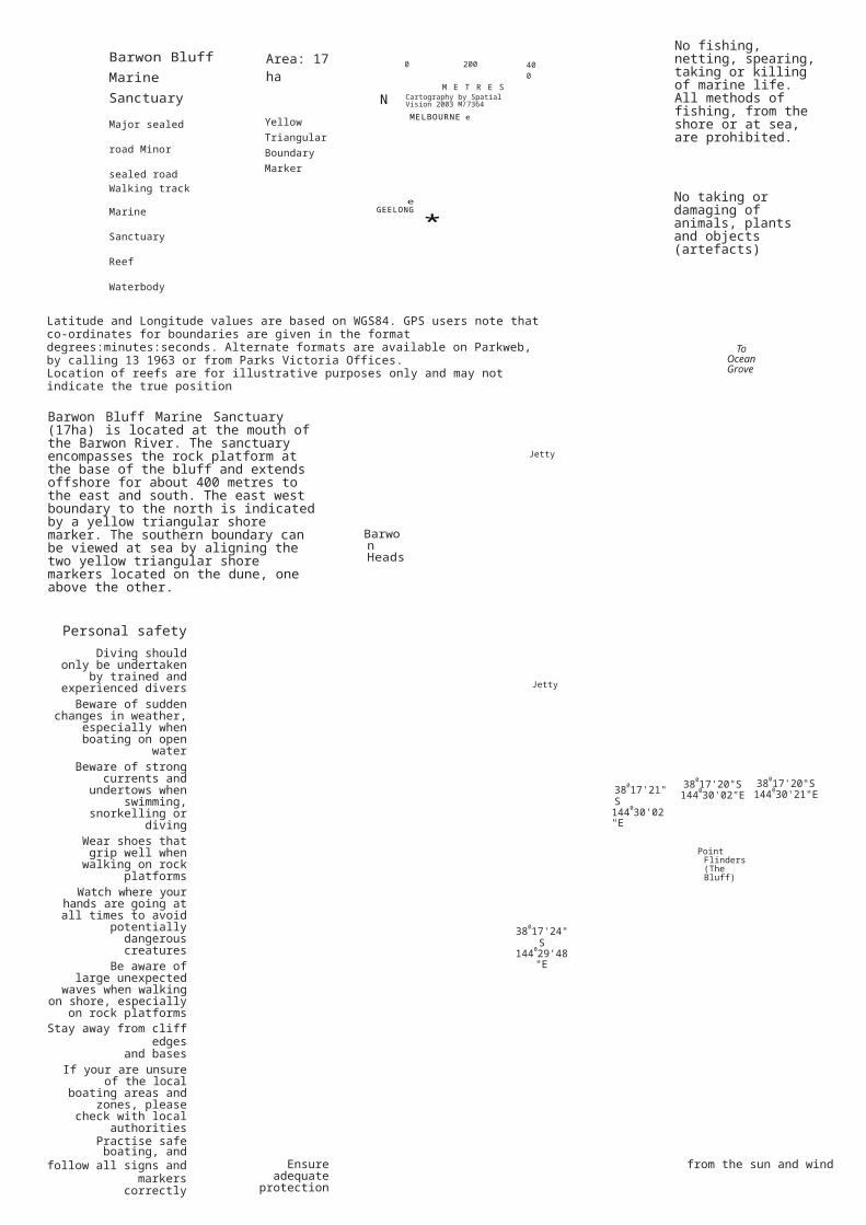
Barwon Bluff Marine Sanctuary
Major sealed road
Minor sealed road
Area: 17 ha
Yellow Triangular Boundary Marker
0 200
M E T R E S Cartography by Spatial Vision 2003 M/7364
MELBOURNE e
400
No fishing, netting, spearing, taking or killing of marine life.All methods of fishing, from the shore or at sea, are prohibited.
Walking track
Marine Sanctuary
Reef
Waterbody
eGEELONG *
No taking or damaging of animals, plants and objects (artefacts)
Latitude and Longitude values are based on WGS84. GPS users note that co-ordinates for boundaries are given in the format degrees:minutes:seconds. Alternate formats are available on Parkweb, by calling 13 1963 or from Parks Victoria Offices.Location of reefs are for illustrative purposes only and may not indicate the true position
To Ocean Grove
Barwon Bluff Marine Sanctuary (17ha) is located at the mouth of the Barwon River. The sanctuary encompasses the rock platform at the base of the bluff and extends offshore for about 400 metres to the east and south. The east west boundary to the north is indicated by a yellow triangular shore marker. The southern boundary can be viewed at sea by aligning the two yellow triangular shore markers located on the dune, one above the other. Barwon
Heads
C121 C121
Jetty
Personal safetyDiving should only be
undertaken by trained and experienced divers
Beware of sudden changes in weather, especially when boating on open
waterBeware of strong currents
and undertows when swimming, snorkelling or
divingWear shoes that grip well
when walking on rockplatforms
Watch where your hands are going at all times to
avoid potentially dangerous
creaturesBe aware of large
unexpected waves when walking on shore, especially
on rock platformsStay away from cliff edges
and basesIf your are unsure of the local boating areas and
zones, please check with local
authoritiesPractise safe boating, and
Jetty
38017'24"S144029'48"E
38017'21"S144030'02"E
38017'20"S144030'02"E
Point Flinders (The Bluff)
38017'20"S144030'21"E
follow all signs and markerscorrectly
Ensure adequate protection from the sun and wind Restrictions
8 A S S S T R A I T38017'36"S144030'04"E
Caring for the marineenvironment
Discarded gear and rubbish can endanger birds and marine animals - please
takeyour rubbish home
Always replace any organisms or rocks you
mayhave disturbed
Please keep off sensitivedune habitats
Keep clear of bird nesting orroosting areas
Please do not feed any wildlife including seagulls
andseals For the protection of the marine environment, a
number of activities are prohibited within the boundaries of Victoria's Marine National Parks and Marine Sanctuaries.
There are strong penalties under the National Parks Act for fishing in Marine National Parks and Marine Sanctuaries. These restrictions and penalties apply in Barwon Bluff Marine Sanctuary from16 November 2002.
You may carry fin-fish on board your boat within park boundaries if you caught the fish outside the park, and you may also carry (but not use) a fishing rod or a spear gun (with the spear separated from the gun).
You may also have abalone or rock lobster and
associated equipment (securely stowed) on board the boat provided that you are travelling straight through the park by the shortest practicable route.
To report a fishing offence call the Department of Primary Industries on 13 FISH (133 474).
Parks Victoria is responsible for the day-to-day management of Victoria's Marine National Parks and Marine Sanctuaries. For further information contact the Parks Victoria Information Centre on 13 1963 or visit the Parks Victoria website at: www.parkweb.vic.gov.au
Parknotes on each of Victoria's Marine National Parks and Marine Sanctuaries, including boundaries and permitted and prohibited activities, have been produced to assist visitors to these areas.
December 2003