Embed Size (px)
Citation preview
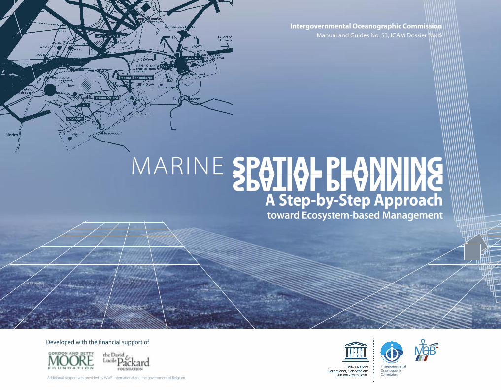
MARINE SPATIAL PLANNING A Step-by-Step Approachtoward Ecosystem-based Management
SPATIAL PLANNING
Man andBiosphere
Intergovernmental Oceanographic Commission Manual and Guides No. 53, ICAM Dossier No. 6
Developed with the financial support of
IntergovernmentalOceanographicCommission
Additional support was provided by WWF-International and the government of Belgium.

2 MARINE SPATIAL PLANNING – A Step-by-Step Approach toward Ecosystem-based Management
The designation employed and the presentation of material throughout the publication do not imply the expression of any opinion whatsoever on the part of
UNESCO in particular concerning the legal status of any country, territory, city or area or of its authorities, or the delineation of its frontiers or boundaries.
The authors are responsible for the choice and the presentation of the facts contained in this manual and for the opinions expressed therein, which are not neces-
sarily those of UNESCO and do not commit the Organization.
Editor: Rachel Dahl
Designer: Eric Loddé
Written by Charles Ehler and Fanny Douvere
For bibliographic purposes, this document should be cited as follows:
Ehler, Charles, and Fanny Douvere. Marine Spatial Planning: a step-by-step approach toward ecosystem-based management. Intergovernmental Oceanographic
Commission and Man and the Biosphere Programme. IOC Manual and Guides No. 53, ICAM Dossier No. 6. Paris: UNESCO. 2009 (English).
Printed by xxx
© UNESCO IOC 2009
A Step-by-Step Approach toward Ecosystem-based Management – MARINE SPATIAL PLANNING 3
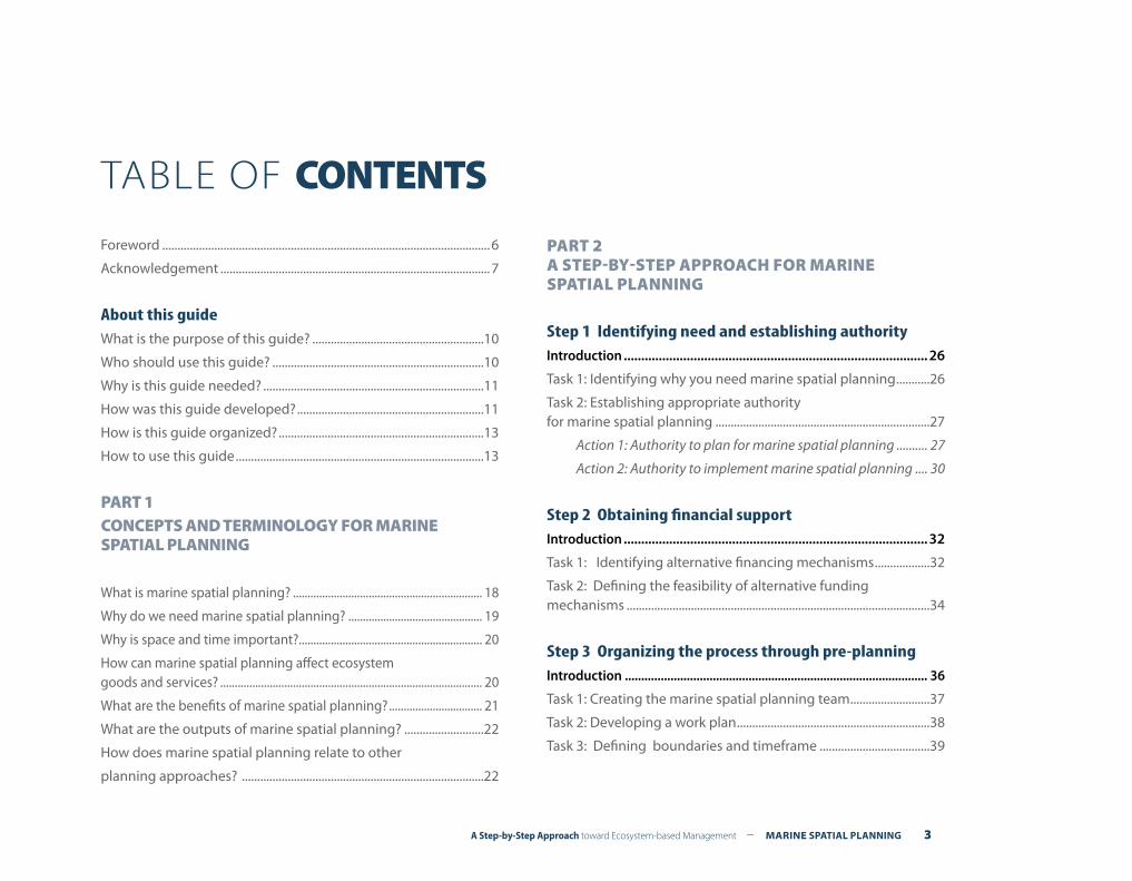
Foreword ...........................................................................................................6
Acknowledgement ........................................................................................7
About this guideWhat is the purpose of this guide? ........................................................10
Who should use this guide? .....................................................................10
Why is this guide needed? ........................................................................11
How was this guide developed? .............................................................11
How is this guide organized? ...................................................................13
How to use this guide .................................................................................13
PART 1CONCEPTS AND TERMINOLOGY FOR MARINE SPATIAL PLANNING
What is marine spatial planning? ................................................................. 18
Why do we need marine spatial planning? .............................................. 19
Why is space and time important? ............................................................... 20
How can marine spatial planning affect ecosystem goods and services? .......................................................................................... 20
What are the benefits of marine spatial planning? ................................ 21
What are the outputs of marine spatial planning? ..........................22
How does marine spatial planning relate to other
planning approaches? ...............................................................................22
PART 2 A STEP-BY-STEP APPROACH FOR MARINE SPATIAL PLANNING
Step 1 Identifying need and establishing authorityIntroduction ....................................................................................... 26
Task 1: Identifying why you need marine spatial planning ...........26
Task 2: Establishing appropriate authority for marine spatial planning ......................................................................27
Action 1: Authority to plan for marine spatial planning .......... 27
Action 2: Authority to implement marine spatial planning .... 30
Step 2 Obtaining financial supportIntroduction ....................................................................................... 32
Task 1: Identifying alternative financing mechanisms ..................32
Task 2: Defining the feasibility of alternative funding mechanisms ...................................................................................................34
Step 3 Organizing the process through pre-planningIntroduction ............................................................................................. 36
Task 1: Creating the marine spatial planning team ..........................37
Task 2: Developing a work plan ...............................................................38
Task 3: Defining boundaries and timeframe ....................................39
TABLE OF CONTENTS
4 MARINE SPATIAL PLANNING – A Step-by-Step Approach toward Ecosystem-based Management
Action 1: Defining boundaries ........................................................ 38
Action 2: Defining the time frame .................................................. 39
Task 4: Defining principles ........................................................................40
Task 5: Defining goals and objectives ...................................................41
Task 6: Identifying risks and developing contingency plans .......................................................................................42
Step 4 Organizing stakeholder participationIntroduction ....................................................................................................43
Task 1: Defining who should be involved in marine spatial planning .......................................................................44
Task 2: Defining when to involve stakeholders .................................45
Task 3: Defining how to involve stakeholders ....................................47
Step 5 Defining and analyzing existing conditions Introduction ....................................................................................................49
Task 1: Collecting and mapping information about ecological, environmental and oceanographic conditions .............50
Task 2: Collecting and mapping information about human activities ..........................................................................................55
Task 3: Identifying current conflicts and compatibilities ...............57
Step 6 Defining and analyzing future conditions Introduction ............................................................................................. 63
Task 1: Projecting current trends in the spatial and temporal needs of existing human activities ........................................................64
Task 2: Estimating spatial and temporal requirements for new demands of ocean space ..........................................................65
Task 3: Identifying possible alternative futures for the planning area ..................................................................................66
Task 4: Selecting the preferred spatial sea use scenario ................68
Step 7 Preparing and approving the spatial management planIntroduction ............................................................................................. 71
Task 1: Identifying alternative spatial and temporal management measures, incentives, and institutional arrangements ..............................................................73
Task 2: Specifying criteria for selecting marine spatial management measures ...............................................................76
Task 3: Developing the zoning plan ......................................................76
Task 4: Evaluating the spatial management plan ............................79
Task 5: Approving the spatial management plan ............................80
Step 8 Implementing and enforcing the spatial management planIntroduction ............................................................................................. 83
Task 1: Implementing the spatial management plan ......................83
Task 2: Ensuring compliance with the spatial management plan .......................................................................................84
Task 3: Enforcing the spatial management plan ..............................85
Step 9 Monitoring and evaluating performance Introduction ............................................................................................. 86
Task 1: Developing the performance monitoring program ..........87
Action 1: Re-confirming the objectives ......................................... 87
A Step-by-Step Approach toward Ecosystem-based Management – MARINE SPATIAL PLANNING 5
Action 2: Agreeing on outcomes to measure .............................. 87
Action 3: Identifying key performance indicators to monitor ........................................................................ 88
Action 4: Determining baseline data on indicators ................... 88
Action 5: Selecting outcome targets .............................................. 89
Task 2: Evaluating performance monitoring data ............................90
Task 3: Reporting results of performance evaluation .....................91
Step 10 Adapting the marine spatial management processIntroduction ............................................................................................. 92
Task 1: Reconsidering and redesigning the marine spatial planning program ..........................................................................92
Task 2: Identifying applied research needs ........................................93
Task 3: Starting the next round of marine spatial planning ..........94
References ................................................................................................. 96
6 MARINE SPATIAL PLANNING – A Step-by-Step Approach toward Ecosystem-based Management
Foreword
Few people imagined in 2006, when UNESCO held the first Interna-tional Workshop on Marine Spatial Planning (MSP), how rapidly the field would develop. The last several years has seen an explosion of interest in MSP as a practical approach to manage both conflicts and compatibilities in the marine environment in the face of both increas-ing development pressures and increasing interest in the conservation of nature. The application of MSP has spread quickly from a handful of countries in Western Europe to places as disparate as the United States and Vietnam.
UNESCO, especially its Intergovernmental Oceanographic Commission (IOC) and the Man and the Biosphere (MAB) Programme coordinated by the Ecological and Earth Sciences Division, is in a unique interna-tional position to assist countries move toward ecosystem-based man-agement of the marine environment through MSP. The IOC promotes development of management procedures and policies leading to the sustainability of marine environments, as well as the capacity-building necessary for maintenance of healthy ocean ecosystems. The MAB Pro-gramme focuses on a broad-based interdisciplinary research agenda with respect to the ecological, social, and economic dimensions of bio-diversity loss and its reduction. It promotes sustainable development through the establishment of interdisciplinary learning laboratories for integrated ecosystem management using sites of the World Network of Biosphere Reserves for research on biodiversity and sustainability.
This UNESCO publication on MSP is a cooperative initiative between the IOC and the MAB Programme. It provides a step-by-step approach to MSP from establishing authority, through planning to implementa-tion, monitoring and evaluation. We hope this report helps countries to foster the technical capacity building and institutional capacities to reduce biodiversity loss and to manage their marine ecosystems sus-tainably.
Patricio Bernal, Executive SecretaryIntergovernmental Oceanographic Commission
AndNatarajan Ishwaran, Director
Division of Ecological and Earth Sciences andSecretary, Man and the Biosphere Programme
UNESCO
A Step-by-Step Approach toward Ecosystem-based Management – MARINE SPATIAL PLANNING 7
Acknowledgement
Marine spatial planning (MSP) is an idea whose time has come. Origi-nally started as a management approach for nature conservation in the Great Barrier Reef Marine Park over 30 years ago, it has been used recently in the more crowded seas of European countries as an effec-tive process for achieving multiple objectives. Several countries in Asia, including China and Vietnam, are using MSP to achieve both economic and environmental objectives. When applied at an ecosystem level, it is a practical approach that moves toward ecosystem-based manage-ment of marine areas.
The initial idea for a step-by-step guide to MSP was developed during meetings (2005-07) of a Working Group on Ocean Zoning at the National Center for Ecological Analysis and Synthesis (NCEAS), University of Califor-nia, Santa Barbara. We participated in lively discussions about how to make ecosystem-based management in the marine environment a reality and took up one of the main working group conclusions to write a practical guide to MSP.
As an initial step, we organized the first international workshop on MSP at UNESCO in Paris in November 2006. A pioneering group of about 50 marine planners and scientists met to exchange ideas and experiences and endorsed the need for a practical guide to MSP. A technical report, Visions for a Sea Change (UNESCO, 2007), and a peer-reviewed special issue of Ma-rine Policy on MSP (September 2008), presented additional results from the workshop.
We relied on an enthusiastic group of international experts for advice on developing the MSP guide. Three meetings were held in Paris over an 18-month period. Participants included Jeff Ardron, Jon Day, Paul Gilliland, Jihyun Lee, Patrick McConney, Leslie-Ann McGee, Chu Hoi Nguyen, Elliott Norse, Eric Olsen, Robert Pomeroy, R. Kerry Turner, Bernadette O’Neil, Ole Vestegaard, and Leo de Vrees. Meg Caldwell, Sarah Chasis, Glen Herbert, Richard Kenchington, Deerin Babb-Brott, and Nico Nolte also reviewed and contributed to the final report. We want to thank An Vanhulle for her substantial contribution to the content of Step 6, defining and analyzing future conditions.
Three meetings were held to fine tune the guidelines at the Depart-ment of Energy and Environmental Affairs, Commonwealth of Mas-sachusetts, the Vietnam Administration of Seas and Islands (VASI), Hanoi, and the Ha Long Bay Management Department, Ha Long City, Vietnam. We thank Deerin Babb-Brott, Chu Hoi Nguyen, and Ngo Van Hung and their professional staffs, respectively, for organizing and hosting those valuable review meetings. We also presented various ideas and versions of the MSP guide at over 20 workshops and confer-ences in 13 countries during which we received important feedback on the content and utility of our work.
We particularly thank The Gordon and Betty Moore Foundation and The David and Lucile Packard Foundation for providing financial support for the preparation of the MSP report. Our grants were guided by Bary Gold and our Program Officers, Emily Goodwin and Kate Wing at the Moore Foundation, and Kristin Sherwood and Tegan Hoffman at the Packard Foundation. WWF-International and the Belgian Science Policy Office also provided financial assistance.
UNESCO’s Intergovernmental Oceanographic Commission (IOC) and the Man and the Biosphere Programme (MAB) also provided support to the project. Dr. Patricio Bernal, Executive Secretary of the IOC, and Dr. Nata-rajan Ishwaran, Director of the Division of Ecological and Earth Sciences and Secretary of MAB have supported the project since its beginning. Julian Barbiere (IOC) and Salvatore Arico (MAB) helped to manage and guide the project. Virginie Bonnet and Natasha Lazic provided critical administrative support throughout the project.
The final report was designed by Eric Lodde and edited by Rachel Dahl. Both provided excellent services that improved the final report under un-reasonable deadlines. Finally, we take responsibility for any misinterpreta-tion or misrepresentation of ideas or factual errors in the report.
Charles Ehler and Fanny DouvereCo-principal Investigators
IOC-MAB Marine Spatial Planning InitiativeParis, France
May 2009


ABOUT THIS GUIDE ABOUT THIS GUIDE
A Step-by-Step Approach toward Ecosystem-based Management – MARINE SPATIAL PLANNING 9
10 MARINE SPATIAL PLANNING – A Step-by-Step Approach toward Ecosystem-based Management
What is the purpose of this guide?
During recent years, marine spatial planning (MSP) has been the focus of considerable interest throughout the world, particularly in heavily used marine areas. MSP offers countries an operational framework to maintain the value of their marine biodiversity while at the same time allowing sustainable use of the economic potential of their oceans. Essentially, MSP is an approach that can make key components of ecosystem-based management of marine areas a reality.
Numerous attempts have been made to define both the scope and nature of MSP, but relatively few have discussed how to put it into practice. This guide aims at answering your questions about how to make MSP operational in such a way that can move your initiative toward successful results.
In this guide, we use a clear, straightforward step-by-step approach to show you how you can set up and apply MSP. Most steps are illus-trated with relevant examples from the real world. To make sure you have the information you need, throughout the text we refer you to more detailed sources, including the UNESCO website on MSP (ioc3.unesco.org/marinesp) that can further support you in making good decisions in MSP.
Who should use this guide?
This guide is primarily intended for professionals responsible for the planning and management of marine areas and their resources. It is especially targeted to situations in which time, finances, informa-tion and other resources are Iimited. If you encounter one or more of the issues listed in Box 2, this guide might be what you need to get started.
The guide provides a comprehensive overview of MSP. It focuses on describing a logical sequence of steps that are all required to achieve desired goals and objectives for marine areas. It does not focus on the technical details of any one of the steps, e.g., it is not intended to be a guide on the development of a marine geographic informa-tion system or implementation of a performance monitoring system. When available, references to existing technical guides, handbooks, and websites are referenced in the text.
This guide can be an important tool for professionals at the interna-tional, regional, national, and sub-national levels who want to know more about the promise and potential of MSP as a way to achieve multiple goals and objectives, including sustainable economic devel-opment and biodiversity conservation.
• Understanding of what marine spatial planning is about, what benefits it can have, and what results you can expect;
• Insight in the logical steps and tasks of setting up a successful MSP program;
• Awareness of what has worked and what has not in MSP prac-tice around the world
• Do you have (or expect) human activities that adversely affect important natural areas of your marine area?
• Do you have (or expect) incompatible human activities that conflict with one another in your marine area?
• Do you need to streamline policies and licensing procedures affecting the marine environment?
• Do you need to decide on what space is most suitable for the development of new human activities such as renewable en-ergy facilities or offshore aquaculture?
• Do you need a vision of what your marine area could or should look like in another 10, 20, 30 years from now?
Box 1. What can this
guide offer you?
Box 2.Checklist for defining the
usefulness of this guide to MSP
A Step-by-Step Approach toward Ecosystem-based Management – MARINE SPATIAL PLANNING 11
Other reasons to begin marine spatial planning include:• To provide a vision and consistent direction not only of what is
desirable, but what is possible in marine areas;• To protect nature, which has its own requirements that must be
respected if long-term sustainable human development is to be achieved and if large-scale environmental degradation is to be avoided or minimized;
• To reduce fragmentation of marine habitats (that is, when eco-systems are split up due to human activities and therefore pre-vented from functioning properly);
• To make efficient use of marine resources—marine resources, in-cluding ocean space, are increasingly in short supply. Those that are available should be used to produce goods and services in a sustainable manner;
• To set priorities—to enable significant inroads to be made into meeting the development objectives of the marine manage-ment area in an equitable way, it is necessary to provide a rational basis for setting priorities, and to manage and direct resources to where and when they are needed most;
• To create and stimulate opportunities for new users of marine areas;
• To coordinate actions and investments in space and time to en-sure positive effects from those investments, both public and private, and to facilitate complementarity among jurisdictions;
• To avoid duplication of effort by different public agencies and levels of government in MSP activities, including planning, moni-toring, and permitting; and
• To achieve a higher quality of service at all levels of government, e.g., by ensuring that permitting of human activities is stream-lined when proposed development is consistent with a compre-hensive spatial management plan.
Why is this guide needed?
Most professionals responsible for the planning and management of marine areas and their resources usually have scientific or techni-cal training in areas such as ecology, biology, oceanography or engi-
neering. Few have been trained as professional planners and manag-ers. Many new marine managers wind up “learning on the job”—a sometimes effective, but often expensive, way to do business.
This guide attempts to fill this gap by using a step-by-step approach for developing and implementing MSP. It provides an understanding of the different tasks, skills and expertise you need to develop and sustain your efforts. It also discusses issues such as obtaining finan-cial resources or organizing stakeholders that are important, often neglected, steps of the MSP process.
Alternative visions of what might happen if we do nothing and what might happen if we manage marine space successfully is presented in Box 3.
How was this guide developed?
The steps proposed in this guide are largely based on the analysis of actual MSP initiatives from around the world. This work allowed documentation and analysis of the steps that can lead to successful implementation of the MSP process. Some of these examples have been used throughout this guide. You can read the full results of this work by visiting the UNESCO website at (http://ioc3.unesco.org/ma-rinesp).
A draft text of the guide was refined through two “fine-tuning” meet-ings. The first was held in the Commonwealth of Massachusetts in the United States of America, from 13-17 October 2008. Massachu-setts recently passed an Oceans Act requiring the development of an integrated management plan for its marine waters. The second meeting was held in two locations, Ha Noi and Ha Long Bay, Viet Nam, from 1-8 April 2009. Viet Nam recently established the Viet-namese Administration of Seas and Islands (VASI), a national agency that is responsible for sea use management and marine spatial plan-ning. Presenting drafts of the guide during these meetings helped to ensure the steps proposed in the guide would be practical, logical, and effective for users.
12 MARINE SPATIAL PLANNING – A Step-by-Step Approach toward Ecosystem-based Management
Box 3. Alternative visions of the
future of marine areas
What if we do nothing?In the next 20 years, human activities in many areas of the ocean will have increased significantly. Traditional uses, such as marine transportation, sand and gravel mining, and marine recreation will continue to grow in importance. Oil and gas development will con-tinue to push further and deeper offshore with many of its opera-tions occurring only underwater. Fisheries, will continue to exist, but at lower levels, due to the diminished stocks, and in more re-stricted areas because of competition for ocean space. New uses of the ocean, e.g., offshore renewable energy and offshore aquacul-ture, will compete with traditional uses for space. Climate change will have modified species distributions and habitats; increasing ocean acidification will raise new concerns about the survival of some species. In many areas, increasing public concern about the health of the ocean will lead to significant areas set aside for nature conservation. Conflicts among human activities will increase, e.g., collisions of ships with wind turbines might occur, as might con-flicts between wave parks and surfers and sailors.
Alternatively, what might marine spatial planning produce?In the next 20 years, our oceans could be very different. We could have achieved a vision of clean, safe, healthy, productive and bio-logically diverse oceans. Ecosystem-based, marine spatial planning of human activities could result in society gaining more benefits from the use of the marine environment than previously, while its natural diversity is better protected.
Climate change will drive change both in the environment itself and the way in which people use it. Offshore renewable energy de-velopment will be commonplace and carbon capture and storage in the ocean could be underway. The cumulative environmental ef-fects of using the marine environment will be managed through integrated MSP and account will be taken of the changing acidity and temperature that will already be affecting our oceans and seas. We will be responding to this through MSP so that the integrity of marine ecosystems is conserved.
We will be using the sea for a variety of reasons, delivering greater economic and social benefits. However, MSP means that activi-ties in the marine environment will co-exist and that the effects of different activities on each other and the cumulative effects on the environment as a whole will be taken into account and man-aged consistently. Marine industries will have access to certain places, generating wealth for the nation. Consumers of marine products, including offshore renewable energy or seafood, will expect these to have been produced sustainably, and marine in-dustries will ensure that the environmental and social effects of their operations are acceptable.
Our seas will be cleaner and healthier than they are now and they will be ecologically diverse and dynamic. Ecosystems will be re-silient to environmental change so that they deliver the products and services we need for present and future generations. Repre-sentative, rare, vulnerable and valued species and habitats will be protected. Spatial and other management measures will be in place to make sure that there is no net loss of biodiversity as a result of human activities. Spatial management measures, such as a representative and ecologically coherent network of well-man-aged marine protected areas, will help deliver this and in some cases enable ecosystems to recover from previous damage. Fish stocks will be caught sustainably, with access to them shared be-tween commercial and recreational fishermen.
In the long term, management of human activities in the marine environment will be implemented to secure long-term benefits for the whole of society and nature. Sustainable marine develop-ment could be the outcome. (See also Step 5, Defining and analyz-ing future conditions)
Modified from: Department of Environment, Food, and Rural Affairs (Defra), 2009. Our seas—a shared resource—high level marine objectives. Defra: London. 12 p.
A Step-by-Step Approach toward Ecosystem-based Management – MARINE SPATIAL PLANNING 13
Finally, three review meetings were held with an expert group of marine scientists and managers at UNESCO’s headquarters in Paris, France. The first review meeting was held from 18-20 March 2008 and focused on the concepts, frameworks, principles, and ap-proaches that should be incorporated into a guide to MSP. The second review meeting was held from 15-16 September 2008 to evaluate an initial draft of the guide. Major points of discussion included the identi-fication of gaps, the logical sequence and practicality of the steps, and where examples from international good practice could be used to support the text. The final review meeting was held from 27-28 April 2009, during which the draft guide was modified and updated before proceeding to publication.
How is this guide organized?
The guide is organized into two parts. The first part defines MSP, why it is needed, what its benefits and outputs are, and includes how it relates to other marine management approaches.
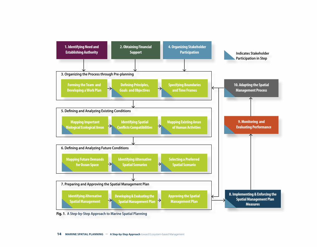
The second part is the most important. It lays out a ten-step approach that will show you how MSP could become operational in your area. Each step is further divided into separate tasks and actions. How the steps are connected is shown in Fig. 1 on the following page.
How to use this guide
This guide is written in distinct parts, following the general structure and elements of well-known coastal and marine management cycles1. It can be used in two ways.
You can start at Step 1, Identifying need and establishing authority, and fol-low the step-by-step approach all the way through to Step 10, Adapting the marine spatial management process. This will give you a good under-standing of the logical steps for planning, developing, implementing, evaluating, and adapting MSP (see Fig. 1).
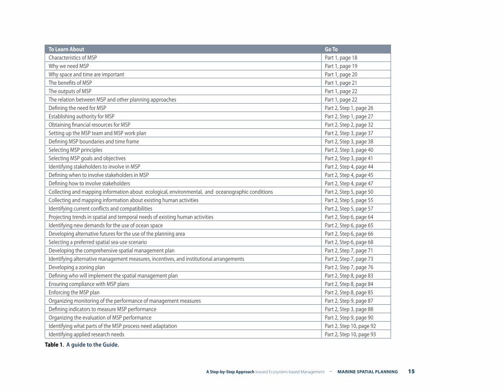
Alternatively, the table at the end of this section can direct you quick-ly to the parts of the guide that you may need most. In this way, you will be able to use the MSP elements you need or that may be more relevant to your time and/or budget limitations.
1 For example, see Olsen (1997) or Chua (1998).
14 MARINE SPATIAL PLANNING – A Step-by-Step Approach toward Ecosystem-based Management
Fig. 1. A Step-by-Step Approach to Marine Spatial Planning
Forming the Team and Developing a Work Plan
Defining Principles,Goals and Objectives
Specifying Boundariesand Time Frames
Identifying SpatialConflicts Compatibilities
Mapping ImportantBiological Ecological Areas
Mapping Existing Areas of Human Activities
Selecting a PreferredSpatial Scenario
Identifying AlternativeSpatial Scenarios
Mapping Future Demands for Ocean Space
Identifying AlternativeSpatial Management
Developing & Evaluating the Spatial Management Plan
Approving the SpatialManagement Plan
4. Organizing Stakeholder Participation
10. Adapting the SpatialManagement Process
9. Monitoring and Evaluating Performance
8. Implementing & Enforcing the Spatial Management Plan
Measures
Indicates Stakeholder Participation in Step
2. Obtaining FinancialSupport
1. Identifying Need andEstablishing Authority
3. Organizing the Process through Pre-planning
5. Defining and Analyzing Existing Conditions
6. Defining and Analyzing Future Conditions
7. Preparing and Approving the Spatial Management Plan
A Step-by-Step Approach toward Ecosystem-based Management – MARINE SPATIAL PLANNING 15
To Learn About Go ToCharacteristics of MSP Part 1, page 18Why we need MSP Part 1, page 19Why space and time are important Part 1, page 20The benefits of MSP Part 1, page 21The outputs of MSP Part 1, page 22The relation between MSP and other planning approaches Part 1, page 22 Defining the need for MSP Part 2, Step 1, page 26Establishing authority for MSP Part 2, Step 1, page 27Obtaining financial resources for MSP Part 2, Step 2, page 32Setting up the MSP team and MSP work plan Part 2, Step 3, page 37Defining MSP boundaries and time frame Part 2, Step 3, page 38Selecting MSP principles Part 2, Step 3, page 40Selecting MSP goals and objectives Part 2, Step 3, page 41Identifying stakeholders to involve in MSP Part 2, Step 4, page 44Defining when to involve stakeholders in MSP Part 2, Step 4, page 45Defining how to involve stakeholders Part 2, Step 4, page 47Collecting and mapping information about ecological, environmental, and oceanographic conditions Part 2, Step 5, page 50Collecting and mapping information about existing human activities Part 2, Step 5, page 55Identifying current conflicts and compatibilities Part 2, Step 5, page 57Projecting trends in spatial and temporal needs of existing human activities Part 2, Step 6, page 64Identifying new demands for the use of ocean space Part 2, Step 6, page 65Developing alternative futures for the use of the planning area Part 2, Step 6, page 66Selecting a preferred spatial sea-use scenario Part 2, Step 6, page 68Developing the comprehensive spatial management plan Part 2, Step 7, page 71Identifying alternative management measures, incentives, and institutional arrangements Part 2, Step 7, page 73Developing a zoning plan Part 2, Step 7, page 76Defining who will implement the spatial management plan Part 2, Step 8, page 83Ensuring compliance with MSP plans Part 2, Step 8, page 84Enforcing the MSP plan Part 2, Step 8, page 85Organizing monitoring of the performance of management measures Part 2, Step 9, page 87Defining indicators to measure MSP performance Part 2, Step 3, page 88Organizing the evaluation of MSP performance Part 2, Step 9, page 90Identifying what parts of the MSP process need adaptation Part 2, Step 10, page 92Identifying applied research needs Part 2, Step 10, page 93
Table 1. A guide to the Guide.

CONCEPTS AND TERMINOLOGY FOR MARINE SPATIAL PLANNING MARINE SPATIAL PLANNING
PART I
A Step-by-Step Approach toward Ecosystem-based Management – MARINE SPATIAL PLANNING 17
18 MARINE SPATIAL PLANNING – A Step-by-Step Approach toward Ecosystem-based Management
1 United Kingdom Department for Environment, Food and Rural Affairs, (2008).
What is marine spatial planning?Marine spatial planning (MSP) is a practical way to create and estab-lish a more rational organization of the use of marine space and the interactions between its uses, to balance demands for development with the need to protect marine ecosystems, and to achieve social and economic objectives in an open and planned way.1
It is important to remember that we can only plan and manage hu-man activities in marine areas, not marine ecosystems or compo-nents of ecosystems. We can allocate human activities to specific marine areas by objective, e.g., development or preservation areas, or by specific uses, e.g., wind farms, offshore aquaculture, or sand and gravel mining.
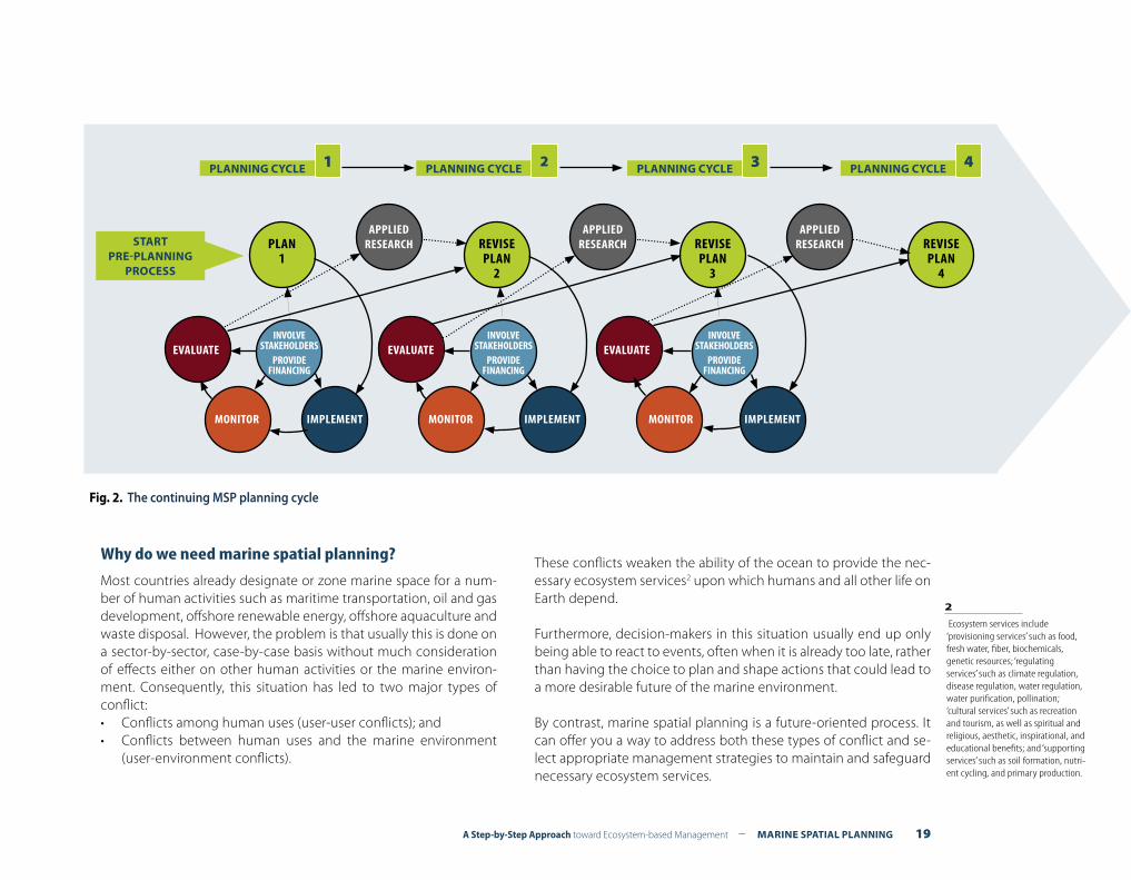
MSP does not lead to a one-time plan. It is a continuing, iterative pro-cess that learns and adapts over time (see Fig. 2). The development and implementation of MSP involves a number of steps, including:
(1) Identifying need and establishing authority (2) Obtaining financial support(3) Organizing the process through pre-planning(4) Organizing stakeholder participation(5) Defining and analyzing existing conditions(6) Defining and analyzing future conditions(7) Preparing and approving the spatial management plan(8) Implementing and enforcing the spatial management plan(9) Monitoring and evaluating performance(10) Adapting the marine spatial management process
These 10 steps are not simply a linear process that moves sequen-tially from step to step. Many feedback loops should be built into the process. For example, goals and objectives identified early in the planning process are likely to be modified as costs and benefits of different management measures are identified later in the plan-ning process. Analyses of existing and future conditions will change as new information is identified and incorporated in the planning process. Stakeholder participation will change the planning pro-cess as it develops over time. Planning is a dynamic process and planners have to be open to accommodating changes as the pro-cess evolves over time.
Comprehensive MSP provides an integrated framework for manage-ment that provides a guide for, but does not replace, single-sector planning. For example, MSP can provide important contextual infor-mation for marine protected area management or for fisheries man-agement, but does not intent to replace them.
The scope and content of each of the above steps is described in Part 2 of this guide, A step-by-step approach for marine spatial planning.
Marine spatial planning (MSP) is a public process of analyzing and allocating the spatial and temporal distribution of human activities in marine areas to achieve ecological, economic, and social objectives that are usually specified through a political process.
• Ecosystem-based, balancing ecological, economic, and social goals and objectives toward sustainable development
• Integrated, across sectors and agencies, and among levels of government
• Place-based or area-based• Adaptive, capable of learning from experience• Strategic and anticipatory, focused on the long-term• Participatory, stakeholders actively involved in the process
Box 4. Characteristics of
effective marine spatial planning
A Step-by-Step Approach toward Ecosystem-based Management – MARINE SPATIAL PLANNING 19
EVALUATE
PLAN1
REVISEPLAN
2
REVISEPLAN
3
REVISEPLAN
4
EVALUATE EVALUATE
MONITOR MONITORIMPLEMENT IMPLEMENT IMPLEMENT
APPLIEDRESEARCH
APPLIEDRESEARCH
APPLIEDRESEARCH
INVOLVESTAKEHOLDERS
PROVIDEFINANCING
PLANNING CYCLE 1 PLANNING CYCLE 2 PLANNING CYCLE 3 PLANNING CYCLE 4
INVOLVESTAKEHOLDERS
PROVIDEFINANCING
INVOLVESTAKEHOLDERS
PROVIDEFINANCING
MONITOR
Fig. 2. The continuing MSP planning cycle
STARTPRE-PLANNING
PROCESS
Why do we need marine spatial planning?
Most countries already designate or zone marine space for a num-ber of human activities such as maritime transportation, oil and gas development, offshore renewable energy, offshore aquaculture and waste disposal. However, the problem is that usually this is done on a sector-by-sector, case-by-case basis without much consideration of effects either on other human activities or the marine environ-ment. Consequently, this situation has led to two major types of conflict:• Conflicts among human uses (user-user conflicts); and• Conflicts between human uses and the marine environment
(user-environment conflicts).
These conflicts weaken the ability of the ocean to provide the nec-essary ecosystem services2 upon which humans and all other life on Earth depend.
Furthermore, decision-makers in this situation usually end up only being able to react to events, often when it is already too late, rather than having the choice to plan and shape actions that could lead to a more desirable future of the marine environment.
By contrast, marine spatial planning is a future-oriented process. It can offer you a way to address both these types of conflict and se-lect appropriate management strategies to maintain and safeguard necessary ecosystem services.
2 Ecosystem services include ‘provisioning services’ such as food, fresh water, fiber, biochemicals, genetic resources; ‘regulating services’ such as climate regulation, disease regulation, water regulation, water purification, pollination; ‘cultural services’ such as recreation and tourism, as well as spiritual and religious, aesthetic, inspirational, and educational benefits; and ‘supporting services’ such as soil formation, nutri-ent cycling, and primary production.
20 MARINE SPATIAL PLANNING – A Step-by-Step Approach toward Ecosystem-based Management
Renewable Goods• Marine animals for food• Marine animals for recreation, e.g., whale watching• Seaweed• Medicines• Other raw materials, e.g., building materials, ornaments• Energy, e.g., wind, wave, tidal, thermal• Water
Non-Renewable Goods• Oil and gas• Sand and gravel• Marine minerals
Renewable Services• Habitat, e.g., nursery areas for fish• Protected areas• Flood and storm protection• Erosion control• Nutrient cycling • Biological regulation• Waste processing• Marine transportation routes• Atmospheric and climate regulation• Carbon sequestration• Tourism, leisure and recreation• Cultural heritage and identity• Education and research• Aesthetics
Box 5. Examples of goods
and services from marine ecosystems
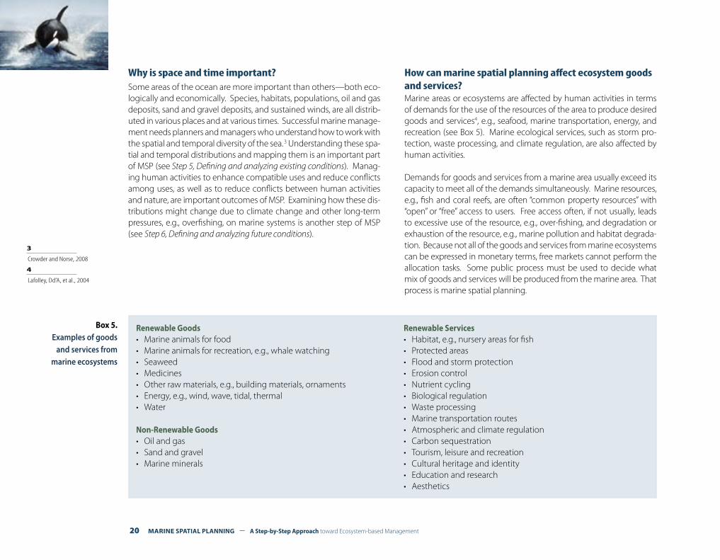
Why is space and time important?Some areas of the ocean are more important than others—both eco-logically and economically. Species, habitats, populations, oil and gas deposits, sand and gravel deposits, and sustained winds, are all distrib-uted in various places and at various times. Successful marine manage-ment needs planners and managers who understand how to work with the spatial and temporal diversity of the sea. 3 Understanding these spa-tial and temporal distributions and mapping them is an important part of MSP (see Step 5, Defining and analyzing existing conditions). Manag-ing human activities to enhance compatible uses and reduce conflicts among uses, as well as to reduce conflicts between human activities and nature, are important outcomes of MSP. Examining how these dis-tributions might change due to climate change and other long-term pressures, e.g., overfishing, on marine systems is another step of MSP (see Step 6, Defining and analyzing future conditions).
How can marine spatial planning affect ecosystem goods and services?Marine areas or ecosystems are affected by human activities in terms of demands for the use of the resources of the area to produce desired goods and services4, e.g., seafood, marine transportation, energy, and recreation (see Box 5). Marine ecological services, such as storm pro-tection, waste processing, and climate regulation, are also affected by human activities.
Demands for goods and services from a marine area usually exceed its capacity to meet all of the demands simultaneously. Marine resources, e.g., fish and coral reefs, are often “common property resources” with “open” or “free” access to users. Free access often, if not usually, leads to excessive use of the resource, e.g., over-fishing, and degradation or exhaustion of the resource, e.g., marine pollution and habitat degrada-tion. Because not all of the goods and services from marine ecosystems can be expressed in monetary terms, free markets cannot perform the allocation tasks. Some public process must be used to decide what mix of goods and services will be produced from the marine area. That process is marine spatial planning.
4 Lafolley, Dd’A, et al., 2004
3 Crowder and Norse, 2008

A Step-by-Step Approach toward Ecosystem-based Management – MARINE SPATIAL PLANNING 21
Ecological/ Environmental Benefits
Identification of biological and ecological important areas
Biodiversity objectives incorporated into planned decision-making
Identification and reduction of conflicts between human use and nature
Allocation of space for biodiversity and nature conservation
Establish context for planning a network of marine protected areas
Identification and reduction of the cumulative effects of human activities on marine ecosystems
Economics Benefits Greater certainty of access to desirable areas for new private sector investments, frequently amortized over 20-30 years
Identification of compatible uses within the same area of development
Reduction of conflicts between incompatible uses
Improved capacity to plan for new and changing human activities, including emerging technologies and their associated effects
Better safety during operation of human activities
Promotion of the efficient use of resources and space
Streamlining and transparency in permit and licensing procedures
Social Benefits Improved opportunities for community and citizen participation
Identification of impacts of decisions on the allocation of ocean space (e.g., closure areas for certain uses, protected areas) for communities and economies onshore (e.g., employment, distribution of income)”
Identification and improved protection of cultural heritage
Identification and preservation of social and spiritual values related to ocean use (e.g., the ocean as an open space)
What are the benefits of marine spatial planning?
When developed properly, marine spatial planning can have significant economic, social, and environmental benefits. Table 2 below shows some of the most important benefits of marine spatial planning.
Table 2. Examples of benefits of MSP
22 MARINE SPATIAL PLANNING – A Step-by-Step Approach toward Ecosystem-based Management
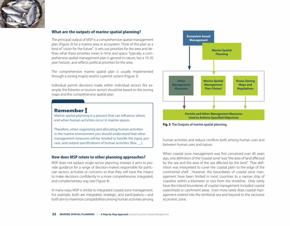
What are the outputs of marine spatial planning?
The principal output of MSP is a comprehensive spatial management plan (Figure 3) for a marine area or ecosystem. Think of this plan as a kind of “vision for the future”. It sets out priorities for the area and de-fines what these priorities mean in time and space. Typically, a com-prehensive spatial management plan is general in nature, has a 10-20 year horizon, and reflects political priorities for the area.
The comprehensive marine spatial plan is usually implemented through a zoning map(s) and/or a permit system (Figure 3).
Individual permit decisions made within individual sectors (for ex-ample, the fisheries or tourism sector) should be based on the zoning maps and the comprehensive spatial plan.
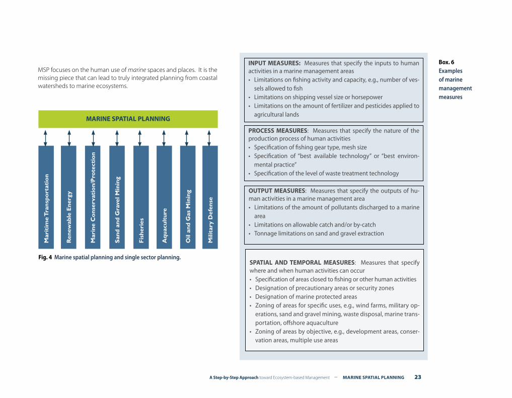
How does MSP relate to other planning approaches?MSP does not replace single-sector planning. Instead, it aims to pro-vide guidance for a range of decision-makers responsible for partic-ular sectors, activities or concerns so that they will have the means to make decisions confidently in a more comprehensive, integrated, and complementary way (see Figure 4).
In many ways MSP is similar to integrated coastal zone management. For example, both are integrated, strategic, and participatory—and both aim to maximize compatibilities among human activities among
human activities and reduce conflicts both among human uses and between human uses and nature.
When coastal zone management was first conceived over 40 years ago, one definition of the “coastal zone” was “the area of land affected by the sea and the area of the sea affected by the land”. That defi-nition was interpreted to cover the coastal plain to the edge of the continental shelf. However, the boundaries of coastal zone man-agement have been limited in most countries to a narrow strip of coastline within a kilometer or two from the shoreline. Only rarely have the inland boundaries of coastal management included coastal watersheds or catchment areas. Even more rarely does coastal man-agement extend into the territorial sea and beyond to the exclusive economic zone.
Fig. 3 The Outputs of marine spatial planning.
Ecosystem-based Management
Marine Spatial Planning
Ocean ZoningMaps and
Regulations
Marine Spatial ManagementPlan (Vision)
OtherManagement
Measures
Permits and Other Management MeasuresUsed to Achieve Specified Objectives
Remember !Marine spatial planning is a process that can influence where and when human activities occur in marine spaces.
Therefore, when organizing and allocating human activities in the marine environment you should understand that other management measures will be needed to handle the input, pro-cess, and output specifications of human activities (Box __).
A Step-by-Step Approach toward Ecosystem-based Management – MARINE SPATIAL PLANNING 23
MSP focuses on the human use of marine spaces and places. It is the missing piece that can lead to truly integrated planning from coastal watersheds to marine ecosystems.
Mar
itim
e T
rans
port
atio
n
Ren
ewab
le E
nerg
y
Mar
ine
Co
nser
vati
on/
Pro
tect
ion
San
d an
d G
rave
l Min
ing
Fis
heri
es
Aqu
acul
ture
Oil
and
Gas
Min
ing
Mili
tary
Def
ense
MARINE SPATIAL PLANNING
Fig. 4 Marine spatial planning and single sector planning.
Box. 6Examples of marine management measures
INPUT MEASURES: Measures that specify the inputs to human activities in a marine management areas• Limitations on fishing activity and capacity, e.g., number of ves-
sels allowed to fish• Limitations on shipping vessel size or horsepower• Limitations on the amount of fertilizer and pesticides applied to
agricultural lands
PROCESS MEASURES: Measures that specify the nature of the production process of human activities• Specification of fishing gear type, mesh size• Specification of “best available technology” or “best environ-
mental practice”• Specification of the level of waste treatment technology
SPATIAL AND TEMPORAL MEASURES: Measures that specify where and when human activities can occur• Specification of areas closed to fishing or other human activities• Designation of precautionary areas or security zones• Designation of marine protected areas• Zoning of areas for specific uses, e.g., wind farms, military op-
erations, sand and gravel mining, waste disposal, marine trans-portation, offshore aquaculture
• Zoning of areas by objective, e.g., development areas, conser-vation areas, multiple use areas
OUTPUT MEASURES: Measures that specify the outputs of hu-man activities in a marine management area• Limitations of the amount of pollutants discharged to a marine
area• Limitations on allowable catch and/or by-catch• Tonnage limitations on sand and gravel extraction
24 MARINE SPATIAL PLANNING – A Step-by-Step Approach toward Ecosystem-based Management
Remember! some important terms
Ecosystem-based managementAn integrated approach to management that considers the entire ecosystem, including humans. The goal of ecosystem-based man-agement is to maintain an ecosystem in a healthy, productive and resilient condition so that it can provide the goods and services humans want and need. Ecosystem-based management differs from current approaches that usually focus on a single species, sector, activity or concern; it considers the cumulative impacts of different sectors. Specifically, ecosystem-based management:
• Emphasizes the protection of ecosystem structure, functioning, and key processes;
• Explicitly accounts for the interconnectedness within systems, recognizing the importance of interactions between many target species or key services and other non-target species;
• Acknowledges interconnectedness among systems, such as among air, land and sea;
• Integrates ecological, social, economic, and institutional per-spectives, recognizing their strong interdependences; and
• Is place-based in focusing on a specific ecosystem and the range of human activities affecting it.
Sea use managementAnalogous to land use management in terrestrial environments, sea use management : (1) works toward sustainable development, rather than only conservation or environmental protection, and in doing so contributes to more general social and economic objectives: (2) provides a strategic, integrated and forward-look-ing framework for all uses of the sea to help achieve sustainable development, taking account of environmental as well as social
and economic goals and objectives; (3) applies an ecosystem-based approach to the planning and management of develop-ment and activities in the marine environment by safeguarding ecological processes and overall resilience to ensure the envi-ronment has the capacity to support social and economic ben-efits (including those benefits derived directly from ecosystems); (4) identifies, safeguards, or where necessary and appropriate, recovers or restores important components of marine ecosystems including natural heritage and nature conservation resources; and (5) through marine spatial planning (MSP), analyzes and allocates space in a way that minimizes conflicts among human activities, as well as conflicts between human activities and nature, and, where possible, maximizes compatibilities among sectors.
Marine spatial planningThe public process of analyzing and allocating the spatial and temporal distribution of human activities in marine areas to achieve ecological, economic and social objectives that are usu-ally specified through a political process. MSP should be ecosys-tem-based and is an element of sea use management.
Ocean zoningAn important regulatory measure to implement comprehensive marine spatial management plans usually through a zoning map or maps and regulations for some or all areas of a marine region. Ocean zoning is an effective tool of MSP.
A Step-by-Step Approach toward Ecosystem-based Management – MARINE SPATIAL PLANNING 25
A STEP-BY-STEP APPROACH FOR MARINE SPATIAL PLANNING
PART 2
Step 1: Identifying need and establishing authorityStep 2: Obtaining financial supportStep 3: Organizing the process through pre-planningStep 4: Organizing stakeholder participationStep 5: Defining and analyzing existing conditions Step 6: Defining and analyzing future conditions Step 7: Preparing and approving the spatial management planStep 8: Implementing and enforcing the spatial management planStep 9: Monitoring and evaluating performance Step 10: Adapting the spatial management process
MARINE SPATIAL PLANNING
26 MARINE SPATIAL PLANNING – A Step-by-Step Approach toward Ecosystem-based Management
IntroductionOnce you decide to embark on marine spatial planning (MSP), two points in particular need consideration before you get underway:
(1) Define clearly why you want to develop MSP. This will enable you to stay on track throughout the process; and
(2) Define whether you have appropriate authority to develop and implement MSP. If not, your efforts might be wasted if implemen-tation is not possible later on.
TASK 1. IDENTIFYING WHY YOU NEED MARINE SPATIAL PLANNING
The best way to start MSP is to define why you need it. Do you have (or expect) incompatible uses or uses that adversely affect important natural areas? If not, you may not need MSP.
Most countries that have successfully embarked on MSP have done so out of a need to tackle particular conflicts or problems, either ex-isting or anticipated. These issues may be related to economic de-velopment (e.g., where to allow new offshore renewable energy in-stallations or aquaculture facilities) or to environmental conservation (e.g., which biologically and ecologically important areas need to be protected). For example, Belgium and Germany initiated MSP follow-ing questions raised about the location of new offshore wind energy facilities. MSP was seen as a way to enable adaptive decision-making
in response to possible conflicts over the safety of maritime transport and the protection of fisheries and important natural areas. Some-what earlier, in the 1960s and early 1970s, MSP in Australia started out of public concern that oil drilling and limestone mining would conflict with the protection of the Great Barrier Reef. 1
Specifying problems or conflicts you want to tackle through MSP will keep your efforts focused throughout the process. Otherwise you may risk losing sight of why you engaged in the process in the first place. Doing this is also the first step toward selecting your goals and objectives for MSP (as discussed in Step 3, Organizing the process through pre-planning). Box 2 of the section About this guide provides a checklist of problems that can help you define more tangibly why you want to develop MSP.
IDENTIFYING NEED AND ESTABLISHING AUTHORITYSTEP 1
What outputs should be delivered from this step?
FA preliminary list of specific problems you want to solve through marine spatial planning
FA decision about what kind of authority you need for developing marine spatial planning
1 Lawrence D., Kenchington R., and Woodley S. 2002. The Great Barrier Reef: Finding the Right Balance. Melbourne University Press, Victoria, Australia.
Remember!Places without any visible problems or conflicts today can look very different in another ten or twenty years. Anticipate poten-tial conflicts and deal with them before they become problem-atic. For more information on projecting trends and anticipating conflicts, go to Step 6, Defining and analyzing future conditions.
A Step-by-Step Approach toward Ecosystem-based Management – MARINE SPATIAL PLANNING 27
Some countries are turning to MSP in a way that reaches far beyond the level of resolving conflicts or specific problems. The United King-dom, for example, is using MSP to create an entirely new framework that will streamline policies and licensing procedures affecting the marine environment. As a result, it will change the course of how its marine areas are managed as a whole.2
TASK 2. ESTABLISHING APPROPRIATE AUTHORITY FOR MARINE SPATIAL PLANNING
A second consideration concerns the kind of authority you need to undertake MSP. While planning without implementation is sterile, implementation without planning is a recipe for failure. Therefore, the development of MSP requires two types of authority:
(1) Authority to plan for MSP; and (2) Authority to implement MSP.
Both types of authority are equally important. They could be combined in one organization, but in most MSP initiatives around the world, new authority is often established for MSP, while implementation is carried out through existing authorities and institutions.
Action 1. Authority to plan for marine spatial planningThe single most important aspect when creating authority to plan for MSP is to make sure that your output (most likely a marine spatial management plan) will be enforceable. A variety of countries follow different paths to establish authority to carry out MSP and to ensure an enforceable output.
One way to establish authority for MSP planning is through the cre-ation of new legislation. The United Kingdom, for example, has opt-ed to create new legislation to provide authority for MSP. Through this it will establish a new organization (referred to as a Marine Man-agement Organization) specifically to develop marine spatial plans. A similar approach was taken in the 1970s in Australia when new legislation established the Great Barrier Reef Marine Park Author-ity that developed its MSP plans.3 In 2008, the Commonwealth of Massachusetts (United States of America) developed a new Oceans Act4 that now provides the authority for MSP. In all three of these examples, legal status of MSP outputs is (or will be, in the case of the United Kingdom) derived from the respective new legislation.
Box 7 (next page) identifies some of the potential advantages and disadvantages of creating new legislation for MSP.
Tip!It’s generally very difficult to gain the necessary support from politicians and other high-level individuals for abstract ideas or long-term causes (no matter how good they are) if they cannot relate or communicate them successfully to their constituen-cies. The same is true for MSP. Therefore, to gain support for MSP from politicians, be sure to specify the problems you encounter and detail exactly how MSP can help solve them.
2 The Marine and Coastal Access Bill. For more information, see: (http://www.defra.gov.uk/marine/legisla-tion/index.htm)
3 The Great Barrier Reef Marine Park Act, 1975. For more information, see: http://www.gbrmpa.gov.au/
4 Oceans Act 2008. Common-wealth of Massachusetts. United States of America. Available at: (http://www.mass.gov/?pageID=eoeeasubtopic&L =3&L0=Home&L1=Ocean+%26+Coastal+Management&L2=Massachusetts+Ocean+Plan&sid=Eoeea)
28 MARINE SPATIAL PLANNING – A Step-by-Step Approach toward Ecosystem-based Management
Potential advantages• Clear authority: Drafting new legislation can provide a clear
and unconditional authority/mandate for MSP;• Unconditional application: Enabling a ‘fresh start’ by avoiding
getting entangled in existing legislation and its accompanying institutional arrangements that could jeopardize a successful outcome of MSP
• Clear leadership: New legislation for MSP can establish clear leadership organized in a way that will produce a multiple-ob-jective outcome; and
• Continuity: Clear authority and leadership for MSP enables in-stitutions to take up appropriate roles and responsibilities, thus ensuring efficient functioning when the support of high-profile advocates becomes less evident later on.
Potential disadvantages• Time consuming: Creating new legislation is very time consum-
ing. In the meantime, business as usual continues when manag-ing the marine environment;
• Inflexible: If new legislation is not drafted in a way that pro-motes a multiple-objective outcome (whatever that might mean for your area), it can become a very inflexible instrument. In many cases, it will be very difficult to renegotiate key elements of new legislation, particularly if it was only recently developed;
• Undesired outcomes: Legislation does not necessarily provide the desired outcome. Even the best intended legislation can end up being very far from what you originally set out to achieve;
• Decreased political support: As most initiatives to draft new legislation require considerable time, they might not be pos-sible within the timeframe of one political mandate or admin-istration (frequently only four or five years). Consequently, most politicians and/or high-level officials will be reluctant to provide support for MSP without evidence of at least some results dur-ing the course of their political mandate/administration. The politician, being judged by the voter, often faces the need to compromise long-term vision in favour of more apparent short-term accomplishments.
Box 7. Potential
advantages and disadvantages
of new legislation for MSP
Another way to establish authority for MSP is to depart from exist-ing legislation, either by re-interpreting it or by slightly modifying it to provide a basis for MSP. Existing legislation (such as integrated coastal zone management legislation, legislation on the exploita-tion and exploration of the territorial sea or exclusive economic zone, or legislation on the protection of the marine environment) can often be interpreted or slightly modified so that it can pro-vide authority for MSP. In the Netherlands, for example, MSP has thus far been developed through an ‘inter-ministerial consulta-tion body for the North Sea’, composed of representatives from all relevant ministries, such as defense, transport, public works and water management, economic affairs and the environment. Both the authority for MSP development and enforceability of MSP out-puts are derived from the 1965 Spatial Planning Act5 which was extended to the exclusive economic zone in 2008. This Act does
not make specific requirements for MSP but can be interpreted such that it enables authority for doing so. With the new integrat-ed “Water Act” (expected to be implemented end 2009) ministries will be legally obliged to make spatial planning decisions accord-ing to the MSP plan.
A similar approach was taken in Norway where MSP has been de-veloped through a governmental steering group, composed of all relevant ministries and chaired by the Ministry of Environment. The authority for MSP planning provided to the steering group and the le-gal status for its outcomes is derived from Norway’s Marine Resources Act that replaced the former Marine Fisheries Act.6 Here again, no specific requirements were made for MSP, but the Act was construct-ed in such a way that it did provide a basis for MSP.
5 Ministry of Housing, Spatial Planning and the Environment. 1965. The Spa-tial Planning Act. The Netherlands
6 Integrated management Plan of the marine environment of the Barents Sea and the Sea Areas off the Lofoten Islands. Norway. For more informa-tion, see: http://www.regjeringen.no/en/dep/md/Selected-topics/Svalbard_og_polaromradene/in-tegrated-management-of-the-bar-ents-sea.html?id=87148
A Step-by-Step Approach toward Ecosystem-based Management – MARINE SPATIAL PLANNING 29
Re-interpreting existing legislation in favor of MSP will often require substantial political and inter-agency will to achieve successful out-comes. In some cases, you might wish to consider certain incentives, such as financial contributions, education and awareness, and so on, to encourage all essential agencies to participate in the process.
A third possible way to establish authority for MSP is to add it to provisions to legislation already underway or that is being consid-ered for development in the near future. In some countries, legisla-tion to regulate new offshore infrastructure such as renewable en-ergy facilities and aquaculture, is already in progress. Incorporating provisions that make MSP mandatory, for example when licenses or permits for new offshore infrastructure are to be given, could be a way to establish authority. If you decide to take this approach, it is important to search for ‘win-win situations’: what, for example, does the other sector(s) for which the legislation is written in the first place win by adding MSP provisions? Try also to have a clear un-derstanding of any limitations contained in the provisions: in which cases will MSP be mandatory? What are the available enforcement tools?
Whether you decide to create new legislation, modify existing legisla-tion, or add MSP provisions to legislation under development, the fol-lowing Box 8 has some considerations to help you define the content for your actions.
Tip!It can be beneficial to consult an independent expert to review existing legislation for potential authority for MSP. In doing so, you should aim for a completely unbiased interpretation rather than one that may possibly be influenced by someone’s own support or non-support for the development and implementa-tion of MSP.
• Specifying a desired outcome: The goal of MSP is to balance demands for development with the need to protect the ma-rine environment. It is not just about environmental protection or economic development. The essence of MSP is integrating various sectors and concerns. Without specifying this, you might wind up with very different results, biased toward one (or more) particular sector or concern, and very far from the integrated results you originally intended to achieve;
• Principles for MSP development: Enforceable principles are critical to a successful MSP process for a number of reasons. Most importantly, they give decision-makers transparent and defensible means of making difficult decisions. They also pro-vide concrete notice of plan objectives to regulated entities and a basis for interested groups and individuals to engage constructively (see also Step 3, Organizing the process through pre-planning).
• Setting an end date: Experience shows that it is advanta-geous to have an end date for both developing a draft plan and adopting a final MSP plan. MSP legislation for the State of Massachusetts7 (USA), for example, allows eighteen months to develop a first plan. Although most of the planning team con-siders this time frame very short, it has nevertheless made the MSP process very efficient in setting goals, finding the best way to achieve them, and specifying more clearly what is possible and what not given the available resources and constraints.
• Equal powers for a multiple-objective outcome: Your out-comes are likely to reflect the type of authority provided to in-stitutions that will carry out MSP. The institutions representing the key sectors or concerns you are planning for should have equal powers concerning decision-making, advisory status and similar matters, when developing MSP. (See text on Germany for an example that illustrates this point);
Box 8. Considerations when developing/adapting legislation to provide authority for MSP
7 Oceans Act 2008. Commonwealth of Massachusetts. United States of America. Available at: http://www.mass.gov/ ?pageID=eoeeasubtopic&L=3&L0=Home&L1=Ocean+%26+Coastal+Management&L2=Massachusetts+Ocean+Plan&sid=Eoeea
30 MARINE SPATIAL PLANNING – A Step-by-Step Approach toward Ecosystem-based Management
Box 8. (continued)
8 Integrated Management Plan for the North Sea 2015. Interdepartmental Directors Consultative Committee North Sea. The Netherlands.
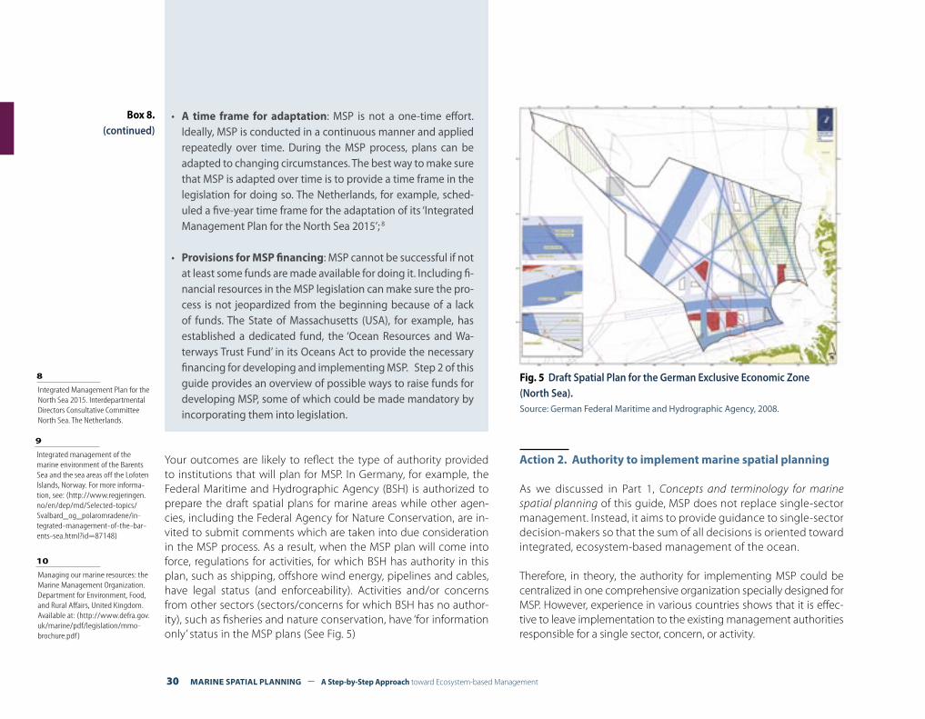
Your outcomes are likely to reflect the type of authority provided to institutions that will plan for MSP. In Germany, for example, the Federal Maritime and Hydrographic Agency (BSH) is authorized to prepare the draft spatial plans for marine areas while other agen-cies, including the Federal Agency for Nature Conservation, are in-vited to submit comments which are taken into due consideration in the MSP process. As a result, when the MSP plan will come into force, regulations for activities, for which BSH has authority in this plan, such as shipping, offshore wind energy, pipelines and cables, have legal status (and enforceability). Activities and/or concerns from other sectors (sectors/concerns for which BSH has no author-ity), such as fisheries and nature conservation, have ‘for information only’ status in the MSP plans (See Fig. 5)
Action 2. Authority to implement marine spatial planning
As we discussed in Part 1, Concepts and terminology for marine spatial planning of this guide, MSP does not replace single-sector management. Instead, it aims to provide guidance to single-sector decision-makers so that the sum of all decisions is oriented toward integrated, ecosystem-based management of the ocean.
Therefore, in theory, the authority for implementing MSP could be centralized in one comprehensive organization specially designed for MSP. However, experience in various countries shows that it is effec-tive to leave implementation to the existing management authorities responsible for a single sector, concern, or activity.
Fig. 5 Draft Spatial Plan for the German Exclusive Economic Zone (North Sea).Source: German Federal Maritime and Hydrographic Agency, 2008.
9 Integrated management of the marine environment of the Barents Sea and the sea areas off the Lofoten Islands, Norway. For more informa-tion, see: (http://www.regjeringen.no/en/dep/md/Selected-topics/Svalbard_og_polaromradene/in-tegrated-management-of-the-bar-ents-sea.html?id=87148)
10 Managing our marine resources: the Marine Management Organization. Department for Environment, Food, and Rural Affairs, United Kingdom. Available at: (http://www.defra.gov.uk/marine/pdf/legislation/mmo-brochure.pdf)
• A time frame for adaptation: MSP is not a one-time effort. Ideally, MSP is conducted in a continuous manner and applied repeatedly over time. During the MSP process, plans can be adapted to changing circumstances. The best way to make sure that MSP is adapted over time is to provide a time frame in the legislation for doing so. The Netherlands, for example, sched-uled a five-year time frame for the adaptation of its ‘Integrated Management Plan for the North Sea 2015’; 8
• Provisions for MSP financing: MSP cannot be successful if not at least some funds are made available for doing it. Including fi-nancial resources in the MSP legislation can make sure the pro-cess is not jeopardized from the beginning because of a lack of funds. The State of Massachusetts (USA), for example, has established a dedicated fund, the ‘Ocean Resources and Wa-terways Trust Fund’ in its Oceans Act to provide the necessary financing for developing and implementing MSP. Step 2 of this guide provides an overview of possible ways to raise funds for developing MSP, some of which could be made mandatory by incorporating them into legislation.
A Step-by-Step Approach toward Ecosystem-based Management – MARINE SPATIAL PLANNING 31
In Norway, for example, no changes were made to the existing insti-tutional arrangements that implement the ‘Integrated Management of the Marine Environment of the Barents Sea and the Sea Areas off the Lofoten Islands’. The existing authority for fisheries, for instance, remains responsible for fisheries management but now has to make its decisions consistent with the Barents Sea management plan.9 A similar approach has been taken in most of the other countries where MSP is evolving, including Belgium, Germany and the Netherlands.
Another way to implement MSP is by taking a mixed approach. The United Kingdom, for example, will implement MSP partially through the newly established Marine Management Organization and par-tially through existing authorities. Here, fisheries, nature conserva-tion and a number of other aspects of MSP will be implemented through this new organization, while licences and leases for uses of the seabed, for example, will still be issued by the Crown Estate.10
There are many reasons why it might be difficult to get started and there will surely be stumbling blocks along the way. Here are a few tips to help you get over them:
• Analyze the problem: - Is it because the time scale is unrealistic and needs
adjusting?- Is it because you don’t feel equipped to start/continue?- Perhaps you need to ask for outside help?- Perhaps some sections need to be developed by some-
one other than you?
• Start with the easier parts: You don’t need to develop MSP in the exact order in which
it will finally appear, so begin with the parts you’re comfort-able with.
• Don’t try to do it all at once: In most countries it’s not possible to include all sectors and
activities or address all conflicts and problems during the first round of MSP. Remember that MSP should be conducted as a repeated and adaptive process. What doesn’t get done in the first plan can be addressed in the second plan!
Box 9. Some things to do when you get stuck
32 MARINE SPATIAL PLANNING – A Step-by-Step Approach toward Ecosystem-based Management
OBTAINING FINANCIAL SUPPORTSTEP 2
What outputs should be delivered from this step?
FA financial plan that: a. Estimates the costs of your MSP activities; and b. Identifies alternative means to obtain financing for those MSP activities
Introduction
Marine spatial planning (MSP) is not possible without adequate finan-cial resources. Although MSP is inherently a governmental responsi-bility, a common problem occurs when funding, which may be avail-able for research, is not available for other MSP activities.
Most governments that undertake MSP have to rely on direct alloca-tions to their budgets from general tax revenues. Agencies are often given responsibilities to undertake MSP activities without receiving additional funds, so-called “unfunded mandates”. Reprogramming of resources within agencies or across government agencies will some-times be required, but often with difficulty at best.
There are, however, other financing mechanisms available that can generate substantial increases in funding for MSP. Alternative financ-ing can include, for example, grants and donations from international and multinational organizations, grants from foundations, partner-ships with non-governmental organizations, funds from the private sector, and user fees, among others.
Each of these alternative financial mechanisms has its pros and cons. In some cases, it might not always be effective to choose a particular financial mechanism for a number of reasons. For this reason, obtain-ing financial support will entail two tasks:
(1) Identifying possible alternative financing mechanisms for MSP tasks; and
(2) Defining the feasibility of alternative funding mechanisms.
Both these tasks are discussed in more details below.
TASK 1. IDENTIFYING ALTERNATIVE FINANCING MECHANISMS
The task of identifying alternative financing mechanisms is closely re-lated to selecting goals and objectives for MSP. How to select goals and objectives is described in Step 3, Organizing the process through pre-planning of this guide. It is good to keep in mind that identifying your financing mechanisms will most likely be done in conjunction with the task of setting goals and objectives.
When government revenues are not sufficient to develop MSP, vari-ous alternative ways to attract financial resources exist. Table 3 pro-vides a list of potential alternative financing mechanisms.
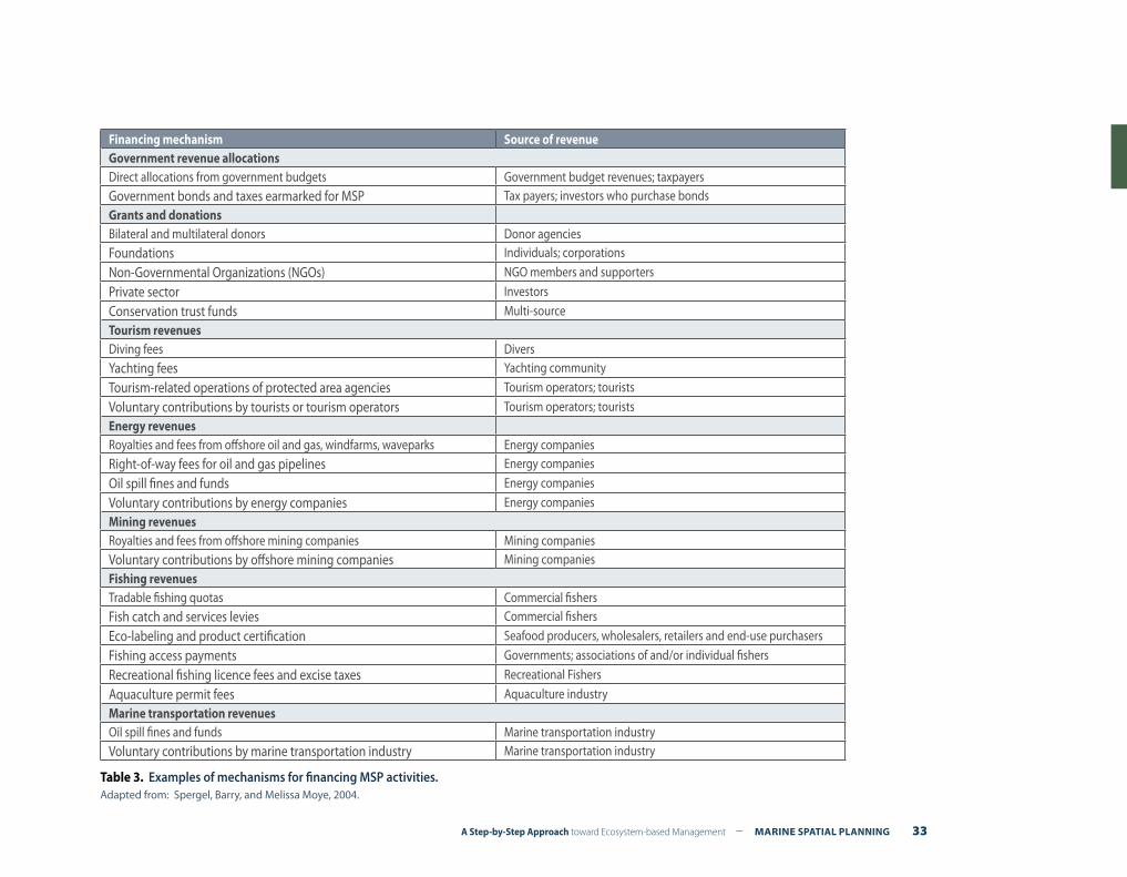
A Step-by-Step Approach toward Ecosystem-based Management – MARINE SPATIAL PLANNING 33
Financing mechanism Source of revenueGovernment revenue allocationsDirect allocations from government budgets Government budget revenues; taxpayersGovernment bonds and taxes earmarked for MSP Tax payers; investors who purchase bondsGrants and donations Bilateral and multilateral donors Donor agencies Foundations Individuals; corporations
Non-Governmental Organizations (NGOs) NGO members and supporters
Private sector Investors
Conservation trust funds Multi-sourceTourism revenuesDiving fees DiversYachting fees Yachting community
Tourism-related operations of protected area agencies Tourism operators; tourists
Voluntary contributions by tourists or tourism operators Tourism operators; touristsEnergy revenuesRoyalties and fees from offshore oil and gas, windfarms, waveparks Energy companiesRight-of-way fees for oil and gas pipelines Energy companies
Oil spill fines and funds Energy companies
Voluntary contributions by energy companies Energy companiesMining revenuesRoyalties and fees from offshore mining companies Mining companiesVoluntary contributions by offshore mining companies Mining companiesFishing revenuesTradable fishing quotas Commercial fishersFish catch and services levies Commercial fishers
Eco-labeling and product certification Seafood producers, wholesalers, retailers and end-use purchasers
Fishing access payments Governments; associations of and/or individual fishers
Recreational fishing licence fees and excise taxes Recreational Fishers
Aquaculture permit fees Aquaculture industryMarine transportation revenuesOil spill fines and funds Marine transportation industryVoluntary contributions by marine transportation industry Marine transportation industry
Table 3. Examples of mechanisms for financing MSP activities.Adapted from: Spergel, Barry, and Melissa Moye, 2004.
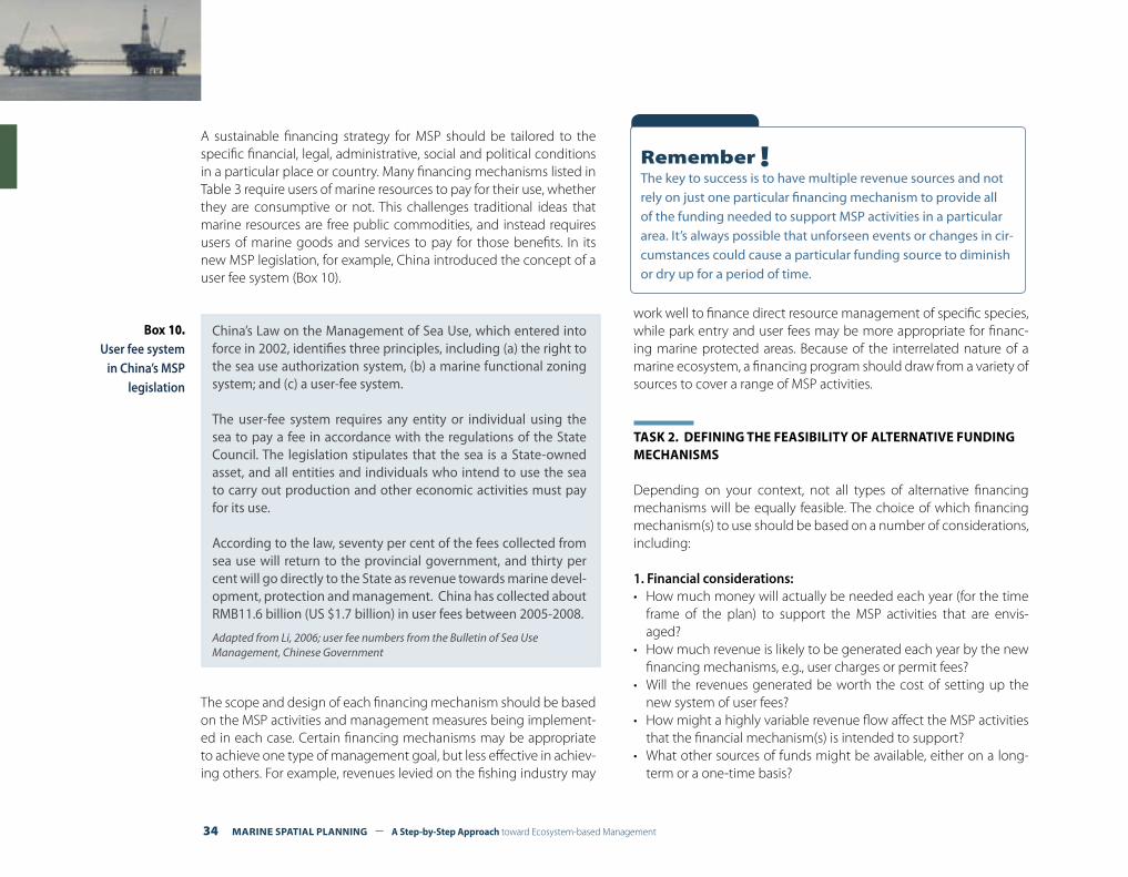
34 MARINE SPATIAL PLANNING – A Step-by-Step Approach toward Ecosystem-based Management
A sustainable financing strategy for MSP should be tailored to the specific financial, legal, administrative, social and political conditions in a particular place or country. Many financing mechanisms listed in Table 3 require users of marine resources to pay for their use, whether they are consumptive or not. This challenges traditional ideas that marine resources are free public commodities, and instead requires users of marine goods and services to pay for those benefits. In its new MSP legislation, for example, China introduced the concept of a user fee system (Box 10).
The scope and design of each financing mechanism should be based on the MSP activities and management measures being implement-ed in each case. Certain financing mechanisms may be appropriate to achieve one type of management goal, but less effective in achiev-ing others. For example, revenues levied on the fishing industry may
work well to finance direct resource management of specific species, while park entry and user fees may be more appropriate for financ-ing marine protected areas. Because of the interrelated nature of a marine ecosystem, a financing program should draw from a variety of sources to cover a range of MSP activities.
TASK 2. DEFINING THE FEASIBILITY OF ALTERNATIVE FUNDING MECHANISMS
Depending on your context, not all types of alternative financing mechanisms will be equally feasible. The choice of which financing mechanism(s) to use should be based on a number of considerations, including:
1. Financial considerations:• How much money will actually be needed each year (for the time
frame of the plan) to support the MSP activities that are envis-aged?
• How much revenue is likely to be generated each year by the new financing mechanisms, e.g., user charges or permit fees?
• Will the revenues generated be worth the cost of setting up the new system of user fees?
• How might a highly variable revenue flow affect the MSP activities that the financial mechanism(s) is intended to support?
• What other sources of funds might be available, either on a long-term or a one-time basis?
China’s Law on the Management of Sea Use, which entered into force in 2002, identifies three principles, including (a) the right to the sea use authorization system, (b) a marine functional zoning system; and (c) a user-fee system. The user-fee system requires any entity or individual using the sea to pay a fee in accordance with the regulations of the State Council. The legislation stipulates that the sea is a State-owned asset, and all entities and individuals who intend to use the sea to carry out production and other economic activities must pay for its use.
According to the law, seventy per cent of the fees collected from sea use will return to the provincial government, and thirty per cent will go directly to the State as revenue towards marine devel-opment, protection and management. China has collected about RMB11.6 billion (US $1.7 billion) in user fees between 2005-2008.
Adapted from Li, 2006; user fee numbers from the Bulletin of Sea Use Management, Chinese Government
Box 10. User fee system
in China’s MSP legislation
Remember !The key to success is to have multiple revenue sources and not rely on just one particular financing mechanism to provide all of the funding needed to support MSP activities in a particular area. It’s always possible that unforseen events or changes in cir-cumstances could cause a particular funding source to diminish or dry up for a period of time.

A Step-by-Step Approach toward Ecosystem-based Management – MARINE SPATIAL PLANNING 35
2. Legal considerations:• Can the proposed financing mechanisms be established under the
current legal system? Some legal systems do not recognize con-cepts such as development rights. In other legal systems, there may be a constitutional prohibition against earmarking tax revenues or fees for specific purposes such as MSP.
• Will new legislation be required to establish the proposed financ-ing mechanism? How difficult and time-consuming will it be to pass such legislation?
• Could the new financing mechanism be established under current legislation by simply issuing an administrative or executive order?
3. Administrative considerations:• How difficult will it be to design, administer, enforce, collect, or im-
plement a particular type of user fee or quota and trading system?• Will it be too complicated or costly to administer?• Are there enough trained people to administer and enforce the sys-
tem? (If not, how difficult will it be to train enough people?)• Will implementing the particular user fee or quota system depend
too much on the discretion of individual officials and possibly pres-ent too many opportunities for corruption?
• Can safeguards be devised to limit potential problems?• How difficult will it be to collect, verify and maintain the data upon
which a particular user fee or trading system is based? For example, how difficult will it be to keep track of the amount of fish caught each day or month by particular individuals, communities, or com-mercial fishing vessels?
4. Social considerations:• What will be the social impacts of implementing a particular sys-
tem of generating revenues for MSP?• Who will pay, and is there a willingness and capacity to pay?• Will the new financing mechanism be perceived as equitable and
legitimate?
5. Political considerations:• Is there government support for introducing a new financing
mechanism?• Can the government be relied upon to spend the new revenues
only for the purposes intended, or is there a strong likelihood that the money may be used instead for purposes other than MSP?
• Can the financing mechanism and management of funds be monitored and ensured by the courts, the media, NGO ‘watch-dog’ groups, particular user groups, an independent board of directors or an international agency?
6. Environmental considerations:• What will be the environmental impact of implementing any new
financing mechanism? For example, for tourism-based mecha-nisms, will the desire to increase revenues from tourism compro-mise other objectives or exceed the carrying capacity of the marine area?
For more information see Spergel and Moye (2004).
Tip !Making financial mechanisms mandatory through legislation is beneficial. It allows you to enforce the funding and ensures the MSP process is not jeopardized because of a lack of resources.
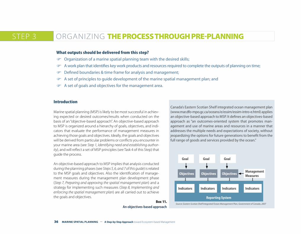
36 MARINE SPATIAL PLANNING – A Step-by-Step Approach toward Ecosystem-based Management
ORGANIZING THE PROCESS THROUGH PRE-PLANNINGSTEP 3
What outputs should be delivered from this step?
F Organization of a marine spatial planning team with the desired skills;
F A work plan that identifies key work products and resources required to complete the outputs of planning on time;
F Defined boundaries & time frame for analysis and management;
F A set of principles to guide development of the marine spatial management plan; and
F A set of goals and objectives for the management area.
Introduction
Marine spatial planning (MSP) is likely to be most successful in achiev-ing expected or desired outcomes/results when conducted on the basis of an “objective-based approach”. An objective-based approach to MSP is organized around a hierarchy of goals, objectives, and indi-cators that evaluate the performance of management measures in achieving those goals and objectives. Ideally, the goals and objectives will be derived from particular problems or conflicts you encounter in your marine area (see Step 1, Identifying need and establishing author-ity), and will reflect a set of MSP principles (see Task 4 of this Step) that guide the process.
An objective-based approach to MSP implies that analysis conducted during the planning phases (see Steps 5, 6, and 7 of this guide) is related to the MSP goals and objectives. Also the identification of manage-ment measures during the management plan development phase (Step 7, Preparing and approving the spatial management plan) and a strategy for implementing such measures (Step 8, Implementing and enforcing the spatial management plan) are all carried out to achieve the goals and objectives.
Goal Goal Goal
Objectives Objectives ObjectivesManagement Measures
Reporting System
Canada’s Eastern Scotian Shelf integrated ocean management plan (www.mar.dfo-mpo.gc.ca/oceans/e/essim/essim-intro-e.html) applies an objective-based approach to MSP. It defines an objectives-based approach as “an outcomes-oriented system that promotes man-agement and use of marine areas and resources in a manner that addresses the multiple needs and expectations of society, without jeopardizing the options for future generations to benefit from the full range of goods and services provided by the ocean.”
Source: Eastern Scotian Shelf Integrated Ocean Management Plan, Government of Canada, 2007Box 11.
An objectives-based approach
Indicators Indicators Indicators Indicators

A Step-by-Step Approach toward Ecosystem-based Management – MARINE SPATIAL PLANNING 37
This step organizes the process for objective-based MSP. It is referred to as “pre-planning” since it sets the stage for the actual planning phases (Step 5, “Defining and analyzing existing conditions” and Step 6, “Defining and analyzing future conditions”). To fulfill this function, pre-planning should develop:
(1) A marine spatial planning team;(2) A work plan (including schedule);(3) The boundaries and time-frame for planning; (4) A set of principles;(5) A set of general goals; (6) A set of clear and measurable objectives;(7) An assessment of the risks of what might go wrong during the
planning process and possible contingencies.
Regardless of the context, pre-planning is a necessary and critical part of any MSP process.
TASK 1. CREATING THE MARINE SPATIAL PLANNING TEAM
A key task is to organize the marine spatial planning team. While it is important to have a multi-disciplinary team comprised of biologists, ecologists, geographers, economists, and planners with disciplinary knowledge, it is as important to have some of the desirable skills such as those found in Table 4. Not all of these skills have to be within the MSP team. Some can be obtained from other governmental agencies or ministries, from the scientific community, from non-governmental organizations, or consultants. Incentives to obtain these skills should be identified in the next task when a work plan is developed.
Functional Role
Skill TypesKnowledge &General Aptitudes
ProgrammaticSkills
AdministrativeSkills
ProgramManagement
Strategic Thinking about Space and Time
Strategic PlanningFinancingProject Implementation
Organizational Management
Authority Knowledge of Spatial Implications of Legislation
Legal Analysis
Analysis Analytical Thinking about Space and Time
Spatial Database Man-agementGeographic Informa-tion Systems
Planning ConceptualizationSpatial Systems Thinking
Problem AssessmentStrategy DesignPlan Development
Coordination
Implementation Conflict Resolution NegotiationMonitoring and Evaluation
Cause-and-Effect Thinking
Monitoring PlanningAssessment Methods
Evaluation
Communications Strategic Communications
Product PlanningProduct Development
Routine Communications
Table 4. Important Roles and Skills of MSP Practitioners.
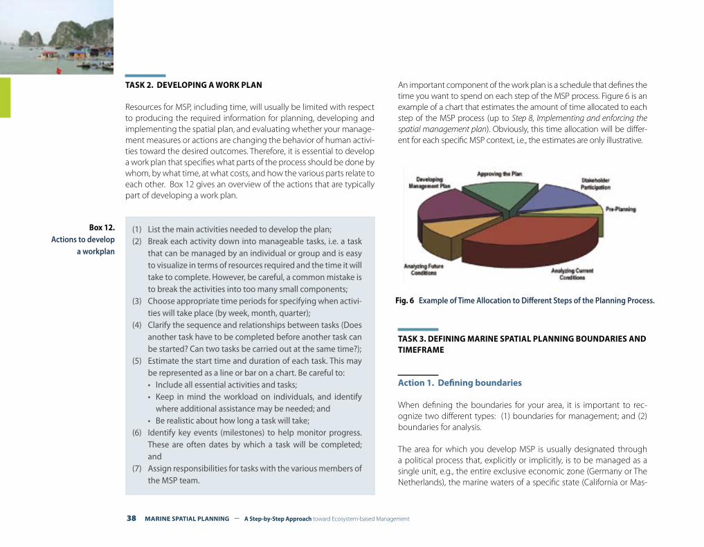
38 MARINE SPATIAL PLANNING – A Step-by-Step Approach toward Ecosystem-based Management
TASK 2. DEVELOPING A WORK PLAN
Resources for MSP, including time, will usually be limited with respect to producing the required information for planning, developing and implementing the spatial plan, and evaluating whether your manage-ment measures or actions are changing the behavior of human activi-ties toward the desired outcomes. Therefore, it is essential to develop a work plan that specifies what parts of the process should be done by whom, by what time, at what costs, and how the various parts relate to each other. Box 12 gives an overview of the actions that are typically part of developing a work plan.
An important component of the work plan is a schedule that defines the time you want to spend on each step of the MSP process. Figure 6 is an example of a chart that estimates the amount of time allocated to each step of the MSP process (up to Step 8, Implementing and enforcing the spatial management plan). Obviously, this time allocation will be differ-ent for each specific MSP context, i.e., the estimates are only illustrative.
TASK 3. DEFINING MARINE SPATIAL PLANNING BOUNDARIES AND TIMEFRAME
Action 1. Defining boundaries
When defining the boundaries for your area, it is important to rec-ognize two different types: (1) boundaries for management; and (2) boundaries for analysis.
The area for which you develop MSP is usually designated through a political process that, explicitly or implicitly, is to be managed as a single unit, e.g., the entire exclusive economic zone (Germany or The Netherlands), the marine waters of a specific state (California or Mas-
(1) List the main activities needed to develop the plan;(2) Break each activity down into manageable tasks, i.e. a task
that can be managed by an individual or group and is easy to visualize in terms of resources required and the time it will take to complete. However, be careful, a common mistake is to break the activities into too many small components;
(3) Choose appropriate time periods for specifying when activi-ties will take place (by week, month, quarter);
(4) Clarify the sequence and relationships between tasks (Does another task have to be completed before another task can be started? Can two tasks be carried out at the same time?);
(5) Estimate the start time and duration of each task. This may be represented as a line or bar on a chart. Be careful to:• Include all essential activities and tasks;• Keep in mind the workload on individuals, and identify
where additional assistance may be needed; and• Be realistic about how long a task will take;
(6) Identify key events (milestones) to help monitor progress. These are often dates by which a task will be completed; and
(7) Assign responsibilities for tasks with the various members of the MSP team.
Box 12. Actions to develop
a workplan
Fig. 6 Example of Time Allocation to Different Steps of the Planning Process.
A Step-by-Step Approach toward Ecosystem-based Management – MARINE SPATIAL PLANNING 39
sachusetts) or bio-region (Southwest Marine Bioregion of Australia). Typically, the management boundaries of the marine area will not coincide with the boundaries of a single ecosystem, because often a number of ecosystems of varying sizes exist within, and may ex-tend beyond, the designated management area. At the same time, the boundaries will probably coincide with only some of the areas from which demands are imposed on the resources of the marine area for which you develop MSP. Finally, the boundaries are not likely to delimit the influences of natural processes that are external to the designated management area, such as larval dispersion, sediment transport, and atmospheric deposition of nutrients.
Therefore, the boundaries for analysis for MSP often will not (and do not have to) coincide with the boundaries for management. On the contrary, defining boundaries for analysis (e.g., for planning) broader than the boundaries for management (e.g., for implementation) will enable you to identify sources of influence (e.g., sources of pollution) that have an effect in your management area and ultimately include the authorities or institutions responsible for those sources in the implementation of your spatial plan.
Action 2. Defining the time frame
In addition to establishing boundaries, it is essential to define a time frame for your MSP initiative. The time frame consists of two parts:
(a) A base year or base period to be used to provide a common or standard basis for identifying “current” conditions (see Step 5, De-fining and analyzing existing conditions); and
(b) Target year or target period that defines the period you are plan-ning for and allows you to identify “future conditions” (see Step 6, Defining and analyzing future conditions).
Often the time frame will have to coincide with other national plan-ning periods for planning, e.g., Viet Nam has a five-year economic planning cycle to which other plans, including marine spatial plans, have to conform.
Box 14. Establishing management boundaries in the Barents Sea
Box 13. Boundaries and time frame in the Dutch National Waterplan, 2008
The Dutch National Waterplan (2008) provides the basis for MSP in The Netherlands. It sets out a vision for the further de-velopment of the Dutch marine areas between 2009-2015. Even though the National Waterplan provides the basis for MSP, it is not limited to the marine area. Instead it covers all waters in The Netherlands as an integrated whole in which land and water are not separate entities but integrally linked with one another.
The baseline for the Dutch National Waterplan is 2009. It consid-ers both short-term and long-term components of MSP. While the target year for the plan is 2015 (management measures are defined for the period 2009-2015), the plan also analyses trends and tries to anticipate changing circumstances until 2025.
Source: National Water Plan: The Netherlands, a safe and liveable delta, now and in the future (A Summary) (2008)
Defining the management boundaries for the Norwegian man-agement plan for the Barents Sea was a process that took over a year and involved much debate and public discussion. Delim-iting the area raised two issues: (1) how to set the boundaries in relation to adjacent areas (ecosystems) in the Norwegian EEZ; and (2) the boundary between the management plan and the area to be managed under the European Union Water Frame-work Directive (WFD).
Currents flow along the Norwegian coast into the Barents Sea carrying with them eggs and larvae of many fish species that spawn along the coast of Northern Norway. These coastal areas, especially the Lofoten islands, are the major spawning grounds for the fish that populate the Barents Sea, and boundaries that excluded these regions from the management area were subop-timal. The arguments against including the Lofoten areas were both geographical and political. A political decision at the top levels of government was needed to resolve this issue and de-cide to include the Lofoten islands in the management area.
A Step-by-Step Approach toward Ecosystem-based Management – MARINE SPATIAL PLANNING 39
40 MARINE SPATIAL PLANNING – A Step-by-Step Approach toward Ecosystem-based Management
TASK 4. DEFINING PRINCIPLES
MSP should be guided by a set of principles that: (a) determine the nature and characteristics of the MSP process; and (b) reflect the re-sults you want to achieve through MSP (see Part I, Concepts and ter-
minology for marine spatial planning). Box 15 gives some examples of MSP principles.
Principles can be derived from a number of sources, including inter-national treaties and agreements, national policy and legislation, or examples of good practice. It is important to remember that princi-ples do not stand by themselves, but should be reflected throughout the MSP process, and in particular, in the goals and objectives you identify later.
Numerous organizations and institutions have already defined princi-ples for MSP. They are very diverse, and often represent a thin line be-tween principles and goals. Examples of principles from the European Union and the State of Massachusetts, among others, are available on the UNESCO marine spatial planning website, http://ioc3.unesco.org/marinesp.
A principle is a basic or essential quality or element determining the intrinsic nature or characteristic behavior of MSP.
The ecosystem integrity principle: The principle implies a primary focus on maintaining ecosystem structure and functioning within a MSP area. It includes the recognition that ecosystems are dynamic, changing and sometimes poorly understood (therefore requiring precautionary decision-making).The integration principle: Working in sectoral and institutional compartments or “silos” is often an efficient way to manage, but it creates significant costs of non-coordination that should be iden-tified and addressed. MSP can play a critical role in facilitating co-herence and integration. Integration among levels of government can help create complementary and mutually reinforcing deci-sions and actions.The public trust principle: This principle (or doctrine) implies that marine resources, including marine space, belong to the people and are held in trust by the government for its people and future genera-
tions. Marine space should be managed as a “commons”, i.e., as part of the public domain, not owned exclusively or to be benefited by any one group or private interest.The transparency principle: This principle suggests that the pro-cesses used to make decisions should be easily understood by the public, allow citizens to see how decisions are made, how resources have been allocated, and how decisions have been reached that af-fect their lives.The precautionary principle: This principle suggests that if a deci-sion could cause severe or irreversible harm to society or the envi-ronment, in the absence of a scientific consensus that harm would not ensue, the burden of proof falls on those who advocate taking the action.The polluter-pays principle: The costs of pollution or damage to the environment should be paid by the responsible party.
Box 15. Examples of MSP
principles
Drawing the boundary toward the coast did not require political resolution as it was already decided that coastal waters were to be managed according to the EU WFD. However, the WFD boundary is defined according to the coastal baseline which, in an area with a large archipelago like Norway, means that vast areas of coastal sea, including spawning areas for oceanic fish species are included in the WFD area. The use of the coastal baseline becomes espe-cially problematic in relation to bays and fjords where the baseline usually is drawn straight across, including the whole bay or fjord in the WFD area and excluding them from the management plan area. This caused considerable local protest, especially from com-munities in areas that considered themselves “maritime”, but that were excluded from the management plan area.
Source: Erik Olsen, Norwegian Institute of Marine Research, personal communication
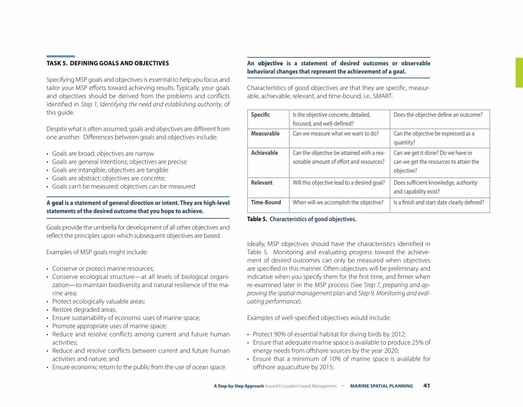
A Step-by-Step Approach toward Ecosystem-based Management – MARINE SPATIAL PLANNING 41
TASK 5. DEFINING GOALS AND OBJECTIVES
Specifying MSP goals and objectives is essential to help you focus and tailor your MSP efforts toward achieving results. Typically, your goals and objectives should be derived from the problems and conflicts identified in Step 1, Identifying the need and establishing authority, of this guide.
Despite what is often assumed, goals and objectives are different from one another. Differences between goals and objectives include:
• Goals are broad; objectives are narrow• Goals are general intentions; objectives are precise• Goals are intangible; objectives are tangible• Goals are abstract; objectives are concrete; • Goals can’t be measured; objectives can be measured
A goal is a statement of general direction or intent. They are high-level statements of the desired outcome that you hope to achieve. Goals provide the umbrella for development of all other objectives and reflect the principles upon which subsequent objectives are based.
Examples of MSP goals might include:
• Conserve or protect marine resources;• Conserve ecological structure—at all levels of biological organi-
zation—to maintain biodiversity and natural resilience of the ma-rine area;
• Protect ecologically valuable areas;• Restore degraded areas;• Ensure sustainability of economic uses of marine space;• Promote appropriate uses of marine space;• Reduce and resolve conflicts among current and future human
activities;• Reduce and resolve conflicts between current and future human
activities and nature; and• Ensure economic return to the public from the use of ocean space.
An objective is a statement of desired outcomes or observable behavioral changes that represent the achievement of a goal.
Characteristics of good objectives are that they are specific, measur-able, achievable, relevant, and time-bound, i.e., SMART.
Ideally, MSP objectives should have the characteristics identified in Table 5. Monitoring and evaluating progress toward the achieve-ment of desired outcomes can only be measured when objectives are specified in this manner. Often objectives will be preliminary and indicative when you specify them for the first time, and firmer when re-examined later in the MSP process (See Step 7, preparing and ap-proving the spatial management plan and Step 9, Monitoring and eval-uating performance).
Examples of well-specified objectives would include:
• Protect 90% of essential habitat for diving birds by 2012;• Ensure that adequate marine space is available to produce 25% of
energy needs from offshore sources by the year 2020;• Ensure that a minimum of 10% of marine space is available for
offshore aquaculture by 2015;
Specific Is the objective concrete, detailed, focused, and well-defined?
Does the objective define an outcome?
Measurable Can we measure what we want to do? Can the objective be expressed as a quantity?
Achievable Can the objective be attained with a rea-sonable amount of effort and resources?
Can we get it done? Do we have or can we get the resources to attain the objective?
Relevant Will this objective lead to a desired goal? Does sufficient knowledge, authority and capability exist?
Time-Bound When will we accomplish the objective? Is a finish and start date clearly defined?
Table 5. Characteristics of good objectives.

42 MARINE SPATIAL PLANNING – A Step-by-Step Approach toward Ecosystem-based Management
• Implement a representative system of marine protected areas by 2012; and
• Reduce the time required to make decisions on marine construc-tion permits by 50% by 2010;
TASK 6. IDENTIFYING RISKS AND DEVELOPING CONTINGENCY PLANS
Any pre-planning should include an assessment of the risks of what could go wrong during the planning process. Questions to consider include what could delay or undermine key steps and tasks in the MSP process, what is the critical path among steps that should be taken, and what contingency measures might be available to address identified risks?
One example would be what if stakeholders cannot agree on a com-mon set of goals and objectives or could not do so during an agreed
period of time? In some cases this situation could be pre-empted by narrowing the range of issues, and therefore stakeholders, addressed in the plan, particularly around contentious issues. For instance, in Massachusetts fisheries is explicitly excluded from the plan being produced (see Ocean Act). While this may seem an attractive option, it raises a wider and longer term risk that the resulting marine spatial plan is neither comprehensive nor integrated. Furthermore, the issues of concern will need to be addressed anyway at some point.
Other foreseeable risks might include specific events that change the context of the MSP process. In Norway, for example, a general election is coming up in September 2009. The current management plan for the Norwegian sea was therefore pushed through the ap-proval process at a much faster pace than the previous Barents Sea plan in order to be presented prior to the election. As a result, it was decided that the impact assessment stage would be undertaken more quickly than would normally be the case. This reduced the time for thorough quality control and public consultation.
A Step-by-Step Approach toward Ecosystem-based Management – MARINE SPATIAL PLANNING 43
ORGANIZING STAKEHOLDER PARTICIPATIONSTEP 4
What outputs should be delivered from this step?
F A plan indicating who, when and how to involve stakeholders throughout the marine spatial planning process.
Introduction
Involving key stakeholders in the development of marine spatial plan-ning (MSP) is essential for a number of reasons. Of these, the most important is because MSP aims to achieve multiple objectives (so-cial, economic and ecological) and should therefore reflect as many expectations, opportunities or conflicts occurring in the MSP area. Box 16 lists some other reasons why involving stakeholders in your MSP initiative is important.
The scope and extent of stakeholder involvement differs greatly from country to country and is often culturally influenced. The level of stakeholder involvement will largely depend on the political or legal requirements for participation that already exist in your country.
Generally speaking, all individuals, groups or organizations that are in one way or another affected, involved or interested in MSP can be considered stakeholders. However, involving too many stakeholders at the wrong moment or in the wrong form can be very time con-suming and can distract you from the expected or anticipated result. To involve stakeholders effectively (e.g., leading toward expected re-sults) and efficiently (e.g., producing expected results at least-cost), you need to consider three important questions1:
Task 1. Who should be involved?Task 2. When should stakeholders be involved?Task 3. How should stakeholders be involved?
Each of these tasks is discussed in more detail in this chapter.
1 (Gilliland and Laffoley, 2008; Pomeroy and Douvere, 2008)
Remember !Who, when and how stakeholders are involved in your MSP initiative will ultimately be closely linked and influenced by two questions:
(a) Who decides what during planning and implementing steps of the MSP process? and
(b) Who is responsible for MSP planning and development?
For example, there might already be a legal obligation to share decision-making about long-term offshore investments with certain stakeholders or groups of stakeholders (e.g., indigenous people) or there might be a legal obligation to consult the gen-eral public about the spatial plan prior to its implementation.
Where no legal obligations exist, it is important to define what type of stakeholder participation will be most suitable for a successful result. For instance, involving indigenous people in your MSP efforts may not be a legal requirement, but they could however be greatly affected (positively or negatively) by your MSP measures, and should therefore participate.
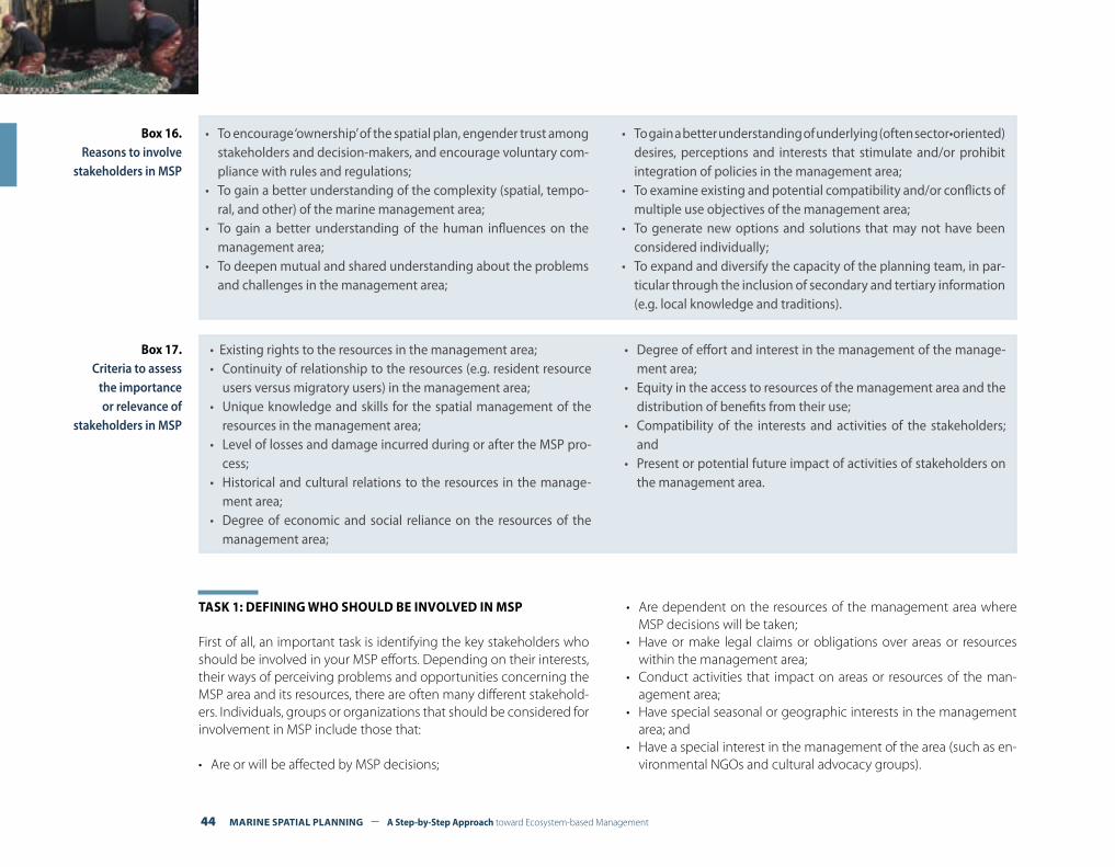
44 MARINE SPATIAL PLANNING – A Step-by-Step Approach toward Ecosystem-based Management
• To encourage ‘ownership’ of the spatial plan, engender trust among stakeholders and decision-makers, and encourage voluntary com-pliance with rules and regulations;
• To gain a better understanding of the complexity (spatial, tempo-ral, and other) of the marine management area;
• To gain a better understanding of the human influences on the management area;
• To deepen mutual and shared understanding about the problems and challenges in the management area;
• To gain a better understanding of underlying (often sector•oriented) desires, perceptions and interests that stimulate and/or prohibit integration of policies in the management area;
• To examine existing and potential compatibility and/or conflicts of multiple use objectives of the management area;
• To generate new options and solutions that may not have been considered individually;
• To expand and diversify the capacity of the planning team, in par-ticular through the inclusion of secondary and tertiary information (e.g. local knowledge and traditions).
Box 16. Reasons to involve
stakeholders in MSP
TASK 1: DEFINING WHO SHOULD BE INVOLVED IN MSP
First of all, an important task is identifying the key stakeholders who should be involved in your MSP efforts. Depending on their interests, their ways of perceiving problems and opportunities concerning the MSP area and its resources, there are often many different stakehold-ers. Individuals, groups or organizations that should be considered for involvement in MSP include those that:
• Are or will be affected by MSP decisions;
• Are dependent on the resources of the management area where MSP decisions will be taken;
• Have or make legal claims or obligations over areas or resources within the management area;
• Conduct activities that impact on areas or resources of the man-agement area;
• Have special seasonal or geographic interests in the management area; and
• Have a special interest in the management of the area (such as en-vironmental NGOs and cultural advocacy groups).
• Existing rights to the resources in the management area;• Continuity of relationship to the resources (e.g. resident resource
users versus migratory users) in the management area;• Unique knowledge and skills for the spatial management of the
resources in the management area;• Level of losses and damage incurred during or after the MSP pro-
cess;• Historical and cultural relations to the resources in the manage-
ment area;• Degree of economic and social reliance on the resources of the
management area;
• Degree of effort and interest in the management of the manage-ment area;
• Equity in the access to resources of the management area and the distribution of benefits from their use;
• Compatibility of the interests and activities of the stakeholders; and
• Present or potential future impact of activities of stakeholders on the management area.
Box 17. Criteria to assess
the importance or relevance of
stakeholders in MSP
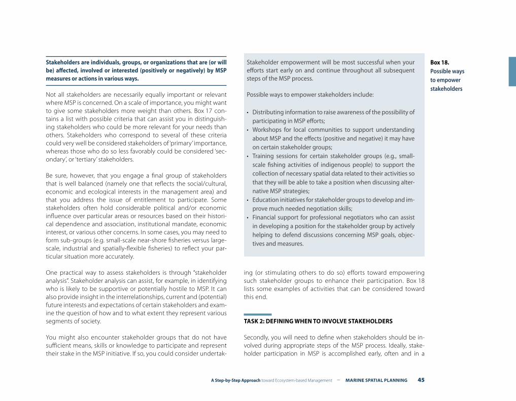
A Step-by-Step Approach toward Ecosystem-based Management – MARINE SPATIAL PLANNING 45
Stakeholders are individuals, groups, or organizations that are (or will be) affected, involved or interested (positively or negatively) by MSP measures or actions in various ways.
Not all stakeholders are necessarily equally important or relevant where MSP is concerned. On a scale of importance, you might want to give some stakeholders more weight than others. Box 17 con-tains a list with possible criteria that can assist you in distinguish-ing stakeholders who could be more relevant for your needs than others. Stakeholders who correspond to several of these criteria could very well be considered stakeholders of ‘primary’ importance, whereas those who do so less favorably could be considered ‘sec-ondary’, or ‘tertiary’ stakeholders.
Be sure, however, that you engage a final group of stakeholders that is well balanced (namely one that reflects the social/cultural, economic and ecological interests in the management area) and that you address the issue of entitlement to participate. Some stakeholders often hold considerable political and/or economic influence over particular areas or resources based on their histori-cal dependence and association, institutional mandate, economic interest, or various other concerns. In some cases, you may need to form sub-groups (e.g. small-scale near-shore fisheries versus large-scale, industrial and spatially-flexible fisheries) to reflect your par-ticular situation more accurately.
One practical way to assess stakeholders is through “stakeholder analysis”. Stakeholder analysis can assist, for example, in identifying who is likely to be supportive or potentially hostile to MSP. It can also provide insight in the interrelationships, current and (potential) future interests and expectations of certain stakeholders and exam-ine the question of how and to what extent they represent various segments of society.
You might also encounter stakeholder groups that do not have sufficient means, skills or knowledge to participate and represent their stake in the MSP initiative. If so, you could consider undertak-
ing (or stimulating others to do so) efforts toward empowering such stakeholder groups to enhance their participation. Box 18 lists some examples of activities that can be considered toward this end.
TASK 2: DEFINING WHEN TO INVOLVE STAKEHOLDERS
Secondly, you will need to define when stakeholders should be in-volved during appropriate steps of the MSP process. Ideally, stake-holder participation in MSP is accomplished early, often and in a
Box 18.Possible ways to empower stakeholders
Stakeholder empowerment will be most successful when your efforts start early on and continue throughout all subsequent steps of the MSP process.
Possible ways to empower stakeholders include:
• Distributing information to raise awareness of the possibility of participating in MSP efforts;
• Workshops for local communities to support understanding about MSP and the effects (positive and negative) it may have on certain stakeholder groups;
• Training sessions for certain stakeholder groups (e.g., small-scale fishing activities of indigenous people) to support the collection of necessary spatial data related to their activities so that they will be able to take a position when discussing alter-native MSP strategies;
• Education initiatives for stakeholder groups to develop and im-prove much needed negotiation skills;
• Financial support for professional negotiators who can assist in developing a position for the stakeholder group by actively helping to defend discussions concerning MSP goals, objec-tives and measures.

46 MARINE SPATIAL PLANNING – A Step-by-Step Approach toward Ecosystem-based Management
sustained manner throughout the process. A number of fora might already exist that allow stakeholders to participate in the planning and management of the marine area. You will need to decide wheth-er you can use these existing fora or you need new ones for the par-ticipation of stakeholders in your MSP efforts.
Not all stakeholders need to be involved all of the time. Different stakeholder groups, with varying levels of interest and entitlement, can take part in different steps of the MSP process (see Figure 1). The most important steps when you should consider stakeholder partici-pation include:
1. Pre-planning and planning for MSPDuring the pre-planning and planning phases of MSP (see Step 3, Or-ganizing the process, Step 5, Defining and analyzing existing conditions, and Step 6, Defining and analyzing future conditions), you will benefit from involving as many stakeholders as possible. This will allow you to collect information on a wide range of expectations, opportunities and conflicts that take place in the management area.
The Commonwealth of Massachusetts (USA), for example, organized 18 public hearings during which it consulted a broad range of stake-holders. The hearings were essentially open to all who were interest-ed. The information derived from these hearings provided a broad basis for identifying the goals and objectives of its MSP initiative.
The development of the Belgian master plan for the North Sea took a new approach (after initial attempts failed) that started with a six-month period of continuous meetings and interviews with different sectors and interest groups. In this way, it was possible to collect as much spatial data and information as possible regarding concerns, ex-pectations and opportunities for each sector. These data and informa-tion provided the basis for Belgium’s marine spatial plan development.
Generally, the greater the participation in the process of setting goals and objectives, the greater the stakeholder acceptance and legitima-cy of the MSP plan is likely to be. The outcomes of the participation
process should be made available to the stakeholders who should then also have a chance to review and verify the outcomes (or parts of it) of their participation.
2. MSP plan developmentA core group of stakeholders should be engaged in the analysis and selection of the plan alternatives and the consequences of different alternatives on areas of their interest (see Step 7, Developing the marine spatial plan).
Belgium, Germany, and The Netherlands, for example, all made a draft MSP plan available for public consultation. The general public was then invited to comment on the proposed spatial management mea-sures. Typically this period takes about three to six months and, in some cases, up to a year.
3. MSP plan implementationEngaging stakeholders in the implementation of MSP measures can be rewarding as well (see Step 8, Implementing and enforcing the ma-rine spatial plan). When stakeholders understand the benefits of tak-ing action, and agree upon the management measures to be imple-mented, it is more likely they will take part in enforcing them too, at least to the extent of encouraging compliance.
4. Monitoring and evaluating MSP performanceStakeholders should also be involved in evaluating the overall per-formance in achieving the goals and objectives of MSP plans and measures (see Step 9, Monitoring and evaluating performance).
Remember !Communicating the results of stakeholder participation to the people who were involved is an important, though often neglected, step. Communication or dialog must be regular and continuous if you are to gain and keep the trust and interest of stakeholders during the MSP process.
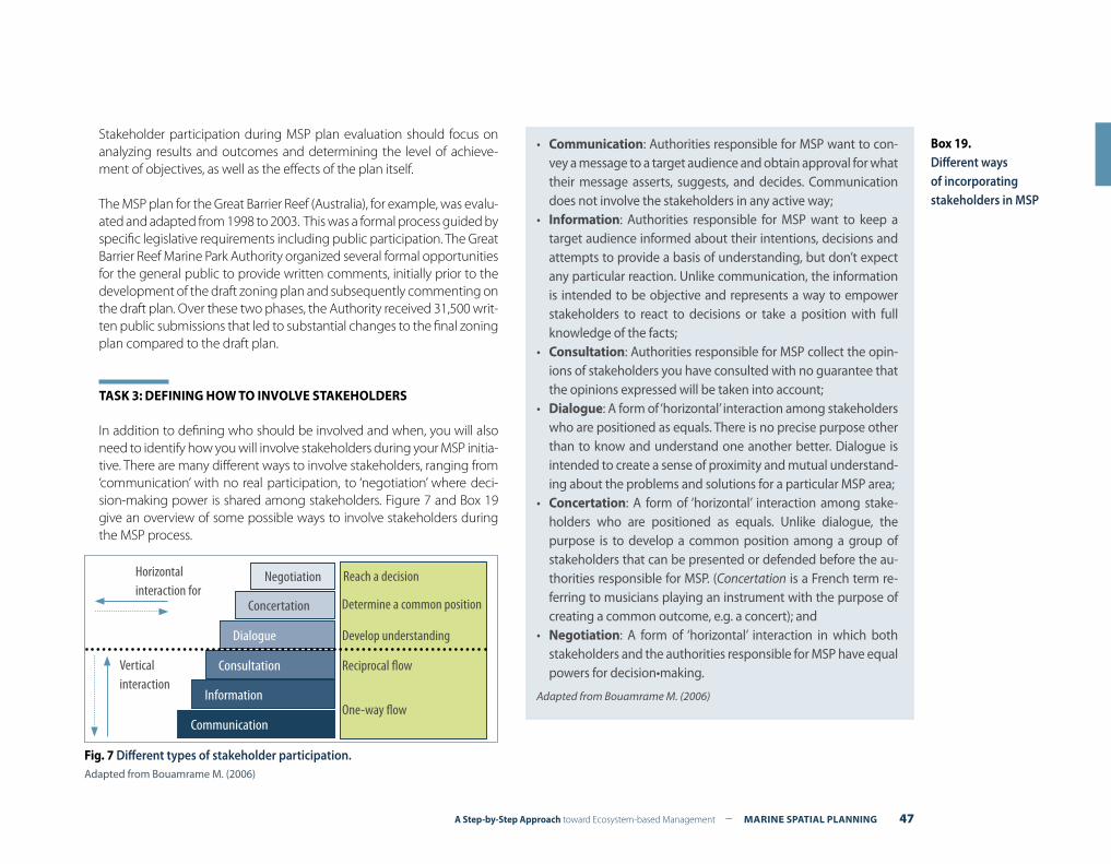
A Step-by-Step Approach toward Ecosystem-based Management – MARINE SPATIAL PLANNING 47
Stakeholder participation during MSP plan evaluation should focus on analyzing results and outcomes and determining the level of achieve-ment of objectives, as well as the effects of the plan itself.
The MSP plan for the Great Barrier Reef (Australia), for example, was evalu-ated and adapted from 1998 to 2003. This was a formal process guided by specific legislative requirements including public participation. The Great Barrier Reef Marine Park Authority organized several formal opportunities for the general public to provide written comments, initially prior to the development of the draft zoning plan and subsequently commenting on the draft plan. Over these two phases, the Authority received 31,500 writ-ten public submissions that led to substantial changes to the final zoning plan compared to the draft plan.
TASK 3: DEFINING HOW TO INVOLVE STAKEHOLDERS
In addition to defining who should be involved and when, you will also need to identify how you will involve stakeholders during your MSP initia-tive. There are many different ways to involve stakeholders, ranging from ‘communication’ with no real participation, to ‘negotiation’ where deci-sion-making power is shared among stakeholders. Figure 7 and Box 19 give an overview of some possible ways to involve stakeholders during the MSP process.
Box 19.Different ways of incorporating stakeholders in MSP
• Communication: Authorities responsible for MSP want to con-vey a message to a target audience and obtain approval for what their message asserts, suggests, and decides. Communication does not involve the stakeholders in any active way;
• Information: Authorities responsible for MSP want to keep a target audience informed about their intentions, decisions and attempts to provide a basis of understanding, but don’t expect any particular reaction. Unlike communication, the information is intended to be objective and represents a way to empower stakeholders to react to decisions or take a position with full knowledge of the facts;
• Consultation: Authorities responsible for MSP collect the opin-ions of stakeholders you have consulted with no guarantee that the opinions expressed will be taken into account;
• Dialogue: A form of ‘horizontal’ interaction among stakeholders who are positioned as equals. There is no precise purpose other than to know and understand one another better. Dialogue is intended to create a sense of proximity and mutual understand-ing about the problems and solutions for a particular MSP area;
• Concertation: A form of ‘horizontal’ interaction among stake-holders who are positioned as equals. Unlike dialogue, the purpose is to develop a common position among a group of stakeholders that can be presented or defended before the au-thorities responsible for MSP. (Concertation is a French term re-ferring to musicians playing an instrument with the purpose of creating a common outcome, e.g. a concert); and
• Negotiation: A form of ‘horizontal’ interaction in which both stakeholders and the authorities responsible for MSP have equal powers for decision•making.
Adapted from Bouamrame M. (2006)
Negotiation
Concertation
Dialogue
Consultation
Information
Communication
Reach a decision
Determine a common position
Develop understanding
Reciprocal flow
One-way flow
Horizontal interaction for
Vertical interaction
Fig. 7 Different types of stakeholder participation.Adapted from Bouamrame M. (2006)
48 MARINE SPATIAL PLANNING – A Step-by-Step Approach toward Ecosystem-based Management
Just as it is not necessary to involve all stakeholders throughout ev-ery step in the MSP process (see above), it is similarly not necessary to involve stakeholders in exactly the same manner. During the pre-planning and planning steps, for example, it might be beneficial to
stimulate ‘horizontal’ types of participation, allowing stakeholders to develop a common and shared opinion about their vision, require-ments, expectations, goals and objectives for the use of marine space. At the same time, however, information sessions can be put in place allowing stakeholders to obtain the best available information upon which to base their opinions and vision.
Once a MSP plan has been developed by the responsible authorities, it will often be open for consultation during a certain period of time. For example, German authorities for MSP planning published drafts of MSP plans for the North Sea and Baltic Sea and made them avail-able for public consultation over a period of four months. The United Kingdom made a draft of its Marine and Coastal Access Bill available for three months for pre-legislative consultation prior to introducing it to Parliament.
When numerous diverse stakeholders with widely differing interests are involved in the MSP process, their participation may become ineffective and unmanageable. In such cases, there is a serious risk that the process may become blocked, even on issues for which stakeholders were not ini-tially invited. Before starting the stakeholder participation process, here are a few key points to consider:
• Different stakeholders talk different languages: Concerning MSP, different stakeholders have different visions of their spatial needs that are not necessarily easily understood, valued or taken seriously by other stakeholders or the management authorities;
• Be clear about what type of stakeholder involvement is envisioned and what outputs are to be achieved. For sensitive issues, it might first be beneficial to consult, prior to the ‘official’ stakeholder involvement process, a key group of individuals to assess the perceptions and opin-ions about what is being proposed. This will allow you to gain insights on
who will support and who will oppose the proposed actions and also for what reasons;
• Professional facilitators: Quite often, stakeholder participation initia-tives are already jeopardized from the start because the facilitator of stakeholder gatherings/meetings has biased viewpoints about MSP (or is considered to have them) because of his/her own interests. Particularly for sensitive or important issues, hiring professional facilitators to guide stakeholder participation meetings may be necessary;
• A key strength of MSP is its ‘visualizing power’: People, especially the general public and stakeholders who are not familiar with issues and viewpoints other than their own, will be more able to understand the scope of measures, decisions or ideas if they are put into the visual form of maps instead of a narrative; and
• Leadership: Exactly who is in charge and who will make the final spatial planning decisions within the management area should be made clear from the beginning of the process.
Box 20. Keeping stakeholder
involvement effective
Remember !It is quite common for decision-makers to announce stakeholder involvement forms that indicate a potentially high level of influ-ence for participations to describe practices that, in reality, are very limited. This practice causes frustration among stakehold-ers and often prohibits effective and manageable stakeholder participation. So be clear from the beginning of the process what stakeholders can expect from their participation.
A Step-by-Step Approach toward Ecosystem-based Management – MARINE SPATIAL PLANNING 49
Introduction
Compiling and mapping data is expensive and can take large amounts of time and resources. Not all the data you collect will be useful for marine spatial planning and so careful selection will be needed. A general rule is that data should be up-to-date, objective, reliable, rel-evant and comparable.
An inventory is a means of gathering information on the current status of the coastal and marine environment. Its purpose is to bring together a wide range of baseline information. An inventory should also take account any obvious trends and developments in order to be able to assess spatial pressures at a later stage of the planning process.
An inventory can be completed both at any spatial and tempo-ral level and also at various levels of detail. Although an inventory should try to be as comprehensive as possible, collating all the nec-essary information is likely to be an incremental process. Initially, an inventory is used simply to gather information, providing the nec-essary background information for MSP. It should be refined during the MSP process to reflect modified objectives and new sources of data.
At least three general categories of spatial information are relevant: (1) biological and ecological distributions including areas of known importance for a particular species or biological community; (2) spa-tial information about human activities; and (3) oceanographic and other physical environmental features (bathymetry, currents, sedi-ments) which in the absence of comprehensive biological data can be especially important for identifying different habitats and impor-
DEFINING AND ANALYZING EXISTING CONDITIONS STEP 5
What outputs should be delivered from this step?
F An inventory and maps of important biological and ecological areas in the marine management area;
F An inventory and maps of current human activities (and pressures) in the marine management area;
F An assessment of possible conflicts and compatibilities among existing human uses; and
F An assessment of possible conflicts and compatibilities between existing human uses and the environment.
Consider the following questions when preparing an inventory:
• What are the specific ecological characteristics of the marine management area? Where are the particularly sensitive or eco-logically important areas?
• Are there any specific economic and social factors that need to be considered?
• Are there any sectors that depend on a certain type of marine area?
• What are the main pressures on the marine management area, and are there any particular threats? What are the main driving forces likely to shape marine development in the near future?
Box 21.Preparing an inventory
50 MARINE SPATIAL PLANNING – A Step-by-Step Approach toward Ecosystem-based Management
tant processes, e.g., upwelling areas. The mapping of jurisdictional and administrative boundaries will also be relevant when institutional arrangements are considered (Step 7, Preparing and approving the ma-rine spatial management plan).
Collecting and collating spatially-explicit databases is usually the most time consuming aspect of planning and management activi-ties. In conducting a review of available data, you should look for spatial information that covers most of the marine area. It is often unproductive to spend time collecting fine-scale data sets for small sub-areas of the management area because, when taken together, they are frequently not comparable.
Data can be collected from many sources including: (1) scientific literature; (2) expert scientific opinion or advice; (3) government sources; (4) local knowledge; and (5) direct field measurement. Most spatial planning efforts rely heavily on the first three sources of data, although local knowledge is increasingly recognized as a valuable source of information for spatial planning. New direct field measure-ments are expensive and time-consuming, and should be kept to a minimum, especially in the initial round of planning. Later, after im-portant knowledge gaps have been identified, some field work may be undertaken. Most initial data collection and mapping can be done through specialized inter-agency working groups and by consulting experts on various topics.
TASK 1. COLLECTING AND MAPPING INFORMATION ABOUT ECOLOGICAL, ENVIRONMENTAL AND OCEANOGRAPHIC CONDITIONS
The sea is spatially very diverse in terms of patterns of bathymetry, water stratification and movement, living organisms and effects from human activities. It is also very diverse where time is concerned; some important things happen in terms of hours, days, or months, and oth-ers happen over years, decades, or centuries. The complexity of natu-ral processes in the sea and resulting mosaic patterns in space and
time mean that any ‘one size fits all’ management regime that treats the sea as uniform or attempts to divide it in ways that do not reflect its real diversity is likely to fail. Successful marine management needs planners and managers who understand and work with the sea’s di-versity in space and time1.
Some places in the sea have much greater importance than others for particular species, ecosystems, or processes and, hence, for humans too. ‘Real estate values’ in the sea vary enormously, just as they do on land. Knowing which places are most important to conserve and which places are compatible with development is central to the art of MSP.
An important task is the identification and mapping of “key ecological features” (an Australian term) or “ecologically or biologically significant areas” (EBSAs, a Canadian term later taken on by the Convention on Biological Diversity (CBD)).
Areas are “ecologically or biologically important” because of the higher potential for, or more lasting consequences of, harm at that location and the greater potential for long-term benefits obtained by effective management. (Department of Fisheries and Oceans, Canada).
Scientific criteria can be used to identify important biological and ecological areas that need special protection. Table 6 lists a number of these criteria.
1 Crowder and Norse, 2008
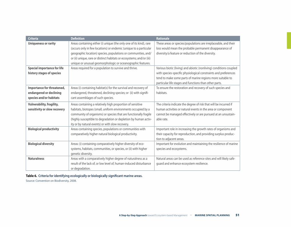
A Step-by-Step Approach toward Ecosystem-based Management – MARINE SPATIAL PLANNING 51
Criteria Definition RationaleUniqueness or rarity Areas containing either (i) unique (the only one of its kind), rare
(occurs only in few locations) or endemic (unique to a particular geographic location) species, populations or communities, and/or (ii) unique, rare or distinct habitats or ecosystems; and/or (iii) unique or unusual geomorphologic or oceanographic features.
These areas or species/populations are irreplaceable, and their loss would mean the probable permanent disappearance of diversity/a feature or reduction of the diversity.
Special importance for life history stages of species
Areas required for a population to survive and thrive. Various biotic (living) and abiotic (nonliving) conditions coupled with species-specific physiological constraints and preferences tend to make some parts of marine regions more suitable to particular life stages and functions than other parts.
Importance for threatened, endangered or declining species and/or habitats
Areas (i) containing habitat(s) for the survival and recovery of endangered, threatened, declining species; or (ii) with signifi-cant assemblages of such species.
To ensure the restoration and recovery of such species and habitats.
Vulnerability, fragility, sensitivity or slow recovery
Areas containing a relatively high proportion of sensitive habitats, biotopes (small, uniform environments occupied by a community of organisms) or species that are functionally fragile (highly susceptible to degradation or depletion by human activ-ity or by natural events) or with slow recovery.
The criteria indicate the degree of risk that will be incurred if human activities or natural events in the area or component cannot be managed effectively or are pursued at an unsustain-able rate.
Biological productivity Areas containing species, populations or communities with comparatively higher natural biological productivity.
Important role in increasing the growth rates of organisms and their capacity for reproduction, and providing surplus produc-tion to adjacent areas.
Biological diversity Areas: (i) containing comparatively higher diversity of eco-systems, habitats, communities, or species, or (ii) with higher genetic diversity.
Important for evolution and maintaining the resilience of marine species and ecosystems.
Naturalness Areas with a comparatively higher degree of naturalness as a result of the lack of, or low level of, human-induced disturbance or degradation.
Natural areas can be used as reference sites and will likely safe-guard and enhance ecosystem resilience.
Table 6. Criteria for identifying ecologically or biologically significant marine areas.Source: Convention on Biodiversity, 2008.
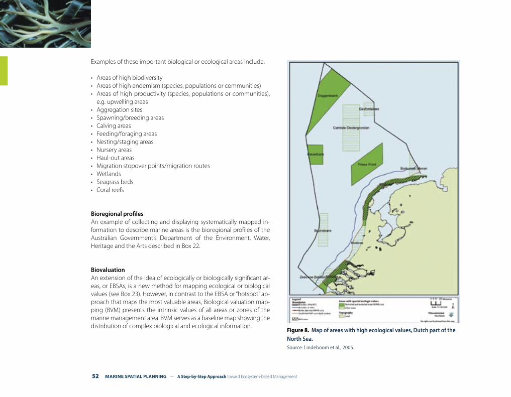
52 MARINE SPATIAL PLANNING – A Step-by-Step Approach toward Ecosystem-based Management
Examples of these important biological or ecological areas include:
• Areas of high biodiversity• Areas of high endemism (species, populations or communities)• Areas of high productivity (species, populations or communities),
e.g. upwelling areas• Aggregation sites• Spawning/breeding areas• Calving areas• Feeding/foraging areas• Nesting/staging areas• Nursery areas• Haul-out areas• Migration stopover points/migration routes• Wetlands• Seagrass beds• Coral reefs
Bioregional profilesAn example of collecting and displaying systematically mapped in-formation to describe marine areas is the bioregional profiles of the Australian Government’s Department of the Environment, Water, Heritage and the Arts described in Box 22.
BiovaluationAn extension of the idea of ecologically or biologically significant ar-eas, or EBSAs, is a new method for mapping ecological or biological values (see Box 23). However, in contrast to the EBSA or “hotspot” ap-proach that maps the most valuable areas, Biological valuation map-ping (BVM) presents the intrinsic values of all areas or zones of the marine management area. BVM serves as a baseline map showing the distribution of complex biological and ecological information.
Figure 8. Map of areas with high ecological values, Dutch part of the North Sea.Source: Lindeboom et al., 2005.
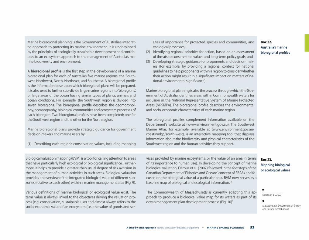
A Step-by-Step Approach toward Ecosystem-based Management – MARINE SPATIAL PLANNING 53
Box 22.Australia’s marine bioregional profiles
Marine bioregional planning is the Government of Australia’s integrat-ed approach to protecting its marine environment. It is underpinned by the principles of ecologically sustainable development and contrib-utes to an ecosystem approach to the management of Australia’s ma-rine biodiversity and environment.
A bioregional profile is the first step in the development of a marine bioregional plan for each of Australia’s five marine regions: the South-west, Northwest, North, Northeast, and Southeast. A bioregional profile is the information base upon which bioregional plans will be prepared. It is also used to further sub-divide large marine regions into ‘bioregions’, or large areas of the ocean having similar types of plants, animals and ocean conditions. For example, the Southwest region is divided into seven bioregions. The bioregional profile describes the geomorphol-ogy, oceanography, biological communities and ecosystem processes of each bioregion. Two bioregional profiles have been completed; one for the Southwest region and the other for the North region.
Marine bioregional plans provide strategic guidance for government decision-makers and marine users by:
(1) Describing each region’s conservation values, including mapping
sites of importance for protected species and communities, and ecological processes;
(2) Identifying regional priorities for action, based on an assessment of threats to conservation values and long-term policy goals; and
(3) Developing strategic guidance for proponents and decision-mak-ers (for example, by providing a regional context for national guidelines to help proponents within a region to consider whether their action might result in a significant impact on matters of na-tional environmental significance).
Marine bioregional planning is also the process through which the Gov-ernment of Australia identifies areas within Commonwealth waters for inclusion in the National Representative System of Marine Protected Areas (NRSMPA). The bioregional profile describes the environmental and socio-economic characteristics of each marine region.
The bioregional profiles complement information available on the Department’s website at (www.environment.gov.au). The Southwest Marine Atlas, for example, available at (www.environment.gov.au/coasts/mbp/south-west), is an interactive mapping tool that displays information about the biodiversity and physical characteristics of the Southwest region and the human activities they support.
Biological valuation mapping (BVM) is a tool for calling attention to areas that have particularly high ecological or biological significance. Further-more, it helps to provide a greater-than-usual degree of risk aversion in the management of human activities in such areas. Biological valuation provides an overview of the integrated biological value of different sub-zones (relative to each other) within a marine management area (Fig. 9).
Various definitions of marine biological or ecological value exist. The term ‘value’ is always linked to the objectives driving the valuation pro-cess (e.g. conservation, sustainable use) and almost always refers to the socio-economic value of an ecosystem (i.e., the value of goods and ser-
vices provided by marine ecosystems, or the value of an area in terms of its importance to human use). In developing the concept of marine biological valuation, Derous et al. (2007) followed in the footsteps of the Canadian Department of Fisheries and Oceans’ concept of EBSAs and fo-cused on the biological value of a particular area. BVM now serves as a baseline map of biological and ecological information. 2
The Commonwealth of Massachusetts is currently adapting this ap-proach to produce a biological value map for its waters as part of its ocean management plan development process (Fig. 10)3
Box 23.Mapping biological or ecological values
3 Massachusetts Department of Energy and Environmental Affairs
2 Derous et al., 2007
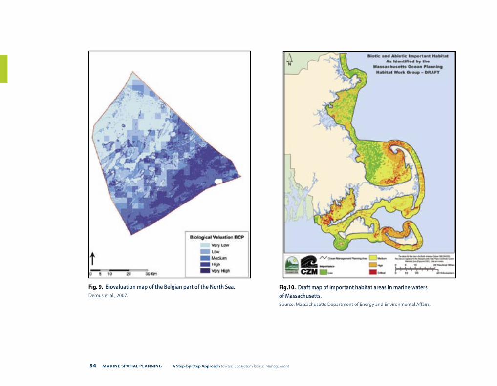
54 MARINE SPATIAL PLANNING – A Step-by-Step Approach toward Ecosystem-based Management
Fig. 9. Biovaluation map of the Belgian part of the North Sea.Derous et al., 2007.
Fig.10. Draft map of important habitat areas In marine waters of Massachusetts.Source: Massachusetts Department of Energy and Environmental Affairs.
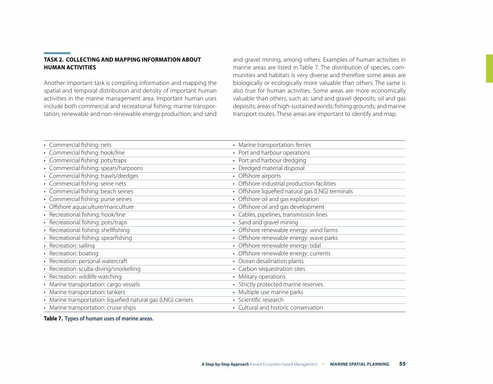
A Step-by-Step Approach toward Ecosystem-based Management – MARINE SPATIAL PLANNING 55
TASK 2. COLLECTING AND MAPPING INFORMATION ABOUT HUMAN ACTIVITIES Another important task is compiling information and mapping the spatial and temporal distribution and density of important human activities in the marine management area. Important human uses include both commercial and recreational fishing; marine transpor-tation; renewable and non-renewable energy production; and sand
and gravel mining, among others. Examples of human activities in marine areas are listed in Table 7. The distribution of species, com-munities and habitats is very diverse and therefore some areas are biologically or ecologically more valuable than others. The same is also true for human activities. Some areas are more economically valuable than others, such as: sand and gravel deposits; oil and gas deposits; areas of high-sustained winds; fishing grounds; and marine transport routes. These areas are important to identify and map.
• Commercial fishing: nets• Commercial fishing: hook/line• Commercial fishing: pots/traps• Commercial fishing: spears/harpoons• Commercial fishing: trawls/dredges• Commercial fishing: seine nets• Commercial fishing: beach seines• Commercial fishing: purse seines• Offshore aquaculture/mariculture• Recreational fishing: hook/line• Recreational fishing: pots/traps• Recreational fishing: shellfishing• Recreational fishing: spearfishing• Recreation: sailing• Recreation: boating• Recreation: personal watercraft• Recreation: scuba diving/snorkelling• Recreation: wildlife watching• Marine transportation: cargo vessels• Marine transportation: tankers• Marine transportation: liquefied natural gas (LNG) carriers• Marine transportation: cruise ships
• Marine transportation: ferries• Port and harbour operations• Port and harbour dredging• Dredged material disposal• Offshore airports • Offshore industrial production facilities• Offshore liquefied natural gas (LNG) terminals• Offshore oil and gas exploration• Offshore oil and gas development• Cables, pipelines, transmission lines• Sand and gravel mining• Offshore renewable energy: wind farms• Offshore renewable energy: wave parks• Offshore renewable energy: tidal• Offshore renewable energy: currents• Ocean desalination plants• Carbon sequestration sites• Military operations• Strictly protected marine reserves• Multiple use marine parks• Scientific research• Cultural and historic conservation
Table 7. Types of human uses of marine areas.

56 MARINE SPATIAL PLANNING – A Step-by-Step Approach toward Ecosystem-based Management
Connecting offshore activities with onshore communitiesThe human dimension of MSP can be simplified in most cases to a listing and mapping of activities (e.g. oil and gas, fisheries, shipping). These are, of course, vital to document, but they are complex process-es across a variety of scales parallel to biophysical processes. Ecosys-tem-based approaches have transformed both the way we view bio-physical processes and, by association, the way we also now manage the biophysical environment by understanding processes, connec-tions, space, and scales. In the same way, human dimensions need to be examined through a similar understanding of processes (e.g., community and territory), connections (e.g. within and across com-munities, economies), space (e.g., territories, cultural perceptions) and scales (e.g. local, regional, national scales of society)4.
Unfortunately, not much work is being carried out on the social or human geography of the oceans. The human dimensions of the marine environment are widely recognized as important to include and integrate into decision-making. However, there are few layers of socio-economic information that one might combine with the bio-physical in, for example, spatial suitability analyses for the establish-ment of a marine protected area (although there are some notable exceptions, e.g., work undertaken through the California Marine Life Protection Act).
The work of Kevin St. Martin, Associate Professor in the Department of Geography at Rutgers, the State University of New Jersey (USA), illustrates how the human dimension can be added to marine spa-tial planning. Based on the local knowledge of fishers of the Gulf of Maine along the northeastern coast of North America, he has been developing maps showing: (1) where fishers fish; (2) who fishes (by gear type and port) in what locations (identifying discrete areas corresponding to the “home range” of vessels from various ports; and (3) where peer groups fish (identifying fishing locations by gear type for single ports).
The results of this work include the development of a method for producing maps of the ‘social landscape’ of the Gulf of Maine, an improved understanding of the processes of human community and territory in this ocean space, a way of reducing uneven impacts of spatial planning decisions, and improved participation of fishers in science and management (Fig 11).
A similar approach to mapping fishing grounds in the UK using the local knowledge of fishers is the FisherMap project (des Clers, S. et al, 2008).
Box 24. Mapping the social
landscape of fishers in the Gulf of Maine
Fig. 11. Mapping the social landscape of fishers in the Gulf of Maine.Source: St. Martin, 2008.
4 St. Martin, 2008
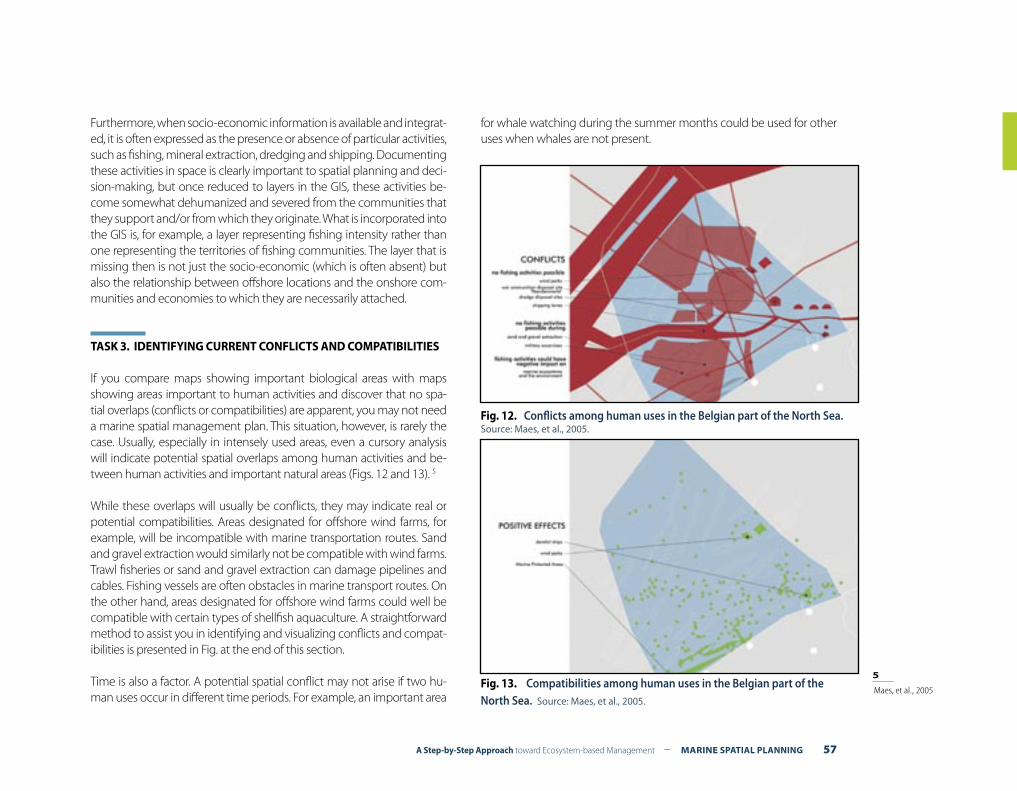
A Step-by-Step Approach toward Ecosystem-based Management – MARINE SPATIAL PLANNING 57
Furthermore, when socio-economic information is available and integrat-ed, it is often expressed as the presence or absence of particular activities, such as fishing, mineral extraction, dredging and shipping. Documenting these activities in space is clearly important to spatial planning and deci-sion-making, but once reduced to layers in the GIS, these activities be-come somewhat dehumanized and severed from the communities that they support and/or from which they originate. What is incorporated into the GIS is, for example, a layer representing fishing intensity rather than one representing the territories of fishing communities. The layer that is missing then is not just the socio-economic (which is often absent) but also the relationship between offshore locations and the onshore com-munities and economies to which they are necessarily attached.
TASK 3. IDENTIFYING CURRENT CONFLICTS AND COMPATIBILITIES
If you compare maps showing important biological areas with maps showing areas important to human activities and discover that no spa-tial overlaps (conflicts or compatibilities) are apparent, you may not need a marine spatial management plan. This situation, however, is rarely the case. Usually, especially in intensely used areas, even a cursory analysis will indicate potential spatial overlaps among human activities and be-tween human activities and important natural areas (Figs. 12 and 13). 5
While these overlaps will usually be conflicts, they may indicate real or potential compatibilities. Areas designated for offshore wind farms, for example, will be incompatible with marine transportation routes. Sand and gravel extraction would similarly not be compatible with wind farms. Trawl fisheries or sand and gravel extraction can damage pipelines and cables. Fishing vessels are often obstacles in marine transport routes. On the other hand, areas designated for offshore wind farms could well be compatible with certain types of shellfish aquaculture. A straightforward method to assist you in identifying and visualizing conflicts and compat-ibilities is presented in Fig. at the end of this section.
Time is also a factor. A potential spatial conflict may not arise if two hu-man uses occur in different time periods. For example, an important area
for whale watching during the summer months could be used for other uses when whales are not present.
Fig. 12. Conflicts among human uses in the Belgian part of the North Sea.Source: Maes, et al., 2005.
Fig. 13. Compatibilities among human uses in the Belgian part of the North Sea. Source: Maes, et al., 2005.
5 Maes, et al., 2005
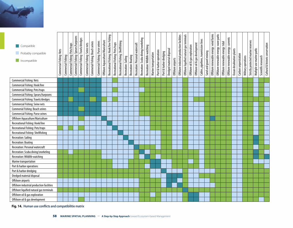
58 MARINE SPATIAL PLANNING – A Step-by-Step Approach toward Ecosystem-based Management
Compatible
Probably compatible
IncompatibleCo
mm
ercia
l Fish
ing:
Net
s
Com
mer
cial F
ishin
g:
Com
mer
cial F
ishin
g: Po
ts/tra
ps
Com
mer
cial F
ishin
g: Sp
ears/
harp
oons
Com
mer
cial F
ishin
g: Tr
awls/
dred
ges
Com
mer
cial F
ishin
g: Se
ine n
ets
Com
mer
ial Fi
shin
g: B
each
sein
es
Com
mer
cial F
ishin
g: Pu
rse se
ines
Offsh
ore A
quac
ultu
re/M
aricu
lture
Recre
atio
nal F
ishin
g: H
ook/
line F
ishin
g
Recre
atio
nal F
ishin
g: Po
ts/tra
ps
Recre
atio
nal F
ishin
g: Sh
ellfis
hing
Recre
atio
n: Sa
iling
Recre
atio
n: B
oatin
g
Recre
atio
n: Pe
rsona
l wat
ercra
ft
Recre
atio
n: Sc
uba d
iving
/sno
rkeli
ng
Recre
atio
n: W
ildlif
e wat
chin
g
Mar
ine t
rans
porta
tion
Port
& ha
rbor
oper
atio
ns
Port
& ha
rbor
dred
ging
Dred
ged m
ater
ial di
spos
al
Offsh
ore a
irpor
ts
Offsh
ore i
ndus
trial
prod
uctio
n fa
ciliti
es
Offsh
ore l
iqui
fied n
atur
al ga
s ter
min
als
Offsh
ore o
il & ga
s exp
lora
tion
Offsh
ore o
il & ga
s dev
elopm
ent
Cabl
es, p
ipeli
nes,
tranm
issio
n lin
es
Sand
and g
rave
l min
ing
Offsh
ore r
enew
able
ener
gy: w
ind f
arm
s
Offsh
ore r
enew
able
ener
gy: w
ave p
arks
Offsh
ore r
enew
able
ener
gy: t
idal
Offsh
ore r
enew
able
ener
gy: c
urre
nts
Ocea
n de
salin
atio
n pl
ants
Carb
on se
ques
tratio
n
Milit
ary o
pera
tions
Stric
tly pr
otec
ted m
arin
e res
erve
s
Mul
tiple
use m
arin
e par
ks
Scien
tific r
esee
arch
Cultu
ral &
hist
oric
cons
erva
tion
Commercial Fishing: NetsCommercial Fishing: Hook/lineCommercial Fishing: Pots/trapsCommercial Fishing: Spears/harpoonsCommercial Fishing: Trawls/dredgesCommercial Fishing: Seine netsCommerial Fishing: Beach seinesCommercial Fishing: Purse seinesOffshore Aquaculture/MaricultureRecreational Fishing: Hook/lineRecreational Fishing: Pots/trapsRecreational Fishing: ShellfishingRecreation: SailingRecreation: BoatingRecreation: Personal watercraftRecreation: Scuba diving/snorkelingRecreation: Wildlife watchingMarine transportationPort & harbor operationsPort & harbor dredgingDredged material disposalOffshore airports Offshore industrial production facilitiesOffshore liquified natural gas terminalsOffshore oil & gas explorationOffshore oil & gas development
Fig. 14. Human use conflicts and compatibilitie matrix
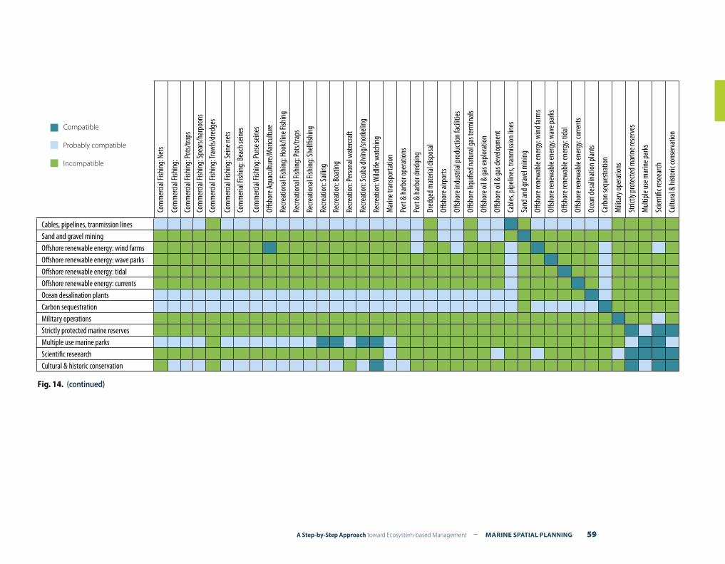
A Step-by-Step Approach toward Ecosystem-based Management – MARINE SPATIAL PLANNING 59
Cables, pipelines, tranmission linesSand and gravel miningOffshore renewable energy: wind farmsOffshore renewable energy: wave parksOffshore renewable energy: tidalOffshore renewable energy: currentsOcean desalination plantsCarbon sequestrationMilitary operationsStrictly protected marine reservesMultiple use marine parksScientific reseearchCultural & historic conservation
Compatible
Probably compatible
IncompatibleCo
mm
ercia
l Fish
ing:
Net
s
Com
mer
cial F
ishin
g:
Com
mer
cial F
ishin
g: Po
ts/tra
ps
Com
mer
cial F
ishin
g: Sp
ears/
harp
oons
Com
mer
cial F
ishin
g: Tr
awls/
dred
ges
Com
mer
cial F
ishin
g: Se
ine n
ets
Com
mer
ial Fi
shin
g: B
each
sein
es
Com
mer
cial F
ishin
g: Pu
rse se
ines
Offsh
ore A
quac
ultu
re/M
aricu
lture
Recre
atio
nal F
ishin
g: H
ook/
line F
ishin
g
Recre
atio
nal F
ishin
g: Po
ts/tra
ps
Recre
atio
nal F
ishin
g: Sh
ellfis
hing
Recre
atio
n: Sa
iling
Recre
atio
n: B
oatin
g
Recre
atio
n: Pe
rsona
l wat
ercra
ft
Recre
atio
n: Sc
uba d
iving
/sno
rkeli
ng
Recre
atio
n: W
ildlif
e wat
chin
g
Mar
ine t
rans
porta
tion
Port
& ha
rbor
oper
atio
ns
Port
& ha
rbor
dred
ging
Dred
ged m
ater
ial di
spos
al
Offsh
ore a
irpor
ts
Offsh
ore i
ndus
trial
prod
uctio
n fa
ciliti
es
Offsh
ore l
iqui
fied n
atur
al ga
s ter
min
als
Offsh
ore o
il & ga
s exp
lora
tion
Offsh
ore o
il & ga
s dev
elopm
ent
Cabl
es, p
ipeli
nes,
tranm
issio
n lin
es
Sand
and g
rave
l min
ing
Offsh
ore r
enew
able
ener
gy: w
ind f
arm
s
Offsh
ore r
enew
able
ener
gy: w
ave p
arks
Offsh
ore r
enew
able
ener
gy: t
idal
Offsh
ore r
enew
able
ener
gy: c
urre
nts
Ocea
n de
salin
atio
n pl
ants
Carb
on se
ques
tratio
n
Milit
ary o
pera
tions
Stric
tly pr
otec
ted m
arin
e res
erve
s
Mul
tiple
use m
arin
e par
ks
Scien
tific r
esee
arch
Cultu
ral &
hist
oric
cons
erva
tion
Fig. 14. (continued)
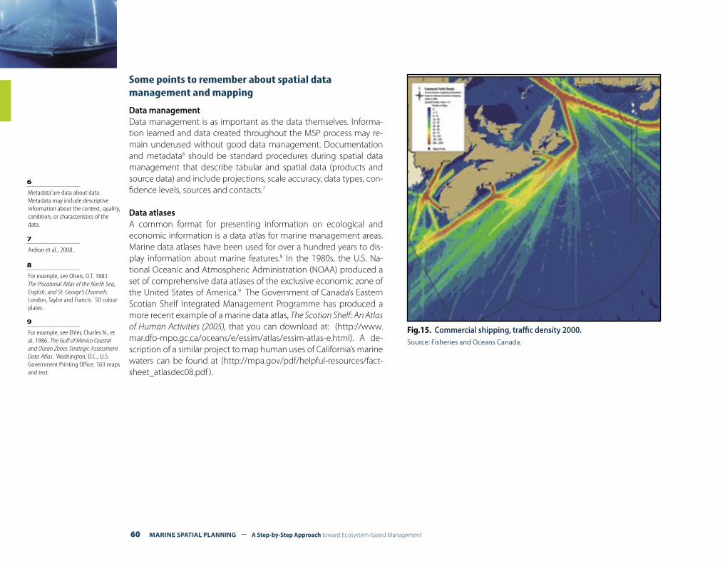
60 MARINE SPATIAL PLANNING – A Step-by-Step Approach toward Ecosystem-based Management
Some points to remember about spatial data management and mapping
Data managementData management is as important as the data themselves. Informa-tion learned and data created throughout the MSP process may re-main underused without good data management. Documentation and metadata6 should be standard procedures during spatial data management that describe tabular and spatial data (products and source data) and include projections, scale accuracy, data types, con-fidence levels, sources and contacts.7
Data atlasesA common format for presenting information on ecological and economic information is a data atlas for marine management areas. Marine data atlases have been used for over a hundred years to dis-play information about marine features.8 In the 1980s, the U.S. Na-tional Oceanic and Atmospheric Administration (NOAA) produced a set of comprehensive data atlases of the exclusive economic zone of the United States of America.9 The Government of Canada’s Eastern Scotian Shelf Integrated Management Programme has produced a more recent example of a marine data atlas, The Scotian Shelf: An Atlas of Human Activities (2005), that you can download at: (http://www.mar.dfo-mpo.gc.ca/oceans/e/essim/atlas/essim-atlas-e.html). A de-scription of a similar project to map human uses of California’s marine waters can be found at (http://mpa.gov/pdf/helpful-resources/fact-sheet_atlasdec08.pdf ).
6 Metadata’ are data about data. Metadata may include descriptive information about the context, quality, condition, or characteristics of the data.
8 For example, see Olsen, O.T. 1883. The Piscatorial Atlas of the North Sea, English, and St. George’s Channels. London, Taylor and Francis. 50 colour plates.
9 For example, see Ehler, Charles N., et al. 1986. The Gulf of Mexico Coastal and Ocean Zones Strategic Assessment Data Atlas. Washington, D.C., U.S. Government Printing Office: 163 maps and text.
Fig.15. Commercial shipping, traffic density 2000.Source: Fisheries and Oceans Canada.
7 Ardron et al., 2008..
A Step-by-Step Approach toward Ecosystem-based Management – MARINE SPATIAL PLANNING 61
Geodatabases and Geographic Information Systems
A geodatabase is a database designed to store, query and manipulate geographic information and spatial data. It is also known as a spatial database.
A review of the tools used to develop geodatabases and their use through geographic information systems and spatial modelling is beyond the scope of this guide, but is readily from several excellent sources of information, along with other decision support tools at:
• The Ecosystem-based Management Tools Network (www.ebm-tools.org); and
• Advancing Ecosystem-based Management: A Decision Support Toolkit for Marine Managers (www.marineebm.org).
A review of practical tools for MSP has been drafted by the Centre for Environment, Fisheries and Aquaculture Science to advance marine spatial planning in the United Kingdom.10 A guide to good practice in geodatabase design is Designing Geodatabases: Case Studies in GIS Data Modeling11.
Geographic information systems (GIS) integrate hardware, software and data for capturing, managing, analyzing and displaying all forms of geographically referenced information.
Geographic information systems (GIS) allow us to view, understand, question, interpret, and visualize data in many ways that reveal re-lationships, patterns, and trends in the form of maps, reports, and charts.
Since there are many user-friendly GIS software packages currently available and also many users who are untrained in cartography, one of the biggest problems is a poorly designed map. A good guide-book is Designing Better Maps: A Guide for GIS Users12, which discusses the many decisions about colour, font, and symbology that must be made to create maps that effectively communicate the message in-
tended by the mapmaker. Poorly designed maps can convey misin-formation and result in poor decision-making.13
A multipurpose marine cadastre is an integrated submerged lands information system consisting of legal (e.g. property ownership or cadastre), physical, and cultural information in a common reference framework. Cadastral data document the geographic extent of past, current and future rights and interests in real property, including the spatial information necessary to describe the geographic extent.
When considering the legal framework for a multipurpose marine ca-dastre, four questions in particular should be taken into account:
(1) What types of rights exist in the marine management area? (2) What laws define those rights? (3) What is the hierarchy of precedence among those rights? (4) How do these various rights interact with one another?
Potentially every appropriate law, boundary, restriction, permit or obstruction, e.g. pipeline, undersea cable, artificial reef, and so on, located in the marine management area could interact with and po-tentially affect decisions managers make in carrying out their respon-sibilities for MSP.
Primary data themes would include the national baseline, coastline, maritime boundaries and zones, marine managed areas, marine pro-tected areas and administrative boundaries. Supporting data themes would include pipelines, cables, artificial reefs, shipping fairways, an-chorage areas, oil and gas leases, essential habitats, aquaculture sites, archaeological sites, to mention a few.
Australia and the USA are currently developing multipurpose marine cadastres of their exclusive economic zones. For more information, you can visit (http://www.csc.noaa.gov/mbwg/htm/multipurpose.html) or (http://www.sli.unimelb.edu.au/maritime/projects.html).
Box 25.The multipurpose marine cadastre
11 Arctur and Zeller, 2004.
12 Brewer, 2005.
13 Monmonier, 1996.
10 CEFAS, Stetzenmuller et al., 2009.
62 MARINE SPATIAL PLANNING – A Step-by-Step Approach toward Ecosystem-based Management
Remember !• Planning for marine spatial management should recognize
that the marine management area typically is affected by hu-man activities that are: (1) upstream from the marine man-agement area, but within the drainage area of the adjacent coastal area, e.g. agriculture; and (2) downstream from the marine management area, e.g. in the open ocean. Pressures on the resources of the marine management area may be greater from activities outside the marine area than from activities inside it. This fact illustrates the importance of draw-ing the boundaries of analysis broader than the boundaries of management (see Step 3, Organizing the planning process through pre-planning);
• Planning for marine spatial management should determine the relative importance of different sources contributing to specific problems in the marine management area. Relative importance is likely to differ with respect to the type of prob-lem, time of year, and from year to year depending on different conditions. The relative importance of sources of problems should influence the initial focus of data collection;
• Planning for marine spatial management should consider ex-plicitly the plans and actions of other sectors of the economy in terms of the spatial and temporal pattern of proposed development and capital investments. Activities in other sec-tors (e.g. energy, transport, fisheries, watershed management) could have major implications for MSP, and vice versa;
• A common framework and time frame across sectors should be considered for making economic and demographic pro-jections, developing scenarios, and using similar analytical techniques for analyzing costs and effectiveness of different management strategies. However, achieving such a common framework is difficult, since there rarely is an institution with overall responsibility for integrated planning and develop-ment of individual sectoral plans and programmes;
• The level of sophistication of planning in the MSP process should not be more complicated than necessary. Increas-ing complexity can certainly increase the accuracy of results up to some level, but beyond that, diminishing returns begin. Increasing increments of complexity produce ever-smaller increments of increased accuracy. In fact, a MSP approach may become so complicated that it will just become too difficult, if not impossible, to interpret the results, so that accuracy actu-ally decreases;
• MSP is a continuous activity; its process must be organized to generate information at various points in time. Therefore, there must be a continuous activity of planning to generate information for the development of management strategies that respond to changing conditions, i.e., adaptive manage-ment (see Step 10).
A Step-by-Step Approach toward Ecosystem-based Management – MARINE SPATIAL PLANNING 63
DEFINING AND ANALYZING FUTURE CONDITIONS STEP 6
What outputs should be delivered from this step?
F A trend scenario illustrating how the MSP area will look if present conditions continue without new management interventions;
F Alternative spatial sea use scenarios illustrating how the management area might look when human activities are redistributed based on new goals and objectives; and
F A preferred scenario that provides the basis for identifying and selecting management measures in the spatial man-agement plan (Step 7).
“Before we can create a desirable future, we first need to imagine it”
Introduction
The previous step concentrated on analyzing existing conditions within the marine management area. Its main purpose was to gain understanding of the existing distribution of important ecological and economic areas in the marine environment and the nature and scope of its human uses. Essentially, it provides an inventory of what exists today in the management area.
The purpose of this phase of the planning process is to answer an-other seemingly simple question: Where do we want to be? The answer takes the form of alternative spatial sea use scenarios and the selection of a preferred scenario.
A spatial sea use scenario provides a vision that projects the future use of marine space based on a core set of goals, objectives, and assumptions about the future.
MSP is a future-oriented activity. Its purpose is to help envision and create a desirable future and enable proactive decision-making in the short run to move toward what is desired. Consequently, planning should not be limited to defining and analyzing only existing con-ditions and maintaining the status quo, but should reveal possible alternative futures of how the area could look like in another 10, 15, or 20 years. Box 26 lists a number of other reasons why the development of alternative spatial sea use scenarios is important.
Defining and analyzing future conditions involves the following tasks:(1) Projecting current trends in the spatial and temporal needs of ex-
isting human uses;(2) Estimating spatial and temporal requirements for new demands
of ocean space;(3) Identifying possible alternative future scenarios for the planning
area; and(4) Selecting the preferred spatial sea use scenario
Each of these steps are discussed in more detail in the following sections.
64 MARINE SPATIAL PLANNING – A Step-by-Step Approach toward Ecosystem-based Management
• Spatial sea use scenarios can help illustrate how the area will look if present trends continue without new management in-terventions;
• Spatial sea use scenarios can illustrate the spatial and temporal consequences of implementing certain goals and objectives. It can, for example, help estimating the required marine space to build 100 offshore windmills (approximately 300 MW) in the management area and help identify its implications upon other uses and/or the environment;
• Spatial sea use scenarios allow you to anticipate potential fu-ture opportunities, conflicts or compatibilities for the area that can guide proactive decision-making;
• Spatial sea use scenarios are important in determining the de-sired direction you want your management area to develop and in selecting management measures needed to get there (see Step 7, Preparing and approving the spatial management plan)
Box 26. Reasons why
developing alternative spatial sea use
scenarios is important
TASK 1. PROJECTING CURRENT TRENDS IN THE SPATIAL AND TEMPORAL NEEDS OF EXISTING HUMAN ACTIVITIES
Projecting trends in the spatial and temporal needs of existing hu-man uses visualizes what is likely to happen if you do not interfere in the management of the area. It is often referred to as a “trend scenario”.
First, you will need to determine the time frame for your forecasting. Step 3, Organizing the process through pre-planning, provides infor-mation on determining the time frame for planning. It is important to use your selected time frame consistently for all forecasts so that future human activities can be compared across sectors.
Forecasts can be made in different ways. One way is by looking at historical trends about each use. For example, if sand and gravel mining has expanded an average 2% each year for the past 10 years
(= historical trend), your projection for the next 15 years (= time frame for planning), can be that sand and gravel mining is likely to expand at the same rate of 2% each year (= projection).
For the development of their National Waterplan, for example, The Netherlands projected current trends by asking representatives of each sector how they saw their sector developing in space and time during the specified time frame. Each sector was asked how the future would look by 2015 and by 2020, considering: (a) maxi-mum level of development, (b) medium level of development; and (c) minimum level of development. This information provided the basis for the development of alternative spatial sea use scenarios (see also Box 28).1
Second, you will need to map the projection for each of the human uses so that the spatial and temporal implications are visualized to the maximum extent possible. These maps should clearly indicate where, when and how the projected human uses and non-uses will occur.
1 Ministerie van Verkeer en Waterstaat. 2008. Pre-policy Documnent on the North Sea. The Netherlands
Remember !Defining and analyzing future conditions is not an exact science. Contrary to mapping existing conditions (see Step 5, defining and analyzing existing conditions), the maps developed to visu-alize future conditions do not need to reflect “exact” locations. Instead, they should indicate patterns, trends, and direction. You will typically involve planners (not necessarily scientists) who will rely on drawing programs and other tools rather than geographic information systems (GIS). Figure 16 illustrates this point.
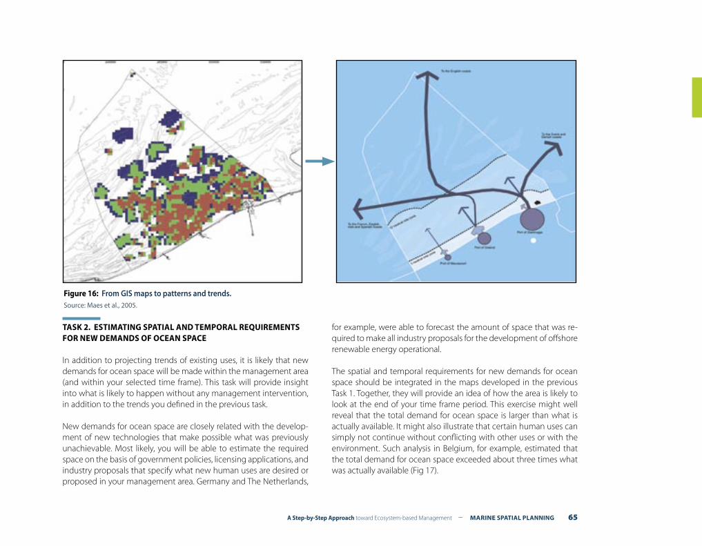
A Step-by-Step Approach toward Ecosystem-based Management – MARINE SPATIAL PLANNING 65
TASK 2. ESTIMATING SPATIAL AND TEMPORAL REQUIREMENTS FOR NEW DEMANDS OF OCEAN SPACE
In addition to projecting trends of existing uses, it is likely that new demands for ocean space will be made within the management area (and within your selected time frame). This task will provide insight into what is likely to happen without any management intervention, in addition to the trends you defined in the previous task.
New demands for ocean space are closely related with the develop-ment of new technologies that make possible what was previously unachievable. Most likely, you will be able to estimate the required space on the basis of government policies, licensing applications, and industry proposals that specify what new human uses are desired or proposed in your management area. Germany and The Netherlands,
for example, were able to forecast the amount of space that was re-quired to make all industry proposals for the development of offshore renewable energy operational.
The spatial and temporal requirements for new demands for ocean space should be integrated in the maps developed in the previous Task 1. Together, they will provide an idea of how the area is likely to look at the end of your time frame period. This exercise might well reveal that the total demand for ocean space is larger than what is actually available. It might also illustrate that certain human uses can simply not continue without conflicting with other uses or with the environment. Such analysis in Belgium, for example, estimated that the total demand for ocean space exceeded about three times what was actually available (Fig 17).
Figure 16: From GIS maps to patterns and trends.Source: Maes et al., 2005.
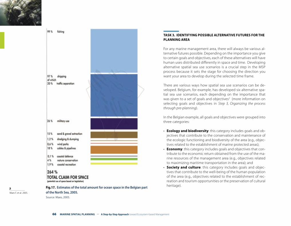
66 MARINE SPATIAL PLANNING – A Step-by-Step Approach toward Ecosystem-based Management
TASK 3. IDENTIFYING POSSIBLE ALTERNATIVE FUTURES FOR THE PLANNING AREA
For any marine management area, there will always be various al-ternative futures possible. Depending on the importance you give to certain goals and objectives, each of these alternatives will have human uses distributed differently in space and time. Developing alternative spatial sea use scenarios is a crucial step in the MSP process because it sets the stage for choosing the direction you want your area to develop during the selected time frame.
There are various ways how spatial sea use scenarios can be de-veloped. Belgium, for example, has developed six alternative spa-tial sea use scenarios, each depending on the importance that was given to a set of goals and objectives2 (more information on selecting goals and objectives in Step 3, Organizing the process through pre-planning).
In the Belgian example, all goals and objectives were grouped into three categories:
• Ecology and biodiversity: this category includes goals and ob-jectives that contribute to the conservation and maintenance of the ecologic functioning and biodiversity of the area (e.g., objec-tives related to the establishment of marine protected areas);
• Economy: this category includes goals and objectives that con-tribute to the economic return obtained from the use of the ma-rine resources of the management area (e.g., objectives related to maximizing maritime transportation in the area); and
• Society and culture: this category includes goals and objec-tives that contribute to the well-being of the human population of the area (e.g., objectives related to the establishment of rec-reation and tourism opportunities or the preservation of cultural heritage).Fig.17. Estimates of the total amount for ocean space in the Belgian part
of the North Sea, 2005. Source: Maes, 2005.
2 Maes F. et al. 2005.
A Step-by-Step Approach toward Ecosystem-based Management – MARINE SPATIAL PLANNING 67
In Belgium, based on these categories and a set of relevant deci-sion rules, six scenarios were developed, each based on different combinations of categories of objectives and the importance that was given to them. A spatial sea use scenario was developed for each of the categories and for a combination of the categories. For example, the “natural sea” scenario represented the spatial and temporal distribution of human use in the area in the case of maxi-mum protection of important biological and ecological areas. The “rich sea” scenario indicated how human use would be distributed in space and time if a maximum economic return were expected from the area. Other scenarios concentrated on a maximum rep-resentation of social/cultural values or a combination of all the above (see Fig. 18 and Fig. 19). You can, however, develop as many spatial sea use scenarios as you want, depending on available re-sources and time.
It is important to realize that certain “decision rules” will be rel-evant for the development of spatial sea use scenarios. Decision rules can be considered as “fixed” rules or constraints that need to be taken into account when locating certain human uses or non-uses to particular spaces in the area. Box 27 provides insight how you can identify “decision rules” for your area.
The spatial sea use scenarios will primarily indicate:• Places of concentration in your management area resulting from
the choice of objectives;• Areas for special protection;• Areas for development;• Spatial relations between different areas; and• Spatial networks (e.g., maritime transport routes or networks of ma-
rine protected areas);
Box 28 gives a brief overview of how spatial sea use scenarios for eco-nomic development and climate change have been developed in the Netherlands.
• International and national regulations: Decision rules can be derived from reviewing international and national regulations and policies that influence space allocation in the area and are not readily changeable. Changes in shipping routes and traffic separa-tion schemes, for example, need to be approved by the Interna-tional Maritime Organization.
• Economic and technical considerations: Decision rules can also be derived from economic or technical requirements to make a particular activity operational. Offshore wind energy, for example, is likely to be more economically viable when placed closer to shore;
• Physical and environmental conditions: Decision rules can also be derived from physical and environmental conditions. Most ex-tracting activities, for example, are dependent on the availability and quality of the resources. The functioning of infrastructure, for example, could be impaired by certain conditions, such as ba-thymetry, sediment type, and currents.
• Preferential conditions: Decision rules can also be derived from reviewing preferential conditions (environmental, economic, so-cial) for the allocation of space to certain human uses. For exam-ple, the “Integrated Management Plan for the North Sea 2015” of the Netherlands stipulated that no wind farms are allowed within 20 km of the shoreline. Another example is that no economic ac-tivities are allowed during marine mammal or bird feeding areas at certain times of the year.
Box 27Criteria to help define “decision rules” for the development of spatial sea use scenarios

68 MARINE SPATIAL PLANNING – A Step-by-Step Approach toward Ecosystem-based Management
Fig. 18. Spatial and temporal distribution of human use in the Belgian “rich sea” spatial sea use scenario. Source: Maes et al., 2005.
Fig.19. Spatial and temporal distribution of human use in the Belgian “natural sea” spatial sea use scenario. Source: Maes et al., 2005.
.
TASK 4. SELECTING THE PREFERRED SPATIAL SEA USE SCENARIO At the end of the previous task you will have several alternative spatial sea use scenarios, each providing a vision of how your management area could look depending on the importance you give to certain goals and objectives. Each of the alternatives should tell you how human uses will be distributed in space and time to achieve the objectives of the scenario. This task focuses on selecting the preferred alternative spatial sea use scenario. The selected scenario will form the basis for implementation and selecting your management measures (see Step 7, Preparing and approving the spatial management plan).
The preferred scenario will be different in each context. If you strive to achieve a set of objectives that are balanced among each other, you will
most likely select a scenario that combines objectives of each of the cat-egories (social, economic, ecologic). Alternatively, if you strive to achieve a maximum economic use of your planning area, your preferred alterna-tive will have a higher emphasis on the economic objectives.
Your chose of spatial sea use scenario that you eventually want to im-plement will most likely depend on a set of criteria. Ideally, the alter-native that will produce results in the most effective (leading toward results), efficient (producing expected results at the least cost), and equitable way (costs and benefits for achieving results are distributed equitably) is the preferred one. It is possible, for example, that one of the scenarios is too costly to implement, or will be too difficult to enforce. Box 29 gives a list of criteria that can help you select the preferred spatial sea use scenario.
A Step-by-Step Approach toward Ecosystem-based Management – MARINE SPATIAL PLANNING 69
Box 28Dutch spatial sea use scenario indicating spatial distribution of human use in case of maximum economic development by 2015
The central goal of the Dutch National Water Plan is the creation of a safe (limiting shipping accidents and reduction of climate change ef-fect), healthy (good water quality and biodiversity conservation) and productive (economic return from oil and gas, wind energy, fishing, and sand extraction) ocean. To achieve this goal, the Dutch govern-ment prepared three alternative spatial sea use scenarios for a time horizon of 10 years (base year: 2005; target year: 2015). The alternative spatial sea use scenarios indicated where opportunities were likely to occur with respectively minimum, medium, or maximum economic growth of human uses.
As a first step, for each activity (including wind energy which is a gov-ernment priority) in the area an estimate was made of: (a) what eco-nomic developments can be expected; (b) what policy development can be expected; (c) what technical or operational developments can be expected; (c) what are the spatial requirements until 2015; and (d) what are the spatial requirements after 2015?
Secondly, the analysis included an economic valuation (both direct and indirect) for each activity in relation to its demand for ocean space. The economic value was estimated in terms of economic return, added value to the general economy and employment. On the basis of this information, three spatial sea use scenarios were developed, each in-dicating a different level of expected growth, e.g., maximum growth, medium growth, and minimum growth.
Thirdly, the spatial and temporal implications of each growth scenario were visualized in maps. These maps further contained information on expected policy developments and estimated technological improve-ments. By visualizing these scenarios, it was possible to anticipate what
opportunities or conflicts could occur when certain objectives (set through the political process) would be implemented. It also allowed drawing initial conclusions about a desired future for the Dutch part of the North Sea.
The scenarios were developed through close cooperation with all rel-evant agencies and steered by an interagency Board of Directors. The estimates for the human uses were mainly developed in cooperation with the sectors themselves. The economic valuations were largely based on economic and financial statistics, historic prices for products, international trade trends and forecasts, and expert opinions. The study took about two years to complete.
Additionally to this work, a State Advisory Committee (Delta Commis-sion) advised the Dutch Government on measures to protect the low-lying country against effects of climate change in the long term. Alter-native sea level rise (SLR) scenarios were developed. For the year 2050 relative SLR could be 20-40 cm (including 5 cm subsidence of the bot-tom), in 2100 the maximum plausible SLR could be 1.30m. The Dutch government decided to integrate the SLR into the National Water Plan, and to protect the coast through beach nourishment, equally to the ac-tual SLR (acknowledging the maximum SLR as a safety strategy albeit not actually planning for it). Further, the Dutch government intends to explicitly offer space for additional sand extraction for coastal and flood protection measures by reserving space in between the 20-m depth contour and the 12-mile zone. The latter is included as a “pre-ferred sand extraction zone” in the National Water Plan.
Adapted from: Verkenning van economische en ruimtelijke ontwikkelingen op de Noordzee. 2008. Ministerie van Verkeer and Waterstaat. The Netherlands; and Pre-policy document North Sea, 2008, The Netherlands.
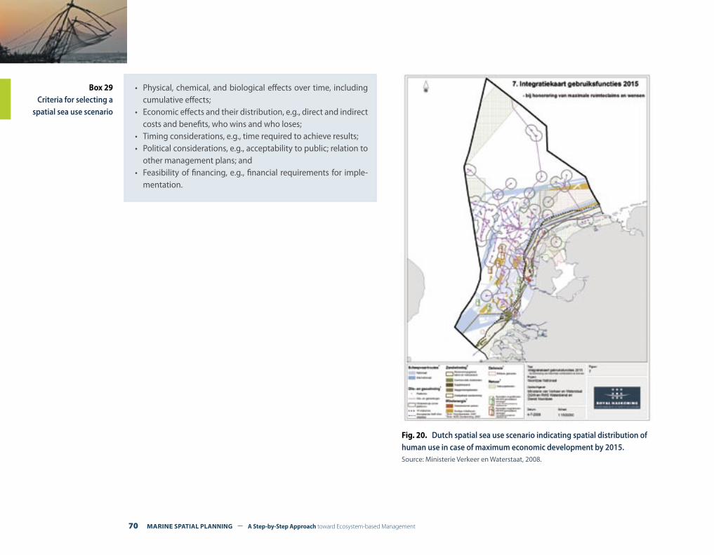
70 MARINE SPATIAL PLANNING – A Step-by-Step Approach toward Ecosystem-based Management
Fig. 20. Dutch spatial sea use scenario indicating spatial distribution of human use in case of maximum economic development by 2015.Source: Ministerie Verkeer en Waterstaat, 2008.
Box 29Criteria for selecting a
spatial sea use scenario
• Physical, chemical, and biological effects over time, including cumulative effects;
• Economic effects and their distribution, e.g., direct and indirect costs and benefits, who wins and who loses;
• Timing considerations, e.g., time required to achieve results;• Political considerations, e.g., acceptability to public; relation to
other management plans; and• Feasibility of financing, e.g., financial requirements for imple-
mentation.
A Step-by-Step Approach toward Ecosystem-based Management – MARINE SPATIAL PLANNING 71
PREPARING AND APPROVING THE SPATIAL MANAGEMENT PLAN STEP 7
What outputs should be delivered from this step?
F An identification and evaluation of alterative management measures for the spatial management plan;
F Identification of criteria for selecting alternative management measures; and
F A comprehensive management plan, including if needed, a zoning plan.
Introduction
Once a preferred scenario or alternative future is decided (Step 6, Defin-ing and analyzing future conditions), then this final phase of planning answers the question: How do we get there? A marine spatial man-agement plan should be developed to identify specific management measures that will produce the desired future through explicit deci-sions about the location and timing of human activities. The marine spatial management plan is not an end in itself but a beginning toward the implementation of desired goals and objectives.
The marine spatial management plan should be a statement of policy from the responsible management authority or authorities, in part-nership with other key agencies and authorities that are responsible for single sectors. It should present an integrated vision of the spatial aspects of their sectoral policies in the areas of economic develop-ment, marine transport, environmental protection, energy, fisheries, and tourism. The marine spatial management plan should be closely integrated with public investment programs, should highlight the spatial dimension of integrated management, and should show where marine policies fit together and where they do not.
A spatial management plan is a comprehensive, strategic document that provides the framework and direction for marine spatial management decisions. It should identify when, where, and how goals and objectives will be met.
The spatial management plan guides the ecological, social, and eco-nomic development of the marine management area, including its airspace, surface area, water column, and submerged lands.
Preparing and approving the spatial management plan includes the following tasks:(1) Identifying alternative spatial and temporal management mea-
sures(2) Specifying criteria for selecting marine spatial management mea-
sures(3) Developing the zoning plan(4) Evaluating the spatial management plan(5) Approving the spatial management plan
Each of these tasks is discussed in more detail below. Box_ specifies what a spatial management plan generally should include.
72 MARINE SPATIAL PLANNING – A Step-by-Step Approach toward Ecosystem-based Management
One purpose of the spatial mangement plan is to guide and coor-dinate proposals for future development and to provide a general reference for more detailed zoning, regulation, and permitting. For example, the spatial management plan should help prospective de-velopers in the private sector evaluate the likelihood of gaining per-mission to develop marine space; a zoning plan should lay out the constraints and conditions imposed on such development.
The spatial management plan should provide direction for further zoning and regulations, as well as the use of other management mea-sures, but the degree of prescription has to be dependent upon local conditions. For example, if regional and local marine management institutions are not well established or lack capacity, then the spatial management plan may play a primary role in guiding development until such time that more detailed zoning plans are created. In any case, the spatial management plan should adopt a minimalist ap-proach concentrating on priorities, key challenges, and places where change is anticipated. There is little value in seeking to achieve full integration of sectoral plans that is clearly unachievable. The objec-
tive should be to achieve consensus on priority actions. When this is not achievable, it is important that to ensure that all stakeholders are aware of the anticipated consequences of such inaction.1
In any marine spatial management area there are:
• Many possible combinations of products and services that can be produced over time (see Part 2, Concepts and terminology for ma-rine spatial planning for examples of goods and services from ma-rine areas); and
• Many possible spatial and temporal management measures that can deliver the products and services.
The number of possible combinations of management measures can be very large. It is not possible, nor is it necessary, to analyze all possibilities. In most situations, existing knowledge will reduce the number of options. Or the political process may set constraints. For example, a decision might be made to establish a large marine pro-tected area, or a network of MPAs that might limit the production of other goods and services from the area.
Box 30Key aspects of the
spatial management plan
In general, the spatial management plan should include:
• A description of the boundaries of the MSP area, as well as a specified base year and time period of the plan;
• The spatial management goals and objectives;• A description of a preferred future—a graphic portrayal of the
vision of the physical development and conservation of the management area;
• The management measures required to achieve the preferred future;
• A timetable for the formal actions needed to implement the plan (who does what, when); and
• Funding requirements of the comprehensive plan and a finan-cial plan that lays out sources of funding.
Remember !A very important objective of planning is to expand the range of alternatives considered in formulating management measures. Often the goals of MSP have not been achieved, or have been achieved at substantially larger costs than would have been necessary, because the planners and decision makers limited themselves to the consideration of only a few management measures.
1 United Nations Economic Com-mission for Europe (ECE), 2008.
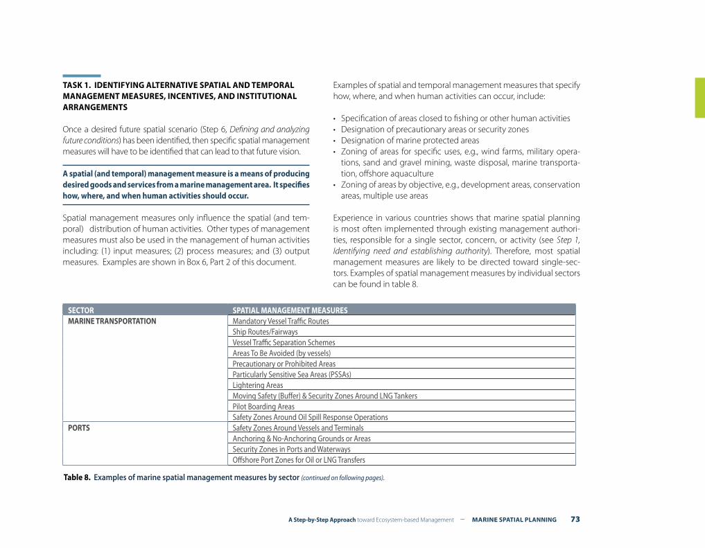
A Step-by-Step Approach toward Ecosystem-based Management – MARINE SPATIAL PLANNING 73
TASK 1. IDENTIFYING ALTERNATIVE SPATIAL AND TEMPORAL MANAGEMENT MEASURES, INCENTIVES, AND INSTITUTIONAL ARRANGEMENTS
Once a desired future spatial scenario (Step 6, Defining and analyzing future conditions) has been identified, then specific spatial management measures will have to be identified that can lead to that future vision.
A spatial (and temporal) management measure is a means of producing desired goods and services from a marine management area. It specifies how, where, and when human activities should occur.
Spatial management measures only influence the spatial (and tem-poral) distribution of human activities. Other types of management measures must also be used in the management of human activities including: (1) input measures; (2) process measures; and (3) output measures. Examples are shown in Box 6, Part 2 of this document.
Examples of spatial and temporal management measures that specify how, where, and when human activities can occur, include:
• Specification of areas closed to fishing or other human activities• Designation of precautionary areas or security zones• Designation of marine protected areas• Zoning of areas for specific uses, e.g., wind farms, military opera-
tions, sand and gravel mining, waste disposal, marine transporta-tion, offshore aquaculture
• Zoning of areas by objective, e.g., development areas, conservation areas, multiple use areas
Experience in various countries shows that marine spatial planning is most often implemented through existing management authori-ties, responsible for a single sector, concern, or activity (see Step 1, Identifying need and establishing authority). Therefore, most spatial management measures are likely to be directed toward single-sec-tors. Examples of spatial management measures by individual sectors can be found in table 8.
SECTOR SPATIAL MANAGEMENT MEASURESMARINE TRANSPORTATION Mandatory Vessel Traffic Routes
Ship Routes/FairwaysVessel Traffic Separation SchemesAreas To Be Avoided (by vessels)Precautionary or Prohibited AreasParticularly Sensitive Sea Areas (PSSAs)Lightering AreasMoving Safety (Buffer) & Security Zones Around LNG TankersPilot Boarding AreasSafety Zones Around Oil Spill Response Operations
PORTS Safety Zones Around Vessels and TerminalsAnchoring & No-Anchoring Grounds or AreasSecurity Zones in Ports and WaterwaysOffshore Port Zones for Oil or LNG Transfers
Table 8. Examples of marine spatial management measures by sector (continued on following pages).
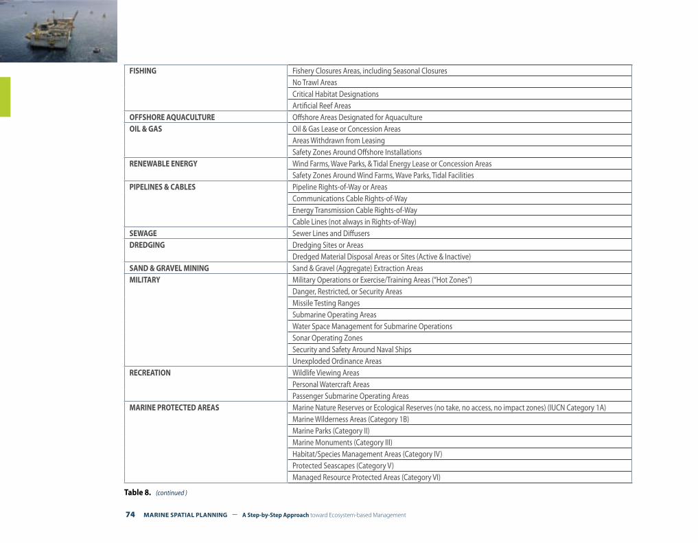
74 MARINE SPATIAL PLANNING – A Step-by-Step Approach toward Ecosystem-based Management
FISHING Fishery Closures Areas, including Seasonal ClosuresNo Trawl AreasCritical Habitat DesignationsArtificial Reef Areas
OFFSHORE AQUACULTURE Offshore Areas Designated for Aquaculture OIL & GAS Oil & Gas Lease or Concession Areas
Areas Withdrawn from LeasingSafety Zones Around Offshore Installations
RENEWABLE ENERGY Wind Farms, Wave Parks, & Tidal Energy Lease or Concession AreasSafety Zones Around Wind Farms, Wave Parks, Tidal Facilities
PIPELINES & CABLES Pipeline Rights-of-Way or AreasCommunications Cable Rights-of-WayEnergy Transmission Cable Rights-of-WayCable Lines (not always in Rights-of-Way)
SEWAGE Sewer Lines and DiffusersDREDGING Dredging Sites or Areas
Dredged Material Disposal Areas or Sites (Active & Inactive)SAND & GRAVEL MINING Sand & Gravel (Aggregate) Extraction AreasMILITARY Military Operations or Exercise/Training Areas (“Hot Zones”)
Danger, Restricted, or Security AreasMissile Testing RangesSubmarine Operating AreasWater Space Management for Submarine OperationsSonar Operating ZonesSecurity and Safety Around Naval Ships Unexploded Ordinance Areas
RECREATION Wildlife Viewing AreasPersonal Watercraft AreasPassenger Submarine Operating Areas
MARINE PROTECTED AREAS Marine Nature Reserves or Ecological Reserves (no take, no access, no impact zones) (IUCN Category 1A)Marine Wilderness Areas (Category 1B)Marine Parks (Category II)Marine Monuments (Category III)Habitat/Species Management Areas (Category IV)Protected Seascapes (Category V)Managed Resource Protected Areas (Category VI)
Table 8. (continued )
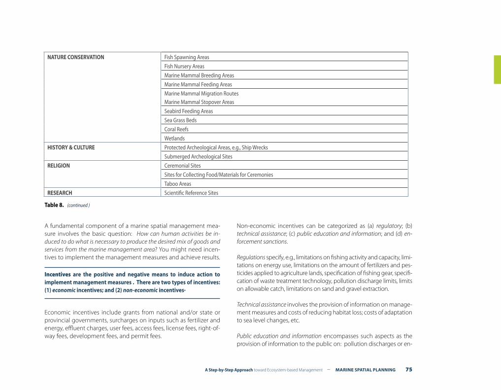
A Step-by-Step Approach toward Ecosystem-based Management – MARINE SPATIAL PLANNING 75
NATURE CONSERVATION Fish Spawning Areas
Fish Nursery Areas
Marine Mammal Breeding Areas
Marine Mammal Feeding Areas
Marine Mammal Migration RoutesMarine Mammal Stopover Areas
Seabird Feeding Areas
Sea Grass Beds
Coral Reefs
Wetlands
HISTORY & CULTURE Protected Archeological Areas, e.g., Ship Wrecks
Submerged Archeological Sites
RELIGION Ceremonial Sites
Sites for Collecting Food/Materials for Ceremonies
Taboo Areas
RESEARCH Scientific Reference Sites
Table 8. (continued )
A fundamental component of a marine spatial management mea-sure involves the basic question: How can human activities be in-duced to do what is necessary to produce the desired mix of goods and services from the marine management area? You might need incen-tives to implement the management measures and achieve results.
Incentives are the positive and negative means to induce action to implement management measures . There are two types of incentives: (1) economic incentives; and (2) non-economic incentives.
Economic incentives include grants from national and/or state or provincial governments, surcharges on inputs such as fertilizer and energy, effluent charges, user fees, access fees, license fees, right-of-way fees, development fees, and permit fees.
Non-economic incentives can be categorized as (a) regulatory; (b) technical assistance; (c) public education and information; and (d) en-forcement sanctions.
Regulations specify, e.g., limitations on fishing activity and capacity, limi-tations on energy use, limitations on the amount of fertilizers and pes-ticides applied to agriculture lands, specification of fishing gear, specifi-cation of waste treatment technology, pollution discharge limits, limits on allowable catch, limitations on sand and gravel extraction.
Technical assistance involves the provision of information on manage-ment measures and costs of reducing habitat loss; costs of adaptation to sea level changes, etc.
Public education and information encompasses such aspects as the provision of information to the public on: pollution discharges or en-

76 MARINE SPATIAL PLANNING – A Step-by-Step Approach toward Ecosystem-based Management
vironmental damage by individual marine operations; various options being considered in relation to management of marine areas; identifi-cation of bad behavior, e.g., the “worst polluters of the year”.
Enforcement sanctions include civil actions, such as administrative pro-cedures, fines, canceling of licenses or permits, injunctions precluding certain actions, canceling the possibility of doing business with gov-ernmental agencies; and criminal penalties, such as jail sentences (See also Step 8, Implementation and enforcement).
Finally, MSP involves multiple human activities and typically involves multiple management agencies. Crucial with respect to the institution-al arrangement for management in a marine area are: (1) designation of what institution or institutions does which tasks of spatial manage-ment; and (2) how the institutions carrying out the tasks are integrated. The problem of institutional integration relates not only to the marine management area, but also to agencies in areas upstream from the ma-rine area, e.g., coastal watersheds.
An institutional arrangement specifies what institutions have the authority to implement selected incentives to implement specified management measures. It allocates responsibilities for the relevant tasks of MSP to public agencies, and in some cases between public agencies and private entities.
Management measures, incentives, and institutional arrangements should be specified clearily in the spatial managment plan.
TASK 2. SPECIFYING CRITERIA FOR SELECTING MARINE SPATIAL MANAGEMENT MEASURES
Just as there will be differences among the stakeholders about the relative importance of problems or objectives to be achieved through marine spatial planning, there may be differences in their views of the criteria to be used in evaluating alternative management measures that will represent the substance of the management plan.
Table 9 lists some criteria, various combinations of which can used in evaluating management measures. Not only must a decision be made about which criteria are to be used, but also the decision must be made about what “weights” (or level of importance) to assign to the various criteria selected. Again, it should be emphasized that the decisions about both criteria and their weights may well change, in the views of the stakeholders, during the course of planning.
TASK 3. DEVELOPING THE ZONING PLAN
Zoning is often the principal management measure used to imple-ment comprehensive marine spatial management plans. See Box_ for the purposes of a zoning plan. A zoning plan is often included in the management plan (See, for example, The Netherlands National Water-plan for the North Sea that includes a zoning plan)2. Key elements of a MSP zoning approach include:
• locating and designing zones based on the underlying topography, oceanography, and distribution of biotic communities;
• designing systems of permits, licenses, and use rules within each zone;
• establishing compliance mechanisms; and• creating programs to monitor, to review, and to adapt the zoning
system.
A zoning plan is the means through which the purpose for each part or parts of a marine management area can be used.
Just as with most other steps in this guide, no one type of zoning will fit all situations. Zoning is often in the form of a legal document. How-ever, the format of a zoning plan will depend on its legislative basis and on the procedures of the agencies responsible for the plan. It could be in the form of a locally-adopted municipal plan, for example see the zoning plan for Moreton Bay, Australia (www.epa.qld.gov.au/parks_and_forests/marine_parks/moreton_bay_marine_park_zoning_plan_review/), or a nationally-endorsed legal instrument , as required by Australia’s Great Barrier Reef Marine Park Authority.3
1 Ministerie van Verkeer en Waterstaat, 2008.
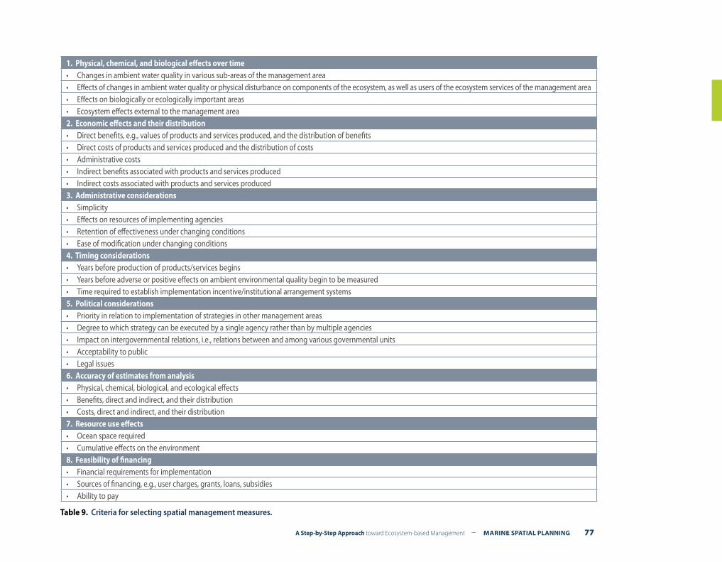
A Step-by-Step Approach toward Ecosystem-based Management – MARINE SPATIAL PLANNING 77
1. Physical, chemical, and biological effects over time• Changes in ambient water quality in various sub-areas of the management area• Effects of changes in ambient water quality or physical disturbance on components of the ecosystem, as well as users of the ecosystem services of the management area• Effects on biologically or ecologically important areas• Ecosystem effects external to the management area2. Economic effects and their distribution• Direct benefits, e.g., values of products and services produced, and the distribution of benefits• Direct costs of products and services produced and the distribution of costs• Administrative costs• Indirect benefits associated with products and services produced• Indirect costs associated with products and services produced3. Administrative considerations• Simplicity• Effects on resources of implementing agencies• Retention of effectiveness under changing conditions• Ease of modification under changing conditions4. Timing considerations• Years before production of products/services begins• Years before adverse or positive effects on ambient environmental quality begin to be measured• Time required to establish implementation incentive/institutional arrangement systems5. Political considerations• Priority in relation to implementation of strategies in other management areas• Degree to which strategy can be executed by a single agency rather than by multiple agencies• Impact on intergovernmental relations, i.e., relations between and among various governmental units• Acceptability to public• Legal issues6. Accuracy of estimates from analysis• Physical, chemical, biological, and ecological effects• Benefits, direct and indirect, and their distribution• Costs, direct and indirect, and their distribution7. Resource use effects• Ocean space required• Cumulative effects on the environment8. Feasibility of financing• Financial requirements for implementation• Sources of financing, e.g., user charges, grants, loans, subsidies• Ability to pay
Table 9. Criteria for selecting spatial management measures.

78 MARINE SPATIAL PLANNING – A Step-by-Step Approach toward Ecosystem-based Management
The zoning plans of the Great Barrier Reef Marine Park are required by na-tional legislation to define the purposes for which areas of the park may be used or entered, i.e., each zone has a specified objective (Figure 21). They allow reasonable activities, such as tourism, fishing, boating, diving and research to occur in specific areas, but also separate conflicting uses by the various zones and determine the appropriateness of various ex-tractive activities. A multiple-use zoning approach provides high levels of protection for specific areas while allowing a range of reasonable uses, including certain extractive activities, to continue in other zones within the park. Many aspects of GBRMP zoning, such as allowing, but separat-ing, conflicting uses, have proven very successful. Experience, however, has also shown that some features of zoning have needed to be refined; furthermore, what works in the GBRMP may not necessarily work else-where and may also need to be modified in other marine situations.4
The process for the development of zoning plans is stipulated in the leg-islation and includes a minimum of two statutory phases of public par-ticipation. Public involvement in the zoning process in the GBRMP has included publication of a variety of brochures and booklets and the use
of other media to involve the public effectively and as far as practicable in the process. The provision of information to assist public understanding once new zoning provisions have been promulgated—in addition to the formal zoning plan and zoning maps—has also been useful.
Zoning has been one of the cornerstones of management for the GBRMP. However, other management tools are also important and should be used in conjunction with zoning. These include, for example:
• Plans of management: Prepare for intensively used, or particularly vul-nerable areas, or for the protection of vulnerable species or ecological communities. Plans of management complement zoning by address-ing issues specific to an area, species or community in greater detail that can be accomplished by the broader zoning plans;
• Site plans: Localized plans determining appropriate use of a particular site. They identify significant values and describe appropriate manage-ment arrangements for a site concentrating on specific use issues and cumulative impacts at that site;
• Designated areas/Special Management Areas: Set additional require-ments/restrictions in specific areas for specific uses (eg, shipping areas) or restricting access (eg, in an emergency situation requiring immedi-ate management action such as an oil spill);
• Best environmental practice: Guidelines advising environmentally re-sponsible ways to conduct activities; and
• Permits: Within the appropriate zones stipulated in the zoning plan, specify conditions that further regulate activities and/or locations and/or timing for permitees.
However, it should be remembered that the final zoning product in a large multiple use marine management area will be the result of compromise, accommodating a range of needs and political require-ments. Zoning is generally not a simple task.5
Innovative proposals to zone marine spaces vertically are discussed in Box 32. The fourth dimension—time—and its implications for ma-rine zoning are discussed in Box 33.
Box 31Purposes of
a Zoning Plan
The main purposes of a zoning plan are to:
• Provide protection for biologically and ecologically important habitats, ecosystems, and ecological processes;
• Separate conflicting human activities or to combine compat-ible human activities;
• To protect the natural values of the marine management area while allowing reasonable human uses of the area;
• To allocate areas for reasonable human uses while minimiz-ing the effects of these human uses on each other and nature; and
• To preserve some areas of the marine managed area in their natural state undisturbed by humans except for scientific or educational purposes.
4 Day, 2002.
5 Day, 2002.
3 Kelleher,1999.
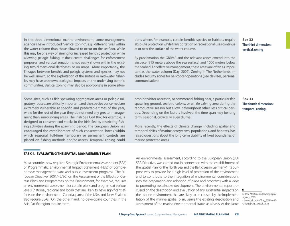
A Step-by-Step Approach toward Ecosystem-based Management – MARINE SPATIAL PLANNING 79
Box 32The third dimension: vertical zoning
In the three-dimensional marine environment, some management agencies have introduced “vertical zoning”, e.g., different rules within the water column than those allowed to occur on the seafloor. While this may be one way of aiming for increased benthic protection while allowing pelagic fishing, it does create challenges for enforcement purposes, and vertical zonation is not easily shown within the exist-ing two-dimensional databases or on maps. More importantly, the linkages between benthic and pelagic systems and species may not be well known, so the exploitation of the surface or mid-water fisher-ies may have unknown ecological impacts on the underlying benthic communities. Vertical zoning may also be appropriate in some situa-
tions where, for example, certain benthic species or habitats require absolute protection while transportation or recreational uses continue at or near the surface of the water column.
By proclamation the GBRMP and the relevant zones extend into the airspace (915 meters above the sea surface) and 1000 meters below the seabed. For effective management, these areas are often as impor-tant as the water column (Day, 2002). Zoning in The Netherlands in-cludes security zones for helicopter operations (Leo deVrees, personal communication).
Box 33The fourth dimension: temporal zoning
Some sites, such as fish spawning aggregation areas or pelagic mi-gratory routes, are critically important and the species concerned are extremely vulnerable at specific and predictable times of the year, while for the rest of the year they do not need any greater manage-ment than surrounding areas. The Irish Sea Cod Box, for example, is designed to conserve cod stocks in the Irish Sea by restricting fish-ing activities during the spawning period. The European Union has encouraged the establishment of such conservation ‘boxes’ within which seasonal, full-time, temporary or permanent controls are placed on fishing methods and/or access. Temporal zoning could
prohibit visitor access to, or commercial fishing near, a particular fish spawning ground, sea bird colony, or whale calving area during the reproductive season but allow it throughout other, less critical peri-ods. Depending on the factors involved, the time span may be long term, seasonal, cyclical or even diurnal.
More recently, the effects of climate change, including spatial and temporal shifts of marine ecosystems, populations, and habitats, has raised questions about the long-term viability of fixed boundaries of marine protected areas.
TASK 4. EVALUATING THE SPATIAL MANAGEMENT PLAN
Most countries now require a Strategic Environmental Assessment (SEA) or Programmatic Environmental Impact Statement (PEIS) of compre-hensive management plans and public investment programs. The Eu-ropean Directive (2001/42/EC) on the Assessment of the Effects of Cer-tain Plans and Programmes on the Environment, for example, requires an environmental assessment for certain plans and programs at various levels (national, regional and local) that are likely to have significant ef-fects on the environment. Canada, parts of the USA, and New Zealand also require SEAs. On the other hand, no developing countries in the Asia-Pacific region require them.
An environmental assessment, according to the European Union (EU) SEA Directive, was carried out in connection with the establishment of the Spatial Plan for the North Sea and the Baltic Sea in Germany.6 Its pur-pose was to provide for a high level of protection of the environment and to contribute to the integration of environmental considerations into the preparation and adoption of plans and programs with a view to promoting sustainable development. The environmental report fo-cused on the description and evaluation of any substantial impacts on the marine environment that are likely to be caused by the implemen-tation of the marine spatial plan, using the existing description and assessment of the marine environmental status as a basis. At the same
6 Federal Maritime and Hydrographic Agency, 2009. - www.bsh.de/en/The_BSH/Notifi-cations/Draft_spatial_plan.
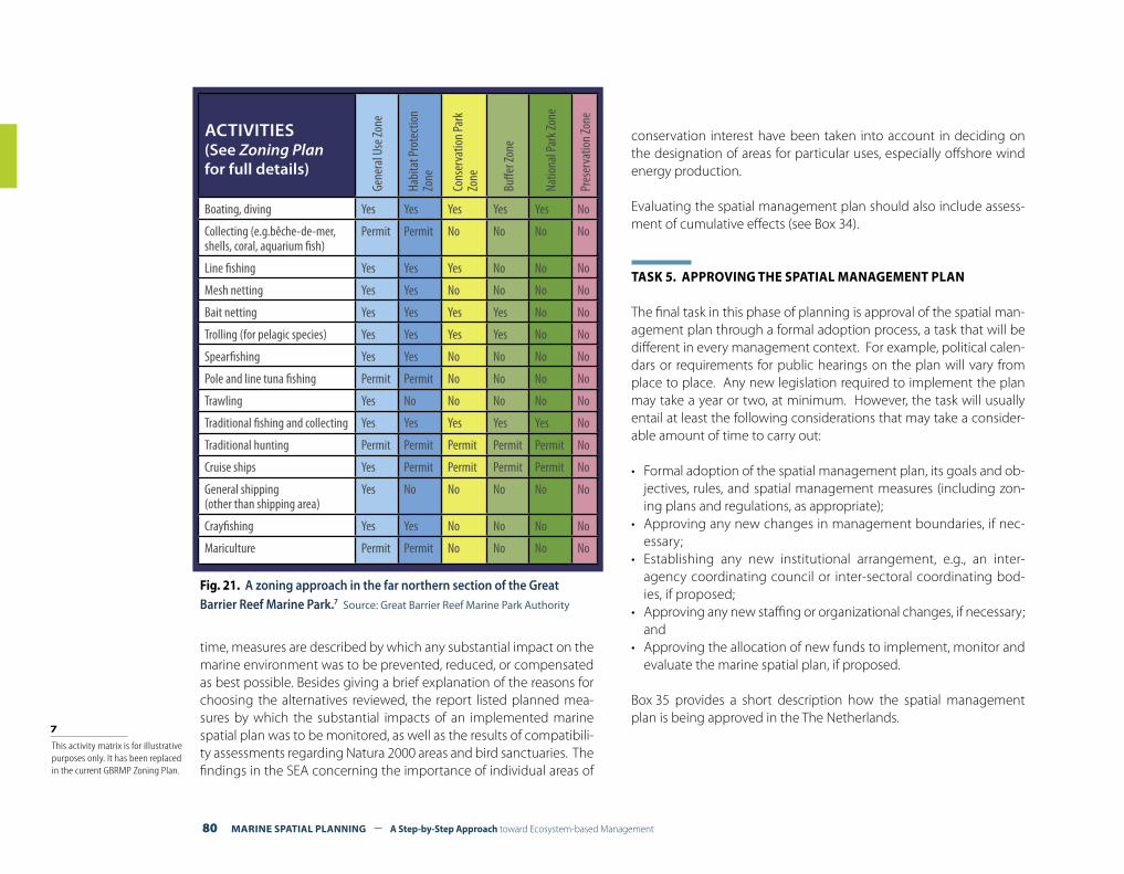
80 MARINE SPATIAL PLANNING – A Step-by-Step Approach toward Ecosystem-based Management
time, measures are described by which any substantial impact on the marine environment was to be prevented, reduced, or compensated as best possible. Besides giving a brief explanation of the reasons for choosing the alternatives reviewed, the report listed planned mea-sures by which the substantial impacts of an implemented marine spatial plan was to be monitored, as well as the results of compatibili-ty assessments regarding Natura 2000 areas and bird sanctuaries. The findings in the SEA concerning the importance of individual areas of
conservation interest have been taken into account in deciding on the designation of areas for particular uses, especially offshore wind energy production.
Evaluating the spatial management plan should also include assess-ment of cumulative effects (see Box 34).
TASK 5. APPROVING THE SPATIAL MANAGEMENT PLAN
The final task in this phase of planning is approval of the spatial man-agement plan through a formal adoption process, a task that will be different in every management context. For example, political calen-dars or requirements for public hearings on the plan will vary from place to place. Any new legislation required to implement the plan may take a year or two, at minimum. However, the task will usually entail at least the following considerations that may take a consider-able amount of time to carry out:
• Formal adoption of the spatial management plan, its goals and ob-jectives, rules, and spatial management measures (including zon-ing plans and regulations, as appropriate);
• Approving any new changes in management boundaries, if nec-essary;
• Establishing any new institutional arrangement, e.g., an inter-agency coordinating council or inter-sectoral coordinating bod-ies, if proposed;
• Approving any new staffing or organizational changes, if necessary; and
• Approving the allocation of new funds to implement, monitor and evaluate the marine spatial plan, if proposed.
Box 35 provides a short description how the spatial management plan is being approved in the The Netherlands.
ACTIVITIES(See Zoning Plan for full details)
Gene
ral U
se Zo
ne
Habi
tat P
rote
ctio
n Zo
ne
Cons
erva
tion
Park
Zo
ne
Buffe
r Zon
e
Natio
nal P
ark Z
one
Pres
erva
tion
Zone
Boating, diving Yes Yes Yes Yes Yes No
Collecting (e.g.bêche-de-mer,shells, coral, aquarium fish)
Permit Permit No No No No
Line fishing Yes Yes Yes No No No
Mesh netting Yes Yes No No No No
Bait netting Yes Yes Yes Yes No No
Trolling (for pelagic species) Yes Yes Yes Yes No No
Spearfishing Yes Yes No No No No
Pole and line tuna fishing Permit Permit No No No No
Trawling Yes No No No No No
Traditional fishing and collecting Yes Yes Yes Yes Yes No
Traditional hunting Permit Permit Permit Permit Permit No
Cruise ships Yes Permit Permit Permit Permit No
General shipping (other than shipping area)
Yes No No No No No
Crayfishing Yes Yes No No No No
Mariculture Permit Permit No No No No
Fig. 21. A zoning approach in the far northern section of the Great Barrier Reef Marine Park.7 Source: Great Barrier Reef Marine Park Authority
7 This activity matrix is for illustrative purposes only. It has been replaced in the current GBRMP Zoning Plan.
A Step-by-Step Approach toward Ecosystem-based Management – MARINE SPATIAL PLANNING 81
Cumulative and interactive consequences of different human activities are largely ignored in marine plans because of the single-sector nature of current management approaches. Since most human activities interact with one another, managing each activity largely in isolation is insufficient to conserve ma-rine ecosystems, or even to meet individual sector goals. Fur-thermore, some threats have direct effects on ecosystem com-ponents, e.g., with fishing over-harvest or damage to habitat caused by bottom trawling or anchors from recreational boats, while others have more indirect consequences, e.g., introduced species that compete with or prey on native species. These in-direct effects in particular make detection and assessment of interactions more complex than simple cause-effect mecha-nisms. Importantly, these activities may also interact with natu-ral temporal or spatial variability in environmental conditions. Acting in concert, natural variability and human perturbations (through both direct and indirect mechanisms) decrease the ability of marine ecosystems to deliver vital products and ser-vices. These issues can make it seem daunting if not impossible to manage for cumulative and interactive impacts.
While the generic concept of cumulative impacts has been part of environmental policy for many years, few management plans move beyond recognizing that there are cumulative conse-quences of different activities, and instead focus primarily on the consequences of each individual activity. To implement an ecosystem-based approach to marine management, clear mea-sures of the environmental impacts of activities on ecosystem products and services should be made, and the cumulative con-sequences of different activities on these products and services assessed.
Such a shift in focus, however, will require explicit consideration of tradeoffs among the products and services supplied by the marine ecosystem. Management actions within various sectors will necessarily alter the mix of available products and services, and the cumulative effects of those management actions may further alter this mix. For example, coral reef loss due to climate change, water quality degradation, sedimentation, disease, and over-fishing may result in complete loss of the suite of goods and services that these systems formerly provided, such as fish production for recreational, artisanal, and aquarium purposes; pharmaceutical products; building materials; and tourism and recreational opportunities.
In other cases, the cumulative effects of various activities may substantially affect major ecosystem services not directly tied to market-based valuations, and in many cases those services are not accounted for in the usual sector-by-sector analysis. For example, activities associated with products and services such as seafood or offshore energy necessarily affect services such as coastal wetlands that provide habitat for wildlife and buffers from natural disaster. In these cases, the issue of how much supporting services can be sacrificed in order to obtain the other services is critical for policy-making. These tradeoffs are not well-articulated or handled in the current single-sec-tor management process. Marine spatial planning based on an ecosystem approach should make tradeoffs in the provision of products and services explicit.
Modified from: Halpern, Ben S., et al., 2008. Managing for cumulative impacts in ecosystem-based management through ocean zoning. Ocean and Coastal Management, 51, 203-211.
Box 34Assessing cumulative effects
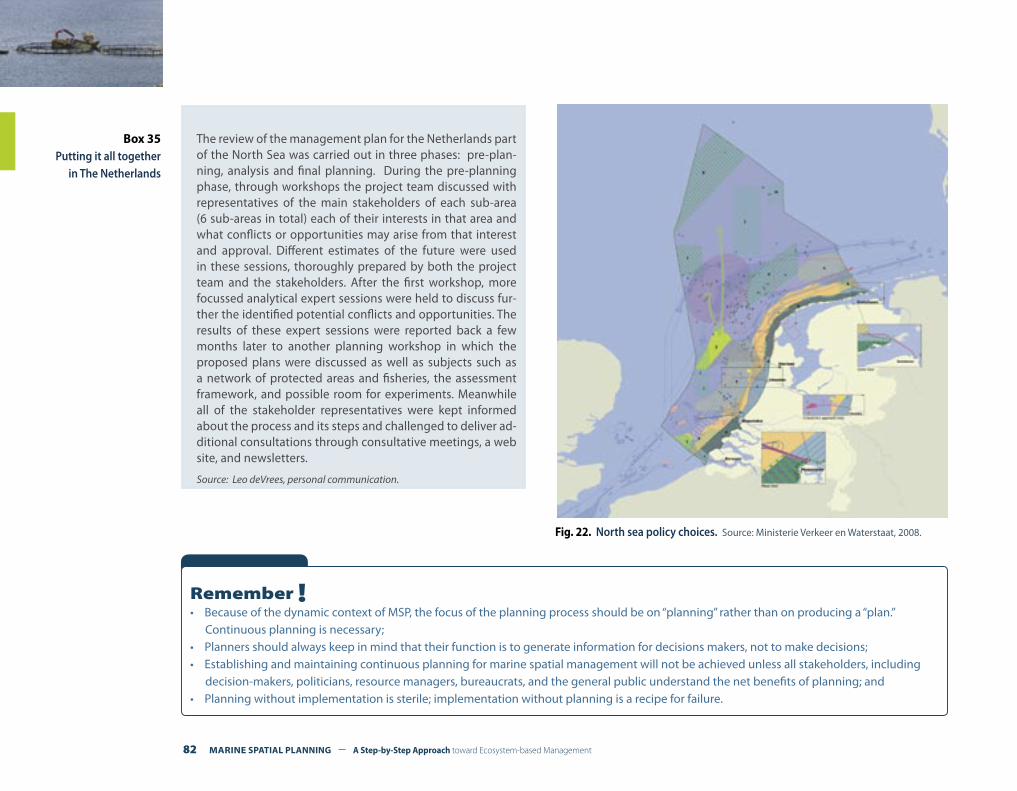
82 MARINE SPATIAL PLANNING – A Step-by-Step Approach toward Ecosystem-based Management
Box 35Putting it all together
in The Netherlands
The review of the management plan for the Netherlands part of the North Sea was carried out in three phases: pre-plan-ning, analysis and final planning. During the pre-planning phase, through workshops the project team discussed with representatives of the main stakeholders of each sub-area (6 sub-areas in total) each of their interests in that area and what conflicts or opportunities may arise from that interest and approval. Different estimates of the future were used in these sessions, thoroughly prepared by both the project team and the stakeholders. After the first workshop, more focussed analytical expert sessions were held to discuss fur-ther the identified potential conflicts and opportunities. The results of these expert sessions were reported back a few months later to another planning workshop in which the proposed plans were discussed as well as subjects such as a network of protected areas and fisheries, the assessment framework, and possible room for experiments. Meanwhile all of the stakeholder representatives were kept informed about the process and its steps and challenged to deliver ad-ditional consultations through consultative meetings, a web site, and newsletters.
Source: Leo deVrees, personal communication.
Fig. 22. North sea policy choices. Source: Ministerie Verkeer en Waterstaat, 2008.
Remember !• Because of the dynamic context of MSP, the focus of the planning process should be on “planning” rather than on producing a “plan.”
Continuous planning is necessary;• Planners should always keep in mind that their function is to generate information for decisions makers, not to make decisions;• Establishing and maintaining continuous planning for marine spatial management will not be achieved unless all stakeholders, including
decision-makers, politicians, resource managers, bureaucrats, and the general public understand the net benefits of planning; and• Planning without implementation is sterile; implementation without planning is a recipe for failure.
A Step-by-Step Approach toward Ecosystem-based Management – MARINE SPATIAL PLANNING 83
IMPLEMENTING AND ENFORCING THE SPATIAL MANAGEMENT PLAN STEP 8
What outputs should be delivered from this step?
F Clear identification of actions required to implement, ensure compliance with, and enforce the spatial management plan.
Introduction
After the steps already discussed in this guide have been completed, planning will be complete and the spatial management plan and the zoning plan should be ready for the next step: implementation, the action phase of management. The end of planning is the beginning of implementation. The focus of this guide is on marine spatial plan-ning (MSP) and so the next steps dealing with other marine spatial management steps will be described only briefly.
Implementation is the process of converting MSP plans into actual operating programs.
As part of the implementation process, designated governmental institutions or newly created bodies (inter-ministerial coordinating councils) will begin the new management actions set out in the approved management plan. Implementation is a critically impor-tant step of the MSP process. It is the action phase and it continues throughout the existence of MSP programs. Effective implementa-tion is integral to the success of any MSP program.
TASK 1. IMPLEMENTING THE SPATIAL MANAGEMENT PLAN
When all official approvals by governmental bodies have been ob-tained (to the extent necessary), your MSP program will be formally established. Now implementation can begin. Most States will not have opted for the creation of a ‘super’ marine management agency (as the UK has chosen to do, for example), and so some sort of inter-agency or inter-ministerial council will have been created, or a ‘lead’ agency designated to coordinate and oversee the MSP process. The process will become operational when this institutional arrangement begins to function on a continuing basis.
Existing single-sector management institutions will carry out most actions toward implementation. These institutions can use the com-prehensive plan and the zoning plan as guides for permitting, as well as other actions for which they are responsible.
Implementation actions can also be coordinated among levels of government. For example, in the Florida Keys National Marine Sanc-tuary (USA) management strategies were put into effect at three levels of government: (1) by the National Oceanic and Atmospher-ic Administration (NOAA) for federal waters (beyond three nautical miles); (2) by appropriate state agencies for marine waters under the
84 MARINE SPATIAL PLANNING – A Step-by-Step Approach toward Ecosystem-based Management
jurisdiction of the state of Florida (within three nautical miles); and (3) by Monroe County (a local jurisdiction that has authority for land use management and development controls) for land. These actions are coordinated through an integrated management plan for the entire marine protected area.1
TASK 2. ENSURING COMPLIANCE WITH THE MARINE SPATIAL MANAGEMENT PLAN
Compliance occurs when requirements are met and desired chang-es in behavior are achieved so that, to give a few examples, catch limits are not exceeded, or human activities are located appropri-ately in designated zones, or certain human activities do not occur in protected areas. The design of requirements affects the success of any marine spatial management plan. If requirements are well designed and specified, then compliance will achieve the desired results. However, if requirements are poorly designed, achieving compliance and/or the desired results will be difficult.
Compliance is the implementation of the requirements of marine spatial planning.
Compliance and enforcement are essential elements of the rule of law and good governance. However, they are often the weak links of the MSP process.
General requirements, such as zoning regulations, permits and li-cences will be most effective if they closely reflect the practical reali-ties of compliance and enforcement. With this in mind, they should:
• Be clear and understandable;• Define which sources or activities are subject to the require-
ments;• Define the requirements and any exceptions or variances;• Clearly address how compliance is to be determined by specifying
procedures;
• Clearly state deadlines for compliance; and• Be flexible enough to be constructively adapted through individ-
ual permits, licences or variances to different regulatory circum-stances.
Compliance will require all responsible single-sector management institutions not only to implement these plans while carrying out their own responsibilities, but also to generate their own plans and programs in accordance with the spatial management plan.
Promoting voluntary compliance can be encouraged by a number of actions including:
• Educating the public and other stakeholders about plans, rules and regulations, and the implications for each stakeholder group;
• Developing ‘codes of conduct’ through agreements with various stakeholders;
• Technical assistance through which governmental agencies pro-vide information on the feasibility of different spatial management strategies;
• Self-regulation through which stakeholder groups, such as fishers, manage their own constituents; and
• Installing physical markers, such as buoys, around important habi-tats or security zones.
1 For more information on the Florida Keys National Marine Sanctuary management plan, go to: floridakeys.noaa.gov/management/welcome.html.
A Step-by-Step Approach toward Ecosystem-based Management – MARINE SPATIAL PLANNING 85
TASK 3. ENFORCING THE SPATIAL MANAGEMENT PLAN
Enforcement refers to the set of actions that governments take to achieve compliance with regulations involving human activities in order to correct or halt situations that endanger the environment or the public.
Enforcement by the government usually includes:
• Inspections to determine the compliance status of the regulated human activities and to detect violations;
• Negotiations with individuals or managers of activities that are out of compliance to develop mutually agreeable schedules and ap-proaches for achieving compliance; and
• Legal action, where necessary, to compel compliance and to im-pose some consequence for violating the law or posing a threat to public health or environmental quality, including monetary penal-ties or withdrawal of a permit.
Non-governmental organizations may also become involved in en-forcement by detecting noncompliance, negotiating with violators, and commenting on government enforcement actions. In some cas-es, where the law allows, they may take legal action either against a violator for noncompliance or against the government for not enforc-ing the requirements.
In addition, certain industries (such as the banking and insurance industries) may be indirectly involved in enforcement by requiring the assurance of compliance with MSP requirements before issuing a loan or insurance policy to construct an offshore facility.
MSP will only be as effective as its ability to enforce the agreed upon plans, rules and regulations. This is a fundamental requirement of the process. The objective of integrated spatial planning will be difficult to achieve if there is any significant measure of unauthorized devel-opment of marine areas.
An important task in relation to enforcement is to ensure that strat-egies, plans and regulations are not too forbidding. Instead, they should be integrated across sectors, and be communicated in a clear, concise manner to the public and the private sector. Stakeholders will usually support effective enforcement if the rules are consistently ap-plied on the basis of transparent policies and procedures.
86 MARINE SPATIAL PLANNING – A Step-by-Step Approach toward Ecosystem-based Management
MONITORING AND EVALUATING PERFORMANCESTEP 9
What outputs should be delivered from this step?
F A monitoring system designed to measure indicators of the performance of marine spatial management measures;
F Information on the performance of marine spatial management measures that will be used for evaluation; and
F Periodic reports to decision makers, stakeholders, and the public about the performance of the marine spatial management plan.
Introduction
Information on which to base evaluations of MSP performance can come from many sources, but monitoring has a particularly important contribution to make in providing the basic data that should under-pin any evaluation.
Monitoring is a continuous management activity that uses the systematic collection of data on selected indicators to provide managers and stakeholders with indications of the extent of progress toward the achievement of management goals and objectives.
At least two types of monitoring are relevant to marine spatial plan-ning: (1) assessing the state of the system, e.g., “What is the status of biodiversity in the marine management area?”; and (2) measuring the performance of management measures, i.e., “Are the management ac-tions we have taken producing the outcomes we desire?” These two types of monitoring are closely related.
To understand whether or not management measures have been ef-fective, we have to know something about the state of the system. An example of a state-of-the-system monitoring program is the Ecosys-tem Monitoring Integration Program of the Florida Keys National Ma-rine Sanctuary (floridakeys.noaa.gov/research_monitoring/welcome.html). Another, even more comprehensive monitoring program, can be found in the Great Barrier Reef Marine Park Authority where over 50 individual monitoring efforts measure both the state-of-the-reef and the performance of management measures (www.gbrmpa.gov.au/corp_site/key_issues/water_quality/marine_monitoring).
Sound monitoring program design depends on the following factors:• The objectives of the monitoring program need to be clearly ar-
ticulated in terms that pose questions that are meaningful to the public and that provide the basis for measurement;
• Not only must data be gathered, but attention must be paid to their management, analysis, synthesis, and interpretation;
• Adequate resources are needed not only for data collection, but for detailed analysis and evaluation over the long term;
A Step-by-Step Approach toward Ecosystem-based Management – MARINE SPATIAL PLANNING 87
• Monitoring programs should be sufficiently flexible to allow for their modification where changes in conditions or new informa-tion suggests the need; and
• Provision should be made to ensure that monitoring information should be reported to all interested parties in a form that is useful to them.
It is important not to overstate the usefulness of monitoring pro-grams. The marine environment is complex and variable. Separating the effects of human activities from natural variability is difficult. This difficulty and others do not argue against monitoring performance of management measures, but they do make the case for realistic ex-pectations, careful design, periodic evaluations, and a sustained com-mitment of resources.
For information of specifying objectives, see Step 3, Organizing the Process through Pre-Planning.
Monitoring is a critical and integral element of MSP. In a broader sense, a “monitoring system” includes a range of activities needed to provide information to marine spatial planning. These activities could include modeling, laboratory and field research, time-series measurements in the field, quality assurance, data analysis, synthe-sis, and interpretation. What distinguishes a monitoring system from any of these activities taken alone is that a monitoring system is integrated and coordinated with the specified goal of producing predefined spatial planning information; it is the sensory compo-nent of management.
Monitoring and evaluation provide the link that enables planners and managers to learn from experience (See Step 10, Adapting the marine spa-tial management process) and helps governments and funding agencies at all levels to monitor the effectiveness of marine spatial management performance. Monitoring programs are often not designed to address public concerns directly or to provide information needed by man-agement or public policy makers. Meaningful communication with,
and participation of, the public and decision makers in the develop-ment of monitoring programs is rarely achieved. Results are often not reported at all; when they are, they may not be in a useful form.
The costs of not monitoring—or of monitoring ineffectively—include failure to obtain the information needed to assess environmental conditions, to validate and verify predictive models, and to chroni-cle changes in the environment resulting from natural variation and management actions. In short, the cost of not adequately monitoring is a serious shortcoming in our efforts to plan and manage human uses of the marine environment.
TASK 1. DEVELOPING THE PERFORMANCE MONITORING PROGRAM
Action 1. Re-confirming the objectives
An effective performance monitoring system begins with a clear set of well-specified planning objectives. Since spatial planning objec-tives may have been modified during the planning process (Steps 4-7), they should be re-confirmed with stakeholders and decision mak-ers and, if necessary, updated before monitoring begins.
Action 2. Agreeing on outcomes to measure
An outcome is an anticipated result of the implementation of a marine spatial management measure.
Outcomes are the most interesting and important results for govern-ments and stakeholders to measure. Outcomes should show what road to take. Existing problems should be reformulated into a set of positive outcomes. A focus on outcomes helps to build the knowl-edge base of the types of measures that work, that do not work, and why. It can help build transparency and accountability into the plan-ning and management process.
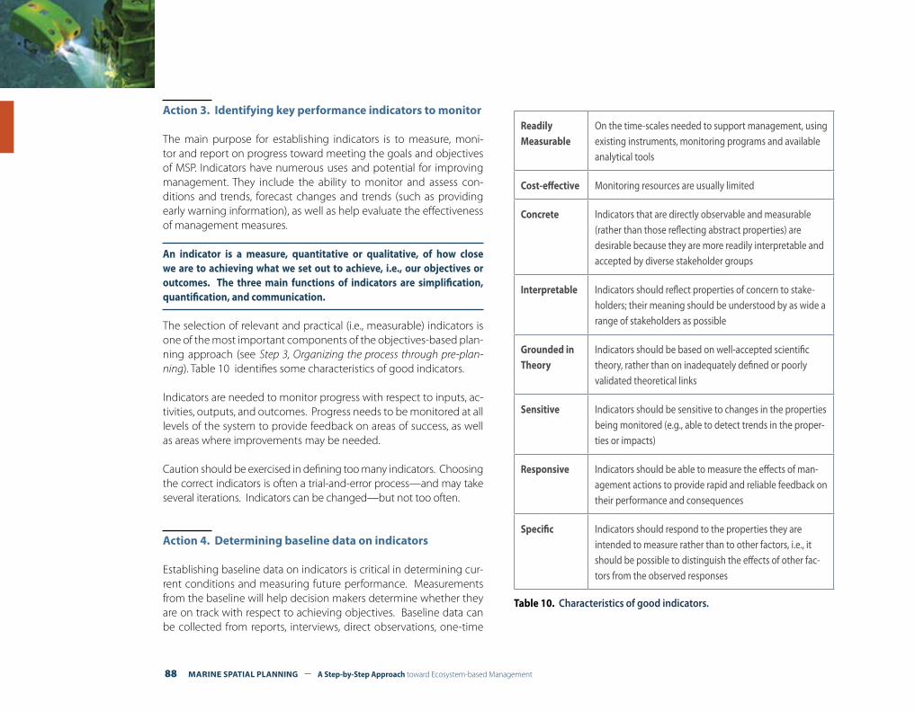
88 MARINE SPATIAL PLANNING – A Step-by-Step Approach toward Ecosystem-based Management
Action 3. Identifying key performance indicators to monitor
The main purpose for establishing indicators is to measure, moni-tor and report on progress toward meeting the goals and objectives of MSP. Indicators have numerous uses and potential for improving management. They include the ability to monitor and assess con-ditions and trends, forecast changes and trends (such as providing early warning information), as well as help evaluate the effectiveness of management measures.
An indicator is a measure, quantitative or qualitative, of how close we are to achieving what we set out to achieve, i.e., our objectives or outcomes. The three main functions of indicators are simplification, quantification, and communication.
The selection of relevant and practical (i.e., measurable) indicators is one of the most important components of the objectives-based plan-ning approach (see Step 3, Organizing the process through pre-plan-ning). Table 10 identifies some characteristics of good indicators.
Indicators are needed to monitor progress with respect to inputs, ac-tivities, outputs, and outcomes. Progress needs to be monitored at all levels of the system to provide feedback on areas of success, as well as areas where improvements may be needed.
Caution should be exercised in defining too many indicators. Choosing the correct indicators is often a trial-and-error process—and may take several iterations. Indicators can be changed—but not too often.
Action 4. Determining baseline data on indicators
Establishing baseline data on indicators is critical in determining cur-rent conditions and measuring future performance. Measurements from the baseline will help decision makers determine whether they are on track with respect to achieving objectives. Baseline data can be collected from reports, interviews, direct observations, one-time
ReadilyMeasurable
On the time-scales needed to support management, using existing instruments, monitoring programs and available analytical tools
Cost-effective Monitoring resources are usually limited
Concrete Indicators that are directly observable and measurable (rather than those reflecting abstract properties) are desirable because they are more readily interpretable and accepted by diverse stakeholder groups
Interpretable Indicators should reflect properties of concern to stake-holders; their meaning should be understood by as wide a range of stakeholders as possible
Grounded in Theory
Indicators should be based on well-accepted scientific theory, rather than on inadequately defined or poorly validated theoretical links
Sensitive Indicators should be sensitive to changes in the properties being monitored (e.g., able to detect trends in the proper-ties or impacts)
Responsive Indicators should be able to measure the effects of man-agement actions to provide rapid and reliable feedback on their performance and consequences
Specific Indicators should respond to the properties they are intended to measure rather than to other factors, i.e., it should be possible to distinguish the effects of other fac-tors from the observed responses
Table 10. Characteristics of good indicators.
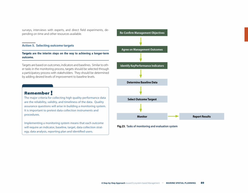
A Step-by-Step Approach toward Ecosystem-based Management – MARINE SPATIAL PLANNING 89
surveys, interviews with experts, and direct field experiments, de-pending on time and other resources available.
Action 5. Selecting outcome targets
Targets are the interim steps on the way to achieving a longer-term outcome.
Targets are based on outcomes, indicators and baselines. Similar to oth-er tasks in the monitoring process, targets should be selected through a participatory process with stakeholders. They should be determined by adding desired levels of improvement to baseline levels.
Fig.23. Tasks of monitoring and evaluation system
Re-Confirm Management Objectives
Agree on Management Outcomes
Identify KeyPerformance Indicators
Determine Baseline Data
Select Outcome Targest
Monitor Report Results
Remember !The major criteria for collecting high quality performance data are the reliability, validity, and timeliness of the data. Quality assurance questions will arise in building a monitoring system. It is important to pretest data collection instruments and procedures.
Implementing a monitoring system means that each outcome will require an indicator, baseline, target, data collection strat-egy, data analysis, reporting plan and identified users.
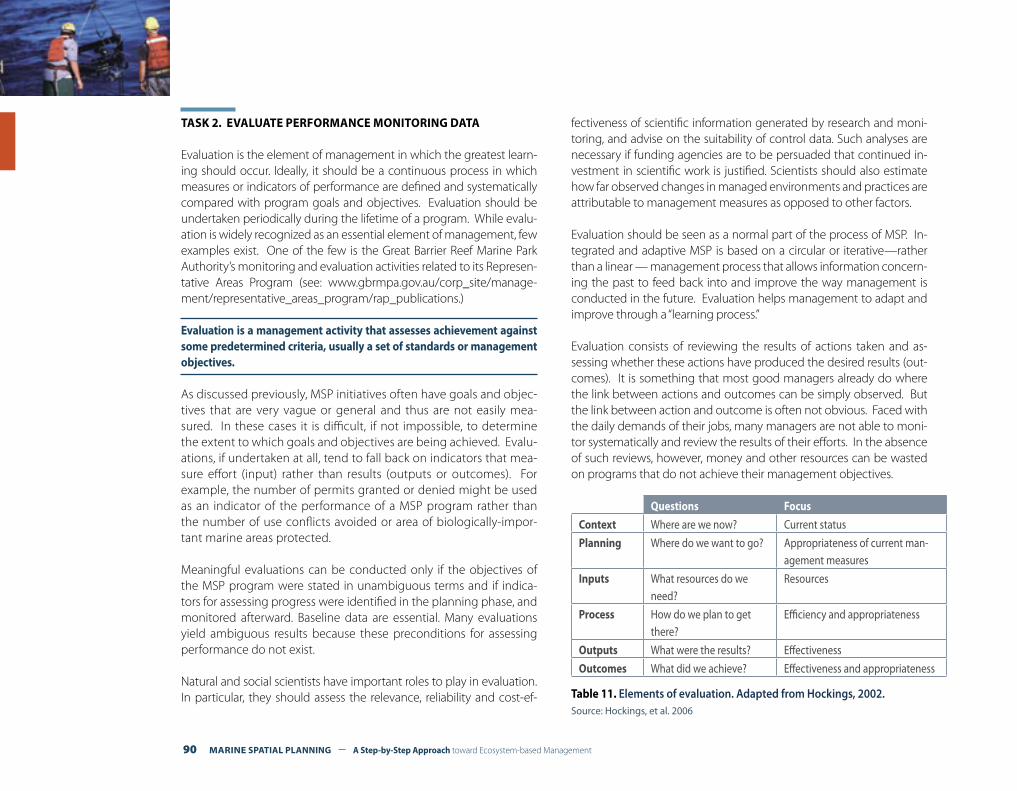
90 MARINE SPATIAL PLANNING – A Step-by-Step Approach toward Ecosystem-based Management
TASK 2. EVALUATE PERFORMANCE MONITORING DATA
Evaluation is the element of management in which the greatest learn-ing should occur. Ideally, it should be a continuous process in which measures or indicators of performance are defined and systematically compared with program goals and objectives. Evaluation should be undertaken periodically during the lifetime of a program. While evalu-ation is widely recognized as an essential element of management, few examples exist. One of the few is the Great Barrier Reef Marine Park Authority’s monitoring and evaluation activities related to its Represen-tative Areas Program (see: www.gbrmpa.gov.au/corp_site/manage-ment/representative_areas_program/rap_publications.)
Evaluation is a management activity that assesses achievement against some predetermined criteria, usually a set of standards or management objectives.
As discussed previously, MSP initiatives often have goals and objec-tives that are very vague or general and thus are not easily mea-sured. In these cases it is difficult, if not impossible, to determine the extent to which goals and objectives are being achieved. Evalu-ations, if undertaken at all, tend to fall back on indicators that mea-sure effort (input) rather than results (outputs or outcomes). For example, the number of permits granted or denied might be used as an indicator of the performance of a MSP program rather than the number of use conflicts avoided or area of biologically-impor-tant marine areas protected. Meaningful evaluations can be conducted only if the objectives of the MSP program were stated in unambiguous terms and if indica-tors for assessing progress were identified in the planning phase, and monitored afterward. Baseline data are essential. Many evaluations yield ambiguous results because these preconditions for assessing performance do not exist.
Natural and social scientists have important roles to play in evaluation. In particular, they should assess the relevance, reliability and cost-ef-
fectiveness of scientific information generated by research and moni-toring, and advise on the suitability of control data. Such analyses are necessary if funding agencies are to be persuaded that continued in-vestment in scientific work is justified. Scientists should also estimate how far observed changes in managed environments and practices are attributable to management measures as opposed to other factors.
Evaluation should be seen as a normal part of the process of MSP. In-tegrated and adaptive MSP is based on a circular or iterative—rather than a linear — management process that allows information concern-ing the past to feed back into and improve the way management is conducted in the future. Evaluation helps management to adapt and improve through a “learning process.”
Evaluation consists of reviewing the results of actions taken and as-sessing whether these actions have produced the desired results (out-comes). It is something that most good managers already do where the link between actions and outcomes can be simply observed. But the link between action and outcome is often not obvious. Faced with the daily demands of their jobs, many managers are not able to moni-tor systematically and review the results of their efforts. In the absence of such reviews, however, money and other resources can be wasted on programs that do not achieve their management objectives.
Questions Focus
Context Where are we now? Current status
Planning Where do we want to go? Appropriateness of current man-agement measures
Inputs What resources do we need?
Resources
Process How do we plan to get there?
Efficiency and appropriateness
Outputs What were the results? Effectiveness
Outcomes What did we achieve? Effectiveness and appropriateness
Table 11. Elements of evaluation. Adapted from Hockings, 2002.Source: Hockings, et al. 2006
A Step-by-Step Approach toward Ecosystem-based Management – MARINE SPATIAL PLANNING 91
Most marine monitoring and evaluation efforts to date have concen-trated on the bio-physical aspects/conditions in a few selected areas. Few are comprehensive assessments of management effectiveness, in-cluding social or economic aspects.2
Most management plans today refer to adaptive management and the need to monitor performance. Few really have, with the main excuses being high costs, institutional barriers, and lack of political support.3
In practice, evaluations can be used by managers to improve their own performance (adaptive management), as well as for reporting (account-ability), or as lessons learned to improve future planning.
TASK 3. REPORTING RESULTS OF PERFORMANCE EVALUATION
Performance data should be reported in comparison to earlier data and to the baseline. In analyzing and reporting data, the more measurements there are, the more certain one can be of trends, directions, and results.
A good communications strategy is essential for disseminating and sharing information with key stakeholders. Sharing information with stakeholders helps bring them into the business of government and can help generate trust. Evaluations should be open, transparent and available to all stakeholders.
2 Bunce et al. 2000.
3 Day, 2008.
Box. 36Lessons learned from monitoring and evaluation in the Great Barrier Reef Marine Park
Since marine spatial planning is a relatively new field, only a few pro-grams are mature enough to have undertaken monitoring and evalu-ation. One, the Great Barrier Reef Marine Park, has over 30 years of ex-perience with the implementation of spatial management measures and their monitoring and evaluation. Jon Day (2008) has summarized some practical lessons from this experience:
• Specify clear objectives and realistic indicators. A fundamental need for MSP is to develop a set of clear objectives and realistic in-dicators against which effectiveness can be measured—from the beginning of the management process;
• Start with a modest monitoring program. It is better to start with a relatively modest program for a few key performance indicators and expand the program as guided by experience. Priority should be given to monitoring programs that provide information about:• The extent to which key objectives are being achieved (or failing
to be achieved);• The condition of the most significant conservation values (espe-
cially those considered to be at risk; and• How important, complex or controversial management issues
can be resolved;
• Determine who is best able/suited to undertake monitoring. For example, should the program be conducted internally or externally? Where possible, it is also advisable to have resource managers and users who are regularly on the water to assist with monitoring;
• Consider opportunities for participatory monitoring and evalua-tion programs. Wherever possible encourage stakeholder partici-pation or local input in the overall evaluation process. In these cas-es, training is required to ensure that monitoring data are accurate and meaningful;
• Consider the need for monitoring a wider context than only within the marine management area. There is often a need to measure indicators both within a marine management area and outside the area to determine relative changes (e.g., to establish whether de-tected changes are due to management actions or other factors, or to determine whether the objectives of a managed area are being achieved in comparison with adjacent areas that are similarly man-aged); and
• The findings and recommendations of evaluation should be regu-larly reported and presented in a manner that is understandable to stakeholders and usable by managers and other decision makers.
Adapted from: Jon Day, 2008.
92 MARINE SPATIAL PLANNING – A Step-by-Step Approach toward Ecosystem-based Management
ADAPTING THE SPATIAL MANAGEMENT PROCESSSTEP 10
What outputs should be delivered from this step?
F Proposals for adapting management goals, objectives, outcomes and strategies for the next round of planning;
F Identification of applied research needs.
Introduction
The results from monitoring and evaluation should be used to adapt marine spatial planning and management so that its actions have their intended effects. Most, if not all, management plans need to be periodically reviewed and updated. See Figure 2 in Part 1, Concepts and terminology for marine spatial planning.
Adaptive management is a systematic approach for improving management through learning by monitoring and evaluating management outcomes. Simply put, it is ‘learning by doing’ and adapting what one does based on what is learned.
Adaptive management is rarely implemented, even though many planning and management documents call for it, and numerous resource managers refer to it. An adaptive approach involves ex-ploring alternative ways to meet MSP objectives, predicting the outcomes of alternatives based on the current state of knowledge, implementing one or more of these alternatives, monitoring them to learn about the effects of management measures, and last but not least, using the results to adjust management actions. Adap-tive management focuses on learning how to create and maintain sustainable development in marine management areas.
Are there any examples of successful adaptive management in ma-rine places? If so, what lessons can we apply from them within the context of MSP? Only a few marine spatial management programs are currently mature enough to claim any practice of adaptive man-agement. The Great Barrier Reef Marine Park (Australia), the Florida Keys National Marine Sanctuary (USA), and The Netherlands Inte-grated Management Plan for the North Sea provide us with interest-ing examples for learning.
TASK 1. RECONSIDERING AND REDESIGNING THE MSP PROGRAM
This step has been omitted or, at best, performed superficially in most MSP initiatives. Nevertheless, if MSP is to be sustained over time, an almost continuous monitoring, evaluation, and learning process is essential.
This step must address two broad questions: First, what has been accomplished through the MSP process and learned from its suc-cesses and failures? Secondly, how has the context (e.g., environ-ment, governance, technology, economy) changed since the pro-gramme was initiated? The answers to these questions can then be used to re-focus planning and management in the future.
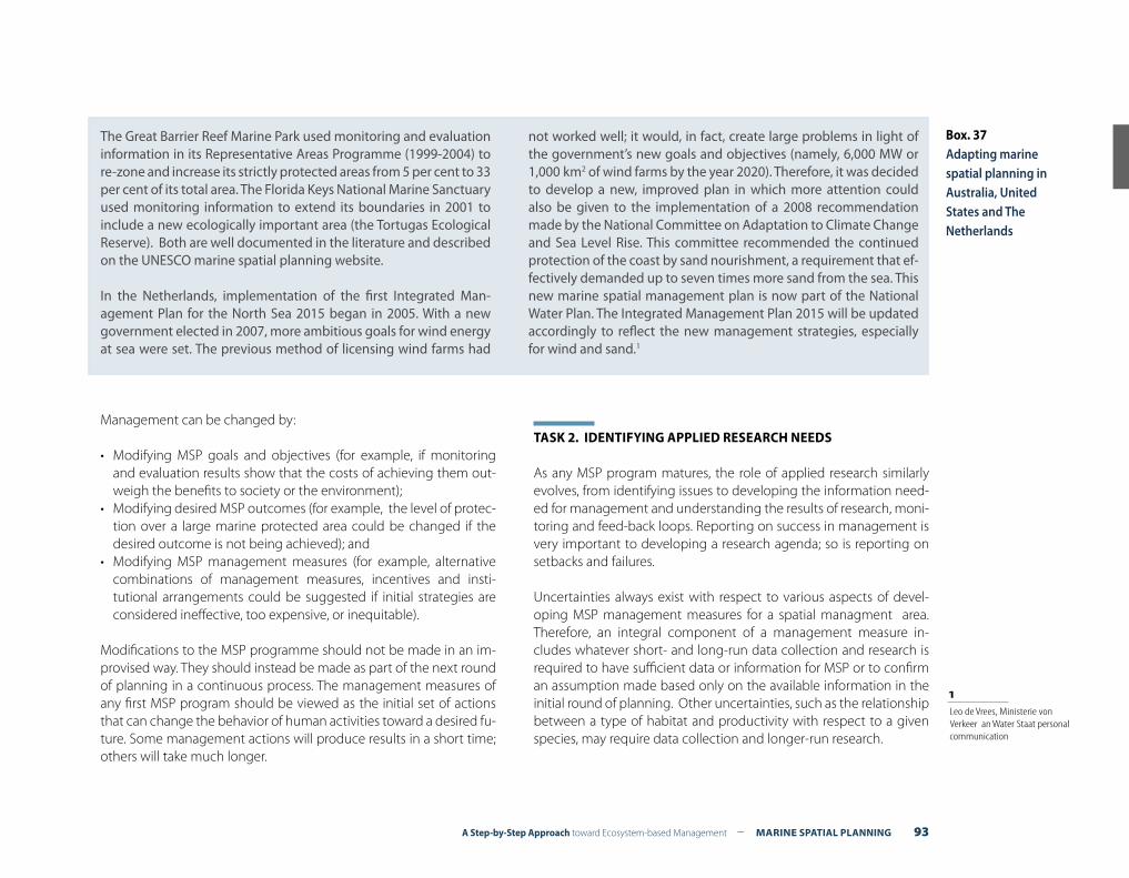
A Step-by-Step Approach toward Ecosystem-based Management – MARINE SPATIAL PLANNING 93
Management can be changed by:
• Modifying MSP goals and objectives (for example, if monitoring and evaluation results show that the costs of achieving them out-weigh the benefits to society or the environment);
• Modifying desired MSP outcomes (for example, the level of protec-tion over a large marine protected area could be changed if the desired outcome is not being achieved); and
• Modifying MSP management measures (for example, alternative combinations of management measures, incentives and insti-tutional arrangements could be suggested if initial strategies are considered ineffective, too expensive, or inequitable).
Modifications to the MSP programme should not be made in an im-provised way. They should instead be made as part of the next round of planning in a continuous process. The management measures of any first MSP program should be viewed as the initial set of actions that can change the behavior of human activities toward a desired fu-ture. Some management actions will produce results in a short time; others will take much longer.
TASK 2. IDENTIFYING APPLIED RESEARCH NEEDS
As any MSP program matures, the role of applied research similarly evolves, from identifying issues to developing the information need-ed for management and understanding the results of research, moni-toring and feed-back loops. Reporting on success in management is very important to developing a research agenda; so is reporting on setbacks and failures.
Uncertainties always exist with respect to various aspects of devel-oping MSP management measures for a spatial managment area. Therefore, an integral component of a management measure in-cludes whatever short- and long-run data collection and research is required to have sufficient data or information for MSP or to confirm an assumption made based only on the available information in the initial round of planning. Other uncertainties, such as the relationship between a type of habitat and productivity with respect to a given species, may require data collection and longer-run research.
The Great Barrier Reef Marine Park used monitoring and evaluation information in its Representative Areas Programme (1999-2004) to re-zone and increase its strictly protected areas from 5 per cent to 33 per cent of its total area. The Florida Keys National Marine Sanctuary used monitoring information to extend its boundaries in 2001 to include a new ecologically important area (the Tortugas Ecological Reserve). Both are well documented in the literature and described on the UNESCO marine spatial planning website.
In the Netherlands, implementation of the first Integrated Man-agement Plan for the North Sea 2015 began in 2005. With a new government elected in 2007, more ambitious goals for wind energy at sea were set. The previous method of licensing wind farms had
not worked well; it would, in fact, create large problems in light of the government’s new goals and objectives (namely, 6,000 MW or 1,000 km2 of wind farms by the year 2020). Therefore, it was decided to develop a new, improved plan in which more attention could also be given to the implementation of a 2008 recommendation made by the National Committee on Adaptation to Climate Change and Sea Level Rise. This committee recommended the continued protection of the coast by sand nourishment, a requirement that ef-fectively demanded up to seven times more sand from the sea. This new marine spatial management plan is now part of the National Water Plan. The Integrated Management Plan 2015 will be updated accordingly to reflect the new management strategies, especially for wind and sand.1
Box. 37Adapting marine spatial planning in Australia, United States and The Netherlands
1 Leo de Vrees, Ministerie von Verkeer an Water Staat personal communication
94 MARINE SPATIAL PLANNING – A Step-by-Step Approach toward Ecosystem-based Management
Typically MSP requires a long-term commitment to data collection, management and analysis. But long-term data are frequently not available when MSP is initiated. Often, a data set extending over many decades is needed to understand the significance of human impacts compared to the natural impacts and processes that underpin the functioning of an ecosystem. In the meantime, you should exercise caution when interpreting results. Ideally, monitoring and research should be supported by long-term funding as part of the core man-agement of the marine management area.
TASK 3. STARTING THE NEXT ROUND OF MARINE SPATIAL PLANNING
The next round of spatial planning will include a revised set of man-agement goals, objectives and management measures. These will take into account the monitoring, evaluation and applied research of initial management results, as well as political, economic and techno-logical changes in the context of MSP.
A Step-by-Step Approach toward Ecosystem-based Management – MARINE SPATIAL PLANNING 95
REFERENCES REFERENCESREFERENCES

96 MARINE SPATIAL PLANNING – A Step-by-Step Approach toward Ecosystem-based Management
Arctur, D., and Zeller M., 2004. Designing Geodatabases: case studies in GIS data modeling. ESRI Press: Redlands, CA, USA. 411 p.
Ardron, J.A., Possingham, H.P., and Klein, C.J. (eds), 2008. Marxan Good Practices Handbook. (External review version). May, 2008. Pacific Marine Analysis and Research Association: Vancouver, BC, Canada. 155 p. www.pacmara.org
Bouamrame M. 2006. Biodiversity and stakeholders: concertation itineraries. Biosphere reserves, technical notes 1. Paris, UNESCO.
Brewer, Cynthia A., 2005. Designing Better Maps: a guide for GIS users. ESRI Press: Redlands, CA, USA. 203 p.
Bunce, L., P. Townsley, R. Pomeroy, R. Pollnac, 2000. Socioeconomic manual for coral reef management. Australia Institute for Marine Science: Townsville, Australia. (downloadable at: www.aims.gov.au/pages/reflib/smcrm/mcrm-000.html).
Chua, T. 1998. Lessons learned from practicing integrated coastal management in Southeast Asia. Ambio 27(8): 599-610.
Commonwealth of Massachusetts Executive Office of Energy and Environmental Affairs. 2008. Oceans Act. United States of America.
Convention on Biological Diversity, Subsidiary Body on Scientific, Technical and Technological Advice, 13th Meeting, 18-22 February 2008, Marine and Coastal Biological Diversity, Annex II, scientific criteria for identifying ecologically or biologically significant marine areas in need of protection, in open ocean waters and deep-sea habitats.
Crowder, L., and Elliott N., 2008. Essential ecological insights for marine ecosystem-based management and marine spatial planning. Marine Policy. Vol. 32, no. 5. September. pp. 762-771. (downloadable at: ioc3.unesco.org/marinesp).
Day, J., 2002. Zoning – Lessons from the Great Barrier Reef Marine Park. Ocean & Coastal Management. 45/139-156.
Day, J., 2008. The need and practice of monitoring, evaluating, and adapting marine planning and management. Marine Policy. 32:5. Sepember. (downloadable at: ioc3.unesco.org/marinesp).
Department for Business Enterprise and Regulatory Reform, 2008. Atlas of UK Marine Renewable Energy Resources. 19 p.
Department of Environment, Food and Rural Affairs, 2009. Our Seas—A Shared Resource—High-level marine objectives. Defra: London, UK. 12 p.
Department for Environmental, Food and Rural Affairs. 2008. The Marine and Coastal Access Bill. United Kingdom.
Department of Environment, Food and Rural Affairs, 2009. Managing Our Marine Resources: the Marine Management Organization. Defra: London, UK. 38 p.
Derous, S., et al., 2007. A Biological Valuation Map for the Belgian Part of the North Sea. Biology Department, University of Ghent: Ghent, Belgium. 100 p.
Derous, S., T. Agardy, H. Hillewaert, et al., 2007. A concept for biological evaluation in the marine environment. Oceanologia, 49 (1), pp. 99-128.
des Clers, S., Lewin, S., Edwards, D., Searle, S., Lieberknecht, L., and Murphy, D., 2008. FisherMap. Mapping the grounds: recording fishermen’s use of the seas. A report published for the Finding Sanctuary Project.
Douvere, F., 2008. The importance of marine spatial planning in advancing ecosystem-based sea use management. Marine Policy. Vol. 32, no. 5. September. pp. 762-771.
Ehler C., Douvere F. 2007. Visions for a sea change. Report of the first international workshop on marine spatial planning. Intergovernmental oceanographic commission and man and the biosphere programme. IOC manual and guides. 48, IOCAM Dossier, 4, UNESCO, Paris.
Ehler C., et al. 1986. The Gulf of Mexico coastal and ocean zones strategic assessment data atlas. Washington DC, Government printing office. 163 maps + text.
Ekebom, J., et al., 2008. Towards marine spatial planning in the Baltic Sea. BALANCE Technical Summary Report 4/4. Copenhagen, Denmark: Geological Survey of Denmark and Greenland. 133 p.
Federal Maritime and Hydrographic Agency, 2008. Draft Spatial Plan for the German Exclusive Economic Zone. Germany.
Florida Keys National Marine Sanctuary management plan. (downloadable at http://floridakeys.noaa.gov/regs/zoning.html
Gilliland P., Lafolley D. 2008. Key elements and steps in the process of developing ecosystem-based marine spatial planning.
Government of Canada. 2007. Eastern Scotian Shelf integrated ocean management plan. Strategic plan. 68p.
Great Barrier Reef Marine Park Authority. 1975. The Great Barrier Reef Marine Park Act. Australia
References
A Step-by-Step Approach toward Ecosystem-based Management – MARINE SPATIAL PLANNING 97
Halpern, Ben S., et al., 2008. Managing for cumulative impacts in ecosystem-based management through ocean zoning. Ocean and Coastal Management, 51, 203-211.
Hockings, M., Stolton, S., Leverington, F., Dudley, N. and Courrau, J. ,2006. Evaluating Effectiveness: A framework for assessing management effectiveness of protected areas. 2nd edition. IUCN: Gland, Switzerland and Cambridge, UK. xiv + 105 pp.
Interdepartmental Directors Consultative Committee North Sea. Integated Management Plan for the North Sea 2015. 2006. The Netherlands
Joint Nature Conservation Committee (JNCC), 2004. Common Standards for Monitoring. Peterborough, UK.
Kelleher, G., 1999. Guidelines for Marine Protected Areas. IUCN: Gland, Switzerland and Cambridge, UK. 107p.
Kenchington, R., and Woodley S. 2002. The Great Barrier Reef: Finding the Right Balance. Melbourne University Press, Victoria, Australia.
Kusek, J.Z, and R.C. Rist, 2004. Ten Steps to a Results-Based Monitoring and Evaluation System. The World Bank: Washington, DC.Lawrence D.
Lafolley D., et al. 2004. The Ecosystem Approach: Coherent actions for marine and coastal environments. A report to the UK government. Peterborough. English Nature. 65p.
Lawrence D., Kenchington R., and Woodley S. 2002. The Great Barrier Reef: Finding the right balance. Melbourne University Press, Victoria, Australia. 263 p.
Li, H. 2006. The impacts and implications of the legal framework for sea use planning and management in China. Ocean & Coastal Management 49: 717-726.
Lindeboom, H., J. Geurts van Kessel, and L. Berkenbosch, 2005. Areas with special ecological values on the Dutch Continental Shelf. Ministerie van Verkeer en Waterstaat. Report RIKZ/2005.008. 103 p.
Maes F. et al. 2005. A Flood of Space. Towards a spatial structure plan for the sustainable management of the North Sea. Belgian Science Policy.
Maes, F., Schrijvers, J., Van Lancker, V., Verfaillie, E., Degraer, S., Derous, S., DeWachter, B., Volckaert, A., Vanhulle, A., Vandenabeele, P., Cliquet, A., Douvere, F., Lambrecht, J. And Makgill, R., 2005. Towards a spatial structure plan for sustainable management of the sea. Research in the framework of the BELSPO Mixed Actions, June, 539 p.
Ministerie van Verkeer en Waterstaat. 2008. National water plan: The Netherlands, safe and liveable delta, now and in the future. (A summary). The Netherlands.
Ministerie van Verkeer en Waterstaat. 2008. Verkenning van economische en ruimtelijke ontwikkelingen op de Noordzee. 171p.
Ministerie van Verkeer en Waterstaat. 2008. Pre-policy Document on the North Sea. The Netherlands.
Ministry of Housing, Spatial Planning and the Environment. 1965. The Spatial Planning Act. The Netherlands.
Royal Norwegian Ministry of the Environment, 2006. Integrated Management Plan of the Marine Environment of the Barents Sea and the Sea Areas off the Lofoten Islands. Norway. 144 p.
Monmonier, M., 1996. How To Lie with Maps. University of Chicago Press: Chicago, IL, USA. 207 p.
Ministry of the Environment. 2006. Integrated Management Plan of the Marine Environment of the Barents Sea and the Sea Areas off the Lofoten Islands. Norway.
Olsen S., Tobey J., and Kerr M. 1997. A common framework for learning from ICM experience. Ocean and Coastal Management 37: 155-174.
Pomeroy, Robert, and Fanny Douvere 2008. The management of stakeholders in the marine spatial planning process. Marine Policy. Vol. 32, no. 5. September. pp. 816-822. (downloadable at: ioc3.unesco.org/marinesp).
Schultz-Zehden, A., K. Gee, and K. Scibior, 2008. Handbook on Integrated Maritime Spatial Planning. PlanCoast Project. Berlin, Germany: s.Pro. 98 p.
Sivas, D., and M.R. Caldwell, 2008. A new vision for California ocean governance: comprehensive ecosystem-based ocean zoning. Stanford Environmental Law Journal. Vol. 27: 209-270.
Spergel, Barry, and Melissa Moye, 2004. Financing Marine Conservation: A Menu of Options. Washington, DC: World Wildlife Fund, Center for Conservation Finance. 68 pp.
St. Martin, K., and Madeleine Hall-Arber, 2008. The missing layer: geo-technologies, communities, and implications for marine spatial planning. Marine Policy. Vol. 32, no. 5. September. pp. 779-786. (downloadable at: ioc3.unesco.org/marinesp).
Stelzenmuller, V., et al., 2009. Review of practical tools for marine planning. Centre for Environment, Fisheries, and Aquaculture Science (CEFAS): Lowestoft, UK. 28 p.
United Nations Economic Commission for Europe (ECE), 2008. Spatial Planning: Key instrument for development and effective governance. New York and Geneva. 46 p.
IOC Manuals and GuidesNo. Title1 rev. 2 Guide to IGOSS Data Archives and Exchange (BATHY and TESAC). 1993. 27 pp. (English, French, Spanish, Russian)2 International Catalogue of Ocean Data Station. 1976. (Out of stock)3 rev. 3 Guide to Operational Procedures for the Collection and Exchange of JCOMM Oceanographic Data. Third Revised Edition, 1999. 38 pp. (English, French, Spanish, Russian)4 Guide to Oceanographic and Marine Meteorological Instruments and Observing Practices. 1975. 54 pp. (English)5 rev. 2 Guide for Establishing a National Oceanographic Data Centre. Second Revised Edition, 2008. 27 pp. (English) (Electronic only)6 rev. Wave Reporting Procedures for Tide Observers in the Tsunami Warning System. 1968. 30 pp. (English)7 Guide to Operational Procedures for the IGOSS Pilot Project on Marine Pollution (Petroleum) Monitoring. 1976. 50 pp. (French, Spanish)8 (Superseded by IOC Manuals and Guides No. 16)9 rev. Manual on International Oceanographic Data Exchange. (Fifth Edition). 1991. 82 pp. (French, Spanish, Russian)9 Annex I (Superseded by IOC Manuals and Guides No. 17)9 Annex II Guide for Responsible National Oceanographic Data Centres. 1982. 29 pp. (English, French, Spanish, Russian)10 (Superseded by IOC Manuals and Guides No. 16)11 The Determination of Petroleum Hydrocarbons in Sediments. 1982. 38 pp. (French, Spanish, Russian)12 Chemical Methods for Use in Marine Environment Monitoring. 1983. 53 pp. (English)13 Manual for Monitoring Oil and Dissolved/Dispersed Petroleum Hydrocarbons in Marine Waters and on Beaches. 1984. 35 pp. (English, French, Spanish, Russian)14 Manual on Sea-Level Measurements and Interpretation. (English, French, Spanish, Russian)
Vol. I: Basic Procedure. 1985. 83 pp. (English)Vol. II: Emerging Technologies. 1994. 72 pp. (English)Vol. III: Reappraisals and Recommendations as of the year 2000. 2002. 55 pp. (English)Vol. IV: An Update to 2006. 2006. 78 pp. (English)
15 Operational Procedures for Sampling the Sea-Surface Microlayer. 1985. 15 pp. (English)16 Marine Environmental Data Information Referral Catalogue. Third Edition. 1993. 157 pp. (Composite English/French/Spanish/Russian)17 GF3: A General Formatting System for Geo-referenced Data
Vol. 1: Introductory Guide to the GF3 Formatting System. 1993. 35 pp. (English, French, Spanish, Russian)Vol. 2: Technical Description of the GF3 Format and Code Tables. 1987. 111 pp. (English, French, Spanish, Russian)Vol. 3: Standard Subsets of GF3. 1996. 67 pp. (English)Vol. 4: User Guide to the GF3-Proc Software. 1989. 23 pp. (English, French, Spanish, Russian)Vol. 5: Reference Manual for the GF3-Proc Software. 1992. 67 pp. (English, French, Spanish, Russian)Vol. 6: Quick Reference Sheets for GF3 and GF3-Proc. 1989. 22 pp. (English, French, Spanish, Russian)
18 User Guide for the Exchange of Measured Wave Data. 1987. 81 pp. (English, French, Spanish, Russian)19 Guide to IGOSS Specialized Oceanographic Centres (SOCs). 1988. 17 pp. (English, French, Spanish, Russian)20 Guide to Drifting Data Buoys. 1988. 71 pp. (English, French, Spanish, Russian)21 (Superseded by IOC Manuals and Guides No. 25)22 GTSPP Real-time Quality Control Manual. 1990. 122 pp. (English)23 Marine Information Centre Development: An Introductory Manual. 1991. 32 pp. (English, French, Spanish, Russian)
98 MARINE SPATIAL PLANNING – A Step-by-Step Approach toward Ecosystem-based Management
No. Title24 Guide to Satellite Remote Sensing of the Marine Environment. 1992. 178 pp. (English)25 Standard and Reference Materials for Marine Science. Revised Edition. 1993. 577 pp. (English)26 Manual of Quality Control Procedures for Validation of Oceanographic Data. 1993. 436 pp. (English)27 Chlorinated Biphenyls in Open Ocean Waters: Sampling, Extraction, Clean-up and Instrumental Determination. 1993. 36 pp. (English)28 Nutrient Analysis in Tropical Marine Waters. 1993. 24 pp. (English)29 Protocols for the Joint Global Ocean Flux Study (JGOFS) Core Measurements. 1994. 178 pp . (English)30 MIM Publication Series:
Vol. 1: Report on Diagnostic Procedures and a Definition of Minimum Requirements for Providing Information Services on a National and/or Regional Level. 1994. 6 pp. (English)Vol. 2: Information Networking: The Development of National or Regional Scientific Information Exchange. 1994. 22 pp. (English)Vol. 3: Standard Directory Record Structure for Organizations, Individuals and their Research Interests. 1994. 33 pp. (English)
31 HAB Publication Series:Vol. 1: Amnesic Shellfish Poisoning. 1995. 18 pp. (English)
32 Oceanographic Survey Techniques and Living Resources Assessment Methods. 1996. 34 pp. (English)33 Manual on Harmful Marine Microalgae. 1995. (English) [superseded by a sale publication in 2003, 92-3-103871-0. UNESCO Publishing]34 Environmental Design and Analysis in Marine Environmental Sampling. 1996. 86 pp. (English)35 IUGG/IOC Time Project. Numerical Method of Tsunami Simulation with the Leap-Frog Scheme. 1997. 122 pp. (English)36 Methodological Guide to Integrated Coastal Zone Management. 1997. 47 pp. (French, English)37 Post-Tsunami Survey Field Guide. First Edition. 1998. 61 pp. (English, French, Spanish, Russian)38 Guidelines for Vulnerability Mapping of Coastal Zones in the Indian Ocean. 2000. 40 pp. (French, English)39 Manual on Aquatic Cyanobacteria – A photo guide and a synopsis of their toxicology. 2006. 106 pp. (English)40 Guidelines for the Study of Shoreline Change in the Western Indian Ocean Region. 2000. 73 pp. (English)41 Potentially Harmful Marine Microalgae of the Western Indian Ocean
Microalgues potentiellement nuisibles de l’océan Indien occidental. 2001. 104 pp. (English/French)42 Des outils et des hommes pour une gestion intégrée des zones côtières - Guide méthodologique, vol.II/
Steps and Tools Towards Integrated Coastal Area Management – Methodological Guide, Vol. II. 2001. 64 pp. (French, English; Spanish)43 Black Sea Data Management Guide (Under preparation)44 Submarine Groundwater Discharge in Coastal Areas – Management implications, measurements and effects. 2004. 35 pp. (English)45 A Reference Guide on the Use of Indicators for Integrated Coastal Management. 2003. 127 pp. (English). ICAM Dossier No. 146 A Handbook for Measuring the Progress and Outcomes of Integrated Coastal and Ocean Management. 2006. iv + 215 pp. (English). ICAM Dossier No. 247 TsunamiTeacher – An information and resource toolkit building capacity to respond to tsunamis and mitigate their effects. 2006.
DVD (English, Bahasa Indonesia, Bangladesh Bangla, French, Spanish, and Thai)48 Visions for a Sea Change. Report of the first international workshop on marine spatial planning. 2007. 83 pp. (English). ICAM Dossier No. 449 Tsunami preparedness. Information guide for disaster planners. 2008. (English, French, Spanish)50 Hazard Awareness and Risk Mitigation in Integrated Coastal Area Management. 2009. 141 pp. (English). ICAM Dossier No. 551 IOC Strategic Plan for Oceanographic Data and Information Management (2008–2011). 2008. 46 pp. (English)52 Tsunami risk assessment and mitigation for the Indian Ocean; knowing your tsunami risk – and what to do about it (English) (In preparation)53 Marine Spatial Planning. A Step-by-step Approach. 2009. 99 pp. (English). ICAM Dossier No. 6. (In preparation)
A Step-by-Step Approach toward Ecosystem-based Management – MARINE SPATIAL PLANNING 99