Embed Size (px)
Citation preview
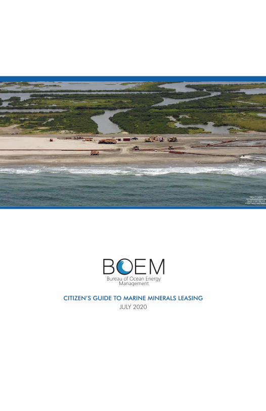
A Citizen’s Guideto the Bureau of Ocean Energy Management’s
Marine Minerals Leasing
The Nation’s Steward of Offshore Minerals
JULY 2020
Photo courtesy of BOEM.
| BOEM Marine Minerals Citizen’s Guideii
A Citizen’s Guide to BOEM’s Marine Minerals Leasing
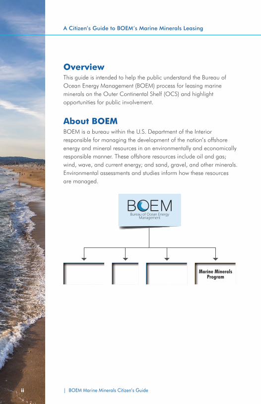
OverviewThis guide is intended to help the public understand the Bureau of Ocean Energy Management (BOEM) process for leasing marine minerals on the Outer Continental Shelf (OCS) and highlight opportunities for public involvement.
About BOEMBOEM is a bureau within the U.S. Department of the Interior responsible for managing the development of the nation’s offshore energy and mineral resources in an environmentally and economically responsible manner. These offshore resources include oil and gas; wind, wave, and current energy; and sand, gravel, and other minerals. Environmental assessments and studies inform how these resources are managed.
Oil & GasProgram
RenewableEnergy Program
Office of Environmental
ProgramsMarine Minerals
Program
| BOEM Marine Minerals Citizen’s Guide BOEM Marine Minerals Citizen’s Guide | 1
BOEM’s Marine Minerals ProgramBOEM is the federal bureau authorized to provide access to marine minerals from the OCS. OCS marine minerals involve sediments (including sand, gravel, mixed sand/clay/silt) and hard minerals (including a number of hard minerals recently designated as ‘critical’ by the U.S. Geological Survey). BOEM manages and leases access to these non-energy minerals in federal waters and strives to maximize long-term use while ensuring that adverse environmental impacts to marine and coastal environments are avoided, minimized, or mitigated. To support this function, BOEM’s Marine Minerals Program (MMP) implements a program that strategically inventories and manages OCS marine mineral resources while simultaneously providing environmental oversight of the use of these resources.
The Outer Continental Shelf The OCS refers to the almost 2.5 billion acres of federal submerged lands, subsoil, and seabed beginning three nautical miles off most states, and nine nautical miles off Texas and the Gulf coast of Florida, and extending to the edge of the areas included in the bureau’s official leasing maps.
The Outer Continental Shelf Lands Act (OCSLA) authorizes BOEM to lease areas for the exploration, development, production, and use of resources contained within the OCS. Before issuing a marine minerals lease, BOEM carefully reviews applications to ensure that the activities will be conducted in a safe and environmentally sound manner and that the interests of key stakeholders have been considered.
The U.S. Census Bureau estimated that America’s coastline counties were home to over 93 million people in 2016, or about 29% of the the total U.S. population.
For more information about the achievements of the MMP, including leases, projects, and related activities, visit https://www.boem.gov/MMP-Current-Statistics/.
| BOEM Marine Minerals Citizen’s Guide2
A Citizen’s Guide to BOEM’s Marine Minerals Leasing
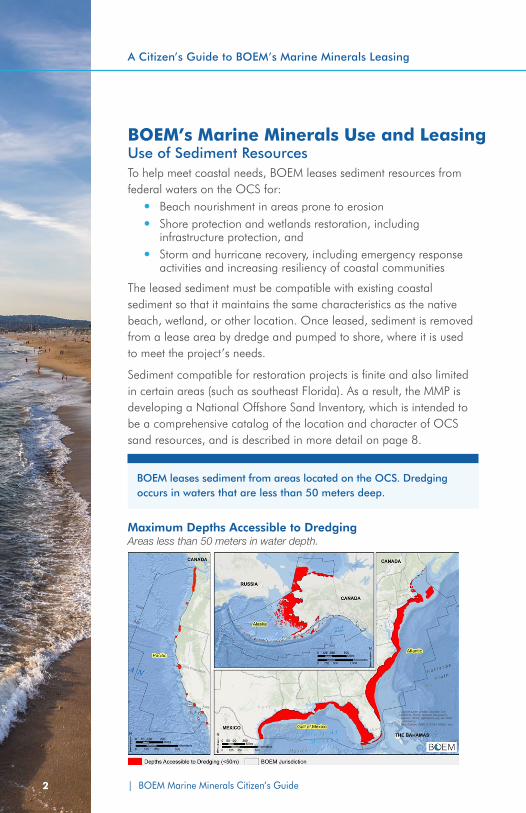
Maximum Depths Accessible to Dredging Areas less than 50 meters in water depth.
BOEM’s Marine Minerals Use and LeasingUse of Sediment ResourcesTo help meet coastal needs, BOEM leases sediment resources from federal waters on the OCS for:
y Beach nourishment in areas prone to erosion y Shore protection and wetlands restoration, including
infrastructure protection, and y Storm and hurricane recovery, including emergency response
activities and increasing resiliency of coastal communities
The leased sediment must be compatible with existing coastal sediment so that it maintains the same characteristics as the native beach, wetland, or other location. Once leased, sediment is removed from a lease area by dredge and pumped to shore, where it is used to meet the project’s needs.
Sediment compatible for restoration projects is finite and also limited in certain areas (such as southeast Florida). As a result, the MMP is developing a National Offshore Sand Inventory, which is intended to be a comprehensive catalog of the location and character of OCS sand resources, and is described in more detail on page 8.
BOEM leases sediment from areas located on the OCS. Dredging occurs in waters that are less than 50 meters deep.
| BOEM Marine Minerals Citizen’s Guide BOEM Marine Minerals Citizen’s Guide | 3
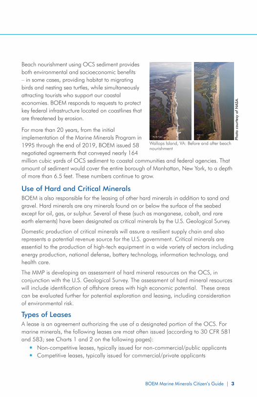
Beach nourishment using OCS sediment provides both environmental and socioeconomic benefits – in some cases, providing habitat to migrating birds and nesting sea turtles, while simultaneously attracting tourists who support our coastal economies. BOEM responds to requests to protect key federal infrastructure located on coastlines that are threatened by erosion.
For more than 20 years, from the initial implementation of the Marine Minerals Program in 1995 through the end of 2019, BOEM issued 58 negotiated agreements that conveyed nearly 164 million cubic yards of OCS sediment to coastal communities and federal agencies. That amount of sediment would cover the entire borough of Manhattan, New York, to a depth of more than 6.5 feet. These numbers continue to grow.
Use of Hard and Critical MineralsBOEM is also responsible for the leasing of other hard minerals in addition to sand and gravel. Hard minerals are any minerals found on or below the surface of the seabed except for oil, gas, or sulphur. Several of these (such as manganese, cobalt, and rare earth elements) have been designated as critical minerals by the U.S. Geological Survey.
Domestic production of critical minerals will assure a resilient supply chain and also represents a potential revenue source for the U.S. government. Critical minerals are essential to the production of high-tech equipment in a wide variety of sectors including energy production, national defense, battery technology, information technology, and health care.
The MMP is developing an assessment of hard mineral resources on the OCS, in conjunction with the U.S. Geological Survey. The assessment of hard mineral resources will include identification of offshore areas with high economic potential. These areas can be evaluated further for potential exploration and leasing, including consideration of environmental risk.
Types of LeasesA lease is an agreement authorizing the use of a designated portion of the OCS. For marine minerals, the following leases are most often issued (according to 30 CFR 581 and 583; see Charts 1 and 2 on the following pages):
y Non-competitive leases, typically issued for non-commercial/public applicants y Competitive leases, typically issued for commercial/private applicants
Wallops Island, VA: Before and after beach nourishment
Phot
o co
urte
sy o
f N
ASA
.
4 | BOEM Marine Minerals Citizen’s Guide
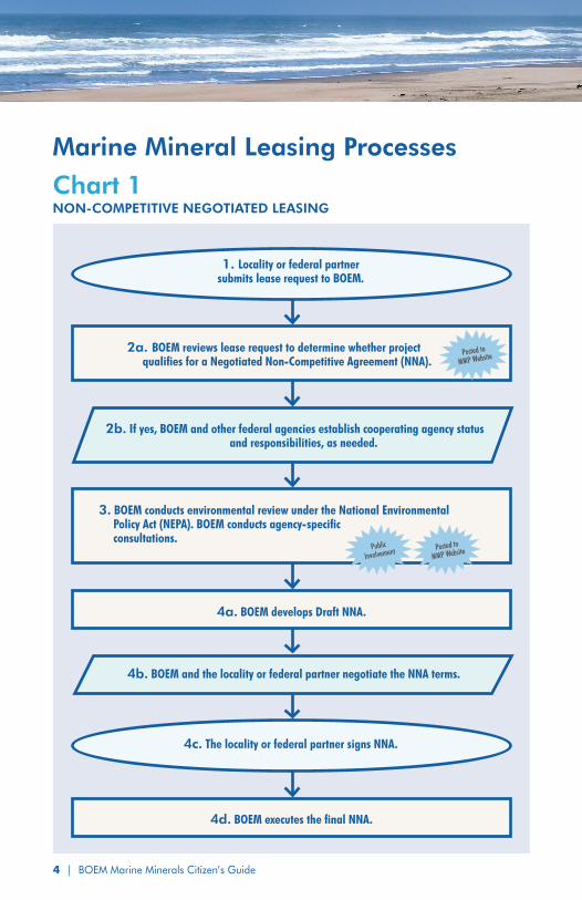
1. Locality or federal partner submits lease request to BOEM.
2a. BOEM reviews lease request to determine whether project qualifies for a Negotiated Non-Competitive Agreement (NNA).
3. BOEM conducts environmental review under the National Environmental Policy Act (NEPA). BOEM conducts agency-specific consultations.
4a. BOEM develops Draft NNA.
2b. If yes, BOEM and other federal agencies establish cooperating agency status and responsibilities, as needed.
4b. BOEM and the locality or federal partner negotiate the NNA terms.
Posted to
MMP Website
Posted to
MMP WebsitePublic
Involvement
4c. The locality or federal partner signs NNA.
4d. BOEM executes the final NNA.
Chart 1 NON-COMPETITIVE NEGOTIATED LEASING
Marine Mineral Leasing Processes
BOEM Marine Minerals Citizen’s Guide | 5
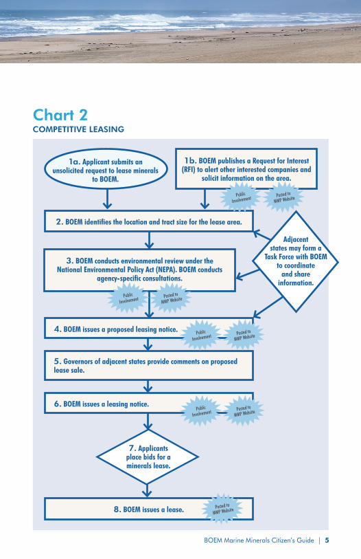
8. BOEM issues a lease.
5. Governors of adjacent states provide comments on proposed lease sale.
Posted to
MMP Website
Adjacent states may form a
Task Force with BOEM to coordinate
and share information.
7. Applicants place bids for a minerals lease.
3. BOEM conducts environmental review under the National Environmental Policy Act (NEPA). BOEM conducts
agency-specific consultations.
Posted to
MMP WebsitePublic
Involvement
2. BOEM identifies the location and tract size for the lease area.
4. BOEM issues a proposed leasing notice.
6. BOEM issues a leasing notice. Posted to
MMP WebsitePublic
Involvement
Posted to
MMP WebsitePublic
Involvement
Chart 2COMPETITIVE LEASING
1a. Applicant submits an unsolicited request to lease minerals
to BOEM.
1b. BOEM publishes a Request for Interest (RFI) to alert other interested companies and
solicit information on the area.
Posted to
MMP WebsitePublic
Involvement
6
A Citizen’s Guide to BOEM’s Marine Minerals Leasing
A locality (city, county, or state) or other government agency (for example, the U.S. Army Corps of Engineers, U.S. Navy, U.S. Air Force, or NASA) may submit a lease request to BOEM for non-commercial use of sediment resources. BOEM will typically follow the non-competitve leasing process (see Chart #1). The lease request must include detailed information about the proposed project, other known uses of the OCS or infrastructure in the proposed lease areas, a description of environmental evaluations that have been completed in the area, known permits and licenses that will be required, and an explanation of the funding that will be used.
A private entity may submit a lease request to BOEM seeking sediment or hard minerals on the OCS for commercial purposes. BOEM will typically follow the competitive leasing process (see Chart #2) to determine whether or not to issue a lease for the requested purpose.
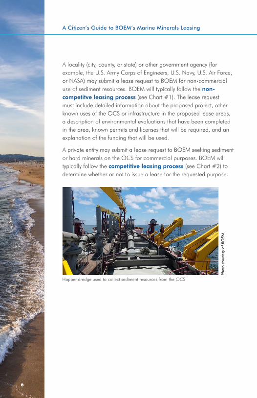
Hopper dredge used to collect sediment resources from the OCS
Phot
o co
urte
sy o
f BO
EM.
BOEM Marine Minerals Citizen’s Guide | 7
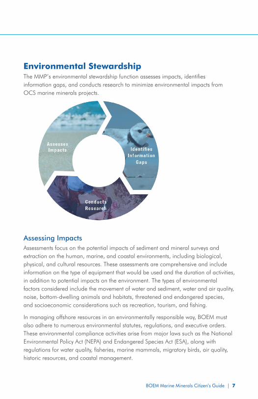
Environmental StewardshipThe MMP’s environmental stewardship function assesses impacts, identifies information gaps, and conducts research to minimize environmental impacts from OCS marine minerals projects.
Assessing Impacts Assessments focus on the potential impacts of sediment and mineral surveys and extraction on the human, marine, and coastal environments, including biological, physical, and cultural resources. These assessments are comprehensive and include information on the type of equipment that would be used and the duration of activities, in addition to potential impacts on the environment. The types of environmental factors considered include the movement of water and sediment, water and air quality, noise, bottom-dwelling animals and habitats, threatened and endangered species, and socioeconomic considerations such as recreation, tourism, and fishing.
In managing offshore resources in an environmentally responsible way, BOEM must also adhere to numerous environmental statutes, regulations, and executive orders. These environmental compliance activities arise from major laws such as the National Environmental Policy Act (NEPA) and Endangered Species Act (ESA), along with regulations for water quality, fisheries, marine mammals, migratory birds, air quality, historic resources, and coastal management.
| BOEM Marine Minerals Citizen’s Guide8
A Citizen’s Guide to BOEM’s Marine Minerals Leasing
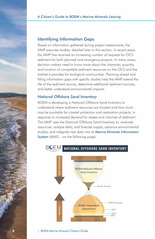
Identifying Information Gaps Based on information gathered during project assessments, the MMP executes studies, detailed later in this section. In recent years, the MMP has received an increasing number of requests for OCS sediment for both planned and emergency projects. In many areas, decision makers need to know more about the character, quantity, and location of compatible sediment resources on the OCS and the habitat it provides for biological communities. Planning ahead and filling information gaps with specific studies help the MMP extend the life of the sediment source, determine additional sediment sources, and better understand environmental impacts.
National Offshore Sand Inventory BOEM is developing a National Offshore Sand Inventory to understand where sediment resources are located and how much may be available for coastal protection and restoration projects, in response to increased demand for leases and volumes of sediment. The MMP uses the National Offshore Sand Inventory to: evaluate resources, analyze data, and forecast supply; advance environmental studies; and integrate new data into its Marine Minerals Information System (MMIS – on the following page).
| BOEM Marine Minerals Citizen’s Guide BOEM Marine Minerals Citizen’s Guide | 9
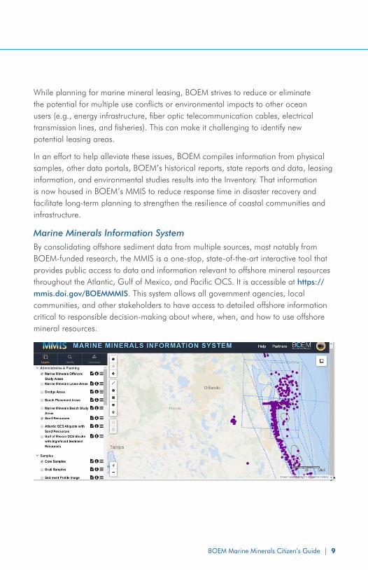
While planning for marine mineral leasing, BOEM strives to reduce or eliminate the potential for multiple use conflicts or environmental impacts to other ocean users (e.g., energy infrastructure, fiber optic telecommunication cables, electrical transmission lines, and fisheries). This can make it challenging to identify new potential leasing areas.
In an effort to help alleviate these issues, BOEM compiles information from physical samples, other data portals, BOEM’s historical reports, state reports and data, leasing information, and environmental studies results into the Inventory. That information is now housed in BOEM’s MMIS to reduce response time in disaster recovery and facilitate long-term planning to strengthen the resilience of coastal communities and infrastructure.
Marine Minerals Information SystemBy consolidating offshore sediment data from multiple sources, most notably from BOEM-funded research, the MMIS is a one-stop, state-of-the-art interactive tool that provides public access to data and information relevant to offshore mineral resources throughout the Atlantic, Gulf of Mexico, and Pacific OCS. It is accessible at https://mmis.doi.gov/BOEMMMIS. This system allows all government agencies, local communities, and other stakeholders to have access to detailed offshore information critical to responsible decision-making about where, when, and how to use offshore mineral resources.
| BOEM Marine Minerals Citizen’s Guide10
A Citizen’s Guide to BOEM’s Marine Minerals Leasing
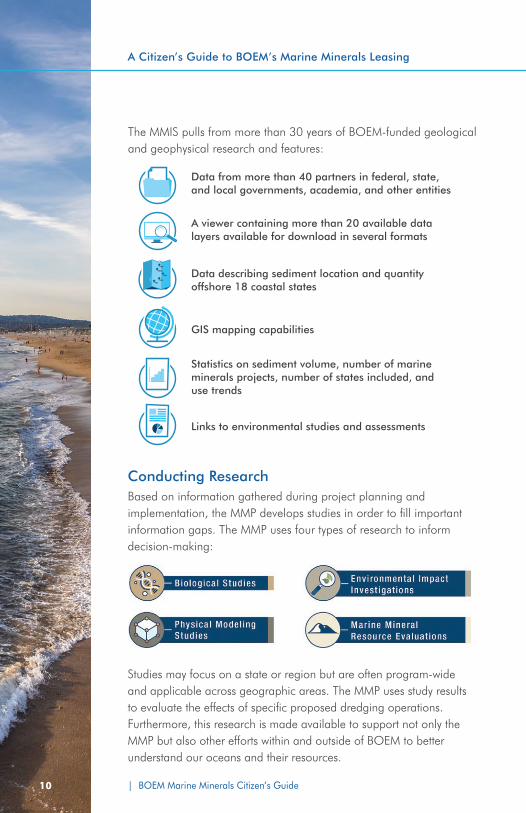
The MMIS pulls from more than 30 years of BOEM-funded geological and geophysical research and features:
Data from more than 40 partners in federal, state, and local governments, academia, and other entities
A viewer containing more than 20 available data layers available for download in several formats
Data describing sediment location and quantity offshore 18 coastal states
GIS mapping capabilities
Statistics on sediment volume, number of marine minerals projects, number of states included, and use trends
Links to environmental studies and assessments
Conducting ResearchBased on information gathered during project planning and implementation, the MMP develops studies in order to fill important information gaps. The MMP uses four types of research to inform decision-making:
Studies may focus on a state or region but are often program-wide and applicable across geographic areas. The MMP uses study results to evaluate the effects of specific proposed dredging operations. Furthermore, this research is made available to support not only the MMP but also other efforts within and outside of BOEM to better understand our oceans and their resources.
| BOEM Marine Minerals Citizen’s Guide BOEM Marine Minerals Citizen’s Guide | 11
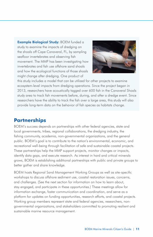
Example Biological Study: BOEM funded a study to examine the impacts of dredging on the shoals off Cape Canaveral, FL, by sampling seafloor invertebrates and observing fish movement. The MMP has been investigating how invertebrates and fish use offshore sand shoals and how the ecological functions of those shoals might change after dredging. One product of this study includes a model that can be utilized for other projects to examine ecosystem-level impacts from dredging operations. Since the project began in 2013, researchers have acoustically tagged over 600 fish in the Canaveral Shoals study area to track fish movements before, during, and after a dredge event. Since researchers have the ability to track the fish over a large area, this study will also provide long-term data on the behavior of fish species as habitats change.
PartnershipsBOEM’s success depends on partnerships with other federal agencies, state and local governments, tribes, regional collaborations, the dredging industry, the fishing community, academia, non-governmental organizations, and the general public. BOEM’s goal is to contribute to the nation’s environmental, economic, and recreational well-being through facilitation of safe and sustainable coastal projects. These partnerships help the MMP support projects, monitor changes or impacts, identify data gaps, and execute research. As interest in hard and critical minerals grows, BOEM is establishing additional partnerships with public and private groups to better gather and share knowledge.
BOEM hosts Regional Sand Management Working Groups as well as site-specific workshops to discuss offshore sediment use, coastal restoration issues, concerns, and challenges. (See the next section for information on how to learn about, stay engaged, and participate in these opportunities.) These meetings allow for information exchange, foster communication and coordination, and serve as a platform for updates on funding opportunities, research efforts, and coastal projects. Working group members represent state and federal agencies, researchers, non-governmental organizations, and stakeholders committed to promoting resilient and sustainable marine resource management.

| BOEM Marine Minerals Citizen’s Guide12
A Citizen’s Guide to BOEM’s Marine Minerals Leasing
PARTNERSFederal partners:
y National Aeronautics and Space Administration y National Oceanic and Atmospheric Administration/
National Marine Fisheries Service y U.S. Air Force y U.S. Army Corps of Engineers y U.S. Fish and Wildlife Service y U.S. Geological Survey y U.S. Navy
State partners: y Association of American State Geologists y Coastal Zone Management offices y State governments y State natural and cultural resource managers
Regional and local partners: y Colleges and universities y County governments y Regional Ocean Partnerships
How To Learn More and Stay EngagedThere are a variety of ways for the public to learn more and receive updates on BOEM’s Marine Minerals Program activities:
y Review the BOEM Marine Minerals website, www.boem.gov/marine-minerals-program/
y Find out more about offshore sediment data using BOEM’s Marine Minerals Information System (MMIS): https://mmis.doi.gov/BOEMMMIS/
y Subscribe to the email list for Stakeholder Announcements, including how to join BOEM’s Regional Sand Management Working Group events: www.boem.gov/Public-Engagement-Opportunities/
y Attend public information and outreach meetings such as BOEM’s Regional Sand Management Working Group meetings.
y Review BOEM’s Federal Register Notices at www.boem.gov/Submitting-Comments/
| BOEM Marine Minerals Citizen’s Guide BOEM Marine Minerals Citizen’s Guide | 13
Additional InformationFor additional information, please contact:
Bureau of Ocean Energy ManagementOffice of Public Affairs1849 C Street NWWashington, D.C. 20240Phone: (202) [email protected]://www.boem.gov/
Common Terms
Critical Minerals: Critical minerals, such as rare earth minerals, manganese, and cobalt, are highly desired for commercial use. In 2018, the U.S. Department of Interior identified 35 minerals critical to U.S. economic and national security. Companies interested in these minerals may apply to BOEM for leases to mine them from the OCS ocean floor.
Dredging: The process by which materials are pulled up from the bottom of a body of water.
Hard Minerals: Hard minerals mean any minerals found on or below the surface of the seabed except for oil, gas, or sulphur.
Lease: An agreement between BOEM and an agency, locality, or company to provide access to non-energy minerals. A lease can be issued non-competitively (typically for non-commercial/public use) or competitively (typically for commercial/private use).
Lease Area: An area on the OCS that BOEM grants access to for non-energy mineral extraction.
Outer Continental Shelf (OCS): The OCS refers to the almost 2.5 billion acres of federal submerged lands, subsoil, and seabed beginning three nautical miles off most states, and nine nautical miles off Texas and the Gulf coast of Florida, and extending to the edge of the areas included in the bureau’s official leasing maps.
Sediment Resources: For purposes of the MMP, sediment resources refer to the non-critical marine minerals located on the OCS that serve as sources of material for the construction of coastal protection and restoration projects.
CITIZEN’S GUIDE TO MARINE MINERALS LEASINGJULY 2020