Embed Size (px)
Citation preview

�������� ����� ��
Oceanographic processes and morphosedimentary products along the Iberianmargins: A new multidisciplinary approach
F. Javier Hernandez-Molina, Anna Wahlin, Miguel Bruno, Gemma Er-cilla, Estefanıa Llave, Nuno Serra, Gabriel Roson, Pere Puig, MicheleRebesco, David Van Rooij, David Roque, Cesar Gonzalez-Pola, FranciscoSanchez, Marıa Gomez, Benedict Preu, Tilmann Schwenk, Till J.J. Hanebuth,Ricardo F. Sanchez Leal, Jesus Garcıa-Lafuente, Rachel E. Brackenridge,Carmen Juan, Dorrik A.V. Stow, Jose Marıa Sanchez-Gonzalez
PII: S0025-3227(15)30079-7DOI: doi: 10.1016/j.margeo.2015.12.008Reference: MARGO 5393
To appear in: Marine Geology
Received date: 6 June 2015Revised date: 13 November 2015Accepted date: 17 December 2015
Please cite this article as: Hernandez-Molina, F. Javier, Wahlin, Anna, Bruno, Miguel,Ercilla, Gemma, Llave, Estefanıa, Serra, Nuno, Roson, Gabriel, Puig, Pere, Rebesco,Michele, Van Rooij, David, Roque, David, Gonzalez-Pola, Cesar, Sanchez, Francisco,Gomez, Marıa, Preu, Benedict, Schwenk, Tilmann, Hanebuth, Till J.J., Sanchez Leal, Ri-cardo F., Garcıa-Lafuente, Jesus, Brackenridge, Rachel E., Juan, Carmen, Stow, DorrikA.V., Sanchez-Gonzalez, Jose Marıa, Oceanographic processes and morphosedimentaryproducts along the Iberian margins: A new multidisciplinary approach, Marine Geology(2015), doi: 10.1016/j.margeo.2015.12.008
This is a PDF file of an unedited manuscript that has been accepted for publication.As a service to our customers we are providing this early version of the manuscript.The manuscript will undergo copyediting, typesetting, and review of the resulting proofbefore it is published in its final form. Please note that during the production processerrors may be discovered which could affect the content, and all legal disclaimers thatapply to the journal pertain.

ACC
EPTE
D M
ANU
SCR
IPT
ACCEPTED MANUSCRIPTMarine Geology, October 2015
1
Oceanographic processes and morphosedimentary products along the Iberian
margins: A new multidisciplinary approach
F. Javier Hernández-Molina1*
, Anna Wåhlin2, Miguel Bruno
3, Gemma Ercilla
4, Estefanía Llave
5, Nuno
Serra6, Gabriel Roson
7, Pere Puig
4, Michele Rebesco
8, David Van Rooij
9, David Roque
10, César González-
Pola11
, Francisco Sánchez12
, María Gómez13
, Benedict Preu14
, Tilmann Schwenk15
, Till J.J. Hanebuth16, 17
,
Ricardo F. Sánchez Leal18
, Jesús García-Lafuente19
, Rachel E. Brackenridge20, 21
, Carmen Juan4, 9
, Dorrik
A.V. Stow20
; José María Sánchez-González7
1 Dept. Earth Sciences, Royal Holloway Univ. London, Egham, Surrey TW20 0EX, UK.
2 Department of Earth Sciences, University of Gothenburg, PO Box 460, SE-405 30 Göteborg, Sweden.
3 CACYTMAR. Univ. Cádiz, Avda República Saharaui S/N, Puerto Real, 11510, Cádiz, Spain.
4 CSIC, ICM, Paseo Marítimo de la Barceloneta, 37-49, 08003 Barcelona, Spain.
5 Instituto Geológico y Minero de España Ríos Rosas, 23, 28003 Madrid, Spain.
6 Institut für Meereskunde, Univ. Hamburg, Bundesstr. 53, 20146 Hamburg, Germany.
7 Facultad de Ciencias do Mar, Univ. Vigo, 36200 Vigo, Spain.
8 OGS, Istituto Nazionale di Oceanografia e di Geofisica Sperimentale, Borgo Grotta Gigante 42 /C, 34010 Sgonico,
TS, Italy. 9 Renard Centre of Marine Geology, Dept. of Geology and Soil Science. Ghent University, Krijgslaan 281 S8 B-9000
Gent, Belgium. 10
CSIC, ICMAN, Campus Universitario Rio San Pedro s/n. Puerto Real, Cádiz. C.P.11510. 11
Instituto Español de Oceanografía. C.O. Gijón. c/ Príncipe de Asturias 70 Bis. CP 33212, Gijón, Spain. 12
Instituto Español de Oceanografía. C.O. de Santander, Promontorio San Martín s/n, Apdo.240, 39080 Santander,
Spain. 13
Instituto Español de Oceanografía, c/ Corazón de María 8, 28002 Madrid, Spain. 14
Chevron Upstream Europe, Chevron North Sea Limited, Seafield House, Aberdeen AB15 6XL, UK. 15
MARUM – Center for Marine Environmental Sciences and Faculty of Geosciences, University of Bremen, Bremen,
Germany. 16
School of Coastal and Marine Systems Sciences, Coastal Carolina University, P.O. Box 261954, Conway, SC 29528,
U.S.A. 17
Marine Sedimentation Systems Group, MARUM - Center for Marine Environmental Sciences, University of Bremen,
Leobener Strasse, 28359 Bremen, Germany. 18
Instituto Español de Oceanografía. C.O. de Cádiz, Muelle de Levante s/n, P.O. Box 2609, 11006 Cádiz, Spain. 19
Physical Oceanography Group, University of Malaga, ETSI Telecomunicación, Campus de Teatinos s/n 29071
Málaga, Spain. 20
Institute of Petroleum Engineering, Heriot-Watt Univ., Edinburgh EH14 4AS, Scotland, UK. 21
Shell International Exploration & Production B.V. Carel van Bylandtlaan 05.0B.03, 2596 HR, The Hague
Netherlands.
* Corresponding author. Email address: [email protected]
Abstract Our understanding of bottom-currents and associated oceanographic processes (e.g., overflows, barotropic tidal
currents) including intermittent processes (e.g., vertical eddies, deep sea storms, horizontal vortices, internal waves and
tsunamis) is rapidly evolving. Many deep-water processes remain poorly understood due to limited direct observations,
but can generate significant depositional and erosional features on both short and long term time scales. This paper
represents a review work, which describes for the first time these oceanographic processes and examines their potential
role in the sedimentary features along the Iberian continental margins. This review explores the implications of the
studied processes, given their secondary role relative to other factors such as mass-transport and turbiditic processes,
and highlights three major results: a) contourite depositional and erosional features are ubiquitous along the margins,
indicating that bottom currents and associated oceanographic processes control the physiography and sedimentation; b)
the position of interfaces between major water masses and their vertical and spatial variation in time specifically
appears to exert primary control in determining major morphologic changes along the slope gradient, including the
contourite terraces development; and c) contourites deposits exhibit greater variation than the established facies model
suggests. Therefore, a consistent facies model however faces substantial challenges in terms of the wide range of
oceanographic processes that can influence in their development. An integrated interpretation of these oceanographic
processes requires an understanding of contourites, seafloor features, their spatial and temporal evolution, and the near-
bottom flows that form them. This approach will synthesize oceanographic data, seafloor morphology, sediments and
seismic images to improve our knowledge of permanent and intermittent processes around Iberia, and evaluate their

ACC
EPTE
D M
ANU
SCR
IPT
ACCEPTED MANUSCRIPTMarine Geology, October 2015
2
conceptual and regional role in the margin’s sedimentary evolution. Given their complexes, three-dimensional and
temporally-variable nature, integration of these processes into sedimentary, oceanographic and climatological
frameworks will require a multidisciplinary approach that includes Geology, Physical oceanography, Paleoceanography
and Benthic Biology.
Key words: Iberian margins, oceanographic processes, bottom currents, sedimentary processes, contourites
1. Introduction
Deep-marine settings have been considered until 1980s as relatively low energy and quiescent
depositional environments where deep-water masses flow as relatively slow-moving tabular bodies
and deposition is episodically interrupted by down-slope gravity driven processes. However, since
the 1990s it has been demonstrated that deep-water masses can exhibit relatively high velocity and
play a dominant depositional role in certain areas (e.g., Rebesco et al., 2014). These conditions hold
especially when water masses interact with local seafloor irregularities (i.e., seamounts, ridges,
hills, mounds, banks, scarps, etc.). Flow through deep oceanic gateways, straits or basins can also
generate high velocity and turbulent flows, resulting in regional-scale erosional, depositional and
mixed morphological features. Understanding these seafloor features therefore requires a more
detailed model of bottom current effects.
The general term ‘bottom current’ refers to deep-water currents capable of eroding, transporting,
and depositing sediments along the seafloor (Rebesco and Camerlenghi, 2008). Background bottom
currents are the result of both the ocean thermohaline circulation (THC) and the ocean wind-driven
circulation (Rahmstorf, 2006). They generally exhibit persistent net flow along-slope (following the
local bathymetry), but can considerably vary in direction and velocity (Stow et al., 2009). Overflows,
tides, including internal tides and other intermittent processes such as bottom reaching (vertical)
eddies, deep sea storms, (horizontal) vortices, internal waves, solitons, tsunami related currents, rogue
waves and cyclonic waves (during storms and hurricanes) can also affect bottom currents (Fig. 1)
(e.g., Shanmugam, 2012a, 2013a, b, 2014; Rebesco et al., 2014). These processes modulate the
bottom currents and their speed, instantaneous direction, and tend to develop local and regional
hydrodynamic structures (e.g., cores, branches, filaments, eddies, vortices, local turbulence, internal
waves, helicoidal flows, vertical columns, etc.). Many of these oceanographic deep-water processes
are poorly understood but can generate pervasive depositional and erosional features over both short-
and long- term time scales (Shanmugam, 2013b; Rebesco et al., 2014 and reference therein).
Contourites are defined as sediments deposited or substantially reworked by the persistent action of
bottom currents (e.g., Stow et al., 2002a; Rebesco, 2005, Rebesco et al., 2014). The term
“contourites” was originally intended to define sediments deposited in the deep sea by contour-
parallel thermohaline currents (Hollister and Heezen, 1967). Usage of the term has subsequently
widened to include a larger range of deposits affected by different types of currents (Rebesco et al.,

ACC
EPTE
D M
ANU
SCR
IPT
ACCEPTED MANUSCRIPTMarine Geology, October 2015
3
2014). Bottom currents are capable of building thick and extensive accumulations of sediments
referred to as “contourite drifts”. The term “contourite depositional system” (CDS) refers to large
contourite deposits (drifts) associated with erosional features in an environment dominated by along-
slope processes due to a particular water mass (Hernández-Molina et al., 2003, 2008a,b, 2009).
The Iberian continental margins have had a very complex and varied origin as well as geodynamic
and sedimentary evolution. For decades, many studies have been carried out on the structure and
evolution of these margins (e.g., Maestro et al., 2015 and reference therein). The circulation of water
masses around Iberia leads to the development of bottom currents and rather unknown associated
oceanographic processes, some of which impinge upon the seafloor with relatively high velocity and
interact along the continental slope. The resulting contourite erosional and depositional features
comprise extensive, complex and often poorly known CDSs in various geological settings, consituting
valuable sedimentary records of margins evolution (see compilation from Hernández-Molina et al.,
2011; Llave et al., 2015a,b). Therefore, the present work have three main objectives: (1) to combine
previous work and new data on describing persistent or intermittent oceanographic processes
associated with bottom currents circulation along the Iberia continental margins; (2) to evaluate their
role in determining the shape, potential sedimentary products and evolution of the margins; and (3) to
propose some future considerations contemplating the implications of these findings.
2. Methodology and data set
Present work constitutes mostly a review of described persistent or intermittent oceanographic
processes associated with bottom current circulation along the Iberia continental margins. Such a
compilation is difficult, since there is a high degree of heterogeneity in both data coverage and
terminology. It represents a collaborative work achieved during the last years by Geologists,
Physical Oceanographers, Paleoceanographers and Benthic Biologists. A varied data set were
compiled from numerous bibliographic sources or unpublished, including: radar images;
conductivity, temperature and depth (CTD) stations; Acoustic Doppler Current Profiler (ADCP);
time series observations of the near-bottom current speed, potential temperature and suspended
sediment concentration (SSC); submarine bottom photographs; superficial samples; swath
bathymetry data; side scan sonar images; high- and low-resolution seismic reflection profiles; and
sediments samples taken by drilling and numerical modelling.
A first part of the work offers a conceptual description of persistent or intermittent
oceanographic processes associated with bottom current circulation inspired in recent works from
Shanmugam (2012a, 2013a, b, 2014) and Rebesco et al. (2014), but including, by first time, an
exhaustive compilation of them around the Iberian margins. The second part describes how to

ACC
EPTE
D M
ANU
SCR
IPT
ACCEPTED MANUSCRIPTMarine Geology, October 2015
4
proceed with the unique research challenge of integrating these complex, three-dimensional and
temporally variable oceanographic processes into sedimentary and climatological models.
3. Oceanographic processes
3.1. Bottom currents and thermohaline circulation
The large-scale deep-water circulation is a critical part of the global conveyor belt that regulates
the Earth’s climate (Rahmstorf, 2006; Kuhlbrodt et al., 2007). In regions where the deep ocean
currents are close enough to the ocean bottom they may shape the deep seafloor. As a first order,
dense water formation at high latitudes drives the global THC. Salinity or temperature driven
density variations cause sinking of the surface water masses towards greater depths and control
their subsequent transport and eventual global distribution. Deep-water formation is closely
associated with convection in a few localities. These mainly occur in the subpolar convergence zone
of the Northern Hemisphere and the convergence zone of the Antarctic polar front in the Southern
Hemisphere. The principal deep-water masses forming part of the THC include the North Atlantic
Deep Water (NADW) and the Antarctic Bottom Water (AABW), which spread across the deepest
marine domains, as Deep Western Boundary Currents (DWBC) (Rahmstorf, 2006). Bottom
circulation and distribution along the oceanic basins is conditioned by their proximity to high-
latitude input sources, seafloor morphology, inter-oceanic connection via deep gateways and the
Coriolis Effect (Kennett, 1982; Faugères et al., 1993; Rahmstorf, 2006). Other bottom currents,
such as the extension of the wind-generated currents, are not linked to THC. These latter currents
include the Gulf of Mexico current system (e.g., Loop Current; Wunsch, 2002) and the Antarctic
Circumpolar Current (Orsi et al., 1995).
Bottom-water masses move generaly relatively slowly as laminar flows over their global course (<
3 cm/s). Regional and local bottom current velocities exhibit local heterogeneity due to varying
seafloor stress and other current instabilities, such as mesoscale variability. Western stretches of ocean
basins and topographic obstacles along the seafloor facilitate higher velocities (> 0.6-1 m/s) (Stow et
al., 2009; Hernández-Molina et al., 2011). Bottom water behaviour and velocity partially affect the
seafloor through lateral transport of suspended particulate matter in the water column. This material is
up to 10 times higher in concentration in the deep nepheloid layer (at 50 – 200 m above the seafloor)
of the Deep Western Boundary Currents compared with other oceanic areas (Rebesco et al., 2014). A
sufficiently active bottom current acting for a prolonged period of time will thus profoundly affect the
seafloor by winnowing of fine-grained sediments, yelding large-scale erosion, depositional and mixed
features (e.g., Stow et al., 2002b; Rebesco and Camerlenghi, 2008; Rebesco et al., 2014). Bottom
currents represent long-term hydrologic conditions on geological time scales. The establishment of
the main CDSs around the world in fact coincides with the Eocene / Oligocene boundary (~32 Ma),

ACC
EPTE
D M
ANU
SCR
IPT
ACCEPTED MANUSCRIPTMarine Geology, October 2015
5
and was more recently reactivated by THC during the Middle Miocene (Hernández-Molina et al.,
2008a).
The topic of bottom current processes around Iberia is addressed by Hernández-Molina et al.
(2011) and Llave et al. 2015a, b (this special issue). Along the Iberian margins, several important
bottom currents shape the continental margins and abyssal plains (e.g., Iorga and Lozier, 1999; Millot,
1999, 2009, 2014; Serra et al., 2010a). These currents derive primarily from the Western
Mediterranean Deep Water (WMDW) and the Levantine Intermediate Water (LIW) in the Alboran
Sea, as well as the Mediterranean Overflow Water (MOW) and the Lower Deep Water (LDW) in the
Atlantic (see the water masses compliation in Hernández-Molina et al., 2011 and Llave et al., 2015a,
b, this issue). Well-developed CDSs around Iberia (e.g., Portuguese margin) have not been
systematically interpreted according to bottom currents models and thus are not well understood.
3.2. Overflows
Overflows constitute permanent oceanographic processes related to: 1) flow over a topographic
barrier from a regional basin into the open ocean (Fig. 1) and 2) open-ocean flow into an isolated
regional basin. The Denmark Strait Overflow Water (DSOW); Iceland-Scotland Overflow Water
(ISOW) and MOW (Price and Baringer, 1994; Legg et al., 2009) offer good examples of the first
type of overflow. The second type of overflow occurs in association with deep gateways such as the
Bruce Passage between the Weddell Sea and Scotia Sea (Legg et al., 2009; Lobo et al., 2011;
García et al., 2015a, this special issue) or the overflow of AABW from the Brazil Basin into the
North Atlantic Basin across the Atlantic ridge or in the Gulf of Mexico (Legg et al., 2009). In the
aforementioned cases, a dense gravity current, carrying a particular water mass, descends the
regional slope to a greater depth until it reaches density equilibrium. Entrainment of surrounding
water, bottom friction and inertial accelerations modify the bottom current along the slope (Fig. S1,
in Supplementary material). Bottom friction and the Earth rotation induce the Ekman bottom
boundary layer (e.g., Pedlosky, 1996; Wåhlin and Walin, 2001), which produces a net transport to
the left in the Northern Hemisphere (Fig. S1). Although the frictional transport is confined to a thin
layer near the bottom (the Ekman boundary layer), it affects the whole water column
asymptotically. The dense water adjusts to the divergence of the frictional transport, which acts as a
horizontal diffusive process, minimizing the curvature of the dense interface. The lower (seaward)
edge moves downhill as the Ekman layer expels the Ekman transport from its interior (e.g., Wåhlin
and Walin, 2001). At the upper (landward) edge, the dense interface then becomes almost
horizontal, with diminished geostrophic velocity and frictional transport (e.g., Wåhlin and Walin,
2001). The combined frictional effect over the entire outflow causes it to gradually widen, keeping
the upper horizontal boundary at a nearly constant depth (e.g., Borenäs and Wåhlin, 2000). If these

ACC
EPTE
D M
ANU
SCR
IPT
ACCEPTED MANUSCRIPTMarine Geology, October 2015
6
processes occur over a laterally varying bottom slope, they act to split the flow into two or more
cores and branches, as suggested for example, in an interpretation of the Mediterranean Outflow
(Borenäs et al., 2002; Serra et al., 2010a, b). As dense water passes from its formation site into the
open ocean as an overflow, it undergoes mixing with the overlying water column. This process
determines the eventual properties and volume transport of the resultant bottom currents, and
triggers eddy formation (Legg et al., 2009).
The main overflow example in the Iberian margins stems from MOW dynamics during the late
Miocene opening of the Gibraltar gateway (Duggen et al., 2003; Bache et al., 2012; Roveri et al.,
2014). The Strait of Gibraltar, which consists of a 60 km long sill and narrow gateway (Armi and
Farmer, 1988), plays a key role in water exchange between the Mediterranean Sea and the Atlantic
Ocean. The excess evaporation over precipitation (0.5 to 0.8 m/yr) dramatically enhances salinity
and density of the Mediterranean, relative to waters of the adjacent Atlantic Ocean (Millot et al.,
2006). Mediterranean salinity tongues develop in the Atlantic Ocean from overflow (0.68 Sv) of
dense, warm (13°C) and highly saline (37) water (Bryden et al., 1994, Candela, 2001; Serra et al.,
2010a). Mediterranean Levantine Intermediate Water (LIW) and Western Mediterranean Deep
Water (WMDW) mix, when they flow out through the Strait and originate the MOW that is around
2 times saltier than any other Atlantic water mass. The overflow spills over the Strait of Gibraltar
sills and cascades from 300 m depth at the edge of the strait down the continental slope of the
eastern Gulf of Cádiz. As it does so, it entrains the overlying, less dense North Atlantic Central
Water (NACW) (Johnson and Stevens, 2000). Overflows typically occur at velocities of 50 to 100
cm/s (Legg et al., 2009), but in the case of MOW, the current velocity decreases from around 200
cm/s in the neighbourhood of the Camarinal sill and its western approaches (Sánchez Román et al,
2009; Gasser et al, 2011), down to 60 - 100 cm/s further to the northwest. From the first 100 km of
the overflow path, volume transport increases by a factor of three to four (Serra et al., 2010a;
Rogerson et al., 2012). As it descends, the overflow veers north and follows the Iberian continental
margins, approaching its neutral buoyancy as it nears 8° W at about 1000 m depth (Ochoa and Bray,
1991; Baringer and Price, 1997, 1999; Käse and Zenk, 1996; Ambar et al., 2002, 2008; Bower et
al., 2002; Serra et al., 2005, 2010a; García-Lafuente et al., 2009).
In the Gulf of Cádiz, friction in the bottom Ekman boundary layer and entrainment in its upper
part affect the MOW plume (Baringer and Price, 1997; Gasser et al., 2011). The vertical
distribution of the along-stream velocity comprises two zones separated by a velocity maximum
(called the plume nose). They consist of an upper (interfacial) layer characterised by sharp velocity
and salinity gradients, and a bottom layer characterized by constant salinity and a sharp decrease in
velocity (Johnson et al., 1994a, b). Secondary across-stream circulation spreads water from the
upper layer upslope and dense water from the bottom layer downslope. In the eastern Gulf of Cádiz,
ACC
EPTE
D M
ANU
SCR
IPT
ACCEPTED MANUSCRIPTMarine Geology, October 2015
7
near the Strait of Gibraltar, this overflow is associated with sandy-sheeted drifts, scours, ripples,
sand ribbons and sediment waves (Nelson et al., 1993), and generates large terraces and erosive
channels (Fig. 2) (Hernández-Molina et al., 2014). The secondary circulation here is especially
relevant to the erosion, resuspension and deposition of sediment, as well as to the formation of large
contourite features (Hernández-Molina et al., 2014).
Other examples of open-ocean overflow could happen between oceanic basins with different
depths (Legg et al., 2009). A possible case to be explored along the Iberian margins could
theoretically develop through the Theta Gap, a passage formed between La Coruña and Finisterre
structural highs (Fig. 3), and narrows to approximately 5 km wide between the Biscay abyssal plain
(average water depth of 5100 m) and the Iberian abyssal plain (about 5300 m deep), or other deep
channels between the abyssal plains. Heezen et al. (1959) first described the Theta Gap connection
as “a constricted passage connecting two abyssal plains which, in the vicinity of the gap, lie at
different levels”. The Biscay abyssal plain regionally slopes in a southward direction, with its
deepest section in the southwest corner, where the slope connects to the Theta gap. Active erosion
occurs about 15 km upslope of the narrowing between the structural highs (Laughton, 1960, 1968),
and creates initial incisions of up to 300 m and later incisions of about 100 m at points further along
the current’s course. The LDW water mass, which makes up this overflow (>3450 m water depth),
penetrates into the North Atlantic through the Discovery Gap on the western flank of the Madeira–
Tore Rise (Haynes and Barton, 1990; McCartney, 1992; Van Aken, 2000), and veers northward
along the Galicia margin as a near-bottom flow (Paillet and Mercier, 1997; Van Aken, 2000). A
cyclonic recirculation cell occurring above the Biscay Abyssal plain deflects the current poleward
however, with a velocity near the continental margin of 1.2 (± 1.0) cm/s (Dickson et al., 1985;
Paillet and Mercier, 1997) (Fig. 3).
3.3. Processes at the interface between water masses
A pycnocline represents a layer with maximum gradient of density, which can be sharp and well
defined, or diffuse with a gradual transition from one water mass to the other (Fig. 1). Turbulent
mixing of water masses caused by tides (or other processes) can disrupt the pycnocline, whereas
stratifying processes (e.g., regional positive buoyancy flux at the surface) maintain it. The relative
balance between these two factors defines the structure of the pycnocline in different regions and at
different times. The interface often tilts in one dominant direction (e.g., Reid et al., 1977) but can be
locally and temporarily displaced by eddies (e.g., Piola and Matano, 2001; Arhan et al., 2002, 2003)
and internal waves. Energetic current patterns associated with internal waves and eddies at the
interface between water masses (Reid et al., 1977) strongly affect the seafloor (e.g., Hernández-

ACC
EPTE
D M
ANU
SCR
IPT
ACCEPTED MANUSCRIPTMarine Geology, October 2015
8
Molina et al., 2009, 2011; Preu et al., 2013) through erosion and re-suspension (Dickson and
McCave, 1986; Cacchione et al., 2002; Puig et al., 2004; Shanmugam, 2013a, 2014).
Some water masses circulating around the Iberian margins have remarkable density contrasts
(Fig. 4 and 5). The exchange flow through the Strait of Gibraltar exhibits these contrasts for
example, as do the base and top boundaries of the MOW (Serra et al., 2010a), which enhanced
during cold (i.e.; glacial) periods (Schönfeld et al., 2003; Voelker et al., 2006; Toucanne et al.,
2007; Rogerson et al., 2012). The associated currents indicate a relationship between the position of
the interface and the development of large contourite terraces (Hernández-Molina et al., 2009,
2011; Preu et al., 2013; Rebesco et al., 2014). Several examples of this relationship have been
described along the Iberian margins in the Alboran Sea (Ercilla et al., 2002, 2015), Gulf of Cádiz
(Hernández-Molina et al., 2014); Portuguese Margin (Fig. 4, Pinheiro et al., 2010; Llave et al.,
2015b); Galician margin (Hanebuth et al., 2015); and Cantabrian Sea (Fig. 4, Maestro et al., 2013;
Sánchez-González, 2013).
3.4. Deep-water tidal currents
Surface tides are mostly driven by the ocean’s response to the gravitational fields of the Sun and
the Moon. Surface tides are considered barotropic tides because their associated currents are mainly
depth-independent (Fig. 1). Tidal signals consist of the superposition of several harmonics (tidal
constituents) with the principle lunar semi-diurnal frequency (M2 tidal constituent; 12.42 h) exerting
the strongest global effects in agreement with the tide-generating potential theory (Lakshmi et al.,
2000). Tidal energy may be transferred to baroclinic modes in stratified fluids, thus generating
baroclinic tides (Fig. 1). Baroclinic tides can dissipate tidal energy by transferring motion along
distant features. Both barotropic and baroclinic tides influence the bottom water circulation in deep-
water environments (Dykstra, 2012). Tidal currents change direction periodically with time,
describing an elliptical hodograph usually aligned along bathymetric contours in the ocean interior.
Tidal energy tends to dissipate, and hence, to exert a stronger effect on continental slopes within
submarine canyons and adjacent areas (e.g., Shepard, 1976; Shepard et al., 1979; Viana et al., 1998;
Kunze et al., 2002; Garrett, 2003; Shanmugam, 2012a, 2013b; Gómez-Ballesteros et al., 2014;
Gong et al., 2013, 2015) and within certain contourite channels (Stow et al., 2013a). Shanmugam
(2012a) has proposed that barotropic tidal currents affect land- or shelf-incising canyons connected
to estuaries or rivers. Baroclinic tide currents affect slope-incising canyons but do not clearly
connect to major rivers or estuary systems. Inversion of bottom current directions due to tidal
influence occurs outside these canyons (Kennett, 1982; Stow et al., 2013a). Deep-marine tidal
bottom current velocities range from 25-50 cm/s but can reach 70-75 cm/s, and exhibit periods of
up to 24 hours (Shanmugam, 2012a).
ACC
EPTE
D M
ANU
SCR
IPT
ACCEPTED MANUSCRIPTMarine Geology, October 2015
9
According to both in situ measurements (tidal gauges) and numerical models, the most important
harmonic affecting the Atlantic Iberian margins is M2 (sea-level amplitudes between 100-180 cm,
Fig. 6), followed by S2 (12.00 h, 30-50 cm) (Alvarez-Fanjul et al., 1997). A typical spring/neap
tidal modulation of 14.8 days (the fortnightly tidal cycle) thus affects Iberian coastal areas. The
regional surface tide dynamics around the Atlantic Iberian Peninsula is part of the amphidromic
system that characterises the semidiurnal tidal waves in the North Atlantic (Cartwright et al, 1980),
where a barotropic Kelvin wave propagates northward along the western Iberian coast with a phase
speed close to 900 km/h. The wave diffracts eastward in the Cantabrian Sea and its amplitude
increases-g steadily shoreward. Kelvin wave dynamics predict counter clockwise tidal ellipses
aligned parallel to the coast. This simple model adequately approximates observed propagation
directions (e.g., the largest phase lags in the Cantabrian Sea, Alvarez-Fanjul et al., 1997), observed
and simulated wave amplitudes, which maximize along the northern coast, and open ocean
dynamics. The model, however, does not adequately describe tidal current variation in the
shelf/slope region where baroclinic tides start playing a significant role and the cross-shore
movement becomes increasingly important. Marta-Almeida and Dubert (2006) concluded that
bathymetric irregularities exert a major influence on the velocity field wherein steepened areas of
the slope amplify tidal currents, orthogonally polarising tidal ellipses along bathymetric contours.
Bottom features can therefore theoretically change the S–N orientation of tidal currents. Quaresma
and Pichon (2013) have recently shown that the cross-shelf velocity component over the slope and
shelf can supersede the along-shelf velocity component, giving rise to clockwise rotation of tidal
currents. The ellipse eccentricity decreases as a function of the slope gradient. Along the
Mediterranean area of the Iberian margins, tidal currents only exert significant affects in the
Alboran Sea (García-Lafuente and Cano Lucaya, 1994), where phases increase eastward. The
velocities of semidiurnal components decrease from a few 10-2
m/s to 10-3
m/s in the Algero-
Provençal Basin (Alberola et al., 1995).
Both M2 and S2 amplitudes increase from the Gulf of Cádiz to the Bay of Biscay, and exert the
dominant influence on tidal wave amplitude and current velocity throughout the shelf (Battisti and
Clarke, 1982). Across-shelf, the tidal amplitude decreases offshore with an average gradient of
~0.027 cm/km. The maximum speeds of ~ 50 cm/s and 20 cm/s (in a clockwise direction) for the
M2 and S2 ellipses (respectively) occur on the French shelf. The Bay of Biscay confines the tidal
wave and forces the generation of noticeable baroclinic tides that amplify the semidiurnal
constituents as the barotropic tidal wave impinges the French Armorican shelf. Velocities are much
smaller around Iberia, with maxima of 5 and 2 cm/s for the respective M2 and S2 ellipses (Quaresma
and Pichon, 2013), and exhibit strong along-shore spatial variability. The O1 and K1 diurnal
ACC
EPTE
D M
ANU
SCR
IPT
ACCEPTED MANUSCRIPTMarine Geology, October 2015
10
constituents are also present (8 and 6 cm amplitude, respectively), and cause the observed diurnal
inequality of the tide.
Although the observed tidal currents are small (rarely > 20 cm/s) around Iberia, they are the
primary driving force behind strong, high-frequency baroclinic activity, which does not affect other
coastal regions. The combination of regional, barotropic tidal velocities and steep bathymetry
amplifies this effect into "hotspots", which occur along the Atlantic margins of Iberia (Quaresma
and Pichon, 2013, Fig. 6C). Hotspot areas include the Extremadura and Ortegal Spurs as well as the
Gettysburg and Ormonde seamounts. The Cádiz Contourite Channel, in the central sector of the
Gulf of Cádiz, offers one of the best examples of sandy bedforms created directly by the dynamic
interaction of tidal currents and seafloor (Stow et al., 2013a, Fig. 7). The narrowness of this channel
(2-12 km) amplifies bottom tidal currents due to a funnelling effect. Current meter data from this
area show a strongly directional, westerly MOW moving at speeds of 1 m/s at the instrument height
of 78 m with a clear periodicity in its velocity, suggestive of a semi-diurnal tidal signal and of a
spring/neap cycle (Fig. 8A).
3.5. Deep-sea storms
Benthic storms (also known as deep-sea storms or abyssal storms) refer to intermittent, strong,
bottom-intensified currents affecting the seafloor (Fig. 1). The HEBBLE (High Energy Benthic
Boundary Layer Experiment; Hollister et al., 1980) first documented the existence of benthic
storms while investigating the response of the cohesive seafloor to high-stress events. During these
storms, bottom current velocity can increase by a factor of 2-5 times (average 15-20 cm/s with
peaks of > 43 cm/s) over a period of a few days (2 to 25 days) to several weeks. Benthic storms
occur at a frequency of about 8 to 10 events per year (Holger, 1987). Benthic storm related flows
can rework up to several millimetres of seafloor sediment per event. Entrainment of the bottom
nepheloid layer or bottom boundary layer by turbulent and diffusive mixing favours rapid
resuspension of particulate matter (Gardner and Sullivan, 1981; Hollister and McCave, 1984;
Nowell and Hollister, 1985; Gross and Williams, 1991). During the occurrence of these storms, the
benthic boundary Layer (BBL) increases in thickness from a few meters up to 70 m, and in turbidity
up to values of 5 g/l (Tucholke, 2002). Other mechanisms for benthic storms hypothesize sediment
plumes descending from continental slopes and rapid input of organic-rich phytodetritus from
plankton blooms in surface waters (Richardson et al., 1993; Puig et al., 2013). In this latter case,
organic-rich detritus draping the seafloor is easier to flocculate and maintain in suspension. Detailed
studies of suspended particulate matter throughout the BBL indicate that sediment concentration
depends on the interplay of several factors, including initial concentration in suspension, turbulence,
height of entrainment, velocity field, transport distance and settling velocity of the particles. Gross

ACC
EPTE
D M
ANU
SCR
IPT
ACCEPTED MANUSCRIPTMarine Geology, October 2015
11
and Williams (1991) emphasized three physical processes, which modulate deep-sea storm events.
These include turbulence in the boundary layer, eroded sediment at the sediment-water interface
and suspended sediment winnowed by the flow. Any one of these three lines of evidence defines a
storm event (Gross and Williams, 1991).
Benthic storms play an important role in the erosion, transport and redistribution of bottom
sediments (Hollister et al., 1980; Nowell and Hollister, 1985; Hollister, 1993). Once disturbed by
the erosional effects of increased bottom shear, sediments may be transported by bottom currents
and deposited in quiet regions downstream (Gardner and Sullivan, 1981; Kennett, 1982; Hollister
and McCave, 1984; Flood and Shor, 1988; Bearmon, 1989; Von Lom-Keil et al., 2002). These
currents may travel over long distances, constrained by the Coriolis force and semi-diurnal tides
parameters. Seafloor morphology from large, kilometer-scale features (e.g., seamounts) to smaller,
meter-scale features (e.g., sediment waves) can affect this transport (Rebesco and Camerlenghi,
2008).
The occurrence of benthic storms relates in part to the formation of large eddies within the water
column due to the interaction between major wind-driven surface currents and the bottom
component of THC. Areas of the ocean with a highly variable sea surface show more frequent
benthic storm activity (Richardson et al., 1993; Faugères and Mulder, 2011). The kinetic energy of
these eddies can extend to depths of > 3000 m and thus change the magnitude and direction of
bottom currents. Benthic storms also occur in the presence of strong, permanent bottom currents,
and in areas where seafloor sediments are easily flocculated into suspension (Richardson et al.,
1993). Due to the limited information concerning benthic storms, however, uncertainties persist in
regards to their initiation and driving mechanism.
As major sediment entrainment processes, benthic storms play an important role in contourite
development. Benthic storms also disturb benthic communities (Gross and Williams, 1991).
Regions subjected to intense deep-sea storms show significant erosion of the continental slope and
evidence of large submarine slides (Pickering et al., 1989; Gao et al., 1998; Einsele, 2000).
Only a few examples of deep-sea storms have been documented around Iberia linked to the
formation of surface dense waters in the Gulf of Lions and the subsequent deep cascading and
open-sea convection process (Font et al., 2007; Palanques et al., 2009; Durrieu de Madron et al.,
2013). Some of these events, as the one observed in winter 2009 (Fig. 9), can be exclusively due to
deep convection without the accompanying cascading process (Salat et al., 2010; Puig et al., 2012;
Stabholz et al., 2013). In the Cantabrian margin, three independent events have been identified at
La Gaviera Canyon (Sanchez et al., 2014). The scarcity of information on this type of phenomena
could mask their frequency. For example, a current meter moored at around 554 m water depth in

ACC
EPTE
D M
ANU
SCR
IPT
ACCEPTED MANUSCRIPTMarine Geology, October 2015
12
the Gulf of Cádiz may have recorded possible benthic storms (Fig. 8B), but further analysis of these
time series observation is required to confirm such interpretation.
3.6. Eddies
Instabilities in bottom currents often generate vortices (Serra et al., 2010a) and contribute to
long-distance sediment transport and the formation of nepheloid layers (Fig. 1). Eddies occur when
a water mass interleaves into a stratified environment, or when current flows meet a seafloor
irregularity such as a canyon, seamount or cape (Roden, 1987; Rogers, 1994; Arhan et al., 2002;
Serra et al., 2010a). Along some regions of the seafloor, eddy activity spans hundreds of kilometres,
as for example, in the Argentine Basin (Cheney et al. 1983; Flood and Shor, 1988; Arhan et al.,
2002; Hernández-Molina et al., 2009), the Weddell and Scotia Seas (Hernández-Molina et al.,
2008a), the Mozambique slope (Preu et al., 2011), the Gulf of Cádiz and the margins west off
Portugal (Serra et al., 2010a).
The best-studied example of eddies around Iberia relate to the MOW (sometimes referred to as
meddies). Meddies are low-potential vorticity bodies that rotate clockwise and maintain MOW-type
temperature and salinity conditions in their cores for long periods of time (on the order of years).
These coherent vortices translate at average speeds of 2-4 cm/s and have typical azimuthal
velocities of 30 cm/s (Fig. 10B). The radial structure of their core velocity resembles solid body
rotation (Schultz-Tokos and Rossby, 1991). Meddies have been observed in the Canary Basin (e.g.,
Armi and Zenk, 1984; Richardson et al., 1989; Pingree and Le Cann, 1993), in the Iberian Basin
(Käse et al., 1989; Zenk and Armi, 1990; Schultz-Tokos et al., 1994), off the southern coast of
Portugal (Prater and Sanford, 1994; Bower et al., 1997; Serra and Ambar, 2002), off west Portugal
(Pinheiro et al., 2010, Fig. 5), and along the northwestern Iberian coast (Paillet et al., 2002). Bower
et al. (1997) identified Cape St. Vincent Spur and the Extremadura Promontory as points of origin
for meddies. The region adjacent to Cape Finisterre (Paillet et al., 2002), the region of the Portimao
Canyon (Serra and Ambar, 2002) and the Gorringe Bank (Serra and Ambar, 2002) are also
recognized sites of meddy formation.
The proposed mechanisms for generating these eddies include boundary layer separation of the
MOW undercurrent (Bower et al., 1997), baroclinic and/or barotropic instability of the MOW
undercurrent (Käse et al., 1989; Cherubin et al., 2000), flow intermittency (Nof, 1991) and
topographic effects due to capes (Pichevin and Nof, 1996; Sadoux et al., 2000; Serra et al., 2005) or
canyons (Cherubin at al., 2000; Serra et al., 2005). Three factors contribute to the meddy
displacements. These include advection by mean flow (Hogg and Stommel, 1990; Dewar and
Meng, 1995), the beta-effect or meridional variation of the planetary vorticity (Nof, 1982) and
interactions between different eddies (Käse and Zenk, 1996; Serra et al., 2002). This latter

ACC
EPTE
D M
ANU
SCR
IPT
ACCEPTED MANUSCRIPTMarine Geology, October 2015
13
mechanism can involve the coupling of cyclones and meddies (Richardson et al., 2000; Carton et
al., 2002; Serra et al., 2002). Near their generation sites, meddies may re-suspend sediment and
carry it into the open ocean.
Eddies interaction with seafloor could produce local erosion (Hernández-Molina et al., 2008a;
Rebesco et al., 2014). In this way some sub-circular depression structures and other erosive features
around the Le Danois Bank (Cantabrian Sea, van Rooij et al., 2010) and the Guadalquivir Bank
Margin uplift (Gulf of Cadiz, García et al., 2015b, this special issue) have been attributed to the
influence of local eddies of the MOW interacting with seafloor irregularities, as slide scars or other
local irregularities.
3.7. Secondary circulation
Dense water masses usually have main current cores that run parallel to isobaths (Fig. 1 and
10A). The velocity of these cores manifests in contourite erosional features as moats and channels
(e.g., McCave and Tucholke, 1986; Faugères et al., 1993, 1999; Rebesco and Stow, 2001; Stow et
al., 2002a, 2009; Rebesco and Camerlenghi, 2008; Faugères and Mulder, 2011). They are often
associated with deposition in downslope areas, and erosion in upslope areas. The structure of these
features may result from helicoidal flow paths, or clockwise secondary circulation of the bottom
current around the core of the current. These structures are referred to as 'horizontal eddies' in
geophysical literature (Davies and Laughton, 1972; Roberts et al., 1974; Roden, 1987; Rogers,
1994; McCave and Carter, 1997; Hernández-Molina et al., 2008a, b; Zenk, 2008). Although
seafloor features, as moats and contourite channels, along the Iberian margins (Garcia et al., 2009;
Llave et al., 2015a, b) suggest helicoidal flow, this interpretation requires further analysis of
currents and seafloor morphology (Rebesco et al., 2014). These features likely result from the
Coriolis effect directing the vortex against the adjacent slope, eroding the right side of the channel
and depositing sediment on the left side where the current velocity is lower (Faugères et al., 1999;
Llave et al., 2007). The combined effect of bottom friction and the Coriolis effect in the Ekman
layer usually results in clockwise secondary circulation in bottom currents (Wåhlin and Walin,
2001; Wåhlin, 2004; Muench et al., 2009; Cossu et al., 2010; Cossu and Wells, 2013).
This type of secondary circulation may occur in the eastern Gulf of Cádiz, near the exit of the
Strait of Gibraltar (Fig. 2, Serra, 2004; Garcia et al., 2009; Hernández-Molina et al., 2014). The
identification of secondary circulation further suggests its role in generating furrows observed to
run oblique relative to the main bodies of the prevailing bottom-currents (Hernández-Molina et al.,
2014).
3.8. Dense shelf water cascades

ACC
EPTE
D M
ANU
SCR
IPT
ACCEPTED MANUSCRIPTMarine Geology, October 2015
14
Dense shelf water cascades (DSWC; Fig. 1) describe the flow of dense water generated in shelf
areas down the continental slope (Simpson, 1982; Killworth, 1983; Ivanov et al., 2004). DSWC are
near-bottom gravity flows that develop when cooling, evaporation, freezing and/or salinization in
the surface layer formed over the continental shelf causes density-driven flow over the shelf edge.
The dense water plume cascades both along and across the slope area according to density, gravity
effects, the Coriolis Effect, friction and mixing. Once the density of the water plume matches the
density of the surrounding waters the DSWC reaches gravitational equilibrium and becomes an
intermediate-depth, neutrally buoyant intrusion (Shapiro and Hill, 1997; Shapiro et al., 2003).
Submarine canyons incised into the shelf edge can offer preferential pathways for DSWC (Canals et
al., 2006, 2009; Trincardi et al., 2007; Allen and Durrieu de Madron, 2009). This intermittent
process affects biogeochemical cycles by re-suspending sediment and transporting significant
volumes of minerals and organic matter (Fohrmann et al., 1998; Hill et al., 1998; Puig et al., 2013).
The Gulf of Lions, located in the northeastern sector of the Iberian Peninsula experiences annual
DSWC (Millot, 1990, 1999; Durrieu de Madron et al., 2005; Puig et al., 2013). Winter cooling and
evaporation, induced by persistent, cold, dry northerly winds (Tramontane and Mistral winds) cause
increased density and mixing of coastal waters. This occurs in spite of buoyancy effects from
freshwater input of the Rhone River. The prevailing westerly coastal circulation, the narrowing
shelf and the topographic constraint of the Cap de Creus peninsula, all facilitate DSWC and
sediment transport. These currents develop in the Gulf’s southwestern sector, primarily moving
through the Lacaze-Duthiers and Cap de Creus submarine canyons, where cascading flows can
reach velocities > 80 cm/s (Palanques et al., 2006). DSWC events occur from January to April/May
with duration of several days, and often begin and/or are enhanced during storms, which cause
increases the suspended sediment concentration and generally amplify down-canyon sediment
fluxes (Palanques et al., 2008). In very dry, windy and cold periods, such as the 1998-99, 2004-05
and 2005-06 winters, the Gulf developed unusually intensive DSWC that lasted for several weeks
(Fig. 11). During these major events, large quantities of water and suspended particles are rapidly
advected over depths of hundreds of meters along submarine canyons, causing erosion of the
seafloor and generating sedimentary furrows (Palanques et al., 2006, 2009, 2012; Canals et al.,
2006; Puig et al., 2008). The most persistent and penetrative cascading pulses generally follow a
multi-step sediment transport mechanism. Sediment is initially transported from the shelf to the
upper canyon region. The subsequent cascading pulses re-suspend and redistribute the sediment
down-slope, generating massive sand beds at the canyon head region (Gaudin et al., 2006). At
depths of 1500 m, where the Cap de Creus submarine canyon widens, most of the dense water and
suspended sediment leaves the canyon and flows along the northern Catalan continental margin as a
contour current (Palanques et al., 2012). Continuous monitoring of cascading events in the Cap de
ACC
EPTE
D M
ANU
SCR
IPT
ACCEPTED MANUSCRIPTMarine Geology, October 2015
15
Creus canyon has recognized a large degree of inter-annual variability in DSWC, as well as its
complex interactions with concurrent storms and down-welling transport (Ribó et al., 2011; Martín
et al., 2013; Rumín-Caparrós et al., 2013).
3.9. Internal waves and solitons
Internal waves typically have much lower frequencies (periods from several tens of minutes to
days) and higher amplitudes (up to hundreds of meters) than surface waves (Fig. 1). Internal waves
can also propagate vertically through the water column transferring energy in either direction
between shallower and deeper levels (Shanmugam, 2012b, 2013a, 2014, Fig. 12). These phenomena
occur throughout the oceans, as evident in temperature, salinity and current measurements (Kantha
and Clayson, 2000). They appear as surface roughness produced by interference between the
current velocity and the upper layer background dynamics (Bruno et al., 2006).
Internal waves occur in stable, stratified fluids due to the restoring action of the buoyancy forces
on water parcels displaced from their equilibrium position (Fig. 12). Interfacial waves on the
density interfaces offer a good example of internal waves (Gill, 1982). When the density interface is
disturbed, waves radiate horizontally along the interface if the vertical density gradient is high
enough (Shanmugam, 2012a, 2013a, b). In continuously stratified waters internal waves travel
along paths (wave characteristics) that run oblique to the horizontal plane. The exact angle is a
function of the frequency of the internal wave, the buoyancy or Brunt Väisälä frequency N and the
Coriolis parameter f (Gill, 1982). Perturbation of a region with high N values, such as steepened
segments of the pycnocline, tend to travel rather horizontally along the pycnocline (Shanmugam,
2012a, 2013a, b), whereas if the vertical density gradient is more uniform the internal perturbation
may radiate at an angle relative to the vertical (Baines, 1982). The frequencies of the free internal
waves are confined to frequencies between f and N. In the upper ocean at middle and high latitudes,
N typically exceeds f by one or two orders of magnitude. At low frequencies approaching f, Earth’s
rotational effects are critical and the waves are referred to as near-inertial internal waves (Garrett,
2001; Puig et al., 2001; van Haren et al., 2013). At higher frequencies approaching N, rotational
effects become negligible. In the deep oceans at middle and high latitudes, f and N are comparable.
The weak stratification at the abyssal regions prevents the formation of high-frequency internal
waves (e.g., only low frequency close to f stand). In latitudes approaching the equator, f approaches
zero. The diminished rotational component affects the internal wave structure and dynamics
primarily at very low frequencies.
As mentioned above internal waves occur due to the disruption of horizontal density surfaces
within a stratified water column. The most usual perturbing mechanism is the interaction between
currents and the bottom topography (Fig. 12) in regions where it changes more or less abruptly, as
ACC
EPTE
D M
ANU
SCR
IPT
ACCEPTED MANUSCRIPTMarine Geology, October 2015
16
ridges, banks, slopes, shelf breaks, etc. (Farmer and Armi, 1999; Shanmugam, 2013a, b). Barotropic
tidal currents are often behind this type of forcing. Other forces that generate vertical perturbations
also produce internal waves by the same mechanism. These types of forces may derive from the
wind stress on the sea surface or from currents induced by other types of barotropic waves, such as
continental shelf waves or edge waves (Bruno et al., 2006).
The topographic perturbations often start with a single wave or soliton, which disintegrates in
rank, ordered internal wave trains (Vlasenko et al, 2009) of lesser wavelengths and shorter periods,
relative to the original internal wave that approached the pycnocline (Apel et al., 1995). These
secondary perturbations exhibit relatively high amplitudes and have induced currents that reach
intensities of 200 cm/s.
Internal waves have been described in coastal areas of California (Emery, 1956), in the Sea of
Japan (Navrotsky et al., 2004), the Indian Ocean (Santek and Winguth, 2005), the Bay of Biscay
(Baines, 1982); Messina Strait (Brandt et al., 1997); Gibraltar Strait (Brandt et al., 1996; Bruno et
al., 2006) and on other areas along the Iberian margins (Puig et al., 2004; Hernández-Molina et al.,
2011, 2014; Van Haren et al., 2013; Ribó et al., 2015a).
The energy associated with internal waves is particularly important close to the continental
margins (maximum horizontal velocities up to 200 cm/s and vertical velocities of 20 cm/s,
Shanmugam, 2012a, 2012b, 2013a). Internal waves may act as the primary mechanism in along-
slope and across-slope processes, maintenance of intermediate and bottom nepheloid layers
(McCave, 1986; Dickson and McCave, 1986; Cacchione et al., 2002; Puig et al., 2004) and in the
erosion of contourite terraces (Hernández-Molina et al., 2009; Preu et al., 2013).
High amplitude internal wave generation in the Strait of Gibraltar strongly affects the Iberian
margins. These processes primarily occur around the Camarinal Sill and other minor sills nearby
where the tide-topography interaction generates internal bores that evolves into the well-shaped
wave trains mentioned above (Armi and Farmer, 1988; Farmer and Armi, 1988; Vlasenko et al.,
2009; Sanchez-Garrido et al, 2011. See also Fig. 13), with amplitudes of 50 to 100 m and
wavelengths of 1 to 4 km (Armi and Farmer, 1988; Farmer and Armi, 1988; Brandt et al., 1996;
Jackson, 2004). The wave trains extend at least 200 km into the Western Mediterranean and persist
for more than 2 days before dissipating (Apel, 2000; Jackson, 2004) (Fig. 13). Solitons and internal
waves have been observed in many other areas along the Iberian margins (Fig. 13), including the
Gulf of Cádiz, the west coast of Portugal and the Galician and Cantabrian margins (Pingree et al.,
1986; Pingree and New, 1989, 1991; Correia, 2003; Apel, 2004; Jackson, 2004; Azevedo et al.,
2006; Pichon et al., 2013); at the NW flank of Le Danois at the Cantabrian margin (Gonzalez-Pola
et al. 2012); and the Gulf of Valencia continental slope (van Haren et al., 2013; Ribó et al., 2015a),
where several large fields of sediment waves intrepreted as being generated by the interaction of

ACC
EPTE
D M
ANU
SCR
IPT
ACCEPTED MANUSCRIPTMarine Geology, October 2015
17
internal waves with the seafloor develop (Ribó et al., 2015b, c). Solitons also frequently occur along
the shelf break of the Iberian margins (Apel, 2004). Although present knowledge about internal
waves and solitons are limited, many features along the Iberian slope could be related to their
effect, as sedimentary waves on the Galician continental margin (Fig. 14, Hanebuth et al., 2012;
2015). Internal waves amplify its influence within submarine canyons (e.g., Shanmugam, 2012a,
2013a, b; Puig et al., 2014), contributing to higher velocity bottom currents within the canyon
(Quaresma et al., 2007; Sánchez et al., 2014) and reworking sandy deposits, as in the Gaviera
Canyon, Cantabrian margin (Fig. 15, Gómez-Ballesteros et al., 2014). Sedimentary waves are very
common at certain depths within submarine canyons, and some of them are reworked sedimentary
waves as those described in the Setubal, Nazaret and Cascais Canyons (Arzola et al., 2008; Lastras
et al., 2009) and interpreted as being due to the action of turbiditic processes (Fig. S2). To what
extent these sedimentary waves could be related to the action of internal waves on submarine
canyons is unknown. The fact is that the role of internal waves on submarine canyons, gullies, etc.,
has been overlooked and should be considered in future multidisciplinary works.
3.10. Other-related traction current
Other processes could generate traction currents in deep-marine settings (Fig. 1), such as the
tsunami-, rogue- and cyclone-related currents (Shanmugam, 2006, 2012a). Tsunami waves carry
energy through the water, but do not displace the water horizontally, nor do they transport sediment.
During the transformation stage, however, tsunami waves erode shallow water zones and
incorporate sediment into the incoming wave. Tsunami-related traction currents can thus transport
large concentrations of sediment in suspension (Abrantes et al., 2008; Shanmugam, 2006, 2012a).
Tsunamis are also important mechanisms for triggering sediment failures, as the advancing tsunami
wave front can generate large hydrodynamic pressures on the seafloor that overwhelm slope
stability factors (Wright and Rathje, 2003). Similar to tsunamis, rogue waves (also known as freak
waves, killer waves, monster waves, extreme events, abnormal waves, etc.) and cyclone waves are
categorized as intermittent processes, which can trigger bottom currents and generate large
hydrodynamic pressures on the seafloor that produce submarine mudflows and slope instabilities
(Shanmugam, 2012a). As such, they accelerate deep-water sedimentation and/or rework previous
deposits.
The southern Iberian margins are seismically active due to the convergent plate boundary
between Eurasia (Iberian sub-plate) and Africa (Nubian sub-plate) (Zitellini et al., 2009).
Earthquakes have triggered a number of tsunamis in the historic past (Rodríguez-Vidal et al., 2011).
These include the 1755 Lisbon tsunami (Baptista et al., 2003), the 1856 and 2003 tsunamis in
Algeria (Roger and Hébert, 2008; Sahal et al., 2009) and the 1969 tsunami in the Atlantic (Guesmia

ACC
EPTE
D M
ANU
SCR
IPT
ACCEPTED MANUSCRIPTMarine Geology, October 2015
18
et al., 1998). The earthquake-induced Lisbon tsunami appears in the geologic record from Portugal
to the Gibraltar Strait (i.e., Dawson et al., 1991, 1995; Hindson et al., 1996; Dabrio et al., 1998,
2000; Hindson and Andrade, 1999; Luque et al., 1999, 2001, 2004; Luque, 2002; Whelan and
Kelletat, 2005; Viana-Baptista et al., 2006; Gracia et al., 2006; Cuven et al., 2013) and even in
southern England (Banerjee et al., 2001). The geologic record also shows evidence of ancient
tsunamis impacting southwestern Spain, Portugal, Morocco (Galbis, 1932; Campos, 1991;
Reicherter, 2001; Luque et al., 2001, 2002; Luque, 2002; Ruiz et al., 2004, 2005; Scheffers and
Kelletat, 2005), and the Alboran Sea (IGN, 1991; Reicherter and Becker-Heidmann, 2009).
Few works have considered the deep-sea sedimentary implications of tsunamis that have
impacted the Iberian margins. The 1522 Almeria earthquake (M>6.5) affected a large area of the
western Mediterranean, even though its epicenter occurred in the Gulf of Almeria along the
Carboneras Fault Zone. The earthquake triggered submarine slides in the Gulf of Almeria and
tsunami waves (Reicherter and Becker-Heidmann, 2009). The IODP Expedition 339 identified
sandy deposits along the Gulf of Cádiz and west of the Portuguese slope (Fig. 16) as possible
tsunami deposits (Stow et al., 2013b). Other tsunami-related traction currents and deposits may
occur along the Iberian slopes. While evidence of other events may exist in the study region,
researchers have not established consistent sedimentological criteria for identifying paleo-tsunami
deposits (Shanmugam, 2012b). Deeper water tsunami deposits and structures may resemble their
shallow water counterparts, or might resemble turbidity and debris (or mud) flow sequences in
terms of facies associations (Dawson and Stewart, 2007).
4. Morphologic and sedimentary implications
The descriptions above highlight a number of permanent and intermittent processes that affect
bottom currents. These processes could be very variable as overflows, tides, eddies, deep-sea
storms, secondary circulation, internal waves and tsunamis, rogue waves and cyclone waves. All
these processes show some degree of variability and, although one of them can prevail in a
particular situation, more probably there are several processes acting in combination to determine
the bottom current’s local direction and velocity. Many of these processes and their effects on deep-
water sedimentation are not well understood. Along the Iberian margins, several of these processes
interact locally or regionally with the seafloor to affect its morphology and sediment distribution
(Table-I). We cannot however yet discern specific sequences of events or the relative influence of
these processes from sedimentary evidence. Discussions and debate continue on how bottom
currents form the range of morphologies observed among contourites. To stimulate this discussion,
future analyses must include the wider and more complex range of deep-water processes described
above. While local oceanographic setting provides first order constrains on contourite morphology,

ACC
EPTE
D M
ANU
SCR
IPT
ACCEPTED MANUSCRIPTMarine Geology, October 2015
19
ancient contourite examples from the geologic record can also reveal how they may vary in
response to different deep-marine conditions.
Specific bottom current facies have been described by many authors (see a recent compilation in
Rebesco et al., 2014). The standard contourite facies model bi-gradational sequence was first
proposed by Gonthier et al. (1984) and Faugères et al. (1984), based on the Faro Drift within the
middle slope of the Gulf of Cádiz. This general model for contourites represents the transition from
weaker to stronger bottom current flow, and then back to weaker conditions (Stow and Holbrook,
1984; Stow et al., 2002a; Huneke and Stow, 2008). The bi-gradational facies sequences are
observed among ancient to recent contourite deposits, including the Brazilian margin (Viana and
Faugères, 1998), the Irish margin (Øvrebø et al., 2006) and in ancient deposits (e.g., Chinese
sedimentary basins, Gao et al., 1998). Authors commonly report partial or incomplete contourite
sequences (Howe et al., 1994; Stoker et al., 1998; Shanmugam, 2000; Howe et al., 2002; Stow et
al., 2002a, 2013a; Mulder et al., 2013). Further modifications of the contourite model (e.g., Stow et
al., 2002a, b; Stow, 2005; Stow and Faugères, 2008) have demonstrated a considerable degree of
variation, thus complicating the establishment of a unique and systematic facies designation.
Mulder et al. (2013) have recently demonstrated that a particular facies sequence may depend on
the supply of coarser terrigenous clastic material provided by increased erosion of indurated mud
along the flanks of confined contourite channels (mud clasts), by increased sediment supply from
rivers (quartz grains) and/or by downslope mass transport along the continental shelf and upper
slope. These results are consistent with the findings of Masson et al. (2010), that the classical
contourite depositional sequence proposed by Gonthier et al. (1984) should be interpreted with
special consideration given to the regional sedimentological background.
The Faro Drift deposits do not offer the best example of a contourite facies sequence due to the
preponderance of mud within these deposits, and their location along the distal part of a much larger
contourite depositional system (CDS). Other facies from different parts of the same depositional
system do not fit neatly into the conceptual model suggested by the Faro Drift (e.g., Mulder et al.,
2013; Stow et al., 2013a; Hernández-Molina et al., 2013, 2014). Mulder et al. (2013) have in fact
showed that most of the contacts between the classical contourite facies (mottled, fine sand, coarse
sand) are rather sharp than transitional, an observation that supports the interpretation by
Shanmugam (2006, 2012a, 2013b). The proposed facies sequence for the Faro Drift could therefore
serve as an appropriate model for fine-grained contourite deposits, for which pervasive bioturbation
is a diagnostic feature. This interpretation, however, suggests that the Faro Drift does not offer a
representative example of other types of contourite deposits (Martín-Chivelet et al., 2008;
Shanmugam, 2012a, 2013b; Mulder et al., 2013). Other authors have described contourite settings

ACC
EPTE
D M
ANU
SCR
IPT
ACCEPTED MANUSCRIPTMarine Geology, October 2015
20
with a higher proportion of sand (Shanmugam et al., 1993; Shanmugam, 2000, 2012a, 2013b),
indicating that activity of bottom currents prevails over bioturbation.
This controversy in contourite identification demonstrates that contourites exhibit greater
variation than the established facies model suggests and commonly include traction sedimentary
structures. The contourite facies model thus would benefit from further modification. A consistent
facies model however faces substantial challenges in terms of the wide range of oceanographic
permanent and intermittent processes (and their spatial and temporal variation) that can influence
development of CDS.
We began an effort to reassess of contourite facies during the IODP Expedition 339 along the
Iberian margins, in the Gulf of Cádiz and off western Portugal
(http://iodp.tamu.edu/scienceops/expeditions/mediterranean_outflow.html), (Expedition 339
Scientists, 2012; Stow et al., 2013b; Hernández-Molina et al., 2013). The facies included sand-rich,
muddy sand, silty-mud and mud-rich contourites, all of which formed at moderate (20-30 cm/ky) to
very high (> 100 cm/ky) rates of sedimentation. The contourites recovered during this expedition
were remarkably uniform in composition and textural attributes. The muddy and silty contourite
deposits displayed an absence of primary sedimentary structures, but exhibited intense continuous
bioturbation throughout the section sampled. The cores also showed consistent, bi-gradational
sequences with inverse and then normal grading as well as a number of partial sequence types.
Expedition 339 also identified thick and extensive contourite sand deposits, as well as turbidite
sands apparently reworked by bottom currents (Expedition 339 Scientists, 2012; Stow et al., 2013b;
Hernández-Molina et al., 2013). These sands occurred in the proximal part of the CDS close to the
Strait of Gibraltar (Fig. 17), where Expedition 339 retrieved a very thick and sandy contourite layer
(> 10 m) that showed traction sedimentary structures (Hernández-Molina et al., 2013, 2014;
Brackenridge, 2014). Sand-rich contourites also occur in other areas around Iberia, such as the
Galician and Cantabrian margins (Fig. 17) (Alejo et al., 2012). Future work around the Iberian
margins will systematically categorize these sedimentary facies and frame them according to
bottom current dynamics and other associated oceanographic processes (e.g., overflows, barotropic
tidal currents) including intermittent processes (e.g., vertical eddies, deep sea storms, horizontal
vortices, internal waves and tsunamis).
Sedimentologists have debated the differentiation between contourites and turbidites for almost
five decades (Hollister, 1967; Piper, 1972, Hollister and Heezen, 1972; Bouma, 1972, 1973; Bouma
and Hollister, 1973) but have not definitively established which structures distinguish contourites.
Contourite processes can in fact trigger gravitational collapse that forms submarine lobes as in the
Gulf of Cádiz (Habgood et al., 2003; Hanquiez et al., 2010) or rework previous turbiditic deposits
(Shanmugam et al., 1993, Shanmugam 2012a, 2013b). Contourite and turbiditic processes can also
ACC
EPTE
D M
ANU
SCR
IPT
ACCEPTED MANUSCRIPTMarine Geology, October 2015
21
intermingle in both vertical and lateral dimensions, and thus form mixed deposits. Differentiating
contourite from turbidite represents a major challenge for future research along the Iberian margins,
especially given the legacy of emphasis on mass-transport and turbiditic processes in interpretations
of Iberian margins deposits.
Regional interpretations of the Iberian margins have generally underestimated the role of bottom
currents in shaping the seafloor and controlling the sedimentary stacking pattern. Very large
contourite drifts occur along these margins (see compilation at Llave et al., 2015a, b) and small to
intermediate sized drifts are ubiquitous (e.g., Ercilla et al., 2015). While CDS genetic models are
under revision, bottom currents and associated oceanographic processes clearly control the
physiography and sedimentation around the Iberian continental margins and adjacent basins. From
all aforementioned oceanographic processes associated to bottom currents, the position of interfaces
between major water masses and their vertical and spatial variation in time specifically appears to
exert primary control in determining major morphologic changes (changes along the slope
gradient), including the formation of the contourite terraces (Fig. 4, 5 and 18). Density contrasts that
form boundaries (Hernández-Molina et al., 2011; Ercilla et al., 2015; Llave et al., 2015a, b) similar
to those reported for other margins (e.g., Hernández-Molina et al., 2009; Preu et al., 2013) are
important components of these interfaces due to their responses to internal waves, tidal waves,
deep-sea storms, eddies, secondary circulations and other processes. A consistent CDS model thus
requires monitoring of these processes and an accurate cause and effect description of how these
processes affect deep-water sedimentation, sedimentary structures and CDS architecture.
5. Final considerations
5.1. A new multidisciplinary approach
Bottom current-controlled depositional, erosional and mixed morphological features commonly
occur along the Iberian continental margins at different depths and in various settings. This paper
depicts the bottom current circulation around the Iberian continental margins that are affected by a
number of permanent and intermittent oceanographic processes (Fig. 19). Previous models for the
margins have not fully acknowledged the role of these processes and they continue to elude our
fullest understanding. Internal waves, tidal waves, deep-sea storms, eddies, secondary circulations
and other deep-sea processes generally shape the seafloor over short- and/or long-term time scales.
Future research should seek to interpret these oceanographic processes in sedimentary stacking
patterns and the overall architecture of continental margin deposits.
A clearer understanding of oceanographic processes related to bottom currents and their associated
sedimentary features requires a multidisciplinary approach, given the complexity of the phenomena
under consideration. This approach should integrate frameworks of marine geology, physical

ACC
EPTE
D M
ANU
SCR
IPT
ACCEPTED MANUSCRIPTMarine Geology, October 2015
22
oceanography and benthic biology. A combined analysis of sedimentology and fluid dynamics is a
priority objective. The approach should specifically include next topics:
Detailed studies of deep-water oceanographic processes related to flow phenomena, including
internal waves, tides, benthic storms, eddies and vortices with the objective of understanding their
importance, interactions and influence on bathymetric features.
A more systematic understanding of the depositional, erosional and mixed morphological
features, as well as their evolution over time and distribution at different points along the
margin. Linking these features to specific oceanographic processes will help categorize small
and large-scale features and clarify sedimentary facies associations.
Studies about the general physiographic architecture of the margins and its relation with water
masses structure and associated interphases require more attention.
Numerical modelling can help link the variation in genetic processes to the range of observed
erosional and depositional features.
Detection and characterization of past pycnoclines based on proxies from the sedimentary record
represents an important objective for future multidisciplinary research. Estimation of the depth
range of water mass interfaces and the study of processes associated with these interfaces (such as
baroclinic tides and internal waves) can inform the interpretation of contourite terraces along the
Iberian continental slope. Paleoceanographic models can help determine potential periods of
greater density contrasts within the pycnocline. Contourite terraces suggest relict features along
the slope that hint at colder oceanic conditions in the past. These hypothetic conditions require
further investigation due to their implications for regional and global climate dynamics.
Research should also seek to detect and characterise intermediate and deep nepheloid layers.
These layers often occur at water mass interfaces. Benthic boundary layers are also critical
interfaces that determine seafloor morphology. These interfaces have mostly been studied from a
biogeochemical perspective and have not been systematically integrated in the sedimentological
and oceanographic models.
We require a more comprehensive understanding of fluid dynamics around submarine obstacles.
Oceanographic monitoring should also focus on linking erosional contourite morphological
features to specific bottom current conditions (e.g., velocity, energy).
Analysis of sedimentary evidence and ROV-assisted visual observations should relate modern
erosional, depositional and mixed features to bottom current and associated processes. This
analysis should query local outcrops on the seafloor, including channel flanks, slide scarps, etc.,
and synthesize observation with facies associations evident from cores (IODP, etc.) and other
sedimentary evidence.
ACC
EPTE
D M
ANU
SCR
IPT
ACCEPTED MANUSCRIPTMarine Geology, October 2015
23
A wide range of small-scale features (cores, outcrops and their lithologic facies), and large-scale
features (depositional systems and seismic facies) require more specific linkages to oceanographic
processes.
Research should foster the analysis and evaluation of the influence of oceanographic processes on
fragile geohabits, relict or active today, which could be situated in scenarios of risk because of
deep environmental changes derived from water-mass circulation modifications.
The current facies model must be adapted to include sandy facies. The facies model should also
address interactions between bottom current and turbidite processes, and offer consistent
interpretations of both sandy contourites and bottom-current reworked turbidite sands that occur
along the Iberian margins.
The differing objectives, frameworks and terminology used in marine geology, physical
oceanography and benthic biology make these integrative efforts a formidable task. Some of the
challenges can be circumvented by deploying remote sensing technology (e.g., Automated
Underwater Vehicles, e.g., AUVs and Remote Operated Vehicles, ROVs) and capitalizing on
advances in data acquisition and processing to build a more complete picture of water column
dynamics, seafloor morphology, contourite distribution and benthic community structure. Further
development of seismic oceanographic techniques (Buffett et al., 2009; Carniel et al., 2012;
Pinheiro et al., 2010) can help integrate in-situ observations with 2D (or 3D) images of the seafloor
and water column (Fig. 18) while acoustic approaches integrated with oceanographic data such as
CTD or (L) ADCP (Preu et al., 2011, 2013; Hernández-Molina et al., 2014) and instrumented
moored stations (Rebesco et al., 2013). High-resolution, 3D seismic images (Campbell and
Deptuck, 2012), multibeam and backscatter data (Palomino et al., 2011; Sweeney et al., 2012) will
also help characterize contourite features and correlate them with specific oceanographic processes.
5.2. Applied research
Multidisciplinary approaches to understanding contourite development carry major implications
for climate, resource exploration and basic science. Sandy contourites represent an entirely different
deep-water sand deposit than turbidite sands. Given the prominent role of turbidite sands in deep-
water oil and gas plays, understanding how their contourite counterparts form could fundamentally
change deep water exploration paradigms (Viana, 2008; Stow et al., 2013b; Hernández-Molina et al.,
2013). We will continue to explore the contourite processes and their implications for resource
exploration, using IODP Expedition 339 data. These data show extensively distributed and well /
moderated sorted sand deposits (Expedition 339 Scientists, 2012; Stow et al., 2013b; Hernández-
Molina et al., 2013) that can potentially serve as reservoirs units, as well as muddy contourites that
may function as hydrocarbon seals or source rocks and/or unconventional reservoirs (Viana, 2008;

ACC
EPTE
D M
ANU
SCR
IPT
ACCEPTED MANUSCRIPTMarine Geology, October 2015
24
Shanmugam, 2012a, 2013a, b; Brackenridge et al., 2013; Stow et al., 2013b). The frequent
association of both sandy and muddy contourite deposits with cold-water coral mounds (Huvenne et
al., 2009; Van Rooij et al., 2011; Somoza et al., 2014; Sánchez et al., 2014), which may function as
unconventional reservoirs (Henriet et al., 2014) further demonstrate the potential for plays in these
settings. As the climate warms due to the usage of these fossil fuels, we must also consider the role of
deep-water circulation as a climate modulator. In addition to its effects on global circulation,
variability in deep-water circulation also affects deep-water ecosystems, such as reefs. Growing
interest in seafloor mining of metalliferous resources (Hoffert, 2008; Rona, 2008) will also benefit
from better understanding of bottom current and associated processes dynamics. These types of
deposits have been identified along the Iberian margins (e.g., González et al, 2009, 2010a, b).
Mapping of these deposits can help interpret their formation with respect to bottom currents and
seafloor morphology parameters.
6. Conclusions
Based on this review work achieved by Geologists, Physical Oceanographers,
Paleoceanographers and Benthic Biologists, we highlight that bottom current dynamics are
commonly affected by a number of associated, permanent and intermittent, oceanographic
processes, as overflows, tides, eddies, deep-sea storms, secondary circulation, internal waves and
other -related traction currents (e.g., tsunamis). All these processes show some degree of variability
and, although some of them can prevail in a particular situation, it is more probably to find several
processes acting in combination determining the bottom current’s local direction and velocity.
Many of these processes and their effects on deep-water sedimentation are not understood. Along
the Iberian margins, several of these processes interact locally or regionally with the seafloor
affecting its morphology and sediment distribution, and three major conclusions could be
considered:
a) Contourite depositional and erosional features are ubiquitous along the margins, indicating
that bottom currents and associated oceanographic processes clearly control the physiography
and sedimentation around the Iberian continental margins.
b) The position of interfaces between major water masses and their vertical and spatial variations
in time specifically appears to exert primary control in determining major morphologic
changes along the slope gradient, including the contourite terraces development. Density
contrasts that form boundaries are important components of these interfaces due to their
responses to internal waves, tidal waves, deep-sea storms, eddies, secondary circulations and
other processes.

ACC
EPTE
D M
ANU
SCR
IPT
ACCEPTED MANUSCRIPTMarine Geology, October 2015
25
c) Contourite deposits exhibit greater variations than the established facies model for these
deposits suggests. Therefore, a consistent facies model however faces substantial challenges
in terms of the wide range of oceanographic permanent and intermittent processes that can
influence in their development.
Future models thus require the monitoring of these oceanographic processes along the Iberian
continental margins (as in another margins) and an accurate cause/effect description of them in
terms of deep-water sedimentation, sedimentary structures and architecture. This approach should
integrate frameworks of marine geology, physical oceanography and benthic biology.
Acknowledgements
This contribution is a product of the IGCP-619 and INQUA-1204 projects, and is partially
supported through the CTM 2008-06399-C04/MAR (CONTOURIBER); CTM 2012-39599-C03
(MOWER); CTM 2010-21229/MAR projects and MARUM project GALIOMAR, as well as the
Continental Margins Research Group (CMRG) at Royal Holloway University of London (UK).
This work interpreted samples and data provided by the Integrated Ocean Drilling Program (IODP).
The figures presented in this paper are original, partially adapted from previous works, and partially
reproduced from previous works. Permission has been obtained for the reproduction or adaptation.
We thank the British Oceanographic Data Center (BODC) and National Oceanographic Centre,
Southampton (NOCS) for current meter data from Figure 8, the EOLi (Earth Observation Link,
European Space Agency) for some images included in Figure 13; Yasuhiro Takashimizu (Niigata
University, Japan) for permission to include an example of possible tsunami deposits in the Gulf of
Cádiz in Figure 16, V. Huvenne (NOCS, UK) for submarine photo of Figure 17 E. We are grateful
to A. Piola (SHN, Argetina) and D. G. Borisov (Russian Academy of Sciences, Russia) for their
helpful guidance in revising the manuscript before it submission. We also thank the guest editors,
D. Van Rooij and A. Rüggeberg (Ghent Univ. Belgium); C. Gong (Univ. Texas at Austin, USA)
and E. Martorelli (Roma Univ.) for their input and very positive and helpful feedback and
discussions that have improved the presentation of this research.
REFERENCES
Abrantes, F., Alt-Epping, U., Lebreiro, S., Voelker, A., Schneider, R. 2008. Sedimentological record of
tsunamis on shallow-shelf areas: the case of the 1969 AD and 1755 AD tsunamis on the Portuguese
shelf off Lisbon, Marine Geology, 249, 283-293.
Albérola, C., Rousseau, S., Millot, C., Astraldi, M., Font J., Garcia-Lafuente J., Gasparini G.P., Send U.,
Annick V. A., 1995. Tidal currents in the western Mediterranean Sea. Oceanologica Acta, 18, 2, 273-
284.
Alejo, I., Nombela, M.A., Ercilla, G., Brackenridge, R.E., Francés, G., Pérez-Arlucea, M., Mena, A.,
Hernández-Molina, F.J., Stow, D.A.V., Medialdea, T., 2012. Caracterización de los sedimentos
superficiales en tres sistemas deposicionales contorníticos (Golfo de Cádiz, Cabo Ortegal y El
Cachucho): implicaciones conceptuales. Geo-Temas, 13: 1-4
Allen, S.E., Durrieu de Madron, X. 2009. A review of the role of submarine canyons in deep-ocean exchange
with the shelf. Ocean Science, 5, 607-20.
ACC
EPTE
D M
ANU
SCR
IPT
ACCEPTED MANUSCRIPTMarine Geology, October 2015
26
Alvarez Fanjul, E., Pérez, B., Rodríguez, I., 1997. A description of the tides in the Eastern North Atlantic.
Progress in Oceanography, 40, 217-244.
Ambar, I., Serra, N.,Brogueira, M. J., Cabeçadas, G., Abrantes, F., Freitas, P., Gonçalves, C., Gonzalez, N.
2002. Physical, chemical and sedimentological aspects of the Mediterranean outflow off Iberia, Deep
Sea Research II, 49, 4163– 4177.
Ambar, I., Serra, N., Neves, F., Ferraira, T. 2008. Observations of the Mediterranean undercurrent and
eddies in the Gulf of Cádiz during 2001. Journal of Marine Systems, 71 (1-2), 195-220.
Apel, J.R. 2000. Solitons near Gibraltar: views from the European remote sensing satellites. Report GOA
2000–1, Global Ocean Association, Silver Spring, MD.
Apel, J.R. 2004. Oceanic internal waves and solitons, In: Jackson C.R., Apel J.R. (eds.), Synthetic aperture
radar marine user’s manual. US Department of Commerce, National Oceanic and Atmospheric
Administration, Silver Spring, 189-206 pp.
Apel, J.R., Ostrovsky, L. A. and Stepanyants, Y. A. 1995. Internal solitons in the ocean, Report
MERCJRA0695, Milton S. Eisenhower Research Center, APL, The John Hopkins University, US, 69
pp.
Arhan, M., Carton, X., Piola, A., Zenk, W. 2002. Deep lenses of circumpolar water in the Argentine Basin.
Journal of Geophysical Research 107 (C1), 3007.
Arhan, M., Mercier, H., Park, Y.-H. 2003. On the deep water circulation of the Eastern South Atlantic
Ocean. Deep Sea Research Part I: Oceanographic Research Papers, 50, 880-916.
Armi, L., Zenk, W. 1984. Large Lenses of Highly Saline Mediterranean Water. Journal of Physical
Oceanography, 14, 1560-1576.
Armi, L., Farmer, D.M. 1988. The flow of Mediterranean water through the Strait of Gibraltar. Progress in
Oceanography, 21, 1-105
Arzola, R.G., Wynn, R.B., Lastras, G., Masson, D.G., Weaver, P.P.E. 2008. Sedimentary features and
processes in the Nazaré and Setúbal submarine canyons, west Iberian margin. Marine Geology, 250,
64-88
Azevedo, A., da Silva, J.C.B., New, A.L. 2006. On the generation and propagation of internal solitary waves
in the southern Bay of Biscay. Deep-Sea Research I, 53, 927-941.
Bache, F. Popescu, S.-M., Rabineau, M., Gorini, C., Suc, J.-P., Clauzon, G., Olivet, J.-L., Rubino, J.-L., Melinte-
Dobrinescu, M.C., Estrada, F., Londeix, L., Armijo, R., Meyer, B., Jolivet, L., Jouannic, G., Leroux, E.,
Aslanian, D., Dos Reis, A.T., Mocochain, L., Dumurdžanov, N., Zagorchev, I., Lesić, V., Tomić, D.,
Çağatay, M.N., Brun, J.-P., Sokoutis, D., Csato, I., Ucarkus, G., Çakir, Z. 2012. A two-step process for
the reflooding of the Mediterranean after the Messinian Salinity Crisis. Basin Research, 24, 125-153.
Baines, P. G. 1982. On internal tide generation models. Deep-Sea Research, 29 (3A), 307-338.
Banerjee, D., Murray, A.S., Foster, J.L.D. 2001. Scilly islands UK: optical dating of a possible tsunami
deposit drom the 1755 Lisbon earthquake. Quaternary Science Reviews, 20 (5-9), 715-718.

ACC
EPTE
D M
ANU
SCR
IPT
ACCEPTED MANUSCRIPTMarine Geology, October 2015
27
Baptista, M.A., Miranda, J.M., Chierici, F., Zitellini, N. 2003. New study of the 1755 earthquake source
based on multi-channel seismic survey data and tsunami modeling. Natural Hazards and Earth
Systems Sciences, 3, 333-340.
Baringer, M.O., Price, J.F. 1997. Mixing and Spreading of the Mediterranean Outflow. JOurnal of Physical
Oceanography, 27, 1654-1677.
Baringer, M.O., Price, J.F. 1999. A review of the physical oceanography of the Mediterranean Outflow.
Marine Geology, 155 (1-2), 63-82.
Battisti, D.S., Clarke, A.J. 1982. A simple method for estimating barotropic tidal currents on continental
margins with specific applications to the M2 tide off the Atlantic and Pacific coasts of the United
States. Journal of Physical Oceanography, 12, 8-16.
Bearmon, G. 1989. Ocean chemistry and deep-sea sediments. The Open University, Pergamon, 134 pp.
Borenäs, K., Wåhlin, A. 2000. Limitations of the Streamtube Model, Deep-Sea Research, 47, 1333-1350.
Borenas, K., Wahlin, A., Ambar, I., Serra, N. 2002. The Mediterranean Outflow Splitting - A Comparison
between Theoretical Models and CANIGO Data. Deep-Sea Research II, 49, 4195-4205.
Bouma, A.H. 1972. Recent and ancient turbidites and contourites. Transactions Gulf Coast Association of
Geological Societies, 22, 205-221.
Bouma, A.H. 1973. Contourites in Niessenflysch, Switzerland. Eclogae Geologicae Helvetica, 66, 315–323.
Bouma, A.H., Hollister, C.D. 1973. Deep ocean basin sedimentation, In: Middleton, G.V., Bouma, A.H.
(eds.), Turbidites and Deep-Water Sedimentation. SEPM, Anaheim, CA, SEPM Pacific section Short
Course, pp. 79-118.
Bower, A.S., Armi, L., Ambar, I. 1997. Lagrangian Observations of Meddy Formation During a
Mediterranean Undercurrent Seeding Experiment. JOurnal of Physical Oceanography, 27, 2545-2575.
Bower, A.S., Fratantoni, D.M., Johns, W.E., Peters, H. 2002. Gulf of Aden eddies and their impact on Red
Sea Water. Geophysical Research Letters, 29, 1-21.
Brackenridge, R.A., 2014. Contourites in the Gulf of Cadiz: characterisation, controls and wider implications
for hydrocarbon exploration. PhD thesis, Heriot-Watt University, Unpublished.
Brackenridge, R.A., Hernández-Molina, F.J., Stow, D.A.V., Llave, E. 2013. A Pliocene mixed contourite-
turbidite system offshore the Algarve Margin, Gulf of Cádiz: Seismic response, margin evolution and
reservoir implications. Marine and Petroleum Geology, 46, 36-50.
Brandt, P., Alpers, W., Backhaus, J.O. 1996. Study of the generation and propagation of internal waves in
the Strait of Gibraltar using a numerical model and synthetic aperture radar images of the European
ERS 1 satellite. Journal of Geophysical Research, 101, 14237-14252.
Brandt, P., Rubina, A.; Alpers, W., Backhaus, J.O., 1997. Internal Waves in the Strait of Messina Studied by
a Numerical Model and Synthetic Aperture Radar Images from the ERS 1/2 Satellites. J. Phys.
Oceanogr., 27: 648-663.
Bruno, M, Vázquez, A., Gómez-Enri, J., Vargas, J.M., García-Lafuente, J.M., Ruiz-Cañavate A., Mariscal,
L., Vidal, J. M., 2006. Observations of internal waves and associated mixing phenomena in the
Portimao Canyon area. Deep Sea Research Part II, 53 (11-13), 1219-1240.

ACC
EPTE
D M
ANU
SCR
IPT
ACCEPTED MANUSCRIPTMarine Geology, October 2015
28
Bryden, H.L., Candela, J., Kinder, T.H. 1994. Exchange through the Strait of Gibraltar. Progress in
Oceanography, 33, 201- 248.
Buffett, G.G., Biescas, B., Pelegrí, J.L., Machín, F., Sallar, V., Carbonell, R., Klaeschen, D., Hobbs, R. 2009.
Seismic reflection along the path of the Mediterranean Undercurrent, Continental Shelf Research, 29,
1848-1860.
Cacchione, D.A., Pratson, L.F., Ogston, A.S. 2002. The shaping of continental slopes by internal tides.
Science 296 (5568), 724-727.
Campbell, D.C., Deptuck, M.E. 2012. Alternating Bottom-Current-Dominated and Gravity-Flow-Dominated
Deposition in a Lower Slope and Rise Setting—Insights From the Seismic Geomorphology of the
Western Scotian Margin, Eastern Canada, In: Prather, B.E., Deptuck, M.E., Mohrig, D., Van Hoorn,
B., Wynn, R.B. (eds.), Application of the Principles of Seismic Geomorphology to Continental-Slope
and Base-of-Slope Systems: Case Studies from Seafloor and Near-Seafloor Analogues. Society for
Sedimentary Geology, Tulsa, Special Publication 99, pp. 329-346.
Campos, M.L. 1991. Tsunami hazard on the Spanish coasts of the Iberian Peninsula. Science of Tsunami
Hazards 9, 83-90.
Canals, M., Puig, P., Durrieu de Madron, X., Heussner, S., Palanques, A., Fabrés, J. 2006. Flushing
submarine canyons. Nature, 444(7117), 354-357.
Canals, M., Danovaro, R., Heussner, S., Lykousis, V., Puig, P., Trincardi, F., Calafat, A.M., Durrieu de
Madron, X., Palanques, A., Sanchez-Vidal, A. 2009. Cascades in Mediterranean Submarine Grand
Canyons. Oceanography, 22, 26-43.
Candela, J. 2001. Mediterranean water and global circulation, In: G. Siedler, J. Church, and J. Gould (eds.),
Ocean Circulation and Climate, pp. 419- 429, Academic Press, San Diego, Ca.
Carniel, S., Bergamasco, A., Book, J.W., Hobbs, R.W., Sclavo, M. Wood, W.T. 2012. Tracking bottom
waters in the Southern Adriatic Sea applying seismic oceanography techniques. Continental Shelf
Research, 44, 30-38.
Carton, X., Cherubin, L., Paillet, J., Morel, Y., Serpette, A., Le Cann, B. 2002. Meddy Coupling with a Deep
Cyclone in the Gulf of Cádiz. Journal of Marine Systems, 32, 13-42.
Cartwright, D.E, Edden, A.C., Spencer, R., Vassie, J.M., 1980. The Tides of the Northeast Atlantic Ocean,
Philosophical Transactions of the Royal Society of London A, 298 (1436), 87-139.
DOI:10.1098/rsta.1980.0241.
Cheney, R.E., Marsh, J.G., Beckley, B.D., 1983. Global mesoscale variability from collinear tracks of Seasat
altimeter data. Journal of Geophysical Research 88, 4343-4354.
Cherubin, L., Carton, X., Paillet, J., Morel, Y., Serpette, A. 2000. Instability of the Mediterranean Water
Undercurrents Southwest of Portugal: Effects of Baroclinicity and of Topography. Oceanological
Acta, 23 (5), 551-573.
Correia, S.M.L. 2003. Observation of internal waves using multisensory satellite data off the Iberian
Peninsula. PhD thesis, University of Lisbon, Institute of Oceanography.

ACC
EPTE
D M
ANU
SCR
IPT
ACCEPTED MANUSCRIPTMarine Geology, October 2015
29
Cossu, R., Wells, M., Wåhlin, A. 2010. Influence of the Coriolis force on the flow structure of turbidity
currents in submarine channel systems. Journal of Geophysical Research - Oceans, 115 (11), C11016.
Cossu, R., Wells, M. 2013. The evolution of submarine channels under the influence of Coriolis forces:
experimental observations of flow structures. Terra Nova, 25, 65-71. doi: 10.1111/ter.12006
Cuven, S., Paris, R., Falvard, S., Miot-Noirault, E., Benbakkar, M., Schneider, J.-L., Billy, I. 2013. High-
resolution analysis of a tsunami deposit: case-study from the 1755 Lisbon tsunami in southwestern
Spain. Marine Geology, 337, 98-111.
Dabrio, C.J., Zazo, C., Lario, J., Goy, J.L., Sierro, F.J., Borja, F., González, J.A., Flores, J.A. 1998. Holocene
incised-valley fills and coastal evolution in the Gulf of Cádiz (southern Spain). Mediterranean and
Black Sea Subcommission Newsletter, 20, 45-48.
Dabrio, C. J., Zazo, C., Goy, J. L., Sierro, F. J., Borja, F., Lario, J., Gonzáles, J. A., Flores, J.A. 2000.
Depositional history of estuarine infill during the Last Postglacial transgression (Gulf of Cádiz,
Southern Spain). Marine Geology, 162 (2-4), 381-404.
Davies, T.A., Laughton, A.S. 1972. Sedimentary Processes in the North Atlantic, In: Laughton, A.S.,
Berggren, W.A. (eds.), Initial Reports of Deep Sea Drilling Project 12. U.S. Government Printing
Office, Washington D.C., pp. 905-934.
Dawson, A.G., Stewart, I. 2007. Tsunami deposits in the geological record. Sedimentary Geology, 200, 166-
183.
Dawson, A.G., Foster, I. D., Shi, S., Smith, D. E., Long, D. 1991.The identification of tsunami deposits in
coastal sediment sequences. Science of Tsunami Hazards, 9, 73-82.
Dawson, A.G., Hindson, R., Andrade, C., Freitas, C., Parish, R., Bateman, M. 1995.Tsunami sedimentation
associated with the Lisbon earthquake of 1 November AD 1755: Boca do Rio, Algarve, Portugal. The
Holocene 5, 209-215.
Dewar, W.K., Meng, H. 1995. The Propagation of Submesoscale Coherent Vortices. Journal of Physical
Oceanography, 25, 1745-1770.
Dickson, R., McCave, I.N., 1986. Nepheloid layers on the continental slope west of Porcupine Bank. Deep-
Sea Research Part A: Oceanographic Research Papers, 33, 791-818.
Dickson, R. B., Gould, W.J., Muller, T.J., Maillard, C. 1985. Estimates of the mean circulation in the deep
(>2000 m) layer of the eastern North atlantic. Progress in Oceanography, 14, 103-127.
Duggen, S., Hoernle, K., Van den Bogaard, P., Rüpke, L., Morgan, J.P. 2003. Deep roots of the Messiniam
salinity crisis. Nature, 422, 602-606.
Durrieu de Madron, X., Zervakis, V., Theocharis, A, Georgopoulos, D. 2005. Comments on “Cascades of
dense water around the world ocean”. Progress in Oceanography, 64, 83-90.
Durrieu de Madron, X., Houpert, L., Puig, P., Sanchez-Vidal, A., Testor, P., Bosse, A., Estournel, C., Somot,
S., Bourrin, F., Bouin, M.N., Beauverger, M., Beguery, L., Calafat, A., Canals, M., Cassous, C.,
Coppola, L., Dausse, D., D’Ortenzio, F., Font, J., Heussner, S., Kunesch, S., Lefevre, D., Le Goff, H.,
Martín, J., Mortier, L., Palanques, A., Raimbault, P. 2013. Interaction of dense shelf water cascading
ACC
EPTE
D M
ANU
SCR
IPT
ACCEPTED MANUSCRIPTMarine Geology, October 2015
30
and open-sea convection in the Northwestern Mediterranean during winter 2012. Geophysical
Research Letters, 40: 1379-1385.
Dykstra, M. 2012. Deep-Water Tidal Sedimentology. In: R.A. Davis, Jr. and R.W. Dalrymple (eds.),
Principles of Tidal Sedimentology, 371-395, DOI 10.1007/978-94-007-0123-6_14.
Einsele, G. 2000. Sedimentary Basins. Evolution, Facies, and Sediment Budget (2nd
ed.). Springer-Verlag.
Berlin, 792 pp.
Emery, K.O., 1956. Deep standing waves in California basins. Limnology and Oceanography, 1, 35-41.
Ercilla, G., Baraza, J., Alonso, B., Estrada, F., Casas, D., Farrán, M. 2002. The Ceuta Drift, Alboran Sea
(southwestern Mediterranean), In: Stow, D.A.V., Pudsey, C.J., Howe, J.A., Faugères, J.-C., Viana,
A.R. (eds.) Deep-water contourite systems: modern drifts and ancient series, seismic and sedimentary
characteristics. Geological Society, London, Memoir 22, 155-170.
Ercilla, G., Juan, C., Hernández-Molina, F. J., Bruno, M., Estrada, F., Alonso, B., Casas, D., Farran, M.,
Llave, E., García, M., Vázquez, J.T., D’Acremont, E., Gorini, C., Palomino, D., Valencia, El Moumni,
B., Ammar, A., 2015. Significance of Bottom Currents in Deep Sea Morphodynamics: The Alboran
Sea Example. Marine Geology. In press.
Expedition 339 Scientists, 2012. Mediterranean outflow: environmental significance of the Mediterranean
Outflow Water and its global implications. IODP Preliminary Report 339. doi:10.2204/
iodp.pr.339.2012
Farmer, D.M., Armi, L. 1988. The flow of Atlantic water through the Strait of Gibraltar. Progress in
Oceanography, 21, 1-105.
Farmer, D.M., Armi, L. 1999. The generation and trapping of internal solitary waves over topography.
Science, 283, 188-190.
Faugères J.-C., Mulder, T. 2011. Contour currents and contourite drifts, In: Hüneke H., Mulder, T. (eds.),
Deep-sea sediments. Elsevier, Amsterdam, Developments in Sedimentology 63, 149-214.
Faugères, J.-C., Gonthier, E., Stow, D.A.V. 1984. Contourite drift molded by deep Mediterranean Outflow.
Geology, 12, 296-300.
Faugères, J.-C., Mezerais, M.L., Stow, D.A.V. 1993. Contourite drift types and their distribution in the North
and South Atlantic Ocean basins. Sedimentary Geology, 82, 189-203.
Faugères, J.-C., Stow, D.A.V., Imbert, P., Viana, A.R. 1999. Seismic features diagnostic of contourite drifts.
Marine Geology, 162, 1-38.
Flood, R.D., Shor, A.N. 1988. Mudwaves in the Argentine Basin and their relationship to regional bottom
circulation patterns. Deep Sea Research, 35, 943-972.
Fohrmann, H., Backhaus, J.O., Blaume, F., Rumohr, J. 1998. Sediments in bottom-arrested gravity plumes:
Numerical case studies. Journal of Physical Oceanography, 28, 2250-2274.
Font, J., Puig, P., Salat, J., Palanques, A., Emelianov, M. 2007. Sequence of hydrographic changes in the
NW Mediterranean deep water due to the exceptional winter 2005. Scientia Marina, 71, 339-346.
ACC
EPTE
D M
ANU
SCR
IPT
ACCEPTED MANUSCRIPTMarine Geology, October 2015
31
Galbis, R.J. 1932. Catálogo sísmico de la zona comprendida entre los meridianos 58 E y 208W de
Greenwich y los paralelos 458 y 258N. Dirección General del Instituto Geográfico, Catastral y de
Estadística, Madrid.
Gao, Z.Z., Eriksson, K.A., He, Y.B., Luo, S.S., Guo, J.H. 1998. Deep-Water Traction Current Deposits - A
Study of Internal Tides, Internal Waves, Contour Currents and Their Deposits. Science Press, Beijing,
New York, 128 pp.
Garcia Lafuente, J.M., Cano Lucana, N. 1994. Tidal dynamics and associated features of the northwestern
shelf of the Alboran Sea. Continental Shelf Research, 14 (1), 1-21.
García-Lafuente, J., Delgado, J., Sánchez-Román, A., Soto, J., Carracedo, L., Díaz del Río, G. 2009.
Interannual variability of the Mediterranean outflow observed in Espartel sill, western Strait of
Gibraltar, Journal of Geophysical Research, 114, C10018.
García, G., Lobo, P., Maldonado, A., Hernández-Molina, F.J., Bohoyo, F., Pérez, L.F., 2015a. The contourite
depositional system of the Scan Basin, central Scotia Sea, Antarctica: recent sedimentary processes
and conceptual implications. Marine Geology (Submitted).
García, M., Hernández-Molina, F.J., Alonso, B., Vázquez, J.T., Ercilla, G., Llave, E., Casas, D., 2015b. Sub-
circular depression structures and other erosive features at the Guadalquivir Bank Margin uplift, Gulf
of Cadiz: interaction between bottom current, mass-wasting and tectonic processes. Marine Geoloy. In
press
García, M., Hernández-Molina, F.J., Llave, E., Stow, D.A.V., León, R., Fernández-Puga, M.C., Díaz del Río,
V., Somoza, L. 2009. Contourite erosive features caused by the Mediterranean Outflow Water in the
Gulf of Cádiz: Quaternary tectonic and oceanographic implications. Marine Geology, 257, 24-40.
Gardner, W.D., Sullivan, L.G. 1981. Benthic storms: temporal variability in a deep ocean nepheloid layer.
Science, 213, 229-331.
Garrett, C., 2001. What is the "near-inertial" band and why is it different from the rest of the internal wave
spectrum? Journal of Physical Oceanography. 31, 962-971.
Garrett, C. 2003. Internal tides and ocean mixing. Science, 301, 1858-1859.
Gasser, M., Pelegrí, J.L.,Nash, D. Peters, H., García-Lafuente, J., 2011. Topographic control on the nascent
Mediterranean outflow, Geo-Marine Letters, 31, 301-314. DOI 10.1007/s00367-011-0255-x.
Gaudin, M., Berné, S., Jouanneau, J.-M., Palanques, A., Puig, P., Mulder, T., Cirac, P., Rabineau, M.,
Imbert, P. 2006. Massive sand beds attributed to deposition by dense water cascades in the Bourcart
canyon head, Gulf of Lions (northwestern Mediterranean Sea). Marine Geology, 234, 111-128.
Gill, A.E. 1982: Atmosphere-Ocean Dynamics, Academic Press, 662 pp.
Gómez-Ballesteros, M., Druet, M., Muñoz, A., Arrese, B., Rivera, J., Sánchez, F., Cristobo, J., Parra, S.,
García-Alegre, A., González-Pola, C., Gallastegui, J., Acosta, J. 2014. Geomorphology of the Avilés
Canyon System, Cantabrian Sea (Bay of Biscay). Deep-Sea Research II, 106, 99-117.
Gong, C., Wang Y., Zhu, W., Li, W., Xu, Q. 2013. Upper Miocene to Quaternary unidirectionally migrating
deep-water channels in the Pearl River Mouth Basin, northern South China Sea. AAPG Bulletin, 97,
285-308.

ACC
EPTE
D M
ANU
SCR
IPT
ACCEPTED MANUSCRIPTMarine Geology, October 2015
32
Gong, C., Y, Wang., S, Xu., K.T, Pickering., X, Peng., W, Li., and Y, Q., 2015, The northeastern South
China Sea margin created by the combined action of down-slope and along-slope processes:
Processes, products and implications for exploration and paleoceanography: Marine and Petroleum
Geology, 10.1016/j.marpetgeo.2015.01.016.
Gonthier, E., Faugères, J.-C., Stow, D.A.V. 1984. Contourite facies of the Faro Drift, Gulf of Cádiz, In:
Stow, D.A.V., Piper, D.J.W. (eds.), Fine Grained Sediments, Deep-Water Processes and Facies.
Geological Society, London, Special Publication 15, pp. 275-291.
González, F.J., Somoza, L., Lunar, R., Martínez-Frías, J., Martín Rubí, J.A., Torres, T., Ortiz, J.E., Díaz del
Río, V., Pinheiro, L., Magalhaes, V.H. 2009. Hydrocarbon-derived ferromanganese nodules in
carbonate-mud mounds from the Gulf of Cádiz: mud-breccia sediments and clasts as nucleation sites.
Marine Geology, 261(1/4), 64-81.
González, F.J., Somoza, L., Lunar, R., Martínez-Frías, J., Martín Rubí, J.A., Torres, T., Ortiz, J.E., Díaz del
Río, V. 2010a. Internal features, mineralogy and geochemistry of Fe-Mn nodules from the Gulf of
Cádiz: the role of the Mediterranean outflow water undercurrent. Journal ofMarine Systems, 80 (3/4),
203-218. doi:10.1016/j.jmarsys.2009.10.010.
González, F.J., Somoza, L., León, R., Medialdea, T. 2010b. Ferromanganese deposits associated to the Cádiz
Contourite channel: imprints of the Mediterranean outflow water. Geo-Temas, 11, 55-56.
Gonzalez-Pola, C., Diaz del Rio, G., Ruiz-Villarreal, M., Sanchez, R.F., Mohn, C., 2012. Circulation
patterns at Le Danois Bank, an elongated shelf-adjacent seamount in the Bay of Biscay. Deep-Sea
Research Part I, 60, 7-21.
Gracia, F.J, Alonso C., Benavente J., Anfuso G., Del Rio L. 2006. The different coastal records of the 1755
tsunami waves along the South Atlantic Spanish coast. Zeitschrift für Geomorphologie,
Supplementbände, 146, 195-220.
Gross, T.F., Willimans, A.J. III 1991. Characterization of deep-sea storms. Marine Geology, 99, 281-301.
Guesmia, M., Heinrich, Ph., Mariotti, C. 1998. Numerical Simulation of the 1969 Portuguese Tsunami by a
Finite Element Method, Natural Hazards, 17 (1), 31-46.
Habgood, E.L., Kenyon, N.H., Masson, D.G., Akhmetzhanov, A., Weaver, P.P.E., Gardner, J., Mulder, T.
2003. Deep-water sediment wave fields, bottom current sand channels and gravity flow channel-lobe
systems: Gulf of Cádiz, NE Atlantic. Sedimentology, 50, 483-510.
Hanebuth, T.J.J., Alekseev, W., Andrade Grand,e A., Baasch, B., Baumann, K.-H., Behrens, P., Bender,
V.B., von Dobeneck, T., dos S. Marques, A.I., Frederichs, Th., Haberkorn, J., Hangen, J., Hilgenfeldt,
Chr., Just, J., Kockisch, B., Lantzsch, H., Lenhart, A., Lipke, A., Lobo Sánchez, F.J., Mena Rodríguez,
A., Müller, H., Petrovic, A., Rodríguez Germade, I., Roud, S., Schwab, A., Schwenk, T., Voigt, I.,
Wenau, S. 2012. Cruise Report and Preliminary Results RV METEOR Cruise M84 / 4 GALIOMAR
III, Vigo – Vigo (Spain), May 1 – 28, 2011. Berichte, Fachbereich Geowissenschaften, Universität
Bremen, 283, 139 pp.

ACC
EPTE
D M
ANU
SCR
IPT
ACCEPTED MANUSCRIPTMarine Geology, October 2015
33
Hanebuth, T. J.J., Zhang, W., Hofmann, A.L., Löwemark, L.A., Schwenk, T., 2015. Oceanic density fronts
steering bottom-current induced sedimentation deduced from a 50 ka contourite-drift record and
numerical modeling (off NW Spain). Quaternary Science Reviews 112: 207-225
Hanquiez, V., Mulder, T., Toucanne, S., Lecroart, P., Bonnel, C., Marchès, E., Gonthier, E. 2010. The sandy
channel–lobe depositional systems in the Gulf of Cádiz: Gravity processes forced by contour current
processes. Sedimentary Geology, 22, 110-123.
Haynes, R., Barton, E. D. 1990. A poleward flow along the Atlantic coast of the Iberian Peninsula. Journal
of Geophysical Research, 95 (C7), 11425-11441.
Heezen B. C., Tharp M., Ewing M., 1959. The floors of the ocean: 1. The North Atlantic, Geological Society
of America, Special Paper, 65, 122 pp.
Henriet, J.P., Hamoumi, N., Da Silva, A.C., Foubert, A., Lauridsen, B.W., Rüggeberg, A., Van Rooij, D.,
2014. Carbonate mounds: from paradox to World heritage. Marine Geology, In press.
http://dx.doi.org/10.1016/j.margeo.2014.01.008.
Hernández-Molina, F.J., Llave, E., Somoza, L., Fernández-Puga, M.C., Maestro, A., León, R., Barnolas, A.,
Medialdea, T., García, M., Vázquez, J.T., Díaz del Río, V., Fernández-Salas, L.M., Lobo, F.,
Alveirinho Dias, J.M., Rodero, J., Gardner, J. 2003. Looking for clues to paleoceanographic imprints:
A diagnosis of the Gulf of Cádiz contourite depositional systems. Geology, 31, 19-22.
Hernández-Molina, F.J., Maldonado, A., Stow, D.A.V. 2008a. Abyssal Plain Contourites, In: Rebesco, M.,
Camerlenghi, A. (eds.), Contourites. Elsevier, Amsterdam, Developments in Sedimentology 60, pp.
345-378.
Hernández-Molina, F.J., Stow, D.A.V., Llave, E. 2008b. Continental slope contourites, In: Rebesco, M.,
Camerlenghi, A. (eds.), Contourites. Elsevier, Amsterdam, Developments in Sedimentology 60, pp.
379-408.
Hernández-Molina, F.J., Paterlini, M., Violante, R., Marshall, P., de Isasi, M., Somoza, L., Rebesco, M.,
2009. Contourite depositional system on the Argentine slope: An exceptional record of the influence
of Antarctic water masses. Geology, 37, 507-510.
Hernandez-Molina, F.J., Serra, N., Stow, D.A.V., Llave, E., Ercilla, G., Van Rooij, D. 2011. Along-slope
oceanographic processes and sedimentary products around the Iberian margin. Geo-Marine Letters,
31, 315-341.
Hernández-Molina, F.J., Stow
, D.A.V., Alvarez-Zarikian, C., Expedition IODP 339 Scientists, 2013. IODP
Expedition 339 in the Gulf of Cádiz and off West Iberia: decoding the environmental significance of
the Mediterranean Outflow Water and its global influence. Scientific Drilling, 16, 1-11,
doi:10.5194/sd-16-1-2013.
Hernández-Molina, F.J., Llave, E., Preu, B., Ercilla, G., Fontan, A., Bruno, M., Serra, N., Gomiz, J.J.,
Brackenridge, R.E., Sierro, F.J., Stow, D.A.V., García, M., Juan, C., Sandoval, N., Arnaiz, A. 2014.
Contourite processes associated with the Mediterranean Outflow Water after its exit from the Strait of
Gibraltar: Global and conceptual implications. Geology, 42, 227-230.

ACC
EPTE
D M
ANU
SCR
IPT
ACCEPTED MANUSCRIPTMarine Geology, October 2015
34
Hill, A.E., Souza, A.J., Jones, K., Simpson, J.H., Shapiro, G.I., McCandliss, R., Wilson, H., Leftley, J. 1998.
The Malin cascade in winter 1996. Journal of Marine Research, 56, 87-106.
Hindson, R. A., Andrade, C. 1999. Sedimentation and hydrodynamic processes associated with the tsunami
generated by the 1755 Lisbon earthquake. Quaternary International, 56, 27-38.
Hindson, R.A., Andrade, C., Dawson, A.G. 1996. Sedimentary processes associated with the tsunami
generated by the 1755 Lisbon Earthquake on the Algarve Coast, Portugal. Physics and Chemistry of
the Earth, 21, 57-63.
Hoffert, M. 2008. Les nodules polymétalliques dans les grands fonds océaniques. Vuibert, Paris.
Hogg, N.G., Stommel, H.M. 1990. How Currents in the Upper Thermocline Could Advect Meddies Deeper
Down. Deep-Sea Research, 37, 613-623.
Holger, K. 1987. Benthic storms, vortices, and particle dispersion in the deep western Europe. Deutsche
Hydrographische Zeitschrift, 40, 88-12.
Hollister, C.D., 1967. Sediment distribution and deep circulation in the western North Atlantic. PhD thesis,
Columbia University, New York.
Hollister, C.D. 1993. The concept of deep-sea contourites. Sedimentary Geolology, 82, 5-11.
Hollister, C.D., Heezen, B.C., 1967. Contour current evidence from abyssal sediments. Transactions
American Geophysical Union, 48, 142 pp.
Hollister, C.D., Heezen, B.C. 1972. Geological effects of ocean bottom currents: Western North Atlantic, In:
Gordon, A.L. (eds.), Studies in Physical Oceanography. Gordon and Breach, New York, 2, pp. 37–66.
Hollister, C.D., McCave, I.N. 1984. Sedimentation under deep-sea storms. Nature, 309, 220-225.
Hollister, C.D., Nowell, A.R.M., Smith, J.D. 1980. The Third Annual Report of the High Energy Boundary
Layer Experiment. WHOI. Technical Report, 80, 32-48.
Howe, J.A., Stoker, M.S., Stow, D.A.V. 1994. Late Cenozoic sediment drift complex, northeast Rockall
Trough, North Atlantic. Paleoceanography, 9, 989-999.
Howe, J.A., Stoker, M.S., Stow, D.A.V., Akhurst, M.C. 2002. Sediment drifts and contourite sedimentation
in the northeastern Rockall Trough and Faeroe-Shetland Channel, North Atlantic Ocean, In: Stow,
D.A.V., Pudsey, C.J., Howe, J.A., Faugères, J.-C., Viana, A.R. (eds.), Deep-Water Contourite
Systems: Modern Drifts and Ancient Series, Seismic and Sedimentary characteristics. Geological
Society, London, Memoir 22, 65-72.
Huneke, N.V., Stow, D.A.V, 2008. Identification of ancient contourites: problems and palaeoceanographic
significance, In: Rebesco, M., Camerlenghi, A. (eds.), Contourites. Amsterdam, Elsevier,
Developments in Sedimentology 60, 323-344.
Huvenne, V.A.I., Van Rooij, D., De Mol, B., Thierens, M., O’Donnell, R., Foubert, A. 2009. Sediment
dynamics and palaeo-environmental context at key stages in the Challenger cold-water coral mound
formation: Clues from sediment deposits at the mound base. Deep Sea Research Part I:
Oceanographic Research Papers, 56, 2263-2280.
IGN (INSITUTO GEOGRÁFICO NACIONAL). 1991. El medio marino. Atlas Nacional de España, Sección
III. Madrid.

ACC
EPTE
D M
ANU
SCR
IPT
ACCEPTED MANUSCRIPTMarine Geology, October 2015
35
Iorga M., Lozier M.S. 1999. Signatures of the Mediterranean outflow from a North Atlantic climatology 1.
Salinity and density fields. Journal Geophysical Researchers, 104: 25985–26009.
Ivanov, V.V., Shapiro, G.I., Huthnance, J.M., Aleynik, D.L., Golovin, P.N. 2004. Cascades of dense water
around the world ocean. Progress in Oceanography, 60, 47-98.
Jackson, C.R. 2004. An atlas of oceanic internal solitary waves. Global Ocean Associates, Rockville, MD,
prepared for Office of Naval Research.
Johnson, G.C., Lueck, R.G., Sanford, T.B. 1994a. Stress on the Mediterranean outflow plume: Part ii.
turbulent dissipation and shear measurements. Journal of Physical Oceanography, 24, 2084-2092,
doi:10.1175/1520-0485(1994)024.
Johnson, G.C., Sanford, T.B., Baringer, M. O’Neil. 1994b. Stress on the Mediterranean outflow plume: Part
i. velocity and water property measurements. Journal of Physical Oceanography, 24, 2072–-,
doi:10.1175/1520-0485(1994)024.
Johnson, J., Stevens, I. 2000. A fine resolution model of the eastern North Atlantic between the Azores, the
Canary Islands, and the Gibraltar Strait. Deep-Sea Research, Part I, 47 (5), 875-899.
Kantha, L.H., Clayson, C.A. 2000. Small scale processes in geophysical fluid flows. Academic 432 Press,
San Diego, 940 pp.
Käse, R.H., Zenk, W. 1996. Structure of the Mediterranean Water and Meddy Characteristics in the
Northeastern Atlantic. In: W. Krauss (ed.), The Warmwatersphere of the North Atlantic Ocean",
Gebruder Borntraeger, 365-395.
Käse, R.H., Beckmann, A., Hinrichsen, H.-H. 1989. Observational Evidence of Salt Lens Formation in the
Iberian Basin. Journal of Geophysical Research, 94 (C4), 4905-4912.
Kennett, J.P. 1982. Marine Geology. Prentice-Hall, Englewood.
Killworth, P.D. 1983. Deep convection in the world ocean. Reviews of Geophysics and Space Physics, 21, 1-
26.
Kuhlbrodt, T., Griesel, A., Montoya, M., Levermann, A., Hofmann, M., Rahmstorf, S. 2007. On the driving
processes of the Atlantic meridional overturning circulation. Reviews of Geophysics, 45, RG2001
Kunze, K., Rosenfeld, L.K., Carter, G.S., Gregg, M.C. 2002. Internal waves in Monterey submarine canyon.
Journal of Physical Oceanography, 32, 1890-1913.
Lakshmi H. Kantha,Carol Anne Clayson, 2000. Numerical Models of Oceans and Oceanic
Processes. International Geophysics Series vol. 66, Academic Press. 750 pp.
Lastras, G., Arzola, R.G., Masson, D.G., ynn, R.B., uvenne, V.A.I., u hnerbach, V., Canals, M. 2009.
Geomorphology and sedimentary features in the Central Portuguese submarine canyons, Western
Iberian margin. Geomorphology, 103, 310-329.
Laughton A. S. 1960. An interplain deep-sea channel system. Deep-Sea Research, 7, 75-88.
Laughton A. S. 1968. New evidence of erosion on the deep ocean floor. Deep-Sea Research, 15, 21-29.
Legg, S., Briegleb, B., Chang, Y., Chassignet, E.P., Danabasoglu, G., Ezer, T., Gordon, A.L., Griffies, S.,
Hallberg, R., Jackson, L., Large, W., Özgökmen, T.M., Peters, H., Price, J., Riemenschneider, U., Wu,
W., Xu, X., Yang, J. 2009. Improving Oceanic overflow representation in climate models. The Gravity
ACC
EPTE
D M
ANU
SCR
IPT
ACCEPTED MANUSCRIPTMarine Geology, October 2015
36
Current Entrainment Climate Process Team. Bulletin of the American Meteorological Society, 657-
670.
Llave, E., Hernández-Molina, F.J., Somoza, L., Stow, D.A.V., Díaz del Río, V. 2007. Quaternary evolution
of the contourite depositional system in the Gulf of Cádiz, In: Viana, A.R., Rebesco, M. (eds.),
Economic and Palaeoceanographic Significance of Contourite Deposits. Geological Society, London,
Special Publication 276, 49-79.
Llave, E., Hernández-Molina, F.J., Ercilla, G., Roque, C., Van Rooij, D., García, M., Juan, C., Mena, A.,
Brackenridge, R., Jané, G., Stow, D., Gómez-Ballesteros, M., 2015a. Bottom current processes along
the Iberian continental margin. Boletín Geológico y Minero, 126 (2-3): 219-256.
Llave, E., Hernández-Molina, F.J., Ercilla, G., García, M., Roque, C., Juan, C., Mena, A., Preu, B., Van
Rooij, D., Rebesco, M., Brackenridge, R.E., Jané, G., Stow, D.A.V., Gómez-Ballesteros, M., 2015b.
Deep wáter circulation around the Iberian continental margin: state of the art and future implications.
Marine Geology. Present Special Issue.
Lobo, F.J., Hernández-Molina, F.J., Bohoyo, F., Galindo-Zaldívar, J., Maldonado, A., Martos, Y.M.,
Rodríguez-Fernández, J., Somoza, L., Vázquez, J.T. 2011. Furrows in the southeastern Scan Basin,
Antarctica: Interplay between tectonic and oceanographic influences. Geo Marine Letters, 31 (5-6),
451-464.
Luque, L. 2002. Cambios en los paleoambientes costeros del sur de la Península Ibérica (España) durante
el Holoceno. Tesis Doctoral. Universidad Complutense de Madrid.
Luque, L., Lario, J., Zazo, C., Goy, J.L., Dabrio, C.J., Silva, P.G. 2001. Tsunami deposits as palaeoseismic
indicators: examples from the Spanish coast. Acta Geologica Hispanica 36 (3-4), 197-211.
Luque, L., Zazo, C., Goy, J.L., Dabrio, C.J., Civis, J., Lario, J., Gómez-Ponce, C. 1999. Los depósitos del
tsunami de Lisboa de 1755. Su registro en la Bahía de Cádiz: Flecha de Valdelagrana (Spain). En
Actas de la X Reunión Nacional del 152 Luis de Luque, RAMPAS, 10, 2008 Revista Atlántica-
Mediterránea de Prehistoria y Arqueología Social, 10, 2008, 131-153. Universidad de Cádiz
Cuaternario, 63-66. Girona.
Luque, L., Zazo, C., Lario, J., Goy, J.L., Civis, J., González-Hernández, F.M., Silva, P G., Dabrio, C.J. 2004.
El efecto del tsunami del año 1755 en el litoral de Conil de la Frontera (Cádiz). In: Baquedano, E.,
Rubio, S., (Coords.): Miscelanea en homenaje a Emiliano Aguirre 1. Geología, pp. 72-82. Madrid.
Maestro, A., López-Martínez, J., Llave, E., Bohoyo, F., Acosta, J., Hernández-Molina, F.J., Muñoz, A., Jané,
G. 2013. Geomorphology of the Iberian Continental Margin. Geomorphology, 196, 13-35.
Maestro, A., Ercilla, G., Hernández-Molina, F.J., 2015. Geological Processes in the Iberian Continental
Margin: new developments and trends. Bolletín Geológico y Minero, 126 (2-3): 633 pp.
Marta-Almeida, M., Dubert, J. 2006. The structure of tides in the western Iberian region. Continental Shelf
Research, 26, 385-400.
Martín-Chivelet, J., Fregenal Martínez, M.A., Chacón, B. 2008, Traction structures in Contourites, In:
Rebesco, M. and Camerlenghi, A. (eds.), Contourites. Elsevier, Amsterdam, Developments in
Sedimentology 60, 159-181.
ACC
EPTE
D M
ANU
SCR
IPT
ACCEPTED MANUSCRIPTMarine Geology, October 2015
37
Martín, J., Durrieu de Madron, X., Puig, P., Bourrin, F., Palanques, A., Houpert, L., Higueras, M., Sanchez-
Vidal, A., Calafat, A.M., Canals, M., Heussner, S. 2013. Sediment transport along the Cap de Creus
Canyon flank during a mild, wet winter. Biogeosciences, 10, 3221-3239.
Masson, D.G., Plets, R.M.K., Huvenne, V.A.I., Wynn, R.B., Bett, B.J. 2010. Sedimentology and
depositional history of Holocene sandy contourites on the lower slope of the Faroe-Shetland Channel,
northwest of the UK. Marine Geology, 268, 85–96
McCartney, M.S. 1992. Recirculating components to the deep boundary current of the northern North
Atlantic. Progress in Oceanography, 29, 283-383.
McCave, I.N. 1986. Local and global aspects of the bottom nepheloid layers in the world ocean. Netherlands
Journal of Sea Research, 20, 167-181.
McCave, I.N., Carter,L. 1997. Recent sedimentation beneath the deep Western Boundary Current off northen
New Zealand. Deep-Sea Research Part I: Oceanographic Research Papers 44, 1203-1237.
McCave, I.N., Tucholke, B.E. 1986. Deep current-controlled sedimentation in the western North Atlantic, In:
Vogt, P.R., Tucholke, B.E. (eds.), The Geology of North America, The Western North Atlantic Region,
Decade of North American Geology. Geological Society of America, Boulder, 451-468.
Millot, C.A. 1990. The Gulf of Lions’ hydrodynamic. Continental Shelf Research, 10, 885-894.
Millot, C. 1999. Circulation in the Western Mediterranean Sea. Journal of Marine Systems, 20, 423–442
Millot, C. 2009. Another description of the Mediterranean Sea outflow. Progress in Oceanography, 101-124,
doi: 10.1016/j.pocean.2009.04.016.
Millot, C. 2014. Heterogeneities of in- and out-flows in the Mediterranean Sea. Progress in Oceanography,
120, 254-278.
Millot, C., Candela, J., Fuda, J. L., Tber, Y., 2006. Large warming and salinification of the Mediterranean
outflow due to changes in its composition. Deep-Sea Research, I, 53, 423–442.
Muench, R.D., Wåhlin, A.K., Özgökmen, T.M., Hallberg, R., Padman, L. 2009. Impacts of bottom
corrugations on a dense Antarctic outflow: NW Ross Sea. Geophysical Research Letters, 36, L23607.
Mulder, T., Hassan, R., Ducassou, E., Zaragosi, S., Gonthier, E., Hanquiez, V., Marchès, E., Toucanne, S.
2013. Contourites in the Gulf of Cádiz: a cautionary note on potentially ambiguous indicators of
bottom current velocity. Geo-Marine Letters, 33, 357-367.
Navrotsky, V.V., Lozovatsky, J.D., Pavlova, E.P., Fernando, H.J.S. 2004. Observations of internal waves
and thermocline splitting near a shelf break of the Sea of Japan (East Sea). Continental Shelf
Research, 24, 1375-1395.
Nelson, C.H., Baraza, J., Maldonado, A. 1993. Mediterranean undercurrent sandy contourites, Gulf of Cádiz,
Spain. Sedimentary Geology, 82 (1-4), 103-131.
Nof, D. 1982. On the beta-induced Movement of Isolated Baroclinic Eddies. Journal of Physical
Oceanography, 11, 1662-1672.
Nof, D. 1991. Lenses Generated by Intermittent Currents. Deep-Sea Research, 38 (3), 325-345.
Nowell, A.R.M., Hollister, C.D. 1985. Deep Ocean Sediment Transport - Preliminary Results of the High
Energy Benthic Boundary Layer Experiment. Marine Geololgy, 66, 420 pp.
ACC
EPTE
D M
ANU
SCR
IPT
ACCEPTED MANUSCRIPTMarine Geology, October 2015
38
Ochoa, J., Bray, N.A. 1991. Water mass exchange in the Gulf of Cádiz. Deep-Sea Research, Part A, 38 (S1),
S465-S503.
Orsi, A.H., Whitworth, T. III., Nowlin, W.D., Jr. 1995. On the meridional extent and fronts of the Antarctic
Circumpolar Current. Deep-Sea Research, I 42, 641-673.
Øvrebø, L.K., Haughton, P.D.W., Shannon, P.M. 2006. A record of fluctuating bottom currents on the slopes
west of the Porcupine Bank, offshore Ireland - implications for Late Quaternary climate forcing.
Marine Geology, 225, 279-309.
Paillet, J., Mercier, H. 1997. An inverse model of the eastern North Atlantic general circulation
andthermocline ventilation. Deep Sea Research, I, 44 (8), 1293-1328.
Paillet, J., Le Cann, B., Carton, X., Morel, Y., Serpette, A. 2002. Dynamics and Evolution of a Northern
Meddy. Journal of Physical Oceanography, 32, 55-79.
Palanques, A., Durrieu de Madron, X., Puig, P., Fabrés, J., Guillén, J., Calafat, A., Canals, M., Heussner, S.,
Bonnin, J. 2006. Suspended sediment fluxes and transport processes in the Gulf of Lions submarine
canyons. The role of storms and dense water cascading. Marine Geology, 234, 43-61.
Palanques, A., Guillén, J., Puig, P., Durrieu de Madron, X. 2008. Storm-driven shelf-to-canyon suspended
sediment transport at the southwestern end of the Gulf of Lions. Continental Shelf Research, 28, 1947-
1956.
Palanques, A., Puig, P., Latasa, M., Scharek, R. 2009. Deep sediment transport induced by storms and dense
shelf water cascading in the northwestern Mediterranean basin. Deep Sea Research I, 56, 425-434.
Palanques, A., Puig, P., Durrieu de Madron, X., Sanchez-Vidal, A., Pasqual, C., Martín, J., Calafat, A.,
Heussner, S., Canals, M. 2012. Sediment transport to the deep canyons and open-slope of the western
Gulf of Lions during the 2006 intense cascading and open-sea convection period. Progress in
Oceanography, 106, 1-15
Palomino, D., Vazquez, J.T., Ercilla, G., Alonso, B., Lopez-Gonzalez, N., Diaz-del-Rio, V. 2011. Interaction
between seabed morphology and water masses around the seamounts on the Motril Marginal Plateau
(Alboran Sea, Western Mediterranean). Geo-Marine Letters, 31, 465-479.
Pedlosky, J. 1996. Ocean circulation theory. Heidelberg, Springer-Verlag, 453 pp.
Pichevin, T., Nof, D., 1996. The Eddy Cannon. Deep-Sea Research, 43 (9), 1475-1507.
Pichon, A., Morel, Y., Baraille, R., Quaresma, L.S. 2013. Internal tide interactions in the Bay of Biscay:
Observations and modeling. Journal of Marine Systems, 109-110: S26-S44.
Pickering, K.T., Hiscott, R.N., Hein, F.J. 1989. Deep marine environments: clastic sedimentation and
tectonics. Unwin Hyman, London, 416 pp.
Pingree, R.D., New, A.L. 1989. Downward propagation of internal tidal energy into the Bay of Biscay.
Deep-Sea Research, 36 (5), 735-758.
Pingree, R.D., New, A.L. 1991. Abyssal Penetration and Bottom Reflection of Internal Tidal Energy in the
Bay of Biscay. Journal of Physical Oceanography, 21, 28-39.
Pingree, R.D., Le Cann, B. 1993. Structure of a Meddy (Bobby 92) Southeast of the Azores. Deep-Sea
Research, 40, 2077-2103.
ACC
EPTE
D M
ANU
SCR
IPT
ACCEPTED MANUSCRIPTMarine Geology, October 2015
39
Pingree, R.D., Mardell, G.T., New, A.L. 1986. Propagation of internal tides from the upper slopes of the Bay
of Biscay. Nature, 321, 154-158.
Pinheiro, L.M., Song, H., Ruddick, B., Dubert, J., Ambar, I., Mustafa, K., Bezerra, R. 2010. Detailed 2-D
imaging of the Mediterranean outflow and meddies off W Iberia from multichannel seismic data.
Journal of Marine Systems, 79, 89-100.
Piola, A.R., Matano, R.P. 2001. Brazil and Falklands (Malvinas) currents. Academic Press, London.
Piper, D.J.W. 1972. Sediments of the Middle Cambrian Burgess Shale, Canada. Lethaia, 5, 169-175.
Prater, M.D., Sanford, T.B. 1994. A Meddy Off Cape St. Vincent. Part I: Description. Journal of Physical
Oceanography, 24, 1572-1586.
Preu, B., Spieß, V., Schwenk, T., Schneider, R., 2011. Evidence for current-controlled sedimentation along
the southern Mozambique continental margin since Early Miocene times. Geo-Marine Letters, 31,
427-435.
Preu, B., Hernández-Molina, F.J., Violante, R., Piola, A.R., Paterlini, C.M., Schwenk, T., Voigt, I., Krastel,
S., Spiess, V. 2013. Morphosedimentary and hydrographic features of the northern Argentine margin:
The interplay between erosive, depositional and gravitational processes and its conceptual
implications. Deep-Sea Research Part I: Oceanographic Research Papers 75, 157-174.
Price, J.F., Baringer, M.O. 1994: Outflows and deep water production by marginal seas. Progress in
Oceanography, 33, 161-200.
Puig, P., Palanques, A., Guillén, J. 2001. Near-bottom suspended sediment variability caused by storms and
near-inertial internal waves in the Ebro mid continental shelf (NW Mediterranean). Marine Geology,
178, 81-93.
Puig, P., Palanques, A., Guillén, J., El Khatab, M. 2004. Role of internal waves in the generation of
nepheloid layers on the northwestern Alboran slope: implications for continental margin shaping.
Journal of Geophysical Research, 109, C09011.
Puig, P., Palanques, A., Orange, D.L., Lastras, G., Canals, M. 2008. Dense shelf water cascading and
furrows formation in the Cap de Creus Canyon, northwestern Mediterranean Sea. Continental Shelf
Research, 28, 2017-2030.
Puig, P., Palanques, A., Martín, J., Ribó, M., Font, J. 2012. Eventos de resuspensión de sedimento en el
ascenso continental del margen Mediterráneo noroccidental. Geotemas, 1840-1843.
Puig, P., Durrieu de Madron, X., Salat, J., Schroeder, K., Martín, J., Karageorgis, A.P., Palanques, A.,
Roullier, F., Lopez-Jurado, J.L., Emelianov, M., Moutin, T., Houpert, L. 2013. Thick bottom
nepheloid layers in the western Mediterranean generated by deep dense shelf water cascading.
Progress in Oceanography, 111, 1-23.
Puig, P., Palanques, A., Martín, J. 2014. Contemporary Sediment-Transport Processes in Submarine
Canyons. Annual Review of Marine Science, 6, 53-77.
Quaresma, L.S., Pichon, A. 2013. Modelling the barotropic tide along the West-Iberian margin. Journal of
Marine Systems, 109-110, S3-S25.

ACC
EPTE
D M
ANU
SCR
IPT
ACCEPTED MANUSCRIPTMarine Geology, October 2015
40
Quaresma, L.S., Vitorino, J.,Oliveira, A., DaSilva, J. 2007. Evidence of sediment resuspension by nonlinear
internal waves on the western Portuguese mid-shelf. Marine Geology, 246, 123-143.
Rahmstorf, S. 2006. Thermohaline ocean circulation, In: Elias, S.A. (ed.), Encyclopedia of Quaternary
Science. Elsevier, Amsterdam, pp. 739 - 750.
Rebesco M, 2005. Contourites. In: Richard C, Selley RC, Cocks LRM, Plimer IR (eds) Encyclopedia of
geology, 4. Elsevier, London, 513–527.
Rebesco, M., Stow, D.A.V. 2001. Seismic Expression of Contourites and Related Deposits: A Preface.
Marine Geophysical Research, 22, 303-308.
Rebesco, M., Camerlenghi, A. (eds.) 2008. Contourites. Elsevier, Amsterdam, Developments in
Sedimentology 60.
Rebesco, M., Wåhlin, A., Laberg, J.S., Schauer, A., Brezcynska-Möller, A., Lucchi, R.G., Noormets, R.,
Accettella, D., Zarayskaya, Y., Diviacco, P. 2013. Quaternary contourite drifts of the Western
Spitsbergen margin. Deep-Sea Research Part I: Oceanographic Research Papers, 79, 156-168.
Rebesco, M.; Hernández-Molina, F.J.; Van Rooij, D., Wåhlin, A. 2014. Contourites and associated
sediments controlled by deep-water circulation processes: state of the art and future considerations.
Marine Geology, 352, 111-154. Doi:10.1016/j.margeo.2014.03.011
Reicherter K. 2001. Paleoseismologic advances in the Granada basin (Betic Cordilleras, Southern Spain).
Acta geologica hispanica, 36 (3-4), 267 - 281.
Reicherter, K., Becker-Heidmann, P. 2009. Tsunami deposits in the western Mediterranean: remains of the
1522 Almería earthquake?. The Geological Society of London, 316, 217-235.
Reid, J.L., Nowlin, W.D., Patzert, W.C. 1977. On the characteristics and circulation of the Southwestern
Atlantic Ocean. Journal of Physical Oceanography, 7, 62-91.
Ribó, M., Puig, P., Palanques, A., Lo Iacono, C. 2011. Dense shelf water cascades in the Cap de Creus and
Palamós submarine canyons during winters 2007 and 2008. Marine Geology, 284, 175-188.
Ribó, M., Puig, P., van Haren, H. 2015a. Hydrodynamics over the Gulf of Valencia continental slope and
their role in sediment transport. Deep Sea Research I, 95: 54-66
Ribó, M., Puig, P., Muñoz, A., Lo Iacono, C. Masqué, P., Palanques, A., Acosta, J., Guillén, J., Gómez
Ballesteros, M. 2015b. Morphobathymetric analysis of the large fine-grained sediment waves over the
Gulf of Valencia continental slope (NW Mediterranean). Geomorphology, 253C: 22-37. DOI:
10.1016/j.geomorph.2015.09.027
Ribó, M., Puig, P., Urgeles, R., Van Rooij, D., Muñoz, A. 2015c. Spatio-temporal evolution of the sediment
waves developed on the Gulf of Valencia margin (NW Mediterranean) during the Plio-Quaternary.
Marine Geology. In press.
Richardson, M.J., Weatherly, G.L., Gardner, W.D. 1993. Benthic storms in the Argentine Basin. Deep-Sea
Research, II (40), 989-999.
Richardson, P.L., Bower, A.S., Zenk, W. 2000. A Census of Meddies Tracked by Floats. Progress in
Oceanography, 45, 209-250.
ACC
EPTE
D M
ANU
SCR
IPT
ACCEPTED MANUSCRIPTMarine Geology, October 2015
41
Richardson, P.L., Walsh, D., Armi, L., Schroder, M., Price, J.F. 1989. Tracking Three Meddies with SOFAR
Floats. Journal of Physical Oceanography, 19, 371-383.
Roberts, D.G., Hogg, N.G., Derek, G., Bishop, G., Flewellen, C.G. 1974. Sediment distribution around
moated seamounts in the Rockall Trough. Deep-Sea Research Part A: Oceanographic Research
Papers 21, 175-184.
Roden, G.I. 1987. Effects of seamount chains on ocean circulation and thermohaline structure, In: Keating
B.H. et al., (eds.), Seamounts, Islands and Atolls. AGU Geophysics Monograph 96, 335-354.
Rodríguez-Vidal, J., Ruiz, F., Cáceres, L. M., Abad, M., González-Regalado, M. L., Pozo, M., Carretero, M.
I., Monge, A. M., Gómez, F. 2011. Geomarkers of the 218–209 BC Atlantic tsunami in the Roman
Lacus Ligustinus (SW Spain): A palaeogeographical approach. Quaternary International, 242, 201-
212.
Roger, J., Hébert, H. 2008. The 1856 Djijelli (Algeria) earthquake and tsunami: source parameters and
implications for tsunami hazard in the Balearic Islands. National Hazards and Earth SystEms Science,
8, 721-731.
Rogers, A.D. 1994. The Biology of Seamounts. Advances in Marine Biology, 30, 305-340.
Rogerson, M., Rohling, E.J., Bigg, G.R., Ramirez, J. 2012. Paleoceanography of the Atlantic-Mediterranean
exchange: Overview and first quantitative assessment of climatic forcing. Reviews of Geophysics, 50,
RG2003.
Rona, P.A. 2008. The changing vision of marine minerals. Ore Geology Reviews, 33, 618-666.
Roveri, M., Flec er, R., ri gsman, ., Lofi, J., Lugli, S., Manzi, V., Sierro, F.J., Bertini, S., Camerlenghi,
A., De Lange, G., Govers, R., ilgen, F.J. u bscher, C., Meijer, P. Th., Stoica, M. 2014. The
Messinian Salinity Crisis: Past and future of a great challenge for marine sciences. Marine Geology,
352, 25-58, doi: 10.1016/j.margeo.2014.02.002.
Ruiz, F., Rodrıguez-Ramirez, A., Caceres, L.M., Rodriguez Vidal, J.R., Carretero, M.I., Clemente, L.,
Muñoz, J, M., Yañez, C., Abad, M. 2004. Late Holocene evolution of the southwestern Doñana
National Park (Guadalquivir Estuary, SW Spain): a multivariate approach. Palaeogeography,
Palaeoclimatogloy, Palaeoecology, 204, 47-65.
Ruiz, F., Rodrıguez-Ramırez, A., Caceres, L.M., Rodriguez Vidal, J.R., Carretero, M.I., Abad, M., Olıas, M.,
Pozo, M. 2005. Evidence of high-energy events in the geological record: mid-holocene evolution of
the southwestern Doñana National Park (SW Spain). Palaeogeography, Palaeoclimatology,
Palaeoecology, 229, 212–229.
Rumín-Caparrós, A., Sanchez-Vidal, A., Calafat, A., Canals, M., Martín, J., Puig, P., Pedrosa-Pàmies, R.
2013. External forcings, oceanographic processes and particle flux dynamics in Cap de Creus
submarine canyon, NW Mediterranean Sea. Biogeosciences, 10, 3493-505.
Sadoux, S., Baey, J.-M., Fincham, A., Renouard, D., 2000. Experimental Study of the Stability of an
Intermediate Current and Its Interaction with a Cape. Dynamics of Atmospheres and Oceans, 31, 165-
192.
ACC
EPTE
D M
ANU
SCR
IPT
ACCEPTED MANUSCRIPTMarine Geology, October 2015
42
Sahal, A., Roger, J., Allgeyer, S., Lemaire, B., Hebert, H., Schindelé, F., Lavigne, F. 2009. The tsunami
triggered by the 21 May 2003 Boumerdes–Zmmouri (Algeria) earthqua e: field investigations on the
French Mediterranean coast and tsunami modelling. National HazardS and Earth System Sciemces, 9,
1823-1834.
Salat, J., Puig, P., Latasa, M. 2010. Violent storms within the Sea: dense water formation episodes in the NW
Mediterranean. Advances in Geosciences, 26, 53-59.
Sánchez, F., González-Pola, C., Druet, M., García-Alegre, A., Acosta, J., Cristobo, J., Parra, S., Ríos, P.,
Altuna, A., Gómez-Ballesteros, M., Muñoz-Recio, A., Rivera, J., Díaz del Río, G. 2014. Habitat
characterization of deep-water coral reefs in LaGaviera canyon (Avilés Canyon System, Cantabrian
Sea). Deep-Sea Research II, 106, 118-140.
Sánchez González, J.M. 2013. Oceanographic and morphosedimentary features in the northwestern sector of
the Galicia margin: implications. MSc work. University of Vigo (Spain).
Sánchez-Garrido, J. C., Sannino, G., Liberti, L., García Lafuente, J., Pratt, L., 2011. Numerical modelingof
three-dimensional stratified tidal flow over Camarinal Sill, Strait of Gibraltar, J. Geophys. Res., 116,
C12026, doi:10.1029/2011JC007093.
Sánchez-Román, A., Sannino, G., García-Lafuente, J., Carillo, A., Criado-Aldeanueva, F., 2009. Transport
estimates at the western section of the Strait of Gibraltar: A combined experimental and numerical
modeling study, J. Geophys. Res., 114, C06002. doi:10.1029/2008JC005023.
Santek, D.A., Winguth, A. 2005. A satellite view of internal waves induced by the Indian Ocean tsunami.
International Journal of Remote Sensing, 26, 2927-2936.
Scheffers, A., Kelletat, D. 2005. Tsunami relics in the coastal landscape west of Lisbon, Portugal. Science of
Tsunami Hazards, 23, 3-16.
Schönfeld, J., Zahn, R., Abreu, L., 2003. Surface and deep water response to rapid climate changes at the
Western Iberian Margin. Global and Planetary Change, 36, 237–264.
Schultz-Tokos, K., Rossby, T. 1991. Kinematics and Dynamics of a Mediterranean Salt Lens. Journal of
Physical Oceanography, 21, 879-892.
Schultz-Tokos, K., Hinrichsen, H.-H., Zenk, W.1994. Merging and Migration of Two Meddies. Journal of
Physical Oceanography, 24(10), 2129-2141.
Serra, N. 2004. Observations and Numerical Modelling of the Mediterranean Outflow. PhD Thesis,
University of Lisbon.
Serra, N., Ambar, I. 2002. Eddy Generation in the Mediterranean Undercurrent. Deep-Sea Research II,
49(19), 4225-4243.
Serra, N., Ambar, I., Boutov, D. 2010a. Surface expression of Mediterranean Water dipoles and their
contribution to the shelf/slope - open ocean exchange. Ocean Science, 6, 191-209.
Serra, N., Ambar, I., Käse, R.H. 2005. Observations and numerical modelling of the Mediterranean outflow
splitting and eddy generation. Deep-Sea Research II, 52, 383-408.
ACC
EPTE
D M
ANU
SCR
IPT
ACCEPTED MANUSCRIPTMarine Geology, October 2015
43
Serra, N., Köhl, R. K. A., Stammer D. 2010b. On the low-frequency phase relation between the Danmark
Strait and the Faroe-Bank Channel overflows. Tellus, Series a Dynamic Meteorology and
Oceanography, 62, 530-550.
Serra, N., Sadoux, S., Ambar, I., Renouard, D. 2002. Observations and Laboratory Modelling of Meddy
Generation at Cape St. Vincent. Jouranl of Physical Oceanography, 32, 3-25.
Shanmugam, G. 2000. 50 years of the turbidite paradigm (1950s-1990s): deep-water processes and facies
models-a critical perspective. Marine and Petroleum Geology, 17, 285-342.
Shanmugam, G. 2006, The tsunamite problem. Journal of Sedimentary Research, 76, 718-730.
Shanmugam, G. 2012a. New perspectives on deep-water sandstones: origin, recognition, initiation, and
reservoir quality. Handbook of Petroleum Exploration and Production, 9, Elsevier, Amsterdam, 524
pp.
Shanmugam, G. 2012b, Process-sedimentological challenges in distinguishing paleo-tsunami deposits, In: A.
Kumar and I. Nister, (eds.), Paleo-tsunamis: Natural Hazards, 63, 5-30.
Shanmugam, G. 2013a. Modern internal waves and internal tides along oceanic pycnoclines: Challenges and
implications for ancient deep-marine baroclinic sands. AAPG Bulletin 97, 767- 811.
Shanmugam, G., 2013b. New perspectives on deep-water sandstones: Implications. Petroleum Exploration
and Development, 40, 316-324.
Shanmugam, G. 2014. Modern internal waves and internal tides along oceanic pycnoclines: Challenges and
implications for ancient deep-marine baroclinic sands: Reply. AAPG Bulletin, 98(4), 858- 879.
Shanmugam, G., Spalding, T.D., Rofheart, D.H. 1993. Process sedimentology and reservoir quality of deep-
marine bottom-current reworked sands (sandy contourites): an example from the Gulf of Mexico.
AAPG Bulletin,. 77, 1241-1259.
Shapiro, G.I., Hill, A.E. 1997. Dynamics of Dense Water Cascades at the Shelf Edge. Journal of Physical
Oceanography, 27, 2381-2394.
Shapiro, G.I., Huthnance, J.M., Ivanov, V.V. 2003. Dense Water Cascading off the Continental Shelf.
Journal of Geophysical Research, 108. C12, 3390. doi:10.1029/2002JC001610.
Shepard, F.P. 1976. Tidal components of currents in submarine canyons. Journal of Geology, 84, 343-350.
Shepard, F.P., Marshall, N.F., McLoughlin, P.A., Sullivan, G.G. 1979. Currents in submarine canyons and
other sea valleys. AAPG, Tulsa, Studies in Geology, 8.
Simpson, J.E. 1982: Gravity currents in the laboratory, atmosphere and ocean. Annual Review of Fluid
Mechanics, 14, 213-234.
Somoza, L., Ercilla, G., Urgorri, V., León, R., Medialdea, T., Paredes, M., Gonzalez, F.J., Nombela, M.A.
2014. Detection and mapping of cold-water coral mounds and living Lophelia reefs in the Galicia
Bank, Atlantic NW Iberia margin. Marine Geology, 349, 73-90
Stabholz, M., Durrieu de Madron, X., Canals, M., Khripounoff, A., Taupier-Letage, I., Testor, P., Heussner,
S., Kerherv´e, P., Delsaut, N., Houpert, L., Lastras, G., Dennielou, B. 2013. Impact of open-ocean
convection on particle fluxes and sediment dynamics in the deep margin of the Gulf of Lions.
Biogeosciences, 10, 1097-1116.

ACC
EPTE
D M
ANU
SCR
IPT
ACCEPTED MANUSCRIPTMarine Geology, October 2015
44
Stoker, M.S., Akhurst, M.C., Howe, J.A., Stow, D.A.V. 1998. Sediment drifts and contourites on the
continental margin off northwest Britain. Sedimentary Geology, 115, 33-51.
Stow, D.A.V., 2005, Sedimentary rocks in the field: A colour guide. Manson Publishing, London.
Stow, D.A.V., Faugères, J.-C., Howe, J.A., Pudsey, C.J., Viana, A.R. 2002b. Bottom currents, contourites
and deep-sea sediment drifts: current state-of-the-art. In: Stow, D.A.V., Pudsey, C.J., Howe, J.A.,
Faugères, J.-C., Viana, A.R. (eds.), Deep-Water Contourite Systems: Modern Drifts and Ancient
Series, Seismic and Sedimentary Characteristics. Geological Society, London, Memoirs 22, 7-20.
Stow, D.A.V., Faugères, J.C., 2008. Contourite facies and the facies model, in: Rebesco, M., Camerlenghi,
A. (Eds.), Contourites. Elsevier, Amsterdam, Developments in Sedimentology 60, 223-256.
Stow, D.A.V., Hernández-Molina, F.J., Alvarez Zarikian, C.A., and the Expedition 339 Scientists, 2013b.
Proceedings IODP, 339. Integrated Ocean Drilling Program Management International, Tokyo.
doi:10.2204/iodp.proc.339.2013.
Stow, D.A.V., Hernández-Molina, F.J., Llave, E., Bruno, M., García, M., Díaz del Río, V., Somoza, L.,
Brackenridge, R.E. 2013a. The Cádiz Contourite Channel: Sandy contourites, bedforms and dynamic
current interaction. Marine Geology, 343, 99-114.
Stow, D.A.V., Hernández-Molina, F.J., Llave, E., Sayago-Gil, M., Díaz-del Río, V., Branson, A. 2009.
Bedform-velocity matrix: The estimation of bottom current velocity from bedform observations.
Geology, 37, 327-330
Stow, D.A.V., Holbrook, J.A. 1984. North Atlantic contourites: an overview, In: Stow, D.A.V., Piper,
D.J.W. (eds.), Fine Grained Sediments, Deep-Water Processes and Facies. Geological Society,
London, Special Publication 15, 245-256.
Stow, D.A.V., Pudsey, C.J., Howe, J.A., Faugères, J.-C., Viana, A.R., 2002a. Deep-Water Contourite
Systems: Modern Drifts and Ancient Series, Seismic and Sedimentary characteristics. Geological
Society, London, Memoirs 22.
Sweeney, E.M., Gardner, J.V., Johnson, J.E., Mayer, L.A. 2012. Geological interpretations of a low-
backscatter anomaly found on the New Jersey continental margin. Marine Geology, 326-328, 46-54.
Trincardi, F., Foglini, F., Verdicchio, G., Asioli, A., Correggiari, A., Minisini, D., Piva, A., Remia, A.,
Ridente, D., Taviani, M., 2007. The impact of cascading currents on the Bari Canyon System, SW-
Adriatic Margin (Central Mediterranean). Marine Geology, 246 (2-4): 208-230.
Toucanne, S., Mulder, T., Schönfeld, J., Hanquiez, V., Gonthier, E., Duprat, J., Cremer, M., Zaragosi, S.,
2007. Contourites of the Gulf of Cadiz: a high-resolution record of the paleocirculation of the
Mediterranean outflow water during the last 50,000 years. Palaeogeography, Palaeoclimatology and
Palaeoecology, 246, 354–366.
Tucholke, B.E. 2002. The Greater Antilles Outer Ridge: development of a distal sedimentary drift by
deposition of fine-grained contourites, In: Stow, D.A.V., Pudsey, C.J., Howe, J.A., Faugères, J.-C.,
Viana, A.R. (eds.), Deep-Water Contourite Systems: Modern Drifts and Ancient Series, Seismic and
Sedimentary Characteristics. Geological Society, London, Memoirs 22, 39-55.

ACC
EPTE
D M
ANU
SCR
IPT
ACCEPTED MANUSCRIPTMarine Geology, October 2015
45
van Aken, H.M. 2000. The hydrography of the mid-latitude Northeast Atlantic Ocean, II. The intermediate
water masses. Deep-Sea Research, Part I ,47 (5), 789-824.
van Haren, H., Ribó, M., Puig P. 2013. (Sub-)inertial wave boundary turbulence in the Gulf of Valencia.
Journal of Gephysical Research, 118, 1-7.
Van Rooij, D., Iglesia, J., Hernández-Molina, F.J., Ercilla, G., Gomez-Ballesteros, M., Casas, D.,
Llave, E., De Hauwere, A., Garcia-Gil, S., Acosta, J., Henriet, J.-P., 2010, The Le Danois
Contourite Depositional System: Interactions between the Mediterranean Outflow Water and
the upper Cantabrian slope (North Iberian margin). Marine Geology 274, 1–20.
Van Rooij, D., Blamart, D., De Mol, L., Mienis, F., Pirlet, H., Wehrmann, L.M., Barbieri, R., Maignien, L.,
Templer, S.P., de Haas, H., Hebbeln, D., Frank, N., Larmagnat, S., Stadnitskaia, A., Stivaletta, N., van
Weering, T., Zhang, Y., Hamoumi, N., Cnudde, V., Duyck, P., Henriet, J.P. 2011. Cold-water coral
mounds on the Pen Duick Escarpment, Gulf of Cádiz: The MiCROSYSTEMS project approach.
Marine Geology, 282, 102-117.
Viana-Baptista, M., A., Soares, P., M., Miranda, J., M., Luis, J., F. 2006. Tsunami propagation along Tagus
estuary (Lisbon, Portugal) preliminary results. Science of Tsunami Hazards, 24 (5), 329-338.
Viana, A.R. 2008. Economic relevance of contourites, In: Rebesco, M., Camerlenghi, A. (eds.), Contourites.
Elsevier, Amsterdam, Developments in Sedimentology 60, 493-510.
Viana, A.R., Faugères, J.-C. 1998. Upper slope sand deposits: The example of Campos Basin, a latest
Pleistocene/Holocene record of the interaction between along and across slope currents, In: Stoker,
M.S., Evans, D., Cramp, A. (eds.), Geological Processes on Continental Margins – Sedimentation,
Mass-Wasting and Stability. Geological Society, London, Special Publication 129, 287–316.
Viana, A.R., Faugères, J.-C., Stow, D.A.V. 1998. Bottom-current controlled sand deposits: A review from
modern shallow to deep water environments. Sedimentary Geology, 115, 53-80.
Vlasenko, V., Sánchez Garrido, J. C., Stashchuk, N., García Lafuente, J., Losada, M. 2009. Three-
dimensional evolution of large-amplitude internal waves in the Strait of Gibraltar, Journal of Physical
Oceanography, 39, 2230–2246.
Voelker, A.H.L., Lebreiro, S.M., Schönfeld, J., Cacho, I., Erlenkeuser, H., Abrantes, F., 2006. Mediterranean
Outflow strengthening during Northern Hemisphere coolings: a salt source for the glacial Atlantic?
Earth and Planetary Science Letter, 245 (1–2), 39–55.
Von Lom-Keil, H., Speiss, V. Hopfauf, V. 2002. Fine-grained sediment waves on the western flank of the
Zapiola Drift, Argentine Basin -Evidence for variations in Late Quaternary bottom flow activity.
Marine Geology, 192, 239-258.
Wåhlin, A.K., Walin, G. 2001. Downward migration of dense bottom currents. Environmental Fluid
Mechanics, 1, 257-279.
Wåhlin, A. 2004. Topographic advection of dense bottom water. Journal of Fluid Mechanics, 210, 95-104.
Whelan, F., Kelletat, D. 2005. Boulder deposits on the southern Spanish Atlantic coast: possible evidence for
the 1755 AD Lisbon tsunami?. Science of Tsunami Hazards, 23 (3), 25-38.
ACC
EPTE
D M
ANU
SCR
IPT
ACCEPTED MANUSCRIPTMarine Geology, October 2015
46
Wright, S.G. and Rathje, E.M. 2003. Triggering Mechanisms of Slope Instability and their Relationship to
Earthquakes and Tsunamis. Pure and Applied Geophysics, 160 (10-11), 1865-1877.
Wunsch, C. 2002. What is the thermohaline circulation?. Science, 298 (5596), 1179-1181.
10.1126/science.1079329, PMID 12424356.
Zenk, W. 2008. Abyssal and Contour Currents, In: Rebesco, M., Camerlenghi, A. (eds.), Contourites.
Elsevier, Amsterdam, Developments in Sedimentology 60, pp. 37–57.
Zenk, W., Armi, L. 1990. The Complex Spreading Pattern of Mediterranean Water Off the Portuguese
Continental Slope. Deep-Sea Research, 37, 1805-1823.
Zitellini, N., Gràcia, E., Matias, L., Terrinha, P., Abreu, M.A., DeAlteriis, G., Henriet, J.P., Dañobeitia, J.J.,
Masson, D.G.; Mulder, T., Ramella, R., Somoza, L., Diez, S. 2009. The quest for the Africa-Eurasia
plate boundary west of the Strait of Gibraltar. Earth and Planetary Science Letters, 280 (1-4), 13-50.
ACC
EPTE
D M
ANU
SCR
IPT
ACCEPTED MANUSCRIPTMarine Geology, October 2015
47
…………………………………………………………………………………………………………
FIGURE CAPTIONS
Figure 1. 3D sketch depicting the possible oceanographic processes in deep-water environments. In
addition to density currents and overflows, the velocity at the seafloor can also be affected
by barotropic currents or intermittent processes like cascading, giant eddies, deep sea
storms, vortices, internal waves, internal tides, tsunamis, cyclone waves and rogue waves
(From Rebesco et al., 2014, with permission from Elsevier).
Figure 2. Swath bathymetry at the exit of the Strait of Gibraltar. Main depositional and erosive
features are shown (from Hernández-Molina et al., 2014 with permission from GSA). Note
that furrows are oblique to the main channels due to the secondary circulatipon related to the
benthic Ekman transport.
Figure 3. Main morphologic features around the Theta Gap showing the regional water mass
circulation.
Figure 4. Example of three contourite terraces (Ortegal, Pardo Bazán and Castro) along the
continental slope northwest of Galicia and its relation with the interfaces between water
masses. A) Multibeam bathymetry indicating the position of the terraces at water depths
around 0.2-0.4 km; 0.9-2 km and 2.2-2.4 km (adapted from Maestro et al., 2012); B)
Seismic profile (CO-16) acquired during the CONTOURIBER-2 Cruise crossing the
terraces (line position in A). Interfaces between regional water masses at present time is
included, with the theoretical position of MOW during glacial stages (in blue); C) T/S
diagram corresponding to eight profiles from ARGOS buoy (6900469, PROVOR Profaling
Float CTS3- OVIDE Project) between the 9.11.2012 to 18.01.2013 (from Sánchez-
González, 2013); D) Water masses percentage in the adjacent area to the contourite terraces
(from Sánchez-González, 2013).
Figure 5. A) Bathymetric map of the west Iberian margin, showing the trajectories of the RAFOS
floats that were caught by Meddy-9 (blue line) and the cyclone C (magenta line) reported
from Pinheiro et al. (2010); the yellow fractions of these trajectories correspond to the
period between the 28th of August and the 3rd of September 1993, during which the seismic
profile in B and C was acquired. B and C) Complete migrated seismic section showing the
eddies (meddies) related to the Mediterranean Outflow Water (MOW) and their interaction
with the seafloor (Pinheiro et al., 2010), including the water masses and the interaction of
MOW with a contourite terrace in the middle slope. The segment to the East of the line was
acquired from W to E, from the 2nd till the 3rd of September 1993. Approximate depth
based on 1500 m/s sound speed, and longitude axis are indicated; C) Detail of a migrated

ACC
EPTE
D M
ANU
SCR
IPT
ACCEPTED MANUSCRIPTMarine Geology, October 2015
48
section with interpreted upper (MU) and lower (ML) MOW (Pinheiro et al., 2010); and D)
detail of a migrated section with the interpreted upper MU (Pinheiro et al., 2010). High
amplitude reflections within the profiles, especially to the upper and lower boundaries of
MOW and meddies are indicative of density contrast surfaces in the water column.
Figure 6. Maps showing: A) the M2 barotropic current velocity map. The maximum M2 velocities
(cm/s) are illustrated by the tidal ellipse semi-major axis magnitude; B) K1 barotropic
current velocity phase map. This corresponds to the phase lag of the maximum current
behind the maximum tidal potential of M2 (degrees referenced to GMT); C) Semi-diurnal
barotropic forcing term map (1/s). Internal tide generation “hotspots” are pointed out by the
following symbols: AC= Arosa canyon; AV= Aveiro canyon; CB= Conil-Barbate; CF= cape
of Finisterra; CS= cape of Sagres; CO= cape of Ortegal; EC= Estremadura promontory;
GB= Galician bank; GS= Gettysburg seamount); MC= Murgia Canyon; NC= Nazaré
canyon; OP= Ortegal promontory; OS= Ormonde seamount; PC= Porto canyon; TP= Tagus
Plateau; Vc= S. Vicente canyon (from Quaresma and Pichon 2013).
Figure 7. Examples from sandy deposits within the Cadiz Contourite Channel affected by bottom
current and barotropic and internal tides (probably generated at the continental slope), which
reinforce the normal MOW flow (from Stow et al., 2013a). A) Cadiz Contourite Channel
image derived from swath bathymetric data, showing location of bottom photograph
transects (black) taken with a BENTHOS-372 camera; B) Airgun deep monochannel
seismic profile across the Cadiz Contourite Channel (location in A); C, D and E) Bottom
photographs along the Cadiz Contourite Channel: Deep linear scours (or small furrows) on
the sea bottom with very rare starved ripples of coarse sediments (C); Strait to rhomboidal
asymmetrical starved ripples; linear to sinuous asymmetrical ripples (D); Sinuous to
crescent sand waves, observed in the Cadiz secondary channel (E). Stoss side with small
regular asymmetrical ripples, lee side with linear erosional chutes, and sand wave trough
region with more irregular ripple pattern. Both ripple and dune orientation indicates flow
towards the west, whereas the current vane shows more southward flow direction at the time
of the photo. Compass diameter 7cm; current vane 25cm; F) Bottom current directions as
inferred from bedform measurement for Transects 2 and 5 (left) and bottom current
directions during the running of Transect 4 as inferred from current vane orientation (right);
G) Tidal data for 16th
and 17th
September 2001 (Port of Cadiz), together with an indication
of the duration of each photographic transect (up), and tidal amplitude through the month of
September 2001 (down).

ACC
EPTE
D M
ANU
SCR
IPT
ACCEPTED MANUSCRIPTMarine Geology, October 2015
49
Figure 8. Time series observations of the near-bottom current (78 m above the seafloor) at the Exit
of the Strait of Gibraltar (A) for 79 days at 472 m water depth and at the eastern Gulf of
Cadiz (B) for 97 days at 554 m water depth (see location in Figure 2), showing a strongly
directional MOW towards the WSW (A) and NNW (B) with speeds up to 1 m/s. A detail in
(A) is illustrating the relation between the current speeds and temperature from 10-14
September of 1975. Inset in B depicts a semi-diurnal tidal periodicity with a spring-neap
tidal cycle is clearly observed, which also modulates the near-bottom temperature. The jump
in the temperature record in B is presumable due to the mooring turn-around operation and
the sampling of a slightly different water parcel after its redeployment. Published with
permission from British Oceanographic Data Center (BODC) and National Oceanographic
Centre, Southampton (NOCS).
Figure 9. Time series observations of near-bottom salinity, potential temperature, current speed and
suspended sediment concentration (SSC) recorded at the Catalan continental rise (1890 m in
depth), illustrating an example of a benthic storm occurring in the northwestern
Mediterranean basin after the winter 2009 deep dense water formation event. Note the sharp
increase of salinity and temperature associated to the arrival of the dense waters to the basin
and the subsequent increase of near-bottom velocities with a peak >40 cm/s that caused
resuspension of bottom sediments (modified from Puig et al., 2012).
Figure 10. A) A snapshot of simulated zonal component of velocity and salinity at 7.5°W showing
the MOW undercurrents flowing westwards in the Gulf of Cadiz; B) Snapshot of simulated
salinity and zonal component of velocity at 13°W, showing the large vertical extension of
the velocity signal associated with the MOW eddies (meddies) downstream of Portimao
Canyon (from Serra et al., 2010a).
Figure 11. A) Map of the Gulf of Lions area showing the regions of dense water formation and
distribution (adapted from Puig et al., 2013). B) A dense shelf water cascading (DSWC)
event in the Gulf of Lions’ shelf illustrated by a time series of near-bottom potential
temperature, current speed and suspended sediment concentration (SSC) recorded at 500 m
depth (5 m above bottom) in the axis of Cap de Creus Canyon during the winter 2004-05.
Adapted from Puig et al. (2008). Legend for water masses by alphabetic order: AW=
Atlantic Water; LIW= Levantine Intermediate Water; WIW= Western Mediterranean
Intermediate Water; WMDW= Western Mediterranean Deep Water.
Figure 12. A) Schematic diagram showing the position of the pycnocline (i.e., primary density
stratification), where density gradient is the sharpest, between mixed (upper) and deep
(lower) ocean layers of different densities (adapted from Shanmugam, 2013b). Internal

ACC
EPTE
D M
ANU
SCR
IPT
ACCEPTED MANUSCRIPTMarine Geology, October 2015
50
waves and tides propagate along the boundaries of both primary and secondary density
stratifications. Internal waves and astronomical internal tides propagate along the boundaries
of density stratification in deep-marine environments. Barotropic currents (red arrow) are
generated by surface waves and tides, whereas baroclinic currents (dark blue arrow) are
generated by internal waves and tides; B) Conceptual oceanographic and sedimentologic
framework showing deposition from baroclinic currents on continental slopes, in submarine
canyons, and on guyots. On continental slopes and in submarine canyons, deposition occurs
in three progressive stages: (1) incoming internal wave and tide stage, (2) shoaling
transformation stage, and (3) sediment transport and deposition stage. Continental slopes
and submarine canyons are considered to be environments with high potential for deposition
from baroclinic currents. In the open ocean, baroclinic currents can rework sediments on flat
tops of towering guyot terraces, without the need for the three stages required for the
deposition on continental slopes (From Shanmugam, 2012, 2013b).
Figure 13. Selected examples of internal solitons propagating toward the continental slope and
shelf around the Iberian margins from: A) Catalonian margin; B) East of the Strait of
Gibraltar; C) West of the Strait of Gibraltar; D) Cádiz; E) NW Morocco; F) NW Portugal;
G) Galicia Bank; H) Rias Baixas (Galicia margin); I) Cantabrian margin (off Gijon); J)
Cantabrian margin (off Bilbao). These oceanographic processes are ubiquitous around Iberia
as well as in the adjacent continental margins from Morocco, France and Porcupine related
mainly to the shelf break, seamounts and banks. Their real implications in sedimentary
processes have not been considered until now although they represent energetic and constant
oceanographic processes. Images are synthetic aperture radar images [from Apel, 2004 and
EOLi (Earth Observation Link, European Space Agency,
http://earth.esa.int/EOLi/EOLi.html)].
Figure 14. Example of sedimentary waves in the Galician continental margin, which could be
attributed to internal waves. A) Swath bathymetric map of the margin indicating the position
of the sedimentary waves along the NW flank of a contourite drift in the lower slope; B)
Seismic profile across the sediment waves (data courtesy from the MARUM project
GALIOMAR, from Hanebuth, et al., 2012).
Figure 15. Examples of sandy bedforms related to internal tides and waves within the Gaviera
Canyon, in the Cantabrian margin. A) Regional area location; B) Shaded bathymetric map
of part of the Cantabrian Sea margin (isobaths equidistance 100 m) indicating the position of
the major canyons, with illumination from the NW (Gómez-Ballesteros et al., 2013). C)
Topas profile crossing NE the head of the Gaviera canyon (Gómez-Ballesteros et al., 2013).
ACC
EPTE
D M
ANU
SCR
IPT
ACCEPTED MANUSCRIPTMarine Geology, October 2015
51
Submarine photographs of the Gaviera canyon seafloor; D) at 863 m water depth (-5.78628 /
43.92902) taken the 24 April 2010 at 15:05. Water temperature was about 9.93ºC; salinity of
35.76 and potential density of 27.54 kg/m3; E) at 837.6 m water depth (-5. 77847°E / 43.
93003°N) taken the 26 April 2010 at 15:41. Water temperature was about 9.95°C; salinity of
35.75 and potential density of 27.53 kg/m3 (Photo taken by F. Sánchez, IEO).
Figure 16. A) Regional water masses and Gulf of Cádiz CDS site locations sampled during IODP
Expedition 339; B) Sandy Holocene deposits drilled during IODP Expedition 339 (Sites
U1388 and U1389) interpreted as tsunami deposits (Stow et al., 2013b, Pers. Comm.,
Yasuhiro Takashimizu, Niigata University, Japan).
Figure 17. Examples of deep water sandy deposits around the Iberian margins. Some of them are
related to the action of contour currents, but other are related to other oceanographic
processes as internal waves, tides, etc. Most of these deposits have not been studied yet and
future work should clarify their characteristics and genesis. A) Examples of sandy contourite
facies sampled during IODP Expedition 339, in the Gulf of Cadiz close to the exit of the
Strait of Gibraltar (Modified from Hernández-Molina et al., 2014); B) Coarse sands and
bioclastic gravel deposits in the slope of the Gulf of Cadiz at the exit of the Strait of
Gibraltar collected with the CONTOURIBER Project (2010); C) Laminated sandy
contourite facies, showing inclined lamination as a result of sand wave migration in the Gulf
of Cadiz sand sheet in proximal sector (Stow and Fauguères, 2008); D) Contourite sandy
deposits affected by bottom current and barotropic and internal tides in the slope channels of
the middle slope of the Gulf of Cadiz (from Stow et al., 2013a); E) Sandy turbiditic
(reworked?) facies from ISIS from ca. 4300 m water depth in the Nazare Canyon (courtesy
from V. Huvenne of NOCS, UK); F) Sandy deposits on top of the Galicia Bank by bottom
current (INDEMARES Project, Photo taken by F. Sánchez, IEO, Spain); G) Example of
sandy deposits from the middle slope of the Ortegal Spur (From A Selva Cruise, 2008 and
R/V Belgica 09/14a cruise, EC FP7 IP HERMIONE project); H) Submarine photographs of
reworked sandy deposits within the Gaviera canyon, Cantabrian Sea (Photo taken by F.
Sánchez, IEO, Spain); I) Sandy deposits along the SE flank of the Le Danois Bank in the
slope of the Cantabrian Sea (ECOMARG 3 Project, Photo taken by F. Sanchéz, IEO, Spain);
and J) Sandy deposits in the Porcupine seabight, Irish continental slope (courtesy of
MARUM, Germany).
Figure 18. Examples of combination of physical oceanographic and geologic/geophysical data
showing the relationship between the long-term current regime, seafloor morphology and
sub-bottom sediment geometry in the Gulf of Cádiz, from the exit of the Strait of Gibraltar

ACC
EPTE
D M
ANU
SCR
IPT
ACCEPTED MANUSCRIPTMarine Geology, October 2015
52
(Hernández-Molina et al., 2014, with permission from Geological Society of America). A)
Salinity and temperature data in the water columns. The black lines refer to isopycnals and
neutral density (kg/m3); B) Vertical sections of ocean velocity measured at the eastern area
close to the exit of the Strait of Gibraltar. The water colour code displays the Acoustic
Doppler Current Profiler (ADCP) velocity components. The panels on the left correspond to
the velocity component in the east-west direction (positive values indicate currents towards
the east), and the panels on the right correspond to the velocity component in the north-south
direction (positive values indicate current towards the north). The dashed black lines
indicate where the current velocity is zero. See Figure 2 for section locations.
Figure 19. Sketch summarizing the locations of permanent or intermittent oceanographic processes
along the Iberian margins and their short- and long-term controls on sedimentary facies and
seafloor morphology. These processes include overflows, barotropic currents, tides, -eddies,
deep-sea storms, horizontal vortices, internal waves, tsunamis, rogue waves and cyclonic
waves. In one particular area, one of these processes may be dominant, but usually several
processes act in tandem to determine the local direction and velocity of bottom currents.
Legend for the Internal tide generation “hotspots”: AC= Arosa canyon; AV= Aveiro
canyon; CB= Conil-Barbate; CF= cape of Finisterra; CS= cape of Sagres; CO= cape of
Ortegal; EC= Estremadura promontory; GB= Galician bank; GS= Gettysburg seamount);
MC= Murgia Canyon; NC= Nazaré canyon; OP= Ortegal promontory; OS= Ormonde
seamount; PC= Porto canyon; TP= Tagus Plateau; VC= S. Vicente canyon. Legend for
water masses by alphabetic order: AABW= Antarctic Bottom Water; ENAC= Eastern North
Atlantic Current; ENACW= Eastern North Atlantic Central Water; IPC= Iberian Poleward
Current; LDW= Lower Deep Water; LIW= Levantine Intermediate Water; LSW= Labrador
Sea Water LSW; MAW= Modified Atlantic Water; MOW= Mediterranean Outflow Water;
NADW= North Atlantic Deep Water; NASW= North Atlantic Superficial Water; SAIW=
Subarctic Intermediate Water; WMDW= Western Mediterranean Deep Water.
Table-I.- Summary of the oceanographic processes and products along the Iberian margins.
SUPPLEMENTARY MATERIAL
Figure S1. A) Physical processes acting in overflows. B) Sketch of a dense overflow showing the
coordinate system and some of the notations used: ambient density r, plume density r+Dr,
reduced gravity g’, bottom slope a, Coriolis parameter f and Nof velocity UN. Also

ACC
EPTE
D M
ANU
SCR
IPT
ACCEPTED MANUSCRIPTMarine Geology, October 2015
53
indicated are the Ekman layer and the benthic Ekman transport. Figure modified from
Rebesco et al., (2014) with permission from Elsevier.
Figure S2. Examples of sedimentary waves described in the Setúbal Canyon, west Iberian margins.
A) Regional bathymetry map. Contours are every 100 m and outlined in bold every 500 m.
Side scan sonar images (A, B and C) showing details of the canyon floor in the lower
Setúbal Canyon; B) Transverse linear bedforms illustrating sediment facies in the Core
CD56844, interpreted to comprise of coarse-grained sediment wave deposits (from Arzola et
al., 2008); C) Reworked sediment waves on the canyon floor and profile show the contrast
between the steep canyon walls and edge of the northern margin terrace, and the wide,
relatively flat but slightly domed canyon floor (from Arzola et al., 2008); D) Sediment
bedforms from the channel-lobe transition zone (from Lastras et al 2009). These
sedimentary wave examples (locations in A) are described in the Setubal, Nazaré and
Cascais Canyons and interpreted as being due to the actions of turbiditic processes.
However, they are very common within submarine canyons worldwide and in many other
cases are generated and / or reworked by oceanographic processes, as tidal current or
internal waves (e.g., Shanmugam, 2012a, 2013b). The role of these processes on submarine
canyons, gullies, etc. have been underestimated but should be considered in future
multidisciplinary studies.
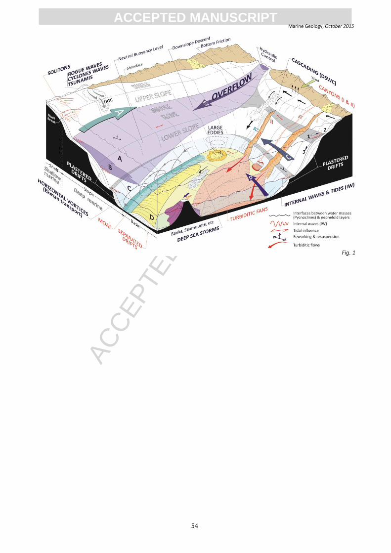
ACC
EPTE
D M
ANU
SCR
IPT
ACCEPTED MANUSCRIPTMarine Geology, October 2015
54
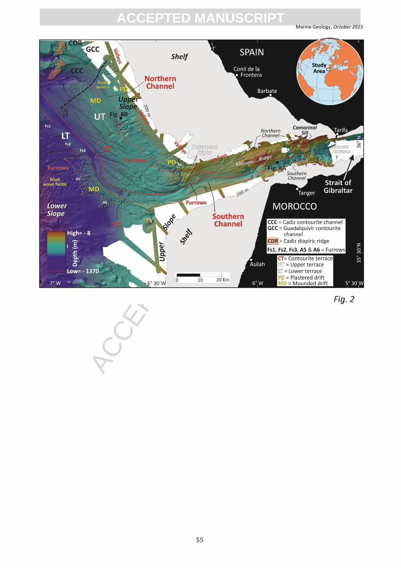
ACC
EPTE
D M
ANU
SCR
IPT
ACCEPTED MANUSCRIPTMarine Geology, October 2015
55

ACC
EPTE
D M
ANU
SCR
IPT
ACCEPTED MANUSCRIPTMarine Geology, October 2015
56
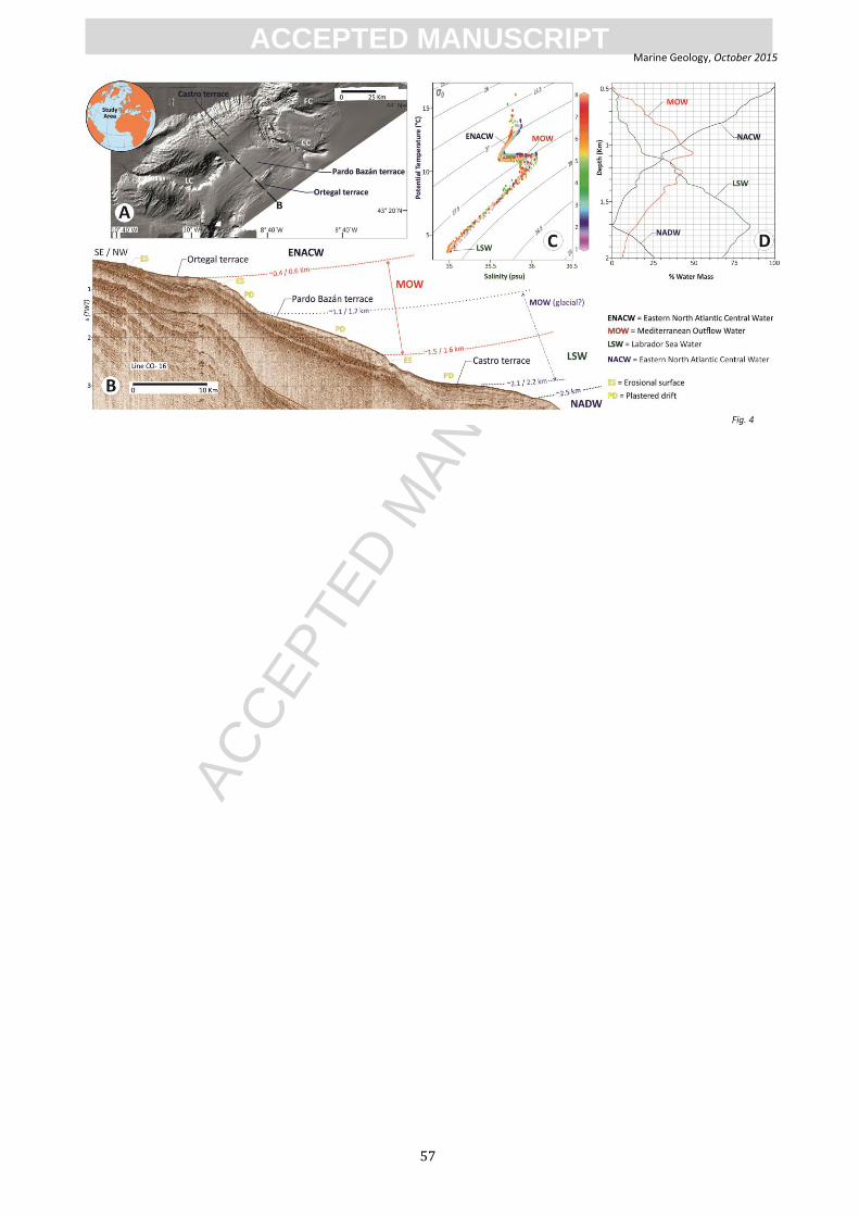
ACC
EPTE
D M
ANU
SCR
IPT
ACCEPTED MANUSCRIPTMarine Geology, October 2015
57

ACC
EPTE
D M
ANU
SCR
IPT
ACCEPTED MANUSCRIPTMarine Geology, October 2015
58

ACC
EPTE
D M
ANU
SCR
IPT
ACCEPTED MANUSCRIPTMarine Geology, October 2015
59
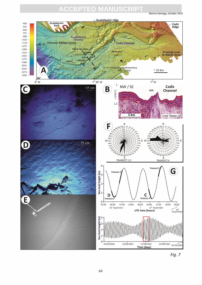
ACC
EPTE
D M
ANU
SCR
IPT
ACCEPTED MANUSCRIPTMarine Geology, October 2015
60

ACC
EPTE
D M
ANU
SCR
IPT
ACCEPTED MANUSCRIPTMarine Geology, October 2015
61
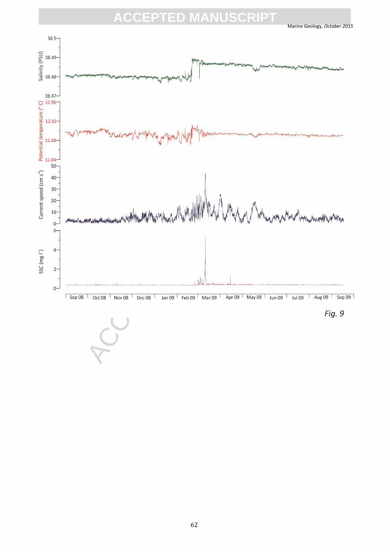
ACC
EPTE
D M
ANU
SCR
IPT
ACCEPTED MANUSCRIPTMarine Geology, October 2015
62

ACC
EPTE
D M
ANU
SCR
IPT
ACCEPTED MANUSCRIPTMarine Geology, October 2015
63

ACC
EPTE
D M
ANU
SCR
IPT
ACCEPTED MANUSCRIPTMarine Geology, October 2015
64

ACC
EPTE
D M
ANU
SCR
IPT
ACCEPTED MANUSCRIPTMarine Geology, October 2015
65

ACC
EPTE
D M
ANU
SCR
IPT
ACCEPTED MANUSCRIPTMarine Geology, October 2015
66

ACC
EPTE
D M
ANU
SCR
IPT
ACCEPTED MANUSCRIPTMarine Geology, October 2015
67

ACC
EPTE
D M
ANU
SCR
IPT
ACCEPTED MANUSCRIPTMarine Geology, October 2015
68

ACC
EPTE
D M
ANU
SCR
IPT
ACCEPTED MANUSCRIPTMarine Geology, October 2015
69

ACC
EPTE
D M
ANU
SCR
IPT
ACCEPTED MANUSCRIPTMarine Geology, October 2015
70
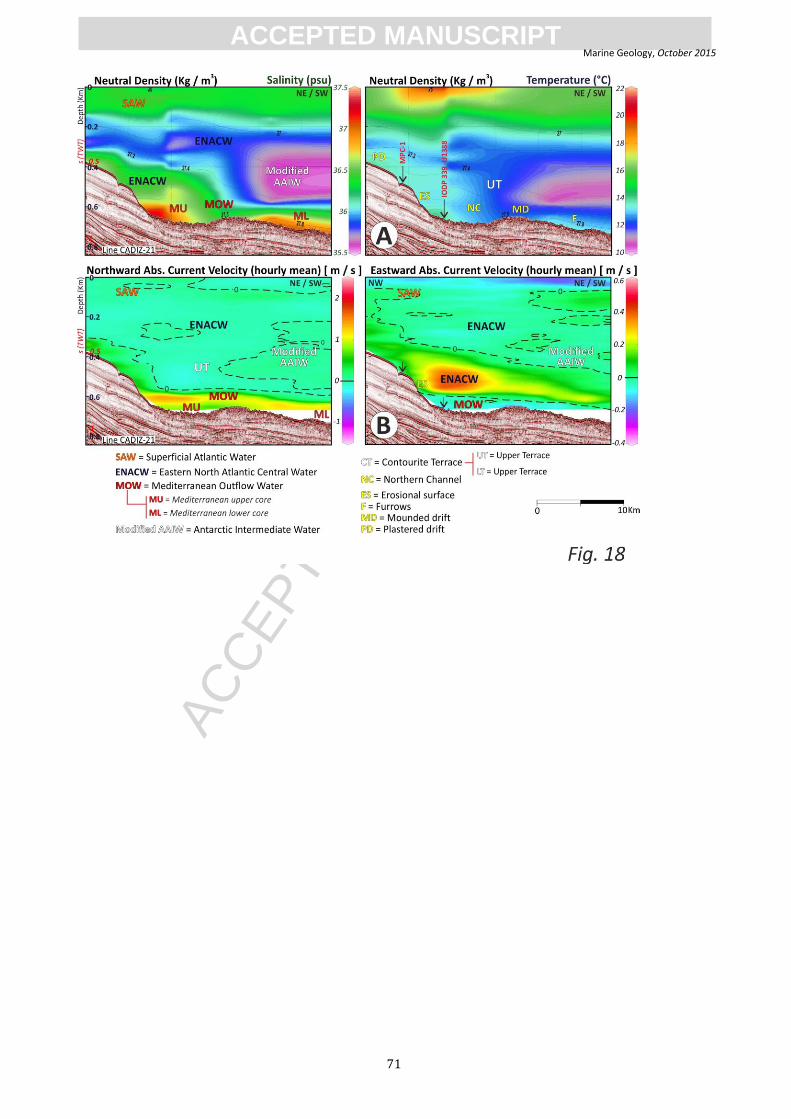
ACC
EPTE
D M
ANU
SCR
IPT
ACCEPTED MANUSCRIPTMarine Geology, October 2015
71

ACC
EPTE
D M
ANU
SCR
IPT
ACCEPTED MANUSCRIPTMarine Geology, October 2015
72
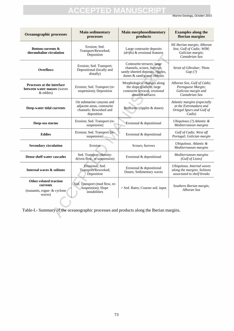
ACC
EPTE
D M
ANU
SCR
IPT
ACCEPTED MANUSCRIPTMarine Geology, October 2015
73
Oceanographic processes Main sedimentary
processes Main morphosedimentary
products Examples along the
Iberian margins
Bottom currents & thermohaline circulation
Erosion; Sed. Transport/Reworked;
Deposition
Large contourite deposits (drifts) & erosional features
NE Iberian margin; Alboran Sea; Gulf of Cadiz; WIM;
Galician margin; Cantabrian Sea
Overflows
Erosion; Sed. Transport; Depositional (locally and
distally)
Contourite terraces; large channels, scours, furrows;
sandy-sheeted deposits, ripples, dunes & sand/gravel ribbons
Strait of Gibraltar; Theta Gap (?)
Processes at the interface
between water masses (waves & eddies)
Erosion; Sed. Transport (re-suspension); Deposition
Morphological changes along the slope gradient; large
contourite terraces, erosional abraded surfaces
Alboran Sea, Gulf of Cádiz; Portuguese Margin; Galician margin and
Cantabrian Sea
Deep-water tidal currents
On submarine canyons and adjacent areas, contourite channels: Reworked and
deposition
Bedforms (ripples & dunes)
Atlantic margins (especially at the Extremadura and
Ortegal Spurs and Gulf of Cadiz)
Deep-sea storms Erosion; Sed. Transport (re-
suspension) Erosional & depositional
Ubiquitous (?).Atlantic & Mediterranean margins
Eddies Erosion; Sed. Transport (re-
suspension) Erosional & depositional
Gulf of Cadiz; West off Portugal; Galician margin
Secondary circulation Erosion Scours; furrows Ubiquitous. Atlantic & Mediterranean margins
Dense shelf water cascades Sed. Transport (density-
driven flow, re-suspension) Erosional & depositional
Mediterranean margins (Gulf of Lions)
Internal waves & solitons
Erosional; Sed. Transport/Reworked;
Deposition
Erosional & depositional Dunes; Sedimentary waves
Ubiquitous. Internal waves along the margins. Solitons associated to shelf breaks
Other-related traction currents
(tsunamis, rogue- & cyclone waves)
Sed. Transport (mud flow, re-suspension); Slope
instabilities > Sed. Rates; Coarser sed. input
Southern Iberian margin, Alboran Sea
Table-I.- Summary of the oceanographic processes and products along the Iberian margins.
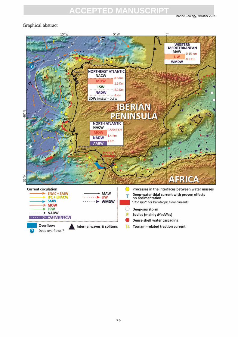
ACC
EPTE
D M
ANU
SCR
IPT
ACCEPTED MANUSCRIPTMarine Geology, October 2015
74
Graphical abstract
ACC
EPTE
D M
ANU
SCR
IPT
ACCEPTED MANUSCRIPTMarine Geology, October 2015
75
Highlights
Knowledge of bottom-currents and associated processes is rapidly evolving.
Deep-water processes generate depositional and erosional features.
Interfaces between water masses control the contourite terraces development on slopes.
Contourites deposits exhibit greater variation than the established facies model.
A new multidisciplinary approach in future contourite research is needed.