Embed Size (px)
Citation preview

March 7, 2013
Attoyac Bayou Watershed Protection Plan Sarah Fuller, SFASU
Arthur Temple College of Forestry
1

Used to assess the physical, chemical, biological, and economic factors affecting attainment of water body use
Identify and assign attainable uses and criteria to water bodies
Ultimate purpose is to establish the most suitable water quality standard for individual bodies of water taking into consideration its unique features
2

Pre 2010 standards Two recreational categories
Primary contact Non-contact
2010 water quality standard revisions 4 categories of water quality contact and standards
Primary contact recreation – 126 (colonies/100ml)
Secondary contact recreation 1 – 630 (colonies/100ml)
Secondary contact recreation2 – 1,030 (colonies/100ml)
Non-contact recreation – 2,060 (colonies/100ml)
3

Primary contact recreation Recreation involving a significant risk of ingestion of
water
4

Secondary contact recreation 1 Recreation with limited incidental body contact not
involving a significant risk of water ingestion
5

Secondary contact recreation 2 Recreation activities with limited incidental body
contact not involving a significant risk of water ingestion but that occur less frequently than for secondary contact recreation 1 due to (a) physical characteristics of the water body and/or (b) limited public access
6
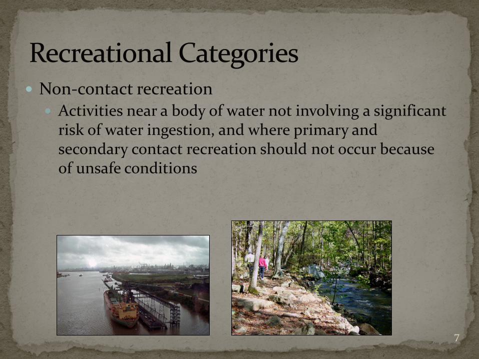
Non-contact recreation Activities near a body of water not involving a significant
risk of water ingestion, and where primary and secondary contact recreation should not occur because of unsafe conditions
7

Forty-four (44) sites were selected for the Attoyac Bayou comprehensive RUAA survey 36 sites : public access
1 public location, landowner retracted permission 8 sites : private property
Conducted during a warm season (temp >70°), during
dry weather flows Survey 1: July 20-22, 2012 Survey 2: August 24-25, 2012
8

9
November 28, 1975 to the present day Historical societies, community members, museums,
government officials, newspapers, recreational service providers, as well as general internet searches regarding the watershed.
10
East Texas Research Center – Ralph W. Steen Library Final Environmental Impact Statement: Attoyac Bayou
Watershed, 1980 “Recreational needs for the northern Nacogdoches County
towns of Garrison, Cushing, and Appleby are not being met because of an uneven distribution of the surface water and water-based recreational facilities…(p 38).”
Newspapers Austin American-Statesman, July 18, 2010
“Using the Old Noodle” The Houston Chronicle, December 12, 1997
“Tips on Finding Bass in the Cold” The Houston Chronicle, March 6, 2008
“Lone Star Anglers Can Cash in Big During the Spawning Season for White Bass”
11

Online blogger and Nacogdoches resident documented canoeing the Attoyac
Photo courtesy of Roberta at: http://myadventuresinsanaugustine.blogspot.com/ 12
13
Evidence collected during interviews confirm that swimming does occasionally occur within the watershed, primarily within the Attoyac Bayou. 2 State Game Wardens through direct observation Shelby County official through word of mouth Landowner confirmed swimming in Attoyac within past 10
years Also familiar with a swimming hole popular from 1970s – 1990s
near community of Black jack Another landowner confirmed swimming in Naconiche
(adults and children) from 1982-1999
State Game Wardens also confirm that noodling occurs periodically Areas between Highway 103 and 21 as well as Highway 7

112 interview forms were distributed through the mail 7 returned
Interviews also conducted by phone 35 formal interviews conducted Most common use attributed to fishing, hunting, and
agricultural use
14

Primary contact recreation was infrequent, secondary and non-contact recreation are noted to occur more often.
Public access to water bodies is limited to public road crossings
Based on interviews and signs observed during field surveys, Attoyac 18 (Hwy 21), Attoyac 15 (Hwy 7), and Attoyac 7 (US 59) road crossings of the Attoyac Bayou appear to be the most publically accessed sites.
15

Mounted on trees or existing structures in plain view of the public at the ten (10) Attoyac Bayou Watershed water quality monitoring sites.
Rotated on a weekly basis in order for each site to be monitored for an equal amount of time.
Captured multiple instances of secondary contact recreation
16

Attoyac at Highway 7 (Attoyac 15)
17

Attoyac at Highway 59 (Attoyac 7)
18
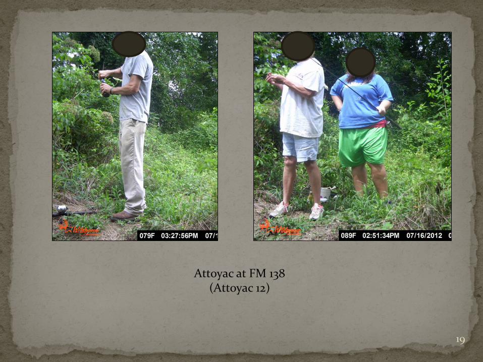
Attoyac at FM 138 (Attoyac 12)
19

Attoyac at Highway 21 (Attoyac 18)
20

Naconiche at FM 95 (Naconiche 11)
21

West at FM 2913 (West 6)
22

Stream parameters Width,depth Flow status Air, water temperature Riparian zone categories Recreational Indicators Direct observation Secondary observation
23

No recreational activities were directly observed at any of the 44 sites by SFASU and CES staff.
Potential indicators of recreation were present at multiple sites.
Naconiche at Cedar Bluff Road (CR 273)
Naconiche 8 Naconiche at Highway 59
(Naconiche 6) Attoyac at Highway 59
(Attoyac 7) 24

Attoyac Bayou Attoyac 4 (FM 1971), Survey 2: A crocheted blanket
spread out on the stream bank next to the bridge crossing with an animal carcass lying on top of it.
Attoyac 7 (US 59), Survey 1 & 2: Evidence of fishing as well as general loitering was observed in the form of bait containers, discarded fishing line, beer bottles/cans, soda cans, and plastic bags full of refuse. Observed on the bank during Survey 2 was the carcass of an alligator gar on a fish stringer.
25

26

Attoyac 7 (US 59) 27

Attoyac 12 (FM 138), Survey 2: Human foot prints observed along the stream bank underneath the bridge crossing. Also present under the bridge crossing was graffiti.
Attoyac 15 (Hwy 7), Survey 2: Human foot prints were observed along the bank underneath the bridge crossing.
Attoyac 17 (CR 392), Survey 1: A trot line attached to a tree and stretched across the stream channel was present.
28

Attoyac 12 (FM 138)
29

Attoyac 15 (Hwy 7)
30

Attoyac 17 (CR 392)
31

Big Iron Ore Big Iron Ore 3 (FM 711), Survey 2: Boot prints were
observed along the stream bank.
32

Big Iron Ore 3 (FM 711)
33

Naconiche Creek Naconiche 6 (US 59), Survey 1 & 2: ATV tracks present
during both surveys underneath Farm to Market (FM) 2435 road crossing.
Naconiche 8 (Cedar Bluff Rd.), Survey 1 & 2: Bait net was present in the stream channel, and further downstream a defunct trotline/set hook was attached to a tree and hanging in the stream. A live bait container (worms) was present on the bank next to the public bridge crossing during Survey 2.
34

Naconiche 6 (US 59),
35

Naconiche 8 (Cedar Bluff Rd.)
36

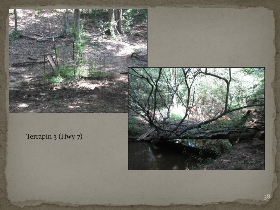
Terrapin Creek Terrapin 3 (Hwy 7), Survey 1: Animal trap present on
left bank, and further downstream a defunct wooden bridge was found across the stream.
Terrapin 4 (FM 95), Survey 2: Along the right stream bank, field staff observed a beech tree in which initials had been carved into the bark.
37
Terrapin 3 (Hwy 7)
38

Terrapin 4 (FM 95)
39

West Creek West 6 (FM 2913), Survey 1: Hammock observed
attached to a tree located along the stream bank.
40

West 6 (FM 2913)
41

Attoyac 2 (CR 3122) Attoyac 8 (CR 294)
Attoyac 9 (Private) Naconiche 6 (Hwy 59) 42

Attoyac 6 (CR 4760) Attoyac 2 (CR 3122)
Naconiche 9 (CR 280) West 1 (CR 4054) 43

West 3 (FM 138) Naconiche 11 (FM 95)
Naconiche 10 (Private) Attoyac 6 (CR 4760)
44

Attoyac 3 (CR 3181) Big Iron Ore 4 (Logging Road)
Waffelow 3 (FM 95) Attoyac 4 (FM 1971) 45

Rural nature and private land ownership
Woody debris, logjams, overgrown banks
Low flow in many areas Wildlife
46

No recreation (primary or secondary) was directly observed during field work
Evidence of recreation was observed at ten (10) of the forty-three (43) survey sites All indicative of secondary or non contact recreation in
the form of fishing or bank-based activities. Game camera documentation of secondary recreation
at six(6) sites Interviews with landowners and community members
indicate sporadic incidences of primary contact recreation Fishing and hunting most common
47

Questions?
Sarah Fuller, Graduate Research Assistant,
Arthur Temple College of Forestry and Agriculture [email protected]
48


![Bayou Queue de Tortue Watershed Implementation Plan€¦ · [bayou queue de tortue watershed implementation plan ] 2013 ii contents 1. introduction 1 2. usepa’s nine key elements](https://img.pdfslide.us/doc/110x75/605b26b89a096825716ed3df/bayou-queue-de-tortue-watershed-implementation-plan-bayou-queue-de-tortue-watershed.jpg)