Embed Size (px)
Citation preview

MAPPING EARTH

Physical maps
• Different colors, lines, tints, shading and spot elevations are used to show the elevation and to differentiate lowlands from the mountains• Colors are used to distinguish landforms and
elevations • The features that make up earth`s surface are
called landforms• some examples of landforms are plains,
plateaus, and plateaus• Some physical maps show elevation

globes
•A globe is a spherical representation of the earth
•When you look at a globe you can see the way the world looks
• Globe categories: terrestrial and celestial
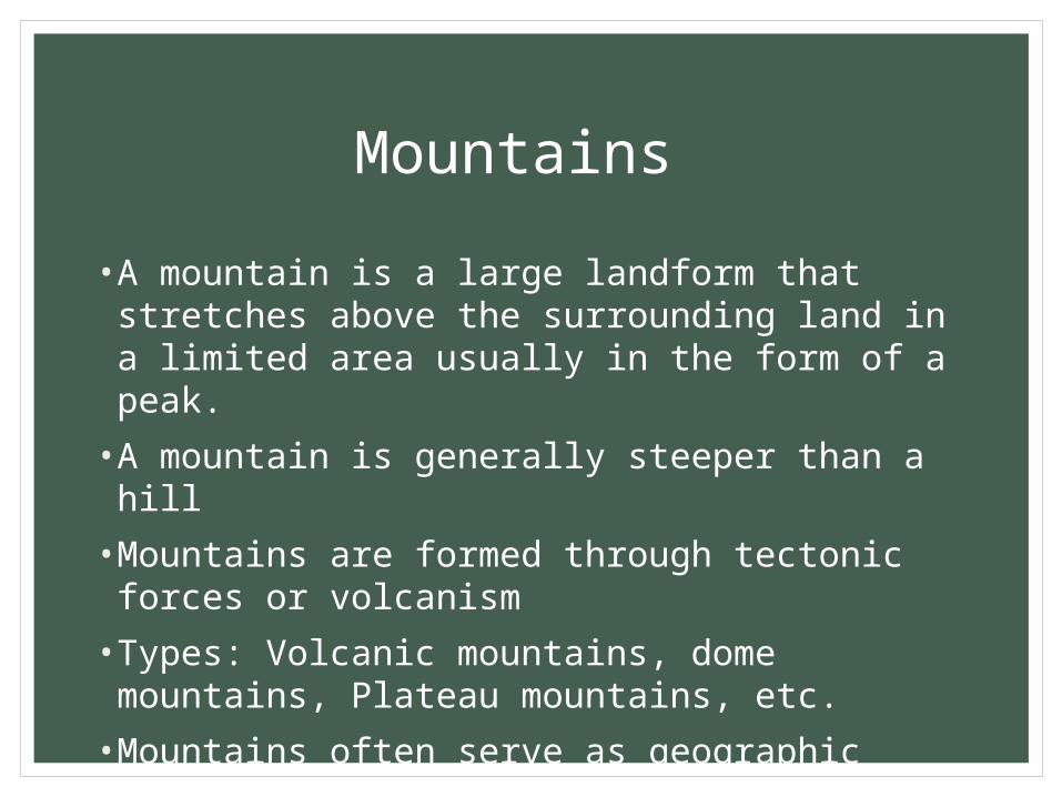
Contour/topographical maps
• A topographic map is a type of map characterized by large-scale detail and quantitative representation of relief
• usually using contour lines
• detailed and accurate graphic representation of cultural and natural features on the ground

Political maps
• Designed to show governmental boundaries of countries, states, and counties, the location of major cities
• Usually include significant bodies of water
• Bright colors are usually used to help you find the borders

Physical features
• Plateaus
• Seas
• Mountains
• Oceans
• Islands
• Rivers
• Plains
• Lakes
• In the earth sciences and geology sub-fields, a landform or physical feature comprises a geomorphological unit, and is largely defined

Deserts
• Arid or dry regions that receive less than ten inches of rain per year
• Large areas with a lot of bare soil and low vegetation
• The world`s deserts cover almost one quarter of the earth`s land surface
• Receive little rainfall but when rain does fall the desert experiences a short period of great abundances

Bodies of water
• any significant accumulation of water, usually covering the Earth
• Some bodies of water are man-made
• Include: reservoirs, harbors, oceans, lakes, rivers, ponds, etc.
• Some bodies of water collect and move water
Mountains
• A mountain is a large landform that stretches above the surrounding land in a limited area usually in the form of a peak.
• A mountain is generally steeper than a hill
•Mountains are formed through tectonic forces or volcanism
• Types: Volcanic mountains, dome mountains, Plateau mountains, etc.
•Mountains often serve as geographic features that define natural borders of countries

Physical map
Political map
Topographical map

sources• http://www.mapsofworld.com/physical-map/
• http://mapas.owje.com/maps/6877_world-physical-map-2003.html
• https://en.wikipedia.org/wiki/Topographic_map
• http://www.vectortemplates.com/raster-globes.php
• http://www.jrank.org/history/pages/8346/What-Are-Different-Types-Maps-Graphs.html
• http://www.1worldglobes.com/earthglobe.htm
• http://www.encyclopedia.com/topic/globe.aspx
• http://en.wikipedia.org/wiki/Mountain
• http://science.nationalgeographic.com/science/earth/surface-of-the-earth/mountains-article/
• www.worldatlas.com/atlas/infopage/political.htm
• www.defenders.org/deserts/basic-facts

sources
• https://en.wikipedia.org/wiki/Topographic_map
• http://en.wikipedia.org/wiki/Body_of_water


![Ac3.01 [Elevations]](https://img.pdfslide.us/doc/110x75/559669fa1a28ab79128b47a1/ac301-elevations.jpg)