Embed Size (px)
Citation preview

Map of Carroll County, MD 1862 ©2014 Old Maps West Chesterfield, NH 03466 www.old-maps.com �
Map of Carroll County, Maryland �862
Edition of April 2014© Old Maps PO Box 54 West Chesterfield, NH 03466
www.old-maps.com
A complete copy of the 1862 county wall map showing the names and locations of houses, businesses, churches and schools.
To find your town, click on the name in the list below
FREEDOM - District #5FRANKLIN - District #9
HAMPSTEAD - District #8MANCHESTER - District #6
MIDDLEBURG - District #�0MYERS - District #3
NEW WINDSOR - District #��TANEYTOWN - District #�UNIONTOWN - District #2
WESTMINSTER - District #7WOOLERY - District #4

2 Map of Carroll County, MD 1862 ©2014 Old Maps West Chesterfield, NH 03466 www.old-maps.com
Modern Map of Carroll County

Map of Carroll County, MD 1862 ©2014 Old Maps West Chesterfield, NH 03466 www.old-maps.com 3
1862 Map of Carroll County
The original map is a large wall map measuring 52” x 47”. The wall map has been “taken apart” for this edition by dividing it into separate images, thus making it easy to use this map for the first time.

4 Map of Carroll County, MD 1862 ©2014 Old Maps West Chesterfield, NH 03466 www.old-maps.com
Table of Contents
Town names listed in all capital letters. Village names listed in upper and lower case letters.
Title pageModern Map of Carroll County1862 Map of Carroll County
TANEYTOWN - District #1Taneytown VillageUNIONTOWN - District #2Uniontown, Union Bridge & Frizzelburg VillagesMYERS - District #3MyersvilleWOOLERY - District #4FinksburgFREEDOM - District #5MANCHESTER - District #6Manchester VillageWESTMINSTER - District #7 Westminster & Warfieldsburg VillagesHAMPSTEAD - District #8 Hampstead VillageFRANKLIN - District #9WinfieldMIDDLEBURG - District #10Middleburg VillageNEW WINDSOR - District #11New Windsor & Mt. Vernon Villages
1862 Map of Carroll County

Map of Carroll County, MD 1862 ©2014 Old Maps West Chesterfield, NH 03466 www.old-maps.com 5
TANEYTOWN - District #1

6 Map of Carroll County, MD 1862 ©2014 Old Maps West Chesterfield, NH 03466 www.old-maps.com
Taneytown Village

Map of Carroll County, MD 1862 ©2014 Old Maps West Chesterfield, NH 03466 www.old-maps.com 7
UNIONTOWN - District #2

8 Map of Carroll County, MD 1862 ©2014 Old Maps West Chesterfield, NH 03466 www.old-maps.com
Uniontown, Union Bridge & Frizzelburg Villages

Map of Carroll County, MD 1862 ©2014 Old Maps West Chesterfield, NH 03466 www.old-maps.com 9
MYERS - District #3

�0 Map of Carroll County, MD 1862 ©2014 Old Maps West Chesterfield, NH 03466 www.old-maps.com
Myersville

Map of Carroll County, MD 1862 ©2014 Old Maps West Chesterfield, NH 03466 www.old-maps.com ��
WOOLERY - District #4

�2 Map of Carroll County, MD 1862 ©2014 Old Maps West Chesterfield, NH 03466 www.old-maps.com
Finksburg

Map of Carroll County, MD 1862 ©2014 Old Maps West Chesterfield, NH 03466 www.old-maps.com �3
FREEDOM - District #5

�4 Map of Carroll County, MD 1862 ©2014 Old Maps West Chesterfield, NH 03466 www.old-maps.com
MANCHESTER - District #6

Map of Carroll County, MD 1862 ©2014 Old Maps West Chesterfield, NH 03466 www.old-maps.com �5
Manchester Village

�6 Map of Carroll County, MD 1862 ©2014 Old Maps West Chesterfield, NH 03466 www.old-maps.com
WESTMINSTER - District #7

Map of Carroll County, MD 1862 ©2014 Old Maps West Chesterfield, NH 03466 www.old-maps.com �7
Westminster & Warfieldsburg Villages

�8 Map of Carroll County, MD 1862 ©2014 Old Maps West Chesterfield, NH 03466 www.old-maps.com
HAMPSTEAD - District #8

Map of Carroll County, MD 1862 ©2014 Old Maps West Chesterfield, NH 03466 www.old-maps.com �9
Hampstead Village

20 Map of Carroll County, MD 1862 ©2014 Old Maps West Chesterfield, NH 03466 www.old-maps.com
FRANKLIN - District #9

Map of Carroll County, MD 1862 ©2014 Old Maps West Chesterfield, NH 03466 www.old-maps.com 2�
Winfield
22 Map of Carroll County, MD 1862 ©2014 Old Maps West Chesterfield, NH 03466 www.old-maps.com
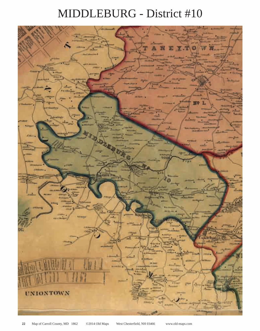
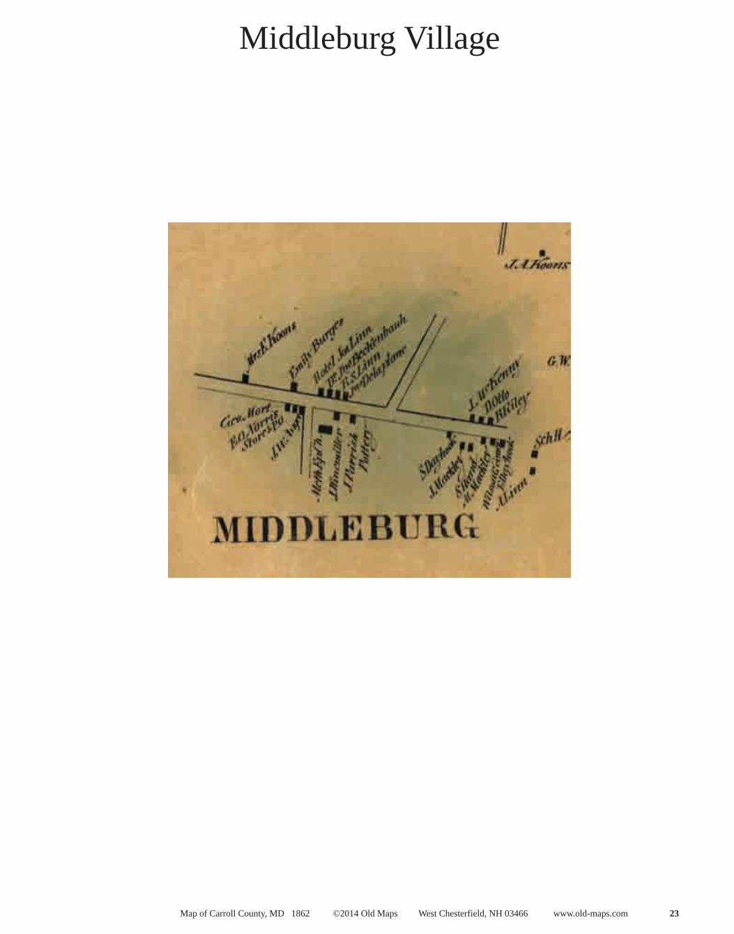
MIDDLEBURG - District #10
Map of Carroll County, MD 1862 ©2014 Old Maps West Chesterfield, NH 03466 www.old-maps.com 23
Middleburg Village

24 Map of Carroll County, MD 1862 ©2014 Old Maps West Chesterfield, NH 03466 www.old-maps.com
NEW WINDSOR - District #11

Map of Carroll County, MD 1862 ©2014 Old Maps West Chesterfield, NH 03466 www.old-maps.com 25
New Windsor & Mt. Vernon Villages

26 Map of Carroll County, MD 1862 ©2014 Old Maps West Chesterfield, NH 03466 www.old-maps.com
1858 Map of Carroll County