Embed Size (px)
DESCRIPTION
Managing Dry Forest Northern Spotted Owl Habitat: The Beginnings of a Landscape Approach Jerry Franklin Norm Johnson. Lack of action to reduce likelihood of uncharacteristic fire. - PowerPoint PPT Presentation
Citation preview

Managing Dry Forest Northern Spotted Owl Habitat: The Beginnings of a Landscape Approach
Jerry FranklinNorm Johnson


Lack of action to reduce likelihood of uncharacteristic fire


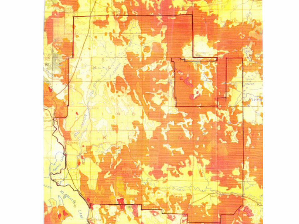
Forest Service Land Allocation
Klamath Reservation
0 5 10 15 202.5
Miles
£¤97
Crater Lake
UpperKlamathLake
KlamathMarsh
Chiloquin
Klamath Falls
Bonanza
AgencyLake
William
so
n River
Sy
can Rive r
Yamsay Mtn.
Solomon Butte
Saddle Mtn.C
hi loqu in Rid
ge
Calimus Butte
Fuego Mtn.
Bly Mtn.
Wil liamson River
Fort Klamath
Wood Rive
r
Seven M
ile Cr e
e
k
Lost Riv er
Beatty
North Fo rk S
pra
gue Riv e r
South Fork Sprague River
Bly
Swan Lake Po int
SycanMarsh
Sy can Riv erKirk
S p ra
gue Rive r
Four Mile C r eek
Sprague Ri v er
Reservation Boundary
Streams
Highways
Timber Production
Old Growth
Special Management
Upper Williamson Management Area
Special Rec.; Yamsay Mtn.
Developed Recreation
Scenic Management
Research Natural Areas
Timber Production in Matrix (NWFP)
Late Successional Reserves (NWFP)
Sycan Wild and Scenic River
Riparian Areas
Bald Eagle Habitat
Big Game Winter Range
Map 6
º


Habitat Types Acres (thous)
PP/SAGE 16
PP/BTBR 360
MC/SNBR 89
Moist MC 40
LP 118
Total 622

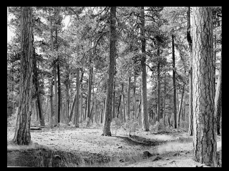
Major goal: Move as much of the forest as possible toward a structurally complex ponderosa pine and mixed conifer forest as rapidly as possible, while recognizing tribal interests in increased habitat for deer and elk and other wildlife and fish and other values.
Components include: 1) large trees, 2) a spatially complex pattern of stand structural units (large tree groves and patches of dense regeneration, 3) coarse wood (snags and down logs), and 4) a well developed understory community of herbs and shrubs.
From: Interforest Report


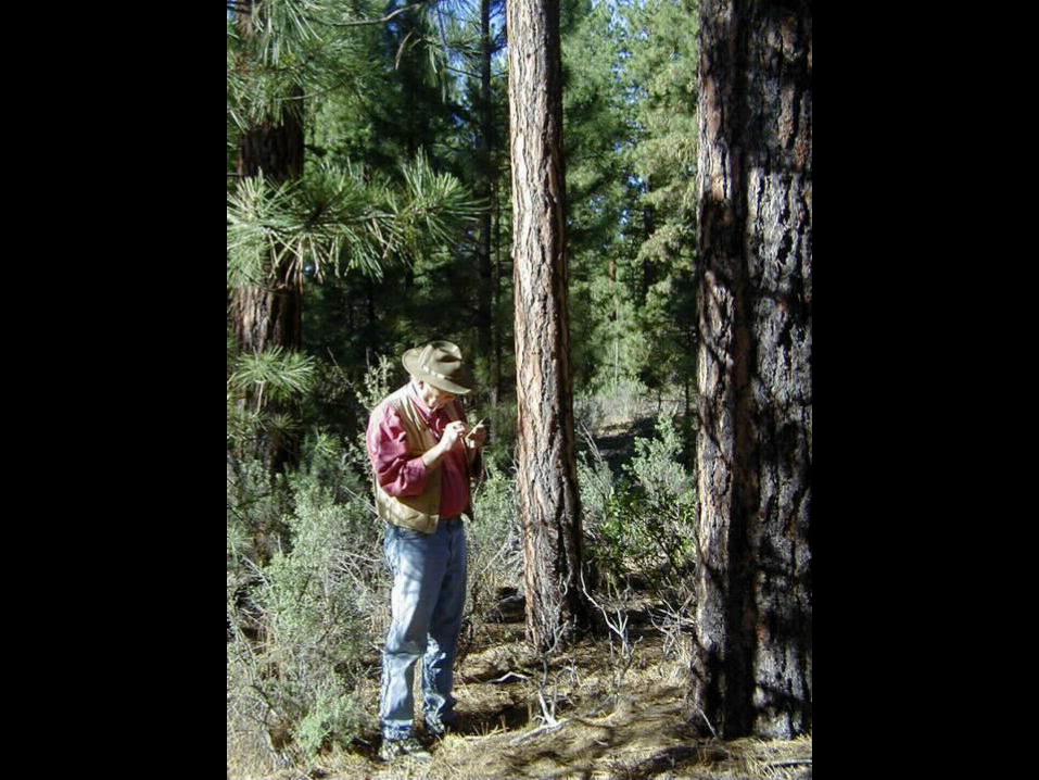
Harold Weaver scaling logs on Ya Whee Plateau, 1929.

“This stand near Badger Creek, Warm Springs Indian Reservation, Oregon, is typical of vast areas of the ponderosa-pine region, where, as a result of total fire exclusion, dense even-aged stands of Douglas-fir reproduction are monopolizing the ground under the mature ponderosa pine.”
Weaver, Harold. 1943. Fire as an ecological and silvicultural factor in the ponderosa pine region of the Pacific Slope. Jour. Forestry 41:7-15.

“It is obvious that the present policy of attempting complete protection of ponderosa-pine stands from fire raises several very important problems.
If ponderosa-pine is desired on vast areas how, unless fire is employed, can other species such as white fir be prevented from monopolizing the ground?
Even with unlimited funds, personnel, and equipment, can they give reasonable assurance that they can continue to keep such extremely hazardous stands from burning up?”
Weaver, Harold. 1943. Fire as an ecological and silvicultural factor in the ponderosa pine region of the Pacific Slope. Jour. Forestry 41:7-15.

“The present deplorable and increasingly critical conditions in vast areas of the region are proof that foresters have not solved the silvicultural problems of ponderosa pine, and to continue present policies will further aggravate an already serious situation.
This article represents the author’s views only and is not to be regarded in any way as an expression of the attitude of the Indian Service on the subject discussed.”
Weaver, Harold. 1943. Fire as an ecological and silvicultural factor in the ponderosa pine region of the Pacific Slope. Jour. Forestry 41:7-15.

Harold Weaver in prescribed burn area, 1958

Historical Fire Regimes for Forested Potential Vegetation Groups
Klamath Reservation
º0 5 10 15 202.5
Miles
£¤97
Crater Lake
UpperKlamathLake
Chiloquin
Klamath Falls
Bonanza
AgencyLake
Wood Riv
e
r
Seven M
ile Cre
e k
Lost Riv er
Four Mile C re
ek
Lethal
Mixed
Nonlethal
Rarely
KlamathMarsh
Source: Interior Columbia Basin Ecosystem Management Project. 1996. http://www.icbemp.gov/spatial/disturbance/
Map 3a
Reservation Boundary
Streams
HighwaysSycanMarsh

Current Fire Regimes for Forested Potential Vegetation Groups
Klamath Reservation
º0 5 10 15 202.5
Miles
£¤97
Crater Lake
UpperKlamathLake
Chiloquin
Klamath Falls
Bonanza
AgencyLake
Wood Riv
e
r
Seven M ile Cre
e k
Lost Riv er
Four Mile C re
ek
Mixed
Nonlethal
Rarely
Lethal
KlamathMarsh
Source: Interior Columbia Basin Ecosystem Management Project. 1996. http://www.icbemp.gov/spatial/disturbance/
Reservation Boundary
Streams
Highways
Map 3b
SycanMarsh

Current Condition by Historical Natural Fire Regime
Klamath Reservation
Map 1
Reservation Boundary
º
0-35 yrs; Condition Class 1
0-35 yrs; Condition Class 2
0-35 yrs; Condition Class 3
200+ yrs; Condition Class 1
200+ yrs; Condition Class 2
200+ yrs; Condition Class 3
35-100+ yrs; Condition Class 1
35-100+ yrs; Condition Class 2
35-100+ yrs; Condition Class 3
Agriculture & Non-Vegetative Areas
Water
Source: Fire Sciences Laboratory, Rocky Mountain Research Station. 2001. http://www.fs.fed.us/fire/fuelman/
0 5 10 15 202.5
Miles

Year Acres Tot PP SP WF OS
1910 647 14.4 13.7 .14 .45 .07
% 95 1 3 1
2006 522 .9 8.3 .44 2.0 .84
% 69 4 17 7
Historical comparison of PP/MC
Total volume 2006: 6.26 billionAnnual growth: 95 million (55 pp, 5 sp, 23 wf, 10 lp)
Growth % 1.4 3.0 2.7 3.31910 est from Wilcox and Mezger 1954.

Source Habitat Type
BA<21”-----Per
BA >21”Acre-----
# Trees------
Lake (Mung 1917) PP 30 71 15
Bluejay Springs PP/BT 37 63 15
Wildhorse PP/BT 38 54 13
Metolius (YB) PP/BT 62 14
Pringle (YB) PP/BT 63 15
Mt Scott (1916) PP+MC 9 68 11PP2 OT
Reference Conditions

Source Habitat Type
BA <21”----------Per
BA >21”Acre------- ------
Lamath (Mung 1917)
MC 29 94 15 PP4 OT

Habitat Typesand Inventory Plot Types
Klamath Reservation
º
Reservation Boundary
Streams
Highways
£¤97
0 5 10 15 202.5
Miles
Mixed Conifer/Snowbrush Low Stock
Mixed Conifer/Snowbrush Simplified
Mixed Conifer/Snowbrush Remnant
Mixed Conifer/Snowbrush Complex
Ponderosa Pine/Bitterbrush Low Stock
Ponderosa Pine/Bitterbrush simplified
Ponderosa Pine/Bitterbrush Remnant
Ponderosa Pine/Bitterbrush Complex
Ponderosa Pine/Sagebrush Simplified
Ponderosa Pine/Sagebrush Remnant
Moist Mixed Conifer Simplified
Moist Mixed Conifer Remnant
Moist Mixed Conifer Complex
Lodgepole pine
Other
Map 10

Habitat Type
TotBA
TotBA <21 # >21 # >32
Acres(M)
PP/BTDFCAveComplexRemnantSimplif
70-95881049771
20-3066557069
>125.4127.1.5
>21.1310
3765823070
MCDFCAveComplexRemnant
100-120121150116
30-40818682
>1591510
>3242
912163


Progression of thought on complex (old growth) forest:
1) Leave complex largely along in first 10 years (no commercial entries); focus on simplified stands
2) Allow commercial entry into mixed conifer
3) Allow commercial entry into all complex
4) Make treatments in complex a top priority
.

Habitat Typeswith Complex Forest
Klamath Reservation
º0 5 10 15 202.5
Miles
Reservation Boundary
Streams
Highways
£¤97
Crater Lake
UpperKlamathLake
KlamathMarsh
Chiloquin
Klamath Falls
Bonanza
AgencyLake
Will i
amson River
S
ycan River
Bl y Mtn.
W illiamson Riv er
Wood R
iver
Seve
n Mil e Creek
Lost Riv er
Beatty
North Fo rk Spra gu e R
iver
South F ork Sprague RiverBly
Sycan Marsh
S y can R iverKirk
S
prague R iver
Four Mile C r eek
Sprague Rive r
Habitat Types
Ponderosa pine/bitterbrush
Ponderosa pine/sagebrush
Mixed conifer/snowbrush
White fir
Wet meadow
Dry meadow
Moist shrubland
Dry shrubland
Juniper
Sagebrush
No vegetation
No data
Marginal site and high elevation lodgepole pine
Moist and wet lodgepole pine
Lodgepole pine/bitterbrush
Moist mixed conifer
Map 4

Forest Service Land Allocation
Klamath Reservation
0 5 10 15 202.5
Miles
£¤97
Crater Lake
UpperKlamathLake
KlamathMarsh
Chiloquin
Klamath Falls
Bonanza
AgencyLake
William
so
n River
Sy
can Rive r
Yamsay Mtn.
Solomon Butte
Saddle Mtn.C
hi loqu in Rid
ge
Calimus Butte
Fuego Mtn.
Bly Mtn.
Wil liamson River
Fort Klamath
Wood Rive
r
Seven M
ile Cr e
e
k
Lost Riv er
Beatty
North Fo rk S
pra
gue Riv e r
South Fork Sprague River
Bly
Swan Lake Po int
SycanMarsh
Sy can Riv erKirk
S p ra
gue Rive r
Four Mile C r eek
Sprague Ri v er
Reservation Boundary
Streams
Highways
Timber Production
Old Growth
Special Management
Upper Williamson Management Area
Special Rec.; Yamsay Mtn.
Developed Recreation
Scenic Management
Research Natural Areas
Timber Production in Matrix (NWFP)
Late Successional Reserves (NWFP)
Sycan Wild and Scenic River
Riparian Areas
Bald Eagle Habitat
Big Game Winter Range
Map 6
º

Proposed Management Emphasis
withManagement Reference Sites
Klamath Reservation
º0 5 10 15 202.5
Miles
£¤97
Crater Lake
UpperKlamathLake
KlamathMarsh
Chiloquin
Klamath Falls
Bonanza
AgencyLake
Wil liamso
n River
Sy can Ri ver
Yamsay Mtn.
Solomon Butte
Saddle Mtn.
Chil oquin Ridg
e
Calimus Butte
Fuego Mtn.
Bly Mtn.
Williamson River
Fort Klamath
Black Hil ls
Boundary Butte
Wood Rive
r
Seven M
ile Cr ee
k
Lost Riv er
Beatty
North Fo rk S
pr
ague Riv e r
South For k Sprague River
Bly
Swan Lake Point
Sycan Marsh
Sy can RiverKirk
S p ra
gue Rive r
Four Mile C r eek
Sprague Ri v er
13 14 96
4
115 17
5
7
316
1211
8
10
Reservation Boundary
Streams
Highways
Reference Area1
Map 7
18
2
Forest Restoration Areas
Sycan Wild and Scenic River
Bald Eagle Habitat
Riparian Areas
Wet Lodgepole
Marginal Site and High Elevation Lodgepole
Lodgepole Pine/Bitterbrush
Complex Forest
Research Natural Area
Mule Deer Winter Range
Rocky Ford Reserve
Yamsay Mtn. Special Area

Restoration UnitsKlamath Reservation
º0 5 10 15 202.5
Miles
Crater Lake
UpperKlamathLake
AgencyLake
Reservation Boundary
Streams
Highways
Sycan Marsh

1) NSOs and prey need areas of denser forest with shade-tolerant component for NRF habitat. A working hypothesis for these denser areas:
a) Large patches (perhaps 300 acres in size) occupying in aggregate perhaps 30% of landscape
b) Retain on moister, steeper parts of landscape where envir conditions most likely to have encouraged them under natural regime
c) Include limited fuel reduction to improve survival of old growth trees within them
d) These habitat islands can exist and function within a landscape treated to reduce stand density to reduce the potential for large scale stand replacement fire and compet pressure on old trees.
.

2) Key elements of matrix treatmenta) Silvicultural treatments focus on returning
stands to something approaching HRV in basal area and stand structure
b) Start by treating areas around old growth trees
c) Small patches (1-20 acres) of dense forest structure would be retained within the matrix for NSO and to help ensure that shade-tolerant seed source/component is not lost.
3) This restoration strategy (owl islands in a restored matrix) should be planned at the level of large natural landscape units (e.g. 10-20 M acres)
4) Developing a credible adaptive mgt. strategy will be critical both scientifically and politically given the scale of what would be proposed.
Spatially coor treatment blocks to break up fire spread
.

4) South Chiloquin block of Winema NF a good place to start (approx 50,000 acres)
a) Mostly mixed conifer habitat typesb) Little harvest or wildfire in the last decadec) Retains significant old tree legacyd) Has significant fuel loadingse) Has had a few owl activity centersf) Designated as matrix in NWFP, except for designated old growth areas in Forest Plang) Largely roaded h) Contains significant revenues to offset treatment costs
.

South Chiloquin
Klamath Reservation
º0 0.8 1.6 2.4 3.20.4
Miles
Reservation Boundary
Streams
Highways
North Facing
0-10%
11-35%
> 35%

South Chiloquin
Klamath Reservation
º0 0.8 1.6 2.4 3.20.4
Miles
Reservation Boundary
Streams
Highways
North Facing
0-10%
11-35%
> 35%
ONRC Roadless Areas

South Chiloquin
Klamath Reservation
º0 0.8 1.6 2.4 3.20.4
Miles
Reservation Boundary
Streams
Highways
North Facing
0-10%
11-35%
> 35%
ONRC Roadless Areas
Old Growth

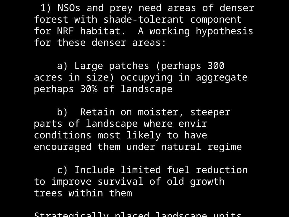
1) NSOs and prey need areas of denser forest with shade-tolerant component for NRF habitat. A working hypothesis for these denser areas:
a) Large patches (perhaps 300 acres in size) occupying in aggregate perhaps 30% of landscape
b) Retain on moister, steeper parts of landscape where envir conditions most likely to have encouraged them under natural regime
c) Include limited fuel reduction to improve survival of old growth trees within them
Strategically placed landscape units to break up fire-spread)
.