Embed Size (px)
Citation preview
Winter 2012
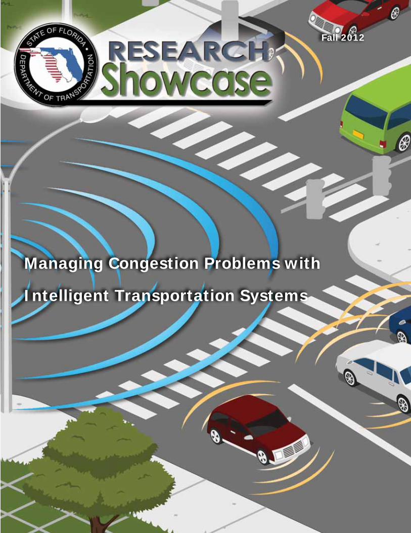
Managing Congestion Problems with
Intelligent Transportation Systems
Fall 2012
The Florida Department of Transportation (FDOT) Research Showcase is published to provide information regarding the benefi ts of FDOT-funded research.
Managing EditorDarryll Dockstader
Editor/WriterVicki MorrisonCharles Brown
Graphic DesignVicki MorrisonCharles Brown
PrinterGandy Printers
Front and Back Cover Atkins North America
GovernorRick Scott
Secretary of TransportationAnanth Prasad, P.E.
ContactFDOT Research Center605 Suwannee Street, MS 30Tallahassee, FL 32399-0450Phone (850) 414-4615 http://www.dot.state.fl .us/research-center/
Fall 2012
FDOT Research Showcase
Managing Traffi c Congestion with Intelligent Transportation Systems 4
STEWARD: FDOT’s Central Data Warehouse for ITS Data 8
Truck Parking: ITS Detects Parking Availability, Improves Safety 10
Meet the Project Manager: Arun Krishnamurthy 12
Meet the Principal Investigator: Lily Elefteriadou 13
Ramp Signals Regulate Traffi c Flow 14
For More Information 15
Contents
FDOT Research Showcase 3
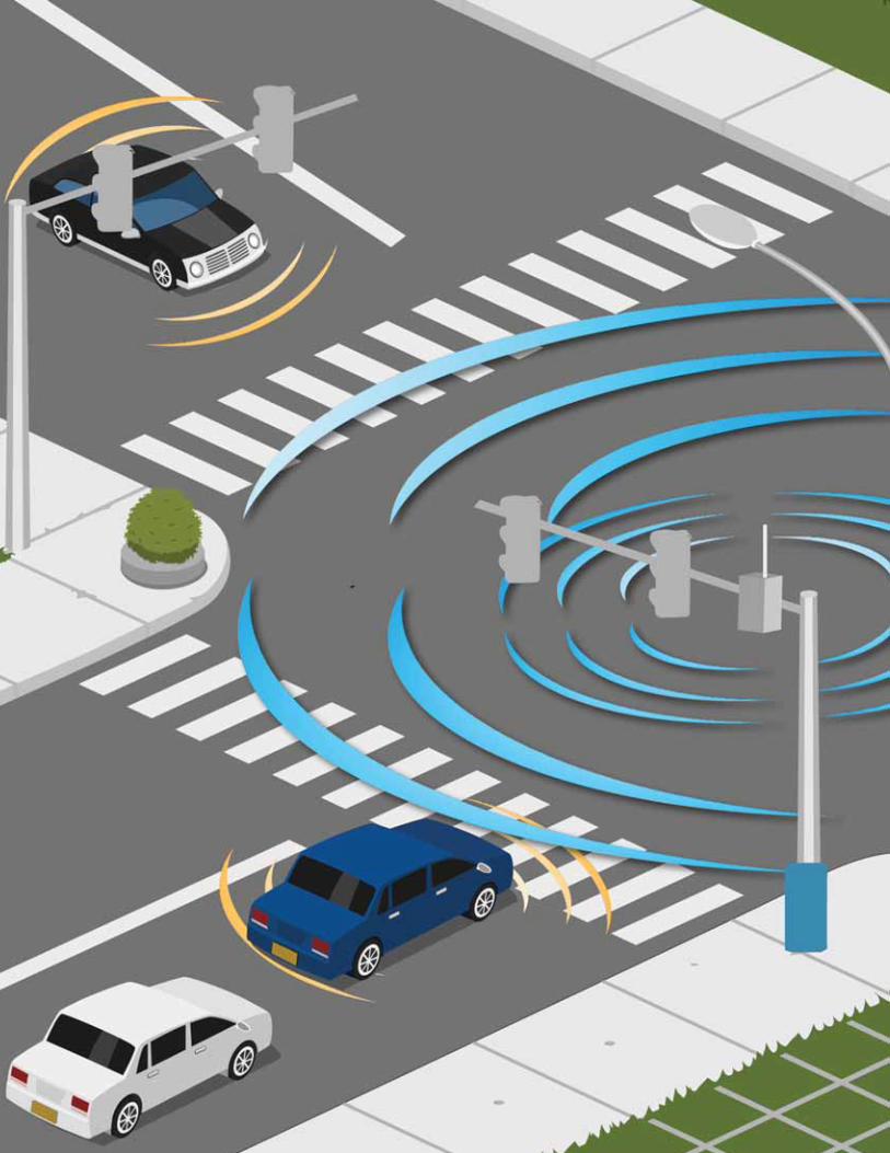
We see myriad traffi c control devices on our roadways: closed-circuit TVs that monitor and verify traf-fi c conditions; sensors that collect traffi c volume and speed data, and detect the presence of vehicles; dynamic message signs that display traffi c information; and more. These Intelligent Transportation Systems (ITS) devices collect and transmit traffi c information to Florida’s transportation management centers, and ultimately back to the traveling public.
In the near future, we will experience another type of intelligent transportation technology — connected vehicles (CV). Statistics show that over 80 percent of avoidable collisions could be prevented with CV technology. In October 2011, the Florida Department of Transportation demonstrated CV capability at the 18th Annual ITS World Congress in Orlando, Florida. By 2013, the USDOT anticipates advancing CV technology to the mainstream, enabling traffi c condition information to be communicated among ve-hicles, infrastructure, and personal communications devices.
Without research, however, these and other advanced transportation technologies would not exist. This issue of Research Showcase highlights ITS research in Florida that is helping to improve roadway safety, alleviate congestion, and protect the environment by reducing fuel consumption. Included is informa-tion about the evolution and implementation of SunGuide®, software that manages Florida’s ITS, and the Statewide Traffi c Engineering Warehouse for Archived Regional Data (STEWARD), the central data warehouse where the vast amounts of data collected by ITS is stored.
This issue also highlights ramp metering technology, which was implemented on I-95 in South Florida to regulate the rate at which vehicles enter the interstate. Another technology, using sensors imbedded in pavement, seeks to match demand for truck parking spaces at interstate rest areas with existing supply.
I invite you to read about these technologies that are helping FDOT to manage congestion on Florida’s roadways and improve transportation safety and mobility.
Darryll Dockstader, Manager
In This Issue
4 FDOT Research Showcase
Managing Traffic Congestion with Intelligent Transportation Systems
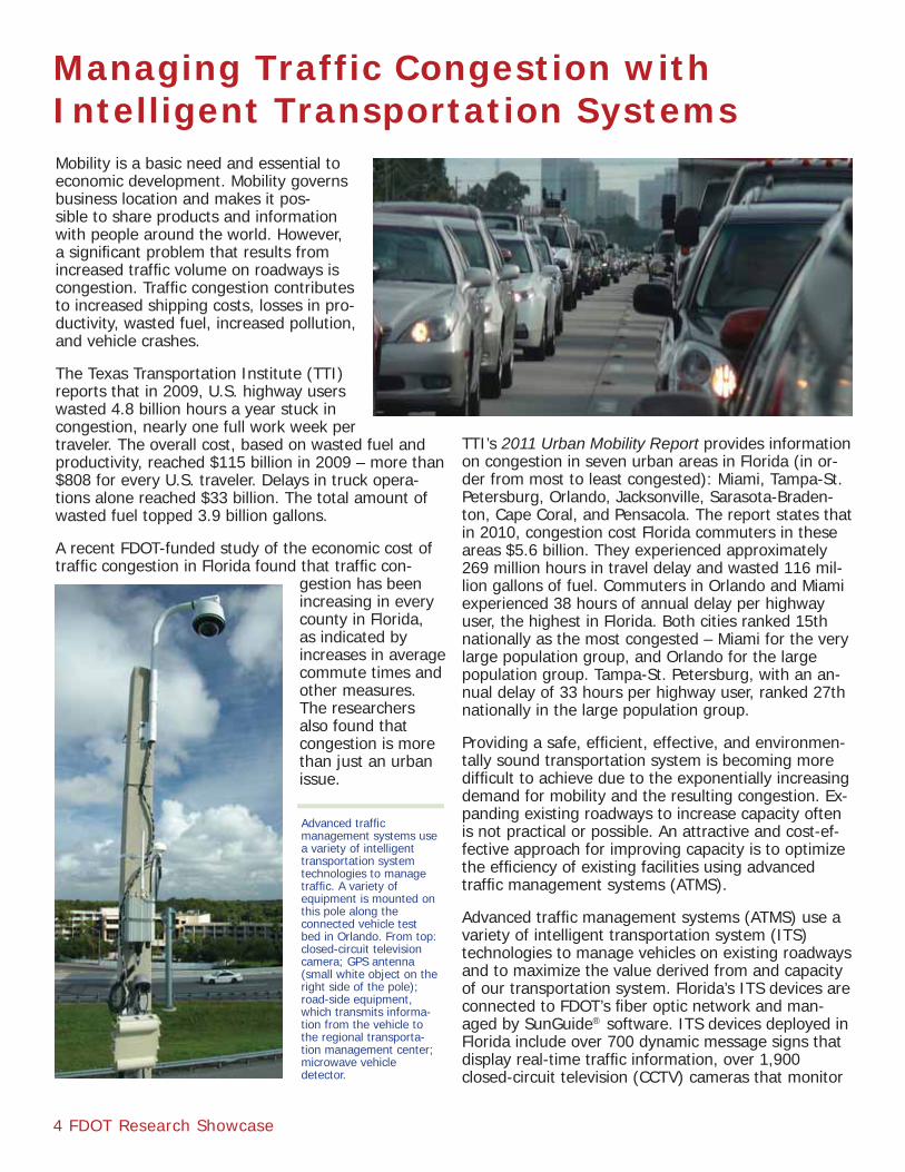
Advanced traffi c management systems use a variety of intelligent transportation system technologies to manage traffi c. A variety of equipment is mounted on this pole along the connected vehicle test bed in Orlando. From top: closed-circuit television camera; GPS antenna (small white object on the right side of the pole); road-side equipment, which transmits informa-tion from the vehicle to the regional transporta-tion management center; microwave vehicle detector.
Mobility is a basic need and essential to economic development. Mobility governs business location and makes it pos-sible to share products and information with people around the world. However, a signifi cant problem that results from increased traffi c volume on roadways is congestion. Traffi c congestion contributes to increased shipping costs, losses in pro-ductivity, wasted fuel, increased pollution, and vehicle crashes.
The Texas Transportation Institute (TTI) reports that in 2009, U.S. highway users wasted 4.8 billion hours a year stuck in congestion, nearly one full work week per traveler. The overall cost, based on wasted fuel and productivity, reached $115 billion in 2009 – more than $808 for every U.S. traveler. Delays in truck opera-tions alone reached $33 billion. The total amount of wasted fuel topped 3.9 billion gallons.
A recent FDOT-funded study of the economic cost of traffi c congestion in Florida found that traffi c con-
gestion has been increasing in every county in Florida, as indicated by increases in average commute times and other measures. The researchers also found that congestion is more than just an urban issue.
TTI’s 2011 Urban Mobility Report provides information on congestion in seven urban areas in Florida (in or-der from most to least congested): Miami, Tampa-St. Petersburg, Orlando, Jacksonville, Sarasota-Braden-ton, Cape Coral, and Pensacola. The report states that in 2010, congestion cost Florida commuters in these areas $5.6 billion. They experienced approximately 269 million hours in travel delay and wasted 116 mil-lion gallons of fuel. Commuters in Orlando and Miami experienced 38 hours of annual delay per highway user, the highest in Florida. Both cities ranked 15th nationally as the most congested – Miami for the very large population group, and Orlando for the large population group. Tampa-St. Petersburg, with an an-nual delay of 33 hours per highway user, ranked 27th nationally in the large population group.
Providing a safe, effi cient, effective, and environmen-tally sound transportation system is becoming more diffi cult to achieve due to the exponentially increasing demand for mobility and the resulting congestion. Ex-panding existing roadways to increase capacity often is not practical or possible. An attractive and cost-ef-fective approach for improving capacity is to optimize the effi ciency of existing facilities using advanced traffi c management systems (ATMS).
Advanced traffi c management systems (ATMS) use a variety of intelligent transportation system (ITS) technologies to manage vehicles on existing roadways and to maximize the value derived from and capacity of our transportation system. Florida’s ITS devices are connected to FDOT’s fi ber optic network and man-aged by SunGuide® software. ITS devices deployed in Florida include over 700 dynamic message signs that display real-time traffi c information, over 1,900 closed-circuit television (CCTV) cameras that monitor
FDOT Research Showcase 5
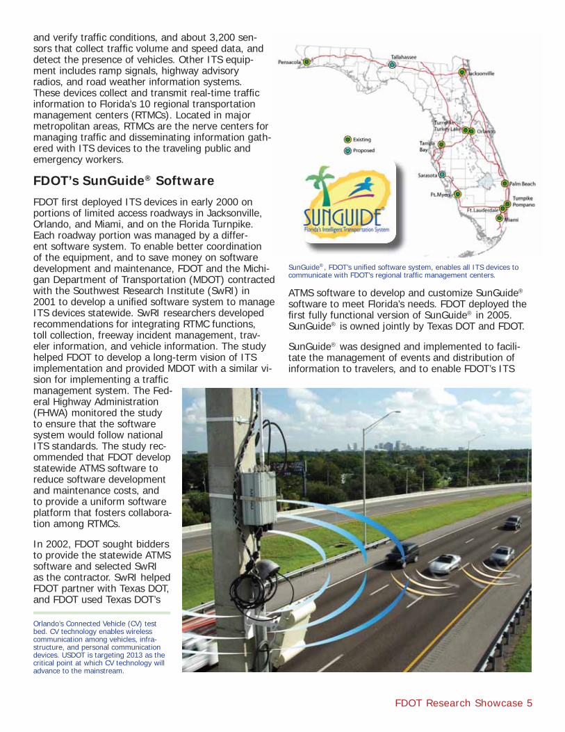
and verify traffi c conditions, and about 3,200 sen-sors that collect traffi c volume and speed data, and detect the presence of vehicles. Other ITS equip-ment includes ramp signals, highway advisory radios, and road weather information systems. These devices collect and transmit real-time traffi c information to Florida’s 10 regional transportation management centers (RTMCs). Located in major metropolitan areas, RTMCs are the nerve centers for managing traffi c and disseminating information gath-ered with ITS devices to the traveling public and emergency workers.
FDOT’s SunGuide® SoftwareFDOT fi rst deployed ITS devices in early 2000 on portions of limited access roadways in Jacksonville, Orlando, and Miami, and on the Florida Turnpike. Each roadway portion was managed by a differ-ent software system. To enable better coordination of the equipment, and to save money on software development and maintenance, FDOT and the Michi-gan Department of Transportation (MDOT) contracted with the Southwest Research Institute (SwRI) in 2001 to develop a unifi ed software system to manage ITS devices statewide. SwRI researchers developed recommendations for integrating RTMC functions, toll collection, freeway incident management, trav-eler information, and vehicle information. The study helped FDOT to develop a long-term vision of ITS implementation and provided MDOT with a similar vi-sion for implementing a traffi c management system. The Fed-eral Highway Administration (FHWA) monitored the study to ensure that the software system would follow national ITS standards. The study rec-ommended that FDOT develop statewide ATMS software to reduce software development and maintenance costs, and to provide a uniform software platform that fosters collabora-tion among RTMCs.
In 2002, FDOT sought bidders to provide the statewide ATMS software and selected SwRI as the contractor. SwRI helped FDOT partner with Texas DOT, and FDOT used Texas DOT’s
ATMS software to develop and customize SunGuide® software to meet Florida’s needs. FDOT deployed the fi rst fully functional version of SunGuide® in 2005. SunGuide® is owned jointly by Texas DOT and FDOT.
SunGuide® was designed and implemented to facili-tate the management of events and distribution of information to travelers, and to enable FDOT’s ITS
SunGuide®, FDOT’s unifi ed software system, enables all ITS devices to communicate with FDOT’s regional traffi c management centers.
Orlando’s Connected Vehicle (CV) test bed. CV technology enables wireless communication among vehicles, infra-structure, and personal communication devices. USDOT is targeting 2013 as the critical point at which CV technology will advance to the mainstream.
6 FDOT Research Showcase
devices to communicate with the RTMCs. SunGuide® allows RTMC operators to perform incident man-agement tasks, obtain data from vehicle detection systems, display videos from roadside cameras, and direct advisory information to motorists by means of dynamic message signs and highway advisory radio or the Florida 511 advanced traveler information system. The software allows the RTMCs to integrate numerous hardware, software, and network applications, and to exchange data effi ciently and effectively among the RTMCs. Currently, over 1,272 miles of FDOT’s 2,000 miles of limited-access roadways, including the entire I-95 corridor, are managed by SunGuide®.
Connected Vehicle TechnologyThe U.S. Department of Transportation (USDOT) launched research on ITS in the mid-1990s, applying processes and technolo-gies previously developed by the defense commu-nity, such as surveillance technologies and systems engineering. Research in-dicated by the early 2000s that technologies allowing vehicles to communicate with other vehicles (V2) and bidirectionally with infrastructure (V2I) held tremendous potential to manage congestion and address highway safety problems. These technolo-gies were known collectively as the vehicle integration initiative (VII). Proof of concept test beds were de-signed and implemented in 2008 and 2009 in Oakland County, Michigan, and Palo Alto, California, to validate the technical feasibility of key components of VII. The USDOT renamed the VII program to Connected Vehicle (CV) in 2010.
The Virginia Department of Transportation (VDOT) is working with several federal, state, and local agen-cies, including FDOT, to establish a multi-phase program to facilitate the fi eld demonstration and deployment of connected transportation infrastructure applications. This pooled fund study (TPF-5(206)) will aid transportation agencies to justify and promote the large-scale deployment of connected systems.
The CV research program is a multimodal initiative that uses networked wireless communications between vehicles, between vehicles and roadway infrastructure, and among vehicles, infrastructure, and personal communication devices. USDOT’s vision for CV technologies is to create a roadway system where highway crashes are signifi cantly reduced, transportation systems can be managed in real time for optimal performance, and travelers have access to
real-time information about roadway condi-tions, enabling them to make informed decisions about route and mode options. By taking advan-tage of the capabilities of wireless technology, USDOT believes the CV program will enhance the mobility and quality of life of roadway users while helping to reduce the environmental impact of surface transportation.
The USDOT’s goal of zero fatalities is one of the driving forces behind the CV research effort. Sta-tistics show that over 80 percent of avoidable colli-sions could be prevented with the implementation of CV technology. USDOT is targeting 2013 as the point at which CV tech-nology will advance to the mainstream with the anticipated ruling by the National Highway Traf-fi c Safety Administration
(NHTSA) requiring new vehicles to be equipped with dedicated short-range communication (DSRC) radios. In anticipation of the ruling, USDOT has upgraded its California and Michigan test beds enabling manufac-turers and agencies to test applications, services, and components using the latest technology and architec-ture, and enabling researchers to fi nd the best way to communicate information between roadway infra-structure and vehicles.
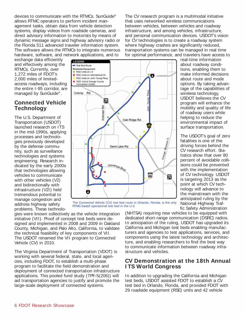
CV Demonstration at the 18th Annual ITS World Congress In addition to upgrading the California and Michigan test beds, USDOT assisted FDOT to establish a CV test bed in Orlando, Florida, and provided FDOT with 29 roadside equipment (RSE) units and 42 vehicle
The Connected Vehicle (CV) test bed route in Orlando, Florida, is the only RTMC-based operational test bed in the U.S.
FDOT Research Showcase 7
awareness devices. In October 2011, FDOT used the test bed to demonstrate the capability of CV technol-ogy when Orlando hosted the 18th Annual World Congress on Intelligent Transportation Systems. The Congress is the ITS industry’s most anticipated event and serves as the premier venue where industry leaders from around the world showcase their latest products and future innovations. The test bed con-sisted of 25 miles of limited access and arterial facili-ties (Interstate 4, International Drive, and John Young Parkway; see map, page 6) in the urban area around the conference site. Because SunGuide® software allows new modules to be developed quickly to meet user needs, FDOT was able to modify SunGuide® and showcase CV functionality at the Congress. Vendors and demonstrators provided probe vehicles equipped with vehicle awareness devices. FDOT installed ve-hicle awareness units on LYNX buses, I-RIDE trolleys, and FDOT maintenance vehicles. During the demon-stration, conference participants observed how the RSE transmitters sent safety messages to the probe vehicles via DSRC radios while collecting information from the vehicles about location and speed.
The deployment of CV technology into the SunGuide® ATMS environment is unique because it is the only RTMC-based operational test bed in the U.S. Following the ITS World Congress, FDOT left the infrastructure in place to use in future research. The vehicles cur-
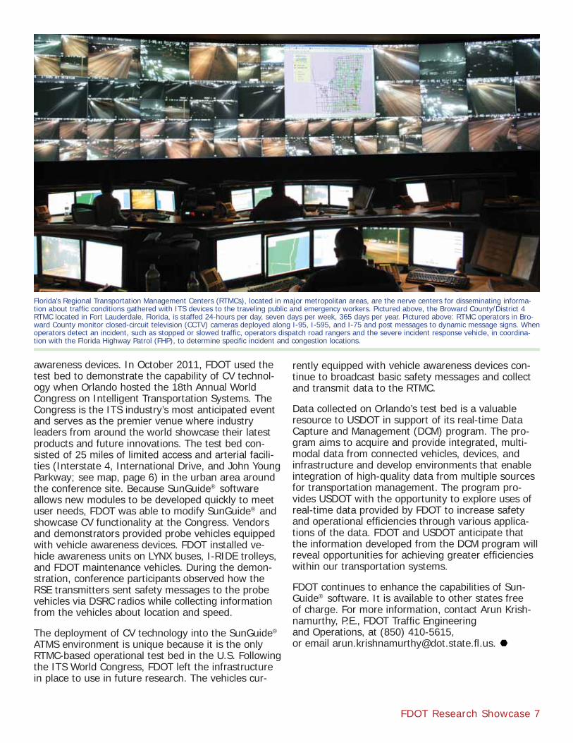
Florida’s Regional Transportation Management Centers (RTMCs), located in major metropolitan areas, are the nerve centers for disseminating informa-tion about traffi c conditions gathered with ITS devices to the traveling public and emergency workers. Pictured above, the Broward County/District 4 RTMC located in Fort Lauderdale, Florida, is staffed 24-hours per day, seven days per week, 365 days per year. Pictured above: RTMC operators in Bro-ward County monitor closed-circuit television (CCTV) cameras deployed along I-95, I-595, and I-75 and post messages to dynamic message signs. When operators detect an incident, such as stopped or slowed traffi c, operators dispatch road rangers and the severe incident response vehicle, in coordina-tion with the Florida Highway Patrol (FHP), to determine specifi c incident and congestion locations.
rently equipped with vehicle awareness devices con-tinue to broadcast basic safety messages and collect and transmit data to the RTMC.
Data collected on Orlando’s test bed is a valuable resource to USDOT in support of its real-time Data Capture and Management (DCM) program. The pro-gram aims to acquire and provide integrated, multi-modal data from connected vehicles, devices, and infrastructure and develop environments that enable integration of high-quality data from multiple sources for transportation management. The program pro-vides USDOT with the opportunity to explore uses of real-time data provided by FDOT to increase safety and operational effi ciencies through various applica-tions of the data. FDOT and USDOT anticipate that the information developed from the DCM program will reveal opportunities for achieving greater effi ciencies within our transportation systems.
FDOT continues to enhance the capabilities of Sun-Guide® software. It is available to other states free of charge. For more information, contact Arun Krish-namurthy, P.E., FDOT Traffi c Engineering and Operations, at (850) 410-5615, or email [email protected] .us.
8 FDOT Research Showcase
SunGuide® software allows FDOT’s 10 regional traffi c man-agement centers (RTMC) to monitor and control roadside equipment and incident manage-ment vehicles. Each RTMC col-lects and archives a wealth of real-time information on traffi c conditions obtained from Intelli-gent Transportation System (ITS) devices located on limited access roadways in urban areas.
As originally designed, Sun-Guide® contained a rudimentary archiving function that created a daily summary of basic data pro-duced by each ITS sensor during each reporting interval (usually 20 seconds). The generated data included traffi c volumes, speeds, vehicle occupancies, and travel times. While the generated data were numerically accurate, the information was not useful until it could be organized geographically, stored in a database, and systemati-cally arranged in the form of useful reports.
In a 2008 study, researchers at the University of Florida’s (UF) Transportation Research Center designed and implemented a traffi c data archive system called the Statewide Transportation Engi-neering Warehouse for Archived Regional Data (STEWARD). STEWARD serves as a central data warehouse for SunGuide® data collected by RTMCs. STEWARD allows transportation practitioners to query archived data and produce a variety of reports. The data is a valuable resource to transportation practitio-ners who study freeway operations. The ability to retrieve and analyze freeway data allows them to develop performance measures and conduct research concerning traffi c fl ow and congestion management.
UF researchers also developed a website to support users in retrieving data and creating reports. The website allows users to choose the source RTMC, request specifi c information, and download the report. The website also includes a systems resources page that provides access to project reports, example re-sults, training materials, and software utilities that are used for processing data fi les.
STEWARD: FDOT’s Central Data Warehouse for ITS Data
STEWARD gives RTMC managers, district ITS program managers, and transportation engineers the ability to identify malfunctioning roadway equipment, calibrate instructions for the equipment, perform quality as-sessment and data reliability tests, develop daily per-formance measures, extract traffi c counts and crash data, and analyze traffi c volume trends. STEWARD also allows transportation practitioners to analyze specifi c traffi c conditions, such as the performance of managed lanes; travel time reliability; speed, fl ow and density relationships; and the effects of incidents.
Since its implementation, UF researchers have used STEWARD data in three subsequent FDOT-funded research projects to study travel time reliability. Re-searchers used STEWARD data to identify congested areas in and around Jacksonville and to extract speed, fl ow, and travel time information from those areas. They used STEWARD data to assess the capacity of Florida freeways and analyzed speed and fl ow data from Jacksonville, Miami, Ft. Lauderdale, Orlando, and Tampa to develop speed-fl ow relationships and capacity distributions for a variety of basic freeway segments. The researchers have also used STEWARD data to model the location of crashes within work zones and to study ramp management.
FDOT Research Showcase 9
Researchers at the Lehman Center for Transportation Research, Florida International University (FIU), used STEWARD data in three recent FDOT-funded research projects. In one study, Traffi c Management Simula-tion Development, researchers developed tools that interface with SunGuide® software and allow system testing using a technique called microscopic simula-tion, which simulates traffi c in unique ways. Archived STEWARD data provided researchers with cost-effec-tive and detailed information for the development and calibration of simulation modeling applications.
In another FIU study, Decision Support Tools to Sup-port the Operations of Traffi c Management Centers, the researchers estimated the accuracy of congestion and incident conditions by combining current Sun-Guide® estimation methods with other methods. They developed a method to estimate the time from the occurrence of an incident to the time it is recorded in the SunGuide® database based on a combination of detailed historical traffi c detector and incident man-agement databases. They also developed methods to measure other incident-related measures and esti-mated secondary freeway crashes and contributing factors. The researchers also developed models and
methods to estimate incident impacts, including the number of lanes blocked; predicted incident dura-tion; and estimated queue length, average delay, and secondary incident probability. The research resulted in improved tools to manage incidents and to optimize future incident response.
A third FIU study, Using Advanced Analysis Tools to Support Freeway Corridor Freight Management, investigated methods and tools for assessing combi-nations of corridor freight management and pricing strategies as part of the corridor freight planning pro-cess. The researchers acquired incident data, traffi c detector data, and travel time data from STEWARD to support the calibration of a traffi c fl ow model for I-95 and I-295 in the Jacksonville, Florida, area. The model was developed to assist transportation planners to better manage freight traffi c on congested roadways.
STEWARD is an important resource for a wide variety of users who need freeway operational data to de-termine traffi c trends and conditions. Transportation practitioners may access the data free of charge at http://cdwserver.ce.ufl .edu/steward/index.
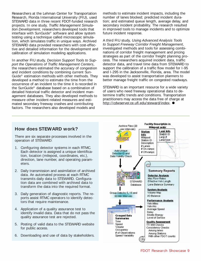
How does STEWARD work?There are six separate processes involved in the operation of STEWARD:
1. Confi guring detector systems in each RTMC. Each detector is assigned a unique identifi ca-tion, location (milepost, coordinates, etc.), direction, lane number, and operating param-eters.
2. Daily transmission and assimilation of archived data. An automated process at each RTMC transmits daily data to STEWARD. Confi gura-tion data are combined with archived data to transform the data into the required format.
3. Daily generation of diagnostic reports. The re-ports assist RTMC operators to identify detec-tors that require maintenance.
4. Application of a quality assurance test to identify invalid data. Data that do not pass the quality assurance test are rejected.
5. Posting of valid data to the STEWARD website for public access.
6. Downloading and use of data by stakeholders.

10 FDOT Research Showcase
Truck Parking: ITS Detects Parking Availability, Improves SafetyStudies conducted by USDOT have found that truck driver fatigue contributes to traffi c accidents. To ensure that drivers do not operate their trucks when tired, the Federal Motor Carrier Safety Administra-tion (FMCSA), a branch of the U.S. Department of Transportation, administers laws regarding the truck-ing industry and regulates the number of hours truck drivers may operate their vehicles before taking a mandatory rest period. Federal law requires that driv-ers may not drive more than 11 hours per day without taking a rest pe-riod, and may not work for more than 14 hours, including driving and non-driving duties, in any 24-hour period. Driv-ers also must take a mandatory rest period during every 24-hour time frame. These requirements are meant to prevent drivers from becoming drowsy and to ensure the safety of all highway users.
Truck drivers typically park either in publicly owned roadside rest areas or at privately owned truck stops. In the absence of a reservation system at publicly owned rest areas, when it is time for a driver to rest, he or she stops at a rest area to see if parking space is available. If parking space is not available, the driver has two choices: park illegally along the roadside or continue driving in violation of hours-of-service rules.
In 2005, FMCSA began studying the truck parking problem and identi-fi ed two possible solutions to park-ing shortages: increase the supply of spaces, and better match supply and demand in areas where park-ing shortages exist. The study found that increasing the supply of parking spaces is a direct but capital-inten-sive solution, whereas better match-ing supply and demand is a more practical and cost-effective solution that could more evenly distribute
parking along highway corridors. To better match demand with existing supply, FMCSA recommended Intelligent Transportation System (ITS) deployments to provide commercial motor vehicle drivers with real-time information on the location and availability of parking spaces.
In 2007, FMCSA began the SmartPark initiative to demonstrate whether ITS technology for providing
real-time parking availability infor-mation to truck drivers would effectively divert them from fi lled to unfi lled parking areas. Research-ers conducted fi eld tests to determine the feasibility of using magnetom-etry technology,
which detects the presence of magnetic metals, to de-termine parking availability. The technology deployed wireless, battery-powered sensors embedded in the pavement to measure the presence of trucks and re-layed this information to a centralized server where a
Parked trucks at an interstate rest area near Orlando.
FDOT Research Showcase 11
driver fatigue, and diesel emissions due to unnecessary driving. Another goal was to develop a method to predict the availability of parking based on travel time by com-bining parking trend data with real-time data.
Researchers at Florida International University (FIU), led by Dr. M. Emre Bayraktar, visited each of Florida’s 53 rest areas along the I-10, I-75, and I-95 corridors to collect data on the adequa-cy of truck parking space capacity and the extent of illegal parking.
The researchers identifi ed facilities that reach or exceed capacity during the busiest hours of a 24-hour period (usually nighttime hours). Over the course of four months, the researchers visited each rest area over a three- to four-day period during daytime and nighttime hours to col-lect data regarding truck parking space supply and demand characteristics. The researchers counted the number of spaces at each location and the number of trucks parked both legally in the park-ing spaces and illegally elsewhere at the facility. They also interviewed truck drivers and on-site security offi cers, state troopers, county sheriffs, and FDOT staff to obtain their observations about truck parking practices.
The researchers summarized truck count and inter-view data for each rest area. They categorized each facility based on the level of the truck parking capaci-ty problem and depicted the facilities on a color-coded map. The data enabled the researchers to identify the rest areas with recurring truck parking problems due to an inadequate supply of parking spaces available to meet demand.
detection/classifi cation processor determined parking availability. Researchers determined that the vehicle detection system performed accurately approximately 96 percent of the time, but that more work was needed to improve accuracy.
In 2011, FDOT funded a study to understand the truck parking problem in Florida, determine supply and demand characteristics for truck parking, assess technology that can be used to improve parking man-agement, and deploy test locations for a smart park-ing system. The goals of the study were to increase operational effi ciency of commercial drivers and to reduce illegal parking on shoulders, crashes due to
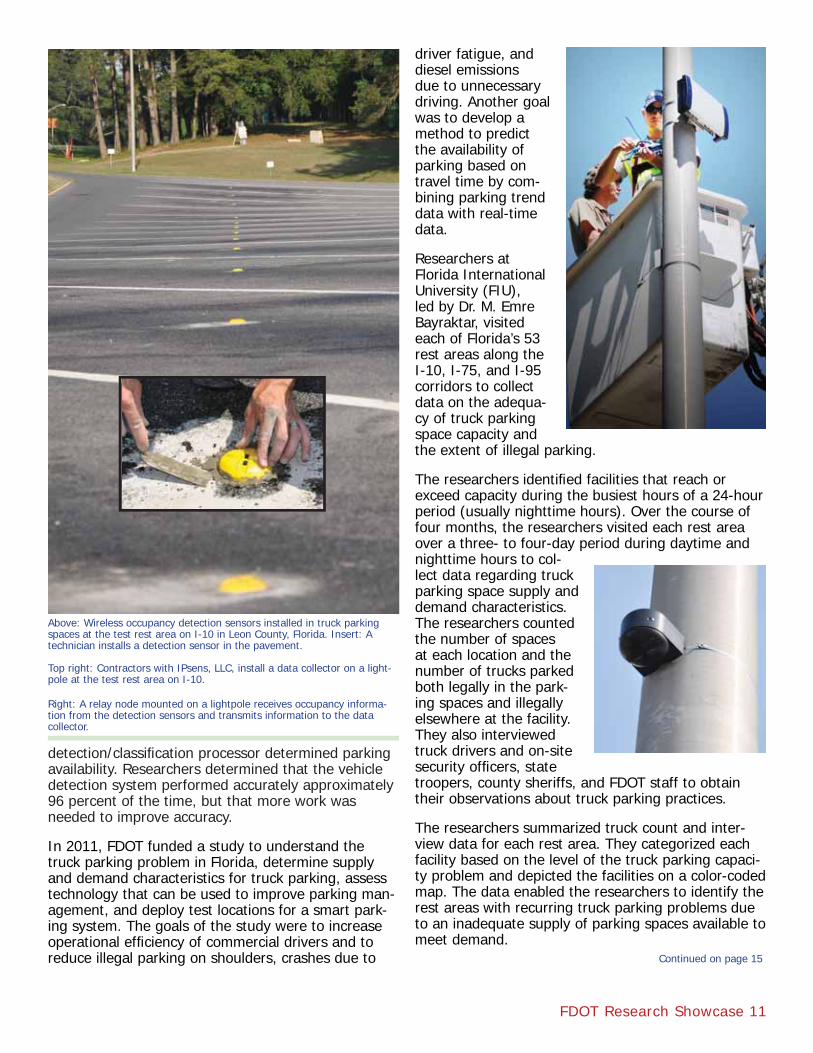
Above: Wireless occupancy detection sensors installed in truck parking spaces at the test rest area on I-10 in Leon County, Florida. Insert: A technician installs a detection sensor in the pavement.
Top right: Contractors with IPsens, LLC, install a data collector on a light-pole at the test rest area on I-10.
Right: A relay node mounted on a lightpole receives occupancy informa-tion from the detection sensors and transmits information to the data collector.
Continued on page 15
12 FDOT Research Showcase
Meet the Project ManagerArun Krishnamurthy, P.E., ITS Software and Architecture Coordinator FDOT Traffi c Engineering and Operations Offi ceArun Krishnamurthy began manag-ing FDOT’s SunGuide® software pro-gram in 2009 and is considered the point person for all things related to SunGuide® software. SunGuide® is an advanced transportation manage-ment system (ATMS) software used by Florida’s 10 regional transporta-tion management centers (RTMC). It enables FDOT’s Intelligent Transpor-tation System (ITS) devices located on Florida’s interstates and turnpike to communicate with the RTMCs.
As ITS devices evolve, so must the capabilities of SunGuide® software. Krishnamurthy oversees the devel-opment and management of new SunGuide® software applications in several ways.
Krishnamurthy is an active member of FDOT’s change management board (CMB). The CMB ensures that proposed changes to FDOT transportation manage-ment initiatives are consistent with FDOT’s long-term goals and user needs. The CMB provides a forum for FDOT ITS engineers to evaluate, investigate, and dis-cuss issues that help with decisions requiring techni-cal input from SunGuide® users and administrators. The CMB meets quarterly to discuss items that need CMB approval prior to implementation and deploy-ment, examines each proposed change, and votes. If the majority of members favor the change, the proj-ect moves forward.
Krishnamurthy also is a member of the SunGuide® software user’s group (SSUG), a subgroup of the CMB. While the CMB makes decisions on changes to the SunGuide® software, the SSUG provides a forum to discuss complex issues that may need signifi cant input from multiple parties prior to making decisions.
Periodic SunGuide® software updates add new func-tions that need to be communicated to users. Krish-namurthy manages the SunGuide® training program that provides training resources to TMC operators, equipping them to operate and confi gure SunGuide® software.
In 2009, Krishnamurthy managed a research proj-ect that developed the Statewide Traffi c Engineering Warehouse for Archived Regional Data (STEWARD), a central data warehouse that stores FDOT’s ITS and
other transportation data. Research-ers at the University of Florida developed a repository for ITS data collected at RTMCs and a method to analyze it. STEWARD gives trans-portation practitioners the ability to produce various reports and prod-ucts from centrally archived data, and enables FDOT to model traffi c congestion, produce performance measures, and improve transporta-tion management.
More recently, Krishnamurthy man-aged a project that developed traffi c management simulation tools using STEWARD. The tools, developed by researchers at Florida International
University, interface with SunGuide® and simulate traffi c conditions. The tools collect data from ITS archives, manipulate and aggregate the data, and automatically modify input fi les. Users can defi ne the traffi c environment by designating the number of ITS devices on a roadway segment, determine the effec-tiveness of message signs, and estimate how many drivers will respond to advisory alerts. The tools can use ITS data archives to estimate traffi c parameters for planning, travel demand forecasting, and traf-fi c analysis purposes. “These are complex problems because both the traffi c system and how people make decisions are complex,” says Krishnamurthy. “Try-ing to simulate how people make decisions is tricky. Although these methods are not an exact science, we get as close as possible to predicting driver behavior through the simulation of traffi c environments and people’s reactions to them.”
Currently, Krishnamurthy is managing the third phase of an FDOT-funded project that will implement previ-ously developed simulation tools in a traffi c manage-ment center environment and determine the useful-ness of the tools to TMC operations.
Krishnamurthy looks forward to working on future FDOT-funded ITS research. “My colleagues and I anticipate devising innovative tools and solutions to problems that can be applied at the RTMCs to man-age traffi c effi ciently and effectively,” says Krish-namurthy. “We strive for the right balance of re-search, planning, deployment, and maintenance and hope FDOT can be a resource for other states.”
FDOT Research Showcase 13
Meet the Principal InvestigatorLily Elefteriadou, Transportation Research CenterUniversity of Florida
FDOT’s Strategic Intermodal Sys-tem (SIS) comprises a network of high-priority transportation facilities across all large-scale transportation modes, ranging from the space-port, airports, seaports, and rail systems, to buses and highways. The goal of the SIS is to provide a transportation system that ef-fi ciently serves Florida’s citizens, businesses, and visitors; helps Florida become a worldwide eco-nomic leader; enhances economic prosperity and competitiveness; enriches quality of life, and refl ects responsible environmental stew-ardship. One way to measure the effi ciency and usefulness of the SIS is to measure travel time reliability (TTR), which is the likelihood that travelers will arrive at their destinations on time. Understanding TTR involves developing com-puter models that can accurately predict the expected travel time in and across transportation modes. Such predictions give transportation planners a means to measure congestion. However, measuring and quan-tifying TTR had been diffi cult due to the lack of data specifi c to Florida conditions.
Lily Elefteriadou, Director of the University of Florida’s Transportation Research Center and principal investi-gator for numerous FDOT-funded research projects, began studying methods to measure TTR on Florida’s freeways in 2006. She and her research team de-veloped a preliminary model to measure, report, and predict travel time on freeways using data from Philadelphia, Pennsylvania. This model provided a framework for estimating TTR based on fi eld data and travel time estimation for various conditions, includ-ing the presence of work zones, congestion, incidents, and rain.
With the deployment in the late 2000s of Intelligent Transportation Systems (ITS) on SIS facilities in urban areas, SunGuide® software to manage ITS data, and the STEWARD central data warehouse to store the data, Elefteriadou has been able to apply data specifi c to Florida’s freeways to subsequent TTR congestion modeling projects. Elefteriadou and her research team have validated the reliability of the models, compared scenarios and reliability estimates, and adjusted the models based on comparisons to the fi eld data.
The models also can be used to estimate travel time on arterial streets. “As more ITS technology is deployed to arterials, researchers will be able to apply models and obtain TTR on arterials as well,” says Elefteriadou. “I anticipate that in the near future, FDOT also will be able to incorporate arterial data into STEWARD.”
The computer tools she has de-veloped as part of the TTR efforts can be used to evaluate the impact of various ITS strategies, incident identifi cation and removal policies, high-occupancy vehicle lanes, and work zone policies. Her research
also has studied the defi nition of TTR across different modes of transportati on, such as cars, trucks, and trains.
Elefteriadou has been the Co-Principal Investigator on the study of adjusted time-of-day lane pricing on the 95 Express in Miami. In another recent project, she studied driver behavior and perceptions of the Vari-able Speed Lane (VSL) system, as well as alternative VSL algorithms on a 10-mile section of the I-4 cor-ridor.
Currently, Elefteriadou is conducting research on TTR implementation for the entire SIS, including both freeways and arterials. She also is researching the relationship between traffi c signal control and work zones on arterials, and developing guidelines to help contractors devise a signal control plan based on the location of the work zone to better accommodate traf-fi c through arterial work zones.
Elefteriadou anticipates that she will continue to study ITS strategies and their impact on traffi c fl ow. “Advanced traffi c management technologies, such as ramp metering, variable speed limits, and congestion pricing, are receiving a lot of attention at both the federal and state levels as methods to relieve conges-tion,” says Elefteriadou.
14 FDOT Research Showcase
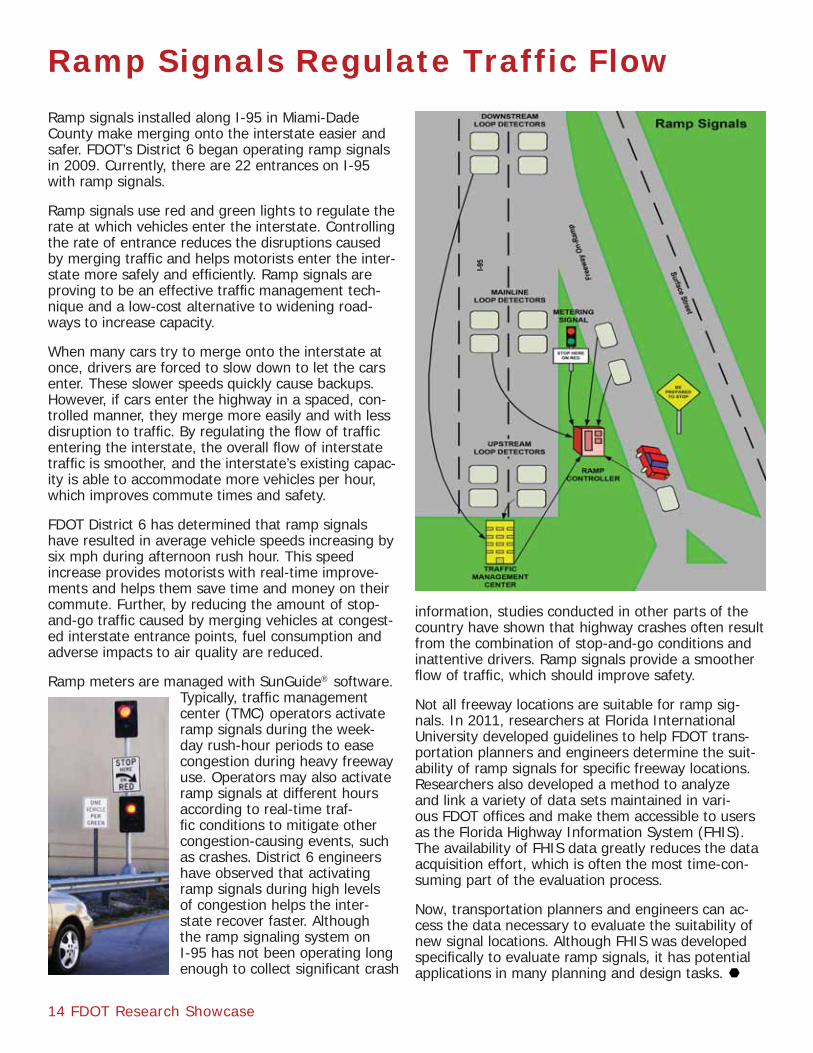
Ramp Signals Regulate Traffic Flow Ramp signals installed along I-95 in Miami-Dade County make merging onto the interstate easier and safer. FDOT’s District 6 began operating ramp signals in 2009. Currently, there are 22 entrances on I-95 with ramp signals.
Ramp signals use red and green lights to regulate the rate at which vehicles enter the interstate. Controlling the rate of entrance reduces the disruptions caused by merging traffi c and helps motorists enter the inter-state more safely and effi ciently. Ramp signals are proving to be an effective traffi c management tech-nique and a low-cost alternative to widening road-ways to increase capacity.
When many cars try to merge onto the interstate at once, drivers are forced to slow down to let the cars enter. These slower speeds quickly cause backups. However, if cars enter the highway in a spaced, con-trolled manner, they merge more easily and with less disruption to traffi c. By regulating the fl ow of traffi c entering the interstate, the overall fl ow of interstate traffi c is smoother, and the interstate’s existing capac-ity is able to accommodate more vehicles per hour, which improves commute times and safety.
FDOT District 6 has determined that ramp signals have resulted in average vehicle speeds increasing by six mph during afternoon rush hour. This speed increase provides motorists with real-time improve-ments and helps them save time and money on their commute. Further, by reducing the amount of stop-and-go traffi c caused by merging vehicles at congest-ed interstate entrance points, fuel consumption and adverse impacts to air quality are reduced.
Ramp meters are managed with SunGuide® software. Typically, traffi c management center (TMC) operators activate ramp signals during the week-day rush-hour periods to ease congestion during heavy freeway use. Operators may also activate ramp signals at different hours according to real-time traf-fi c conditions to mitigate other congestion-causing events, such as crashes. District 6 engineers have observed that activating ramp signals during high levels of congestion helps the inter-state recover faster. Although the ramp signaling system on I-95 has not been operating long enough to collect signifi cant crash
information, studies conducted in other parts of the country have shown that highway crashes often result from the combination of stop-and-go conditions and inattentive drivers. Ramp signals provide a smoother fl ow of traffi c, which should improve safety.
Not all freeway locations are suitable for ramp sig-nals. In 2011, researchers at Florida International University developed guidelines to help FDOT trans-portation planners and engineers determine the suit-ability of ramp signals for specifi c freeway locations. Researchers also developed a method to analyze and link a variety of data sets maintained in vari-ous FDOT offi ces and make them accessible to users as the Florida Highway Information System (FHIS). The availability of FHIS data greatly reduces the data acquisition effort, which is often the most time-con-suming part of the evaluation process.
Now, transportation planners and engineers can ac-cess the data necessary to evaluate the suitability of new signal locations. Although FHIS was developed specifi cally to evaluate ramp signals, it has potential applications in many planning and design tasks.
Intelligent Transportation Systems
BDK75 977-19, The Economic Cost of Traffi c Conges-tion in FloridaDarryll Dockstader, Project ManagerA. G. Blanco, Principal Investigator
BDK80 977-02, Decision Support Tools to Support the Operations of Traffi c Management CentersDong Chen, Project ManagerMohammed Hadi, Principal Investigator
BDK80 977-03, Traffi c Management Simulation Devel-opmentTrey Tillander, Project ManagerMohammed Hadi, Principal Investigator
BDK80 977-24, Demonstration of the Applications of Traffi c Management Center Decision Support ToolsArun Krishnamurthy, Project ManagerMohammed Hadi, Principal Investigator
TPF-5(206), Program to Support the Research, De-velopment, and Deployment of System Operations Applications of Vehicle Infrastructure Integrationhttp://www.pooledfund.org/Details/Study/431
Central Data Warehouse
BC354-61, Feasibility Study for an Integrated Network of Data Sources, Phase ILiang Hsia, Project ManagerCharles Wallace, Principal Investigator
BD545-37, Development of a Central Data Warehouse for Statewide ITS and Transportation Data in Florida, Phase II: Proof of ConceptLiang Hsia, Project ManagerKenneth Courage, Principal Investigator
BD545-93, Development of a Central Data Warehouse for Statewide ITS and Transportation Data in Florida, Phase III: Final ReportArun Krishnamurthy, Project ManagerScott Washburn, Principal Investigator
Truck Parking
BDK80 977-14, Commercial Motor Vehicle Parking Trends at Rest Areas and Weigh Stations Paul Clark, Project ManagerM. Emre Bayraktar, Principal Investigator
Ramp Signals
BDK80 977-08, Integrated Database and Analysis System for the Evaluation of Freeway Corridors for Potential Ramp Signaling Javier Rodriguez, Project ManagerAlbert Gan, Principal Investigator
For More Information
FDOT Research Showcase 15
During the second phase of the project, researchers installed a smart parking management system at two rest areas on the east- and west-bound sides of I-10 in Leon County, Florida. The system has the capability to monitor real-time occupancy information of indi-vidual parking spaces and transmit that information to truck drivers on the highway.
The system consists of wireless occupancy detection sensors embedded in the parking spaces to determine availability; relay nodes mounted on light poles to receive and transmit sensor data to the collector; and the collector, which is a central unit that receives the raw data and transmits it to a remote server, e.g., the server of a regional traffi c management center.
The smart parking system also includes an archival function so that a historical record of parking avail-
ability can be developed and used in estimating park-ing availability. Researchers propose that by collecting and archiving parking space occupancy data, FDOT will be able to predict parking availability, including peak parking hours, parking space usage, and parking duration, and deploy parking availability information to roadside dynamic message signs.
FDOT anticipates incorporating data collected during this research project into SunGuide®. Once the smart-parking system is implemented, RTMCs will be able to deploy parking availability information to truck drivers based on real-time and predictive data. Better infor-mation about the supply and availability of parking will help truck drivers make informed decisions about when and where to park.
Continued from page 11