Embed Size (px)
Citation preview
0.6
Management of Vertisols
under Semi-Arid Conditions


•
MANAGEMENT OF VERTISOLS UNDER SEMI-ARID CONDITIONS


The seminar was organized by
The International Board for Soil Research and Management (lBSRAM)in cooperation with
The Ministry of Agriculture and Livestock Development (Kenya)
The Kenyan National Research Council for Science and Technology (NRCST)
The International Council for Research and Agro-Forestry (ICRAF)
The International Crops Research Institute for the Semi-Arid Tropics (ICRISAT)
The International Livestock Centre for Africa (ILCA)
and sponsored by the
Overseas Development Administration, U.K. (ODA)
Scientific EditorsMarc Latham and Peter Ahn
Publication EditorCoIin R. EIIiott
Correct citation: International Board for Soil Research and Management Inc. (lBSRAM), 1987,Management of Vertisols under Semi-Arid Conditions, Proceedings of the First Regional Seminar onManagement of Vertisols under Semi-Arid Conditions, Nairobi; Kenya, 1-6 December 1986. Thisbook or any part thereof must not be reproduced in any form without written permission of IBSRAM.
ISBN 974-7614-47-2
Printed in Thailand


CONTENTS
Summary. . . . . . . . . . . . . . . . . . . . . . . . . . . . . . . . . . . . . . . . 1Opening addresses. . . . . . . . . . . . . . . . . . . . . . . . . . . . . . . . . . 3
SECTION 1: IBSRAM'S NETWORK APPROACH
IBSRAM and management of the Vertisols network. . . . . . . . . . . . 13MARC LATHAM
Characterization of Vertisols from India and Iraq and theirtaxonomic problems . . . . . . . . . . . . . . . . . . . . . . . . . . . . . . . . 21fA WAHAR L. SEHGAL and i.c. BHATTACHARfEE
Vertisols in eastern Africa. . . . . . . . . . . . . . . . . . . . . . . . . . . . . 45R.F. VAN DE WEG
The Vertisols network: objectives and plans. . . . . . . . . . . . . . . . . 51f.R. BURFORD
SECTION 2: SITE SELECTION
Selection of sites for the Vertisols network: distinction betweentypes of Vertisols . . . . . . . . . . . . . . . . . . . . . . . . . . . . . . . . . . 65P. BRABANT
Soil site criteria for selecting experiment sites for a Vertisolmanagement network. . . . . . . . . . . . . . . . . . . . . . . . . . . . . . . . 71fAWAHAR L. SEHGAL, S. VADIVELU, L.R. HIREKERURand S.B. DESHPANDE
Site selection for agronomic experiments:Kenyan situation. . . . . . . . . . . . . . . . . . . . . . . . . . . . . . . . . . . 83N.N. NYANDA T
SECTION 3: SITE CHARACTERIZATION
The physical and mechanical characterization of Vertisols. . . . . . . . 89K.J. COUGHLAN, D. McGARR Y and G.D. SMITH

Water management of Vertisols in the semi-arid tropicsD.F. YULE
Chemical fertility characteristics of VertisolsP.H. LEMARE
107
125
Occurrence and management of Vertisols for the production ofcotton and other crops in western Tanzania. . . . . . . . . . . . . . . .. 139J.G.MOWO
Conservation measures in Vertisols under large-scale wheat farming innorthern Tanzania. . . . . . . . . . . . . . . . . . . . . . . . . . . . . . . . .. 145R. NGA TOLUWA, H. MANSOOR, B.D. MAJANGAand J.A. McKEAGUE
SECTION 4: MANAGEMENT SYSTEMS (1)
Management of Vertisols for improved crop production in thesemi-arid tropics: a plan for a technology transfer network in Africa 157J.S. KANWAR and S.M. VIRMANI
Improved agricultural utilization of Vertisols in the Ethiopianhighlands - an interinstitutional approach. . . . . . . . . . . . . . . . .. 173SAMUEL JUTZI and MESFIN ABEBE
SECTION 5: MANAGEMENT SYSTEMS (2)
The potential of agroforestry for soil conservation, with specialreference to Vertisols. . . . . . . . . . . . . . . . . . . . . . . . . . . . . . .. 187A. YOUNG
Vertisols management systems in semi-arid Mediterranean areas. . .. 201A.OSMAN
Avenues for the improvement of cultural practices on Vertisols . . .. 207THEO. J. WILL COCKS
Management problems of cotton oil Vertisols in the lower ShireValley of Malawi. . . . . . . . . . . . . . . . . . . . . . . . . . . . . . . . . .. 221A.J.B. MITCHELL
SECTION 6: IMPLEMENTATION OF THE VERTlSOLS NETWORK
Soil variability, experimental design, and data processingW. SIDERIUS
233
Fertilizer management in Vertisols . . . . . . . . . . . . . . . . . . . . . .. 247r.c. KATYAL. C.W. HONG and PLG. VLEK
Supplementary irrigationH.G. FARBROTHER
SECTION 7: SUSTAINABILITY OF IMPROVED SYSTEMS
267
Approaches to erosion control on Vertisols in Queensland, Australia 285I.A. MULLINS. A.A. WEBB and K.J. COUGHLAN
Cropping systems evaluation . . . . . . . . . . . . . . . . . . . . . . . . . .. 299R.W. WILLEY
Strategies for maintenance of soil fertilityI.R. BURFORD
APPENDIXES
Appendix I: Working group reportsAppendix 11: Seminar resolutionsAppendix Ill: Programme of the seminar and field tourAppendix IV: Participants
311
327331334338

SUMMARY
The First Regional Seminar on the Management of Vertisols under Semi-Arid Conditions in Africa and Southwest Asia took place in Nairobi, Kenya, from 1-6 December1986. The sixty-nine participants from 23 countries (see Appendix IV) included formalrepresentatives from 14 countries inside the region: Botswana, Burkina Faso, Egypt,Ethiopia, India, Kenya, Mali, Pakistan, Sudan, Tanzania, Tunisia, Uganda, Zambia andZimbabwe, and one from the Arab Center for the Studies of Arid Zones and Dry Lands(ACSAD).
The meeting was organized by IBSRAM in coordination with the Kenyan Ministryof Agriculture and Livestock Development, the Kenyan National Research Council forScience and Technology (NRCST), the International Council for Research and AgroForestry (ICRAF), the International Crops Research Institute for the Semi-Arid Tropics(ICRISAT), and the International Livestock Centre for Africa (ILCA). The British Overseas Development Administration (ODA) provided the main support for the seminar.
The meeting was officially opened by the Director of Research of the Ministry ofAgriculture, M. Wapakala, with an introductory address by the IBSRAM Director, Or.Marc Latham, and a welcome address by Or. Wang'ati, Secretary of the National Councilfor Science and Technology. 1
The first two days of plenary sessions introduced various aspects of the approach andmethodology to be adopted by a proposed IBSRAM Regional Network on the Management of Vertisols under Semi-Arid Conditions in Africa and Southwest Asia. A total of26 papers were presented and discussed. They were concerned with IBSRAM's networkapproach to Vertisols, site selection, site characterization, management systems, implementation of the Vertisols network, and the sustainability of improved systems.
During the first day, the papers dealt with the taxonomic aspects of Vertisols in theregion, the soil physical and mechanical properties, and water management. On thesecond day, papers were presented on management systems - particularly the ICRISAT,ILCA, ICRAF and ACSAD technologies - implementation practices, tillage, supplementary design, fertilizer management, the design of experiments, and methods toevaluate the sustainability of these systems with regard to control, cropping systems orsoil fertility.
1 For more details of the seminar programme, see Appendix Ill.

2
On the following day, fourteen project proposals were presented and reviewed, andthese proposals were discussed during the fourth day of the seminar in an enlarged Network Coordinating Committee (NCC), while different groups drew up guidelines on sitecharacterization, physical and chemical analytical methods and the monitoring of soilproperties (see Appendix I).
In the enlarged NCC it was felt that particular attention should be given to threemajor problems which are common to the region as a whole: the elimination oftemporary excess surface water, water deficiency, and erosion. A basic core experimentdesigned to remove these constraints was designed. The ICRISAT "broadbed-and-furrows" technique was mentioned as the most promising on slopes. In addition - andsuperimposed on this basic treatment - low-input. and recommended-input techniqueswith regard to fertilizers, tillage, varieties and weeding were suggesed. Support trials orcomponent experiments may also be conducted in the screening of improved varieties,fertilizer inputs, alternative cropping systems, and tillage.
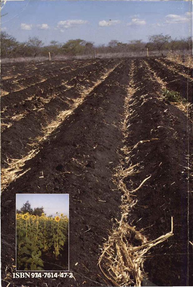
On the fifth day, there was a field tour, which took the participants into the MweaArea, where Typic Pellusterts are cropped in depressions for irrigated rice, and rainfed.crops are grown on the adjacent slopes. The main problems faced by farmers for theirrainfed crops were low rainfall, distributed in two seasons, and the occasional surfaceponding. This last consideration explains why sowing is often left until late in the season,as farmers are afraid that the seedlings may be destroyed, and this means that the subsequent crops suffer from drought in the dry months.
On the final day of the seminar, twelve cooperators indicated their willingness, torevise their project proposals so that they would comply with the agreed network approach and methodology. Finally the seminar adopted a resolution to form a network tobe known as the Management of Vertisols under Semi-Arid Conditions in Africa Network(MOYUSAC). Agreement was also reached on a general organizational strategy for thenetwork (see Appendix 11), and the meeting was closed by Dr. F. Wang 'ati.
INAUGURAL ADDRESS
by William W. WapakalaDirector of Research, Ministry of Agriculture
Mr. Chairman, distinguished guests, delegates, ladies and gentlemen.On behalf of the government and the people of the Republic of Kenya, it gives me
great pleasure to welcome to this country and to the City of Nairobi all of you who havecome from outside Kenya to this Regional Seminar on the Management of Vertisolsunder Semi-Arid Conditions. We are particularly happy that you have chosen Nairobi asthe venue of your first seminar on this topic.
The subject of soil and water management is an important one, particularly indeveloping countries where agriculture is the mainstay of the economy and the majorityof the population depend on it for their livelihood. In recent years severe drought's havethreatened many parts of the African continent, with resultant serious food deficitsaffecting millions of people and animals. While emergency intervention by the international community in provision of food aid to the affected countries has helped to alleviate the situation, it is becoming clear to us in Africa that the long-term solution to thefood crisis is not food aid but increased efforts by national governments to promote foodproduction. Soil and water are the cornerstones of agricultural production. It followsthat one of the most important areas which requires the attention of the national governments and international support for increased food production is development and conservation of the soil and water resources.
It has been observed that the rate of population growth in most developing countriesis higher than the rate of increase in food production; and while this inbalance prevailsthe resources for agriculture, Le. land and water, are decreasing in acreage in most countries because of the use of agricultural land for nonagricultural purposes such as residential accommodation, roads, factories, etc., and the loss of good agricultural land due toerosion, encroachment of desertification, salinity, alkalinization, and waterlogging. Thisprogressive reduction of agricultural land inevitably reduces the land:man ratio; and inorder to provide food to the increasing population in the coming decades it is thereforeessential to increase agricultural productivity per unit area of land. This can only be donethrough integrated, well-organized and efficient agricultural research systems capable of
4
generating new technology suited to the various soil types in different agroecologicalenvironments. Although expansion of the cultivated areas is still possible in some parts ofAfrica for increased food production, it should be noted that good soils are unevenlydistributed and that most of the soils in Africa are fragile and subject to degradation anderosion. Hence there is a great need for their proper management in order to increasetheir productivity.
Mr. Chairman, referring to my own country, Kenya, agriculture is the mainstay ofour economy. More than 80% of Kenya's population who live in the rural areas live anddepend on agriculture for their livelihood. In view of this, the government developmentplans over the last two decades have laid emphasis and given priority to programmesaimed at developing the rural areas, particularly the smallholder farm sector, and atdevising methods of developing the moderate- to low-rainfall (semi-arid) areas in order topromote a more even development in the country and at the same time increase foodproduction. However, the agricultural sector is faced with a number of problems, amongwhich is the restricted access to good agricultural land. The per capita availability of landwas about 0.75 ha in 1977 and is expected to decline to about 0.30 ha or less by the year2000. This trend is very disturbing when it is realized that less than 20% of the land issuitable for arable agriculture without resorting to irrigation. A small part of the remaining 80% can only support arable farming under irrigation or under proper soil and watermanagement practices.
Mr. Chairman, one of the first and most important steps in intensifying agriculturalproduction is to know the state of the soil resources. This can be done through a soilsurvey which indicates the location and extent of each kind of soil and its potential andlimitations for various uses. Unless a country knows the productive capacity of its soils,agricultural planning can be greatly constrained. Intensification of land use also requiresmore efficient management of soil moisture and plant nutrients. In addition there is aneed to reorientate irrigation to water-saving types of irrigation and to develop the poorlydrained soils. This too, is only possible if we know our soils and their likely response tovarious management practices.
The theme of this seminar is a very important one in that it addresses itself to themanagement of one of the soils that occurs extensively in humid, subhumid, semi-aridand arid climates, and has high potential for agricultural production. It is estimated thatVertisols, popularly known in this country as "black cotton soils" or "black crackingclays" occupy approximately 103 million ha of the total land area of sub-Saharan Africa.In Kenya these soils occupy approximately 2.8 million ha, which constitutes about 4.9%of our total land area. They are found under different climatic conditions, but themajority of them are in the semi-arid areas. As I mentioned earlier, the semi-arid or aridareas constitute about 80% of Kenya's land area and support 20% of the country's peopleand half of its livestock.
The Vertisols in Kenya are being used for extensive grazing as well as for productionof a variety of crops. Due to their occurrence in terrains which are relatively flat, they aresuited to irrigation; hence these soils are used extensively for growing irrigated rice in theMwea, Ahero and West Kano irrigation schemes; for sugarcane production in the Nyanza

5
Sugar Belt (Mumias, Chemilil, South Nyanza and Muhorini); cotton in the Bura and Holairrigation schemes; and vegetable production in the Athi River area. They are also used forproduction of maize, cotton, chickpea, beans and other crops under rainfed conditions.The yields of the various crops obtained from these soils very much depend on how theyare managed. Under poor management they have been known to yield only 40 t of caneper hectare in the Nyanza Sugar Belt. However, in the same area, and under propermanagement and adequate water supply, yields of up to 175 t of cane per hectare havebeen realized. Rice yields ranging from 5 to 6 t per hectare have been obtained at theMwea irrigation scheme. Irrigated cotton on these soils in the Bura and Hola irrigationschemes give yields ranging from 3 to 5 t seed cotton per hectare.
Although these soils have a very high potential for agricultural production, high levelsof production are rarely reached due to management problems. They are waterlogged orflooded during the rainy seasons, making them difficult to cultivate when wet. When drytoo, they have physical properties that render them difficult to till, especially with simpletools. Some of them have unfavourable chemical properties - for example in those withhigh pH, phosphorus availability is low. Nitrogen dificiency may occur as a result of poordrainage and relatively low content of organic matter. They may also have managementproblems when irrigated. In summary, there is a need for research to solve problems ofworkability, water availability and nutrient availability of these soils.
I do not intend to go into the details of various aspects underlying the theme of thismeeting, but I do realize from the programme that the seminar is going to consider allaspects of managing Vertisols for increased agricultural production, and in the end youwill be making specific recommendations as to how you intend to carry out collaborativeresearch. This seminar is being held at the time when we in this country are reorganizingour agricultural research system. In this reorganization, which involves developingpriorities among commodities/factors, major emphasis is being laid on management andconservation of soil and water resources. Collaborative research and strong interlinkageswith local and international organizations such as yours has been emphasized in the organizational process. I can thus assure you of our support and future collaboration.
I am pleased to note that you have included in your programme a field excursionto the Mwea area to enable you to see various environmental conditions existing in thearea and particularly the use being made of Vertisols. I also hope there will be time forvisiting our game reserves, and that you will enjoy your short stay in this country.
Mr. Chairman, without taking too much of your time, I would like to wish you allthe best in your deliberations. However, let me reiterate once again my pleasure at beinginvited to participate in this seminar.
It is now my humble duty and pleasure to declare this First Regional Seminar onManagement of Vertisols under Semi-Arid Conditions officially open.


INTRODUCTORY ADDRESS
Marc LathamDirector, International Board for Soil Research and Management
Director Wapakala,Your Excellency, ladies and gentlemen,
It is my honour to be with you for this Seminar on the Management of Vertisolsunder Semi-Arid Conditions. I am happy to see that so many of you have responded toour invitation. Even if the charms of Nairobi are amongst the reasons which induced youto come, I am sure that the importance of the subject we are dealing with this week isthe main motive for your being here.
Soil management and food production are one of the major issues affecting thiscontinent, especially in the semi-arid zone which has been hit so severely by a drought inrecent years. The population increase will require in the coming years more and morefood and agricultural production. All the resources need to be exploited, and Vertisolsare one of the underexploited resources of this area. They are potentially rich soils andwe all know that Indian regur, Egyptian black cotton soils, or Morrocan tirs can be a realsource of wealth. But they are complicated to manage. Their clayey texture make themdifficult to plough, and farmers often prefer to use proper sandy soils for this reason.They are too hard to be ploughed when dry, and too sticky after heavy rain.
Moisture is also a major constraint, as these soils absorb water easily but release itwith difficulty to the crops. The nutrients are sometimes presumed to be sufficient,mainly in the case of extensive farming like that practiced in Queensland, Australia; butphosphorus, nitrogen and micronutrients may rapidly become a limitation under intensiveexploitation. Erosion can also be a high risk, even if the slopes are not unusually steep.
Moreover Vertisols are not a uniform soil entity, and they occur under very differentagroclimatic environments, which is a limitation to the transfer of technology for managing them. In most classification systems, Vertisols do not appear to be very diversifiedin comparison with other great groups like Oxisols or Ultisols for example. But variationsin their constitution or in their organization have often been hidden to the pedologistbecause of the uniform colour, texture or structure which they present. In these semi-
8
arid zones, which extend from a maximum annual rainfall of 1000 to 1200 mm to suchlimited rainfall as 200-300 mm, moisture regimes and cropping possibilities are also verydiversified.
The search for soil management technologies adapted to these difficult agroenvironments is one of the priorities for the development of these zones. Solutions exist: somehave been successfully tested by ICRISAT in India, by ILCA in Ethiopia, and CIRAD inwestern Africa. Major progress has been obtained in the selection of adapted germ plasm,in the irrigation systems, and in the tillage practices. They now need to be tested,adapted, validated and transferred to the farmers.
The IBSRAM aim, which is to promote coordinated research efforts by nationalresearch organizations in collaborative research networks, is specifically designed to meetthese needs. Even if our knowledge of these soils is more limited than that which we canbring to bear on many others, we are not starting from nothing. We have to build on theresults we already have, while at the same time trying to generate new knowledge. Wemust have a two-phase strategy: on the one hand adapting the available results in orderto find out - rapidly - improved alternatives to the existing farmers' practices, and onthe other hand a longer-term strategy which consists of ascertaining carefully the fertilitycomponents of these soils by means of a coordinated research programme.
Strategic research and adaptive research cannot be disassociated. Adaptive researchmay bring improvements but may rapidly be limited by a lack of sound knowledge ofthe components. Strategic research will bring into play the strong scientific understanding needed to find solutions to the management problems which these soils present.However, this is a long-term effort and it may discourage donors, who will not seetangible results in a reasonable period of time. It may also be too comfortable an approach for the scientists, who will set out to achieve a remote target without regard tothe immediate applicability of the results.
In the six days of this seminar, I count on your efficient efforts to bring into effectthis network on the management of Vertisols under semi-arid conditions in Africa andSouthwest Asia. In the two first days, general presentations will be made in order toestablish the basis of the methodology to be applied by you, the future cooperators.This basis will be discussed in working groups and then coordinated later with the resultsof the other IBSRAM seminars in order to provide scientific guidelines for conductingIBSRAM programmes.
On Wednesday, you will present your country papers and project proposals. This isthe most important aspect of this meeting. We want to establish a soil managementnetwork, and for this we need good realistic projects which can be integrated into a network scheme. In 1985 we had, thanks to ICRISAT, USAID and ADAB, our InauguralWorkshop on the Management of Vertisols for Improved Agricultural Production, held inHyderabad, where the target of the network was established and where guidelines for thepreparation of project proposals were prepared. Dr. J. Burford has been able to visitsome of you since then in order to help you draft your projects. We now need to reviewand revise these projects in order to ascertain their scientific and socioeconomic relevance,and to put together a network from this collection of national projects. Discussion after

9
the presentations, and later on individually with the NCCs, are designed to secure thisintegration.
On Friday, during the field tour, you will be able to see some of the managementpractices conducted in Kenya, and also you will have the chance to discuss what youobserved amongst yourselves and with the resource persons who have been invited. Hopefully, by Saturday the basis of the network will have been established, and a core of threeto five projects will be outlined in a suitable form for presentation to potential donors.
I would like now, after having described the aims and the scheduled contents of thisseminar, to thank those who have made the seminar possible. We all gratefully acknowledge the assistance provided by the British Overseas Development Administration in supporting this seminar financially, and we hope that the results - in terms of inauguratingan efficiently integrated network - will measure up to this contribution and the expectations which have prompted ODA's initial effort.
We also wish to thank the participants from Australia, the Netherlands, Botswana,Italy and France, who have come to the seminar through the support provided by theirgovernments. And moreover I would like to thank ICRISAT, ILCA and ICRAF for theirstrong input in promoting this seminar. Finally, I must express our sincere thanks for thehard work which .has been put in by the local organizing committee, who have madeevery effort to solve all the details involved in organizing this seminar.
Your Excellency, ladies and gentlemen, we have a long week of work in front of us.The inputs you contribute are the only way to achieve our aim - which is to build anetwork on the management of Vertisols under semi-arid conditions. I count on yourinterest and your enthusiasm to make this seminar a success. Thank you.


First session: IBSRAM's network approach
Chairmen: Dr.Wang"ati
Dr.Kanwar


IBSRAM AND MANAGEMENT OF THE VERTISOLS NETWORK
Marc Latham*
Abstract
The International Board for Soil Research and Management (IBSRAM), which wasset up in 1983, is in the process ofdeveloping three regional programmes - one for Africa,one for Africa and Southwest Asia, and one far Monsoon Asia. These regional programmes are related to IBSRAM's three soil management targets: (i) management ofVertisols, [ii] management ofacid tropical soils, and [iii] tropical land clearingfor sustainable agriculture.
IBSRAM wants to promote sustainable improved soil management technologies inorder to remove soil constraints to food and other agriculturalproduction. The practicaladaptative investigations which IBSRAM advocates require multidisciplinary efforts fromsoil scientists, agronomists, and socioeconomists if the results obtained are to betransferred to the farmers concerned. In order to achieve these objectives, IBSRAM haschosen a collaborative network approach.
It is intended that the proposed network organization should comprise three components: (i) cooperators - who can be simple, active, basic or support participants;[ii) IBSRAM - which will act through a coordinator backed by a Network CoordinationCommittee (NCC); and [iii) the donors. The mechanism of acceptance involves submitting the project to IBSRAM, a review by the NCC, approval by the IBSRAM Board, andregular discussion and review of the results. In order to be accepted as part of thenetwork programme a project should conform to network objectives, and should adoptthe defined approach and methodology. It should also be economically acceptable andhave a broader scope than purely country objectives for basic research.
The aim of this seminar is to define the common approach and methodology, revisenational project proposals, and establish a regional network on the Management of Vertisols under Semi-Arid Conditions in Africa and Southwest Asia.
* International Board for Soil Research and Management (IBSRAM), PO Box 9-109, Bangkhen, Bangkok 10900, Thailand.

14
Introduction
IBSRAM was set up three years ago in September 1983, which was when the firstBoard was elected. At that time, it was decided, as a first priority, to promote four soilmanagement concerns. After four inaugural workshops from December 1984 to September 1985, three soil management targets were considered to be of special interest byvirtue of their great potential for developing agricultural resources:
Management of Vertisols (IBSRAM 1985a);Management of acid tropical soils (IBSRAM 1985b);Tropical land clearing for sustainable agriculture (IBSRAM 1985c).In order to establish networking arrangements to cover these topics, three regional
network programmes have since been proposed. They are:Land Development and Management of Acid Tropical Soils in Africa, for which aregional seminar took place in Douala, Cameroon, in January 1986;Land Development and Soil Management in Monsoon Asia, for which a regionalseminar took place in Khon Kaen, Thailand, in October 1986;Management of Vertisols under Semi-Arid Conditions in Africa and Southwest Asia,which is the object of this meeting.This paper will discuss the IBSRAM soil management network approach, the main
features of the proposed regional network on the Management of Vertisols under SemiArid Conditions, the proposed organization of this network, the mechanism of approvalfor project proposals, and finally the objectives of this particular seminar.
IBSRAM Soil Management Network Approach
The IBSRAM soil management network approach has been described earlier (IBSRAM, 1985d, 1985e, 1985b and 1986c), but it may need to restated for those who arenot yet familiar with it. The overall goal of IBSRAM is to promote sustainable improvedsoil management technologies in order to remove soil constraints to food and other agricultural production. To implement this goal, the IBSRAM approach is to help cooperators, through soil management networks, to conduct the investigations necessary for thepractical adaptation and validation of improved soil management and land-use practices.
Soil management, in the IBSRAM view, is a multidisciplinary undertaking whichmust combine inputs from soil science, agronomy and socioeconomics. Soil knowledgefor soil management has to envisage the soil as a whole in its environmental context, andto classify it according to recognized reference systems in order to provide the means fora general transfer of agrotechnology. However, it must focus on the layers prospected byroots, on the lateral variations of their characteristics, and on the dynamics of their mostmobile components - air, water, ions, fauna and flora. These components are related tothe climate and seasons, since they are controlled by rainfall and temperature. In turn,the climate and seasons are also the direct causes of erosion, taken in conjunction withthe slope and the land use. For proper application to management, a good soil knowledge

15
must be comprehensive so that a sound interpretation of experimental data can be madeand the results can be promulgated extensively.
New technologies have been produced by agronomists. International agriculturalcentres and other research organizations have found new germ plasms, improved phytosanitary protection, and appropriate tillage and fertilizer practices, which have led towhat has been called 'the green revolution'. Unfortunately, these techniques, which canbe applied successfully on good agricultural soils, have been difficult to extend to themore marginal lands, which is where the current pressure for agricultural development isbecoming more intense. Also, more complexity is involved in marginal lands - Ultisols,Oxisols, Vertisols, and steepland Inceptisols - than there is in good agricultural landssuch as alluvial Inceptisols, Entisols or Mollisols. This means that there is a great deal ofwork to be done in adapting and testing these new improved technologies, taking intoaccount the variability of the environments involved.
Socioeconomic inputs are necessary because they are the means by which these newtechnologies can be applied. A knowledge of the farmers and of their traditional practices is essential in the search for acceptable technologies. Agricultural habits derivedfrom long experience represent a very rich source of information. The attempt to integrate familiar habits into the proposed technologies, and at the same time to improvethem, will save time and will make them more acceptable. Finally, soil managementtechnologies must adapt to the farmers' possibilities and to national priorities regardingthe lands and crops to be developed.
Individual efforts are long and costly in agricultural research. The use of the existingknowledge, the sharing of new findings by national institutions working on the samesubject, and the coordination of these efforts, are the most cost-effective ways of tacklingthese problems. This is why IBSRAM has chosen a collaborative research approach toachieve its objectives.
MOVUSAC Network in Africa and Southwest Asia
The network on the Management of Vertisols under Semi-Arid Conditions(MOVUSAC) in Africa and Southwest Asia will concentrate on the dark swelling claysoils which occur extensively in the semi-arid regions of Africa, the Middle East and theIndian subcontinent. Because of their topographical position, their depth, the nature oftheir clay and their mineral content, they possess a very high potential for agriculturalproductivity. However, high levels of crop yields are seldom reached due to variouslimitations - tillage difficulties, low infiltration rates and permeability, and nutrient deficiencies - that can be overcome by improved management techniques.
The inaugural IBSRAM workshop on the Management of Vertisols for ImprovedAgricultural Production, held at the ICRISAT headquarters in India in February 1985,showed that:o improved techniques are available for achieving better soil management;o such techniques and others need to be tested and adapted in a range of semi-arid

16
zones in order to determine those which can be introduced most easily and effectively into farming practices; and
o further research is especially needed on tillage, water conservation, nutrient management, and cropping systems.Following the report of the inaugural workshop and the guidelines proposed, re
search project proposals have been sent by different future cooperators in order to jointhe IBSRAM Vertisols network.
The proposed regional network will focus on one part of the initially envisaged network on the Management of Vertisols for Improved Agricultural Production - the subarid nonflooded Vertisols. The area concerned will be Africa and Southwest Asia. Otherprogrammes for the management of Vertisols may be developed in other parts of theworld on different types of Vertisols. It is hoped to link participants from different regional programmes through a Vertisols newsletter and other information media, and eventually through global activities such as specific meetings or training courses.
Organization of the Regional Network
The proposed organization of this regional network will be similar to that envisagedfor the initial networks. It will comprise three components, namely:
1. Cooperators
Cooperators will initiate and operate the soil management programme activitiesconnected with one of the following types of participation:o simple participation in the different programme activities, mainly with a view to shar
ing information;o active participation - both by having an accepted programme, and by participating
in all the various programme activities;o basic participation - by having an approved programme, some basic research related
to the objectives of the network, and also participation in all the programme activities;
o support participation by international and other research agencies, by undertakingsome part of the basic research related to the objectives of the network, either aloneor in conjunction with other cooperators.
2. IBSRAM
Through a programme coordinator, backed by the Network Coordinating Committee, IBSRAM will catalyze, coordinate, and assist cooperators in conducting their activities. IBSRAM provides assistance in the preparation and presentation of the projects todonor agencies. The coordinator acts as a link between the cooperators and IBSRAM.He helps strengthen the national cooperators' programmes by regular visits and consulta-

17
tions and by backstopping the following network activities;o site characterization;o exchange of control soil samples and analytical methods;o design of experiments, analyses and interpretation of data arising from these experi-
ments;o technical assistance;o regular meetings during which programmes are reviewed and eventually revised;o monitoring tours;o training courses;o creation of a data base;o a review of past and ongoing research and bibliographic information services;o production of a programme newsletter, publications, and documentation.
3. Donors
The role of the donors will be to fund the programme coordination and, in part, theactivities of the individual national cooperators.
Mechanism of Approval of National Project Proposals
One of the main objectives of this meeting is to revise and approve national projectproposals in order to establish the regional network programme. The mechanism ofapproval, which is already being applied, consists of the following steps:1. A project proposal on soil management is presented to IBSRAM by a national
institution. Coordination between national organizations is favoured.2. The project is reviewed by the Network Coordination Committee (NCC). Until now,
the initial interim NCC formed during the inaugural workshops has been used.During this meeting, one question to be discussed is the formation of an NCC for thisregional network on the management of Vertisols. The NCe will consist of scientistswith useful expertise in the management of Vertisols, the main donors, and theIBSRAM coordinator.
3. The IBSRAM Board must then endorse its acceptance of the project proposals.4. After approval, an official letter of acceptance will be sent to the cooperators, who
may use it as a letter of support for fund seeking. During the regular meetings of thenetwork, cooperators will present their results, and these will be discussed and reviewed by the participants in order to maintain a high scientific and developmentstandard in the programme.The criteria for the approval of a national project proposal are as follows:The project must fulfill the network objectives as defined during the inaugural workshops and as clarified during the present seminar.The project must be technically acceptable, i.e. it should follow the approach andmethodology to be defined during this seminar. An example is given by the results
18
of the Cameroon seminar that you have to hand (lHSKAM 1986a).The project is thought to be scientifically and economically acceptable.The country is already involved in research of the type proposed, or is willing to invest in training for its personnel to achieve worthwhile participation.If a basic research project is proposed, it should have a broader objective than thecountry objectives per se, and should have implications on a wider scale. Thiscriterion will not apply to validation projects.
Objectives of this Seminar
This seminar, then, will have three major objectives:1. To define a common approach and methodology. The review papers presented in
the first part and the following discussions are designed to help the working groupsto design this common methodology and approach - without which no exchangeamongst cooperators can function. The results of these working groups will be discussed and provisionally approved on the last day of the seminar: they will be thebasis of our future work. In order to harmonize the work of the three regional network programmes and of the future ones, the Board will review these results andthose of the other regional programmes during its meeting in March 1987. However,the results obtained here can serve as a basis to start the projects.
2. To revise the national project proposals. An exchange of correspondence has alreadytaken place with regard to the national project proposals received. Improvementshave been made, but further discussions and revisions will be conducted during thisweek when it is hoped to finalize some of these projects. Others, which have not yetbeen discussed, will be reviewed. Finalized projects will be submitted to the Boardimmediately after the seminar in order to get its final approval. They will be published separately as the basis of the regional programme.
3. To establish the regional network on the Management of Vertisols under Semi-AridConditions in Africa and Southwest Asia. Some donors have expressed their stronginterest in this network and we expect that a coordination plan will be funded by thebeginning of 1987. Your requests will be discussed and finalized on the last day ofthis meeting.This network must be yours. This means that in addition to your national project
proposals, we must work out in more detail the rules governing the functioning of thenetwork and the common activities which can be implemented. A regional NCC must beformed which will serve as an advisory body to the coordinator. Finally, three publications will be produced after this seminar:1. A report of the seminar in the format of the report of the Cameroon seminar. This
will be ready by March 1987 and will be widely distributed.2. A document including the approved projects, to be circulated internally in the net
work as a base document and for donorsupport purposes.3. Proceedings of the seminar, which will be largely a compilation of the papers present-

19
ed during the first two days. In order to keep a standard level in these proceedings,we will form an editorial committee which will look at the scientific aspects of thepapers. I hope that we may have these proceedings published before the end of1987.
Conclusion
We now have six days of heavy work ahead of us to cover our tightly packed schedule; but I feel that you' will lend your very best efforts to the task since we are buildingyour network. Monday and Tuesday will be devoted fo lectures on specific points relatedto the implementation of the network. Wednesday will see the presentation of countryreports and project proposals. On Thursday, we will split into working groups and lookat the common methodology to be employed in the network. On Friday, we will havethe chance to visit sites in the Mwea district, where Vertisols are being used for paddyrice and rainfed agriculture; and on Saturday we will finalize our discussions.
This seminar is an opportunity for you to meet each other, and it is also a uniquechance to discuss your specific problems regarding your projects on the management ofVertisols for improved agricultural production. So your enthusiasm and your work willbe the best start for the cooperative activities which the network can foster.
References
IBSRAM (International Board for Soil Research and Management). 1985a. Managementof Vertisols for Improved Agricultural Production. Report of the Inaugural Workshop, ICRISAT Centre, Patancheru, India, 18-22 February 1985. ICRISAT. 20p.
IBSRAM (International Board for Soil Research and Management). 1985b. Acid Tropical Soil Management Network. Report of the Inaugural Workshop and Proposal forImplementation, 24 April-3 May 1985, Yurirnaguas, Peru and Manaus, Brasilia,Brazil. IBSRAM. 40p.
IBSRAM (International Board for Soil Research and Management). 1985c. Tropical LandClearing for Sustainable Agriculture. Report of the Inaugural Workshop and Proposal for Implementation, 27 August-2 September 1985, Jakarta and Bukittinggi,Indonesia. IBSRAM. 48p.
IBSRAM (International Board for Soil Research and Management). 1985d. IBSRAMNewsletter no. 1, July 1985.
IBSRAM (International Board for Soil Research and Management). 1985e. IBSRAMNewsletter no. 2, December 1985.
IBSRAM (International Board for Soil Research and Management). 1986a. Land Development and Management of A cid Tropical Soils. Report of the IBSRAM Sessions,Seminar on Lateritic Soils, Materials and Ores, 21-27 February 1986, Douala, Camerroan. IBSRAM. 32p.
IBSRAM (International Board for Soil Research and Management). 1986. IBSRAM Newsletter no. 3, June 1986.
IBSRAM (International Board for Soil Research and Management). 1986c. IBSRAMHighlights 1985. IBSRAM. 32p.
/

CHARACTERIZATION OF VERTISOLS FROM INDIA AND IRAQAND THEIR TAXONOMIC PROBLEMS
Jawahar L. Sehgal andJ.C. Bhattacharjee*
Abstract
Vertisols are deep, dark-coloured clayey soils with considerable uniformity, and arefound in semi-arid to subhumid climates.
The dominance of smectite clay and high swell-shrink phenomena with changes ofmoisture results in cyclic movement which inhibits horizonation and has significantgenetic implications in the development of Vertisols. These soils are characterized bydeep'~ wide cracks, gilgai microrelief, intersecting slickensides and/or wedge-shaped structural aggregates in the subsoils. In India they are found extensively in the central peninsular region, while in Iraq they are confined to the intermontane valley plains in thenortheast and the basins ofMesopotamia. In central peninsular India, the soil moistureregime is predominantly ustic, and accordingly Vertisols are classified as Chromustertswith a hyperthermiclisohyperthermic temperature regime. In Iraq, they are classified asChromoxererts and Salitorrerts, depending on the moisture regime and other factors. Theclimatic pattern reveals variations in the number ofdry and humid days in a year, indicating appreciable differences in soil moisture storage during the growing season of the crop,although soils apparently have a uniform moisture regime at the great group level.
It is considered necessary for Vertisol classification to subdivide the ustic moistureregime into aridic, typic and udic subgroups on the basisofclimatic parameters, indicatingdifferences in soil moisture storage. Similarly xeric and aridic moisture regimes have beensubdivided into dry-xeric and extreme-aridic subgroups. In view of the high salinity inthe Torrerts of Iraq, it is proposed that the classification ofTorrerts should be completedat great group level by introducing groups called Salitorrerts, (Calci-, Gypsi-, and Haplotorrerts].
* National Bureau of Soil Survey and Land Use Planning, Amravati Road, Nagpur - 440 010, India.

22
Generalities
Vertisols are deep, dark-coloured clayey soils of predominantly smectitic mineralogy.They are characterized by deep and wide cracks and at places have gilgai microrelief withfrequent micro knolls and microdepressions. These soils have characteristic cyclic pedons,which make them different from other soils. The slow and steady process of haploidization induced by argillipedoturbation (Hole, 1961) inhibits the process of horizonation(Simonson, 1954; White, 1967; Buol et al., 1973) and favours the development ofVertisols having characteristic structural profiles.
Vertisols are remarkably homogeneous soils; but differences within their taxa may becaused by climatic components, slope and landforms, the amount and composition ofsmectite minerals, and the nature of saturating cations. The soils are fine to very fine intexture, have a high CEC, base saturation, bulk density (dry), coefficient of linear extensibility, predominance of saturating cations such as Ca2+, Mg2+ and Na3 (either singly orin combination), a high water storage capacity, low saturated hydraulic 'conductivity, anda neutral to alkaline reaction. They are normally low in plant-available nutrients.
The proper understanding of their characteristics in relation to their potential use forfood production is a justifiable aim of research on Vertisols, which should lead to theeffective management and viable use of these soils. In the present paper an attempt hasbeen made to review and compare the soil characteristics of Vertisols from India and Iraq,highlighting their taxonomic problems and their potential for normal rainfed-crophusbandry.
Distribution
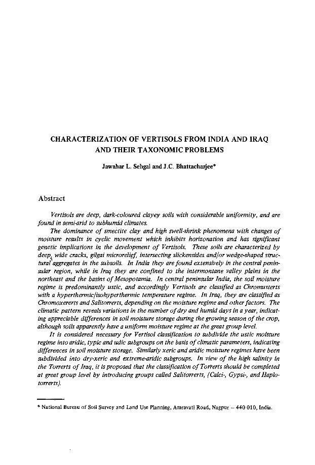
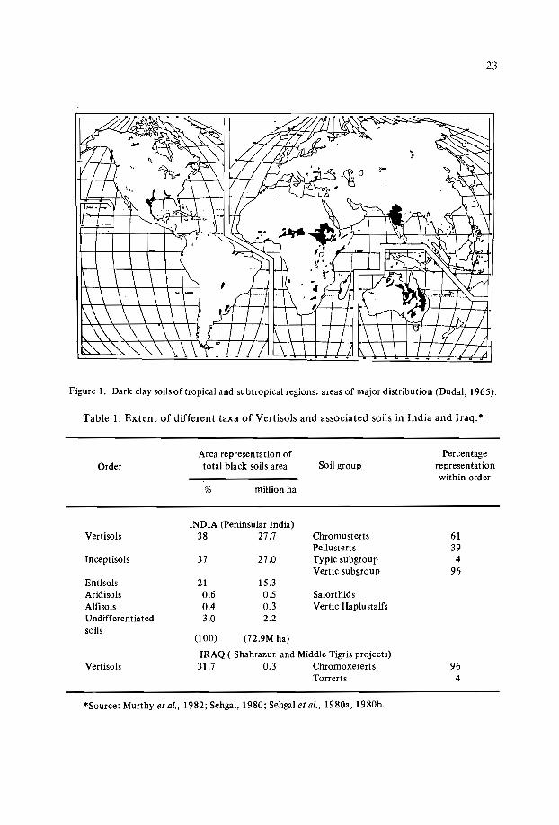
Vertisols and associated vertic soils are the most widely dispersed soils in the world,and can be found under varied climatic conditions. Such soils are spread over five continents from 45°S to 45°N, mainly in tropical and subtropical areas, and their major areasof distribution are located in Asia and Africa (Dudal, 1963) (Figure 1). There are about310 million ha of these soils in Asia (mostly in India), in America (mostly in the USA,Venezuela and Argentina), in Australia, and in the African continent.
"0 In India, Vertisols and associated soils are mostly observed in the peninsular regionextending from latitudes 8°45' to 26°0'N and longitudes 68°0' to 83°45'E. They occupyapproximately 72.9 million ha and constitute 22.2% of the total geographical area of thecountry (Table 1). They occur in the states of Maharashtra (7.9%), Madhya Pradesh(5.1%), Gujarat (2.6%), Andhra Pradesh (2.2%), Karnataka (2.1%), Tamil Nadu (1.0%),Rajasthan (0.7%), Orissa (0.4%), Bihar (0.2%), and Uttar Pradesh (Murthy et al., 1982).
In Iraq, such soils are confined to areas with level to nearly l~~~l landscapes, andoccupy an estimated 30% of the land area in the intermontane valley plain (in the northeast) and 1% of the basin area (in the Mesopotamian Plain of central Iraq) (Table 1). Theassociated Mollic subgroups and/or Mollisols in the hilly areas are observed on the higherelements of the topography (Sehgal et al., 1980a, 1980b).
23
Figure 1. Dark clay soils of tropical and subtropical regions: areas of major distribution (Dudal, 1965).
Table 1. Extent of different taxa of Vertisols and associated soils in India and Iraq."
OrderArea representation oftotal black soils area
% million ha
Soil groupPercentage
representationwithin order
(lOO) (72.9M ha)
IRAQ ( Shahrazur and Middle Tigris projects)31.7 0.3 Chromoxererts
Torrerts
INDIA (Peninsular India)38 27.7Vertisols
Inceptisols
EntisolsAridisolsAlfisolsUndifferentiatedsoils
Vertisols
37
210.60.43.0
27.0
15.30.50.32.2
ChromustertsPellustertsTypic subgroupVertic subgroup
SalorthidsVertic Haplustalfs
6139
496
964
"'Source: Murthy et al., 1982; Sehgal, 1980; Sehgal et al., 1980a, 1980b.

24
Climatic Environments
The climatic conditions in the central peninsular region of India supporting Vertisolsvary from semi-arid to subhumid tropical (Figure 2). The area is characterized by hot anddry premonsoon summer months (March to May), followed by well-expressed summer
ARABIAN
SEA
66'
26'
32
24'
36
96'92'
A
Scale I: 115,000,000100 0 100 200 100 400 1500 Ielll
J;;;I I:i=1
66'64'
c
60'76'
'''.72'
BAY 20· .
OFBENGAL
"Vt. ie-
q.~~
~+.o Vertisols O~
~ , Dependable rainfall 8~'2'
;. .", '.:. Undependable a ~.: . :, rainfall.~ ~:z
~Q 6"~
N D ~I C E A N ~
72' 76' 64' 66' 92'
66'
REFERENCES
D. DELHIS SIKKIMN NAGALAHOM MIZORAMT TRIPURA
6'
'2'
'6
64'
20
26'
24'
32'
36
Figure 2. Assured-rainfall (750-1500 mm) and unassured-rainfall (below 750 mm) regions in centralpeninsular India (Virmani et al.• 1978).
25
monsoon months (June to September). The subsequent short period from October toNovember receives uncertain showers with a low probability of occurrence, followed bya fairly dry spell of mild winter (December to February). The mean annual (air) temperature ranges from 24 to .27°C. The mean summer (April, May and June) and mean winter(December, January and February) temperatures vary from 30 to 33°C and from 15 to22°C respectively. The mean annual rainfall ranges from 500 to 1500 mm, of which 80to 90% is received during the monsoon period. It covers 42 to 77% of the 'mean annualpotential evaporatranspiration (PE). The area experiences 4 to 8 months of dry weatherin a year, when the soil moisture control section (MCS) remains dry, either completely orin parts, suggesting a ustic moisture regime (Figure 3) (Bhattacharjee and Landey, 1984).
The intermontane valley in northeast Iraq, supporting Xererts, has a subtropical semiarid Mediterranean climate, and the Mesopotamian Plain, s~porting Torrerts, has a hotsubtropical desert climate. The mean annual (air) temperature and rainfall in northeastIraq is 18,S°C and 765 mm respectively; it is 24.7°C and 136 mm in major parts of theMesopotamian Plain. Here rainfall occurs from December to March (winter season)which is typical of a Mediterranean climate. The summer and autumn (June to November) are dry in most years. The MCS remains dry for about 4 to 5 months in thenortheast sectors, and almost throughout the year in the central Mesopotamian Plain,suggesting xeric and torric soil moisture regimes respectively (Figure 3) (Sehgal et al.,1980a, 1980b).
Characterizati0 n
Typical Usterts of the central peninsula, India
Usterts occur extensively in central peninsular India and are represented by manysoil series, including the benchmark soils of Kheri, Linga, Aroli, Sarol and Mimone. Thesalient morphometric, physical and chemical characteristics of these soils are given inTable 2.
Typical Usterts are deep (100 to 150 cm) and clayey. Their colour is predominantlyin hues of 10YR with values of 4 (dry) and 3 (moist) and chromas of 2 and/or 3 (dry andmoist) (Table 2). The soils are classified as Chromusterts (NBSS, 1982a).
The Kheri, Linga and Aroli series are found in the subhumid tropics and experiencea hyperthermic temperature environment. They occur on the level to very gently slopingpiedmont and flood plains of the Wardha and Narrnada river systems, and receive assuredrainfall ranging from 1000 to 1500 mm p.a., with moderate to considerable runoff in themonsoon season, resulting in moderate to severe erosion. Runoff and soil-lossstudies onsome soils comparable to the Aroli series with bunded fields (used as a normal soil conservation practice) under cotton and sorghum crop covers indicate an annual soil loss of12-15 ton/ha/yr. which occurs from runoff amounting to 15-20% of the total rainfall.During dry periods, the soils crack, with widths ranging from 2 to 5 cm, separating thesurface 30 to 40 cm soil mass into hard, massive, deep prism-like blocks (polyhedrons).

26
Jabalpur (Rep:Kherl Series)o I 0 I
mm 23 10 N, 79 57 E600 (UDIC- USTlCl
JFMAMJJASOND
N a llpur (Rep: Aroll,Lingo Series)
°co I 0 I
mm 21 06 N,79 03 E 0
C40 400 (TYPIC USTIC) 40
30 300 30
20 200 • 20
10 100 ." 10
0J F M A M J J A SON D
Ahmadnallar (Rep: Nimone
mm 19 05 N,74 55 ESeries) °c
400 (ARIDIC- USTIC) 40- Surplus
• ••• Temperatureb-___J Deficit 300 • • 30
• • • • • o-----e Rainfall
~ Recharge • • PET200 • • 20 .---.c:=:J Utilization It----i( A ET
[CI3 Dry Period 100 10
B Moist Period 0J F M A M J J A S o N D
Climatic histogram
AI-Hal (Rep:Abu-Holono,Towollio S ha h r a z u r (Rep. : Molowois,320 34'N,45' 38' Series) 0 0 , 0 I Sir won Series) 0
C. mm 35 35 N,46 02 C(EXTREME ARIDIC) 40 400 (DRY XERlC)
40mm .'I'i ~'.
300 II1 I 1 I , 30 300 30~IIIIIIIII'II,
200" 1 , I I I , I ,I 11 11,1 1
1,1,',',',. 20 200 20I'~IIII"I 1['1'1 11 1 11 11I'
100,I' ,,1 I I" , I I I , , ,.
1011,1,1,1 III 11' 11, ' , 111, 1, ' , ' 100 10I 1 , J 1 1, ,1 1 1",1 I , I I ,
01 ' I 1 I ,
0J F M A M J J A SON D J F M A M J J A SON D
Figure 3. Climatic data and water balance (Bioclimatic Bulletin of India, 1982, and Sehgal et al.,1980).
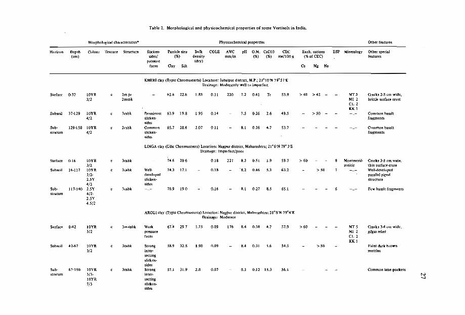
Table 2. Morphological and physicochemical properties of some Vertisols in India.
Morphological characteristics" Physicochemical properties Other features
Horizon Depth Colour Texture Structure Slicken- Particle size Bulk COlE AWC pH 0.101. CaC03 CEC Exch. cations ESP Mineralogy Other special(cm) sides/ (%) density mm/m (%) (%) me/lOO g (%ofCEC) features
pressure (dry)faces Clay Silt Ca Mg Na
KHERI clay (Typic Chromusterts) Location: Jabalpur district, M.P.; 23°10'N 79°S7'EDrainage: Moderately well to imperfect
Surface 0-37 10YR c 2m pr 62.6 22.6 1.85 0.11 220 7.2 0.41 Tr 53.9 > 40 > 42 - MT5 Cracks 2-3 cm wide,3/2 2msbk 10112 brittle surface crust
Cl2KK I
Subsoil 37-129 10YR c Scabk Prominent 63.9 19.8 1.95 0.14 7.5 0.26 2.6 49.5 > 50 - - - ..- Common basalt4/2 slicken- fragments
sidesSub- 129-150 10YR c 2eabk Common 65.7 20.6 2.07 0.11 8.1 0.26 4.7 53.7 - - ..- Common basaltstratum 4/2 slicken- fragments
sides
LlNGA clay (Udic Chromusterts) Location: Nagpur district, Maharashtra; 21°6'N 79°3'EDrainage: Imperfect/poor
Surface 0-16 10YR c Scabk 74.6 20.6 0.18 227 8.3 0.51 1.9 59.3 > 60 8 Montmoril- Cracks 3-5 cm wide,3/2 lonitic thin surface crust
Subsoil 16-117 lOYR c Jcabk Well- 74.3 17.1 0.18 8.2 0.46 5.3 63.2 - > 50 7 - ..- Well-developed3/2- developed parallel piped2.5Y slicken- structure4/2 sides
Sub- 117-140 2.5Y c Jcabk - ..- 70.9 19.0 0.16 8.1 0.27 8.5 65.1 - 6 - .. - Few basalt fragmentsstratum 4/2-
2.5Y4.5/2
AROLl clay (Typic Chrcmustetts) Location: Nagpur district, Maharashtra: 2l oS'N 79°4'EDrainage: Moderate
Surface 0-42 10YR c 3m·cabk Weak 67.4 29.7 1.75 0.09 176 8.4 0.38 4.7 57.9 >60· - MT 5 Cracks 3-4 cm wide.3/2 pressure 10112 gilgai relief
faces Cl2KKI
Subsoil 42-67 10YR c Scabk Strong 58.9 32.8 1.90 0.09 8.4 0.31 1.6 54.5 - >50 Faint dark brown3/2 inter- mottles
sectingslicken-sides
Sub- 67-190 10YR c Scabk Strong 57.1 31.9 2.0 0.07 0.5 0.12 15.3 56.1 - - Common lime pocketsstratum 3/3- inter- N
10YR secting -.l
7/3 sllcken-sides
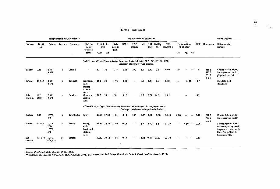
Iv00
,.Table 2. (Continued)
Morphologicalcharacteristics'" Physicochemical properties Other features
Horizon Depth Colour Texture Structure Slicken- Particle size Bulk COLE AWC pH O.M. csco, CEC Exch. cations ESP Mineralogy Othew: special(cm) sides/ (%) density mm/m (%) (%) me/lOO 9 (%ofCEC) features
pressure (dry)faces Clay Silt Ca Mg Na
SAROL clay {Typic Chromusterts); Location: Indore district, M.P.; 22"43'N 75·48'EDrainage: Moderately well drained
Surface 0.29 2.SY c 2msbk 57 31 1.89 0.16 230 8.0 0.37 1.8 49.0 70 - 8 MT5 Cracks3-4 cm wide.3.5/2 MI2 loose granular mulch;
CL 2 gilgai microreliefKK I
SUbsoil 29-147 2.5Y c 3m-cabk Prominent 56.! 3S 1.96 0.16 - 8.1 0.30 2.7 54.0 - > 35 8.7 Parallel piped3.5/2 inter- structures
sectingslicken-sides
SUb- 147- 2.SY c 3mabk Moderate 52.S 38.1 2.0 0.16 8.2 0.27 14.9 43.5 - 11stratum 160+ 3.5/2 slicken-
sides
NOMONEclay (Typic Chromusterts); Location: Ahmednagar district, MaharashtraDrainage: Moderate to imperfectly drained
Surface 0-47 10YR c 2m'bk-abk Faint 49.39 27.39 1.81 0.12 200 8.35 0.54 6.60 35.45 > 80 - 0.12 MT5 Cracks3-4 cm wide,3/2 MI2 loose granular mulch
CL 2Subsoil 47-107 10YR c 3cabk Strong 53.83 28.87 1.80 0.15 8.5 0.40 9.68 35.23 > 50 - 0.26 Strong parallelpiped
2/2- well- structure;many basalt10YR developed fragments coated with4/4 slicken- lime; few yellowish
sides brown mottlesSub- 107-155 10YR gc 2msbk - 52.32 20.16 1.S6 0.17 - 8.65 0.29 17.23 35.10 - 0.21stratum 4/3,4/4
Source: Benchmark Soils of India, 1982, NBSS.·AbbreviatiQns as used in Revised Soil Survey Manual, 1978, SCS, USDA, and Soil Survey Manual,AI/India Soil and lAnd Use Survey, 1970.

29
These blocks break into hard and firm, subangular to angular blocky peds and these structural peds impose great limitations on normal tillage operations. The surface soils arecovered by a 5 to 10 mm-thick crust, which is broken into fine particles by the heatingaction of the rain, and the crust seals the surface pores and partly moves into the cracks(Anonymous, 1986).
Among these soils, the soils of Kheri and Linga are more clayey (with more than 60%clay content) and are classified at the family levelas very fine in texture. The Aroli soilseries (like the Sarol and Nimone soils), however, have a slightly lower clay content(50-58%) and qualify at the family level as fine in texture (NBSS, 1982a).
Sarol soils occur in- the transitional belt of the dry subhumid to semi-arid tropicswith hyperthermic environments on nearly level to' very gently sloping piedmont plainwith assured rainfall from 800 to 1000 mm.
Nimone soils occur extensively in the dry semi-arid tropics with an isohyperthermicregime. They occur on a nearly level to very gently sloping piedmont plain. The areareceives unassured rainfall of from 500-700 mm, covering only 42% of the PE.
The gilgai microrelief is a prominent feature of the Linga, Aroli and Sarol soils. Theamplitude of microknolls over the microdepressions varies from 10 to 20 cm. Unlike thesoils of the subhumid tropics (Kheri, Linga and Aroli series), besides cracking the Saroland Nimone soils have a dark grey, 20-30 mm-thick pulverized granular surface mulchthat partly covers wide open cracks (Bhattacharjee and Landey, 1984). The Vertisolshaving surface mulch have a comparatively friable and finer surface structure with morevoid space between the peds in the dry season than those without mulch (Blokhuis,1982)..
The dominant saturating cation on the exchange complex in the surface horizons ofthese soils isCa?", except Kheri soils which are saturated with Mg2 + (Table 1). The presence of high Mg2 + (in Kheri soils) results in dispersion and probably leads to restricteddrainage, and limited use for paddy followed by wheat cultivation.
The coefficient of linear extensibility (COLE) in general varies from 0.1 0-0.19(Table 2). It is significantly higher in the subsoils as compared with the surface soil. TheLinga soils show the highest value, indicating high swelling potential. The high swelling,coupled with Mg and/or Na saturation in most of the subsoils is suggestive of possibledispersion, resulting in limited root ramification and oxygen availability in the rootinglone.
Xererts a/northeast Iraq
The soilscape in northeast Iraq, supporting Xererts, is an intermontane valley plain.The Xererts are represented by the soils of the Malawais and Sirwan series developed oncalcareous alluvium (derived mainly from limestone, dolomite and marls) under semi-arid(submoist) thermal Mediterranean climate and supporting steppic grass vegetation (Sehgalet al., 1980a). On the lower slopes with nearly level soilscape, Malawais soils are replacedby hydromorphic soils of the Sirwan series (Sehgal, 1980). The soils are very deep, darkcoloured, and clayey, with a relatively high CEC. Ca++ constitut'es the dominant saturating cation on the exchange complex (Table 3).
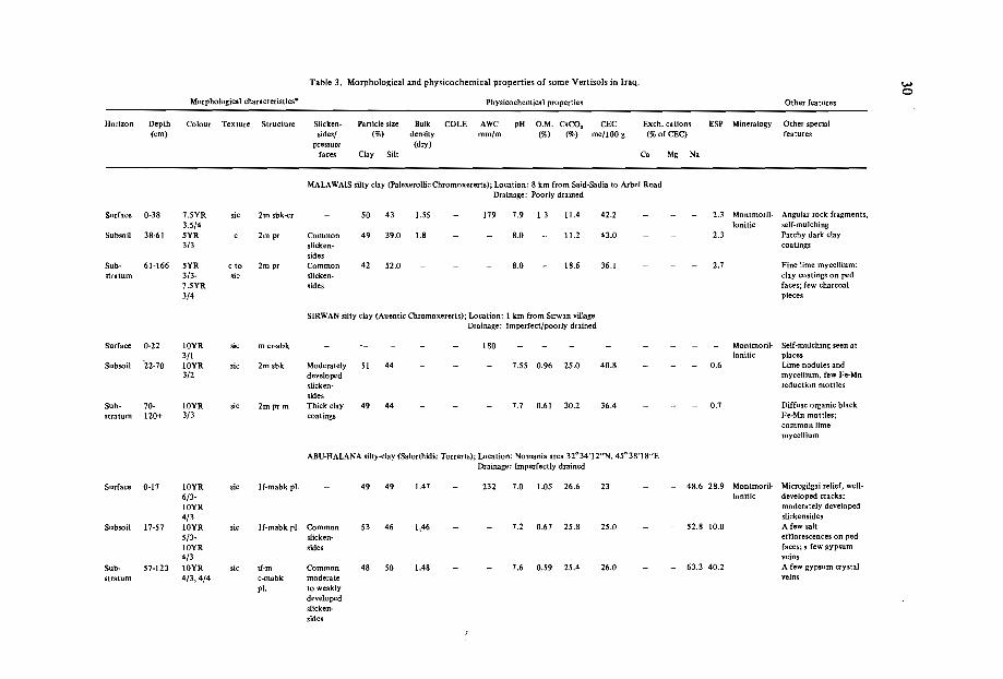
Table 3. Morphological and physicochemical properties of some Vertisols in Iraq. .....0
Morphological characteristics" Physicochemical properties Other features
Horizon Depth Colour Texture Structure Slicken- Particle size Bul1c COLE AWC pH O.M. CaCO, CEC Exch. cations ESP Mineralogy Other special(cm) sides/ (%) density mm/m (%) (%) me/lOO g (%of CECj features
pressure (dry)
faces Clay Silt Ca Mg Na
MALAWAlS silty clay (Palexercllic Chromoxererts): Location: 8 km from Sald-Sadia to Arbel RoadDrainage: Poorly drained
Surface 0-38 1.5YR sic 2m sbk-cr 50 43 1.55 119 1.9 1.3 11.4 42.2 2.3 Montmoril- Angular rock fragments,3.5/4 lonitic self-mulching
Subsoil 38-61 5YR c 2m pr Common 49 39.0 1.8 8.0 11.2 43.0 2.3 Patchy dark clay3/3 slicken- coatings
sidesSub- 61-166 5YR c 10 2m pr Common 42 52.0 8.0 18.6 36.1 2.1 Fine Iirne mycellium;stratum 3/3- sic slicken- clay coatings on ped
1.5YR sides faces; few charcoal3/4 pieces
SlRWAN silty clay (Auentic Chrcmoxererts); Location: 1 km from Sirwan villageDrainage: Imperfect/poorly drained
Surface 0-22 10YR sic m cr-abk 180 Montmoril- Self-mulching seen at3/1 lonitfc places
Subsoil '22-10 10YR sic 2m sbk Moderately 51 44 - - 1.55 0.96 25.0 40.8 - 0.6 Lime nodules and3/2 developed mycellium, few Fe-Mn
slicken- reduction mottlessides
Sub- 10- 10YR sic 2m pr m Thick clay 49 44 1.1 0.61 30.2 36.4 0.1 Diffuse organic blackstratum 120+ 3/3 coatings Fe-MD mottles;
common limemycellium
ABU-HALANA silty-clay (Salorthidic Torrerts); Location: Nomania area 32°34'12"N, 45° 3S'IS"EDrainage: Imperfectly drained
Surface 0-11 10YR sic If-mabk pI. 49 49 1.41 232 1.0 1.05 26.6 23 48.6 28.9 Montmcril- Microgilgai relief, well-
6/3- lonitic developed cracks;IOYR moderately developed
4/3 slickensidesSubsoil 11-51 10YR sic lf-mabk pI. Common 53 46 1,46 1.2 0.61 25.8 25.0 52.8 10,0 A few salt
5/3- slicken- efflorescences on ped
IOYR sides faces; a few gypsum4/3 veins
Sub- 51·123 10YR sic if-m Common 48 50 1.48 1.6 0.59 25.4 26.0 63.3 40.2 A few gypsum crystal
stratum 4/3,4/4 c-mabk moderate veins
pI. to weaklydevelopedslicken-sides

Morphological characteristics'"
Table 3. (Continued)
Physicochemical properties Other features
Horizon Depth(cm)
Colour Texture Structure Slick.ensides!
pressurefaces
Particle size(%)
Clay Silt
Bulkdensity(dry)
COlE AWCmm/m'
pH O.M. CaCO,(%) (%)
CECme/lOO g
Exch. cations(%ofCEC)
Ca Mg Na
ESP Mineralogy Other specialfeatures
TOWAIJIA silty clay loam {Eluventic Torrer ts); Location: Suwaira area; 310 S'7"NDrainage: Moderately well/imperfect
Surface 0-25 10YR sic If- m Few 220 7.6 0.88 27.6 22.0 4.3 Montmoril- Characterized by cracks.5/3 sbk, pI. pressure lonitic very hard crusty surface;
faces in a few salts on ped faces,7-25 cm weakly developed gilgai
relief;Subsoil 25-92 10YR sic-c lf-cpr Few 59 38 7.6 0.50 24.9 22.6 7.2 Partly decomposed
5/3,4/2 mabk sllcken- rootssides
Sub- 92-165 7.5YR sic-e I pr Few weak 59 39 7.9 0.40 26.1 25.6 52.6 17.9 Bands of sandystratum 4/4- 2 mabk. pressure stratified material; few
10YR faces rnottles of 5YR 5/2,3/3 few gypsum, mycellium
and crystals
Source: 1. The soils of the Middle Tigrts Project (Mesopotamian Plain) for land-use planning by Jawanhar L. Sehgal et al. Soils Bulletin Feb, 1980. Directorate of Soil Investigations and Land Classification,Baghdad, Iraq.
2. Soil Survey Report - The Soils of the Shahrazur Area (NE Iraq) and their SUitability for Land-Use Planning, by Jawahar L. Sehgat et al. 1976. Bureau of Soil Studies and Design, Baghdad, Iraq .
• Abbreviations as used in Revised Soil Survey Manual, 1978, SCS, USDA, and SoU Survey Manual, All India SoU and Land-Use Survey, 1970.
w-
32
The Malawais soils have a hue of 7.5YR or redder and chromas of 3 to 4, whereasthe Sirwan soils have a hue of 10YR throughout the chromas of 2 or more, except inthe surface horizon where the chroma is I. This is because of flooding in the area. TheMalawais soils with a higher chroma indicate relatively better drainage conditions than theSirwan soils. In the dry period (June to November), the soilscape develops cracks (I0-15cm in width) and gilgai microrelief with linear frequency of microknolls and microdepressions occurring at intervals of 100 cm or so. The deep cracks separate the soil intomassive prism-like blocks (polyhedrons), about 30 cm deep, that break into hard to veryhard and firm angular blocky peds. The dark brown, clayey, slightly alkaline subsoilsshow a typical prismatic structure, breaking into blocky peds with slickensides closeenough to intersect. These features are characteristic of these soils.
The soils of Sirwan, on the other hand, show evidence of hydromorphic characteristics, such as rusty root channels, Fe-Mn nodules, distinct dark mottles, and high groundwater « 1.5 m)(Table 3).
Torrerts of the Mesopotamian Plain, Iraq
The Torrerts, represented by the soilscapes of the Abu-Halana and Towaijia series,are deep, calcareous, imperfectly drained, and strong to moderately saline. They occurin the shallow basin (Playa) of the Mesopotamian Plain under extreme hot and aridenvironments.
The Abu-Halana soils are highly calcareous throughout with a salic horizon at theirsurfaces. The soils crack and have gilgai microrelief with a dendritic, gully-patternedlandscape (Figure 4). The detailed morphometric features along with the physical andchemical characteristics are given elsewhere (Sehgal et al., 1980a). The groundwater tablevaries from 123 cm to 80 cm from the surface. These soils are comparatively more saline(ECe 34.8 mm/hos/cm) than Towaijia soils (ECe 13.5 rnm/hos/cm) (Table 3). The AbuHalana soils are uncultivable, while those of the Towaijia series are cultivated for wheat,but give poor yields.
The weighted means of some important soil properties calculated on a number ofpedons occupied by Usterts, Xererts and Torrerts are given in Table 4.
Pedogenesis
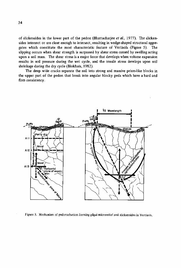
Parent material that is primarily basic in nature and which contains a high proportion of alkaline earth, favouring the development of the smectite group of minerals, isessential for the genesis of Vertisols and vertic associates. The high coefficient of expansion and contraction of these minerals results in a three-dimensional volume change ofsoil mass during alternate wet and dry cycles, as conditioned by the climatic environments and topography. The net result is the development of deep and wide cracks withor without gilgai microrelief. Simultaneously, the volume changes set up a cyclic movement of soil materials (autoinversion) to cause vertical mixing (pedoturbation) of the soilmaterial. Such phenomena cause one mass to slip over another, resulting in the formation
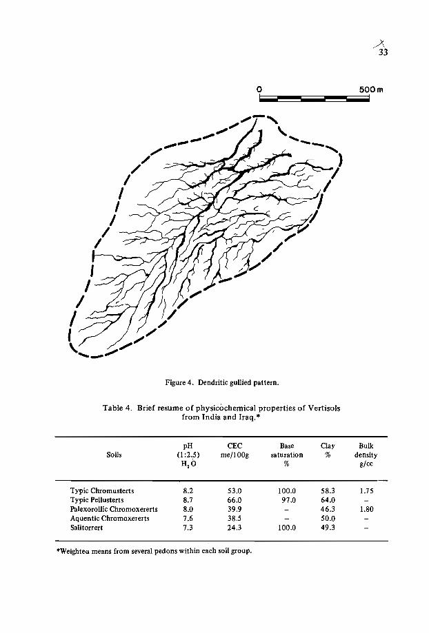
Figure 4. Dendritic gullied pattern.
Table 4. Brief resume of physicochemical properties of Vertisolsfrom India and Iraq. '"
pH CEC Base Clay BulkSoils (l :2.5) me/lOOg saturation % density
H2 O % gjcc
Typic Chromusterts 8.2 53.0 100.0 58.3 1.75Typic Pellusterts 8.7 66.0 97.0 64.0Palexorollic Chromoxererts 8.0 39.9 46.3 1.80Aquentic Chromoxererts 7.6 38.5 50.0Salitorrert 7.3 24.3 100.0 49.3
*Weighteu means from several pedons within each soil group.
34
of slickensides in the lower part of the pedon (Bhattacharjee et al., 1977). The slickensides intersect or are close enough to intersect, resulting in wedge-shaped structural aggregates which constitute the most characteristic feature of Vertisols (Figure 5). Theslipping occurs when shear strength is surpassed by shear stress caused by swelling actingupon a soil mass. The shear stress is a major force that develops when volume expansionresults in soil pressure during the wet cycle, and the tensile stress develops upon soilshrinkage during the dry cycle (Blokhuis, 1982).
The deep wide cracks separate the soil into strong and massive prism-like blocks inthe upper part of the pedon that break into angular blocky peds which have a hard andfirm consistency.
All
AI2
~2 Wavelength
Figure 5. Mechanism of pedoturbation forming gilgai microrelief and slickensides in Vertisols.

35
Taxonomic Problems - Some Considerations and Criteria
Soil temperature regime
The principal climatic parameters are temperature (including air and soil temperature) and precipitation. Variation in any of the principal parameters affects the significance of the others, resulting in different rates of evapotranspiration, crop phenology andbiomass production. Flohn (1969) considered that global radiation, albedo and radiationbalance on the one hand, and duration of flows of sensible heat and of latent heat fromsoil to atmosphere and vice-versaon the other, are of vital importance.
The striking feature of the climate of central peninsular India is the sharp rise in airtemperature from March onwards. The highest temperatures are reached during themonths of April, May and June when the environment remains dry. The MCS during thisperiod remains completely dry and the growth of mesophytes is not possible (NBSS,1982). The summer monsoon sometimes arrives in the second half of June. The temperature drops sharply, and remains more or less consistent throughout the entire monsoon period (June-September). The temperature drops further during the postmonsoonperiod. The summer is the period when the temperatures are highest. Since the temperature during the monsoon period (June-September) drops significantly, these monthsshould not be considered as summer months. This being so, the MST should be based onthe mean monthly temperature of April, May and June - and not on June, July andAugust as defined in Soil Taxonomy (1975). Strahler and Strahler (1978) have madesimilar observations.
In India, the mean annual soil temperature (MAST) is calculated by adding 3.5°Cto the mean annual air temperature in areas located below latitude 18°N, by adding2.0°C to areas located between latitudes 18° to 23°N, and by adding 1.5°C to areaslocated above 23°C (NBSS, 1982b).
For calculating the mean summer and mean winter soil temperatures (MSST, MWST),we need to add 2.5°C to the MWT (air) and substract 2.5°C from the MST (air) to arriveat the mean difference .of the'temperatures at 50 cm depth which define 'iso' and 'noniso'soil temperature regimes.
The differences between the MSST and the MWST, calculated using NBSS (1982),Soil Taxonomy (1975), and SMSS/USDA (1981) criteria, are presented in Table 5. Thedata show no significant differences between the two approaches (NBSS and Soil Taxonomy) for computing the 'iso' and 'noniso' temperature regimes. However, the data showsignificant differences using the SMSS approach. The difference between the MSST andthe MWST suggests a nonisohyperthermic temperature regime for Indore, Najpur andJabalpur, and an isohyperthermic regime for the Ahmednagar station using NBSS andSoil Taxonomy criteria. However, the SMSS approach suggests a nonisohyperthermictemperature regime for the Ahmednagar station. Consequently it would seem that theNBSS criteria (NBSS, 1982) holds good for logistic calculation of the temperature regimeunder Indian conditions.
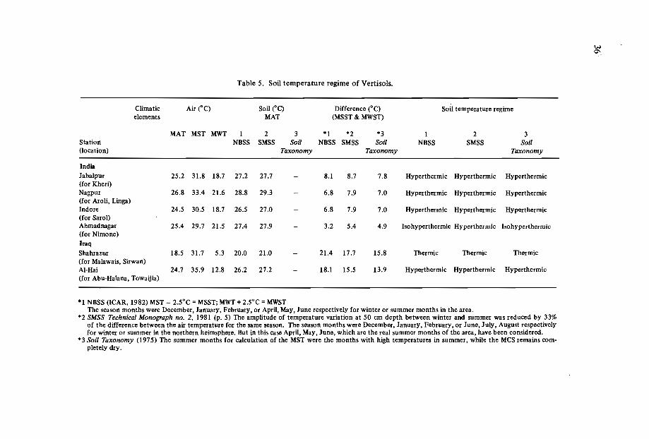
Table 5. Soil temperature regime of Vertisols.
Climatic Air ("C) Soil ('C) Difference ("C) Soil temperature regimeelements MAT (MSST & MWST)
MAT MST MWT 1 2 3 *1 *2 *3 1 2 3Station NBSS SMSS Soil NBSS SMSS Soil NBSS SMSS Soil(location) Taxonomy Taxonomy Taxonomy
IndiaJabalpur 25.2 31.8 18.7 27.2 27.7 - 8.1 8.7 7.8 Hyperthermic Hyperthermic Hyperthermic(for Kheri)Nagpur 26.8 33.4 21.6 28.8 29.3 - 6.8 7.9 7.0 Hyperthermic Hyperthermic Hyperthermic(for Aroli, Linga)Indore 24.5 30.5 18.7 26.5 27.0 6.8 7.9 7.0 Hyperthermic Hyperthermic Hyperthermic(for Sarol)Ahmadnagar 25.4 29.7 21.5 27.4 27.9 - 3.2 5.4 4.9 Isohypertherrnic Hyperthermic Isohypertherrnic(for Nimone)IraqShahrazur 18.5 31.7 5.3 20.0 21.0 - 21.4 17.7 15.8 Thermic Thermic Thermic(for Malawais, Sirwan)AI-Hai 24.7 35.9 12.8 26.2 27.2 - 18.1 15.5 13.9 Hyperthermic Hyperthermic Hyperthermic(for Abu-Halana, Towaijia)
*1 NBSS (lCAR, 1982) MST - 2.5°C =MSST; MWT + 2.5°C =MWSTThe season months were December, January, February, or April, May, June respectively for winter or summer months in the area.
*2 SMSS Technical Monograph no. 2, 1981 (p. 5) The amplitude of temperature variation at 50 cm depth between winter and summer was reduced by 33%of the difference between the air temperature for the same season. The season months were December, January, February, or June, July, August respectivelyfor winter or summer in the northern heimsphere. But in this case April, May, June, which are the real summer months of the area, have been considered.
*3 Soil Taxonomy (1975) The summer months for calculation of the MST were the months with high temperatures in summer, while the MCSremains completely dry.
W0'>
37
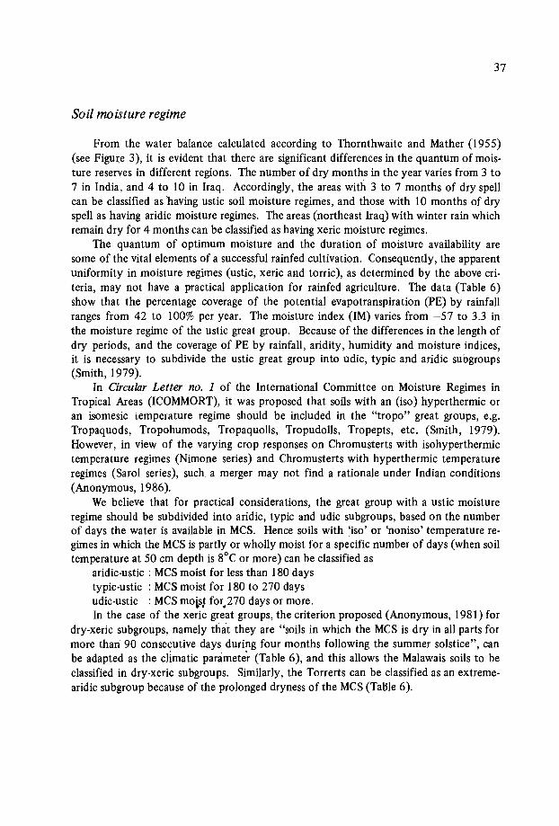
Soil moisture regime
From the water balance calculated according to Thornthwaite and Mather (I955)(see Figure 3), it is evident that there are significant differences in the quantum of moisture reserves in different regions. The number of dry months in the year varies from 3 to7 in India, and 4 to 10 in Iraq. Accordingly, the areas with 3 to 7 months of dry spellcan be classified as 'having ustic soil moisture regimes, and those with 10 months of dryspell as having aridic moisture regimes. The areas (northeast Iraq) with winter rain whichremain dry for 4 months can be classified as having xeric moisture regimes.
The quantum of optimum moisture and the duration of moisture availability aresome of the vital elements of a successful rainfed cultivation. Consequently, the apparentuniformity in moisture regimes (ustic, xeric and torric), as determined by the above criteria, may not have a practical application for rainfed agriculture. The data (Table 6)show that the percentage coverage of the potential evapotranspiration (PE) by rainfallranges from 42 to 100% per year. The moisture index (IM) varies from -57 to 3.3 inthe moisture regime of the ustic great group. Because of the differences in the length ofdry periods, and the coverage of PE by rainfall, aridity, humidity and moisture indices,it is necessary to subdivide the ustic great group into udic, typic and aridic subgroups(Smith, 1979).
In Circular Letter no. 1 of the International Committee on Moisture Regimes inTropical Areas (ICOMMORT), it was proposed that soils with an (iso) hyperthermic oran isomesic temperature regime should be included in the "tropo" great groups, e.g.Tropaquods, Tropohumods, Tropaquolls, Tropudolls, Tropepts, etc. (Smith, 1979).However, in view of the varying crop responses on Chromusterts with isohyperthermictemperature regimes (Nimone series) and Chromusterts with hyperthermic temperatureregimes (Sarol series), such, a merger may not find a rationale under Indian conditions(Anonymous, 1986).
We believe that for practical considerations, the great group with a ustic moistureregime should be subdivided into aridic, typic and udic subgroups, based on the numberof days the water is available in MCS. Hence soils with 'iso' or 'noniso' temperature regimes in which the MCS is partly or wholly moist for a specific number of days (when soiltemperature at 50 cm depth is 8°C or more) can be classified as
aridic-ustic : MCSmoist for less than 180 daystypic-ustic : MCSmoist for 180 to 270 daysudic-ustic : MCSmolst for)70 days or more.In the case of the xeric great groups, the criterion proposed (Anonymous, 1981) for
dry-xeric subgroups, namely that they are "soils in which the MCS is dry in all parts formore than 90 consecutive days during four months following the summer solstice", canbe adapted as the climatic parameter (Table 6), and this allows the Malawais soils to beclassified in dry-xeric subgroups. Similarly, the Torrerts can be classified as an extremearidic subgroup because of the prolonged dryness of the MCS(Table 6).
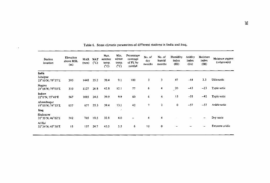
Table 6. Some climatic parameters of different stations in India and Iraq.
---Elevation
Max. Min. PercentageNo. of No. of Humidity Aridity Moisture
Stationabove MSL
MAR MAT summer winter coveragedry humid index index index
Moisture regimelocation
(m)(mm) ("C) temp. temp. of PE by
months months (IH) (lA) (IM)(subgroups)
("C) ("C) rainfall
IndiaJabalpur23° IO'N; 79° 57'E 393 1448 25.2 39.4 9.1 100 3 3 47 -44 3.3 Udic-ustic
Nagpur21°06'N; 79°03'E 310 1127 26.8 42.8 12.1 77 6 4 20 -43 -23 Typic ustic
Indore22°0'N; 75°48'E 567 1085 24.5 39.9 9.9 60 6 4 13 -55 -42 Typic ustic
Ahrnednagar19°05'N; 74° 55'E 657 677 25.3 39.4 13.1 42 7 2 0 -57 -57 Aridic-ustic
Iraq
Shahrazur35° 35'N; 46°02'E 742 765 18.5 32.8 4.0 4 4 - - - Dry xeric
AIHai32°34'N; 45°38'E 15 137 24.7 43.5 5.5 6 10 0 - - Extreme aridic
w00
39
Soil depth
A minimum depth is essential for a soil to qualify as a Vertisol. During field surveysin the Vertisol areas, we rarely observed characteristic Vertisols on soil with a depth of50 cm or less. We believe that a shallow soil depth does not permit the development ofthe characteristic structure in the subsoil. The deep wide cracks, prismatic- and wedgeshaped structures, and slickensides, which are the essential requirements of Vertisols, arenot observed in shallow soils « 50 cm depth).
Soil colour
According to Soil Taxonomy, the concept of "pell" and "chrom" is based on theprevailing drainage conditions. The Chromusterts are supposed to be better drained thanPellusterts. The criteria, viz. chroma (moist) of 1.5 or more for Chromusterts and lessthan 1.5 for Pellusterts, is arbitrary and not based on field reality. Intensive field studyof such soils indicates that a chroma (moist) of 1.5 or more and chroma (moist) of lessthan 1.5 do not always represent well-drained and ill-drained Vertisols as envisaged inSoil Taxonomy. Many soils from central peninsular India and soils from Iraq showchroma of 2 or more, even though many of them are imperfectly to poorly drained.They are classified as Typic Chromusterts (Nimone, Dhanduka, Otur, Aroli series) ofIndia and Chromoxererts (Malawais series) of Iraq. In contrast, many moderately tomoderately well drained soils developed on basic metamorphic rocks showing chroma ofless than 1.5 have been classified as Pellusterts (Table 7). Therefore the concept of "pell"and "chrom" in different situations of drainage and topography does not conform tothe field reality. It is felt that chroma (moist) for better-drained Vertisols should behigher than 2, indicating oxidation potential in the soils in contrast to poorly drainedsoils, since drainage is a parameter which influences the agricultural use of the soils.
Table 7. Colour (chroma) and drainage condition in differenttaxa of Vertisols.
Soil series
IndiaNimoneUmbrajDhandhukaSarolMalegaonAchamattiRaichurIraqMalawaisAbu-Halana
Drainage
imperfectpoorpoormoderately wellmoderately wellimperfectmoderately well
imperfectimperfect
Chroma(moist)
2222II1
3-43
Classification
ChromustertChromustertChromustertChromustertPellustertPellustert
ChrornoxerertSalitorrert

40
Horizonation
The Vertisol profiles are generally designated as A-C profiles because of haploidizadon (Dudal, 1965, Buol et al., 1973). But in view of the strong structural developmentdue to swelling and shrinking phenomena there is a school of thought which believesthat such soils should be designated as having A-{B)-C or A-B-C profiles rather than A-Cprofiles (Yalon and Kalmar, 1978; Singer, pers. comm. 1985; Eswaran, pers. comm.1986).
The view taken here is that in most soils with cambic B horizons (structural and/orcolour B), the organic-matter content decreases regularly with depth because of thepedogenesis. While colour and structural B horizons are predominant in lnceptisols,structural B horizons are generally observed in Vertisols, since in the latter the structuraldevelopment results from the mechanical forces due to alternate swell-shrink phenomena,concomitant to accretion and depletion of moisture during wet and dry cycles. Althoughthe organic-matter content in Vertisols remains almost uniform with depth, the structuralaspects are well expressed. Such structural B horizons in Vertisols should be designatedas vertic B horizons, such as argillic (Bt), spodic (Bhir) and calcic (Bca) horizons. Accordingly, a letter "v" could be suffixed to B to designate the vertic horizon as Bv and tohighlight its vertic character.
Saline cracking clay soils
Torrerts, by definition, are Vertisols with a torric moisture regime. They have highclay (> 30%), cracks (I cm or more wide at 50 cm depth) and slickensides close enoughto intersect (Soil Survey Staff, 1975). Many such soils with gilgai microrelief have developed locally on alluvium in close depression areas of Mesopotamia, which are floodedonce every few years by runoff from higher areas. Harris (I958) reported that montmorillonite and mica are the main constituents in gilgaied Tigris soils. Some such soilsin Mesopotamia [Abu-Halana series) have an accumulation of salts at their surface, orwithin 75 cm of the surface, and may qualify as having a salic horizon. The most likelysource of salts is the saline groundwater which renders the soil saline as a result of capilllary rise. The high salts are generally associated with restricted or poor permeabllity.Although the system provides phases within a taxonomic unit to take account of highsalts, yet we believe that a high salt content, when associated with poor permeabilityresulting from the swelling of clayey soils, may restrict the easy removal of salts andhence make the reclamation process difficult.
Such soils, according to the current class definition, are classified as Torrerts orSalorthids (if the salts are high enough to qualify as having a salic horizon) or both. TheTorrerts enjoy priority over Salorthids in exemplifying such soils (Soil Survey Staff,1975) as the cracking clay properties are of a permanent nature. Accordingly, such soilsare classified as Typic Torrerts. But this does not clearly indicate their saline nature. Thediagnostic horizons in Soil Taxonomy which are followed are of the great group level.Some comparable soils (saline with high ESP and clay) in the Indo-Gangetic Plain in India
41
have been logically classified by introducing sa1ic subgroups within Halaquepts, Natrustalfs, Natraqua1fs, Natrargids, etc. (Sehgal et al., 1975) to take into account a salt contentwhich is high (l% or more), but not high enough to define the horizon as salic. For practical considerations, we proposed the introduction of a Salitorrert great group of Torrertsto complete the classification of Torrerts at the great group level.
On similar grounds, we propose Calcitorrerts, Gypsitorrerts, and Haplotorrerts. Themodification proposed not only places due emphasis on the salic horizon but also appearslogical and results in a better grouping for practical land use. This modification also findssupport from the distribution of these soils on the landscape, with Salorthids occurringin close association.
Vertisols in India and Iraq have been classified in accordance with the existing classcriteria, and this classification is given in Table 8.
Table 8. Classificationof benchmark soils from India and Iraq.
Soil FamilySoil series Locality
'Texture MineralogySubgroup
Temperature
Hyperthermic Typic ChromustertsHyperthermic Udic ChrornustertsHyperthermic Typic ChrornustertsHyperthermic Typic ChrornustertsIsohypertherrnic Typic Chromusterts
IndiaKheriLingaAroHSarolNimoneIraqMalawaisSirwanAbu-HalanaTowaijia
Jabalpur Very fineNagpur Very fineNagpur FineIndore FineAhmadnagar Fine
Shahrazur FineShahrazur FineAl-Hai FineAl-Hai Fine
MontmorilloniticMontmorilloniticMontmorilloniticMontmorilloniticMontmorillonitic
MontmorilloniticMontmorilloniticMontmorilIoniticMontmorillonitic
ThermicThermicHyperthermicHyperthermic
PalexeroIIic ChromoxerertAquentic ChrornoxerertSalitorrertFIuventic Torrerts
Use and Management
In India, Vertisolsand their associated vertic soils are widely cultivated under rainfedconditions. Rainfed crop husbandry is dependent prtmarily on some factors such as soilvariability and management practices. The marked changes in volume associated withmoisture changes pose problems in the use and management of these soils. The workability of these soils in the rainy season becomes poor because they become extremelysticky. Tillage operations are difficult in dry periods because of the development of widecracks anda hard massive structure between 'the cracks. Consequently, these soils can beworked only under a narrow rare~of moisture conditions.
Sorghum, maize and pearl millet are the main cereal crops; pigeonpea, gr_~~ea andchickpea are the main p.ukes; safflower is the main oilseed crop; and cotton is the maincommercial crop. Recently, soybean has become popular in the assured-rainfall areas ofcentral peninsular India. Wheat as a postmonsoon crop is grown at places on residual soil
Table 9. Grain yields (kg/ha) of sorghum and wheat grown on Ustertsin central peninsular India." .
Soil series SAROL AROL LINGA KHERI NIMONE
ITemperature Hyperthermic Hyperthermic Hyptherrnic Hyperthermic Isohypertherrnic
regime
I Moisture Typic-Ustic Typic-Ustic Typic-Ustic Udic-Ustic Aridic-Usticsubgroup
Sorghum (sole) 2783 1838 2615 - 3860t(rainfed in rainy season)
Wheat (sole) 3607 1874 2611 3192 3404(irrigated farming inpostmonsoon season)
·Source: Cooperative Benchmark Soils Project, India (unpublished).
tWith two protective irrigations at panicle and milk stages.
~
IV
43
moisture with two life-saving irrigations; otherwise in the majority of cases it is grownunder irrigation. v ,·0_ ,
, \ r •
Sorghum is grown either as a sole crop or intercropped with pigeonpea in the rainyseason, while postmonsoon sorghum is grown as the sole crop on residual soil moistureunder traditional and improved management practices.f Sorghum is grown as the solerainy-season crop on Aroli, Sarol and Linga soils under assured rainfall, whereas it isgrown on Nimone soils with two protective irrigations.
The yield of sorghum grown in the monsoon season and wheat grown in the postmonsoon season is given in Table 9. The higher yield of rainfed sorghum on isohyperthermic and aridic-ustic Nimone soils is attributed to two protective irrigations given atcritical stages of growth; otherwise the yield would have been far less than from othersoils. In the case of Aroli, Linga and Sarol soils, the MCSremains moist during the cropgrowth and consequently it shows no moisture-stress during the crop growth. From theforegoing it may be concluded that the Isohyperthermic Chromusterts give higher cropyields than the Hyperthermic Chromusterts. In contrast, wheat yield under irrigatedfarming in the postmonsoon season is higher on Chromusterts with a hyperthermic temperature regime than on Chromusterts with an isohyperthermic temperature regime.
Acknowledgements
The authors wish to express their sincere gratitude to MissC. Roychowdhury and herteam for undertaking the cartography and for analyzing the climatic data; to Or. S.B.Deshpande, Mr. R.K. Batta and Mr. K.R. Venugopal for making useful suggestions; andto Mrs. T.L. Pillai and Shri D.K. Nandanwar for typing the manuscript.
References
ANONYMOUS. 1986. Cooperative Project on Benchmark Soils Network for Agrotechnology Transfer. (Unpublished report).
BHATTACHARIEE, I.C., LANDEY, R.I. and KALBANDE, A.R. 1977. A new approachin the study of Vertisol morphology, Journal of the Indian Society of Soil Science25(3): 221-232.
BHATTACHARIEE, I.C. and LANDEY, R.I. 1984. Minimum data sets for agrotechnology transfer on Vertisols and associated soils in India. In: Proceedings of the International Symposium on Minimum Data Sets for Agrotechnology Transfer, March 2126, 1983. Patancheru, A.P., India: ICRISAT.
BLOCKUIS, W.A. 1982. Morphology and genesis of Vertisols. In: Symposium Papers I/.12th International Congress ofSoil Science. New Delhi.
BUOL, S.W., HOLE, F.D. and McCRACKEN, R.I. 1973. Soil Genesis and Classification.Iowa, USA: Iowa State University Press.
DUDAL, R. 1963. Dark clay soils of tropical and sub-tropical regions. Soil Science 95:264.
DUDAL, R., ed, 1965. Dark clay soils of tropical and subtropical regions. FAO Agricultural Development Paper no. 83. Rome, Italy: FAO.
44
ESWARAN, H. 1986. Vertiso1 morphology. (Personal communication).FLOHN, H. 1969. Climate and Weather. London: Weidenfe1d and Nico1son.HARRIS, S...\.. 1958. The gilgaied and bad-structured soils of Central Iraq. Journal of
Soil Science 9:169-185.HOLE, F.D. 1961. Journal of Soil Science 91 :375.MURTHY, R.S., BHATTACHARJEE, J.C., LANDEY, R.J. and POFALI, R.M. 1982.
Distribution, characteristics and classification of Vertiso1s. In: Symposium Papers II.12th International Congress ofSoil Science. New Delhi, India: Indian Society of SoilScience.
NBSS (National Bureau of Soil Survey and Land Use Planning). 1982a. Benchmark Soilsof India. Nagpur, India: NBSS.
NBSS (National Bureau of Soil Survey and Land Use Planning). 1982b. Bioclimate ofIndia. Bulletin no. 7. Nagpur, India: NBSS.
SEHGAL, J.L., HALL, G.F. and BHARGAVA, G.P. 1975. An appraisal of the problemsin classifying saline-sodic soils of Indo-GangeticPlain of NW India. Geoderma 14:75-91.
SEHGAL, J.L., AL-MISHADANI, M., ABDUL GHANI, S.A. and SIGUR, R.H. 1980a.The soils of Schahrazur area (NE Iraq) for land use planning. Journal of the IndianSociety of Soil Science 28(1): 57-71.
SEHGAL, J.L., MAHAMMED, M.A., AL-JOHAR, T. and ALLEWY, R.J. 1980. The soilsof the Middle Tigris project (Mesopotamian Plain) for land-use planning. SoilsBulletin. Badhdad, Iraq: SOSLR. p.376.
SEHGAL, J.L. 1980. Soils of the Shahrazur area (NE Iraq). H. Genesis and classification.Journal of the Indian Society of Soil Science 28(3): 329-335.
SIMONSON, ROY W. 1954. Morphology and classification of the Regur soils of India.Journal of Soil Science 5:275-288.
SMITH, G.D. 1979. International Committee on Moisture Regimes in Tropical Areas.ICOMMORT Circular Letter no. 1: ICOMMORT.- .
SOIL SURVEY STAFF. 1975. Soil Taxonomy. U.S. Department of Agriculture Hand-book no. 436, USDA, Washington, D.C.: U.S. Government Printing Office.
STRAHLER, ARTHUR N. and STRAHLER, A.H. 1978. Modern Physical Geography.London: John Wiley and Sons. pp. 133-137.
THORNTHWAITE, C.W. and MATHER, J.R. 1955. The water balance. In: Climatology,vol. 8, no. 1.
USDA (U.S. Department of Agriculture). 1981. SMSS Monograph no. 2. Washington,D.C.: U.S. Government Printing Office.
VIRMANI, S.M., SIVAKUMAR, M.V.K. and REDDY, S.J. 1978. Rainfall' probabilityestimates for selected locations of semi-arid India. ICRISAT Research Report no. 1.Patancheru, A.P., India: ICRISAT.
YAALON, D.H. and KALMAR, D. 1978. Earth Surface Processes.
VERTISOLS IN EASTERN AFRICA
R.F. van De Weg*
Abstract
The paper outlines the extent and distribution of Vertisols in Kenya and Sudan, anddiscusses their morphology, chemical and physical properties, and classification, withspecific examples from Kenya and Sudan. The use and management of Vertisols is reviewed in relation to tillage, irrigation, erosion, flooding, fertility and engineering problems.'
Environment
In Kenya, Vertisols occupy about 5% of the country, of which about 80% is in thesemi-arid to arid regions. Most of them are scattered all over the country and occur ongently undulating peneplains ("uplands"), alluvial and volcanic plains, flood plains,valley bottoms, and bottom lands. They are developed on parent materials ranging fromPrecambrian Basement System rocks (ferrornagnesian gneisses, etc.), volcanic rocks(basalts, etc.) to alluvial/colluvial deposits derived from various rocks (Muchena andGachene, 1985).
In Sudan, Vertisols occur mainly on the western, central and eastern clay plains.They cover an area of approximately 500000 km", constituting about 20% of the country. They occur under different climatic conditions, with precipitation ranging from200-800 mm per year. They have developed on various parent materials of differentmodes of origin; in the central part on the alluvium of the Nile system, in the east onbasaltic rocks, and in the west they were formed on residual and alluvial/colluvial materialderived from the Nuba mountains (Hassan, 1985).
* Netherlands Soil Survey Institute (STIBOKA), P.O. Box 98, 6700 AB Wageningen, Netherlands.I .. . .
This paper is based on the papers presented at the Fifth Meeting of the Eastern African Sub-com-mittee for Soil Correlation and Land Evaluation held in Wad Medani, Sudan, 1983 (FAO, 1985) andon observations in Kenya and Sudan.
46
Properties of Vertisols
Vertic properties
Although cracks, gilgai, and slickensides are all referred to in the literature (FAO,1985) as diagnostic properties of Vertlsols, they are not always clearly recorded in theprofile descriptions. There is no convention for describing cracks, and often they are notrecorded in detail (width, depth, duration). In Sudan and Kenya, gilgai are often absent(or obliterated by cultivation). Slickensides are most commonly mentioned, and theyare more pronounced ("intersecting") in the deeper parts of the soils.
Other morphological properties
The morphology of Vertisols exhibits in general a high degree of uniformity. Thesoils are usually deep and dark in colour to a considerable depth. In Kenya colours oflow value (2·4) and chroma (2 or less) are predominant and usually extend to 100 cm. InSudan, in the central Gezira, a colour contrast is seen within the solum, with a clearcolour change with depth from 10YR 4/3 to IOYR 3/1. The cause of this colour difference is not yet clearly understood, and various theories have been put forward.
All Vertisols have a clay texture, predominantly montmorillonitic, ranging from40·80% clay. Mottling is noted only in some depression Vertisols. In general, drainageappears to be based on permeability, and internal drainage is referred to as either poorlyor imperfectly drained. Structure is generally described as coarse angular blocky to prismatic. Often the surface horizon consists of a thin (2-10 cm) loose surface mulch consisting of fine to medium granular/crumby and subangular blocky aggregates. The consistency is hard to extremely hard when dry, friable to extremely firm when moist, plastic andsticky when wet. The content, form, and depth of occurrence of calcium carbonate varies,both hard and soft. In Kenya, Vertisols in depressions have a greater depth (1-2 m) thanthose on slopes (50-100 cm), By and large, horizon boundaries are gradual or diffuse.
Physical properties
Little work has been done to assess the infiltration rates, permeability and waterholding capacity of Vertisols. Water retention is high. It is recognized that the availablewater content is low in contrast to other clay soils because the water content at both thefield capacity and the permanent wilting point is high. Vertisols are described as extremely active clays, swelling and shrinking with changes in soil moisture.
Chemical properties
Organic carbon content is generally less than 2% at the surface, and decreases withdepth below the surface. Total nitrogen is low, and available phosphorus is generallyIow in Sudan. pH is normally neutral to (slightly) alkaline. Both CEC and base satura-
47
tion are high, with calcium usually being dominant. Vertisols in Sudan are generallynonsaline within the top 50 cm. Sodicity is, however, of more widespread occurrencethan salinity.
Classification
When correlated with USDA and FAO/UNESCO systems of classification, the majority of Vertisols in Kenya become Pellusterts or Pellic Vertisols on account of theirdark colours. In Sudan, Chromusterts are by far the most dominant group, but Pellusterts are dominant in the higher-rainfall areas in the south. When they occur in the sameclimatic belt, Pellusterts occupy slightly lower areas relative to the Chromusterts.
Attention is drawn to the useful distinction between Lithomorphic andTopomorphic Vertisols, differentiating those found over rocks on slopes from thoseformed due to topographic low-lying positions.
Some Examples from Sudan?
Pedons 1 and 2 (Suliemi series) - Gezira scheme
These two are distinguished from other pedons by a clear colour change with depthfrom 10YR 4/3 to 10YR 3/1 or 4/1. Horizon designation A-C is based on the colourchange. Theories put forward as to the cause of this colour difference are:
The whole profile was once dark and the colour has changed under the more aridclimate of the north, causing "brunification", Depth of cracking controls colourchange.The two colours represent different alluvial deposits, though there is no physical orchemical data to support this. Carbon dating shows no difference in the ages, bothapproximately 5-6000 BP,The dark colours are due to iron-manganese staining.The change is due to an increase in fine clay (not shown in analysis). Profile I hadbeen under permanent fallow for at least 40 years and showed no obvious vertic properties at the surface.Gezira Vertisols, in the old scheme area, have been under a 4-crop rotation (cotton,
sorghum, wheat, fallow) for more than 40 years; in the newer scheme at Managil, theVertisols have been under a 3-crop rotation with no fallow since 1958. Both groundnutsand vegetables are now included in rotations, especially onions and tomatoes. A massiveland preparation exercise for cotton starts in December and continues until June, including deep ploughing to break up the structure, followed by discing, harrowing, etc.
2 FAO (1985).

48
Pedon 6 (Shuheit series) - Gadambalyia scheme
Pedon 6 has been developed over weathered basalt, is situated in a rainfed farmingscheme (2 million ha), and is particularly interesting as it shows a very clear horizon ofmassive structure, IQ-15 cm thick, just below the surface. The area has been cultivatedfor some 40 years (sorghum, cotton, sesame) mostly by tractor, but the surface is onlyharrowed and has not been deep-ploughed for years, hence the compaction. The area isfarmed by absentee landowners, often city merchants, who come at the beginning of therains, cultivate, sow, then return for harvest. No fertilizers are used; weeding and harvesting are done annually, mainly by hired labour; residues are grazed. There are residentcaretakers to guard the crops against itinerant herds migrating to green pastures. Pedon 6is an outstanding example of compaction by machinery.
Some examples from Kenyar
The Vertisols in the Mwea-Tebere area have been developed on olivine basalt. Thesesoils are separated on the soil maps from the black soils developed on Basement Systemrocks, rich in ferromagnesian minerals (hornblende gneisses). The latter in particular arenot related to low topographic position, but can occur on any position in the landscape.The reason why red soils are found on certain places and black soils on others cannot befully explained yet. One explanation may be that slight differences in mineralogical orchemical composition of the rocks occur which result in the formation of either blackor red soils; another explanation may be the difference in structure of the rock. Stratified rocks (like the gneisses) may react in different ways, depending on the direction ofthe slope, perpendicular or parallel, in relation to the direction of stratification, resultingin different internal drainage conditions.
Use and Management
Vertisols have been partly used for grazing, and particulrly for dry-season grazing indepressions. They are also used for arable farming - by irrigation where water is available. Crops include rice, cotton, sugarc~ne, wheat, maize, sorghum, sunflower, beans,peas and soybeans, both rainfed and irrigated. The most detailed accounts, of management concern irrigated sugarcane (Kenya, Sudan) 'and cotton (Sudan). Whether rainfedor irrigated, there are problems of cultivating Vertisols which either do not occur in othersoils or do not occur to the same extent.

49
Tillage
The optimum moisture range for tillage is both narrow and, usually, of short duration, which means that the timing of tillage operations is crucial to the successful use ofVertisols. Their extreme hardness when dry makes cultivation with simple implements,e.g. hoe, very difficult. Consequently powerful machinery is required; but rough terrain,resulting from gilgai and cracks, causes heavy wear and tear and leads to machinery breakdown, and tyres can burst if they get wedged in cracks. Rain is needed to soften the surface and close the cracks. When wet, Vertisols are sticky, so the soil clings to tillage implements and tends to form clods on drying, making seedbed preparation difficult.Machinery is then needed to produce a fine tilth. If ploughed when wet, the soil is easilypuddled, which causes compaction and thereby creates problems of poor aeration androot penetration; and machinery is liable to get stuck in the soil. Because rain is unpredictable, the farmer must be alert and prepared, and the requirement of both timing andprocuring the necessary power to carry out cultivation makes machanized farming oflarge areas under rainfed conditions more difficult.
The maintenance of a good surface structure has been found essential for the successful use of Vertisols, and may be assisted by deep ploughing and by maintaining organicmatter levels. In Kenya deep ploughing has been found to increase water intake andstorage, and also to increase rooting depth and produce increased sugarcane yields.
In Sudan deep ploughing is carried out by tractors during the dry season while tractors also perform other tillage operations preparatory to cotton growing.
Irrigation
Under irrigation, the "shrinking" properties which close cracks also give an "automatic water acceptance rate" so that it is impossible to overirrigate Vertisols, provided external drainage is adequate and allows excess water to flow away. Otherwise water standingon the surface will cause poor aeration. Cracks also cause "variable point infiltration"leading to unequal rates of wetting the soil. Closure of cracks lessens losses, thereby increasing irrigation efficiency.
Erosion
Erosion occurs on slopes, particularly under the intense showers of early rains.Severe gullying can result even on very gentle slopes. In Kenya, for example, gullies 90cm deep and 3 m wide frequently form after the early rains.
Flooding
Vertisols in topographic depressions are liable to flooding, though the incidence andduration of flooding can vary from year to year. Drainage can be a problem becausemany of these depressions are enclosed basins with no drainage outlet. Flooding reducesthe range of crops that can be grown.
50
Fertility
Vertisols are generally considered to have a high nutrient content, good moisturestorage, and to be more fertile than surrounding soils. This base status is high, but Nfertilizer is required for most crops. Phosphorus availability is low, because of fixationdue to the calcareous properties, and is usually marginal or deficient, as are some micronutrients. High sodium has been recorded in some Vertisols in Kenya, and yields havebeen improved using gypsum. In Sudan it was found that ESP values of up to 40 had noeffect on cotton.
Engineering
The shrink and swell properties of Vertisols give rise to engineering problems whichare particularly apparent in irrigation development. Inadequate foundations can resultin dangerous cracks. Examples of this may be found in the buildings of the Sudan SoilSurvey Administration headquarters, and in the labourers' houses in Ahero (Kano plain,West Kenya).
References
FAO (Food and Agriculture Organization of the United Nations). 1985. Correlation fieldtour, Sudan. In: Fifth Meeting of the Eastern African Sub-committee for Soil Correlation and Land Evaluation, Wad Medani, Sudan, 1983. World Soils Resources Reports no. 56. Rome: FAO.
HASSAN, H.A. 1985. Vertisols in the Sudan: their properties, management and classification. In: Fifth Meeting of the Eastern African Sub-committee for Soil Correlationand Land Evaluation, Wad Medani, Sudan, 1983. World Soils Resources Reportsno. 56. Rome: FAO.
MUCHENA, F.N. and GACHENE, C.K.K. 1985. Properties, management and classification of Vertisols in Kenya. In: Fifth Meeting of the Eastern African Sub-committeefor Soil Correlation and Land Evaluation, Wad Medani, Sudan, 1983. World SoilsResources Reports no. 56. Rome: FAO.
WEG, R.F. VAN DE, and MBUVI, I.P. 1975. Soils of the Kindaruma area. Reconnaissance Soil Survey Report.
THE VERTISOLS NETWORK: OBJECTIVES AND PLANS
J.R. Burford*
Abstract
IBSRAM's network for the improved management of Vertisols has the goal ofachieving sustainable increased productivity on Vertisols by the development of improvedmanagement systems, initially in a broad African-Southwest Asian region. To achieve thisgoal, three major activities are planned: projects conducted by cooperators in nationalprogrammes, common methodologies for site characterization and experimentation, anddissemination of literature and other information on Vertisols to cooperators. Duringthis workshop to launch the network activities, emphasis will be given to the final formulation of the network's first projects, and to reaching agreement on relevant commonmethodologies. Projects may consist of two types of experiments: a core managementexperiment, and side disciplinary experiments.
In preliminary discussions, the nominated national cooperators confirmed that themost widespread problem is the difficulty of manipulating these clay soils, especiallywith animal-drawnequipment. Lower in priority were difficulties due to variablerainfall,both drought and excess. The need for nutrient inputs appears to vary widely throughoutthi! region, but there seems to be a need for studying the maintenance of fertility in afew well-chosen locations. Cropping systems researchwill also be required.
Topics that should be identified for some specialized discussion at the workshop arebase data analysis, soil variability, and diagnosisofconstraints.
• International Crops Research Institute for the Semi-Arid Tropics (ICRISAT), Patancheru P.G.,Andra Pradesh 502324, India.

52
Introduction
Vertisols are potentially one of the most productive soils under rainfed agriculturein the semi-arid tropics (SAT), primarily because their high water-holding capacity assistscrops to best tolerate the consequences of the rainfall variability that is a feature of theSAT. Yet actual productivity of rainfed crops on Vertisols varies greatly across the region. Crop yields under traditional systems are usually very low, often less than 1 t/ha.Only in a few specific situations have systems been developed that have a high productivity that also appears to be sustainable; in some others, current research is identifying thecomponents that will ensure increasing productivity.
Improving the flow of information between those scientists and institutions whoare actively conducting research on Vertisols will greatly promote the development ofimproved management systems on Vertisols throughout the region. This is the overallgoal of the IBSRAM network. Achievement of this goal requires more than written orverbal communications: the major thrust will be achieved by projects conducted bycooperators from the national programmes participating in the network. Considerabledepth will be given to projects by the adoption of common methods for analyses, monitoring, and site characterizations; this will facilitate comparisons and interpretationsbetween results from different sites, and later between those from different areas of Vertisols. Additionally, there is a need for some commonality in the experimental approaches used in different projects. Hence, the initial objectives of the network willbe to develop three major activities:
Projects, initiated and conducted by national programmes.The use of common methodologies for site selection, site characterization, andexperimental approaches.Dissemination of information on Vertisols amongst cooperating scientists and institutions.Because cooperators' projects will be the essential building blocks of the network, the
finalization of the project proposals will be the most important goal of this workshop.Obviously, to facilitate current planning and the initiation of these projects in the forthcoming year, this workshop will need to provide guidelines on common methods andapproaches.
At this stage, projects may aim at solving components or subcomponents of an eventual system, as it is worthwhile at this point to consider the general systems approach.
Developing New Systems
The dramatic increases in productivity in irrigated agriculture that resulted from theintroduction of new cultivars of rice, wheat and maize have led to the coining of the nowcommonly used epithet "green revolution". Dramatic though such increases were, theyhave in some respects delayed the development of improved systems under rainfed agriculture. For this, it was often assumed that water (or erratic rainfall) was the major
53
limiting factor; but at this workshop examples will be presented of similarly large increases in productivity under rainfed agriculture (see, for example, the presentations byICRISAT, ILCA, and ICARDA). Commonly the key components of the new systems aresimilar to those for irrigated agriculture, namely:
o improved cultivars,o improved nutrient inputs, ando improved agronomy.For the development of new systems, the crucial difference between irrigated and
rainfed agriculture appears to lie in the importance of improved agronomic techniques tominimize the uncertainties caused in rainfed agriculture by variable soil moisture regimes.Improved agronomy appears to be all the more important in rainfed agriculture: untilimproved management techniques have been introduced, the full benefits of improvedcultivars will not be achieved. Conversely, although research on management techniqueswill reveal the key components for improved systems, these may not be successful untilimproved cultivars become available. Relevant for this workshop is the recent releaseof a new sorghum cultivar in the Sudan; this may considerably assist current plans for improved soil management studies.
Although hopes may be expressed that a new successful system will be developedwhich would be sufficiently robust to transfer in toto from one area to another, this islikely to be feasible only over short distances, Le. between completely analogous sites.Transferability, however, over quite large distances appears to be possible for techniqueswithin components. Thus, within each project, we would not expect to be able to copya complete system from elsewhere, but rather to compile one from a composite of components adapted from the most appropriate available components, perhaps from a number of separate, quite different locations.
Activities
Of the three main activities of the network, this workshop will address two - projects and methodologies. Some background is given below.
Projects
Project proposals are expected to contain the background information on the participants' target area, and to include an appropriate description of the tranditional and/orcurrent agricultural systems, plus diagnoses of the major constraints and the currentstatus of attempts to develop improved systems. Comments will be made later on thispoint.
The next step is the presentation of the proposed experimental approaches. Atpresent, it is envisaged that there will be two main types:
o A management experiment - in which the experimenter is testing possible systems.

54
o Side component experiments - in which the experimenter is conducting disciplinary research on components of his proposed system.
It seems obvious that a project should combine both types of experimentation. Themanagement experiment will assist in the identification of practical problems, and thecomponent experiments will provide any information needed on important componentsof the management experiment.
For the types of treatments that might be considered in a component experiment,there is a very convenient example. The most widespread management problem, as wewill see later, is the difficulty of preparing the land so that a crop can be sown at the optimum time; the need to use only animal-drawn equipment is an added constraint. Partof the experimentation to determine possible solutions could involve comparisons ofseveral different types of equipment - which could include the most advanced, the mostappropriate, and the farmer's common practice. Another part could involve comparisonsof different timings of primary and secondary cultivation.
At this stage, projects that are primarily strategic in nature are only being encouragedif they have an application wider than the cooperator's own national target area.
Methods
For both types of project, the methods used for site characterization and for monitoring experimental variables need to be standardized, at least to the extent that resultscan be compared between cooperators within this network. Lack of such characterization and standardization is a major reason for our inability to interpret more fully manyof the field experiments that have been conducted in the past. The use of appropriatecommon methods and approaches will assist in the comparison of results from differentexperiment sites, such as those which might be involved in the validation example quotedin the previous section.
Useful preliminary indications of the approaches to be considered in the standardization of methods were given in the group discussion on this topic at the inaugural Vertisolworkshop at Hyderabad, and in the report of the Cameroon workshop. It is importantto mention at this point that the common approaches also apply to site selection, andinclude the points covered in the first paragraph of the previous section.
Before going into the details of the previous suggestions on common methodologies,it Is best to consider the likely priorities for research in the network.
Preworkshop Activities
Project proposals
Table 1 presents a summery of the tentative views of the proposed project cooperators in the middle of this year. Their perceptions of the constraints and priorities fornational projects are most useful, even though they must be considered as tentative

Table 1. Network for Vertisol management
Country
Botswana
Burundi
Ethiopia
Kenya
Pakistan
Sudan
Agencies
IAR*MoAU 0 AlemayaILCAICRISAT
Soil Survey*KARIU 0 Nairobi
Soil Survey *PARC
ARC
Environment
Altitude Rainfall
Low Low-med
High Medium
High 1100 mm(2800 m)Medium 900 mm(2000 m)Low 1000 mm(1100)
Medium 550-1000 mm(?)
Low?
Low 500-900 mm(?)
Low 650 mm(?)
Major problems
Diagnosis,develop new systems
Tillage, equipment,crop systems, nutrients
Drainage, tillage,implements,nutrients, crop systems
Water utilization?Maintaining fertility?Erosion?
Tillage, equipment,crop systems
Tillage, equipment,nutrients,water utilization
Comments
Active IBSRAM projectnot planned
Coordination committeeformed
Rice-based croppingsystem
New cultivaravailable
Syria
Tanzania
Zimbabwe
MoL&ATARO
DRSS, MoA*U 0 Zimbabwe
LowMedium?
Low
550-1000 mm(?)
400-650 mm(?)
Tillage
Tillage, equipment,water utilization,crop systems
*Indicates lead or coordinating institution. UlUl

56
(many cooperators were still in the process of collecting information from others intheir country). As you can see from the report of the Cameroon workshop, an upgradedversion of this table needs to be completed shortly after we finish the formal sessions ofthis workshop.
Expressions ofinterestAll potential cooperators confirmed their interest in the founding of the network.
Especially useful Were the comments heard from countries in which Vertisols are not adominant soil. Agricultural development of these soils had been deferred because othersoils were easier to work; but with adequate research and development on the moreextensive soils, it was now time to study Vertisols, This is an interesting point, becauseit helps to explain the relatively small amount of research on Vertisols, and also the difficulty in gathering information.
Target environmentsMost, but not all, countries have an adequate general delineation of their soils and
agroclimates, so the different tracts of Vertisols can be given a priority for research undertheir network project. Particular mention must be made of the efforts in Zimbabwe,where detailed studies have been made to characterize the soil properties that areprobably responsible for the marked differences in the management requirements oftheir Vertisols. This information was used, in conjunction with socioeconomic considerations, in deciding the target area for their network project. The target Vertisol hasa self-mulching surface soil, a higher infiltration rate, and higher water-holding capacitythan the other Vertisols examined in Zimbabwe.
ConstraintsAll cooperators stated that the most important management problem was the diffi
culty encountered in timely preparation of the soil so that seeding could be accomplishedat the optimum time. The usual comment was that the soil was, in the words of the commonly quoted description, "too hard when dry, and too sticky when wet". The generaldifficulties encountered with tillage appeared to hinder clear appraisal of other constraints.
The next most general problem area is perhaps that arising from rainfall variability.In wetter environments, surface drainage is required to dispose of excess water. In theenvironments that have suboptimal moistures, better agronomic techniques are needed tominimize drought stress.
Interest was expressed in the development of improved cropping systems, especiallyin relation to variations in seasonal rainfall. Views on the role of nutrients varied widely;nutrients are an important component in at least two intended projects, but in othersthere -is little evidence of their need, except for suggestions that they are involved in adecline of fertility under intensive cropping.
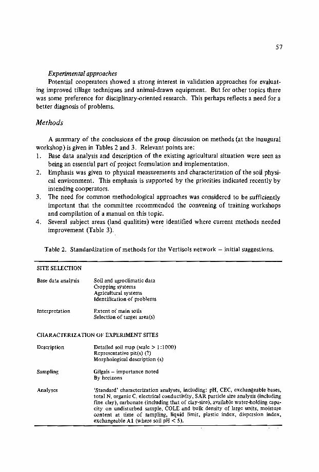
57
Experimental approachesPotential cooperators showed a strong interest in validation approaches for evaluat
ing improved tillage techniques and animal-drawn equipment. But for other topics therewas some preference for disciplinary-oriented research. This perhaps reflects a need for abetter diagnosis of problems.
Methods
A summary of the conclusions of the group discussion on methods (at the inauguralworkshop) is given in Tables 2 and 3. Relevant points are:1. Base data analysis and description of the existing agricultural situation were seen as
being an essential part of project formulation and implementation.2. Emphasis was given to physical measurements and characterization of the soil physi
cal environment. This emphasis is supported by the priorities indicated recently byintending cooperators.
3. The need for common methodological approaches was considered to be sufficientlyimportant that the committee recommended the convening of training workshopsand compilation of a manual on this topic.
4. Several subject areas (land qualities) were identified where current methods neededimprovement (Table 3). .
Table 2. Standardization of methods for the Vertisols network - initial suggestions.
SITE SELECTION
Base data analysis
Interpretation
Soil and agroclimatic dataCropping systemsAgricultural systemsIdentification of problems
Extent of main soilsSelection of target area(s)
CHARACTERIZATION OF EXPERIMENT SITES
Description
Sampling
Analyses
Detailed soil map (scale> 1:1000)Representative pit(s) (?)Morphological description (s)
Gilgais - importance notedBy horizons
'Standard' characterization analyses, including: pH, CEC, exchangeable bases,total N, organic C, electrical conductivity, SAR particle size analysis (includingfine clay), carbonate (including that of clay-size), available water-holding capacity on undisturbed sample, COLE and bulk density of large units, moisturecontent at time of sampling, liquid limit, plastic index, dispersion index,exchangeable Al (where soil pH < 5).
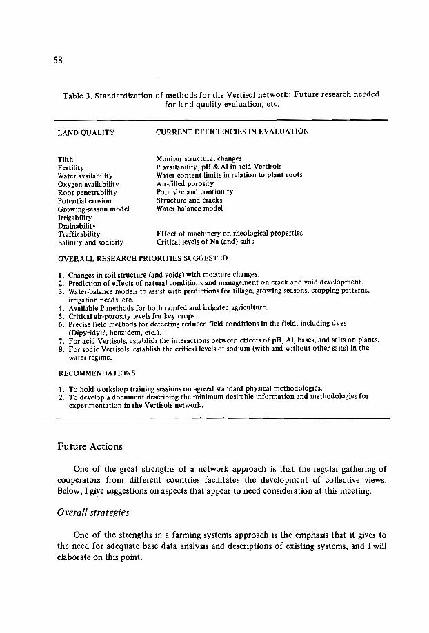
58
Table 3. Standardization of methods for the Vertisol network: Future research neededfor land quality evaluation, etc.
LAND QUALITY
TilthFertilityWater availabilityOxygen availabilityRoot penetrabilityPotential erosionGrowing-season modelIrrigabilityDrainabilityTrafficabilitySalinity and sodicity
CURRENT DEFICIENCIES IN EVALUATION
Monitor structural changesP availability, pH & Al in acid VertisolsWater content limits in relation to plant rootsAir-filled porosityPore size and continuityStructure and cracksWater-balance model
Effect of machinery on rheological propertiesCritical levels of Na (and) salts
OVERALL RESEARCH PRIORITIES SUGGESTED
1. Changes in soil structure (and voids) with moisture changes.2. Prediction of effects of natural conditions and management on crack and void development.3. Water-balance models to assist with predictions for tillage, growing seasons, cropping patterns,
irrigation needs, etc.4. Available P methods for both rainfed and irrigated agriculture.5. Critical air-porosity levels for key crops.6. Precise field methods for detecting reduced field conditions in the field, including dyes
(Dipyridyl", benzidem, etc.).7. For acid Vertisols, establish the interactions between effects of pH, AI, bases, and salts on plants.8. For sodic Vertisols, establish the critical levels of sodium (with and without other salts) in the
water regime.
RECOMMENDATIONS
1. To hold workshop training sessions on agreed standard physical methodologies.2. To develop a document describing the minimum desirable information and methodologies for
experimentation in the Vertisols network.
Future Actions
One of the great strengths of a network approach is that the regular gathering ofcooperators from different countries facilitates the development of collective views.Below, I give suggestions on aspects that appear to need consideration at this meeting.
Overall strategies
One of the strengths in a farming systems approach is the emphasis that it gives tothe need for adequate base data analysis and descriptions of existing systems, and I willelaborate on this point.

59
Methods
Basedata analysisMost countries have general soil and agroclimatic maps available (or in the process
of completion) that give a general description of the soils and climatic resources, and areadequate for planning. Discussion is needed to check the adequacy of the existing information for site selection, and of the agroclimatic analysis for assisting with the selectionof management options.
Currentagricultural practices and diagnosisAlthough general knowledge concerning current agricultural practices is well esta
blished, there is in some cases a need to ensure the availability of the detailed knowledgeneeded for the clear identification of constraints on Vertisols. This appears to reflect thelower priority given to Vertisols in the past; but such compilations and studies are highlydesirable. The advantages can be seen from two examples from within this region,notably from Ethiopia and Sudan.
At high altitude in the highlands of Ethiopia, the 'giue' system was practiced intraditional farming. At the end of a long resting phase, perhaps 15-30 years of naturalpasture, grass and manure were placed in regular heaps, about 1 per square meter, coveredwith soil, then ignited. Later the baked soil was spread evenly over the soil surface priorto ploughing and sowing a crop. In the first year, yields were excellent; much loweryields were obtained in the second year, after which the land was allowed to revert to anatural pasture for many years. Analysis of this system has provided useful clues concerning the constraints to introducing more intensive improved cropping systems.
Analysis of the apparently effective shifting cultivation system in the Sudan wouldseem to be warranted. In this, each cycle consisted of an alternation of cropping andgrass-fallow phases, with about 4 years for each phase. At the end of the grass fallow, thegrass residues were burnt (the 'hariq' system) providing excellent weed control for at leastthe first two years of the subsequent cropping phase.
I have given these two examples because they are relevant to the network. One main.point is clear: although traditional systems may not now be as productive as moremodern intensive systems, there can be valuable clues about constraints that we can learnfrom the traditional cultivators; after all, their systems presumably evolved in response totheir identification of the constraints to effective cultivation.
Experimental methods
Table 2 gives a brief summary of topics and approaches suggested as being of importance, and it thus provides a useful list to consider in the group discussions.
Soil variabilityVertisols are noted for two particular types of variability - their shrinking into large
60
(hexagonal) peds on drying, and gilgais. Both will need to be considered in the recommendations for sampling and other experimental techniques.
The importance of gilgais appears to vary greatly. There are well-documented examples of extreme heterogeneity in Australia, but there is little mention of this phenomenoncausing problems amongst the current potential cooperators.
Analytical techniquesMethods currently available for chemical analysis seem to present little difficulty,
though a reminder is given that the 'Bal' modification of the Kjeldahl method for determining total nitrogen was developed specifically for Vertisols.
The indicated importance of land preparation and structure indicates the need togive particular thought to the best techniques for soil physical characterization, especially soil moisture regimes and structure. Particularly important will be simple andreliable methods for some of the difficult soil physical measurements. Relevant for watermeasurements in Vertisols is their swelling and shrinking with changes in water content,and the fact that few experimenters make allowance for this.
Method developmentTopics on which some method development may be required are indicated in Table 3.
If any are 'relevant but are beyond the resources of a network cooperator, the emphasiswhich has been given them at this workshop may motivate external organizations topromote further development.
One particularly relevant aspect of methodology is soil water balances, which canhelp several of the proposed projects in the planning of experimental strategies - especially in the drier environments.
Experimental approachesDiscussion may be needed to establish any changes in views on the balance between
management and disciplinary experiments in the network.
Themes
The widespread interest in improving the farmer's ability to work his soil and achievetimely seeding indicates a common theme for most projects - tillage equipment andtechniques. A cropping systems component may also be desired.
For strategic research, a project in the general area of soil physics appears to be ofthe highest priority, because of the general importance of this field for validation projects. Aspects relevant to the management of Vertisols are the structure of the surfacesoil (e.g. crusting, self-mulching vs. massive), infiltration, erosion, water-holding capacity,ease of tillage, etc. Complementary to such studies could be long-term research in one ortwo well-chosen locations, to include other aspects of the maintenance of fertility.
For the drier environments, research should be encouraged into techniques to optimize utilization of rainfall, because of the general lack of information in this field.

61
Other aspects
Coordination within countriesDr. Latham (these proceedings) has already indicated the need for a multidiscipli
nary approach, but this of course may also require coordination between institutions.Such coordination has been formally initiated in Ethiopia, as evidenced by Dr. Mesfin'sappearance here as the chairman of the coordination committee. Less formal coordination is developing in other countries, and is encouraged because it can assist so much inovercoming difficulties due to a lack of resources. One point commonly overlooked isthat joint projects can be achieved with virtually no loss in freedom of action, and considerable gain in quality of results from each partner.
Consultants and trainingThe use of consultants or training to provide additional expertise is another useful
way of improving resources ina project.
Concluding Comments
The above comments have been compiled mainly on the basis of preliminary discussions with the network's prospective participants in the middle of this year, when allwere still gathering information and developing ideas on project development. I wouldnot like current participants to be held to tentative views that they then so freely gave,and which have been so invaluable in the planning for this workshop.


Second session: Site selection
Chairmen: Prof. K. Zake
Dr.S.M. Virmani


SELECTION OF SITES FOR THEVERTISOLS NETWORK:DISTINCfION BETWEEN TYPES OF VERTISOLS
P. Brabant*
Abstract
Particular attention must be paid to the selection of test sites for the Vertisolnetwork if the results obtained are to be truly transposablefrom one region to another inthe same country and from one country to another in the world.
To distinguish between different tropical Vertisols, it is advisable to use other criteriathan the slope and soil colour criteria used in the classification systems (FAO, SoilTaxonomy, cr.c.s. 1 ).
The author recommends that priority be given to the following parameters: the soilmoisture regime, the properties of the topsoil, the parent material and the risk ofdegradation. These are the characteristics that really distinguish between different tropical Vertisols, and they are often the main limiting factors for soil management. These propsalsare based on soil mapping followed by detailed field studies in a semi-arid tropical zone.
Introduction
The establishment of a Vertisol network implies two main activities:1. Selecting representative sites for measurement and experimentation.2. Transposing the results obtained on these sites to other sites in the same country or
elsewhere.This second activity raises an important question. Are the Vertisols where we
transpose the results the same type of Vertisol as those studied on the test sites? The
* L'Institut Francais de Recherche pour le Developpement en Cooperation (OR8TOM), 213 rue LaFayette, 75010 Paris, France.
1 Commission de Pedologie et de Cartographie des Sols.
66
answer to this question seems simple, because Vertisols are the most easily recognizable.of all the soils in the world. Consequently one might think that it would be easy to findrepresentative sites and then to transpose the results obtained.
The reality is different. There are in fact several types of Vertisol, and they differwidely enough to make it necessary to distinguish between them before the test sites are
'chosen. When seeking to identify Vertisols and make correlations between them fromone country to another, the currently recommended procedure is to adopt the Vertisol 'definitions given in the commonly used classification systems: FAO, Soil Taxonomy,and French C.P.C.S. ' This may seem to be an adequate method for drawing up a generalworld inventory of Vertisols; but given IBSRAM's ultimate objectives, we need a procedure for distinguishing between the different Vertisol categories and selecting the network's test sites. The criteria proposed here are based on a recent study made in Cameroon.
Country Background
Cameroon is a central African country covering 475000 km 2 and has a populationof approximately 10 million. It includes three main ecological zones: a densely forestedhumid equatorial zone in the south, a zone of high plateaux with savanna and forestin the centre, and a semi-arid topical zone in the north. The first two zones have mainlyFerralsols, while the Vertisols are to be found in the third zone.
North Cameroon
This province covers 100000 km", and the annual rainfall varies between 600 and1400 mm; a continuous dry season lasting 6 to 9 months alternates with a rainy seasonthat fluctuates from year to year. The most extensive Vertisols are to be found betweenthe 600 and 900 mm isohyets; beyond the 1100 mm and up to the 1400 mm isohyet,Vertisols occur only on highly basic rocks. The entire province has been mapped onvarious scales. Thus we know that Vertisols cover 1 200000 ha, divided between 300polygons on the 1:500 000 soil map. That represents 12% of North Cameroon's land areaand 2.5% of the total country.
Identification of the Different Types of Vertisols in North Cameroon
Using the definitions of the classification system
Looking at the descriptions given by the different classification systems, Vertisolsare defined as having the following characteristics:o a 30% clay content, at least to a depth of 50 cm,o shrinkage cracks I cm wide to a depth of at least 50 cm, and
67
o a gilgai microrelief or slickensides or wedge-shaped structural aggregates at depths ofbetween 25 and 100 cm.They are distinguished from each other in terms of the following features.
o the colour, with a chroma, moist, more or less than 1.5,o the slope - gentle slopes or flat areas and depressions, ando the rate of saturation of the exchange complex, by calcareous nodules (F Aa system,
1985).Table I shows the results we obtain for North Cameroon's Vertisols using these cri
teria.In general, the keys provided by the classification systems are adequate for distin
guishing Vertisols from the other soils of North Cameroon. In the field, the FrenchC.P.C.S. system has been found to give slightly more satisfactory results than the twoother systems, but none of the systems includes the most important parameters in itsdefinitions,' Le. those which ultimately determine the management of tropical Vertisols.For example, the Pellic Vertisols category includes Vertisols which may differ very widelyin their main limiting factors for land use - the control of flooding water for some,gully erosion for others. It is very surprising, then, to see that soil scientists only identifytwo types among the I 200000 ha of Vertisols in North Cameroon, when uneducatedlocal farmers easily identify five or more types of Vertisols and give each a special name:"yaeres", "karal", "karal muskuari", etc.
Using other parameters
To distinguish Vertisols from other soils, we continue to use the criteria which werelisted above, Le. textural and structural properties, shrinkage cracks, etc. A Vertisolalways consists of a single horizon, and in Cameroon we have called this the Sv horizon,S being more or less synonymous with "cambic" and v expressing the vertic feature. TheSv horizon contains organic matter in its upper part, except where the soil is eroded.
To differentiate between one Vertisol and another and to choose representative sitesfor study, we have selected other parameters. These have been chosen on the basis ofsoil-mapping results, detailed catena studies, and observations of farming practices in theregion.
Six parameters have been selected:I. The landscape (and not merely the slope): alluvial plains or pediments,2. The pedoclimate and hydrologic regime: dry or humid pedoclimate, with flooding
or without flooding,3. The parent material: recent or old clayey alluvia, acid crystalline rocks, basic rocks,
limestone, argillite or marl.4. The other soils and horizons associated with the Vertisols in the landscape: Fluvisols,
Planosols, Cambisols, Regosols, etc.5. The properties of the topsoil (0-25 cm) with regards to tillage: microrelief, cracks,
clay content, structure.6. The level of potential degradation: topsoil degradation, gully erosion.

0100
Table 1. Types of Vertisols in North Cameroon.
FAO system1975, revised 1985
Soil Taxonomy C.P.C.S., France
VERoTISOLS(soil units)
VERTISOLS Class
Groups
Subclass
Subgroupstypicgleyicsodic
iVERTISOLSi
TOPOMORPHIC LITHOMORPHIC
I TOPsoil.--LIdne with fine coarse
coarse medium structure medium
Order
Groups
Suborder
SubgroupstypicI
typic
USTERTSI
I IPellusterts Chromusterts
I
Eutric
Calcic
Pellic
Chromic
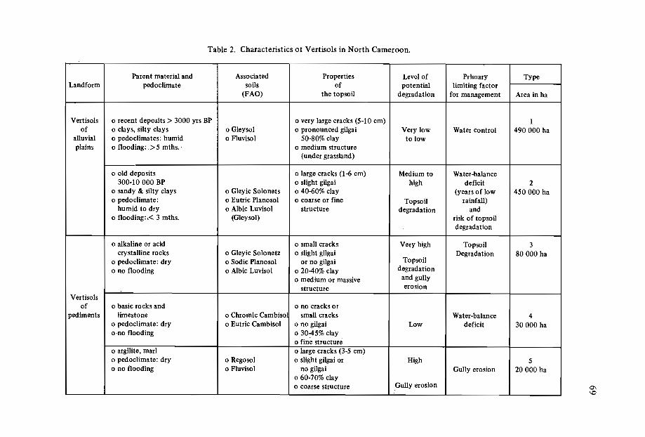
Table 2. Characteristics or Vertisols in North Cameroon.
Parent material and Associated Properties Level of Primary TypeLandforrn pedoclimate soils of potential limiting factor
(FAO) the topsoil degradation for management Area in ha
Vertisols o recent deposits> 3000 yrs BP o very large cracks (5-10 cm) 1of o clays, silty clays o Gleysol o pronounced gilgai Very low Water control 490000 ha
alluvial o pedoclimates: humid o Fluvisol 50-80% clay to lowplains o flooding: > 5 mths.· o medium structure
(under grassland)
o old deposits o large cracks (1-6 cm) Medium to Water-balance300-10 000 BP o slight gilgai high deficit 2
o sandy & silty clays o Gleyic Solonets o 40-60% clay (years of low 450000 hao pedoclimate: o Eutric Pianosol o coarse or fine Topsoil rainfall)
humid to dry o Albic Luvisol structure degradation ando flooding: i< 3 mths. (Gleysol) risk of topsoil
degradation
o alkaline or acid o small cracks Very high Topsoil 3crystalline rocks o Gleyic Solonetz o slight gilgai Degradation 80000 ha
o pedoclimate: dry o Sodic Pianosol or no gilgai Topsoil
o no flooding o Albic LuvisoI 02040% clay degradation
o medium or massive and gully
structure erosion
Vertisolsof o basic rocks and o no cracks or
pediments limestone o Chromic Cambiso small cracks Water-balance 4o pedoclimate: dry o Eutric Cambisol ono gilgai Low deficit 30000 haono flooding 03045% clay
o fine structureo argilite, mar! o large cracks (3-5 cm)o pedoclimate: dry o Regosol o slight gilgai or High 5o no flooding o Fluvisol no gilgai Gully erosion 20000 ha
o 60-70% clayo coarse structure Gully erosion 0\
\Q

70
Along these lines, we have distinguished five main types of Vertisols in North Cameroon: two types in the alluvial plains and three types on the pediments. Their characteristics are shown in Table 2.
It should be noted that Vertisols of types 2 or 5, for example, include both Pellicand Chromic Vertisols, Chromusterts and Pellusterts. Also, an examination of Table 2shows that the moisture regime, the properties of the topsoil, the parent material and therisk of degradation take precedence over colour and slope of terrain as characteristics ofa tropical Vertiso!.
Recommendations
The results obtained from a test site on type I Pellic Vertisols could not be transposed to type 5 Pellic Vertisols, for example. Similarly, the results obtained with type 4Chromic Vertisols could not be transposed to type 2 Chromic Vertisols. This means thatsoil scientists in the Vertisol network should not restrict themselves to the classificationsystem criteria, either in selecting sites in the first place, or subsequently when they aremaking correlations between the Vertisols of different African countries or between African Vertisols and those of other continents in the semi-arid zone (India, Uruguay andArgentina, for example). As a matter of general policy, IBSRAM should pay special attention to the correlation between the test sites of the Vertisol network.
SOIL-SITE CRITERIA FOR SELECTING EXPERIMENT SITES
FOR A VERTISOL MANAGEMENT NETWORK
Jawahar L. Sehgal, S. Vadivelu, L.R. Hirekerur andS.B. Deshpande*
Abstract
In India, the dark-coloured, deep, cracking clayey Vertisols and associated vertic soilsoccur extensively in the l/~"insular region. They have varying properties. For the selection of sites for agronomic experiments to test technologies for subsequent successfultransfer to similar areas, the properties of Vertisols and the environment in which theyoccur have to be taken into account. In this paper, soil properties, land qualities, climaticparameters, crop plants, management levels and general features are discussed, and criteriabased on the most important soil-site characteristics are proposed for consideration.
Introduction
The basic purpose of conducting experiments is to transfer the technologies developed in the experiment sites to similar sites in the region. Therefore the experiment siteshould be so selected that it represents wide areas in the region defined in terms of thesoilscape characteristics and the environmental parameters. To facilitate a fair selectionof experiment sites, the criteria to be followed have to be identified and defined. Thefirst step for success in the operation commences with the selection of a proper site. Thispaper discusses the criteria which need to be followed in selecting experiment sites for aVertisol management network in India.
* National Bureau of Soil Survey and Land Use Planning, Arnravati Road, Nagpur 440 010, India.

72
Criteria for Site Selection
The criteria to be considered for site selection can be broadly divided as follows:o Soil-based criteriao Land-based criteriao Climate-based criteriao Crop-based criteriao Management-based criteriao General criteriaThough these criteria are listed separately for purposes of convenience, many of
them are closely related and interdependent.
Soil-Based Criteria
Some of the soil-based criteria to be considered for site selection are the distributionand extent of Vertisols, soil problems (like salinity, sodicity and high carbonate), the soilmoisture regime, the soil temperature regime, the surface texture, and the soil taxonomicunits which have been identified.
Distribution and extent
Information on the distribution and extent of Vertisols and associated soils (Murthyet al.• 1982a) in India is given in Table I.
Table I. Distribution and extent of Vertisols and associatedsoils in India.
Soilno.
1.2.3.4.5.6.7.8.9.
State
Andhra PradeshBiharGujaratKarnatakaMadhya PradeshMaharashtraOrissaRajasthanTamil Nadu
Area inmillion ha
7.300.708.666.82
16.8125.85
1.432.223.08
Percentage of thegeographical area
of the state
26.44.0
44.235.637.984.1
9.26.5
23.7
73
These soils are the major soil groups in the states of Maharashtra, Madhya Pradesh,Gujarat, Karnataka and Andhra Pradesh, and hence there is a need for selecting experiment sites on a sound footing.
Within-site variation
The within-site variation has to be minimal. The relative purity of the soil unitsensures reliable transferability of the results of the experiments and leads to meaningfulconclusions.
Soil moisture regime
The soil moisture regimes observed in the Vertisol tracts are mostly ustic and aridic(Figure 1). The ustic moisture regime area which is extensively occupied by Vertisols isfurther subdivided into aridic and typic tropustic and typic and wet tempustic regimes(Anonymous, 1981), and covers most parts of Andhra Pradesh, Karnataka, Maharashtra,Gujarat and Madhya Pradesh. The weak aridic moisture regime covers some areas in thestates of Karnataka, Andhta Pradesh and Gujarat. The moisture regime has to be considered as a criterion for site selection so that technologies can be transferred to other sitesin regions with a similar moisture regime.
Soil temperature regime
The Vertisol areas in India fall under two soil temperature regimes, namely hyperthermic and isohyperthermic. The area south of the Tropic of Cancer falls normallyunder an isohyperthermic temperature regime and that to the north of it falls under ahyperthermic temperature regime.
Surface texture
Some of the Vertisols occurring in regions of granite-gneissic geoldgy have clay loamor a coarser surface texture followed by clayey texture in the subsoils, unlike those developed from basalt which are fine throughout the profile depth. These Vertisols differfrom other Vertisols with a clayey texture throughout the profile in respect to infiltrationand moisture-retention characteristics. A light-textured surface facilitates easy entry ofwater, while a very fine-textured surface impedes the downward movement of water,leading to a high runoff.
Major soil units
The experiment sites should be so selected that they represent important soil families. This requires proper utilization of soil survey data as a base, and then large-scalemapping (say I: 1000 scale) for the selected experiment sites.

74
CALCULATED SOIL1------ MOISTURE REGIMES
LEGENDARIDIC
adras~ Extreme
lAD Typie
[A!J Weak
TROPUSTI~ Aridie
[SO Typic
!Si] Udie
TEMPUSTICTypie
XerieWet
Dry TEMPUDIC ~PERUDIC
Figure 1. Calculated soil moisture regimes (SMSS Monograph, 1961).
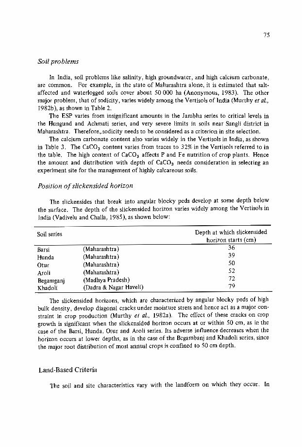
75
Soil problems
In India, soil problems like salinity, high groundwater, and high calcium carbonate,are common. For example, in the state of Maharashtra alone, it is estimated that saltaffected and waterlogged soils cover about 50000 ha (Anonymous, 1983). The othermajor problem, that of sodicity, varies widely among the Vertisols of India (Murthy et al.,1982b), as shown in Table 2.
The ESP varies from insignificant amounts in the Jambha series to critical levels inthe Hungund and Achrnati series, and very severe limits in soils near Sangli district inMaharashtra. Therefore,. sodicity needs to be considered as a criterion in site selection.
The calcium carbonate content also varies widely in the Vertisols in India, as shownin Table 3. The CaC03 content varies from traces to 32% in the Vertisols referred to inthe table. The high content of CaC03 affects P and Fe nutrition of crop plants. Hencethe amount and distribution with depth of CaC03 needs consideration in selecting anexperiment site for the management of highly calcareous soils.
Position of slieken sided horizon
The slickensides that break into angular blocky peds develop at some depth belowthe surface. The depth of the slickensided horizon varies widely among the Vertisols inIndia (Vadivelu and Challa, 1985), as shown below:
Soil series
BarsiHundaOturAroliBegamganjKhadoli
(Maharashtra)(Maharashtra)(Maharashtra)(Maharashtra)(Madhya Pradesh)(Dadra & Nagar Haveli)
Depth at which slickensidedhorizon starts (cm)
363950527279
The slickensided horizons, which are characterized by angular blocky peds of highbulk density, develop diagonal cracks under moisture stress and hence act as a major constraint in crop production (Murthy et al., 1982a). The effect of these cracks on cropgrowth is significant when the slickensided horizon occurs at or within 50 cm, as in thecase of the Barsi, Hunda, Otur and Aroli series. Its adverse influence decreases when thehorizon occurs at lower depths, as in the case of the Begambanj and Khadoli series, sincethe major root distribution of most annual crops is confined to 50 cm depth.
Land-Based Criteria
The soil and site characteristics vary with the landform on which they occur. In
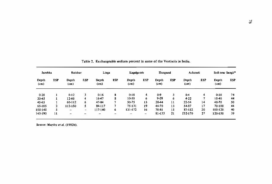
Table 2. Exchangeable sodium percent in some of the Vertisols in India.
Jarnbha Raichur Linga Kagalgomb Hungund Achmati Soil near Sangli"
Depth ESP Depth ESP Depth ESP Depth ESP Depth ESP Depth ESP Depth ESP(cm) (cm) (cm) (cm) (cm) (cm) (cm)
0-20 1 0-12 3 0-16 8 0-10 4 0-9 3 04 4 0-10 742045 1 12-60 4 1647 8 10-50 6 9-28 6 4-22 7 1040 4445-65 1 60-112 6 47-84 7 50-75 13 2844 11 22-54 14 40·10 5065-105 2 112-150 5 84-117 7 75-131 19 44-70 13 54-87 17 70-100 44
105-145 5 - - 117-140 6 131-172 16 70-81 15 87-152 20 100-120 40145-190 11 - - - - - - 81-133 21 f52·170 27 120-150 39
Source: Murthy et al. (l982b).
-....J0'1
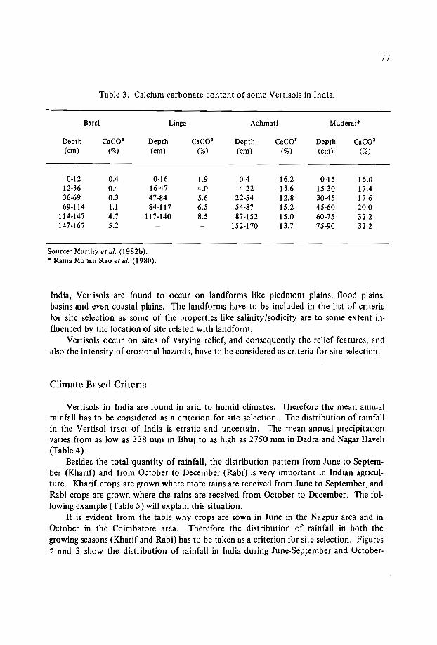
77
Table 3. Calcium carbonate content of some Vertisols in India.
Barsi Linga Achmati Muderai*
Depth csco- Depth csco- Depth csco- Depth csco-(cm) (%) (cm) (%) (cm) (%) (cm) (%)
0-12 0.4 0-16 1.9 0-4 16.2 0-15 16.012-36 0.4 16-47 4.0 4-22 13.6 15-30 17.436-69 0.3 47-84 5.6 22-54 12.8 30-45 17.669-114 1.1 84-117 6.5 54-87 15.2 45-60 20.0
114-147 4.7 117-140 8.5 87-152 15.0 60-75 32.2147-167 5.2 152-170 13.7 75-90 32.2
Source: Murthy et al. (1982b).* Rama Mohan Rao et al. (1980).
India, Vertisols are found to occur on landforms like piedmont plains, flood plains,basins and even coastal plains. The landforms have to be included in the list of criteriafor site selection as some of the properties like salinity(sodicity are to some extent influenced by the location of site related with landform.
Vertisols occur on sites of varying relief, and consequently the relief features, andalso the intensity of erosional hazards, have to be considered as criteria for site selection.
Climate-Based Criteria
Vertisols in India are found in arid to humid climates. Therefore the mean annualrainfall has to be considered as a criterion for site selection. The distribution of rainfallin the Vertisol tract of India is erratic and uncertain. The mean annual precipitationvaries from as low as 338 mm in Bhuj to as high as 2750 mm in Dadra and Nagar Haveli(Table 4).
Besides the total quantity of rainfall, the distribution pattern from June to September (Kharif) and from October to December (Rabi) is very important in Indian agriculture. Kharif crops are grown where more rains are received from June to September, andRabi crops are grown where the rains are received from October to December. The following example (Table 5) will explain this situation.
It is evident from the table why crops are sown in June in the Nagpur area and inOctober in the Coimbatore area. Therefore the distribution of rainfall in both thegrowing seasons (Kharif and Rabi) has to be taken as a criterion for site selection. Figures2 and 3 show the distribution of rainfall in India during June-September and October-

78
Table 4. Mean annual precipation at some selected stations in India.
Stn. No. Station MAR (mm)
l.2.3.4.5.6.7.8.9.
BhujBijapurCoimbatoreAhrnednagarHyderabadIndoreNagpurJabalpurSilvasa
(Gujarat)(Karna taka)(Tamil Nadu)(Maharashtra)(Andhra Pradesh)(Madhya Pradesh)(Maharashtra)(Madhya Pradesh)(Dadra & Nagar Haveli)
338574612677764
1053112714482750
Source: India Meterological Department.
Table 5. Mean monthly rainfall at Nagpur and Coimbatore during theKharif (June-September) and Rabi (October-December) seasons.
Rainfall (mm)Station
June July Aug. Sept. Get. Nov. Dec.
Nagpur 174.3 351.5 277.1 180.5 66.6 8.7 1.7Coimbatore 34.0 41.7 33.9 37.3 148.7 125.3 33.5
Source: India Meteorological Department.
December respectively. Most of the Vertisol area receives high rainfall during the periodJune to September, and therefore crops are generally grown during this season.
Crop-Based Criteria
The major crop grown on Vertisols is a regional feature associated closely with climatic and socioeconomic conditions. Some of the major crops grown on Vertisols areshown in Table 6. The major crops grown have to be considered as criteria for site selection.

68-c-~::o---
PAKISTAN
84
c H
88
N A
92
79
Figure 2. Distribution f .o rainfall in Indi .la durinz Je une-Septernber

80
10~ 10 lsohyet (m)
°8
96°
92°
92 0
A
88°
N
88°
H
km lOOs) 0 100 200 SOO400 tmI tiiI tiiii1 tiiii1
84°
C
84°
MNC.72
68°
PAKISTAN
ARABIAN SEA
oo
o8
12
16
Figure 3. Distribution of rainfall in India during October-December.
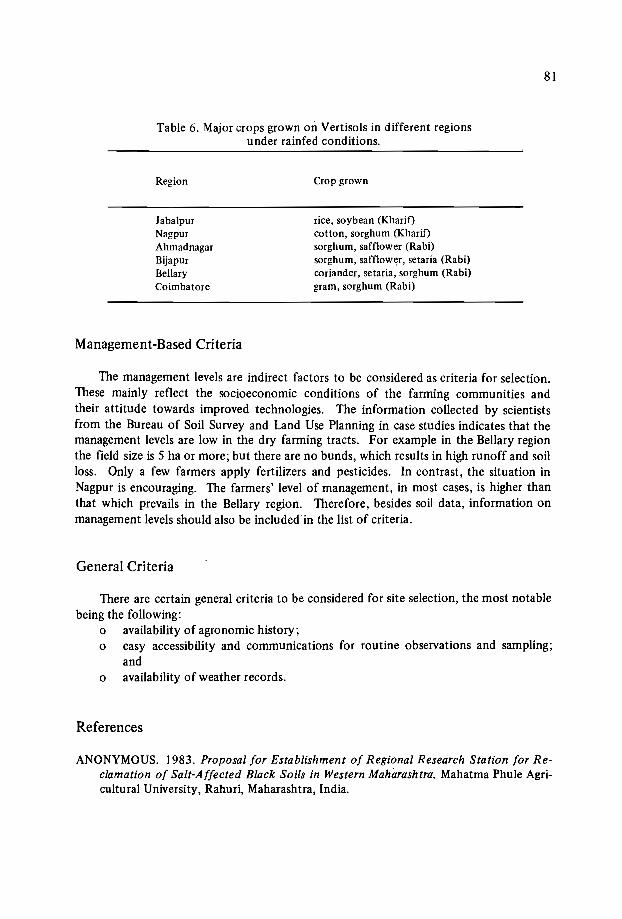
81
Table 6. Major crops grown 011 Vertisols in different regionsunder rainfed conditions.
Region
JabalpurNagpurAhmadnagarBijapurBellaryCoimbatore
Management-Based Criteria
Crop grown
rice, soybean (Kharif)cotton, sorghum (Kharif)sorghum, safflower (Rabi)sorghum, safflower, setaria (Rabi)coriander, setaria, sorghum (Rabi)gram, sorghum (Rabi)
The management levels are indirect factors to be considered as criteria for selection.These mainly reflect the socioeconomic conditions of the farming communities andtheir attitude towards improved technologies. The information collected by scientistsfrom the Bureau of Soil Survey and Land Use Planning in case studies indicates that themanagement levels are low in the dry farming tracts. For example in the Bellary regionthe field size is 5 ha or more; but there are no bunds, which results in high runoff and soilloss. Only a few farmers apply fertilizers and pesticides. In contrast, the situation inNagpur is encouraging. The farmers' level of management, in most cases, is higher thanthat which prevails in the Bellary region. Therefore, besides soil data, information onmanagement levels should also be included in the list of criteria.
General Criteria
There are certain general criteria to be considered for site selection, the most notablebeing the following:
o availability of agronomic history;o easy accessibility and communications for routine observations and sampling;
ando availability of weather records.
References
ANONYMOUS. 1983. Proposal for Establishment of Regional Research Station for Reclamation of Salt-Affected Black Soils in Western Maharashtra. Mahatma Phule Agricultural University, Rahuri, Maharashtra, India.

82
MURTHY, R.S., BHATTACHARJEE, r.c., LANDEY, R.J., and POFALI, R.M. 1982a.Distribution, characteristics and classification of Vertisols. Pages 3-22 in: Transactions of the 12th Congress of the International Society of Soil Science. SymposiaPapers ll. New Delhi, India.
MURTHY, R.S., HIREKERUR, L.R., DESHPANDE, S.B., and VENKATA RAO, B.V.1982b. Pages 374ff. in: Benchmark Soils of India, National Bureau of Soil Surveyand Land Use Planning. Nagpur, India.
RAMA MOHAN RAO, M.S., BHOLA, S.N., and JAYARAM, N.S. 1980. Soils: 25 YearsResearch on Soil and Water Conservation in Semi-Arid Deep Black Soils. ResearchCenter, Central Soil and Water Conservation Research and Training Institute, Bellary,India.
USDA (United States Department of Agriculture). 1981. SMSS Monograph no. 2.Washington, D.C.: U.S. Government Printing Office.
VADIVELU, S., and CHALLLA, O. 1985. Depth of slickenside occurrence in Vertisols.Journal of the Indian Society of Soil Survey 33:452-454.

SITE SELECTION FOR AGRONOMIC EXPERIMENTS:
KENY AN SITUATION
N.N. Nyandat*
Abstract
Research must involve the quantification of constraints to agricultural production.Sites must be typical as regards soils, climate and land use of the areas they are designedto represent, so that results can later be extrapolated from the site to those areas. Otherconsiderations involved in site selection include the socioeconomic circumstances andtechnological level of the farmers of the area, the availability of land and facilities, security of tenure at the site, and site accessibility. Inputs and implements to be testedshould be easily availableand within the reach of target farmer groups.
Introduction
Kenyan agriculture is quite varied. Ecologically it varies from tropical on the coastto arid and semi-arid as well as temperate agriculture in the interior. The productionstructure is also vastly different for small landholders and large farms in terms of the technology and the crops grown. The extent to which the land can produce crops is undoubtedly very limited. The limits of production are set by soil and climatic conditionsas well as by the specific inputs and management applied.
It is essential that research should attempt to identify and quantify the differentconstraints which face agricultural- production. On-site verification studies over a widerange of environmental and socioeconomic conditions are required to test the applicability of technologies for crop production. Such on-site verification studies need to beconducted through a network of trials which are sited on appropriately selected locations.
* National Council for Science and Technology, p.a. Box 30623, Nairobi, Kenya.

84
Factors to Consider in Site Selection
Agronomic experiments have often been done without due consideration of the environmental and socioeconomic characteristics of the test site, leading to difficulties inadopting the results of the experiments. The ultimate usefulness of the results of agronomic research requires a recognition of the following site characteristics at the time ofselecting the site for the experiment:
the representativeness of soil, climate, land use, and the cropping system at thelocation of the experiment;the capability of the farmers who are expected to use the results of the experiment;the availability of the tested materials within the region;the availability of sufficient land and appropriate facilities at the site to conduct theexperiment properly;security at the site;accessibility of the site;the extent of the variables at the site.The above site characteristics are briefly elaborated on below, especially with regard
to the Kenyan situation.
Representativeness ofsoils, climate, land use and the cropping systems
Some of the fundamental factors that should be considered in the selection of asite for field agronomic experiments is the representativeness of the soils, climate, landuse, and the cropping systems at the site of the experiment. In Kenya, there are diversesoils and agroclimatic zones (Sombroek et al., 1982). The Vertisols of the semi-arid zones(Agroclimatic Zones IV and V: Sombroek, 1982) occur in different regions of Kenya(Muchena et al., 1986) where there are also different land uses and cropping systems.
Past agronomic experiments in Kenya have been carried out at sites that are not representative of the general region. It has consequently been difficult to extrapolate theresults, and even when the extrapolation is done the outcome is often disappointing tothe farmers. For ultimate adoption of the results of an experiment, the first requirementis to determine representative soils and agroclimatic zones so that the agronomic experiment can be located at a site which represents adequately the general features of the region. With the present availability of fairly detailed soil maps and agroclimatic maps(scale I: 1 million) in Kenya, there is now more scope to improve agronomic research bycarrying out appropriately focused and sited agronomic experiments.
Capability of the farmers
In Kenya, four sets of socioeconomic circumstances pertaining to farmers may berecognized (Collinson, 1983). They are as follows:I. Wholly subsistence production for basic food requirements with surpluses locally
exchanged or used for social activities.
85
2. Dominantly subsistence production for basic food requirements with deliberatelyproduced surpluses for sale locally or elsewhere.
3. Dominantly cash enterprises but with basic food requirements still produced on thefarm; food shortfalls or special preferences are supplemented by purchases.
4. Wholly cash enterprises and most family food purchased.Most of Kenya's small-scale farmers fall under the second category. Therefore in
Kenya, for the technology tested to be relevant and acceptable, it has to be site-specificand should be focused on one of the four categories of farmers - whichever one prevailsin the area of the experiment.
A vailability of the tested materials within the region
The materials concern the inputs as well as the implements used in conducting anexperiment. The inputs determine the anticipated output. It is therefore unrealistic totest inputs which will be unobtainable to the user of the results of the experiment, sinceunder such circumstances the results of the experiment cannot be adopted. Testing ofmaterials that cannot be easily secured within a region or carrying out experimental treatments at rates which are not economically feasible for the farmers of the region is notuncommon. Often lower rates of treatment have been ignored.
In Kenya, cases are known where certain materials for mulching have been testedwhen the material cannot easily be secured, even if it was found to be effective. Similarly, cases are known where the manure to be tested is imported to the experiment sitewhen it is obvious that the manure is not available in the region and cannot be economically imported for routine use. Certainly agronomic experiments that do not considerthe availability of the test materials within the region cannot provide practical results.
It is necessary to consider right from the beginning the supply of inputs being tested.It is especially important to identify the constraints that may be operating on the availability of the inputs within the region and test only those inputs which can be easilyobtained in quantity, quality, and at a reasonable price. Emphasis should also be placedon the selection and development of simple implements appropriate to the conditionsexperienced by the target farmers. These site-specific approaches will enhance a fasteradoption rate of new research technology.
A vailability of land and facilities
In order to carry out a field experiment properly, there is need for adequate land.Where adequate land is available it is possible to layout a satisfactory design for the experiment and also to install the essential supporting facilities. In Kenya, however, the majority of landholders have small tracts of land, so they cannot spare large plots for experiments. This implies that the required land for an experiment should be the minimumfor conducting a particular experiment properly and also should be acquired where thelandholder cannot be inconvenienced.

86
Security at the site
Security involves both the convenience of the landholder and the safety of the experiment. The establishment of the experiment should not become a hindrance to thenormal use of land by the owner. Also the experiment should not be sited within easyreach of the general public, as for instance at the side of a major public road. Furthermore, the experiment should not be sited in an isolated area, away from the cultivatedplots of the farmer, where it stands the risk of being destroyed by wild animals and birds.
As part of the security, the land for the experiment should be acquired under a leaseagreement. This will give the landholder a feeling of security with regard to the future ofhis land, and by virtue of receiving some income from the lease he will not feel he islosing by allowing part of his land to be used for experiments. This is an aspect whichhas been given little attention in Kenya, where land for field experiments has often beenobtained on a rent- free basis. It is therefore not uncommon to find that the farmer willrefuse continued use of his land for an experiment before the experiment is concluded.
Accessibility to the site
An experiment can only be properly installed and managed if there is easy access tothe site of the experiment. It is essential that vehicles and implements should be able toreach the site without difficulty. Furthermore, the experiment should not be sited whereservicing of the equipment being used is not possible. Delays in servicing broken-downequipment can be detrimental to the success of the experiment.
Extent of variables at the site
When the site of the experiment has too many variables to be controlled, the experiment may be difficult to handle. For this reason it would be advisable to site an experiment only where the number of variables do not create difficulties.
References
COLLINSON, M.P. 1983. African farming systems and some indications of research priorities. Page 187ff. in: Proceedings of the Eastern Africa-A CIAR Consultation onAgricultural Research, Nairobi, Kenya.
SOMBROEK, W.G., BRAUN, H.M.H., and VAN DER POUW, B.J.A. 1982. Exploratorysoil map and agroclimatic zone map of Kenya, 1980. Report no. El, Kenya SoilSurvey, Nairobi, Kenya.

Third session: Site characterization
Chairmen: Dr. A.Osman
Dr. M. Rasheed


THE PHYSICAL AND MECHANICAL CHARACTERIZATION
OF VERTISOLS
K.J. Coughlan", D. McGarry2 and G.D. Smith"
Abstract
Soil characterization is required for management decision making in agriculture, fordetermining the effects of management practices on soil properties, for the location offield experiments, and for technology transfer. Characterization may range from visualassessment of selected soil profile properties to complex field and laboratory measurements. The choice of the variables to be characterized is dependent on the reasons forthe characterization, as well.ason the availability offacilities and expertise.
A range of physicochemical properties which influence soil physical behaviour areconsidered. We also consider certain direct measures of the physical properties of Vertisols which affect, or are affected by, management practices.
It is stressed that there are certain problems associated with the measurement and interpretation of the physical properties of Vertisols, due particularly to the effect ofsoilwater content. A prime example is the difficulty of comparing bulk density measurements between soils, or over time for one soil.
Introduction
The characterization of soil at a site is vital - principally to provide a datum for technology transfer. Only with such a datum can a field trial be optimally located, the resultsof the trial be meaningfully related to data from other sites, management decision makingbe soundly founded, and the effect of management practices be fully assessed. The varia-
1 Queensland Department of Primary Industries, Meiers Road, Indooroopilly, QLD 4068, Australia.2 CSIRG Division of Soils, 306 Carrnody Road, St. Lucia, QLD 4067, Australia.3 Queensland Wheat Research Institute, P.G. Box 5282, Toowoomba, QLD 4350, Australia.
90
bles characterized at a given site will be determined not only by the reasons behind thecharacterization but also by the availability of facilities and expertise. The level ofcharacterization can range from simple to complex field observation. With Vertisols, soilphysical and mechanical properties are important in affecting crop growth and are greatlyaffected by management practices, but because of the difficulties of interpreting the measurements adequate characterization is rarely done.
The majority of the physical properties of soils are controlled by the arrangement ofsoil solids and pores. This arrangement determines the movement of water and air, andthese affect root growth and nutrient availability. With Vertisols in particular, no onemeasure provides a complete picture of their physical and mechanical nature, since theirphysics changes as their water content changes. As a result, their physical identity ismultifacet and best documented by a set of techniques, each giving further insight intotheir nature under different water content conditions. With Vertisols, physical measurements are no more difficult to collect than with most soils. However, care is needed bothto collect representative samples and in the interpretation of the measurements.
The prime objective of this paper is to describe our experience with selected measures of the physical and mechanical properties of Vertisols to characterize sites. Associated problems will also be documented. Some physicochemical attributes that arerelated to these physical properties will also be presented. To this end there are two subsidiary objectives: (i) to present either sufficient detail on these techniques, or providereferences to published sources, to help a potential user decide on which methods andequipment would be best suited to his needs, and (ii) to illustrate problems encounteredin making physical measurements on Vertisols.
The experiences that we report here are not all drawn from Vertisols as defined bySoil Taxonomy (Soil Survey Staff, 1975), though all the soils concerned, the Ug soils asdefined by Northcote (1979), can be termed 'vertic' as they have> 30% clay throughoutand show seasonal cracking. Our experiences are also drawn from limited climatic conditions, mainly semi-arid with a summer rainfall maximum (500-700 mm/year). This latterpoint is important as it helps explain our perception of the relative importance of variousphysical measurements.
Site and Soil Profile Description
In terms of site characterization, the importance of site and soil profile descriptionscannot be overemphasized. Soil morphological description can be a most useful guide tosoil physical behaviour, and is the very basis for technology transfer since it provides mostof the data for soil classification. In addition, morphological properties are relatively permanent and most do not vary seasonally. Data recorded for general soil profile description are principally concerned with the kind, thickness and arrangement of soil horizonsand in particular their colour, texture, structure, consistence, segregations, depth of soilto hard layers, and parent material. These data, together with landform, slope, aspect,microrelief, and regional climatic information, can be used to devise land-use decisionsand management strategies.

91
Of prime importance in site and soil description is the standardization of terms andsubjectively-named size classes that are used, normally achieved by standardizing the fieldhandbook used. The authors use the Australian Soil and Land Survey (McDonald et al.,1984). Others available are: The Soil Survey Manual (Soil Survey Staff, 1951) andGuidelines for Soil Description (FAO, 1968).
Physicochemical Properties
Excluding field observations, the simplest methods of inferring a soil's physical andmechanical properties are based on laboratory measurements of p'tysicochemical properties. In Queensland we have done a considerable amount of research (Smith et al., 1984;Coughlan and Loch, 1984; Shaw and Thorburn, 1985) relating physicochemical properties to the physical behaviour of field soils. Information on plant-available water capacity (PAWC),hydraulic conductivity, shrinkage and surface aggregation has been obtainedfrom these studies.
Our experience with Vertisols indicates that soil salt profiles, cation-exchange capacity (CEC), clay percentage and exchangeable sodium data are the most useful in predicting soil physical behaviour. Soil organic matter seems to be of secondary importance inthese soils because of the strong forces of both bonding and aggregate disruption associated with swelling clay minerals.
Coughland et al. (in press) have listed the major constraints to crop production onVertisols. These are: surface sealing and crusting, excessive cloddiness, low PAWC,restrictions to root growth (including subsoil salinity), and surface waterlogging. Theysuggested that these properties often occur in combination and appear to be related tohydraulic conductivity. The model explaining these relationships is given by Coughlan{l984). Our hypothesis is that the amount and distribution of soluble salts in the soilprofile (and particularly of mobile anions such as chloride) is a good indicator of theamount of water movement through the profile. Evidence for this hypothesis is theeffect of rainfall, irrigation and soil management on the salt profile (Coughlan et al.,in press).
For a given environment, increased profile salinity is taken as an indicator of reducedprofile hydraulic conductivity. According to the model proposed by Coughlan {l984),low hydraulic conductivity leads to:-o surface water logging, runoff and erosion;o crusting or excessive cloddiness on drying;o limited water penetration and reduced PAWC.If! some cases, resultant subsoil salinity may be sufficient to limit root growth.
From the studies of Shaw and Thorburn {l985) and Coughlan and Loch {l984),CEC, clay percentage and exchangeable sodium percentage (ESP) appear to be the majorproperties determining at least unsaturated hydraulic conductivity. Shaw and Thorburnexamined physicochemical data on 766 Queensland soils. After removing the variabilityassociated with rainfall, they made the following conclusions regarding the effect of soil

92
properties on "relative permeability". The variables used were clay percentage, the ratioof CEC:clay percentage (CCR), and ESP. The effect of these variables is shown inFigure 1.
5
:0c11E...110-
Il.~-eIia:
0.1
0
" ........V1"-,
'~,
" .-l
1\ J, ,V
1\ "-, (
\ I1
b
~\ /~
e-, V\
\1\.\'\
b
1\ V 'l--"".........-'
Y'
\ Vl,..-V
r-, lJ/.
c
/' -,....... ..... .......
.... r-.. / "-
1'\ )'Y-~.j
'Y
ESP CCR0 3 a 0.35-0.55[] 9 b 0.55-0.75/),. 25 c :> 0.95
Cloy %
Figure 1. The relationship between "relative permeability" and clay percentage for different claytypes and a range of ESP.
Conclusions were:The lowest permeabilities occurred at 35-45% clay and the effect of ESP is greatestin this clay percentage range.
The lowest permeabilities were for soils in the CCR range 0.75-0.95. The rangeclosest to this (Figure 1) is 0.55-0.75. In Queensland Vertisols, smectites (with anaverage CCR of about 1) are the dominant clay minerals, with kaolinite (CCR <0.2)normally the subdominant mineral. The above result suggests that relatively smallamounts of kaolinite in a smectite-dominant soil can markedly reduce its stabilityand hydraulic conductivity.Soils with active smectite clays (CCR >0.95) have a permeability which is relativelyinsensitive to variations in clay percentage or ESP.Measurements of clay percentage, CEC and ESP are relatively time-consuming, and
we have been investigating simpler ways of predicting these properties. Results for pre-

93
diction of CEC and clay percentage from water absorption measurements are encouraging. However, no simple method of predicting ESP is yet available.
Plant-Available Water Capacity
Charaterization of plant-available water capacity ~PAWC) is important because PAWCis a measure of the soil's capability of storing water that wiJI be available for use by crops.PAWC influences the potential for dry-season cropping (e.g. the ICRISAT broadbed andfurrow system depends on soils having a PAWC of 200 mm (Swindale and Miranda,1984) and irrigation frequency under irrigation. Our concept of PAWC involves two factors: the soil water storage and plant water extraction. PAWC is defined (Gardner et al.,1984):
z=RDPAWC= ~ (Wmax-Wdry)BDI:J.z/DW
z=O
where Wmax
Wdry
RD =BD =I:J.z =DW
the gravimetric water content at the upper storage limit in the fieldsoil (gig),the final gravimetric water content after plant water extraction inthe field (gig),rooting depth,field bulk density at Wm ax (measured or estimated).depth incrementdensity of water
PAWC may vary with crop, stage of growth, level of stress, root development restrictions, extent of soil water recharge, etc., but when measured using management appropriate for the intended application it has proved an extremely useful concept for comparisons among soils (Shaw and Yule, 1978; Gardner and Coughlan, 1982).
Wrnax should be measured by sampling the fully wet profile (Le. two to three daysafter profile recharge) and Wdry by sampling when the crop shows a specific stress symptom. If suitable equipment is available, field bulk density can be measured in conjunction with Wmax sampling. However, Shaw and Yule (1978), Gardner et al. (I 984) andGardner (1985) have shown that BD at depths> 20-30 cm can be estimated from themeasured Wmax value using the fol1owing equation:
I -eBD=----
_1_ +WmaxAD DW
where e air content (ern" Icm 3)
AD = particle density (glcm3 )
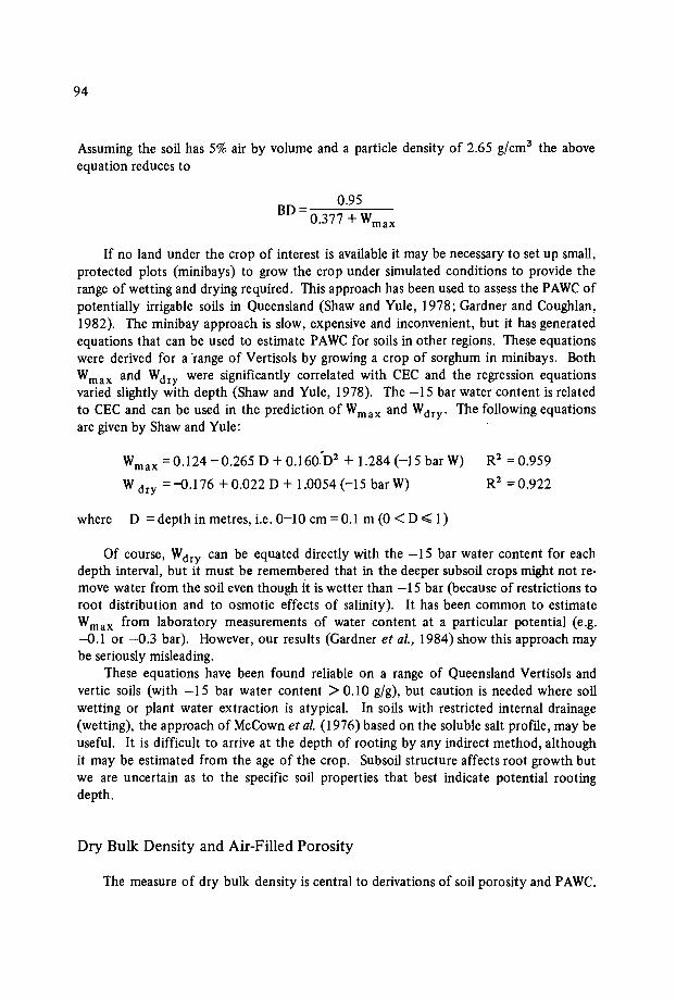
94
Assuming the soil has 5% air by volume and a particle density of 2.65 g/cm3 the aboveequation reduces to
0.95BD=----
0.377 + Wm ax
If no land under the crop of interest is available it may be necessary to set up small,protected plots (minibays) to grow the crop under simulated conditions to provide therange of wetting and drying required. This approach has been used to assess the PAWC ofpotentially irrigable soils in Queensland (Shaw and Yule, 1978; Gardner and Coughlan,1982). The minibay approach is slow, expensive and inconvenient, but it has generatedequations that can be used to estimate PAWC for soils in other regions. These equationswere derived for a 'range of Vertisols by growing a crop of sorghum in minibays. BothWmax and Wdry were significantly correlated with CEC and the regression equationsvaried slightly with depth (Shaw and Yule, 1978). The -15 bar water content is relatedto CEC and can be used in the prediction of Wm ax and Wdry' The following equationsare given by Shaw and Yule:
Wm ax =0.124 -0.265 D + 0.160"D2 + 1.284 (-IS bar W)
W dry = -0.176 + 0.022 D + 1.0054 (-15 bar W)
where D = depth in metres, Le. 0-10 cm = 0.1 m (0 < DE;;; 1)
R2 = 0.959
R2 =0.922
Of course, Wdry can be equated directly with the -15 bar water content for eachdepth interval, but it must be remembered that in the deeper subsoil crops might not remove water from the soil even though it is wetter than -15 bar (because of restrictions toroot distribution and to osmotic effects of salinity). It has been common to estimateWrnax from laboratory measurements of water content at a particular potential (e.g.-0.1 or -0.3 bar). However, our results (Gardner et al., 1984) show this approach maybe seriously misleading.
These equations have been found reliable on a range of Queensland Vertisols andvertic soils (with -IS bar water content> 0.10 gig), but caution is needed where soilwetting or plant water extraction is atypical. In soils with restricted internal drainage(wetting), the approach of McCown et al. (l976) based on the soluble salt profile, may beuseful. It is difficult to arrive at the depth of rooting by any indirect method, althoughit may be estimated from the age of the crop. Subsoil structure affects root growth butwe are uncertain as to the specific soil properties that best indicate potential rootingdepth.
Dry Bulk Density and Air-Filled Porosity
The measure of dry bulk density is central to derivations of soil porosity and PAWC.

95
It is also commonly accepted as a direct measure of soil compaction, but it is only one index of this complex phenomenon. Defined as the weight of solids per unit of total soilvolume, bulk density provides a basis for comparing the compactness of soil particlepacking between two samples. Soil porosity is an alternative way of expressing a soil'sstructural condition. Air-filled porosity is the volume of air-filled pore space in a soil ata given moisture content, and as such provides a guide to a soil's aeration status, whichmay be related to air diffusion and the potential for plant root respiration.
Values of bulk density and air-filled porosity can be derived from the one sample.Samples collected should be undisturbed and of known value. A common techniqueuses an integral sampler where a sharpened cylindrical metal sleeve of known dimensionsis driven into the soil (Loveday, 1974, eh, 3). The trimmed, 'wet' soil core is weighed,dried at 105° to constant weight, and reweighed after cooling. The calculation (afterLoveday, 1974, chs. 3 and 8) of dry bulk density and air-filled pore space (as well as thegravimetric and volumetric water contents of the sample) requires:
M = 'wet' mass of the core (g),Ms = mass of solids (i.e. the oven-dry mass of the soil in the sleeve) (g),Vb = bulk volume (i.e. the volume of the metal sleeve) (ern"),AD = particle density, usually taken as 2.65 (g/cm");
to give:o Dry bulk density, Db = Ms/Vb g/cm 3
o Gravimetric water content, W= (M-Ms)/Ms gigo Volumetric water content, Wv= W.Db cm3/cm3
o Air-filled porosity, f= (l-(Db/AD) - Wv cm' /cm 3
In all soils it is vital that samples taken for determination of bulk density and airfilled porosity contain representative proportions of the volumes of solid, liquid and air.This is particularly difficult in Vertisols due to cracking. Doubt has been expressed aboutthe efficacy of 7.5 cm and 10.9 cm (internal diameter) cores for sampling Vertisols,(McGarry, in press; Berndt and Coughlan, 1976, respectively) but no author has demonstrated an optimal size for all conditions.
If bulk density is required for expression of water content and/or nutrients involumetric terms, it may be sufficient and preferable to estimate Db from more easilymeasured soil variables (see 'plant-available water capacity' section and Figure 2).
When using bulk density as a measure of soil compaction, two things should beremembered:
When comparing soils, the minimum bulk density will depend on the maximum fieldwater content. The latter is determined in Vertisols by the amount and swellingcapacity of the soil clay fraction. For these reasons, it may not be reasonable toconclude that Soil TSl (Figure 2) is 'more compacted' than Soil B8.When comparing treatments on a single soil (or where Db measurements are madeover a period of time), it is important to remember that the Db-water content plothas a negative trend similar to that shown in Figure 2, particularly if cracks are notrepresentatively sampled. Therefore, to compare different treatments or times it is

96
important to sample at the same water content, or over a similar range of water contents.
1.8
(;;
(;;(;; Soil Types
1.7 (;;6
00 • B8
1.8 0 6l( T6S
ME 0 OAR]0
o 1.5 O· • AL2<, 6 • 6 TSlCl
01.4
>. 0.... .:en 1.3c:11) •0 1.2 •5% air line~ ,:::lID 1.1
1.0
0.1 0.2 0.3 0.4 0.5 0.8
Maximum Water Content (g/g)
Figure 2. The relationship between bulk density and water content (both measured at maximum fieldwater content) for a range of Vertisol subsoiIs.
Air-filled porosity can be a more meaningful way of presenting soil structural statusor compaction than bulk density. To illustrate differences, plot the increase in the percentage of air-filled pores on subsequent days after an irrigation or heavy rainfall. Acommonly accepted critical value of air-filled porosity below which a soil is waterloggedis 10%, though it ·is somewhat arbitrary, being both soil type- and crop-dependent. Therapidity with which a soil achieves an air-filled porosity value of 10% following an irrigation or heavy rainfall may be related to the soil's structural status, a more compacted soilremaining at low air-filled porosities longer. An ~xample illustrates recovery rates of airfilled porosity for a Vertisol after irrigation (McGarry and Chan, 1984) (Figure 3). Thesite (where a cotton crop was growing at the height of summer) was sampled on each of2, 5 and 10 days after an irrigation. For five days after the irrigation, air-filled porositywas < 10% below 20 cm, and it took 10 days before this extended to 40 cm. Even after10 days, below 40 cm did not achieve a value greater than 10%. At this site, therefore, ifyou accept that 10% air-filled pores is a critical value, then plant root respiration beneath 20 cm was impaired for 5 days after an irrigation, and to 40 cm for 10 days.

oo
10
~ 20
s:c.. 30CDo
40
50
Air Filled10
Porosity20
(%)30 40
97
Figure 3. Air-filled porosity vs. depth in a Vertisol sampled 2, 5, and 10 days after irrigation of acotton crop.
Penetration Resistance
Soil resistance to the insertion of a penetrometer is a commonly accepted measureof soil strength which many authors have attempted to relate to root exploration andexpansion into soil. The ease and rapidity of data collecting have ensured its popularity.However, uncertainty exists about the meaningfulness of the measure, both due to itsinterdependency with other soil factors, and to its interpretation as regards plant rootexploration of a soil. Measurement is commonly made by means of a hand-poweredpenetrometer, though electric-powered recording penetrometers are becoming morewidely used. The range of penetrometers available in terms of size, shape of tip, strengthof internal spring, etc., is very large, but the uncertainties associated with interpretationof the values are common to all.
If soil water content is not taken into account when penetration resistance is measured, misleading interpretations can be made. For example, in one study six sites onVertisols were sampled, each over a different range of soil water content (McGarry,unpublished data) (Figure 4). If associated water content had not been measured, then itcould have been concluded (wrongly) that site 5 had higher penetration resistance (soilstrength was greater) than the other sites. Whenviewed in association with water contentit can be seen that all sites quite closely fit one line - a negative exponential. As withbulk density, between-site comparisons of penetration resistance should be restricted toone water content or the same range of water content. Measurement at maximum fieldwater content is one option.
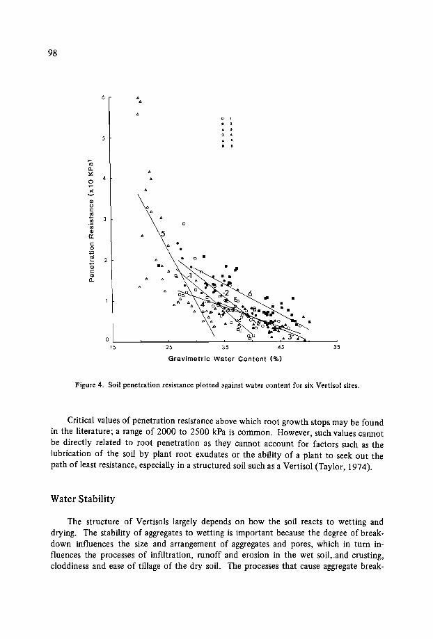
98
55
•
453525
OL-_----'__--'-__""'--__'-:-_-=__~....:.....":;""Ou.....--___:
15
6 ....c ,
· 2
· ,0 ·5 · ·· ·
70C-l<:0
4 ..)(~
C1l0 ..<:: ..~
'" 0
'"C1l 5a:<:: .0 ..~
0 •2 ..Q; ...<::C1l
C-
Gravimetric Water Content (%)
Figure 4. Soil penetration resistance plotted against water content for six Vertisol sites.
Critical values of penetration resistance above which root growth stops may be foundin the literature; a range of 2000 to 2500 kPa is common. However, such values cannotbe directly related to root penetration as they cannot account for factors such as thelubrication of the soil by plant root exudates or the ability of a plant to seek out thepath of least resistance, especially in a structured soil such as a Vertisol (Taylor, 1974).
Water Stability
The structure of Vertiso1s largely depends on how the soil reacts to wetting anddrying. The stability of aggregates to wetting is important because the degree of breakdown influences the size and arrangement of aggregates and pores, which in turn influences the processes of infiltration, runoff and erosion in the wet soil.iand crusting,cloddiness and ease of tillage of the dry soil. The processes that cause aggregate break-
99
down in wet soil are:Slaking, Le. aggregates break into smaller aggregates due to swelling stress when drysoil is wetted quickly.Dispersion, Le. the individual clay particles that make up aggregates are no longerbonded together and to other soil particles and may move apart due to electrokinetic repulsion.Slaking only occurs when dry soils are wetted rapidly. The degree of breakdown is a
function of the rate water is applied and the rate at which aggregates take up water(Collis-George and Laryea, 1971; Coughlan, 1979). Dispersion can occur spontaneously,but it more commonly occurs after mechanical energy is applied, e.g. raindrop impact,tillage, or livestock trending. Coughlan (1984) proposed a model for stability to rainfallwetting of aggregates in the immediate surface soil. The mean elements of this modelwere that surface tension forces maintain aggregate stability until the soil reaches thedisruptive moisture content (DMC); at or above the DMC the aggregates are very easilybroken down into individual particles. Coughlan also proposed that aggregates of somesoils have an inherently slower rate of wetting. These slow-wetting aggregates might notbreak apart on wetting (e.g. immersion followed by wet sieving), but are susceptible todispersion under raindrop impact.
Thus the degree of breakdown undergone by aggregates is a function of several factors - rainfall rate and energy, and soil wetting rate and strength characteristics. Nosingle test for aggregate stability can fully assess stability under the range of conditionsthat may be experienced in the field. Any chosen test gives results directly relevant onlyto the standard conditions applied. Thus test results are a guide to field response andbecome more reliable (or may be applied with greater confidence) if they can be correlated with field responses under a range of conditions.
The choice of a test should be based on the soil physical factors and the soil management processes that are of most interest in the field. Wet sieving (after immersion of dryaggregates) has been used extensively for nonswelling soils, but is not appropriate forvertic soils (Coughlan, 1984). This is because the aggregates when immersion-wet are notexposed to the same energy as occurs under rainfall and may be wet more rapidly thanoccurs in the field.
The simplest approach is to note soil behaviour in the field. In the dry state notewhether aggregates are coarse or fine, whether there is crusting on the surface, sandseparation and clay 'curls' in depressions. If the soil can be observed when wet, it isuseful to know under what rainfall conditions ponding occurs, and if ponded water isturbid. Soils showing ponding under light rain or having turbid surface water are morelikely to have physical problems.
Simple tests may provide a guide to soil behaviour. The aggregate coherence (Emerson) test (Emerson, 1967) is a very simple test that separates soils on the basis of slaking,spontaneous dispersion, and dispersion after remoulding. The dispersion tendencies canbe rated numerically to give a dispersion index (Loveday and Pyle, 1971), but our generalexperience for Vertisols has been that this test may not separate soils that show differingbehaviour in the field. Our results (Coughlan, 1984) suggest that the dispersion ratio

100
(Midd1eton, 1930) is a better guide to field soil aggregate behaviour.Of the many other stability tests available, most require complex equipment and so
phisticated laboratory conditions. Tests that may be of value if relationships can bedeveloped include those based on aggregate wetting rate (Coughlan, 1984; Quirk andPanabokke, 1962) and using simulated rain. Some results with Vertisols (Glanville andSmith, unpublished) suggest that the proportion of water-stable aggregates < 0.125 mmis closely linked with infiltration under simulated rainfall (Figure 5) .
<lJ 100 .. • •- • • •CIl • •er: •Ciic
"toer:
-0c~
Cl)
to
Q}-to0:
c0....CIl....
C 0
0 25% 45
% by Weight < 0.12 mm
Figure 5. The relationship between infiltration of simulated rainfall and percentage of water-stableaggregates < 0.125 mm.
Self-Mulching
Dry aggregate size of the surface of self-mulching Vertisols is a distinctive morphological feature which can be subjectively rated in the field. Beckmann and Thompson(1960) used the fineness of aggregation in the surface as a criterion for classifying Vertisols, Such a classification relates to land use, since fineness of aggregation is related tosurface tilth and ease of seedbed preparation. It must be remembered, however, that
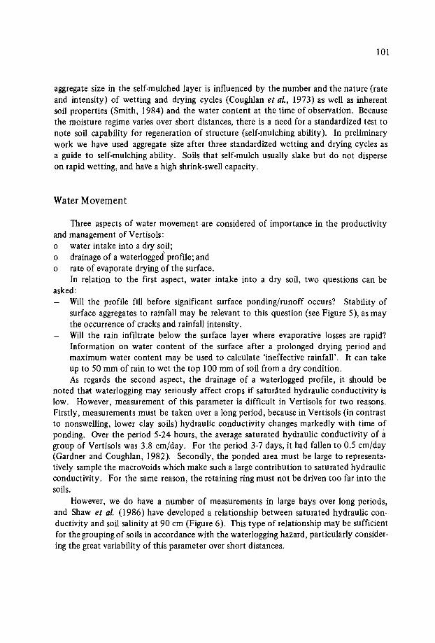
101
aggregate size in the self-mulched layer is influenced by the number and the nature (rateand intensity) of wetting and drying cycles (Coughlan et al., 1973) as well as inherentsoil properties (Smith, 1984) and the water content at the time of observation. Becausethe moisture regime varies over short distances, there is a need for a standardized test tonote soil capability for regeneration of structure (self-mulching ability). In preliminarywork we have used aggregate size after three standardized wetting and drying cycles asa guide to self-mulching ability. Soils that self-mulch usually slake but do not disperseon rapid wetting, and have a high shrink-swell capacity.
Water Movement
Three aspects of water movement .are considered of importance in the productivityand management of Vertisols:o water intake into a dry soil;o drainage of a waterlogged' profile; ando rate of evaporate drying of the surface.
In relation to the first aspect, water intake into a dry soil, two questions can beasked:
Will the profile fill before significant surface pending/runoff occurs? Stability ofsurface aggregates to rainfall may be relevant to this question (see Figure 5), as maythe occurrence of cracks and rainfall intensity.Will the rain infiltrate below the surface layer where evaporative losses are rapid?Information on water content of the surface after a prolonged drying period andmaximum water content may be used to calculate 'ineffective rainfall'. It can takeup to 50 mm of rain to wet the top 100 mm of soil from a dry condition.As regards the second aspect, the drainage of a waterlogged profile, it should be
noted that waterlogging may seriously affect crops if saturated hydraulic conductivity islow. However, measurement of this parameter is difficult in Vertisols for two reasons.Firstly, measurements must be taken over a long period, because in Vertisols (in contrastto nonswelling, lower clay soils) hydraulic conductivity changes markedly with time ofponding. Over the period 5·24 hours, the average saturated hydraulic conductivity of agroup of Vertisols was 3.8 cm/day. For the period 3-7 days, it had fallen to 0.5 cm/day(Gardner and Coughlan, 1982). Secondly, the ponded area must be large to representatively sample the macrovoids which make such a large contribution to saturated hydraulicconductivity. For the same reason, the retaining ring must not be driven too far into thesoils.
However, we do have a number of measurements in large bays over long periods,and Shaw et al. (1986) have developed a relationship between saturated hydraulic conductivity and soil salinity at 90 cm (Figure 6). This type of relationship may be sufficientfor the grouping of soils in accordance with the waterlogging hazard, particularly considering the great variability of this parameter over short distances.
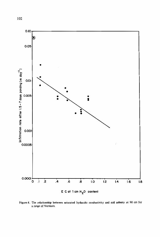
102
O.lOT""'"---------------------------,
•0.05
c:
2 0.001c...=~c:-
...CD--cCDC...
Clc:'6c:oa.
~ 0.005c
"CI"
I10
•
0.01
-'»c
"C
E
0.0005
1.81.61.41.21.0.8.6.40.0001 +---.-........,r-----r--...,....--,..--......--........--...-----.---!
o .1 .2
E C ot 1 cm H20 content
Figure 6. The relationship between saturated hydraulic conductivity and soil salinity at 90 cm fora range of Vertisols.

103
In relation to the third aspect, the rate of evaporative drying of the surface, it will beappreciated that the rate of drying is relevant to both seedling emergence and long-termprofile evaporative losses. Measurements of both water content and water potential maybe useful.
Conclusions
On the basis of our experience, the following measurements are recommended forphysical and mechanical characterization of Vertisols. Both field and laboratory measurements are listed in the order simple to complex and/or necessary to less necessary.As the range of measurements made increases, the confidence of prediction of soil behaviour also increases.
Field profile description:o aggregate size and crusting tendency of surface soilo aggregate consistence, depth of self-mulchingo size and type of subsurface structural unitso presence/absence of polished faces on pedso distribution and nature of segregationso mottlingo field pH profile
Field measurements:o profile description (structure, concretions, pH)o maximum field water contento wet penetration resistanceo permeabilityo rate of drying of seedbed (water content, potential)
Laboratory measurements:o salinity and pH profileso water contents at -15 bar and lower water potentialso CEC, exchangeable cationso clayo dispersiono aggregate size after simulated rainfallo self-mulching of clodso aggregate porosityo liquid and plastic limito high energy moisture characteristicso clod shrinkage curve

104
References
BECKMANN, G.D. and THOMPSON, C.H. 1960. Soils and land use in the Kurrawa area,Darling Downs, Queensland. Soils Land Use Series no. 37, Division of Soils, CSIRO.Melbourne, Australia: CSIRO.
BERNDT, R.D. and COUGHLAN, K.J. 1976. The nature of changes in bulk density withwater content in a cracking clay soil. Australian Journal of Soil Research 15:27-37.
COLLIS-GEORGE, N. and LARYEA, K.B. 197 I. Infiltration behaviour of structurallyunstable soils under ponded and non-ponded conditions. Australian Journal of SoilResearch 9:7-20.
COUGHLAN, K.J. 1979. Influence of microstructure on the physical properties ofcracking clay soils. Report to Reserve Bank, August 1979.
COUGHLAN, K.J. 1984. The structure of Vertisols. Pages 87-96 in: Properties andUtilization of Cracking Clay Soils, eds. J.W. McGarity, E.H. Hoult and H.B. So. Reviews in Rural Science no. 5: University of New England, Armidale, New SouthWales, Australia.
COUGHLAN, K.J., FOX, W.E. and HUGHES, J.D. 1973. Aggregation in swelling claysoils. Australian Journal of Soil Research 11: 133-141.
COUGHLAN, K.J. and LOCH, R.J. 1984. The relationship between aggregation and othersoil properties in cracking clay soils. Australian Journal ofSoil Research 22: 59-69.
COUGHLAN, K.J., SMITH, G.D. and YULE, D.F. In press. Soil Physical Research for Improved Dryland Crop Production on Vertisols in Queensland, Australia. In: Proceedings of the IBSRAM Inaugural Workshop on Management of Vertisols for ImprovedAgricultural Production, India: February 1985: ICRISAT.
EMERSON, W.W. 1964. The slaking of soil crumbs as influenced by clay mineral composition. Australian Journal of Soil Research 2:211-217.
FAO (Food and Agriculture Organization of the United Nations). 1968. Guidelines forSoil Profile Description. Soil Survey and Fertility Branch, Land and Water Division,FAO, Rome, Italy.
GARDNER, E.A., SHAW, R.J., SMITH, G.D. and COUGHLAN, K.J. 1984. Plant-available water capacity: concept, measurement and prediction. Pages 164-175 in: Properties and Utilization of Cracking Clay Soils, eds. J. McGarity, E.H. Hoult, and H.B. So.Reviews in Rural Science no. 5: University of New England, Arrnidale, New SouthWales, Australia.
GARDNER, E.A. and COUGHLAN, KJ. 1982. Physical factors determining soil suitability for irrigation crop production in the Burdekin-Elliot River area. TechnicalReport no. 20, Agricultural Chemistry Branch, Department of Primary Industries,Brisbane, Queensland, Australia.
LOVEDA Y, J., ed. 1974. Methods for analysis of irrigation soils. Technical Communication no. 54, Commonwealth Bureau of Soils, Harpenden, U.K.
McCOWN, R.L., MURTHA, G.G. and SMITH, G.D. 1976. Assessment of available waterstorage capacity of soils with restricted sub-soil permeability. Water Resources Research 12:1255-1259.
McDONALD, R.C., ISBELL, R.F., SPEIGHT, J.G., WALKER, J. and HOPKINS, M.F.1984. Australian Soil and Land Survey: Field Handbook. Inkata Press, Melbourne.
McGARRY, D. and CHAN, K.Y. 1984. Preliminary investigation of clay soils' behaviourunder furrow irrigated cotton. Australian Journal of Soil Research 22: 99-108.

105
McGARRY, D. (In press). The effect of soil water content during land preparation onaspects of soil physical condition and cotton growth. Soil and Tillage Research.
MIDDLETON, L. 1930. Properties of soils which influence soil erosion. Technical Bulletin no. 178, U.S. Department of Agriculture.
NORTHCOTE, K.H. 1979. A factual key for the recognition of Australian soils. 3rd edn.Rellim Technical Publications, Glenside, South Australia.
QUIRK, J.P. and PANABOKKE, C.R. 1962. Incipient failure of soil agregates. Journalof Soil Science 13:60-70.
SHAW, R.J., HUGHES, K.K., DOWLING, A.J. and THORBURN, P.J. 1986. Principlesof landscape, soil and water salinity - processes and management options. Part A in:Landscape, Soil and Water Salinity. Proceedings of the Burdekin Regional SalinityWorkshop, Ayr, April 1986. QDPI Publication QC86003. Also in: Proceedings of theDarling Downs Regional Workshop, Toowoomba, March 1986. QDPI PublicationQC86001.
SHAW, R.J. and THORBURN, P.J. 1985. Prediction of leaching fraction from soil properties, irrigation water and rainfall. Irrigation Science 6: 73-83.
SHAW, R.J. and YULE, D.F. 1978. The assessment of soils for irrigation, Emerald,Qld, Technical Report no. 13, Agricultural Chemistry Branch, Department of Primary Industries, Brisbane, Queensland, Australia.
SMITH, G.D. 1984. Soil constituent and prehistory effects on aggregate porosity in cracking clays. Pages 109-115 in: The Properties and Utilization of Cracking Clay Soil,eds. J.W. McGarity, E.H. Hoult, and H.B. So. Reviews in Rural Science no. 5: University of New England, Armidale, New South Wales, Australia.
SMITH, G.D., YULE, D.F. and COUGHLAN, K.J. 1984. Soil Physical Factors in CropProduction on Vertisols in Queensland, Australia. Pages 87-104 in: Proceedings ofthe International Workshop on Soils, 12-16 September 1983, Townsville, Queensland, Australia.
So'IL BURVEY STAFF. 1951. Soil Survey Manual. Agricultural Handbook no. 18.U.S. Department of Agriculture: U.S. Printing Office, Washington, D.C., USA.
SOIL SURVEY STAFF. 1975. Soil Taxonomy: A Basic System of Soil Classification formaking and Interpretating Soil Surveys. Agricultural Handbook no. 436. U.S. Department of Agriculture: U.S. Government Printing Office, Washington, D.C., USA.
SWINDALE, L.D. and MIRANDA, S.M. 1984. The distribution and management indryland agriculture of Vertisols in the semi-arid tropics. In: The Properties andUtilization of Cracking Clay Soils, eds. LW. AcGarity, E.H. Hoult and H.B. So. Reviews in Rural Science no. 5: University of New England, Armidale, New SouthWales, Australia.
TAYLOR, H.M. 1974. Root behaviour as affected by soil structure and strength. Pages271-291 in: The Plant Root and its Environment, ed. E.W. Carson. Virginia, USA:University of Virginia Press.

WATER MANAGEMENT OF VERTISOLS IN THE SEMI-ARID TROPICS
D.F. Yule*
Abstract
Water management for cropping in semi-arid environments must aim to maximizetranspiration and minimize evaporation, runoff and drainage. The soil water balance isused to consider these processes and their interactions. Data applicable to Vertisols arelimited.
Our research on Vertisols in Queensland indicates that infiltration (rainfall-runoff)depends on rainfall, soil surface and soil profile conditions. On an annual basis, runoffwill generally be small. Soil evaporation is the major exter-loss mechanism, oftenaccounting for more than 50% of rainfall. Rainfall < 30 mm is readily lost to evaporation. Drainage may be significant in water-balance terms. Tillage management and itseffects on cover, weed growth and surface roughness can increase infiltration and/ordecreaseevaporation.
Transpiration can be maximized by managingcrop, planting, and agronomic options.Crops develop in a high-stress environment in semi-arid regions and few applicable cropwater-usedata are available.
Options for soil water measurement are discussed.
Introduction
Water management must aim to maximize the productive use of water by minimizing the unproductive losses. Simplistically this means maximizing the transpiration component of the water balance. This will achieve maximum annual dry-matter production.However, to achieve acceptable grain production it may be necessary to accept greater
* Queensland Department of Primary Industries, Rockhampton 4700, Australia.
108
losses during a fallow period.This discussion is based on a consideration of the soil water balance and its applica
tion to relatively dry environments where soil evaporation is the major loss mechanismand crop growth is extremely restricted by water stress. Most of the examples used arefrom Queensland, Australia.
The Soil Water Balance
Infiltration = Precipitation - Runoff = Evaporation + Transpiration + Drainage +Soil Water Change.
Components and processes within the soil water balance
RainfallRainfall amount, frequency, reliability and intensity are all important considerations.
Specific requirements include rain for planting and crop establishment, rain during thegrowing season, rain for fallow water accumulation, start and end of wet season, etc.Matching crop requirements to rainfall expectations and stored soil water becomes moreimportant and more difficult with decreasing rainfall.
RunoffRunoff is a loss that should be minimized to increase soil water available to crops and
to decrease erosion and off-site effects. The amount of runoff can be influenced by soilsurface conditions (roughness and cover), rainfall characteristics (amount, intensity)and antecedent soil water content (surface, subsurface). Surface roughness is useful atthe start of a fallow but is difficult to maintain during seedbed preparation and duringwetting and drying cycles. Cover can decrease runoff markedly, particularly when thesoil is dry (Figure 1) (Freebairn and Wockner, 1986). Similar effects have been measurednear Emerald (Table 1). Cover prevents degradation of the surface soil structure andtherefore maintains a higher infiltration rate. When the soil is fully wet, the infiltrationrate is determined by the hydraulic conductivity of the soil, and cover has a small effect(Figure 1).
InfiltrationInfiltration is far more important than runoff from a soil water management pers
pective. On an annual basis, infiltration can be more than 90% of rainfall, and factorswhich markedly affect runoff will have only a small effect on infiltration. The dominanteffect on infiltration is soil water content (Figure 1). Annual infiltration will be increasedby maintaining higher soil water deficits. The soil hydraulic conductivity, soil cracks,rainfall intensity, and cover can also influence infiltration. Infiltration into Vertisols isnot well understood and is being studied by our group in Queensland using rainfall simulators and small catchments (l to 15 ha). Currently attempts are being made to estimate
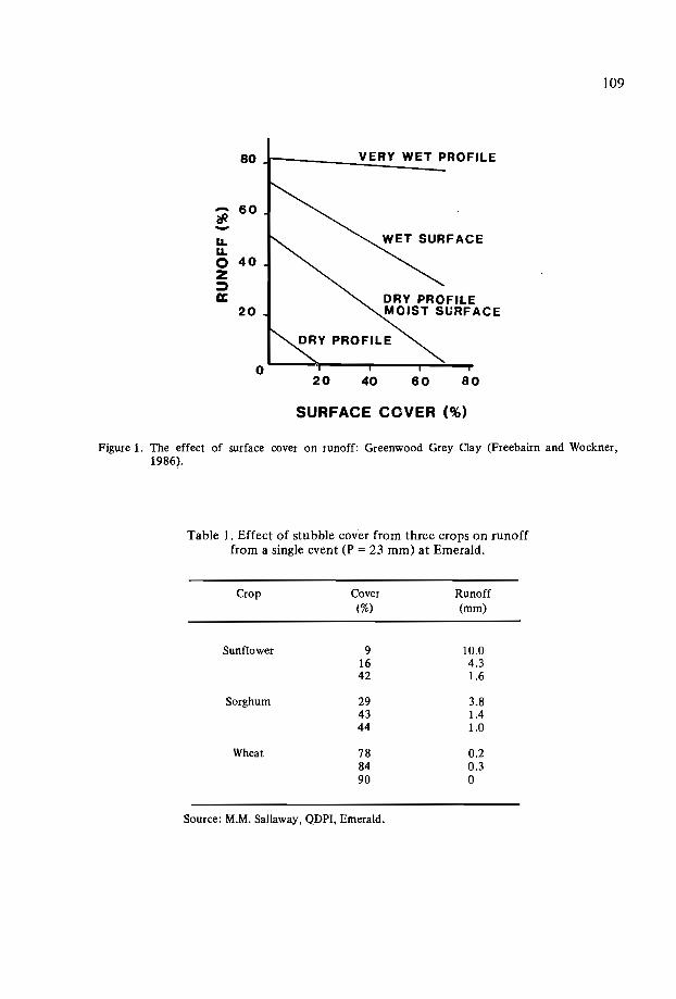
109
80 VERY WET PROFILE
- 60fP-I.LI.L0 40Z::;)CC
20
60
SURFACE COVER (%)
Figure 1. The effect of surface cover on runoff: Greenwood Grey Clay (Freebairn and Wockner,1986).
Table 1. Effect of stubble cover from three crops on runofffrom a single event (P = 23 mm) at Emerald.
Crop Cover Runoff(%) (mm)
Sunflower 9 10.016 4.342 1.6
Sorghum 29 3.843 lA44 1.0
Wheat 78 0.284 0.390 0
Source: M.M. Sallaway, QDPI, Emerald.
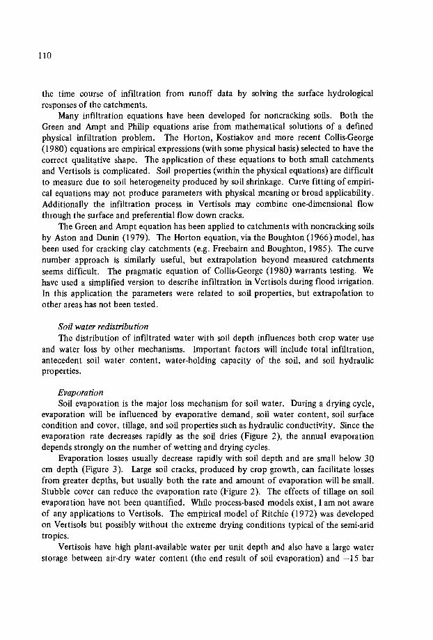
llO
the time course of infiltration from runoff data by solving the surface hydrologicalresponses of the catchments.
Many infiltration equations have been developed for noncracking soils. Both theGreen and Ampt and Philip equations arise from mathematical solutions of a definedphysical infiltration problem. The Horton, Kostiakov and more recent Collis-George(1980) equations are empirical expressions (with some physical basis) selected to have thecorrect qualitative shape. The application of these equations to both small catchmentsand Vertisols is complicated. Soil properties (Within the physical equations) are difficultto measure due to soil heterogeneity produced by soil shrinkage. Curve fitting of empirical equations may not produce parameters with physical meaning or broad applicability.Additionally the infiltration process in Vertisols may combine one-dimensional flowthrough the surface and preferential flow down cracks.
The Green and Ampt equation has been applied to catchments with noncracking soilsby Aston and Dunin (1979). The Horton equation, via the Boughton (1966) model, hasbeen used for cracking clay catchments (e.g. Freebairn and Boughton, 1985). The curvenumber approach is similarly useful, but extrapolation beyond measured catchmentsseems difficult. The pragmatic equation of Collis-George (1980) warrants testing. Wehave used a simplified version to describe infiltration in Vertisols during flood irrigation.In this application the parameters were related to soil properties, but extrapolation toother areas has not been tested.
Soil water redistributionThe distribution of infiltrated water with soil depth influences both crop water use
and water loss by other mechanisms. Important factors will include total infiltration,antecedent soil water content, water-holding capacity of the soil, and soil hydraulicproperties.
EvaporationSoil evaporation is the major loss mechanism for soil water. During a drying cycle,
evaporation will be influenced by evaporative demand, soil water content, soil surfacecondition and cover, tillage, and soil properties such as hydraulic conductivity. Since theevaporation rate decreases rapidly as the soil dries (Figure 2), the annual evaporationdepends strongly on the number of wetting and drying cycles.
Evaporation losses usually decrease rapidly with soil depth and are small below 30cm depth (Figure 3). Large soil cracks, produced by crop growth, can facilitate lossesfrom greater depths, but usually both the rate and amount of evaporation will be small.Stubble cover can reduce the evaporation rate (Figure 2). The effects of tillage on soilevaporation have not been quantified. While process-based models exist, I am not awareof any applications to Vertisols. The empirical model of Ritchie (1972) was developedon Vertisols but possibly without the extreme drying conditions typical of the semi-aridtropics.
Vertisols have high plant-available water per unit depth and also have a large waterstorage between air-dry water content (the end result of soil evaporation) and -15 bar

III
-EE-z2 50~Ca:oa.-e> 30lU
lU>~C-':) 10~:)(J
BARE
STUBBLE
40 80 120
TIME (days)
Figure 2. Soil evaporation during a long drying cycle for bare and stubble-covered plots (Yule, unpublished data).
VOLUMETRIC WATER CONTENT (cm3cm3
)
0.40.2
, ---120 DAYS" ---- STUBBLE...._- --------"""-- - -----............
BARE --......... ---
........- '"...._,,~
<,11
11
-E(,)-:c 20~a.lUC
-'-0tn
40
Figure 3. Volumetric water content profiles one day and 120 days after rainfall for bare and stubblecovered plots (Yule, unpublished data).

112
water content. Consequently, after a long dry period, very large deficits develop in thesurface soil (e.g. the deficit of 30 mm at 0 to 10 cm in Figure 3) and large falls of rainare needed to penetrate to the subsoil. Rainfalls of 20 mm or less are held in the 0 to 10cm zone and rapidly evaporate (12 days in Figure 2).
TranspirationTranspiration rate is a function of soil water supply and evaporative demand. Other
influences include leaf area index and depth, and activity of rooting. Models developedelsewhere should be generally applicable. Difficulties may arise due to high plant waterstress conditions associated with semi-arid environments. Reasonably successful modelshave been developed in Queensland for sunflower (Hammer et al., 1982), wheat (Hammerand Woodruff, 1984) and sorghum (in progress) (Wade, pers. comm.).
DrainageFew direct measurements of drainage in Vertisols are available from dry semi-arid
tropical environments. Soluble salt profiles can be used to indicate the likelihood ofsignificant drainage (Shaw and Thorburn, 1985). In our black basaltic cracking clays(Typic Pellusterts) salt bulges do not occur if the solum is shallower than 1SO cm. If soildepth> ISO cm, it is usual to find salt accumulation in the profile. Therefore significantleaching could be expected in the shallow Pellusterts. In grey Vertisols (Entic Chromusterts) with lower hydraulic conductivity, salt bulges occur at shallow depths (SO to 80cm). Application of water-balance models such as SPAW may allow a better definitionof drainage. At Emerald on Pellusterts, indications of drainage greater than SO mmfrom single-rainfall events have been obtained. These have occurred during unusuallylarge winter rainfalls of low intensity when drainage appears to exceed runoff on mostoccasions ..These findings suggest that hydraulic conductivity is an important soil property.
Soil water storageChange in the soil water storage are the net results of the rainfall inputs and the loss
mechanisms described. Measurement of the soil water content is a fundamental part ofsoil water-balance studies and will be discussed later.
Summary of soil water balanceThe components of the soil water balance that are most dominant are rainfall, infil
tration, transpiration, evaporation and drainage. Soil water content is used to monitorchanges. The factors involved are meteorological (rainfall, evaporative demand), soil properties (PAWC, hydraulic conductivity, air-dry water content, cracking), historical (asindicated by antecedent soil water content) and soil surface management (cover, roughness).
113
Implications for Management
This discussion will consider the interactions of the soil and crop processes with theenvironment and some possible management options which may be exploited. The intentis to produce regular crops rather than irregular, large crops.
Interpretation and extrapolation of these responses is highly dependent on environmental conditions. Table 2 presents some monthly mean data for two sites in the semiarid cropping regions of Queensland and, for comparison, Niamey and Bulawayo (Source:ICRISAT's Agroclimatic Environment, ICRISAT Annual Report, 1984). These centreshave similar annual rainfalls. Table 2 suppotts the 'Comment "as in most semi-arid areas,rainfall during the rainy season accounts for over 90% of the annual rainfall" (ICRISATInformation Bulletin no. 19) for Niamey and Bulawayo. By comparison, Emerald has57% and Roma 49% of annual rainfall in the four wettest months. As a consequence the"rainy season" is comparatively more arid and less reliable for crop growth.
Table 2 shows that mean evaporation greatly exceeds mean rainfall in all months atEmerald and Roma, and that significant rain can fall in each month. These factors combine to decrease the amount of effective rainfall, and our research results may be applicable to areas with much lower annual rainfall. Additionally, successful crop productionis dependent on fallow soil water storage.
Fallow water accumulation
Factors that affect fallow water accumulation are antecedent water content (deficitat harvest), rainfall, and surface management. At Emerald, fallow water storage (FS)is linearly related to soil water deficit at harvest (SWD) by the equation:
FS=0.55 SWD-13(n=26,r2 = 0.71)(units are mm).Data were taken from three cropping monocultures (wheat, sorghum, sunflower)
during 1982-J986. This relationship indicates that the deficit is reduced by about halfduring an average fallow. However a fallow following a wet harvest may produce negativestorage. The high r2 value shows that soil water deficit has the major effect on fallowwater accumulation.
The effect of rainfall on the physical processes occurring has been discussed. Highintensity rain can produce runoff, rain on a wet profile can produce drainage, and frequent small rainfalls can produce high evaporation losses. This last effect is demonstratedin Table 3. If rainfall events do not exceed 30 to 40 mm, evaporation losses can reducesoil water accumulation to very small amounts.
In our studies at Emerald, surface management has had some effect on fallow soilwater accumulation (Table 4). The total effect appears to be a combination of reducedrunoff (in 1983/84 and 1985/86) and reduced evaporation (1982/83). Fallow efficiencies are very low « 35%) and, as expected, depend strongly on soil water deficit at harvest. The achievement of high fallow efficiency is further complicated by feedbackmechanisms within the water balance. Clearly a treatment that increases infiltration during one rainfall event may produce higher evaporation or greater runoff from subsequent

Table 2. Monthly mean values of rainfall, class A pan evaporation and maximum temperature for four sites.
JAN FEB MAR APR MAY JUN JUL AUG SEP OCT NOV DEC TOTAL
Emerald R'" 106 100 74 36 28 40 29 21 26 39 57 81 638E 232 188 177 153 118 93 108 133 180 232 252 260 2126T 35 34 33 30 26 23 23 25 28 32 34 35
Roma R 81 76 65 31 34 36 38 26 34 49 55 68 593E 235 199 186 141 93 63 71 99 138 186 222 248 1881
Niamey R 0 0 0 0 35 85 150 205 95 10 0 0 580E 160 170 215 210 220 200 160 130 130 175 160 135 2050T 34 36 40 41 40 37 33 31 33 37 37 33
Bulawayo R 140 120 70 25 10 0 0 0 10 ·30 90 130 625T 31 30 27 25 24 20 22 25 27 30 27 29
'" R = Rain (mm)E = Class A pan evaporation (mm)T = Maximum temperature ("C)
.............

115
Table 3. Soil water accumulation during fallows as related to rainfall amounts.
Soil water Soil water Total RainfallsStubble Date deficit change rain >30mm
(mm) (mm) (mm) (mm)
Wheat 29.2.84 10521.6.84 112 -7 80 Nil
Wheat 21.6.84 1128.8.84 37 +75 123 75,38
Sunflower 28.6.84 16125.1.85 78 +83 310 75,45,39
37,38
Sunflower 25.1.85 782.5.85 67 +11 126 Nil
Table 4. Soil water balances during sunflower fallows for reduced tillage (RT)(blade plough, tyned cultivators) and zero tillage (ZT) systems.
1982/83 1983/84 1984/85 1985/86
ZT RT ZT RT ZT RT ZT RT
Rainfall (mm) 246 246 272 272 459 459 164 164SWD at harvest (mm) 155 174 72 40 161 186 121 153Runoff (mm) 27 25 13 23 8 8 11 27Soil wateraccumulation (mm) 73 44 21 -6 107 114 57 53Fallow efficiency (%) 30 18 8 -2 23 25 35 32
rainfall. The net result is generally conservative responses to soil management, particu
larly over longer times or several rainfalls. Therefore stored soil water should be used
productively (for transpiration) as soon as possible.
116
Surface management
Surface management and soil physical amelioration techniques can influence the soilwater balance. Our emphasis has been on tillage and cover effects, and the responseswithin the soil water balance have been discussed. The implications for management byour farmers using heavy machinery include a longer time after rain before planting cancommence, a longer time when planting conditions are optimum, and the need for newequipment to handle high stubble levels. Herbicide technology is well advanced, thoughgenerally too expensive to be economic for complete zero till. Opportune herbicidespraying can be highly effective, for example, to control weed growth when the soil istoo wet to cultivate, or to allow rapid weed control postharvest prior to double-cropping.
Cultivation methods have changed dramatically. Disc ploughs have been replacedby tyned ploughs with sweeps. This has increased stubble retention and decreased soildisturbance. The number of cultivations needed to prepare a seedbed can be reduced .
. While tillage for weed control requires subsequent tillage to prepare a seedbed, directdrilling following chemical weed control is possible. The self-mulching characteristicof Vertisols produces adequate seedbed properties for seedling establishment. The implications are that tillage should be reduced and should aim for minimum soil disturbancewhile achieving the main aim of weed control.
Cultivation for surface water retention can be effective. Soils with a rough surfacecan absorb high-intensity rainfalls, particularly when dry. No-till treatments may sealand run off. However the conditions when such rough cultivation can be effective havenot been defined. Additionally, the rough surface degrades naturally during wetting anddrying cycles, and a seedbed must be prepared. The use of furrow dykes, basin listing,etc. may have potential as appropriate machinery is developed. Research at Emerald inthe 1960s found no advantage from basin listing for fallow water accumulation. However,this was an extremely dry period with little runoff (D. Younger, pers. comm.).
The most common manipulation of surface configuration used on Vertisols inQueensland is contour banks. About 850000 ha of cropped land have been contoured.Contour banks are installed to decrease soil erosion, to prevent gully formation and tocontrol runoff. While no direct effect on the soil water balance has been measured, theopportunity exists for increased infiltration (and possible deep drainage) in the channelof the contour bank. Soil erosion is such a major concern that any proposed management system must consider the implications for runoff and soil erosion control.
Gypsum can be effective in reducing runoff, increasing soil water storage, and increasing crop yields (So and McKenzie, 1984). However these responses are not achievedconsistently. In a number of experiments on the Darling Downs, Queensland, yield increases have been recorded, but without an increase in fallow-soil water storage (G.D..Smith et al., 1986). The seasons were wetter than normal and possibly did not allow
. expression of a gypsum response. The explanation of gypsum responses, and thereforethe situations where a response can be expected, requires further clarification.
Vertical mulching at intervals of 4 m and 8 m has increased soil water recharge andcrop yields in India (Rama Mohan Rao et al., 1977). Gypsum enriched slots (mixinghigh rates of gypsum into a trench) are being tested in Australia (Jayawardane and Black-
117
well, 1985). Deep ripping on the contour has increased infiltration into a dry soil duringheavy storms. These developments in the management of Vertisols indicate considerablepotential, but the circumstances needed for successful implementation must be defined.Presumably they function by intercepting runoff.
In-summary, a wide range of options exist to manage the soil surface so as to manipulate the soil water balance. It is now opportune to develop management systems incorporating these options. These systems should be based on the philosophy of zonaltillage (Larson, 1963), Le. managing zones of the field for their intended use: for example, zones for seedbed, traffic, infiltration, root growth, runoff, etc. Such systems havebeen developed for Vertisols in India (E1-Swaify et al., 1984) and for Red-Brown Earthsin Australia (Adem and Tisdall, 1984). These systems are designed around permanentbeds and consequently provide excellent control of machine operations. Therefore contour banks or furrows, vertical mulching, tie ridging, etc. could be incorporated. Usingthis approach, systems can be designed to optimize the soil water balance for cropproduction.
Crop water use
Cropping requirements include rain for crop establishment and rain or stored soilwater for crop growth. In Queensland, it is usual to plant after rain. A "planting rain"must wet the soil to the depth of stored soil water, that is the zone of soil evaporation. Asstated previously, this may require 30 to 40 mm of rain. Planting dry in the expectationof rain is very uncommon. However this management option should be evaluated forsummer crops in relation to rainfall probabilities. Manipulation of surface configurationmay also be useful (Coughlan et al., in press). Furrows could decrease the depth of drysoil and allow localized runoff to concentrate. A zonal tillage system would allow subsequent planting in the furrows.
Water for crop growth will be supplied by rainfall and stored soil water. The principles have been discussed in relation to fallow water accumulation. Due to the large inefficiencies in soil water storage, rainfall on crops must be potentially more efficient. Therefore, if water for cropping is limited, some crops should be grown during the rainy season.
Many aspects of crop agronomy offer options for soil water management. A range ofcrops and planting dates are needed to take advantage of soil water when it is available.This is more important in regions without discrete rainy seasons such as Queensland.Satisfactory planting conditions can occur in virtually every month of the year. However planting at Emerald is generally confined to the periods from December to May andfrom August to September, and the crops grown are sorghum, sunflower, wheat and
.Jl1aize with smaller areas of pigeonpea and .chtckpea. At Roma, summer crops are lesssuccessful due to the lower rainfall expectation, and wheat is the most common crop.Sorghum, sunflower and chickpea may be grown if conditions are favourable.
A range of crops and a range of varietal maturity can provide a large spread of possible planting dates. The decision to plant must, then, be based on an assessment of storedsoil water and the probability of sufficient rain on, the crop. These assessments can be
118
carried out using appropriate crop and water-balance models and historical meteorologicalrecords. We are currently developing these models by combining our research work withavailable models (Freebairn et al., 1986). As indicated previously, modelling the soilwater balance during the crop cycle is probably more advanced than during the fallow,but a major limitation relates to the definition of suitable conditions for planting - howmuch stored soil water is needed? what constitutes a planting rain? These questions canbe addressed using models, and the results expressed in terms of a yield probability curve.
Plant population can be based on available soil water at planting, although underQueensland conditions benefits from low populations and wide row spacing (2 to 4 m)occur only at yield levels below 900 kg ha (Thomas et al., 1981). In intensively farmedareas, it may be possible to respond to improved seasonal conditions by intercropping.The previously described zonal tillage system would facilitate this possibility. For extensively farmed areas, strip-cropping may have potential. The minimum width of stripwould be determined by tillage, planting and harvesting machinery.
While crop growth and yield are limited by water stress, soil fertility must be adequate for the expected yields. Despite low soil nutrient levels in many central Queensland Vertisols (bicarbonate phosphorus 6-10 ppm and total nitrogen < 1%), fertilizer responses are rarely measured. The adequate phosphorus nutrition is apparently due to mycorrhizal associations (Hunter and McCosker, 1982; Hibberd et al., 1986).
Adequate weed control is necessary to maximize crop water use. In particular,large or perennial weeds can use water from below the evaporation zone. A particularproblem in our zero-till experiments is grain sorghum regrowth, because it is difficult tokill postharvest and has a well-developed root system.
In our environment, flexible crop rotations are essential to maximize crop water use.A system of opportunity cropping has developed. Cropping systems are particularlydifficult to research and few specific data are available. Our assessment will be based onlong-term simulations using crop models developed from experiments with monocultures. Consequently synergistic effects tend to be neglected.
In summary, crop water use can be maximized by using a wide range of planting-timeoptions and by controlling weeds. High soil water deficit at harvest will increase fallowefficiency. The most important decision is "When to plant?", and further research isneeded to define planting conditions based on stored soil water and rainfall probabilities.Every planting opportunity must be taken if efficient water management is to beachieved.
Measurement of the soil water balance
Gravimetric water contentThe vast majority of our work has involved gravimetric sampling with thin-walled
tubes and machined cutting tips. Tubes are driven hydraulically or by jack hammer. Allweighing is now automated so that gravimetric water content calculations involve onlyinternal computer manipulations. This has decreased the time involved and preventstranscription and data entry errors.

119
Bulk densityBulk density is needed to convert gravimetric values to a volumetric basis. Bulk
density is not constant in Vertisols due to the shrink-swell property. Possible approachesto these problems have been discussed by Yule (I 984b), Bridge and Ross (I 984), andRoss (I985). The soil shrinkage curve, which relates bulk density or shrinkage to soilwater content, can be obtained by slowly drying undisturbed cores in the laboratory(Yule and Ritchie; 1980; Yule, 1984a). The shrinkage curve defines the swelling limitand allows accurate bulk density calculation at all water contents.
An approximate bulk density that is sufficiently accurate for many applications wascalculated by Yule (I 984b) from
l-EBD=--
1PD 4- °gl
where BD =; bulk densityE = air contentPD =particle density (usually assumed 2.65 g cm ")0gl =gravimetric water content at the swelling limit (approximated by sampling
2 to 3 days after rain)
The assumed density of water is 1 g cm'". The air content of fully wet soil varieswith soil depth (Table 5). The values at 0 to 20 cm depth are based on few data and maychange with further sampling. Additionally, these values can be influenced by tillage,self-mulching, crusting, etc. This approximate bulk density can be used at all water contents with errors in profile water-content change of less than 4% (Yule, 1984b). Thismethod accounts for soil shrinkage but does not account for sampling errors associatedwith soil shrinkage.
Table 5. The effect of soil depth on the air content of fullywet soil (approximately the swelling limit).
Depth(cm)
0-1010-2020-100
Air content(cm' cm-')
0.20.10.07
120
Soil shrinkageSoil shrinkage can be used to estimate profile water-content change (Yule, I984a).
Since shrinkage is equidimensional, profile water-content change will be approximatelythree times the change in the soil surface elevation. This method could also be calibratedin the field. I am not aware of any reports where this method has been attempted, although it would provide a quick estimate of profile water-content change for irrigationscheduling or to support a planting decision.
Neutron moisture meterThe neutron moisture meter has been widely used in Vertisols, but few calibration
curves have been published. It is unclear if the problems associated with soil shrinkagearound the access tube have been addressed. We are currently evaluating a field calibration experiment (Greacen et al., 1981) in which we used soil shrinkage curves to calculatebulk density (S.E. Ockerby and D.F. Yule, unpublished). Preliminary results suggestthat the calibration equations vary with both depth and soil type (two Vertisols wereexamined). The correlation coefficients of linear regression equations for each depthwere generally greater than 0.9. These results suggest that the neutron meter is useful inVertisols provided field calibrations are used.
RunoffWhile runoff is generally a small portion of the soil water balance, its measurement
allows an independent check of the other estimates. Even estimates of runoff or observations of occurrence of runoff are often helpful in interpretation of other data. Additionally it is usual to calculate some factors (for example, drainage) in the water balanceby difference. Runoff measurement is not difficult and measurements over time mayallow estimates of soil infiltration parameters.
Plant-available water capacity (PAWCjA measurement or estimate of PAWC is needed for water-balance interpretation or
modelling. Details are discussed by Coughlan et al. (these proceedings).
ModellingThe end result of most of our research will be the development of appropriate
models of the soil water balance, erosion and crop production. As Smith et al. (1984)have stated, modelling is seen as a tool to extend and extrapolate research results. Estimation of the soil water balance over large areas or many fields can be most efficientlyachieved by models. Our development of models is proceeding by (a) testing availablemodels with our data sets and (b) process research to define relationships within the models. A number of models are currently being used with considerable success (Freebairn et al., 1986), but weaknesses. within the soil water balance (as previously outlined)remain a limitation.
· 121
Conclusion
This paper has provided a broad outline of the processes and principles involved insoil water management based on the soil water balance. The soil water balance has beendiscussed for Vertisols in the semi-arid cropping regions of Queensland. While a solidbase of knowledge exists, much research is still needed to better define the processeswithin the soil water balance on Vertisols. Major emphasis should be placed on infiltration under rainfall and soil evaporation during fallows and when crop cover is small.Since the soil/crop/environment interaction dominates these responses, integratedresearch across a range of Vertisols and environments must produce highly robust solutions to these problems.
Similarly a vast amount of knowledge exists about crop water use, but its applicability to the high-stress environments of the semi-arid tropics must be rigorously testedacross soils and environments. This research should culminate in the development ofrobust models which can then provide a basis for the development of soil managementsystems specifically for Vertisols in the semi-arid tropics.
References
ADEM, H.H. and T,ISDALL, I.M. 1984. Management of tillage and crop residues fordouble cropping in fragile soils of south-eastern Australia. Soil Tillage Research. 4:577-89.
ASTON, A.R. and DUNIN, F.X. 1979. Coupled infiltration and surface runoff on a 5 haexperiment catchment, Krawaree, New South Wales. Australian Journal of SoilResearch 17: 53-64.
BOUGHTON, W.C. 1966. A mathematical model for relating runoff to rainfall with dailydata. Civil Engineering Transactions of the Institute ofEngineering of Australia CE8:83-97.
BRIDGE, B.]. and ROSS, P.]. 1984. Relations among physical properties of cracking claysoils. Pages 97-104 in: Properties and Utilization of Cracking Clay Soils, eds. ] .W.McGarity, E.H. Houitz and H.B. So. Revie~s in Rural Science no. 5: University ofNew England, Armidale, New South Wales, Australia.
COLLIS-GEORGE, N. 1980. A pragmatic method to determine the parameters thatcharacterize ponded inbltration.A ustralian Journal of Soil Research 18: 111-117.
COUGHLAN, K.]., SMITH, G.D. and YULE, D.F. In press. Soil physical research for improved dryland crop production on Vertisols in Queensland, Australia. In: Proceedings of the Inaugural Workshop on Mangement of Vertisols for Improved AgriculturalProduction, February 1985. Patancheru, A.P. 502324, India: ICRISAT.
EL-SWAIFY, S.A., PATHAK, P., REGO, T.I. and SINGH, S. 1984. Soil managementfor optimized productivity under rainfed conditions in the semi-arid tropics. Advances in Soil Science 1: 1-64.
FREEBAIRN, D.M. and BOUGHTON, W.e. 1985. Hydrologic effects of crop residuemanagement practices. A ustralian Journal ofSoil Research 23: 23-35.
122
FREEBAIRN, D.M., SILBURN, D.M., HAMMER, G.L., WOODRUFF, .D.R., LUCH,R.J., YULE, D.F., ROSENTHAL, K., GLANVILLE, S.; LAWRENCE, P.A. andSALLAWAY, M.M. 1986. Surface management and stability of production in cropping systems: Development of a model to simulate erosion and crop yield. QDPIProject Report, Brisbane, Australia. 69p.
FREEBAIRN, D.M. and WOCKNER, G:H. 1986. A study of soil erosion on Vertisols ofthe eastern Darling Downs, Queensland. I. Effects of surface conditions on soilmovement within contour bay catchments. Australian Journal of Soil Research 24:135-158.
GREACEN, E.L., CORREL, R.L., CUNNINGHAM, R.B., JOHNS, G.G. and NICOLLS,K.D. 1981. Pages 50-81 in: Soil Water Assessment by the Neutron Method, ed. E.L.Greacen. East Melbourne, Australia:.CSIRO.
HAMMER, G.L., GOYNE, P.J. and WOODRUFF, D.R. 1982. Phenology of sunflowercultivars. Ill. Models for prediction in field environments. Australian Journal ofAgricultural Research 33: 262-274.
HAMMER, G.L. and WOODRUFF, D.R. 1984. Water use efficiency in crop production- yield in relation to water supply. Pages 1-10 in: Proceedings of the QueenslandCrop Production Conference 1983. Queensland, Department of Primary Industries,QC840065.
HIBBERD, D.E., WANT, P.S., HUNTER, M.N., STANDLEY, J., WHITEHOUSE,M.J.,MOODY, P.W. and GRANT, 1.1. 1986. Fertilizer investigations in grain sorghum oncracking clay soils on the central highlands, central Queensland. Pages 6.28-6.35 in:Proceedings of the First Australian Sorghum Conference, eds. M.A. Foale and R.G.Henzell. Gatton, Australia.
HUNTER, M.N. and McCOSKER, A.N. 1982. Interactions between water supply, NandP, in the performance of an open-pollinated and a hybrid sunflower variety in a semiarid environment. In: Proceedings of the Tenth International Sunflower Conference,Surfers Paradise, Australia.
JAYAWARDANE, N.S. and BLACKWELL, J. 1985. The effects of gypsum-enrichedslots on moisture environment and aeration in an irrigated swelling clay. AustralianJournal of Soil Research 23: 481-492.
LARSON, W.E. 1963. Important soil parameters for evaluating tillage practices in theUnited States. Netherlands Journal of Agricultural Science 11: 100-109.
RAMA MOHAN RAO, M.S., RANGA RAO, V., RAMACHANDRAM, M. and AGNIHOTRI, R.C. 1977. Effect of vertical mulch on moisture conservation and yield ofsorghums in Vertisols, Agricultural Water Management 1: 333-342.
RITCHIE, J.T. 1972. Model for predicting evaporation from a row crop with uncomplete_cover. Water Resources Research 8: 1204-1212.
ROSS, P.J. 1985. Using bulk density to calculate soil water changes in soils with shrinkage cracks. Australian Journal of Soil Research 23: 109-113.
SHAW, R.J. and THORBURN, P.J. 1985. Prediction of leaching fraction from soil properties, irrigation water and rainfall. Irrigation Science 6: 73-83.
SO, H.B. and McKENZIE, n.c. 1984. Use oOf gypsum in the management of the grey andbrown clays of the Lower Gwydir Valley, New South Wales. Pages 329-334 in:Properties and Utilization of Cracking Clay Soils, eds. J.W. McGarity, E.H. Houltzand H.B. So. Reviews in Rural Science no. 5: University of New England, Armidale,New South Wales, Australia.

123
SMITH, G.D., ORANGE, D. and BLACKET, D. 1986. Recent research with gypsum insouth-west Queensland. Pages 111-120 in: Proceedings of the Queensland Crop Production Conference 1985. Queensland Department of Primary Industries, QC86002.
SMITH, G.D., YULE, D.F. and COUGHLAN, K.T. 1984. Soil physical factors in cropproduction on Vertisols in Queensland, Australia. Pages 87-104 in: Proceedings ofthe International Workshop on Soil, 12-16 September, 1983, Townsville, Australia.Australia: ACIAR.
THOMAS, G.A., MYERS, R.I.K., FOALE, M.A., FRENCH, A.V., HALL, B., LADEWIG,I.H., DONE, A.A., TAYLOR, G.K., LEFROY, E., WYLIE, P. and STIRLING, G.D.1981. Evaluation of row spacing and population density effects on grain sorghumover a range of northern Australian environments. Australian Journal ofExperimental Agriculture and Animal Husbandry 21: 210-217.
YULE, D.F. 1984a. Measured and predicted field shrinkage and swelling. Pages 105-108in: Properties and Utilization of Cracking Clay Soils, eds. I.W. McGarity, E.H. Houltzand H.B. So. Reviews in Rural Science no. 5: University of New England, Armidale,New South Wales, Australia.
YULE, D.F·. 1984b. Volumetric calculations in cracking clay soils. Pages 136-140 in:Properties and Utilization of Cracking Clay Soils, eds. I.W. McGarity E.H. Houltzand RB. So. Reviews in Rural Science no. 5: University of New England. Armidale,New South Wales, Australia.
YULE, D.F. and RITCHIE, I.T. 1980. Soil shrinkage relationships of Texas Vertisols.1. Small cores. Soil Science Society ofAmerica Journal 44: 1285-1291.


CHEMICAL FERTILITY CHARACTERISTICS OF VERTISOLS
P.R. Le Mare*
Abstract
Most Vertisols are neutral to alkaline; their dominant clay minerals are smectites;they often contain little organic matter and organic nitrogen, and they may have a largeC:N ratio. The most important nutrient deficiency is usually nitrogen. Ureaand ammonium fertilizers may lose ammonium ions, which associate with the smectite clay minerals. In general, responses to phosphate have been small, butsome large responses havebeen reported. Response to phosphate is sometimes related to water supply: ferrichydrous oxides may absorb phosphate when Vertisolsare dry, but some is released whenthey are flooded and iron is reduced. There has been little investigation of the nature andbehaviour ofphosphate in Vertisols, but work on Greek and Asian soils has indicated thatsorption of phosphate is less than in many acid soils of the tropics. There are few reportsof responses to potassium; although Vertisols [IX potassium, the concentrations maintained in solution are generally adequate for most crops. The micronutrients most oftendeficient are iron and zinc. Harmful amounts ofexchangeable sodium occur in some Vertisols.
Introduction
The principle areas of Vertisols are in Australia, India, and Africa, but they are alsofound in many smaller areas elsewhere in the tropics and subtropics. This paper collatesreports from India, Africa and the Middle East; it includes reports on soils that were referred to as regurs, grumusols, black cotton soil, and other terms which were used beforeVertisol became the generally accepted name for black cracking clay soil. Vertisols arealmost identical in different classification systems and include most black tropical clays
* Department of Soil Science, University of Reading, London Road, Reading RGl 5AQ, England.

126
(D'Hoore, 1968). McGarity et al. (1984) edited a good review of Australian Vertisols sothey are not considered in detail here. Other reviews ofVertisols, mainly Indian and African, have been made by Finck and Venkateswarlu (1982) and Virmani et al. (1982).
In the areas considered here, two large zones of Vertisols occur, in the Deccanplateau of India, reviewed by Landey et al. (1982), and in southern Sudan. Elsewhere inAfrica, large areas occur in Chad and Ethiopia; there are smaller areas of Vertisols inmany other countries, but for these there are few reports of investigations.
Effects offertilizers in Vertisols
Investigations of the chemical fertility of Vertisols have a long history in Sudan,based on the Gezira irrigated agricultural project established in 1911. Nitrogen deficiencywas recognized from the start (Crowther, 1948; Snow, 1948; Ferguson, 1953) and therehave been many experimental investigations since 1919. Burhan and Mansi (1970) reported the results of an eighteen-year experiment which confirmed response to nitrogen;phosphate deficiency was less critical but response was related to soil moisture. Effectsof potassium and micro nutrients have been negligible. Elsewhere in Africa, Hagenzieker(1963) reported large responses to nitrogen and phosphorus in Ghana; smaller effectsoccurred on mbuga soils in western Tanzania (Scaife, 1968; Spence and Smithson, 1967)and at Kibos in the Kano Plain of Kenya (Hastie, 1966); on the Kafue Flats of Zambia,nitrogen increased yields of cotton and other crops, but there was little or no effect ofphosphorus (Kerkhoven, 1963; 1964); these authors reported that potassium fertilizerdid not affect yield.
Similar results were reported from Andhra Pradesh, India. Responses of cereals tonitrogen were very large; band placement of the fertilizer was better than broadcasting.Response to phosphate was small, which is especially interesting because the amountextracted by sodium bicarbonate solution (Olsen reagent) was also small, less than 2.5Ilg P fl of soil (ICRISAT, 1981; 1984). However, Finck and Venkateswarlu (1982)quote results of a field experiment in India where there was a very large response tophosphate by sorghum.
Surface samples of two Vertisols in Syria (ICARDA, 1981) contained about 6 IlgP fl of soil extractable in NaHC03. Wheat responded to phosphate, especially when itwas band placed (Matar, 1985).
Clay mineralogy
The most common clay minerals are smectites, as the criterion of cracking in thedefinition of Vertisols implies. In the Deccan plateau of India, the Vertisols are the lowermember of a catena, associated with red soils derived from the same or similar parentmaterial. The Vertisol clay mineral is largely beidellite (Nagelschmidt et al., 1940),montmorillonite (Chatterjee and Rathbone, 1976), or described more generally as montmorillonitic (Lotse et al., 1974). Some kaolinite or other 1:1 layer silicate often occurswith the smectite mineral.

127
In the clay plains of the Gezira (Fadl, 1971) and the Fung (Bunting and Lea, 1962)in Sudan, montmorillonite is dominant, accompanied by some kaolinite; but in Khashmel Girba illite is present (Blockhuis et al., 1964). In the Athi plains of Kenya (Stephenet al., 1956) and the coastal area of Ghana (Stephen, 1953) the clay is largely montmorillonite in the Vertisols, whereas in Togo aluminous beidellite occurs (Konnetsron et al.,1977). In Tanzania, the black cracking clays in the south (Muir et al., 1957), the mbugasoil in the Ukiriguru catena (Calton, 1963), and the Vertisols of the West Lake region(Moburg, 1973), contain montmorillonite as the dominant mineral, with some kaolinitepresent, but in the Lubiri mbuga soil in central Tanzania illite is dominant, with accessorykaolinite (Anderson, 1957).
The common mineral characteristic of Vertisols, namely that they contain 2: I layersilicates, usually smectites, is the basis of some chemical characteristics, especially cationbehaviour, including ammonium and potassium fixation and cation-exchange capacity,that affect their fertility. The cation-exchange capacity is commonly in the range 30-60me/lOO g of soil (Jewitt, 1955; Landey et al., 1982; Ahmad, 1983).
Chemical Characteristics
Vertisols are generally plains or valley soils, often the lowest member of a catena inwhich richer minerals were formed with ions received from higher members of the catena.The potential productivity of Vertisols is greater than soils above them, but their use andproductivity may be limited by physical properties which make their management forarable cropping and grazing difficult during the wet season. Where these problems areovercome, some chemical characteristics may limit production.
pH
The Vertisols in Sudan have surface soil pH in water in the range 8 to 9.5 with littlechange below the surface (Robinson et al., 1970; Bunting and Lea, 1962). Elsewhere inAfrica the Vertisols are less alkaline or slightly acid (Anderson, 1957; Stephen, 1953;Stephen et al., 1956; Muir et al., 1957; Calton, 1963; Brammer and de Endredy, 1954).In India, Vertisols are alkaline, in the pH range 7.2-8.5 (Simonson, 1954; Landey et al.,1982; ICRISAT, 1984). Acid Vertisols, pH 5.0-6.2, occur in the Caribbean area (Ahmad,1983).
Organic carbon and nitrogen
The Vertisols of India have 0.3-0.9% organic carbon (Simonson, 1954; Singh, 1954;Landey et al., 1982; ICRISAT, 1984) and similar amounts occur in the Gezira soil, inwhich there is little change with depth (Robinson et al., 1970). In central, western andsouthern Tanzania (Anderson, 1957; Muir et al., 1957; Mbourg, 1973) and in Ghana(Brammer and de Endredy, 1954) there is up to 4% organic carbon in Vertisols. In Syria,
128
two samples contained about 0.45% organic carbon and 0.06% total nitrogen (ICARDA,1981).
In general, Vertisols contain little organic carbon, especially when they are cultivatedcontinuously. The dark colour of Vertisols, despite small amounts of organic matter inmany of them, is caused by complexes of it with the smectite clay, probably with somecontribution by sorption of Fe, Mn, Ca, and Mg (Singh, 1956).
Organic matter and crop productionJones (1957; 1958a) investigated the complex effects of rotations involving cotton,
sorghum, Dolichos lablab and bare fallow. During six years, rotational cropping did notincrease organic nitrogen content beyond an equilibrium amount which was presumedto be a function of environmental conditions. Changes in nitrate nitrogen depended uponthe nature of the rotation and on the time of year. Nitrate accumulated in the surfaceat the beginning of the rainy season but was rapidly leached. Organic nitrogen was independent of rotation phase; cotton yields were not limited by organic nitrogen but byphysical conditions which improved with fallowing. Soil organic nitrogen and nitrate
. nitrogen did not seem to function interdependently.Seasonal changes of organic carbon showed a phase of slow fluctuation when the soil
was wet and carried a crop, and a phase of rapid fluctuation when the soil was bare,dried by insolation, and cracked (Jones, 1958b). Rotations did not affect the organiccarbon:organic nitrogen ratio, which was 13:18, but it fluctuated between seasons:the ratio increased during senescence of the crop and decreased during the hot, dry periodthat followed, and during crop growth (Jones, 1958c).
In Tamil Nadu, India, farmyard manure and NPK fertilizers, applied to eight cropsgrown with irrigation during three years, increased organic carbon and organic nitrogen.This effect was caused by the extra crop residues which the manures and fertilizers produced (Mathau et al., 1978).
At Nagpur, under annual dressings of NPK fertilizers and farmyard manure for eightyears, organic nitrogen fractions, especially humin-N and amino acid N, predominatedunder all treatments. Farmyard manure increased total and organic nitrogen, and greenmanure increased nitrate nitrogen more than fertilizers (Purinak et al., 1978).
Nitrogen transformationsInvestigations of microbiological activity in Gezira soil (Musa and Mukhtar, 1969;
Musa, 1971) showed that there was much activity in surface soil but it decreased downthe profile. Moisture, from rain or irrigation, stimulated activity. Musa (1970) observedthat the Nitrosomonas population increased more rapidly than Nitrobacter so that atthe beginning of the crop season nitrite may accumulate for a short time. Nitrate accumulated later and moved down the profile; little nitrate was formed during hot, drymonths. The effect of drying and wetting on biological activity and nitrate productionmay be especially important in Vertisols.
Nitrogen fertilizer is necessary for sustained large. crop yields, so its reactions inVertisols are important. Ammonia volatilization can cause serious waste of fertilizer.

129
Musa (l968a) reported that loss of ammonia was fastest during the first week after application; there was greater loss from ammonium sulphate than from urea. Loss waslessened by increasing the amount of irrigation water, but the loss was increased whenthe soil was alternately dried and wetted. Loss of ammonia was greater where fertilizerwas more concentrated, so patchy distribution of fertilizer and frequent light showersmay cause poor recovery of fertilizer nitrogen by crops (Musa, 1968b).
The Gezira soils contain up to 0.3 me of fixed ammonium per 100 g of soil, comprising 12 to 20% of total nitrogen (Said, 1973). The fixation capacity, which is associatedwith smectite minerals in the clay, increases with depth, but cropping and fertilizerpractices have little effect on ammonium fixation.
Ayed and Wild (1983) reported that in three Gezira soils no nitrate accumulatedexcept in the lower layers of a natural reserve plot. All samples contained about 12 ppmof NH4 +; their large capacity to fix NH4 +, and the amount of NH4 + fixed, was threetimes greater after drying and increased with depth, where it accounted for a larger proportion of total nitrogen. Long-term field treatments seemed to have no effect on thefractions of N that were measured.
Ayoub (1986) investigated uptake of nitrogen from urea using'" N in the Gezira. Theamount of N taken up by cotton from urea placed 10 to 20 cm deep was 45% more thanwhen placed on the surface. Recovery of fertilizer applied to sorghum at sowing time wassmall, but improved when the fertilizer was given four weeks later.
Phosphorus
The responses to the fertilizers mentioned above indicate that lack of phosphate isnot generally a major limitation to crop production; hence there has been little chemicalinvestigation of the amount, nature and behaviour of phosphate in Vertisols.
Phosphate sorptionNychas and Kosmas (1984) measured sorption of phosphate by three Greek soils:
the amounts of phosphate adsorbed by surface and subsurface samples were similar to ,those adsorbed by many acid, kaolinitic soils. Unpublished sorption data from Vertisolsof Andhra Pradesh by K.L. Sahrawat and G.P. Warren, and of Pakistan by A. Rashid(pers. comms.), showed that amounts of phosphate adsorbed were similar to those in theGreek soils. However, all these Vertisols adsorbed very much less phosphate than someacid Ultisols, Oxisols and Andepts from West Africa and South America (Le Mare, 1982).The few data available indicate that phosphate is probably weakly held in Vertisols, andthat it maintains concentrations which are adequate to prevent severe deficiencies inmany crops, as most field experiments indicated.
Phosphate and soil waterThe effect of water on phosphate availability in Vertisols is important: phosphate
responses tend to be smaller and less consistent in irrigated and flooded soils than in soilsthat grow crops under rainfall. In flooded Vertisols iron exists as Fe + +, but when soils
130
dry the iron is oxidized and poorly crystalline ferric hydrous oxides form; these mayadsorb phosphate so that its availability is diminished, but the p~osphate may becomeavailable when the iron is reduced after the soil is wetted again. Willett and Muirhead(1984) indicated that this mechanism is important for phosphate availability in NewSouth Wales Vertisols; they also found that phosphate sorption was less if fertilizer wasplaced rather than broadcast.
Turner and Gilliam (1976a, 1976b) recognized that rice in lowland flooded Vertisolsresponded less consistently to phosphate than crops on similar upland soils. They considered that reduction of ferric phosphate may not account wholly for the difference, andthat in alkaline soils more phosphate was likely to be associated with calcium than withiron. Later, ICRISAT (1984) reported that in a Vertisol from Andhra Pradesh, abouttwo-thirds of phosphate was associated with calcium, and about one-third with iron;there was very little aluminium phosphate. Turner and Gilliam measured a number ofphosphate characteristics to investigate the effects of waterlogging on diffusion of phosphate in Vertisols in Andhra Pradesh and Tamil Nadu, India. More phosphate was adsorbed by an anion exchange resin from a saturated soil than from a moist soil; this effect occurred before reducing conditions were established in the saturated soil, so theextra phosphate sorbed by the resin was not from ferrous phosphate. Measurements ofcapacity, kinetic and intensity factors of phosphate were not consistently affected bysaturation of the soils with water, but diffusion coefficients increased greatly as moistureincreased, especially beyond one-third bar. In split-root experiments with rice, uptake ofphosphate and growth of shoots increased with moisture level. Turner and Gilliam concluded that the better availability of phosphate in flooded soils was related to improveddiffusivity, caused by decreased tortuosity.
Katyal and Venkatramayya (1983) reported that in a phosphate-deficient Vertisolin Andhra Pradesh, concentration of P was influenced only slightly by flooding, but theconcentration was 2.5 times greater in the wet than in the dry season, irrespective offlooding. The effect was attributed to temperature, which was 10°C higher in the firsttwo months of the wet season then in the corresponding dry season. Effects of iron werenot investigated.
Sulphur
There are few reports of sulphur deficiency in Vertisols, despite their small organicmatter content. In most Vertisols, gypsum in the profile probably ensures adequatesulphur for crops.
Cations
PotassiumForms of potassium in sixteen profiles in Karnataka, India, were investigated by Kal
blade and Swamynatha (1976). The range of total K was 12-49 me/lOO g; cationexchange capacity was 33-62 me/lOO g, and exchangeable K was 0.5-1.3 me/lOO g. The

131
content and distribution of potassium was not related to potassium in the parentmaterials, and various fractions were not related to total K. Potassium soluble in water,nitric 'and citric acids and exchangeable K were intercorrelated; exchangeable and citricacid soluble potassium were correlated with silt, clay, organic matter, cation-exchangecapacity and pH. In 22 soils of Rajasthan, India, the range of fixation was 2.5 to 25me/WO g, with mean 7.5 me K per lOO g of soil (Bhatnagar et al., 1973).
The lack of response to potassium in Vertisols in Sudan led Finck (l962) to investigate whether fixation caused inefficient use of fertilizer potassium, or whether, despitefixation, an adequate supply of potassium was maintained by the soil. Despite muchclay, the soils have only moderate K reserves, but exchangeable potassium was large:more than 400 p.g g-I (I me/lOO g) in most soils; fixed potassium was about 8 me K per100 g of soil. The more productive areas have more clay and available potassium. Potassium in young cotton leaves was about 3% of dry matter, more than is normally adequate.Potassium fixation was independent of clay content but the amount fixed was positivelycorrelated with potassium concentration round clay particles. Fixation increased as morepotassium was given. Finck concluded that, despite fixation, the soils supplied adequatepotassium for cotton production.
Said (l971) showed that drying the Gezira Vertisol increased exchangeable potassium, and the effect was greater as intensity of drying increased. Both exchangeablepotassium content and the amount released on drying were positively correlated withclay content. The effects. of drying were less in soils treated with potassium then in untreated samples. Some of the potassium released on drying was fixed when soil was moistened and incubated, but the amount fixed was less than the amount released when themoist field soil was dried.
Calcium and magnesiumDeficiencies of these nutrients are unlikely in most Vertisols because their exchange
capacities are dominated by calcium and magnesium, whose relative amounts are relatedto the origin of the soil: calcium is dominant in soils derived from calcareous materialsbut magnesium may be as much as calcium, or more, in soils derived from basic igneousand metamorphic rocks, and from marine sediments (Ahmad, 1983). Imbalance of themagnesium :potassium ratio may occur in soils with little magnesium and much potassium.
SodiumExchangeable sodium is important in some Vertisols. Robinson et al. (l970)
concluded that a satisfactory exchangeable sodium percentage in Gezira soils.is between6 and 25, with optimum about 10. The range is larger than is suitable in other kinds ofsoil. The importance of the exchangeable sodium percentage is largely physical: muchwater enters the soil through the surface cracks which develop between irrigations; exchangeable sodium enhances swelling and cracking so that water penetration is better.
The basis for land classification in Gezira for many years was the sodium value,which expressed soluble plus exchangeable sodium per 100 g of clay. However, Finckand Ochtman (l961) indicated that clay content was better, except that sodium measure-

132
ments were necessary to exclude sodic soils. Nevertheless, Robinson (1971) reported thatthe best soils have 0-15% exchangeable sodium and poor soils more than 25% in the top30 cm. More exchangeable sodium occurs below 30 cm in all soils.
Micronutrients
Deficiency of iron occurred in central Tanzania (Le Mare, 1959) and of zinc in theFung of Sudan, where the interaction with phosphate was important (Bunting, 1957).Both elements were deficient in Madhya Pradesh (Rai et al., 1970) and in Uttar Pradesh,where zinc and iron were antagonistic; concentration of iron in rice tissue was greatestwhen the crop was in waterlogged soil, whereas zinc concentration was greatest in soilat field capacity (Tiwari et al., 1976). Sarkar and Deb (1985) reported that zinc becomesunavailable in alkaline soils with much clay that contains smectite minerals.
Chemical estimates of available copper indicated small concentrations in black soilsin Madhya Pradesh, but although copper sulphate applied to wheat slightly increasedcopper concentration in the tissue, it caused very little effect on yield (Rai et al., 1972b).Similar results occurred with barley seedlings (Chatterjee and Rathore, 1974). Copper,like zinc, is strongly held by smectite minerals in Vertisols.
Investigations in Madhya Pradesh indicated that Vertisols there generally containedadequate available boron, manganese and molybdenum (Rai et al., 1970; Rai et al.,1972a).
Soluble salts
These may affect plant growth by their effect on osmotic pressure and its influenceon intake of water. Robinson (1971) reported that soluble salts are not excessive in mostGezira soils.
Discussion
The definition of the Vertisol order is based on physical properties and does not specify a chemical or mineralogical criterion as, for example, in the Ultis~1 order, for whicha criterion of cation-exchange capacity is specified. Hence Vertisols do not have a priorichemical fertility characteristics: these must be investigated and described for soils already classified as Vertisols. However, many of the chemical fertility characteristicsdepend upon important properties of Vertisols, especially their large amount of smectiticclay that causes turning and inversion of the soil, as implied by the Latin root of theirname. These properties lead to important effects of water and aeration, which affectnutrient supply: The smectites give Vertisols a large cation-exchange capacity whichenables them to hold reserves of cations; this is especially important for ammonium,potassium and some micronutrient ions. The generally small organic carbon content andlarge C:N ratio cause nitrogen deficiency in most Vertisols.
133
Repeated seasonal wetting and drying occurs in the semi-arid climates in which Vertisols occur. The smectites cause Vertisols to swell upon wetting and to crack when thesoil dries again. When the soils are cracked, surface materials, especially fertilizer andorganic residues, fall into the cracks and reach deeper into the soil, so that lower levelsare enriched more than in noncracking soil. Amounts of organic carbon are relativelysmall but they vary little with depth. In cracked soil good aeration occurs throughoutthe profile, so oxidation of organic matter and nitrification of ammonium can occurrapidly when the soil is rewetted; but subsequently when the soil swells, and aeration islimited, reducing conditions exist.
Good aeration also ensures that, when soil is dry, iron is in the ferric state; this maycause iron deficiency, especially early in the life of a crop; but when the soil is saturated,so that aeration is poor, iron is reduced and it becomes available to the crop.
Oxidation of iron may lead to the formation of slightly soluble iron phosphates;however the solubility of these increases with pH so that the concentration of iron phosphate in solution in Vertisols will be greater than in acid soils. Nevertheless, most phosphate in Vertisols exists as calcium phosphates and these have smaller solubility thanferric phosphates at the pH of most Vertisols, so if equilibrium exists between the different forms of phosphate, calcium phosphates will control the concentration in solution.However, the repeated sealing and cracking of Vertisols, and consequent mixing, mayaffect the equilibrium between phosphates so that ferric phosphates may be important.When reducing conditions exist, ferric phosphates release phosphate as the iron is reduced.
ICRISAT (1974) gave an example of the small response to phosphate although theestimate of available phosphate by Olsen's solution of sodium bicarbonate was small,less than 3 ppm P. In a phosphate sorption investigation the amount of phosphate necessary to bring the concentration to 0.2 Ilg P cm-3 was constant in samples taken down to180 cm. The small response to phosphate in apparently deficient soils may occur becausesmall amounts of phosphate are released throughout a large volume of soil, so that thetotal available to a deep rooting crop is adequate for it to achieve the yield potential setby the limitations of other factors.
Little is known about the state of phosphate in Vertisols. The mechanismsmentioned, and perhaps others, may ensure that phosphate is readily available to crops.The nature of the phosphates, and their kinetic behaviour, seem important topics forfurther investigation - although it may not be urgent for better crop productionbecause large response to phosphate by crops is not common.
Effects of wetting and drying seem important for the fixation and release of cations,including some micronutrients. Although concentrations of these seem to be small inmany Vertisols, responses by crops are often small. There may be processes which ensureintermittent or slow release of potassium and micronutrient cations from reserves tomaintain an adequate concentration. As with phosphate, in deep Vertisols a smallconcentration in a large volume of soil may supply crops with their needs. Nevertheless,deficiencies of micronutrients occur in some Vertisols.
134
References
AHMAD, N. 1983. Vertisols. In: Pedogenesis and Soil Taxonomy. II. The Soil Orders,eds. L.P. Wilding, N.E. Smeck and G.F. Hall. Amsterdam: Elsevier Science PublishersB.V.410p.
ANDERSON, B. 1957. A Survey of Soils in the Kongwa and Nachingwea Districts ofTanganyika. Reading: University of Reading. 120p.
AYED, LA. and WILD, A. 1983. The distribution of nitrogen in profiles of Sudan GeziraVertisol with special reference to fixed ammonium. Egyptian Journal of Soil Science23-53-61.
AYOUB, A.T. 1986. 15 N-Iabelled urea recovery by different crops in the Sudan Gezirasoil. Fertilizer Research 9:213-221.
BHATNAGAR, R.K., NATHAM, G.P., CHOUHAN, S. and SETH S.P. 1973. Potassiumfractions and fixing capacity of medium black soils of Rajasthan, Journal of theIndian Society of Soil Science 21:429-432.
BLOCKHUIS, W.A., OCHTMAN, L.H.S. and PETERS, K.H. 1964. Vertisols in the Gezira and Khashm el Girba clay plains, Sudan. In: Eighth International Congress of SoilScience Transactions 5: 591-603.
BRAMMER, H. and DE ENDREDY, A.S. 1954. The tropical black earths of the GoldCoast and their associated vlei soils. In: Fifth International Congress of Soil ScienceTransactions 4: 70-76.
BUNTING, A.H. 1957, Agricultural research at the Sudan Central Rainlands Station,1952-56. Empire Cotton Growing Review 34:21-24.
BUNTING, A.H. and LEA, J.D. 1962. The soils and vegetation of the Fung, East CentralSudan. Journal of Ecology 50:529-558.
BURHAN, H.O. and MA~SI, M.G. 1970. Effects of N,P and K on yields of cotton inthe Sudan Gezira. Experimental Agriculture 6:279-286.
CALTON, W.E. 1963. Some data on a Tanganyika catena. East African Agricultural andForestry Journal 29: 173-177.
CHATTERJEE, R.K. and RATHORE, G.S. 1974. Plant available copper in black soils ofMadhya Pradesh and its relationship with soil and clay mineral properties. Journalof the Indian Society of Soil Science 22:383-385.
CHATTERJEE, R.K. and RATHORE, G.S. 1976. Clay mineral composition, genesis andclassification of some soils developed from basalts in Madhya Pradesh. Journal ofthe Indian Society of Soil Science 24: 144-157.
CROWTHER, F. 1948a. A review of experimental work. In: Agriculture in the Sudan,ed. J.D. Tothill. London: Oxford University Press. 974p.
CROWTHER, F. 1948b. Organization of agricultural research and the experimentalfarms. In: Agriculture in the Sudan, ed. J .D. Tothill. London: Oxford UniversityPress. 974p.
D'HOORE, J.L. 1968. Classification of tropical soils. In: Soil Resources of TropicalAfrica, ed. R.P. Moss. Cambridge: Cambridge University Press. 226p.
FADL, A.E. 1971. A mineralogical characterization of some Vertisols in the Gezira andthe Kenana clay plains of the Sudan. Journal of Soil Science 22:129-135.
FERGUSON, H. 1953. Agronomic research on cotton in the Sudan Gezira. Empire Cotton Growing Review 30: 241-266.
FINCK, A. 1962. Kalium status of some Sudan clay soils. Plant and Soil 16:293-309.
135
FINCK, A. and OCHTMAN, L.H.J. 1961. Problems of soil evaluation in the SudanGezira. Journal ofSoil Science 12: 87-95.
FINCK, A. and VENKATESWARLU, J. 1982. Chemical properties and fertility management of Vertisols. Pages 61-79 in: Symposium papers II. Transactions of the 12thInternational Congress of Soil Science, New Delhi.
HAGENZIEKER, F. 1963. Contribution to the agropedological knowledge of the tropicalblack earths of southern Ghana. Netherlands Journal of Agricultural Science 11:54-65.
HASTIE, M.S. 1966. Progress Reports from Experiment Stations, Season 1964-65:Kenya. London: Cotton Research Corporation. 29p.
ICARDA (International Centre for Agricultural Research in Dry Areas). 1981. Some dataon the classification and the fertility of soils at Khanasser, Brida, Tal Hadia, KafrAnteon andJindires, Internal Report, Aleppo, Syria: ICARDA.
ICRISAT (International Centre for Research in the Semi-Arid Tropics). 1981. FarmingSystems Annual Report for 1980-81. Patancheru: ICRISAT.
ICRISAT (International Centre for Research in the Semi-Arid Tropics). 1984. FarmingSystems Annual Report for 1983-84. Patancheru: ICRISAT.
JEWITT, T.N. 1955. Gezira soil. Bulletin 'no. 12, Ministry of Agriculture, Sudan Government, Khartoum. 83p.
JONES, T.A. 1957. Nitrogen studies of the irrigated soils of the Sudan Gezira. Journal ofSoil Science 8:211-224.
JONES, T.A. 1958a. Nitrogen studies of the irrigated soils of the Sudan Gezira. 11. Extended fallowing in cotton rotations. Journal ofSoil Science 9:267-271.
JONES, T.A. 1958b. Carbon studies on the irrigated soils of the Sudan Gezira. JournalofSoil Science 9:272-276.
JONES, T.A. 1958c. A study of carbon-nitrogen ratios on the irrigated soils of the Sudan Gezira. Journal ofSoil Science 9:277-279.
KALBANDE, A.R. and SWAMYNATHA, R. 1976. Characterization of potassium inblack soils developed on different parent materials in Tungaghadra catchment.Journal of the Indian Society ofSoil Science 24: 290-296. .
KATYAL, J .C. and VENKATRAMA YYA, K. 1983. Seasonal differences in soil solutionphosphorus in Vertisols and phosphorus nutrition of rice. Journal of the IndianSociety ofSoil Science 31: 192-196.
KERKHOVEN, G.J. 1963. Crop potential of margalitic soil in the Kafue Flats. Rhodesian Journal of Agricultural Research I: 71-79.
KERKHOVEN, G.J. 1964. Cotton on tropical black clay, Kafue Flats, Northern Rhodesia. Empire Cotton Growing Review 41 :2-12.
KONNETSRON, 0., ROBERT, M. and BERRIER, J. 1977. Nouvel aspect de la formation des smectites dans les vertisols. Comptes Rendus Hebdomadaires des Seancesde l'Academie des Sciences, D 284:733-736.
LANDEY, R.J., HIREKERUR, L.R. and KRISHNAMOORTHY, P. 1982. Morphology,genesis and classification of black soils. In: Review of Soil Research in India. II.12th International Congress ofSoils Science, New Delhi, 8-16 February 1982.
LE MARE, P.H. 1959. Soil fertility studies in three areas of Tanganyika. Empire JournalofExperimental Agriculture 27: 197-222.

136
LE MARE, P.H. 1982. Sorption of isotopically exchangeable and non-exchangeablephosphate by some soils of Colombia and Brazil, and comparisons with soils ofsouthern Nigeria. Journal ofSoil Science 33:691-707.
LOTSE, E.G., DATTA, N.P., TOMAR, K.P. and MOTSARA, M.R. 1974. Mineralogicalcomposition of some red and black soils of India. Proceedings of the Indian National Academy ofScience, B 40:216-226.
MATAR, A. 1985. Phosphate fixation and management in rainfed calcareous soils. Pages90-100 in: ICARDA Farming Systems Program Report 1984-85.
MATHAU, K.K., SANKARAN, K., NANAKABUSHANI, N. and KRISHNAMOORTHY,, K.K. 1978. Effect of continuous rotational cropping on the organic carbon and
total nitrogen content in a black soil. Journal of the Indian Society of Soil Science26:283-285.
McGARITY, I.W., HOULT, E.H. and SO, H.B., eds. 1984. Properties and Utilization ofCracking Clay Soils. Reviews in Rural Science no. 5: University, of New England,Armidale, New South Wales, Australia. 386p.
MOBURG, I.P. 1973. An edaphological and pedological investigation of the soils in theWest Lake Region of Tanzania. Report from the Department ofSoils and Agriculturral Chemistry, Royal Veterinary and Agricultural University, Copenhagen, 156p.
MUIR, A., ANDERSON, B. and STEPHEN, I. 1957. Characteristics of some Tanganyikasoils. Journal of Soil Science 8: 1-18.
MUSA, M.M. 1968a. Nitrogenous fertilizer transformations in the Sudan Gezira soil. I.Ammonia volatilization losses following surface applications of urea and ammoniumsulphate. Plant and Soil 28:413-421.
MUSA, M.M. 1968b. Nitrogenous fertilizer tansfromations in the Sudan Gezira soil. 11.Nitrification of urea and ammonium sulphate. Plant and Soil 29: 1-8.
MUSA, M.M. 1970. Some aspects of nitrogen transformations in Gezira soil. In: CottonGrowing in the Gezira Environment, eds. M.A. Siddig and L.C. Hughes. AgriculturalResearch Council, Republic of the Sudan. 318p.
MUSA, M.M. 1971. Seasonal variations in the soil micro flora and microbiological activityof the Sudan Gezira soil. African Soils 16:81-90.
MUSA, M.M. and MUKHTAR, N.O. 1969. Enzymatic activity of a soil profile in the Sudan Gezira. Plant and Soil 30: 153-156.
NAGELSCHMIDT, G., DESAI, A.D. and MUIR, A. 1940. The minerals in the clay fractions of a black cotton soil and a red earth from Hyderabad, Deccan State, India.Journal ofAgricultural Science 30:639-653.
, NYCHAS, A.E. and KOSMAS, C.S. 1984. Phosphate absorption by dark alkaline Vertisols in Greece. Geoderma 32: 319-3 27.
PURANIK, R.B., BALLAL, D.K. and BARDE, N.K. 1978. Studies on nitrogen forms asaffected by long-term manuring and fertilization of Vertisols. Journal of the IndianSociety ofSoil Science 26: 169-172.
RAI, M.M., SHITOLEY, D.B. and PAL, A.R. 1970. Available micronutrient status ofdeep black soils of Madhya Pradesh. Journal of the Indian Society of Soil Science18:383-389.
, RAI, M.M., PAL, A.R. and SHITOLEY, D.B. 1972a. Available molybdenum status ofdeep black soils of Madhya Pradesh. Journal of the Indian Society of Soil Science20:53-58.

137
RAI, M.M., DIGHE, J.M. and PAL, A.R. 1972b. Availability of copper in deep black soilsof Madhya Pradesh. Journal of the Indian Society of Soil Science 20-135-142.
ROBINSON, G.H., MAGAR, W.Y. and RAI, K.D. 1970. Soil properties in relation tocotton growth. In: Cotton Growing in the Sudan Environment, eds. M.A. Siddigand L.C. Hughes. Wad Medani: Agricultural Research Council, Republic of Sudan.318p.
ROBINSON, G.H. 1971. Exchangeable sodium and yields of cotton on certain clay soilsof Sudan. Journal of Soil Science 22:328-335.
SAID, M.B. 1971. Effect of drying and rewetting on the exchangeable potassium contentof the Sudan Gezira soil. Agrochimica 15:356-361.
SAID, M.B. 1973. Ammonium fixation in the Sudan Gezira soils. Plant and Soil 38:9-16.SARKAR, A.K. and DEB, D.L. 1985. Fate of fertilizer zinc in a black soil (Vertisols).
Journal of Agricultural Science 104:249-251.SCAIFE, M.A. 1968. Maize fertilizer experiments in western Tanzania. Journal of Agri
cultural Science 70:209-222.SIMONSON, R.W. 1954. Morphology and classification of the regur soils of India. Jour
nal ofSoil Science 5:275-288.SINGH, S. 1954. A study of the black cotton soils with special reference to their colora
tion. Journal of Soil Science 5:289-299.SINGH, S. 1956. The formation of dark-coloured clay-organic complexes in black soils.
Journal of Soil Science 7:43-58.SNOW,O.W. 1948. Fertilizers and manures. In: Agriculture in the Sudan, ed. J.D. Tothill.
London: Oxford University Press. 974p.SPENCE, J.R. and SMITHSON, J.B. 1967. Cotton Agronomy. Progress Reports from Ex
periment Stations, Season 1965-66: Tanzania Western Cotton Growing Area. London: Cotton Research Corporation. 36p.
STEPHEN, I. 1953. A petrographic study of a tropical black earth and grey earth fromGold Coast. Journal of Soil Science 4:211-219.
STEPHEN, I., BELLIS, E. and MUIR, A. 1956. Gilgai phenomena in tropical balckclays of Kenya. Journal ofSoil Science 7: 1-9.
TIWARI, K.N., PATHAK, A.N. and UPADHYAY, R.L. 1976. Studies on Fe and Zn nutrition of rice at varying moisture regimes in a black clay soil of Uttar Pradesh.Journal of the Indian Society ofSoil Science 24:303-307.
TURNER, F.T. and GILLIAM, J.W. 1976a. Effect of moisture and oxidation status ofalkaline rice soils on the absorption of soil phosphorus by an anion resin. Plant andSoil 45:353-363.
TURNER, F.T. and GILLIAM, J.W. 1976b. Increased P diffusion as an explanation ofincreased P availability in flooded rice soils. Plant and Soil 45:365-377.
VIRMANI, S.M., SAHRAWAT, K.L. and BURFORD, J.R. 1982. Physical and chemicalproperties of Vertisols and their management. Pages 80-91 in: Symposium Papers 1I.Transactions of the Twelfth International Congress of Soil Science, New Delhi.
WILLETT, LR. and MUIRHEAD, W.A. 1984. Nutrient transformations in a grey claysoil during rice rotation in relation to fertilizer requirements of post-rice crops. In:Properties and Utilization of Cracking Clay Soils, eds. J.W. McGarity, E.H. Hoult andH.B. So. Reviews in Rural Science no. 5: University of New England, Armidale,New South Wales, Australia. 386p.


OCCURRENCE AND MANAGEMENT OF VERTISOLS
FOR THE PRODUCTION OF COTTON AND OTHER CROPS
IN WESTERN TANZANIA
J.G. Mowo*
Abstract
The paper outlines the properties and distribution of Vertisols in Tanzania, and discusses their management for agricultural production. At Ukirigura Research Station inwestern Tanzania, cambered beds were found to drain away excess surface water effectively and good yields of cotton were obtained. Cotton responded to sulphate ofammonia. The establishment of other crops, including maize and sorghum, is often poor dueto waterlogging, but chickpeas in the area grow well when planted at the end of the rain.A t present largeareasof Vertisols in the region are used for grazing.
Introduction
In Tanzania the majority of the Vertisols are calcareous, and the calcium in thesesoils has accumulated and preciptiated as calcium carbonate. A few, however, are noncalcareous, and in these the exchange complex is saturated but there is no excess calcium.Vertisols are basically soils with a high clay content (clayey soils) characterized by deepwide cracks at a certain time of the year brought about by their shrinking properties whendry. Through these cracks, their moisture reserves are replenished in depth at the onsetof rains. On becoming wet, the soil swells and the cracks close. The mineralogy of Vertisols varies from place to place, but they are mostly montmorillonitic, kaolinitic or illitic. In Tanzania, the dominant clay minerals are montmorillonite and illite (Anderson,
* Tanzania Agricultural Research Organization, PO Box 1433, Mwanza, Tanzania.

140
1963). They accumulate sodium and some are saline. Table 1 shows some of the chemi-cal properties of Vertisols.
Table 1. Some chemical characteristics of Vertisols*
Exchangeable bases Total base OrganicDepth pH CaC03 Conductivity (me/lOOg) saturation N carbon C/N(cm) 1:5 H,O % (mm/hos/cm)
% % %Ca Mg Na K
0-30 8.4 2.3 0.06 35.6 3.6 0.49 0.13 100 0.07 0.90 12.9
50-75 9.0 3.0 0.13 36.1 3.9 2.16 0.17 100 0.56
*Source: Wengell et al. (undated).
In Tanzania, Vertisols occupy the broad open valleys or mbugas! of the western(Lake Victoria), central and northern regions (Anderson, 1963). The area covered bythese soils in western Tanzania is approximately 2.5 million ha. Large areas of Vertisolscan be found in the Mwanza and Shinyanga regions to the south of Lake Victoria, in theMara region - mostly around Lake Victoria and extending as far as the initial part of theSeronera region - in the Serengeti region, and in the Tabora region. Figure 1 shows themain Vertisol areas in western Tanzania.
Management of Vertisols for Agricultural Production
The drainage problem
Vertisols are well known 'for their high fertility, despite the fact that they sufferfrom a number of drawbacks. Because of their swelling properties when wet, it becomesvery difficult to work these soils after a good amount of rain has fallen; and during thedry season they are so hard that it is very difficult to till them. In western Tanzania,most 'Vertisols lie at the bottom of the catena, where they are subject to flooding by surface water coming from the soils further up. It is only through evaporation or by surfacedrainage that the water can escape.
The use of these soils for optimum agricultural production must therefore involvethe removal of surplus surface water to allow the soils to dry out, crack, and restoreaeration before the crop suffers from waterlogging. Studies carried out at UkiriguruResearch Institute in 1964.concentrated on how best to manage these soils for a goodcrop of cotton.
1 Mbuga: A flat grassy plain with dark grey to black soils, impeded drainage, and calcareous concretions.
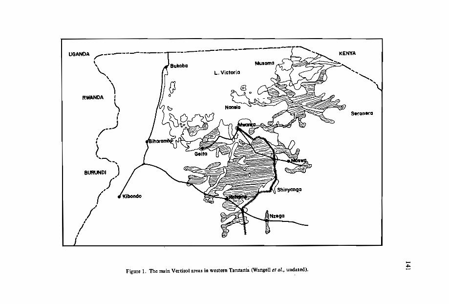
UGANDA ~-----------------,,
'"',
"RWANDA :
\,I
/'--),I
t~' ..
BURUNDI )
j"('
,f",
,I,
Nz.go
KENYA
' ...
.........., ...
S.ron.ro
Figure 1. The main Vertisol areas in western Tanzania (Wangel1 et al., undated).-~-
142
Cambered beds for cotton production
The cambered-bed system was tried as a measure for improving drainage (Spence,1967). These beds were prepared towards the end of the rains when it was not too wetor too dry. It was observed that the cambering of the beds enabled excess surface waterto drain effectively, and the beds could be tilled within a day or two after heavy rains.
A yield of up to 2556 kg/ha of seed cotton was obtained from cotton sown at theend of December 1964 in a season when it was fairly dry (590 mm from December toMay). In the following season, when it was relatively wetter (846 mm from December toMay), the yield was 2778 kg/ha of seed cotton. A yield of up to 4078 kg/ha has been reported from these soils (Le Mare, 1965). It was observed at the end of the two very different seasons that the cambered beds had kept their shape, and no operations were neededfor the third season. It was also found that cotton crops on these soils responded well tosulphate of ammonia, with yield increases of up to 15%. However, response to compost,phosphate, lime and gypsum were minimal or absent, while potassium depressed yields.Superimposing ridges on the beds gave similar yields to cotton sown flat on the beds.
Other crops on Vertisols
A few farmers in western Tanzania grow maize and sorghum on these soils. Some ofthem make ridges as a measure of improving drainage, while others provide simple waterways to remove excess water. However the establishment of plants is always poor andyields are very low. Paddy rice is commonly grown in these soils, and is planted on wellprepared bunded fields where rainwater from the hills collects. Normally this is notsupplemented by irrigation, and in an abnormally dry season a substantial crop loss canbe experienced. The Vertisols of western Tanzania are also well known for the production of chickpeas. These are normally grown at the end of the rainy season, since theycan be established with the small amount of water available at that time.
Conclusion
Given the difficulties which have to be overcome in order to make use of these soilsfor agricultural production, it would appear that the commercial use of Vertisols forlarge-scale production of cotton - and other crops sensitive to poor drainage - is limitedin western Tanzania, at least for the time being. Currently large areas under Vertisols inthe region are used for grazing.
References
ANDERSON, B. 1963. Soils of Tanganyika. Bulletin no. 16, Ministry of Agriculture,Government of Tanzania.

143
LE MARE, P.H. 1967. Progress Reports from Experiment Stations, Season 1965-66:Tanzania Western Cotton Growing Area. London: Cotton Research Corporation.
SPENCE, J.R. 1967. Camber beds for cotton. In: Ukiriguru Research Notes no. 1, Feb.1967.
WENGELL, A.R., BARDEN, R.W. and REINSBOROUGH, J. Undated. ReconnaissanceEcological Soil Survey of Western Tanzania.

CONSERVATION MEASURES IN VERTISOLS UNDER LARGE-SCALE
WHEAT FARMING IN NORTHERN TANZANIA
R. Ngatoluwa, H. Mansoor, B.O. Majanga and I.A. McKeague*
Abstract
Wheat is produced in the highlands of northern Tanzania (latitude 4°20' to 4°35'S; longitude 35°0' to 35°20'£) at elevations of 1650 to 1800 m on seven NAFCO(National Agricultural and Food Corporation) farms with a total area of30000 ha. Vertisols account for approximately half the area of the farms; associated soils are Mollisols,Alfisols and Inceptisols. During the early stage of development of the farms in the '70s,the land was cleared completely and farmed as fields of several hundred hectares. Sheetwash and gullying in Vertisols on slopes as gentle as 1%showed the need for conservationmeasures. On the established farms, strips 5 to 8 m wide and 75 to 150 m apart, depending on slope, were surveyed on the contour, and annual weeds and native grasses wereallowed to become established. Shallow ditches within the contoured grass strips helpedto trap water. On the new farms being developed, contoured strips of the natural grassywoodland were left at 75 to 100 m intervals. Runofffrom fields and adjacent highlandswas directed into natural waterways under native vegetation.
Conservation measures on new farms have been completely effective in preventingerosion. Vertisols on slopes ofup to ~% are being farmed without problems of sheetwashand gullying. The contoured grass strips have been an effective conservation measure onmany fields of the older farms. They enforce cultivation on the contour and provide abarrier to sheetwash. On some slopes, however, especially in areas of shallow Vertisols,runoff from intense storms has washed out recently established grass strips and formedshallow gullies. Other conservation measures are being tested in such fields.
* Tanzania-Canada Wheat Project, Tanzania Agricultural Research Organization, Selian AgriculturalResearch Institute, Arusha, Tanzania.
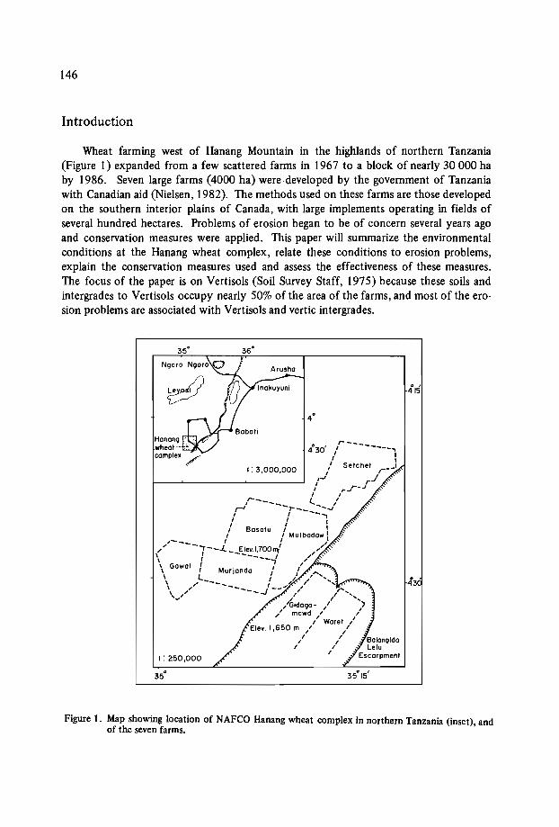
146
Introduction
Wheat farming west of Hanang Mountain in the highlands of northern Tanzania(Figure I) expanded from a few scattered farms in 1967 to a block of nearly 30 000 haby 1986. Seven large farms (4000 ha) were developed by the government of Tanzaniawith Canadian aid (Nielsen, 1982). The methods used on these farms are those developedon the southern interior plains of Canada, with large implements operating in fields ofseveral hundred hectares. Problems of erosion began to be of concern several years agoand conservation measures were applied. This paper will summarize the environmentalconditions at the Hanang wheat complex, relate these conditions to erosion problems,explain the conservation measures used and assess the effectiveness of these measures.The focus of the paper is on Vertisols (Soil Survey Staff, 1975) because these soils andintergrades to Vertisols occupy nearly 50% of the area of the farms, and most of the erosion problems are associated with Vertisols and vertic intergrades.
415
I: 3,000,000
I: 250,000
4°30' ,r- - ..,1 I
1 I" Selchet r:__1
r i J'1 rI ,.-',.. ....../
1 Ir--:-: l,'r' -r--_ --oJ
1 " --.,1 1 I
/ Basolu 1 I1 1 Mulbadaw I
,/-___ I / .:( 7--J.. __E.!.e!.~700"l ,/
" Gawal : --, /\ I Murjondo / /,...\ /l____ / ",,1.,/'"\, ,// -----.J --" I"
v ,/Gidogo- ,I
~' mowd /' /I Woret I
Elev. 1,650 m / /, ,, ,, ,,
Hanangwheatcomplex /
Figure 1. Map showing location of NAFCO Hanang wheat complex in northern Tanzania (inset), andof the seven farms.

147
Environment of the Hanang Farm Area
Location and landform
The Hanang wheat complex is located above and to the west of the main Gregorianrift escarpment in north central Tanzania (latitude 4°20' to 4°35'S, longitude 35°0'to 35°20'E) (Figure 1). Most of the farms are located on the long, gentle incline thatforms the backslope of the rift escarpment (Figure 2). Long (1 to 4 km) gentle slopes,averaging 3%.but ranging from 1 to 8%, account for most of the current and potentialfarmland in the area. Elevations of the farms range from approximately 1650 to 1800m. The farms are approximately 280 km southwest of Arusha, site of the Selian Agricultural Research Institute that provides research support.
---;..~ EAST
MBULU PLATEAU
Explosion craterlMature Qranlllcpeneplain lurface
Minor faulls
InselberQ
ElcarpmentRift Wllley aealanalSaline lake
MauntllananQ,laurce of theWllcanic tulldepalits
• Calcareous tuffIEj Granitic bedrock[[] Fluvial material
....-------------- 38 km------------------l~
Figure 2. Geologic setting of Hanang wheat complex (Fenger et al., in press).
Vegetation and land use
The native vegetation of the Hanang plateau is grasses: Cynodon dactylon, Themedatriandra, and Pennisetum mexianum, with scattered trees: Acacia seyal, A. sonegal, A.garrardii (Chatwin and Chatwin, in press). The area was formerly used as grazing land forcattle and goats by the Barbaig, a pastoral tribe that practices little agriculture. The Barbaig people continue to occupy the area surrounding the farms and uncultivated landwithin the Hanang wheat complex.
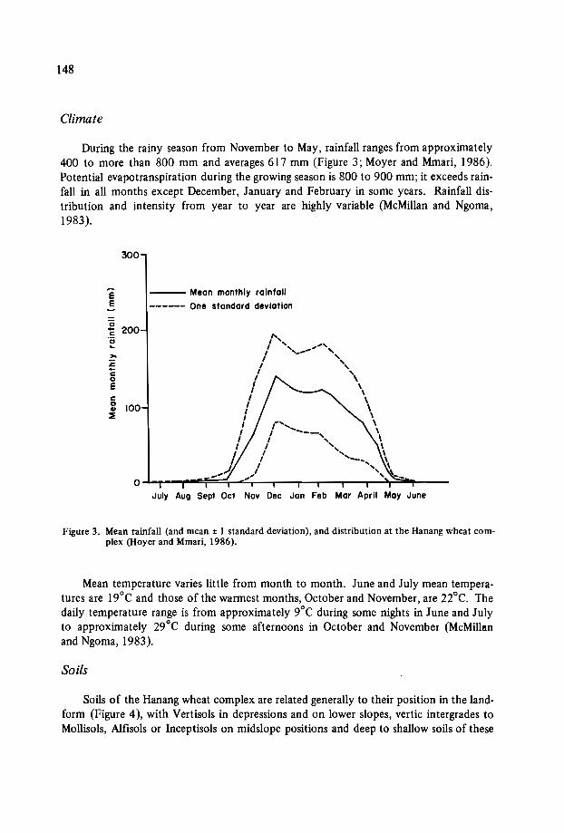
148
Climate
During the rainy season from November to May, rainfall ranges from approximately400 to more than 800 mm and averages 617 mm (Figure 3; Moyer and Mmari, 1986).Potential evapotranspiration during the growing season is 800 to 900 mm; it exceeds rainfall in all months except December, January and February in some years. Rainfall distribution and intensity from year to year are highly variable (McMillan and Ngoma,1983).
300
EE
:2 200c'0..,..s:c0Eca
100..:::E
--- Mean monthly rainfall
------ One standard deviation
,"<,I ---,
I ,
I 'I '
I
.-,/
July Aug Sept Oct Nov Dec Jan Feb Mar April May June
Figure 3. Mean rainfall (and mean ± 1 standard deviation), and distribution at the Hanang wheat complex (Hoyer and Mmari, 1986).
Mean temperature varies little from month to month. June and July mean temperatures are 19°C and those of the warmest months, October and November, are nOc. Thedaily temperature range is from approximately 9°C during some nights in June and Julyto approximately 29°C during some afternoons in October and November (McMilhmand Ngoma, 1983).
Soils
Soils of the Hanang wheat complex are related generally to their position in the landform (Figure 4), with Vertisols in depressions and on lower slopes, vertic intergrades toMollisols, Alfisols or Inceptisols on midslope positions and deep to shallow soils of these
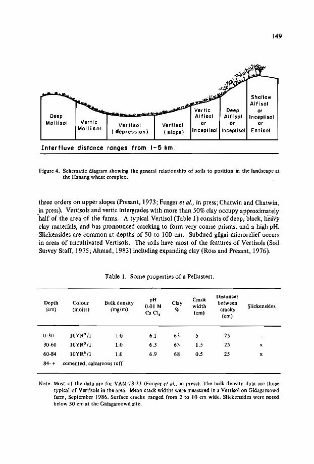
DeepMolli sol Verti c
Moll i solVerti sol
( depression)Verti sol( slope)
DeepAlfisol
or orInceptisol Inceptisol
149
ShallowAlfisol
orInceptisol
orEntisOI
Interfluve distance ranges from 1-5 km.
Figure 4. Schematic diagram showing the general relationship of soils to position in the landscape atthe Hanang wheat complex.
three orders on upper slopes (Presant, 1973; Fenger et al., in press; Chatwin and Chatwin,in press). Vertisols and vertic intergrades with more than 50% clay occupy approximately
-half of the area of the farms. A typical Vertisol (Table 1) consists of deep, black, heavyclay materials, and has pronounced cracking to form very coarse prisms, and a high pH.Slickensides are common at depths of 50 to 100 cm. Subdued gilgai microrelief occursin areas of uncultivated Vertisols. The soils have most of the features of Vertisols (SoilSurvey Staff, 1975; Ahrnad, 1983) including expanding clay (Ross and Presant, 1976).
Table I. Some properties of a Pellustert.
pH CrackDistances
Depth Colour Bulk density0.01 M
Claywidth
betweenSlickensides(cm) (moist) (mg/rn)
Ca Cl, % (cm) cracks(cm)
0-30 lOYR3/1 1.0 6.1 63 5 25
30-60 lOYR3/1 1.0 6.3 63 1.5 25 x
60-84 10YR3/1 1.0 6.9 68 0.5 25 x
84-+ cemented, calcareous tuff
Note: Most of the data are for VAM-78-23 (Fenger et al., in press). The bulk density data are thosetypical of Vertisols in the area. Mean crack widths were measured in a Vertisol on Gidagamowdfarm, September 1986. Surface cracks ranged from 2 to 10 cm wide. Slickensides were notedbelow 50 cm at the Gidagamowd site.

150
Erosion Problems
Sheetwash and severe gullying on cultivated Vertisols on several of the Hanang farmswas recognized as a significant problem in the early years of this decade. The factors contributing to the problem are summarized below.
Natural factors
SlopeThough slopes in the farmed area are relatively gentle (1 to 8%), the slopes are long,
and large volumes of runoff water may move over the lower part of the slope during intense storms.
SoilsVertisols swell markedly on wetting and are almost impermeable when nearly saturat
ed with water (Abmad, 1983). At the onset of the rainy season, water enters the soilreadily through cracks; approximately 120 mm of water may be required just to fill thespace occupied by cracks. By the middle of the· rainy season, however, the soil hasusually swelled sufficiently to close the cracks. Subsequently, only a small proportionof water from intense rainstorms will enter the soils; the rest will run downslope. If theslope is long, small channels will develop into gullies.
RainfallRainfall intensity is highly variable but several downpours have been recorded with
intensities greater than 50 mm/h (McMillan and Ngoma, 1983). If such storms occurwhen the Vertisols are nearly saturated, serious runoff occurs from Vertisols on slopes,and those in depressions are flooded and receive a deposit of sediment.
Gully developmentOnce a small gully forms in a Vertisol, its growth is assured unless countermeasures
are taken. During the dry season, the walls of the gully crack, and soil material falls intothe gully and is washed downslope during the rainy season. The gully becomes progressively wider.
Man-induced factorsThough erosion is a natural process, the activities of man on the Hanang plateau have
accelerated the process in several ways:Pastoral people initiated some gully formation by destroying vegetation on trailsleading to water for their cattle. But this is minor relative to the changes broughtabout by large-scale wheat farming.In the first 10 years of development at the Hanang wheat complex, the naturalvegetation was removed completely from fields of several hundred hectares. Noeffort was made to till on the contour. Frequently the access roads ran up and downslopes, thus initiating gullies.
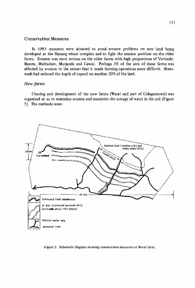
151
Conservation Measures
In 1983 measures were initiated to avoid erosion problems on new land beingdeveloped at the Hanang wheat complex and to fight the erosion problem on the olderfarms. Erosion was most serious on the older farms with high proportions of Vertisols:Basotu, Mulbadow, Murjanda and Gawal. Perhaps 5% of the area of these farms wasaffected by erosion to the extent that it made farming operations more difficult. Sheetwash had reduced the depth of topsoil on another 20% of the land.
New farms
Clearing and development of the new farms (Waret and part of Gidagamowd) wasorganized so as to minimize erosion and maximize the storage of water in the soil (Figure5). The methods were:
-:''''"--," \/ \
I \
/ \I \
\\\\
>//
//
//
//
/
---
seosonal river
Natural water way
~-='~Forms18Od :::. ' ,',' ••,.,,'=::::::::
I.~ Contoured field occessrood
5-Bm Contoured grossed stripCultiyoble .trip (75-IOOm)
:----------/ ---------I//
/
T/260m/
11///\\\I,,,\~---........_--.;....~ .....
Figure 5. Schematic diagram showing conservation measures on Waret farm.

152
The land was surveyed and strips of natural vegetation 5 m wide were marked oncontours at intervals of 75 to 100 m. These strips were left intact during clearing,thus forcing cultivation on the contour..Roads were designed, when possible, along contours.Shallow soils and slopes greater than 5% were not cleared.Natural waterways were left intact.Diversion channels were constructed to guide water from hilly .uncultivated areasto natural waterways.
Older farms
Conservation work began with a general survey to assess relationships between erosion and slope, soil and farm management, and to decide on procedures. Severalconser-.vation measures were tried:
Contoured grass strips were planted on gently sloping areas. Strips 5 to 8 m apartwere surveyed on the contour, and native grasses were allowed to become established.Absorption channel terraces (shallow, wide ditches) were installed on the contour75 to 125 m apart on slopes of more than 3%. The purpose of the ditch is to intercept and store runoff.Graded channel terraces. These are similar to absorption channels except that theyhave a gentle slope (0.3%) to conduct water to a waterway. They are used on steeperslopes in areas of shallow soils where runoff is appreciable.Installation of these conservation measures should be completed on the older farms
in 1987. The next step will be to work on reclaiming the small areas of gullies.
Assessment of Conservation Measures
The conservation measures described for the farms have been effective to date. Noerosion problems were noted on Waret in 1985-86 in spite of the higher-than-average rainfall and some storms of high intensity. The strips of natural vegetation were effective inabsorbing any runoff water.
On the older farms, the enforced cultivation on the contour and the grass strips havebeen effective in most cases. Problems have occurred on some shallow, sloping Vertisols.In some cases, absorption channels have overflowed and shallow gullies have developeddownslope. Some of these problems are due partly to the need to space contoured stripsfar enough apart to accommodate large machinery between the strips. Graded channelterraces appear to be effective if grass becomes established prior to the occurrence ofintensive storms.
Perhaps the most convincing evidence of the effectiveness of the conservation measures applied is the fact that the farm managers are requesting aid for establishing conservation measures on their farms. Their recognition of the need for farming on the contour

153
and of interrupting cultivated slopes with strips of natural vegetation or grass on the contour implies benefits that exceed the costs of installation, the loss of land (approximately7% of the area), and the inconvenience of having to farm relatively narrow strips onsloping terrain. Indeed, preliminary results indicate that the yield of wheat from a givenarea under conservation farming exceeds that of an area of the same size under clear cultivation. The greatest benefits, however, are avoidance of gullying and reduction of sheetwash.
Conclusion
The conservation measures described have been particularly effective on the newestfarm, Waret. The layout of the farm was designed with conservation in mind. The contoured strips of natural vegetation, natural waterways left intact, and roads following contours have been highly effective in avoiding serious erosion problems. This implies thatthe remaining 70 000 ha of potential wheatland in the area (Chatwin and Chatwin, inpress) could be developed for large-scalewheat farming without incurring serious erosion.
Conservation measures applied to the older farms after the development of erosionproblems have been successful in many areas. Some problems remain,however, in areasof shallow, sloping Vertisols. Establishment of grass on absorption channels, and gradedchannels prior to the onset of runoff is essential. In addition the problem of filling andpreventing the spread of gullies remains. Clearly, the most effective conservation resultsfrom planning farm development with conservation as a priority. With such planning,large-scale wheat farming without incurring serious erosion problems is feasible on theHanang plateau of northern Tanzania.
References
AHMAD, N. 1983. Vertisols. Pages 91-123 in: Pedogenesis and Soil Taxonomy: 11. TheSoil Orders, eds. L.P. Wilding, N.E. Smeck and G.F. Hall, Developments in SoilScience llB. Amsterdam, Oxford, New York, Tokyo: Elsevier.
CHATWIN, S. and CHATWIN, T. In press. Land Resources of Parts of Hanang, Mbulu,Singida, and Iramba Districts, Tanzania: A Reconnaissance Assessment of Landforms, Soils, Vegetation, and Climate. Department of Supply and Services. Government of Canada, Hull, Canada.
FENGER, M., HIGNETT, V. and GREEN, A.I. In press. Soils of the Basotu and Balangida-Lelu Map Areas, Northern Tanzania. Department of Supply and Services,Govern-ment of Canada, Hull, Canada. _
-McMILLAN, R.A. and NGOMA, A. 1983. Vertisolic soils of the Hanang wheat complex,Tanzania: Characteristics, distribution, use and management. Paper presented at 5thmeeting of the Eastern Africa Soil Correlation Committee, Wad Medani, Sudan.
MOYER, I.R. and MMARI, E.A.V. 1986. Optimum Time for Planting Wheat at TwoLocations in Tanzania in Relation to Rainfall, Weed Growth and Yield. Arusha,Tanzania: TARO.
-l
'''t\

154
NIELSEN, J.G. 1982. History of the Tanzania-Canada Wheat Program 1967-1982. Report to the Department of Supply and Services, Government of Canada, Ottawa,Canada.
PRESANT, E.W. 1973. Report on the soils of the Basotu Wheat Farm, Tanzania Agronomic Research Project (Wheat). Ottawa, Canada: Canadian International Development Agency.
ROSS, G:J. and PRESANT, E.W. 1973. Physical, chemical and mineralogical propertiesof selected soils of Tanzania with reference to their genesis and behaviour. EastAfrican Agricultural and Forestry Journal 41: 20 1-217.
SOIL SURVEY STAFF. 1975. Soil Taxonomy. U.S. Department of Agriculture, Handbook no. 436, Washington, D.C.: U.S. Government Printing Office.

Fourth session: Management systems
Chairmen: Dr. J. R.F. Hansell
Dr.Q.T. Mandiringana

~~I
MANAGEMENT OF VERTISOLS FOR IMPROVED CROP PRODUCTION
IN THE SEMI-ARID TOPICS:
A PLAN FOR A TECHNOLOGY TRANSFER NETWORK IN AFRICA
J.S. Kanwar and S.M. Vinnani*
Abstract
In the Vertisols ofsemi-aridIndia (Usterts), feR/SAT has shown that by the application of efficient land, water and crop management techniques, crop yields of the orderof over 3 tons per ha can be harvested successfully where traditional methods only yield500-700 kg per ha. Some of the components of this technology can be progressivelyapplied to the African Vertisols and vertic soils. Verification trialsand additional experiments may be required to adapt the available improved technologies in Vertisols to thesemi-arid tropical regions ofAfrica.
This paper also outlines the background leading to the proposal for the establishmentof a Vertisol management network for increasetf,rop production. A suggested list ofac~vities fo.r.collaborative research an~ the ins.tir;: tions tha~ are comparatively strong invanous activity areas has been compiled. -Flnlly some Items towards an agenda fordeveloping a workshop network proposal are identified.
The Semi-Arid Tropics
Semi-arid cltmates! cover much of the tropical areas of the African continent stretching in a broad band from west to east in the sub-Saharan region, and including much ofeastern and south-central Africa. In Asia they cover much of India and parts of Burma
* International Crops Research Institute for the Semi-Arid Tropics (ICRISAT), Patancheru P.O.,Andhra Pradesh 502 324, India.
1 Following Troll's classification, the semi-arid tropics have been defined as areas where monthly rainfall exceeds potential evapotranspiration for 2-7 months. In these areas the mean monthly temperature is above 18°C.
"1'
158
and Thailand. The northern territories of Australia, several countries in southern Africa, .including Mexico, Venezuela, Brazil, Paraguay, and Bolivia lie within this region.
The tropical regions are characterized by high evapotranspirational demand. Temperatures are fairly high for most of the year, usually exceeding a mean of 18°C in allmonths. The semi-arid areas have a short rainy season. Most of the rainfall is receivedwithin 2 to 5 months - from June to October in the northern hemisphere and fromOctober to April in the southern hemisphere.
Of the different climatic elements which are important for crop production in thesemi-arid tropics (SAT), rainfall is the most variable. The total annual rainfall varies considerably, ranging from 400 to 2000 mm. The coefficient of variation of annual rainfallis 20-30%. In most years the rainy season in the SAT is long enough for annual crops togrow. Indeed, there is often excess water in the rainy season, a part of which can bestored in the soil, but most of it runs off and causes soil erosion. In the SAT, the management of land, crops, and livestock is intimately associated with the water resource availability.
Distribution and Properties of Vertisols
Vertisols occur in many climates. There are approximately 310 million ha of thesesoils in Asia (mostly in India), in America (mostly in the United States of America, Venezuela, and Argentina), in Australia, and in the continent of Africa.
Vertisols occur extensively in several countries in Africa under arid, semi-arid, andhumid climates, and have an agroecological potential for food production well above theirpresent level of use. According to Swindale (1982), there are approximately 104 millionha of Vertisols and vertic soils in Burkina Faso, Niger, Nigeria, Chad, Sudan, Ethiopia,Somalia, Kenya, Burundi, Malawi, Zambia, Zimbabwe, and Botswana (Figure 1). Somesmall areas occur in other countries of Africa, and altogether about 30% of the world'sVertisols are located in Africa.
Vertisols are a highly productive group of soils. They contain at least 30% clay, andthe dominant clay mineral is usually one of the smectite group. These soils are generally60 cm deep or more. Vertisols are therefore able to retain considerable amounts ofavailable water in the soil profile. Due to the nature of the dominant clay mineral, theyexhibit shrinking and swelling properties, and are highly erodable. Their physical properties make them difficult to handle. For example, they are heavy soils and are difficultto cultivate; further, some exhibit a 'gilgai' formation, and therefore the preparation ofthe seedbed on these soils presents many difficulties. Due to their low terminal waterintake rates, they easily get waterlogged during the rainy season.
In Africa, three suborders of Vertisols (as defined in Soil Taxonomy) are found:Torrerts: Vertisols of deserts or very low rainfall areas of the arid tropics, generallyhaving less than 2 humid months annually.Usterts: Vertisols in summer-rainfall areas of the SAT, generally having 2-7 humidmonths annually.
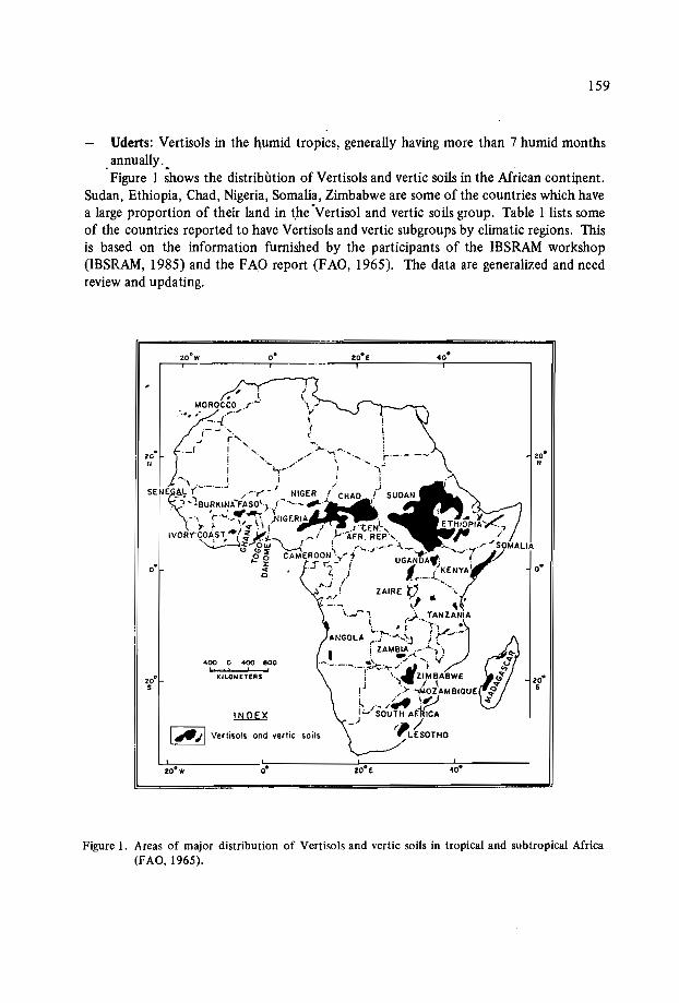
159
Uderts: Vertisols in the humid tropics, generally having more than 7 humid monthsannually .
.Figure I ;hows the distribution of Vertisols and vertic soils in the African continent.Sudan, Ethiopia, Chad, Nigeria, Somalia, Zimbabwe are some of the countries which havea large proportion of their land in the "vertisol and vertic soils group. Table I lists someof the countries reported to have Vertisols and vertic subgroups by climatic regions. Thisis based on the information furnished by the participants of the IBSRAM workshop(IBSRAM, 1985) and the FAO report (FAO, 1965). The data are generalized and needreview and updating.
c;...I1 Verlisols ond ver tic soils
o·
20·S
lOOW o·
"00 0 400 800I.-.l< '
KILOWETEAS
o· 40·
20·N
20·S
Figure 1. Areas of major distribution of Vertisols and vertic soils in tropical and subtropical Africa(FAO, 1965).

160
Table 1. A tentative list.of co~ntries in Africa with"Vertisolsand vertic soil groups by climatic zones*
Humid and subhumid
CameroonEthiopiaSudanZaireMozambique
"AngolaUgandaDahomeyTogoShanaIvory Coast
Semi-arid
BotswanaBurkina FasoBurundiChadEthiopiaKenyaMalawiNigerNigeriaSudanSouth AfricaZambiaZimbabweSenegalTanzaniaUgandaGhana
Arid
ChadSomaliaSudan
*Source: FAO (1965) and IBSRAM (1985).
Current Management of Vertisols in Semi-Arid Africa
Since Vertisols and vertic soils occur in diverse agroecological environments in Africa, they are used for a variety of purposes. The Torrerts, Vertisols of the arid areas, aregenerally under natural grassland and associated vegetation and are used for extensiveagriculture, mainly cattle raising. Where irrigated, these soils are highly productive, andare used to growa variety of tropical crops. The management of irrigated Vertisols posesmany problems: they become waterlogged, and soil salinity can also develop if watermanagement is inefficient. In Sudan, Torric Vertisols are used mainly for growing cotton.In the semi-arid areas of Africa which have a ustic moisture regime, Vertisols and verticsoils are sometimes used for raising crops like sorghum, millet and maize in the uplands,and rice, teff, etc. in the lowlands. In some areas of southern Africa, wheat is also grownin these soils. However, in most instances the intensity of cultivation is very low. Theircommon current land use is pasture-livestock production systems. The lowland Vertisolsof the humid tropics have a udic moisture regime. Generally these are not cultivated, butin some cases they are used for growing rice and teff.
To summarize, the current land use of Vertisols and vertic soils in Africa is limitedto livestock farming, grazing, and related animal farming activities. These soils are not extensively used for raising food crops, and they primarily sustain subsistence-level animal

·t"'1 1
161
production systems. Whe.re crop production activity is prevalent, the per ha yield ofcrops is quite low. On an average, in rainfed agriculture grain yields of 250-500 kg/haof most crops are commonly reported. The components of improved agriculture do notseem to have touched the Vertisol areas of Africa.
We have calculated the length of the crop-growing season for a few locations of Vertisols in Africa to illustrate their agroecological potential, and have also included datafrom the ICRISAT Center in Hyderabad (India) for comparison. The data (Table 2) showthat except for the Torric Vertisols, the Usterts exhibit a crop-growing season with alength of 130-240 days. The thermal environment of the locations studied is also suitablefor growing tropical and subtropical crops. We believe that through the application ofappropriate land and water management and crop production technologies, the Vertisolsand vertic soils of Africa can be efficiently harnessed for increased crop production.Based on the experience gained at ICRISAT, the agricultural production on these soilscan be significantly increased. Under soil and climatic conditions which are somewhatsimilar to those found in Africa, ICRISAT has shown that through the scientific management of Vertisols and vertic soils in a semi-arid environment, a sustained and high cropproduction can be achieved in dryland farming conditions.
IBSRAM's Proposal for Launching a Vertisol Soil Management Network
In February 1985, IBSRAM - the International Board for Soil Research and Management, in cooperation with several other institutions, organized a workshop on theManagement of Vertisols for Improved Agricultural Production at the ICRISAT Centerin India. At this meeting it reviewed the important principles of improved Vertisolmanagement technology and its application for increasing production under diversefarming systems. The workshop discussed research priorities for the. improved management of Vertisols for sustained agricultural production. In the dryland semi-arid areas,it noted that soil-related problerps associated with improved Vertisol management are:surface drainage during the r~eason, lack of water in the dry season, and inadequateplant nutrients. In the irrigated use of Vertisols important research priority areas werealso identified. Some of these are: drainage, salinization, irrigation scheduling, cropsand cropping systems, soil and water management, weed control, soil testing for availablenutrients, and standardization of methods for evaluating nutrient deficiencies.
The IBSRAM workshop (IBSRAM, 1985) also discussed the verification, testing, andvalidation of improved technologies developed by different institutions. It was considered essential to select components suitable for local needs, and it was suggested that aVertisol soilmanagement network should be organized without delay. A set of principlesfor a successful Vertisols network were listed.o Establish a common objective and then set priorities.o Allocate resources by the national research programmes for the network.o Identify the comparative advantages and leadership capabilities of the various re
.searchorganizations with improved technologies.
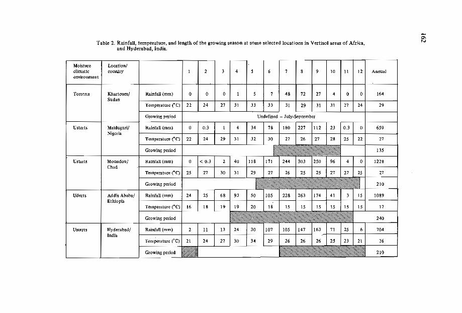
-0\Table 2. Rainfall, temperature, and length of the growing season at some selected locations in Vertisol areas of Africa, N
and Hyderabad, India.
Moisture Location/climatic country 1 2 3 4 5 6 7 8 9 10 11 12 Annualenvironment
Torrerts Khartoum/ Rainfall (mm) 0 0 0 1 5 7 48 72 27 4 0 0 164Sudan
Temperature ("C) I 22 1 24 1 27 1 31 1 33 I 33 I 31 1 29 1 31 I 31 I 27 1 24 I 29--Growing period
Usterts 1 Maiduguri/ Rainfall (mm) 180 1227 1112 I 23 10.3~59Nigeria
Temperature ("C) 22 22 27
Growing period 135
Ustarts Moundou/ Rainfall (mm) 0 0 1228Chad
Temperature (QC) 25
Growing period
Uderts I Addis Ababa/ Rainfall (mm) 24 25 1 68 I 93 1 50 1105 I 228 1263 1174 I 41 1 3 1 15 I 1089Ethiopia
Temperature ("C) I 16 1 18 1 19 1 19 1 20 I 18 1 15 I 15 I 15 I 15 I 15 I 15 I 17--Growin~~ 240
Usterts 1 Hyderabad/I
Rainfall (mm) 2 11 13 1 24 I 30 1107 I 105 1147 1163 I 71 I 25 I 6 I 704India
Temperature ("C)
Growing period
163
o Supply coordination and logistics.o Look at the levels of interaction required.o Link national cells (units) with other agencies.o Establish principles for the selection of areas of activity.
Management of Vertisols in the SAT: ICRISAT's Work in India*
In the Indian subcontinent, about 70 million ha of Vertisols and vertic soils occur,mostly in the ustic moisture regime in peninsular India. In this region the farmers aresmall landholders who operate 2-4 ha farms and own a pair of oxen for draught. Thesesmall farmers of limited means are generally not able to cultivate their farms in time forthe planting of rainy-season crops. Their land is often exposed to short-term waterlogging. Most farmers can raise only one crop a year on these soils, even in relatively assuredrainfall areas.
ICRISAT has now assembled a technology for improved management of Vertisolssuitable for the SAT. It facilitates growing two crops, one in the rainy season andanother in the postrainy season. Adoption of this improved Vertisols management technology has resulted in considerable increases in crop production. Where a farmer harvested about half a ton of sorghum or chickpea by using his traditional system, a totalyield or"some three tons of grain per ha has been consistently harvested through a twocrop combination under the improved Vertisols management system at ICRISAT duringthe past nine years of experimentation (Table 3). Further, in the vertic soils severalintercrop combinations, e.g. sorghum-pigeonpea or millet-pigeonpea, have producedyields of 2-3 tons/ha under medium-fertility treatment (60-12-0), as shown in Table 4.The introduction of the new system has also resulted in (i) a considerable reduction insoil erosion; (H) a much higher in-situ moisture conservation, and therefore in higherrainfall-use efficiency (Table 5); and (Hi) much more dependable harvests year after year(Table 3).
The improved Vertisols management technology
The technology for improved management of Vertisols is a framework. It consistsof several interrelated components, each of which consists of several options. The components of the improved technology are:
Landand water managementImproved land and water management practices are applied for alleviating the con
straints, such as waterlogging, which arise due to the physical properties of Vertisols.
* A detailed explanation of the technology may be found in Kanwar et al. (1982) and Virmani et al.(in press). Ryan et al. (1982) have given details on the economic aspects of the improved Vertisolsmanagement technology and indicated some constraints to its adoption in the Indian semi-aridtropics.

164
Table 3. Grain yields under improved and traditional technologies on deep Vertisols*at ICRISAT Center in 9 successive years. .
Grain yield (kg ha?)
Cropping period Improved system: double cropping Traditional system:Year rainfall (mm) single crop
Sorghum/ Sequential chickpea/maize and intercropped pigeonpea Sorghum or chickpea
1976/77 708 3204 717 436 5431977/78 616 3076 1223 377 8651978/79 1089 2145 1256 555 5321979/80 715 2295 1195 500 4501980/81 751 3587 920 596 5631981/82 1073 3194 1047 635 10461982/83 667 3269 1095 630 12351983/84 1045 3051 1766 838 4771984/85 546 3355 1014 687 1232
Mean 801 3020 1137 587 771SD 209 482 289 138 327CV (%) 26 16 25 24 42
Average rainfall for Hyderabad (29 km away from ICRISAT Center) based on 1901-84data is 784 mmwith a CV of 27%.
*Available water-holding capacity of 180 cm deep soil profile is 240 mm.
Table 4. Grain yields of some cropping systems grown on vertic soils* under low (0-0-0)and medium (60-12-0) fertility at ICRISAT Center in operational-scale experiments. **'
Grain yield (kg ha~1 )Cropping period Soil Sole
Year rainfall (mm) fertility pigeonpea Sorghum/ Millet/ Groundnut/ Solepigeonpea pigeonpea pigeonpea sorghum
1981/82 1073 Low 700 937 1201 1387 516Medium 868 2175 3581 1423 3234
1982/83 667 Low 1041 2219 2190 2214 1170Medium 1217 4291 3178 2917 2869
* Available water-holding capacity of 50 cm soil profile is 80 mm.** Source: ICRISAT (1983,1984).

, ~ \
165
Table 5. Annual water balance and soil loss (tjha) for traditional and improved technologies in Vertisol watersheds, ICRISAT Center, 1976/77 to 1983/84.
Water-balance component
Farming systems technology
Annualrainfall(mm)
Water usedby crops
(mm)
Water lostas surface
runoff(mm)
Water lostas bare-soil
evaporation anddeep percolation
(mm)
Soilloss
(t/ha)
Improved system:double-cropped on broadbed
and furrows 904 602(67)* 130(14) 172(19) 1.5
Traditional system:single crop in postrainy
season, and cultivation onflat 904 271(30) 227(25) 406(45) 6.4
*Figures in parentheses are amounts of water used or lost expressed as percentage of total rainfall.
Vertisols have very poor internal drainage when they are wet. Under the improvedsystem of management, microwatersheds of 3-15 ha size were taken as U~its for land and• 11
water management and agronomic practices. Surface drainage is impr~)-ed through theprovision of surface drains and land smoothing. The in-situ water consi~ation improvements are brought about by laying out the bed-furrow (ridge-furrow) cultivation systemsalong the contour. Since the surface runoff water is discharged in a controlled manner,the loss of soil is considerably reduced and water-use efficiency is increased considerably(Table 4). At the ICRISAT Center, the main features of this system are that a slope of0.4 to 0.6% graded broadbeds and furrows (50 cm apart) are made which lead intograssed waterways and finally lead to a dug tank or a drain (Figure 2). By following thissystem the soil moisture storage is increased and the drainage of excess water is facilitated.
Primary tillage to prepare a rough seedbed is best carried out soon after the harvestof the postrainy-seaon or rainy-season crops. Land should be harrowed whenever 20-25mm of rain is received over a period of one-two days. When blade-harrowing is done,the clods easily shatter and a satisfactory seedbed is attained.
Dry sowing ahead ofonset ofrainy seasonSince the preparation of the seedbed and the sowing of crops present serious pro
blems in Vertisols, we find that the planting of crops in dry soils ahead of the commencement of rains ensures their establishment early, and avoids the difficulty of planting in
. .

166
Figure 2. Some important layout features of a small agricultural watershed on a Vertisol at theICRISAT Center.
a set, sticky soil. We have noted that dry seeding is successful where the early seasonrainfall is fairly dependable and seeds are placed at a depth of 7-10 cm. At the ICRISATCenter, good stands were established by dry seeding of crops such as mung, sunflower,maize, sorghum, and pigeonpea (Figure 3).
intercropping of long-duration crops (e.g. pigeonpea) with short-duration crops (e.g.maizeor sorghum or soybean).sequential cropping of crops (e.g. sorghum or maize followed by chickpea or saf
.flower).*
Improved cropping systemsThe introduction and adoption of improved cropping systems provide a continuum
of crop growth from the commencement of the rainy season until most of the availablemoisture is utilized by the crop. At ICRISAT we have found that this can be achievedby :
*

167
Figure 3. A two-week-old stand of dry-sown maize intercropped with pigeonpea combination testedon a Vertisol watershed at the ICRISAT Center.
Fertility managementIn the tropics the management of soil fertility is very important for realizing the
full potential of improved cropping systems. At the lCRISAT Center we have found thatthe management of soil and fertilizer nitrogen is necessary in Vertisols . We have alsoobserved that the application of phosphates and zinc is also required. Our studies haveshown that the inclusion of legumes in the crop rotations or in intercrop systems hassubstantially reduced the fertilizer nitrogen needs (by about 40 kg N ha) of the subsequent cereal crops .
Efficient farm machineryFor a successful implementation of the improved Vertisols management system, we
have observed that it is necessary to carry out all the operations thoroughly and in goodtime. Since animal draught is the main source of energy available to small farm operatorsof semi-arid areas in Asia and Africa, much of ICRISAT's work is related to animaldrawn equipment. We have found that the use of a wheeled tool carrier (e.g. Tropicultoror Nikart) is a most efficient technique for managing Vertisols in India.
Appropriate crop managementIn order to realize the full potential of improved land and water management and
cropping systems, it is essential that an appropriate set of crop management practices be
168
adopted. Weed control, integrated pest management, the placement of fertilizers at anappropriate depth and their application at critical stages of crop growth are some of thecrop management factors which could lead to the realization of high and sustainedyields on Vertisols.
Since most SAT soils are deficient in nutrients like N, P, and Zn, we get goodresponses to applied fertilizers. The application of fertilizers in the right doses and at theright time, and, the adoption of appropriate methods in their application, is the way toobtain good results from fertilizer application in Vertisols (Kanwar and Rego, 1983).
One important aspect of the improved Vertisol technology is the synergistic effectof various components when applied together, as compared with their individual effect:This point has been brought out convincingly after ten years of watershed-based experimental results from ICRISAT (Table 3). Kanwar and Rego (1983) and Kanwar et of."(1984) noted during the steps taken to improve Vertisols technology conducted atICRISAT that though the contribution of fertilizers was highest, the response to fertilizers was most highly marked when they were applied in combination with improved landand water management treatments and the adoption of improved agronomic practices.This observation has great relevance in the African continent. Here fertilizers are costlyand in most instances have to be imported. All efforts therefore must be made to realizemaximum fertilizer-use efficiency by applying the principles of improved Vertisol technology.
Suggested Agenda for a Vertisol Management Network in Africa
Purpose
We believe that in the African context the main purpose of a Vertisols managementnetwork is to tackle successfully issues related to increased agricultural productivity,sustainability, and the introduction of appropriate technologies in the Vertisol and verticsoil areas. We further believe that such research should receive priority because of thevast underutilized potential of Vertisols for crop production. As a first step, we suggestthat improved technologies that are already available should be screened and tested bothin Usterts and Uderts. Issues concerning the improvement of productivity of irrigatedVertisols should receive priority where soil-related problems are major constraints to increased crop yield.
Main problems to be solved
In terms of the adoption and testing of new technologies, the major problems to betackled are likely to be in the following three areas: soil management, cropping systems,and land and water management. A partial listing of some 'researcheable issues is givenin Table 6.
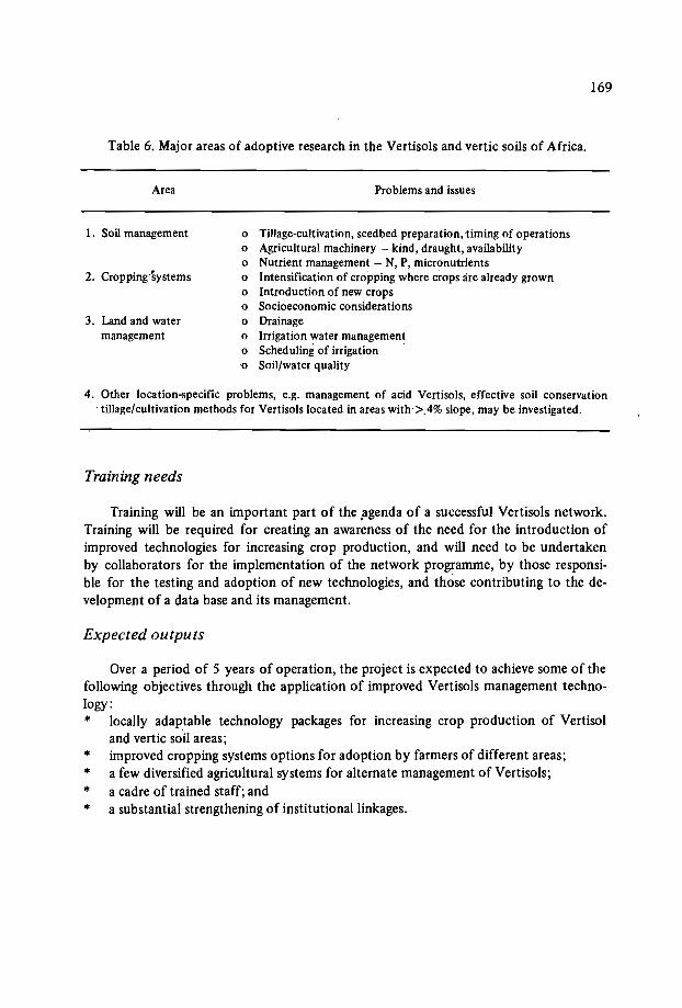
169
Table 6. Major areas of adoptive research in the Vertisols and vertic soils of Africa.
Area
1. Soil management
2. Cropping Systems
3. Land and watermanagement
Problems and issues
o Tillage-cultivation, seedbed preparation, timing of operationso Agricultural machinery - kind, draught, availabilityo Nutrient management - N, P, micronutrientso Intensification of cropping where crops lire already growno Introduction of new cropso Socioeconomic considerationso Drainageo Irrigation water managemento Scheduling of irrigation .o Soil/water quality
4. Other location-specific problems, e.g. management of acid Vertisols, effective soil conservation. tillage/cultivation methods for Vertisols located in areas with'>.4% slope, may be investigated.
Training needs
Training will be an important part of the .agenda of a successful Vertisols network.Training will be required for creating an awareness of the need for the introduction ofimproved technologies for increasing crop production, and will need to be undertakenby collaborators for the implementation of the network programme, by those responsible for the testing and adoption of new technologies, and those contributing to the development of a data base and its management.
Expected outputs
Over a period of 5 years of operation, the project is expected to achieve some of thefollowing objectives through the application of improved Vertisols management technology:* locally adaptable technology packages for increasing crop production of Vertisol
and vertic soil areas;* improved cropping systems options for adoption by farmers of different areas;* a few diversified agricultural systems for alternate management of Vertisols;* a cadre of trained staff; and* a substantial strengthening of institutional linkages.

170
Collaborating institutions
A suggested list of institutions where there are opportunities for training and collaborative research, and where research results are available for evaluation with a view toadoption in the Vertisols and vertic areas of Africa, is given in Table 7. We propose thatIBSRAM provide the necessary backup support for coordination of the network activities, and for organizing financial support.
Table 7. A suggested list of institutions for developing collaborative activities of the network.
Soil suborder
Torrerts Usterts Uderts
o Soil characterization National Res. - SMSS - IRAT/Gerdat
o Agroclimatic evaluation
o Cropping systems
o Land and water management
o Crop management
o Soil management
o Tillage equipment andrelated research
ICRISATAgrhyrnet
National Res.
National Res.
To be identified
US Soil SalinityLab. SMSS
ICRISATAgrhyrnet
ICRISAT
ICRISAT
ICRISAT
ICRISAT
ICRISAT
IRRI for rice-basedsystems, ICRISAT forpostrice cropping
IRRI/ICRISAT/IITA
IRRI/ICRISAT + otherinstitutions
IRRI
Animal-drawn equipment ICRISAT/IRAT/NIAE/National Res.
Powered machines
o Fertility/nutrient
NIAETillage Lab.Netherlands
National Res.IFDCIRAT
NIAETillage Lab.NetherlandsICRISAT
ICRISAT IFDCIRAT
National Res.
IRRITillage Lab.NetherlandsNIAE
IRRIUTAIFDCIRATNational Res.:=J
171
Issues Needing Immediate Attention for Formulating Network Plans
1. A complete inventory of soils (at the suborder level) and of climate (rainfall, evaporation, temperature, radiation) is necessary to characterize the agroecological potentialof the Vertisols and vertic soils in the region concerned. These base data would berequired both for the design of improved technologies and for their transfer.
2. Assembly of information on improved land-use and cropping systems suitable forVertisols and vertic soils of the semi-arid humid-subhumid tropics of Africa.
3. Assessment of research needs, identification of locations where research could becarried out, and promotion of cooperation for interchange of information.
4. Exchange of germ plasm of improved cultivars amongst institutions for testing newcropping systems.
5. Identification of locations for training staff.6. Establishment of a Vertisols soil management unit (SMU).7. Location of an SMU network coordinator.
Conclusion
The Vertisols of Africa, which are situated mostly in ustic (Usterts) moisture regimes,have fairly long growing seasons, and consequently can be used to harvest successfullyone or two crops per year. On such soils improved dryland agricultural practices for increased crop production could be adopted. For bringing about improvements in agriculture in Vertisols in the ustic moisture regimes, the major soil problems to be overcome arerelated to tillage, land preparation, water management, and the identification of suitablecropping systems. In the case of Uderts, issues related to drainage, preparation of landfor planting of postrainy-season crops, and soil fertility management are the priorityareas for research. In the Vertisols of the highland regions, some of the important agendaof adoptive research would be to fit crops into the available growing season, and to determine the management, water control, fertilizer application, and land preparation whichthey require. Some of the priority areas of research for a Vertisols and vertic soils management network for Africa would be the characterization of soil, and the study ofclimatic and biotic constraints to increased crop production.
References
DUDAL, R. In press. Vertisols of sub-humid and humid zones. In: Proceedings of theInaugural Workshop on Management of Vertisols for Improved Agricultural Production, 18-22 February 1985, ICRISAT Center, India. Patancheru, A.P. 502 324,India: ICRISAT.
FAO (Food and Agriculture Organization of the United Nations). 1965. Dark clay soilsof tropical and sub-tropical regions. FA 0 Agricultural Development Paper no. 83, ed.R. Dudal. Food and Agriculture Organization of the United Nations, Rome, Italy:FAO.16Ip.
172
ICRISAT (International Crops Research Institute for the Semi-Arid Tropics). 1983.Farming Systems. Annual Report. Patancheru, A.P. 502 324, India: ICRISAT. pp.231-205.
ICRISAT (International Crops Research Institute for the Semi-Arid Tropics). 1984.Farming Systems. Annual Report. Patancheru, A.P. 502 324, India: ICRISAT. pp.249-315.
IBSRAM (International Board for Soil Research and Management). 1985. Report of theInaugural Workshop on Management of Vertisols for Improved Agricultural Production, 18-22 February 1985, ICRISAT Center, India. ICRISAT Publication No. ICR85-0015, Patancheru, A.P. 502324, India: ICRISAT.
KANWAR, J.S., KAMPEN, J. and VIRMANI, S.M. 1982. Management of Vertisols formaximizing crop production - ICRISAT experience. Pages 94-118 in: SymposiumPapers I/. Transactions of 12th International Congress of Soil Science, 8-16 February1982, New Delhi, India. India Society of Soil Science, New Delhi, India.
KANWAR, J.S. and REGO, T.J. 1983. Fertilizer use and watershed management inrainfed areas for increasing crop production. Fertilizer News 28:33-43.
KANWAR, J.S., REGO, T.J. and SEETHARAMA, N. 1984. Fertilizer and water-use efficiency in pearl millet and sorghum in Vertisols and Alfisols of semi-arid India. Fertilizer News 29:42-52.
RYAN, J.G., VIRMANI, S.M. and SWINDALE, L.D. 1982. Potential technologies fordeep black soils in relatively depenable rainfall regions of India. Pages 41-61 in:Proceedings of Indian Bank Seminar on Innovative Technologies for Integrated RuralDevelopment, 15-16 April 1982, New Delhi, India.
SWINDALE, L.D. 1982. Distribution and use of arable soils in the semi-arid tropics.Pages 67-100 in: Managing Soil Resources: Plenary session papers. Transactions of12th International Congress of Soil Science, 8-16 February 1982, New Delhi, India.Indian Society of Soil Science, New Delhi, India.
VIR MANI, S.M.. RAO, M.R. and SRIVASTAVA, K.L. In press. Approaches to management of Vertisols in the semi-arid tropics: the ICRISAT experience. In: Proceedingsof the Inaugural Workshop on Management of Vertisols for Improved AgriculturalProduction, 18-22 February 1985, ICRISAT Center, India. Patancheru, A.P. 502324, India: ICRISAT.

IMPROVED AGRICULTURAL UTILIZATION OF VERTlSOLSIN THEETHIOPIAN HIGHLANDS -
AN INTERINSTlTUTlONAL APPROACH
S. Jutzi! and M. Abebe''
Abstract
Vertisols cover 7.6 million ha of the Ethiopian highlands. One quarter of these soilsis presently cropped, an acreage which in turn accounts for 24% of all highland soilscropped in Ethiopia. Vertisols account for about 70% of all highland soils with slopesbetween 0% and 8%. The high clay content (60-70%) of these Vertisols is responsible fortheir commonly heavy waterlogging. This characteristic is especially important inhighland areas with good average rainfall and low evaporative demands due to moderatetemperatures. Waterlogging imposes severe restrictions on the traditional agriculturaluse of these soils. If they are cultivated at all, the crops grown on Vertisols use mainlyresidual moisture. Much of the land under Vertisols is therefore left fallow and is subjectto serious water erosion during the main part of the heavy rains.
There is much evidence for the possibility of producing substantial increasesin cropyields on Vertisols if the excessive surface soil water is drained off and if appropriatecropping practices are used. Effective surface drainage enables farmers to use the fullrainy season and the postrainy season for crop growth. A removal of the waterloggingstress also allows the utilization of higher-yielding crop species and cultivars and moreeffective preservation of the soil due to more important vegetation cover.
ILCA has initiated a research, training and outreach project on the improved management and utilization of highland Vertisols in conjunction with the International CropsResearch Institute for the Semi-Arid Tropics (ICRISAT) and the Government ofEthiopia(Institute of Agricultural Research, Alemaya University ofAgriculture, the Ministry of
I International Livestock Centre for Africa (lLCA), PO Box 5689, Addis Ababa, Ethiopia.2 Alemaya University of Agriculture, Dire Dawa, Ethiopia.
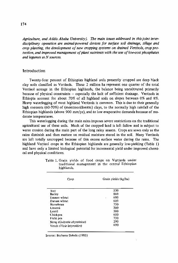
174
Agriculture, and Addis Ababa University). The main issues addressed in this joint interdisciplinary operation are animal-powered devices for surface soil drainage, tillage andcrop planting, the development of new cropping systems on drained Vertisols, crop protection, and improved management ofplant nutrients with the use oflow-cost phosphatesand legumes asN sources.
Introduction
Twenty-four percent of Ethiopian highland soils presently cropped are deep blackclay soils classified as Vertisols. These 2 million ha represent one quarter of the totalVertisol acreage in the Ethiopian highlands, the balance being uncultivated primarilybecause of physical constraints - especially the lack of sufficient drainage. Vertisols inEthiopia account for about .70% of all highland soils on slopes between 0% and 8%.Heavy waterlogging of most highland Vertisols is common. This is due to their generallyhigh contents (60-70%) of (montmorillonitic) clays, to the normally high rainfall of theEthiopian highlands (above 900 mm/yr), and to low evaporative demands because of moderate temperatures.
This waterlogging during the main rains imposes severe restrictions on the traditionalagricultural use of these soils. Much of the cropped land is left fallow and is subject towater erosion during the main part of the long rainy season. Crops are sown only as therains diminish and then mature on residual moisture stored in the soil. Many Vertisolsare left totally uncropped because of this excess surface water during the rains. Thehighland Vertisol crops in the Ethiopian highlands are generally low-yielding (Table 1)and have only a limited biological potential for incremental yield under improved chemical and physical conditions.
Table I. Grain yields of food crops on Vertisols undertraditional management in the central Ethiopianhighlands.
Crop
TeffBarleyEmmer wheatDurum wheatHorsebeanLinseedLentilChickpeaField peaNoug (Guizotia abyssinica)Vetch (Vicia latyroides)
Source: Berhanu Debele (1983)
Grain yields (kg/ha)
530860680610750300500600730290690
175
By removing the main plant growth constraint on these soils - waterlogging - drastic changes can be brought about. in their agricultural use so as to bridge the large gapbetween their low actual productivity and their high potential productivity.
Considering the need to address the improved utilization of these soils in a multidisciplinary mode, it has been agreed to set up a joint research, training and outreach operation with the participation of all interested institutions. A description of this joint operation is given below, after first outlining the main characteristics of Ethiopian highlandVertisols and alternative land-use techniques. Suggestions are then made for the discussion of programme perspectives beyond Ethiopian borders.
The Ethiopian Highland Vertisols
Vertisols, the fourth most important soil order in Ethiopia after Lithosols (16.2%),Cambisols (15.3%) and Nitosols (11.8%), cover 10.3% or 12.6 million ha of Ethiopia'sland mass. It is suspected that more detailed surveys may reveal many more Verti~olareas than are reported here on the basis of an exploratory study. It has been estimatedthat 7.6 million ha of these Vertisols are located in the highlands above 1500 m asl, andthat of these 1.93 million ha are currently cropped (H. Hurni, pers. comm.). The highland Vertisols are mainly on high-elevation plateaux (> 2500 m asl) in temperate ecosystems.
The general slope range of the landscapes on which Vertisols occur is 0-8% (Debele,1983). They occur throughout this range but are more frequent in the 0-2% range, andare prevalent in landscapes of restricted drainage such as seasonally inundated depressions, basins, deltas, aIluvial/colluvial plains, pyroclastic plains, undulated plateaux,valleys and undulating sideslopes (Debele, 1983).
In Vertisol areas it is generally rare to find extended tree vegetation. The predominant natural vegetation is grassland. Where they occur, trees are normally found scattered on better-drained terrain. Andropogon, Sporobolus, Festuca, Eleusine, Hyparrhenia,Agrostis, Cynodon and Digitaria are common grass species. Common weed species arePennisetum, Plantago and Guizotia.
Debele (1983) reports that where Vertisols are cultivated the common crops grownunder rainfed conditions include teff, durum wheat, chickpea, lentils, Vicia Iatyroides,linseed, Guizotia abyssinica, fenugreek, and Emmer wheat. In relatively better-drainedconditions, horsebean, field peas and barley are also grown.
Debele (1983) also reports on a number of features of Ethiopian highland Vertisols.On the basis of the limited studies available, it can be concluded that they are generallydark, deep, heavy-textured (> 50% clay), with strongly developed prismatic structuresand wide deep cracks, strongly developed slickensides, and pH in the acid range (61%between 5.5 and 6.7), and with a CEC between 35 and 70 me/lOO g soil. The predominant exchangeable cation is Ca, which accounts for 80% of the exchange complex, andthis is followed by Mg. In the highlands, base saturation: even in the presence of calciumcarbonate nodules, is rarely greater than 80-90%. Calcium carbonate nodules occurringin the highland Vertisols are crystalline, hard, and chemically inactive. This carbonate
176
has practically no effect either on the pH or the base-saturation status of the soil.It is noteworthy that, thanks to the large proportion of Vertisols in the total agricul
tural land in Ethiopia, the soils of this country present above average CEC whencompared with a large number of other countries (SiIlanpaa, 1982).
In the surface horizon (0-30 cm) most of the Vertisols contain 3·10% organic matter.This percentage decreases with depth but is still about I% at one metre depth - an indication of the self-cultivating characteristic of many Vertisols.
In 70% of the cases analyzed by Debele (1983), available phosphate (PzOs, Olsen)was below 5 ppm. The remaining samples all had less than 15 ppm. In ILCA's experience(unpublished) high-plateau Vertisols invariably had phosphate contents of less than 2ppm in the top 30 cm. P deficiency, together with N deficiency, is therefore a generalfeature of these Vertisols (Jutzi and Haque, 1984).
Debele's statement on the proneness to erosion of the Vertisols is corroborated byVirgo and Munro (1978) who have indicated 400 t/ha X yr soil loss on a Vertisol innorthern Ethiopia. These high soil-loss figures are commonly linked to the rainy-season
. fallow practice with several cultivation passes during that period. Loch and Freebairn(1984) have recorded drastic reductions of soil losses when a surface cover wasintroduced.
The Ethiopian highland Vertisol areas are generally characterized by smallholdermixed cereal-livestock farming systems with marked subsistence orientation. Land cultivation is almost exclusively done using animal power (oxen). These areas are also characterized by generally high rainfall (> 900 mm per annum) and low evaporative demandsdue to moderate temperatures, which vary widely with altitude but might average 15°annually. This results in severe waterlogging of most of these soils, and also of considerable acreages of other soils with vertic properties (an estimated 2.5 million ha, especiallyland with Vertic Cambisols and Vertic Luvisols).
It is therefore not surprising that many farming communities on these soils havedeveloped techniques to drain cropped fields and even native pasture areas. The mostwidely used, although not very effective, system is the construction of drainage furrowsacross the contour at varying distances (3 m to 6 m). These furrows are opened using thetraditional ox-drawn plough ("maresha"). Another widely used system is the ridge-andfurrow practice, whereby crops are grown on narrow ridges between furrows made withthe "maresha". Very rarely, handmade raised beds-and-furrows are found similar to theones proposed by ICRISAT (Kanwar et al., 1982), and notably on the Inewari plateau,Selate, and the Fogera plains.
In high elevation locations on lighter-textured Vertisols with high organic-mattercontent and on other soils with vertic properties, soil burning (called "guie") is a quitewidely used and most labour-intensive practice. It consists of intensively ploughingfallowed plots, of heaping up the topsoil into heaps of about 60 cm in height and 120 cmin diameter, and of burning them after they have been lit with drained dungcakes introduced while burning into the heaps. The soil is then left burning for several days, andafter cooling down the burnt soil is distributed over the field which is reploughed beforeplanting. Besides accelerating the mineralization of plant nutrients, especially P (Roorda,1984), this soil burning also contributes to. a temporary change in soil texture, in the
177
sense that the high temperatures developed in the heap (600°C) can bake clay into sandlike particles which contribute to better in-situ drainage and soil aeration (Abebe, 1981:Debele, 1983). The combined effects of accelerated nutrient mineralization and texturalchanges on crop growth are quite impressive (plus 300-400%) but very short-lived (oneseason).
Experiences with Improved Management of Vertisols
There is much evidence that substantial increases in crop yields can be obtained onVertisols if excessive surface soil water is drained off and if appropriate cropping and soilfertility practices are used.
During the past twelve years, ICRISAT has been developing a management technology for Vertisols in India with 100 million ha of Vertisols. The technological packagedeveloped at ICRISAT is designed to make optimum use for crop production of both therainy-season and the postrainy-season growing periods. The package - essentially adouble-cropping system - includes elements such as land shaping for surface drainage,tillage innovations, new crop and soil fertility management options, and improved cropprotection. Results obtained at the ICRISAT Center (Hyderabad, Andhra Pradesh) withthis technology consistently showed superior production and profits as compared withthe traditional rainy-season fallow system. It allows two crops per year, which both aremore productive than the traditional postrainy-season crop (Ryan and von Oppen, 1983).
The practical nature of all elements of improved Vertisol management and theirrelative importance are a function of the cultural, socioeconomic and ecological circumstances of the envisaged target areas. The Ethiopian highlands differ in all these aspectsfrom those of the semi-arid tropics of India and of most other extended Vertisol areas.Special efforts for each particular setting are therefore warranted.
The Ethiopian Institute of Agricultural Research (JAR), which has three major research stations on Vertisols, proposed (among other projects) the construction of cambered beds of varying width (7-11 m) for Vertisol drainage. Results have been reportedby Debele (1983). More than threefold yields of wheat and barley were obtained whenusing this technique as compared with the traditional land preparation practice. TheIAR results not only revealed these large drainage effects but also stringent nitrogen andphosphorus deficiencies.
When analyzing the effects of soil burning ("guie"), Abebe (1981) recognized thatthey dealt importantly with in-situ drainage, effects which could just as well be attainedby camber bedding, while also preserving organic matter. The construction of camberedbeds, however, involves considerable earth movement, which is too expensive anoperation for local resources.
It was mentioned earlier in connection with examples of traditional Vertisol drainagepractices that the farmers realize that waterlogging is a major crop growth constraint.Substantial impacts of more systematic and more effective drainage systems are thusnot only likely to be expected, but their acceptance by the farmers can be taken forgranted.

178
Considering the subsistence character of the target farming systems, the Joint Vertisol Management Project in Ethiopia adopted a strict low-external-cost approach in thedevelopment of technological elements for the improved management of Vertisols.
An extremely low-cost device was developed for an animal-powered construction ofbroadbeds-and-furrows (BBFs) (Jutzi et al., ~ 986). This broadbed maker (BBM) is builton the basis of two interconnected traditional ploughs with shortened beams, as shown inFigure 1. The two flat wooden wings of the traditional plough are replaced by twowooden mouldboard-shaped wings on either side of each beam. The two central wingsof the BBM throw earth towards the centre, thus building up a raised bed, and the twooutside wings throw soil to the outside. The implement thus leaves behind a raised bedabout 1.2 m across and two drainage furrows about 20 cm deep. The implement can bepulled by a pair of local Zebu oxen, weighs about 28 kg (8 kg more than the "maresha"),and can be handled by one operator. It can cover up to 1 ha per working day (7 hours),depending on the moisture and tilth status of the soil. Its cost, in addition. to the two"mareshas" used, is about US$lS, and it can be made and maintained by village craftsmen. The BBM can be used as a seed-covering device while making the BBFs. Attachments for row-planting of crops and for harrowing (blade-harrow) are also available at anapproximate cost of US$60 and US$lO respectively.
I Center beam2 Front bar3 Lateral beam4 Handle stablizer5 Handle6 Centre wing7 Outside wing8 Metaltip
9 Metal hook10 Frame stablizer
240 cm120 cm
88 cin120 cm150 cm80 cm60cm40cmaOcm
140 cm
Figure 1. Broadbed makers - BBM (not to scale).
179
in an on-farm verification test in Debre Zeit in 1985 with 15 participating farmers,wheat yields increased by 78% and 56% for grain and straw respectively when using BBFs,with all other inputs being identical for drained and undrained plot pairs.
The implement is currently (1986) under on-farm verification in four differenthighland Vertisol areas (Debre Zeit - 1800 m asl, 800 mm annual rainfall, a teff-growingarea; the Wereta and Fogera plains - 1800 m asl, 1500 mm annual rainfall, a finger rnillet-,teff-, and noug-growing area with traditional double-cropping systems; Were Ilu andS-Wello - 2600 m asl, 1100 mm annual rainfall, a wheat- and horsebean-growing area;the Inewari plateau and N-Shewa - 2600 m asl, 1100 mm annual rainfall, a wheat-,horsebean-, teff-, and fenugreek-growing area, with traditionally handmade BBFs). Someinitial experiences are given below for the two high-elevation plateaux - Were IIu andInewari.
The heavy rainfall in Were Ilu during the 1986 cropping season resulted in extremewaterlogging which caused severe damage to the crops. In August 1986, thirty rainy dayswere recorded with an average rainfall of 9 mm per day. Tensiometer readings averaged1.3 cbar suction on the BBF and 0.6 cbar on flat plots, with both readings taken at 15cm soil depth. Horsebean (Vieia faba minor) has been entirely eliminated on many traditionally managed plots without adequate drainage. The results of a scoring of the cropsfor comparative treatment effects carried out in the second week of October (podsetting in horsebean, heading in wheat) are given in Table 2.
Table 2. Crop scoring for expected drainage effect on yieldsat Were Ilu (October 1986)
Crop Frequency, using pairs of plots of expected yield increase (seetext) in the drained plots as compared with the traditionallymanaged plots.
WheatHorsebeanTeff
equal
23
+50%
106
+100%
441
+ > 100%
17
On the Inewari plateau, a representative survey (45 farmers monitored) was undertaken to determine the human labour inputs into the traditional handmade constructionof BBFs. With very little variation this operation requires about 60 h/ha. If the animaldrawn broadbed maker is used, the human labour input is reduced to about 16 h/ha. Thetotal human labour input in land cultivation (average two ploughings before planting)and in BBF construction with seed covering can thus be reduced from 120 h/ha to about

180
75 h/ha. A socially interesting aspect of this substitution of human by animal labour isthat the substituted labour is basically from children and women. Early indications arethat the crops planted on BBFs made with the animal-drawn implement will outyieldthe ones made by hand, probably because of the greater uniformity of the BBFs.. There are strong indications of very serious soil fertility deficiencies (nitrogen, andespecially phosphorus) in many highland Vertisols. Expected yield levels, even with irnproved surface drainage, are therefore still very low. Considerable soil fertility inputs areneeded if higher levels of land productivity are to be obtained. Most of the highland Vertisols are in the acid range and can therefore make good use of cheap unrefined rockphosphates (Haque et al., 1986). Nitrogen can be supplied to the soil by the farmerhimself by strategically using leguminous plants in his cropping system (grain legumes,herbaceous forage legumes, leguminous browse plants). The nitrogen fixation of legumescan be considerable (Haque and Jutzi, 1984), and substantial nitrogen transfers fromlegume crops to the subsequent cereal crops grown on the same plots have been reported(Nnadi and Haque, in preparation).
The two key elements of low-external-cost soil fertility management on Vertisolsare therefore cheap sources of phosphates and legumes for the generation of plant-available nitrogen.
An Interinstitutional Approach to Vertisol Management
A maximum impact on crop yields and soil and water preservation can only beexpected if all relevant elements of improved Vertisol management are adequately combined and applied. The generation of these technological elements requires the input ofspecialists of many different disciplines in a coordinated mode of operation. It has therefore been decided to carry out the Vertisol management project for the Ethiopian highlands as a joint operation between the International Livestock Centre for Africa (ILeA),the International Crops Research Institute for the Semi-Arid Tropics (ICRISAT), theInstitute of Agricultural Research (IAR), Alemaya University of Agriculture (AUA),the Ministry of Agriculture (MoA) and Addis Ababa University (AAU). Table 3 reflectsthe basic understanding between these participating agencies with respect to their contributions to the project.
An advisory committee has been established for the project whose members are thechief executives of all the participating agencies. This project governing committee hasappointed a technical committee composed of specialists of all participating agencies. It isin charge of implementing the project as a joint operation, thereby utilizing all comparative advantages among the partner institutes.
Specific Vertisol activities in participating agencies are currently being identified foradequate budget allocation in order to ensure a concerted R&D effort for the improvedutilization of the Ethiopian highland Vertisols for increased human food and animal feedproduction. The Joint Project on Improved Vertisol Management will participate as amain cell in the international network on Vertisol utilization organized by IBSRAM(In-
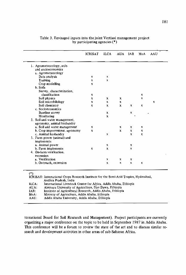
181
Table 3. Envisaged inputs into the joint Vertisol management projectby participating agencies (*)
ICRISAT ILCA AUA IAR MoA AAU
l. Agrometeorology, soilsand socioeconomicsa. Agrometeorology
Data analysis x xTraining x xCrop modelling x
b.SoilsSurvey, characterization,
classification x xSoil physics x x x xSoil microbilology x x x xSoil chemistry x x x x x
c. SocioeconomicsBaseline survey x xMonitoring x
2. Soil and water management,agronomy, animal husbandrya. Soil and water management x x x xb. Crop improvement, agronomy x x x xc. Animal husbandry x x x
3. Farm power (animal) andimplementsa. Animal power x xb. Farm implements x x x
4. On-farm verification,extensiona. Verification x x xb. Outreach, extension x x x x
(*):ICRISAT: International Crops Research Institute for the Semi-Arid Tropics, Hyderabad,
Andhra Pradesh, IndiaILCA: International Livestock Centre for Africa, Addis Ababa, EthiopiaAUA: Alernaya University of Agriculture, D'ire Dawa, EthiopiaIAR: Institute of Agricultural Research, Addis Ababa, EthiopiaMoA: Ministry of Agriculture, Addis Ababa, EthiopiaAAU: Addis Ababa University, Addis Ababa, Ethiopia
ternational Board for Soil Research and Management). Project participants are currentlyorganizing a major conference on the topic to be held in September 1987 in Addis Ababa.This conference will be a forum to review the state of the art and to discuss similar research and development activities in other areas of sub-Saharan Africa.
182
Acknowledgements
The Joint Vertisol Management Project is indebted to the Swiss government forlargely funding its activities. Oxfam and Caritas are funding part of the outreach operations.
References
DEBELE, B. 1983. The Vertisols of Ethiopia: their properties, classification and management. In: Fifth Meeting of the Eastern African Sub-committee for Soil Correlationand Land Evaluation. December 1983, Wad Medani, Sudan. World Soils ResourcesReports 110.56. Rome: FAO.
HAQUE, I. and JUTZI, S. 1984. Nitrogen fixation by forage legumes in sub-SaharanAfrica: potentials and limitations. Pages 340-371 in: Proceedings of 1st Conferenceof the African Association for Biological Nitrogen Fixation, eds. H. Ssali and S.O.Keya. July 23-27, 1984, Nairobi, Kenya. Also published in ILeA Bulletin no. 20, pp.2-23.
HAQUE, I., NNADI L.A. and SALEEMM, M. 1985. Phosphorus management, with special reference to forage legumes in sub-Saharan Africa. Paper presented at the Workshop on Potentials of Forage Legumes in Farming Systems of sub-Saharan Africa,September 16-19, 1985, Addis Ababa, Ethiopia.
JUTZI, S. and HAQUE, I. 1984. The effect of P and NIP fertilizers on the growth, nodulation and seed set of three African clovers on a P-deficient Vertiso!. Paper presentedat the 9th World Fertilizer Congress, June 11-16,1984, Budapest, Hungary.
JUTZI, S., ANDERSON, F.M. and ASTATKE, A. 1986. Low-cost modifications of thetraditional Ethiopian tine plough for land shaping and surface drainage of heavy claysoils: preliminary results from on-farm verification. Paper presented at the SecondWest African Integrated Livestock Systems Workshop, September 19-25, 1986,Freetown, Sierra Leone.
KANWAR, J.S., KAMPEN, J. and VIRMANI, S.M. 1982. Management of Vertisols formaximizing crop production - ICRISAT experience. Pages 94-118 in: Vertisols andRice Soils of the Tropics: Symposium Papers II. 12th International Congress ofSoilScience, New Delhi, India.
LOCH, R.J. and FREEBAIRN, D.M. 1985. Methods for measuring soil erosion: some results from subtropical and tropical Queensland. Soil Erosion Management, eds.E.T. Craswell, J.V. Remenyi and L.G. Nattana. Proceedings of a workshop held atPCARRD, December 3-5, 1984, Los Banos, Philippines. ACIAR Proceedings Seriesno. 6. 132p.
MESFIN, A. 1981. Soil burning in Ethiopia. Ethiopian Journal ofAgricultural Sciences3(1): 57-74.
NNADI, L.A. and HAQUE, I. In preparation. Effect of annual forage legumes' on the nitrogen economy and physico-chemical properties of vertic soils.
ROORDA, T.M.M. 1984. Effects on soil burning ("guie") on physico-chemical propertiesof soils in Sheno, Debre Berhan and Chacha areas of Ethiopia. Dissertation submittedto the National Agricultural College, Denverter, the Netherlands.

183
RYAN, J.G. and VON OPPEN, M. 1983. Assessment of impact of deep Vertisol technology options. Paper at the TAC meeting, ICRISAT, Hyderabad, India.
SILLANPAA, M. 1982. Micronutrients and the nutrient status of soils: A global study.FAO Soils Bulletin no. 48. Rome: FAO.
VIRGO, K.J. and MUNRO, R.N. 1978. Soil and erosion features of the central plateauregion of Tigrai, Ethiopia. Geoderma 20: 131-157.


Fifth session: Management systems (cont.l
Chairmen: Mr. F. N. Muchena
Dr. J.C. Katyal

THE POTENTIAL OF AGROFORESTRY FOR SOIL CONSERVATION
WITH SPECIAL REFERENCE TO VERTISOLS
A. Young*
Abstract
Soil conservation includes both control of erosion and maintenance offertility. Theprincipal adverse effect of erosion is reduction in fertility, through loss of soil organicmatter and nutrients. Specific problems of Vertisols include the high erosion hazard ongentle slopes, low permeability, and Nand P deficiencies. Six agroforestry practices canbe effective in control oferosion, and eight in maintenance offertility. A t the same time,agroforestry contributes to other productive and service functions of farming systems.There has been very little agroforestry research conducted on Vertisols. The existence ofa high apparent potential for soil conservation, coupled with the paucity of researchresults, calls for an internationally coordinated programme of soils research on Vertisolsin semi-aridclimates.
Introduction
ICRAF has recently carried out a review of the potential of agroforestry for soil conservation (Young, 1986b; Young, Cheatle and Muraya, in press). In this, soil conservationwas interpreted in its broader sense, to include both control of erosion and maintenanceof soil fertility. The present paper gives a summary of some results from this review,relating them when possible to the particular circumstances of Vertisols.
It should be said at the outset that there is relatively little recorded informationabout agroforestry on Vertisols. In the agroforestry systems inventory of the Interna-
* International Council for Research in Agroforestry, PO Box 30677, Nairobi, Kenya.

188
tional Council for Research in Agroforestry (ICRAF) there are only two such records,and in the multipurpose tree data base, seven. This review is therefore necessarily confined to the assessment of potential on general grounds.
Trends in Soil Conservation Research and their Implications
The traditional approach
Features for the earlier approach to soil conservation were:Soil conservation was regarded as synonymous with erosion control; the problem ofdecline in soil fertility, whether as a consequence of erosion or through other causes,received little consideration.Attention was concentrated on rate of soil loss, as tonnes per hectare or millimetresof soil thickness per year. Conservation measures were directed at reducing theserates to a (presumed) acceptable limit - "tolerable erosion"The requirements of arable cropping as regards soil cover were taken as unalterable.Hence conservation measures were directed at checking runoff by a barrier function,using bunds, terraces, etc.Assessment of the economic consequences of erosion were directed at the effects ofreduction in soil depth, or total loss of land through gullying.Extension was carried out on the basis that erosion control should come first, as aprerequisite for good farming, applied in isolation from other agricultural improvements. Conservation extension was sometimes conducted on the basis of a prohibitive, legally enforced policy.Some notable successes were achieved by this approach in its country of origin, the
V.S., and in a few less developed countries (e.g. Zimbabwe). It ran into a number of problems, however. The costs (or equivalent labour requirements involved in structuressuch as bunds and terraces were high. Particularly when based on loss of soil depth, conservation works were frequently hard to justify in economic terms. Finally, in the present social context, conservation extension simply did not work: it was found impossibleto enforce a prohibitive policy, and the cooperation offarmers could not be obtained unless they could see immediate benefits in the form of higher yields.
Recent trends
Recent findings from research (both scientific and socioeconomic), and resultingtrends in policy, are as follows:
Erosion is now treated as one of a number of forms of soil degradation. Fertilitydecline and its causes (physical, chemical and biological soil degradation) is of equalor greater importance. These aspects interact, both physically and economically,and conservation should address both jointly.Experimental work into the effects of erosion on crop yields has shown that the

189
earlier technique of artificial desurfacing underestimated yield reductions. Erosionreduces productivity not only by reduction in soil depth, but through effects onwater-holding capacity, loss of nutrients, decline in soil organic matter and degradation of physical properties. The effects of a given rate of erosion on crop productionare relatively greater in tropical than temperate zones, and are greatest on 'old',highly weathered tropical soils. Under high-input farming in the temperate zone,the consequences of erosion could be masked for a time by increasing fertilizers an option not open to low-capital farmers of the tropics.It has been shown that soil cover (by including minimum-tillage agroforestry) can bea highly efficient means of controlling erosion, at least as effective as the runoffbarrier approach, and less costly.In extension, it is recognized that conservation must be achieved by the willingcooperation of farmers. It follows that farmers must be able to see tangible benefits,in the form of higher production, and associate these with conservation.A schematic calculation illustrates the cost of loss of nutrients in soil erosion.. Consi
der a tropical soil of moderately low fertility, containing 0.1% nitrogen in the top horizon. Assume a nitrogen enrichment factor in eroded sediment of 2.0 (it is often nearer4.0) and a rate of soil loss under agriculture of 50 t/ha/yr. There will be a loss of 100 kgN/ha/yr, equivalent to removing 5 bags of 20-N fertilizer per hectare.
Policy implications
Once the full range of effects of erosion on soil properties and crop productivity aretaken into account, conservation is more often found to be economically justifiable.Whilst problems of time preferences and pricing of externalities remain, there is less needfor special pleading or manipulation of figures. Add to this the gains from maintenanceof soil fertility, and analysis will often show good returns for investment in soil conservation, both to the farmer and to society.
From a technical aspect, further research is needed into land management practiceswhich make use of methods of conservation based on soil cover. Such research shouldinclude how to reconcile maintenance of cover with other agricultural operations, and theranges of physical environments and social conditions to which particular practices areapplicable.
There should be no "soil conservation projects"! Conservation should be applied asan integral part of agricultural improvements, linked to increases in productivity.'
J The principal sources used for this section were as follows: El-Swaify et al., 1985; FAO, 1979,1983; Follett and Stewart, 1985; Greenland and Lal, 1977; Morgan, 1981; National Soil Erosion,1981; Rijsberrnon and Wolman, 1985; Stocking, 1984; Stocking and Peake, 1986; Wiggins, 1981.

190
The Nature and Functions of Agroforestry
Definition and range
Agroforestry refers to land-use practices in which trees or shrubs are grown inassociation with herbaceous plants (crops or pastures) in a spatial arrangement or timesequence, and in which there are both economic and ecological interactions between thetree and nontree components of the system.
It is the ecological effects of the trees, for the most part acting through the microclimate and soil, that form the distinctive feature of agroforestry, and distinguish it fromsocial forestry. All agroforestry practices except one, the establishment of timber plantations by the taungya system, are also social forestry; but the latter includes monopurposewood production, such as the planting of eucalypt woodlots.
Nearly all agroforestry takes place on agricultural land. Indeed, with the singleexception of the taungya practice, over 90% of agroforestry can be described in fourwords: "planting trees on farmland". It is thus the concern of departments of agriculture. However, 100% of it involves the raising, planting and tending of trees, a subjectin which expertise lies with departments of forestry. There are real problems here in allocation of responsibilities, for which each country must work out its own solution.
In contrast to the situation five years ago, most people in the development field havesome idea of what agroforestry is. Some, however, still view it mainly in terms of one ora few practices, often taungya or alley cropping. An agroforestry practice is an arrangement of components (trees, crops, pastures, livestock) in time and space. An agroforestrysystem is a specific local example of a practice, characterized by plant species, management, environment, and social and economic functioning. There are many thousands ofagroforestry systems, but only some 20 distinctive practices (Nair, 1985; Young, inpress). Table 1 is a classification intended to illustrate the range of practices. At thehighest category it is based on components present, at the next on spatial and temporalarrangement, and at the lowest level on more detailed arrangement and on functions.
Functions
It is the function of trees in a land-use system which giveagroforestry its distinctivenature. These are both productive functions, for fuelwood, domestic timber, fodder,food, oils, fibres, etc.; and service functions, such as shade, shelter (from Wind), soilconservation, fencing and water management. Of the products, fuelwood is the most important on a world scale, perhaps matched in a few countries (e.g, India) by fodder. Ofthe service functions, without doubt soil conservation is that for which there is thegreatest potential.

Table 1. Agroforestry practices.
191
MAINLY AGROSYLVICULTURAL (trees with crops)Rotational:
1. Planted-tree fallow2. Taungya
Spatial mixed:3. Trees on cropland4. Plantation crop combinations:
5. Tree gardens:
Spatial zoned:6. AlIey cropping7. Boundary planting8. Trees for soil conservation:
9. Windbreaks and shelterbelts10. Biomass transfer
- with upper-storey trees- with lower-storey tree/shrub crops- with herbaceous crops (cf. also 12)- multistorey tree gardens- home gardens
- barrier hedges- grass barrier strips- on bunds etc.- on terraces
MAINLY OR PARTLY SYLVOPASTORAL (trees with pastures and livestock)Spatial mixed:11. Trees on rangeland or pastures12. Plantation crops with pasturesSpatial zoned:13. Live fences - mainly barrier function
- multipurpose14. Fodder banks
TREE COMPONENT PREDOMINANT15. Woodlots with sultipurpose management16. Reclamation forestry leading to production
(cf', also 2)
OTHER PRACTICES AND SPECIAL ASPECTS17. Apiculture with forestry18. Aquaforestry (trees with fisheries)19. Trees in water management20. Irrigated agroforestry,
- on eroded land- salinized land- on moving sands

192
The Potential of Agroforestry for Soil Conservation
General
The broader interpretation of soil conservation, as set out above, will be taken as thebasis for reviewing the actual and potential contribution of agroforestry. This may besummarized by the pseudoequation:
Soil conservation = Control of erosion + Maintenance of fertility
These two aspects will be taken in turn, notwithstanding the fact that one of themain messages is their interdependence, mainly through the effects of erosion on fertility decline.
Control of erosion
The distinctive problem presented by Vertisols is a high erosion hazard on gentleslopes, the result of their very low infiltration capacity when wet. Management systemsdesigned to check erosion generally seek to reduce runoff or direct it into grassed waterways, as in the graded broadbed-and-furrow system developed by ICRISAT. It is alsodesirable to avoid decline in organic matter, leading to degradation of soil physical properties and still lower permeability (Dudal and Bramao, 1965; Young, 1976, eh. 9;Ahmed, 1984; Virmani and Swindale, 1984).
The tree component in agroforestry systems can assist in controlling the rate of soilloss through effects on four of the causative factors of erosion: rainfall erosivity, soilerodibility, runoff, and ground surface cover. Experimental evidence shows that the reduction in the impact energy of raindrops caused by a tree canopy is usually slight andmay even be negative. Soil erodibility depends in part on organic-matter content, and thecapacity of tree litter to maintain this can help to prevent decline in permeability andstructural stability. For runoff reduction, the tree component can be designed so as toform a runoff barrier.
However, analysis of all of the major predictive equations (USLE, SLEMSA, FAO,Rose) shows that by far the greatest potential for controlling the rate of soil erosion liesin the cover factor. A ground surface litter cover of only 60%, maintained throughoutthe period of erosive rains, will normally reduce erosion to low and acceptable levels,even without additional structures of the barrier type. This effectiveness has beendemonstrated specifically on Vertisols (Coughlan, 1987). In the design of agroforestrysystems for control of water erosion, therefore, management practices that will lead tosuch a litter cover should be the primary aim, with runoff barriers secondary.
The functions of the tree component in the control of water erosion may include anyof the following:
To reduce erosion by increasing soil cover through tree litter, from both natural falland prunings.

193
To act as a runoff barrier, by means of closely planted hedgerows, coupled with thelitter that accumulates against them.To strengthen and stabilize earth structures for erosion control (bunds, terrace risers,etc.) through the binding effect of roots.To make productive use of land taken up by earth structures, for fuelwood, fodder,fruit, etc.A function, partly psychological" of linking erosion control practices with production, and thus helping to make these practices an integral and permanent part of thefarming system.Evidence from controlled experiments on the effectiveness of agroforestry practices
in controlling soil loss is scanty, but a number of countries have had sufficient confidence to include such practices in extension recommendations. Recent reviews haveshown a capacity for erosion control in the following practices (with examples of countries in which they are found or recommended):o Barrier hedges (e.g. Cameroon, Indonesia, Malawi, Philippines, Rwanda).0' Trees on soil conservation works - grass strips, bunds, terrace risers (e.g. Cameroon,
Kenya, Nepal, Malawi, Philippines, Rwanda).o Alley cropping: Trials that measure erosion rates are in progress (e.g. India, Nigeria,
Tanzania), but available data are sparse. Through the capacity to combine littercover with runoff barriers, the a priori potential for erosion control is high, and thereis an urgent need for further experimental work.
o Tree gardens: Inherently highly effective (e.g. Sri Lanka, Tanzania, humid WestAfrica).
o Plantation crop combinations: Effective provided that they are managed for maintenance of ground cover (e.g. Costa Rica, Malaysia).
o Trees on pastures: In some countries, Vertisols are used as grazing land. Agroforestryis of little use in erosion control unless accompanied by standard measures of pasturemanagement, control of livestock numbers, and rotational grazing. There is potentialto assist in reducing the often serious erosion, but research is needed.?
Maintenance of soil fertility
Trees normally increase soil fertility. We know this from the high fertility of soilsunder natural forests, the restoration of fertility under fallow in shifting cultivation, andthe effectiveness of reclamation forestry. The tree component in agroforestry systemspossesses a capacity to improve soil fertility, whereas the crop component tends to decrease it. There is thus a prima facie potential to design agroforestry systems so that theeffects of these two components balance each other, and soil fertility is maintained ina steady state.
2 The principal sources used for this section were as follows: Craswell et al., 1985; Lundgren and Nair,1985; Wiersum, 1984; Young, 1984, 1986b.
194
Some of the mechanisms by which trees improve soils are proven, others are hypotheses in need of testing. These processes are as follows:o Processes which augment additions to the soil:
o photosynthetic fixation of carbon and its transfer via litter and root decay tosoil humus;
* nitrogen fixation;* nutrient retrieval from deeper soil horizons;* providing favourable conditions for input of nutrients by rainfall and dust.
o Processes which reduce losses from the soil:* control of erosion;* root uptake of nutrients that would otherwise have been lost by leaching.
o Improvement of soil physical properties:* soils under trees tend to have favourable structural stability and water-holding
capacity, as a result of organic-matter maintenance and the growth and decayof root systems.
o Processes which affect the quality of plant residues and the timing of their transferto the soil:* provision of a range of qualities of plant litter, woody and herbaceous;* growth-promoting substances in the rhizosphere;* the potential, through management of pruning, to control the timing of nutrient
release from decay of litter;* effects of shading on microclimate, and thereby on rate of litter decay.
Vertisols are commonly deficient in Nand P, particularly if continuously cropped.Problems of poor root development arise if the structure is degraded through reductionin organic matter.
Of the processes listed above, those which appear to have particular significance withrespect to Vertisols are maintenance of organic matter, nitrogen fixation, and improvement of soil physical properties.
It can be presumed from the above that every agroforestry practice is likely to bemore favourable for maintenance of soil fertility than arable agriculture. For some practices, the effects may be slight, e.g. boundary planting, live fences, and trees on soil conservation works. In the case of the taungya system, the comparison is with pure plantation forestry; such limited evidence as exists suggests that the cropping period will lead tosome loss of fertility, although no substantial retardation in rates of subsequent treegrowth has been demonstrated.
For eight agroforestry practices, there is a substantial and proven capacity for thetree component to augment soil fertility, and thus a potential for the design of land-usesystems that will be sustainable. These are:o Alley cropping: Experimental evidence (including results from Nigeria, Philippines,
and Malawi) has demonstrated the capacity of alley-cropping systems to lead tohigher levels of soil organic matter and nutrients, and higher crop yields, than controlplots under pure cropping, provided that leaf litter is returned to the soil. The

195
system is most effective if the nitrogen- and carbon-fixation .capacities of the treesare combined with modest levels of fertilizer addition, but zero-fertilizer systems arealso possible! Quantitative data on amounts of biomass production and nitrogenfixation are available.
o Tree gardens: Multistorey tree gardens and home gardens (e.g. Sri Lanka, Tanzania,Vietnam) combine high litter production with dense ground cover. They exemplifyin extreme form the three attributes commonly specified for good agroforestry design, being highly productive, fully sustainable, and practicable.
o Plantation crop combinations: The best documented example is the combination ofcoffee with Erythrina 'poepiggiana and/or Cordia alliodora in tropical America, theprunings from the Erythrina having a-recognized function in fertility maintenance.Quantitative data on nutrient cycling exist for a few cases.
o Windbreaks: It should be possible to design windbreaks in such a way as to combinethe architectural form necessary to fulfill their primary function with a capacity toenhance fertility on adjacent cropland. Research is needed.
o Biomass transfer: This refers to the practice, for example in Nepal, of carrying plantlitter from communal forestland onto cropland. From the fact of its adoption, thisclearly does improve fertility, although it may contribute to the degradation of communal forests.
o Controlled or planted fallow: Many years ago, work was conducted in Zaire to improve shifting cultivation through the corridor system. Some comparable methodshave been tried in Amazonia. In part of the Philippines, a system of planting nitrogen-fixing trees in blocks in rotation exists. These systems are relatively demandingfor land, but may have a potential in humid areas subject to rapid leaching and soildegradation under cropping.
o Trees on cropland: The beneficial effects of Acaicia albida on crops beneath them areknown both to farmers of many countries and to scientists. Some other species withsimilar effects are known, e.g. Prosopis cineraria, in the drier regions of India,Sesbania spp. in moist subhumid western Kenya.
o Trees and shrubs on pastures: It is commonly found that pasture beneath trees isbetter than that on open ground, although to what extent this is due to livestock preferring to stand there is not known. An equal or greater contribution than pasture ismade by the provision of tree fodder from deep-rooting woody perennials, particularly at a time when grasses are unpalatable or absent.There is a potential for combining reclamation forestry with agroforestry in restor
ing degraded lands to productive use. The land is initially placed under pure forest cover.Once soil fertility has been found to be restored to some degree, selective clearance canbe undertaken, along contour lines, with limited cropping or pasture production. Theintroduction of fruit trees is another possibility. Research is needed into the design andmonitoring of such systems.
One substantial problem should be noted: the capacity of trees to maintain soilfertility is substantially reduced if a large part of the litter is not returned to the soil. Aninput-output model developed at ICRAF (Soil Changes Under Agroforestry, SCUAF)
196
has shown that, whilst the contribution of root residues is substantial, it is much harderto design a sustainable system if aboveground tree biomass, particularly the leaf element,is removed (Young et al., 1987). This is a serious difficulty in planning sustainable systems in countries, notably India, where fodder shortage has led to the practice of feedingall available herbaceous residues to livestock.
A second schematic calculation illustrates the orders of magnitude involved in thefertility-enhancement capacity of agroforestry. Alley cropping is most suitable as anexample because the experimental evidence is best. In the humid and moist subhumidtropics, Leucaena leucocephala and certain other N-fixing trees have the capacity, in practical alley cropping designs, to yield 100-200 kg N/ha/yr; in the drier subhumid zone, therange is about 50-100 kg. A value of 100 kg N/ha/yr will be taken for illustration. Inan N-deficient soil, it is common for each kilogramme of added N to raise cereal yields bysomething of the order of 10 kg/ha. Thus alley cropping with N-fixing trees has apotential either to raise cereal yields by 1 tonne per hectare, or to act as a substitute for5 bags of 20-N fertilizer or 100 kg N. Substitution of money values for cereal crops forfertilizer gives the order of magnitude of the added production, or cost savings, involved.For farmers without access to fertilizer, there is an equivalent cost in lost production,either through being forced to leave land fallow in order to restore fertility, or in reducedyields."
Discussion
There is a set of interactions and partial substitutions between soil erosion, otherforms of soil degradation, decline in fertility, input of fertilizers, crop yields and production. The major adverse effect of erosion is through the annual loss of soil organic matterand nutrients, and consequent lowering of fertility. Reduced fertility can additionally orseparately be caused by physical, chemical and biological soil degradation, basically theresult of removing more organic matter and nutrients in crop production than is appliedas inputs. Lowered fertility can be counteracted, by farmers with capital, through higherfertilizer inputs with consequent added costs. For many, it will mean reduced yields andcrop production, leading towards a state of lower-level equilibrium, in which the agroecosystem is in a steady state but with very low productivity, a situation not uncommonon continuously cultivated Vertisols.
There is a known potential for agroforestry practices both to control erosion and tohelp maintain soil fertility. The proven experimental evidence is scanty, particularly asto the magnitude of effects and the applicability of specific practices to different environmental conditions. Moreover, by comparison with erosion control through earth struc-
3 The principal sources used for this section were as follows: Nair, 1984; Prinsley and Swift, 1987;Swift, 1984, 1985; Young, 1986a, 1986c, and in preparation.
197
tures on the one hand, and fertilizer inputs on the other, soil conservation by means ofagroforestry is a relatively lower-cost form of illustrated development. This compareswith the very substantial benefits, as illustrated by the order-of-magnitude calculationsabove. The problem-solving approach normally adopted in agroforestry development is
well suited to tackling problems in ways that are realistic for, and secure the cooperationof, the farmer.
It is necessary to repeat the qualification that many of the propositions put forwardon the effects of agroforestry practices on soils, and thus their capacity to lead to sustainabe land use, rest on uncomfortably scanty evidence. Much information can be derivedby analysis of data drawn from agricultural, soils, and forestry research, but there isstill need for a much more substantial body of scientific information stemming fromagroforestry itself.
Research is needed at two levels: understanding of the basic processes of tree-c:opsoil interactions, through research on components and the tree/crop interface; and adaptive research leading to practical management systems. Substantial international and national effects are needed (not in planning networks but in actually doing research!)over the next 5-10 years if a body of knowledge comparable to that in other developmentdisciplines is to be built up.
So far as is known, there are no published accounts of completed agroforestry research on Vertisols, other than their possible inclusion in accounts of the soil-improvingcapacity of Acacia albida. Work is in progress at the Dharwad (Karnataka) station of theIndian Council of Agricultural Research. Vertisols under semi-arid climates present adistinctive type of environment, in which it is highly desirable that agroforestry researchshould be conducted. A feature to which attention should particularly be directed is thecombined roles of tree litter - in checking erosion, maintaining soil organic matter, andrecycling nutrients. The potential for nitrogen fixation is also of significance.
It cannot yet be said that the potential of agroforestry systems for erosion controland maintenance of fertility is yet proven on Vertisols. However, the existence of aprima facie potential to achieve these aims, coupled with the relatively low input levelsand costs required, is sufficiently great to call for an internationally coordinated programme of agroforestry research on Vertisols.
References
AHMED, N. 1984. Tropical clay.soils: their use and management. Outlook on Agriculture13:87-95.
CRASWELL, E.T., REMENYI, J.V. and NALLANA, L.G., eds. 1985. Soil ErosionManagement. Proceedings of a Workshop held at PCARRD, Los Banos, Philippines,3-5 December 1984. A CIAR Proceedings Series no. 6. Canberra: ACIAR. .
DUDAL, R. and BRAMAO, D.L. 1965. Dark clay soils of tropical and subtropical regions. FAO Agricultural Development Paper no. 83. Rome: FAO.
EL-SWAIFY, S.A., MOLDENHAUER, W.C. and LO, A., eds. 1985. Soil Erosion andConservation. Ankeny: Soil Conservation Society of America.
198
FOLLETT, R.F. and STEWART, B.A., eds. 1985. Soil Erosion and Crop Productivity.Madison: American Society of Agronomy.
FAO (Food and Agriculture Organization of the United Nations). 1979. A ProvisionalMethodology for Soil Degradation Assessment. Rome: FAO.
FAO (Food and Agriculture Organization of the United Nations). 1983. Guidelines forthe Control ofSoil Degradation. Rome: UNDPjFAO.
GREENLAND, D.J. and LAL, R., eds. 1977. Soil Conservation and Management in theHumid Tropics. Chichester: Wiley.
LUNDGREN, B. and NAIR, P.K.R. 1985. Agroforestry for soil conservation. Pages 703717 in: Soil Erosion and Conservation, eds. S.A. EI-Swaify, W.C. Moldenhouer andA. Lo. ICRAF Reprint no. 27. Nairobi: ICRAF.
MORGAN, R.P.C., ed. 1981. Soil Conservation: Problems and Prospects. Chichester:Wiley.
NAIR, P.K.R. 1984. Soil Productivity Aspects ofAgroforestry. Nairobi: ICRAF.NAIR, P.K.R. 1985. Classification of agroforestry systems. In: Agroforestry Systems
3:97-128. ICRAF Reprint no. 23. Nairobi: ICRAF.NRPC (National Soil Erosion - Soil Productivity Research Planning Committee). 1981.
Soil erosion effects on soil productivity: a research perspective. Journal of Soil andWater Conservation 36:82-90.
PRINSLEY, R.T. and SWIFT, M.J. 1987. Amelioration of soil by trees. A review ofcurrent concepts and practices. London: Commonwealth Science Council.
RIJSBERMAN, F.R. and WOLMAN, M.G. 1985. Effect of erosion on soil productivity:an international comparison. Journal ofSoil and Water Conservation 40:349-354.
STOCKING, M. 1984. Erosion and Soil Productivity: A Review. Rome: FAO.STOCKING, M. and PEAKE, L. 1986. Crop yield losses from the erosion of Alfisols.
Tropical Agriculture 63 :41-45.SWIFT, M.J., ed. 1984. Soil biological processes and tropical soil fertility: a proposal for
a collaborative program of research. In: Biology International, Special Issue no. 5.Paris.
SWIFT, M.J., ed. 1985. Tropical soil biology and fertility (TSBF). Planning for research.In: Biology International. Special Issue no. 9, Paris.
VIRMANI, S.M. and SWINDALE, L.D. 1984. Soil taxonomy: an aid to the transfer ofimproved farming systems for Vertisols in the semi-arid tropics. Soil TaxonomyNews 7:3-9.
WIERSUM, K.F. 1984. Surface erosion under various tropical agroforestry systems.Pages 231-239 in: Proceedings of Symposium on Effects of Forest Land Use onErosion and Slope Stability, eds. C.L. O'Lough1in and A.J. Pearce. Honolulu: EastWest Center.
WIGGINS, S.L. 1981. The economics of soil conservation in the Ache1huate River Basin,El Salvador. Pages 399-415 in: Soil Conservation: Problems and Prospects, ed. R.P.C.Morgan. Chichester: Wiley.
YOUNG, A. 1976. Tropical Soils and Soil Survey. Cambridge, UK: Cambridge UniversityPress. .
YOUNG, A. 1986a. Effects of trees on soils. Pages 28-40 in: Amelioration of Soils byTrees. Technical PUblication no. 190. London: Commonwealth Science Council.ICRAF Reprint no. 31, Nairobi: ICRAF.
199
YOUNG, A. 1986b. The potential of agroforestry for soil conservation. Part I. Controlof erosion. ICRAF Working Paper no. 42. Nairobi: ICRAF.
YOUNG, A. 1986c. The potential of agroforestry as a practical means of sustaining soilfertility. Pages 121·144 in: Amelioration of Soil by Trees, a Review of Current Concepts and Practices, eds. R.T. Prinsley and M.I. Swift. London: CommonwealthScience Council. ICRAF Reprint no. 36 (1987).
YOUNG, A. In press. 1987. Agroforestry and its potential to contribute to land development in the tropics. Journal of Biogeography.
YOUNG, A. In preparation. The potential of agroforestry for soil conservation, Part 11.Maintenance of fertility. ICRAF Working Paper no. 43. Nairobi: ICRAF.
YOUNG, A., CHEATLE, R.I. and MURAYA, P. 1987. The potential of agroforestry forsoil conservation, Part Ill. Soil changes under agroforestry (SCUAF): a predictivemodel. ICRAF Working Paper no. 44. Nairobi: ICRAF.

VERTISOLS MANAGEMENT SYSTEMS IN SEMI-ARID
MEDITERRANEAN AREAS
A.Osman*
Abstract
The paper reviews the properties, distribution and management of the over 10million ha of Vertisols found in Arab countries. It discusses the major crops grown onthese soils, the range of yields currently obtained, and land management problems, including surface drainage, tillage, cropping systems and fertilizer responses.
Introduction
Arab countries cover an area of 1400 million ha located in North Africa and theMiddle East, and most of this area (about 90%) receives less than 150 mm rainfall peryear. The remaining part is less dry, but rainfall occurs in a short time period and consistsof heavy showers alternating with dry and sunny days.
Vertisofs' cover more than la million ha, located mainly in Sudan and partly inMorocco, Tunisia, Somalia and Syria. These soils produce numerous annual crops andfruit trees. Although they give relatively low yields, their potential production is considered to be very high, given appropriate soil and land management.
* Arab Center for the Studies of Arid Zones and Dry Lands (ACSAD), PO Box 2440, Damascus,Syria.

202
Environmental Conditions
Climate
Two different climatic types are notable in Arab countries - the Mediterranean typeand the monsoon type. A Mediterranean climate can be defined as having a wet, coldwinter and a dry, hot summer. This is the situation in all North African countries and theMiddle East. The monsoon type can be defined as having two rainy seasons, normallyvery short, when the rainfall exceeds the evapotranspiration.
Parent material and landscape
Vertisols are formed on different parent rocks and material. The most common onesoriginate from eruptive rocks, mainly basalt, or from alluvial material. The weatheringof basalt gives a special kind of silicate clay that is not well crystallized and is very rich iniron oxides. These clays havehigh swelling/shrinking properties that characterize the soilorder in the taxonomical systems.* Vertisols formed on alluvial material have a mixedclay composition, but consist predominantly of 2: 1 silicate clays. They have differentcolours, generally light or dark brown, and sometimes red or reddish in the Munsell sys-tem. They may also show some textural changes or layering in the profile. --
In both cases, Vertisols have a flat topography. They form very wide valleys(Orontes in Syria, Gezira in Sudan), but they might be found in rolling topography (Bejain Tunisia), mainly in the low-lying areas or depressions. Some Vertisols, however, areformed on colluvial clays on relatively steep slopes.
Vertisols are characterized by a texture with a high clay content. The clay fractionis dominated by 2: 1 layer silicate clays that shrink and swell under alternating wet anddry conditions. This phenomenon is expressed by the formation of cracks that are over1 cm wide and 50 cm deep. Most classification systems use these properties at least as themajor criteria for determining the classification of Vertisols.
Most Vertisols in Arab countries have the same properties, but they show variationsin colour, parent material, organic matter, calcium carbonate content, and landscape. Allof them have a low water infiltration rate, low porosity, and a high water-retention capacity. These properties allow water to stagnate on the soil surface during the rainy season,and it takes a long time before any soil tillage or mechanized farming can take place. Soilfertility is generally very high, and weatherable mineral reserves in the soil are also veryhigh, especially potash. These soils havea good response to nitrogen fertilizers, and ahigh potential for phosphorus accumulation.
* These Vertisols are dark- or black-coloured and are generally homogeneous in the profile. Some ofthem have a high organic-matter content in the topsoil, and when this is associated with colourchange between the dry and wet conditions, they are classified as Mollisols.
203
Geographic distribution
Vertisols cover over 10 million ha in the Arab countries, which is about 15% ofthecultivated area under rainfed conditions. They are mainly located in Sudan (3.4 millionha), and are also located in Morocco (2.1 million ha), Algeria (1.8 million ha), Tunisia(1.3 million ha), Somalia (1.1. million ha), and Syria (1 niillion ha).
Land Use
Vertisols in the Arab countries produce a multitude of crops. Either under rainfedor irrigated conditions, they are used for field crops, legumes, vegetables, industrial crops,or fruit trees.
Wheat is the main annual crop cultivated on the rainfed Vertisols. This is the case inthe North African countries (Tunisia, Algeria and Morocco) and the Middle East (Syria,Lebanon, Jordan and Iraq). Crop rotation is either biennial, where wheat is followed bylegumes (e.g. vesces, lentils), or triennial, where the wheat-legume sequence is followedby fallow. The fallow system is applied under dry semi-arid conditions where rainfall islow and irregular. In Sudan and Somalia, sorghum replaces wheat. Other crops are alsocultivated under rainfed conditions, such as chickpeas and faba beans as winter crops.
Under irrigation, the choice of crop is wider, and Vertisols can produce two cropsper year. The winter crop might receive supplementary irrigation, giving a higher yield.Industrial crops are cultivated on a large scale: cotton and sugar beet in Syria, cotton andother fibre crops in Sudan. In neighbouring countries, vegetables are cultivated near thebig cities under intensive cropping systems, receiving a high amount of fertilizer and manure. The coastal areas of the North African and the Middle East countries is cultivatedby citrus trees and other subtropical fruit trees where frost or low temperatures are notto be expected.
Productivity
Vertisols have a very high potential capacity for production. Very often, the averageyield is very low, and generally land management is responsible for this situation.Farmers do not care for these soils as they should. They apply traditional technologiesin the farming system, or they do not receive the necessary technical and scientificassistance from extension services. This might explain the wide range in the level ofyields obtained from these soils. Table 1 gives the range of yields obtained in the Arabcountries from Vertisols.
204
Table 1. Crop yields from Vertisols in Arab countries.
Range of yields (tons/ha)Crop
Low High
Wheat 1 6Sugar beets 15 100Cotton 2 4.5Citrus 10 40Maize 2 6Sorghum 1 4Potatoes 5 20
Land Management
The variations of yields presented here might be even more extreme in some years,when it is either too wet or too dry. An integrated soil/land management system appropriate to each location and to individual conditions is the only way to increase the agricultural production of Vertisols.
Surface drainage
Even under severe drought conditions Vertisols may become waterlogged after heavyrain unless surface drainage is properly maintained. Irregular microtopography leads toirregularity in moisture distribution, and in this case it is necessary to use the grader bladeor some other suitable technique to obtain a regular slope. This operation should be repeated whenever necessary, since this irregular microrelief forms normally even on aflat topography due to the swelling and shrinking of these soils every year in responseto the sequence of the wet and dry seasons.
Tillage
Vertisols should receive particular care with regard to soil tillage. Cultivation shouldtake place at the appropriate time and with the appropriate moisture content. In contrastwith so many other soils, Vertisols are not easy to cultivate under very dry or very wetconditions. Ploughing should be as shallow as possible, and deep ploughing should onlybe applied for annual crops once every 3 to 4 years. Zero tillage is suitable in most cases,and is highly recommended in citrus orchards or other tree plantations where the rootingsystem is very shallow. Ploughing should be done immediately after harvesting the wheat- to conserve the remaining moisture in the soil on the one hand, and to avoid the hardening of the topsoil due to drought on the other.
205
Cropping systems
Vertisols should receive particular care with regard to the selection of a croppingsystem. For instance, suitable crop rotation is an important part of land management.Moreover, crop selection should take into consideration the provision of a good densevegetation cover. The seeding rate also needs to be taken into account as an essentialaspect of the technology. Further, it is important that plant residue should be incorporated in the soil to increase the organic-matter content and to allow better root penetration. One of the difficulties in the management of Vertisols is that the plant roots arenot able to penetrate the. soil and absorb the maximum amount of moisture and nutrients, even if the soil is very deep.
Fertilization
Vertisols generally give a good response to nitrogen fertilizer. Although the dissemination of the nutrients in the SQil is relatively slow, it is recommended that the amountof nitrogen should be split into two or three applications to obtain the maximum benefit.Phosphorus also gives good results, but may only need to be applied once, either beforeor with seeding. Alternatively it might be applied once every two or three years, depending on its availability in the soil.
Most Vertisols are already rich in potash, so this element is not applied in most cases,unless its level decreases or the cropping system includes some potash-sensitive crop.Micronutrients might be needed in some cases, but deficiences can easily be detected andtests can be made accordingly.
Irrigation techniques
Wherever irrigation water is available, it should be applied according to the waterinfiltration iate, which is normally very low. Water application should be carefully calculated whatever irrigation method is used. Also, the amount of water should be calculated according to the depth of the roots.
Conclusion
These remarks are based solely on local and .partial experience: only research cananswer the many questions which arise concerning Vertisol management. Interdisciplinary investigation is highly recommended, and the results and experience gained shouldbe exchanged and transferred at the regional and international level. Food security andstarvation problems cannot be solved without increasing the production of the farmers'fields and without the efforts of the farmers themselves.


AVENUES FOR THE IMPROVEMENT OF CULTURAL PRACTICESON VERTISOLS
T.J. Willcocks*
Abstract
Various ways of improving cultural practices on Vertisols are examined and themultidisciplinary nature of the work is emphasized. It is recommended that existingfarming systems need to be carefully studied so that relevant research and developmentneeds can be identified and effectively implemented. Examples ofagricultural engineering projects for small- and large-scale rainfed and irrigated farming from countries likeSudan, Tanzaniaand Egypt are summarized.
Introduction
This paper outlines and gives examples of how agricultural engineers can assist in themultidisciplinary task of improving the management of Vertisols. The work of the ODAfunded Overseas Division at the AFRC Institute of Engineering Research (formerly theNIAE), Bedford, UK, has been concerned with the improvement of cultural practices inmany developing countries. The information below is based on experience with Vertisolsthrough field trials and/or observations in countries which include Egypt, India, Kenya,Sudan, Tanzania and the USA.
Vertisols cover about three million square kilometres of the earth's surface (Le. 2%of the land area), and consequently represent vast crop production resources. Much ofthis potential has not been realized because of the difficult nature of these montmorillonitic clays which are very hard and cloddy when dry and extremely sticky when wet.
* Overseas Division, AFRC Institute of Engineering Research, Silsoe, Bedford MK45 2BB, England.

208
The object of the agricultural engineering studies at AFRC has been to develop improved cultural practices that can be adopted readily by local farmers. The generalcriteria for an improved farming system has been that it shall conserve scarce inputs likeenergy and water and be more reliable than the one it is designed to replace.
The development and implementation of an appropriate methodology has been ofparamount importance in this work, and it cannot be overstressed that it is necessary toapproach the problem on a multidisciplinary basis. For the effective development of cultural practices it is essential that engineers work with local farmers, agriculturalists, agricultural economists (with farming systems experience), soil physicists and agroclimatologists.
Methodology Factors to Consider in Implementing R&D Programmes
Improved cultural practices should not only reduce the inputs necessary to produce acrop, but they should achieve it more reliably than with existing methods, and above allthe new technology must be sustainable within a given environment. It is essential,therefore, that any research and development (R&D) work should take into account theprimary and secondary constraints to efficient crop production. To achieve thisadequately, the factors/resources discussed below must be considered carefully.
Farming systems management and energy resources
Resources are scarce in most developing countries and researchers need to ensure thattheir work is relevant to the realistic needs of local farmers. This is unlikely to happenunless scientists are quantitatively aware of the constraints within currently practicedfarming systems. To achieve this the work must be done on a multidisciplinary basis,and economic, as well as agricultural, engineering and soil aspects play an important rolein determining what level of technology is appropriate. In the past, agricultural economists have tended to concentrate on "constraints analyses" in postproject evaluations toestablish the degree of technology adoption. This "post-mortem strategy" is of limitedvalue in the management of R&D, and a new approach is needed so that economics canbe used more effectively in the identification of variable R&D topics at the outset. Farming Systems Analysis (FSA) teams are therefore recommended to identify primary andsecondary constraints to efficient and reliable crop production within current culturalpractices. A typical team would consist of an agriculturalist, an agricultural engineer,a soil scientist and a farming systems economist. They should quantify the labour, time,financial, technical and economic constraints within farming systems so that R&D can bespecifically targeted to meet priority needs.
The FSA team will need to conduct on-farm surveys with the advice and support ofagricultural extension and research services. It is recommended that the work beconducted in four stages:
Study the production environment of farmers so that their main management pro-

209
blems can be understood.Describe how farmers meet these problems, i.e. what they do and how they do it,and explain why they approach their priorities in these ways.Identify and describe the primary and secondary constraints that prevent farmersfrom achieving better or more reliable crop production, and consider the effect ofconstraint interaction.Provide the operational specifications for improved cultural practices that could beachieved with new or improved management or technology.In the identification of agricultural engineering needs for the improvement of
cultural practices the FSA team should have the following objectives:To identify primary and secondary constraints to effective crop production.To describe the mechanization systems used by the farmers and explain how theseare determined by primary resources like climate, soil and energy (Le. available inputs -labour, draught power, fertilizer, etc.), and agronomic and economic factors.Where improved mechanization is thought to be appropriate, to develop zero-optionand managerially optimal models * in addition to the technically optimal models resulting from research-station experience. This type of analysis will provide evidencefor the selection of relevant system and machinery designs.Where an improved implement is required, to provide:* a cost ceiling for viable implementation (the cost must be considered in terms of
income-generating potential and also financial and economic costs, Le. theeffects of fuel subsidies, etc.), and
* specifications for agronomic and/or soil requirements for optimum crop growthand the effect of reducing these specifications.
To conduct a survey and literature search to establish whether the required equipment is already available elsewhere and whether such equipment could be producedlocally.The approach taken in these studies will depend on whether the farming system is
rainfed, based on residual soil moisture, or irrigated.With dryland farming, cultural practices are primarily determined by climate, soil
type and available draught power - with timeliness of operations usually being of over·
*Zero option
Technically optimal model
Managerially optimal model,Le. on-farm conditions(frequently suboptimaltechnically)
productivity of agricultural system without improved technology componentpotential productivity of improved system or technologies operating under ideal conditions (e.g. as often found on researchstations)potential productivity of improved technology when used underpre- and postoptimal conditions, in addition to optimal (e.g.tillage cannot always be conducted when soil is friable since soilcan be hard early in the season and more weedy later). Theseconsiderations on system capability are particularly importantfor implements since they need to be used over sufficientlylong periods to keep cost/ha or cost}: low).
210
riding importance. For investigations into tillage and planting practices, a soil physicistshould be consulted, and for certain aspects the services of a soil and water engineer willbe needed.
For irrigated agriculture, consideration must be given to water-use management, andmultiple cropping aspects will warrant special attention to market analysis.
The studies will need to be ongoing to cover different seasons and crop regimes, anda diagnostic approach should be developed to indicate trends early on in the managementof the R&D. It must be stressed that the introduction of more efficient crop-production
systems is the primary goal of this work and any new fa~m implements or systems shouldonly be developed within this context.
Soil (Vertisol)
The improvement of cultural or til\age practices can only be achieved when the difference between the physical condition of the undisturbed soil and the optional edaphicrequirements of the crop are known. This can often be readily achieved by inspecting/comparing the root growth of crops grown in until\ed soil and soil which has beencultivated to known depths.
The inherent bulk density of self-loosening Vertisols is not general1y limiting to croproot growth (Wil\cocks, 1984a, 1984b), and any til\age can, therefore, be confined toshallow weed control operations. Knowledge of soil physical properties is thereforeneeded, and an example is given in Table I which compares a Vertisol with a Luvisol,
Background information on the properties of Vertisols is readily available (seebibliography by Wil\cocks and Browning, 1986). Helpful reference material includesDe'Vos and Virgo (1969) on Sudan, Newman (1983) on Texas, Smith et al. (1984) onAustralia, and Venkateswarlu (1983) on India.
Vertisols can be described as 'self-loosening' soils:During soil drying, shrinkage occurs, resulting in the formation of deep cracks(fissures) with rough cleavage faces. Continued dry-season desiccation of the soilresults in the formation of a loose and dusty surface with the majority of Vertisols.Under the combined influence of livestock, wind, cultivation, rainfal1, irrigation and
gravity, much of this surface soil is dislodged and accumulates within the fissures.When water enters the cracks, through the onset of rains or irrigation, swelling ofthe accumulated soil at the bottom of the cracks occurs. This results in considerablestress at this level (typical1y I m depth) due to expansion of the montmorilloniteclay through wetting. These pressures are relieved by an upward movement of someof the soil mass along slickensides (Newman, 1983). This process results in an intermixing of soil surface material with the lower horizons (homogenization).Because Vertisols shrink and fissure they are also referred to as 'clod-forming'soils.This can lead to severe management difficulties in countries where there are no froststo break down clods lifted to the surface by inappropriate til\age operations. In addition to this, these soils are very sticky when wet, and on account of their physicalproperties Vertisols require very careful management.
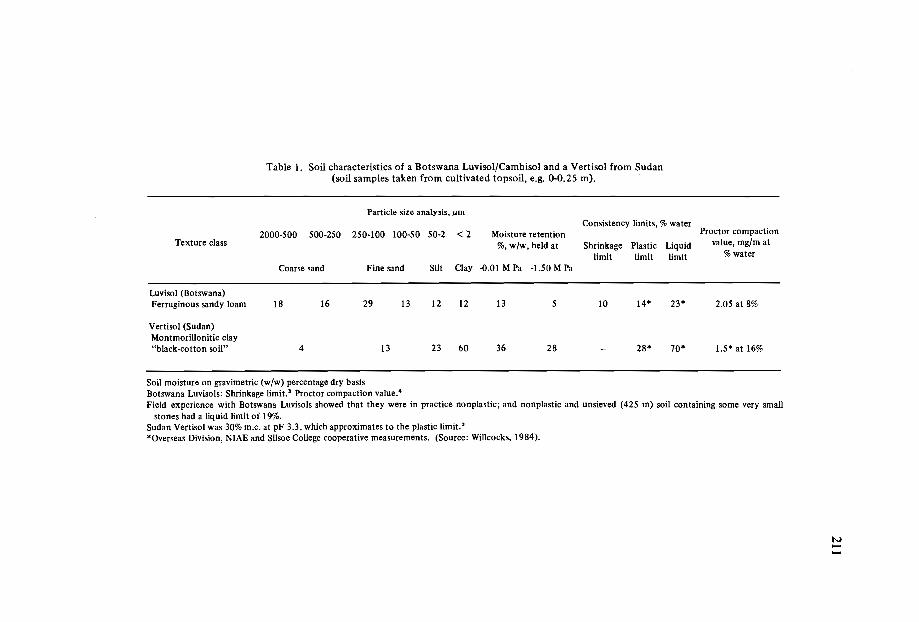
Table I. Soil characteristics of a Botswana Luvisol/Cambisol and a Vertisol from Sudan(soil samples taken from cultivated topsoil, e.g. 0-0.25 m).
Particle size analysis, ,...rnConsistency limits, % water
Proctor compaction2000-S00 SOO-2S0 2S0-100 lOO-SO SO-2 <2 Moisture retentionTexture class %, w/w, held at Shrinkage Plastic Liquid value, mg/m at
limit limit limit % water
Coarse sand Fine sand Silt Clay -0.01 M Pa -I.SO M Pa
Luvisol (Botswana)Ferruginous sandy loam 18 16 29 13 12 12 13 S 10 14- 23- 2.0S at 8%
Vertisol (Sudan)MontmoriUonitic clay"black-cotton soil" 4 13 23 60 36 28 - 28- 70- I.S- at 16%
Soil moisture on gravimetric (w/w) percentage dry basisBotswana Luvisols: Shrinkage limit." Proctor compaction value.'Field experience with Botswana Luvisols showed that they were in practice nonplastic; and nonplastic and unsieved (42S m) soil containing some very small
stones had a liquid limit of 19%.Sudan Vertisol was 30% m.c, at pF 3.3, which approximates to the plastic limit.'-Overseas Division, NIAE and Silsoe College cooperative measurements. (Source: WilIcocks, 1984).
N----

212
The suitability of the edaphic environment for effective crop production can bestbe estimated by excavating soil pits next to crop plants to a depth of about onemetre so that the development of mature crop root systems can be inspected. Croproots are a valuable and readily available dynamic "instrument" as they will clearlyshow if soil physical factors are seriously limiting to root elongation. Since the drybulk density of these clay soils is rarely limiting to crop root growth (i.e. > 1.6 million g/m3
) , and homogenization occurs naturally, it is necessary to consider carefullythe question: "What is the purpose of tillage?"
Climate
The water and heat (temperature) resources of the crop-growing season(s) needs tobe known so that cultural practices can be aimed at optimum climatic conditions forcrop growth. Figure 1 depicts typical rainfed cropping systems in Maharastra, India, andFigure 2 shows how cotton yields are seriously depleted by late planting in Kordofan,Sudan. Timeliness of planting is critically important in rainfed agriculture, and climaticdata is needed to develop optimum rainfed and irrigated systems.
350
300
250EE
200Ci-cc
150It:
harvest100
50
0L..-JL..-L..-L..-1-1-1-1-1-L..-1-=L-~
Jan Mar May Jul Sep Nav Jan
Figure 1. Rainfed cropping in Vertisol region of India (Central Vidarbha Zone, Maharashtra).

213
Yield cotton vs planting date500
AugMidJuly
Date of planting
oMidJune
c.s::.~ 400 .......--.....~.. ,
" ,,,-,
',1969-_...1970
..... Mean of 3 years......-1968
:EQl 300';"-.sl:o:: 100oo
Figure 2. Effect of date of planting on yield of cotton grown on Vertisol in South Kordovan, Sudan:
Case Studies
Rainfed agriculture (single and multiple cropping)
Small-scale manual and mechanized fanningField trials and observations of cropping on Vertisols in countries such as Sudan,
Tanzania and India have clearly shown that timeliness of planting/rainfall and the controlof weeds are the major field constraints to smallholder crop production. Weed controlis most easily achieved by early-season seedbed preparation to enable timeliness of cropplanting, which in turn allows the establishment of an early crop canopy to smotherweeds. The benefits of crop-canopy control are often enhanced by multiple cropping, awell-proven traditional practice amongst many subsistence farmers. Improved culturalpractices for these farmers must make timeliness of planting and subsequent weed controleasier to achieve. .
The lack of labour or draught power does make early (often prerains) cultivation(hoeing) difficult, and attempts have been made to assist farmers with tractor power.This has often failed in smallholder agriculture because of inadequate planning (Gibbet al., 1986/87), and because in small plots tractors are inefficient, logistics are difficult,and backup services to remote areas are extremely costly and usually unsustainable(Fieldson et al., in press; Willcocks, 1981).
Reduced tillage or no-till systems do have a significant role to play in alleviating someof the constraints encountered by the small-scale Vertisol farmers of Africa and India.
Observation trials in small Vertisol fields in southeastern Tanzania clearly showedthat the use of Glyphosate herbicide as a field preparation activity effectively controlled
'difficult stoloniferous and rhizomatous weeds in rice fields. (Glyphosate functions systemically and is much less toxic than most herbicides.) The productive use of many low-

214
cost, hi-tek, but simple, manually operated machines, like the one-wheel pull-alongsprayer (Kemp, 1984), for the application of herbicides is a much better way to controlweeds in smallholder fields than by spending scarce foreign currency on a few large agricultural tractors (Willcocks, 1983). It is acknowledged, however, that the concept of notill agriculture is not generally accepted and there is a significant education/training taskthat is needed at all levels. A comparision of inputs for conventional tractor-ploughingand no-till systems is given in Table 2 and Figure 3. In these calculations it is estimatedthat Glyphosate would only be needed every third year, and the duration of its residualeffect could be longer with good husbandry.
Table 2. Comparison of commercial energy requirements for conventional and reducedprimary field preparation (provisional data).
Conventionalprimary tillage
Reduced system:(T) Tractor (M) Knapsack
Activity Fuel Energy"I/ha MJ/ha
Activity Fuel Energy* ActivityI/ha MJ/ha
EnergyMJ/ha
YEAR ONEPloughPloughing
12022.5 1260
1380
Sprayer 35 Sprayer 50Spraying I.7 95Glyphosate 908 Glyphos. 908(@2 kg/ha a.i.) 1038 958
-- - - - - - - - - - - - - - - - - f-- - - - - - - - - -
YEAR TWO Polydisc 100 Sprayer 50Ploughing 22.5 1380 Tillage 5.0 280 Herbicide 276**
- - - - - - -- ----------- ----------- - - -- -----YEAR THREE Polydisc 100 Sprayer 50
Ploughing 22.5 1380 Tillage 5.0 280 Herbicide 276**
THREE·YEAR TOTAL 4140 1798 1610(100%) (43%) (39%)
*Energy values include allowance for depreciation and repairs of equipment (Leach, 1976), estimatedas +40% of net fuel use (@ 40 MJ/l) for tractors.
**Paraquat herbicide (a1 0.6 kg/ha active ingredient (a.i.). Energy values for herbicides from Green et al.(1977).
From this study it is evident that the use of herbicides requires less than half theinputs needed for conventional tillage. Another advantage of light manually operatedmachines is that their use is not so restricted by wet conditions, which are a severe limitation with heavy tractor-drawn implements.
Refugee smallholder farmers in East Sudan have recently adopted the 'saluka' hoe forplanting their sorghum, as tractor-hire tillage was not always available for timely planting.
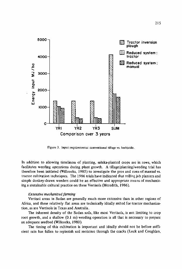
215
5000~ Tractor inversion
plough
[[]] Reduced system:4000 tractor
Cl ~ Reduced system:.J::. manual".., 3000:E-~Q.c:
2000>-Cl...Qlc:lLJ
1000
IYRI YR2 YR3 SUM
Comparison over 3 years
Figure 3. Input requirements: conventional tiIIage vs. herbicide.
In addition to allowing timeliness of planting, saluka-planted crops are in rows, whichfacilitates weeding operations during plant growth. A tillage/planting/weeding trial hastherefore been initiated (Willcocks, 1985) to investigate the pros and cons of manual vs.tractor cultivation techniques. The 1986 trials have indicated that rolling jab planters andsimple donkey-drawn weeders could be an effective and appropriate means of mechanizing a sustainable cultural practice on these Vertisols (Meredith, 1986).
Extensive mechanized [armingVertisol areas in Sudan are generally much more extensive than in other regions of
Africa, and these relatively flat areas are technically ideally suited for tractor mechanization, as are Vertisols in Texas and Australia.
The inherent density of the Sudan soils, like most Vertisols, is not limiting to croproot growth, and a shallow (0.1 m) weeding operation is all that is necessary to preparean adequate seedbed (Willcocks, 1980).
The timing of this cultivation is important and ideally should not be before sufficient rain has fallen to replenish soil moisture through the cracks (Lock and Coughlan,
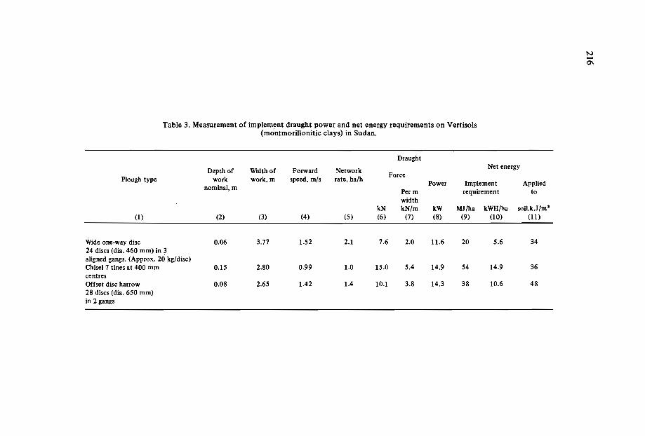
Table 3. Measurement of implement draught power and net energy requirements on Vertisols(mcntmorillonitic clays) in Sudan.
Draught
Depth of Width of Forward NetworkNet energy
Plough type work work,m speed, tnls rate, ha/hForce
nominal, mPower Implement Applied
Per m requirement towidth
kN kN/m kW MJ/ha kWH/ha soil.k.Jjrn?(1) (2) (3) (4) (5) (6) (7) (8) (9) (10) (11)
Wide one-way disc 0.06 3.71 1.52 2.1 7.6 2.0 11.6 20 5.6 3424 discs (dia. 460 mm) in 3aligned gangs. (Approx. zo kg/disc)Chisel 7 tines at 400 mm 0.15 2.80 0.99 1.0 15.0 5.4 14.9 54 14.9 36centresOffset disc harrow 0.08 2.65 1.42 1.4 10.1 3.8 14.3 38 10.6 4828 discs (dia. 650 mm)in 2 gangs
IV-0'\
217
1984) and germinate the first flush of weeds, which can then be killed by the cultivation.Clearly optional timing will not always be possible and some compromise will be necessary to ensure economic utilization of the equipment (see 'managerially optional model'in footnote above). Where prerains tillage becomes a managerial necessity during earlyseason operations, most open cracks will be covered and light rains can be sufficient towet the shallow seedbed profile to a moisture content sufficient for seed germination.This moist seedbed profile will, however, be 'perched' and problems will arise if midseason rains are poor, since water replenishment of the deeper profile via the cracks willhave been inhibited. ,
Tillage equipment for these conditions needs to be high-speed so that each implement can cultivate the maximum area during the short season (Figure 2) before the rainsmake the Vertisols too sticky for tractor-tillage operations. High-speed equipment isessentially low-draught, and since there is no need to loosen Vertisols deeper than 0.1 m,wide weed control equipment is very suitable. Detailed draught measurements were conducted in Sudan to measure the inputs for various tillage systems (Table 3) and establishthe cost of producing one tonne of crop (Figure 4). Deep tillage as conducted in temperate agriculture is very costly under these Vertisol conditions, since it produces acloddy tilth which requires further energy to break down the soil to an acceptable seedbed. This is clearly indicated in Table 3 and Figure 4, where the slow chisel ploughsystem required secondary cultivation and had unacceptably high input costs per hectare.The energy cost of the chisel system per tonne of crop yield was about four times thatachieved with shallow tillage. In addition to this, the seasonal area potential of thedeeper cultivation system would only be about 25% of that achievable with shallowdiscing equipment at 2 ha/h. Clearly, therefore, high-speed shallow cultivation is themost convenient and economic method for the extensive cultivation of Vertisols.
Smallholder agriculture in an extensive region like South Kordofan can benefit fromthis technology, provided several plots can be cultivated at once so as to keep field efficiencies of the equipment high and thereby maintain low input costs.
Figure 4 also shows energy input costs for the cultivation and semi-arid cropping ofa dense Luvisol (sandy loam) in Botswana. It is of interest to note that sorghum production is more energy efficient on the self-loosening Vertisol than on the dense Luvisol.
Irrigated agriculture (single, multiple. and double-cropping)
Irrigation of Vertisols is practiced on the vast Gezira and other Nile-dependentschemes in Sudan. The various systems of irrigation have been described by Coleman(I950), Farbrother (I972) and Spoor (I 963), as summarized in the bibliography byWillcocks and Browning (1986). Mwea is an example of a smaller scheme in Kenya, andEgyptian farmers have practiced the irrigation of Vertisols for centuries.
Deep replenishment of soil moisture is most readily achieved through the cracks,but deep cracks only appear when the soil is dry (at PWP according to Coleman, 1950).Careful programming of irrigation in Egypt means that Vertisols, following the wheatharvest in June, are deeply fissured and therefore suitable for irrigation. The commonly

218
TILLAGE IN SEMI-ARID AREAS
.I-
Vertisols (SudanI
•
Luv;sOls (Botswono)5°riiill40
~ L..J.. ----.JL'-- ......200r--------------,--------------,
,s:~...'!i 150..s,
~(J
b..~ 100
!:;0-.s>-~~ 50..Ciz
Tillaoe system
Figure 4. Net energy inputs (top) per hectare. ( • primary tillage inputs; 0 secondary cultivationswhere necessary); and (bottom) per tonne of crop yield; (lJl sorghum, iil maize; p cotton) for the various tillage treatments on (left) dense Luvisols (Botswana) and (right) Vertisols (Sudan).
used tine tillage is, however, inappropriate and costly since it produces large clods, making seedbed preparation expensive. Since the clod problem is introduced by the methodof primary tillage (chiselling), improved practices need to deal with the cause insteadoftreating the symptom. Improved cultural practices have been recommended (Willcocks,1983) and include no-till and shallow-tillage techniques that produce suitable seedbedtilth with one-pass implements. Polydisc and newer machines, like the twin-shaft DynaDrive developed by NIAE or similar rotary implements, have a role in these conditions.
The production of ridges for furrow irrigation can be difficult in dry cloddy conditions when using tined implements. Instead of loosening the soil from below with a tine
219
or lister body, a technique of progressive "scratching" from the surface can be used toproduce the ridge. The "Lilliston"-type rolling cultivator fitted with helical spider wheelshas proved most effective for weed control and ridge formation.
Many Vertisols are successfully irrigated for single and multiple cropping.Experience with double-cropping is very limited because it is difficult to replenish soilwater adequately without the presence of deep open cracks. Shallow soil profile techniques with frequent watering and the development of common furrow techniques need tobe studied and developed further so that more farmers can realistically capitalize on thedouble-cropping potential of Vertisols. This will need a concentrated effort by rnultidisciplinary teams, as outlined in the section on farming systems above.
Conclusions/Recommendations
An improved cultural practice for Vertisols in semi-arid regions needs to:* conserve scarce water and energy resources,* increase the farmers' ability to achieve timely planting, and* facilitate effective control of weeds.The identification and implementation of relevant research needs will best be
achieved by multidisciplinary FSA teams (see the section on farming systems above).Inspection of crop root systems in Vertisols will show that inherent soil density is
not limiting to root elongation. This is because of the self-loosening nature of the soil, asmentioned in the section on farming systems above. Deep tillage is, therefore,unnecessary, and it will usually produce clods which make seedbed preparation difficultand expensive.
Smallholders in rainfed agriculture need low-input sustainable farming systems. Reduced-tillage hoe-planting systems enable timeliness of planting and improved weedcontrol through row cropping. No-till cultural practices show great promise on Vertisols,and they can be efficiently mechanized with manual or animal-powered rolling 'jab planters' and 'pull-along' sprayers for the application of herbicides like Glysophate, as discussed in the section on mechanized farming above.
Extensive rainfed farming of Vertisols is economic, provided high-speed (2 ha/h)shallow (max 0.1 m) weeding implements are used as a primary, one-pass tillage operation, as pointed out in the discussion on extensive mechanized farming. This section alsopoints out that irrigated agriculture for single and multiple cropping on Vertisols is wellestablished, but there is still room for some reduction in inputs.
There is an urgent need for a practical and adoptable cultural practice for doublecropping on Vertisols. It is the author's belief that an in-depth study of the managementof cracks would be a reliable R&D approach to achieving appropriate farming systemsfor double-cropping with irrigation.
It is strongly recommended that a multidisciplinary group be set up and charged withthe responsibility of initiating and implementing an R&D programme to produce realistic and easily managed double-cropping systems for Vertisols.
220
References
DE'VOS, J.H. and VIRGO, K.J. 1969. Soil structure in Vertisols of the Blue Nile claypans, Sudan. Journal ofSoil Science 20( 1): 189-206.
FIELDSON, R., SEAGER, P. and VOSE, D. In press. Public sector tractor hire schemesin developing countries. OD/NIAE Report no. OD/86/2. Bedford, U.K.: AFRC.95p.
GIBB, J.A.C., WILLCOCKS, T.J. and VOSE, D.E. 1986. Non-engineering factors affecting agricultural mechanization schemes. ASAE paper no. 86-5004. 15p.
KEMP, D.C. 1984. A new pull-along sprayer for herbicides capable of adaptation fortreating field plots. Pages 185-190 in: Proceedings of the 6th International Conference on Mechanication of Field Experiments (IAMFE 6J, Dublin, 1984.
LUCK, R.J. and COUGHLAN, K.J. 1984. Effects of zero tillage and stubble retentionon some properties of a cracking clay. Australian Journal of Soil Research 22 :91-98.
MEREDITH, J.R. 1986. OD/NIAE/Euro-Action Accord Collaborative Work Program.:OD/NIAE Report no. OD/19/86. Bedford, U.K.: AFRC. 36p.
NEWM~N, A.L. 1983. Vertisols in Texas - Some Comments. Soil Conservation Service,Temple, Texas: U.S. Department of Agriculture. 27p.
SMITH, G.D., YULE, D.F. and COUGHLAN, K.J. 1984. Soil physical factors in cropproduction on Vertisols in Queensland, Australia. Pages 87-104 in: Proceedings ofthe International Workshop on Soils, 12-15 September, 1983. Townsville, Queensland, Australia: ACIAR.
VENKATSWARLU, J. 1983. Soil problems with Vertisols, with particular reference tosurface soil conditions and water relations. Pages 105-115 in: Proceedings of theInternational Workshop on Soils, 12-15 September, 1983. Townsville, Australia:ACIAR.
WILLCOCKS, T.J.W. 1980. Tillage requirements of Vertisol soils in South Kordofan andthe role of the agricultural mechanization project in Kadugli, Sudan. OD/NIAEReport. Bedford, U.K.: AFRC. 46p.
WILLCOCKS, T.J. 1981. Reducing the energy required for mechanized cultivations indeveloping countries. Pages 1945-1955 in: Beyond the Energy Crisis, Opportunityand Challenge, vol. Ill, eds. R.A. Fazzolare and B.S. Smith. Third InternationalConference on Energy Use Management, Berlin. Oxford: Pergamon Press.
WILLCOCKS, T.J. 1983. Recommendations for the improvement of tillage practices(Egypt). A Consultants' Report for the NIAE/CEEMAT Program with the MenufiaSohag Mechanization Project. 103p.
WILLCOCKS, T.]. 1984a. Some observations and recommendations for the improvement of tillage practices on Vertisols. OD/NIAE/ODA publication. 28p.
WILLCOCKS, TJ. 1984b. Tillage requirements in relation to soil type in semi-arid rainfed agriculture. Journal ofAgricultural Engineering Research 30(4): 327-336.
WILLCOCKS, T.]. 1985. Development of sustainable cultural practices for rainfed cropping on Vertisols at Qal En Nahal, E. Sudan. OD/NIAE Report no. OD/85/2F.Bedford, U.K.: AFRC. 28p.
WILLCOCKS, TJ. and BROWNING, J. 1986. Vertisols ('black' cracking clays): A bibliography with some abstracts/extracts, content analyses and comments. Overseas Division. Bedford, U.K.: AFRC Engineering. 121p.
MANAGEMENT PROBLEMS OF COTTON ON VERTISOLSIN THE LOWER SHIRE VALLEY OF MALAWI
A.J.B. Mitchell*
Abstract
A soil survey in 1971 pointed to a number ofpossible causes for the uneven growthof cotton, which was particularly apparent in dry years. Lack ofwater in the root zonecould be caused by degradation of the surface structure (accelerated runoff), saline orsodic soil at shallow depth, or shallow gravel layers.
At the same time a serious increase in soil erosion could be attributed to two maincauses:
o rapid expansion of the area under cotton, including cultivation of the diffusedrainage lines;
o progressive decline in the size of topsoil aggregates over a period of 4-5 yearsafter the land is brought under cultivation.
A research programme was initiated in 1973 to investigate management techniquesthat would maintain crop yields and reduce erosion. The initial findings were that conventional soil conservation techniques could result in crop reductions, and showed thatthe farmers' reluctance to follow the recommended practice of planting on ridges wasbased on sound experience; the seed failed to germinate in dry years, and floods afterheavy rain could wash away the ridges. Soil conservation could result in waterlogging inwet years, though its effects could be countered by nitrogen applications.
Cotton yields in a year ofgood rains showed a marked local fluctuation related togilgai, with higher yields from the gilgai hollows despite apparent prolonged waterlogging.This effect was attributed to the higher nitrogen content of the soils in the hollows.
*Land Resources Development Centre, Overseas Development Administration, Tolworth Tower,Surbiton, Surrey, England.
222
Introduction
The Shire Valley of Malawi is the southernmost extension of the East African riftvalley, carrying the river that flows from Lake Malawi into the Zambezi. It is 16° southof the equator. Part of the floor of the lower Shire Valley contains Vertisols derivedmainly from Tertiary basalts that outcrop on the western wall of the rift. The soils,locally known as Makande, have developed in alluvial and colluvial deposits of variousages. Repeated cycles of erosion and deposition have left a complex pattern in whichthe Vertisols alternate with calcareous rubble on old denuded ridges, and recentlydeposited clays in diffuse drainage lines.
The Vertisols lie between 50 m and 180 m asl, and the climate is characterized byvery hot summers and warm winters. The annual rainfall is 750 mm, 90% of which fallsin the summer months of November to April. The soils are associated with a distinctgilgai microtopography accompanied by significant variations in soil characteristics. Thesoils under the gilgai ridges are Typic Chromusterts (Soil Taxonomy, USDA, 1985);while those under the hollows are Typic Pellusterts. Under the FAO Soils Legend (FAO,1974) they are Chromic Vertisols and Pellic Vertisols respectively.
The Makande soils have been noted for many years for their ability to produce highyields of cotton under continuous cultivation, without fertilizers. Consequently the areahas been the subject of a number of schemes to promote cotton production, including amajor initiative financed by the World Bank that started in 1968. Shortly after the startof this project (The Chikwawa Cotton Development Project, which became phase 1 of theShire Valley Agricultural Development Project), there was an alarming increase in thevisible evidence of soil erosion, and there were reports of very patchy cotton growth,particularly in years when the rains ended earlier than usual.
A soil survey in 1971 (Mitchell, 1973) pointed to two main causes for the increase insoil erosion:
The rapid expansion of the area under cotton, including cultivation of the poorlydefined drainage lines.Progressive decline in the size of the soil aggregates in the topsoil during the first4-5 years after the land is first brought under cultivation.The uneven growth of cotton appeared in many cases to be related to the availability
of water in the root zone. Variations could be caused by:* local runoff due to soil structural deterioration under continuous cultivation,* the presence of saline or sodic soil at shallow depth,* shallow gravel layers.Some of the variation was related directly to the gilgai micro topography characteris
tic of the Makande soils.A variety of other factors could also affect cotton growth, including local water
logging, weed competition, and attack by insect pests (including harvester termites).The Agricultural Research Corporation of Malawi (ARCM) started a programme of
investigations into the productivity of the Mukande soils, starting in 1973/74. The_ARCM was dissolved in April 1975, but the research programme was continued under the
223
Ministry of Agriculture, and reports of the investigations in the 1973/74 and 1974/75seasons are available. The purpose of the present paper is to review briefly some of theobservations from the 1971 soil survey, and how they relate to the results of subsequenttrials.
Soil Erosion and Conservation
While the Mukande soils were under their natural grassland, the drainage lines werediffuse and poorly defined. A vigorous grass species, Lachaemum brachyatherum, grewin the wetter places and held the surface .soil with a dense mar of rhizomes that slowedand diffused the flow of runoff water. When the land was cleared for agriculture, no effort was made to leave the drainage lines under grass; in fact the topography is so gentlethat it was not easy to discern them. The cultivation techniques - hand-hoeing andplanting on the flat - did nothing to prevent runoff, which now flowed more rapidly andbegan to scour out the drainage lines.
When the land is newly opened, the soil maintains a comparatively coarse crumbstructure in the topsoil, but this deteriorates gradually so that after about four years thesoil can be seen to comprise much smaller aggregates (Table I) and sometimes to showevidence of surface capping by rain. These smaller aggregates are very much more transportable by water, and at the time of the soil survey in 1971 considerable alluvial depositsof this material had built up in some streambeds. The limited number of observationsin Table I suggest that a similar decline occurs in alluvial soils, though more gradually.Interestingly, the one example that could be found of former cultivated land reverted tograss showed that tinder a good grass cover soil aggregates might be restored to theiroriginal size-in about three years.
Apart from the loss of topsoil, the increased erosion reflects a high rate of surfacerunoff, and reduces crop yields directly through water shortage in a region of near-marginal rainfall. The research programme begun in 1973 included studies of methods ofwater conservation ranging from flat cultivation on the natural slope (the control plots)to levelled plots surrounded with bunds 0.15-0.2 m high (Jones and Herbert, 1975, andMalawi Ministry of Agriculture, 1980). The latter, with few exceptions, held all the rainthat fell on the plots. The effect of the conservation treatments is shown in Table 2 forthe two years 1973/74 and 1974/75, the first with good rains and the second with poor,badly distributed rains.
Soil water measurements to a depth of 1.2 m confirmed that the three water conservation treatments retained water in the soil more effectively than the natural slope. Thiswas accompanied by a reduction in crop yields in 1973/74, apparently due to waterlogging; from February to April the crops were yellow and sickly-looking. A possible effectof the waterlogging was to reduce the nitrogen supply to the crop; the effect of appliednitrogen was to raise the control plot yield by about 15% and eliminate the yield reductiondue to the water conservation treatments.

Table 1. Average sizes of water-stable aggregates of Ngabu soils in relation to the length of time under cultivation(from Mitchell, 1973).
Average aggregate diameter (mm)
Soil type Land cultivated for (number of years)Grassland
2 3 4 5 6-7 8-9 10-11 12-13 More than 13
Old alluvium of mixed 2.6 1.8 1.7 1.0 1.3 0.6origin (8) (11 ) (2) (2) (2) (7)
Recent alluvium derived 2.2 1.3 0.8from basalt (2) (3) (1)
Recent alluvium of mixed 1.5 1.8 0.6origin (2) (2) (2)
Vertisols derived from 1.9 1.6 1.0 0.6 0.5 0.6basalt (4) (5) (2) (2) (2) (7)
Vertisols of mixed origin 2.1 1.7 1.6 1.3 0.8 0.9 1.1 0.9(l0) (4) (2) (4) (3) (6) (4) (2)
Note: Figures in brackets denote the number of samples in each category
IVIV.j:>.
225
Table 2. The effect of rainwater conservation by different methods oncotton yields at two sites in 1973/74 and 1974/75.
Rain (mm) between Yield (kg/ha)Plot and treatment November and April
1973/74 1974/75 1973/74 1974/75
NSANGWE 802 484
Control (no conservation) 1869 1584Flat planted on natural slope
Tied ridges: ridges on the 1607 1206contour with cross-ties
Levelled land: cotton planted 1404 1308on ridges
MPHONDE 695 537
Control 1733 941
Tied ridges 1484 1085
Levelled land, flat planted 1507 1101
Levelled land, ridged 1560 1135
In the following year (I 974/75), most water conservation treatments improvedcotton yields, except at Nsangwe where cotton planted on ridges failed to germinate inthe poor early rains and had to be replanted. This raised an interesting problem: localfarmers had been unwilling to adopt extension advice that they should plant cotton onridgesfor good soil conservation. Their normal practiceis to plant on the flat. The research team observed that the farmers' technique of sowing cotton was to scoop a smallhollow, about 0.3 m long, 0.25 m wide and 0.1 m deep, with a hoe, and plant the seed init uncovered. After light rains the seed remained uncovered and did not germinate, butafter heavier showers local runoff concentrated in the hollows covered the seeds, andenabled the crop to germinate successfully after only 12-15 mm of rain, oompared to atleast 50 mm for conventional planting.
There was very little waterlogging in 1974/75 apart from a short period in late February, and applied nitrogen had no effect on either the control plots or the water conservation treatments.

226
Another problem with ridge cultivation appeared when part of a trial was damagedby a flood 20 days after germination in 1973/74. Cotton sown on the ridges was destroyed while that planted on the flat was undamaged.
Uneven Growth of Cotton
The rains of 1970/71, immediately before the soil survey, had been below average,with very little rain after the end of February. Consequently it was possible to study anumber of occurrences of uneven cotton growth in some detail, including physical andchemical soil analyses. Uneven growth could be divided into two broad categories:regular patterns associated with gilgai microrelief, and other occurrences not associatedwith gilgai.
Uneven crop growth associated with gilgai
Regular 'ripple' patterns could be seen during the soil survey, where poor, stuntedcotton grew on the gilgai ridges while that in the hollows was tall and well developed.This pattern was often very clear on older cultivated land, though on newly opened landnearby the cotton grew as well on the ridges as in the hollows.
Certain differences between the soils of the ridges and the hollows were common toall the Vertisols. Typically the soil of the ridges was lighter-coloured or browner thanthat of the hollows, had slightly less clay, a lower organic-matter content and a less pronounced structure. Gravel and small stones were often found on the ridges but not inthe hollows. The subsoil cracked more widely in the hollows, and the pattern of crackswas more visible on the surface. Where it could be distinguished, the substratum approached closer to the surface under the ridges. There were corresponding differences inthe chemical characteristics; the ridges had higher soil reaction, exchangeable sodium andoften exchangeable magnesium, but lower organic matter, phosphorus, potassium and exchangeable calcium.
Detailed examinations of the soil profiles under several examples of uneven cottongrowth showed that the roots of poor cotton plants on gilgai ridges were turned asideat shallow depth (30 cm or less) while the roots of good plants under neighbouring gilgairidges went down to below 45 cm. The subsoil under the poor plants was compact, withlarger structures and fewer, finer cracks than under good plants. Soil analyses showedthat this was associated with a high exchangeable sodium percentage. The plants in thehollows where the exchangeable sodium percentage was lower were unaffected. At onesite the old land (cultivated for 20 years) displayed very uneven growth, while immediately adjoining it a recently opened field, cultivated for only two years, carried a uniform,good crop. The ridge soil in the new field was well structured; the subsoil was less compacted and had many wide vertical cracks. It appeared that the sodic subsoil had onlybecome compacted as a result of the long period of continuous cultivation.

227
One site that displayed a regular 'ripple' pattern of very poor cotton on the ridgesbut good cotton in the hollows had no visible or analytical soil differences that couldexplain the condition, except that the soil on the ridges formed a very loose tilth thatwould make a poor seedbed. There was a lot of ungerminated seed on the ridges, whichindicated that the farmer had had to replant several times. The variation of cottongrowth with gilgai was studied in detail by Bradshaw (1976), who concluded that themain cause' is the wider cracking in the hollows (allowing penetration of water into theprofile), and the higher clod density of the ridge soils.
The ARCM research team sampled the soil moisture under gilgai ridges and hollowsduring 1973/74 (Jones and Herbert, 1975). The progress of moisture down the profileis charted in Table 3, where it can be seen that the hollows became very much wetter, andextended to a greater depth. This was during a year of good rains; in a year of poor rains,particularly when they end early, the ridge is not likely to be wetted below 60 cm.
Table 3. The wetting of soils under ridge and hollow of gilgai microreliefduring the rains (adapted from Jones and Herbert, 1975).
Moisture Increase in moisture as percentage of moistureLocation content at content at start of rains, after:
and depth start of(cm) rains I month 2 months 3 months 4 months
(w/w%) (178 mm)' (384 mm) (96 mm) (126 mm)
Ridge0-15 22 40 100 50 135
15-30 25 20 85 45 9530-45 29 3 60 25 804HO 30 0 35 35 5560-75 31 0 20 20 5075-90 30 0 10 10 5590-105 31 0 6 6 45
105-120 32 0 0 3 25
Hollow0-15 20 115 200 130 200
15-30 27 75 120 60 10530-45 29 50 90 60 954HiO 31 30 75 60 7560-75 36 15 30 40 5075-90 40 3 8 20 3590-105 41 0 3 5 25
105-120 40 0 0 0 15
I Rainfall during each month is shown in brackets.
228
The field capacity of the soil is at a moisture content of about 45%. The topsoil ofthe ridges was slightly above this for brief periods, but the hollows were at or above fieldcapacity from the first month onwards and were probably waterlogged for a considerabletime. Despite this the cotton grew taller in the hollows, and yields on similar land in thefarmer's field adjacent to the sampled area were twice as high in the hollows. The studywas not repeated in 1974/75, a much drier year.
Soil chemical analyses from the same gilgai showed no consistent differences betweengilgai ridges and hollows in mechanical analysis, pH, available phosphorus (Olsen),exchangeable bases, or cation-exchange capacity. Organic carbon and total nitrogen werealways. higher in the furrows, which may have been the reason for the higher cottonyields despite the waterlogging; this would agree with the findings of the water conservation trials discussed earlier, though the apparent interaction between waterlogging andnitrogen supply could not be explained satisfactorily.
Uneven cotton growth not associated with gilgai
. Soil-related poor cotton growth was recorded during the soil survey in depressionsand seepage areas where the soil was saline or waterlogging was prolonged, and on ridgeswhere erosion had left less than 50 cm of vestigial Vertisol over lime rubble. These wereisolated occurrences, and since little can be done economically to improve them, theywere not followed up in the research programme. They are 'the tip of an iceberg',however, as the accelerated soil erosion will denude the topsoil above other gravel ridgesand saline patches.
Conclusions
Soil erosion
The reason why soil erosion increases when grassland is replaced by arable croppingof Vertisols is easy to identify: removal of the perennial cover results in a faster flow ofrunoff, while cultivation in successive years reduces the size of the topsoil aggregates. Thesolutions are less easy to find; drainage patterns are often intricate, and conventional soilconservation measures can result in reduced crop yields. Control of soil water is important, to maximize infiltration but avoid waterlogging. Although the effects of waterlogg~ng can be countered by nitrogen application, this will significantly raise the cost of cropproduction. There is a clear message for researchers and extension workers: to learnabout the farmers' own systems and to build soil conservation recommendations aroundthem.
Uneven growth of cotton
Availability of water seems to be the main factor causing local variations in crop

229
growth. When this is associated with the gilgai micro relief it appears gradually over anumber of years after the land is brought under cultivation, commonly due to deterioration of the structure of both topsoil and subsoil in places where the subsoil is poorlyflocculated due to sodium. The obvious solution would seem to be to introduce grassfallows to restore the surface structure, but land pressure is such that this option maynot r be available. Effective soil conservation is essential, to halt the erosion that iscontinuing to expose unproductive gravel and saline subsoils.
Implications of the soil patterns for research
Any programme of research on Vertisols must take account of the intricate patternsof local soil variation - most, though not all of them, related to gilgai, that can producestrongly contrasting effects on crop growth. Although one can say that these effectsaverage out across a field, it is important to study them in detail, .since potentiallyvaluable findings can otherwise be masked.
References
BRADSHAW, P.N. 1976. The properties and genesis of the black cotton soils of theLower Shire Valley, Malawi. MSc Thesis, Soil Science Department, University ofAberdeen.
FAO (Food and Agriculture Organization of the United Nations). 1974. FAO-UNESCOSoil Map of the World. Volume 1: Legend. Rome: FAO.
IONES, E. and HERBERT, R.F. 1975. Final Report: Malawi 1973-74. Cotton ResearchReports, Soil Productivity Research Unit, Agricultural Research Station, Bvumbwe.Ldndon: Cotton Research Corporation. pp. 67-83.
MALAWI MINISTRY OF AGRICULTURE. 1980. Soil productivity of the Lower ShireValley. Annual Report of the Department of Agricultural Research for the year1974/75. pp. 325-343.
MITCHELL A.I.B. 1973. Reconnaissance soil survey of the cotton growing areas aroundNgabu. Department of Agriculture, Soil Survey Section, Lilongwe, Malawi.
USDA (U.S. Department of Agriculture). 1985. Keys to Soil Taxonomy. Technical Monograph no. 6. Soil Management Support Services, U.S. Department of Agricultureand Agency of International Development, Washington, D.C.: U.S. GovernmentPrinting Office.


Sixth session: Implementation of the Vertisols network
Chairmen: Ors. R.F. van de Weg
Or.A. Woldeab

SOIL VARIABILITY, EXPERIMENTAL DESIGN, AND DATA PROCESSING
W. Siderius*
Abstract
In contrast to the settled opinion that Vertisols are homogeneous soils, this reviewindicates that they may vary greatly in almost all their properties. This variability iscaused by the different influences of the soil-forming factors, of which the climate, theparent material and the topography are especially important. The one unifying feature ofVertisols is the process of swell and shrink under the influence ofdifferent moisture contents, which is caused by the predominance of clay minerals from the smectite group.This physical characteristic is ofgreat importance in determining the suitability ofa particular Vertisol for cultivation. Suggestions are made for improving the description ofVertisols, and guidelines aregiven for setting up research and data-processingprojects.
Vertisol Variability
Variability in soils is caused by the (inter) action of independent soil variables, andthis also holds true for Vertisols. These independent soil variables that define any soilsystem are described by Jenny (1941) as follows:
s = f(c, 0, p, r, t, m), in which:s = soil system, or a function of "f", which is dependent on:
c = climate,o = organisms,p = parent material,r = relief (or topography),t = time, andm= man.
* International Institute of Aerospace Survey and Earth Sciences (ITe), P.O. Box 6, Enschede 7500AA, The Netherlands.

234
Climate
The factor 'climate' in this paper relates to the semi-arid tropics (SAT). For the definition of a semi-arid climate, the proposal by Kranz and Kampen (1978) is adhered to.This definition is based on climate analysis of the Indian subcontinent, but seems wellapplicable to other regions of the world. The SAT are defined as regions where themonthly rainfall exceeds the potential evapotranspiration in 2-7 months and where themean monthly temperature is above 18°C.
A further subdivision is made with regard to the number of wet months (p>ET): drySAT have 24.5 wet months, and wet-dry SAT have 4.5-7 wet months (Swindale andMiranda, 1984). The alternating dry and wet periods associated with these climates arethought to be indispensable to the formation of Vertisols (Hubble, 1984; Blokhuis, inpress; Wilding, 1985a). Although a semi-arid climate may occur over large areas, considerable variations have been observed, leading to a certain zonation which is inducedprimarily by the rainfall pattern. For the Sudan, this zonation has been recognized byBlokhuis (1980) and Jewitt et al. (1979), and is associated with a number of soil properties and the grade in which they occur, e.g. stronger development under higher contrastbetween the wet and the dry months (xeric to ustic soil moisture regimes) of surfacemulch, gilgai,crack pattern, and structure.
On the whole, the climate leads to an accumulation of constituents (like Ca, Mg andNa) in a neutral to alkaline environment, which induces the formation of smectite clayminerals. This condition has been reported by most studies of Vertisol formation undersemi-arid conditions, viz. Ahmad (1983), Buringh (1979), Dudal (1965). The contrastingtemperatures induce rapid mineralization of organic matter and promote physicalweathering of primary fragments, especially in the transitional zone between the arid andsemi-arid regions.
The occurrence of acid conditions in Vertisols in SAT regions has not been reported.Acid Vertisols occur, however, outside these areas under more humid conditions, as isthe case with the Vertisols in Trinidad (Ahmad, 1985). The influence of a groundwatertable for most SAT regions is negligible as it often occurs at too great a depth. Exceptions are made for situations where local relief is dominant, for example in depressionalareas which are subject to ponding or flooding and for which aquic soil moisture regimeshave been recognized (Blokhuis, 1985; Comerma, 1985; Grossman et al., 1985).
The parent material
A large number of studies deal with the composition of the parent material onwhich or from which Vertisols have been developed; rocks are usually rich in ferromagnesian and/or calcareous minerals (Dudal, 1965; Mohr et al., 1972; Nyamapfene, 1984).They all have a relatively low percentage of silica and a high percentage of alkaline earthmetals (Ca, Mg, K, Na) in the primary mineral fraction. After undergoing hydrolysis andbeing SUbjected to the prevailing climatic conditions, the formation of minerals from the
.smectite group is common, as is indicated by detailed studies on this subject (Buursink,

235
1971; Alien and Fanning, 1983). The high Si02/AI20 3 ratio of the clay and the positivecorrelation with the equally high K2 0+Na2 0+MgO/Al203 ratio is indicative for Vertisols in the SAT (Siderius, 1973).
In some areas, notably where vulcanism or wind erosion is or has been active, theauthochtone parent material and/or soils may be "contaminated" by particles from duststorms or volcanic ash. This admixture may have a positive or negative effect on thesoils, e.g. increasing the chance of sealing, or increasing the fertility of the soil (Harmse,1967). The churning capacity of the soil material, and also leaching and the biologicalmixing of the soil, may cause a fairly rapid homogenization of these constituents withthe original ones.
Organisms
The activity of organisms as an independent variable in the formation of Vertisols hasreceived little attention so far. However macromorphological observations point to thepresence of small rodents, in addition to earthworms, termites, spiders, etc. Micromorphological observations of a Vertisol from Botswana confirmed the. presence of isotubulesand agrotubules in the subsoil of a Vertisol, indicating that the process of homogenizationthrough soil fauna was active (Siderius, 1973). Similar observations were made by Sleeman and Brewer (1984). There is little known about changes in biological activity underdifferent management practices.
Topography
The influence of topography (or relief) on soil formation is well known, and appliesto Vertisols as it does to other soil groups. The position of Vertisols in the landscape inrelation to the parent material has led to the introduction of terms like "Lithomorphic"and "Topomorphic" Vertisols (Jewitt et al., 1979; Murdoch, 1970; Comerma, 1985). Thefirst term refers to the dominancy of the soil parent rock on the formation of the Vertisol, while the latter indicates that the variable "topography" is the major soil-formingfactor.
Lithomorphic Vertisols are usually less deep but may be better drained than Topomorphic Vertisols, which generally occur in relatively low-lying areas. This situationoccurs frequently in denudational landscapes. Large flat to gently sloping areas of Vertisols are found in the Sudan and India. In the first case, the alluvial plain of the Whiteand Blue Niles form the Vertisol landscape; and in the second case, the occurrence ofmafic rock in flat position causes the formation (Blokhuis, 1982; Virmani et al., 1985).
Vertiso1s in topomorphic position may have formed on materials leached from surrounding higher areas, which may be underlain by acid rocks. This situation has beenobserved, for example, in Nigeria and Uruguay (Purnell, 1979; Rossignol, 1983). Theoccurrence of Vertisols in rather flat topography results in slow water movement and prevents fast removal of soluble constituents. In some cases this may cause anaerobic conditions in the deep subsoil, and/or perched water tables.
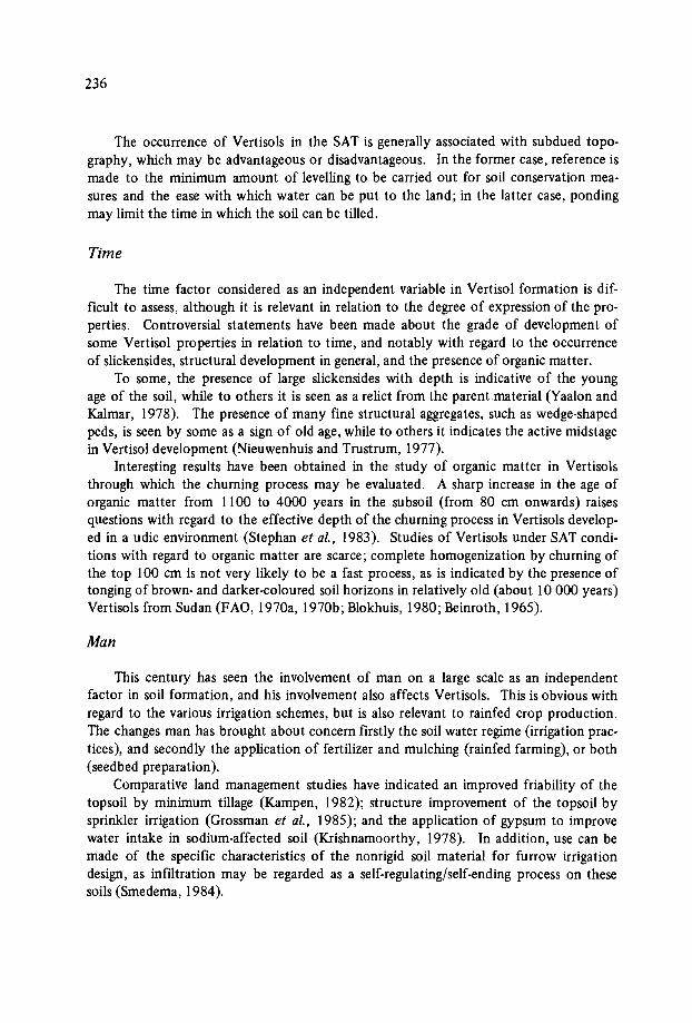
236
The occurrence of Vertisols in the SAT is generally associated with subdued topography, which may be advantageous or disadvantageous. In the former case, reference ismade to the minimum amount of levelling to be carried out for soil conservation measures and the ease with which water can be put to the land; in the latter case, pondingmay limit the time in which the soil can be tilled.
Time
The time factor considered as an independent variable in Vertisol formation is difficult to assess, although it is relevant in relation to the degree of expression of the properties. Controversial statements have been made about the grade of development ofsome Vertisol properties in relation to time, and notably with regard to the occurrenceof slickensides, structural development in general, and the presence of organic matter.
To some, the presence of large slickensides with depth is indicative of the youngage of the soil, while to others it is seen as a relict from the parent.material (Yaalon andKalmar, 1978). The presence of many fine structural aggregates, such as wedge-shapedpeds, is seen by some as a sign of old age, while to others it indicates the active midstagein Vertisol development (Nieuwenhuis and Trustrum, 1977).
Interesting results have been obtained in the study of organic matter in Vertisolsthrough which the churning process may be evaluated. A sharp increase in the age oforganic matter from 1100 to 4000 years in the subsoil (from 80 cm onwards) raisesquestions with regard to the effective depth of the churning process in Vertisols developed in a udic environment (Stephan et al., 1983). Studies of Vertisols under SAT conditions with regard to organic matter are scarce; complete homogenization by churning ofthe top 100 cm is not very likely to be a fast process, as is indicated by the presence oftonging of brown- and darker-coloured soil horizons in relatively old (about 10 000 years)Vertisols from Sudan (FAO, 1970a, 1970b; Blokhuis, 1980; Beinroth, 1965).
Man
This century has seen the involvement of man on a large scale as an independentfactor in soil formation, and his involvement also affects Vertisols. This is obvious withregard to the various irrigation schemes, but is also relevant to rainfed crop production.The changes man has brought about concern firstly the soil water regime (irrigation practices), and secondly the application of fertilizer and mulching (rainfed farming), or both(seedbed preparation).
Comparative land management studies have indicated an improved friability of thetopsoil by minimum tillage (Kampen, 1982); structure improvement of the topsoil bysprinkler irrigation (Grossman et al., 1985); and the application of gypsum to improvewater intake in sodium-affected soil (Krishnamoorthy, 1978). In addition, use can bemade of the specific characteristics of the nonrigid soil material for furrow irrigationdesign, as infiltration may be regarded as a self-regulating/self-ending process on thesesoils (Smedema, 1984).
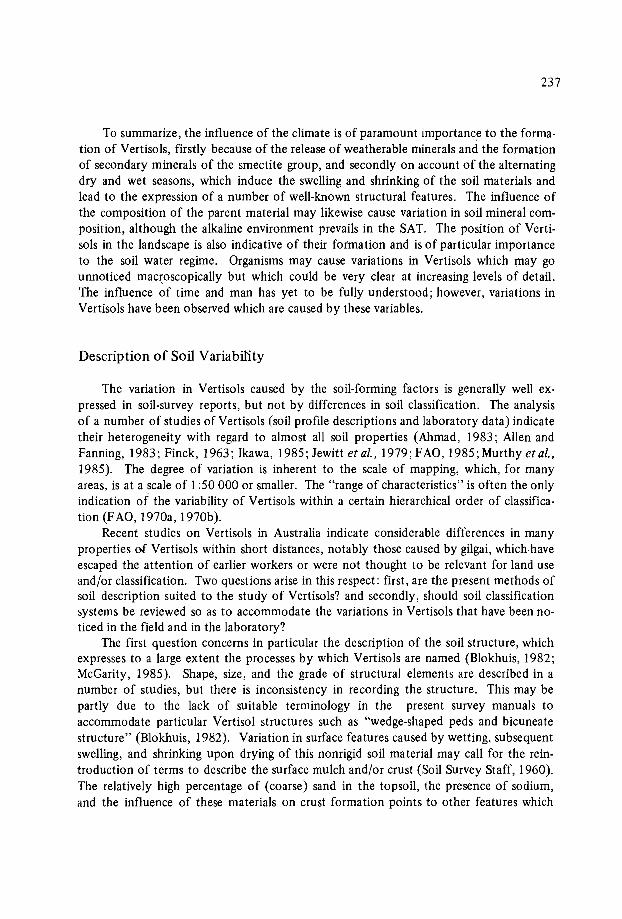
237
To summarize, the influence of the climate is of paramount importance to the formation of Vertisols, firstly because of the release of weatherable minerals and the formationof secondary minerals of the smectite group, and secondly on account of the alternatingdry and wet seasons, which induce the swelling and shrinking of the soil materials andlead to the expression of a number of well-known structural features. The influence ofthe composition of the parent material may likewise cause variation in soil mineral composition, although the alkaline environment prevails in the SAT. The position of Vertisols in the landscape is also indicative of their formation and is of particular importanceto the soil water regime. Organisms may cause variations in Vertisols which may gounnoticed macroscopically but which could be very clear at increasing levels of detail.The influence of time and man has yet to be fully understood; however, variations inVertisols have been observed which are caused by these variables.
Description of Soil Variability
The variation in Vertisols caused by the soil-forming factors is generally well expressed in soil-survey reports, but not by differences in soil classification. The analysisof a number of studies of Vertisols (soil profile descriptions and laboratory data) indicatetheir heterogeneity with regard to almost all soil properties (Ahmad, 1983; Alien andFanning, 1983; Finck, 1963; Ikawa, 1985; Jewitt et al., 1979; FAO, 1985; Murthy et al.,1985). The degree of variation is inherent to the scale of mapping, which, for manyareas, is at a scale of 1:50 000 or smaller. The "range of characteristics" is often the onlyindication of the variability of Vertisols within a certain hierarchical order of classification (FAO, 1970a, 1970b).
Recent studies on Vertisols in Australia indicate considerable differences in manyproperties of Vertisols within short distances, notably those caused by gilgai, which haveescaped the attention of earlier workers or were not thought to be relevant for land useand/or classification. Two questions arise in this respect: first, are the present methods ofsoil description suited to the study of Vertisols? and secondly, should soil classificationsystems be reviewed so as to accommodate the variations in Vertisols that have been noticed in the field and in the laboratory?
The first question concerns in particular the description of the soil structure, whichexpresses to a large extent the processes by which Vertisols are named (Blokhuis, 1982;McGarity, 1985). Shape, size, and the grade of structural elements are described in anumber of studies, but there is inconsistency in recording the structure. This may bepartly due to the lack of suitable terminology in the present survey manuals toaccommodate particular Vertisol structures such as "wedge-shaped peds and bicuneatestructure" (Blokhuis, 1982). Variation in surface features caused by wetting, subsequentswelling, and shrinking upon drying of this nonrigid soil material may call for the reintroduction of terms to describe the surface mulch and/or crust (Soil Survey Staff, 1960).The relatively high percentage of (coarse) sand in the topsoil, the presence of sodium,and the influence of these materials on crust formation points to other features which
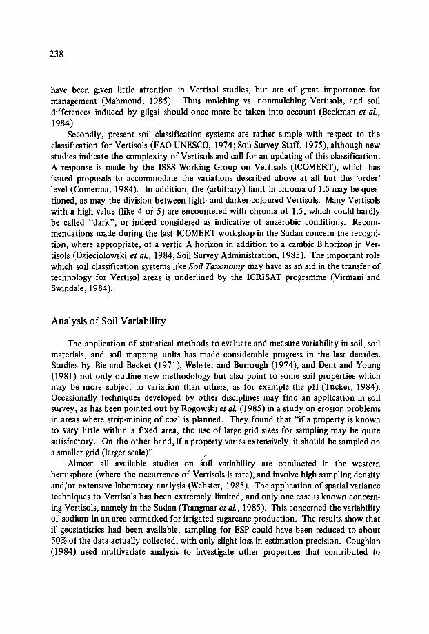
238
have been given little attention in Vertisol studies, but are of great importance formanagement (Mahmoud, 1985). Thus mulching vs. nonmulching Vertisols, and soildifferences induced by gilgai should once more be taken into account (Beckman et al.,1984).
Secondly, present soil classification systems are rather simple with respect to theclassification for Vertisols (FAO-UNESCO, 1974; Soil Survey Staff, 1975), although newstudies indicate the complexity of Vertisols and call for an updating of this classification.A response is made by the ISSS Working Group on Vertisols (ICOMERT), which hasissued proposals to accommodate the variations described above at all but the 'order'level (Comerma, 1984). In addition, the (arbitrary) limit in chroma of 1.5 may be questioned, as may the division between light- and darker-coloured Vertisols. Many Vertisolswith a high value (like 4 or 5) are encountered with chroma of 1.5, which could hardlybe called "dark", or indeed considered as indicative of anaerobic conditions. Recommendations made during the last ICOMERT workshop in the Sudan concern the recognition, where appropriate, of a vertic A horizon in addition to a cambic B horizon in Vertisols (Dzieciolowski et al., 1984, Soil Survey Administration, 1985). The important rolewhich soil classification systems like Soil Taxonomy may have as an aid in the transfer oftechnology for Vertisol areas is underlined by the ICRISAT programme (Virmani andSwindale, 1984).
Analysis of Soil Variability
The application of statistical methods to evaluate and measure variability in soil, soilmaterials, and soil mapping units has made considerable progress in the last decades.Studies by Bie and Becket (1971), Webster and Burrough (1974), and Dent and Young(1981) not only outline new methodology but also point to some soil properties whichmay be more subject to variation than others, as for example the pH (Tucker, 1984).Occasionally techniques developed by other disciplines may find an application in soilsurvey, as has been pointed out by Rogowski et al. (1985) in a study on erosion problemsin areas where strip-mining of coal is planned. They found that "if a property is knownto vary little within a fixed area, the use of large grid sizes for sampling may be quitesatisfactory. On the other hand, if a property varies extensively, it should be sampled ona smaller grid (larger scale)". /
Almost all available studies on soil variability are conducted in the westernhemisphere (where the occurrence of Vertisols is rare), and involve high sampling densityand/or extensive laboratory analysis (Webster, 1985). The application of spatial variancetechniques to Vertisols has been extremely limited, and only one case is known concerning Vertisols, namely in the Sudan (Trangmar et al., 1985). This concerned the variabilityof sodium in an area earmarked for irrigated sugarcane production. The results show thatif geostatistics had been available, sampling for ESP could have been reduced to about50% of the data actually collected, with only slight loss in estimation precision. Coughlan(1984) used multivariate analysis to investigate other properties that contributed to
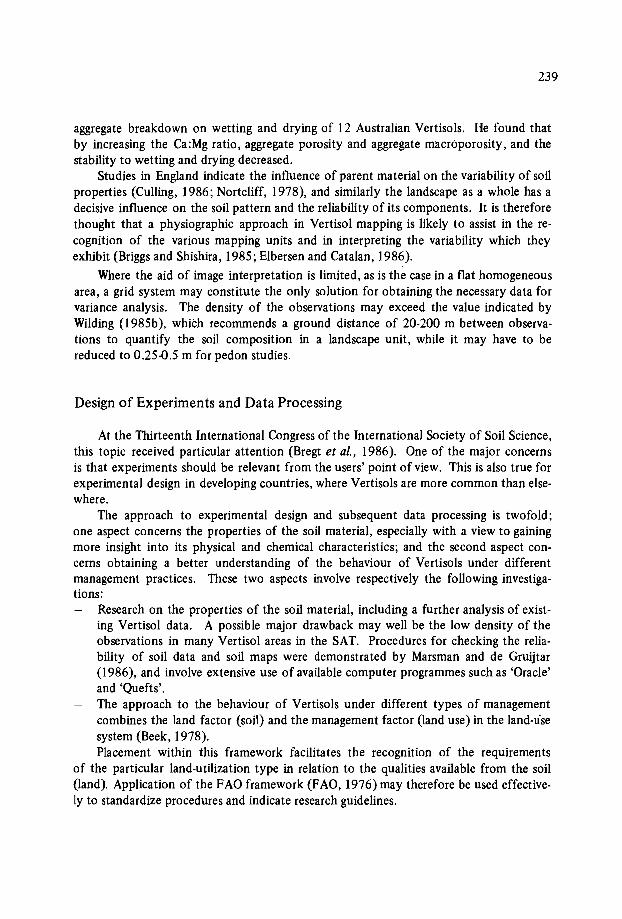
239
aggregate breakdown on wetting and drying of 12 Australian Vertiso1s. He found thatby increasing the Ca:Mg ratio, aggregate porosity and aggregate rnacroporosity, and thestability to wetting and drying decreased.
Studies in England indicate the influence of parent material on the variability of soilproperties (Culling, 1986; Nortcliff, 1978), and similarly the landscape as a whole has adecisive influence on the soil pattern and the reliability of its components. It is thereforethought that a physiographic approach in Vertisol mapping is likely to assist in the recognition of the various mapping units and in interpreting the variability which theyexhibit (Briggs and Shishira, 1985; Elbersen and Catalan, 1986).
Where the aid of image interpretation is limited, as is the case in a flat homogeneousarea, a grid system may constitute the only solution for obtaining the necessary data forvariance analysis. The density of the observations may exceed the value indicated byWilding (1985b), which recommends a ground distance of 20-200 m between observations to quantify the soil composition in a landscape unit, while it may have to bereduced to 0.25-0.5 m for pedon studies.
Design of Experiments and Data Processing
At the Thirteenth International Congress of the International Society of Soil Science,this topic received particular attention (Bregt et al., 1986). One of the major concernsis that experiments should be relevant from the users' point of view. This is also true forexperimental design in developing countries, where Vertisols are more common than elsewhere.
The approach to experimental design and subsequent data processing is twofold;one aspect concerns the properties of the soil material, especially with a view to gainingmore insight into its physical and chemical characteristics; and the second aspect concerns obtaining a better understanding of the behaviour of Vertisols under differentmanagement practices. These two aspects involve respectively the following investigations:
Research on the properties of the soil material, including a further analysis of existing Vertisol data. A possible major drawback may well be the low density of theobservations in many Vertisol areas in the SAT. Procedures for checking the reliability of soil data and soil maps were demonstrated by Marsman and de Gruijtar(1986), and involve extensive use of available computer programmes such as 'Oracle'and 'Quefts',The approach to the behaviour of Vertisols under different types of managementcombines the land factor (soil) and the management factor (land use) in the land-usesystem (Beek, 1978).Placement within this framework facilitates the recognition of the requirements
of the particular land-utilization type in relation to the qualities available from the soil(land). Application of the FAO framework (FAO, 1976) may therefore be used effectively to standardize procedures and indicate research guidelines.
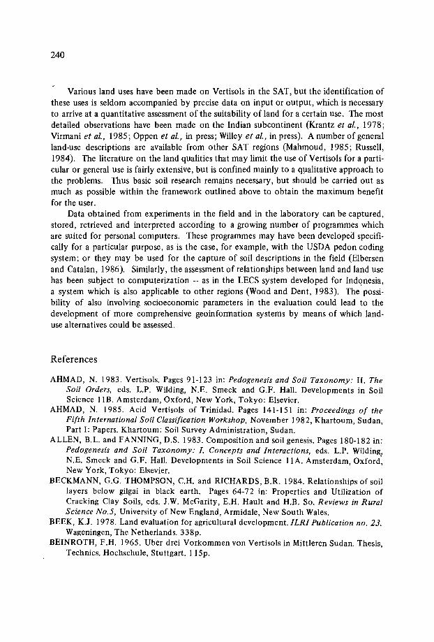
240
Various land uses have been made on Vertisols in the SAT, but the identification ofthese uses is seldom accompanied by precise data on input or output, which is necessaryto arrive at a quantitative assessment of the suitability of land for a certain use. The mostdetailed observations have been made on the Indian subcontinent (Krantz et al., 1978;Virmani et al., 1985; Oppen et al., in press; Willey et al., in press). A number of generalland-use descriptions are available from other SAT regions (Mahmoud, 1985; Russell,1984). The literature on the land qualities that may limit the use of Vertisols for a particular or general use is fairly extensive, but is confined mainly to a qualitative approach tothe problems. Thus basic soil research remains necessary, but should be carried out asmuch as possible within the framework outlined above to obtain the maximum benefitfor the user.
Data obtained from experiments in the field and in the laboratory can be captured,stored, retrieved and interpreted according to a growing number of programmes whichare suited for personal computers. These programmes may have been developed specifically for a particular purpose, as is the case, for example, with the USDA pedon codingsystem; or they may be used for the capture of soil descriptions in the field (Elbersenand Catalan, 1986). Similarly, the assessment of relationships between land and land usehas been subject to computerization - as in the LECS system developed for Indonesia,a system which is also applicable to other regions (Wood and Dent, 1983). The possibility of also involving socioeconomic parameters in the evaluation could lead to thedevelopment of more comprehensive geoinformation systems by means of which landuse alternatives could be assessed.
References
AHMAD, N. 1983. Vertisols. Pages 91-123 in: Pedogenesis and Soil Taxonomy: 11. TheSoil Orders, eds. L.P. Wilding, N.E. Smeck and G.F. Hall. Developments in SoilScience liB. Amsterdam, Oxford, New York, Tokyo: Elsevier.
AHMAD, N. 1985. Acid Vertisols of Trinidad. Pages 141-151 in: Proceedings of theFifth International Soil Classification Workshop, November 1982, Khartoum, Sudan,Part I: Papers. Khartoum: Soil Survey Administration, Sudan.
ALLEN, B.L. and FANNING, D.S. 1983. Composition and soil genesis. Pages 180-182 in:Pedogenesis and Soil Taxonomy: I. Concepts and Interactions, eds. L.P. Wilding,N.E. Smeck and G.F. Hall. Developments in Soil Science II A. Amsterdam, Oxford:New York, Tokyo: Elsevier.
BECKMANN, G.G. THOMPSON, C.R and RICHARDS, B.R. 1984. Relationships of soillayers below gilgai in black earth. Pages 64-72 in: Properties and Utilization ofCracking Clay Soils, eds. J.W. McGarity, E.R Hault and RB. So. Reviews in RuralScience No.5, University of New England, Armidale, New South Wales.
BEEK, K.J. 1978. Land evaluation for agricultural development. ILRI Publication no. 23.Wageningen, The Netherlands. 338p.
BEINROTH, F.R 1965. Uber drei Vorkommen von Vertisols in Mittleren Sudan. Thesis,Technics. Hochschule, Stuttgart. liSp.
241
BIE, S.W. and BECKET, P.H.T. 1971. Quality control in soil survey. Introduction: Thechoice of the mapping unit. Journal of Soil Science 22: 32-49.
BLOKHUIS, W.A. 1980. Vertisols, Pages 44-48 in: Land reclamation and water management. ILRI Publication no. 27. Wageningen, the Netherlands.
BLOKHUIS, W.A. 1982. Morphology and genesis of Vertisols, Pages 23-47 in: Proceedings of the ISSS Symposium, vol. 3, pp. 23-47.
BLOKHUIS, W.A. 1985. Relationships between morphological properties and drainage inVertisols. Pages 231-242 in: Proceedings of the Fifth International Soil ClassificationWorkshop, Khartoum, Sudan, November 1982, Part I: Papers. Khartoum: SoilSurvey Administration, Sudan.
BLOKHUIS, W.A. Vertisols of the semi-arid tropics. In press. In: Proceedings of theWorkshop on Management of Vertisols for Improved Agricultural Production,Patancheru, India, 18-22 February 1985. Bangkok, Thailand: IBSRAM.
BREGT, A.K., DENNEBOOM, J, STOLP J. and VLEESHOUWER, J.J. 1986. BIS: an information system for soil survey and research. Pages 1064-1065 in: Proceedings ofthe Thirteenth International ISSS Congress, Hamburg, 13-20 August 1986, vol.3.
BRIGGS, D.J. and SHISHIRA, E.K. 1985. Soil variability in geornorphologically definedsurvey units in the Albudeite area of Murcia Province, Spain. Pages 69-84 in: Soilsand Geornerphology, ed. Peter D. Juangerius. Catena Supplement no.6, CatenaVerlag Braunschweig 1985.
BURINGH, P. 1979. Introduction to the Study of Soils in Tropical and Subtropical Regions. Wageningen, the Netherlands: Centre for Agricultural Publishing and Documentation (PUDOC). 124p.
BUURSINK, J. 1971. Soils of central Sudan. Doctorate thesis, State University, Utrecht,the Netherlands. 240p.
COMERMA, J.A. 1984. 40th circular letter of ICOMERT, July 1984.COMERMA, J.A. 1985. Vertisols of Venezuela. Pages 153-159 in: Proceedings of the
Fifth International Soil Classification Workshop, November 1982 Khartoum, Sudan,Part I: Papers. Khartoum: Soil Survey Administration, Sudan.
COUGHLAN, K.J. 1984. The structure of Vertisols, Pages 87-86 in: Properties and Utilization of Cracking Clay Soils, eds. J.W. McGarity, E.H. Hault and H.B. So. Reviewsin Rural Science no. 5, University of New England, Armidale, New South Wales.
CULLING, W.E.H. 1986. Highly erratic spatial variability of soil pH on Iping Common,West Sussex. Catena 13: 81-98.
DENT, D. and YOUNG, A. 1981. Soil Survey and Land Evaluation. London: GeorgeAlien & Unwin. 278p.
DUDAL, R. 1965. Dark clay soils of tropical and SUbtropical regions. FAO AgriculturalDevelopment Paper no. 83. Rome: FAO. 161p.
DZIECIOLOWSKI, W., DRZYMALA, S. and MOCEK, A. 1984. The salient propertiesand classification of some North Iraqi Vertisols, Pages 10-18 in: Studia i Materialy.Agricultural Academy, Krakow.
ELBERSEN, G.W.W. and CATALAN, R. 1986. The use of portable computers in physiographic soil surveys. Pages 1102-1104 in: Proceedings of the Thirteenth InternationalISSS Congress, Hamburg, 13-20 August 1986, vol.3.
FAO (Food and Agriculture Organization of the United Nations). 1970a. Semi-detailedsoil survey of parts of the central clay plain - Sudan, AGL: SF jSUD 15. TechnicalReport no.3. Rome: FAO.

242
FAO (Food and Agriculture Organization of the United Nations). 1970b. Reconnaissance soil surveys of parts of the central clay plain, AGL: SF/SUO IS. TechnicalReport no.2. Rome: ·FAO.
FAO (Food and Agriculture Organization of the United Nations). 1976. A frameworkfor land evaluation. Soils Bulletin no.32. Rome: FAO. 72p.
FAO (Food and Agriculture Organization of the United Nations). 1985. Fifth Meetingof the Eastern African Subcommittee -for Soil Correlation and Land Evaluation.Wad-Medani, 5-10 December 1983. FAO World Soil Resources Report no.56. Rome:FAO.207p.
FAO-UNESCO (Food and Agriculture Organization of the United Nations - United Nations Educational Scientific and Cultural Organization). 1974. Soil Map of the World1:5.000.000 - Volume I: Legend. Rome, Paris: FAO-UNESCO.
FINCK, A. 1963. Tropische Boden. Hamburg and Berlin: Verlag Paul-Parey. 188p.GROSSMAN, R.B., NETTLETON, W.D. and BRASHER, B.R. 1985. Application of
pedology to plant response prediction for tropical areas. Pages 97-116 in: Proceedings of the Fifth International Soil Classification W.orkshop; November 1982 Khartoum, Sudan, Part I: Papers. Khartoum: Soil Survey Administration, Sudan.
HARMSE, RJ. von M. 1967. Soil genesis of Highveld region, southern Africa. Doctiratethesis, State University, Utrecht. 201p.
HUBBLE, G.D. 1984. The cracking clay soils: definition, distribution, nature, genesis anduse. Pages 3-14 in: Properties and Utilization of Cracking Clay Soils, eds, J.W. McGarity, E.R Hault and H.B. So. Reviews in Rural Science no. 5, University of New
_ England, Arrnidale, New South Wales.IKAWA, H. 1985. The Vertisols of Hawaii. Pages 125-139 in: Proceedings of the Fifth
International Soil Classification Workshop, November 1982, Khartoum, Sudan,Part I: Papers. Khartoum: Soil Survey Administration, Sudan.
JENNY, H. 1941. Factors ofSoil Formation. New York, London: McGraw Hill. 281p.JEWITT, T.N., LAW, R.D. and VIRGO, K.J. 1979. Vertisol soils of the tropics and sub
tropics: their management and use. Outlook on Agriculture 10 (1): 33-40.KAMPEN, J. 1982. An approach to improved productivity on deep Vertisols. ICRISA T
Information Bulletin no.I I, Patancheru, A.P. 502324, India: ICRISAT. 14p.KRANTZ, B.A. and KAMPEN, J. 1978. Soil and water management in the semi-arid
tropics. Pages 228-242 in: Soil Resources Data for Agricultural Development, ed.L.D. Swindale, Hawaii Agricultural Experiment Station, College of Tropical Agriculture, University of Hawaii.
KRISHNAMOORTHY, C. 1978. Management of rainfed agriculture in semi-arid India.Pages 243-251 in: Soil Resource Data for Agricultural Development, ed. L.D. Swindale. Hawaii Agricultural Experiment Station, College of Tropical Agriculture, University of Hawaii.
MAHMOUD, M.A. 1985. Management of Vertisols for rainfed crop production in theSudan. Pages 317-321 in: Proceedings of the Fifth International Soil ClassificationWorkshop, November 1982 Khartoum, Sudan, Part I: Papers. Khartoum: Soil SurveyAdministration, Sudan.
MARS MAN, B.A. and DE GRUIJTER, J.J. 1986. Quality of soil maps. A comparisonof survey methods in a sandy area. Soil Survey Papers no.lS, Netherlands Soil Survey Institute. 103p.

243
MCGARITY, J.W., HAULT, E.R and SO, H.B. eds, 1984. Properties and Utilization ofCracking Clay Soils. Reviews in Rural Science no.5, University of New England,Armidale, New South Wales.
McGARITY, J.W. 1985. Vertisols of Australia. Pages 1973-190 in: Proceedings of theFifth International Soil Classification Workshop, November 1982 Khartoum, Sudan,Part I: Papers. Khartoum: Soil Survey Administration, Sudan.
MOHR, E.C.J., VAN BAREN, F.A. and VAN SCHUYLENBORGH, J. 1972. TropicalSoils. 3d ed. The Hague, Paris, Djakarta: Mouton - Ichtiar Baru - van Hoeve. 481p.
MURDOCH, G. 1970. Soils and Land Capability in Swaziland. Swaziland Ministry ofAgriculture. 360p.
MURTHY, R.S., BHATTACHARJEE, J.C and LANDEY, RJ. 1985. Vertisols and associated soils of India: distribution, morphology, chemistry and taxonomy. Pages205-219 in: Proceedings of the Fifth International Soil Classification Workshop,November 1982 Khartoum, Sudan, Part I: Papers. Khartoum: Soil Survey Administration, Sudan.
NIEWENHUIS, E. and TRUSTRUM, N.A. 1977. Gilgai in Extremadura, Spain. International Training Centre Technical Report no. 4. 43p.
NORTCLIFF, S. 1978. Soil variability reconnaisance soil mapping: a statistical study inNorfolk. Journal ofSoil Science 29: 403-418.
NYAMAPFENE, K.W. 1984. Transmission electron microscopy and electron diffractionstudies on the clay fraction of three Zimbabawean Vertisols derived from basalt.Zimbabwe Journal Agricultural Research 22: 111-117.
OPPEN, R VON, NODAKE, R.D.G., KSHIRSOGAR, U.G. and SINGH, R.P. In press.Socioeconomic aspects of transfer of Vertisol technology. In: Proceedings of theWorkshop on Management of Vertisols for Improved Agricultural Production,Patancheru, India, 18-22 February 1985. Bangkok, Thailand: IBSRAM.
PURNELL, M.F. 1979. Vertisols and their utilization in West Africa. Paper presented atthe UTA Annual Research Conference, Ibadan, Nigeria, 15-19 October 1979.
ROGOWSKI, A.S., KHANBILVARIDI, R.M. and DE ANGELIS, R.J. 1985. Estimatingerosion on plot, field, and watershed scales. Pages 149-166 in: Soil Erosion and Conservation, Proceedings of International Conference on Soil Erosion and Conservation, eds. S.A. Swaify, W.C. Moldenhauer and Andrew Lo. Honolulu, Hawaii, 16-22January 1983. Hawaii: Soil Conservation Society of America.
ROSSIGNOL, J.P. 1983. Les Vertisols du Nord de I'Uruguay. Cahiers OR STOM, SeriePedologie 20 (4): 271-291.
RUSSELL, J.S. 1984. Management of cracking clay soils in rain fed conditions. Pages307-315 in: Properties and Utilization of Cracking Clay Soils, eds. J .W. McGarity,E.H. Hault and H.B. So. Reviews in Rural Science no. 5, University of New England,Armidale, New South Wales.
SIDERIUS, W. 1973. Soil transitions in central east Botswana. Docorate thesis, StateUniversity of Utrecht. 260p.
SLEEMAN, J.R. and BREWER, R. 1984. Micromorphology of some Australian crackingclay soils. Pages 73-82 in: Properties and Utilization of Cracking Clay Soils, eds. J .W.McGarity, E.R Hault and RB. So. Riviews in Rural Science no. 5, University of NewEngland, Armidale, New South Wales. .
SMEDEMA, L.K. 1984. Furrow irrigation design for Vertisols. Agricultural Water Management 9: 211-218.
244
SOIL SURVEY ADMINISTRAnON, ed. I 985. Proceedings of the Fifth International SoilClassification Workshop, November 1982, Khartoum, Sudan, Part I: Papers. Khartoum: Soil Survey Administration, Sudan.
SOIL SURVEY STAFF. 1960. Soil Classification - A Comprehensive System: 7th Approximation. Soil Conservation Service, U.S. Department of Agriculture, Washington, D.C.: U.S. Government Printing Office.
SOIL SURVEY STAFF. 1967. Supplement to Soil Classification System: 7th Approximation. Soil Conservation Service, U.S. Department of Agriculture, Washington,D.C.: U.S. Government Printing Office.
SOIL SURVEY STAFF. 1975. Soil Taxonomy - A Basic System of Soil Classificationfor Making and Interpreting Soil Surveys. Agriculture Handbook no. 436. SoilConservation Service, U.S. Department of Agriculture, Washington, D.C.: U.S. Government Printing Office.
STEPHAN, S., BERRIER, J., DE PETRE, A.A., JEANSON, C., KOOISTRA, M.J.,SCHARPENSEEL, H.W. and SCHIFFERMANN, H. 1983. Characterisation oi in-situorganic matter constituents in Vertisols from Argentina, using submicroscopic andcyto-chemical methods. Geoderma 30: 21-34.
SWINDALE, L.D. 1978. ed. Soil Resource Data for Agricultural Development. HawaiiAgricultural Experiment Station, College of Tropical Agriculture, University ofHawaii. 306p.
SWINDALE, L.D. and MIRANDA, S.M. 1984. The distribution and management indryland agriculture of Vertisols in the semi-arid tropics. Pages 316-323 in: Properties and Utilization of Cracking Clay Soils, eds. J.W. McGarity, E.H. Hault and H.B.So. Reviews in Rural Science no. 5, University of New England, Armidale, NewSouth Wales.
TRANGMAR, B.B., SINGH, U., YOST, R.S. and UEHARA, G. 1985. Application of geostatistics for soil survey and land evaluation. Pages 77-96 in: Proceedings of theFifth In ternational Soil Classification Workshop, November 1982, Khartoum, Sudan,Part It-Papers. Khartoum: Soil Survey Administration, Sudan.
TUCKER, R.J. 1984. Frequency distribution of soil morphological and pH data fromfield descriptions of cracking clay soils in the Emerald irrigation area, Queensland.Pages 19-28 in: Properties and Utilization of Cracking Clay Soils, eds. J .W. McGarity,E.H. Hault and H.B. So. Reviews in Rural Science no. 5, University of New England,Armidale, New South Wales.
VIRMANI, S.H. and SWINDALE, L.D. 1984. An aid to the transfer of improved farmingsystems for Vertisols in the semi-arid tropics. Soil Taxonomy News, no. 7, January1984. Benchmark Soils Project, Department of Agronomy and Soil Science, University of Hawaii. Hawaii: Soil Management Support Services (SMSS).
VIRMANI, S.H., BURFORD, J.R. and SAHRAWAT, K.L. 1985. Improved managementsystems for Vertisols in India. Pages 275-283 in: Proceedings of the Fifth International Soil Classification Workshop, November 1982, Khartoum, Sudan, Part I:Papers. Khartoum: Soil Survey Administration, Sudan.
WEBSTER, R. and BURROUGH, P.A. 1974. Multiple discriminant analysis in soil survey.Journal of Soil Science 25(1): 110-134.
WEBSTER, R. 1985. Quantitative spatial analysis of soil in the field. Pages 1-67 in:Advances in Soil Science, vol3. New York: Springer Verlag Inc.
245
WILDING, L.P. 1985a. Genesis of Vertisols. Pages 47-62 in: Proceedings of the Fifth International Soil Classification Workshop, November 1982, Khartoum, Sudan, Part I:Papers. Khartoum: Soil Survey Administration, Sudan.
WILDING, L.P. 1985b. Spatial variability: its documentation and implication to soilsurveys. Pages 166-189 in: Proceedings of a Workshop of the ISSS and SSSA on SoilSpatial Variability, eds. D. R. Nielson and J. Bouma. Wageningen: Centre for Agricultural Publishing and Documentation (PUDOC).
WILLEY, R.W., SINGH, R.P. and REDDY, M.S. In press. Cropping systems for Vertisols.In: Proceedings of the Workshop on Management of Vertisols for Improved Agricultural Production, Patancheru, India, 18-22 February 1985. Bangkok, Thailand:IBSRAM.
WOOD, S.R. and DENT, F.J. 1983. LECS - Land Evaluation Computer System Methodology. AGOF/INS/78/006. Center for Soil Research, Bogor: FAO.
YAALON, D.H. and KALMAR, D. 1978. Dynamics of cracking and sweiling clay soils:displacement of skeletal grains, optimum depth of slickensides, and rate of intrapedonic turbation. Earth Resource Processes 3: 31-42.

FERTILIZER MANAGEMENT IN VERTISOLS
r.c, Katyal, C.W. Hong, and P.L.G. Vlek*
Abstract
Vertisols of the semi-arid tropics (SAT) are universally deficient in N. N fertilizationwas formerly considered to be a risky enterprise, but research over the last decade has Idispelled this belief. Benefits from N fertilizers fluctuate with soil depth and seasonalrainfall. With deep Vertisols, response to N is higher and stable across contrasting rainfalls, while with shallow Vertisols response to N is generally low and it decreases with increasing rainfall. Excessive loss ofN (measured by N balance) is a factor contributing todecreased N-use efficiency in shallow soils. A discussion on the comparative efficiency ofN sources and the methods ofapplying them to deep and shallow Vertisols is presented.
Next to N, deficiency of P is important in Vertisols of the semi-arid tropics, withdeficiency increasing on Vertisols derived from granite parent material. Deficiencies ofK and S are rarely encountered in crops grown in Vertisols. Soil analysis suggests thepossibility of a widespread deficiency of Zn, Fe, Mn, and B. In some instances cropshave responded to the applications of these micronutrients.
Introduction
Soils belonging to the order Vertisol occur extensively in the semi-arid tropics (SAT).Black cotton soils in India and Sudan, cracking clays of Australia, black clays of theUnited States, Grumusols and Regurs of the old classification system are examples ofVertisols. Of a total of 257 million ha of Vertisols worldwide (Dudal, 1965), 72.9 million ha are located in India (Murthy etal., 1982),70.5 million ha in Australia, 40 millionha in Sudan, 16.5 million ha in Chad, and 10 million ha in Ethiopia (Dudal, 1965). Thesefive countries account for more than three-fourths of the total Vertisol area in the world.
* International Fertilizer Development Center (lFDC). Muscle Shoals, p.a. Box 2040, Alabama 35662,USA.

248
The outstanding features of Vertisols are their shrink/swell potential, alkaline pH,high cation-exchange capacity, high and stable water-holding characteristics, high generalfertility (except N), exceedingly low infiltration rates once saturated, and poor workability when wet. Vertisols of the semi-arid tropics as a group show remarkably homogeneous fertility patterns, which may serve as a base for appropriate fertility managementand fertilizer use. The dominant variables against any extrapolation of results across siteswill be availability of moisture during a cropping season, and depth of soil.
In the semi-arid tropical environments, crop yields are generally assumed to be hindered by the lack of available moisture because of a high atmospheric water demand andlimited water resources. Rainfall in the SAT is the most erratic of the climatic elementswhich are important for crop production. According to an analysis of 30-year rainfallpatterns in the SAT of India (Huda et al., 1985), it was evident that the overall means ofmonthly and annual rainfall showed coefficients of variation ranging from 39% to 225%for monthly rainfall and 32% for the annual rainfall. The sharp contrasts in rainfall patterns across years and seasons preclude uniform and firm recommendations on the useand management of fertilizers. Vertisols of variable depth (from < 50'cm to > 1 m) arenot uncommon; therefore the mechanics and dynamics of fertilizer transformations andloss may be inconsistent. This will complicate further the choice of appropriate fertilizersand methods of application. The present paper is an attempt to highlight the interactiveeffect of rainfall and soil depth on the fertilizer management strategies in the Vertisols ofthe SAT. The main emphasis is placed on nitrogen because the major research effort thusfar has been directed to this nutrient.
Nitrogen (N)
Deficiency of N is universal in tropical Vertisols. Indian Vertisols, in general, haveless than 1% organic carbon (OC), and their total N content seldom exceeds 0.1% (Dudal,1965; Virmani et al., 1982; Tandon and Kanwar, 1984). Vertisols of the Sudan Geziraare still poorer in OC «0.5%) and lower in total N (0.02%-0.06%) (Ayub, 1986). Incomparison, Vertisols in Australia and North America have high OC (20/0-6%) (Dudal,1965; William and Colwell, 1977) and high N contents (>0.1%). Organic carbon seemsto be uniformly distributed in the top I m of a Vertisol profile and decreases in thedeeper horizons (Murthy et al., 1982).
Organic matter is the main source of N in soils. Its readily mineralizable fractionmeasured by alkaline KMn04 extraction (Subbiah and Asija, 1956) provides an index ofN availability over the life of a crop. Inclusion of NO;-N, which represents the instantpool of available N, is suggested to improve the relationship between N availability andcrop-yield response, more specifically under upland conditions (Sahrawat and Burford,1982). Malear et al. (1984) found a close relationship-between grain yield of sorghumgrown on a Typic Chromustert and availability of N measured either by KMn04 - extraction or NOi-N. Yields of cotton grown on the Vertisols of the Gezira in Sudan werepositively correlated with NOi-N content of the soil profile (Crowther, 1954). Rego

249
et al. (I 982) reported that 1 m of soil profile accumulated 65-72 kg of NOi-N/ha withcropping. This finding suggested that accumulation of NOi-N in the soil profile duringthe rainy-season faIlowing will benefit the postrainy-season crop.
FaIlowing land during the rainy season foIlowed by postrainy-season cropping is thetraditional practice in India. However, the benefits of faIlowing may vary from year toyear (Table 1). In a moderate-rainfaIl year (seasonal rainfaIl =515 mm), safflower yieldrose from 630 kg/ha after rainy-season sorghum to 1470 kg/ha after rainy-season fallowing. In contrast, in a high-rainfaIl year (seasonal rainfaIl =913 mm) the beneficial effect.of faIlowing during the rainy season on grain yield of safflower in the postrainy seasonwas not distinguishable (safflower yield =690 kg/ha after sorghum vs. 530 kg/ha afterfaIlowing). Kanwar and Rego (1983) cited some Indian studies that showed that duringhigh-rainfall years there was a considerable loss of topsoil and nutrients because of erosion, runoff, percolation, and volatilization. More NOi-N was lost during large storms.Thus, high rainfaIl during fallowing can limit the beneficial effect of NOi accumulationon the subsequent postrainy-season crop.
Table I. Seed yield (kg/ha) of postrainy-season safflower in a double-cropping system.
Treatments
1982(Rainy-season
rainfall 516 mm)
kg Nlha
1983(Rainy-season
rainfall 913 mm)
Rainy season Postrainy season o 60 o 60
FallowSorghumSEM
SafflowerSafflower
1470 1960630
90
530 1460690
108
Data from IFDC/ICRISAT Collaborative Research Project.
Despite the fact that there was a buildup of N during the rainy-season fallowing(Rego et al., 1982), the post rainy-season safflower still responded significantly to anapplication of 60 kg N/ha (Table 1). The grain yield rose from 1470 kg/ha without Napplication to 1960 kg/ha with N application. When the rainfall during the rainy seasonwas high, the response of postrainy-season crops to an N application became more striking. Application of N to a previous crop did not seem to produce a significant residualeffect on the succeeding crop. Of the 200/0-30% residual IS N found in the soil, hardly 2%could be used by the succeeding crop. (Data on 15N balance are not presented here.)

250
Response of crops to fertilizer-N
Historically, semi-arid tropical soils were considered to be deficient in available moisture for plant growth. Use of fertilizers was considered to be too risky to be economically viable. Contrary to this former belief, several studies during the last decade have established a positive and significant response to fertilizer-N of crops grown on Vertisols (seeRandhawa and Venkateswarlu, 1980; Finck and Venkateswarlu, 1982; Kanwar and Rego,1983; Tandon and Kanwar, .1984; EI-Swaify et al., 1985). The extent of the responseseems to be modified by rainfall, soil depth, and native soil fertility. The influence ofthese variables on N response can be illustrated from results of a 4-year study (1982-85)on deep and shallow Vertisols. The study was conducted by the International FertilizerDevelopment Cent er (IFDC) in collaboration with the International Crops Research Institute for the Semi-Arid Tropics (ICRISAT). The purpose of this research was to studythe response of rainy-season sorghum to urea applied at different rates (0-120 kg N/ha)by a split-band application technique.
The 1982, 1983, 1984, and 1985 seasonal rainfall, of 516,913,485, and 322 mmrespectively, provided contrasting environments for crop growth, yield responses, andrecovery studies with IS N-labelled urea. This research, similar to the findings of earlierresearch, conclusively established that fertilizer-N offers a considerable potential to'increase yields of sorghum on Vertisols in dryland regions. Yield increases attributableto fertilizer-N varied from 300 kg to more than 2000 kg sorghum grain/ha (Figures 1 and2). There was a-general Iinear response up to 60 kg N/ha, and levelling off occurred atabout 90 kg N/ha. Shallow Vertisols, particularly in high-rainfall years, appeared to beexceptions, in that grain yields more or less levelled off at N application rates higher than30 kg N/ha.
7.000...,.....----------------.....,
- - - Deep ver1lsol, 300 mm-- Deep ver1isol 900 mm(SE-341.6)
'ii"
~ 5,000'a'i>>=c1!ell
~ 3,000z::e'co
o:n
1209030 60
Urea N Rate (kgfha)
1,OOO+------r-----r------,------1o
Figure 1. Grain-yield response of sorghum to nitrogen on deep Vertisols.
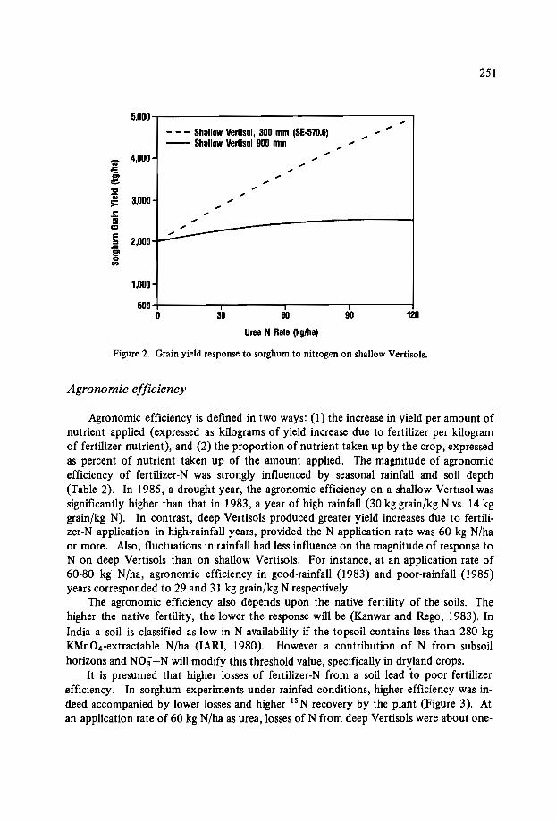
251
5,000 ..- - - Shallow vertisol, 300 mm (SE-57D.6)
......-- Shallow Vertlsol 900 mm ....
4,000-..
la....
E ..... ..~ ..... ..a;
3,000 ..>= ..c:i! ..c::l
~E 2,000..,I::
e'coen
1,000
500 I I
0 30 60 90 120
Urea N Rate (kglha)
Figure 2. Grain yield response to sorghum to nitrogen on shallow Vertisols.
Agronomic efficiency
Agronomic efficiency is defined in two ways: (1) the increase in yield per amount ofnutrient applied (expressed as kilograms of yield increase due to fertilizer per kilogramof fertilizer nutrient), and (2) the proportion of nutrient taken up by the crop, expressedas percent of nutrient taken up of the amount applied. The magnitude of agronomicefficiency of fertilizer-N was strongly influenced by seasonal rainfall and soil depth(Table 2). In 1985, a drought year, the agronomic efficiency on a shallow Vertisol wassignificantly higher than that in 1983, a year of high rainfall (30 kg grain/kg N vs. 14 kggrain/kg N). In contrast, deep Vertisols produced greater yield increases due to fertilizer-N application in high-rainfall years, provided the N application rate was 60 kg N/haor more. Also, fluctuations in rainfall had less influence on the magnitude of response toN on deep Vertisols than on shallow Vertisols. For instance, at an application rate of60-80 kg N/ha, agronomic efficiency in good-rainfall (1983) and poor-rainfall (1985)years corresponded to 29 and 31 kg grain/kg N respectively.
The agronomic efficiency also depends upon the native fertility of the soils. Thehigher the native fertility, the lower the response will be (Kanwar and Rego, 1983). InIndia a soil is classified as low in N availability if the topsoil contains less than 280 kgKMn04-extractable N/ha (IARI, 1980). However a contribution of N from subsoilhorizons and N03"-N will modify this threshold value, specifically in dryland crops.
It is presumed that higher losses of fertilizer-N from a soil lead to poor fertilizerefficiency. In sorghum experiments under rainfed conditions, higher efficiency was indeed accompanied by lower losses and higher 15N recovery by the plant (Figure 3). Atan application rate of 60 kg N/ha as urea, losses of N from deep Vertisols were about one-

252
Table 2. Agronomic efficiency of urea-N as influenced by N rate.irainfall,and depth of Vertisols.
Agronomic efficiencySoil Year Rainfall Check yield
30-40 kg N/ha 60-80kg N/ha
(kg grain/kg N)
Deep Vertisol 1980 674 3,380 14 141981 907 2,720 24 341982 516 2,870 401983 913 1,500 26 291985 322 3,270 33 31
Shallow Vertisol 1983 913 670 14 211984 485 1,310 31 371985 322 3,390 30 18
Data from IFDC/ICRISAT Collaborative Research Project.
Agronomic Eniciency = -22.7 + 1.006 UN Recovery60 r = 0.62*
n = 14o
50z
...... 0
i 40 0... 0
... 0...~ 30.. 0uis.....
20 00E 0
C> 0ce 0~ 0
10
20 30 40 501sNRP
60 70
Figure 3. Relationship between agronomic efficiency and 15N recovery by crop.
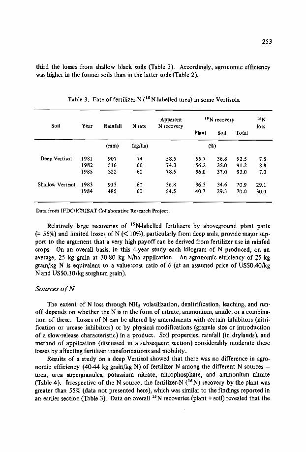
253
third the losses from shallow black soils (Table 3). Accordingly, agronomic efficiencywas higher in the former soils than in the latter soils (Table 2).
Table 3. Fate of fertilizer-N es N-Iabelled urea) in some Vertisols.
Apparent 15 N recovery 'SNSoil Year Rainfall N rate N recovery loss
Plant Soil Total
(mm) (kg/ha) (%)
Deep Vertisol 1981 907 74 58.5 55.7 36.8 92.5 7.51982 516 60 74.3 56.2 35.0 91.2 8.81985 322 60 78.5 56.0 37.0 93.0 7.0
Shallow Vertisol 1983 913 60 36.8 36.3 34.6 70.9 29.11984 485 60 54.5 40.7 29.3 70.0 30.0
Data from IFDC/ICRISAT Collaborative Research Project.
Relatively large recoveries of IS N-labelled fertilizers by aboveground plant parts(= 55%) and limited losses. of N « 10%), particularly from deep soils, provide major support to the argument that a very high payoff can be derived from fertilizer use in rainfedcrops. On an overall basis, in this 4-year study each kilogram of N produced, on anaverage, 25 kg grain at 30-80 kg N/ha application. An agronomic efficiency of 25 kggrain/kg N is equivalent to a value:cost ratio of 6 (at an assumed price of US$0.40/kgNand US$O.lO/kg sorghum grain).
Sources ofN
The extent of N loss through NH3 volatilization, denitrification, leaching, and runoff depends on whether the N is in the form of nitrate, ammonium, amide, or a combination of these. Losses of N can be altered by amendments with certain inhibitors (nitrification or urease inhibitors) or by physical modifications (granule size or introductionof a slow-release characteristic) in a product. Soil properties, rainfall (in drylands}, andmethod of application (discussed in a subsequent section) considerably moderate theselosses by affecting fertilizer transformations and mobility.
Results of a study on a deep Vertisol showed that there was no difference in agronomic efficiency (40-44 kg grain/kg N) of fertilizer N among the different N sources urea, urea supergranules, potassium nitrate, nitrophosphate, and ammonium nitrate(Table 4). Irrespective of the N source, the fertilizer-N es N) recovery by the plant wasgreater than 55% (data not presented here), which was similar to the findings reported inan earlier section (Table 3). Data on overall PN recoveries (plant + soil) revealed that the
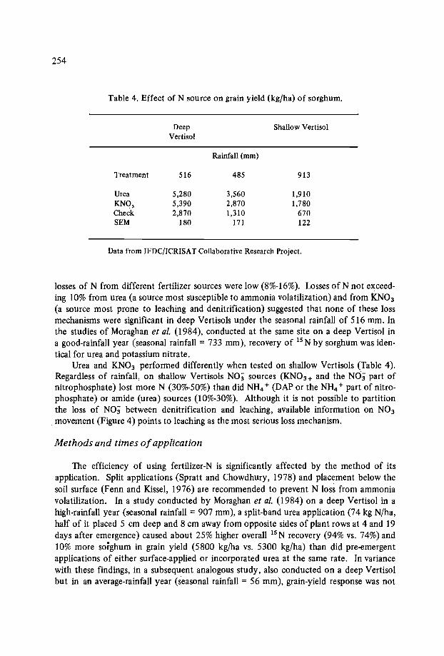
254
Table 4. Effect of N source on grain yield (kg/ha) of sorghum.
Deep Shallow Vertiso1Vertiso1
Rainfall (mm)
Treatment 516 485 913
Urea 5,280 3,560 1,910KN03 5,390 2,870 1,780Check 2,870 1,310 670SEM 180 171 122
Data from IFDC/ICRISAT Collaborative Research Project.
losses of N from different fertilizer sources were low (8%-16%). Losses of N not exceeding 10% from urea (a source most susceptible to ammonia volatilization) and from KN03
(a source most prone to leaching and denitrification) suggested that none of these lossmechanisms were significant in deep Vertisols under the seasonal rainfall of 516 mm. Inthe studies of Moraghan et al. (I984), conducted at the same site on a deep Vertisol in
. a good-rainfall year (seasonal rainfall = 733 mm), recovery of 15 N by sorghum was identical for urea and potassium nitrate.
Urea and KN03 performed differently when tested on shallow Vertisols (Table 4).Regardless of rainfall, on shallow Vertisols NO; sources (KN0 3 + and the NO; part ofnitrophosphate) lost more N (300/0-50%) than did NH4 + (DAP or the NH4 + part of nitrophosphate) or amide (urea) sources (100/0-30%). Although it is not possible to partitionthe loss of NO; between denitrification and leaching, available information on N03
movement (Figure 4) points to leaching as the most serious loss mechanism.
Methods and times ofapplication
The efficiency of using fertilizer-N is significantly affected by the method of itsapplication. Split applications (Spratt and Chowdhury, 1978) and placement below thesoil surface (Fenn and Kissel, 1976) are recommended to prevent N loss from ammoniavolatilization. In a study conducted by Moraghan et al. (I984) on a deep Vertisol in ahigh-rainfall year (seasonal rainfall = 907 mm), a split-band urea application (74 kg N/ha,half of it placed 5 cm deep and 8 cm away from opposite sides of plant rows at 4 and 19days after emergence) caused about 25% higher overall 15N recovery (94% vs. 74%) and10% more sorghum in grain yield (5800 kg/ha vs. 5300 kg/ha) than did pre-emergentapplications of either surface-applied or incorporated urea at the same rate. Invariancewith these findings, in a subsequent analogous study, also conducted on a deep Vertisolbut in an average-rainfall year (seasonal rainfall = 56 mm), grain-yield response was not
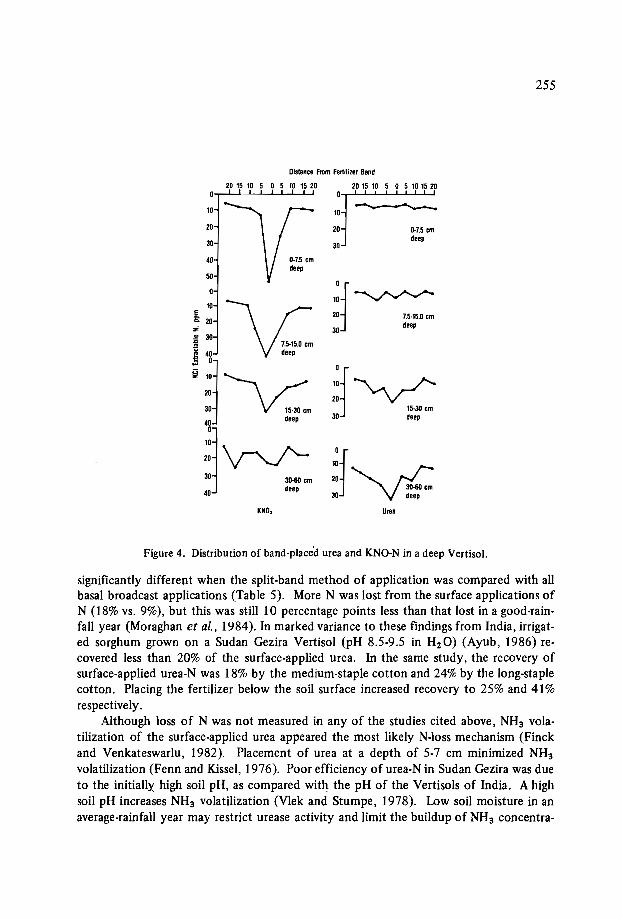
255
Distance From Fertilizer Band
20 15 10 5 0 5 10 15 20 20 15 10 5 0 5 10 15 20
0·7.5 cmdeep
10
20
30
Of10~20 7.5·15.0 cm
30 deep
Of10 ""'"'\..A -../'-20 ""'-v-
15·30 cm30 deep
Of10
2030·60 cm
30 'vG
20
30
40
10
10
50
E~ 20Z.!! 30
!;1,\ :::j V 15·30 cm
;:j~30 30.60 cm
40 deep
KNO, Ure.
Figure 4. Distribution of band-placed urea and KNO-N in a deep VertisoJ.
significantly different when the split-band method of application was compared with allbasal broadcast applications (Table 5). More N was lost from the surface applications ofN (I 8% vs. 9%), but this was still 10 percentage points less than that lost in a good-rainfall year (Moraghan et al., 1984). In marked variance to these findings from India, irrigated sorghum grown on a Sudan Gezira Vertisol (pH 8.5-9.5 in H20) (Ayub, 1986) recovered less than 20% of the surface-applied urea. In the same study, the recovery ofsurface-applied urea-N was 18% by the medium-staple cotton and 24% by the long-staplecotton. Placing the fertilizer below the soil surface increased recovery to 25% and 41%respectively.
Although loss of N was not measured in any of the studies cited above, NH3 volatilization of the surface-applied urea appeared the most likely N-Ioss mechanism (Finckand Venkateswarlu, 1982). Placement of urea at a depth of 5-7 cm minimized NH3
volatilization (Fenn and Kissel, 1976). Poor efficiency of urea-N in Sudan Gezira was dueto the initially high soil pH, as compared with the pH of the Vertisols of India. A highsoil pH increases NH3 volatilization (Vlek and Stumpe, 1978). Low soil moisture in anaverage-rainfall year may restrict urease activity and limit the buildup of NH3 concentra-

256
Table 5. Effect of urea-N application methods on N uptake and grain yield of sorghum.
Treatment
Deep Vertisol
Rainfall 516 mm
Shallow Vertisol
Rainfall 397 mm
Grain yield
(kg/ha)
N uptake Grain yield
(kg/ha)
N uptake
Check 2,870 40 1,310 30Split band 5,280 84 3,508 61Split broadcast 4,620 70 2,753 61All basal broadcast 5,650 86 2,493 48All basal band 5,290 82 2,328 52
SEM 180 16 170 3
Data from IFDC/ICRISAT Collaborative Research Project.
tions at the soil surface. A similar argument was given to explain the lack of NH3 volatilization from surface-applied urea in northern Australia (Myers, 1978). On the contrary,a high soil moisture favoured NH3 volatilization, as was the case in a good-rainfall year(Moraghan et al., 1984) or with the irrigation of sorghum or cotton in Sudan Gezira(Ayub, 1986). Trierweiler and Bishop (1983) confirmed that placement of urea on thewet surface of Vertisols accelerated NH3 volatilization. To counter NH3 volatilization,they suggested applying urea before irrigation. Percolating water may transport the ureadown below the soil surface and protect its hydrolysis products from volatilization(Katyal et al., 1987).
Results on the efficiency of urea, surface broadcast or applied by split-band methodto shallow Vertisols, were at variance with those obtained on deep Vertisols in a Iow-rainfall year. The split-band method of application produced about I ton/ha additional sorghum grain when compared with basal-broadcast or split-broadcast methods of application (Table 5). Why the yield from band-placed urea was higher than that from surfacebroadcast urea in a shallow Vertisol is not clear, particularly when the N uptake did notvary between the two methods of application. Further interpretation of these data willhave to await a more detailed analysis of the seasonal rainfall patterns.
Efficiency of fertilizer-N obtained by the split-band method could be improved further by its application (at 40-60 kg N/ha) in the seedrows. Results presented in Figure 5show that total dry-matter yield and grain yield declined as the distance from the seedrowincreased. Seedrow applications surpassed the usual application in bands located about5 cm from the seedrow. Subsequent studies conducted across seasons and soils confirmedthe superiority of seedrow application. In none of the investigations was the generally

257
4000
3000
....c
if 2000-r:i;;;>=
1000
ISEMx
Check
---......Jt__ Stalk I"'"-:.._ SEM
'" * "'--.--.. * Grain.-_----- Check ----------.;------
- - Check 1SEMI...
o 5 10 15 20Fertilizer Row Distance From Seed Row (cm)
Figure 5. Effect of the distance of fertilizer row from the yields of pearl millet (Kharif, 1984).
feared germination injury from a seed-fertilizer contact observed at the levels of fertilizerapplications tested (40·60 kg N/ha).
Phosphorus (P)
Deficiency of P is widespread in Vertisols (Swindale, 1982). In fact, next to N, P isthe most limiting nutrient in Vertisols (Finck and Venkateswarlu, 1982). It is believedthat Vertisols of basaltic origin are less prone to deficiency than those developed on granites and sedimentary rocks (Singh and Venkateswarlu, 1985). Phosphorus availabilityfrom Vertisols is largely assessed by alkaline bicarbonate extraction (Olsen et al., 1954).Some Vertisols contain as low as 1 ppm Olsen-extractable P (Katyal, 1978) with a generalrange of 2-10 ppm.
In India, a soil is considered deficient if it contains less than 5 ppm Olsen-extractable P (Tandon and Kanwar, 1984). According to Kanwar and Rego (1983), the critical
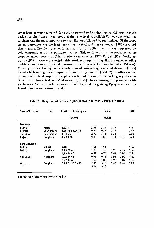
258
lower limit of water-soluble P for a soil to respond to P application was 0.5 ppm. On thebasis of results from a 4-year study at the same level of available P, they concluded thatsorghum was the most responsive to P application, followed by pearl millet. Of the cropstested, pigeonpea was the least responsive. Katyal and Venkatramaya (1983) reportedthat P availability fluctuated with season. Its availability from soil was suppressed bycold temperatures of the postrainy season. This explained why the postrainy-seasoncrops depended more upon P fertilization (Kanwar et al., 1973; Katyal, 1978). Venkateswarlu (1979), however, reported fairly small responses to P application under recedingmoisture conditions of postrainy-season crops at several locations in India (Table 6).Contrary to these findings, on Vertisols of granite origin Singh and Venkateswarlu (1985)found a high and significant response of rainfed sorghum to P (Table 7). Inother studies,response of dryland crops to a P application did not become distinct as long as yields continued to be low (Singh and Venkateswarlu, 1985). In well-managed experiments withsorghum on Vertisols, yield responses of 7-20 kg sorghum grain/kg P205 have been obtained (Tandon and Kanwar, 1984).
Table 6. Response of cereals to phosphates in rainfed Vertisols in India.
Season/Location Crop Fertilizer dose applied Yield LSD
(kg P/ha) (t/ha)
MonsoonIndore Maize 0,22,44 2.56 2.57 2.87 N.S.Bijapur Pearl millet 0,18,35,53,70,88 0.54 0.58 0.82 0.14Sholapur Pearl millet 0,11,22 2.79 3.15 3.21 0.30Rajkot Sorghum 0,7,13,20 2.87 3.02 3.34 3.46 0.23
Post-MonsoonIndore Wheat 0,18 1.58 1.68 N.S.Ballary Sorghum 0,13,26,40 1.77 1.75 1.95 2.17 N.S.
0,13,26,40 0.80 0.78 0.84 1.00 N.S.Sholapur Sorghum 0,22,44,66 0.90 0.75 0.95 0.92 N.S.
0,22,44,66 1.04 1.08 0.92 1.07 N.S.Bijapur Sorghum 0,18,35,53,70,88 2.97 3.19 3.42 3.44 ·0.23
3.16 3.12
Source: Finck and Venkateswarlu (1982).
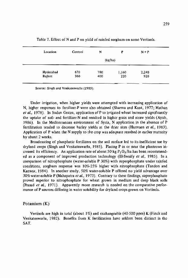
259
Table 7. Effect of Nand P on yield of rainfed sorghum on some Vertisols.
Location Control N P N+P
(kg/ha)
Hyderabad 670 780 1,160 2,240Rajkot 360 400 220 920
Source: Singh and Venkateswarlu (1985).
Under irrigation, when higher yields were attempted with increasing application ofN, higher responses to fertilizer-P were also obtained (Sharma and Kant, 1977; Mathanet al., 1978). In Sudan Gezira, application of P to irrigated wheat increased significantlythe uptake of soil- and fertilizer-N and resulted in higher grain and straw yields (Ayub,1986). In the Mediterranean environment of Syria, N application in the absence of Pfertilization tended to decrease barley yields at the drier sites (Harmsen et al., 1983).Application of P when the N supply to the crop was adequate resulted-in earlier maturityby about 2 weeks.
Broadcasting of phosphatic fertilizers on the soil surface led to its inefficient use bydryland crops (Singh and Venkateswarlu, 1985). Placing P in or near the plantrows increased its efficiency. An application rate of about 50 kg P2 Os/ha has been recommended as a component of improved production technology (El-Swaify et al.. 1985). In acomparison of nitrophosphate (water-soluble P 30%) with superphosphate under rainfedconditions, sorghum response was 10%-25% higher with nitrophsophate (Tandon andKanwar, 1984). In another study, 50% water-soluble P offered no yield advantage over30% water-soluble P (Mahapatra et al., 1973). Contrary to these findings, superphosphateproved superior to nitrophosphate for wheat grown in medium and deep black soils(prasad et al., 197 I).. Apparently more research is needed on the comparative performance of P sources differing in water solubility for dryland crops grown on Vertisols.
Potassium (K)
Vertisols are high in total (about 1%) and exchangeable (40-500 ppm) K (Finck andVenkateswarlu, 1982). Benefits from K fertilization have seldom been distinct in theSAT.
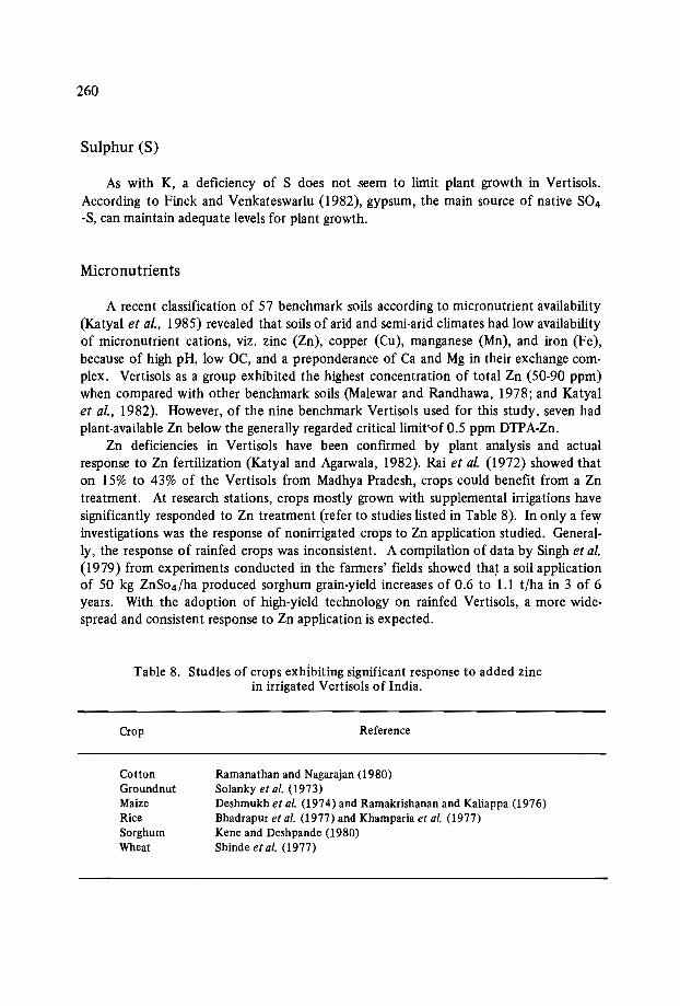
260
Sulphur (S)
As with K, a deficiency of S does not seem to limit plant growth in Vertisols.According to Finck and Venkateswarlu (1982), gypsum, the main source of native S04-S, can maintain adequate levels for plant growth.
Micronutrients
A recent classification of 57 benchmark soils according to micronutrient availability(Katyal et al., 1985) revealed that soils of arid and semi-arid climates had low availabilityof micronutrient cations, viz. zinc (Zn), copper (Cu), manganese (Mn), and iron (Fe),because of high pH, low OC, and a preponderance of Ca and Mg in their exchange complex. Vertisols as a group exhibited the highest concentration of total Zn (50-90 ppm)when compared with other benchmark soils (Malewar and Randhawa, 1978; and Katyalet al., 1982). However, of the nine benchmark Vertisols used for this study, seven hadplant-available Zn below the generally regarded critical limit-of 0.5 ppm DTPA·Zn.
Zn deficiencies in Vertisols have been confirmed by plant analysis and actualresponse to Zn fertilization (Katyal and Agarwala, 1982). Rai et al. (1972) showed thaton 15% to 43% of the Vertisols from Madhya Pradesh, crops could benefit from a Zntreatment. At research stations, crops mostly grown with supplemental irrigations havesignificantly responded to Zn treatment (refer to studies listed in Table 8). In only a fewinvestigations was the response of nonirrigated crops to Zn application studied. Generally, the response of rainfed crops was inconsistent. A compilation of data by Singh et al.(1979) from experiments conducted in the farmers' fields showed that a soil applicationof 50 kg ZnS04/ha produced sorghum grain-yield increases of 0.6 to 1.1 t/ha in 3 of 6years. With the adoption of high-yield technology on rainfed Vertisols, a more widespread and consistent response to Zn application is expected.
Table 8. Studies of crops exhibiting significant response to added zincin irrigated Vertisols of India.
Crop
CottonGroundnutMaizeRiceSorghumWheat
Reference
Ramanathan and Nagarajan (1980)Solanky et al. (1973)Deshmukh et al. (1974) and Ramakrishanan and Kaliappa (1976)Bhadrapur et al. (1977) and Khamparia et al. (977)Keneand Deshpande (1980)Shindeet al. (1977)

261
On an average, Vertisols contain about 800 ppm Mn, which is one and one-half timesmore than that of the neighbouring Alfisols (Katyal et al., 1982). Despite rich reservesof total Mn, Sharma and Motiramani (1964) suspected Mn deficiencyin about 11% ofthe Vertisols of Madhya Pradesh, India. Sharrna and Shinde (1968) also noted low contents of available Mn in Vertisols. In contrast, Rai et al. (1970) found that deep Vertisolsfrom the same state were adequate in Mn availability. Similarly, none of the nine benchmark Vertisols (Katyal et al., 1982) tested below the critical limit of Mn availability« 2.5 DTPA-Mn). In field experiments, PatH et al. (1972) and Deshmukh et al. (1974)noted a lack of sorghum response to applied Mn. Earlier, with sorghum grown on similarVertisols, Kene and Deshpande (1979) obtained significant response to a Mn treatment inonly 1 of 3 years. It thus appears that Mn deficiency does not seriously constrain cropproduction in semi-arid tropical Vertisols.
On an average, Vertisols contain about 4% total Fe in the surface horizons. Despitethis, Fe deficiency is frequently encountered in Vertisols because of their calcareousness.Rai et al. (1970) concluded that nearly 50% of the Vertisols occurring in Madhya Pradeshwere deficient in Fe « 2 ppm NH4 OAc-Fe). Widespread Fe deficiency in sugarcanegrowing on Vertisols of Tamil Nadu, India, was corrected by FeS04 sprays (see Katyaland Vlek, 1985). likewise, Saxena and Sheldrake (1980) could control Fe chlorosis andincrease the yield of chickpea up to 50% by FeS04 sprays. Kene and Deshpande (1979),however, did not observe any significant yield increase of sorghum in Vertisols having4.2-7.8 ppn. available Fe.
As for total Cu contents (range 40-150 ppm and mean 68 ppm) (Katyal et al.,1982), Vertisols exceeded other soil orders. Because total Cu and its plant-available fraction are often closely related (see Katyal and Vlek, 1985), a Cu deficiency is seldom expected to obstruct plant growth in Vertisols (Kavimandan et al., 1964; Rai et al., 1970).Contrary to this background, yield increases of wheat were obtained with the applicationof 9 kg Cu/ha as CUS04 (Gupta and Singh; 1972). Although Cu deficiencies for plantgrowth are rare, a possibility of insufficiency for nutrition of grazing cattle may .exist,as was reported in sheep grazing pastures of Australia (see Finck and Venkateswarlu,1982).
Deficiency of B, despite high pH and calcareousness, has seldom been recorded inVertisols. Availability of Mo is synergized by the high pH of Vertisols, which also precludes its deficiency in crops.
Summary and Conclusions
From the standpoint of nutrient management, Vertisols of the SAT are universallydeficient in N. Contrary to the supposition in the past that excessive risks are involved inusing fertilizers, research over the last decade has conclusively established that there isa remarkable potential for increasing crop yields through N fertilization of crops grownon Vertisols over contrasting rainfall environments of the SAT. In a 4-year study (seasonal rainfall = 322-913 mm) at ICRISAT in India, increases in yields of sorghum of from
262
300 to 2000 kg/ha were achieved through the application of 30-90 kg N/ha.Variations in year-to-year response depended mainly upon the seasonal rainfall and
the depth of the soils. On shallow Vertisols, 30 kg N/ha increased sorghum grain yieldup to almost 1 t/ha in 1984 and 1985 which were years of drought (mean seasonalrainfall, 300400 mm). In years of heavy rainfall (900 mm) response from the same levelof N application was less than half, and it was accompanied by relatively low use offertilizer-N (~30%). The response of sorghum growing on deep Vertisols was found tobe more stable across seasons. However, as with shallow soils, and specifically in highrainfall years, all urea-N broadcast on the surface or incorporated to a depth of about 10cm was less efficient than urea applied by the split-band technique (fertilizer applied intwo equal splits, at planting and 3-4 weeks later, in bands 5 cm deep and 3 cm away fromthe seedrow and covered with soil).
15 N-balance studies confirmed the pattern of response viz-a-viz soil depth. Ureaapplication (by the split-band method) resulted in rather high (~ 55%) use efficiency offertilizer-N by sorghum on deep Vertisols. Losses of fertilizer-N, suspected to be mainlyvia ammonia volatilization, were relatively low « 10%). In high-rainfall years, losses ofN tended to be high (250/0-30%), and consequently 15N recovery by plants tended to below (~ 45%), especially if urea was placed on the surface or mixed with the soil ratherthan placed in bands. In sharp contrast to deep Vertisols, losses of N in shallow Vertisols,even when applied by the split-band method and in low-rainfall years, were comparativelyhigh (~30%), and use by the crop was low (~40%).
Several experiments on the evaluation of N sources showed that (1) for deepVertisols, urea, potassium nitrate, or compound fertilizers could be recommended, and(2) for shallow soils, nitrate-containing fertilizers were a poor choice, since the proportionof fertilizer-N .lost increased to more than 50% if amide (urea) or ammonium (DAP)fertilizers were replaced by nitrate (KN0 3 ) fertilizers. Leaching seemed to be a seriousloss mechanism in shallow Vertisols.
Parallel to 15 N-balance data, over the years of experimentation, split application ofN in bands was superior to broadcast application on the surface or broadcast-incorporatedmethods of application in high-rainfall years, and was equal to or better than broadcastapplication in other years. This methodology has another merit in that it allows thefarmer to make midseason adjustments: (1) in a season with below average rainfall towithhold further fertilizer application, and (2) in a season with above average rainfall toapply more N. Agronomic efficiency could be increased further by the application offertilizer-N (at 40-60 kg N/ha) in the seedrows instead of its placement in bands awayfrom the seedrows. An additional benefit' from seedrow application was the saving indraught power; a single furrow opener was required for combined placement of seed andfertilizer instead of the usual double seed-and-fertilizer furrow opener.
It was evident from the response to fertilizer-N in a double-cropping of sorghum andsafflower, that additional N fertilizer was required for both the rainy-season and postrainy-season crops. The lack of residual effect from the fertilizer-N remaining in the soilsuggested that N should be applied independently to both crops. Efficiency of fertilizerN (measured as recovery of 15 N by aboveground portions of a crop) did not vary betweenrainy-season and postrainy-season crops. Interestingly, the beneficial effect of fallowingin the rainy season on the postrainy-season crop was not constant across the seasons. Thefavourable effect of fallowing on the subsequent postrainy-season crop was marked in anaverage-rainfall year. In a high-rainfall year fallowing was not beneficial to the postrainy-

263
season crop.Deficiency of P is widespread in Vertisols. Several studies, however, showed that
response to fertilizer-P was fairly small if the crop yields continued to be low. Responseto P became more distinct in crops (1) grown on Vertisols developed on granite ratherthan basalt, and (2) grown under irrigation, when higher yields were attempted with increasing application of N. Placement of P in or near the plantrows increased its efficiency.
Vertisols, in general, are deficient in Zn. However, responses to Zn application havebeen obtained mostly for crops grown under irrigated conditions. Under rainfed conditions, benefit from Zn fertilization became inconsistent. Despite the calcareousness andhigh pH of Vertisols, deficiency of Fe and Mn is not commonly encountered. Vertisolsare sufficient in the remaining micronutrients and in K and S. Several of the nutrient deficiencies which have been less distinct in the past may become important once highyield technology is widely adopted.
References
AYUB, A.T. 1986. IS N-Iabelled urea recovery by different crops in the Sudan Gezira soil.Fertilizer Research 9:213-221.
BHADRAPUR, T.G., BADIGAR, M.K, and PANCHAL, Y.C. 1977. Application of zinc,manganese, and iron to salt-affected soils of TBP area can increase paddy yields.Current Research 6(8): 132-134.
CROWTHER, F. 1954. A review of experimental work. In: Agriculture in Sudan, London England: Oxford University Press.
DESHMUKH, V.A., DESHPANDE, T.L. and BALLAL, D.K. 1974. Response of hybridJowar (CSH-I) to the application of zinc and manganese. Journal of the Indian Society of Soil Science 22:201-202.
DUDAL, R. 1965. Dark clay soils of tropical and subtropical regions. Agricultural Development Paper no. 83. ROme, Italy: FAO.
EL-SWAIFY, S.A., PATHAK, P., REGO, T.J. and SINGH, S. 1985. Soil managementfor optimized productivity under rain fed conditions in the semi-arid tropics. Advances in Soil Science I: 1-64.
FENN, L.B. and KISSEL, D.E. 1976. The influence of cation exchange capacity anddepth of incorporation on ammonia volatilization from ammonia compounds appliedto calcareous soils. Soil Science Society ofAmerica Journal 40:394-398.
FINCK, A. and VENKATESWARLU, I. 1982. Chemical properties and fertility management of Vertisols. Pages 61-79 in: Vertisols and Rice Soils of the Tropics, SymposiaPapers I/, Transactions of the Twelfth International Congress on Soil Science, NewDelhi, India.
GUPTA, G.P. and SINGH, D. 1972. Response of wheat to the soil application of zincand copper on the black cotton soils of Madhya Pradesh. Indian Journal of Agricultural Chemistry 5:93-97.
HARMSEN, K., SHEPHERD, K.D. and ALLEN, A.Y. 1983. Crop response to nitrogenand phosphorus in rainfed agriculture. Pages 223-248 in: Proceedings of the Seventeenth Colloquium of the International Potash Institute, Bern.

264
HUDA, A.K.S., SIVAKUMAR, M.V.K. and REGO, T.J. 1985. An analysis of agroclimaticdata in relation to fertilizer use in dryland farming areas of India. Fertilizer News30(2):35-41.
IARI (Indian Agricultural Research Institute). 1980. Soil fertility maps of India. ResearchBulletin no. 22. New Delhi, India: IARI.
KANWAR, J.S., DAS, M.N. SARDANA, M.G. and BAPAT, S.E. 19.73. Economics offertilizer use in rice farmers' fields. Fertilizer News 18( 1): 71-88.
KANWAR, J.S. and REGO, T.J. 1983. Fertilizer use and watershed management in rainfed areas for increasing crop production. Fertilizer News 28(9):33-43.
KATYAL, J.C. 1978. Management of phosphorus in lowland rice. Phosphorus in Agriculture 73:21-34.
KATY AL, J.C. and AGARWALA, S.C. 1982. Micronutrient research in India. FertilizerNews 27(2):66-86.
KATYAL, J.C., DOSHI, S.P. and MALHOTRA, P.K. 1985. Use of cluster analysis forclassification of benchmark soil samples from India in different micronutrientavailability groups. Journal ofAgricultural Science of Cambridge 104:421-424.
KATYAL, J.C., SHARMA, B.D. and MEHTA, S.K. 1982. 14th Annual Report of theICAR's All-India Coordinated Scheme of Micronutrients in Soils and 'Plants for theYear 1980/1981.
KATYAL, J.c., SINGH, B., VLEK, P.L.G. and BURESH, R.J. In press. Efficient nitrogen use as affected by, urea application and irrigation sequence. Soil Science SocietyofAmerica Journal.
KATYAL, J.C. and VENKATRAMAYYA, K. 1983. Seasonal differences in soil solutionphosphorus in Vertisols and phosphorus nutrition of lowland rice. Journal of theIndian Society of Soil Science 31: 192-196.
KATY AL, J .C. and VLEK, P.L.G. 1985. Micronutrient problems in tropical Asia. Fertilizer Research 7:69-94.
KAVIMANDAN, S.K., BADHA, M.N. and BALLAL, D.K. 1964. Available copper andmolybdenum in Vidarbha soils. Journal of the Indian Society ofSoil Science 12:281288.
KENE, D.R. and DESHPANDE, T.L. 1979. Critical limits of available Zinc, manganese,and iron in calcareous black cotton soils of Vidarbha. Fertilizer News 24(2):20-22.
KENE, D.R. and DESHPANDE, T.L. 1980. Effect of application of zinc, manganese,and iron on the biological quality of grain of hybrid sorghum grown in black soils.Journal of the Indian Society ofSoil Science 28: 199-202.
KHAMPARIA, R.S., GUPTA, G.P. and RATHOVE, G.S. 1977. Relative response of zincsulphate and trace as sources of zinc to paddy grown in black soils of Jabalpur(M.P.) JNKVV Research Journal 11(2&4): 173-176.
MAHAPATRA, I.C., PRASAD, R. and LEELAVATHI, C.R. 1973. Efficiency of nitrophosphates as compared to straight Nand P fertilizers. In: Proceedings of Symposium on Use of NPK-Complex Fertilizers Based on the Nitrophosphate Process. NewDelhi, India: Fertilizer Association of India.
MALEWAR, G. U., PHADNAVIS, A.N. and MATHEKAR, P.D. 1984. Correlation of soiltest nitrogen with grain yield and nitrogen uptake by wheat and sorghum. Pages513-518 in: Nitrogen in Soils, Crops, and Fertilizers, Bulletin no. 13 of the IndianSociety ofSoil Science, New Delhi, India.
265
MALEWAR, G.U. and RANDHAWA, N.S. 1978. Clay mineralogical makeup of Marathwada soils and their relationship with the content of zinc, iron, manganese, andcopper. Journal ofMaharashtra Agricultural University 3(1): 1-4.
MATHAN, K.K., SANKARAN, K., KANAKABHUSHANI, N. KRISHNAMOORTHY,K.K. 1978. Available nitrogen status of black soil under the influence of continuouscropping. Journal of the Indian Society of Soil Science 26: 166.
MORAGHAN, J.T., REGO, TJ. BURESH, RJ. VLEK, P.L.G., BURFORD, J.R. SINGH,S. and SAHRAWAT, K.L. 1984. Labeled nitrogen fertilizer research with urea inthe semi-arid tropics. 11. Field studies on a Vertisol. Plant Soil 80:21-33.
MURTHY, R.S., HIREKERUR, L.R. DESHPANDE, S.B. and VENKATARAO, B.V.1982. Benchmark Soils of India - Morphology Characteristics of Classification forResource Management. National Bureau of Soil Survey and Land Use Planning,Naghur, Maharashtra, India.
MYERS, R.J.K. 1978. Nitrogen and phosphorus nutrition of dryland grain sorghum atKatherine, Northern Territory. 3. Effect of nitrogen carrier, time, and placement.Australian Journal of Experimental Agriculture and Animal Husbandry 18:834-843.
OLSEN, S.R., COLE, C.V. WATANABE, F.S. and DEAN, L.A. 1954. Estimation ofavailable phosphorus in soils by extraction with sodium bicarbonate. U.S. Department ofAgriculture Circular no. 939.
PATIL, N.D., KULKARNI, P.G. and CHAVAN, D.P. 1972. Micronutrient status of soilsand crop responses in Maharashtra. Fertilizer News 17(6):45-48.
PRASAD, R., BHENDIA, M.L. and TURKHEDE, B.B. 1971. Relative efficiency ofphosphatic fertilizers in different soils oflndia. Pages 747-756 in: Proceedings of theInternational Symposium' on Soil Fertility Evaluation, New Delhi.
RAI, M.M., PAL, A.R. CHIMANIA, B.P. SHITOLEY, D.B. and VAKIL, P. 1972. Available micronutrient status of shallow black soils of Madhya Pradesh. Journal of theIndian Society ofSoil Science 20: 129-134.
RAI, M.M., SHITOLEY, D.B., PAL, A.R. and VAKIL, P. 1970. Available micronutrientstatus of deep black soils of Madhya Pradesh. Journal of the Indian Society ofSoilScience 18:383-389.
RAMAKRISHNAN, R. and KALIAPPA, S. 1976. Methods and rates of application ofZn in relation to NPK fertilization in maize. Madras Agricultural Journal 63 :269-271.
RAMANATHAN, G. and NAGARAJAN, R. 1980. A note on the response of CBS 156cotton to Zn application. Madras Agricultural Journal 67:481-482.
RANDHAWA, N.S. and VENKATESWARLU, J. 1980. Indian experience in the semi-aridtropics: Prospect and retrospect. Pages 207-220 in: Proceedings of the InternationalSymposium on Development and Transfer of Technology for Rainfed Agricultureand the SAT Farmer. Patancheru, A.P. 502 324, India: ICRISAT.
REGO, T.J., MORAGHAN, J.T. and SINGH, S. 1982. Some aspects of soil nitrogen relating to double cropping of 'deep' Vertisols in the SAT. In: Transactions of theTwelfth International Congress on Soil Science, New Delhi, India. vol. 6.
SAHRAWAT, K.L. and BURFORD, J.R. 1982. Modification of the alkaline permanganate method for assessing the availability of nitrogen in upland soils. Soil Science133(1): 53-57.
SAXENA, N.P. and SHELDRAKE, A.R. 1980. Iron chlorosis in chickpea (Cicer arietinum L.) grown on high pH calcareous Vertisol, Field Crops Research 3: 211-214.

266
SHARMA, D.L. and KANT, K. 1977. Distribution of forms of phosphorus in mediumblack soils of Kota, Rajasthan. Indian Journal ofAgricultural Research 11:6-1 O.
SHARMA, O.P. and SHINDE, B.A. 1968. Manganese status of black soils of Indore district. Journal of the Indian Society ofSoil Science 17: 19-26.
SHINDE, P.H., KHILARI, J.M., KALE, S.P. and KHANYILKAR, G.S. 1977. Effect ofgraded levels of zinc compounds applied through two sources on yield of wheat.Journalof Maharashtra Agricultural University 2(3):214-216.
SINGH,D., LEELAVATHI, C.R. KRISHNAN, K.S. and SWARUP, S. 1979.Monographof Crop Responses to Micronutrients. New Delhi, India: Indian Agricultural StatisticsResearch Institute.
SINGH, R,P. and VENKATESWARLU, J. 1985. Role of All-India Coordinated ResearchProject for dryland agriculture in research development. Fertilizer News 30(4):6780.
SOLANKY, B.S., SINHA, S.B. and MAHADIK, O.N. 1973. Response of groundnut tofoliar application in medium black soils of Indore (Madhya Pradesh). JNKVVResearch Journal 7(1):2-3.
SPRATT, E.D. and CHOWDHURY, S.L. 1978. Improved cropping systems for rainfedagriculture in India. Field Crops Research I: I 03-126.
SUBBIAH, B.V. and ASIJA, G.L. 1956. A rapid procedure for the estimation of availablenitrogen in soils, Current Science 25:259-260.
SWINDALE, L.D. 1982. Distribution and use of arable soils in semi-arid tropics. Pages67-100 in: Managing Soil Resources, Plenary Session Papers, Transactions of theTwelfth International Congress on Soil Science, New Delhi, India.
TANDON, H.L.S. and KANWAR, J.S. 1984. A review of fertilizer use research on sorghum in India. Research Bulletin no. 8. Patancheru, A.P. 502324, India: ICRISAT.
TRIERWEILER, J.F. and BISHOP, B.L. 1983. Estimated NH3 volatilization losses fromsurface-applied urea on wet calcareous Vertisols. Fertilizer Research 4: 261-280.
VENKATESWARLU, J. 1979. Management of soil fertility in black soils. Paper presented at Seminar on Management of Black Soils; University of Agriculture Sciences,Dharwar, Karnataka, India.
VIRMANI, S.M., SAHRAWAT, K.L. and BURFORD, J.R. 1982. Physical and Chemicalproperties of Vertisols and their management. Pages 80-93 in: Vertisols and RiceSoils of the Tropics, Symposia Papers I/, Transactions of the Twelfth InternationalCongress on Soil Science, New Delhi, India.
VLEK, P.L.G. and STUMPE, J.M. 1978. Effect of solution chemistry and environmentalconditions on ammonia vclatilization losses from aqueous system. Soil Science Society ofAmerica Journal 42:416-421.
WILLIAM, C.H. and COLWELL, J.D. 1977. Inorganic chemical properties. Pages 105·106 in: Soil Factors in Crop Production in a Semi-Arid Environment, eds. J.S.Russell and E.L. Greascen. St. Lucia, Queensland, Australia: University of Queensland Press.

SUPPLEMENTARY IRRIGATION
H.G. Farbrother*
Abstract
The field capacity concept is discussed in the context of the heavy cracking clay ofthe Sudan Gezira Scheme. Hydraulic conductivity determinations are shown as having ledthe way towards understanding the practical consequences of' (a) the weight-of-overburden compaction at 20 cm depth of soil; (b) the role of the cracks;and (c) the unique'self-regulating' characteristic of Gezira clay. The engineering and the experimentalapproaches to 'scheduling' of supplies in the past are shown to have had their limitations,and it is claimed that interdisciplinary 'monitoring' of the best of existing irrigationpractices is a more realistic approach. An outline is given of the technical, economic andsocial advantages of today's field schedules, as evolved unofficially by the scheme'stenants themselves over the past 20 years.
Introduction
With at least 3000 years of history to its credit, irrigation certainly cannot be claimedas one of the products of modern science and technology. The Mareb Dam of biblicaldays, the network of tanks dating back almost as far in Sri Lanka, and the floodbasinsof ancient Egypt must have been brilliant examples of expertise with water - probablyas good or better than much of today's irrigation. Nevertheless, over the past century orso, civil engineering and agricultural science have together made an enormous contribution to the development of irrigation schemes worldwide.
Modern technology has brought irrigation water within reach of many millions offarmers in many countries. Some, such as the cotton growers of the San Joachim valley
* 7 The Lanes, Over, Cambridge, England.

268
in California, and others, such as the owners of 5HP Yamaha pumpsets in Yemen, onlyuse small and unsophisticated equipment. But the most numerous, and by far the mostimportant class of farmer-users of water, are those earning their living in the so-called'large-scale smallholder' irrigation schemes of the tropics and subtropics; and it is insolving their technical, economic and social problems that the irrigation sciences, irrespective of discipline, have the most rewarding contributions to make.
My theme is that in irrigated agriculture in general, and in large-scale smallholderirrigation schemes in particular, no problem should be dissected into what we conventionally take to be its separate components. The danger is that each individual topic isthen pursued in clinical isolation by specialists in the relevant discipline - only to bethrown back into the melting pot when an overall solution is sought by a multidisciplinary committee. Irrigated agriculture in the tropics needs location-specific, open-ended,and fully integrated applied research policies, which cut across all professional boundariesat the local research-worker level.
As irrigation scientists, we are caught in the middle, between the civil engineersabove, and the farmer-users below. Civil engineers have adopted all the advances inmodern science to their own advantage with the greatest enthusiasm; but there is stilluniversal apathy amongst farmer-users about our suggestions as to how they should irrigate, when they should irrigate, and how much water they should apply. All farmersworldwide, almost without exception, are still completely confident in their own personaljudgement with regard to their tactical handling of soils, water and crops. For irrigationscientists this is an embarassing anomaly, particularly since our understanding of the roleof soils, water, and climate in crop production has improved so greatly over recent years.
Background material
There is certainly no shortage of technical information on irrigation. Scientists of alldisciplines have been provided with a really sound background to water use in irrigatedagriculture since the publication of FAO's brilliantly comprehensive Irrigation andDrainage Paperno. 23: Crop Water Requirements (Doorenbos and Pruitt, 1977).
Similarly, for engineers, Irrigation Principles and Practices by Hansen, Israe1sen andStringham (I979), now in its 4th edition, has been a best-selling textbook on the subjectfor a generation or more. Although written by civil engineers for civil engineers, thisAmerican textbook is to be found, well-thumbed, on engineering and agricultural libraryshelves everywhere, and is particularly popular in the countries of the Third World. These'principles' of irrigation, which are intended as generalized guidelines, have often beenpressed into service as. substitutes for site-specific inputs (despite appropriate warningsnot to 00 so) to provide instant solutions to problems worldwide.
Nevertheless, Irrigation Principles and Practices has for a long time been a valuablereference book for all the various disciplines involved in irrigated agriculture. Thepopular presentation of the terminology has done much to internationalize the languageof irrigation around the world, especially on the fundamentals of soils, water, andclimate. There can be few students of irrigation anywhere today who are not familiar
269
with such terms as 'consumptive use', 'PWP', 'black cotton soil', 'field capacity', 'whenand how much', 'rooting zone', 'available water', 'scheduling' and so on. We have, ingeneral, become so accustomed to using many of these terms that perhaps we are now nolonger sufficiently questioning what they really stand for in situations remote from,say, Californian silty loams, or the irrigation of large level basins in Arizona.
Location-specific research
With the cracking clays of Africa in mind, and the. semi-arid climatic conditionsassociated with them, it seems reasonable to question how the conventional terminologyof irrigation stands up under this particular combination. I propose to be even moresite-specific, and look critically at two of the terms in the context of the montrnorillonitic clay of the central Sudan. With acknowledgements to the director and staff of theGezira Research Station, my examples will be taken from the history of research onirrigation in Sudan's well-known Gezira Scheme.
I have chosen two technical terms for special attention, and both concern soil-waterrelations. Firstly 'field capacity', because of the very low permeability reported for thesoils of the scheme; and secondly, 'scheduling', because the traditional (I 934) irrigationregime of the Gezira originally imposed a rigid fixed-interval schedule of watering on theparticipating tenants of the scheme - and this 50-year-old administrative ruling continuesto this day as a controversial issue in Khartoum and Washington.
I intend to use this story of development of applied research policies in the GeziraScheme, to press the general case for more and closer collaboration in irrigation studieselsewhere in Africa. The four 'key' disciplines - soil physics, agrometeorology, cropphysiology, and hydraulic engineering - must be brought into a common approach onthe actual practices of irrigation.
Field Capacity in Theory and Practice
The term 'field capacity' has been selected for discussion because of its loose andsometimes uncritical use across the disciplines. Its definition is a frequent cause oftrouble when supplementary irrigation needs have to be quantified in the context of aheavy cracking clay of low permeability.
In principle, there should be no problem, as textbook warnings have always insistedthat field capacity is not an accurate datum point in soil-moisture relationships. Quotingfrom Irrigation Principles andPractices:
"When gravitational water has been removed, the moisture content of soil is calledfield capacity. Field capacity cannot be determined accurately because there is nodiscontinuity in the curve of moisture content versus time. Nevertheless, the conceptof field capacity is extremely useful in arriving at the amount of water available inthe soil for plant use.... In practice, field capacity is usually determined 2 days afteran irrigation. Therefore field capacity defines a specific point on the moisture-con-

270
tent time curve.... Field capacity can be measured by determining the moisture content of soil after an irrigation which is sufficiently heavy to ensure thorough wettingof the soil to be tested."
A vailable water
The concept of 'available' is central to both the theoretical and the practicalapproach to irrigation control. Field capacity is needed to define the upper limit, andpermanent wilting point (PWP) the lower limit of available water. In most soils, includingthe heaviest of clays, PWPcan be determined precisely, using either potted-plant methodsor pressure plates. There is thus a strong temptation in field situations to resort to aplausible figure, or even an arbitrary figure, to stand for field capacity, if the conventionalfield method is inconclusive.
Whether one has a reliable figure for field capacity or not may be quite inconsequential under rainfall only. In the context of a modest rainfall regime, for example, anyerrors introduced by a poor estimate of field capacity are likely to be minimal, particularlyon finely textured silts and clays. One of the main reasons for this is that smalllocalized pockets of high soil moisture content after storms are rapidly redistributed in alldirections, primarily in response to steep moisture gradients, rather than to the downwards pull of gravity. The micro topography typical of semi-arid areas, coupled with infiltration problems caused by capping of the soil, often encourages the accumulation ofsuch localized pockets of soil water; but it has been observed that saturated-flow conditions do not usually persist for more than a few hours after a storm, and thus the opportunity for downwards drainage is very restricted (Farbrother, 1973).
Under irrigated conditions on many heavy clays the opposite is true: the surface soilis regularly raised to saturation capacity, and may remain so for several days during andafter each field watering. Opportunities will certainly occur for the textbook's two-daydraining spells; and if drainage is assumed, then the likely errors from using an arbitraryvalue for field capacity may be considerable.
In the particular case of Gezira clay, however, the permeability at saturation is solow that the field capacity concept is positively misleading. In research on the irrigationregimes of the Gezira, field capacity was abandoned as a datum point in 1972. The calculation of available water on Gezira clay is only of practical value when saturation capacityis used as the definition of the upper limit to available water, plus such amounts of freestanding water as may be left in the furrows on completion of watering.
This was a dramatic break from the former longstanding assumption of 36% for thefield capacity ofGezira clay (Jewett, 1954). The new calculations of available watertallied with observed field data, and immediately provided a rational explanation for thetenants' field-watering practices in the Gezira.
Hydraulic conductivity
The new understanding of soil-moisture relations in the Gezira dates back to 1971,
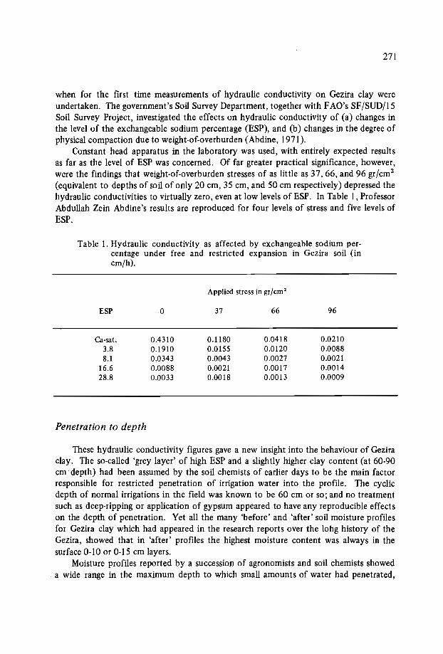
271
when for the first time measurements of hydraulic conductivity on Gezira clay wereundertaken. The government's Soil Survey Department, together with FAO's SF/SUD/15Soil Survey Project, investigated the effects on hydraulic conductivity of (a) changes inthe level of the exchangeable sodium percentage (ESP), and (b) changes in the degree ofphysical compaction due to weight-of-overburden (Abdine, 1971).
Constant head apparatus in the laboratory was used, with entirely expected resultsas far as the level of ESP was concerned. Of far greater practical significance, however,were the findings that weight-of-overburden stresses of as little as 37, 66, and 96 gr/cm 2
(equivalent to depths of soil of only 20 cm, 35 cm, and 50 cm respectively) depressed thehydraulic conductivities to virtually zero, even at low levels of ESP. In Table 1, ProfessorAbdullah Zein Abdine's results are reproduced for four levels of stress and five levels ofESP.
Table 1. Hydraulic conductivity as affected by exchangeable sodium percentage under free and restricted expansion in Gezira soil (incm/h).
Applied stress in gr/cm 2
ESP 0 37 66 96
Ca-sat. 0.4310 0.1180 0.0418 0.02103.8 0.1910 0.0155 0.0120 0.00888.1 0.0343 0.0043 0.0027 0.0021
16.6 0.0088 0.0021 0.0017 0.001428.8 0.0033 0.0018 0.0013 0.0009
Penetration to depth
These hydraulic conductivity figures gave a new insight into the behaviour of Geziraclay. The so-called 'grey layer' of high ESP and a slightly higher clay content (at 60·90cm depth) had been assumed by the soil chemists of earlier days to be the main factorresponsible for restricted penetration of irrigation water into the profile. The cyclicdepth of normal irrigations in the field was known to be 60 cm or so; and no treatmentsuch as deep-ripping or application of gypsum appeared to have any reproducible effectson the depth of penetration. Yet all the many 'before' and 'after' soil moisture profilesfor Gezira clay which had appeared in the research reports over the lohg history of theGezira, showed that in 'after' profiles the highest moisture content was always in thesurface 0-10 or 0-15 cm layers.
Moisture profiles reported by a succession of agronomists and soil chemists showed. a wide range in the maximum depth to which small amounts of water had penetrated,
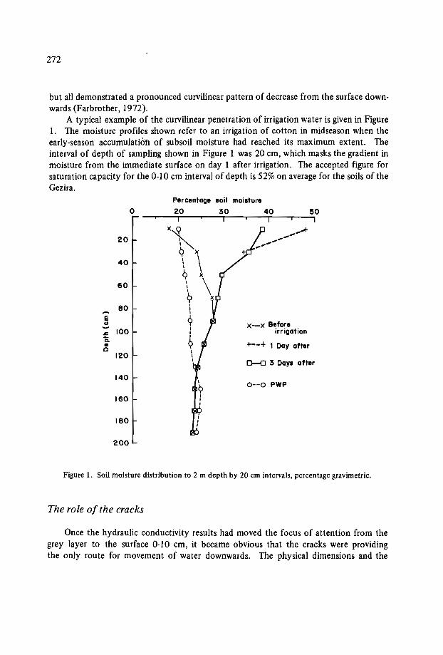
272
but all demonstrated a pronounced curvilinear pattern of decrease from the surface downwards (Farbrother, 1972).
A typical example of the curvilinear penetration of irrigation water is given in Figure1. The moisture profiles shown refer to an irrigation of cotton in midseason when theearly-season accumulation of subsoil moisture had reached its maximum extent. Theinterval of depth of sampling shown in Figure 1 was 20 cm, which masks the gradient inmoisture from the immediate surface on day 1 after irrigation. The accepted figure forsaturation capacity for the 0-10 cm interval of depth is 52% on average for the soils of theGezira.
Percentage soil moisture
0 20 30 40 50I I I I
20 x~9 )(
40 \ \~ x
60 \ \9 x80
,I-- 1
E 1
U 9 x-x Before100 I irrigation; I
Ia. 9 +--+ I Day after•c ,
120 II 0-0 3 Days after
1400--0 PWP
160
180
200
Figure 1. Soil moisture distribution to 2 m depth by 20 cm intervals, percentage gravimetric.
The role of the cracks
Once the hydraulic conductivity results had moved the focus of attention from thegrey layer to the surface 0-10 cm, it became obvious that the cracks were providingthe only route for movement of water downwards. The physical dimensions and the

273
functions of the cracks that develop as the clay dries out needed further study.The linear contraction of samples of Gezira clay over the moisture range from satura
tion capacity (52% gravimetric) down to air-dry (6%) has been reported as 12.6% (Farbrother, 1967). Estimates of the volumetric reduction over the same moisture range bythe paraffin method on samples in the laboratory were of the order of 36%. Attempts toestimate the volume of cracks in the field failed. Nevertheless it was assumed that thetotal air space developed on drying out reflected the reduction in moisture content; andthat over the 45 cm depth usually observed within cropped fields during the season, thevolume at any depth was reasonably well correlated with the moisture observed at thatdepth.
Intensive gravimetric soil moisture samplings before and after an irrigation showedthat the acretions were inversely proportional to the amount of soil moisture present before the irrigation. The amount of freestanding water left on the surface of the soil, ofcourse, had to be accounted for separately. The amounts left after satisfying the soil requirements - according to 'by eye' observations of an experienced Gezira waterman could be either nil, or halfway up the side of the ridge, or to the top of the ridge (viz.'light' and 'heavy' waterings).
For well-made ridges and furrows at the standard spacing of 80 cm, the maximumamount that could be left in the furrow has been variously reported as between 36 and48 mm (357 and 476 m3/ha).
The 'self-regulating' characteristics of Gezira clay
The immediate result of irrigating a field plot is that the cracks take as much water astheir volume dictates. Depending on the rate of supply, this step is rapidly completed,and is followed by the free water being absorbed by the dry walls of the cracks, and themoisture is redistributed in all directions in response to such moisture gradients as arepresent. The cracks also begin to close in response to the lateral expansion of the clay ofthe monoliths, which at any depth is effectively free to expand without the restrictionof weight-of-overburden. If surplus water is available on the surface, some will replacethat moved through the walls of the cracks, until such time as the cracks close completely. Redistribution continues thereafter at rates that decline with time. Near-uniformityis approached at any specific depth some three days after irrigation. The final moistureincrement at any specific depth will approximate to the original cross section of the crackat that depth; and this, no doubt, is the mechanism for preserving the curvilinear form ofthe profile of soil moisture.
This control of the amount of water taken by the soil at each watering has been referred to as the 'self-regulating' characteristic of Gezira clay. In practice, it means thatwhatever the initial dryness of the profile, the postirrigation state will be much the samein each case, although it might have taken very different quantities of water to haveachieved that result. With no freestanding water remaining on the surface, the availablewater held by the 0-60 cm depth zone in the postirrigation state is of the order of 93 mm,(929 m3/ha), of which 49%, 33% and 18% is held in intervals of 0-20, 20-40 and 40·60cm depths respectively.
274
Irrigation of virgin Gezira clay sites
Soil moisture profiles before and after irrigation have been reported for newly developed irrigation schemes eslewhere in the Sudan on Gezira clay.
In the Rahad Irrigation Project (Chesworth and Farbrother, 1984), the irrigationwater was shown to penetrate in markedly greater quantities to the 20-40 and 40-60 cmdepths during the first season (1977) of irrigation. A similar result on virgin sites at thenewly developed Kenana Sugar Estate was reported in 1976 (Gallacher, pers. comm.).Both sites were known to have supported a dense seasonal cover of perennial grasses, andsparse 'kitr' bushes prior to being cleared for irrigation development. The remains of therooting systems of those grasses were observed during the soil moisture sampling programme, and the atypical penetration during the first season was attributed to them.
Scheduling - in Theory and Practice
Answers on when to irrigate and how much water to apply cannot be predicted,except in a most generalized way. The daily water needs of the crop, and the capacityof the soil to store water within -the rooting zone of the crop, are obviously two of themain considerations; and although predicting the daily water needs of a crop is now relatively easy, the ability to predict the detailed behaviour of rooting systems under fieldconditions is still the major constraint.
'Rooting zone' is a particularly controversial term in the context of Gezira clay.Below the 60 cm depth of cyclic wetting and drying, there is a slow early-season buildupof subsoil moisture. These reserves can be exploited by plants with strong taprootsystems, and in some seasons provide modest buffers against chance short-term deficitsof moisture in the upper soil profile.
The engineering approach
In the context of large-scale smallholder irrigation schemes, information on when toirrigate, and how much to apply has for many years been considered an essential inputfor engineering planning and design (Ibrahim, 1984). The objective has been twofold:firstly, to minimize seepage losses in the smaller and invariably unlined tertiary channels(by raising the designed discharge capacity of each and thus reducing the time each is inoperation); secondly, to provide the means whereby the agricultural administration of thescheme can subsequently maintain water-use discipline by ensuring that the .recommended rotational schedules for the proposed crops can be physically imposed by the administration on the smallholding farmer-users.
The consequence of this has been that practically all of the large-scale schemes of thetropics today still operate some form of scheduled supply on a fixed-rotation basis. InEgypt, it is not uncommon for large secondary canals to rotate supplies at the locallyapproved intervals, thus ensuring that the discipline of optimum watering frequency forthe crops is adhered to by the irrigators (Bottrall, 1980).

275
In Pakistan, and in some areas of India, local 'distributaries' operate alternately forthe same purpose (Wade, 1979). In the Sudan, the traditional system originally devised in1925 for the Gezira Scheme was designed to enforce the recommended 14-day intervalfor cotton by operating pairs of tertiary channels alternately at two-weekly intervals(Griffen, 1951).
On the other hand, the introduction of CAD in India has encouraged much debateon the ethics of imposing rigid rotational schedules by engineering design (Hashim Ali,1979). Under CAD, continuous supplies at each village outlet (at approximately 1 m3/s
for each unit not exceeding 100 acres) are to be maintained day and night by the operating engineers throughout the season. As many as 60 very small-scale farmer-users maydepend on the one village outlet, each individual farmer taking the whole of the supplyfor a period of time (in hours and minutes) proportional to the area of his land. CAD departs from the traditional engineering approach in that the equitable distribution of wateris now entirely at the discretion of the villagers themselves, rather than an impositionfrom outside the village by the officials of the district irrigation administration.
The experimental approach
Remembering that the Sudan Gezira was commissioned as early as 1925, there arelessons to be learnt from examining the history of the early experimental approach to thedetermination of formal irrigation schedules.
From 1925 to 1963, the scientific approach to scheduling water involved field trialsrepeated seasonally, testing various factorial combinations of intervals (usually 7, 14,and 21 days), and various rates of application. Before water meters became available,the rates of application were nominally designated 'light', 'medium' and 'heavy', andquantified somewhat arbitrarily as 300, 420 and 600 per feddan (71 mm, 100 mm and142 mm). Cotton yields harvested from the replicated subplots were analyzed statistically to rank the order of responses to watering treatments. Throughout, the rnaximization of the yield of seed cotton per unit area of land was the main objective.
Over those 38 years in the Gezira, more than 126 such field trials testing factorialcombinations of intervals and rates were conducted by staff of the Gezira Research Station (GRS). Although immense effort was put into the implementation of these fieldtrials, statistically significant differences between treatments were only very rarely obtained, and then only between the most extreme combinations. It is also an interestingcomment that never on any occasion did the 'best' irrigation treatment outyield theCotton Breeding Section's variety trial in the same year - the latter being grown underthe standard irrigation practices of the station. Nevertheless, as the number of trialsaccumulated, the trend overall gave strong support to the scheme's design assumption ofa fixed interval of 14 days between waterings, coupled with a 'medium' (100 mm) rate ofapplication.
By 1962, the field trials had adopted rather more sophisticated experimental layouts,with metered water supplies and soil moisture sampling programmes. Dethridgemetersw~re introduced to the Sudan for this purpose. In the 1962-63 season, the trial compared
276
cotton yields at all combinations of four intervals and four rates. The results were reported in detail in the GRS annual report for that year, and I quote the table of yieldsbelow (Table 2), having converted the seed-cotton yields from the original 'kantars perfeddan' to kg per hectare.
Table 2. Yields in kg/ha of seed-cotton irrigated at four intervals and fourrates.
Rates: Intervals in days:mm/day:
7 14 21 28
means:2.5 2342 2261 2271 2019 22235.0 2070 2097 1957 2206 20827.5 2012 2019 2186 2244 2115
10.0 2026 2053 2172 2073 2081
means: 2112 2108 2146 2136no significant differences
For obvious reasons, this field trial was the last major experiment on rates and intervals at the GRS. With the mean crop water requirements (CWR) for cotton over theaverage season at 7.1 mm/day, it was clear that the technology of applying controlledamounts of irrigation water to relatively small subplots (12 m X 8 m) was at fault andthat the unique characteristics of Gezira clay were not sufficiently well understood.
Failure to obtain statistically sound results from experimental layouts testing irrigation schedules is by no means confined to the Sudan. A number of classical examplesfrom elsewhere were put on record in FAO's Irrigation and Drainage Paperno. 13, reporting the Damascus Seminar on Water Use, 1972. Some 16 field experiments on a widevariety of sites, mostly with highly sophisticated layouts (which included tensiometercontrolled intervals at 75%, 50% and 35% reduction of available water) all failed toprovide statistically significant yield results.
The Alternative Research Strategy at GRS
From 1964 onwards, a new research approach to irrigation and the fundamentals ofcrop management on Gezira clay was initiated by the then director of the GRS, Dr. Hussein ldris. Three stages were envisaged:

277
1st: Integrated research on the fundamentals of soils and water on Gezira clay,bringing soil physics, agrometeorology, and plant physiology into a commonapproach.
2nd: Collaboration with the Ministry of Irrigation (Mol) and the Sudan Gezira Board(SGB) in the monitoring of irrigation practices in the commercial areas.
3rd: Intervention tactics.
First stage
During this stage, interdisciplinary research was encouraged to resolve the manyanomolies irr the field behaviour of Gezira clay, and to determine the influence of theGezira environment on the growth and development of crops. Although the Gezira already had a long history of soils research going back to 1911, only soil chemists had untilthen been involved, and the hazards of alkalinity and salinity for the Gezira had dominated their thinking. Studies of the basic physical characteristics of the soils of theGezira were therefore the starting point for the newly appointed soil physicist (Fadl,1976). Drainage and soil aeration, and volume-weight conversion factors were also examined in detail (Hack, 1969, 1984).
In agrometeorology, the primary task was the localization of Penman methodologies:reference evaporation (Eo), evapotranspiration (ET), CWR, crop coefficients (kc), windterm and solar radiation corrections, reflection coefficients, albedo, and advective energy(Adam, 1984). Physiological contributions were made (i) on relative turgidity - ET,CWR, and yield/stress functions (Farbrother, 1973); and (H)on leaf area indices, net assimilation rates, and growth analysis (Taha, 1969).
Second stage
This stage, which started in 1969, involved monitoring the irrigation practices of theGezira at the field level: (a) observing and recording the day-to-day field water management tactics of the tenants of the scheme, and (b) documenting the discharges at selectedminor heads and other structures operated by employees of Mol. All monitoring in thisstage was passive observation by research staff, but wholly dependent on close cooperation with field staff and administrators of the SGB and irrigation engineers of Mol. Theobjective was to obtain a properly balanced view of the attitudes and motivations of allthose with roles in water control and management.
The sites selected for monitoring were each chosen on grounds of suitability for aparticular line of investigation. These varied widely, ranging from the causes of fluctuating supply levels at key points in the distributive system to the unofficial labour-savingmethods of field watering introduced by experienced Gezira tenants in response to intensification and diversification of cropping.
The lesson was quickly learnt: that no single aspect of irrigation in a large-scale smallholder scheme can be isolated and studied in clinical isolation by researchers in anyone_discipline. The appointment of a multidisciplinary committee does not necessarily over-
278
come the inherent tendency for disciplines to operate introspectively. In practice, it isonly after working closely together in interdisciplinary monitoring exercises that individual members acquire from one another the ability to see a problem as it really is, in allits complexities, and from a properly balanced point of view. The most important pointof view, of course, is that of the actual farmer-user himself; and unfortunately for conventionally trained scientists and engineers, an insight into his thinking is most difficult toacquire.
Third stage
This stage was planned to follow with a number of positive interventions on specificaspects of irrigation in the commercial areas of the Gezira - but only when the monitoring exercises had produced enough documented evidence to warrant a joint move by allthree interested parties: the SGB, the Mol, and the GRS. Only one such intervention waspossible - in 1977, when ~ project was sponsored by FAO for a field trial of CWRmethods at the block inspector level, in an effort to replace the traditional indent procedure at minor heads (Farbrother, 1979).
The Gezira Tenants' Contribution
Although I have pressed the case (in the previous section) that much can be learnedby monitoring the way experienced farmer-users use their available resources of water,this approach is not without its critics. In the Sudan, for example, it is widely believedthat because the tenants are no longer following the letter of the old strictly disciplinedways with water in the fields, the crops must inevitably be less well watered than formerly. Even when our GRS research results demonstrated that the new field tactics shouldbe supported as progressive on economic and social grounds, and that they were no lessadequate on scientific and engineering grounds, the tendency amongst nontenants was tomisinterpret the data presented, and use them simply as evidence of what they termed the'declining standards' of the tenants.
It would not be proper for me to comment here on the current controversies overhow today's Gezira tenant can be retrained to conform with the 1934 concept of hisrole in field water management. But as we have already discussed how the soil physicists'understanding of irrigation on this unique cracking clay has developed over the years, it isreasonable for me to outline how the tenants' understanding of the practical issuesinvolved have developed over the 50 years that they and their fathers have had in day-today contact with the soils and water of the scheme.
Scheduling from the tenants' viewpoint
Formerly, the Gezira tenant had no option but to water at the 14-day (or so) intervalimposed by the field staff of the scheme. The nine tenants sharing supplies delivered to
279
one of the Gezira's standard tertiary supply channels (known locally as 'Abu Ishreen')took water for their cotton in sequence for one week, and a neighbouring group of ninetenants on another Abu Ishreen took water for the alternating week. The field staff werein control, because it was their employees, the canal 'Ghaffirs', who physically openedand closed the outlets to the designated Abu Ishreen.
The official schedule also dictated that field watering of cotton could only be doneduring the twelve daylight hours, and the rates of discharge at the outlet pipes wereraised so that all nine tenants could complete their fields within the seven days, giving therecommended 1000 m3 to each hectare (420 m per feddan). Without going now into toomuch detail, the result was that 4.5 individual tenants each had a stream size averagingsome 100 m3/h for 3 days (Le. 42 daylight working hours, 6 a.m. to 6 p.m.) for his 4.2 haof cotton (10 feddans).
In order to assist the tenant in spreading the water evenly over the land, the schememanagement set out the 4.2 ha into a rectangular arrangement of field channels, bunds,ridges and furrows, dividing the holding into 137 small basins, each of approximately306 m". The tenant's duty was then to divert his 100 m3/h supply in succession aroundthese small basins throughout the prescribed hours of watering.
It was not long before the tenants (or the paid watermen acting for them) discoveredthat this formal schedule was quite impracticable on Gezira clay, for the following reasons:
The cross-cracks which develop in ridges and bunds during a drying cycle make itimpossible for a waterman to contain water within the limits of any specified basinor combination of basins.With the minimum of interference by the waterman, the whole field could be evenlycovered as one large basin (apart from known 'high-spots' on some difficult fields).The "thirstiness of the soil" (as they called it) determined the amount of watertaken, and their only control over the rate was limited to small differences in theamount of standing water left in the furrows.Putting these three reasons together, the tenants could see no virtue in being com
pelled to spend a seasonal total of 420 hours in the cotton field for the ten biweeklywaterings given to cotton. Once the cotton plants had become established (preferably onrainfall alone), and the roots of the cotton had developed into the soil below the surface0-15 cm (OWing to its surface susceptibility to waterlogging), they then saw their necessary role reduced to simply opening the field to water, and eventually closing it a fewdays later.
Unpredictable fluctuations in the supplies available at the scheduled outlets werean additional reason for the tenants to abandon the official practices. The local engineersand the local field inspectorate were also embrassed by the limitations that fluctuatingsupplies imposed on the scheduling of alternate outlets by weeks. As early as 1956, theevidence against the need for alternating outlets already existed. Joint experimentationat a particular site in the Gezira equipped with Dethridgemeters for the purpose of measuring discharges to tenants (Faris Minor 54/55 and 55/56, Mol unpublished data)showed that an outlet continuously open to nine sharing tenants took exactly the sameamount of water over the season as one opened for only alternate weeks.
280
The advantages of half-rate discharges for double the time were ful1y appreciated bythe tenants. The most valuable aspect of the scheme was that rotation of water betweenfields within Abu Ishreens became possible, thus allowing the frequency of watering tobe at the discretion of the nine tenants alone, according to their judgement of the needsof their crops.
The advantages of quarter-rate discharges at four times the number of open outletswere exploited by the tenants from the mid·1960s onwards. Diversification of croppingat that time involved a threefold increase in the numbers of outlets 'Jive to crops' at anyone time; and the former regimented style of 'scheduling' for cotton alone at 14-day intervals proved inadequate. The current Gezira version of on-demand, continuous-flowmanagement of Abu Ishreens soon applied unofficial1y throughout the scheme.
The tenants' longer intervals
The irrigation of large open fields as single basins (now halved to 2.1 ha), with lowstreamflows in the 25-35 m3/h range, means that the time taken to complete wateringoveral1 is now increased to some seven to ten days or more. Moreover, on the completionof watering, practical1y the whole field is covered with some surplus water standing inthe furrows. The tenants, very correctly, have learnt that the traditional 14-day intervalhas to be reinterpreted as a 14·day drying phase. The standard interval in the commercial areas of the Gezira is thus today between 21 and 25 days, depending on the variabletime which it takes to complete watering.
The tenants are of course much criticized for not adhering to the longstanding research recommendation for 14-day intervals. Indeed, it is not uncommon for newresearch findings on intervals to refer only to the smal1 12 m X 8 m standard subplot sizefor irrigation experiments with no mention of recommendations for the large open-stylefields of the commercial areas. On the other hand, one realizes that it would be total1yimpracticable to design and conduct formal experiments with controlled watering treatments using subplot dimensions on the 2.1 ha scale of the commercial areas!
Current monitoring projects in the Gezira
It is encouraging that the monitoring approach has been revived in the Gezira since1984. The Mol's Hydraulics Research Station, with the support of Hydraulics ResearchLtd., Wallingford, England, has initiated a project designed to provide data on the supplyof water at the field level in the Gezira. On the principles established in FAD's Irrigationand Drainage Paper no. 33, "Yield Responses to Water", it will thus be possible toevaluate the tenants' field practices by another and more profitable route.
According to Paper no. 33, yield potential wiJI be maximized when actual crop wateruse (CWU) is equal to calculated crop water requirements (CWR). If the water supplyperiod by period over the season can be measured at the field level at a representativenumber of tenants' fields, then in will be reasonable to deduce how close they have beento achieving optimum CWU. The same principle has been used for supply and demand
281
data at the head works of the scheme with considerable success for a number of years(Abdu, 1984).
Assuming some measure of agreement between CWU and CWR at the field level,monitoring exercises such as this could do much to reaIieve the current administrativepressure on the tenants of the Gezira to return to the highly labour-intensive practices ofpast generations.
References
ABDINE, A.Z. 1971. Factors affecting hydraulic conductivity in the soil profile of theGezira. Appendix Ill, Technical Report attached to Terminal Statement: FAO Project SF/SUD/15.
ABDU, K:M., FADL, O.A., and ADAM, H.S. 1984. Analytical study of irrigation waterused in the Gezira schemes during the 1983/84 season. In: Proceedings of Conference on Water Distribution in Sudanese Irrigated Agriculture, eds. Osman A. Fadland Charles R. Bailey. University of Gezira, Republic of Sudan.
ADAM, H.S. 1984. On the wind function in the Penman formula. In: Water Distributionin Sudanese Irrigated Agriculture, Productivity and Equity, eds. Osman A. Fadl andCharles R. Bailey. University of Gezira, Republic of Sudan.
BOTTERALL, A. 1980. Irrigation in Egypt, past and present. Network Paper no. 1/80/3,Irrigation Management Unit, Overseas Development Institute, London. 18p.
CHESWORTH, P. and FARBROTHER, H.G. 1984. Irrigation field trials on the montmorillonitic cracking clay soils of the Rahad irrigation project. Pages 97-118 in: Proceedings of the Twelfth ICID Congress (Q 38 R 5).
DOORENBOS, J. and PRUITT, W.O. 1977. Crop water requirements. FAO Irrigation andDrainage Paper no. 24. Rome: FAO.
FARBROTHER, H.G. 1967. Water relations and volumetric soil water data. ProgressReports from Experiment Stations, Season 1965-66. Cotton Research Corporation,Republic of Sudan.
FARBROTHER, H.G. 1972. Field behaviour of Gezira clay under irrigation. CottonGrowing Review, vol. 49, January 1972.
FARBROTHER, H.G. 1973. Water relations of crops in the Gezira. Cotton ResearchReports, Season 1972-73. Cotton Research Corporation, Republic of Sudan.
FARBROTHER, H.G. 1975. The accumulation of soil moisture under fallow during therains in the Gezira. Cotton Research Reports, Cotton Research Corporation, Republic of Sudan, 1971-72.
FABROTHER, H.G. 1979. Water management in Gezira. Terminal statement preparedfor the government of Sudan: FAO Project TCP/SUD/6/0 1.
GRIFFEN, A.E. 1951. In: Sudan Gezira Board Handbook for New Personnel.HANSEN, V.E. Strinbham, O.W. and Israelsen, G.E. 1979 Irrigation Principles and Prac
tices. 4th edn, New York: John Wiley & Sons. 417p.HACK, H. 1984. Calculations of the field volumetric water content of cracking clay soils
from measurements of gravimetric water content and bulk density. Journal of SoilScience 35: 299-31 S.
282
HASHlM All, S. 1979. Practical experience of irrigation reform, Andra Pradesh, India.Paper presented at the Workshop on Water Bureaucracy and Performance, Instituteof Development Studies, University of Sussex, UK.
IBRAHlM, A.M. 1984. Concepts of design and practice for irrigation distribution Systems in Sudan. Pages 105-116 in: Water Distribution in Sudanese Irrigated Agriculture, Productivity and Equity, eds. Osman A. Fadl and Charles R. Bailey. Universityof Gezira, Wad Medani, Republic of Sudan.
JEWETT, T. 1954. Gezira soil. Gezira Research Station Bulletin no. 12. AgriculturalResearch Department, Government of Sudan.
TAHA, M.A. 1969. Growth and development of the cotton plant under irrigation. In:Cotton Growth in the Gezira Environment, eds. M.Siddig and L.C. Hughes. Agricultural Research Corporation, Sudan.
WADE, R. 1979. Man mismanagement in canal irrigation, A South Indian example. Paperpresented at the Workshop on Water Bureaucracy and Performance, Institute ofDevelopment Studies, University of Sussex, UK.

Seventh session: Sustainability of improved systems
Chairmen: Dr.T. Walker
Dr.N.N. Nyandat


APPROACHES TO EROSION
CONTROL ON VERTISOLS IN QUEENSLAND, AUSTRALIA
J.A. MuUins, A.A. Webb and K.J. Coughlan*
Abstract
Vertisols are used for both cropping and grazing in Queensland. Soil erosion is oneof the major problems threatening their long-term viability.
Soil conservation can be achieved on the arable Vertisols through the maintenanceof high levels of protective ground cover and in conjunction with the use of structuressuch as graded terraces and waterways to control runoff before it reaches scouring velocities. The maintenance of ground cover using both crop and crop residues protects thesoil surface from the impact of raindrops and permits maximum infiltration. This isachieved with practices such as reduced tillage, selection ofcrops that provide maximumcover at critical periods, opportunity cropping, strip-cropping and fallow management.
In grazing lands, erosion is controlled by the maintenance ofground cover, through.reduced stocking pressures, and the strategic placement offences, watering points, yards,etc.
Land-use planning is the recommended basis for selection of management practicesand land development.
Introduction
Vertisols cover approximately 50 million ha, which is more than one quarter of theQueensland land surface (Coughlan et al., 1986). Native pasture, which takes up thelargest proportion of Vertisols (approximately 43 million ha), is the base of the livestock
* Queensland Department of Primary Industries, Meires Road, Indooroopilly QLD. 4068, Australia.

286
industry. These areas are considered too dry for rain fed cropping as.they have an annualrainfall of less than 500 mm which is highly variable.
Approximately 1.25 million ha of Vertisols are cultivated for grain production,mainly wheat and sorghum, with smaller areas of oilseeds such as sunflower and safflower.
The Vertisols are highly erodible, particularly under cropping, and considerable emphasis has been placed on the management of these soils to ensure sustainable long-termstability.
This paper presents a brief description of the soils and the climate, and describes theerosion problem on the Vertisols of Queensland, with details on the strategies used tocontrol the soil erosion.
Soil Characteristics
The characteristics of the Vertisols in Queensland have been described by Smithet al. (I 984), and will not be considered here in any detail. They are generally consideredas two broad groups, Black Earths (approximately coinciding with the Pellustert greatgroup) and the Grey, Brown or Red Clays (Chromusterts and Torrerts). The differencesbetween the soils are related to the lithology of the parent material. The Black Earthsare usually formed on basic rocks such as basalt, or alluvium largely of basaltic origin,while the Grey, Brown and Red Clays are formed on a range of parent materials largelyof sedimentary origin. The Black Earths generally have a high clay content, high cationexchange capacity, and low sodicity and salinity. The Grey Clays in particular are usuallylower in clay content and cation-exchange capacity, sodic, often moderately saline, andhave gilgai development.
Climate
The main cropping area lies between 20° and 29° S latitude and within the 500-700mm rainfall isohyet. In this area rainfall is summer-dominant and highly variable. Panevaporation exceeds rainfall in nearly all months. In this paper summer-dominant rainfallmeans that more than 50% of the annual rainfall occurs in the six months between October and March.
Although summer rainfall is dominant (the summer:winter rainfall ratio is 2:1 at29° S and greater than 3: I at 20° S latitude), wheat is the main cereal crop in southernareas, particularly in drier western areas where rainfall is less reliable.
Both the amount and seasonal distribution of rainfall are highly variable. Droughtsand floods are experienced in most cropping areas. Rainfall intensity is high, comparedto that of many other cereal-cropping areas of Australia and the world. High-intensityrainfall events are caused mainly by convective frontal storms (spring to early summer),cyclonic systems (mid to late summer and midwinter) and upper level disturbances (at
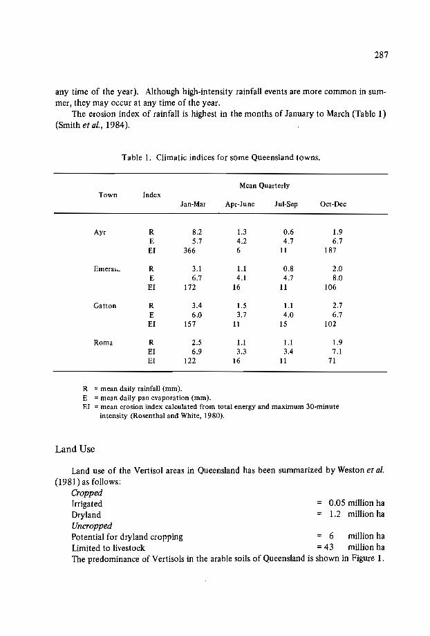
= 0.05 million ha= 1.2 million ha
287
any time of the year). Although high-intensity rainfall events are more common in summer, they may occur at any time of the year.
The erosion index of rainfall is highest in the months of January to March (Table 1)(Smith et al., 1984).
Table 1. Climatic indices for some Queensland towns.
Mean QuarterlyTown Index
Jan-Mar Apr-June Jul-Sep Oct-Dec
Ayr R 8.2 1.3 0.6 1.9E 5.7 4.2 4.7 6.7El 366 6 11 187
Emerai,.. R 3.1 1.1 0.8 2.0E 6.7 4.1 4.7 8.0El 172 16 11 106
Gatton R 3.4 1.5 1.1 2.7E 6.0 3.7 4.0 6.7El 157 11 15 102
Roma R 2.5 1.1 1.1 1.9El 6.9 3.3 3.4 7.1El 122 16 11 71
R = mean daily rainfall (mm).E = mean daily pan evaporation (mm).El = mean erosion index calculated from totalenergy andmaximum 3D-minute
intensity (Rosenthal andWhite, 1980).
Land Use
Land use of the VertisoI areas in Queensland has been summarized by Weston et al.(1981) as follows:
CroppedIrrigatedDrylandUncroppedPotential for dryland cropping = 6 million haLimited to livestock =43 million haThe predominance of Vertisols in the arable soils of Queensland is shown in Figure 1.

288
IVIIIIIIIIIII
J----1IIIIr---------_
Vertisols
{B lack Earths
Grey and Brown Clays
Red Friable Clays
Mixed Soils
.'P5CJ
-
Figure 1. Major arable soils of Queensland.

289
The large proportion of native grass pastures used for livestock production indicatesthe occurrence of very large areas of Vertisols in low-rainfall regions.
Vertisols are commonly used for irrigation in Queensland despite problems of cropestablishment, waterlogging and salinity in some soils. The total area of irrigated Vertisols is relatively small, but is highly valued.
Extensive dryland cropping in Queensland is largely opportunistic, as planting decisions depend both on the level of subsoil moisture available and the occurrence of planting rains. The annual reliability of rainfall thus influences the amount of crop plantedeach year. A fallow phase is often included to restore soil moisture to overcome rainfalldeficiencies during the growing season. In traditional cropping systems, the soil surfaceis kept bare during the fallow period, and when high-intensity rain hits this bare and oftenloose surface, severe soil erosion results.
The Erosion Problem
The erosion problem on the Vertisols in Queensland is a result of the interactingcomponents of soils, topography, management practices, and rainfall. .
The Vertisols have slow infiltration when cracks are closed, and their inherent structural instability under rainfall leads to the formation of surface seals and crusts. Thesefactors result in high runoff from rainfall. In addition, the Vertisols, particularly thosedeveloped on basalt, are highly erodible.
Vertisols occur in either plain or upland situations. Land slopes in upland situationsmay be very steep. Soil losses cannot be adequately controlled under cropping on landslopes in excess of between 4 and 8%. The upper slope limit depends on the localenvironment and the level of management practices available for the area.
Management practices which exacerbate the inherent disadvantages of Vertisols re-sult in severe erosion. These include:
o long periods of fallow with infrequent cropping;o frequent aggressive tillage;o removal of crop residues; ando cropping of shallow soils.There is of course, a strong interaction between rainfall and management practices.
In Figure 2, rainfall erosivity for the eastern Darling Downs is shown with a number ofcommonly practiced crop and fallow sequences.. Two situations are considered:
o Where continuous winter cropping is practiced, the greatest erosion potential is in theDecember to May period. This is the fallow period when soil moisture is stored forthe subsequent crop. The erosion index (El) of rainfall is very high in the early partof this period. In the latter part, although the El is less, soil water content is usuallyhigh, cracks are closed, and macroporosity is at its minimum. Under conventionaltillage techniques, crop residues are also progressively reduced over the period. Allthese conditions lead to increased runoff and soil loss.
o When summer cropping is practiced, fallow periods occur during the months of
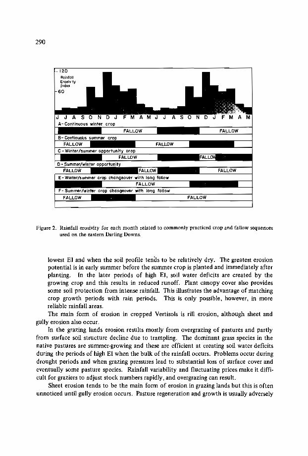
290
FALLOW
FALLOW
FALLOW0- Summer/winter opportunity
FALLOW
120RainfallErosivityInd ..
60
Figure 2. Rainfall erosivity for each month related to commonly practiced crop and fallow sequencesused on the eastern Darling Downs.
lowest El and when the soil profile tends to be relatively dry. The greatest erosionpotential is in early summer before the summer crop is planted and immediately afterplanting. In the later periods of high El, soil water deficits are created by thegrowing crop and this results in reduced runoff. Plant canopy cover also providessome soil protection from intense rainfall. This illust'rates the advantage of matchingcrop growth periods with rain periods. This is only possible, however, in morereliab le rainfall areas.The main form of erosion in cropped Vertisols is rill erosion, although sheet and
gully erosion also occur.In the grazing lands erosion results mostly from overgrazing of pastures and partly
from surface soil structure decline due to trampling. The dominant grass species in thenative pastures are summer-growing and these are efficient at creating soil water deficitsduring the periods of high El when the bulk of the rainfall occurs. Problems occur duringdrought periods and when grazing pressures lead to substantial loss of surface cover andeventually some pasture species. Rainfall variability and fluctuating prices make it difficult for graziers to adjust stock numbers rapidly, and overgrazing can result.
Sheet erosion tends to be the main form of erosion in grazing lands but this is oftenunnoticed until gully erosion occurs. Pasture regeneration and growth is usually adversely
291
affected, and weed invasion often follows. Although erosion rates in grazing lands aregenerally low, the resultant effect on productivity can be considerable due to the loss ofnutrients, seed source, and reduced infiltration.
Strategies for Erosion Control
Strategies for erosion. control involve maximizing infiltration of rainfall, protectionto the soil surface, and the control of runoff. An overriding strategy is land-use planning,which provides the basis for the implementation of the other strategies.
On most Vertisols in Queensland - apart from those on very low-gradient land slopes- a combination of conservation cropping practices and mechanical structures is neededto control soil erosion on cultivated lands. In some situations, such combinations havenot been adequate to reduce soil losses to acceptable levels and a land-use reversal to pasture has been necessary.
Land-use planning
The key outcome from land-use planning is an assessment of land capability. Thisrequires an understanding of physical resources, and particularly of soils. Land management units are delineated and appropriate land-use and management practices for sustained production and erosion control are formulated. Runoff control structures areintegrated.
Runoff control
Irrespective of the cropping practices adopted, runoff still occurs when the rainfallrate exceeds the infiltration rate of water. Various techniques are used to control the effects of overland flow. The major ones include contour cultivation, terraces, diversionterraces, waterways, and strip-cropping.
TerracesThe function of terraces (commonly referred to as graded banks in Australia) is to
decrease the length of slope down which water can flow. They collect water before itreaches scouring velocities and convey it at safe speeds to the side of the paddock wherethe water is deposited into a constructed grass waterway or a stable drainage area. Thelength of slope over which sheet and rill erosion will occur is reduced, and this limits theformation of major rills and gullies.
Terraces are used on land planted with a wide variety of crops, including cerealgrains, oilseeds, sugarcane and some horticultural crops. For practical reasons, terracesare designed to carry the greatest runoff, expected only once in every IO-year period.Depending on the land slope and soil erodibility, terraces are spaced at intervals down theslope. The steeper the land and the more erodible the soil, the closer together the
292
terraces need to be to reduce rill erosion. ' In the drier cropping area's of Queensland(rainfall less than 600 mm), terraces are spaced at vertical intervals of 1.7 m on a 2% landslope, increasing to 2.3 m on a 5% land slope. This vertical interval is reduced on shallowVertisols and those with sodic and/or saline subsoils.
Depending on factors such as land slope, soil type, land value and land use, differenttypes of terraces are used. On most Vertisols, it is necessary to cultivate at least the topside of the terrace, otherwise the deep cracks which occur on these soils when they dryout allow water to break through the terrace.
On gently sloping areas with deep soil, terraces can be built with a broad base so thatit is possible to cultivate along both sides of the terrace. As the land slope increases, itbecomes more difficult and impractical to work the bottomside; and finally, on steepland slopes, it is impractical to build anything but a narrow-base bank, in which case onlythe channel can be cultivated. Because a broad-base bank requires much soil, narrowbase banks are generally used on shallow soils.
Terraces are built with a very low gradient so that water travelling along the channeldoes not cause scouring under cultivated conditions. Maximum permissible velocities of0.5 m/sec are acceptable for Vertisols with nonsodic subsoils and of 0.35 m/sec on sodicsubsoils. Due to the potential for major scouring, terraces are not constructed on Vertisols with highly sodic subsoils.
Terraces are built with either bulldozers, graders, or a blade mounted on a tractor.An allowance for settlement of 60% is made when terraces are constructed on Vertisolswith a water content close to field capacity.
Regular maintenance of terraces is recommended, particularly following periods ofhigh runoff. The need for maintenance is significantly reduced if conservation croppingpractices are used to reduce the amount of silt deposited in the channel.
WaterwaysFarm waterways play a very important role in the overall soil conservation strategy
of a farm. Concentrated runoff water collected by terraces within a paddock is conveyedto a waterway and hence to a safe point of release. Because of the concentration of waterflow, waterways are very vulnerable to erosion and can constitute the. weakest link in asoil conservation scheme.
Where possible, waterways are located in natural depressions. However, other locations (for example parallel to a fence line) are often used in order to improve the workability of a terrace layout.
Waterways are designed to carry a certain amount of water at a safe speed. Factorssuch as land slope, soil type, catchment area, rainfall intensity, grass cover and rainfallduration are taken into consideration when designing a waterway. As for terraces, waterways are designed to carry the greatest runoff expected once in a ID-year period. Waterway design in Vertisols is based on a maximum permissible velocity of 1.2 m/sec and at avegetal retardance category C.
Water flowing in a waterway reaches higher velocities than in diversion banks andterraces. It is therefore important that waterways are properly constructed and protected
293
with a dense cover of grass before water is discharged into them. As with terraces, maintenance is required at regular intervals, especially after major events. In general, becauseof their high plant-available water capacity and nutrient status, Vertisols have the potential to produce good grass cover in their natural state. However, if the subsoil of SodicVertisols is exposed during waterway construction, the potential to establish a vigorouspasture can be markedly reduced.
Careful management is required when establishing small-seeded grass species on thoseVertisols with self-mulching surfaces or coarse-surface structure. The main factors reducing seeding emergence and establishment on Vertisols are moisture stress and mechanicalimpedance by the dry crumbs (Leslie, 1965). A better overall establishment was oftenachieved when the stubble was slashed on the top of the seeds (Younger and Gilmore,1978). The practice of growing a: winter cereal crop such as wheat, oats or barley on the
. waterways in autumn or a millet crop in spring has been found to be very effective inprotecting the waterways from high-intensity storms in spring and early summer. Inaddition, this crop provides a good mulch for the planting of grass species in summer(Truong, 1983).
Vertisols with highly sodic and saline subsoil at very shallow depths are not used forwaterways. It is necessary to replace the topsoil when constructing waterways on shallowVertisols or those with slight to moderately sodic or saline subsoils,
ContourcultivationBecause the infiltration of water, into a Vertisol soil profile is generally slow, any
practice which increases surface retention will assist infiltration. Contour cultivationachieves this on sloping lands. By ploughing on the contour, each furrow acts as a smallretention dam. Studies using simulated rain (Loch and Donnollan, 1983) have shownthat cultivation on the contour can increase infiltration into Vertisols by up to 13 mm ofrainfall per storm event when compared to downslope cultivation.
Strip-croppingThe strategy for controlling erosion on large expanses of Vertisol flood plains of
southern Queensland involves the spreading of flood runoff through predetermined patterns of land use.
In this area, with a favourable rainfall for both summer and winter crops, stripcropping is a successful solution. This involves growing alternate strips of winter andsummer crops at right angles to the direction of water flow. If strip-cropping is combinedwith conservation cropping techniques, there is always either crop or crop residue inevery strip to help spread the water and reduce flow velocity. When possible, the stripsare designed to be straight and parallel for ease of working.
Strip widths vary depending on the type of flow, presence of run-on water, surfaceconditions, land slope, flow obstructions, crop sequence, time of year and management(Macnish, 1980). Optimum strip width for a range of situations and management conditions were also detailed by the same author.
In the more marginal cropping areas where a rotation incorporating both summer and
294
winter crops cannot be maintained, a rotation that includes pasture is used.Built-up roads, railway lines, fences and irrigation works can divert and concentrate
flood flows, causing serious erosion. Wherever possible, provision is made for water todrain under these structures at frequent intervals, or the features are lowered or relocated.
Division terracesDiversion terraces are used to protect cultivation from runoff from steep timbered
and rocky areas above, and to divert such water to a safe disposal area. They are alsoused to divert water away from unstable areas, away from buildings and into farm dams.
Apart from those situations where additional protection may be required, diversionterraces are designed to carry the greatest runoff expected once in a la-year period. Thechannel of a diversion terrace is grassed and is designed for a maximum permissible velocity of 1 m/sec. Regular maintenance of diversion terraces is essential.
Conservation cropping systems
Conservation cropping systems incorporate a range of specific practices which together result in less erosion than from most conventional practices.
Typically a conservation cropping system involves management of crop and fallowto achieve maximum water infiltration into the soil, optimum use of this water by crops,and retention of crop residues on the soil surface. Antecedent moisture content is themajor factor controlling infiltration. Hence any practice which creates soil water deficitsat periods of high rainfall is beneficial in reducing runoff. Opportunity cropping ordouble-cropping, which involves growing crops whenever soil water is sufficient, is onesuch practice.
On the eastern Darling Downs annual winter cropping, annual summer cropping anddouble-cropping produced 84 mm, 54 mm and 40 mm respectively of runoff annually(Freebairn et al., in press). In that environment, double-cropping is used as a conservation cropping practice.
Research into different crop and tillage options (Freebairn and Wockner, 1986) onVertisols in southern Queensland has shown that stubble-mulch (reduced-tillage) practicesproduce less runoff, less soil loss and higher crop yields than practices which removestubble (Figure 3). Zero tillage, although it achieves very low soil loss, results in morerunoff and slightly lower yields than reduced-tillage practices.
One of the major findings of these studies is the benefit accrued from having soilcover. Soil erosion losses have averaged less than 5 t ha- l yr- l when surface cover of 2030% was maintained over the summer rainfall period of October to March. By contrastsoil erosion from bare fallows over the same period was 60 t ha l yr- l
.
These and other studies on the Vertisols have led to the development of specificrecommendations aimed at increasing water infiltration and reducing soil erosion. Theseare:
o the use of high stubble-producing crops such as wheat and barley, which withstubble retention can provide soil protection at critical periods;
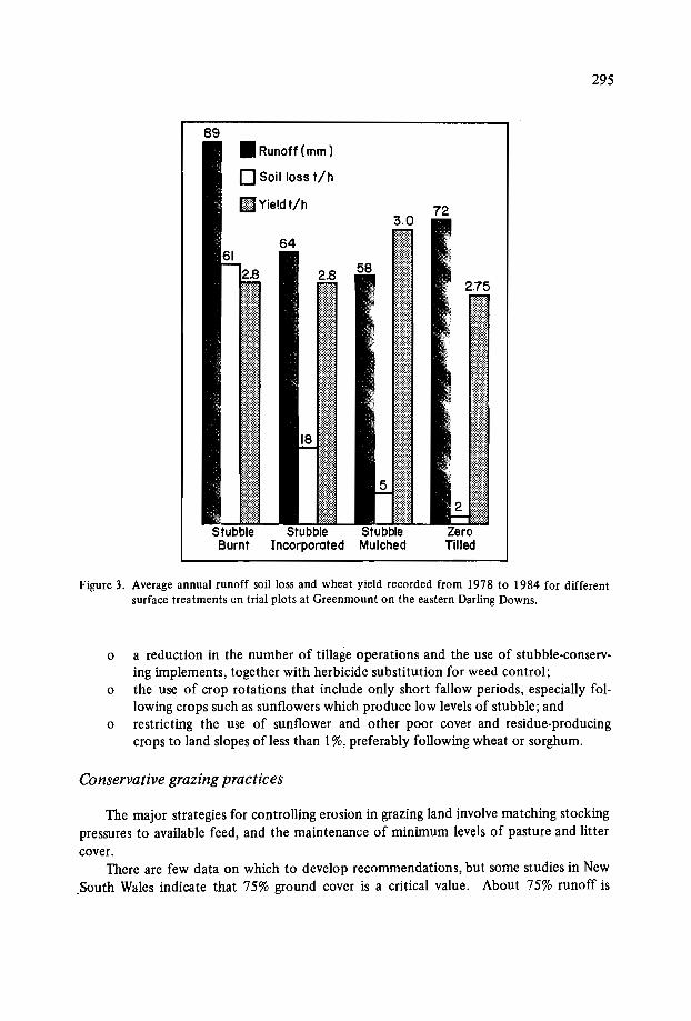
295
89
2.75
I
3.0
• Runoff (mm)
o Soil loss t/h
flVieldt/h
Figure 3. Average annual runoff soil loss and wheat yield recorded from 1978 to 1984 for differentsurface treatments on trial plots at Greenmount on the eastern Darling Downs.
o a reduction in the number of tillage operations and the use of stubble-conserving implements, together with herbicide substitution for weed control;
o the use of crop rotations that include only short fallow periods, especially following crops such as sunflowers which produce low levels of stubble; and
o restricting the use of sunflower and other poor cover and residue-producingcrops to land slopes of less than I%,preferably following wheat or sorghum.
Conservative grazing practices
The major strategies for controlling erosion in grazing land involve matching stockingpressures to available feed, and the maintenance of minimum levels of pasture and littercover.
There are few data on which to develop recommendations, but some studies in NewSouth Wales indicate that 75% ground cover is a critical value. About 75% runoff is
296
slight, while below 75% runoff increases rapidly.In land which has well-developed gully erosion, grazing management is usually not
sufficient to arrest or reclaim eroded areas. Under these circumstances, some disturbanceand revegetation procedure is required. In the drier and less productive lands reclamationis not economical.
Generally it is uneconomic to attempt pasture renovation by cultivation and theapplication of fertilizer nitrogen. Pasture renovation is occasionally carried out on sownpastures in more favoured areas such as those in the cropping zone, especially when seedharvesting is practised.
Pasture spelling at critical periods to allow flowering and seeding are recommendedto allow rejuvenation of pastures. Since most pasture species in Queensland flower, setseed, and germinate in response to rainfall in spring and summer, pasture spelling is bestdone in summer, particularly following good rainfall.
Diversion terraces are occasionally used on pastures on Vertisols, especially whererunoff control is required to prevent damage to cropped areas, or where water harvestingis attempted. There are a few examples of water harvesting on Vertisols in the easternDarling Downs. The water is used to irrigate high-value crops or pastures for milk production.
Conclusion
In Queensland, the Vertisols are the most productive soils for both cropping andgrazing, but are also highly erodible. Effective soil conservation programmes to protectVertisols from soil erosion have been developed for most of the cropping areas and someof the grazing lands of the state. Research and development is continuing in these areasfor which solutions are not available. The major task of implementing these soil conservation programmes through a major extension and advisory programme is under way.
References
COUGHLAN, K.J., SMITH, G.D. and YULE, D.F. In press. Soil physical research for improved dryland crop production on Vertisols in Queensland, Australia. In: Proceedings of the Inaugural Workshop on Management of Vertisols for Improved Agricultural Production, Patancheru, India, 18-22 February 1985. Bangkok, Thailand:IBSRAM.
FREEBAIRN, D.M. and WOCHNER, G.H. i 986. A study of soil erosion on Vertisols ofthe Eastern Darling Downs, Queensland. I. Effects of surface conditions and soilmovement within contour bay catchments. A ustralian Journal of Soil Research24: 135-158.
FREEBAIRN, D.M., WOCHNER, G.H. and SILBURN, D.M. In press. Control of runoffand water quality from Vertisols on the Eastern Darling Downs, Queensland. Agricultural Water Management, vol. 12.

297
LESLIE, I.K. 1965. Factors responsible for the failure in the establishment of summergrasses on the black earth of the Darling Downs, Queensland. Queensland Journal ofAgricultural and Animal Sciences 22: 17-38.
LOCH, R.I. and DONNOLLAN, T.E. 1983. Field rainfall simulator studies on two claysoils of the Darling Downs, Queensland. I. The effects of plot length and tillageorientation on erosion processes and runoff and erosion rates. Australian Journal ofSoil Research 21 :33-16.
MACNISH, S.E. 1980. A review of strip cropping practice on the Eastern Darling Downs.Queensland Department of Primary Industries. Division of Land Utilization Reportno. 80/11.
SMITH, G.D., YULE, D.F. and COUGHLAN, K.I. 1984. Soil physical factors in crop production on Vertisols in Queensland, Australia. Pages 87-104 in: Proceedings of theInternational Workshop on Soils, Townsville, Queensland, Australia, 12-16 September 1983. Queensland: ACIAR.
TRUONG, P.N.V. 1983. Farm waterways need special care. Queensland AgriculturalJournal 109:201-203.
YOUNGER, D.R. and GILMORE, I.M. 1978. Studies with pasture grasses on the blackcracking clays of the Central Highlands of Queensland. 2. Sowing methods. TropicalGrasslands 12: 163-169.


CROPPING SYSTEMS EVALUAnON
R.W. WilIey*
Abstract
The paper first summarizes the different types of cropping system that are possiblein Vertisol environments; it outlines how the seasonalpattern ofwater availability determines the potential cropping period, which in turn determines the cropping systemoptions that can be considered.
The paper then considers the evaluation ofdifferent cropping systems at a given location. An assessment in biological (or agronomic) terms should aim to examine how fullyand how efficiently different cropping systems utilize environmental resources; the valueof measuring water use and light interception (or. canopy cover), where these measurements are possible, is stressed. The problems of comparing the biological productivityofdifferent crops are discussed.
It is suggested that economic evaluation at a given location should be considered interms of input costs as well as net returns so that for any given system the level of inputsrequired (and any associated problems and constraints) is seen as an integral part of thatsystem. Ideally, evaluation will be on the basis of the most limiting resource. Allexperiments should at least assess the cost of the inputs ofseeds, fertilizers and chemicals;and where the scaleofthe experiment allows, the inputs of labour and animal power (andif possible their distribution throughout the year) should also be examined. The importance of on-farm studies involving the farmer is emphasized, since these studies allowmanagement constraints to be examined.
The evaluation of different cropping systems experiments across a network is alsoconsidered. Although informal comparisons may obviously indicate which systems appear most suitable in any given environment, it is suggested that it could also be useful toexamine biological efficiencies in terms of crop output per unit of environmental
"University of East Anglia, Norwich, Norfolk, England.

300
resource, particularly available water. Methods of comparing the stability of differentcropping systems are discussed, and the contribution ofnetwork data to stability analysisis stressed.
Introduction
This paper deals only with annual crops and the term 'cropping system' refers to anycombination of annual crops that is grown on the same area of ground in a given year.The different types of cropping system that can be possible in any given environmentare largely determined by the length of the potential cropping period, which in semiarid regions is usually synonymous with the period for which there is adequate moistureavailable for crop growth. Under rainfed conditions this moisture availability is primarilydependent on the amount and distribution of rainfall, but is of course modified by theamount of rainfall that can be stored in the soil profile to be utilized during dry periods.Vertisols have a very large moisture capacity, so in addition to whatever cropping may bepossible during the rainy season itself, the residual moisture in these soils can provide along period of cropping after the end of the rains. And of course the large moisturestorage capacity of the Vertisols provides an excellent buffer against within-seasondroughts during periods of low or erratic rainfall.
Cropping Systems for Vertisols
Cropping systems for Vertisols have been discussed in detail elsewhere (Willeyet al.,1985) but the possible types are summarized here by considering environments in whichthe combination of rainy-season duration and residual soil moisture provides potentialcropping periods of different lengths. For example, a long potential cropping period of6-7 months is typical of the higher-rainfall areas of the Indian semi-arid Vertisols. Inthese areas the rainy season itself is about 100 days and a full soil profile at the end ofthe rainy season will provide sufficient moisture for a postrainy season of a further 100days (Virmani et al., 1978). Traditional cropping systems seldom utilize the whole of this6-7-month period. Because of the difficulties in managing the wet and sticky Vertisolsduring the rainy season, crops are sown towards the end of, or even after, the rains, andare thus raised mainly, or wholly, on residual soil moisture. However, ICRISAT scientistshave described a land management system that allows cropping during the rains, and certainly for illustrative purposes it can be assumed that these areas can potentially supportcropping for 6-7 months.
Given this long cropping period, there is scope for several different types of croppingsystem. These can be summarized:

301
Sequential cropping
This is when two consecutive crops are grown, the second being sown after the harvest of the first. In the Indian semi-arid areas referred to above, the first crop could bea rainy-season crop of maize, sorghum, soya, mung, blackgram or sesame; while thesecond would be a cool-season crop of wheat, sorghum, chickpea, safflower or lentil.Such a sequential system is very productive, in effect producing two full crops in oneyear. However, it is managerially very demanding because of the need for a rapid turnaround between crops.
Relay cropping
In this system a second crop is sown shortly before the harvest of the first. Theoretically this is a very attractive alternative to sequential cropping because it still producestwo full crops; but the total cropping period is usually 2-3 weeks shorter (reducing theprobability of end-of-season drought), and sowing of the second crop is carried out beforethe labour bottleneck of harvesting and threshing the first crop. However, the system isnot always practicable where there are difficulties in sowing into the standing first crop(e.g. where sowing is normally done by animal-drawn implements).
Ratoon cropping
In this sytem the stubble of a first crop is allowed to regrow to produce a second,or ratoon, crop. The attraction of the system is the low-input requirement of the ratooncrop. But only a few of the annuals suitable for Vertisol systems will ratoon (sorghum,pearl millet and pigeonpea) and, particularly with the cereals, the ratoon yield is low andunreliable.
Intercropping
This system is defined as the growing of two or more crops on the same area of landat the same time. The advantage of the system is that there are a number of possible interactions between crops that can increase the overall crop productivity; the commonestof these is the complementary use of resources by different component crops. With apotentially long growing period there is a choice of two types of intercropping. In onetype, a "temporal" system, a rapid-growing early-maturing crop acts as a first crop,ensuring good use of early resources, and the late-maturing crop acts as a second crop,ensuring good use of later resources, especially residual soil moisture. At ICRISATCenter in India, such a temporal system used pigeonpea as the later-maturing crop, andeither maize, sorghum, or one of a range of legumes as the earlier-maturing crop. Compared with a sequential system, the first crop of this pigeonpea intercropping systemusually suffers a small loss in yield, and the pigeonpea then produces a little less thancould be achieved by a sole crop of the best postrainy-season pulse, which would be

302
chickpea. But despite a lower productivity than a good sequential system, this temporalintercropping system has the great practical advantage of having an already-establishedsecond crop after harvest of the first.
The other type of intercropping is a "spatial" system where crops of reasonably similar maturity are grown together. If the growing season is long enough for two consecutivecrops, spatial intercropping systems can obviously be practiced during the first or secondcrop periods, or both. Many such intercropping systems have been examined (on manysoil types) and yield increases of 20-25% have commonly been achieved compared withgrowing sole crops (e.g. Reddy and Willey, 1981).
With a shorter potential cropping period, the choice of cropping system is morelimited. With only five months available, sequential or relay systems are not usuallypossible unless one or both of the crops are very short-season and therefore low-yielding.Similarly, ratoon systems would only be possible if one of the crops was cut early forfodder. The simplest option is therefore to grow a single assured crop. However, a singlecrop system will often leave some of the moisture resources unutilized. For example, improved cereal varieties in the 90-100 day maturity range will not use end-of-season residual moisture; or some of the later-maturing crops that will occupy the full five-monthperiod (e.g. pigeonpea and cotton) are very slow to establish and do not make efficientuse of early moisture. An ideal system for this five-month growing period is in fact atemporal intercropping system as described above, where the later-maturity crop matchesthe full-season crop. For example, over a two-year period on a shallow black soil providing about five months cropping at ICRISAT Center in India, a sorghumjpigeonpea systemaveraged 78% of a full sorghum yield plus 82% of a full pigeonpea yield, and wastherefore much more productive than growing only one of these crops (ICRISAT, 1983).
With a very short potential cropping period of 3-4 months (either because of a veryshort rainy season or because crops are being grown only on residual. moisture), there istime for only one full-season crop. But systems do not have to be limited to growingonly one crop. As indicated above, spatial intercropping systems are possible to increasethe cropping intensity and to raise productivity above that of a single crop. These comments also apply to biomodal rainfall situations where there are two short and separategrowing periods. In some biomodal areas, however, long-season crops may span bothseasons. With cotton, for example, one of the seasons may be used simply to establishthe crop, which then matures after the next season. Alternatively, a common system ineastern Africa is the temporal intercropping of maizejpigeonpea, the maize maturing afterthe first rains and the pigeonpea after the second. This last system is an excellent one toensure some use of a less-assured second rainy season; it is commonly grown on Alfisolsbut it illustrates a type of system that may be considered on Vertisols.
Evaluation of Different Systems
This section discusses the procedures that are necessary to evaluate different systemsthat are being examined in field trials. It must be emphasized at the outset that there is
303
no simple, single measure, and therefore different procedures have to be -carried out toevaluate different aspects. It is usually desirable to evaluate systems both in biological (oragronomic) and in economic terms. The objective of the biological evaluation is to determine if systems are using the available environmental resources fully and efficiently. Thisinformation is important for scientists because it can indicate how systems need to bemodified to improve resources use and therefore productivity. Economic evaluation ishere taken to be assessments that cover both monetary and management aspects; its ultimate objective is to assess systems in practical terms that are meaningful to a farmer.
It must be emphasized that cropping systems evaluation is seldom aimed at identifying a single "best" system; more usually the objective is to describe the characteristicsof a range of possible options from which the farmer can choose as he feels appropriate.
Evaluation at a given location
One of the simplest and most useful assessments for a biological evaluation in semiarid areas is to consider how fully systems are utilizing the whole length of the potentialcropping period. A classic example of systems occupying only part of the potential cropping period, and therefore underutilizing resources (ignoring for the moment any practical justification for doing so) is the traditional pattern of rainy-season fallowing on thehigher-rainfall Vertisol areas (see Table I); even where crops such as chillis or cotton aresown in the later part of the rains, there is still poor utilization of early rainfall. A further example, as emphasized earlier, is where a single-crop system occupies only the first100 days or so of a ISO-day potential cropping period, and this leaves much of the residual soil moisture unutilized. A less extreme example is the mung and sorghum systemin Table I which has a relatively short cropping period because of the very early maturing mung. This assessment of biological efficiency could easily be quantified (e.g. actualnumber of days, or proportion of potential cropping period unutilized), but a formalassessment is probably unnecessary. It is probably sufficient for scientists to recognizewhere inefficiency occurs and to appreciate that there may be scope for improvement.To make even this informal assessment, however, it is essential to record sowing and maturity dates of all crops in cropping systems experiments.
In some instances scientists may be able to examine resource use in detail (e.g. thepattern of moisture use throughout the season). Where this is possible, very valuable information on the efficiency of resource use can be obtained, and possible areas of improvement may be identified. Even where detailed investigation is not possible, somesimple measurements may be very useful. For example, a simple gravimetric assessmentat final harvest of each system can indicate how efficiently residual soil moisture hasbeen utilized. A further very useful assessment is the degree of light interception; this isimportant not just because all resource use must eventually be reflected in the conversionof light energy, but because light interception can be a very good general indicator ofcrop growth and efficiency. Although detailed investigation of light interception requires special instruments, simple measurements of canopy cover (e.g. with a grid system)can be very valuable; for instance, a period of poor canopy cover during a cropping period
304
Table 1. Illustration of evaluation parameters for some example cropping systems grownin operational-scale plots at ICRISAT ~enter (means of 4 years).
Traditionala Sequentital Intercrop Sequential Sequential
1st crop Fallow Maize Sorghum/ Mung 'Sorghum
2nd crop Sorghum Chickpea Pigeonpea Sorghum Safflower
Cropping period (days) 120 190 180 150 190
Yields (kg/ha) 1st 2410 2876 653 3337
Yields (kg/ha) 2nd (lOOO)c 1305 936 2070 785
Nutrient value/haM. cals 3049 10120 11032 7956 10765kg protein 104 494 508 371 453kg oil 19 157 71 48 271
Biomass(kg/ha)c 3300 9363 9510 6776 9023
Energy (M.cals/ha)Seed yields 4452 17250 17351 12407 19464Biomass 14112 41094 41567 29821 44287
M. cats/ha/mm rainfaUbSeed yields 6.85 26.54 26.69 19.09 29.94Biomass 21.71 63.22 63.95 45.88 68.13
Gross returns (Rsjha] 1200 7490 6727 4770 6900
Costs (Rs/ha) 600 2200 1600 1750 2450
Net returns (Rs/ha) 600 5290 5127 3020 4450
Rate of return (%) 100 240 320 173 182
a = Traditional system added for illustrative purposes. Costs from ICRISAT watershed.b = Rainfall during potential cropping period estimated at 650 mmc = Estimated
will usually indicate that neither light, water nor nutrients are being fully utilized.
The ultimate measure of biological efficiency is of course crop productivity. Andwhen evaluating at a given location, where environmental resources may be regarded as
constant, a very simple way of assessing the relative efficiencies of different systemswould appear to be to compare their levels of productivity. However, where differentcrops are involved such comparisons are extraordinarily difficult because the products ofdifferent crops are seldom equatable. Broad, simple comparisons are possible and may be
305
very informative. For example, the mung-sorghum, maize+chickpea, and sorghum/pigeonpea systems in Table I can all be broadly compared in terms of how much cerealand how much legume each produces. But direct comparison of any of these systemswith the sorghum+safflower system would involve trying to equate an oilseed with alegume; in simple yield terms this is not very meaningful. For subsistence situations itcan be useful to compare nutrient values (see Table I). But whilst this helps to indicatewhat balance of crops and cropping systems might be required in the farmer's overallfarming system, it still does not allow direct comparison between systems that providedifferent dietary requirements (e.g. protein or oil); and it does not resolve how tocompare food and nonfood crops. Biomass productivity may also have a place in biological evaluation by indicating whether a low productivity of economic yield is due to poor
. overall growth or poor partitioning. For example, Table I shows that the low economicyield of the mung and sorghum system was at least in part attributable to low biomassproduction, which no doubt was largely a function of the shorter cropping period indicated earlier.
In truly biological terms, different crops should probably be equated in energy values- that is, by the net amount of solar energy that they have accumulated during growth.Thus Table I shows that the rather lower biomass and economic yields of sorghum+safflower compared with, say, maize+chickpea occurred because of the high energyneeded for oil synthesis, and not because of poorer biological efficiency. But this energyaspect will be returned to later when considering evaluation across a network.
Turning now to an economic evaluation, the essential feature of this assessment isthat crop productivity is expressed in monetary values. This approach does not have toassume that all crops are cash crops, though it does assume that some market value canbe assigned to each crop. Apart from the obvious financial aspects, the great merit ofthis assessment for cropping systems work is that money provides a common unit forequating the yields of different crops. Thus in Table I the productivity of all systems canbe easily compared in terms of a gross return; it can be seen that maize+chickpea has thehighest value of production, followed by sorghum+safflower, then sorghum/pigeonpea.For these example systems the gross returns are based only on the seed yields. It mustbe explained, however, that where the straw or stalks have a value for fuel, fodder, etc.,this value should also be included to provide the fuel returns for any system.
But obviously a more critical economic assessment of different cropping systems istheir net returns. However, particularly for resource-poor farmers, net returns must beconsidered in close association with the input costs required to achieve those returns.Thus in Table I sorghum/pigeonpea has slightly poorer net returns than maize+chickpea,but because of lower input costs (mainly because of not having to establish a secondcrop) and a greater overall rate of return to these inputs, this sorghum/pigeonpea systemcould be the more attractive proposition. In contrast, despite its high gross returns,sorghum+safflower has high costs (main:ly because both crops have a high fertilizer requirement) and therefore a lower net return and a lower rate of return than the two previous systems; it therefore appears a poorer proposition. In comparison with this sorghum-safflower system, the mung+sorghum has lower net returns but lower costs and a
306
similar rate of return, so it is probably more attractive. These financial details also allowassessment of the costs and returns of changing from one system to another (Ryan andSarin, 1981). Thus if a farmer were to upgrade his traditional system to, say mung+sorghum the additional investment would be Rs l150/ha with an increased net return ofRs 2520/ha. representing a rate of return on additional investment of 210%.
Quite often, however, these overall fina~cial assessments tell only part of the story,and systems may need to be evaluated in terms of their returns to a specific input such aslabour, or even animal power; assessing returns to these two particular inputs can be especially important when there are critical periods of peak demand. These approaches underline the importance of making a detailed assessment of inputs in cropping systemsexperiments. Even in small-plot experiments, the monetary inputs such as seeds, fertilizers and sprays can easily be costed. In fact these factors can often be variable inputs;for example, plots may be easily split for different fertilizer levels, an approach whichallows specific assessments of returns to fertilizer.
Asssessing labour inputs is more difficult in small-plot experiments, and in earlystag' cropping system studies this assessment is often ignored; but even general observations such as numbers of weedings and timings of different operations can be extremelyuseful. Large plots provide the opportunity for detailed assessments of labour demandand its distribution throughout the year. They also allow the use of field-scale equipmentsuch as animal-drawn seeders or cultivators, so possible operational problems of differentsystems can be observed. There is thus a strong argument for using large plots in laterstage studies.
Other economic aspects, such as general management problems associated with aparticular system, may only be assessable in on-farm studies in which the farmer himselfis fully involved. For instance, in ICRISAT's early on-farm Vertisol studies, the two mostattractive cropping systems in purely financial terms appeared to be the maize+chickpeaand the sorghum/pigeonpea, However, the farmer greatly preferred the sorghum/pigeonpea sytem because this did not involve sowing a second crop at a time when there was asevere labour peak for harvesting and threshing the first crop; previous to these on-farmstudies, this crucial labour aspect had not been fully appreciated by scientists. In thesame studies, farmers also regarded mung+sorghum as a worthwhile option, despite thefact that scientists saw it as giving a poor rate of return. The farmers' assessment wasclearly based on the fact that this system is relatively undemanding for a two-crop system, with sufficient turnaround time between mung harvest and sorghum sowing.
A final. point on the general aspects of evaluation is related to the argument forproviding a range of options. One reason for options is that different farmers may havediffe~ent requirements and preferences. Another reason is that an individual farmer willcommonly have to grow more than one system, e.g. to rotate crops, to reduce risks, tospread labour, etc. To return to the ICRISAT on-farm example, the sorghum/pigeonpea system cannot be grown continuously because of soil-borne diseases; thus a furtherfactor in the farmers' liking for mung and sorghum was probably that it provided an alternate-year rotational system with the much-preferred sorghum/pigeonpea. Clearly, therefore, the evaluation process should try to avoid assessing individual systems in isolationbut should try to identify what niches they may occupy in the farmer's overall system.
307
Evaluation across a network
Formal evaluation of cropping systems across a network probably presents even moredifficulties than evaluation at a given location because the range of different crops andsystems is likely to be even greater. But informal evaluation can still be extremelyvaluable in trying to observe any consistent patterns of performance, e.g. whether certainsystems give consistently high economic performance, whether others give consistentmanagement problems, etc. Network information also provides the opportunity of observing how environmental differences determine which cropping systems are most appropriate. Some of the problems of having to compare very different crops can be reducedby focusing on type of system rather than on individual crop combinations. Thus thegeneral problems or advantages of, say, sequential vs. relay systems, or sequential vs. intercropping systems, can usefully be compared. With this kind of comparison in mind,when selecting treatments for study it can be advantageous to ensure that specific typesof system are repeated across the network.
A rather different objective of comparing across a network could be to assess the efficiency with which environmental resources are being used at the different locations.If a single-crop system of the same crop occurred at different locations, this assessmentcould easily be done by comparing yields. But for systems involving different crops,there is again a problem in equating yields. This may be a situation where total cropenergy can serve as a general measure of systems productivity. Table 1 shows energyvalues for the systems grown at the ICRISAT Center, as discussed earlier. Table 2 showsenergy values for some systems grown in a much higher rainfall location in MadhyaPradesh. The latter systems involve some different crops, and range across cereal+cereal,cereal+legume and legume+legume combinations, but these were the most productivesystems at the location. It can be seen that energy production was much greater at thisMadhya Pradesh location. However, if the efficiency of production is examined in termsof energy produced per unit of rainfall received during the cropping period, the MadhyaPradesh systems are very similar to the best ICRISAT Center systems. (The lower valuesfor soya+chickpea at Madhya Pradesh could be partly due to the energy cost of nitrogenflxation.)
This analysis is a very tentative one (and aspects of the calculation involved estimation, as indicated in the tables); but to take these locations as an example, it suggests thatrainfall was a major yield-determining factor and each location used it with similar efficiency. On the other hand, a lower efficiency at a given site could be due to a number offactors: loss of rainfall due to runoff, etc.; systems not occupying the potential croppingperiod; a soil fertility limitation; or poor management factors, such as inadequate weeding. While the efficiency analysis would not indicate which of these factors was most critical, it would pinpoint the need for detailed consideration of a particular location.(Ideally, efficiency of rainfall use should be considered in conjunction with the efficiencyof light-energy conversion because light energy could vary considerably at different locations; but this requires data on incident light energy which are not normally available.)
One further evaluation that can be carried out with network data is the analysis of

308
Table 2. Yields and energy values for four example cropping systems grown in MadhyaPradesh, India, 1982-3.
Sequential Intercrop Sequential Sequential
1st crop Maize Maize Maize Soya
2nd crop Chickpea Pigeonpea Wheat Chickpea
Yields (kg/ha) 1st 4598 4591 4547 1867Yields (kg/ha) 2nd 2092 1368 1796 1914
Biomass (kg/ha)a 16742 16100 15858 12603
Energy (M.cals/ha)Yields 30712 27171 28258 21137Biomass 73260 70090 68219 59320
M.cals/ha/mm rainfaUb
Yields 29.25 25.88 26.91 20.13Biomass 69.77 66.75 64.97 56.50
a = estimatedb = estimated at 1050 mm during potential cropping period
stability. It is obviously very desirable to have stability information on any individualsystem under test, and it may also be useful to make comparisons between different typesof system, e.g. intercropping vs. traditional systems, etc. The simplest and probably themost useful measure of stability is the coefficient of variation. Because it is a relativemeasure, the coefficient of variation allows direct comparison between individual cropswhatever their absolute level and type of yield. And even in multiple-crop systems, examining individual crops in this way can sometimes be useful, for example to determinewhether second crops are more risk-prone than first crops in sequential systems. But tocompare the overall stability of systems in which two or more different crops are involved, which would be the main objective in a cropping systems network, there is yetagain the problem of deciding on the common units with which to combine yields.Monetary values probably offer the best solution. And examining gross returns isprobably better than net returns because a fixed price for any given crop can be adoptedacross all locations; this avoids confounding genuine crop-stability aspects with locationalprice differences. A common price structure is more difficult for costs, but stability ofnet returns might still be informative. A stability analysis of monetary values, alongroughly the above lines, was carried out by Rao and Willey (1980) to compare intercropping systems and sole-cropping systems. These workers expressed stability in terms ofthe probability of failure, which may have more practical appeal than a coefficient of

309
variation.An alternative form of stability analysis is to assign an environmental index to each
location and to fit a regression of productivity against this index. Breeders have used thisapproach to examine different genotypes, arid the environmental index at a given location
.is taken as the mean yield of all genotypes (Finlay and Wilkinson, 1963). Rao and Willey(1981) found there could be problems using this technique with systems data if different
:crops responded differentially to environmental changes, because the environmental indexwas then less meaningful. However, if locations can be characterized in detail, it mightbe possible to set up an independent index on a factor such as water availability. Thisapproach would have the advantage that any system could be examined across whicheverlocations it occurred at. To use the environmental index technique suggested by Finlayand Wilkinson, and ideally to use coefficients of variation, any of the systems being compared would have to be present at all of the locations used in the analysis. This is afurther argument for standardizing at least some of the systems across the network. Andclearly if stability analyses are intended, there is a particularly urgent need to considertreatment selection on a network rather than, an individual-location basis.
References
FINLAY, K.W. and WILKINSON, G.N. 1963. Australian Journal ofAgricultural Research14:742-754.
ICRISAT (International Crops Research Institute for the Semi-Arid Tropics). 1983.Cropping Systems: Five-year Report. Patancheru, A.P. 502324, India: ICRISAT.
RAO, M.R. and WILLEY, R.W. 1980. Evaluation of yield stability in intercropping:studies on sorghum/pigeonpea, Experimental Agriculture 16: 105-116.
REDDY, M.S. and WILLEY, R.W. In press. Growth and resource use studies in an intercrop of pearl millet/groundnut. Field Crops Research 14: 13-24.
RYAN, J.G. and SARIN, R. 1981. Economics of technology options for Vertisols in therelatively dependable rainfall regions of the Indian semi-arid tropics. In: Improvingthe Management of India's Deep Black Soils. Patancheru, A.P. 502 324, India:ICRISAT.
VIRMANI, S.M., SIVAKUMAR, M.V.K. and REDDY, S.J. 1978. Climatological featuresof the semi-arid tropics in relation to the Farming Systems Research Program.Pages 5-16 in: Proceedings of the International Workshop on AgriclimatologicalResearch Needs of the Semi-Arid Tropics, Hyderabad, India. Patancheru, A.P. 502324, India: ICRISAT.
WILLEY, R.W., SINGH, R.P. and REEDY, M.S. In press. Cropping Systems for Vertisols.Proceedings of the Inaugural 'Workshop on Management of Vertisols for ImprovedAgricultural Production, Patancheru, India, 18-22 February 1985. Bangkok, Thailand: IBSRAM.


STRATEGIES FOR MAINTENANCE OF SOIL FERTILITY
J.R. Burford*
Abstract
The development of strategiesfor the maintenance of soil fertility should consider allthe major disciplinary components - physical. chemical. and biological - rather than justthe narrower chemical or nutrient base often used in the past. The underlying researchshould include both short- and long-term experiments and investigate interactionsbetween the different components. Because such studies require considerable resources,particularattention needs to be paid to the guidelines proposed by IBSRAM for site selection and characterization. and for the longer-term studies. meticulous attention to detailmay be required for some of the disciplinary components.
Results of some recent research on nutrients are used to provide an example of stepwise approaches in one disciplinary area.
Introduction
The maintenance of soil fertility is perhaps one of the most important aspects of thedevelopment of systems to increase agricultural productivity, yet commonly it receivesinadequate emphasis. When a new system is being developed, the immediate increases inproductivity are usually of greatest interest. Any queries on the sustainability of theincreased yields usually tend to focus on the reliability of yield increase in the next fewyears. This is a logical approach in the evaluation of the first stage of success, but weshould ensure that the next stage - assessing the sustainability of the system in the longterm - is also initiated.
* International Crops Research Institute for the Semi-Arid Tropics (lCRISAT), Patancheru p.a.,Andhra Pradesh 502 324, India.
312
Studies on sustainability need to be commenced early in the life of a system if mostof the target farmers are subsistence agriculturalists. A substantial decline in productivitycould have serious effects, especially if it occurs some years after the introduction of anew system. By then, these farmers will have become accustomed to higher yields, andthus have good reason to expect them to be sustainable.
A decline in productivity may also be masked initially by the normal season-toseason fluctuations in yield. It may be only after yields are low in several successiveyears, and the cause is not known, that farmers will realize that the fertility of their soilhas declined. Depending upon the cause of the decline and the development of a solution, productivity may have declined much further before remedial measures have beendeveloped. Then the farmer's situation could be bleak.
The development of severe problems can be avoided by careful research approaches.In fact, as a generalization we can state that the new systems developments that encounter problems earliest are those that have been based on the least thorough researchapproaches.
Strategies for fertility maintenance are needed for reasons other than preventing thecatastrophic type of decline in soil fertility. They are also needed to provide guidelinesfor the most· efficient use of resources. The simplest example involves the changes thatoccur with time in the amelioration of severe nitrogen and phosphorus deficiencies. Theneed for phosphatic fertilizer usually decreases with time due to the accumulation ofphosphorus in the soil in slowly available forms. For nitrogen, the use of fertilizer is aconvenient short-term means of correcting a deficiency, but inputs by legumes are usuallya much less costly input. At some stages, even if not at the introduction of an improvedsystem, policies or economic situations will dictate an evaluation of the cost-effectivenessof the inputs. To satisfy such a request and thus facilitate long-term planning, we need asound knowledge of the soil and agricultural production systems. This will involve astrategy for the long-term maintenance of soil fertility. In this way, planning for the bestuse of resources will be possible.
A number of the approaches that IBSRAM is proposing in fact include provision forthe early detection of declines in fertility. Timely studies on the maintenance of fertility,appropriate to the indicated needs of each major target soil, could pay handsome dividends by sustaining the productivity under recently introduced systems.
Soil Fertility
Soil fertility has been interpreted in many different ways. In this paper, the termincludes soil chemical, physical, and biological components, as propounded by Hallsworth(1969) and others, rather than being used in its much narrower sense to describe just thechemical or even nutrient status of the soil. The use of such a broad meaning is justifiedby the fact that often we do not know the exact cause of low or declining fertility, orwhether one or several different factors are involved.
An excellent example of the complexity of factors involved in a general fertilityapproach, and additionally a reason why we should not bias studies to chemical factors, is

313
the development of intensive cropping systems to replace shifting cultivation on lightertextured soils. Organic matter declines under continuous cropping, and the use of inorganic fertilizers can compensate for the diminished supply of nutrients from this naturalsource. But nutrient inputs cannot compensate for the effects of the loss of soil structurecaused directly by cultivation.
In the next few sections, some of the known components of fertility will be discussed, and the identified problems in a few selected countries will be indicated.
Fertility components
Chemical fatorsThe nutrient status of Vertisols varies considerably across the SAT. In general,
nitrogen and phosphorus are the two most important nutrients. In the areas of high andassured rainfall in India and Ethiopia, nitrogen deficiency can be acute, and it appears tobe universal for these areas in India. Severe phosphorus deficiencies have also beenrecorded in these countries and in Syria. Sudan has reported deficiencies of .both nutrients, but much less pronounced than in India or Ethiopia. Proposed cooperators inZimbabwe, Kenya, and Tanzania indicated that there appeared to be little evidence ofsevere nutrient deficiencies on their Vertisols, though information was still being collected from their regional research centres. In Australia, the Black Earths have a highphosphorus content relative to other Australian soils (Wild, 1958). Some Vertisols ofthe Darling Downs in Queensland, one of the longest cultivated areas of Vertisols in theAustralian sub-tropics, did not develop phosphorus deficiency until after many years ofcropping, though some variation is indicated by the discovery of other nearby Vertisolswith a lower phosphorus status.
These differences in the nitrogen and phosphorus status of Vertisols across the SATwould seem to reflect differences both in the soil's parent material and previous intensities of cropping. Traditional systems in some areas of India and Ethiopia would havebeen nutrient-depleting because they involved continuous cropping.
Of the micronutrients, zinc is the only one that appears to be of general significance.Deficiencies are common in India and Australia, and have been reported in the Sudan.
Organic-matter and nitrogen levels appear to reflect the intensity of cropping. Leguminous trees and shrubs are a common component of many Vertisol tracts prior to cultivation and cropping; it can be assumed that these provide a steady input of nitrogen tothe soil. Total nitrogen contents of such soils not uncommonly exceed 0.1%, whereasold cultivated Vertisols in India may have total nitrogen contents of about 0.03-0.04%.
Many Vertisols appear to be neutral to moderately alkaline in reaction, althoughsome are acidic, e.g. in the Ethiopian highlands and Queensland. Alkalinity is a factor inthe occurrence of zinc deficiency.
Calcium status appears to be inadequate in at least two different situations: in Vertisols with extremely acid subsoils in Queensland, and in Vertisols developed on ultramafie parent material of the Great Dyke in Zimbabwe (Kanyanda, 1975).
Exchangeable sodium would be expected to have very marked effects on the physical
314
characteristics of Vertisols because of their high clay content and low permeability, evenwhen exchangeable sodium levels are low. A number of irrigation schemes are plannedfor extensive areas of Vertisols.
Physical factorsThe structure of Vertisols, both in the surface soil and at depth, is one of its most
interesting features. Soils that "self-mulch", Le. form a surface layer of small granuleswhen dry, are much easier to manage than those that have a massive structure in thesurface soil. In Zimbabwe, the latter type have a lower water-holding capacity and infiltration capacity than those with self-mulching surface soils (Hussein, 1984); additionally,they are particularly compact, and thus are extremely difficult to cultivate even withheavy tractors and equipment, and some are even particularly abrasive on equipment(Marshall, pers. comm.). The stability of these properties will be of particular interest.
The low permeability of Vertisols can cause waterlogging in areas with high and assured rainfall, with implications for aeration, trafficability, nutrient availability, germination of seeds, and the biological factors promoted by poor aeration.
Erosion may not present serious problems for crop growth in the short term. Onthose extensive areas of very flat Vertisols, it also is not a problem; on these, heavy rainoften cannot drain away quickly, and flooding appears to be the more important longterm problem. However, in some areas, the combination of slope and rainfall variabilitycan create a high erosion risk, especially if cropping practices leave the soil unprotected attimes of high probability of heavy rain; for these soils, erosion presents a very seriouslong-term threat to the maintenance of fertility.
Biological factorsDespite an abundance of qualititative evidence on various biological factors, these
are generally rather difficult to quantify.Weeds cause very substantial yield losses, and their control presents difficulties in
both the short and the long term, although the type of difficulty differs. The immediateproblems mainly relate to the farmer's management, Le. how to control annual weedswithin a very short but critical time in the development of a crop (shortly after emergence), with limited facilities for cultivation and purchase of herbicides. Perennial weedssuch as Striga and Cynodon appear to become increasingly serious after the introductionof more intensive systems, especially as control is difficult without the use of herbicides.
Allelopathy has been observed with some crop sequences; crops yield less after sorghum than after maize (Reddy and Willey, pers. comm.). Without doubt there are manyother effects, but this topic has received little serious attention. A "long fallow" disorderin the Darling Downs of Queensland appears to be caused mainly by diminution ofmycorrhiza populations and possibly an increase in nematode activity by the end of the(bare) fallow (l.P. Thompson, pers. comm.).
"Large" soil fauna (rats, ants, termites, etc.) can cause very substantial yield reductions, and are one of the major hazards in introducing "dry-seeding" techniques. Changesin surface structure (e.g. major cracks) or drainage could markedly affect faunal habitats.

315
Earthworm activity appears to have been little studied, but it is known to influence aeration, and populations are particularly affected by cultivation.
Any change in drainage may substantially alter some microbiological activities. Inparticular, anaerobic activity will increase, with the possibility of the evolution of somephytotoxic agents (e.g. ethylene) and the certainty that denitrification will be promoted.Pathogens may be more active (e.g. wilt on chickpea).
Identified country problems
IndiaICRISAT's development of an improved system based on double-cropping for an
assured-rainfall target area contains a number of long-term fertility aspects. In adding acrop during the rainy season, this system reduces erosion markedly due to the protectionof the soil by vegetation; additionally, the provision of the broadbed-and-furrow (BBF)land configuration provides a drainage system and at the same time minimizes erosion.Thus, the long-term erosion hazard is minimal, and in fact 'it is much lower than under thefarmer's original system. Nutrient management was designed originally to be mainly byfertilizer inputs. The system does not aim at a rigid sequence of crops; instead a widerange of crop combinations and crop sequences have been tested to provide as manyoptions as possible. A common two-year sequence is a sorghum/pigeonpea intercropalternating with a maize/chickpea sequential crop: this has been found to be quite a promising simple rotation with a good legume component.
After testing the robustness of this system for almost ten years, only a few long-termfertility problems are emerging. A serious one is the increasing extent of infestations ofCynodon dactylis, which is difficult to control without utilizing herbicides. A longerterm strategic problem is the management of soil nitrogen; rotation experiments havebeen established to study long-term fertility maintenance problems. Strategic research onphosphorus is indicated, because the long-term maintenance needs of Vertisols appear tohave received little attention.
EthiopiaThe Ministry of Agriculture and ILCA are currently testing solutions to the identified
problems on key Vertisols with a long cultivation history in the highlands of Ethiopia.Excessive soil moisture appears to be a greater problem than drought. The main fertilityrelated components are: nutrient inputs, for which legumes wiII be used as a nitrogen'source, and phosphorus, added primarily for the legumes; and drainage, using a narrowbed and furrow (NBF) system. Planting patterns for Leucaena, and the NBF system, willminimize erosion. It seems reasonable to speculate that the long-term fertility problemswill involve strategies for phosphorus and nitrogen inputs, erosion control, and the consequences of waterlogging.
SudanMany different agencies have conducted an array of research efforts to improve dry-

316
land agriculture on Vertisols in the Sudan. Agronomic problems have been identified foragriculture under a rainfall which ranges from low to moderately assured. But attemptsat solutions have met with only modest success: general yield levels have not been high,and responses to inputs have been very variable (Riley, 1986); a new sorghum cultivar(Hageen Dura I) is showing much promise, and may allow a better agronomic evaluationof the effectiveness of improved management practices. Immediate agronomic problemsare: difficulties in soil preparation, sowing at the optimum time (especially with highvariability of rainfall early in the season), possibly nutrients, and very severe weed infestations. Weed problems' involve both annuals (with the severity aggravated by labourshortages) and some pernicious perennials' (especially Striga); the latter appears to be along-term problem. The presence of a so far unidentified factor cannot be excluded,because of the extremely large variability in agronomic results obtained previously, evenin areas with relatively assured rainfall.
Identifying fertility research needs
The above brief country scenarios indicate some of the variation that exists acrossthe major SAT Vertisol areas in system development, the identification of fertilityproblems, and the research needed for the development of long-term fertility strategies.In India and Ethiopia, improved systems are being developed on land that has long beencultivated by small farmers, and which consequently has a low fertility status. In Sudan,where population densities are much lower, land use on rainfed Vertisols involves a widerange of cropping intensities. Some land is used mainly for extensive grazing, and similarland may be extensively cropped with various cropping intensities; at the other extreme,land under shifting cultivation is under increasing cropping pressure and some is approaching continuous cultivation.
In these. three selected major target areas of Vertisols, jhe long-term fertility problems involve a combination of biological, chemical, and physical factors. Clearly, thesetting of priorities between the disciplinary areas will be important. Priorities within adisciplinary area will also be important, so the long-term problems are being identified asearly as possible during system development. Consideration of the research strategiesrequired for studies on nutrient management provides an example of the stepwiseapproach required in just one disciplinary area.
Nutrient Management
Strategy
The development of a good strategy for nutrient management involves at least fourseparate stepwise investigations: diagnosis, annual agronomic experiments, long-term experiments, and modelling. All stages will be required if insufficient background information is available for a chosen area.
317
Diagnosis of probable nutrient requirements involves an initial soil chemical characterization, preferably supplemented by additional information from plant analysis (of'crops from the area) and pot or field experiments. Soil analysis gives only a general guideto nutrient status. Plant analysis appears to be more accurate for some nutrients, especially phosphorus and zinc. Simple omission-type pot or field experiments are an efficient means of providing an initial indication of nutrient needs.
Annual experiments are needed for two or three years in a new benchmark locationfor two main reasons: first, to provide a check on diagnoses (as these are not infallible);second, to provide preliminary information on the rate of nutrients needed (as these areusually not predicted from diagnostic tests) and on the consistency of responses betweenyears.
Long-term experiments are required for a number of reasons. They provide an excellent basis for determining the variability in responses between seasons. They also provide the means for determining the residual effects of nutrient inputs and thus assessingthe long-term effects of proposed nutrient management strategies on soil nutrient status;they are essential for determining optimum inputs of fertilizer phosphorus and legumenitrogen.
Modelling can provide a particularly useful basis for predicting nutrient inputsneeded for maintaining soil nutrient status at benchmark locations, and also for predicting nutrient needs throughout an area from results at just a few benchmark locations.However, the development of useful models requires a considerable amount of inputinformation, of the type that is provided by annual and long-term experiments, inconjunction with appropriate environmental characterizations.
The use of the above stepwise approach can be illustrated by the results fromresearch on nutrients as a component of the double-cropping system developed atICRISAT for Vertisols under assured rainfall in India (Kanwar and Virmani, 1987).
Example: Vertisols under assured rainfall in India
The need for nutrient inputs for cereal crops in the target area for ICRISAT's improved systems had been clearly indicated by the results of many empirical field experiments conducted by national programmes, by preliminary diagnostic experiments conducted by ICRISAT, and by further results from operational-scale research (Kanwar andVirrnani, 1987). But in on-farm testing, farmers were slow to accept the first two components of the system, improved sorghum cultivar and nutrients (nitrogen and phosphorus). The reasons were not fully understood, and some did not involve fertility problems;but there was clearly a need to reassess diagnostic procedures and to determine the likelyreliability of responses to nutrient inputs.
Diagnosis
Preliminary research at ICRISAT Center has shown the need for an appraisal of theeffectiveness of standard soil test procedures for Vertisols. The standard critical limits

318
used in India for the 01sen bicarbonate test for available soil phosphorus are 5 and 10ppm, to indicate possible and probable adequacy of soil phosphorus supplies. Ourpreliminary results indicate that for rainy-season sorghum on Vertisols, these criticallevels are only about 2.0-2.5 ppm (ICRISAT, 1985).
Analysis of young leaves of crops has been quite effective as a diagnostic techniquefor some nutrients. For phosphorus and zinc, concentrations of about 0.20% and 20 ppm(on a dry weight basis) in sorghum and maize leaves have been quite a reliable index ofadequate supplies of these nutrients. For micronutrients, DTPA extractions of soils havenot given reliable results for either zinc or iron; for iron, o-phenanthroline extractableiron in young leaves givesa much better indication of the iron status of groundnut.
Reliability of responses
The reliability of responses to fertilizer-N was queried because of the known dependence of responses on an assured soil moisture regime. The target area for ICRISAT'simproved system had been delineated, on an agroclimatological basis, as being assured forthe establishment and growth of crops. But data was not available to assess the assuredness of the moisture regime of the target Vertisols for responses to nitrogen. Althoughempirical experiments had shown numerous examples of good responses to nitrogen, themagnitude of responses varied widely (Rao and Das, 1982) but the causes were notknown.
To obtain information on the reliability of responses, we compared the responsecurves from fertilizer-N experiments conducted over 6 successive seasons at ICRISATCenter, which lies at the edge of the delineated assured-rainfall area. These results (Figure 1) show clearly the importance of nitrogen supplies for rainy-season sorghum. Variations in seasonal rainfall did not affect maximum yield, which was in excess of 5000 kgha-1 in every ·season. Yields were as low as 1000-2000 kg ha-1 when fertilizer nitrogenwas not applied. Particularly relevant to our concern about the adequacy of seasonalrainfall was the attainment of an adequate maximum yield in 1979, which was a veryharsh year with long droughty spells up to anthesis.
Although the above results showed the importance of the total nitrogen supplies tothe crop, and that responses to a small input of fertilizer-N would always be economic,the response curves do not indicate large consistency between years in the rates of fertilizer-N needed. In fact, the responses are inversely related to the amount of N suppliedby the soil.
Because ICRISAT Center is located on the dry edge of the 'assured' rainfall area forVertisols, we can therefore conclude from the above - with only minor reservations that responses to fertilizer nitrogen will not usually be limited by droughtiness. In fact,within this area, excessive soil moisture may limit the effectiveness of fertilizer nitrogen.Substantial losses (> 25%) of fertilizer-N in a high-rainfall year at ICRISAT Center(Moraghan et al., 1984) were probably due to denitrification. Although these losses werereduced markedly by improved fertilizer application techniques, the probability of losses~ccurring would increase with an increase in average rainfall.
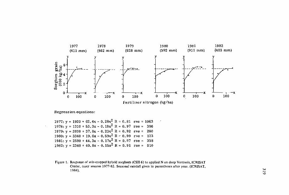
0' I X
1977(411 mm)
y
100
1982(403 mm)
I I X
y
o100
1981(911 mm)
I I X
o
y
1980(592 mm)
o 100I i X
y
100
1979(628 mm)
I I X
o
y
100
1978(862 mm)
I I X
y
o100o
c.;; ~ 6ti;1l
<,
E bo4;:1..1'
..c:: 0boO
82. 2Cl)
Ferti lizer nitrogen (kg/ha)
Regress ion equations:
1977.: y = 1920 + 62.4x - 0.28x2 R = 0.81 rse = 10631978: y = 1310 + 53. 3x - O. 19x2 R = 0.97 rse = 3861979: y = 3920 + 37. 8x - 0.23x2 R = 0.92 rse = 2801980: y = 3340 + 19.6x - 0.59x2 R = 0.99 rse = 1231981: y = 2580 + 44. 3x - O. 17x2 R = 0.97 rse = 3581982: y = 2340 + 40. 8x - 0.15x2 R = 0.91 rse = 510
Figure 1. Response of sole-cropped hybrid sorghum (CSH 6) to applied N on deep Vertisols, ICRISATCenter, rainy seasons 1977-82. Seasonal rainfall given in parentheses after year. (ICRISAT,1984 ). w.....
\0
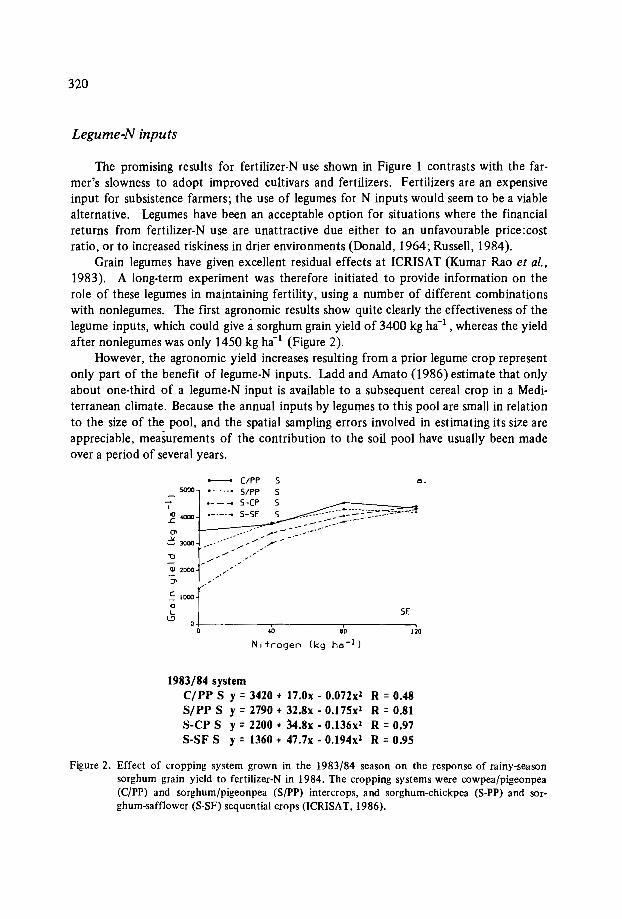
320
Legume-N inputs
The promising results for fertilizer-N use shown in Figure 1 contrasts with the farmer's slowness to adopt improved cultivars and fertilizers. Fertilizers are an expensiveinput for subsistence farmers; the use of legumes for N inputs would seem to be a viablealternative. Legumes have been an acceptable option for situations where the financialreturns from fertilizer-N use are unattractive due either to an unfavourable price:costratio, or to increased riskiness in drier environments (Donald, 1964; Russell, 1984).
Grain legumes have given excellent residual effects at ICRISAT (Kumar Rao et al.,1983). A long-term experiment was therefore initiated to provide information on therole of these legumes in maintaining fertility, using a number of different combinationswith nonlegumes. The first agronomic results show quite clearly the effectiveness of thelegume inputs, which could give asorghum grain yield of 3400 kg ha", whereas the yieldafter nonlegumes was only 1450 kg ha-! (Figure 2).
However, the agronomic yield increases resulting from a prior legume crop representonly part of the benefit of legume-N inputs. Ladd and Amato (I 986) estimate that onlyabout one-third of a legume-N input is available to a subsequent cereal crop in a Mediterranean climate. Because the annual inputs by legumes to this pool are small in relationto the size of the pool, and the spatial sampling errors involved in estimating its size areappreciable, measurements of the contribution to the soil pool have usually been madeover a period of several years.
0_
SE
ClPP 5S/PP 5s-ee 5S-SF 5
5000
~ ~-
~ 3!lOO .-/ ... """:~r--
QI 1000
:J>
.~ 1000
ClL~
I
.2 4000
40 80Nitrogen (kg ho· l)
o+----------.-------r-------,o
1983/84 systemC/PP S y =3420 + 17.0x - 0.072x1 R =0.48S/ pp S y =2790 + 32.8x - 0.175x1 R =0.81S-CP S Y= 2200 + 34.8x - 0.136x1 R = 0.97S-SF S y = 1360 + 47.7x - 0.194x1 R = 0.95
Figure 2. Effect of cropping system grown in the 1983/84 season on the response of rainy-seasonsorghum grain yield to fertilizer-N in 1984. The cropping systems were cowpea/pigeonpea(C/PP) and sorghum/pigeonpea (S/PP) intercrops, and sorghum-chickpea (S-PP) and sorghum-safflower (S-SF) sequential crops (ICRISAT, 1986).

321
Modelling
From a combination of the results from both annual and long-term experiments,attempts can be made to develop models that predict the effects of various crop and fertilizer combinations on productivity and soil nutrient status. Data of the type given inFigure I allow an assessment of the desired crop yield to be made, based on currenteconomics of fertiliser use. In association with data of the type given in Figure 2, we candecide the balance between fertilizer-N and legume-N inputs desired for the range oflegumes and nonlegumes available. For these ranges of possible production factors wecan calculate the likely affects on the maintenance of soil nitrogen status. For fertilizer-N, modelling is much easier, because the output (offtake) data is known from theassociated plant-N removal data. Removal from the zero-N plot gives us an estimation ofthe mineralization of soil N, and immobilization of N can be assessed by using 15 N-Iabelled fertilizer, as can the losses of N by denitrification.
Accurate determination of legume-N inputs have encountered difficulties because ofthe errors associated with some of the field measurements. In the past, the only solutionwas to conduct long-term experiments; from the measured removal of N in plant products
4000
vic:
3000o:tICIl..U0 2000..CIla..Q
Z 1000
kc=0.01
Legend ac = 20@ for the permanent posture plot (29)x for 0 plot (13) of the two years wheat ,4 years posture rotation+ for 0 continuous follow-wheat plot (35)
1925 1935 1945 1955 1965 1975
Figure 3. Changes in the nitrogen content of the 04 inch soil horizon under continuous fallow-wheat,and under pasture and pasture-wheat rotations, assuming the changes to follow the equationdN/dt = - kN + a. Under fallow-wheat it has been assumed that kc = 0.04 and ac = 20 Ibper acre, and under pasture kp = 0.01 and ap = 80 Ib per acre. Years and nitrogen levels havebeen chosen to correspond to plots in the permanent rotation trial (Cl) at the Waite Institute. Actual levels of nitrogen are shown in 1963 (Greenland 1971).

322
~and changes in soil N, the net addition of nitrogen by biological-N fixation could be estimated. A more accurate estimation requires inclusion of estimates of additions or lossesin rainfall, leaching, gaseous losses etc. Such experiments are laborious, and requiremeticulous attention to detail to measure the changes in soil N, including corrections forchanges in bulk density. Only a few institutions have the resources to conduct experiments that require such continuing attention.
From the approaches given above, relationships can be established that show theeffects of different proportions of legumes and nonlegumes in crop sequences and cornbinations of soil nitrogen contents (see Figure 3, from Greenland, 1971). This representsthe type of information that is needed for planning crop options with regard to maintaining soil nitrogen status.
Measurement of the inputs by biological-N fixation has been hindered in the past bythe high cost of resources for conducting the appropriate long-term experiments. Developmentof techniques using dilution of IS N raised hopes that measurements could bemade in just a single season,but their accuracy was dubious because of nonuniformlabelling of soil nitrogen, both in time and with soil depth. By allowing time for equilibration, it appears that the accuracy of the IS N technique will be much better (Ladd andAmato, 1986).
Integration of Fertility Research
The results shown above for soil nitrogen indicate the considerable amount of research effort required to develop a strategy for maintaining one aspect of soil fertility.Obviously, if several factors are involved, research efforts will be substantial. However,the overall effort can be minimized by careful selection of the few factors that are mostimportant. The results in Figure 1 confirm that the high priority to nitrogen researchwas warranted.
Future nutrient management research on Vertisols will involve studies of thebehaviour of phosphorus, as discussed earlier. However, interactions between nutrientsand other components will require increasing attention. For Vertisols under high rainfall,there appears to be a potential for substantial losses of nitrogen, depending upon theattention given to drainage. For Vertisols under unreliable rainfall regimes, the effectiveness of nutrient inputs needs consideration in relation to water supplies both for the cropand for nutrient availability.
References
DONALD, C.M. 1964. The impact of cheap nitrogen. Journal of the Australian InstituteofAgricultural Science 26: 317-338.
GREENLAND, D.J. 1971. Changes in the nitrogen status and physical condition of soilsunder pasture, with special reference to the maintenance of the fertility of Australiansoils used for growing wheat. Soils and Fertilizers 34: 237-251.

323
HALLSWORTH, E.G. 1969. The measurement of soil fertility: The national soil fertilityproject. Journal of the Australian Institute of Agricultural Science 35: 78-89.
HUSSEIN, J. 1984; Laboratory analyses for assessing potential irrigation problems ofbasalt-derived Vertisols. Zimbabwe Agricultural Journal 81: 9-16.
ICRISAT (International Crops Research Institute for the Semi-Arid Tropics). 1984.Annual Report 1983, Patancheru, A.P. 502 324, India: ICRISAT. 256p.
ICRISAT (International Crops Research Institute for the Semi-Arid Tropics). 1985.Annual Report 1984. Patancheru, A.P. 502 324, India: ICRISAT. 288p.
ICRISAT (International Crops Research Institute for the Semi-Arid Tropics). 1986.Annual Report 1985. Patancheru, A.P. 502324, India: ICRISAT. 288p.
KANWAR, J.S. and VIRMANI, S.M. 1987. Management of Vertisols for improved cropproduction in the semi-arid tropics: a plan for a technology transfer network in Africa. (These proceedings).
KANYANDA, C.W. 1985. Properties, management, and classification of Vertisols in Zimbabwe. Pages 94-109 in: Fifth Meeting of the Eastern African Sub-committee for SoilCorrelation and Land Evaluation. World Resources Report no. 56. Rome: FAO.207p.
KUMAR RAO, J.V.D., DART, P.J. and SASTRY, P.V.S.S. 1983. Residual effect ofpigeonpea (Cajanus cajan) on yield and nitrogen response of maize. ExperimentalAgriculture 19: 131-141.
LADD, J .A. and AMATO, M. In press. Nitrogen cycling in legume-cereal rotations. In:Proceedings of the International Symposium on Nitrogen Management in FarmingSystems in the Humid Tropics, Ibadan, Nigeria.
MORAGHAN, J.T., REGO, T.J., BURESH, R.J., VLEK, P.L.G., BURFORD, J.R.,SINGH, S. and SAHRA WAT, K.L. 1984. Labelled nitrogen fertilizer in the semi-aridtropics. 11. Yield studies on a Vertiso!. Plant and Soil 80: 21-33.
RAO, A.C.S. and DAS, S.K. 1982. Soil fertility management and fertilizer use in drylandcrops. Pages 120-139 in: A Decade of Dryland Agricultural Research in India. AllIndia Co-ordinated Research Project for Dryland Agriculture, Hyderabad, India.
RILEY, J.J. 1986. Report no. 37. Western Sudan Agricultural Research Project, Khartoum.
RUSSELL, J .S. 1984. Nitrogen in dry land agriculture. Pages 202-226 in: Proceedings ofthe International Congress on Dryland Farming.
WILD, A. 1958. The phospphorus content of Australian soils. Australian Journal of Agricultural Research 9: 193-204.


APPENDICES

Appendix I
WORKING GROUP REPORTS
On the two days following paper presentations, country proposals were presented bythe country representatives, and reviewed with the Network Coordinating Committee.The proposals emphasized current research procedures in the various countries concerned,the objectives envisaged, and the means of obtaining these objectives. While the projectproposals were being finalized, three groups drafted the methodology to be applied forsite characterization, physicial and chemical analytical methods, and the monitoring offarming systems.
Working Group A
Site Characterization
The group considered two major topics: (i) criteria for site selection, and (ii) data tobe collected for site characterization.
Criteria for site selectionThe first sites to be considered should be those meeting the following criteria:
they are occupied by Vertisols which comply with the FAOjUSDA definition;they have a growing season of at least 70-90 days;they are farmed by an established rural population.
The representativity of the site should be assessed using existing soil maps andcomplementary investigations:
Data to be collected for site characterizationSoil:* detailed map of the site (l :1,000);* soil morphological characters as described by the Guidelines for Soil Descrip
tion (FAO, 1967);

328
* landscape description - physiography, topography, parent material;* sampling and measurements by horizon for taxonomic purposes, and compo
site fertility samples for experimental purposes;* physical parameters and chemical characters;* the designation of the horizons should follow the conclusions of the Interna
tion Commission on Vertisols (ICOMERT).Climate:* general description of the climate of the site regarding temperature and rain
fall;* characterization of the site using FAO's agroecological zoning stipulations,
and giving details of the soil moisture and temperature regime;* measurement on the site of the following features: daily rainfall, maximum
and minimum temperature, and potential evapotranspiration.Other data on the natural environment:* incidence of flooding and ponding;* incidence of biotic yield reducers - pests and diseases;* natural vegetation and agricultural history of the site.Human environment:* farming systems used in the region;* endowment of resources;* profiles of cropping systems;* marketing;* farmers' perception of difficulties.
Working Group B
Soil physical and chemical characterization
The group considered a set of soil characteristics relevant to crop production whichcan be measured simply.
Physical characteristicsFrom surface observations, three characters seemed important: dry aggregates(presence, size, thickness), cracks (presence, Width), and gilgai (presence, wavelength, amplitude).From profile observations, a number of characteristics should be determinedfrom a freshly opened pit: the depth, texture and consistency of the differenthorizons, the cracks, macrovoids and slickensides, the size of the structural units,and the presence of roots.Field measurements: At maximum field water retention after rain or irrigation,it is important to determine the saturated hydraulic conductivity, the maximumwater content with the associated bulk density, and the wet penetration resis-

329
tance. In addition, the maximum rate of drying of the surface mulch and thesurface aggregate size can be measured.Laboratory measurements: Shrinkage (COLE), the porosity of dry clods (Protortest), the plasticity index, and the aggregate breakdown with wetting and .dryingare recommended measurements. Others which can be useful are those providedby a mechanical analysis, and by measuring the IS-bar water content, the hydraulic conductivity of the surface layer, and the soil coherence.
Chemical characteristicsThe following analyses are considered to be of primary importance: CEC, exchang
able cations, soluble salts, pH, total organic matter, total elements (N,P,K,Zn,Cu,Mn,Fe),carbonates, and available P (Olsen).
The group also made the following recommendations:that a central laboratory be used for certain measurements;that such problems as cohesion and adhesion in tillage be regarded as a researchrequirement;that support should be given to some cooperators to attend" a workshop/trainingcourse on the effect of soil management on soil physical properties to be held inSeptember 1987 in Australia.
Working Group C
. Monitoring of improved systems
The aim in monitoring improved systems is to assess the extent of changes bymeasurements of well-chosen components using reliable and preferably simple methods.
EnvironmentClimatic components, such as rainfall, temperature, solar radiation, and wind speed,
can be measured automatically. Details on evaporation, soil temperture (5-10 cm) andlong-term weather patterns should also be available.
Soil physicsSoil water should be measured all the year round, either by neutron probe or by
gravimetry, and the water table can be monitored by piezometers. Runoff and erosionmeasurements would also be useful.
Soil structureThe stability of the surface aggregates is important and should be measured. The
width and spacing of the cracks and root penetration on the subsoil should be noted.
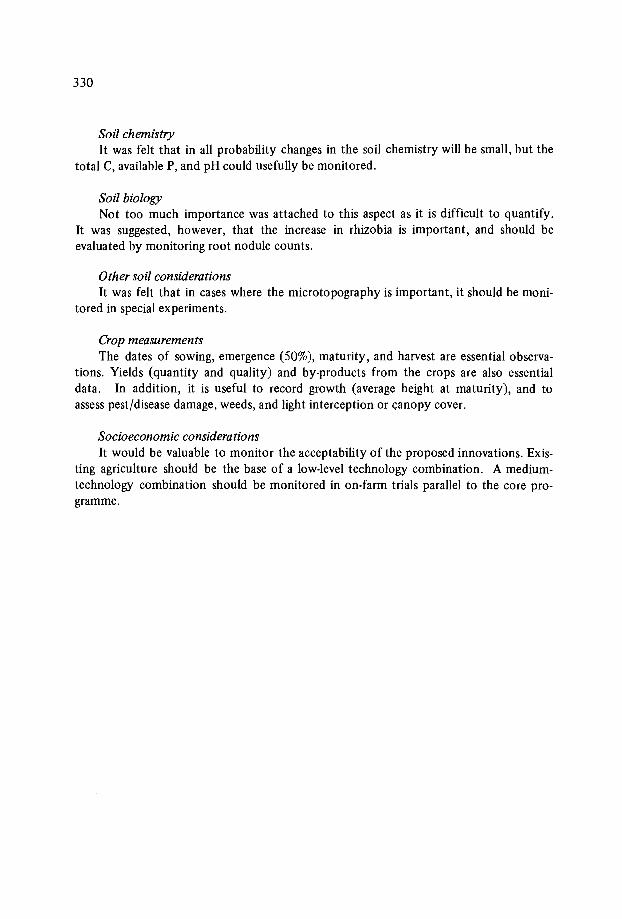
330
Soil chemistryIt was felt that in all probability changes in the soil chemistry will be small, but the
total C, available P, and pHcould usefully be monitored.
Soil biologyNot too much importance was attached to this aspect as it is difficult to quantify.
It was suggested, however, that the increase in rhizobia is important, and should beevaluated by monitoring root nodule counts.
Other soil considerationsIt was felt that in cases where the microtopography is important, it should be moni
tored in special experiments.
Crop measurementsThe dates of sowing, emergence (50%), maturity, and harvest are essential observa
tions. Yields (quantity and quality) and by-products from the crops are also essentialdata. In addition, it is useful to record growth (average height at maturity), and toassess pest/disease damage, weeds, and light interception or canopy cover.
Socioeconomic considerationsIt would be valuable to monitor the acceptability of the proposed innovations. Exis
ting agriculture should be the base of a low-level technology combination. A mediumtechnology combination should be monitored in on-farm trials parallel to the core programme.

Appendix 11
SEMINAR RESOLUTIONS
Proposed MOVUSAC Regional Network
The network organization has been described in other JBSRAM publications, mainlyin the reports of the inaugural workshops, the IBSRAM Highlights, and the newsletters.By and large these descriptions remain valid; but in order to achieve better efficiency aregional approach has been adopted.
The title of the proposed network is Management of Vertisols under Semi-AridConditions in Africa (MOVUSAC). This regional network is part of the global networkon the management of Vertisols for improved agricultural production. However, its aimis more restricted than the global one as it addresses problems which are mainly relevantto Africa and to upland rainfed conditions.
Organization of the MOVUSA C Network Programme
The proposed organization of this regional network will be similar to that envisagedfor the initial global network. It will comprise three components, namely:
Cooperators, who will initiate and operate the soil management programmeactivities. Four types of participation are possible.* simple participation in the different programme activities, mainly with a
view to sharing information;* active participation - both by having an accepted programme, and by partici
pating in all the various programme activities;* basic participation - by having an approved programme, some strategy re
search related to the objectives of the network, and also participation in allthe programmes;
* support participation by international and other research agencies, by undertaking some part of the basic research related to the objective of the network,either alone or in conjunction with other cooperators.
IBSRAM, which through a programme coordinator backed by the NetworkCoordinating Committee, will catalyse, coordinate, and assist cooperators in

332
conducting their activities. IBSRAM provides assistance in the preparation andin the presentation of the projects to donor agencies. The coordinator acts asa link between the cooperators and IBSRAM. He helps strengthen the nationalcooperators' programmes by regular visits and consultations and by backstopping the following network activities:* site characterization;* exchange of control soil samples and analytical methods;* design of experiments, analyses, and interpretation of the data arising from
the experiments;* technical assistance;* regular meetings, during which programmes will be reviewed and eventually
revised;* monitoring tours;* training courses;* creation of a data base;* review of past and ongoing research, and bibliographical information services;* provision of a programme newsletter, publications, and documentation.Donors, who will fund the programme coordination and, in part, the activitiesof the individual national cooperators.
Mechanism ofApproval of National Project Proposals
One of the main objectives of this meeting was to revise and approve national projectproposals in order to establish the regional network programme. The mechanism ofapproval, which has already been put into effect, consists of the following steps:
A project proposal on Vertisol management is presented to IBSRAM by a national institution (coordination between national organizations is favoured).More than twenty projects have been presented for this MOVUSACnetwork.The project is reviewed by the Network Coordinating Committee (NCC). Untilnow, the initial interim NCC formed during the inaugural workshops has beenused. The NCC consists of the active, basic, and support cooperators, the maindonors, and the IBSRAM coordinator. The IBSRAM Board must then endorseits acceptance of the project proposals.After approval, an official letter of acceptance is sent to the cooperators, whomay use it as a letter of support for fund seeking. During the regular meetingsof the network, cooperators will present their results, and these will be discussedand reviewed by the participants in order to maintain a high scientific anddevelopment standard in the programme.
Criteria ofApproval for National Project Proposals
The criteria for the approval of a national project proposal are as follows:.The project must fulfill the network objectives as defined during the inaugural

333
workshops and as clarified during the present seminar.The project must be technically acceptable, Le. it must follow the approach andmethodology defined during this seminar.The project must be economically acceptable.The country must already be involved in research of the type proposed, or bewilling to invest in training for its personnel to achieve worthwhile participation.If a basic research project is proposed, it should have a broader objective thanthe country objectives per se, Le. it should have implications on a wider scale.This criterion will not apply to validation projects.
Network Implementation
Immediate action will be taken by the director of IBSRAM to implement thisMOVUSAC network. As ODA has agreed to fund the coordination of the network for aninitial three-year period, a coordinator will be recruited and assume his duties as soon aspossible. For the time being, the most important step is to revise the project proposalswith a view to ensuring that they follow the recommendations of the workshop as regardsthe approach which-is to be adopted.
After they have been revised, the proposals will be evaluated and, if accepted, will bepresented in a portfolio of MOVUSAC project proposals suggested by IBSRAM for initialdonor support. This portfolio will be widely disseminated amongst donors for funding,either on a bilateral basis or through IBSRAM. At the same time, the MOVUSAC coordinators (accompanied by one or two experts) will tour the different cooperating countries in order to assess the practical modalities for the implementation of their projects.
In order to ensure a smooth sequence of administrative operations, it is suggestedthat cooperators and relevant organizations carry out the various functions set out below:
Cooperators - to send a revised project proposal drafted in accordance withthe recommendations of the seminar.IBSRAM - to recruit a coordinator, to review and edit the project proposals,to seek funding for their implementation, and to organize a first visit of a teamcomposed of the coordinator and one or more experts.Cooperators - to follow up activities in the proposed project which have alreadystarted, or to start activities as soon as possible, even on a small scale.Cooperators - to send IBSRAM an inventory of their available laboratory equipment and to list their needs regarding soil and plant analyses.Cooperators - to send their training plans and a list of available facilities at different levels in order to organize training sessions. IBSRAM will encouragecooperators to send participants to ICRISAT and other similar organizationswhich plan soil management training courses on Vertisols.
Appendix III
PROGRAMME OF THE SEMINAR AND FIELD TOUR
Monday 1 December
Registration (Serena Hotel)Opening session
Opening remarks: Dr. Marc latham - Director, International Board for Soil Research and Management (IBSRAM)Inaugural address: Mr. Wapakala - Director of Research, Ministry of AgricultureWelcome address: Dr. F. Wang'ati - Secretary of the National Council for Scienceand TechnologyMaster of Ceremonies: Mr. F.N. Muchena
First session: IBSRAM's network approach
Chairmen: Dr. F. Wang'atiDr. J.S. KanwarIBSRAM's Vertisols network managementTaxonomic characterization of VertisolsVertisols in eastern AfricaFarming systems approachVertisols network: goal and objectivesDiscussion
Second session: Site selection
Chairmen: Prof. K. ZakeDr. S.M. VirmaniCriteria for site selection in VertisolsCase study: IndiaCase study: Kenya
M.lathamJ.L. Sehgal
R.F. van de WegT. Walker
J.R. Burford
P. BrabantJ.L. Sehgal
N.N. Nyandat
Third session: Site characterization
Chairmen: Dr. A. OsmanDr. M. RasheedPhysical and mechanical propertiesWater managementChemical fertility parametersThe occurrence and management of Vertisols for theproduction of cotton and other crops inwestern TanzaniaConservation measures under large-scale wheatfarms on Vertisols in northern Tanzania
Tuesday 2 December
Fourth session: Management systems
Chairmen: Dr. 1.R.l. HansellDr. O.T. MandiranganaManagement of Vertisols for improved cropproduction in the semi-arid tropics:a plan for a technology transfernetwork in AfricaAfrican highlands (ILCA)
Fifth session: Management systems (cont.)
Chairmen: Mr. F.N. MuchenaDr. I.C. KatyalSoil conservation and agroforestrySemi-arid Mediterranean areas (ACSAD)Avenues for the improvement of cultural practiceson VertisolsManagement problems of cotton on VertisolsDiscussion
Sixth session: Implementation of the Vertisols network
Chairmeri: Dr. R.F. van de WegDr. A. WoldeabExperimental design and data processingFertility control and fertilizer management (IFDC)Supplementary irrigation
335
K. CoughlanD. Yule
P. Le Mare
I.G. Mowo
R. Ngatoluwa
I.S. Kanwar andS.M. Virmani
T. Abate
A. YoungA.Osman
T.l. WillcocksA.J .B. Mitchell
W. SideriusI.C. Katyal
H.G. Farbrother
336
Seventh session: Sustainability o[improved systems
Chairmen: Dr. T. WalkerDr. N.N. NyandatErosion controlCropping system evaluationStrategy for fertility managementDiscussion
Wednesday 3 December
Eighth session: Country reports - project proposals
K. CoughlanR. Willey
J .R. Burford
Chairman:Rapporteurs:
Chairman:Rapporteurs:
Chairman:Rapporteur:
Dr. R. WilleyDr. D. YuleDr. J.R. Burford- Egypt- Pakistan- Sudan-ACSAD- Tunisia- Zimbabwe- Kenya- TanzaniaDr. S.M. VirmaniDr. G.G. RistoriDr. J.R. Burford- Uganda- Mali- Burkina Faso- Botswana- IndiaDr. T. WillcocksDr. P. Le Mare- Report and projects: Ethiopia- General discussion
Thursday 4 December
Ninth session: Working groups

Site characteirzationChairman: Or. T. WalkerRapporteur: Or. P. Brabant
Physical and chemical analytical methodsChairman: Or. K. CoughlanRapporteur: Or. M. Razig
Monitoring of soil propertiesChairman: Or. A.M. VirmaniRapporteur: Or. T. MitchelI
Friday 5 December
Field tour
Leave Six-Eighty HotelArrive site 1Leave site 1Arrive site 2Leave site 2Arrive site 3Leave site 3Stop for lunchLeave for Masinga Matuu areaShort stops on the wayShort stops at MatuuLeave Matuu for ThikaArrive at Thika Blue Post HotelLeave Thika for NairobiArrive Nairobi
Saturday 6 December
Tenth session: General discussions and conclusion
General discussions on the working groups' reportsReport of the NCCFormation of the network programme and discussionClosing session
337
Appendix IV
LIST OF PARTICIPANTS(in order of country work base)*
AUSTRALIA
COUGHLAN, KepSoil Conservation Research BranchQueensland Department Primary
IndustriesMiers RoadIndooroopillyQueensland 4068Tei. 61-07·3779462
YULE, DonaldQueensland Department Primary
IndustriesPO Box 683RockhamptonQueensland 4700Tei. 079-360253
BOTSWANA
GAKALE, Lucas P.Agricultural ResearchBP 0033GaboroneTei. 52381Cable: RESAGRIC
REMEUWAAL, ArieFAOc/o UNDPPO Box 54Gaborone
BURKINA FASO
ZOMBRE, ProsperBureau National des SoilsBP 7142, QuagadoubouTeI. 3352-39
EGYPT
RASHEED, Mohamed AbbasSoils & Water Use DepartmentThe National Research CentreDokkiCairoTei. 701211,701615
*Representatives from international organizations are listed separately at the end.

ETHIOPIA
GETACHEW, AlemAgricultural Research InstitutePO Box 2003Addis AbabaTel. 160309
ASKANEW, WoldeabAgricultural Research InstitutePO Box 2003Addis AbabaTel. 160309
FRANCE
BRABANT, Pierre74 Route d'Aulnay93140 BondyTel. (I) 48473195Telex: 2 I 5203 F ORSTOM
INDIA
SEHGAL, Jawahar LalNational Bureau of Soil Survey and
Land Use PlanningAmravati RoadNagpur - 440 0 I0Tel. 34664Telex: 0715-262 NBSLIN
ITALY
RISTORI, Giuseppe G.Centro di Studio CoIIoidi SouloPzole Cascine 2850 I44 - FirenzeTeI. 055 36449 ICable: CONSIGLlONAZ RICERCHE
KENYA
CHWEYA, lamesDepartment of Crop ScienceUniversity of NairobiPO Box 29053Nairobi
ENGELEN, Vincent vanKenya Soil SurveyPO Box 14733NairobiTeI. 482 I I
GACHENE, Charles K.Kenya Soil SurveyPO Box 14733NairobiTel. 4821 I
GATAHI, Milton M.Kenya Soil SurveyPO Box 14733Nairobi
IKITOO, Edwin C.Mwea-TeberaAgricultural Research StationMinistry of AgriculturePO Box 2298Kerugoya
MANGALE, BesbertKenya Agricultural Research InstitutePO Box 30148NairobiTeI. 32883
339
340
M'ARIMI, A.M.Tana and Athi Rivers Department
AuthorityPO Box 47309NairobiTel. 332455
MOCHOGE, BensonUniversity of NairobiPO Box 30197NairobiTel. 592154
WEEDA, NoutKenya Soil SurveyPO Box 14733NairobiTel. 48211
WOKABI, Stanley MwangiKenya Soil SurveyPO Box 14733NairobiTel. 48211
MALI
BAGAYOKO, MirambaIER/DRA/SRCVOSRCVO B438Satuba - Bamako
NETHERLANDS
VAN DE WEG, RoelNetherlands Soil Survey Institute
(STIBOKA)PO Box 986700 AB WangeningenTel. 80370-19100Telex: 75230 VISI NL
SIDERIUS, WoutITCPO Box 67500 AA EnschedeTel. 053-320330Telex: 44525 NL
WANG 'ATI, FrederickNational Council for Science and
TechnologyPO Box 30623NairobiTel. 336173Telex: 25356 KI TACCHITCable: SCIENCENTECH NAIROBI
MUCHENA, F.N.Kenya Soil SurveyPO Box 14733NairobiTel. 49501/02
NJIHIA, Christopher MugoNational Agriculture LaboratoriesMinistry of AgriculturePO Box 14733NairobiTel. 48211 or 49501
NYANDAT, Nelson NyambiahNational Council for Science and
TechnologyPO Box 30623NairobiTel. 336173
OCHIENG, Nicholas PatrickKenya Soil SurveyPO Box 14733NairobiTel. 84211/273

OGUTU, ChristopherKenya News AgencyPO Box 75638NairobiTel. 333561
OSORO, MichaelNSRS, Ministry of AgriculturePO Box 1221KisumuTel. 2293
PAKISTAN
KHAN, AurangzebSoil Survey of PakistanP.O. ShahnoorLahore -18Tel. 430101Cable: PAKSOILS, LAHORE
SAUDI ARABIA
MOHAMED, Gailey Abdel RazibAlowaidah Agriculture CompanyPO Box 41880RiyadhTel. 4793700Telex: 240858 MWADEO
SUDAN
BABIKER, Ibrahim AhmedAgricultural ResearchPO Box 126MedaniTel. 2232 MEDANICable: TAOARIB MEDANI
MOHAMMED, Hassan Hag AbdullaAgricultural ResearchPO Box 126MedaniTel. 2232 MEDANI
TANZANIA
HAULE, LallistoTARO - MallinganoBP TangaTelex: 45095 TACORD TZ
MANSOOR, Hussein AhmedTanzania-Canada Wheat ProjectPO Box 6024ArushaTel. 3883
McKEAGUE, AlexTanzania-Canada Wheat ProjectCIDAPO Box 6160ArushaTel. 3883
MOWO, JeremiasTanzania Agricultural ResearchPO Box 1433MwanzaTel. 40596/7
NGATOLUWA, RamadhanTanzania-Canada Wheat ProjectPO Box 6024ArushaTel. 3883
341

342
TUNISIA
MIZOURI, MaaouiaDirection des SolsMinistere de l'Agriculture42 Avenue de la Republique1001 Tunis-Port, TunisTeI. 246-232
UGANDA
ZAKE, K.Makerere UniversityPO Box 7062Kampala
UNITED KINGDOM
FARBROTHER, Herbert G.7 The LanesOverCambridgeEngland
GUYVER, PatrickLandell-Mills65 Maidenhead RoadStratford-on-AvonWarwickshireEnglandTeI. 0789-205052
LE MARE, PeterDepartment of Soil ScienceUniversity of ReadingLondon Road, Reading RG 1 5AQEnglandTeI. 44 734 875234 ext. 280Telex: 847813 RULIB G
MITCHELL, AnthonyLand Resource Development CentreODATolworth TowerSurbitonSurrey, KT6 7DYEnglandTeI. 01-399-5281
WILLEY, Robert W.School of Development StudiesUniversity of East AngliaNorwich NRI5 1SWEnglandTeI. (0603) 56161
WILLCOCKS, Theo J.Overseas DivisionAFRC Institute Engineering ResearchSilsoeBedford MK45 2BBEnglandTeI. (0525) 60000Telex: 825808
ZAMBIA
MUTELO, JosephMinistry of AgriculturePO Box 50291LusakaTeI. 253008
MUKANDA, NawaMt. Makulu Railway StationDepartment of AgricultureSoil Survey UnitPB7ChilangaTeI. 01-278087
ZIMBABWE
MANDIRINGANA, Owen T.Soil Productivity Research LaboratoriesPO Box 2757MaronderoTei. 3621Cable: AGRICSEARCH ZW
INTERNAnONAL ORGANIZAnONS
ACSAD
OSMAN, AhmedPO Box 2446DamascusSYRIATei. 755713Telex: 412697 SY
EEC
SMITH, AnthonyEECPO Box45119NairobiKENYATel. 333592
FAO
PHILLIPS, John C.PO Box 30470NairobiKENYATei. 725069 (359) (369)Telex: 23016 FOODAGRI NRB
IBSRAM
LATHAM, MarcPO Box 9-109Bangkok 10900THAILANDTei. 5797590, 5611230Telex: 21505 IBSRAM THCable: IBSRAM
CHALINEE, NiamskulPO Box 9-109Bangkok 10900THAILANDTei. 5797590, 5611230Telex: 21505 IBSRAM THCable: IBSRAM
ELLIOTT, Colin R.PO Box 9-109Bangkok 10900THAILANDTei. 5797590, 5611230Telex: 21505 IBSRAM THCable: IBSRAM
ICRAF
LUNDGREEN, BjornPO Box 30677NairobiKENYATel. 29867
YOUNG, AnthonyPO Box 30677NairobiKENYATei. 29867
343
344
ICRISAT
BURFORD, John R.Resource Management ProgramICRISAT Patancheru A.P. 502324
INDIA
KANWAR, Jaswant S.ICRISATPatancheruA.P.502324INDIATei. 224016
VIRMANI, Surinder M.ICRISATPatancheruA.P.502324INDIA
WALKER, Thomas S.ICRISATPatancheruA.P.502324INDIA
IFDC
KATYAL, JagdishIFDCMuscle ShoalsPO Box 2040Alabama 35662USATei. (205) 381-6600
ILCA
ABATE, TedlaILCAPO Box 5689Addis AbabaETHIOPIA
ODA
HANSELL, JohnBritish High CommissionPO Box 30465NairobiKENYA
UNDP
YAYA,C.W.UNDPNairobiKENYA
USAID
LUNDBERG, DavidPO Box 30261NairobiKENYA

IBSRAM
BOARD OF TRUSTEES
Dr. C.F. Bentley (Chairman)13103·66 AvenueEdmonton, AlbertaCANADA T6H 1Y6
Dr. RW. ArnoldSoil Conservation ServiceDepartment of AgricultureP.O. Box 2890Washington, D.C. 20013
Dr. R FauckThe World Bank Agriculture and Rural
Development Department1818 H Street N.W.Washington, D.C. 20433U.S.A.
Dr. K. KumazawaDepartment of Agricultural ChemistryFaculty of AgricultureUniversity of TokyoBunkyo Ku, TokyoJAPAN
Dr. RJ. MillingtonChief,Division of Water and Land ResourcesCSIROPO Box 1666Canberra, ACT 2601AUSTRALIA
Dr. A. OsmanDirector of Soil Science DivisionThe Arab Center for the Studies of Arid
Zones and Dry Lands (ACSAD)PO Box 2440, DamascusSYRIA
Dr. Christopher R. PanabokkeAgricultural ScientistInternational Institute for Irrigation
ManagementDiagana Village, via KandySRI LANKA
Dr. Samarn PanichapongExpert, Soil Survey and ClassificationDepartment of Land DevelopmentBangkok 10900THAILAND
Dr. W. TreitzDeputy DirectorACP·EEC Convention of LameTechnical Centre for Agriculture
and Rural CooperationBP 3806700 AJ WageningenTHE NETHERLANDS
Dr. F.J. Wang'atiNational Council for Science and
Technology (NCST)PO Box 30623NairobiKENYA

IBSRAMInternational Board for Soil Research and ManagementInc. - HeadquartersP.O. Box 9-109BangkhenBangkok 10900THAILANDPhone: 579-7590,561-1230Telex: 21505 IBSRAM TH, Cable: IBSRAM